Totale Sonnenfinsternis vom 24.06.-1832
| Wochentag: | Mittwoch |
| Maximale Dauer der Verfinsterung: | 05m46s |
| Maximale Breite des Finsternispfades: | 226 km |
| Saroszyklus: | 17 |
| Bedeckungsgrad: | 100% |
| Magnitude: | 1.0685 |
| Gamma: | 0.1456 |
Wo kann man die Sonnenfinsternis vom 24.06.-1832 sehen?
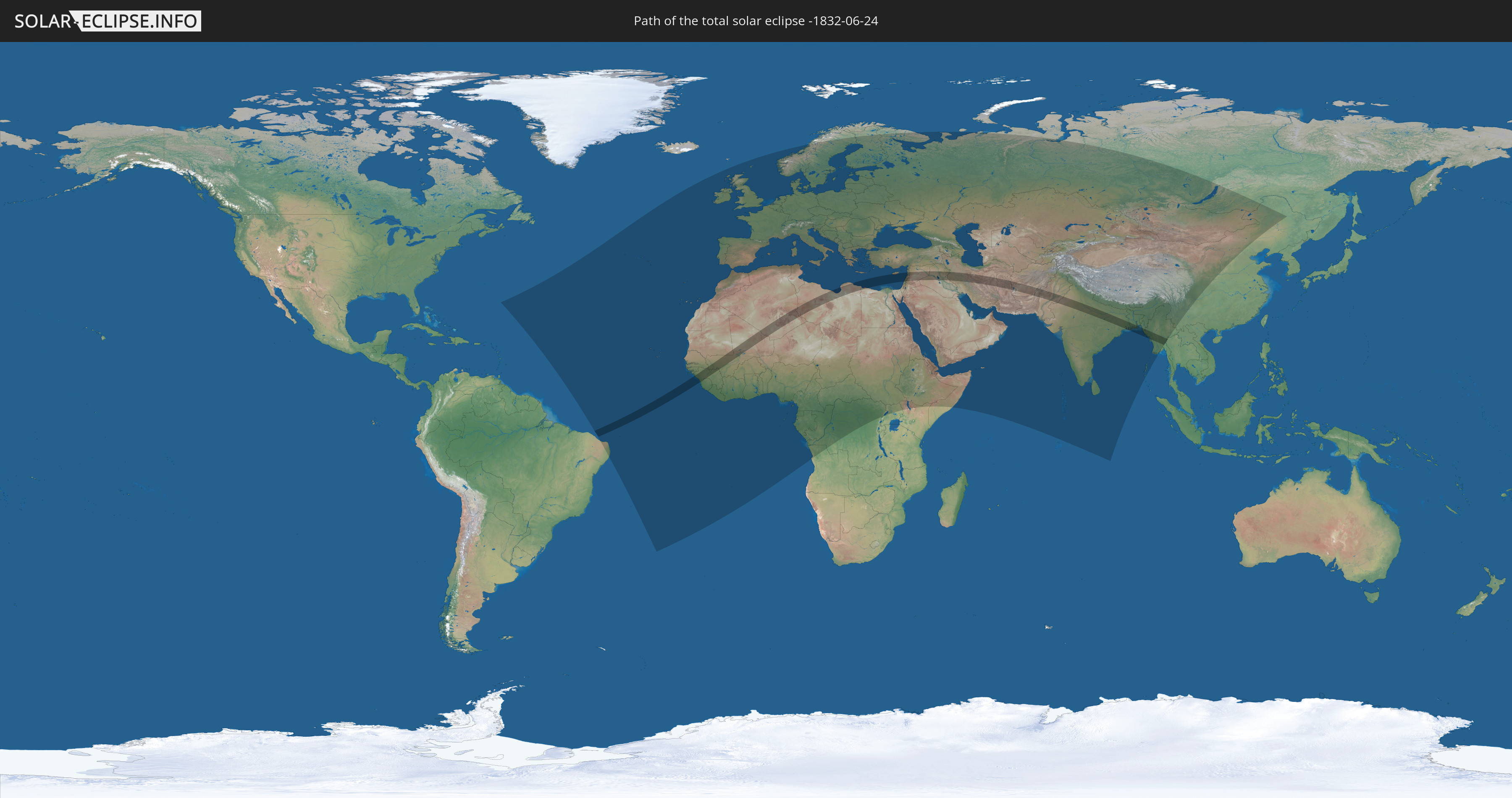
Die Sonnenfinsternis am 24.06.-1832 kann man in 123 Ländern als partielle Sonnenfinsternis beobachten.
Der Finsternispfad verläuft durch 21 Länder. Nur in diesen Ländern ist sie als totale Sonnenfinsternis zu sehen.
In den folgenden Ländern ist die Sonnenfinsternis total zu sehen
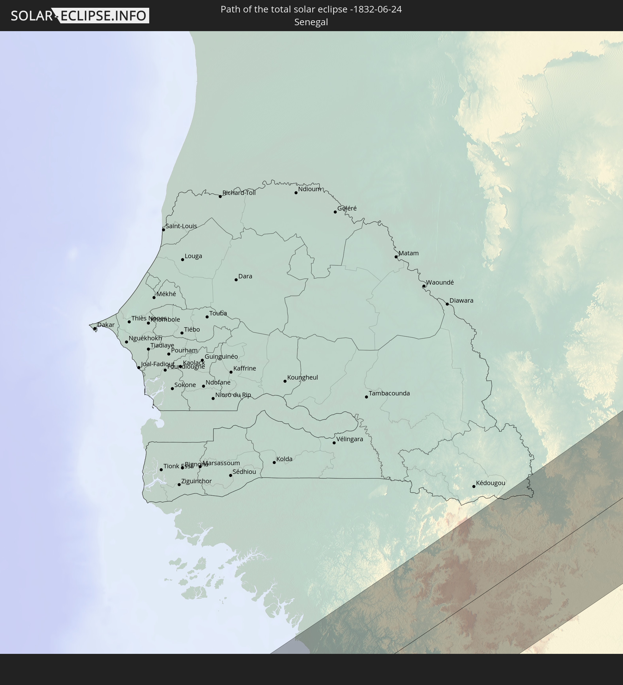 Senegal
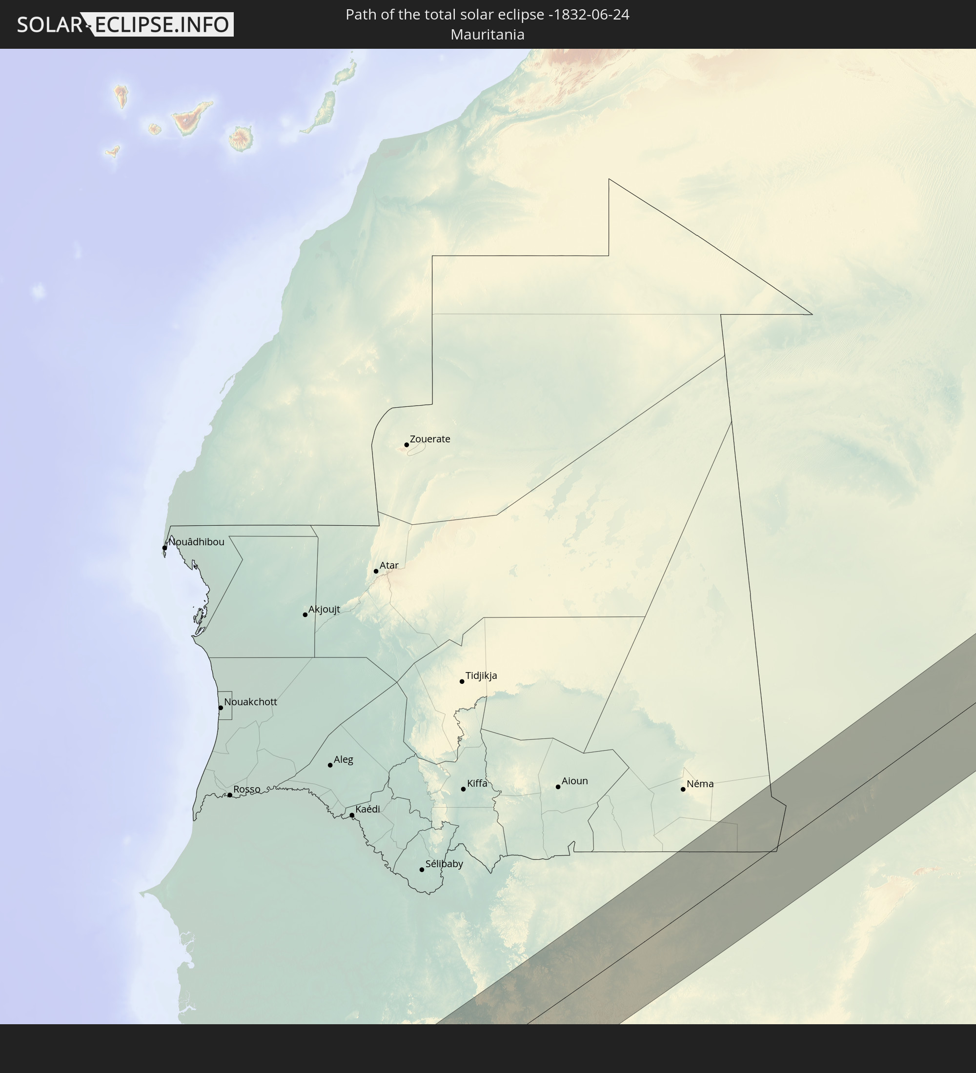 Mauretanien
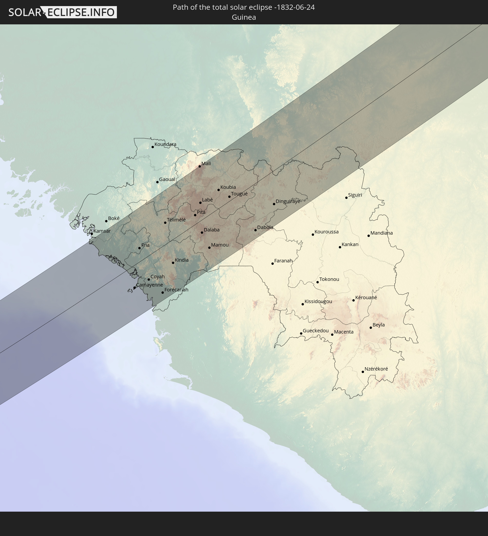 Guinea
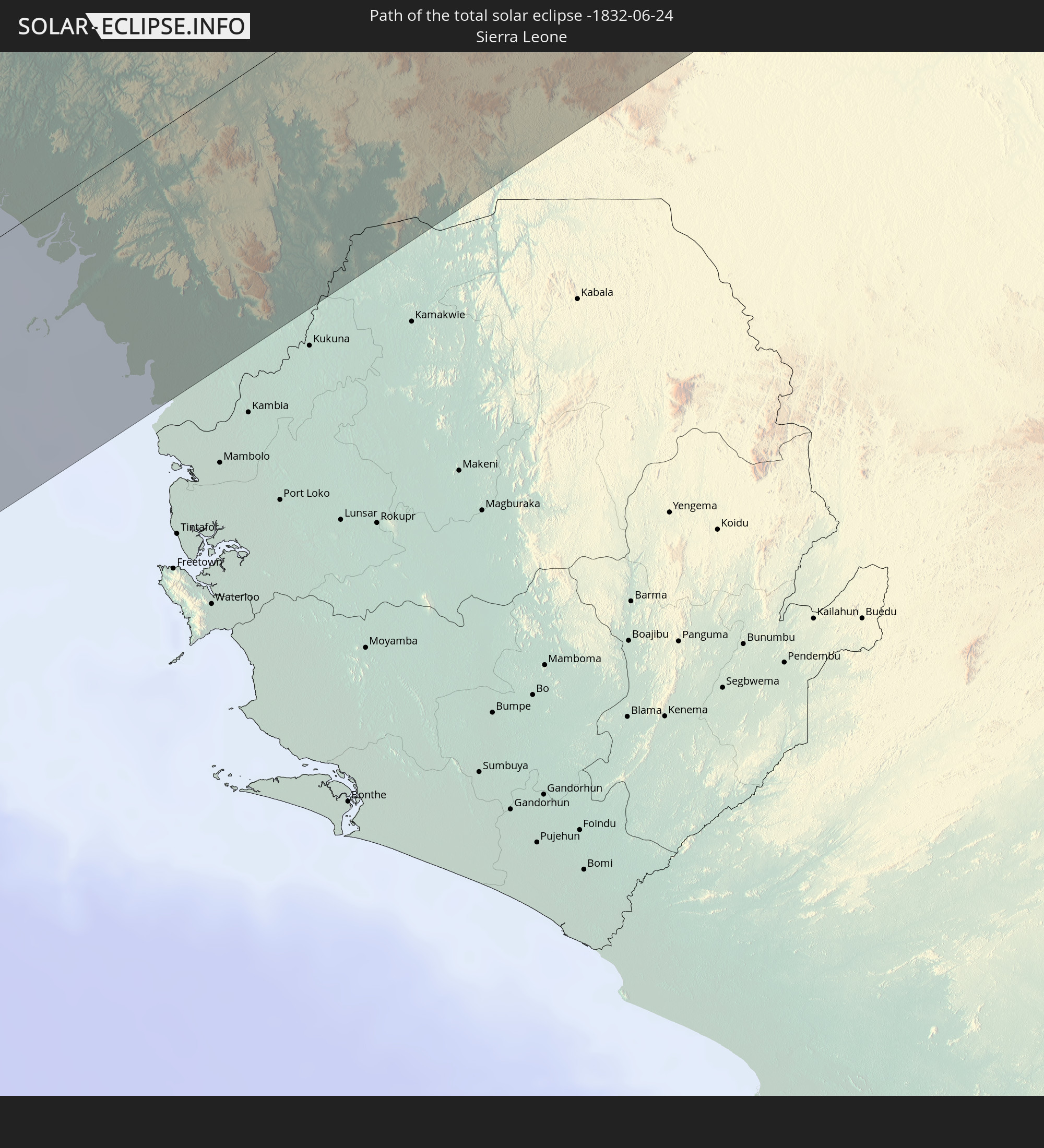 Sierra Leone
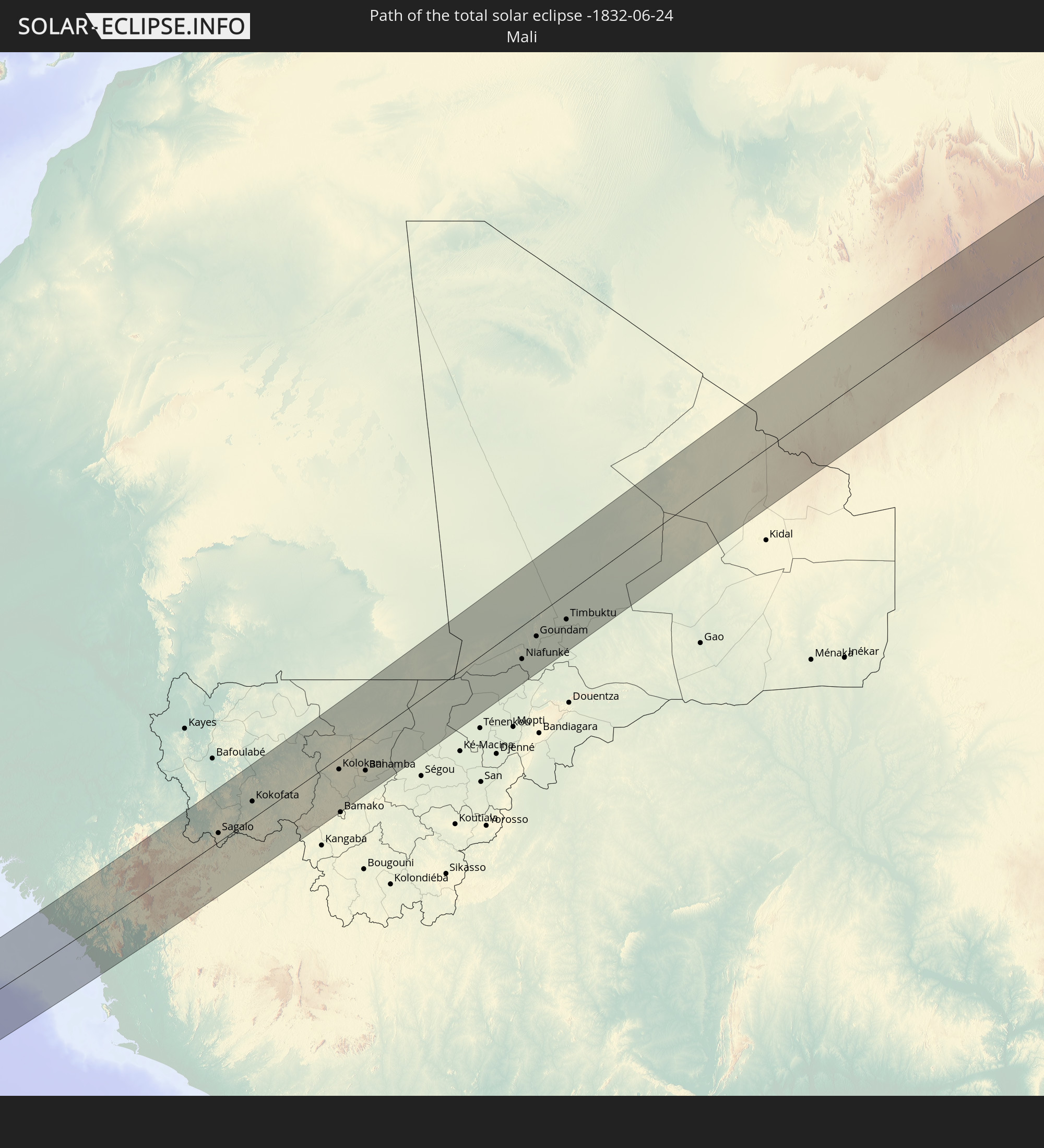 Mali
Mali
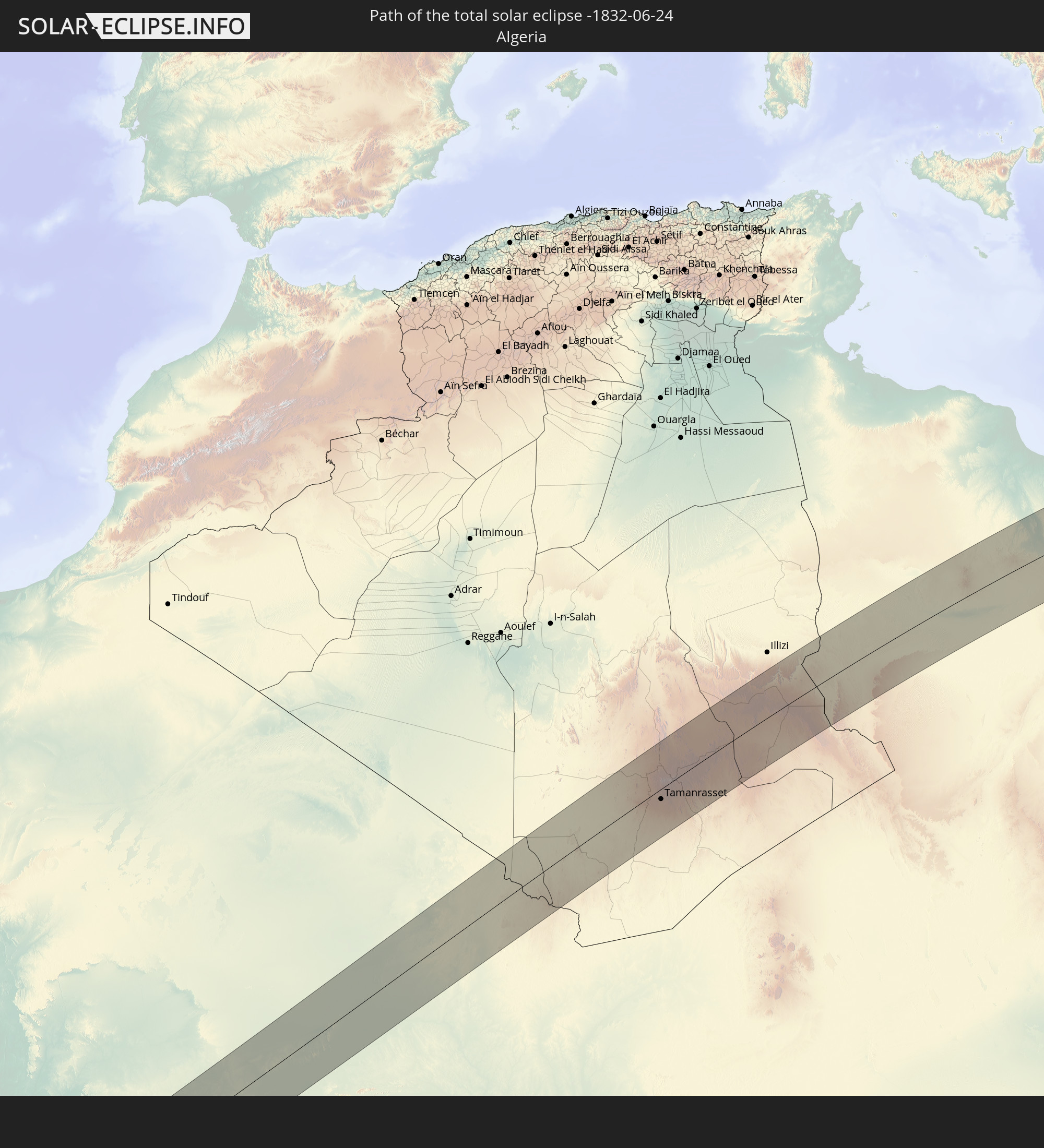 Algerien
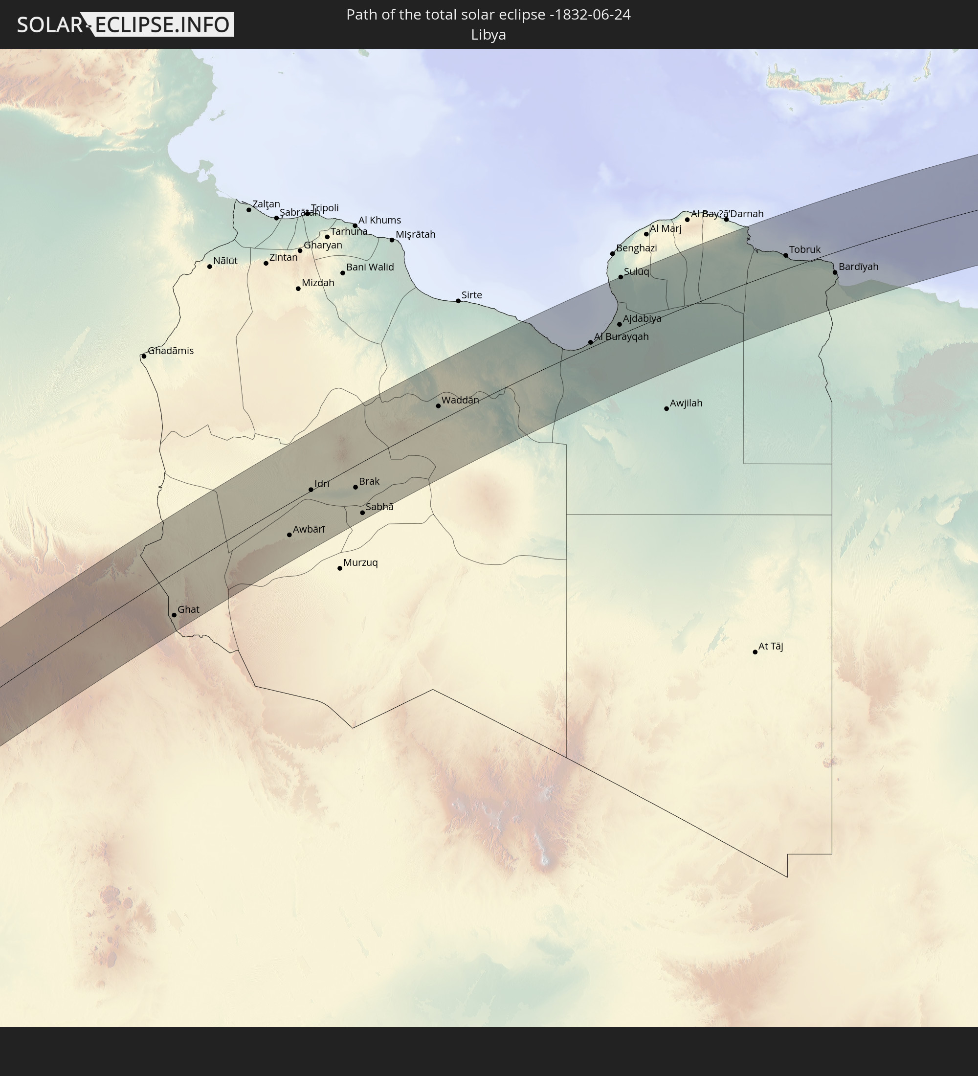 Libyen
 Ägypten
 Republik Zypern
 Israel
 Jordanien
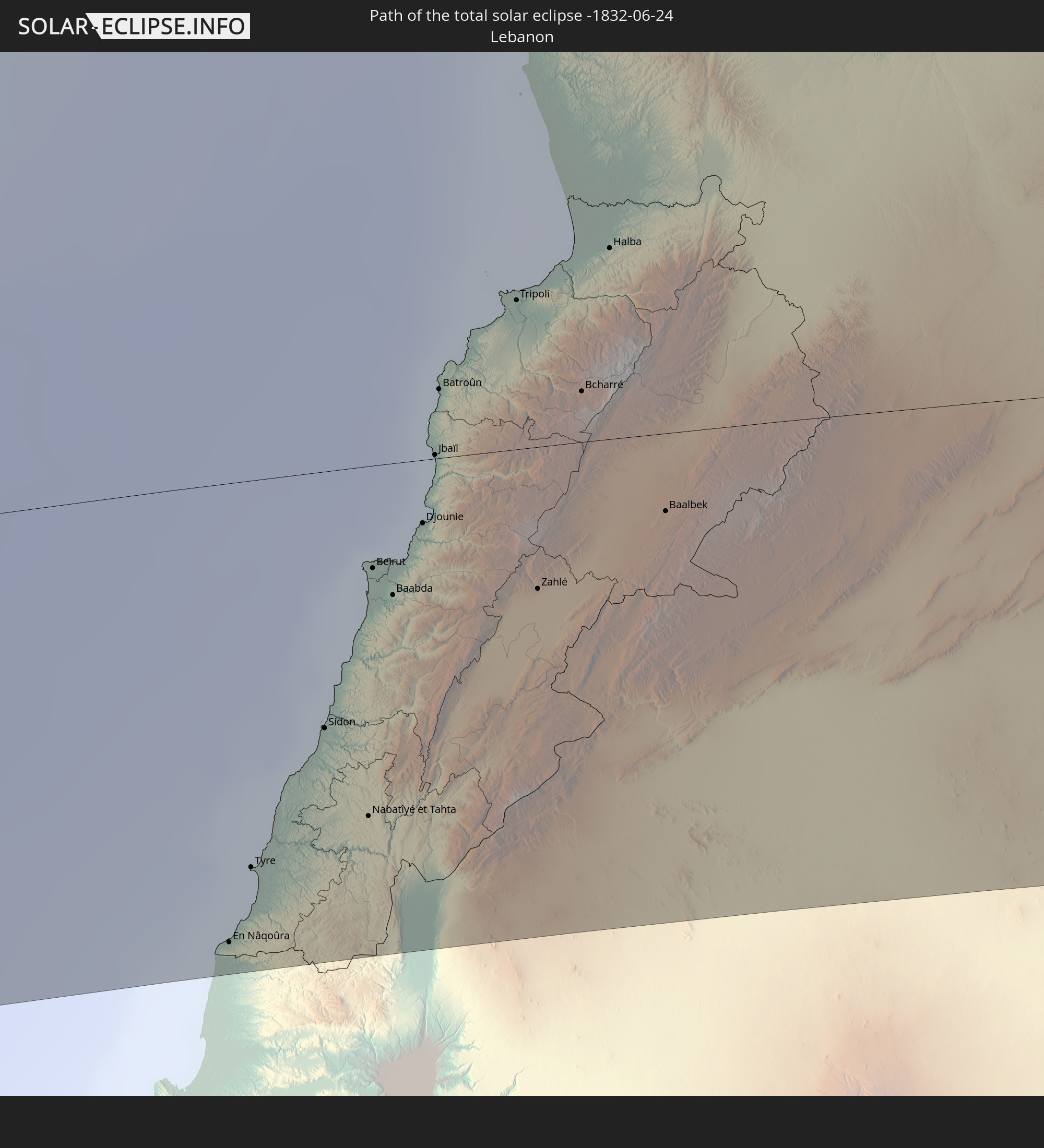 Libanon
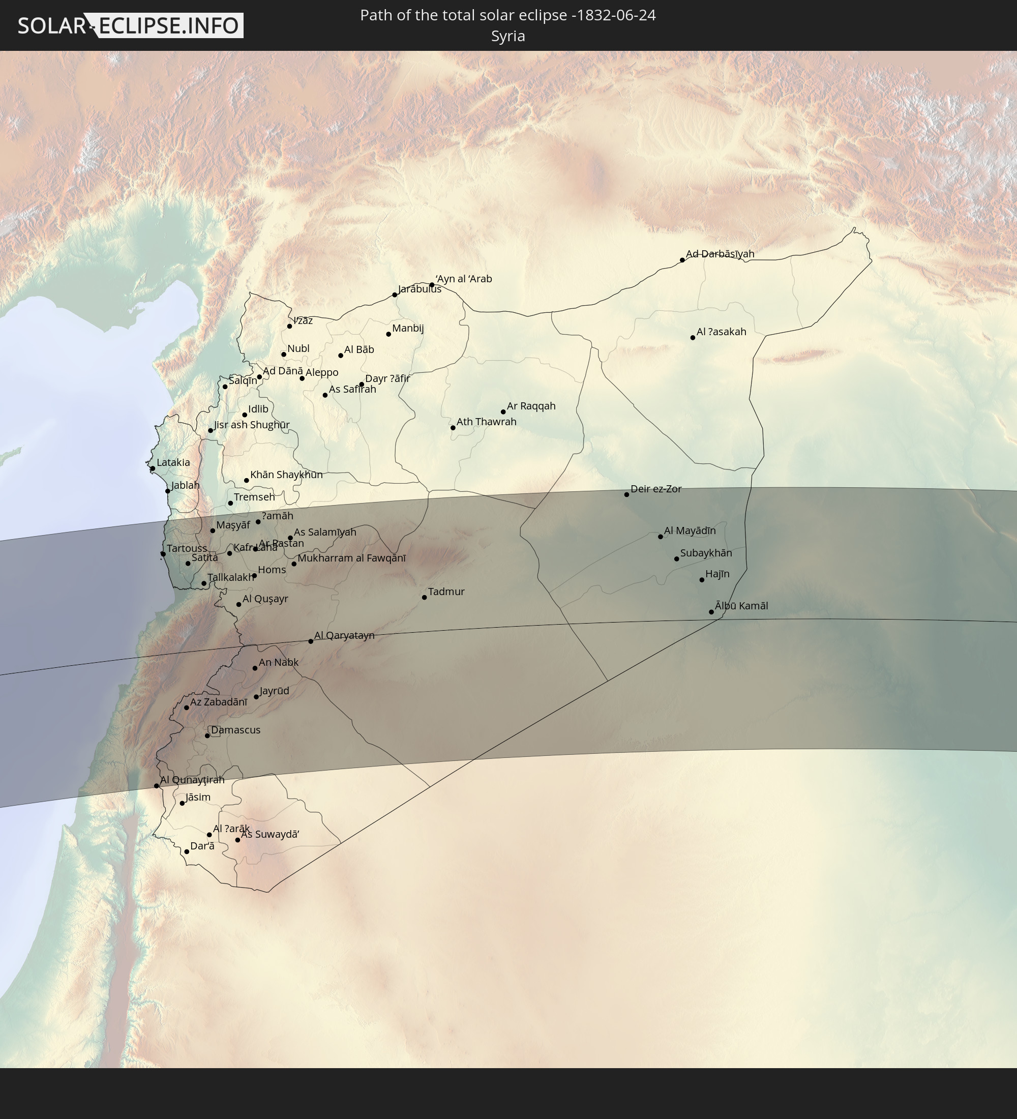 Syrien
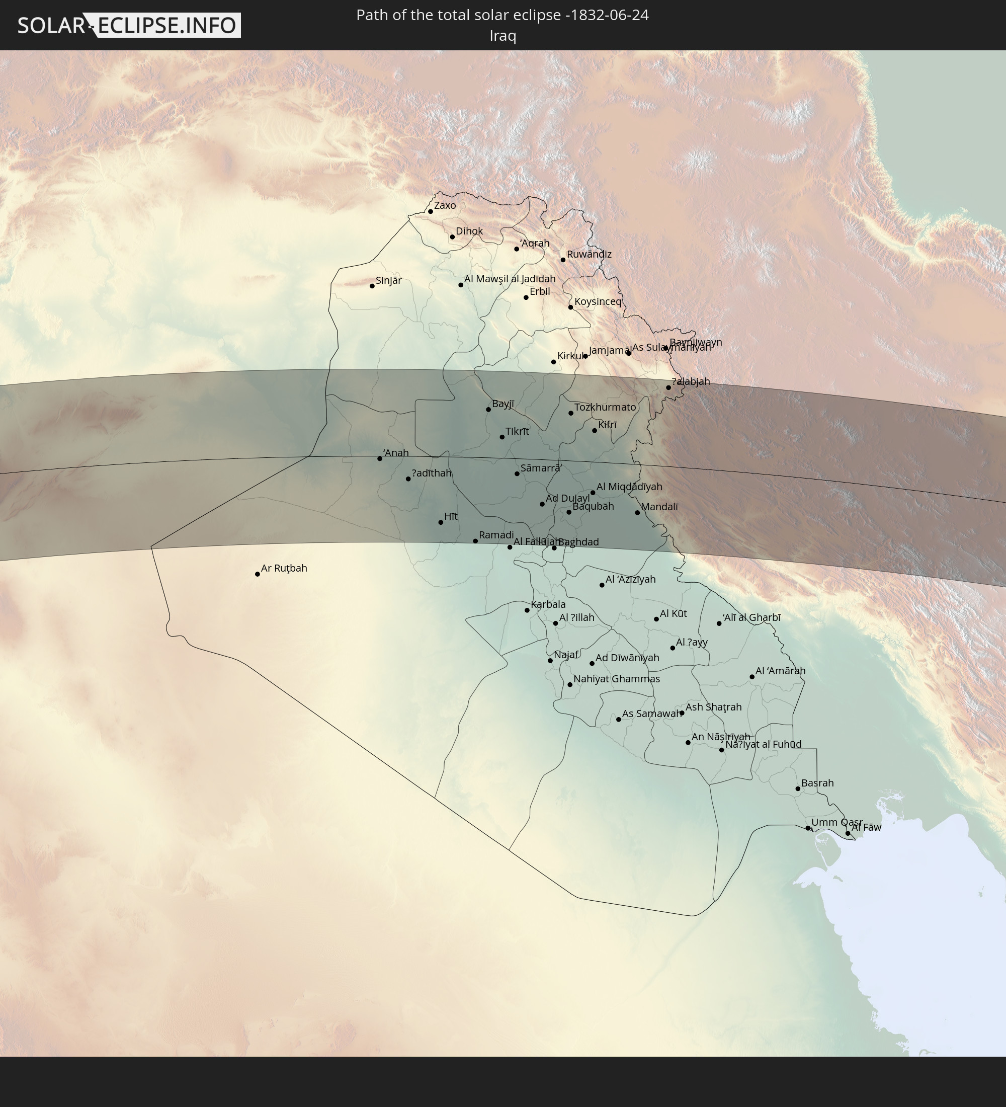 Irak
Irak
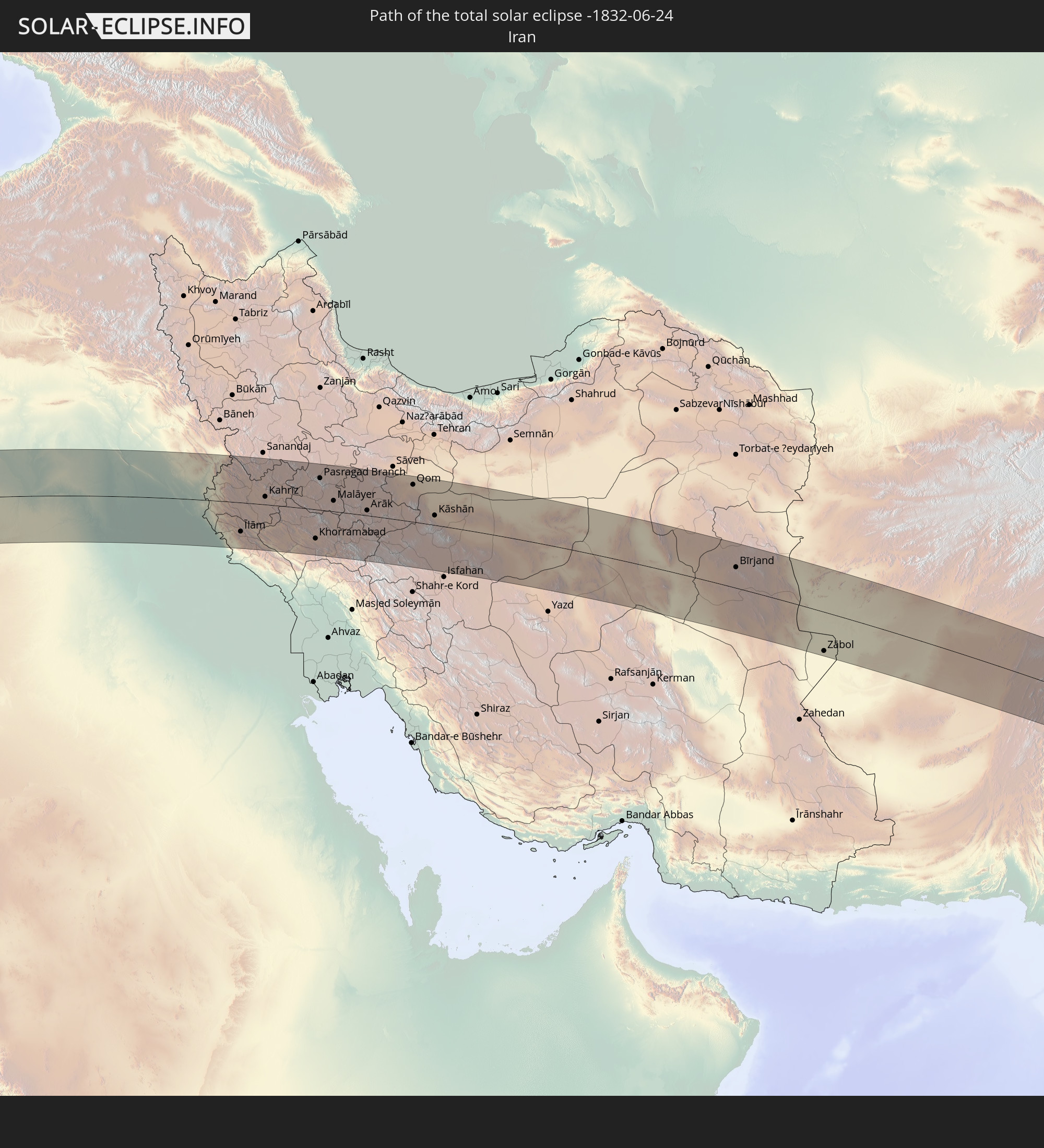 Iran
Iran
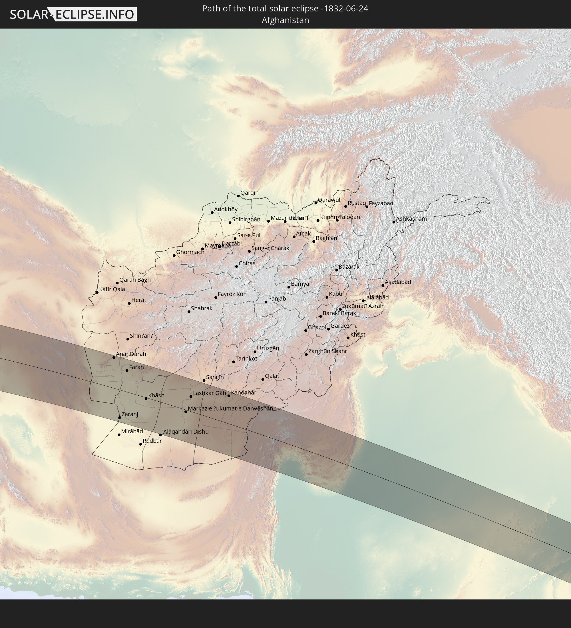 Afghanistan
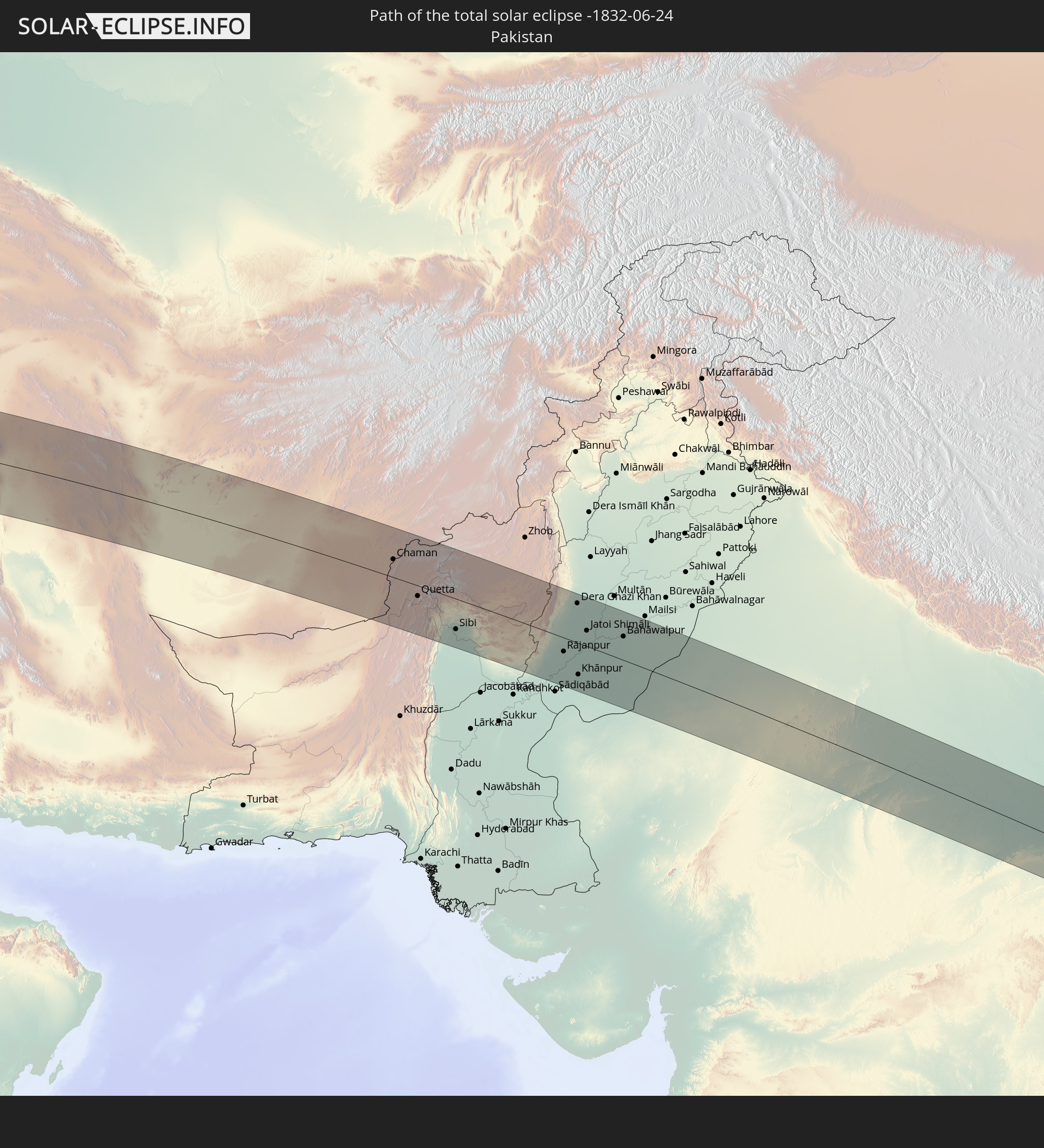 Pakistan
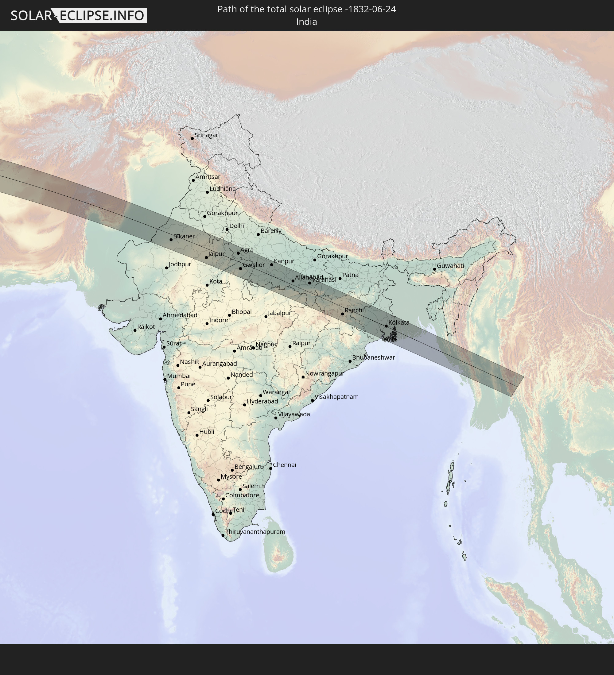 Indien
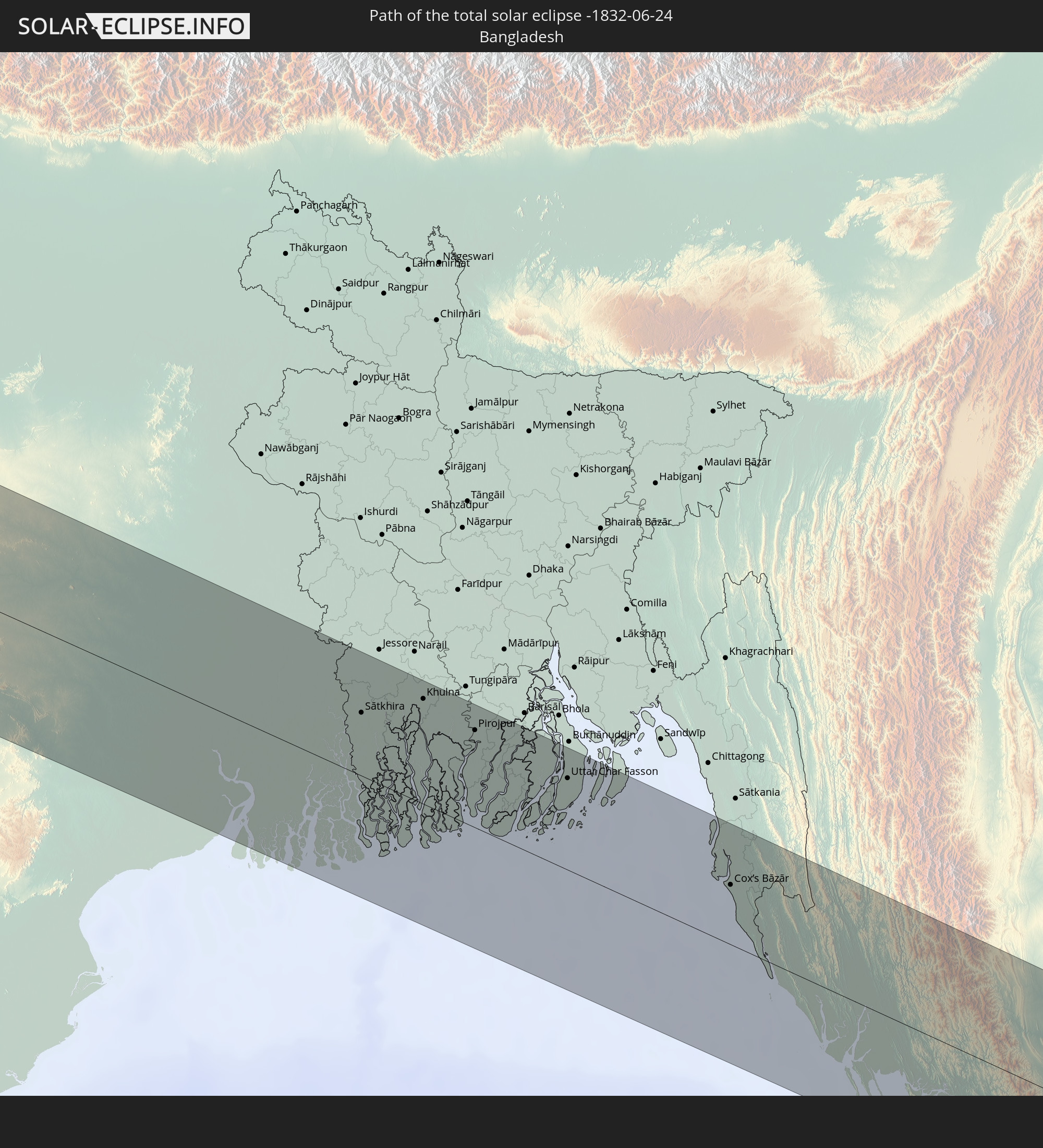 Bangladesch
 Myanmar
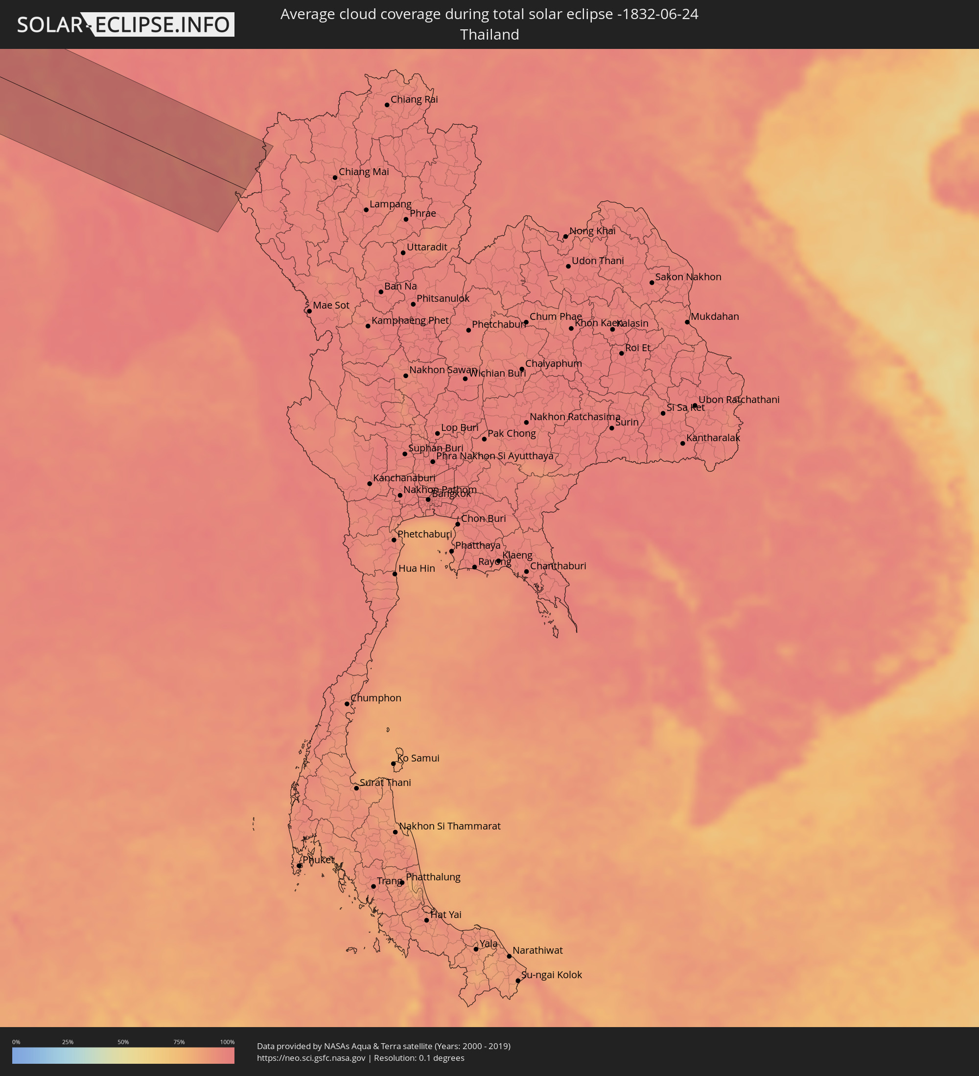
 Thailand
In den folgenden Ländern ist die Sonnenfinsternis partiell zu sehen
 Russland
 Brasilien
 Portugal
 Kap Verde
 Spanien
 Senegal
 Mauretanien
 Gambia
 Guinea-Bissau
 Guinea
 St. Helena
 Sierra Leone
 Marokko
 Mali
Mali
 Liberia
 Irland
 Algerien
 Vereinigtes Königreich
 Elfenbeinküste
 Burkina Faso
 Gibraltar
 Frankreich
 Isle of Man
 Ghana
Ghana
 Guernsey
 Jersey
 Togo
Togo
 Niger
Niger
 Benin
Benin
 Andorra
 Belgien
 Nigeria
 Niederlande
 Norwegen
 Äquatorialguinea
 Luxemburg
 Deutschland
 Schweiz
 São Tomé und Príncipe
 Italien
 Monaco
 Tunesien
 Dänemark
 Kamerun
 Gabun
Gabun
 Libyen
 Liechtenstein
 Österreich
 Schweden
 Republik Kongo
 Angola
 Tschechien
 Demokratische Republik Kongo
 San Marino
 Vatikanstadt
 Slowenien
 Tschad
 Kroatien
 Polen
Polen
 Malta
Malta
 Zentralafrikanische Republik
 Bosnien und Herzegowina
 Ungarn
 Slowakei
 Montenegro
 Serbien
 Albanien
 Åland Islands
 Griechenland
 Rumänien
 Mazedonien
 Finnland
 Litauen
 Lettland
 Estland
 Sudan
Sudan
 Ukraine
 Bulgarien
 Weißrussland
 Ägypten
 Türkei
 Moldawien
 Uganda
 Republik Zypern
 Äthiopien
 Kenia
Kenia
 Staat Palästina
 Israel
 Saudi-Arabien
 Jordanien
 Libanon
 Syrien
 Eritrea
 Irak
Irak
 Georgien
 Somalia
 Dschibuti
 Jemen
Jemen
 Armenien
 Iran
Iran
 Aserbaidschan
 Kasachstan
 Kuwait
 Bahrain
 Katar
Katar
 Vereinigte Arabische Emirate
 Oman
Oman
 Turkmenistan
 Usbekistan
 Afghanistan
 Pakistan
 Tadschikistan
 Indien
 Kirgisistan
 Malediven
 Volksrepublik China
 Sri Lanka
 Nepal
Nepal
 Mongolei
 Bangladesch
 Bhutan
 Myanmar
 Thailand
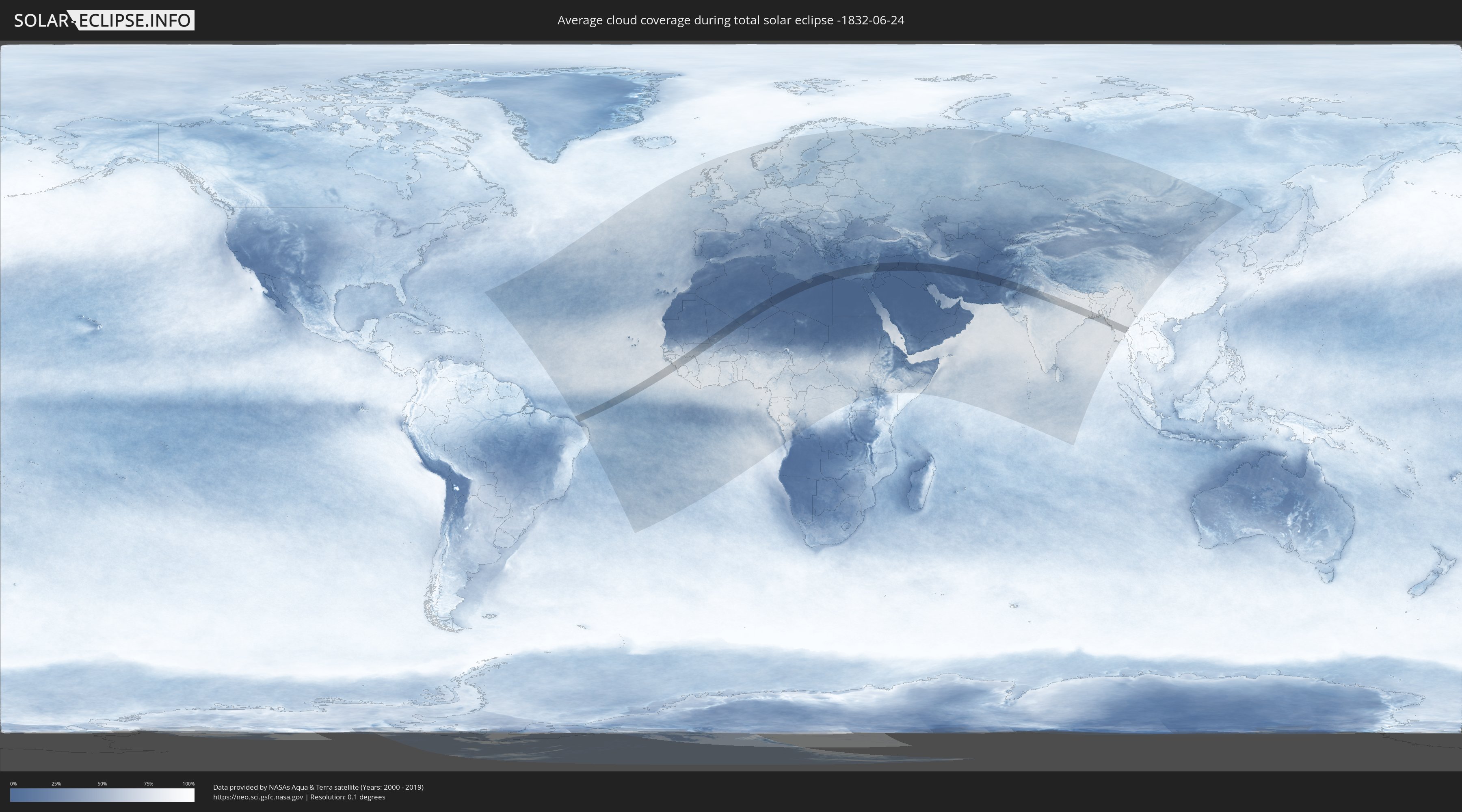
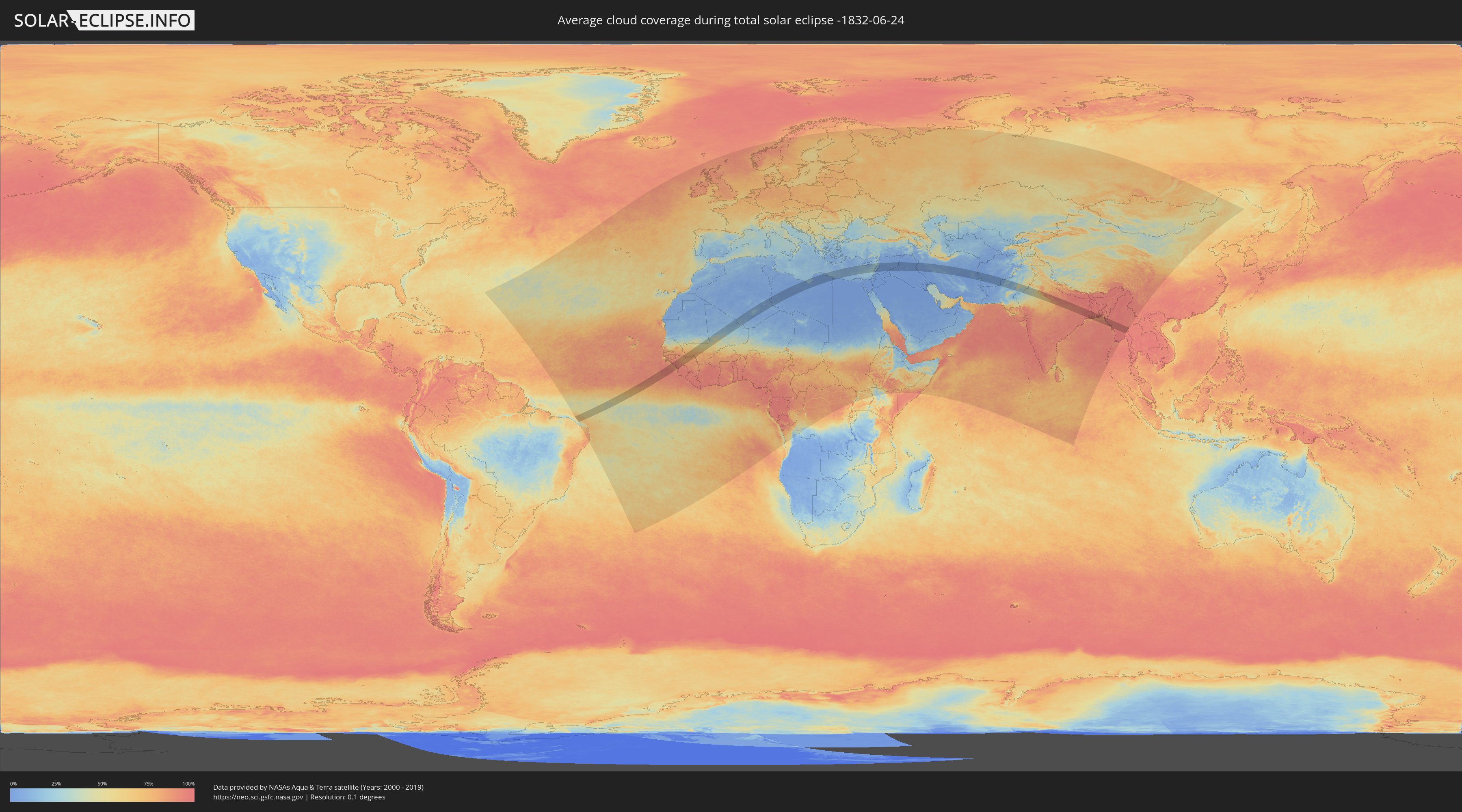
Wie wird das Wetter während der totalen Sonnenfinsternis am 24.06.-1832?
Wo ist der beste Ort, um die totale Sonnenfinsternis vom 24.06.-1832 zu beobachten?
Die folgenden Karten zeigen die durchschnittliche Bewölkung für den Tag, an dem die totale Sonnenfinsternis
stattfindet. Mit Hilfe der Karten lässt sich der Ort entlang des Finsternispfades eingrenzen,
der die besten Aussichen auf einen klaren wolkenfreien Himmel bietet.
Trotzdem muss man immer lokale Gegenenheiten beachten und sollte sich genau über das Wetter an seinem
gewählten Beobachtungsort informieren.
Die Daten stammen von den beiden NASA-Satelliten
AQUA und TERRA
und wurden über einen Zeitraum von 19 Jahren (2000 - 2019) gemittelt.
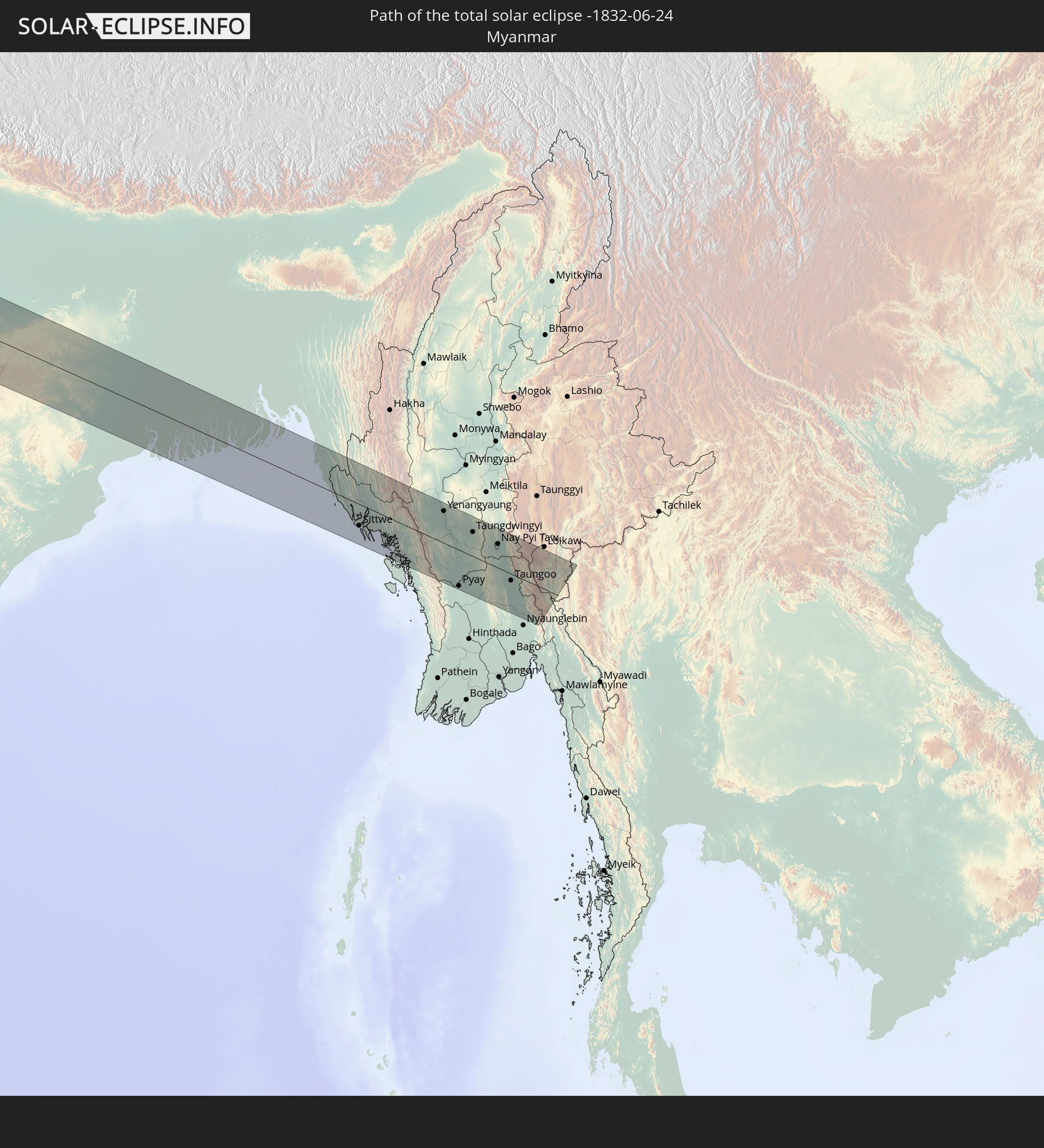
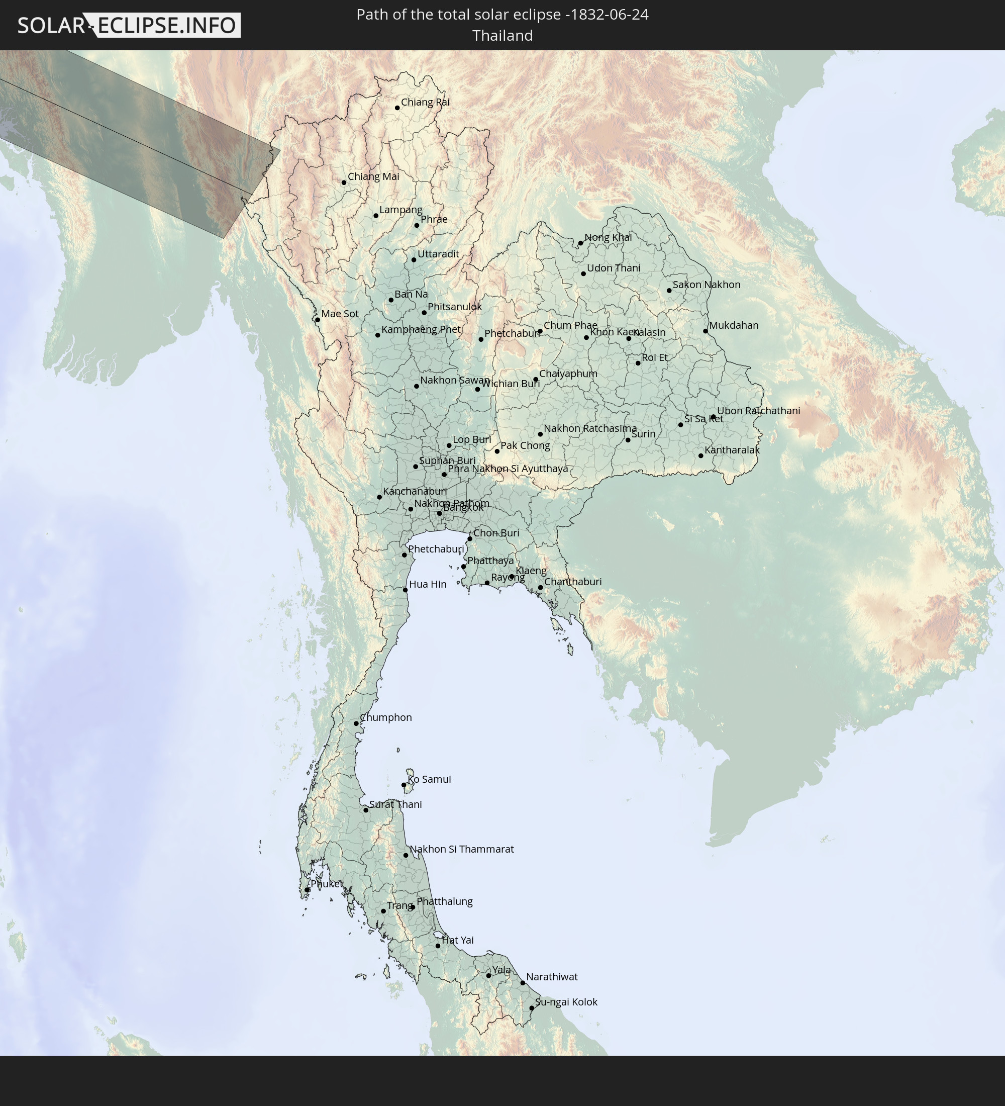
Detaillierte Länderkarten
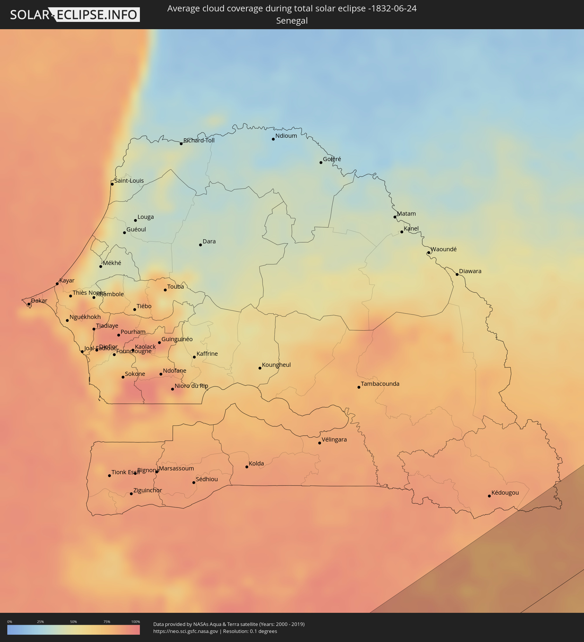 Senegal
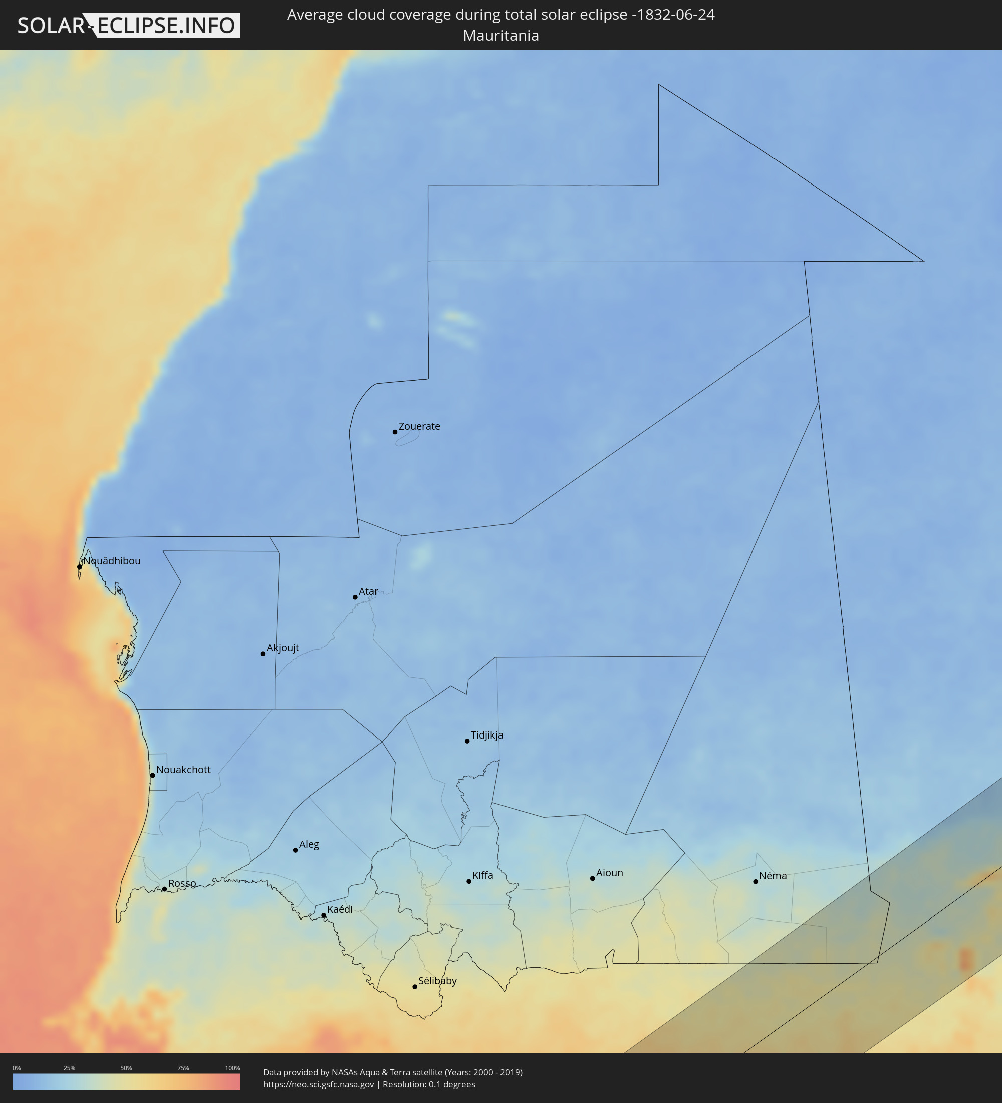 Mauretanien
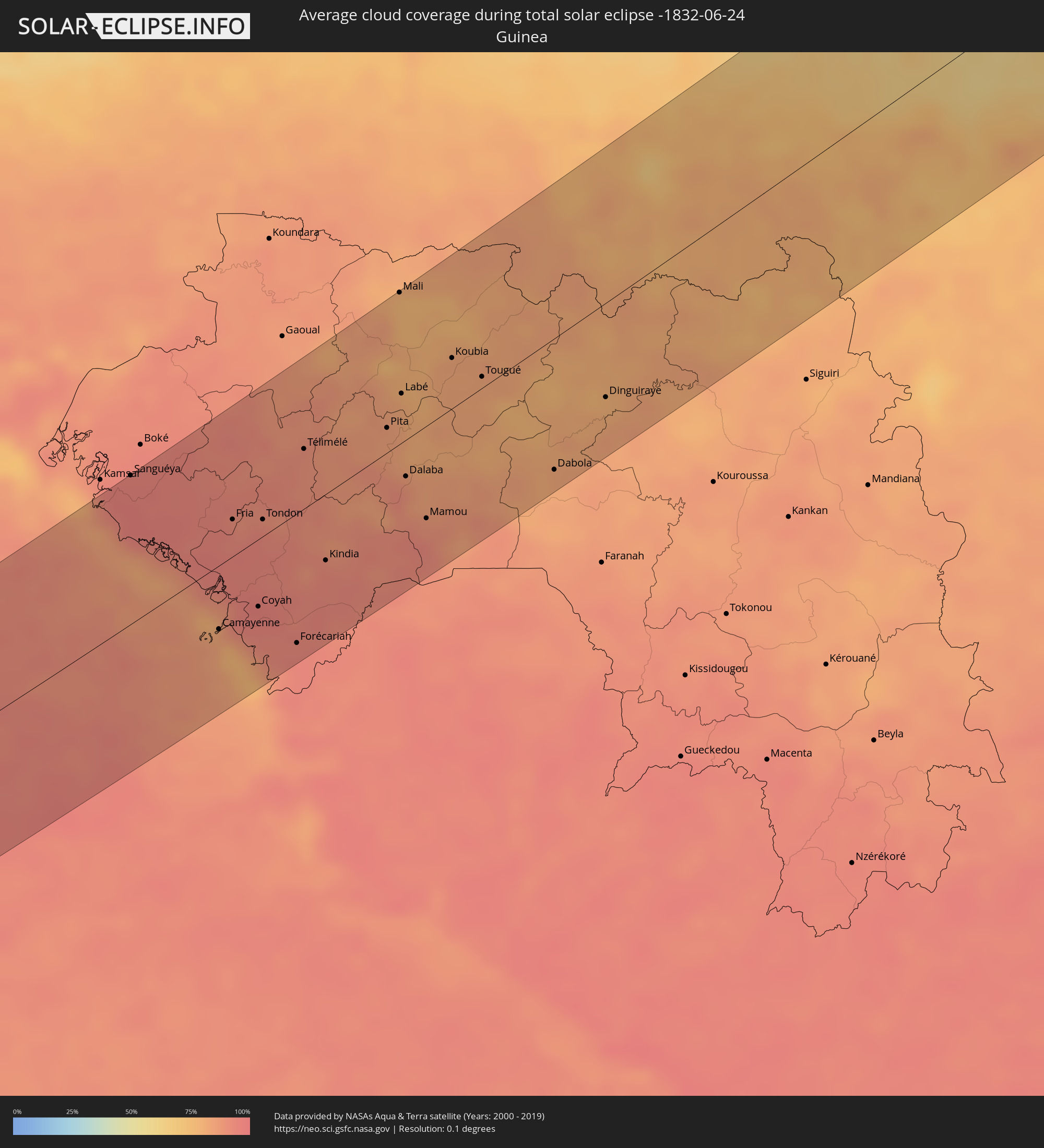 Guinea
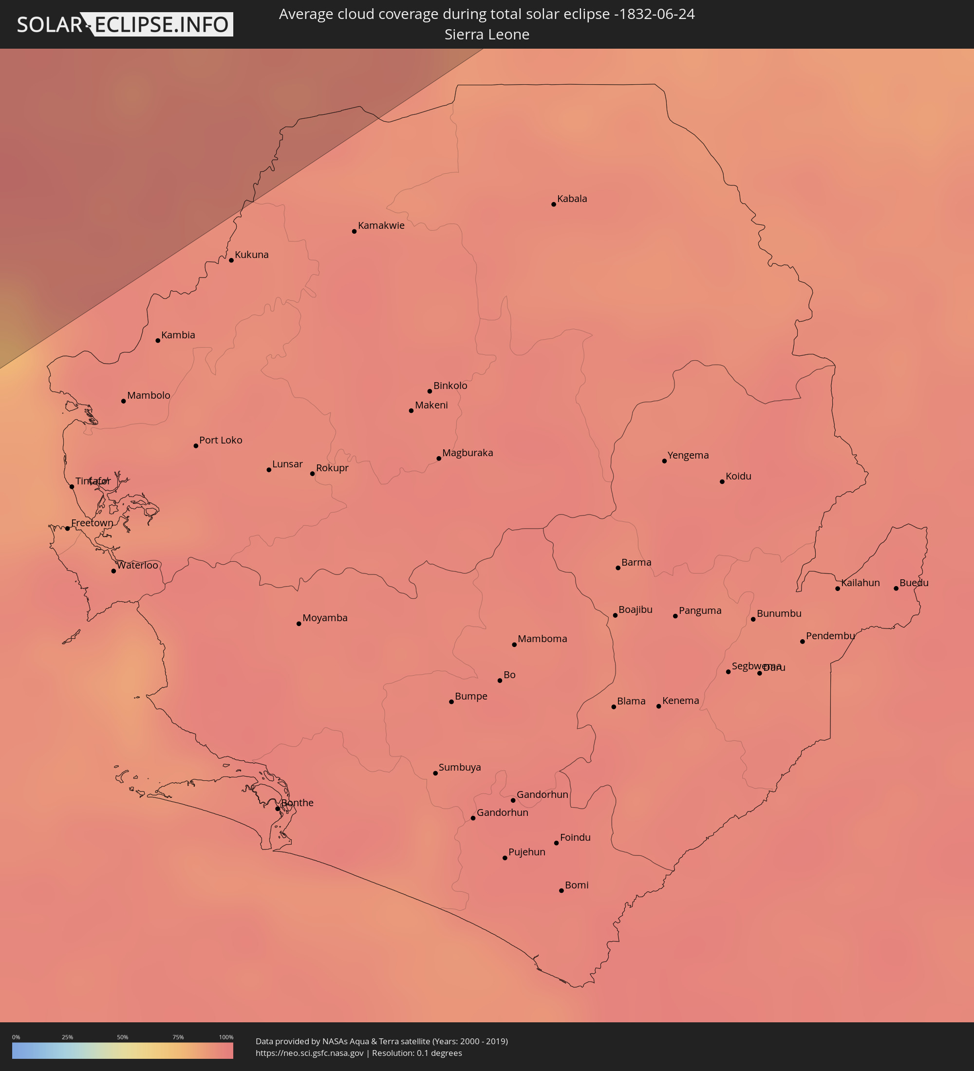 Sierra Leone
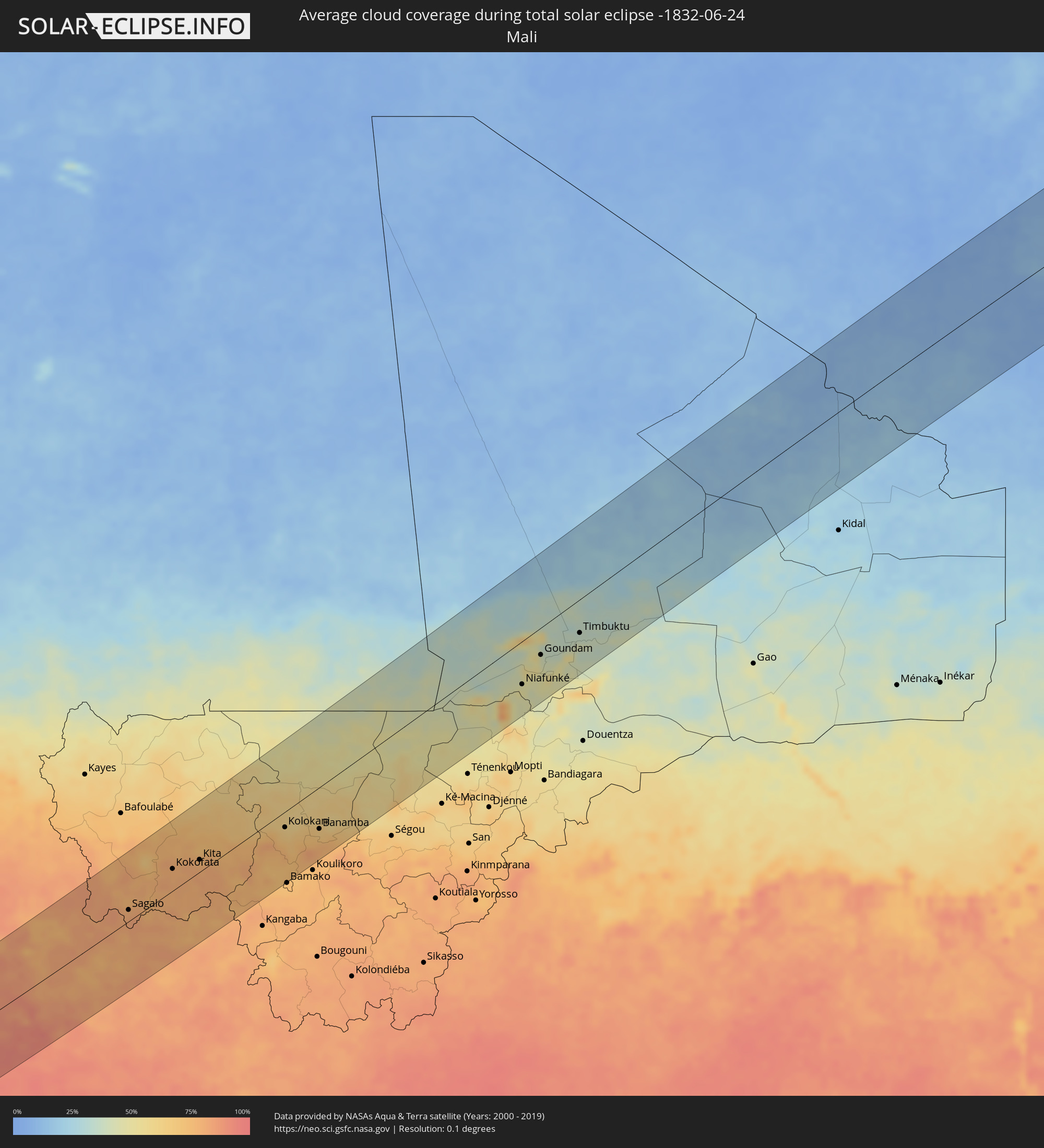 Mali
Mali
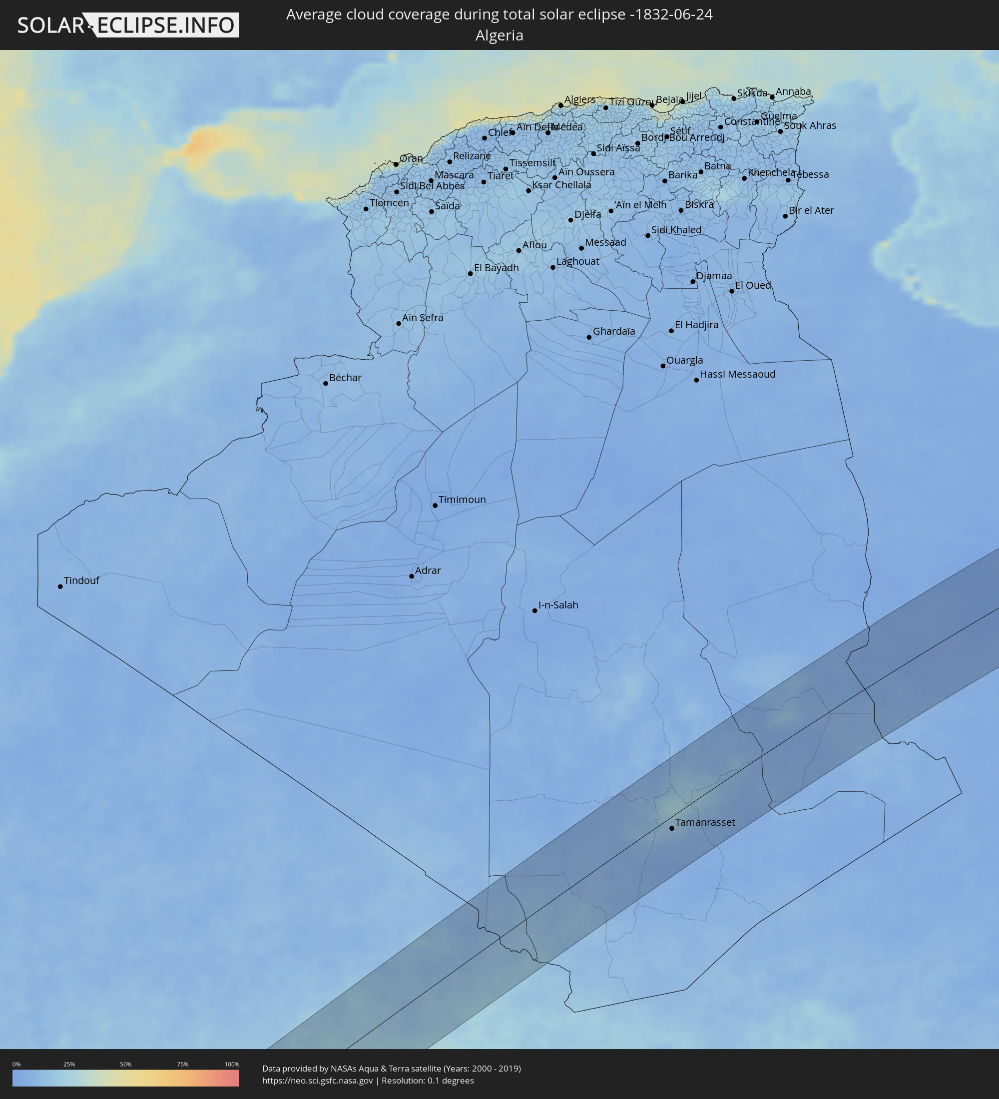 Algerien
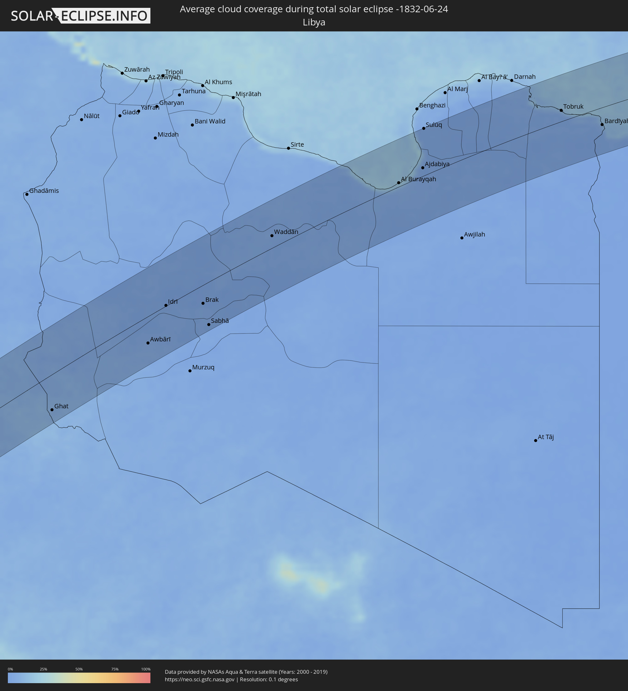 Libyen
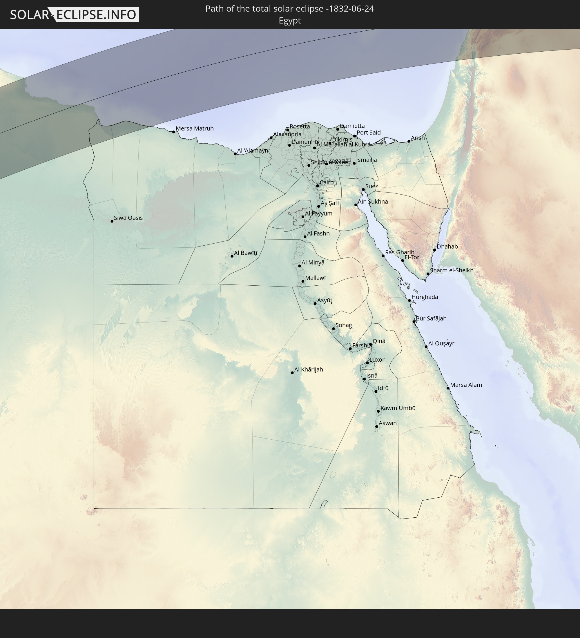
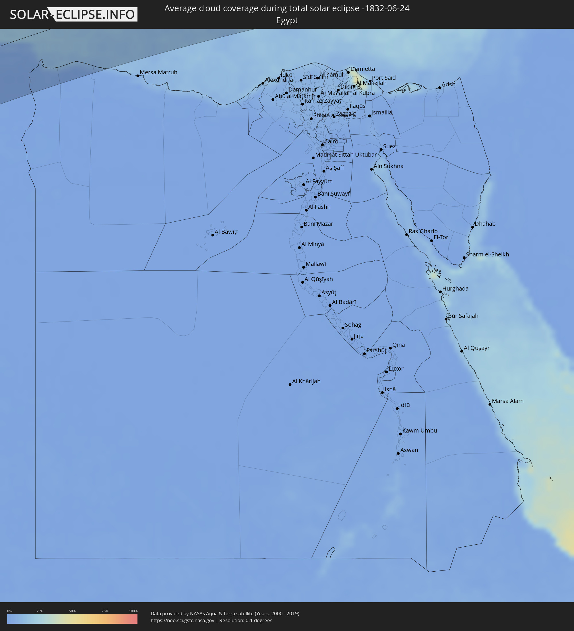 Ägypten
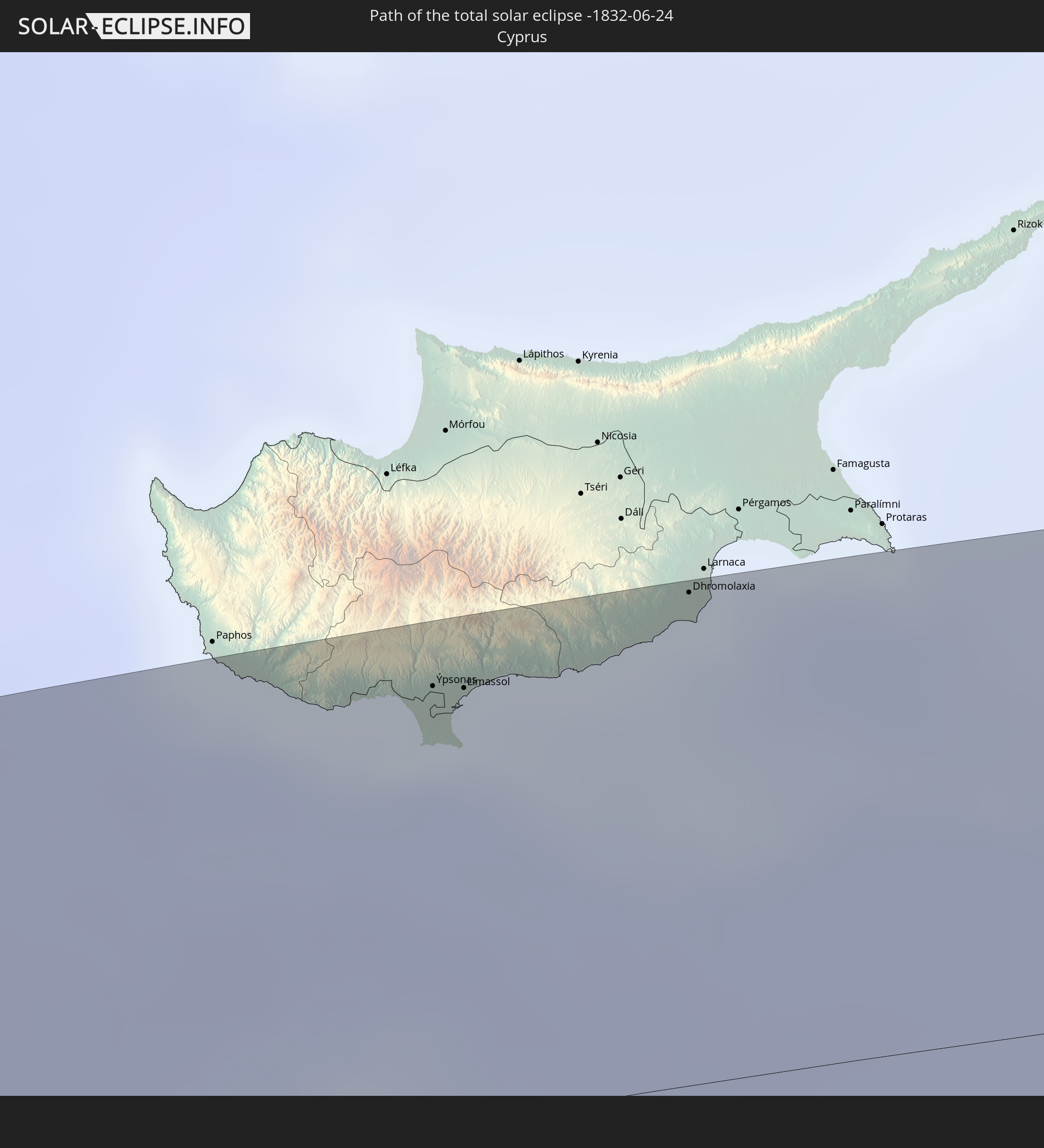
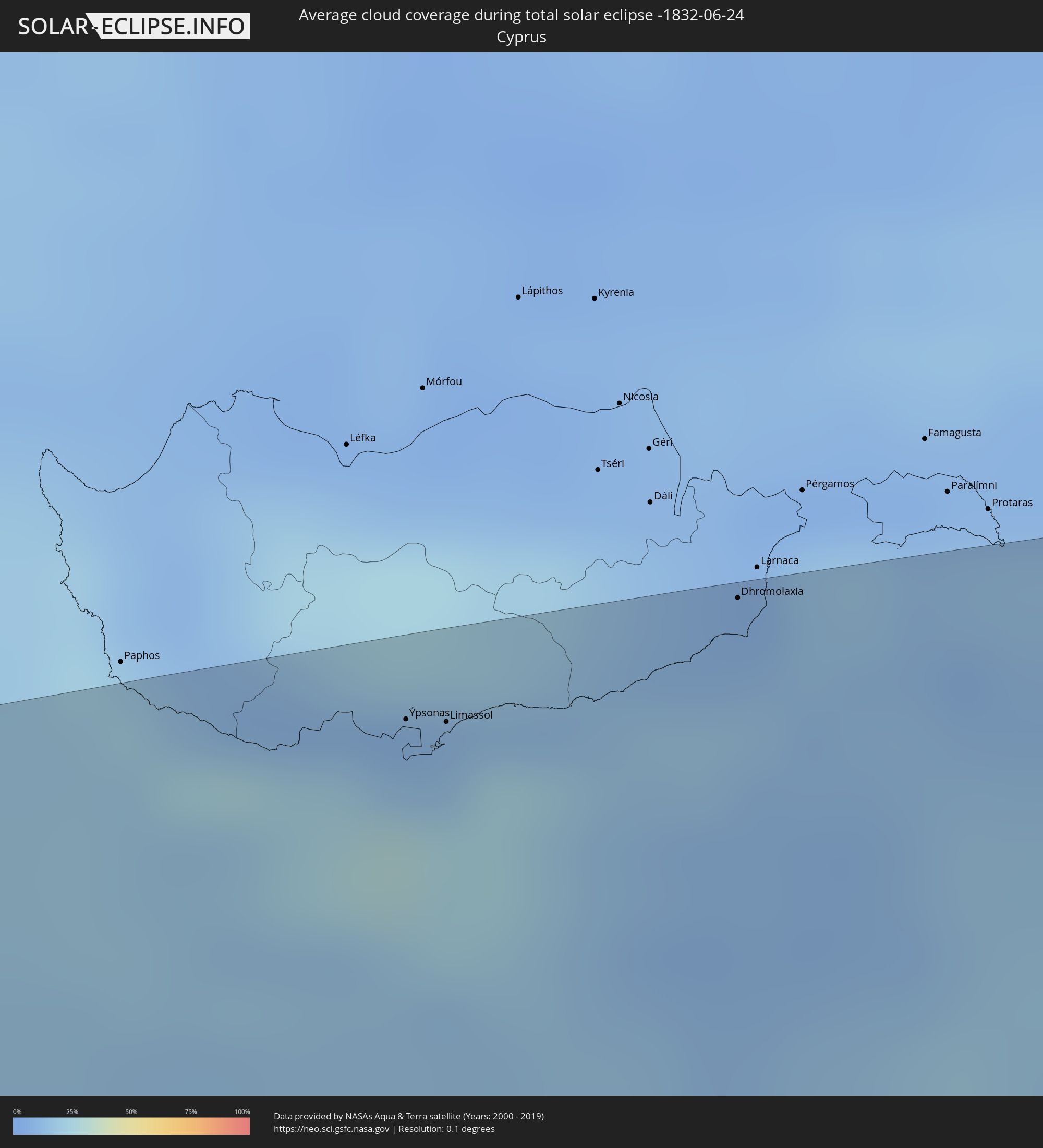 Republik Zypern
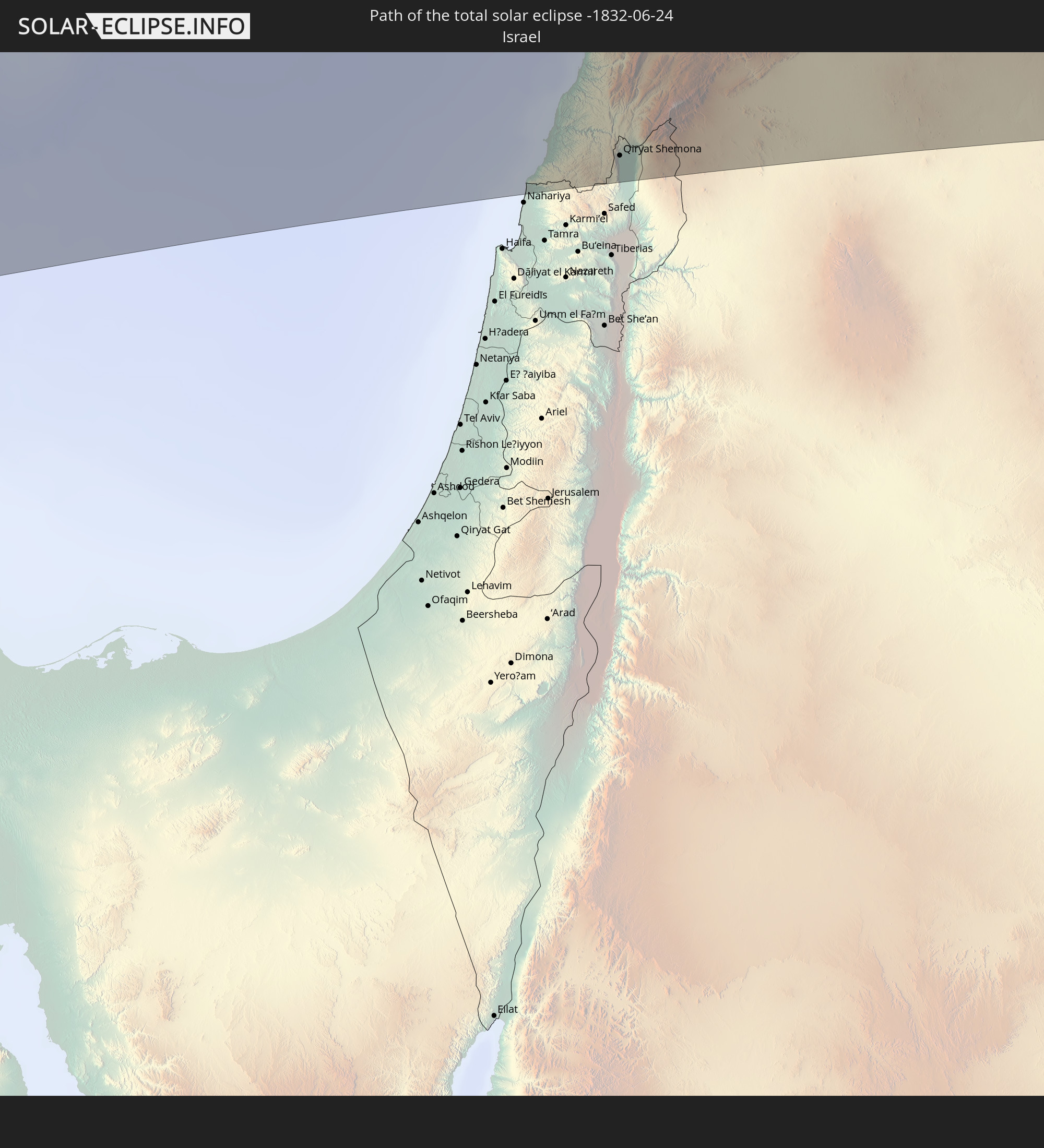
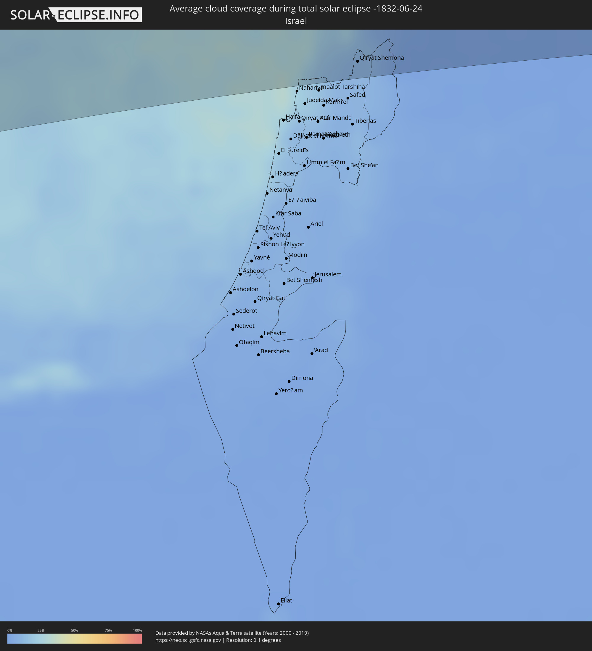 Israel
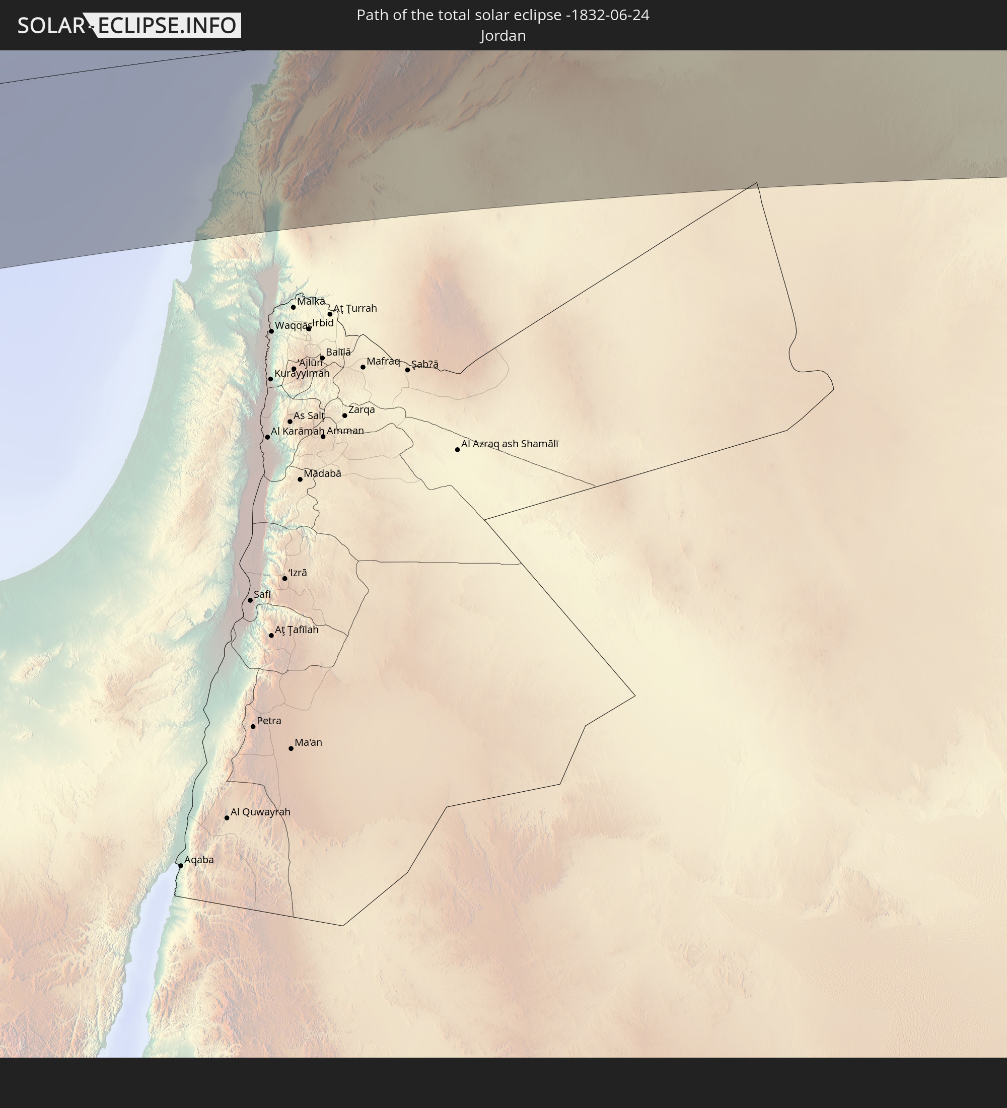
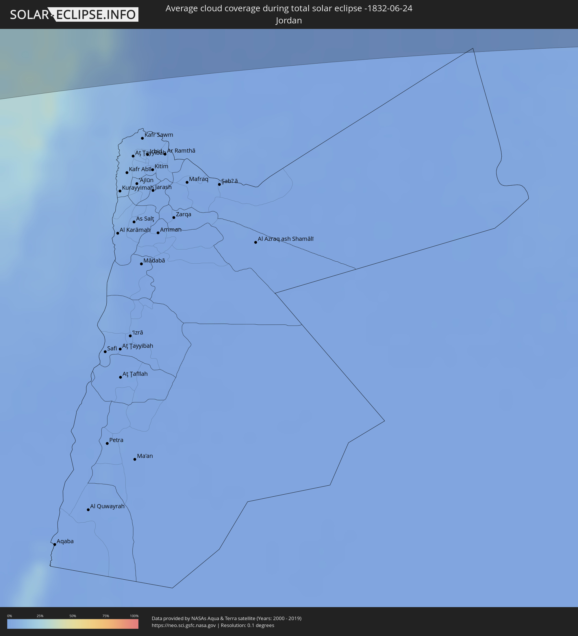 Jordanien
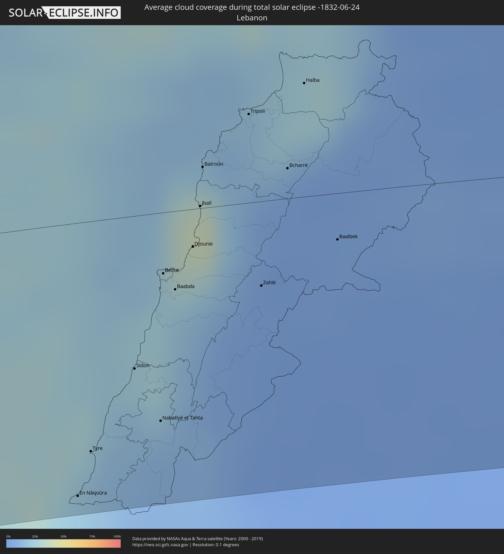 Libanon
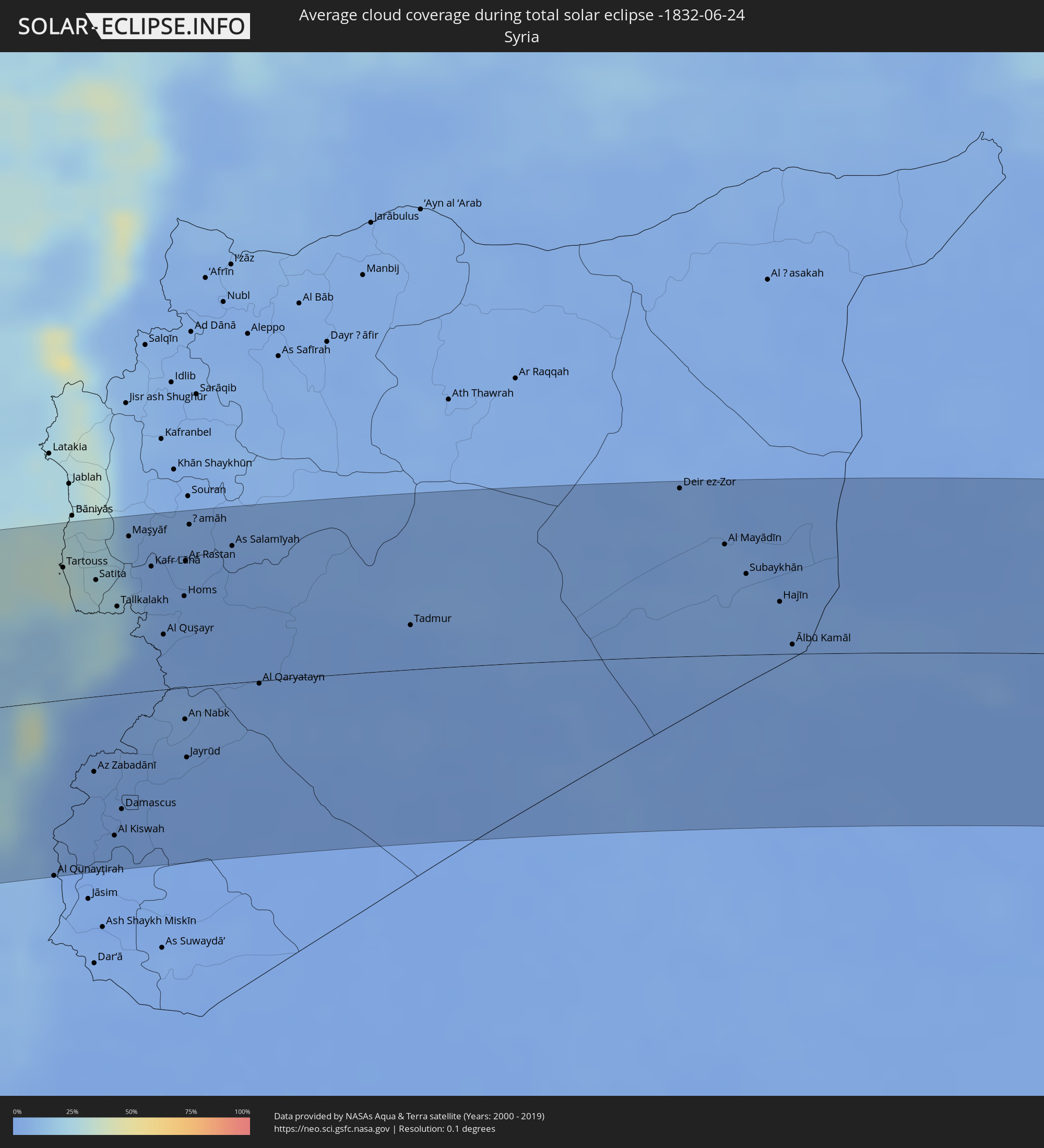 Syrien
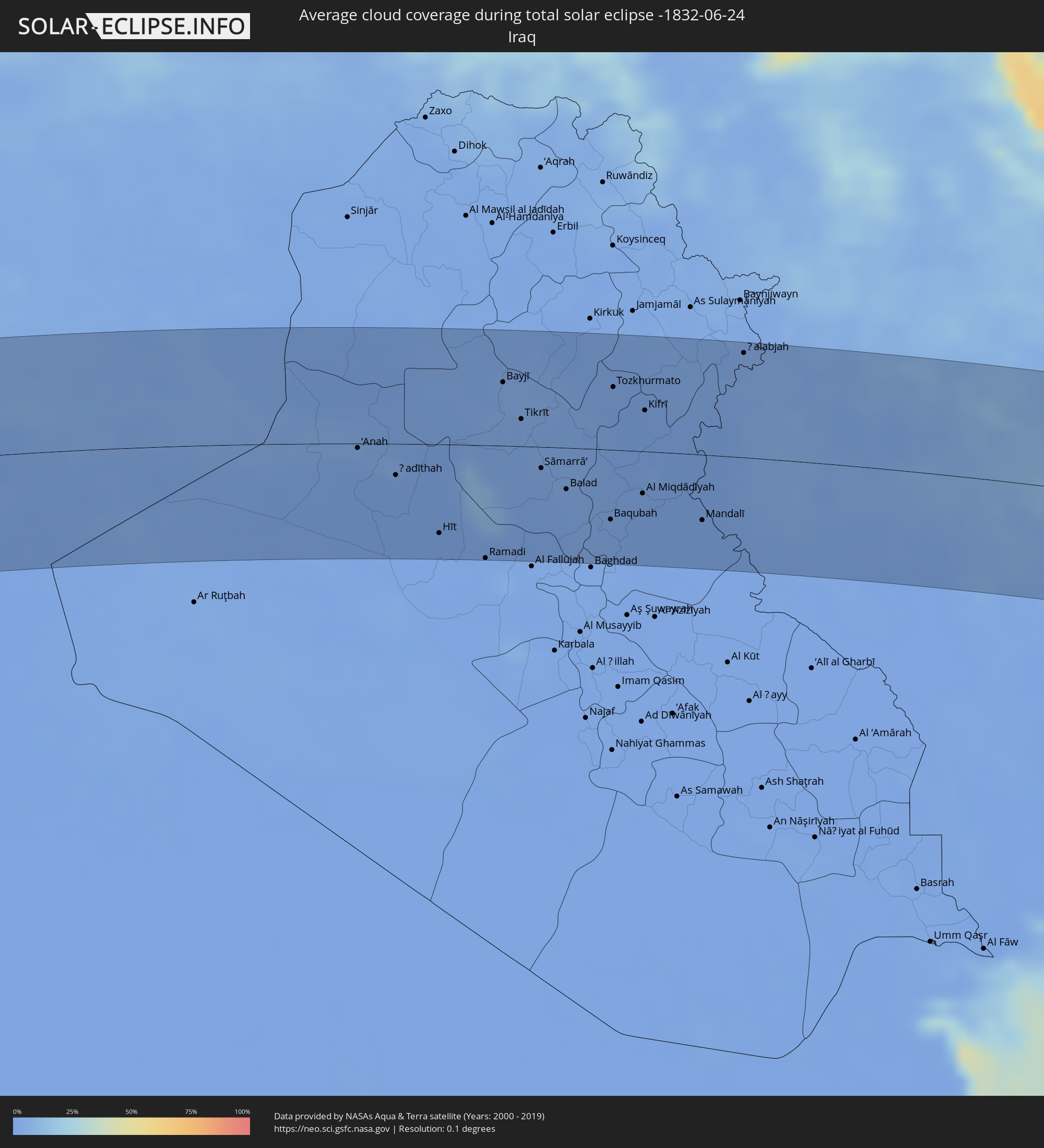 Irak
Irak
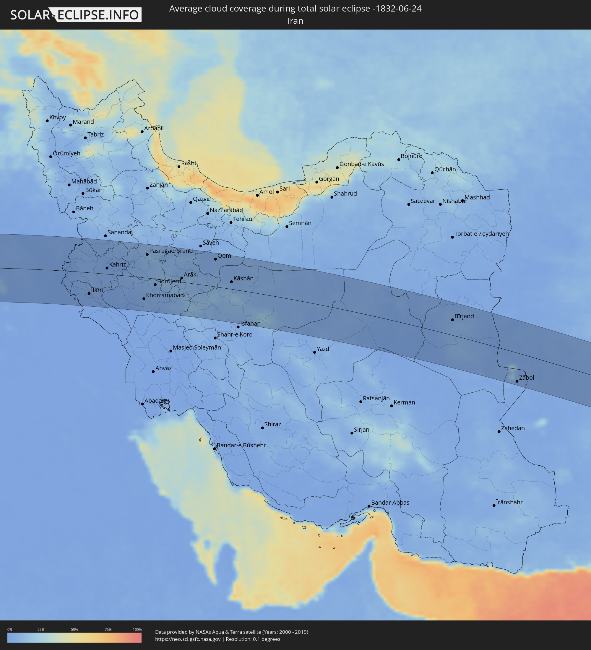 Iran
Iran
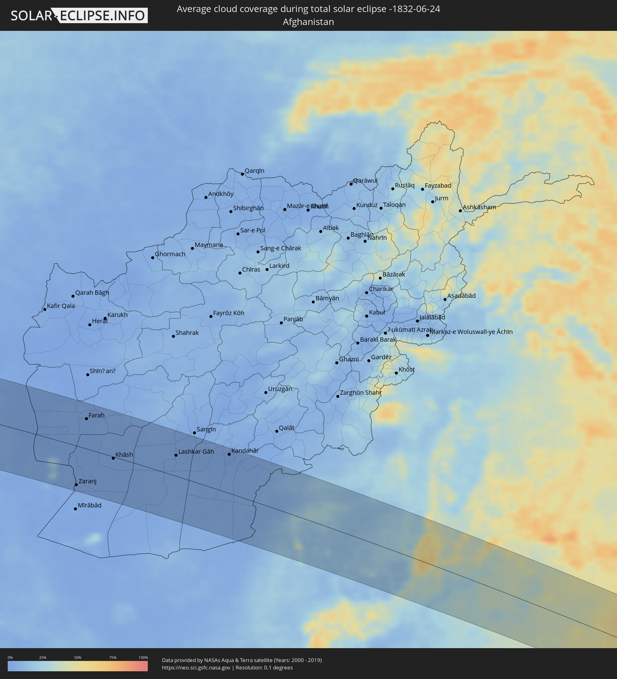 Afghanistan
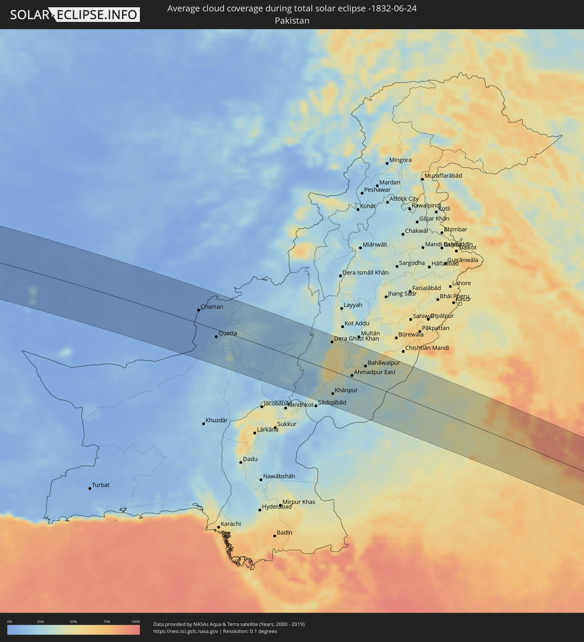 Pakistan
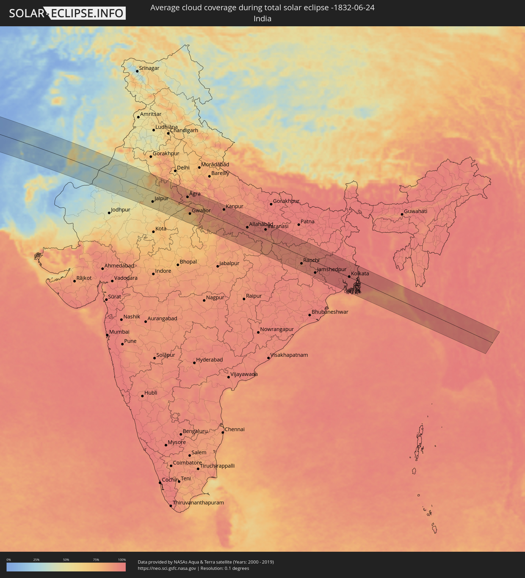 Indien
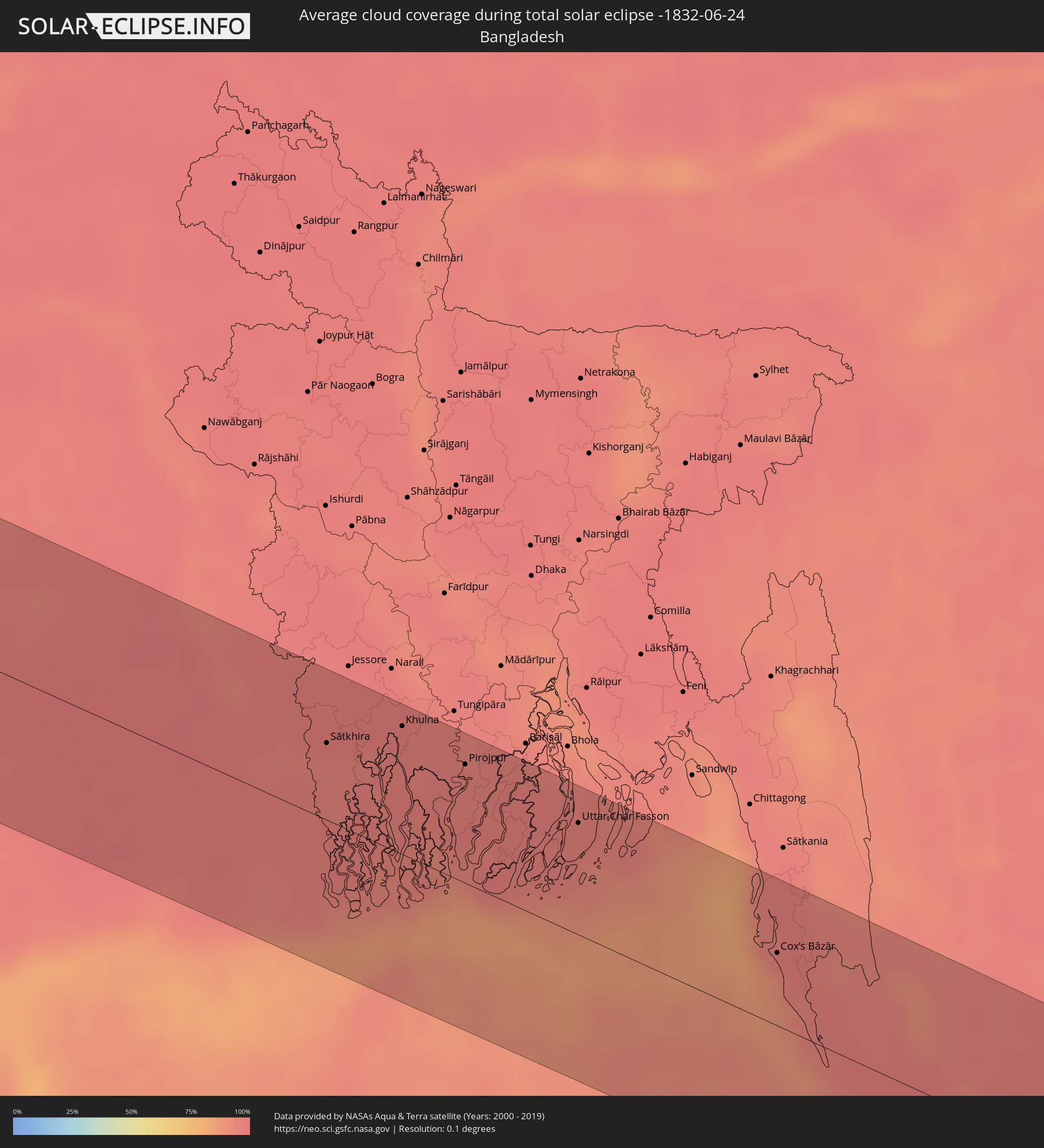 Bangladesch
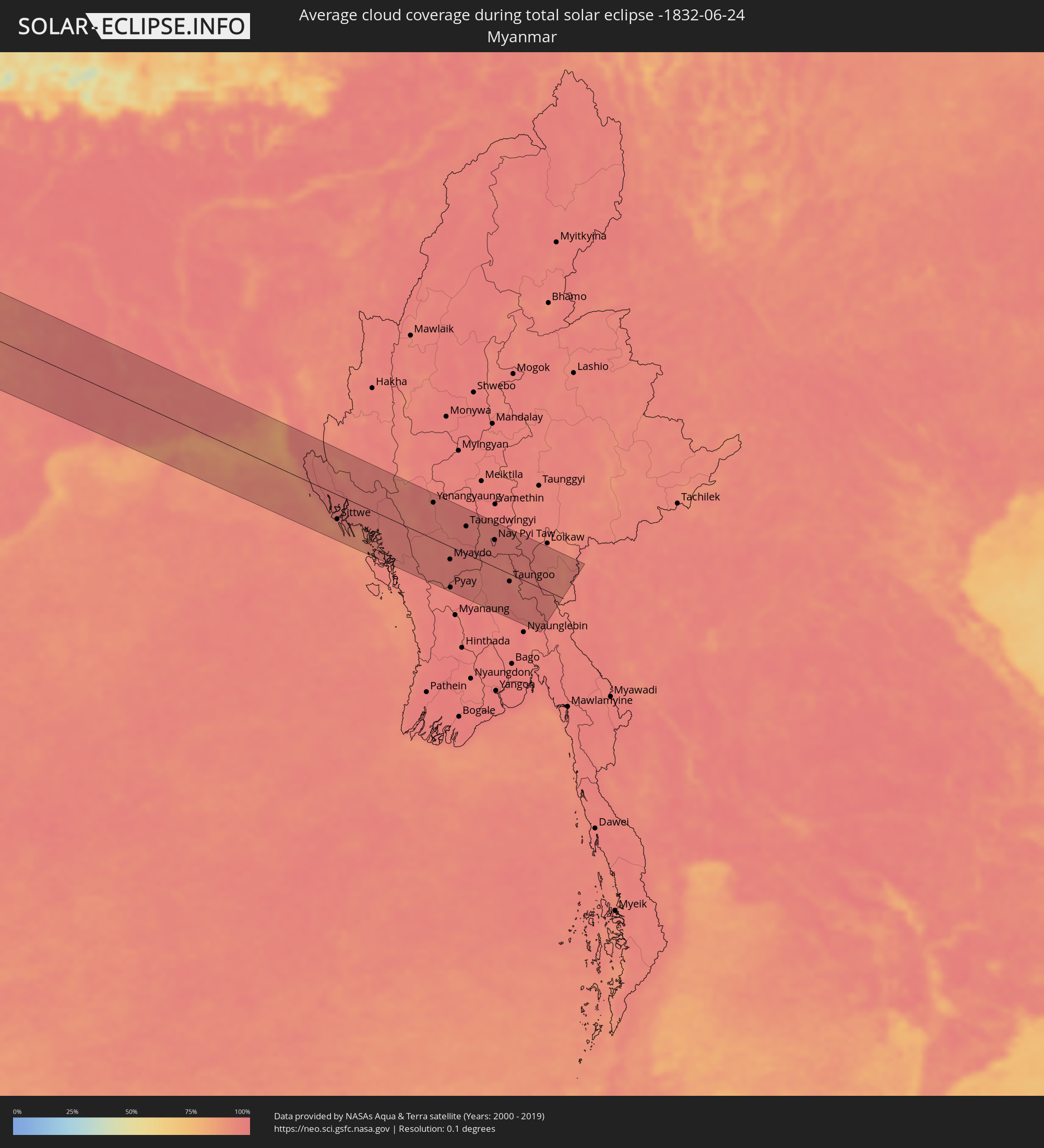 Myanmar
 Thailand
Orte im Finsternispfad
Die nachfolgene Tabelle zeigt Städte und Orte mit mehr als 5.000 Einwohnern, die sich im Finsternispfad befinden. Städte mit mehr als 100.000 Einwohnern sind dick gekennzeichnet. Mit einem Klick auf den Ort öffnet sich eine Detailkarte die die Lage des jeweiligen Ortes zusammen mit dem Verlauf der zentralen Finsternis präsentiert.
| Ort | Typ | Dauer der Verfinsterung | Ortszeit bei maximaler Verfinsterung | Entfernung zur Zentrallinie | Ø Bewölkung |
|
Camayenne, Conakry
|
total | - | 08:27:11 UTC-00:16 | 45 km | 84% |
|
Fria, Boke
|
total | - | 08:28:13 UTC-00:16 | 26 km | 94% |
|
Dubréka, Kindia
|
total | - | 08:27:35 UTC-00:16 | 31 km | 95% |
|
Coyah, Kindia
|
total | - | 08:27:35 UTC-00:16 | 47 km | 95% |
|
Tondon, Kindia
|
total | - | 08:28:22 UTC-00:16 | 12 km | 93% |
|
Forécariah, Kindia
|
total | - | 08:27:27 UTC-00:16 | 91 km | 94% |
|
Télimélé, Kindia
|
total | - | 08:29:12 UTC-00:16 | 42 km | 89% |
|
Kindia, Kindia
|
total | - | 08:28:19 UTC-00:16 | 46 km | 92% |
|
Pita, Mamou
|
total | - | 08:29:50 UTC-00:16 | 17 km | 84% |
|
Labé, Labe
|
total | - | 08:30:13 UTC-00:16 | 34 km | 82% |
|
Mamou, Mamou
|
total | - | 08:29:14 UTC-00:16 | 64 km | 90% |
|
Koubia, Labe
|
total | - | 08:30:49 UTC-00:16 | 35 km | 82% |
|
Tougué, Labe
|
total | - | 08:30:49 UTC-00:16 | 8 km | 82% |
|
Dabola, Faranah
|
total | - | 08:30:23 UTC-00:16 | 91 km | 81% |
|
Diré
|
total | - | 08:32:23 UTC-00:16 | 42 km | 83% |
|
Sagalo, Kayes
|
total | - | 08:32:29 UTC-00:16 | 17 km | 81% |
|
Kokofata
|
total | - | 08:33:57 UTC-00:16 | 33 km | 79% |
|
Kita, Kayes
|
total | - | 08:34:32 UTC-00:16 | 18 km | 79% |
|
Kati, Koulikoro
|
total | - | 08:35:23 UTC-00:16 | 96 km | 72% |
|
Kolokani, Koulikoro
|
total | - | 08:36:31 UTC-00:16 | 23 km | 64% |
|
Banamba, Koulikoro
|
total | - | 08:37:01 UTC-00:16 | 62 km | 71% |
|
Niafunké, Tombouctou
|
total | - | 08:43:53 UTC-00:16 | 63 km | 50% |
|
Goundam, Tombouctou
|
total | - | 08:44:56 UTC-00:16 | 40 km | 49% |
|
Timbuktu, Tombouctou
|
total | - | 08:46:13 UTC-00:16 | 49 km | 37% |
|
Tamanrasset, Tamanrasset
|
total | - | 09:33:05 UTC+00:09 | 24 km | 15% |
|
Ghat, Sha‘bīyat Ghāt
|
total | - | 10:28:13 UTC+00:52 | 82 km | 6% |
|
Awbārī, Sha‘bīyat Wādī al Ḩayāt
|
total | - | 10:35:48 UTC+00:52 | 63 km | 4% |
|
Idrī, Ash Shāţiʼ
|
total | - | 10:38:07 UTC+00:52 | 1 km | 2% |
|
Brak, Ash Shāţiʼ
|
total | - | 10:40:16 UTC+00:52 | 43 km | 3% |
|
Al Jadīd, Sabhā
|
total | - | 10:39:50 UTC+00:52 | 98 km | 1% |
|
Sabhā, Sabhā
|
total | - | 10:39:52 UTC+00:52 | 101 km | 2% |
|
Hūn, Al Jufrah
|
total | - | 10:45:59 UTC+00:52 | 33 km | 3% |
|
Waddān, Al Jufrah
|
total | - | 10:46:27 UTC+00:52 | 28 km | 2% |
|
Al Burayqah, Sha‘bīyat al Wāḩāt
|
total | - | 10:55:33 UTC+00:52 | 9 km | 8% |
|
Az Zuwaytīnah, Sha‘bīyat al Wāḩāt
|
total | - | 10:57:24 UTC+00:52 | 43 km | 15% |
|
Ajdabiya, Sha‘bīyat al Wāḩāt
|
total | - | 10:57:25 UTC+00:52 | 19 km | 2% |
|
Sulūq, Banghāzī
|
total | - | 10:58:30 UTC+00:52 | 111 km | 2% |
|
Tobruk, Sha‘bīyat al Buţnān
|
total | - | 11:07:21 UTC+00:52 | 26 km | 7% |
|
Bardīyah, Sha‘bīyat al Buţnān
|
total | - | 11:09:37 UTC+00:52 | 42 km | 10% |
|
Ýpsonas, Limassol
|
total | - | 12:50:15 UTC+02:13 | 98 km | 15% |
|
Limassol, Limassol
|
total | - | 12:50:25 UTC+02:13 | 96 km | 15% |
|
Dhromolaxia, Larnaka
|
total | - | 12:51:42 UTC+02:13 | 109 km | 12% |
|
En Nâqoûra, South Governorate
|
total | - | 12:41:14 UTC+02:00 | 104 km | 23% |
|
Shelomi, Northern District
|
total | - | 13:01:54 UTC+02:20 | 110 km | 23% |
|
Tyre, South Governorate
|
total | - | 12:41:24 UTC+02:00 | 88 km | 23% |
|
Sidon, South Governorate
|
total | - | 12:41:52 UTC+02:00 | 58 km | 23% |
|
Habboûch, Nabatîyé
|
total | - | 12:42:05 UTC+02:00 | 76 km | 14% |
|
Nabatîyé et Tahta, Nabatîyé
|
total | - | 12:42:05 UTC+02:00 | 79 km | 14% |
|
Beirut, Beyrouth
|
total | - | 12:42:13 UTC+02:00 | 23 km | 22% |
|
Baabda, Mont-Liban
|
total | - | 12:42:19 UTC+02:00 | 30 km | 25% |
|
Qiryat Shemona, Northern District
|
total | - | 13:02:55 UTC+02:20 | 99 km | 9% |
|
Djounie, Mont-Liban
|
total | - | 12:42:30 UTC+02:00 | 14 km | 32% |
|
Jbaïl, Mont-Liban
|
total | - | 12:42:36 UTC+02:00 | 1 km | 33% |
|
Batroûn, Liban-Nord
|
total | - | 12:42:39 UTC+02:00 | 16 km | 19% |
|
Al Qunayţirah, Quneitra
|
total | - | 13:08:00 UTC+02:25 | 111 km | 6% |
|
Tripoli, Liban-Nord
|
total | - | 12:43:06 UTC+02:00 | 34 km | 13% |
|
Tartouss, Tartus
|
total | - | 13:08:27 UTC+02:25 | 83 km | 33% |
|
Zahlé, Béqaa
|
total | - | 12:43:07 UTC+02:00 | 32 km | 3% |
|
Bcharré, Liban-Nord
|
total | - | 12:43:25 UTC+02:00 | 11 km | 13% |
|
Baalbek, Baalbek-Hermel
|
total | - | 12:43:50 UTC+02:00 | 18 km | 2% |
|
Damascus, Dimashq
|
total | - | 13:09:07 UTC+02:25 | 73 km | 0% |
|
Al Quşayr, Homs
|
total | - | 13:09:54 UTC+02:25 | 35 km | 2% |
|
Homs, Homs
|
total | - | 13:10:14 UTC+02:25 | 58 km | 2% |
|
An Nabk, Rif-dimashq
|
total | - | 13:10:10 UTC+02:25 | 20 km | 2% |
|
Ar Rastan, Homs
|
total | - | 13:10:17 UTC+02:25 | 80 km | 2% |
|
Jayrūd, Rif-dimashq
|
total | - | 13:10:10 UTC+02:25 | 44 km | 1% |
|
Ḩamāh, Hama
|
total | - | 13:10:21 UTC+02:25 | 102 km | 3% |
|
As Salamīyah, Hama
|
total | - | 13:10:58 UTC+02:25 | 86 km | 2% |
|
Tadmur, Homs
|
total | - | 13:13:35 UTC+02:25 | 28 km | 1% |
|
Deir ez-Zor, Deir ez-Zor
|
total | - | 13:17:25 UTC+02:25 | 106 km | 3% |
|
Al Mayādīn, Deir ez-Zor
|
total | - | 13:18:05 UTC+02:25 | 70 km | 4% |
|
Ālbū Kamāl, Deir ez-Zor
|
total | - | 13:19:07 UTC+02:25 | 6 km | 4% |
|
‘Anah, Anbar
|
total | - | 13:53:42 UTC+02:57 | 4 km | 2% |
|
Ḩadīthah, Anbar
|
total | - | 13:54:33 UTC+02:57 | 30 km | 0% |
|
Hīt, Anbar
|
total | - | 13:55:34 UTC+02:57 | 85 km | 0% |
|
Ramadi, Anbar
|
total | - | 13:56:35 UTC+02:57 | 108 km | 1% |
|
Bayjī, Salah ad Din Governorate
|
total | - | 13:56:34 UTC+02:57 | 60 km | 3% |
|
Tikrīt, Salah ad Din Governorate
|
total | - | 13:57:02 UTC+02:57 | 26 km | 2% |
|
Sāmarrā’, Salah ad Din Governorate
|
total | - | 13:57:33 UTC+02:57 | 20 km | 2% |
|
Balad, Salah ad Din Governorate
|
total | - | 13:58:07 UTC+02:57 | 39 km | 2% |
|
Baqubah, Diyālá
|
total | - | 13:59:05 UTC+02:57 | 67 km | 2% |
|
Tozkhurmato, Salah ad Din Governorate
|
total | - | 13:58:47 UTC+02:57 | 60 km | 1% |
|
Al Miqdādīyah, Diyālá
|
total | - | 13:59:40 UTC+02:57 | 40 km | 1% |
|
Kifrī, Diyālá
|
total | - | 13:59:29 UTC+02:57 | 39 km | 1% |
|
Mandalī, Diyālá
|
total | - | 14:00:56 UTC+02:57 | 62 km | 0% |
|
Ḩalabjah, As Sulaymānīyah
|
total | - | 14:01:13 UTC+02:57 | 99 km | 3% |
|
Īlām, Īlām
|
total | - | 14:30:46 UTC+03:25 | 69 km | 1% |
|
Kahrīz, Kermānshāh
|
total | - | 14:31:38 UTC+03:25 | 18 km | 3% |
|
Kūhdasht, Lorestān
|
total | - | 14:33:01 UTC+03:25 | 71 km | 1% |
|
Khorramabad, Lorestān
|
total | - | 14:34:24 UTC+03:25 | 69 km | 4% |
|
Pasragad Branch, Hamadān
|
total | - | 14:33:59 UTC+03:25 | 75 km | 12% |
|
Borūjerd, Lorestān
|
total | - | 14:34:55 UTC+03:25 | 20 km | 4% |
|
Malāyer, Hamadān
|
total | - | 14:34:50 UTC+03:25 | 25 km | 9% |
|
Arāk, Markazi
|
total | - | 14:36:27 UTC+03:25 | 12 km | 9% |
|
Alīgūdarz, Lorestān
|
total | - | 14:36:49 UTC+03:25 | 64 km | 9% |
|
Khomeyn, Markazi
|
total | - | 14:37:21 UTC+03:25 | 33 km | 11% |
|
Qom, Qom
|
total | - | 14:38:08 UTC+03:25 | 87 km | 4% |
|
Kāshān, Isfahan
|
total | - | 14:39:26 UTC+03:25 | 23 km | 7% |
|
Bīrjand, Khorāsān-e Jonūbī
|
total | - | 14:51:35 UTC+03:25 | 49 km | 5% |
|
Zābol, Sistan and Baluchestan
|
total | - | 14:55:50 UTC+03:25 | 92 km | 2% |
|
Anār Darah, Farah
|
total | - | 15:28:54 UTC+04:00 | 97 km | 2% |
|
Zaranj, Nimroz
|
total | - | 15:30:36 UTC+04:00 | 90 km | 2% |
|
Farah, Farah
|
total | - | 15:29:45 UTC+04:00 | 68 km | 2% |
|
Khāsh, Nimroz
|
total | - | 15:31:12 UTC+04:00 | 4 km | 2% |
|
Markaz-e Ḩukūmat-e Darwēshān, Helmand
|
total | - | 15:33:03 UTC+04:00 | 7 km | 4% |
|
Lashkar Gāh, Helmand
|
total | - | 15:32:51 UTC+04:00 | 47 km | 3% |
|
Gereshk, Helmand
|
total | - | 15:32:52 UTC+04:00 | 77 km | 2% |
|
Kandahār, Kandahar
|
total | - | 15:34:11 UTC+04:00 | 88 km | 2% |
|
Chaman, Balochistān
|
total | - | 16:03:42 UTC+04:28 | 37 km | 5% |
|
Quetta, Balochistān
|
total | - | 16:04:49 UTC+04:28 | 22 km | 13% |
|
Sibi, Balochistān
|
total | - | 16:06:09 UTC+04:28 | 63 km | 14% |
|
Rājanpur, Punjab
|
total | - | 16:08:33 UTC+04:28 | 29 km | 34% |
|
Jāmpur, Punjab
|
total | - | 16:08:19 UTC+04:28 | 37 km | 54% |
|
Dera Ghazi Khan, Punjab
|
total | - | 16:07:59 UTC+04:28 | 81 km | 30% |
|
Khānpur, Punjab
|
total | - | 16:09:12 UTC+04:28 | 65 km | 28% |
|
Jatoi Shimāli, Punjab
|
total | - | 16:08:37 UTC+04:28 | 32 km | 54% |
|
Ahmadpur East, Punjab
|
total | - | 16:09:14 UTC+04:28 | 7 km | 29% |
|
Shujāābād, Punjab
|
total | - | 16:08:38 UTC+04:28 | 85 km | 34% |
|
Lodhrān, Punjab
|
total | - | 16:09:10 UTC+04:28 | 62 km | 39% |
|
Bahāwalpur, Punjab
|
total | - | 16:09:19 UTC+04:28 | 49 km | 36% |
|
Kohror Pakka, Punjab
|
total | - | 16:09:18 UTC+04:28 | 80 km | 39% |
|
Fort Abbās, Punjab
|
total | - | 16:10:18 UTC+04:28 | 68 km | 38% |
|
Bīkaner, Rajasthan
|
total | - | 17:04:33 UTC+05:21 | 37 km | 36% |
|
Jaipur, Rajasthan
|
total | - | 17:06:54 UTC+05:21 | 60 km | 58% |
|
Āgra, Uttar Pradesh
|
total | - | 17:07:47 UTC+05:21 | 52 km | 77% |
|
Gwalior, Madhya Pradesh
|
total | - | 17:08:36 UTC+05:21 | 40 km | 64% |
|
Kanpur, Uttar Pradesh
|
total | - | 17:09:17 UTC+05:21 | 69 km | 83% |
|
Allahābād, Uttar Pradesh
|
total | - | 17:10:34 UTC+05:21 | 25 km | 93% |
|
Varanasi, Uttar Pradesh
|
total | - | 17:10:59 UTC+05:21 | 59 km | 91% |
|
Ranchi, Jharkhand
|
total | - | 17:12:52 UTC+05:21 | 47 km | 91% |
|
Jamshedpur, Jharkhand
|
total | - | 17:13:22 UTC+05:21 | 66 km | 94% |
|
Āsansol, West Bengal
|
total | - | 17:12:53 UTC+05:21 | 57 km | 95% |
|
Durgapur, West Bengal
|
total | - | 17:13:02 UTC+05:21 | 54 km | 97% |
|
Nangi, West Bengal
|
total | - | 17:13:46 UTC+05:21 | 10 km | 97% |
|
Kolkata, West Bengal
|
total | - | 17:13:45 UTC+05:21 | 2 km | 97% |
|
Bhātpāra, West Bengal
|
total | - | 17:13:33 UTC+05:21 | 34 km | 97% |
|
Sātkhira, Khulna
|
total | - | 17:45:52 UTC+05:53 | 47 km | 95% |
|
Jhingergācha, Khulna
|
total | - | 17:45:36 UTC+05:53 | 89 km | 96% |
|
Kesabpur, Khulna
|
total | - | 17:45:44 UTC+05:53 | 73 km | 98% |
|
Phultala, Khulna
|
total | - | 17:45:52 UTC+05:53 | 67 km | 96% |
|
Khulna, Khulna
|
total | - | 17:45:49 UTC+05:53 | 78 km | 96% |
|
Sarankhola, Khulna
|
total | - | 17:46:08 UTC+05:53 | 37 km | 95% |
|
Morrelgonj, Khulna
|
total | - | 17:46:03 UTC+05:53 | 55 km | 96% |
|
Pirojpur, Barisāl
|
total | - | 17:45:58 UTC+05:53 | 73 km | 96% |
|
Bhāndāria, Barisāl
|
total | - | 17:46:02 UTC+05:53 | 67 km | 96% |
|
Nālchiti, Barisāl
|
total | - | 17:45:56 UTC+05:53 | 91 km | 96% |
|
Uttar Char Fasson, Khulna
|
total | - | 17:46:12 UTC+05:53 | 68 km | 96% |
|
Lālmohan, Barisāl
|
total | - | 17:46:08 UTC+05:53 | 81 km | 96% |
|
Cox’s Bāzār, Chittagong
|
total | - | 17:46:39 UTC+05:53 | 45 km | 90% |
|
Teknāf, Chittagong
|
total | - | 17:46:58 UTC+05:53 | 2 km | 94% |
|
Sittwe, Rakhine
|
total | - | 18:18:47 UTC+06:24 | 48 km | 91% |
|
Yenangyaung, Magway
|
total | - | 18:18:23 UTC+06:24 | 71 km | 95% |
|
Minbu, Magway
|
total | - | 18:18:33 UTC+06:24 | 42 km | 94% |
|
Magway, Magway
|
total | - | 18:18:33 UTC+06:24 | 41 km | 95% |
|
Thayetmyo, Magway
|
total | - | 18:18:58 UTC+06:24 | 31 km | 95% |
|
Myaydo, Magway
|
total | - | 18:18:56 UTC+06:24 | 25 km | 95% |
|
Pyay, Bago
|
total | - | 18:19:13 UTC+06:24 | 80 km | 95% |
|
Taungdwingyi, Magway
|
total | - | 18:18:33 UTC+06:24 | 54 km | 96% |
|
Nay Pyi Taw, Nay Pyi Taw
|
total | - | 18:18:35 UTC+06:24 | 53 km | 97% |
|
Pyinmana, Nay Pyi Taw
|
total | - | 18:18:35 UTC+06:24 | 56 km | 97% |
|
Taungoo, Bago
|
total | - | 18:18:57 UTC+06:24 | 15 km | 97% |
|
Pyu, Bago
|
total | - | 18:19:11 UTC+06:24 | 61 km | 97% |