Totale Sonnenfinsternis vom 25.05.-1840
| Wochentag: | Freitag |
| Maximale Dauer der Verfinsterung: | 05m50s |
| Maximale Breite des Finsternispfades: | 249 km |
| Saroszyklus: | 8 |
| Bedeckungsgrad: | 100% |
| Magnitude: | 1.072 |
| Gamma: | 0.3401 |
Wo kann man die Sonnenfinsternis vom 25.05.-1840 sehen?
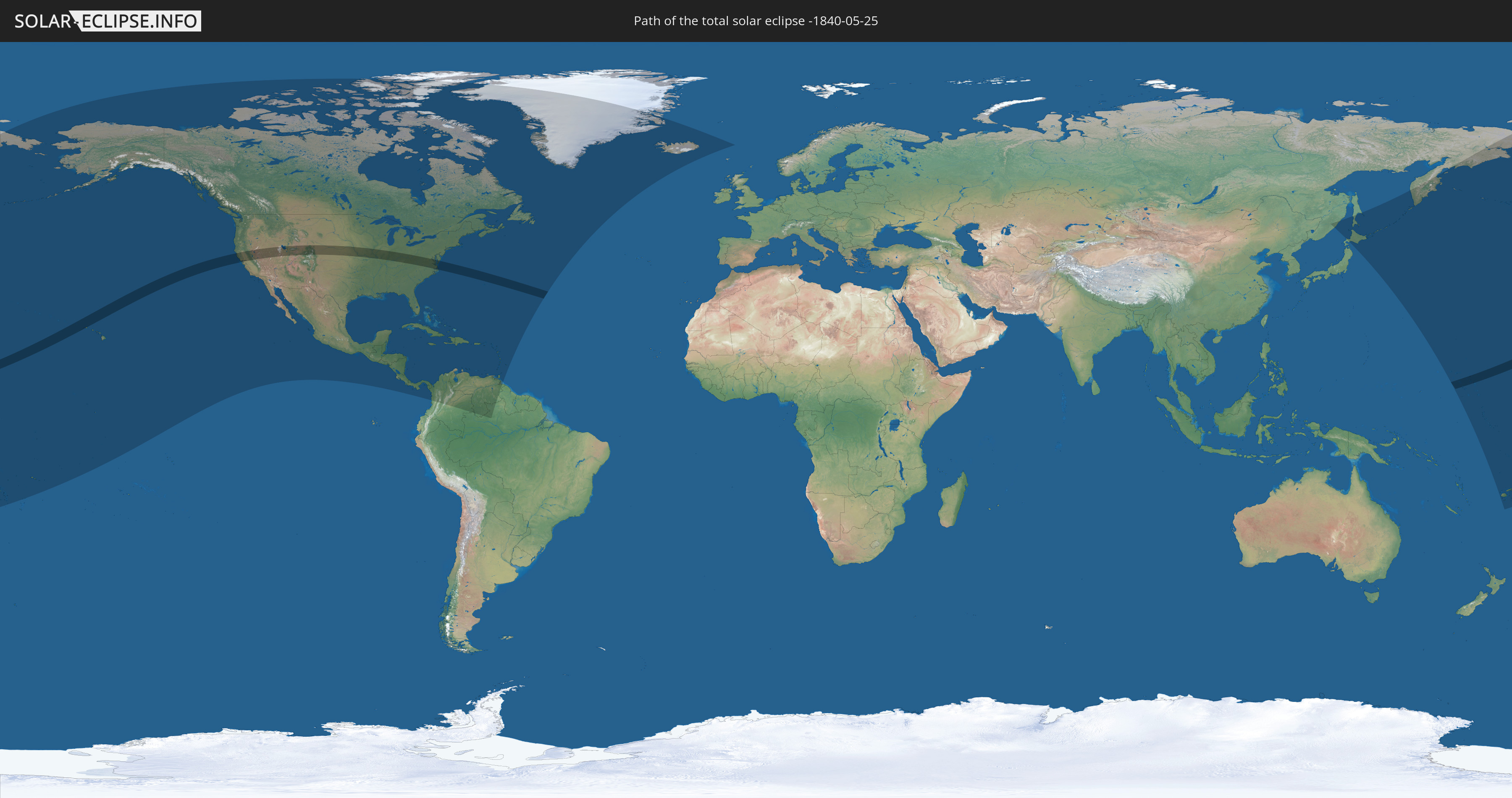
Die Sonnenfinsternis am 25.05.-1840 kann man in 56 Ländern als partielle Sonnenfinsternis beobachten.
Der Finsternispfad verläuft durch 2 Länder. Nur in diesen Ländern ist sie als totale Sonnenfinsternis zu sehen.
In den folgenden Ländern ist die Sonnenfinsternis total zu sehen
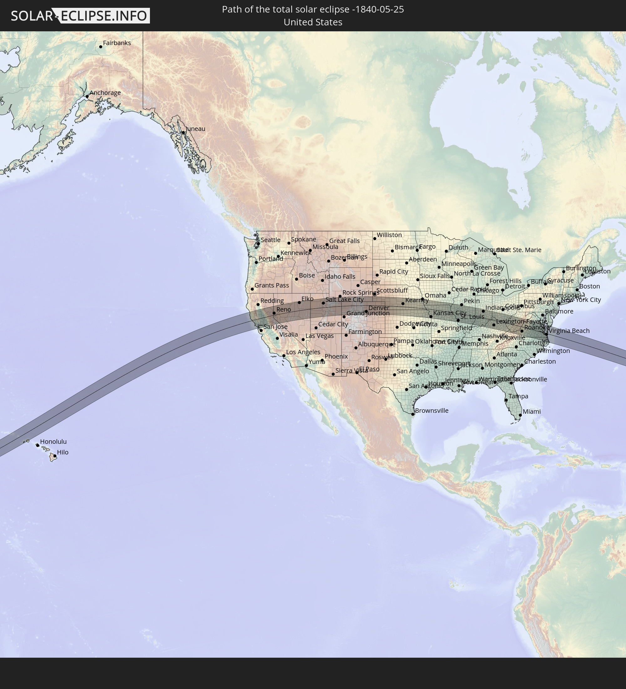 Vereinigte Staaten
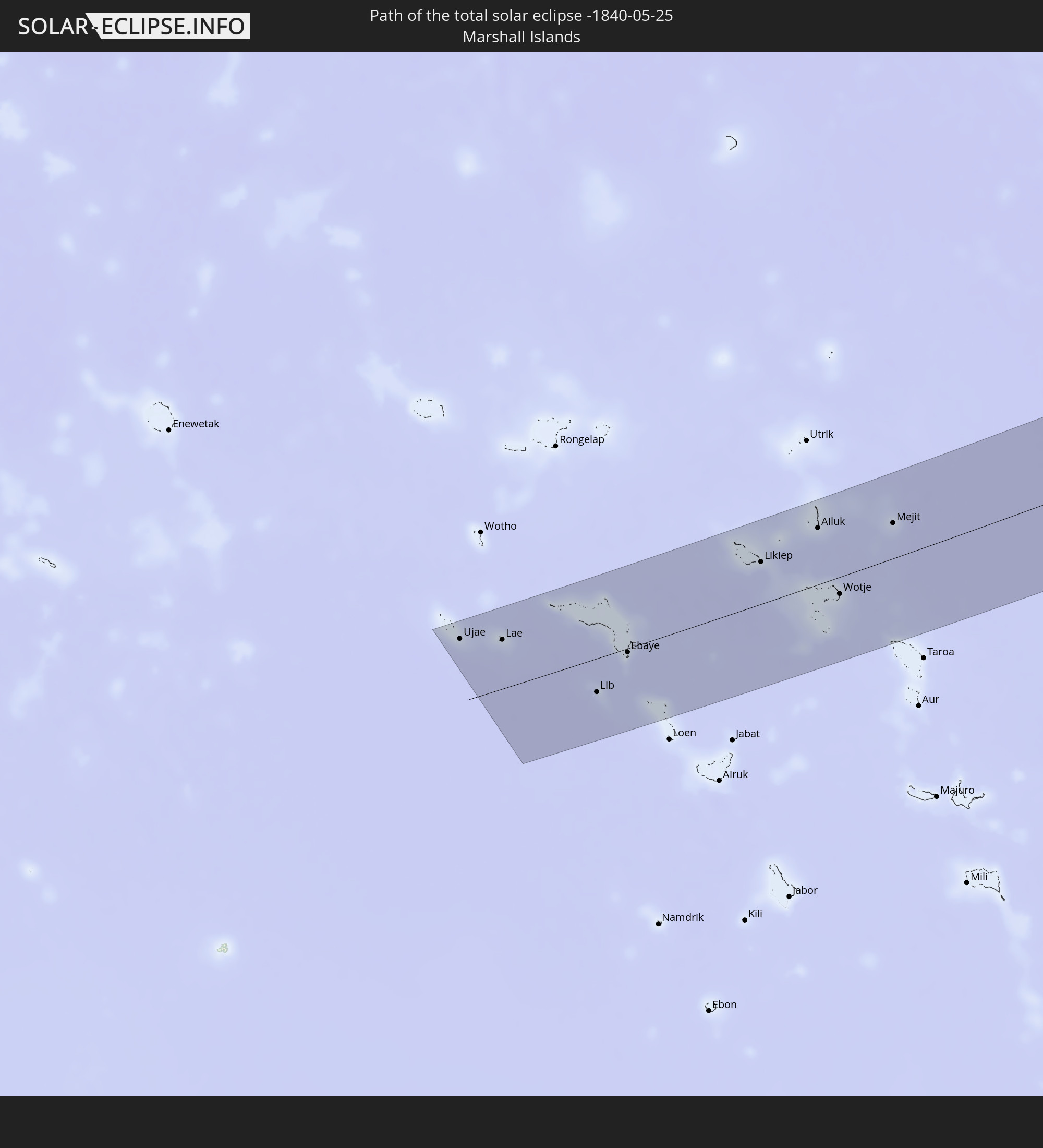 Marshallinseln
In den folgenden Ländern ist die Sonnenfinsternis partiell zu sehen
 Fidschi
 Russland
 Vereinigte Staaten
 United States Minor Outlying Islands
 Wallis und Futuna
 Tonga
Tonga
 Kiribati
 Samoa
Samoa
 Tokelau
 Amerikanisch-Samoa
 Cookinseln
 Kanada
 Mexiko
 Grönland
 Guatemala
 El Salvador
 Honduras
 Belize
 Nicaragua
 Costa Rica
 Kuba
Kuba
 Panama
 Kolumbien
 Kaimaninseln
 Bahamas
 Jamaika
 Haiti
Haiti
 Brasilien
 Venezuela
 Turks- und Caicosinseln
 Dominikanische Republik
 Aruba
Aruba
 Puerto Rico
 Amerikanische Jungferninseln
 Bermuda
 Britische Jungferninseln
 Anguilla
 Saint-Martin
 Saint-Barthélemy
 St. Kitts und Nevis
 Antigua und Barbuda
 Montserrat
 Trinidad und Tobago
 Guadeloupe
 Grenada
 Dominica
 St. Vincent und die Grenadinen
 Guyana
 Martinique
 St. Lucia
 Barbados
 Saint-Pierre und Miquelon
 Island
 Japan
Japan
 Marshallinseln
 Tuvalu
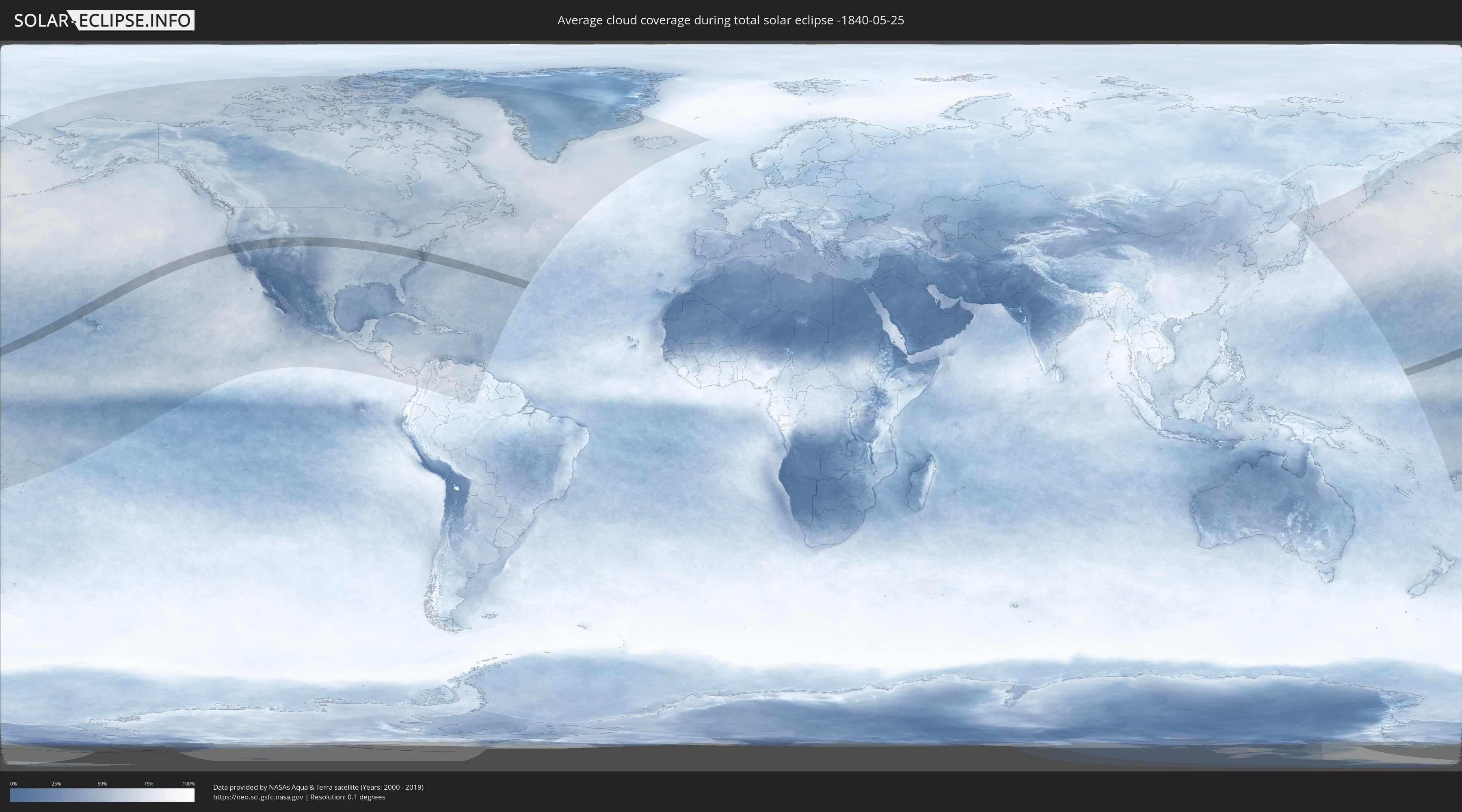
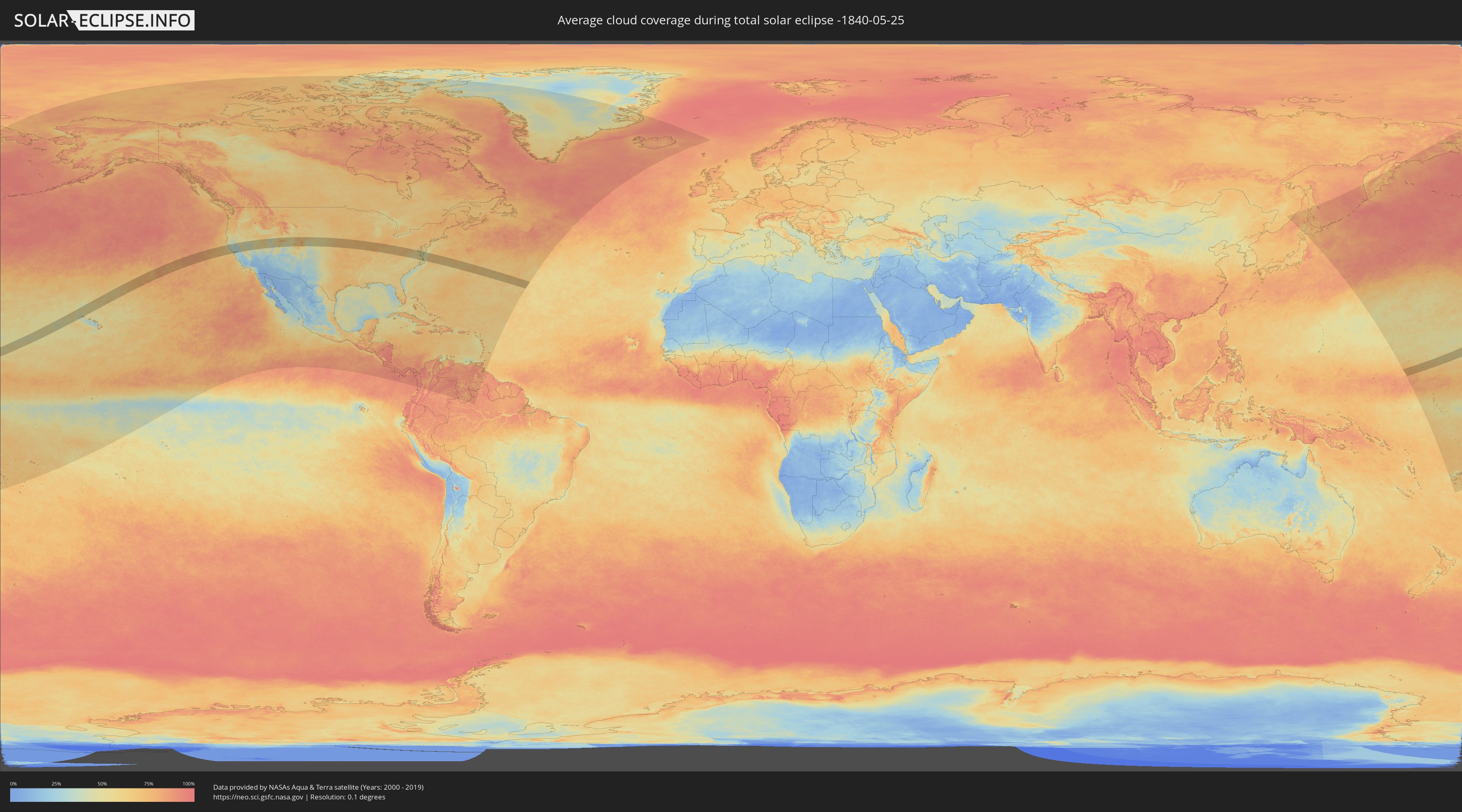
Wie wird das Wetter während der totalen Sonnenfinsternis am 25.05.-1840?
Wo ist der beste Ort, um die totale Sonnenfinsternis vom 25.05.-1840 zu beobachten?
Die folgenden Karten zeigen die durchschnittliche Bewölkung für den Tag, an dem die totale Sonnenfinsternis
stattfindet. Mit Hilfe der Karten lässt sich der Ort entlang des Finsternispfades eingrenzen,
der die besten Aussichen auf einen klaren wolkenfreien Himmel bietet.
Trotzdem muss man immer lokale Gegenenheiten beachten und sollte sich genau über das Wetter an seinem
gewählten Beobachtungsort informieren.
Die Daten stammen von den beiden NASA-Satelliten
AQUA und TERRA
und wurden über einen Zeitraum von 19 Jahren (2000 - 2019) gemittelt.
Detaillierte Länderkarten
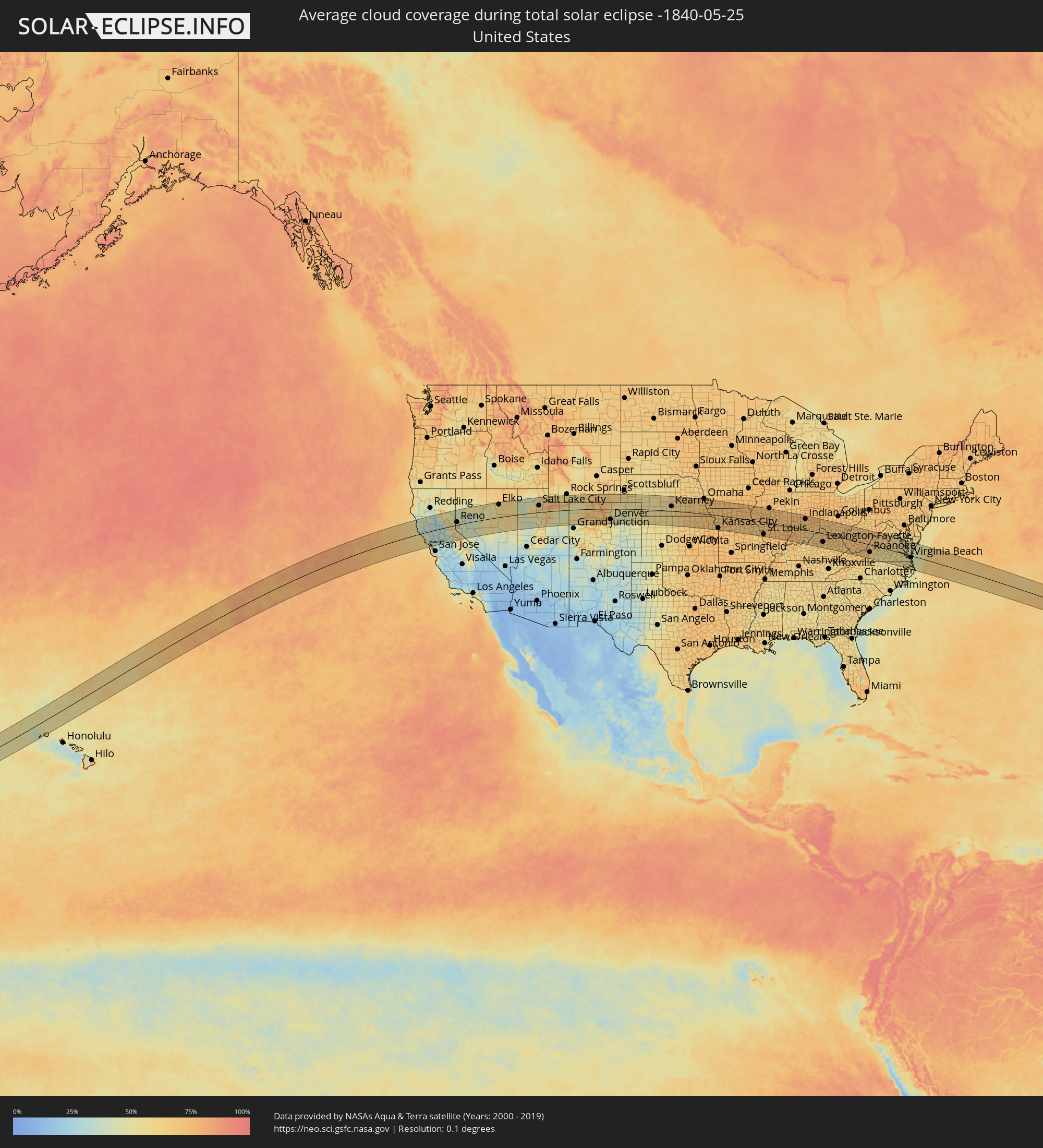 Vereinigte Staaten
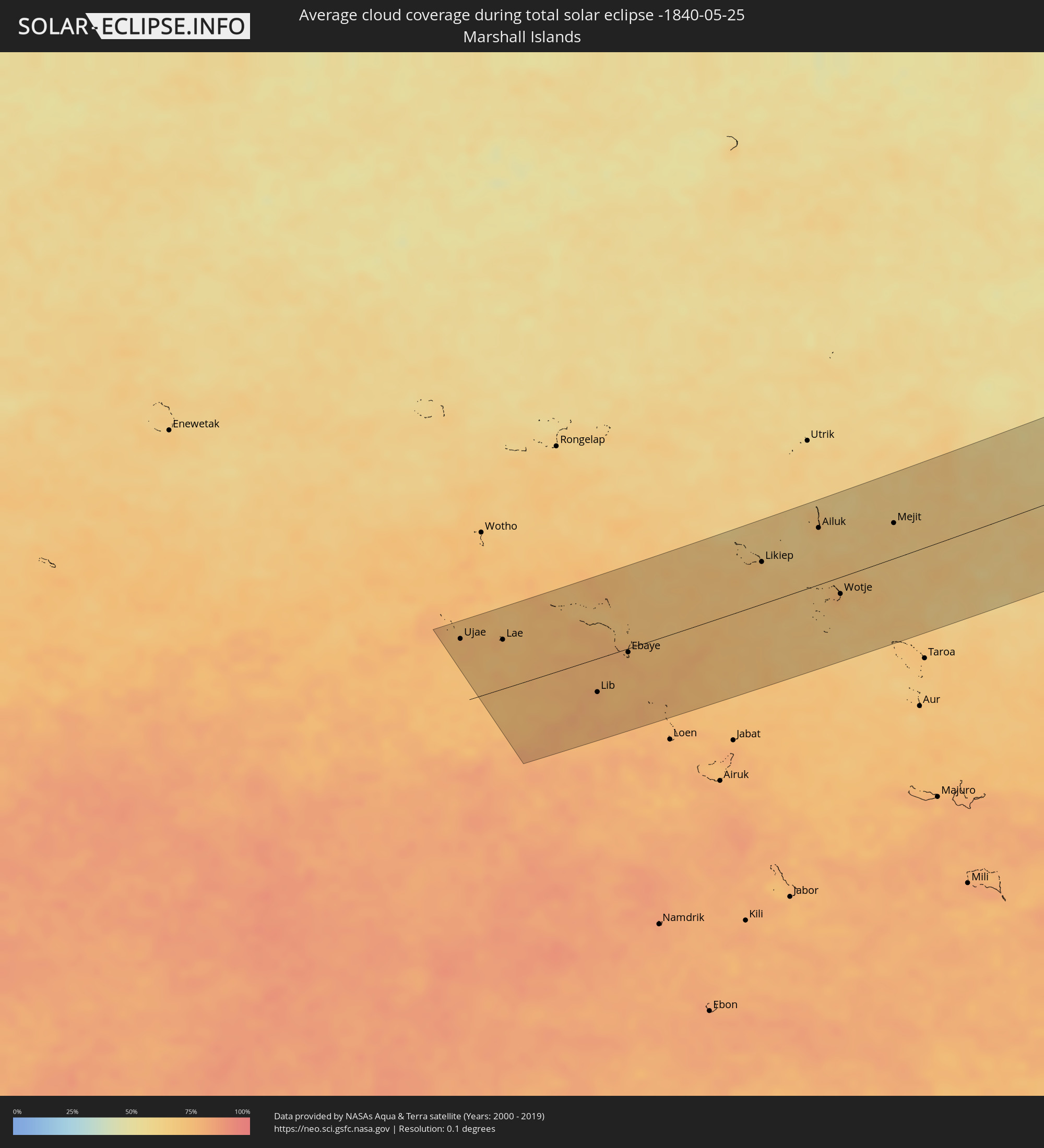 Marshallinseln
Orte im Finsternispfad
Die nachfolgene Tabelle zeigt Städte und Orte mit mehr als 5.000 Einwohnern, die sich im Finsternispfad befinden. Städte mit mehr als 100.000 Einwohnern sind dick gekennzeichnet. Mit einem Klick auf den Ort öffnet sich eine Detailkarte die die Lage des jeweiligen Ortes zusammen mit dem Verlauf der zentralen Finsternis präsentiert.
| Ort | Typ | Dauer der Verfinsterung | Ortszeit bei maximaler Verfinsterung | Entfernung zur Zentrallinie | Ø Bewölkung |
|
Santa Rosa, California
|
total | - | 12:31:37 UTC-08:00 | 38 km | 42% |
|
Petaluma, California
|
total | - | 12:31:41 UTC-08:00 | 62 km | 41% |
|
Novato, California
|
total | - | 12:31:46 UTC-08:00 | 77 km | 38% |
|
San Rafael, California
|
total | - | 12:31:47 UTC-08:00 | 92 km | 37% |
|
San Francisco, California
|
total | - | 12:31:55 UTC-08:00 | 116 km | 51% |
|
Napa, California
|
total | - | 12:32:27 UTC-08:00 | 63 km | 39% |
|
Berkeley, California
|
total | - | 12:32:17 UTC-08:00 | 109 km | 46% |
|
Vallejo, California
|
total | - | 12:32:25 UTC-08:00 | 84 km | 35% |
|
Fairfield, California
|
total | - | 12:32:57 UTC-08:00 | 73 km | 30% |
|
Concord, California
|
total | - | 12:32:50 UTC-08:00 | 103 km | 33% |
|
Danville, California
|
total | - | 12:32:50 UTC-08:00 | 120 km | 41% |
|
Chico, California
|
total | - | 12:34:00 UTC-08:00 | 83 km | 30% |
|
Antioch, California
|
total | - | 12:33:20 UTC-08:00 | 104 km | 27% |
|
Woodland, California
|
total | - | 12:33:42 UTC-08:00 | 32 km | 32% |
|
Davis, California
|
total | - | 12:33:42 UTC-08:00 | 47 km | 33% |
|
Yuba City, California
|
total | - | 12:34:13 UTC-08:00 | 14 km | 34% |
|
Sacramento, California
|
total | - | 12:34:14 UTC-08:00 | 49 km | 34% |
|
Elk Grove, California
|
total | - | 12:34:25 UTC-08:00 | 70 km | 32% |
|
Rancho Cordova, California
|
total | - | 12:34:38 UTC-08:00 | 52 km | 33% |
|
Lincoln, California
|
total | - | 12:34:47 UTC-08:00 | 19 km | 32% |
|
Stockton, California
|
total | - | 12:34:24 UTC-08:00 | 120 km | 28% |
|
Roseville, California
|
total | - | 12:34:44 UTC-08:00 | 34 km | 32% |
|
Lodi, California
|
total | - | 12:34:30 UTC-08:00 | 102 km | 31% |
|
El Dorado Hills, California
|
total | - | 12:35:08 UTC-08:00 | 46 km | 34% |
|
Reno, Nevada
|
total | - | 12:38:01 UTC-08:00 | 22 km | 43% |
|
Carson City, Nevada
|
total | - | 12:38:00 UTC-08:00 | 18 km | 42% |
|
Tooele, Utah
|
total | - | 13:52:43 UTC-07:00 | 33 km | 61% |
|
Ogden, Utah
|
total | - | 13:53:13 UTC-07:00 | 107 km | 52% |
|
Layton, Utah
|
total | - | 13:53:15 UTC-07:00 | 89 km | 49% |
|
West Jordan, Utah
|
total | - | 13:53:22 UTC-07:00 | 39 km | 52% |
|
Salt Lake City, Utah
|
total | - | 13:53:26 UTC-07:00 | 55 km | 50% |
|
Lehi, Utah
|
total | - | 13:53:34 UTC-07:00 | 14 km | 50% |
|
Provo, Utah
|
total | - | 13:53:57 UTC-07:00 | 5 km | 50% |
|
Laramie, Wyoming
|
total | - | 14:04:12 UTC-07:00 | 89 km | 64% |
|
Boulder, Colorado
|
total | - | 14:05:18 UTC-07:00 | 56 km | 66% |
|
Ken Caryl, Colorado
|
total | - | 14:05:46 UTC-07:00 | 105 km | 60% |
|
Longmont, Colorado
|
total | - | 14:05:31 UTC-07:00 | 39 km | 57% |
|
Broomfield, Colorado
|
total | - | 14:05:39 UTC-07:00 | 67 km | 60% |
|
Fort Collins, Colorado
|
total | - | 14:05:21 UTC-07:00 | 7 km | 62% |
|
Loveland, Colorado
|
total | - | 14:05:27 UTC-07:00 | 13 km | 58% |
|
Denver, Colorado
|
total | - | 14:05:54 UTC-07:00 | 87 km | 56% |
|
Centennial, Colorado
|
total | - | 14:06:09 UTC-07:00 | 105 km | 54% |
|
Brighton, Colorado
|
total | - | 14:06:04 UTC-07:00 | 59 km | 50% |
|
Cheyenne, Wyoming
|
total | - | 14:05:31 UTC-07:00 | 69 km | 65% |
|
Greeley, Colorado
|
total | - | 14:06:02 UTC-07:00 | 11 km | 51% |
|
Kearney, Nebraska
|
total | - | 15:14:30 UTC-06:00 | 38 km | 59% |
|
Grand Island, Nebraska
|
total | - | 15:15:23 UTC-06:00 | 67 km | 65% |
|
Lincoln, Nebraska
|
total | - | 15:17:44 UTC-06:00 | 66 km | 67% |
|
Manhattan, Kansas
|
total | - | 15:19:05 UTC-06:00 | 112 km | 69% |
|
Bellevue, Nebraska
|
total | - | 15:18:30 UTC-06:00 | 110 km | 66% |
|
Leavenworth, Kansas
|
total | - | 15:21:11 UTC-06:00 | 83 km | 69% |
|
Saint Joseph, Missouri
|
total | - | 15:20:55 UTC-06:00 | 31 km | 71% |
|
Overland Park, Kansas
|
total | - | 15:21:46 UTC-06:00 | 116 km | 75% |
|
Kansas City, Missouri
|
total | - | 15:21:47 UTC-06:00 | 102 km | 74% |
|
Liberty, Missouri
|
total | - | 15:21:53 UTC-06:00 | 85 km | 71% |
|
East Independence, Missouri
|
total | - | 15:22:05 UTC-06:00 | 100 km | 72% |
|
Columbia, Missouri
|
total | - | 15:24:42 UTC-06:00 | 93 km | 69% |
|
Quincy, Illinois
|
total | - | 15:24:56 UTC-06:00 | 27 km | 70% |
|
O'Fallon, Missouri
|
total | - | 15:26:43 UTC-06:00 | 87 km | 68% |
|
Chesterfield, Missouri
|
total | - | 15:26:59 UTC-06:00 | 102 km | 65% |
|
Saint Charles, Missouri
|
total | - | 15:27:00 UTC-06:00 | 87 km | 67% |
|
Mehlville, Missouri
|
total | - | 15:27:25 UTC-06:00 | 115 km | 69% |
|
St. Louis, Missouri
|
total | - | 15:27:27 UTC-06:00 | 100 km | 71% |
|
Upper Alton, Illinois
|
total | - | 15:27:15 UTC-06:00 | 68 km | 68% |
|
Belleville, Illinois
|
total | - | 15:27:47 UTC-06:00 | 109 km | 73% |
|
Springfield, Illinois
|
total | - | 15:27:00 UTC-06:00 | 37 km | 70% |
|
Decatur, Illinois
|
total | - | 15:27:42 UTC-06:00 | 51 km | 73% |
|
Champaign, Illinois
|
total | - | 15:28:10 UTC-06:00 | 92 km | 72% |
|
Danville, Illinois
|
total | - | 15:28:46 UTC-06:00 | 103 km | 70% |
|
Terre Haute, Indiana
|
total | - | 16:29:36 UTC-05:00 | 34 km | 71% |
|
Bloomington, Indiana
|
total | - | 16:30:45 UTC-05:00 | 16 km | 66% |
|
Indianapolis, Indiana
|
total | - | 16:30:31 UTC-05:00 | 88 km | 70% |
|
Carmel, Indiana
|
total | - | 16:30:21 UTC-05:00 | 112 km | 69% |
|
Greenwood, Indiana
|
total | - | 16:30:43 UTC-05:00 | 72 km | 71% |
|
Columbus, Indiana
|
total | - | 16:31:17 UTC-05:00 | 31 km | 70% |
|
Louisville, Kentucky
|
total | - | 16:32:20 UTC-05:00 | 70 km | 63% |
|
Florence, Kentucky
|
total | - | 16:32:39 UTC-05:00 | 32 km | 67% |
|
Nicholasville, Kentucky
|
total | - | 16:33:46 UTC-05:00 | 89 km | 66% |
|
Hamilton, Ohio
|
total | - | 16:32:19 UTC-05:00 | 77 km | 68% |
|
Georgetown, Kentucky
|
total | - | 16:33:28 UTC-05:00 | 53 km | 67% |
|
Lexington-Fayette, Kentucky
|
total | - | 16:33:43 UTC-05:00 | 68 km | 68% |
|
Cincinnati, Ohio
|
total | - | 16:32:39 UTC-05:00 | 53 km | 69% |
|
Middletown, Ohio
|
total | - | 16:32:21 UTC-05:00 | 92 km | 66% |
|
Mason, Ohio
|
total | - | 16:32:35 UTC-05:00 | 77 km | 67% |
|
Richmond, Kentucky
|
total | - | 16:34:09 UTC-05:00 | 98 km | 67% |
|
Kettering, Ohio
|
total | - | 16:32:23 UTC-05:00 | 115 km | 69% |
|
Ironville, Kentucky
|
total | - | 16:34:49 UTC-05:00 | 10 km | 67% |
|
Huntington, West Virginia
|
total | - | 16:35:03 UTC-05:00 | 11 km | 63% |
|
Charleston, West Virginia
|
total | - | 16:35:46 UTC-05:00 | 20 km | 62% |
|
Blacksburg, Virginia
|
total | - | 16:37:46 UTC-05:00 | 76 km | 67% |
|
Roanoke, Virginia
|
total | - | 16:38:04 UTC-05:00 | 61 km | 64% |
|
Lynchburg, Virginia
|
total | - | 16:38:29 UTC-05:00 | 28 km | 59% |
|
Harrisonburg, Virginia
|
total | - | 16:37:39 UTC-05:00 | 89 km | 68% |
|
Charlottesville, Virginia
|
total | - | 16:38:19 UTC-05:00 | 53 km | 62% |
|
Richmond, Virginia
|
total | - | 16:39:27 UTC-05:00 | 25 km | 60% |
|
Petersburg, Virginia
|
total | - | 16:39:48 UTC-05:00 | 9 km | 56% |
|
Suffolk, Virginia
|
total | - | 16:40:47 UTC-05:00 | 43 km | 56% |
|
Newport News, Virginia
|
total | - | 16:40:30 UTC-05:00 | 2 km | 53% |
|
Norfolk, Virginia
|
total | - | 16:40:51 UTC-05:00 | 23 km | 55% |
|
Virginia Beach, Virginia
|
total | - | 16:41:01 UTC-05:00 | 15 km | 46% |
|
Ujae, Ujae Atoll
|
total | - | 05:36:42 UTC+11:00 | 78 km | 74% |
|
Lae, Lae Atoll
|
total | - | 05:36:35 UTC+11:00 | 61 km | 72% |
|
Lib, Lib Island
|
total | - | 05:35:54 UTC+11:00 | 42 km | 77% |
|
Ebaye, Kwajalein Atoll
|
total | - | 05:36:11 UTC+11:00 | 5 km | 78% |
|
Likiep, Likiep Atoll
|
total | - | 05:36:46 UTC+11:00 | 51 km | 68% |
|
Ailuk, Ailuk Atoll
|
total | - | 05:37:00 UTC+11:00 | 69 km | 65% |
|
Wotje, Wotje Atoll
|
total | - | 05:36:21 UTC+11:00 | 21 km | 76% |
|
Mejit, Mejit Island
|
total | - | 05:36:58 UTC+11:00 | 43 km | 68% |