Totale Sonnenfinsternis vom 12.04.-1912
| Wochentag: | Samstag |
| Maximale Dauer der Verfinsterung: | 06m48s |
| Maximale Breite des Finsternispfades: | 249 km |
| Saroszyklus: | 8 |
| Bedeckungsgrad: | 100% |
| Magnitude: | 1.0769 |
| Gamma: | 0.0431 |
Wo kann man die Sonnenfinsternis vom 12.04.-1912 sehen?
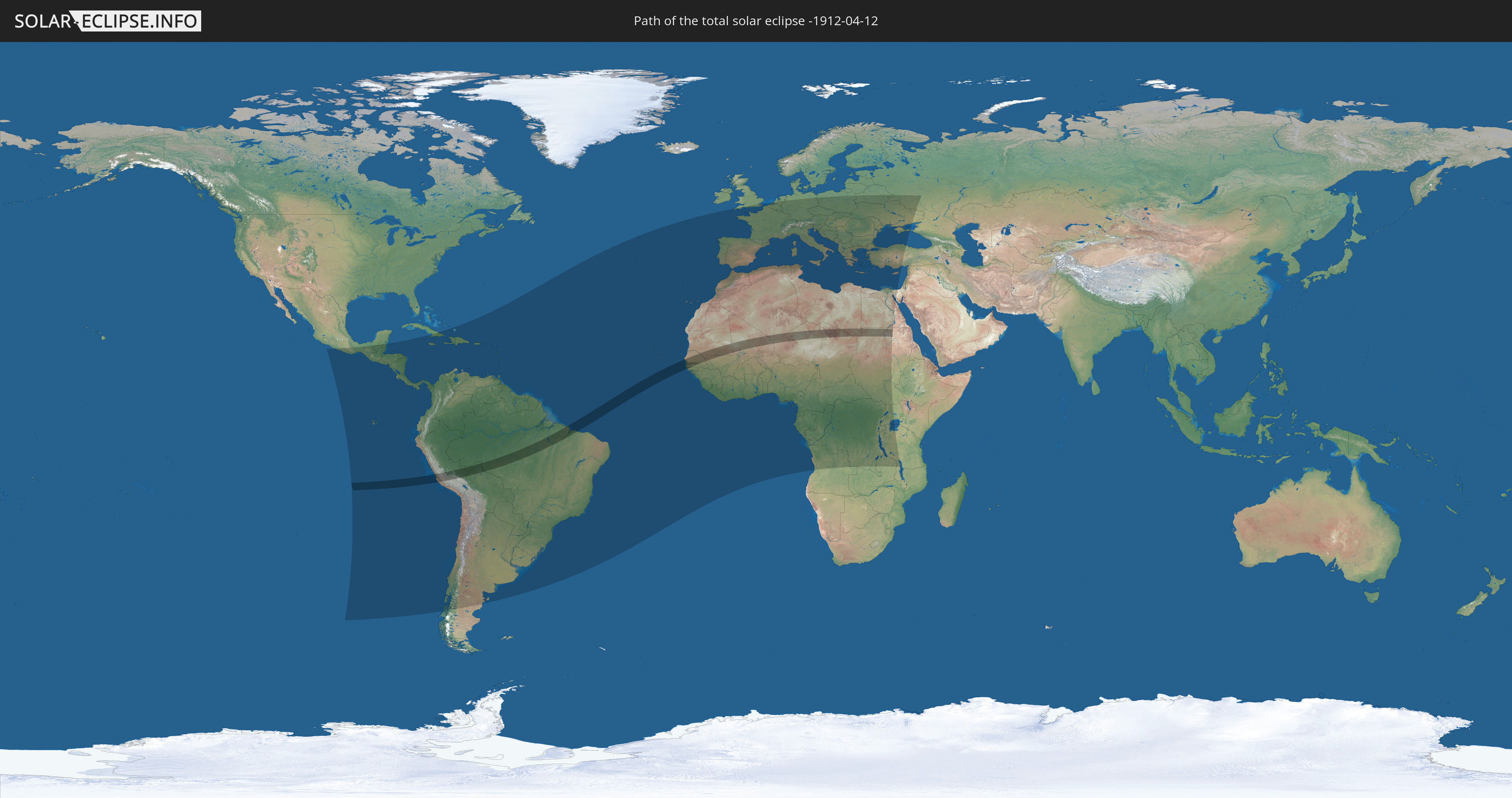
Die Sonnenfinsternis am 12.04.-1912 kann man in 125 Ländern als partielle Sonnenfinsternis beobachten.
Der Finsternispfad verläuft durch 13 Länder. Nur in diesen Ländern ist sie als totale Sonnenfinsternis zu sehen.
In den folgenden Ländern ist die Sonnenfinsternis total zu sehen
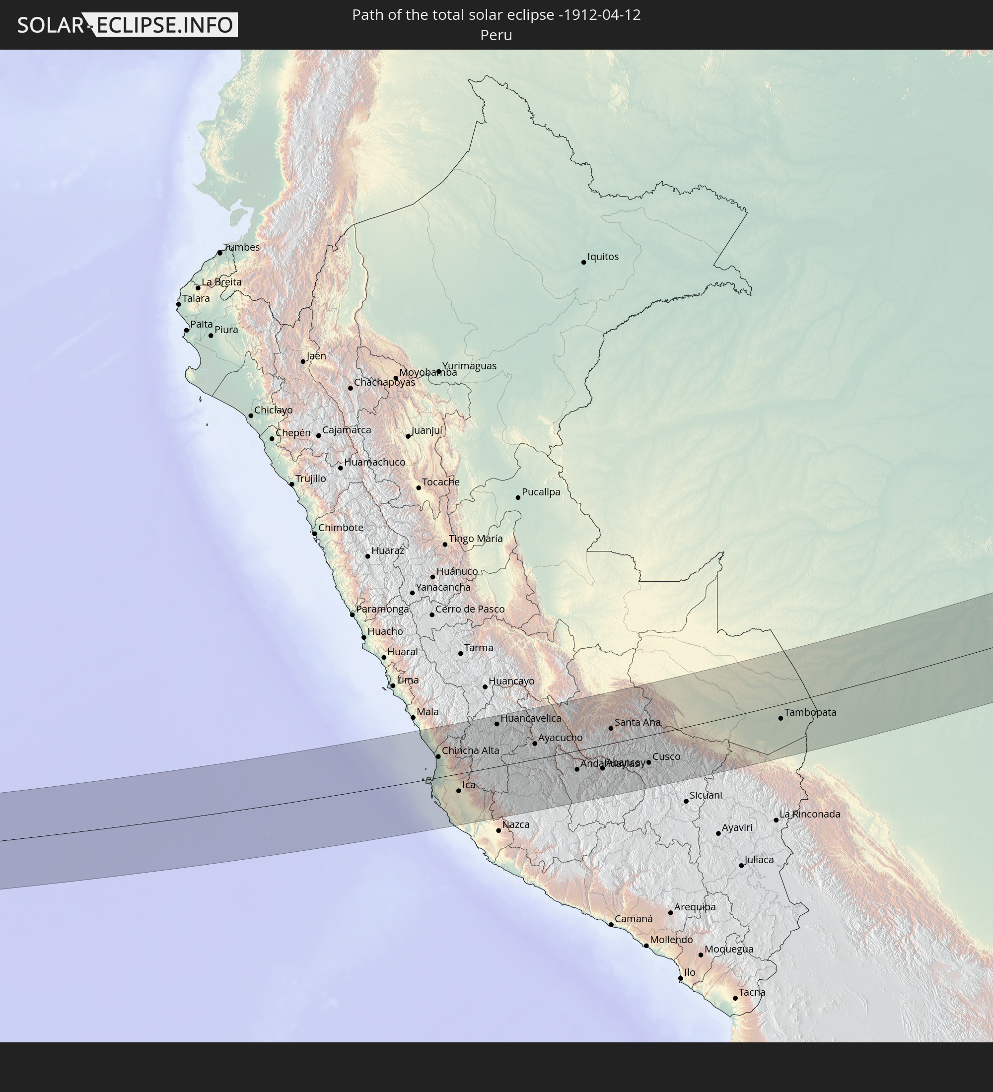 Peru
Peru
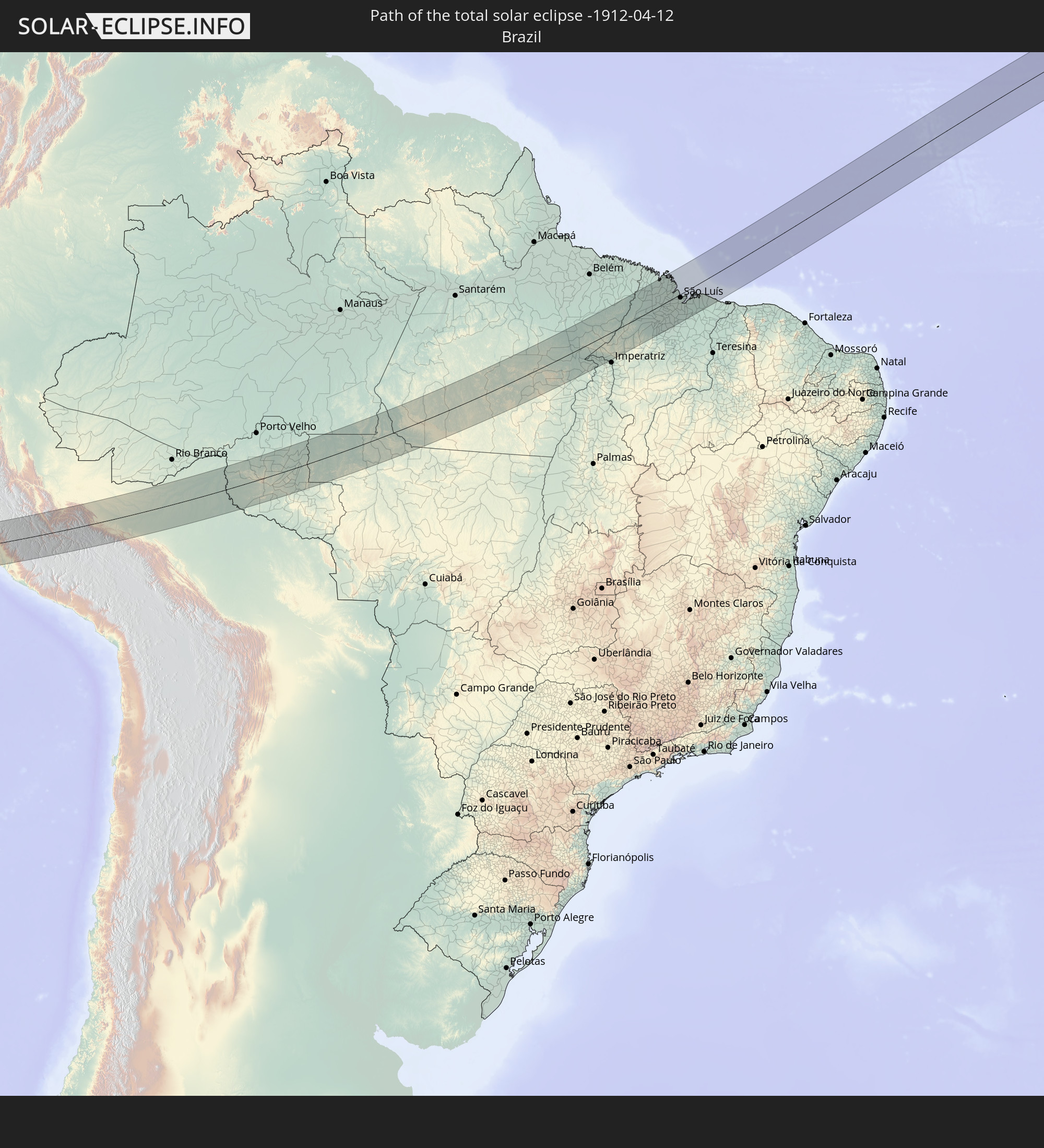 Brasilien
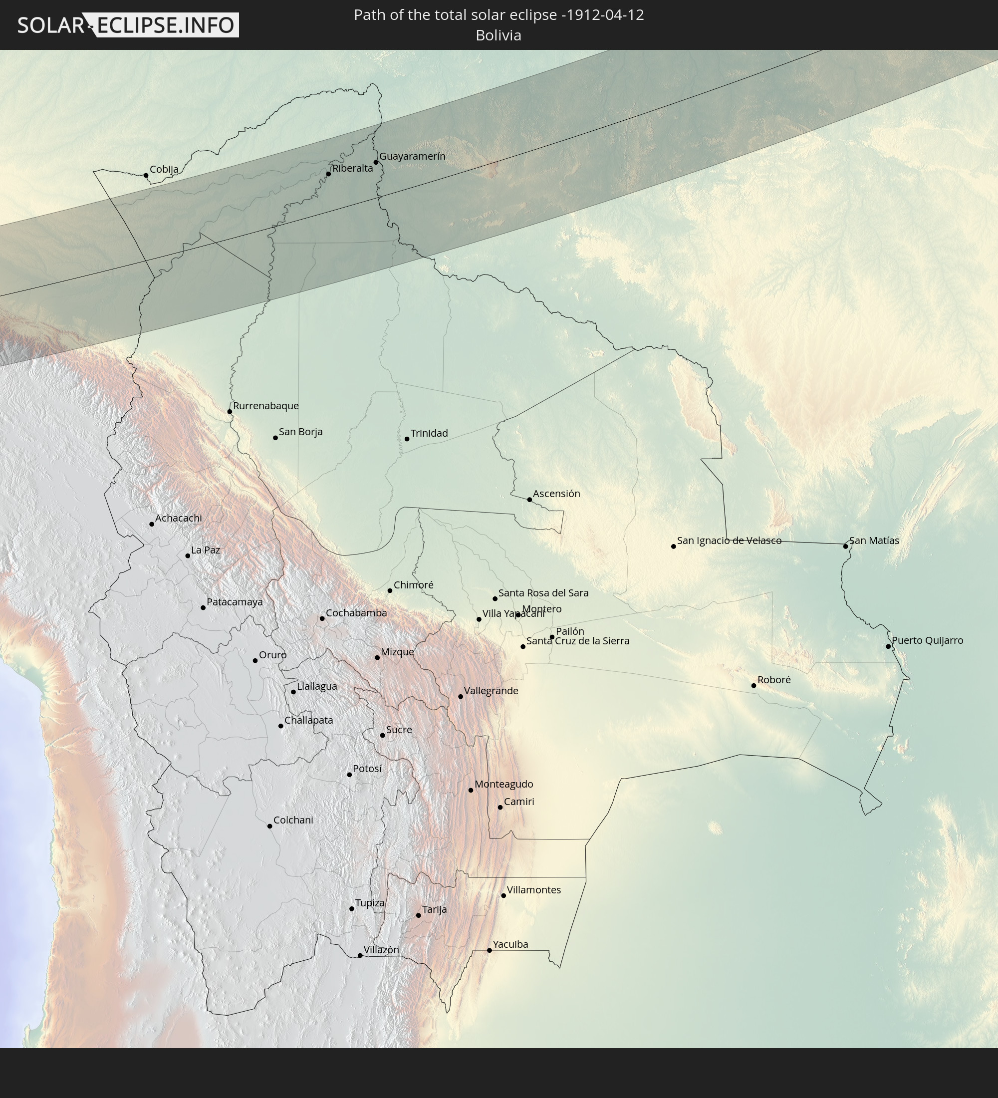 Bolivien
 Senegal
 Mauretanien
 Gambia
 Guinea-Bissau
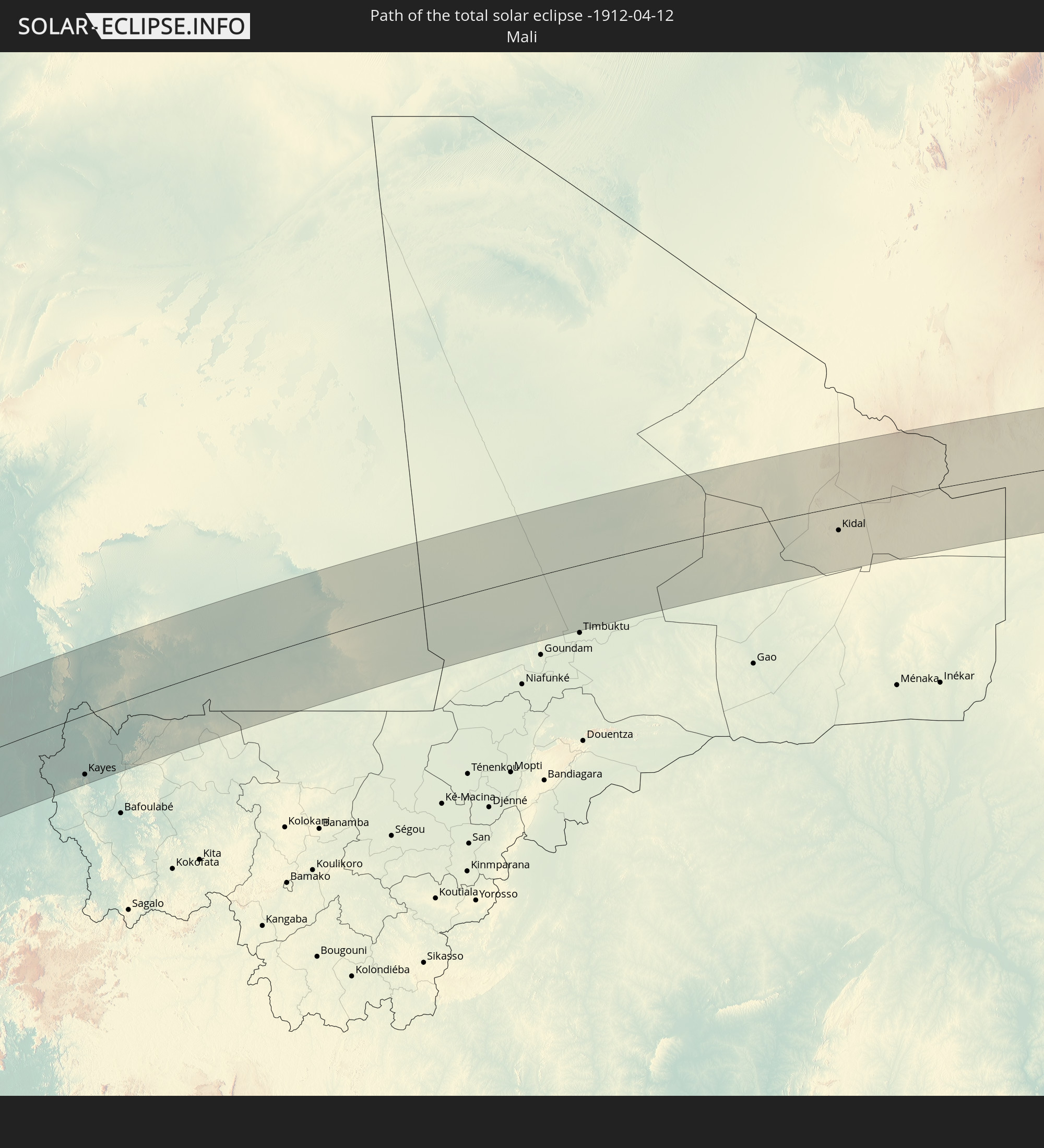 Mali
Mali
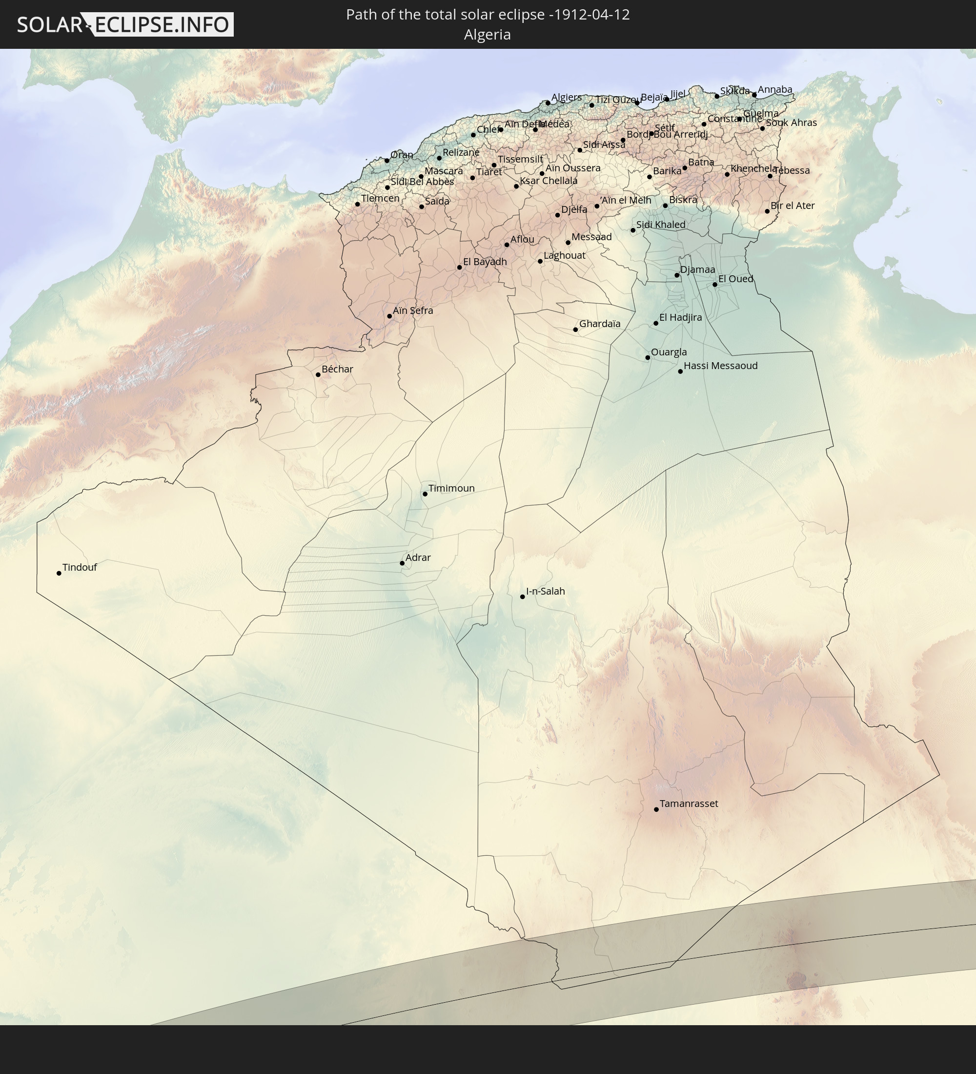 Algerien
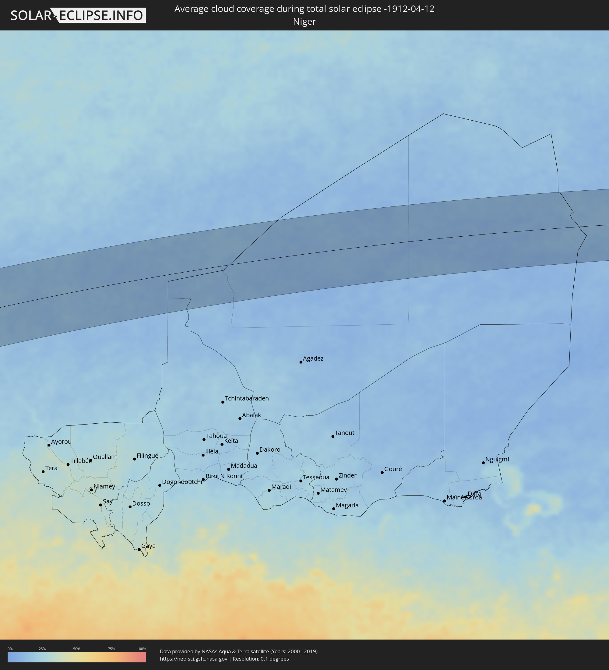
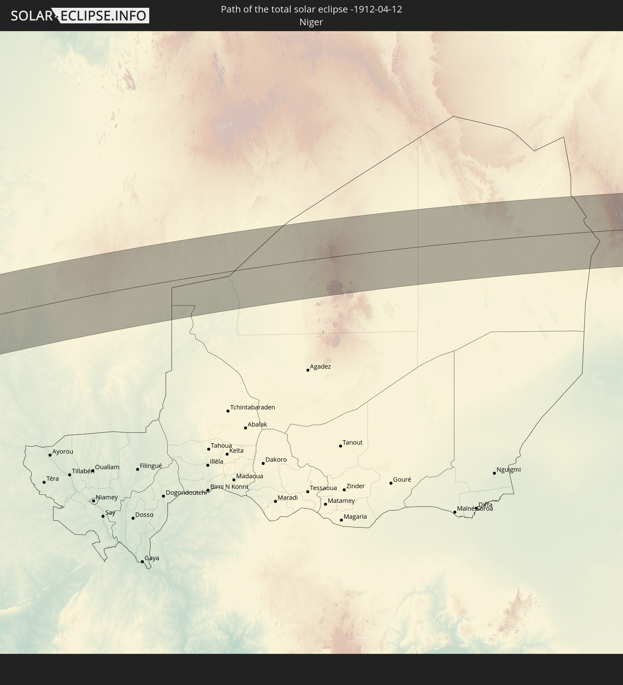 Niger
Niger
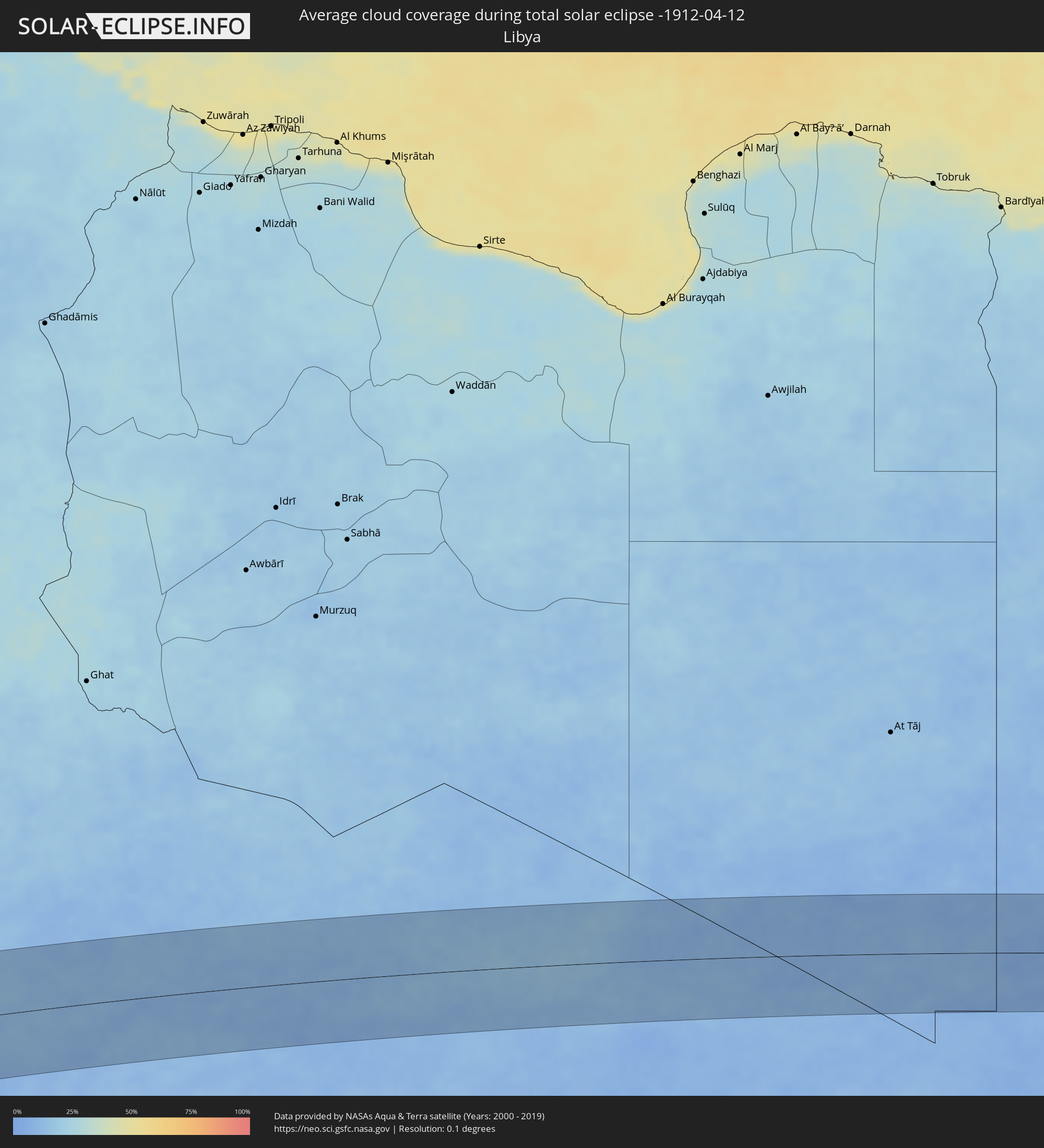
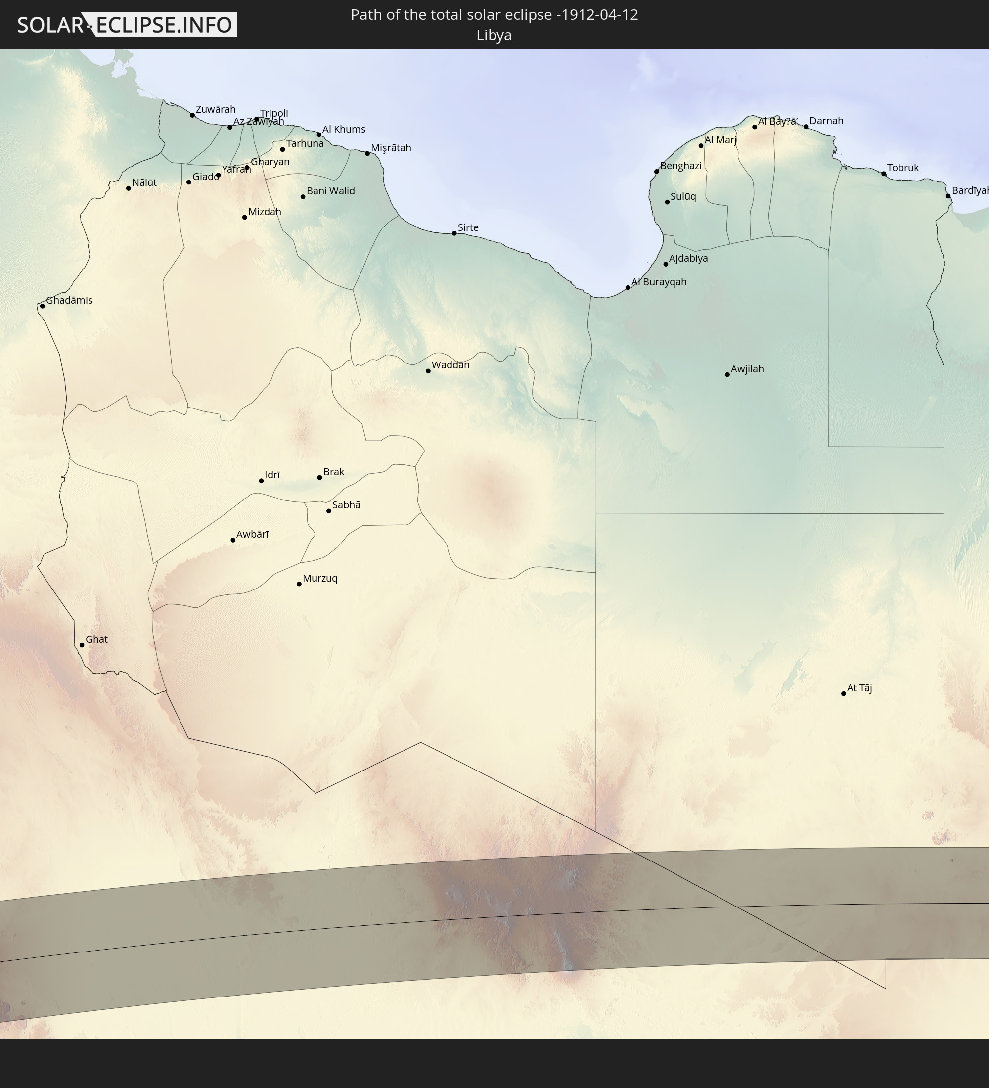 Libyen
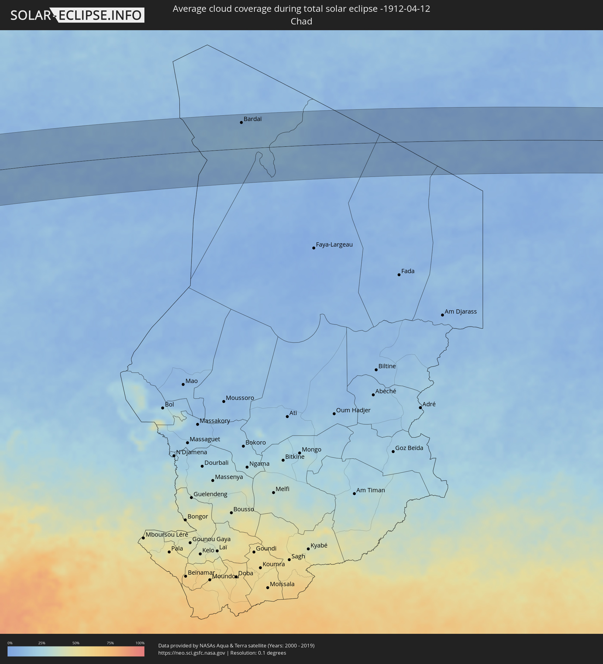
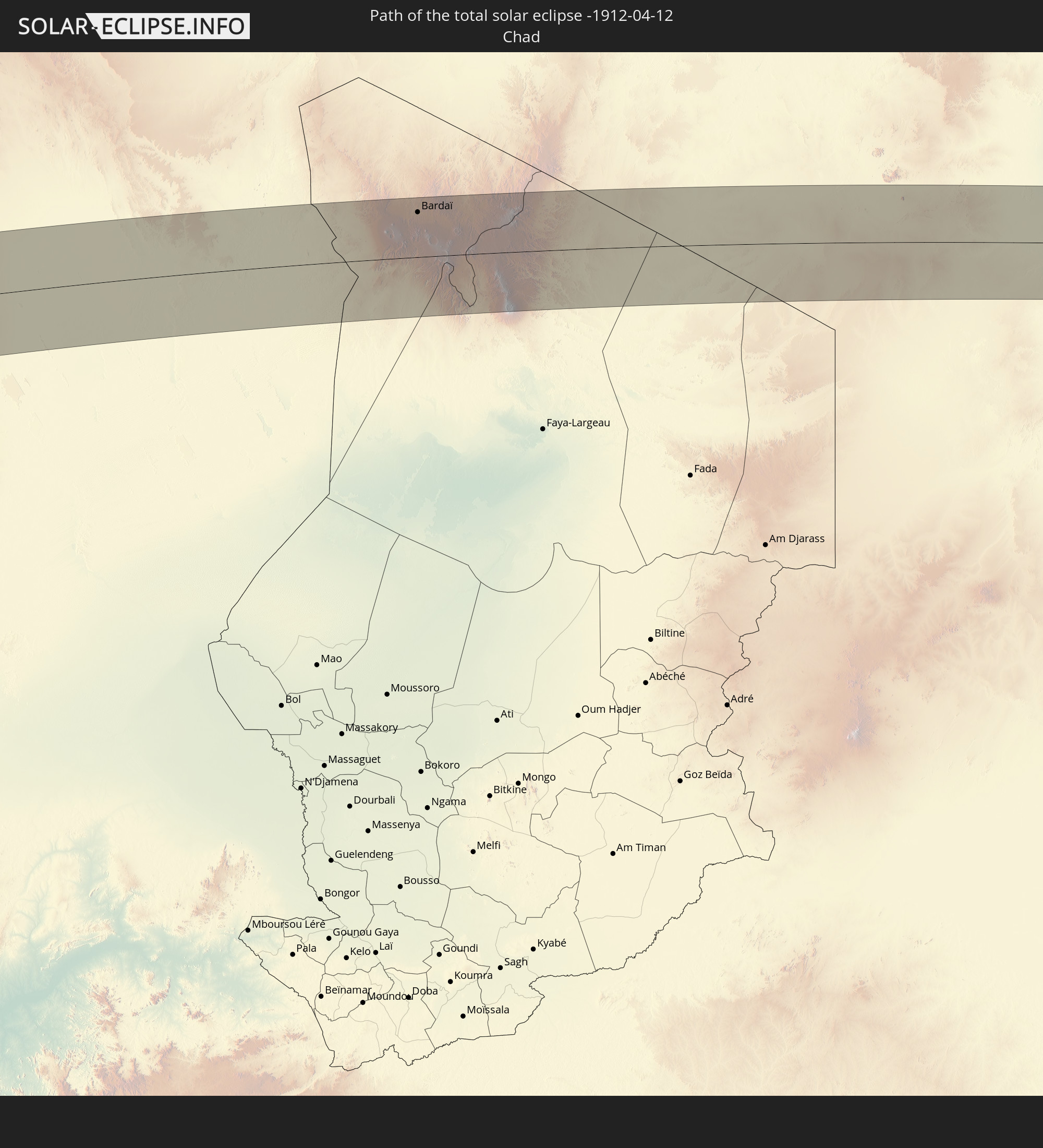 Tschad
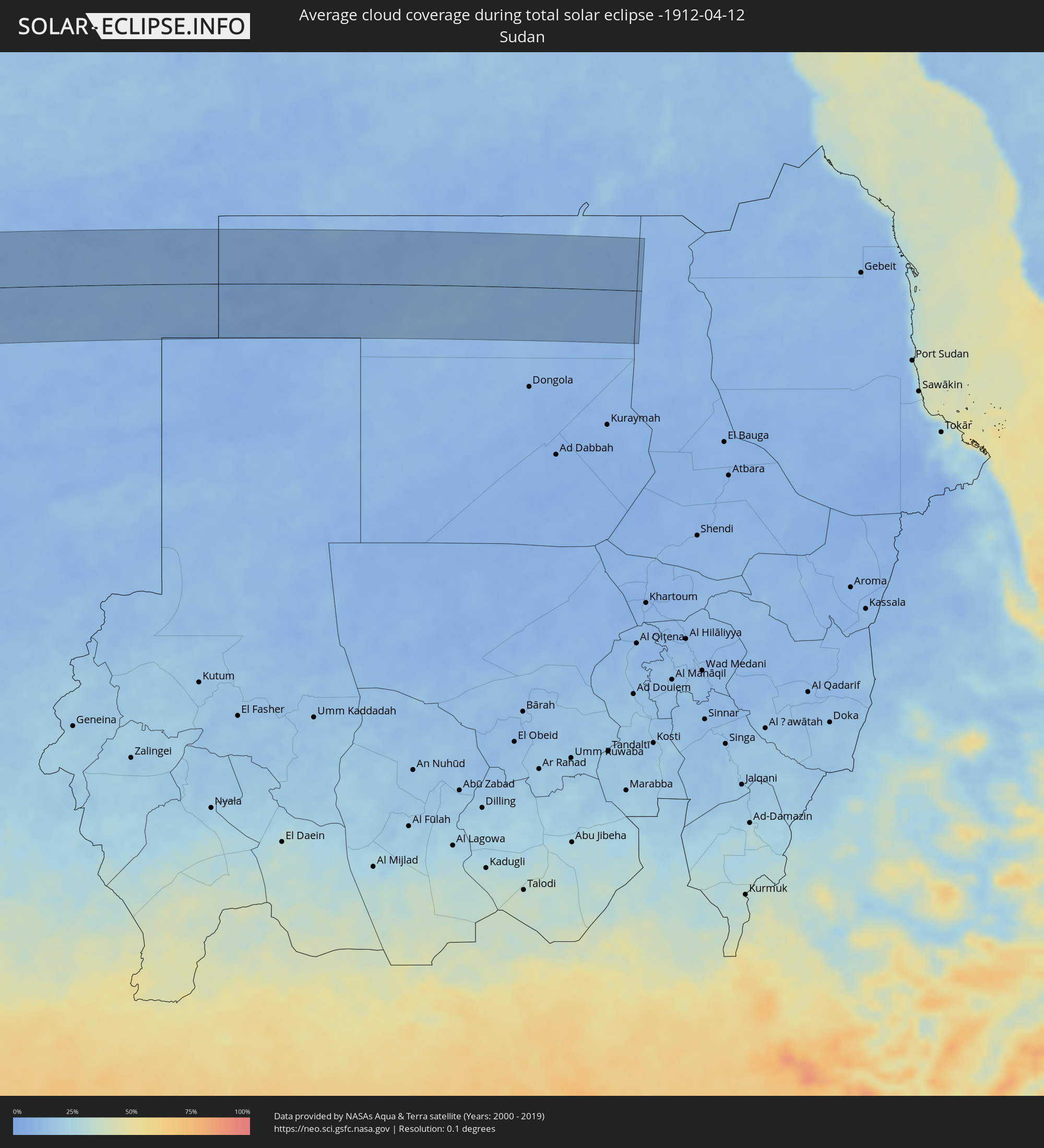
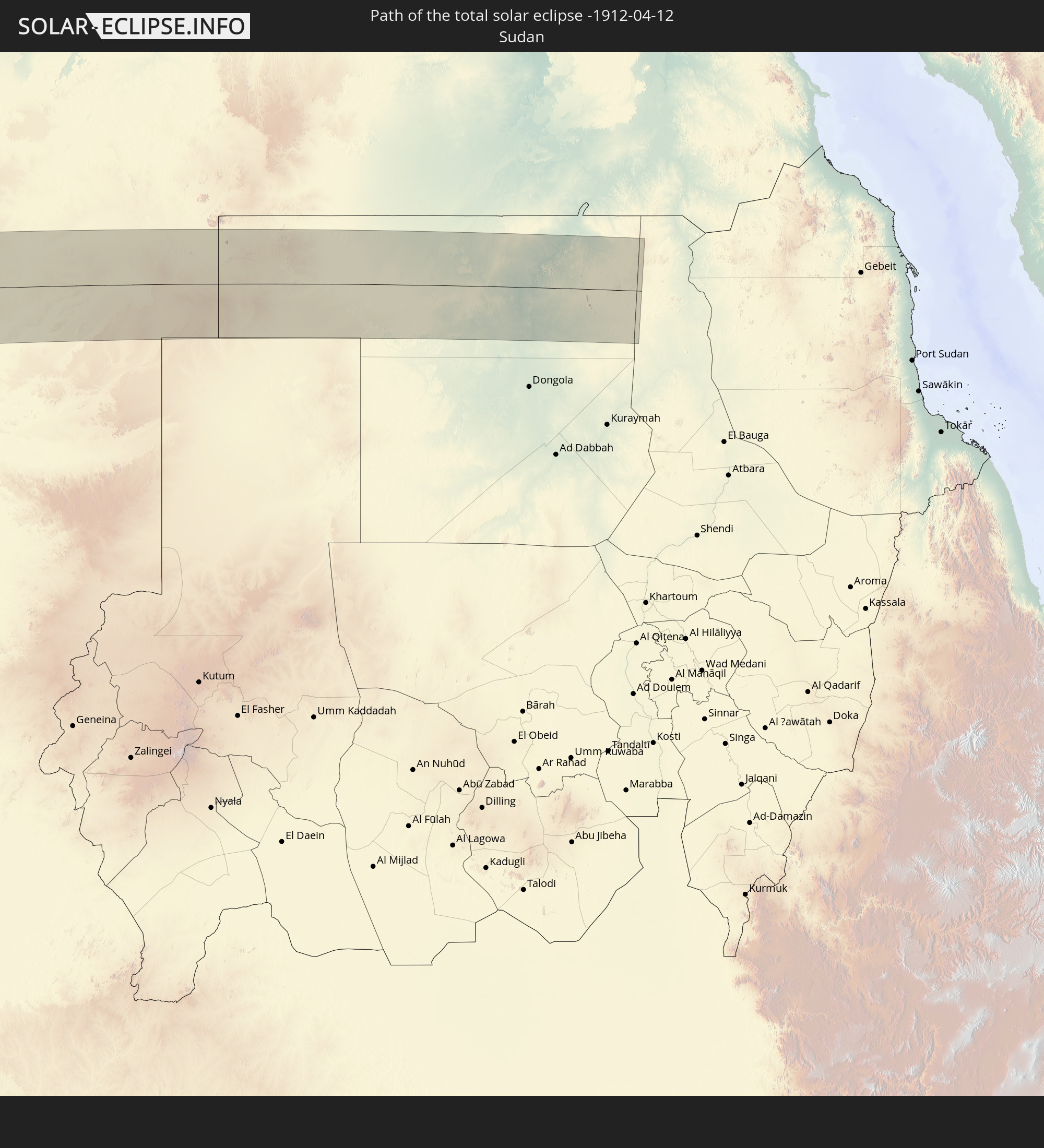 Sudan
Sudan
In den folgenden Ländern ist die Sonnenfinsternis partiell zu sehen
 Russland
 United States Minor Outlying Islands
 Mexiko
 Chile
Chile
 Guatemala
 Ecuador
 El Salvador
 Honduras
 Belize
 Nicaragua
 Costa Rica
 Kuba
Kuba
 Panama
 Kolumbien
 Kaimaninseln
 Peru
Peru
 Bahamas
 Jamaika
 Haiti
Haiti
 Brasilien
 Argentinien
 Venezuela
 Turks- und Caicosinseln
 Dominikanische Republik
 Aruba
Aruba
 Bolivien
 Puerto Rico
 Amerikanische Jungferninseln
 Britische Jungferninseln
 Anguilla
 Saint-Martin
 Saint-Barthélemy
 St. Kitts und Nevis
 Paraguay
 Antigua und Barbuda
 Montserrat
 Trinidad und Tobago
 Guadeloupe
 Grenada
 Dominica
 St. Vincent und die Grenadinen
 Guyana
 Martinique
 St. Lucia
 Barbados
 Uruguay
 Suriname
 Französisch-Guayana
 Portugal
 Kap Verde
 Spanien
 Senegal
 Mauretanien
 Gambia
 Guinea-Bissau
 Guinea
 St. Helena
 Sierra Leone
 Marokko
 Mali
Mali
 Liberia
 Algerien
 Vereinigtes Königreich
 Elfenbeinküste
 Burkina Faso
 Gibraltar
 Frankreich
 Ghana
Ghana
 Guernsey
 Jersey
 Togo
Togo
 Niger
Niger
 Benin
Benin
 Andorra
 Belgien
 Nigeria
 Niederlande
 Äquatorialguinea
 Luxemburg
 Deutschland
 Schweiz
 São Tomé und Príncipe
 Italien
 Monaco
 Tunesien
 Kamerun
 Gabun
Gabun
 Libyen
 Liechtenstein
 Österreich
 Republik Kongo
 Angola
 Tschechien
 Demokratische Republik Kongo
 San Marino
 Vatikanstadt
 Slowenien
 Tschad
 Kroatien
 Polen
Polen
 Malta
Malta
 Zentralafrikanische Republik
 Bosnien und Herzegowina
 Ungarn
 Slowakei
 Montenegro
 Serbien
 Albanien
 Griechenland
 Rumänien
 Mazedonien
 Sudan
Sudan
 Sambia
 Ukraine
 Bulgarien
 Weißrussland
 Ägypten
 Türkei
 Moldawien
 Ruanda
 Burundi
 Tansania
 Uganda
 Republik Zypern
 Malawi
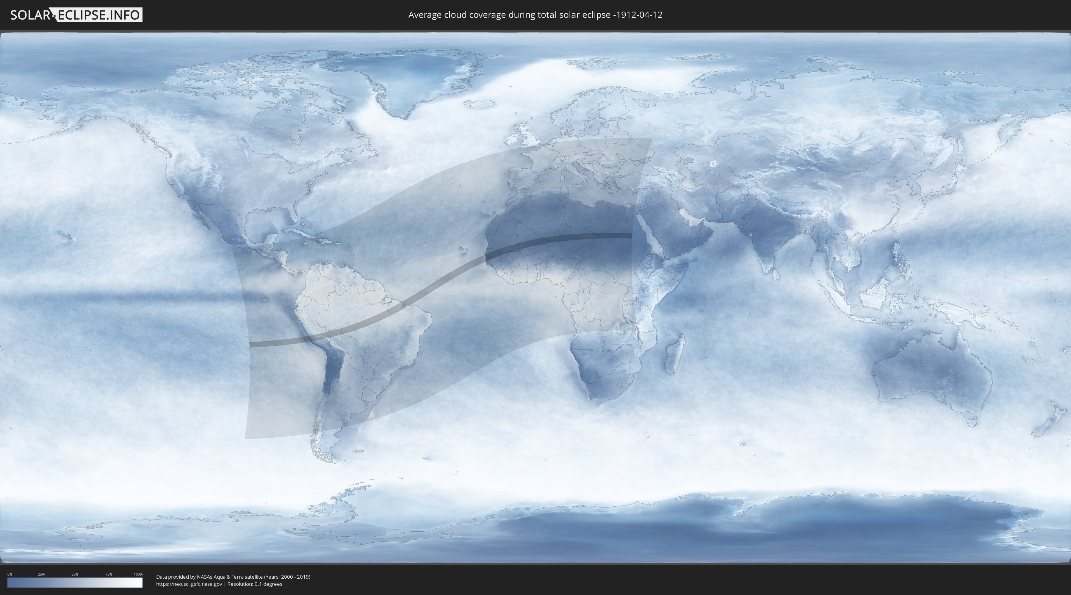
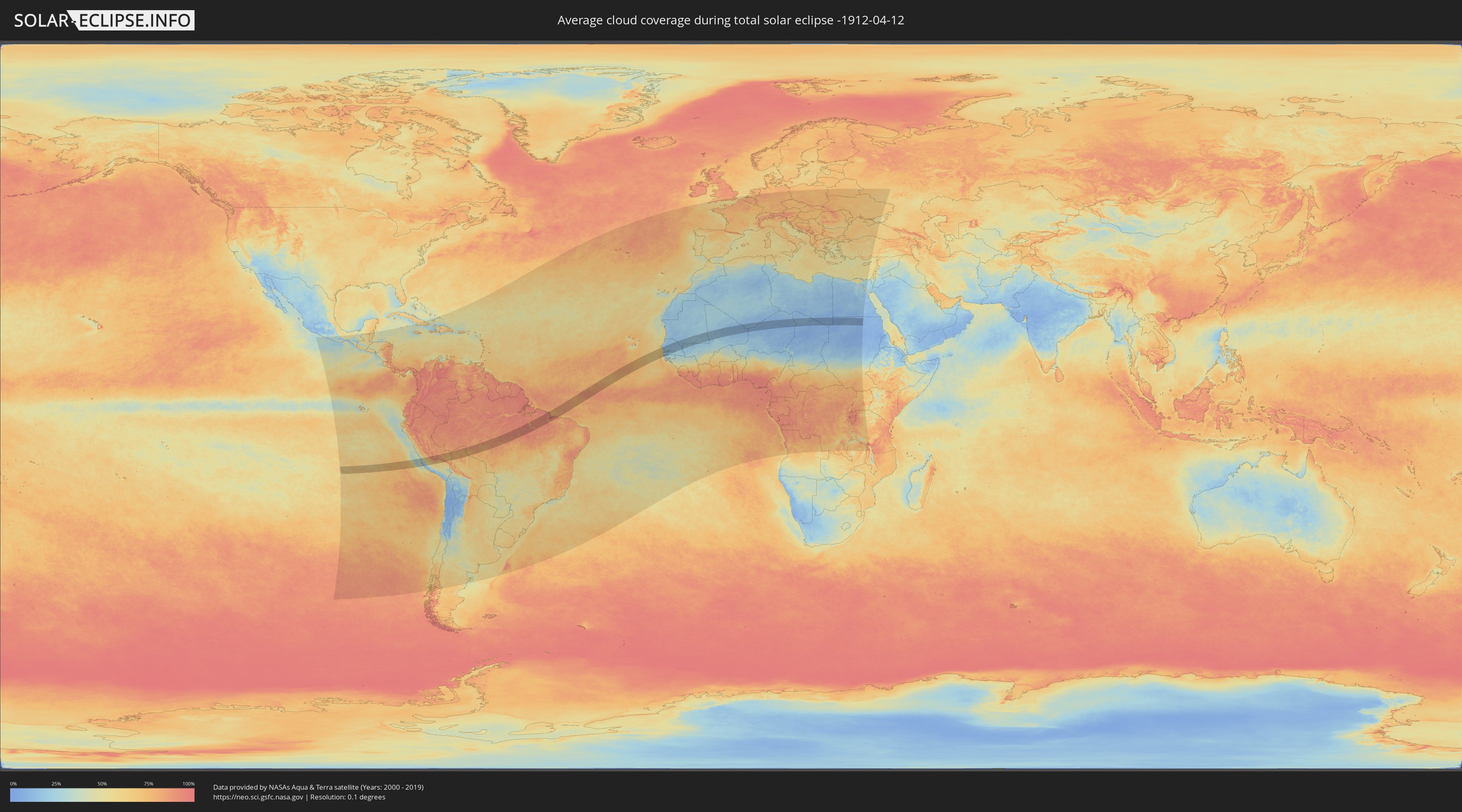
Wie wird das Wetter während der totalen Sonnenfinsternis am 12.04.-1912?
Wo ist der beste Ort, um die totale Sonnenfinsternis vom 12.04.-1912 zu beobachten?
Die folgenden Karten zeigen die durchschnittliche Bewölkung für den Tag, an dem die totale Sonnenfinsternis
stattfindet. Mit Hilfe der Karten lässt sich der Ort entlang des Finsternispfades eingrenzen,
der die besten Aussichen auf einen klaren wolkenfreien Himmel bietet.
Trotzdem muss man immer lokale Gegenenheiten beachten und sollte sich genau über das Wetter an seinem
gewählten Beobachtungsort informieren.
Die Daten stammen von den beiden NASA-Satelliten
AQUA und TERRA
und wurden über einen Zeitraum von 19 Jahren (2000 - 2019) gemittelt.
Detaillierte Länderkarten
 Peru
Peru
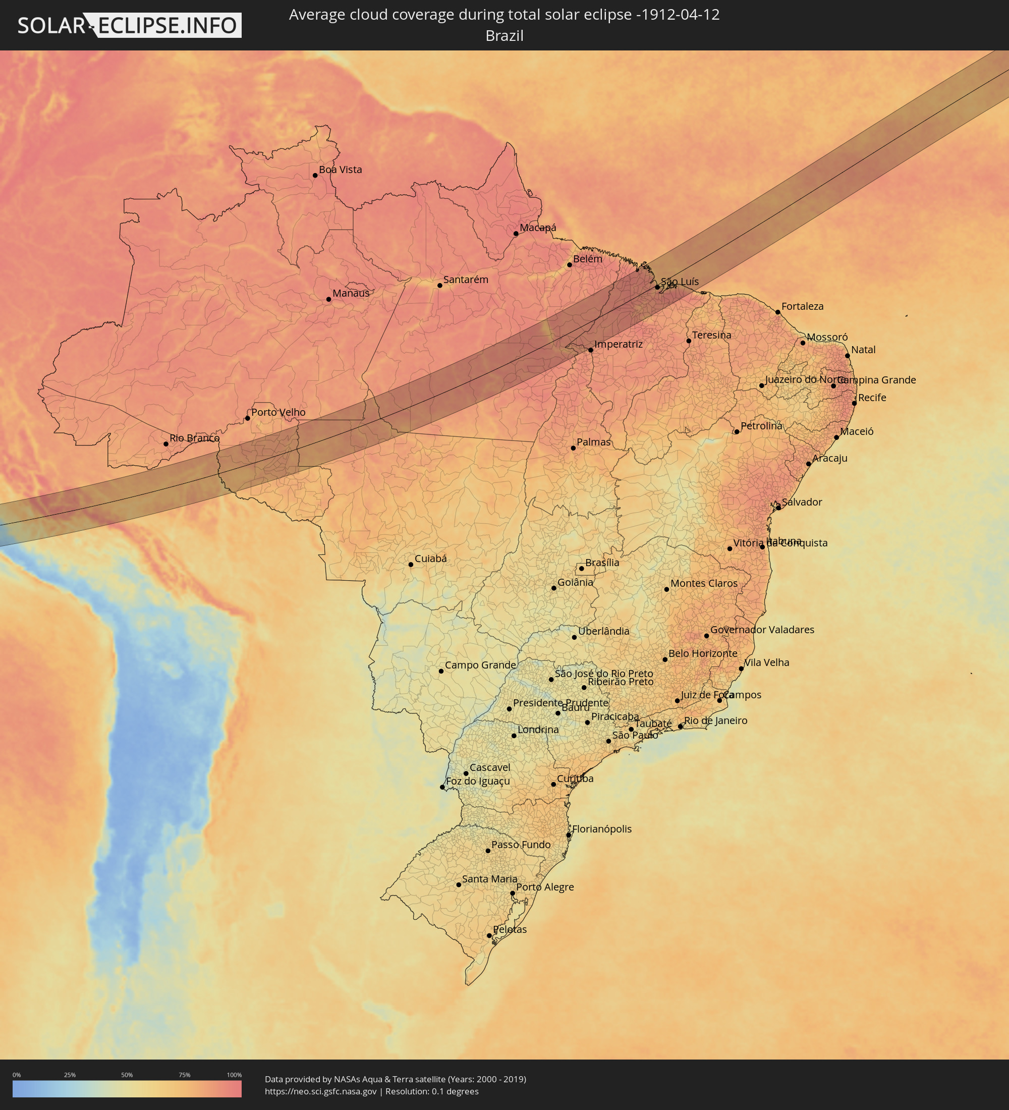 Brasilien
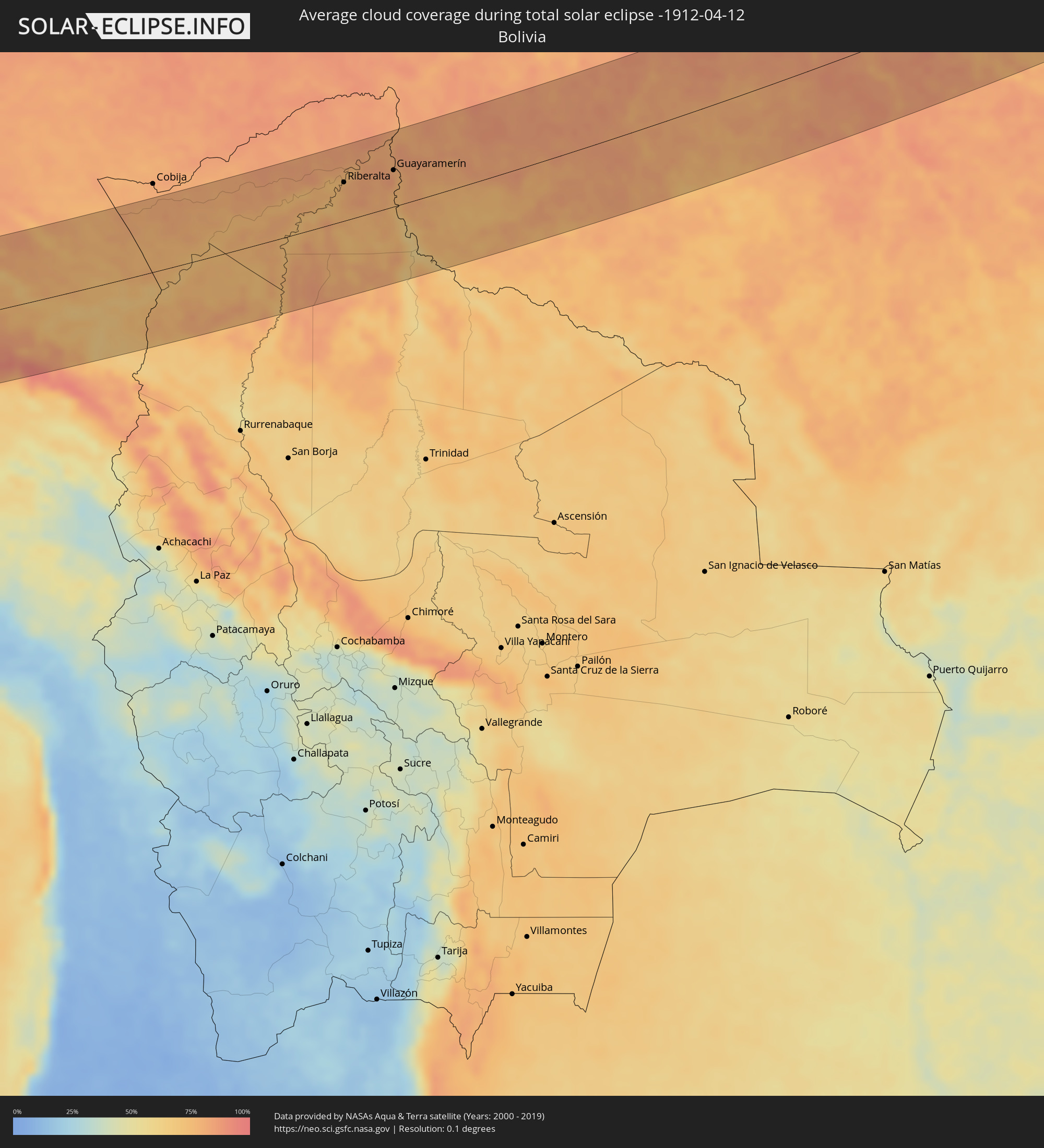 Bolivien
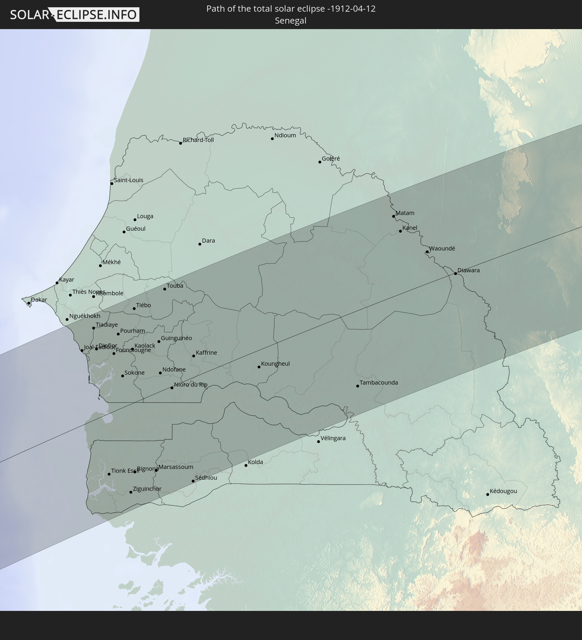
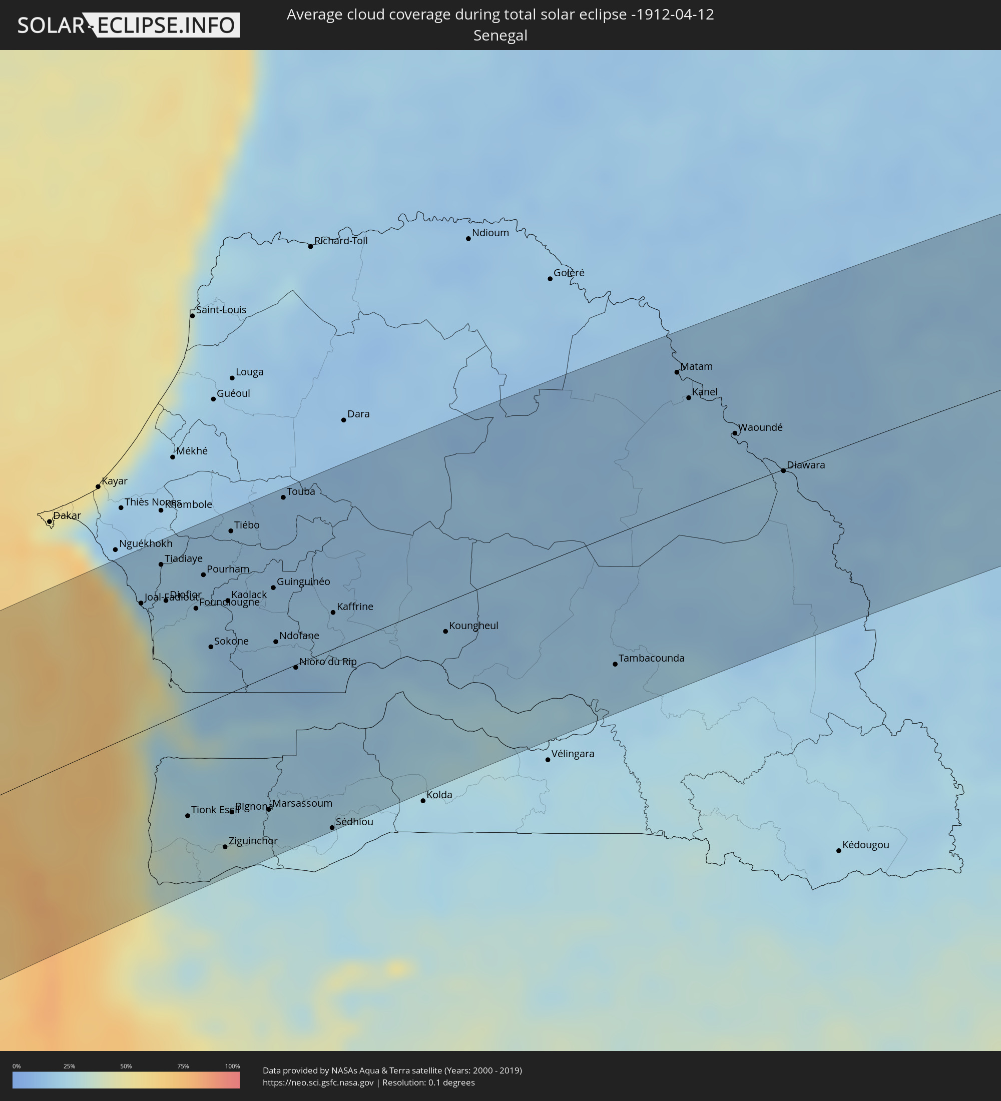 Senegal
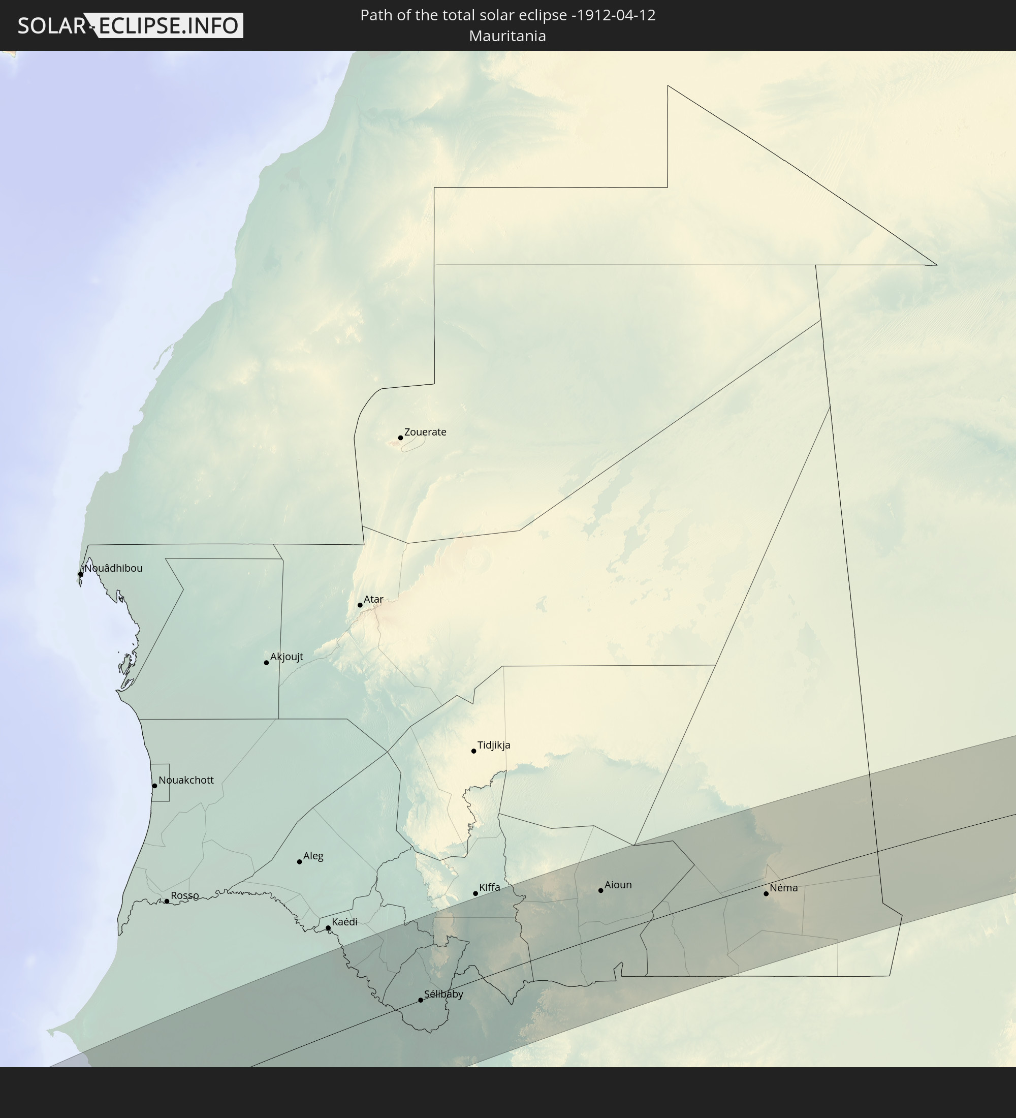
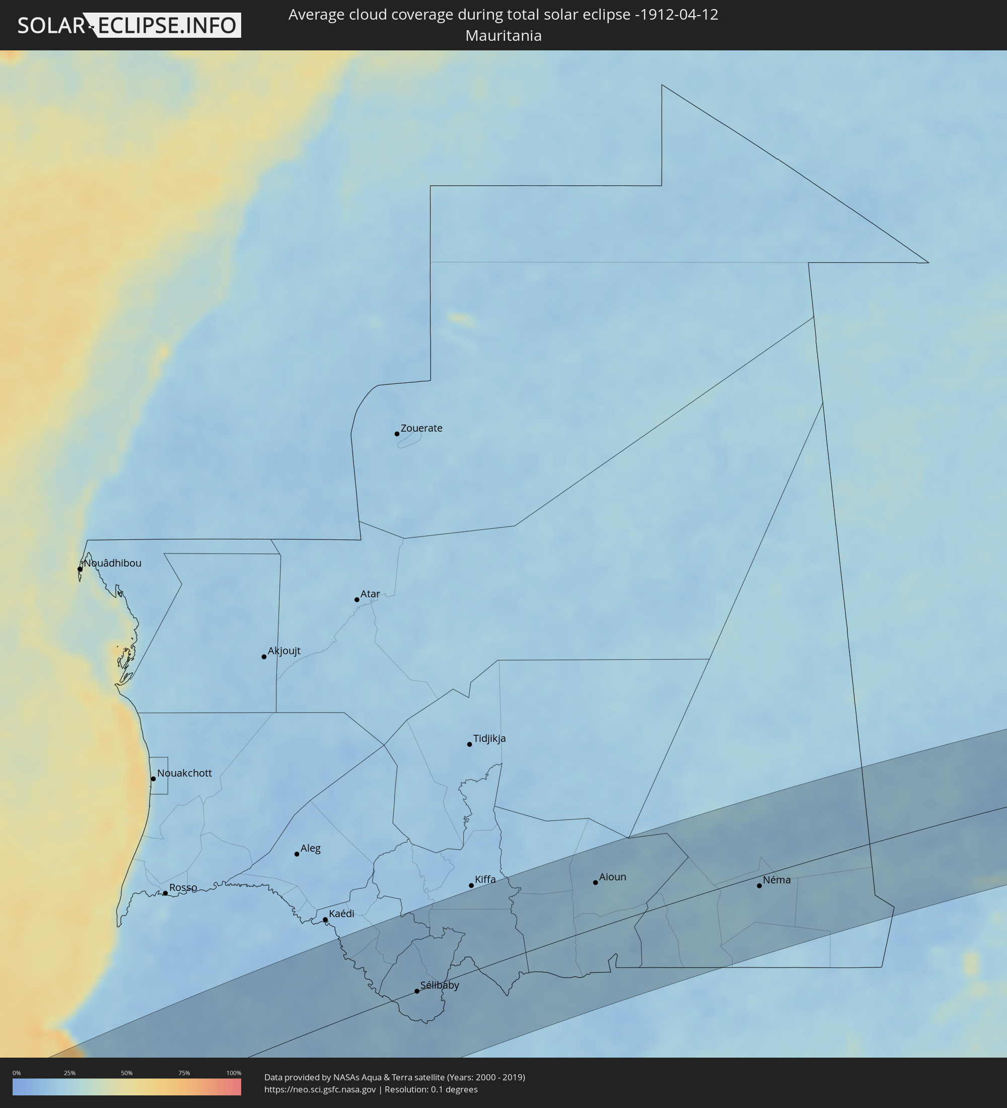 Mauretanien
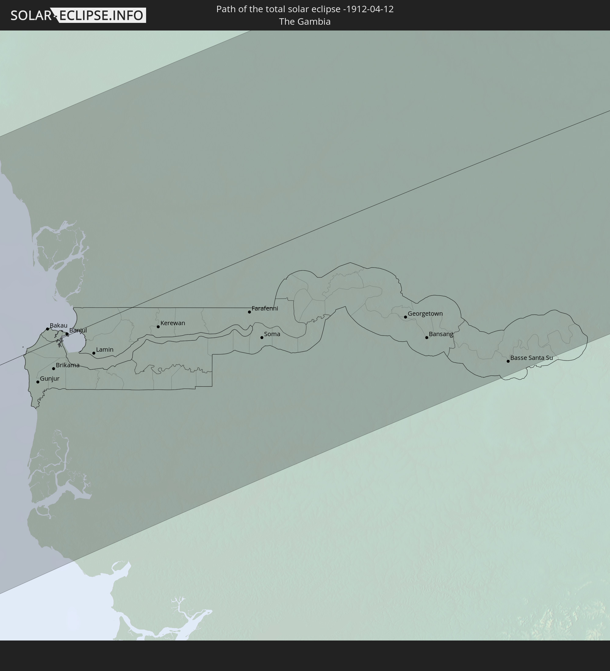
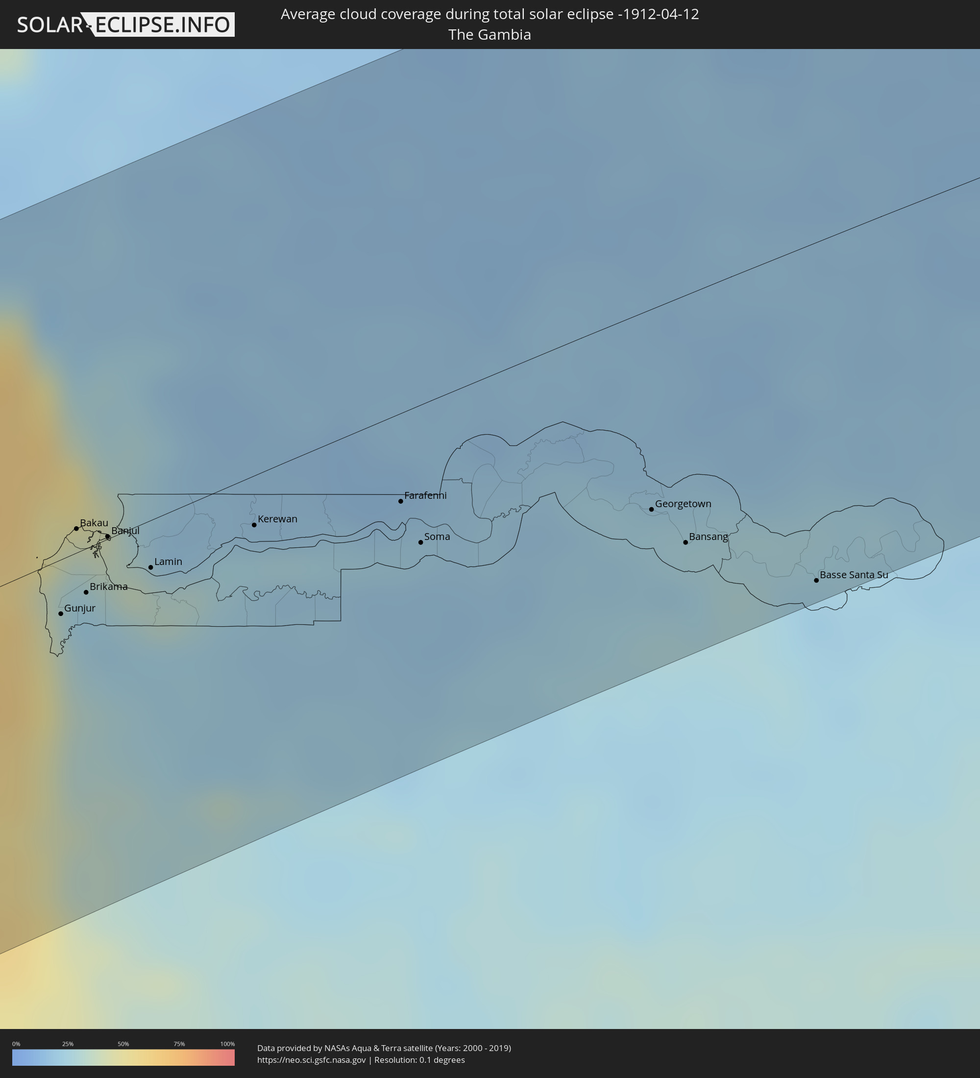 Gambia
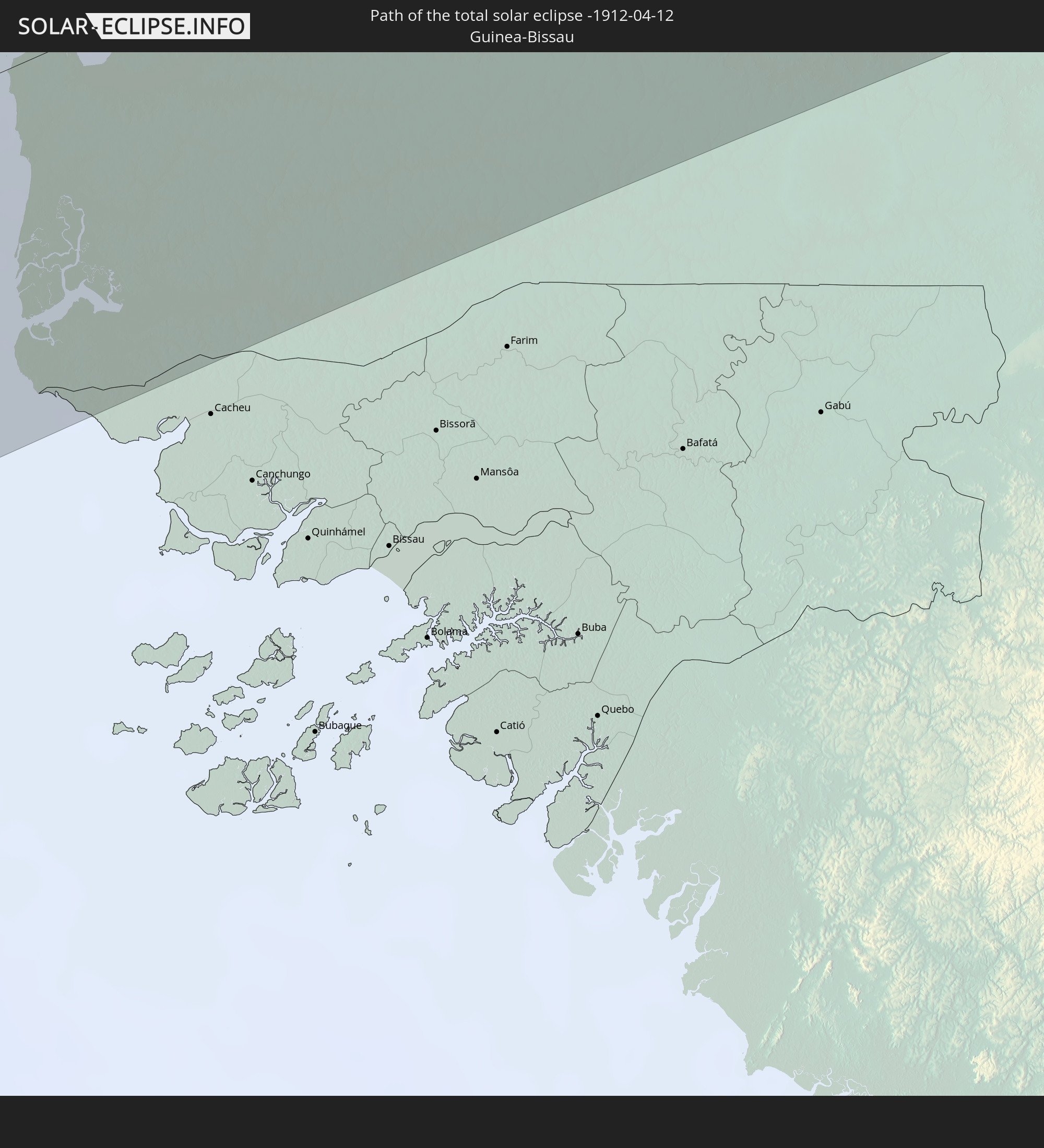
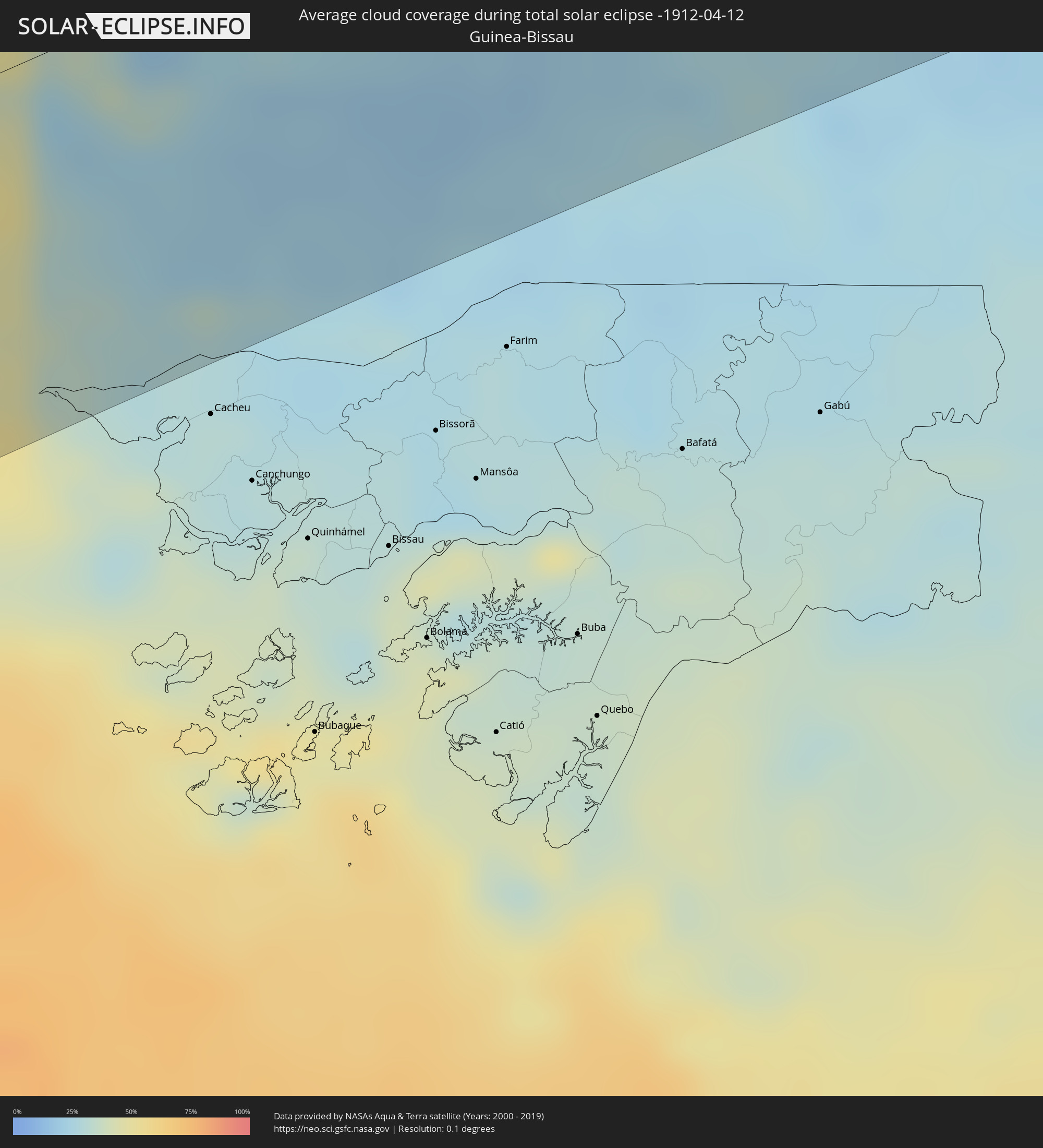 Guinea-Bissau
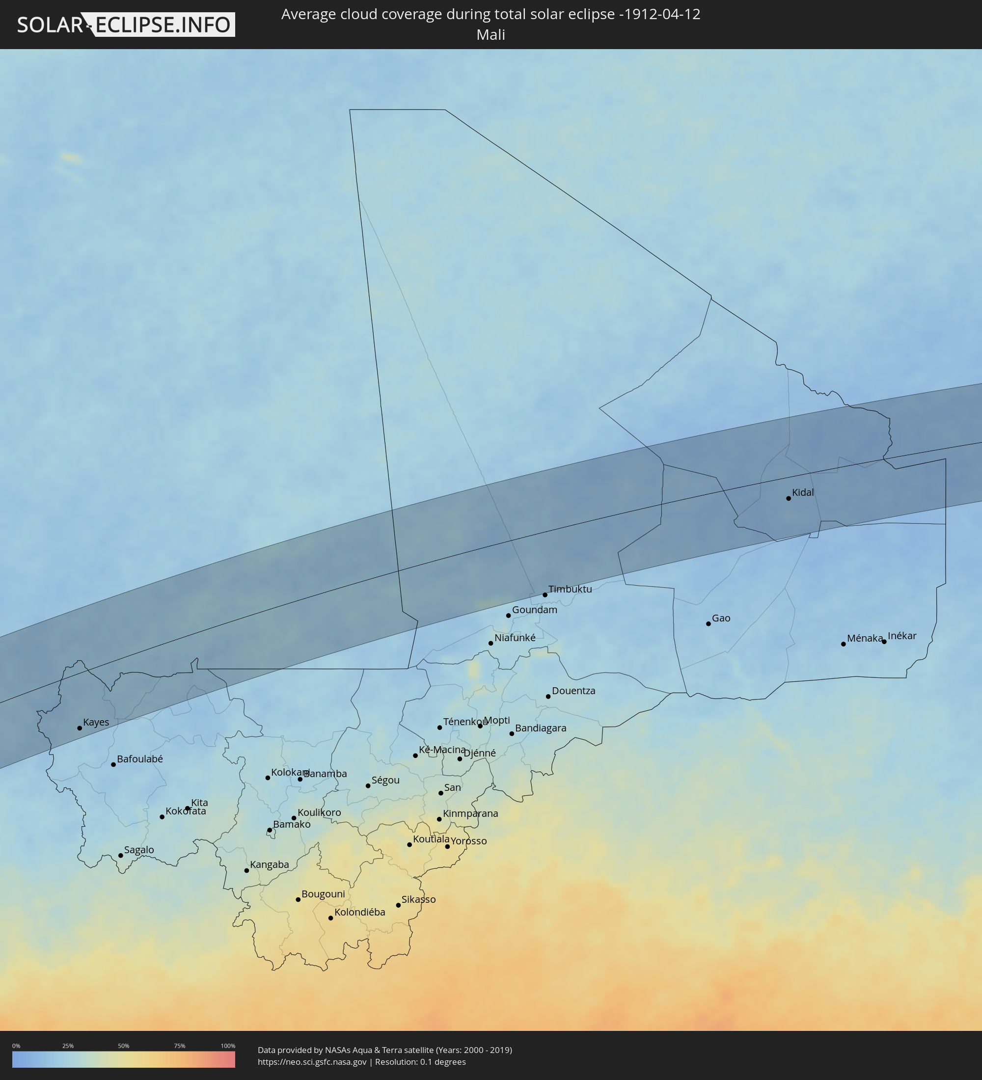 Mali
Mali
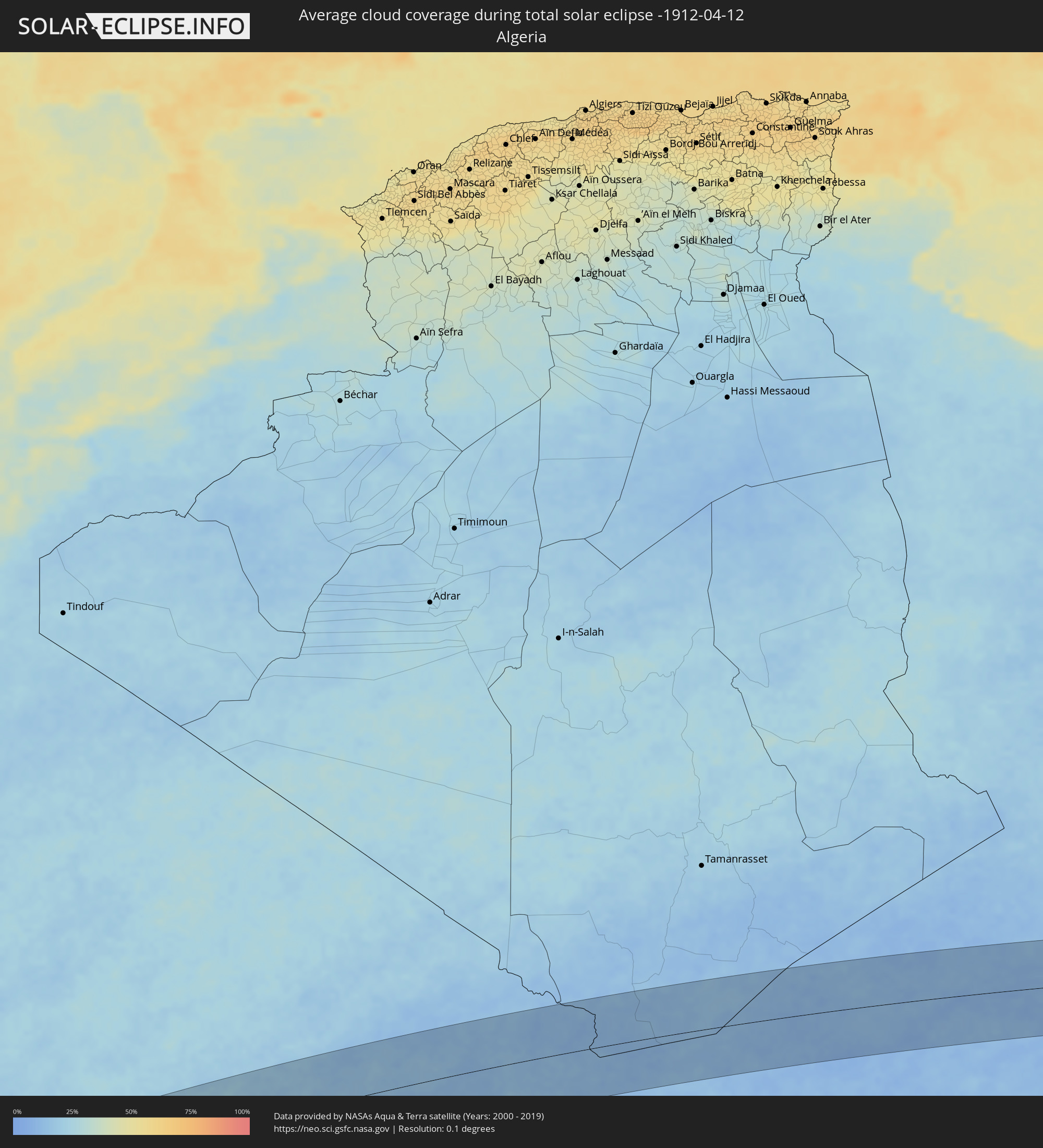 Algerien
 Niger
Niger
 Libyen
 Tschad
 Sudan
Sudan
Orte im Finsternispfad
Die nachfolgene Tabelle zeigt Städte und Orte mit mehr als 5.000 Einwohnern, die sich im Finsternispfad befinden. Städte mit mehr als 100.000 Einwohnern sind dick gekennzeichnet. Mit einem Klick auf den Ort öffnet sich eine Detailkarte die die Lage des jeweiligen Ortes zusammen mit dem Verlauf der zentralen Finsternis präsentiert.
| Ort | Typ | Dauer der Verfinsterung | Ortszeit bei maximaler Verfinsterung | Entfernung zur Zentrallinie | Ø Bewölkung |
|
San Vicente de Cañete, Lima region
|
total | - | 07:30:11 UTC-05:08 | 84 km | 42% |
|
Imperial, Lima region
|
total | - | 07:30:13 UTC-05:08 | 86 km | 42% |
|
Nuevo Imperial, Lima region
|
total | - | 07:30:14 UTC-05:08 | 83 km | 36% |
|
Pisco, Ica
|
total | - | 07:30:05 UTC-05:08 | 11 km | 30% |
|
San Clemente, Ica
|
total | - | 07:30:08 UTC-05:08 | 15 km | 30% |
|
Villa Tupac Amaru, Ica
|
total | - | 07:30:07 UTC-05:08 | 10 km | 31% |
|
Chincha Alta, Ica
|
total | - | 07:30:14 UTC-05:08 | 43 km | 46% |
|
Subtanjalla, Ica
|
total | - | 07:30:17 UTC-05:08 | 31 km | 23% |
|
San Juan Bautista, Ica
|
total | - | 07:30:18 UTC-05:08 | 31 km | 28% |
|
Ica, Ica
|
total | - | 07:30:17 UTC-05:08 | 37 km | 28% |
|
Santiago, Ica
|
total | - | 07:30:16 UTC-05:08 | 50 km | 25% |
|
Los Aquijes, Ica
|
total | - | 07:30:18 UTC-05:08 | 41 km | 28% |
|
Huancavelica, Huancavelica
|
total | - | 07:31:20 UTC-05:08 | 89 km | 73% |
|
Huanta, Ayacucho
|
total | - | 07:31:50 UTC-05:08 | 57 km | 56% |
|
Ayacucho, Ayacucho
|
total | - | 07:31:46 UTC-05:08 | 32 km | 65% |
|
San Miguel, Ayacucho
|
total | - | 07:32:01 UTC-05:08 | 43 km | 78% |
|
Talavera, Apurímac
|
total | - | 07:32:12 UTC-05:08 | 39 km | 70% |
|
Andahuaylas, Apurímac
|
total | - | 07:32:14 UTC-05:08 | 40 km | 70% |
|
Abancay, Apurímac
|
total | - | 07:32:40 UTC-05:08 | 49 km | 69% |
|
Santa Ana, Cusco
|
total | - | 07:33:08 UTC-05:08 | 31 km | 86% |
|
Urubamba, Cusco
|
total | - | 07:33:27 UTC-05:08 | 31 km | 68% |
|
Cusco, Cusco
|
total | - | 07:33:29 UTC-05:08 | 58 km | 69% |
|
Calca, Cusco
|
total | - | 07:33:35 UTC-05:08 | 38 km | 74% |
|
Tambopata, Madre de Dios
|
total | - | 07:36:21 UTC-05:08 | 30 km | 68% |
|
Puerto Maldonado, Madre de Dios
|
total | - | 07:36:33 UTC-05:08 | 26 km | 69% |
|
Riberalta, El Beni
|
total | - | 08:16:53 UTC-04:32 | 57 km | 78% |
|
Guayaramerín, El Beni
|
total | - | 08:17:50 UTC-04:32 | 54 km | 82% |
|
Guajará Mirim, Rondônia
|
total | - | 08:47:50 UTC-04:02 | 59 km | 78% |
|
Ariquemes, Rondônia
|
total | - | 08:51:23 UTC-04:02 | 78 km | 83% |
|
Jaru, Rondônia
|
total | - | 08:51:46 UTC-04:02 | 3 km | 84% |
|
Ouro Preto do Oeste, Rondônia
|
total | - | 08:51:53 UTC-04:02 | 39 km | 83% |
|
Ji Paraná, Rondônia
|
total | - | 08:52:09 UTC-04:02 | 62 km | 81% |
|
Aripuanã, Mato Grosso
|
total | - | 09:19:33 UTC-03:38 | 72 km | 83% |
|
São Félix do Xingu, Pará
|
total | - | 10:01:12 UTC-03:13 | 28 km | 82% |
|
Itupiranga, Pará
|
total | - | 10:08:19 UTC-03:13 | 6 km | 84% |
|
Marabá, Pará
|
total | - | 10:08:25 UTC-03:13 | 40 km | 88% |
|
Paragominas, Pará
|
total | - | 10:15:04 UTC-03:13 | 113 km | 90% |
|
Santa Inês, Maranhão
|
total | - | 10:58:42 UTC-02:34 | 67 km | 92% |
|
Pindaré Mirim, Maranhão
|
total | - | 10:58:52 UTC-02:34 | 64 km | 88% |
|
Santa Helena, Maranhão
|
total | - | 11:00:54 UTC-02:34 | 68 km | 90% |
|
Penalva, Maranhão
|
total | - | 10:59:41 UTC-02:34 | 42 km | 80% |
|
Pio XII, Maranhão
|
total | - | 10:58:59 UTC-02:34 | 96 km | 87% |
|
Pinheiro, Maranhão
|
total | - | 11:00:59 UTC-02:34 | 28 km | 88% |
|
Viana, Maranhão
|
total | - | 11:00:10 UTC-02:34 | 44 km | 87% |
|
Vitória do Mearim, Maranhão
|
total | - | 11:00:08 UTC-02:34 | 75 km | 87% |
|
Cururupu, Maranhão
|
total | - | 11:02:28 UTC-02:34 | 83 km | 91% |
|
São Bento, Maranhão
|
total | - | 11:01:19 UTC-02:34 | 3 km | 89% |
|
Arari, Maranhão
|
total | - | 11:00:21 UTC-02:34 | 79 km | 86% |
|
Itapecuru Mirim, Maranhão
|
total | - | 11:01:24 UTC-02:34 | 96 km | 89% |
|
São Luís, Maranhão
|
total | - | 11:02:45 UTC-02:34 | 16 km | 92% |
|
São José de Ribamar, Maranhão
|
total | - | 11:03:17 UTC-02:34 | 33 km | 87% |
|
Barreirinhas, Maranhão
|
total | - | 11:05:51 UTC-02:34 | 119 km | 92% |
|
Joal-Fadiout, Thiès
|
total | - | 14:51:35 UTC-00:16 | 85 km | 34% |
|
Gunjur, Western
|
total | - | 14:50:50 UTC-00:16 | 18 km | 28% |
|
Sukuta, Western
|
total | - | 14:51:06 UTC-00:16 | 2 km | 26% |
|
Tiadiaye, Thiès
|
total | - | 14:52:06 UTC-00:16 | 104 km | 19% |
|
Bakau, Banjul
|
total | - | 14:51:13 UTC-00:16 | 8 km | 34% |
|
Diofior, Fatick
|
total | - | 14:51:57 UTC-00:16 | 79 km | 22% |
|
Abuko, Western
|
total | - | 14:51:12 UTC-00:16 | 1 km | 26% |
|
Brikama, Western
|
total | - | 14:51:05 UTC-00:16 | 15 km | 24% |
|
Banjul, Banjul
|
total | - | 14:51:25 UTC-00:16 | 1 km | 36% |
|
Barra, North Bank
|
total | - | 14:51:31 UTC-00:16 | 2 km | 31% |
|
Essau, North Bank
|
total | - | 14:51:32 UTC-00:16 | 2 km | 31% |
|
Tionk Essil, Ziguinchor
|
total | - | 14:50:51 UTC-00:16 | 70 km | 28% |
|
Lamin, North Bank
|
total | - | 14:51:37 UTC-00:16 | 16 km | 31% |
|
Pourham, Fatick
|
total | - | 14:52:38 UTC-00:16 | 85 km | 19% |
|
Sokone, Fatick
|
total | - | 14:52:17 UTC-00:16 | 36 km | 24% |
|
Ziguinchor, Ziguinchor
|
total | - | 14:51:10 UTC-00:16 | 101 km | 28% |
|
Gandiaye, Kaolack
|
total | - | 14:52:50 UTC-00:16 | 67 km | 19% |
|
Kaolack, Kaolack
|
total | - | 14:52:49 UTC-00:16 | 61 km | 19% |
|
Tiébo, Diourbel
|
total | - | 14:53:17 UTC-00:16 | 107 km | 16% |
|
Bignona, Ziguinchor
|
total | - | 14:51:30 UTC-00:16 | 80 km | 23% |
|
Kerewan, North Bank
|
total | - | 14:52:28 UTC-00:16 | 17 km | 25% |
|
Marsassoum, Kolda
|
total | - | 14:52:02 UTC-00:16 | 89 km | 24% |
|
Guinguinéo, Fatick
|
total | - | 14:53:31 UTC-00:16 | 57 km | 16% |
|
Ndofane, Kaolack
|
total | - | 14:53:13 UTC-00:16 | 20 km | 16% |
|
Touba, Diourbel
|
total | - | 14:54:12 UTC-00:16 | 114 km | 14% |
|
Nioro du Rip, Kaolack
|
total | - | 14:53:20 UTC-00:16 | 2 km | 14% |
|
Farafenni, North Bank
|
total | - | 14:53:34 UTC-00:16 | 29 km | 20% |
|
Sédhiou, Sédhiou
|
total | - | 14:52:48 UTC-00:16 | 119 km | 23% |
|
Kaffrine, Kaffrine
|
total | - | 14:54:11 UTC-00:16 | 24 km | 17% |
|
Mansa Konko, Lower River
|
total | - | 14:53:34 UTC-00:16 | 42 km | 22% |
|
Soma, Lower River
|
total | - | 14:53:34 UTC-00:16 | 46 km | 18% |
|
Koungheul, Kaffrine
|
total | - | 14:55:36 UTC-00:16 | 20 km | 18% |
|
Georgetown, Central River
|
total | - | 14:55:15 UTC-00:16 | 67 km | 23% |
|
Bansang, Central River
|
total | - | 14:55:23 UTC-00:16 | 83 km | 22% |
|
Basse Santa Su, Upper River
|
total | - | 14:56:09 UTC-00:16 | 113 km | 20% |
|
Tambacounda, Tambacounda
|
total | - | 14:57:40 UTC-00:16 | 88 km | 19% |
|
Ouro Sogui, Matam
|
total | - | 14:59:55 UTC-00:16 | 89 km | 15% |
|
Matam, Matam
|
total | - | 15:00:05 UTC-00:16 | 92 km | 14% |
|
Kanel, Matam
|
total | - | 15:00:06 UTC-00:16 | 72 km | 16% |
|
Waoundé, Matam
|
total | - | 15:00:30 UTC-00:16 | 36 km | 19% |
|
Diawara, Matam
|
total | - | 15:00:56 UTC-00:16 | 1 km | 19% |
|
Sélibaby, Guidimaka
|
total | - | 15:01:43 UTC-00:16 | 1 km | 18% |
|
Kayes, Kayes
|
total | - | 15:02:32 UTC-00:16 | 102 km | 21% |
|
Aioun, Hodh El Gharbi
|
total | - | 15:07:27 UTC-00:16 | 66 km | 20% |
|
Néma, Hodh ech Chargui
|
total | - | 15:11:23 UTC-00:16 | 15 km | 19% |
|
Kidal, Kidal
|
total | - | 15:24:21 UTC-00:16 | 41 km | 14% |
|
Bardaï, Tibesti
|
total | - | 16:53:55 UTC+01:00 | 78 km | 12% |