Totale Sonnenfinsternis vom 07.12.-1915
| Wochentag: | Mittwoch |
| Maximale Dauer der Verfinsterung: | 01m36s |
| Maximale Breite des Finsternispfades: | 121 km |
| Saroszyklus: | 21 |
| Bedeckungsgrad: | 100% |
| Magnitude: | 1.0182 |
| Gamma: | 0.8567 |
Wo kann man die Sonnenfinsternis vom 07.12.-1915 sehen?
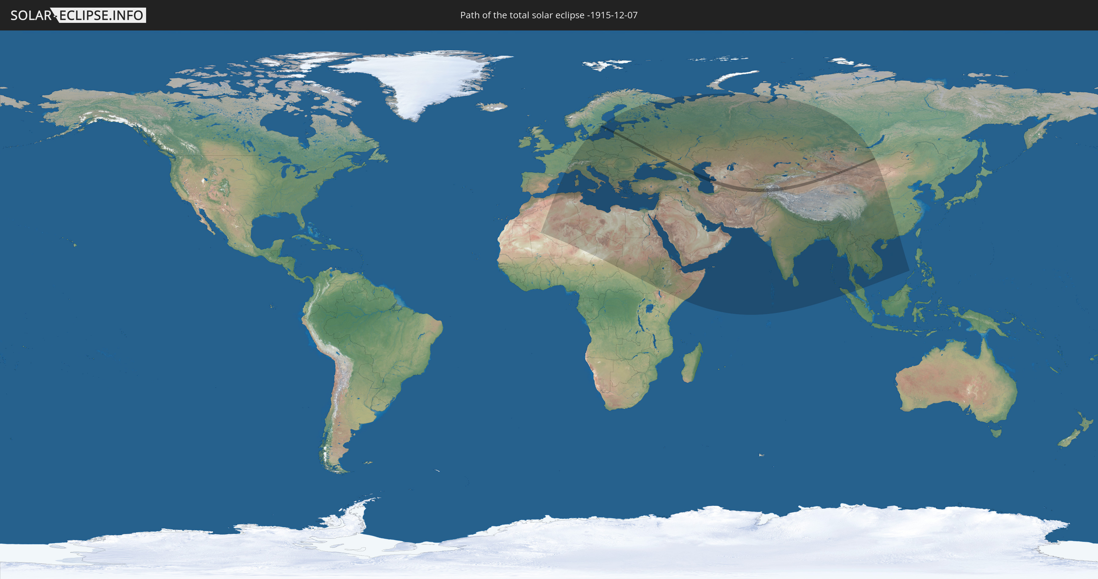
Die Sonnenfinsternis am 07.12.-1915 kann man in 91 Ländern als partielle Sonnenfinsternis beobachten.
Der Finsternispfad verläuft durch 12 Länder. Nur in diesen Ländern ist sie als totale Sonnenfinsternis zu sehen.
In den folgenden Ländern ist die Sonnenfinsternis total zu sehen
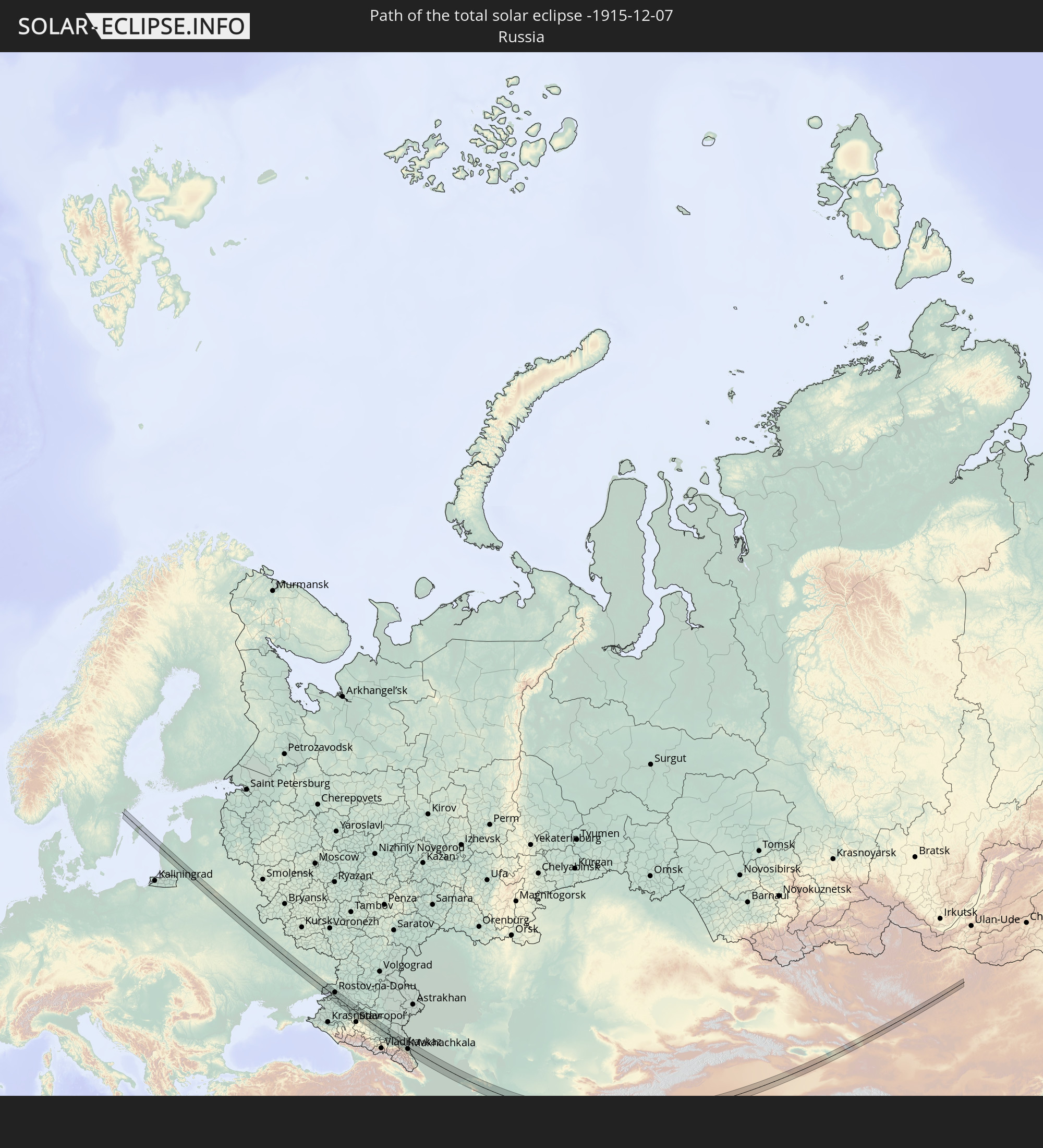 Russland
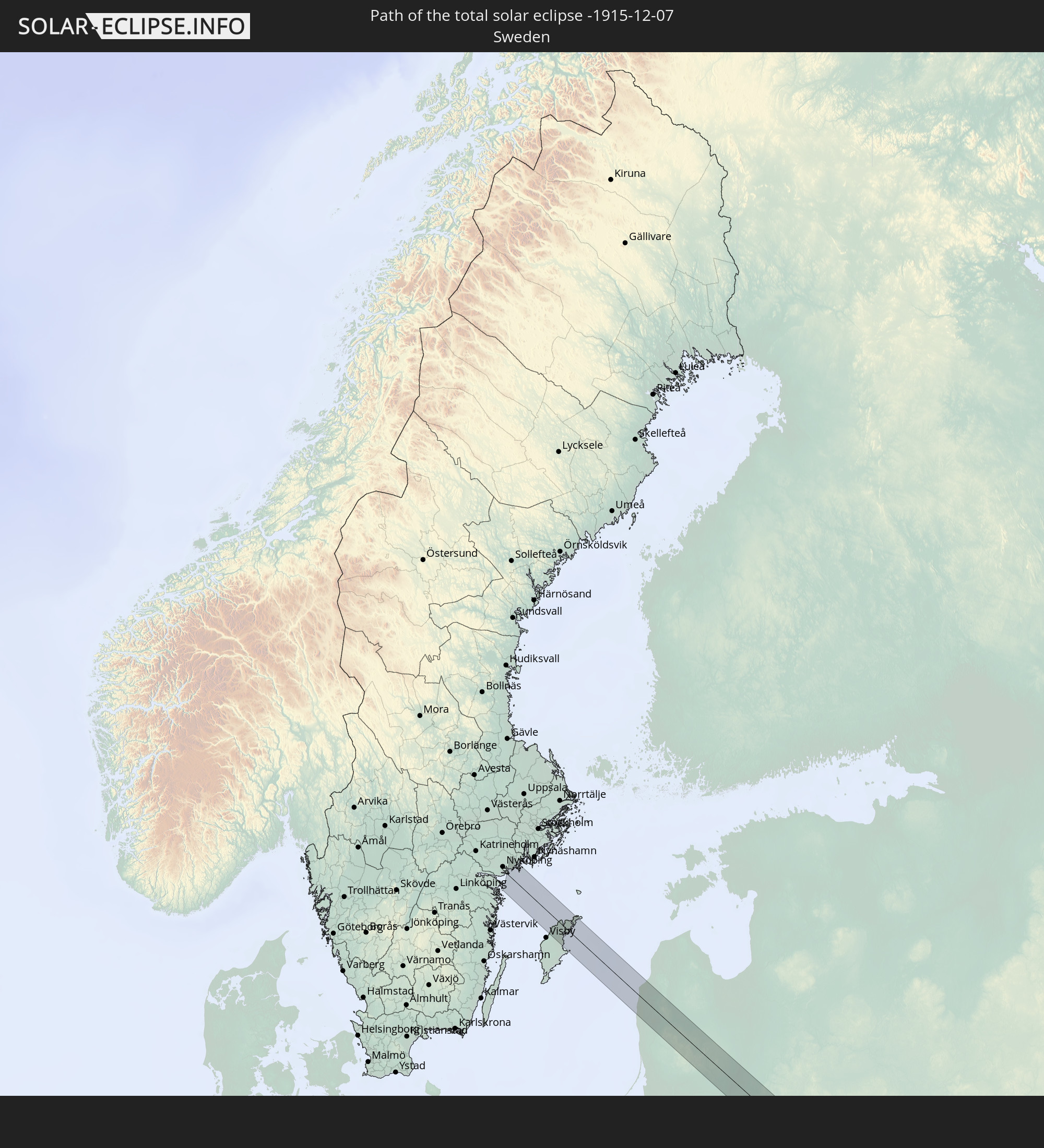 Schweden
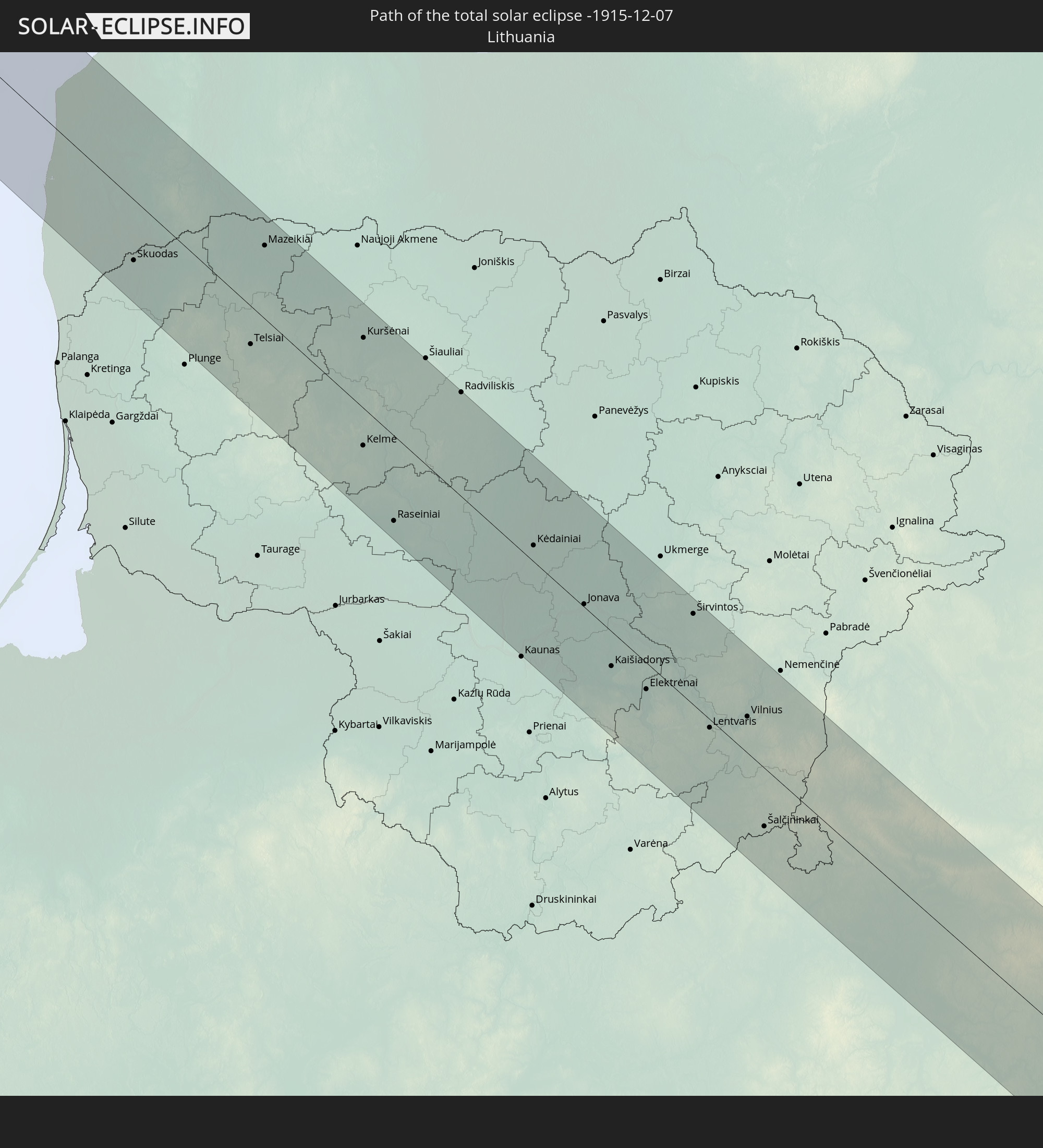 Litauen
 Lettland
 Ukraine
 Weißrussland
 Turkmenistan
 Usbekistan
 Afghanistan
 Tadschikistan
 Volksrepublik China
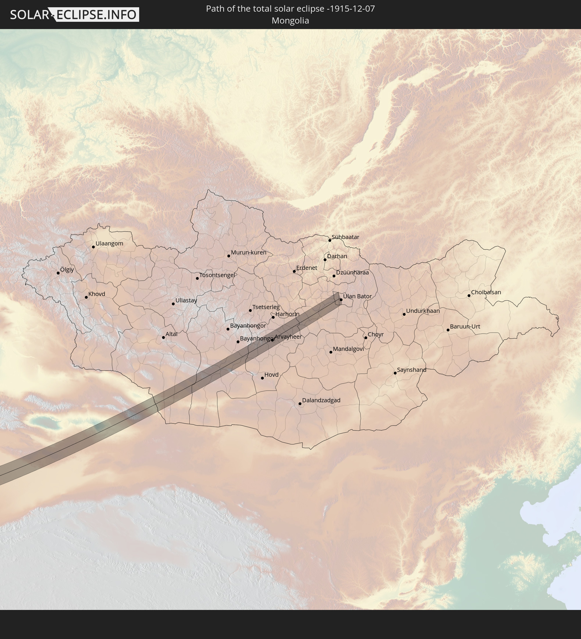 Mongolei
In den folgenden Ländern ist die Sonnenfinsternis partiell zu sehen
 Russland
 Spanien
 Algerien
 Frankreich
 Niger
Niger
 Deutschland
 Schweiz
 Italien
 Monaco
 Tunesien
 Dänemark
 Libyen
 Liechtenstein
 Österreich
 Schweden
 Tschechien
 San Marino
 Vatikanstadt
 Slowenien
 Tschad
 Kroatien
 Polen
Polen
 Malta
Malta
 Bosnien und Herzegowina
 Ungarn
 Slowakei
 Montenegro
 Serbien
 Albanien
 Åland Islands
 Griechenland
 Rumänien
 Mazedonien
 Finnland
 Litauen
 Lettland
 Estland
 Sudan
Sudan
 Ukraine
 Bulgarien
 Weißrussland
 Ägypten
 Türkei
 Moldawien
 Republik Zypern
 Äthiopien
 Kenia
Kenia
 Staat Palästina
 Israel
 Saudi-Arabien
 Jordanien
 Libanon
 Syrien
 Eritrea
 Irak
Irak
 Georgien
 Somalia
 Dschibuti
 Jemen
Jemen
 Armenien
 Iran
Iran
 Aserbaidschan
 Kasachstan
 Kuwait
 Bahrain
 Katar
Katar
 Vereinigte Arabische Emirate
 Oman
Oman
 Turkmenistan
 Usbekistan
 Afghanistan
 Pakistan
 Tadschikistan
 Indien
 Kirgisistan
 Malediven
 Volksrepublik China
 Sri Lanka
 Nepal
Nepal
 Mongolei
 Bangladesch
 Bhutan
 Myanmar
 Indonesien
 Thailand
 Malaysia
 Laos
Laos
 Vietnam
 Kambodscha
 Macau
Macau
 Hongkong
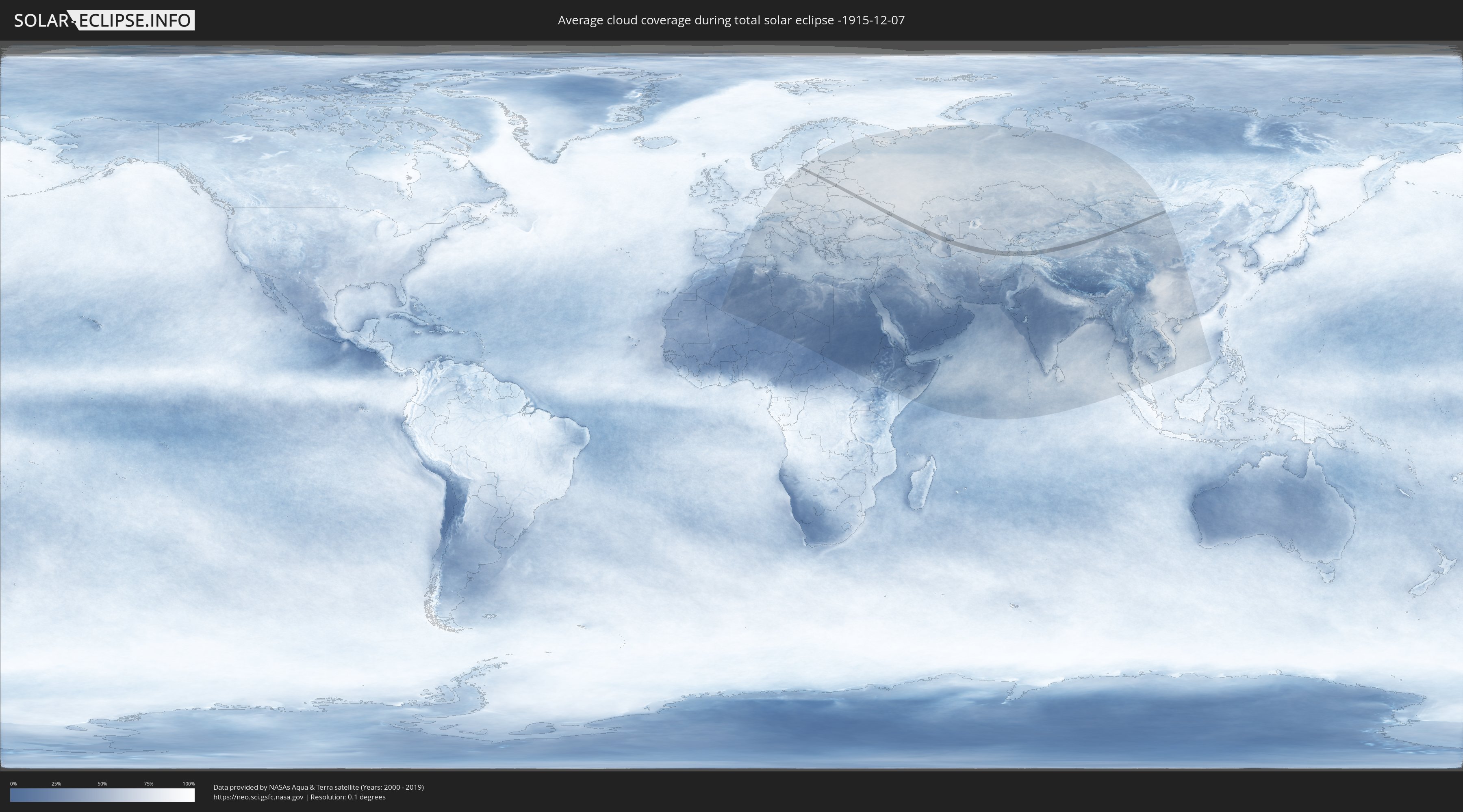
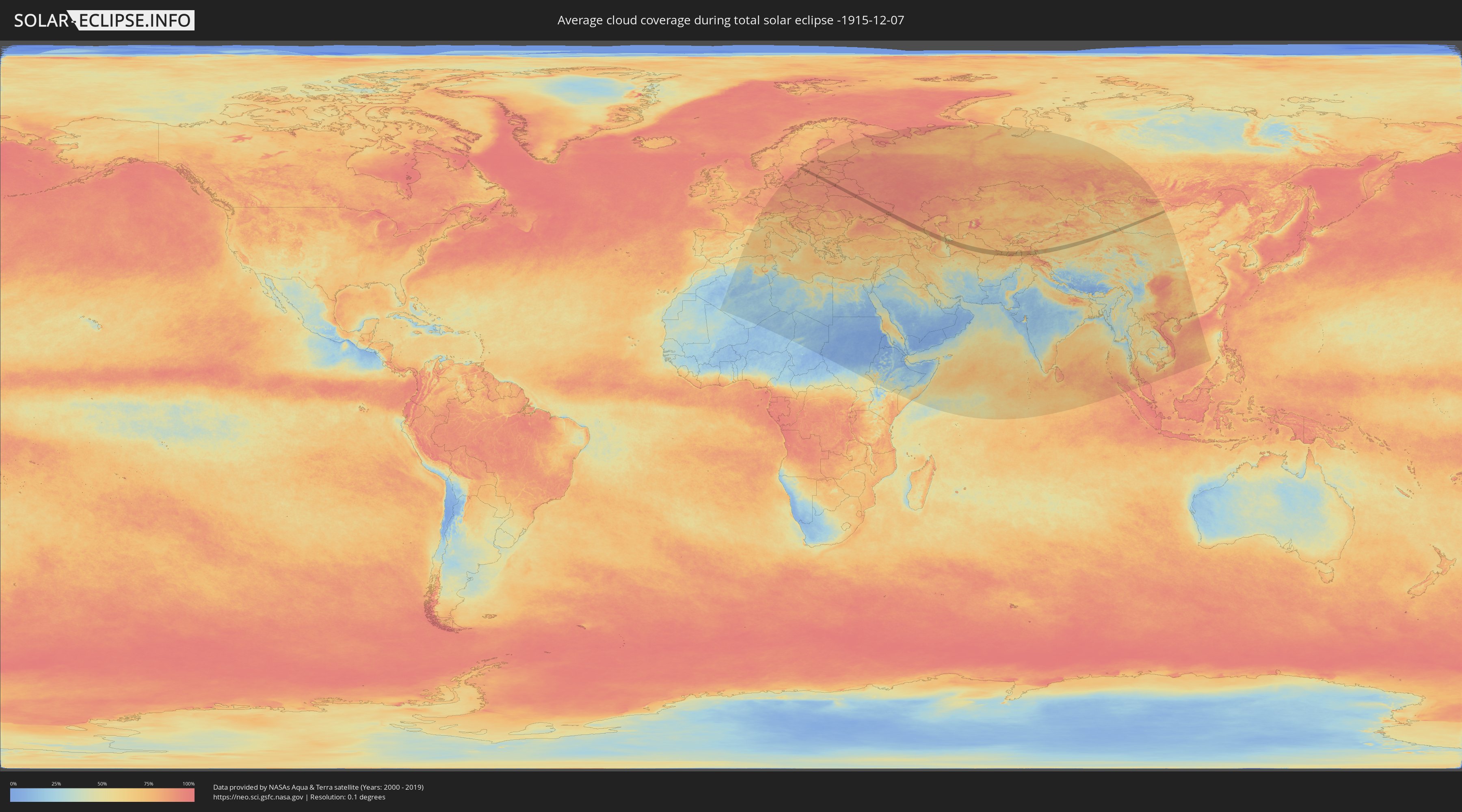
Wie wird das Wetter während der totalen Sonnenfinsternis am 07.12.-1915?
Wo ist der beste Ort, um die totale Sonnenfinsternis vom 07.12.-1915 zu beobachten?
Die folgenden Karten zeigen die durchschnittliche Bewölkung für den Tag, an dem die totale Sonnenfinsternis
stattfindet. Mit Hilfe der Karten lässt sich der Ort entlang des Finsternispfades eingrenzen,
der die besten Aussichen auf einen klaren wolkenfreien Himmel bietet.
Trotzdem muss man immer lokale Gegenenheiten beachten und sollte sich genau über das Wetter an seinem
gewählten Beobachtungsort informieren.
Die Daten stammen von den beiden NASA-Satelliten
AQUA und TERRA
und wurden über einen Zeitraum von 19 Jahren (2000 - 2019) gemittelt.
Detaillierte Länderkarten
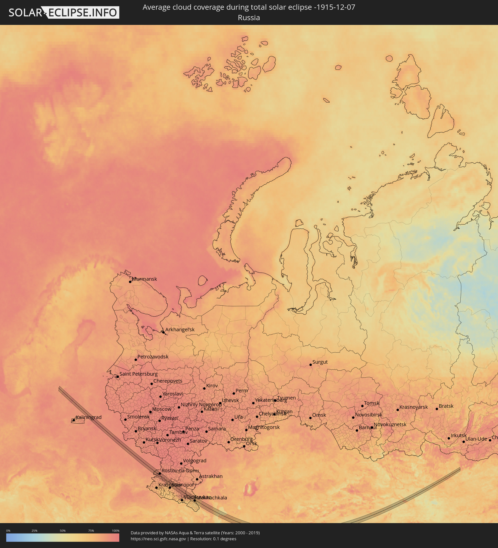 Russland
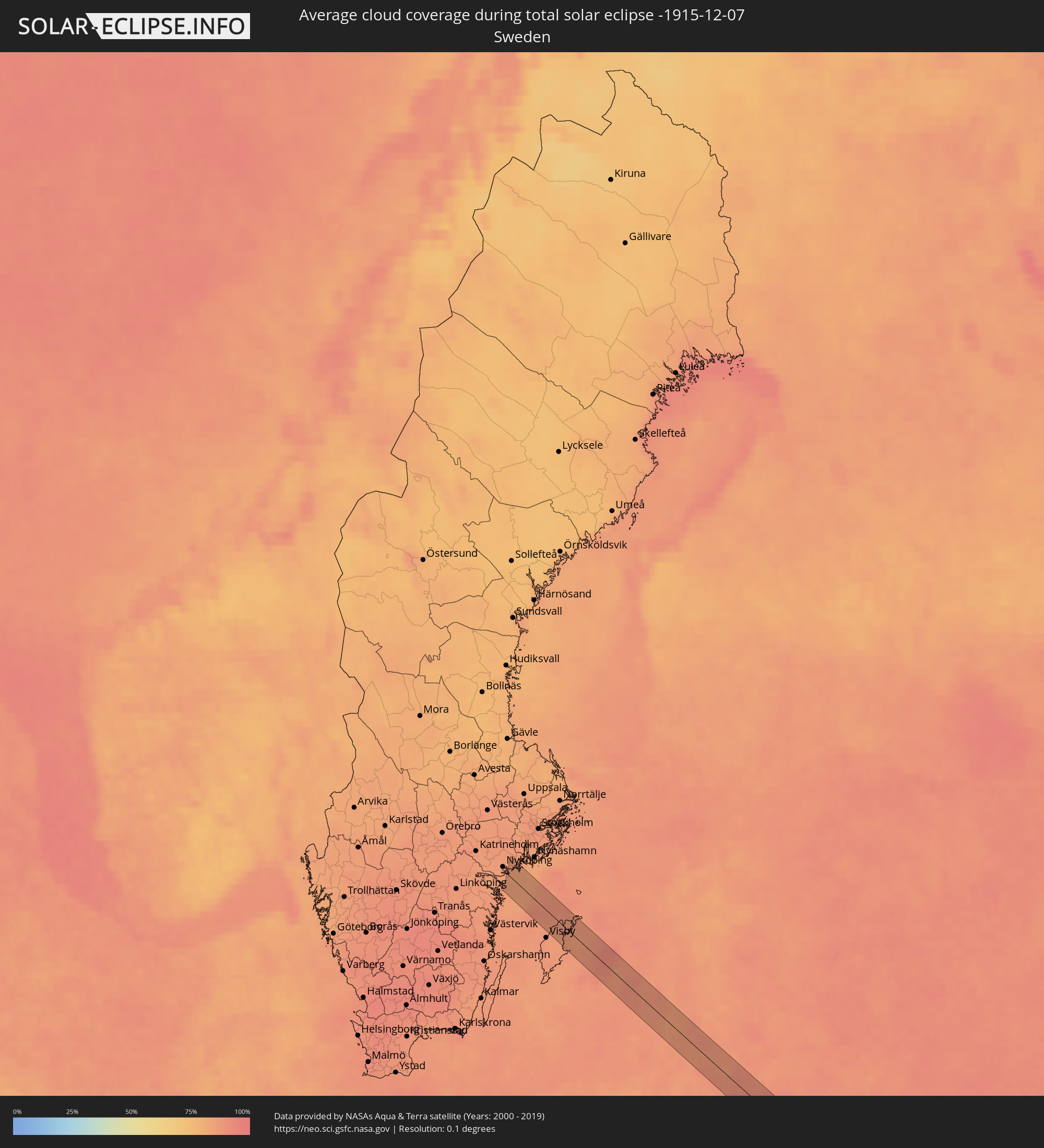 Schweden
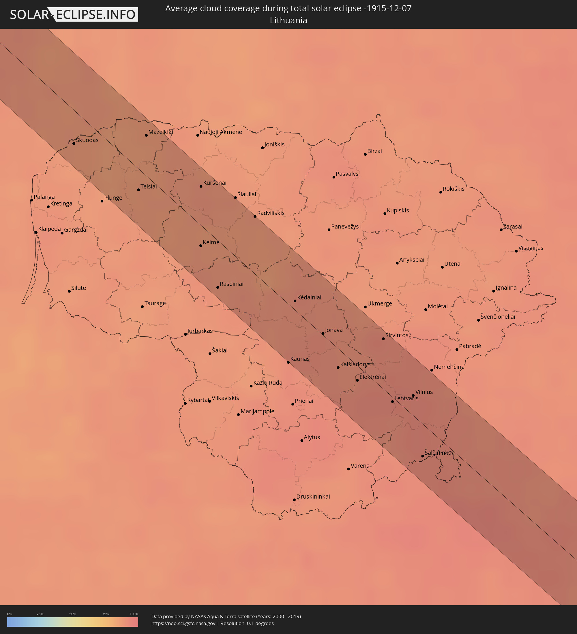 Litauen
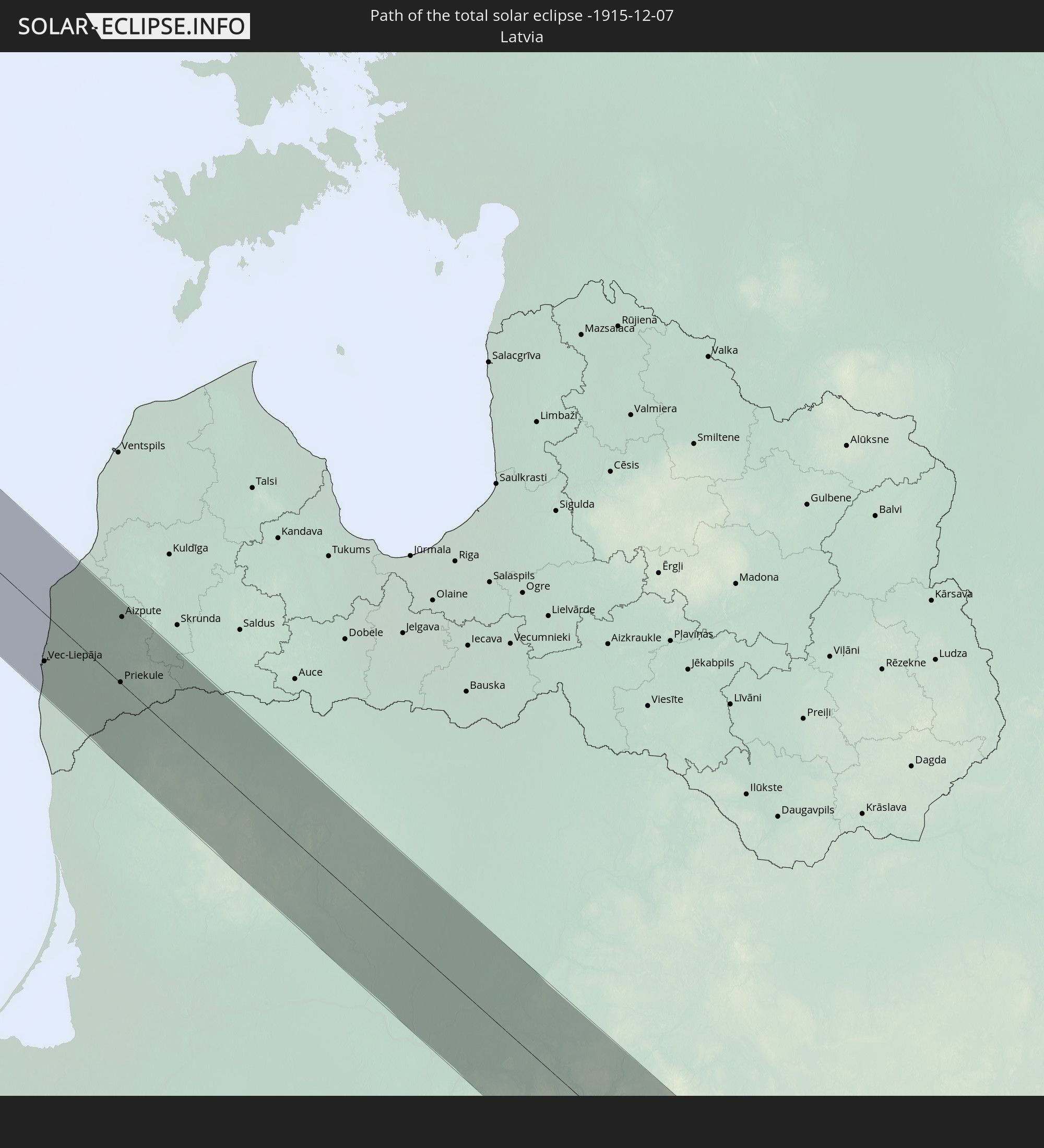
 Lettland
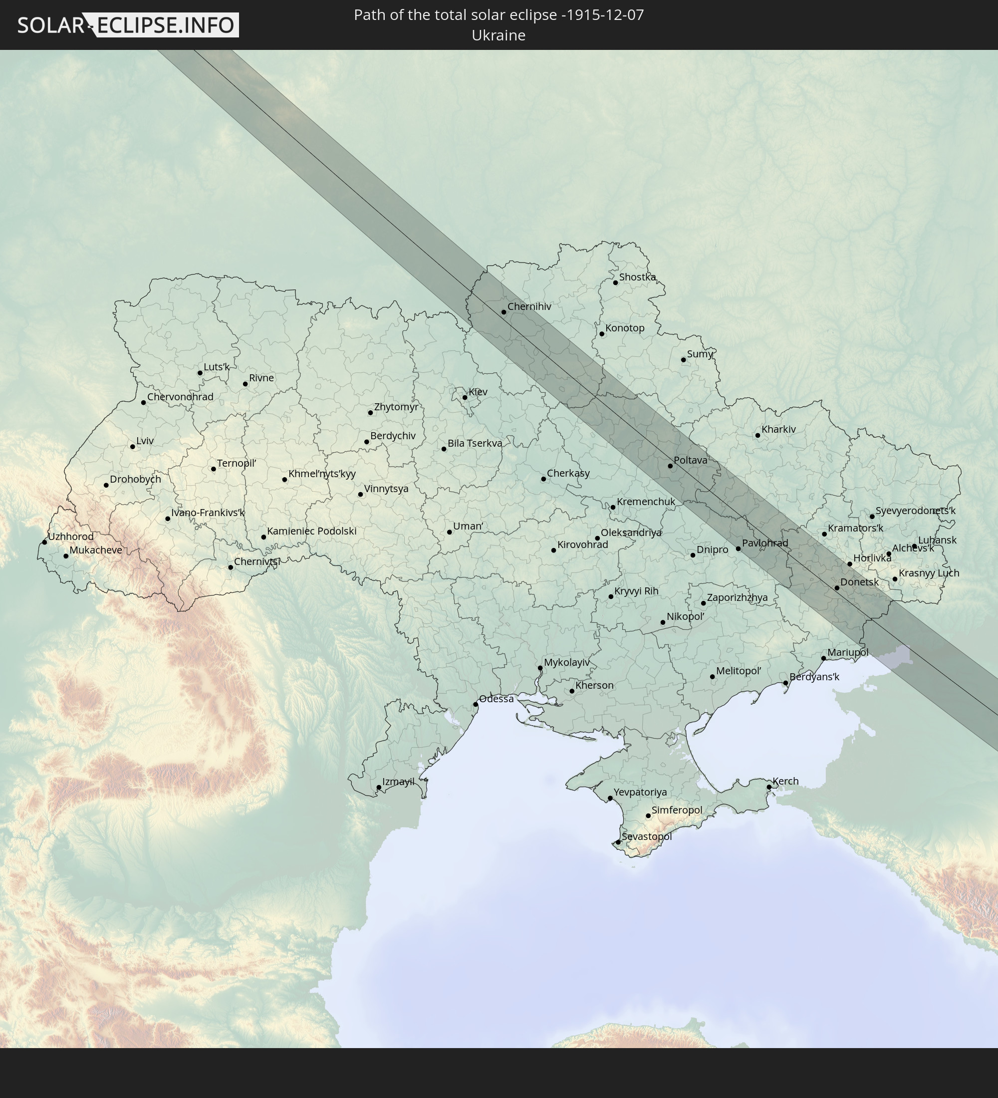
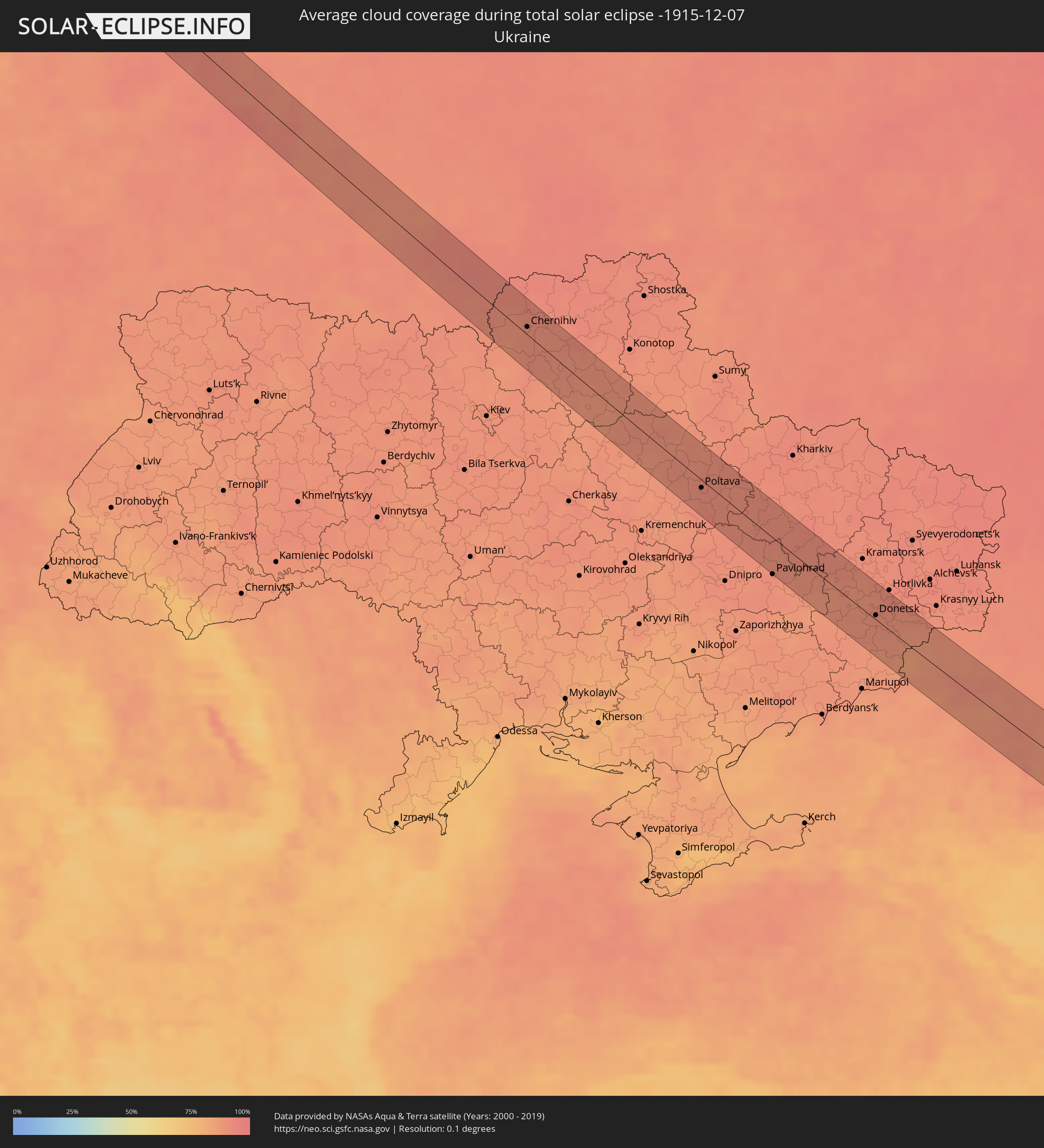 Ukraine
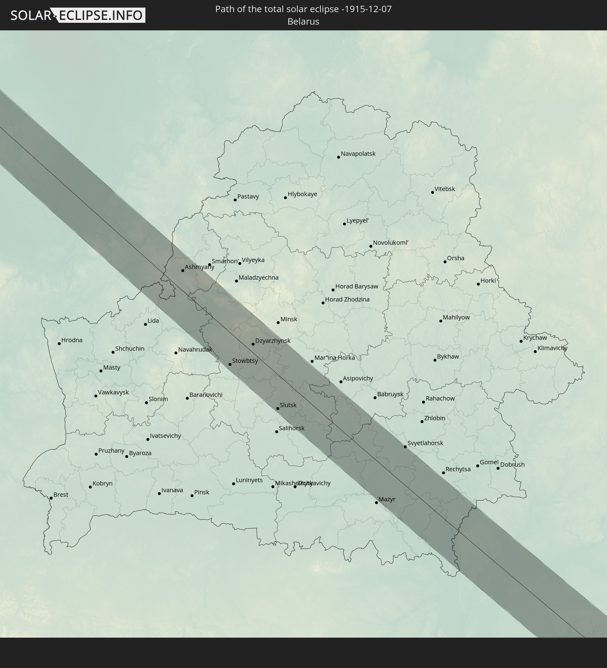
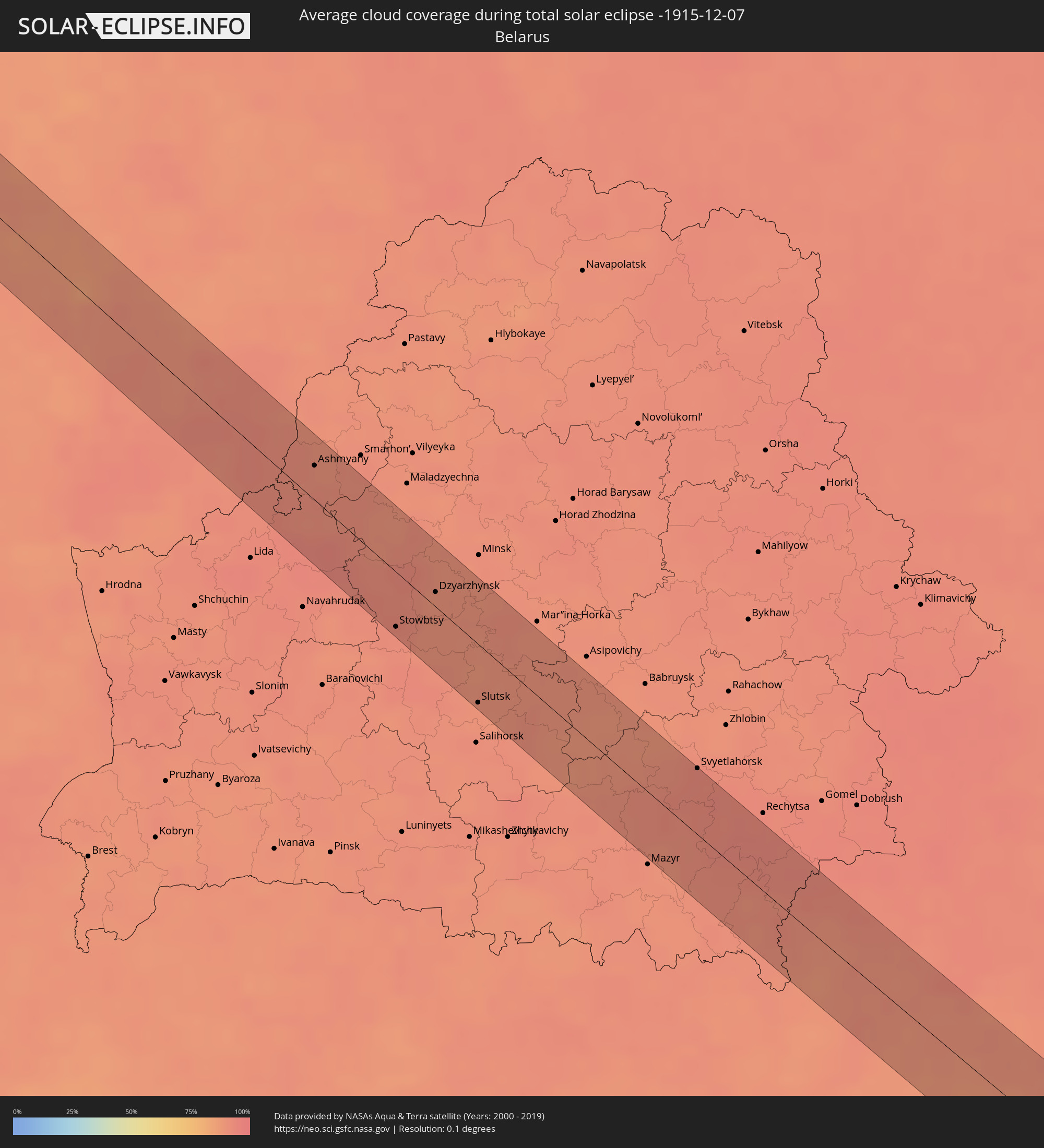 Weißrussland
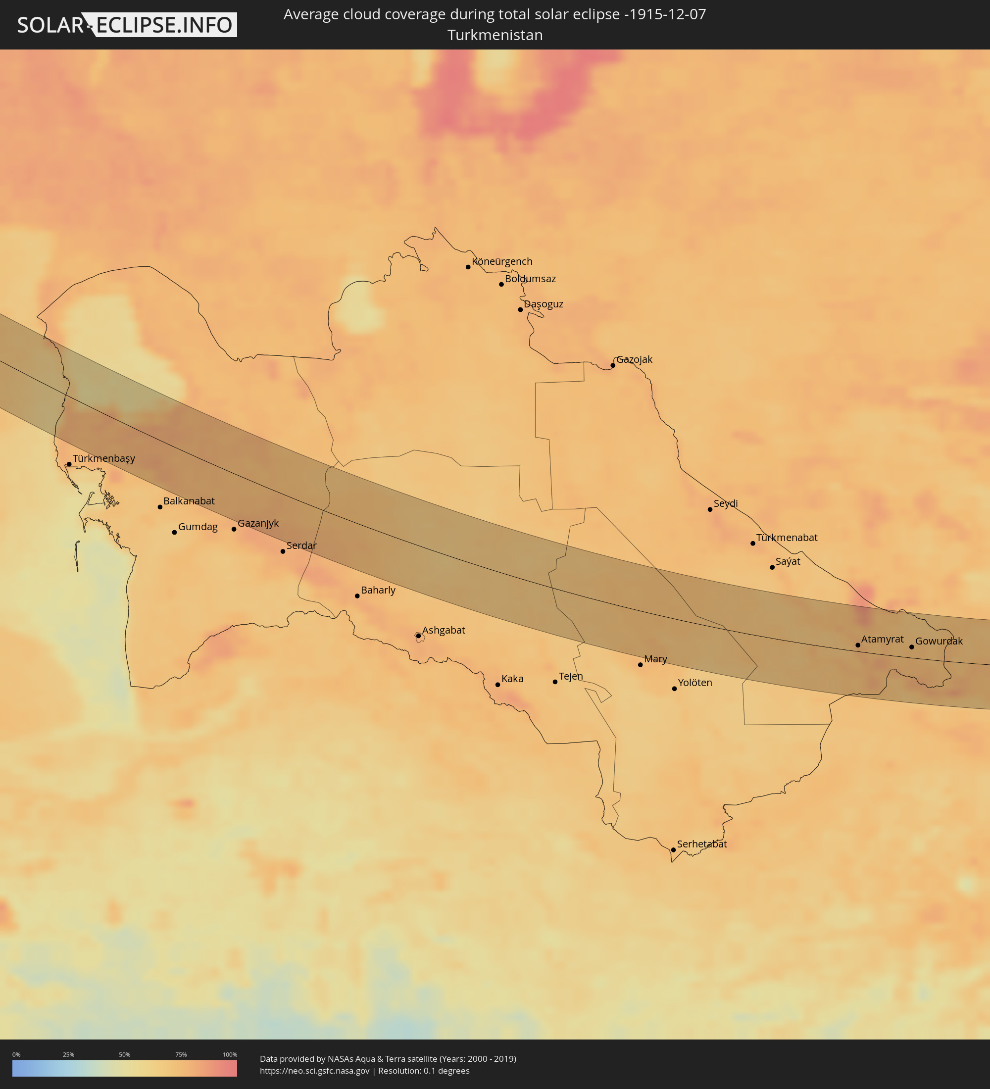 Turkmenistan
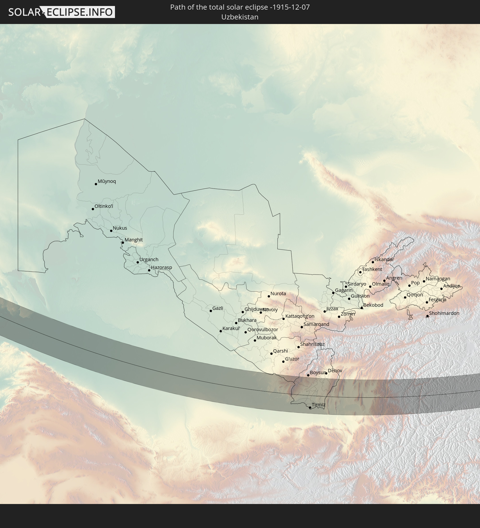
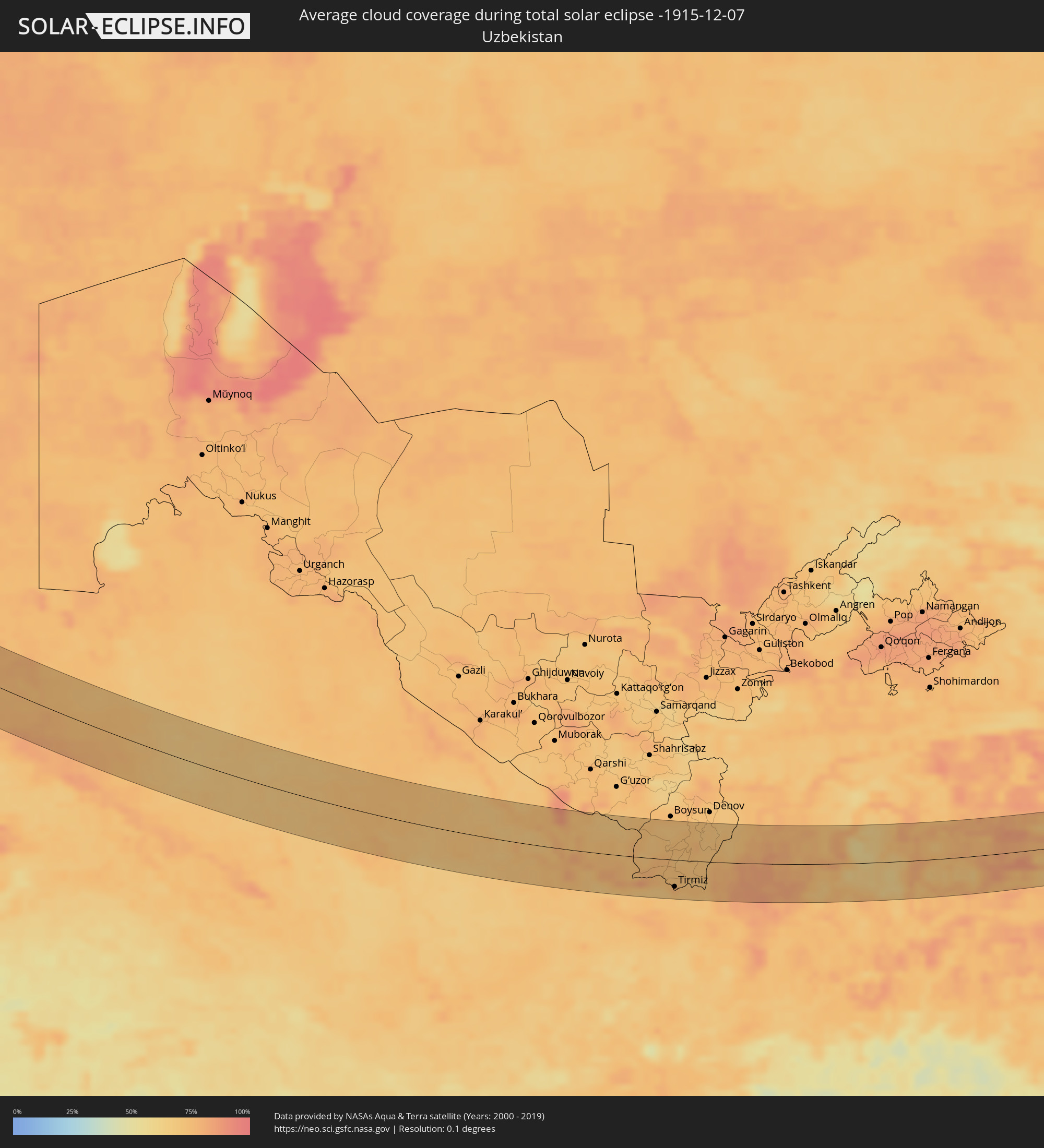 Usbekistan
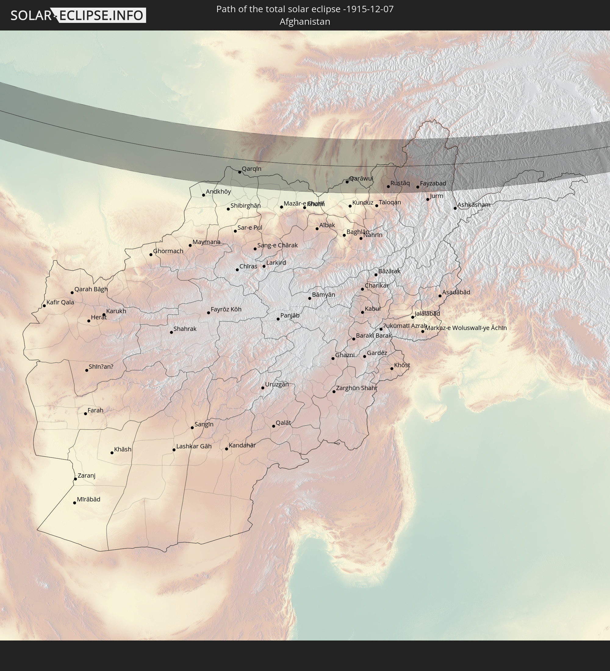
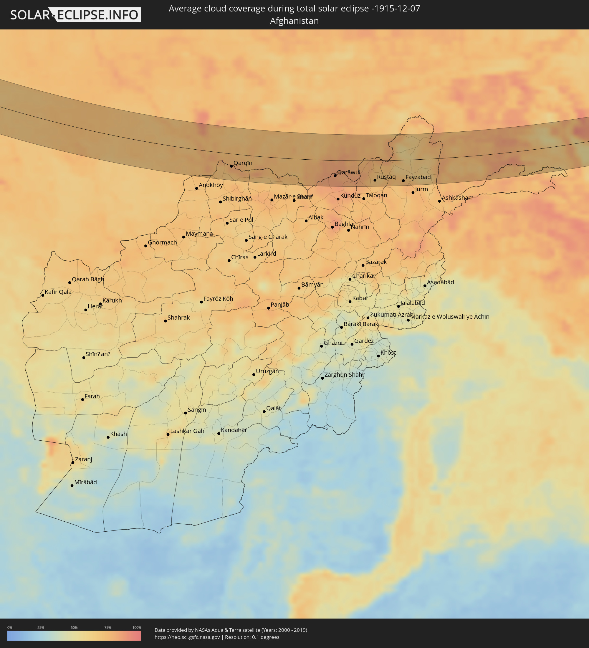 Afghanistan
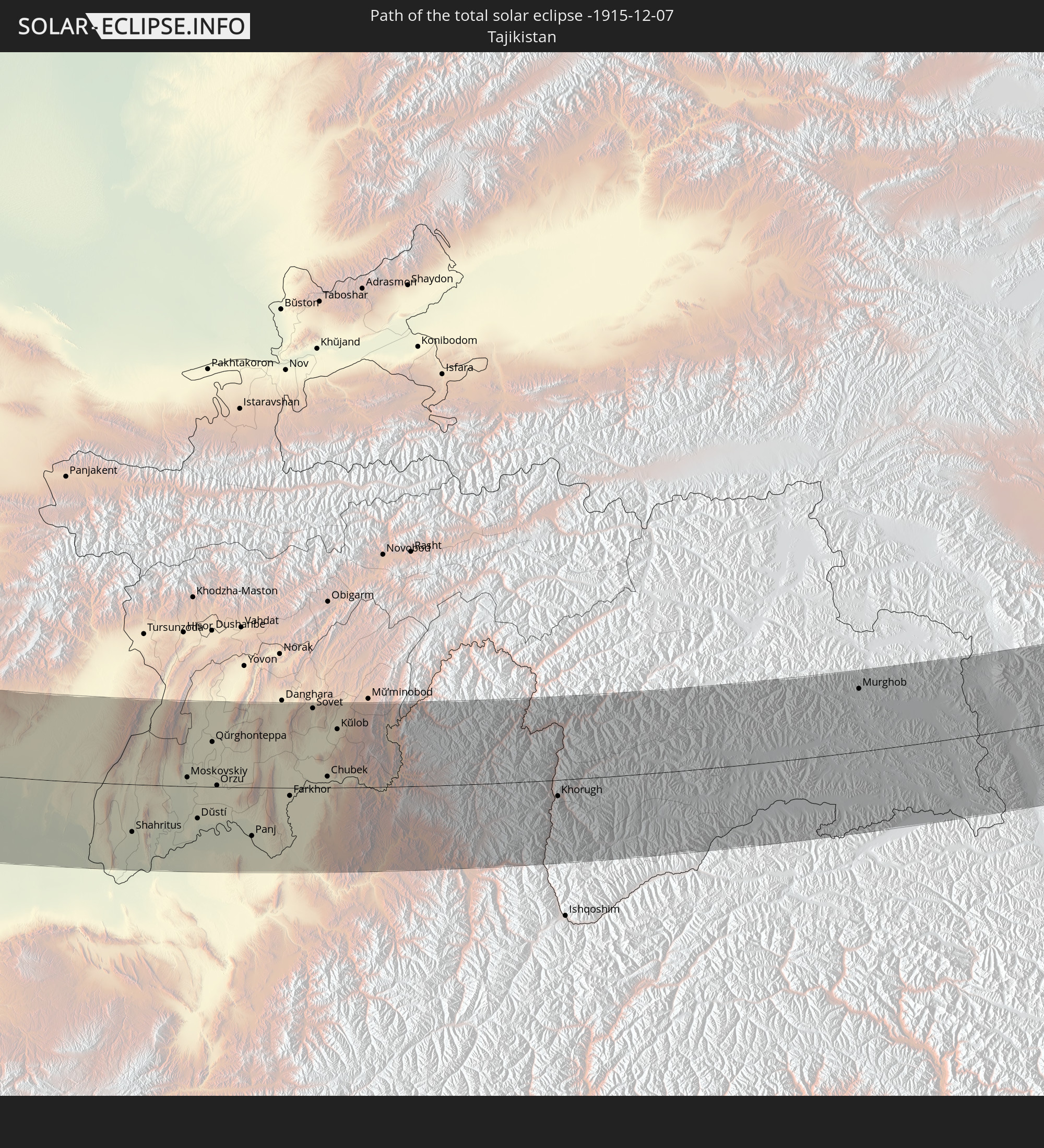
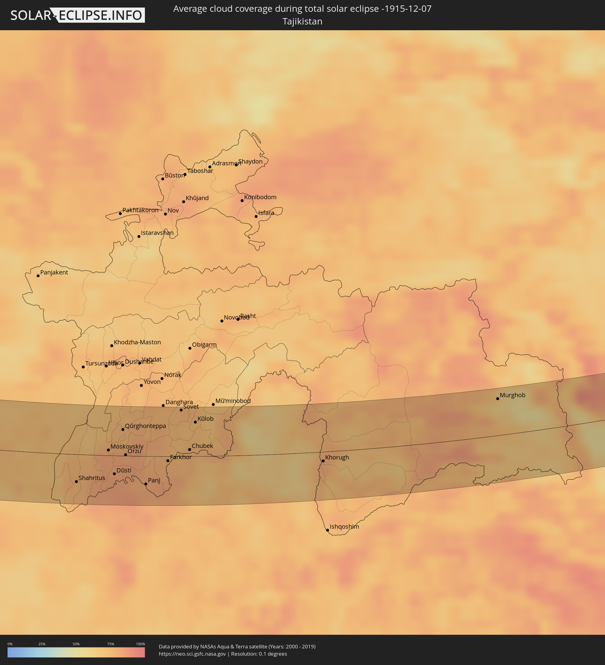 Tadschikistan
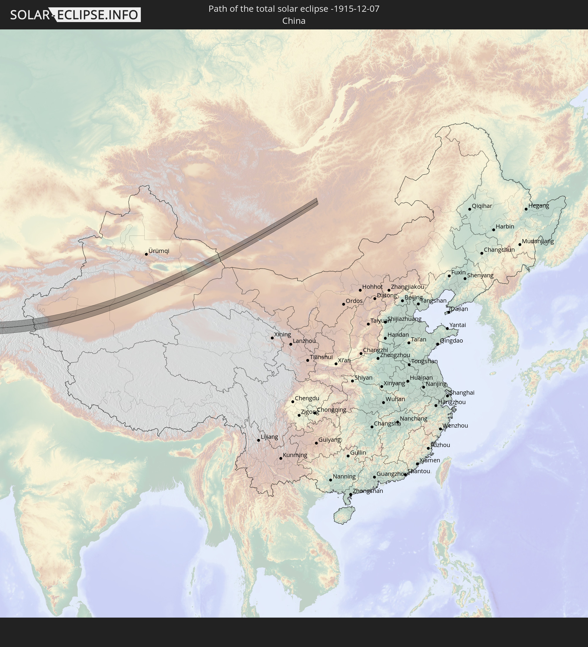
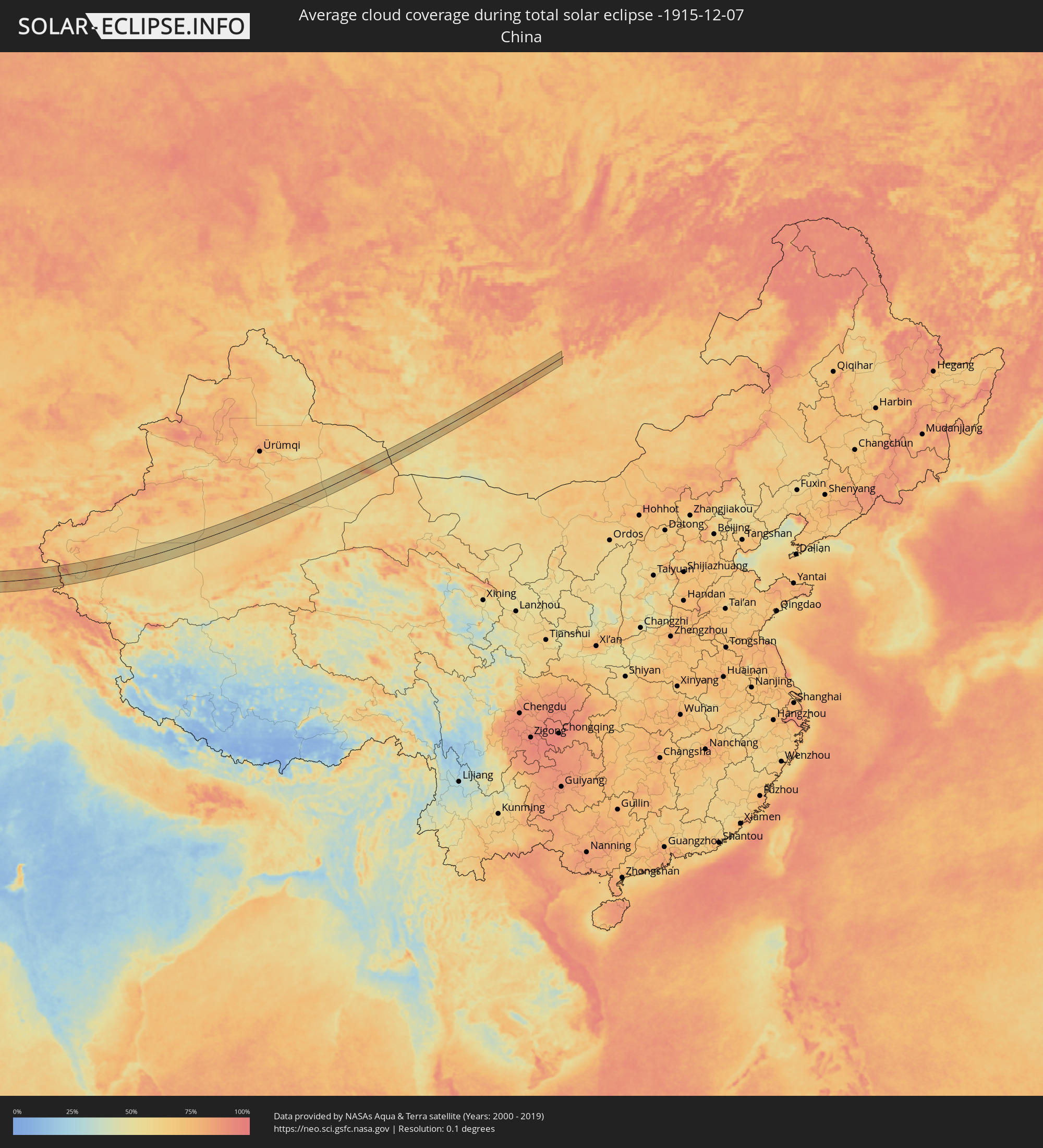 Volksrepublik China
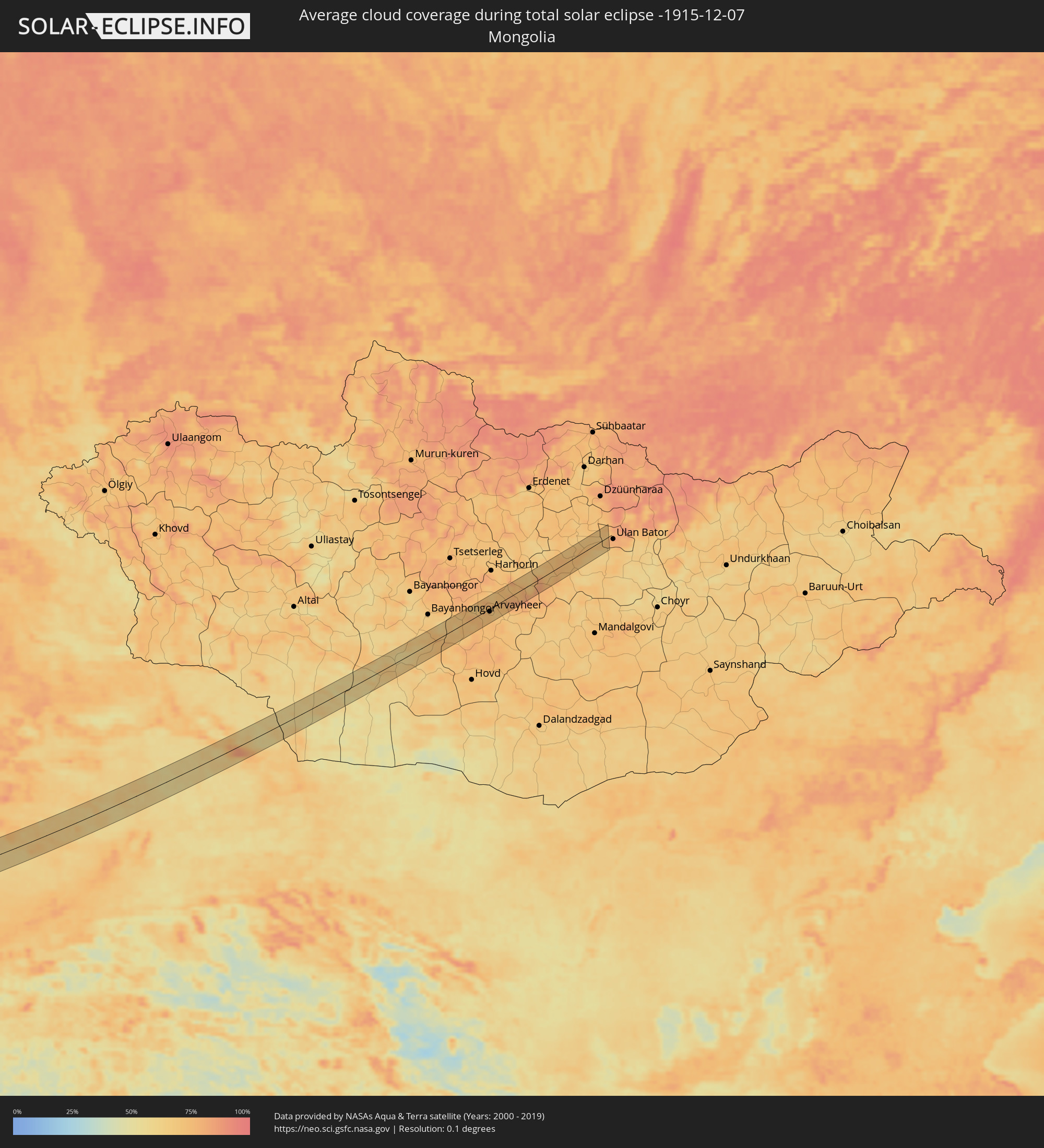 Mongolei
Orte im Finsternispfad
Die nachfolgene Tabelle zeigt Städte und Orte mit mehr als 5.000 Einwohnern, die sich im Finsternispfad befinden. Städte mit mehr als 100.000 Einwohnern sind dick gekennzeichnet. Mit einem Klick auf den Ort öffnet sich eine Detailkarte die die Lage des jeweiligen Ortes zusammen mit dem Verlauf der zentralen Finsternis präsentiert.
| Ort | Typ | Dauer der Verfinsterung | Ortszeit bei maximaler Verfinsterung | Entfernung zur Zentrallinie | Ø Bewölkung |
|
Vec-Liepāja, Liepāja
|
total | - | 08:58:20 UTC+01:36 | 16 km | 88% |
|
Liepāja, Liepāja
|
total | - | 08:58:19 UTC+01:36 | 18 km | 88% |
|
Karosta, Liepāja
|
total | - | 08:58:21 UTC+01:36 | 15 km | 89% |
|
Grobiņa, Grobiņa
|
total | - | 08:58:27 UTC+01:36 | 10 km | 88% |
|
Pāvilosta, Pāvilostas
|
total | - | 08:58:52 UTC+01:36 | 20 km | 87% |
|
Lieģi, Durbe
|
total | - | 08:58:37 UTC+01:36 | 1 km | 87% |
|
Priekule, Priekule
|
total | - | 08:58:39 UTC+01:36 | 0 km | 87% |
|
Aizpute, Aizpute
|
total | - | 08:58:59 UTC+01:36 | 23 km | 89% |
|
Vaiņode, Vaiņode
|
total | - | 08:58:51 UTC+01:36 | 11 km | 85% |
|
Telsiai, Telšiai County
|
total | - | 08:46:03 UTC+01:24 | 11 km | 87% |
|
Mazeikiai, Telšiai County
|
total | - | 08:46:30 UTC+01:24 | 21 km | 85% |
|
Kelmė
|
total | - | 08:46:12 UTC+01:24 | 11 km | 88% |
|
Kuršėnai, Šiauliai County
|
total | - | 08:46:37 UTC+01:24 | 20 km | 90% |
|
Raseiniai, Kaunas County
|
total | - | 08:46:04 UTC+01:24 | 24 km | 89% |
|
Radviliskis, Šiauliai County
|
total | - | 08:46:53 UTC+01:24 | 30 km | 87% |
|
Dainava (Kaunas), Kaunas County
|
total | - | 08:46:15 UTC+01:24 | 27 km | 91% |
|
Kėdainiai, Kaunas County
|
total | - | 08:46:39 UTC+01:24 | 5 km | 90% |
|
Jonava, Kaunas County
|
total | - | 08:46:41 UTC+01:24 | 1 km | 91% |
|
Kaišiadorys
|
total | - | 08:46:35 UTC+01:24 | 10 km | 90% |
|
Elektrėnai, Vilnius County
|
total | - | 08:46:41 UTC+01:24 | 8 km | 92% |
|
Lentvaris, Vilnius County
|
total | - | 08:46:52 UTC+01:24 | 2 km | 93% |
|
Grigiškės
|
total | - | 08:46:56 UTC+01:24 | 2 km | 93% |
|
Pilaitė, Vilnius County
|
total | - | 08:47:02 UTC+01:24 | 7 km | 92% |
|
Justiniškės, Vilnius County
|
total | - | 08:47:05 UTC+01:24 | 10 km | 92% |
|
Vilkpėdė, Vilnius County
|
total | - | 08:47:03 UTC+01:24 | 8 km | 92% |
|
Naujamiestis, Vilnius County
|
total | - | 08:47:05 UTC+01:24 | 9 km | 93% |
|
Vilnius, Vilnius County
|
total | - | 08:47:06 UTC+01:24 | 11 km | 93% |
|
Rasos, Vilnius County
|
total | - | 08:47:07 UTC+01:24 | 11 km | 93% |
|
Iwye, Grodnenskaya
|
total | - | 09:12:45 UTC+01:50 | 31 km | 94% |
|
Ashmyany, Grodnenskaya
|
total | - | 09:13:24 UTC+01:50 | 17 km | 90% |
|
Valozhyn, Minsk
|
total | - | 09:13:35 UTC+01:50 | 15 km | 90% |
|
Stowbtsy, Minsk
|
total | - | 09:13:10 UTC+01:50 | 27 km | 92% |
|
Rakaw, Minsk
|
total | - | 09:13:56 UTC+01:50 | 27 km | 90% |
|
Dzyarzhynsk, Minsk
|
total | - | 09:13:44 UTC+01:50 | 7 km | 89% |
|
Uzda, Minsk
|
total | - | 09:13:35 UTC+01:50 | 8 km | 89% |
|
Fanipol
|
total | - | 09:13:59 UTC+01:50 | 21 km | 90% |
|
Slutsk, Minsk
|
total | - | 09:13:29 UTC+01:50 | 29 km | 90% |
|
Lyuban’, Minsk
|
total | - | 09:13:41 UTC+01:50 | 29 km | 91% |
|
Staryya Darohi, Minsk
|
total | - | 09:14:10 UTC+01:50 | 3 km | 90% |
|
Hlusk, Mogilev
|
total | - | 09:14:27 UTC+01:50 | 10 km | 88% |
|
Kalinkavichy, Gomel
|
total | - | 09:14:22 UTC+01:50 | 27 km | 90% |
|
Svyetlahorsk, Gomel
|
total | - | 09:15:15 UTC+01:50 | 34 km | 93% |
|
Khoyniki, Gomel
|
total | - | 09:14:47 UTC+01:50 | 19 km | 92% |
|
Slavutych, Kiev
|
total | - | 09:27:21 UTC+02:02 | 16 km | 90% |
|
Loyew, Gomel
|
total | - | 09:27:47 UTC+02:02 | 23 km | 93% |
|
Chernihiv, Chernihiv
|
total | - | 09:27:55 UTC+02:02 | 8 km | 91% |
|
Nizhyn, Chernihiv
|
total | - | 09:28:11 UTC+02:02 | 4 km | 89% |
|
Pryluky, Chernihiv
|
total | - | 09:28:22 UTC+02:02 | 20 km | 88% |
|
Myrhorod, Poltava
|
total | - | 09:29:17 UTC+02:02 | 18 km | 88% |
|
Hadyach, Poltava
|
total | - | 09:30:03 UTC+02:02 | 33 km | 90% |
|
Poltava, Poltava
|
total | - | 09:30:07 UTC+02:02 | 8 km | 91% |
|
Krasnohrad, Kharkiv
|
total | - | 09:31:04 UTC+02:02 | 15 km | 92% |
|
Pavlohrad, Dnipropetrovsk
|
total | - | 09:31:01 UTC+02:02 | 39 km | 91% |
|
Lozova, Kharkiv
|
total | - | 09:31:50 UTC+02:02 | 12 km | 91% |
|
Dobropillya, Donetsk
|
total | - | 09:32:33 UTC+02:02 | 10 km | 89% |
|
Krasnoarmiys’k, Donetsk
|
total | - | 09:32:34 UTC+02:02 | 1 km | 89% |
|
Selydove, Donetsk
|
total | - | 09:32:38 UTC+02:02 | 7 km | 90% |
|
Dokuchayevs’k, Donetsk
|
total | - | 09:32:54 UTC+02:02 | 25 km | 89% |
|
Donetsk, Donetsk
|
total | - | 09:33:14 UTC+02:02 | 5 km | 89% |
|
Dzerzhyns’k, Donetsk
|
total | - | 09:33:32 UTC+02:02 | 40 km | 90% |
|
Khartsyz’k, Donetsk
|
total | - | 09:33:43 UTC+02:02 | 22 km | 90% |
|
Shakhtars’k, Donetsk
|
total | - | 09:34:08 UTC+02:02 | 37 km | 90% |
|
Amvrosiyivka, Donetsk
|
total | - | 09:34:01 UTC+02:02 | 16 km | 86% |
|
Taganrog, Rostov Oblast
|
total | - | 10:02:30 UTC+02:30 | 14 km | 87% |
|
Azov, Rostov Oblast
|
total | - | 10:03:10 UTC+02:30 | 2 km | 91% |
|
Kushchëvskaya, Krasnodarskiy
|
total | - | 10:03:10 UTC+02:30 | 40 km | 90% |
|
Rostov-na-Donu, Rostov Oblast
|
total | - | 10:03:40 UTC+02:30 | 23 km | 92% |
|
Zernograd, Rostov Oblast
|
total | - | 10:04:19 UTC+02:30 | 16 km | 90% |
|
Sal’sk, Rostov Oblast
|
total | - | 10:05:58 UTC+02:30 | 40 km | 88% |
|
Svetlograd, Stavropol'skiy
|
total | - | 10:07:29 UTC+02:30 | 3 km | 84% |
|
Ipatovo, Stavropol'skiy
|
total | - | 10:07:43 UTC+02:30 | 34 km | 86% |
|
Blagodarnyy, Stavropol'skiy
|
total | - | 10:08:19 UTC+02:30 | 2 km | 87% |
|
Zelenokumsk, Stavropol'skiy
|
total | - | 10:08:47 UTC+02:30 | 41 km | 86% |
|
Budënnovsk, Stavropol'skiy
|
total | - | 10:09:24 UTC+02:30 | 6 km | 89% |
|
Gudermes, Chechnya
|
total | - | 10:12:15 UTC+02:30 | 40 km | 83% |
|
Khasavyurt, Dagestan
|
total | - | 10:13:04 UTC+02:30 | 28 km | 80% |
|
Kizlyar, Dagestan
|
total | - | 10:13:26 UTC+02:30 | 33 km | 84% |
|
Kizilyurt, Dagestan
|
total | - | 10:13:33 UTC+02:30 | 20 km | 74% |
|
Buynaksk, Dagestan
|
total | - | 10:13:55 UTC+02:30 | 46 km | 65% |
|
Makhachkala, Dagestan
|
total | - | 10:14:38 UTC+02:30 | 14 km | 77% |
|
Kaspiysk, Dagestan
|
total | - | 10:14:52 UTC+02:30 | 17 km | 76% |
|
Izberbash, Dagestan
|
total | - | 10:15:13 UTC+02:30 | 37 km | 67% |
|
Atamyrat, Lebap
|
total | - | 12:15:26 UTC+03:53 | 8 km | 72% |
|
Qarqīn, Jowzjan
|
total | - | 12:23:59 UTC+04:00 | 30 km | 71% |
|
Gowurdak, Lebap
|
total | - | 12:17:18 UTC+03:53 | 14 km | 75% |
|
Tirmiz, Surxondaryo
|
total | - | 12:54:43 UTC+04:27 | 42 km | 74% |
|
Sho’rchi, Surxondaryo
|
total | - | 12:55:19 UTC+04:27 | 47 km | 70% |
|
Shahritus, Khatlon
|
total | - | 13:03:53 UTC+04:35 | 34 km | 77% |
|
Gharavŭtí, Khatlon
|
total | - | 13:04:21 UTC+04:35 | 1 km | 81% |
|
Jilikŭl, Khatlon
|
total | - | 13:04:35 UTC+04:35 | 7 km | 82% |
|
Moskovskiy, Khatlon
|
total | - | 13:04:36 UTC+04:35 | 6 km | 81% |
|
Kolkhozobod, Khatlon
|
total | - | 13:04:47 UTC+04:35 | 4 km | 83% |
|
Dŭstí, Khatlon
|
total | - | 13:04:58 UTC+04:35 | 23 km | 83% |
|
Qarāwul, Kunduz
|
total | - | 12:30:06 UTC+04:00 | 37 km | 84% |
|
Qŭrghonteppa, Khatlon
|
total | - | 13:04:53 UTC+04:35 | 32 km | 77% |
|
Abdurahmoni Jomí, Khatlon
|
total | - | 13:04:52 UTC+04:35 | 44 km | 77% |
|
Orzu, Khatlon
|
total | - | 13:05:09 UTC+04:35 | 1 km | 81% |
|
Vakhsh, Khatlon
|
total | - | 13:05:05 UTC+04:35 | 19 km | 78% |
|
Kirov, Khatlon
|
total | - | 13:05:04 UTC+04:35 | 30 km | 80% |
|
Imām Şāḩib, Kunduz
|
total | - | 12:30:28 UTC+04:00 | 40 km | 83% |
|
Panj, Khatlon
|
total | - | 13:05:59 UTC+04:35 | 34 km | 81% |
|
Dasht-e Archī, Kunduz
|
total | - | 12:31:00 UTC+04:00 | 46 km | 79% |
|
Farkhor, Khatlon
|
total | - | 13:06:27 UTC+04:35 | 6 km | 78% |
|
Ārt Khwājah, Takhar
|
total | - | 12:31:42 UTC+04:00 | 51 km | 79% |
|
Sovet, Khatlon
|
total | - | 13:06:27 UTC+04:35 | 56 km | 77% |
|
Yangī Qal‘ah, Takhar
|
total | - | 12:31:43 UTC+04:00 | 9 km | 77% |
|
Vose’, Khatlon
|
total | - | 13:06:45 UTC+04:35 | 29 km | 75% |
|
Chubek, Khatlon
|
total | - | 13:07:01 UTC+04:35 | 8 km | 79% |
|
Kŭlob, Khatlon
|
total | - | 13:06:58 UTC+04:35 | 41 km | 75% |
|
Rustāq, Takhar
|
total | - | 12:32:26 UTC+04:00 | 47 km | 71% |
|
Fayzabad, Badakhshan
|
total | - | 12:34:02 UTC+04:00 | 49 km | 77% |
|
Khorugh, Gorno-Badakhshan
|
total | - | 13:11:00 UTC+04:35 | 11 km | 79% |
|
Murghob, Gorno-Badakhshan
|
total | - | 13:15:21 UTC+04:35 | 44 km | 62% |
|
Shache, Xinjiang Uyghur Autonomous Region
|
total | - | 16:46:12 UTC+08:00 | 23 km | 79% |
|
Hami, Xinjiang Uyghur Autonomous Region
|
total | - | 17:05:12 UTC+08:00 | 9 km | 62% |
|
Arvayheer, Övörhangay
|
total | - | 16:16:38 UTC+07:07 | 6 km | 71% |