Totale Sonnenfinsternis vom 11.03.-1966
| Wochentag: | Donnerstag |
| Maximale Dauer der Verfinsterung: | 06m14s |
| Maximale Breite des Finsternispfades: | 236 km |
| Saroszyklus: | 8 |
| Bedeckungsgrad: | 100% |
| Magnitude: | 1.0719 |
| Gamma: | -0.1456 |
Wo kann man die Sonnenfinsternis vom 11.03.-1966 sehen?
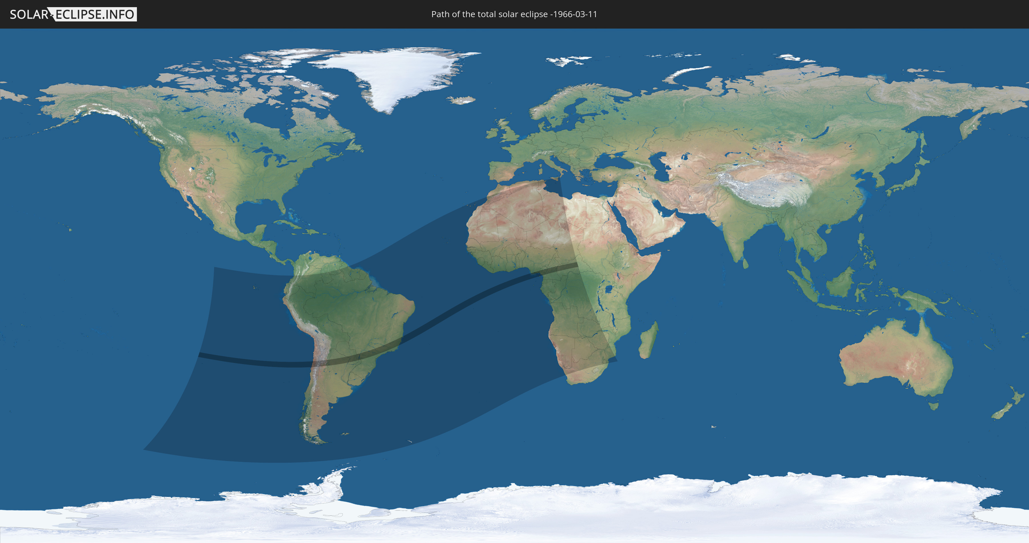
Die Sonnenfinsternis am 11.03.-1966 kann man in 55 Ländern als partielle Sonnenfinsternis beobachten.
Der Finsternispfad verläuft durch 8 Länder. Nur in diesen Ländern ist sie als totale Sonnenfinsternis zu sehen.
In den folgenden Ländern ist die Sonnenfinsternis total zu sehen
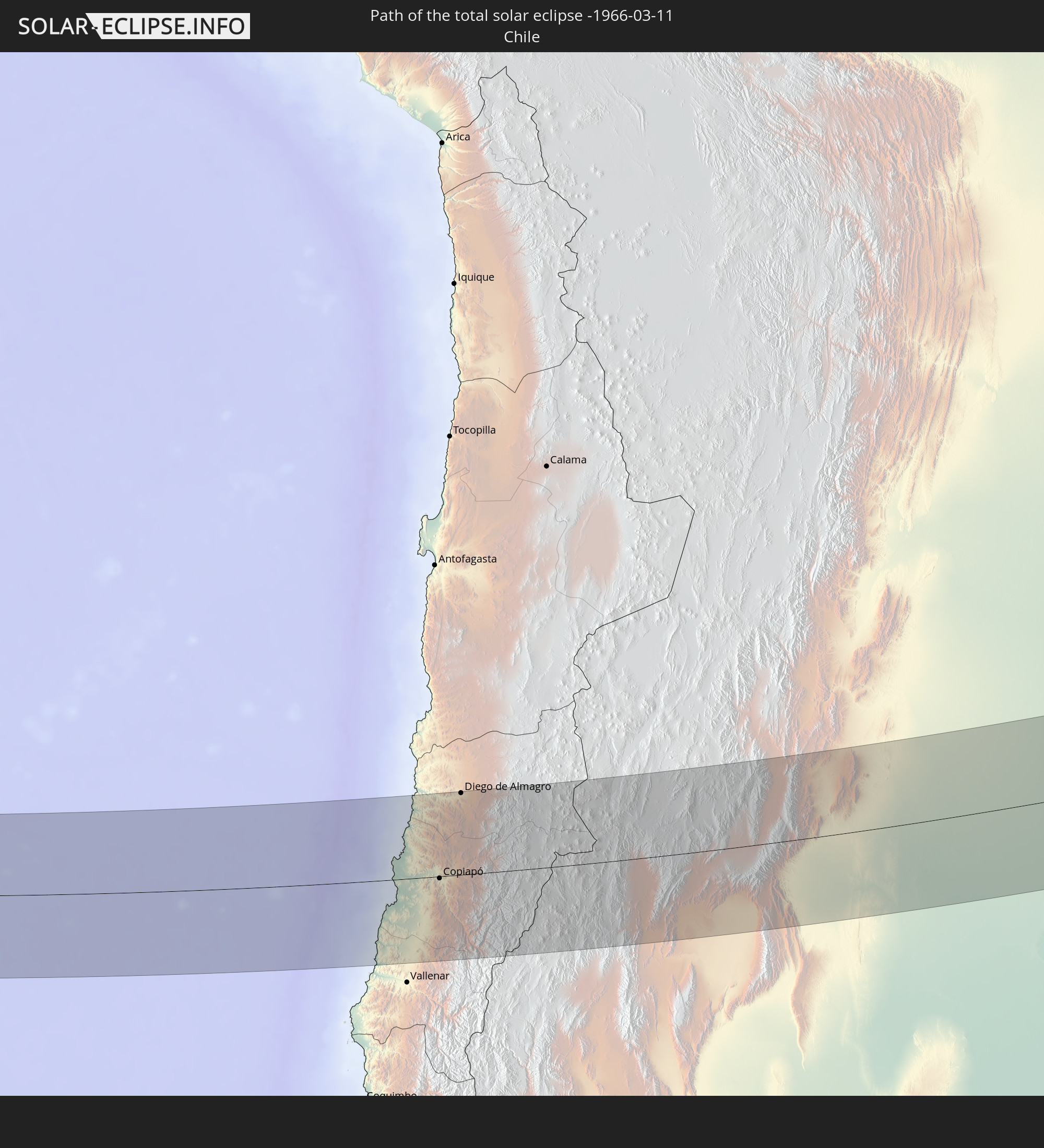 Chile
Chile
 Brasilien
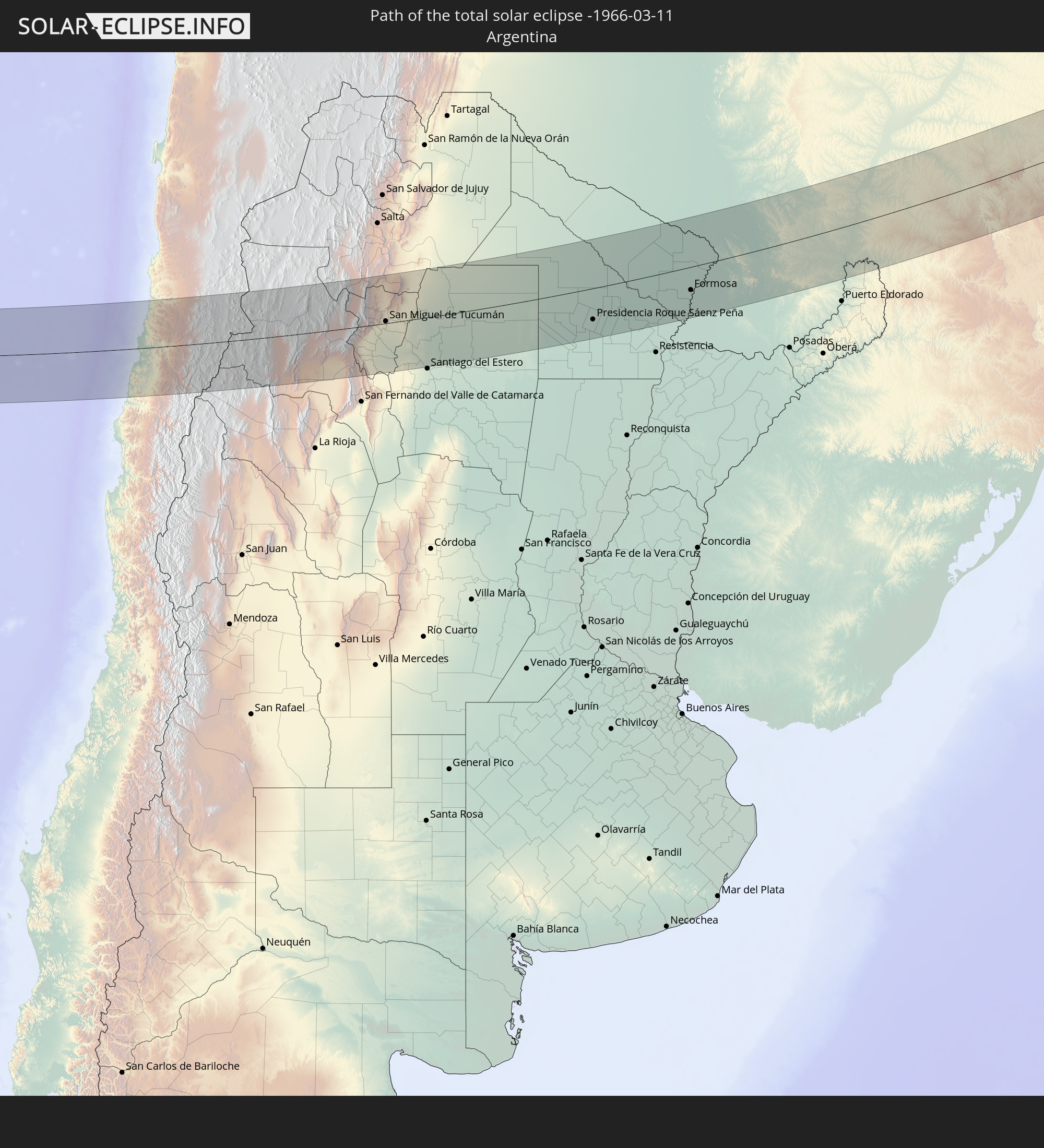 Argentinien
 Paraguay
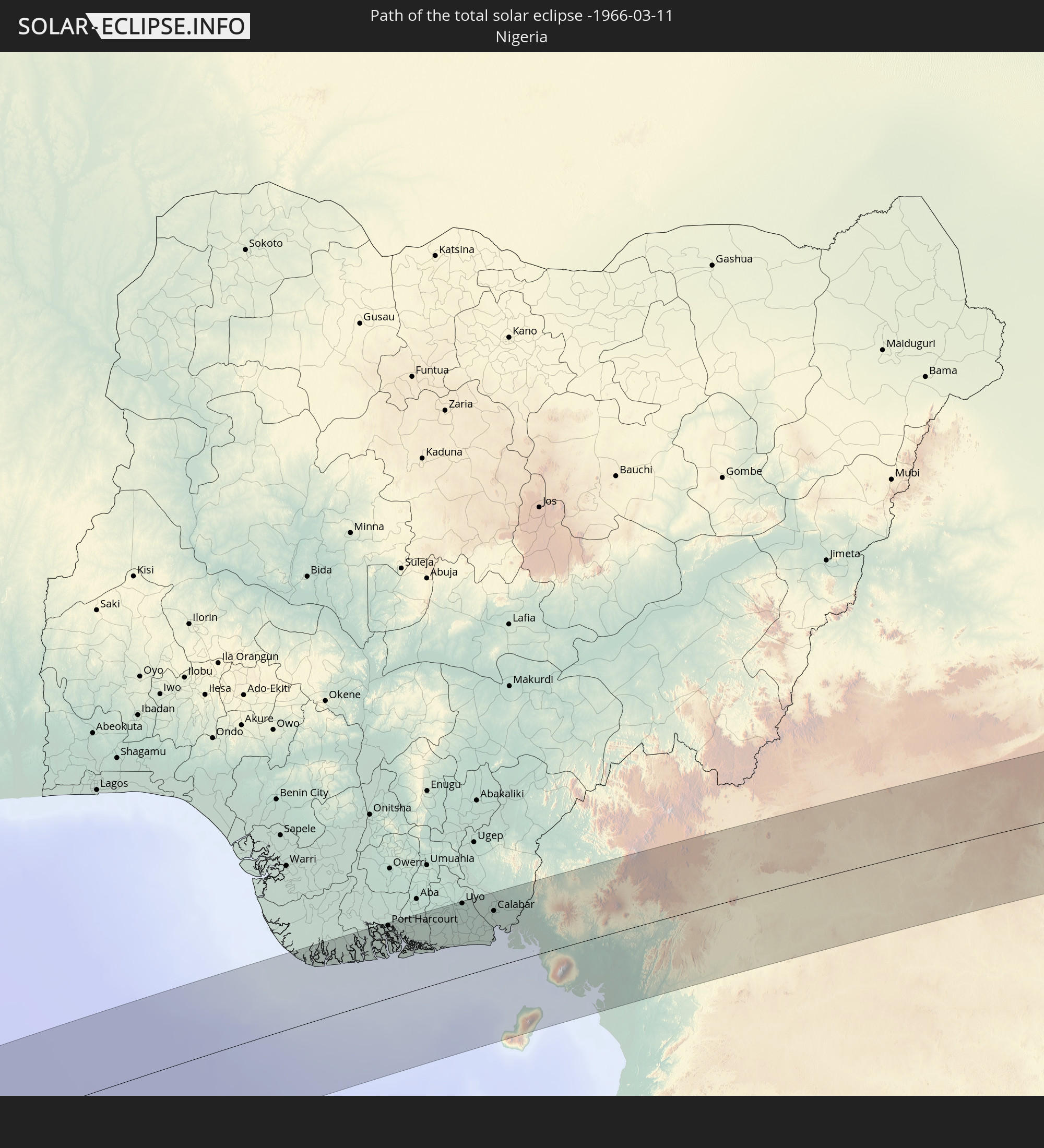 Nigeria
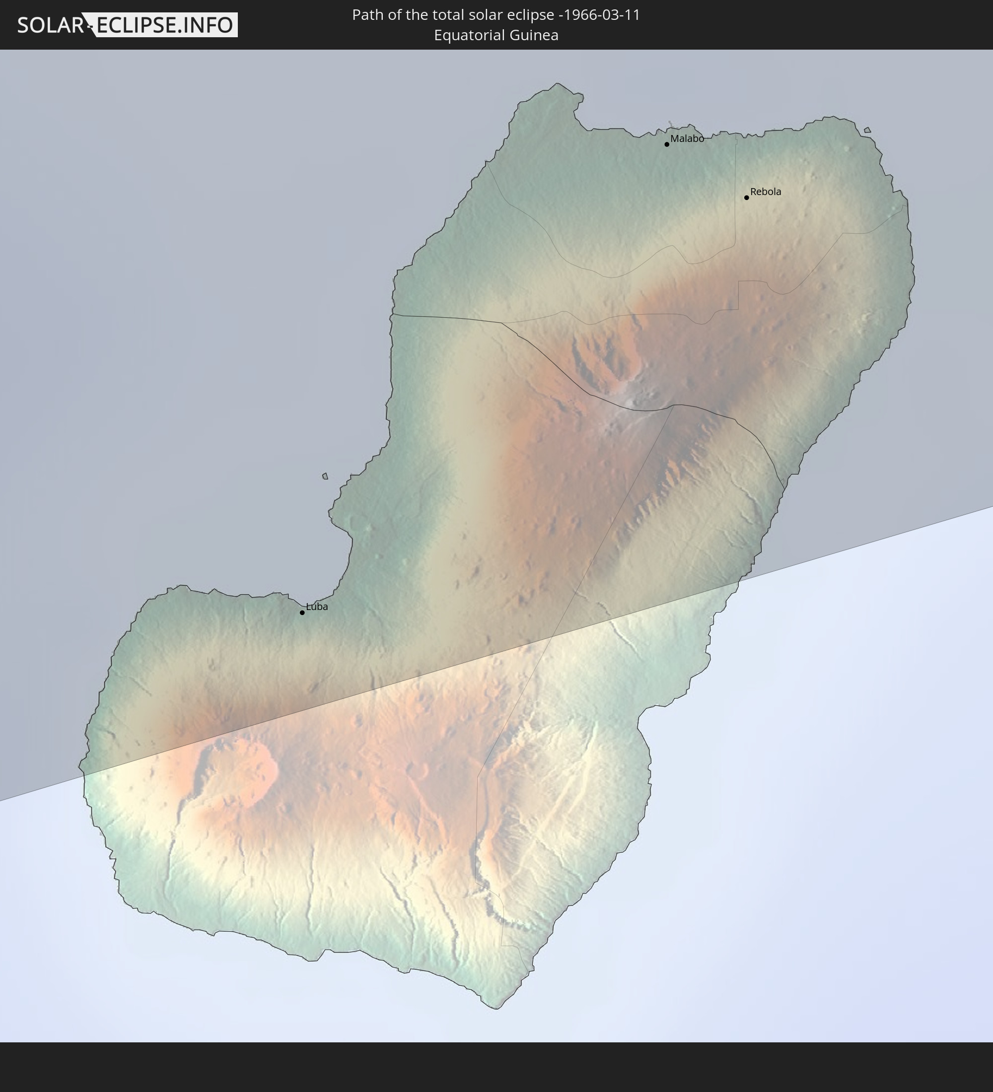 Äquatorialguinea
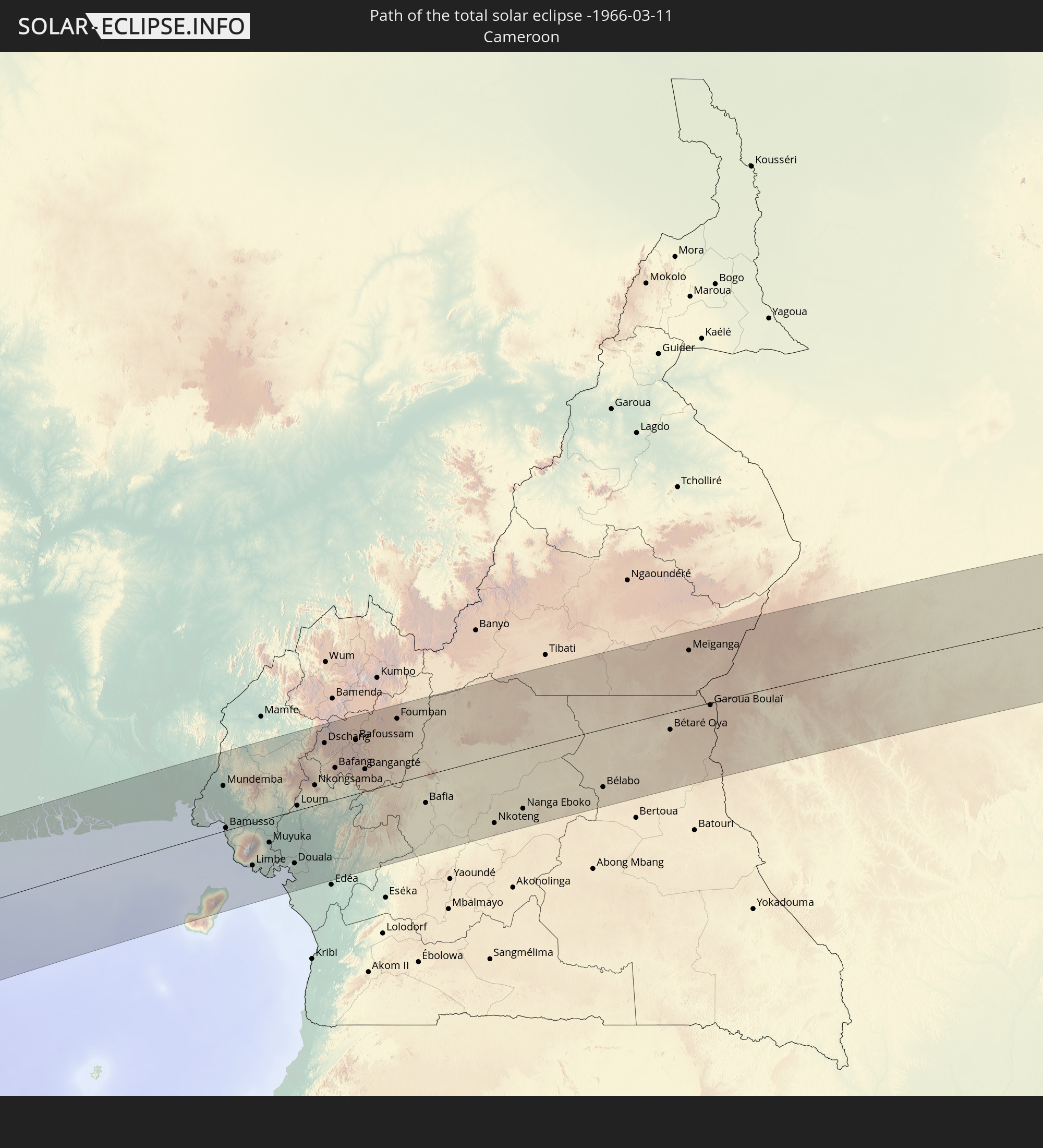 Kamerun
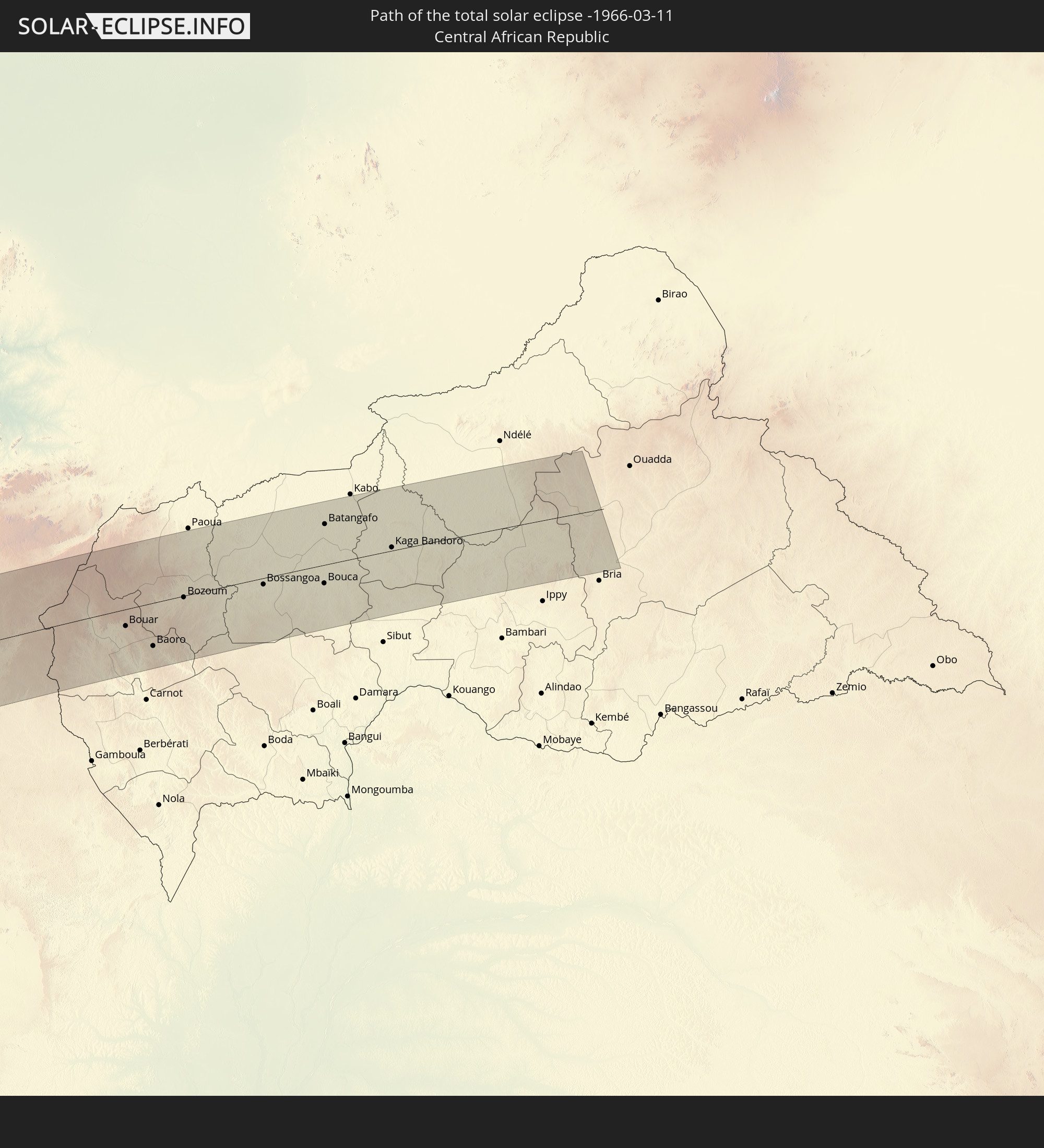 Zentralafrikanische Republik
In den folgenden Ländern ist die Sonnenfinsternis partiell zu sehen
 Chile
Chile
 Ecuador
 Kolumbien
 Peru
Peru
 Brasilien
 Argentinien
 Venezuela
 Bolivien
 Paraguay
 Falklandinseln
 Guyana
 Uruguay
 Suriname
 Französisch-Guayana
 Südgeorgien und die Südlichen Sandwichinseln
 Kap Verde
 Spanien
 Senegal
 Mauretanien
 Gambia
 Guinea-Bissau
 Guinea
 St. Helena
 Sierra Leone
 Marokko
 Mali
Mali
 Liberia
 Algerien
 Elfenbeinküste
 Burkina Faso
 Ghana
Ghana
 Togo
Togo
 Niger
Niger
 Benin
Benin
 Nigeria
 Äquatorialguinea
 São Tomé und Príncipe
 Italien
 Tunesien
 Kamerun
 Gabun
Gabun
 Libyen
 Republik Kongo
 Angola
 Namibia
 Demokratische Republik Kongo
 Tschad
 Malta
Malta
 Zentralafrikanische Republik
 Südafrika
 Botswana
 Sambia
 Simbabwe
 Mosambik
 Swasiland
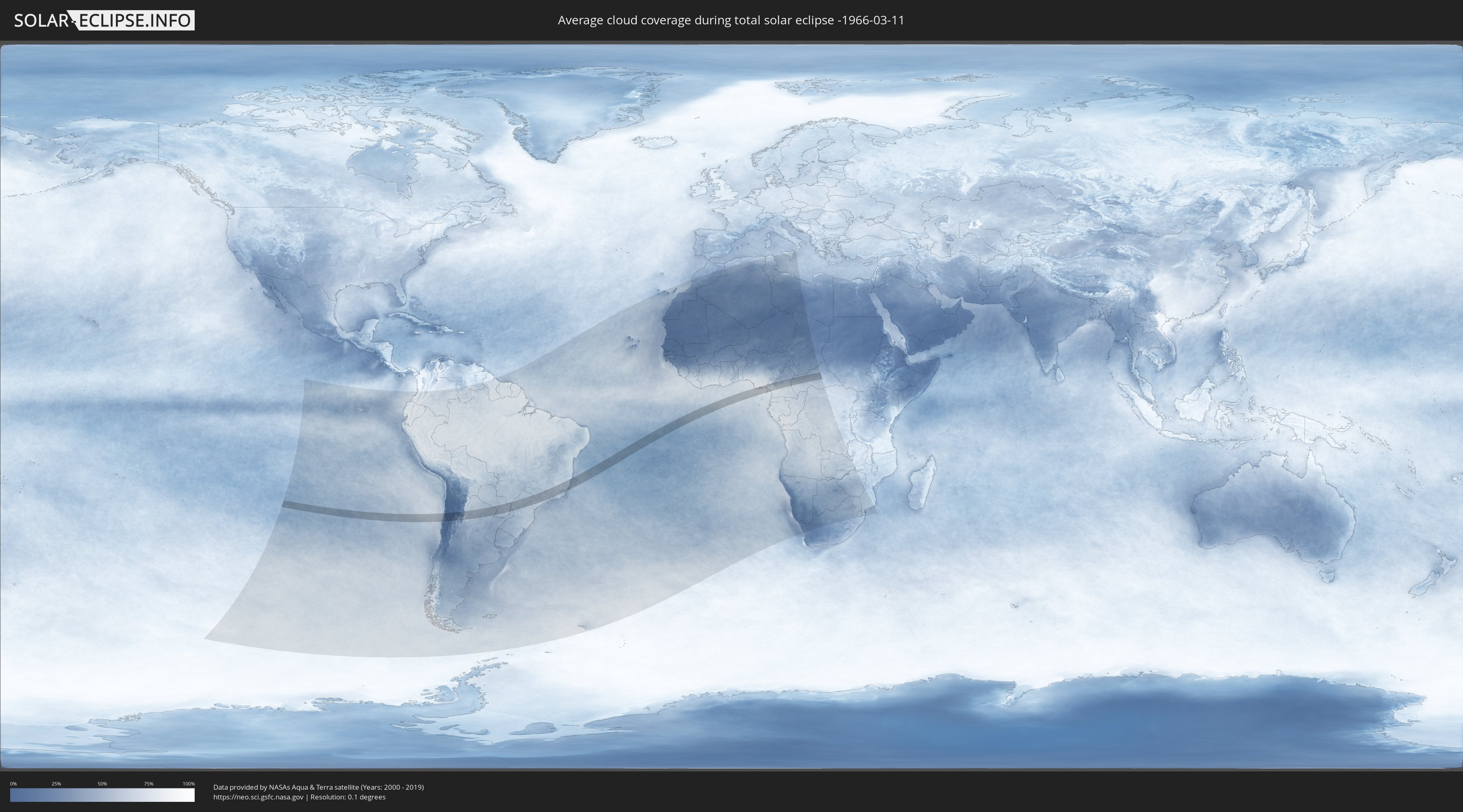
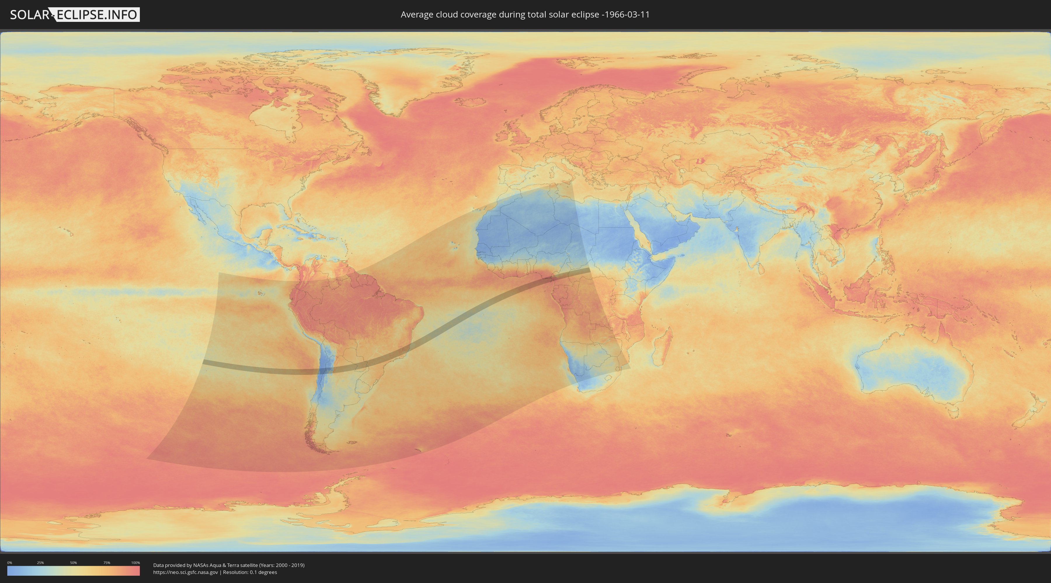
Wie wird das Wetter während der totalen Sonnenfinsternis am 11.03.-1966?
Wo ist der beste Ort, um die totale Sonnenfinsternis vom 11.03.-1966 zu beobachten?
Die folgenden Karten zeigen die durchschnittliche Bewölkung für den Tag, an dem die totale Sonnenfinsternis
stattfindet. Mit Hilfe der Karten lässt sich der Ort entlang des Finsternispfades eingrenzen,
der die besten Aussichen auf einen klaren wolkenfreien Himmel bietet.
Trotzdem muss man immer lokale Gegenenheiten beachten und sollte sich genau über das Wetter an seinem
gewählten Beobachtungsort informieren.
Die Daten stammen von den beiden NASA-Satelliten
AQUA und TERRA
und wurden über einen Zeitraum von 19 Jahren (2000 - 2019) gemittelt.
Detaillierte Länderkarten
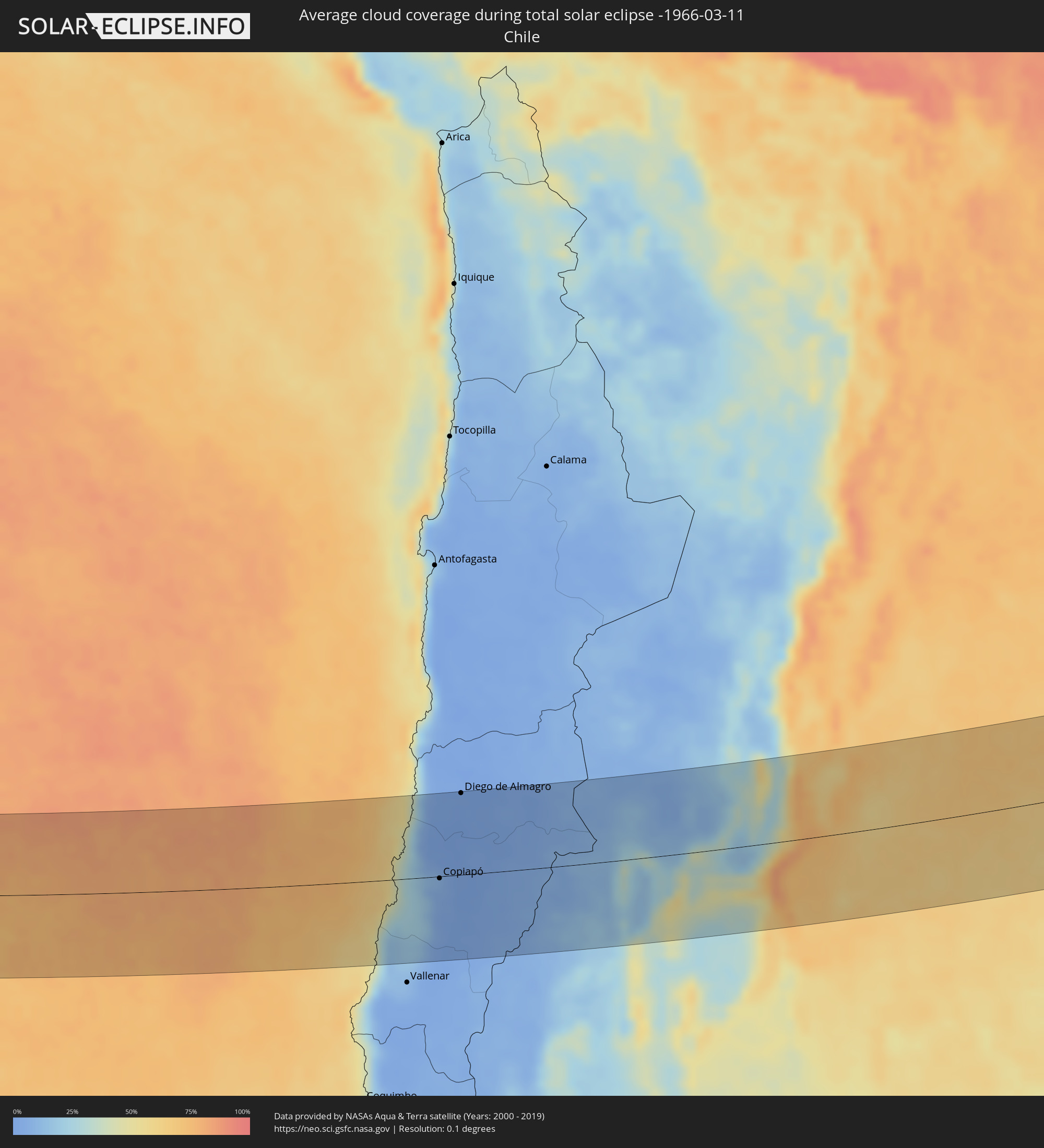 Chile
Chile
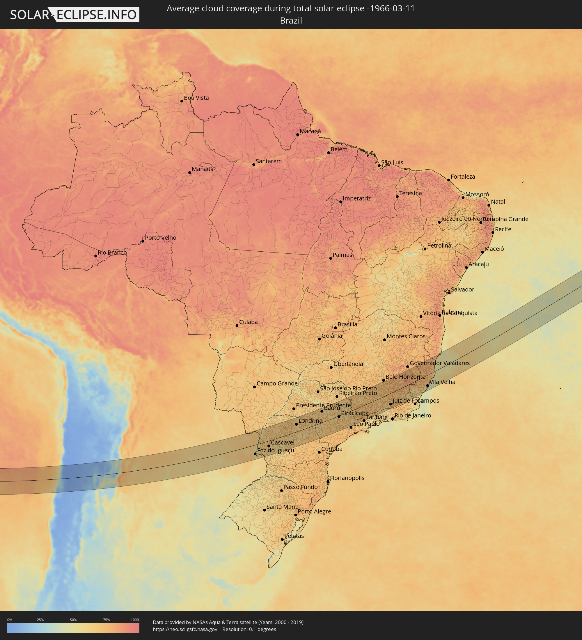 Brasilien
 Argentinien
 Paraguay
 Nigeria
 Äquatorialguinea
 Kamerun
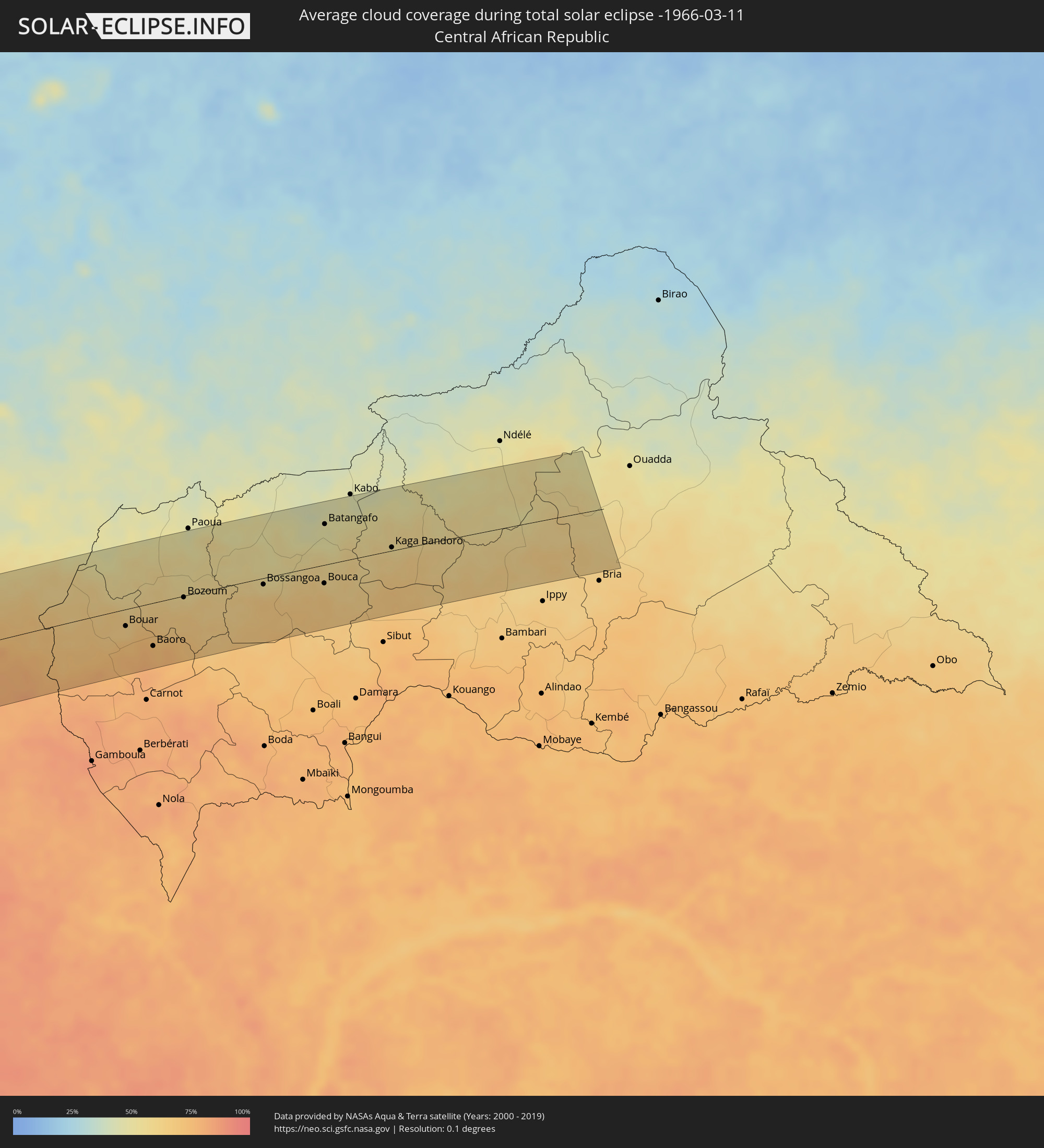 Zentralafrikanische Republik
Orte im Finsternispfad
Die nachfolgene Tabelle zeigt Städte und Orte mit mehr als 5.000 Einwohnern, die sich im Finsternispfad befinden. Städte mit mehr als 100.000 Einwohnern sind dick gekennzeichnet. Mit einem Klick auf den Ort öffnet sich eine Detailkarte die die Lage des jeweiligen Ortes zusammen mit dem Verlauf der zentralen Finsternis präsentiert.
| Ort | Typ | Dauer der Verfinsterung | Ortszeit bei maximaler Verfinsterung | Entfernung zur Zentrallinie | Ø Bewölkung |
|
Copiapó, Atacama
|
total | - | 09:03:56 UTC-04:42 | 3 km | 5% |
|
Diego de Almagro, Atacama
|
total | - | 09:04:16 UTC-04:42 | 106 km | 1% |
|
Tinogasta, Catamarca Province
|
total | - | 09:34:13 UTC-04:16 | 104 km | 35% |
|
Andalgalá, Catamarca Province
|
total | - | 09:36:15 UTC-04:16 | 67 km | 36% |
|
Cafayate, Salta Province
|
total | - | 09:36:53 UTC-04:16 | 97 km | 50% |
|
Aguilares, Tucumán Province
|
total | - | 09:37:26 UTC-04:16 | 58 km | 72% |
|
Monteros, Tucumán Province
|
total | - | 09:37:38 UTC-04:16 | 30 km | 71% |
|
Famaillá, Tucumán Province
|
total | - | 09:37:49 UTC-04:16 | 18 km | 71% |
|
San Miguel de Tucumán, Tucumán Province
|
total | - | 09:38:08 UTC-04:16 | 5 km | 72% |
|
Termas de Río Hondo, Santiago del Estero Province
|
total | - | 09:38:43 UTC-04:16 | 74 km | 61% |
|
Charata, Chaco Province
|
total | - | 09:45:25 UTC-04:16 | 103 km | 62% |
|
Las Breñas, Chaco Province
|
total | - | 09:45:39 UTC-04:16 | 91 km | 61% |
|
Corzuela, Chaco Province
|
total | - | 09:45:53 UTC-04:16 | 78 km | 59% |
|
Campo Largo, Chaco Province
|
total | - | 09:46:10 UTC-04:16 | 64 km | 57% |
|
Castelli, Chaco Province
|
total | - | 09:46:49 UTC-04:16 | 25 km | 65% |
|
Presidencia Roque Sáenz Peña, Chaco Province
|
total | - | 09:46:57 UTC-04:16 | 70 km | 59% |
|
Tres Isletas, Chaco Province
|
total | - | 09:47:05 UTC-04:16 | 22 km | 57% |
|
Quitilipi, Chaco Province
|
total | - | 09:47:22 UTC-04:16 | 84 km | 59% |
|
Machagai, Chaco Province
|
total | - | 09:47:40 UTC-04:16 | 93 km | 56% |
|
Pampa del Indio, Chaco Province
|
total | - | 09:48:10 UTC-04:16 | 2 km | 60% |
|
Presidencia de la Plaza, Chaco Province
|
total | - | 09:48:03 UTC-04:16 | 106 km | 57% |
|
El Colorado, Formosa Province
|
total | - | 09:49:11 UTC-04:16 | 40 km | 55% |
|
General José de San Martín, Chaco Province
|
total | - | 09:49:11 UTC-04:16 | 66 km | 54% |
|
Pirané, Formosa Province
|
total | - | 09:49:54 UTC-04:16 | 17 km | 59% |
|
Formosa, Formosa Province
|
total | - | 09:51:39 UTC-04:16 | 52 km | 55% |
|
Clorinda, Formosa Province
|
total | - | 09:52:57 UTC-04:16 | 34 km | 60% |
|
Asunción, Asunción
|
total | - | 10:19:15 UTC-03:50 | 30 km | 61% |
|
Benjamín Aceval, Presidente Hayes
|
total | - | 10:19:32 UTC-03:50 | 65 km | 63% |
|
Limpio, Central
|
total | - | 10:19:37 UTC-03:50 | 41 km | 63% |
|
Guarambaré, Central
|
total | - | 10:19:32 UTC-03:50 | 7 km | 59% |
|
Capiatá, Central
|
total | - | 10:19:38 UTC-03:50 | 20 km | 63% |
|
Areguá, Central
|
total | - | 10:19:46 UTC-03:50 | 23 km | 62% |
|
Itá, Central
|
total | - | 10:19:44 UTC-03:50 | 2 km | 60% |
|
Ypacarai, Central
|
total | - | 10:19:56 UTC-03:50 | 10 km | 62% |
|
Paraguarí, Paraguarí
|
total | - | 10:20:08 UTC-03:50 | 16 km | 64% |
|
Caacupé, Cordillera
|
total | - | 10:20:15 UTC-03:50 | 9 km | 66% |
|
Tobatí, Cordillera
|
total | - | 10:20:28 UTC-03:50 | 22 km | 65% |
|
Piribebuy, Cordillera
|
total | - | 10:20:24 UTC-03:50 | 4 km | 65% |
|
Eusebio Ayala, Cordillera
|
total | - | 10:20:37 UTC-03:50 | 3 km | 65% |
|
Coronel Oviedo, Caaguazú
|
total | - | 10:21:43 UTC-03:50 | 15 km | 61% |
|
Villarrica, Guairá
|
total | - | 10:21:35 UTC-03:50 | 48 km | 63% |
|
Caazapá, Caazapá
|
total | - | 10:21:32 UTC-03:50 | 97 km | 58% |
|
Caaguazú, Caaguazú
|
total | - | 10:22:37 UTC-03:50 | 26 km | 65% |
|
San Juan Nepomuceno, Caazapá
|
total | - | 10:22:25 UTC-03:50 | 97 km | 60% |
|
Colonia General Alfredo Stroessner, Caaguazú
|
total | - | 10:23:21 UTC-03:50 | 25 km | 68% |
|
San Isidro de Curuguaty, Canindeyú
|
total | - | 10:23:47 UTC-03:50 | 66 km | 62% |
|
Doctor Juan León Mallorquín, Alto Paraná
|
total | - | 10:24:16 UTC-03:50 | 41 km | 62% |
|
Santa Rita, Alto Paraná
|
total | - | 10:24:30 UTC-03:50 | 87 km | 66% |
|
Nueva Esperanza, Canindeyú
|
total | - | 10:25:39 UTC-03:50 | 44 km | 69% |
|
Ciudad del Este, Alto Paraná
|
total | - | 10:25:38 UTC-03:50 | 70 km | 61% |
|
Foz do Iguaçu, Paraná
|
total | - | 11:09:52 UTC-03:06 | 75 km | 61% |
|
Puerto Iguazú, Misiones Province
|
total | - | 09:59:32 UTC-04:16 | 81 km | 57% |
|
Salto del Guairá, Canindeyú
|
total | - | 10:27:09 UTC-03:50 | 76 km | 62% |
|
Cascavel, Paraná
|
total | - | 11:12:43 UTC-03:06 | 44 km | 69% |
|
Maringá, Paraná
|
total | - | 11:17:13 UTC-03:06 | 71 km | 71% |
|
Londrina, Paraná
|
total | - | 11:19:08 UTC-03:06 | 57 km | 65% |
|
Bauru, São Paulo
|
total | - | 11:25:00 UTC-03:06 | 87 km | 66% |
|
Araraquara, São Paulo
|
total | - | 11:27:40 UTC-03:06 | 108 km | 68% |
|
São Carlos, São Paulo
|
total | - | 11:28:09 UTC-03:06 | 74 km | 68% |
|
Piracicaba, São Paulo
|
total | - | 11:28:03 UTC-03:06 | 8 km | 69% |
|
Rio Claro, São Paulo
|
total | - | 11:28:34 UTC-03:06 | 21 km | 66% |
|
Sorocaba, São Paulo
|
total | - | 11:27:47 UTC-03:06 | 96 km | 70% |
|
Santa Bárbara d'Oeste, São Paulo
|
total | - | 11:28:36 UTC-03:06 | 20 km | 66% |
|
Limeira, São Paulo
|
total | - | 11:28:48 UTC-03:06 | 1 km | 65% |
|
Itu, São Paulo
|
total | - | 11:28:23 UTC-03:06 | 77 km | 69% |
|
Sumaré, São Paulo
|
total | - | 11:28:53 UTC-03:06 | 33 km | 69% |
|
Indaiatuba, São Paulo
|
total | - | 11:28:46 UTC-03:06 | 62 km | 69% |
|
Campinas, São Paulo
|
total | - | 11:29:18 UTC-03:06 | 49 km | 68% |
|
Jundiaí, São Paulo
|
total | - | 11:29:28 UTC-03:06 | 85 km | 67% |
|
Francisco Morato, São Paulo
|
total | - | 11:29:42 UTC-03:06 | 100 km | 67% |
|
Poços de Caldas, Minas Gerais
|
total | - | 11:31:39 UTC-03:06 | 46 km | 72% |
|
Pindamonhangaba, São Paulo
|
total | - | 11:33:10 UTC-03:06 | 115 km | 64% |
|
Juiz de Fora, Minas Gerais
|
total | - | 11:39:35 UTC-03:06 | 87 km | 71% |
|
Ipatinga, Minas Gerais
|
total | - | 11:44:23 UTC-03:06 | 107 km | 69% |
|
Cachoeiro de Itapemirim, Espírito Santo
|
total | - | 11:46:13 UTC-03:06 | 97 km | 62% |
|
Serra, Espírito Santo
|
total | - | 11:49:07 UTC-03:06 | 64 km | 61% |
|
Vila Velha, Espírito Santo
|
total | - | 11:48:54 UTC-03:06 | 84 km | 57% |
|
Twon-Brass, Bayelsa
|
total | - | 16:52:29 UTC+00:13 | 72 km | 86% |
|
Obonoma, Rivers
|
total | - | 16:52:58 UTC+00:13 | 96 km | 92% |
|
Buguma, Rivers
|
total | - | 16:53:01 UTC+00:13 | 97 km | 92% |
|
Port Harcourt, Rivers
|
total | - | 16:53:06 UTC+00:13 | 96 km | 92% |
|
Okrika, Rivers
|
total | - | 16:53:06 UTC+00:13 | 90 km | 92% |
|
Bonny, Rivers
|
total | - | 16:52:58 UTC+00:13 | 56 km | 89% |
|
Bori, Rivers
|
total | - | 16:53:11 UTC+00:13 | 74 km | 95% |
|
Abak, Akwa Ibom
|
total | - | 16:53:32 UTC+00:13 | 93 km | 94% |
|
Etinan, Akwa Ibom
|
total | - | 16:53:28 UTC+00:13 | 76 km | 94% |
|
Eket, Akwa Ibom
|
total | - | 16:53:22 UTC+00:13 | 53 km | 92% |
|
Uyo, Akwa Ibom
|
total | - | 16:53:37 UTC+00:13 | 96 km | 94% |
|
Akankpa, Cross River
|
total | - | 16:53:46 UTC+00:13 | 96 km | 92% |
|
Esuk Oron, Akwa Ibom
|
total | - | 16:53:35 UTC+00:13 | 60 km | 93% |
|
Calabar, Cross River
|
total | - | 16:53:43 UTC+00:13 | 74 km | 92% |
|
Ikang, Cross River
|
total | - | 16:53:41 UTC+00:13 | 50 km | 90% |
|
Luba, Bioko Sur
|
total | - | 16:52:52 UTC+00:13 | 93 km | 93% |
|
Malabo, Bioko Norte
|
total | - | 16:53:08 UTC+00:13 | 69 km | 93% |
|
Rebola, Bioko Norte
|
total | - | 16:53:08 UTC+00:13 | 74 km | 95% |
|
Limbe, South-West
|
total | - | 16:53:27 UTC+00:13 | 53 km | 91% |
|
Tiko, South-West
|
total | - | 16:53:32 UTC+00:13 | 52 km | 93% |
|
Muyuka, South-West
|
total | - | 16:53:41 UTC+00:13 | 31 km | 96% |
|
Kumba, South-West
|
total | - | 16:53:54 UTC+00:13 | 5 km | 95% |
|
Mbanga, Littoral
|
total | - | 16:53:52 UTC+00:13 | 13 km | 96% |
|
Penja, Littoral
|
total | - | 16:53:59 UTC+00:13 | 1 km | 94% |
|
Douala, Littoral
|
total | - | 16:53:38 UTC+00:13 | 65 km | 87% |
|
Loum, Littoral
|
total | - | 16:54:02 UTC+00:13 | 6 km | 95% |
|
Manjo, Littoral
|
total | - | 16:54:08 UTC+00:13 | 16 km | 91% |
|
Fontem, South-West
|
total | - | 16:54:31 UTC+00:13 | 82 km | 83% |
|
Nkongsamba, Littoral
|
total | - | 16:54:14 UTC+00:13 | 25 km | 89% |
|
Melong, Littoral
|
total | - | 16:54:21 UTC+00:13 | 42 km | 83% |
|
Dschang, West
|
total | - | 16:54:33 UTC+00:13 | 74 km | 72% |
|
Bafang, West
|
total | - | 16:54:26 UTC+00:13 | 40 km | 83% |
|
Mbouda, West
|
total | - | 16:54:43 UTC+00:13 | 88 km | 57% |
|
Bafoussam, West
|
total | - | 16:54:41 UTC+00:13 | 67 km | 61% |
|
Bangangté, West
|
total | - | 16:54:31 UTC+00:13 | 28 km | 78% |
|
Foumbot, West
|
total | - | 16:54:45 UTC+00:13 | 64 km | 61% |
|
Foumban, West
|
total | - | 16:54:57 UTC+00:13 | 80 km | 53% |
|
Bafia, Centre
|
total | - | 16:54:29 UTC+00:13 | 35 km | 80% |
|
Mbandjok, Centre
|
total | - | 16:54:29 UTC+00:13 | 86 km | 83% |
|
Nkoteng, Centre
|
total | - | 16:54:34 UTC+00:13 | 83 km | 83% |
|
Nanga Eboko, Centre
|
total | - | 16:54:44 UTC+00:13 | 74 km | 84% |
|
Meïganga, Adamaoua
|
total | - | 16:56:03 UTC+00:13 | 72 km | 62% |
|
Garoua Boulaï, East
|
total | - | 16:55:47 UTC+00:13 | 3 km | 69% |
|
Bouar, Nana-Mambéré
|
total | - | 16:55:57 UTC+00:13 | 24 km | 65% |
|
Baoro, Nana-Mambéré
|
total | - | 16:55:51 UTC+00:13 | 63 km | 73% |
|
Bozoum, Ouham-Pendé
|
total | - | 16:56:13 UTC+00:13 | 2 km | 61% |
|
Bossangoa, Ouham
|
total | - | 16:56:22 UTC+00:13 | 9 km | 59% |
|
Bouca, Ouham
|
total | - | 16:56:25 UTC+00:13 | 27 km | 61% |
|
Batangafo, Ouham
|
total | - | 16:56:46 UTC+00:13 | 59 km | 47% |
|
Kaga Bandoro, Nana-Grébizi
|
total | - | 16:56:39 UTC+00:13 | 5 km | 57% |