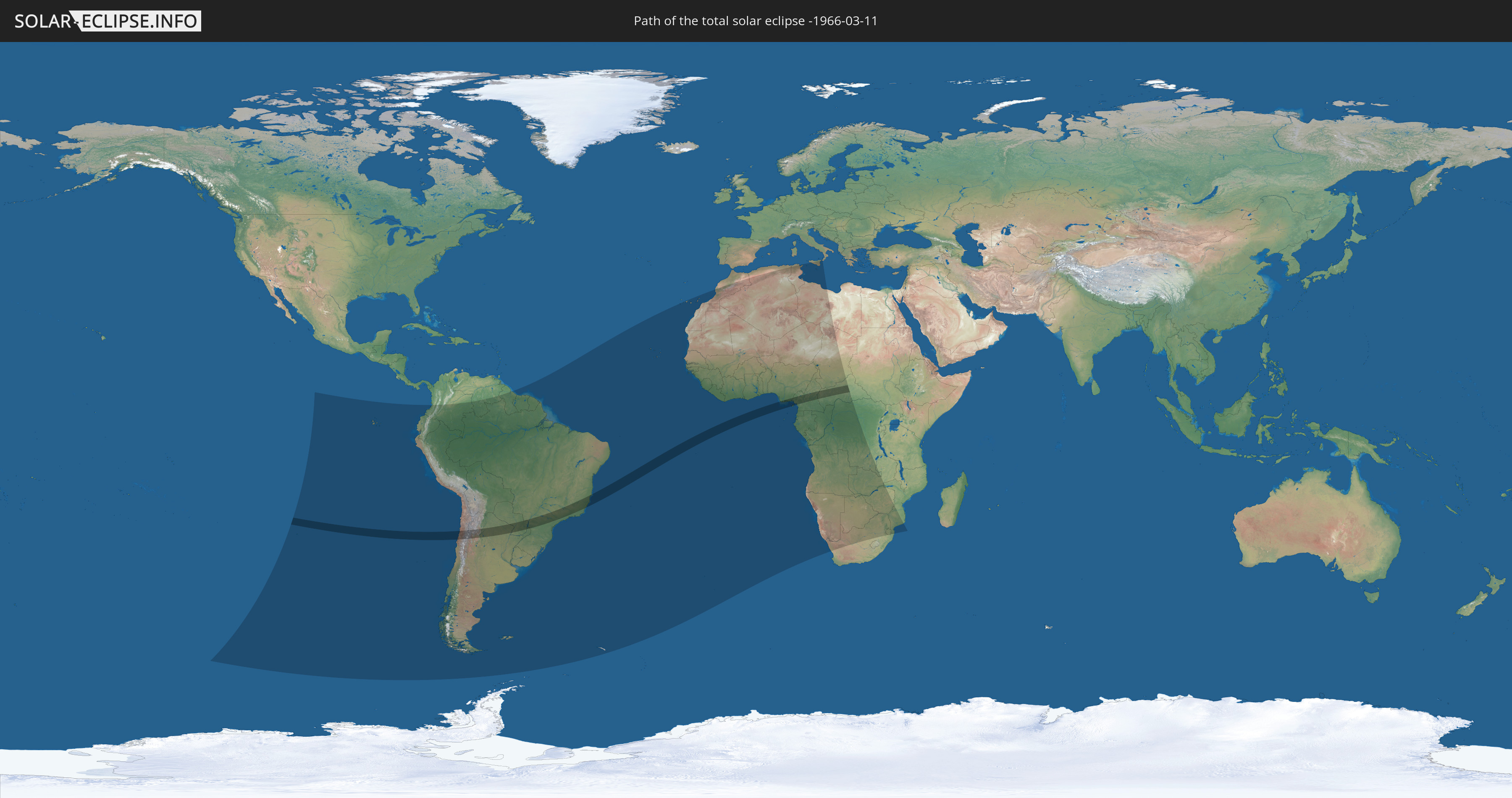
Total solar eclipse of 03/11/-1966
| Day of week: | Thursday |
| Maximum duration of eclipse: | 06m14s |
| Maximum width of eclipse path: | 236 km |
| Saros cycle: | 8 |
| Coverage: | 100% |
| Magnitude: | 1.0719 |
| Gamma: | -0.1456 |
Wo kann man die Sonnenfinsternis vom 03/11/-1966 sehen?
Die Sonnenfinsternis am 03/11/-1966 kann man in 55 Ländern als partielle Sonnenfinsternis beobachten.
Der Finsternispfad verläuft durch 8 Länder. Nur in diesen Ländern ist sie als total Sonnenfinsternis zu sehen.
In den folgenden Ländern ist die Sonnenfinsternis total zu sehen
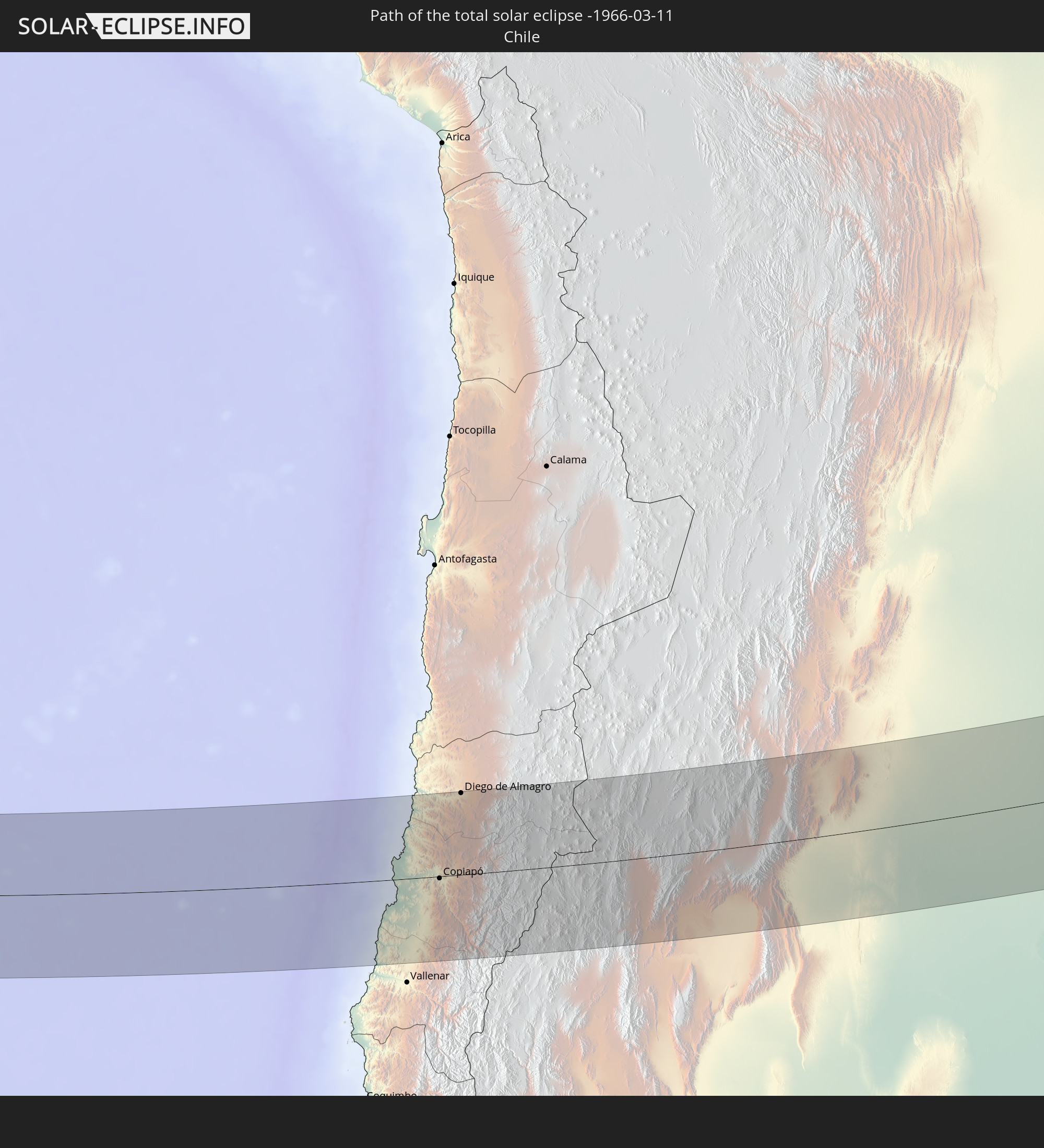 Chile
Chile
 Brazil
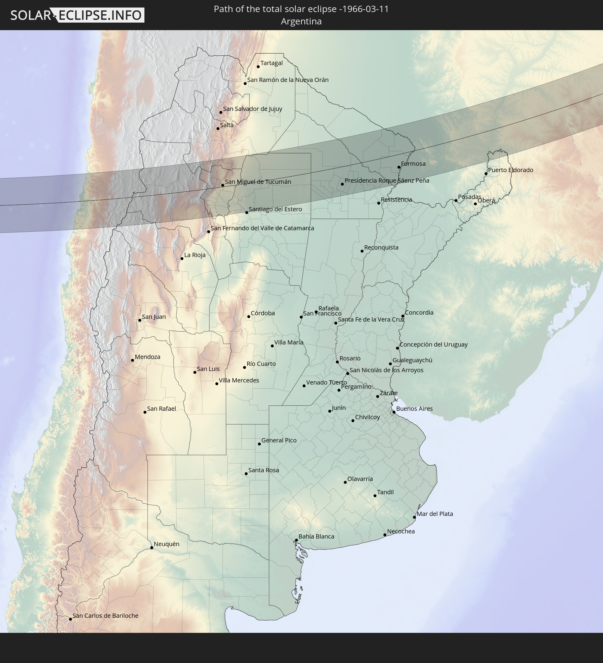 Argentina
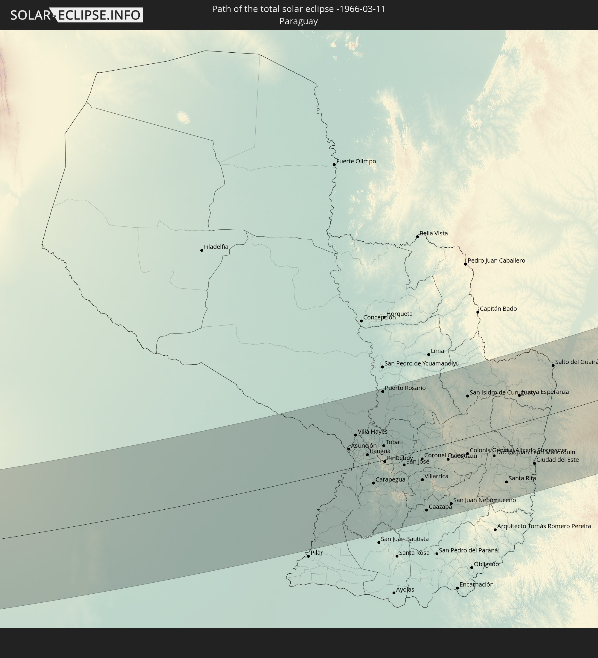 Paraguay
 Nigeria
 Equatorial Guinea
 Cameroon
 Central African Republic
In den folgenden Ländern ist die Sonnenfinsternis partiell zu sehen
 Chile
Chile
 Ecuador
 Colombia
 Peru
Peru
 Brazil
 Argentina
 Venezuela
 Bolivia
 Paraguay
 Falkland Islands
 Guyana
 Uruguay
 Suriname
 French Guiana
 South Georgia and the South Sandwich Islands
 Cabo Verde
 Spain
Spain
 Senegal
 Mauritania
 The Gambia
 Guinea-Bissau
 Guinea
 Saint Helena, Ascension and Tristan da Cunha
 Sierra Leone
 Morocco
 Mali
Mali
 Liberia
 Algeria
 Ivory Coast
 Burkina Faso
 Ghana
Ghana
 Togo
Togo
 Niger
Niger
 Benin
Benin
 Nigeria
 Equatorial Guinea
 São Tomé and Príncipe
 Italy
Italy
 Tunisia
 Cameroon
 Gabon
Gabon
 Libya
Libya
 Republic of the Congo
 Angola
 Namibia
 Democratic Republic of the Congo
 Chad
Chad
 Malta
Malta
 Central African Republic
 South Africa
 Botswana
 Zambia
 Zimbabwe
 Mozambique
 Swaziland
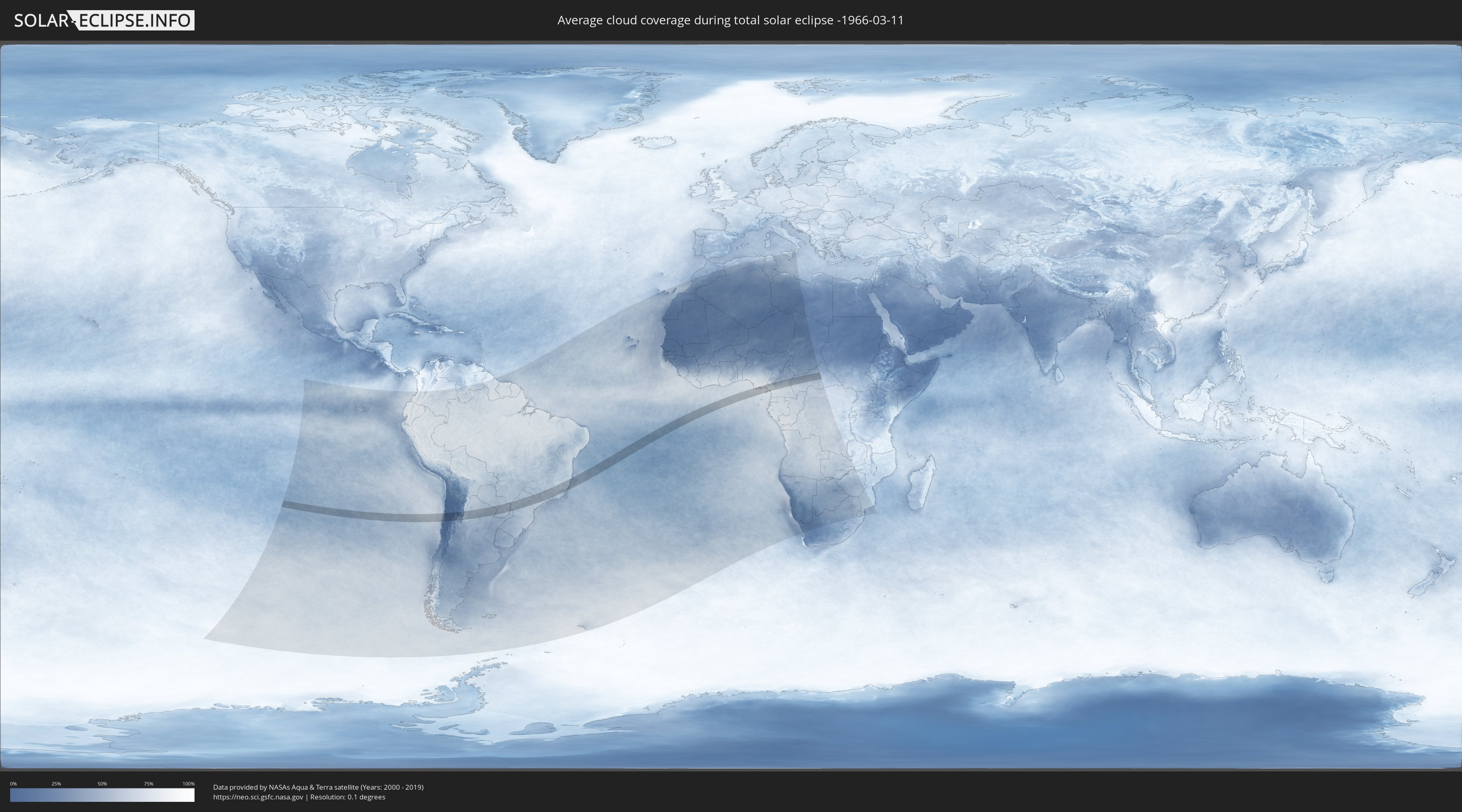
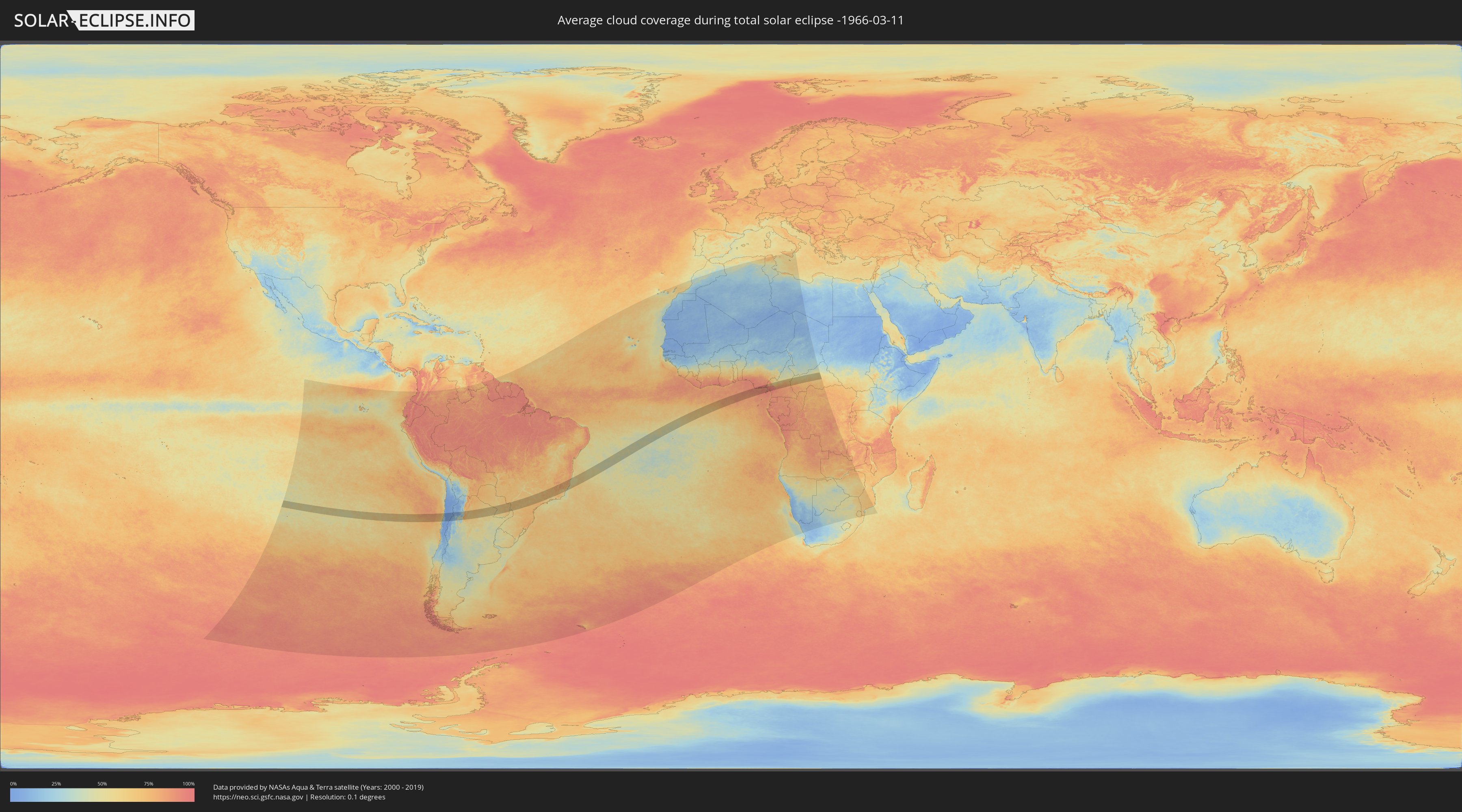
How will be the weather during the total solar eclipse on 03/11/-1966?
Where is the best place to see the total solar eclipse of 03/11/-1966?
The following maps show the average cloud coverage for the day of the total solar eclipse.
With the help of these maps, it is possible to find the place along the eclipse path, which has the best
chance of a cloudless sky.
Nevertheless, you should consider local circumstances and inform about the weather of your chosen
observation site.
The data is provided by NASAs satellites
AQUA and TERRA.
The cloud maps are averaged over a period of 19 years (2000 - 2019).
Detailed country maps
 Chile
Chile
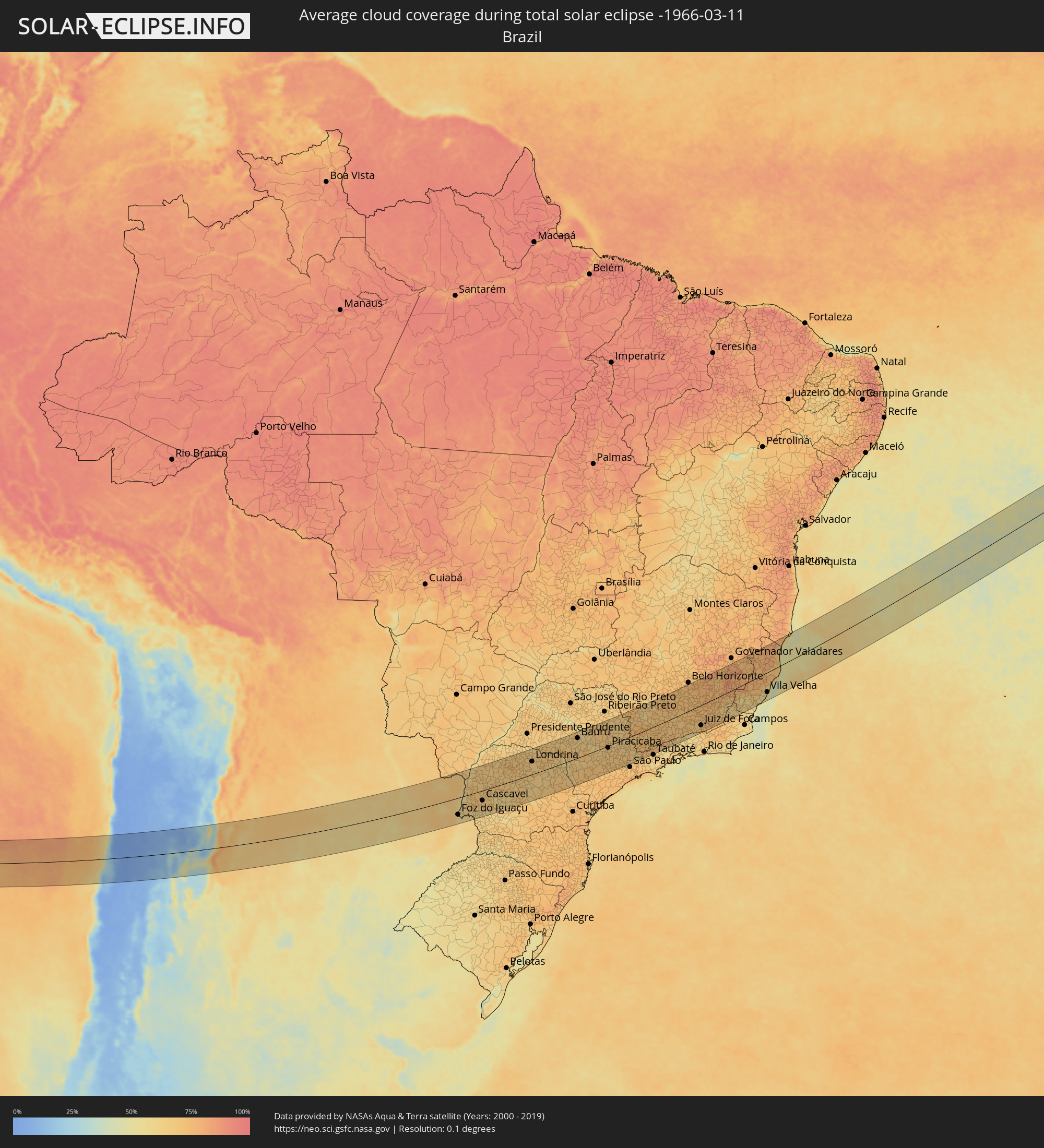 Brazil
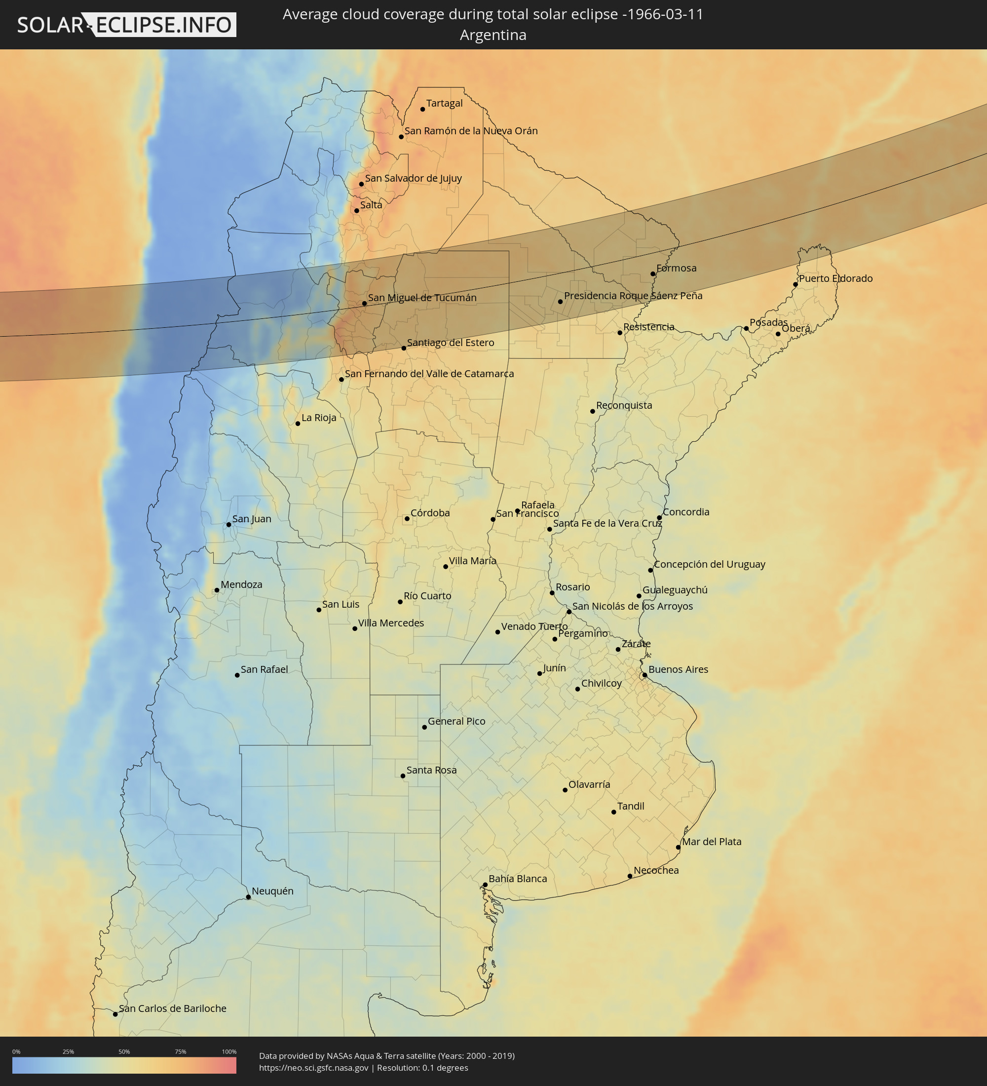 Argentina
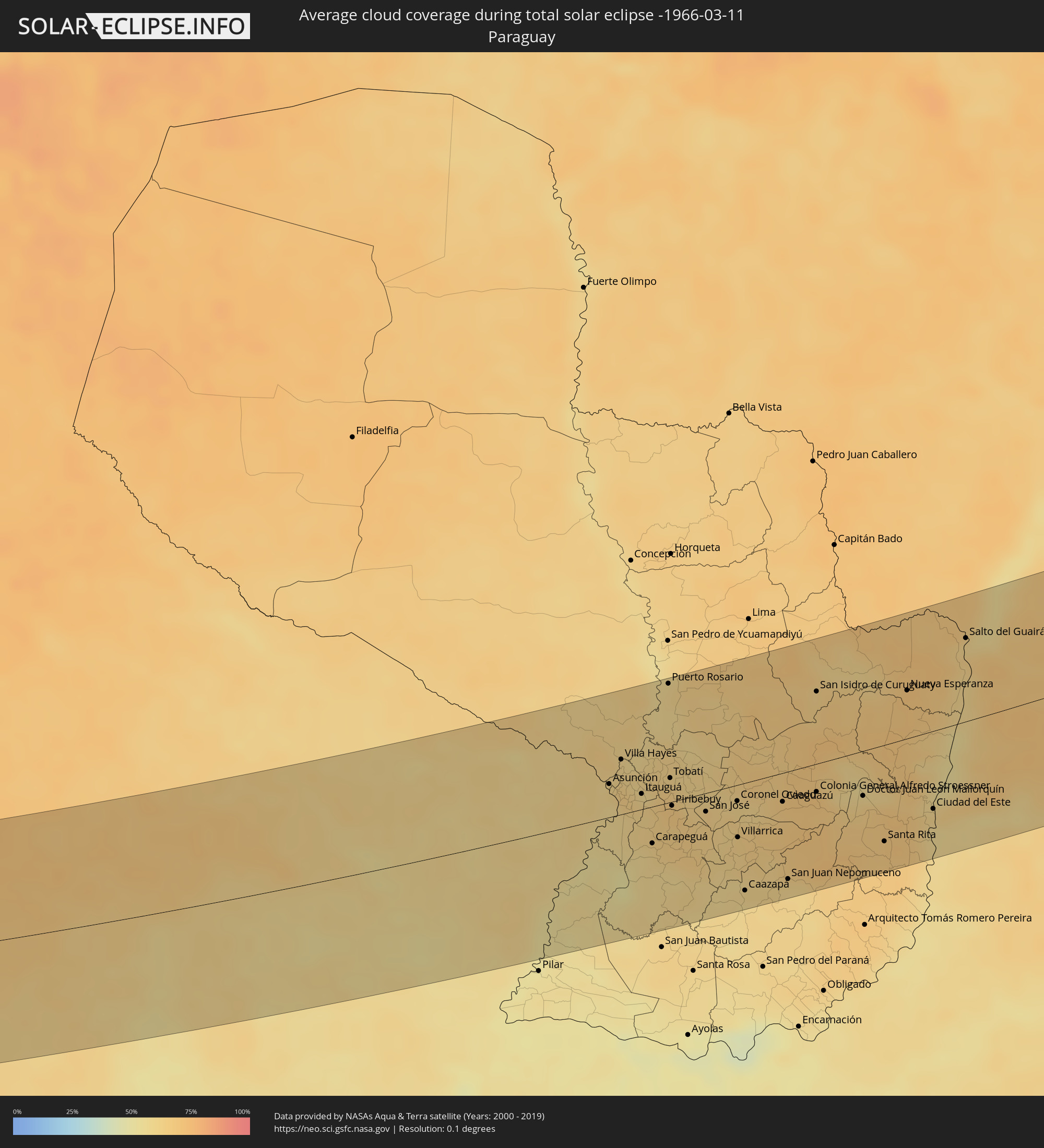 Paraguay
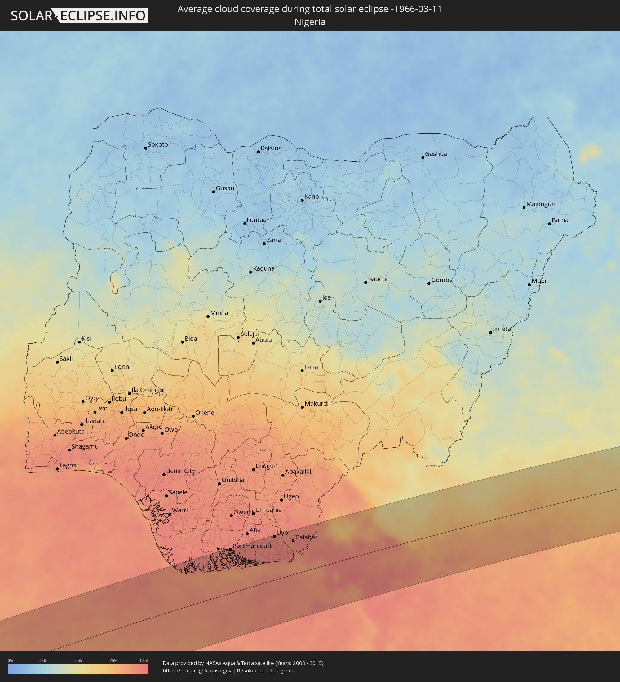 Nigeria
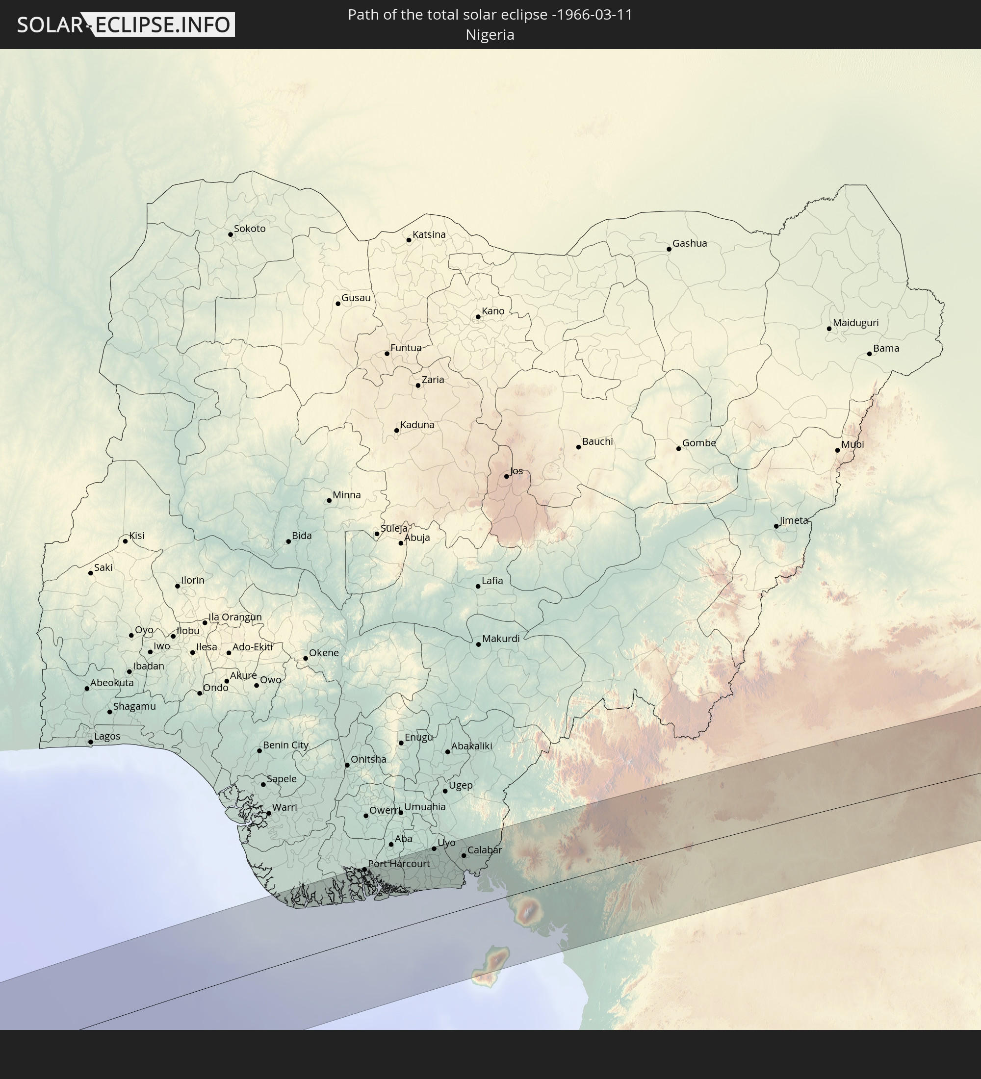
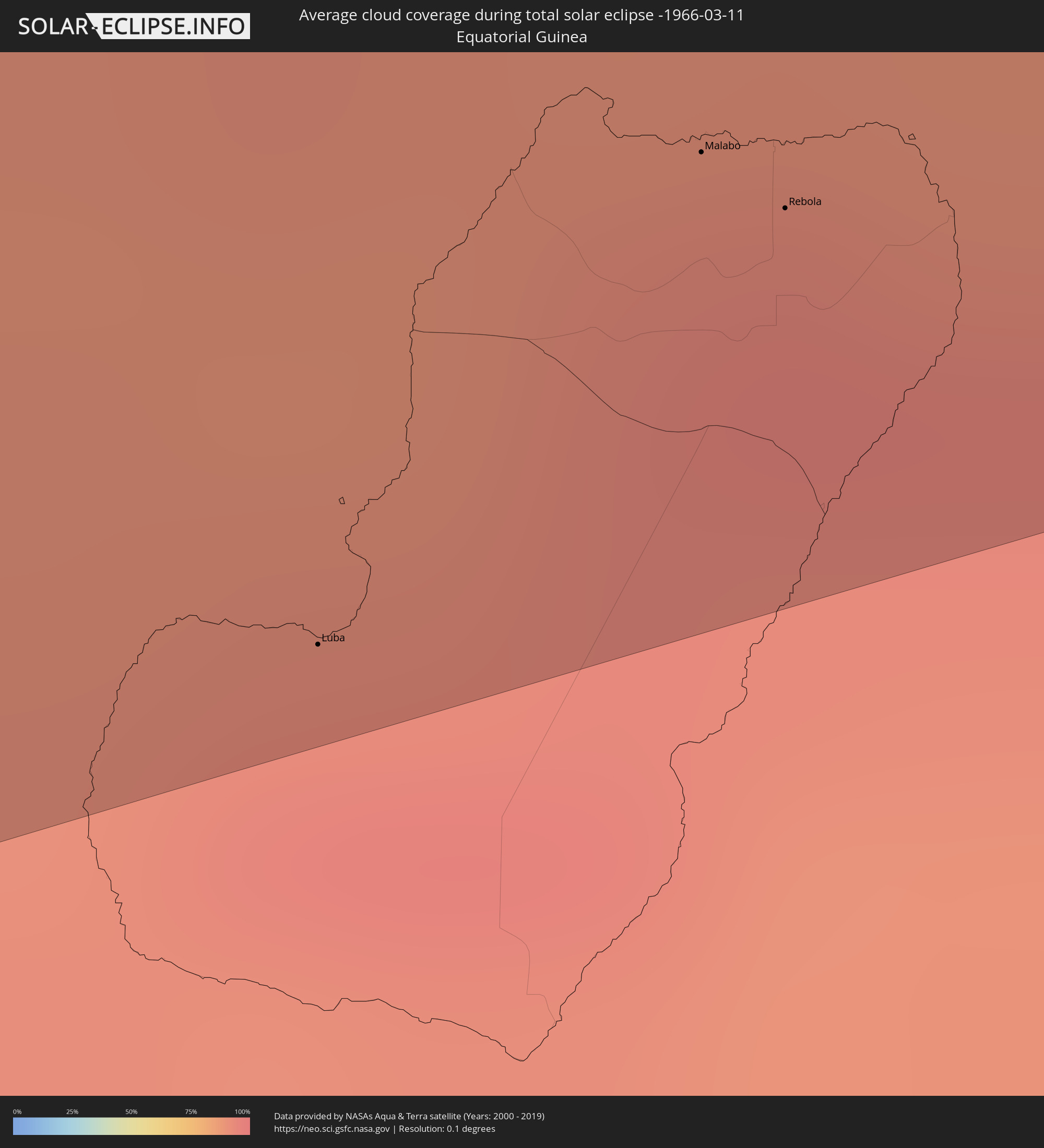 Equatorial Guinea
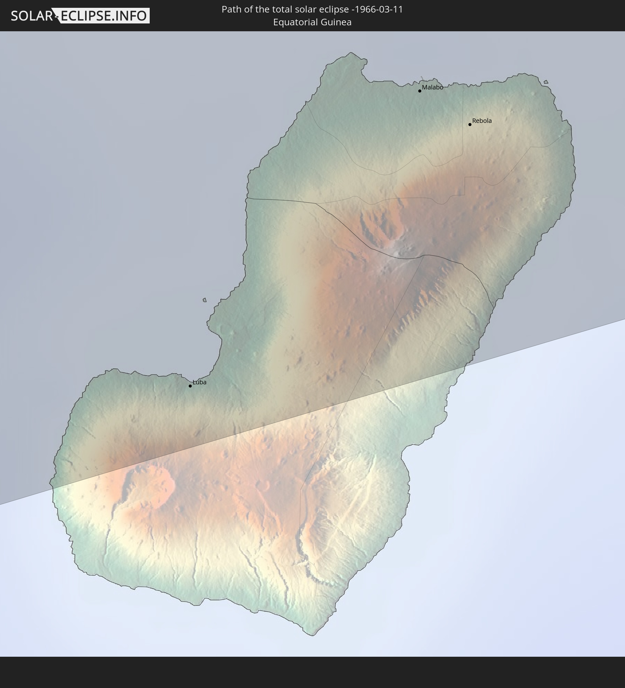
 Cameroon
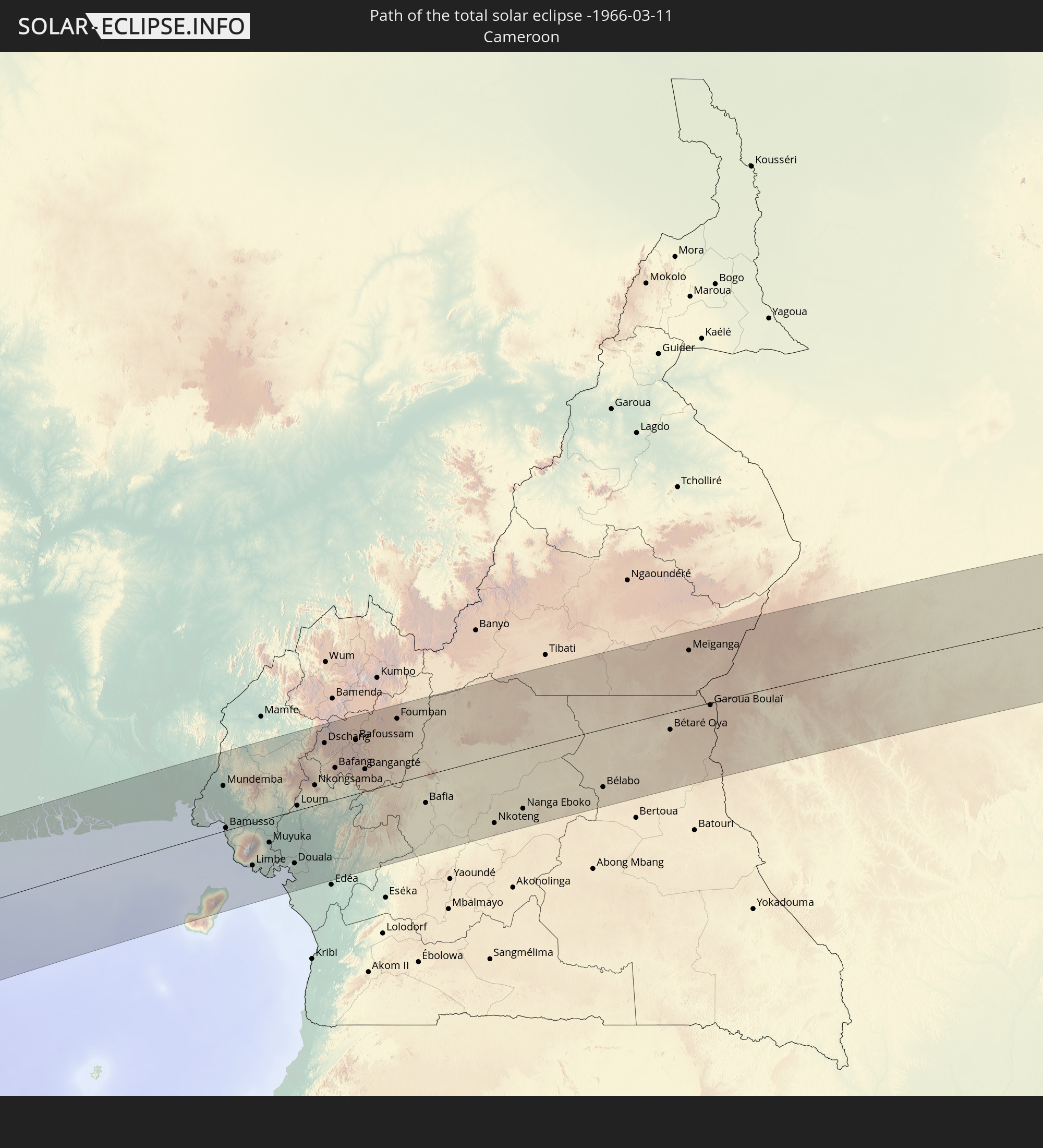
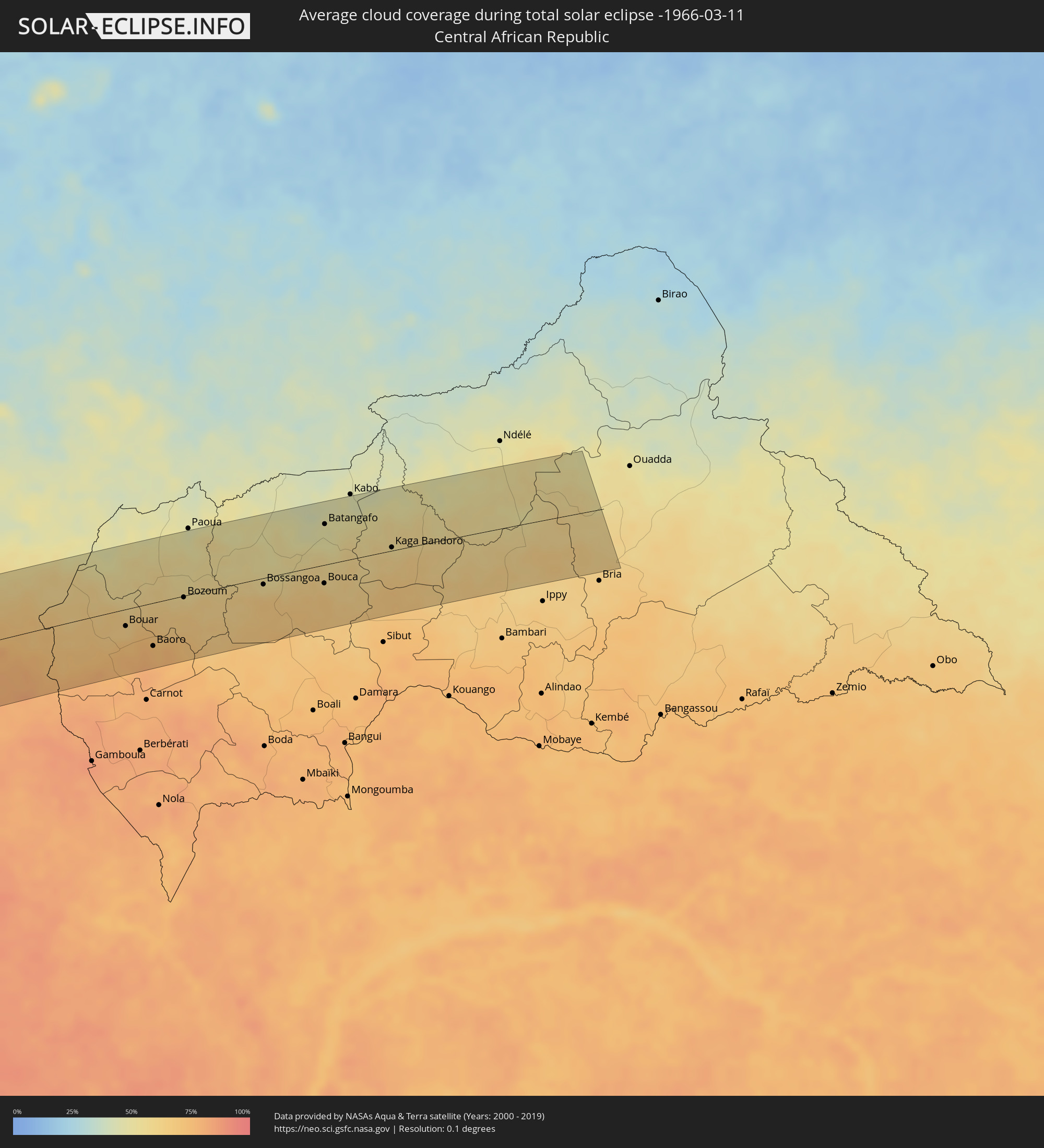 Central African Republic
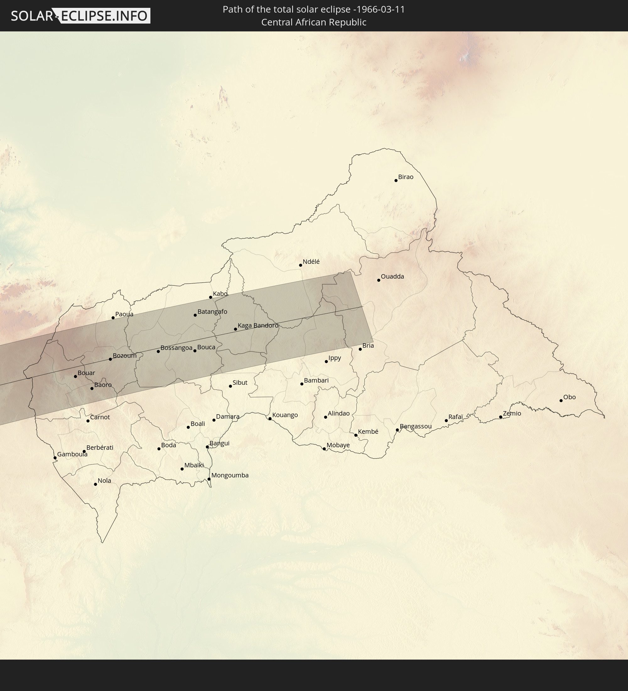
Cities inside the path of the eclipse
The following table shows all locations with a population of more than 5,000 inside the eclipse path. Cities which have more than 100,000 inhabitants are marked bold. A click at the locations opens a detailed map.
| City | Type | Eclipse duration | Local time of max. eclipse | Distance to central line | Ø Cloud coverage |
|
Copiapó, Atacama
|
total | - | 09:03:56 UTC-04:42 | 3 km | 5% |
|
Diego de Almagro, Atacama
|
total | - | 09:04:16 UTC-04:42 | 106 km | 1% |
|
Tinogasta, Catamarca Province
|
total | - | 09:34:13 UTC-04:16 | 104 km | 35% |
|
Andalgalá, Catamarca Province
|
total | - | 09:36:15 UTC-04:16 | 67 km | 36% |
|
Cafayate, Salta Province
|
total | - | 09:36:53 UTC-04:16 | 97 km | 50% |
|
Aguilares, Tucumán Province
|
total | - | 09:37:26 UTC-04:16 | 58 km | 72% |
|
Monteros, Tucumán Province
|
total | - | 09:37:38 UTC-04:16 | 30 km | 71% |
|
Famaillá, Tucumán Province
|
total | - | 09:37:49 UTC-04:16 | 18 km | 71% |
|
San Miguel de Tucumán, Tucumán Province
|
total | - | 09:38:08 UTC-04:16 | 5 km | 72% |
|
Termas de Río Hondo, Santiago del Estero Province
|
total | - | 09:38:43 UTC-04:16 | 74 km | 61% |
|
Charata, Chaco Province
|
total | - | 09:45:25 UTC-04:16 | 103 km | 62% |
|
Las Breñas, Chaco Province
|
total | - | 09:45:39 UTC-04:16 | 91 km | 61% |
|
Corzuela, Chaco Province
|
total | - | 09:45:53 UTC-04:16 | 78 km | 59% |
|
Campo Largo, Chaco Province
|
total | - | 09:46:10 UTC-04:16 | 64 km | 57% |
|
Castelli, Chaco Province
|
total | - | 09:46:49 UTC-04:16 | 25 km | 65% |
|
Presidencia Roque Sáenz Peña, Chaco Province
|
total | - | 09:46:57 UTC-04:16 | 70 km | 59% |
|
Tres Isletas, Chaco Province
|
total | - | 09:47:05 UTC-04:16 | 22 km | 57% |
|
Quitilipi, Chaco Province
|
total | - | 09:47:22 UTC-04:16 | 84 km | 59% |
|
Machagai, Chaco Province
|
total | - | 09:47:40 UTC-04:16 | 93 km | 56% |
|
Pampa del Indio, Chaco Province
|
total | - | 09:48:10 UTC-04:16 | 2 km | 60% |
|
Presidencia de la Plaza, Chaco Province
|
total | - | 09:48:03 UTC-04:16 | 106 km | 57% |
|
El Colorado, Formosa Province
|
total | - | 09:49:11 UTC-04:16 | 40 km | 55% |
|
General José de San Martín, Chaco Province
|
total | - | 09:49:11 UTC-04:16 | 66 km | 54% |
|
Pirané, Formosa Province
|
total | - | 09:49:54 UTC-04:16 | 17 km | 59% |
|
Formosa, Formosa Province
|
total | - | 09:51:39 UTC-04:16 | 52 km | 55% |
|
Clorinda, Formosa Province
|
total | - | 09:52:57 UTC-04:16 | 34 km | 60% |
|
Asunción, Asunción
|
total | - | 10:19:15 UTC-03:50 | 30 km | 61% |
|
Benjamín Aceval, Presidente Hayes
|
total | - | 10:19:32 UTC-03:50 | 65 km | 63% |
|
Limpio, Central
|
total | - | 10:19:37 UTC-03:50 | 41 km | 63% |
|
Guarambaré, Central
|
total | - | 10:19:32 UTC-03:50 | 7 km | 59% |
|
Capiatá, Central
|
total | - | 10:19:38 UTC-03:50 | 20 km | 63% |
|
Areguá, Central
|
total | - | 10:19:46 UTC-03:50 | 23 km | 62% |
|
Itá, Central
|
total | - | 10:19:44 UTC-03:50 | 2 km | 60% |
|
Ypacarai, Central
|
total | - | 10:19:56 UTC-03:50 | 10 km | 62% |
|
Paraguarí, Paraguarí
|
total | - | 10:20:08 UTC-03:50 | 16 km | 64% |
|
Caacupé, Cordillera
|
total | - | 10:20:15 UTC-03:50 | 9 km | 66% |
|
Tobatí, Cordillera
|
total | - | 10:20:28 UTC-03:50 | 22 km | 65% |
|
Piribebuy, Cordillera
|
total | - | 10:20:24 UTC-03:50 | 4 km | 65% |
|
Eusebio Ayala, Cordillera
|
total | - | 10:20:37 UTC-03:50 | 3 km | 65% |
|
Coronel Oviedo, Caaguazú
|
total | - | 10:21:43 UTC-03:50 | 15 km | 61% |
|
Villarrica, Guairá
|
total | - | 10:21:35 UTC-03:50 | 48 km | 63% |
|
Caazapá, Caazapá
|
total | - | 10:21:32 UTC-03:50 | 97 km | 58% |
|
Caaguazú, Caaguazú
|
total | - | 10:22:37 UTC-03:50 | 26 km | 65% |
|
San Juan Nepomuceno, Caazapá
|
total | - | 10:22:25 UTC-03:50 | 97 km | 60% |
|
Colonia General Alfredo Stroessner, Caaguazú
|
total | - | 10:23:21 UTC-03:50 | 25 km | 68% |
|
San Isidro de Curuguaty, Canindeyú
|
total | - | 10:23:47 UTC-03:50 | 66 km | 62% |
|
Doctor Juan León Mallorquín, Alto Paraná
|
total | - | 10:24:16 UTC-03:50 | 41 km | 62% |
|
Santa Rita, Alto Paraná
|
total | - | 10:24:30 UTC-03:50 | 87 km | 66% |
|
Nueva Esperanza, Canindeyú
|
total | - | 10:25:39 UTC-03:50 | 44 km | 69% |
|
Ciudad del Este, Alto Paraná
|
total | - | 10:25:38 UTC-03:50 | 70 km | 61% |
|
Foz do Iguaçu, Paraná
|
total | - | 11:09:52 UTC-03:06 | 75 km | 61% |
|
Puerto Iguazú, Misiones Province
|
total | - | 09:59:32 UTC-04:16 | 81 km | 57% |
|
Salto del Guairá, Canindeyú
|
total | - | 10:27:09 UTC-03:50 | 76 km | 62% |
|
Cascavel, Paraná
|
total | - | 11:12:43 UTC-03:06 | 44 km | 69% |
|
Maringá, Paraná
|
total | - | 11:17:13 UTC-03:06 | 71 km | 71% |
|
Londrina, Paraná
|
total | - | 11:19:08 UTC-03:06 | 57 km | 65% |
|
Bauru, São Paulo
|
total | - | 11:25:00 UTC-03:06 | 87 km | 66% |
|
Araraquara, São Paulo
|
total | - | 11:27:40 UTC-03:06 | 108 km | 68% |
|
São Carlos, São Paulo
|
total | - | 11:28:09 UTC-03:06 | 74 km | 68% |
|
Piracicaba, São Paulo
|
total | - | 11:28:03 UTC-03:06 | 8 km | 69% |
|
Rio Claro, São Paulo
|
total | - | 11:28:34 UTC-03:06 | 21 km | 66% |
|
Sorocaba, São Paulo
|
total | - | 11:27:47 UTC-03:06 | 96 km | 70% |
|
Santa Bárbara d'Oeste, São Paulo
|
total | - | 11:28:36 UTC-03:06 | 20 km | 66% |
|
Limeira, São Paulo
|
total | - | 11:28:48 UTC-03:06 | 1 km | 65% |
|
Itu, São Paulo
|
total | - | 11:28:23 UTC-03:06 | 77 km | 69% |
|
Sumaré, São Paulo
|
total | - | 11:28:53 UTC-03:06 | 33 km | 69% |
|
Indaiatuba, São Paulo
|
total | - | 11:28:46 UTC-03:06 | 62 km | 69% |
|
Campinas, São Paulo
|
total | - | 11:29:18 UTC-03:06 | 49 km | 68% |
|
Jundiaí, São Paulo
|
total | - | 11:29:28 UTC-03:06 | 85 km | 67% |
|
Francisco Morato, São Paulo
|
total | - | 11:29:42 UTC-03:06 | 100 km | 67% |
|
Poços de Caldas, Minas Gerais
|
total | - | 11:31:39 UTC-03:06 | 46 km | 72% |
|
Pindamonhangaba, São Paulo
|
total | - | 11:33:10 UTC-03:06 | 115 km | 64% |
|
Juiz de Fora, Minas Gerais
|
total | - | 11:39:35 UTC-03:06 | 87 km | 71% |
|
Ipatinga, Minas Gerais
|
total | - | 11:44:23 UTC-03:06 | 107 km | 69% |
|
Cachoeiro de Itapemirim, Espírito Santo
|
total | - | 11:46:13 UTC-03:06 | 97 km | 62% |
|
Serra, Espírito Santo
|
total | - | 11:49:07 UTC-03:06 | 64 km | 61% |
|
Vila Velha, Espírito Santo
|
total | - | 11:48:54 UTC-03:06 | 84 km | 57% |
|
Twon-Brass, Bayelsa
|
total | - | 16:52:29 UTC+00:13 | 72 km | 86% |
|
Obonoma, Rivers
|
total | - | 16:52:58 UTC+00:13 | 96 km | 92% |
|
Buguma, Rivers
|
total | - | 16:53:01 UTC+00:13 | 97 km | 92% |
|
Port Harcourt, Rivers
|
total | - | 16:53:06 UTC+00:13 | 96 km | 92% |
|
Okrika, Rivers
|
total | - | 16:53:06 UTC+00:13 | 90 km | 92% |
|
Bonny, Rivers
|
total | - | 16:52:58 UTC+00:13 | 56 km | 89% |
|
Bori, Rivers
|
total | - | 16:53:11 UTC+00:13 | 74 km | 95% |
|
Abak, Akwa Ibom
|
total | - | 16:53:32 UTC+00:13 | 93 km | 94% |
|
Etinan, Akwa Ibom
|
total | - | 16:53:28 UTC+00:13 | 76 km | 94% |
|
Eket, Akwa Ibom
|
total | - | 16:53:22 UTC+00:13 | 53 km | 92% |
|
Uyo, Akwa Ibom
|
total | - | 16:53:37 UTC+00:13 | 96 km | 94% |
|
Akankpa, Cross River
|
total | - | 16:53:46 UTC+00:13 | 96 km | 92% |
|
Esuk Oron, Akwa Ibom
|
total | - | 16:53:35 UTC+00:13 | 60 km | 93% |
|
Calabar, Cross River
|
total | - | 16:53:43 UTC+00:13 | 74 km | 92% |
|
Ikang, Cross River
|
total | - | 16:53:41 UTC+00:13 | 50 km | 90% |
|
Luba, Bioko Sur
|
total | - | 16:52:52 UTC+00:13 | 93 km | 93% |
|
Malabo, Bioko Norte
|
total | - | 16:53:08 UTC+00:13 | 69 km | 93% |
|
Rebola, Bioko Norte
|
total | - | 16:53:08 UTC+00:13 | 74 km | 95% |
|
Limbe, South-West
|
total | - | 16:53:27 UTC+00:13 | 53 km | 91% |
|
Tiko, South-West
|
total | - | 16:53:32 UTC+00:13 | 52 km | 93% |
|
Muyuka, South-West
|
total | - | 16:53:41 UTC+00:13 | 31 km | 96% |
|
Kumba, South-West
|
total | - | 16:53:54 UTC+00:13 | 5 km | 95% |
|
Mbanga, Littoral
|
total | - | 16:53:52 UTC+00:13 | 13 km | 96% |
|
Penja, Littoral
|
total | - | 16:53:59 UTC+00:13 | 1 km | 94% |
|
Douala, Littoral
|
total | - | 16:53:38 UTC+00:13 | 65 km | 87% |
|
Loum, Littoral
|
total | - | 16:54:02 UTC+00:13 | 6 km | 95% |
|
Manjo, Littoral
|
total | - | 16:54:08 UTC+00:13 | 16 km | 91% |
|
Fontem, South-West
|
total | - | 16:54:31 UTC+00:13 | 82 km | 83% |
|
Nkongsamba, Littoral
|
total | - | 16:54:14 UTC+00:13 | 25 km | 89% |
|
Melong, Littoral
|
total | - | 16:54:21 UTC+00:13 | 42 km | 83% |
|
Dschang, West
|
total | - | 16:54:33 UTC+00:13 | 74 km | 72% |
|
Bafang, West
|
total | - | 16:54:26 UTC+00:13 | 40 km | 83% |
|
Mbouda, West
|
total | - | 16:54:43 UTC+00:13 | 88 km | 57% |
|
Bafoussam, West
|
total | - | 16:54:41 UTC+00:13 | 67 km | 61% |
|
Bangangté, West
|
total | - | 16:54:31 UTC+00:13 | 28 km | 78% |
|
Foumbot, West
|
total | - | 16:54:45 UTC+00:13 | 64 km | 61% |
|
Foumban, West
|
total | - | 16:54:57 UTC+00:13 | 80 km | 53% |
|
Bafia, Centre
|
total | - | 16:54:29 UTC+00:13 | 35 km | 80% |
|
Mbandjok, Centre
|
total | - | 16:54:29 UTC+00:13 | 86 km | 83% |
|
Nkoteng, Centre
|
total | - | 16:54:34 UTC+00:13 | 83 km | 83% |
|
Nanga Eboko, Centre
|
total | - | 16:54:44 UTC+00:13 | 74 km | 84% |
|
Meïganga, Adamaoua
|
total | - | 16:56:03 UTC+00:13 | 72 km | 62% |
|
Garoua Boulaï, East
|
total | - | 16:55:47 UTC+00:13 | 3 km | 69% |
|
Bouar, Nana-Mambéré
|
total | - | 16:55:57 UTC+00:13 | 24 km | 65% |
|
Baoro, Nana-Mambéré
|
total | - | 16:55:51 UTC+00:13 | 63 km | 73% |
|
Bozoum, Ouham-Pendé
|
total | - | 16:56:13 UTC+00:13 | 2 km | 61% |
|
Bossangoa, Ouham
|
total | - | 16:56:22 UTC+00:13 | 9 km | 59% |
|
Bouca, Ouham
|
total | - | 16:56:25 UTC+00:13 | 27 km | 61% |
|
Batangafo, Ouham
|
total | - | 16:56:46 UTC+00:13 | 59 km | 47% |
|
Kaga Bandoro, Nana-Grébizi
|
total | - | 16:56:39 UTC+00:13 | 5 km | 57% |