Totale Sonnenfinsternis vom 25.10.-1987
| Wochentag: | Mittwoch |
| Maximale Dauer der Verfinsterung: | 01m58s |
| Maximale Breite des Finsternispfades: | 165 km |
| Saroszyklus: | 21 |
| Bedeckungsgrad: | 100% |
| Magnitude: | 1.026 |
| Gamma: | 0.846 |
Wo kann man die Sonnenfinsternis vom 25.10.-1987 sehen?

Die Sonnenfinsternis am 25.10.-1987 kann man in 34 Ländern als partielle Sonnenfinsternis beobachten.
Der Finsternispfad verläuft durch 2 Länder. Nur in diesen Ländern ist sie als totale Sonnenfinsternis zu sehen.
In den folgenden Ländern ist die Sonnenfinsternis total zu sehen
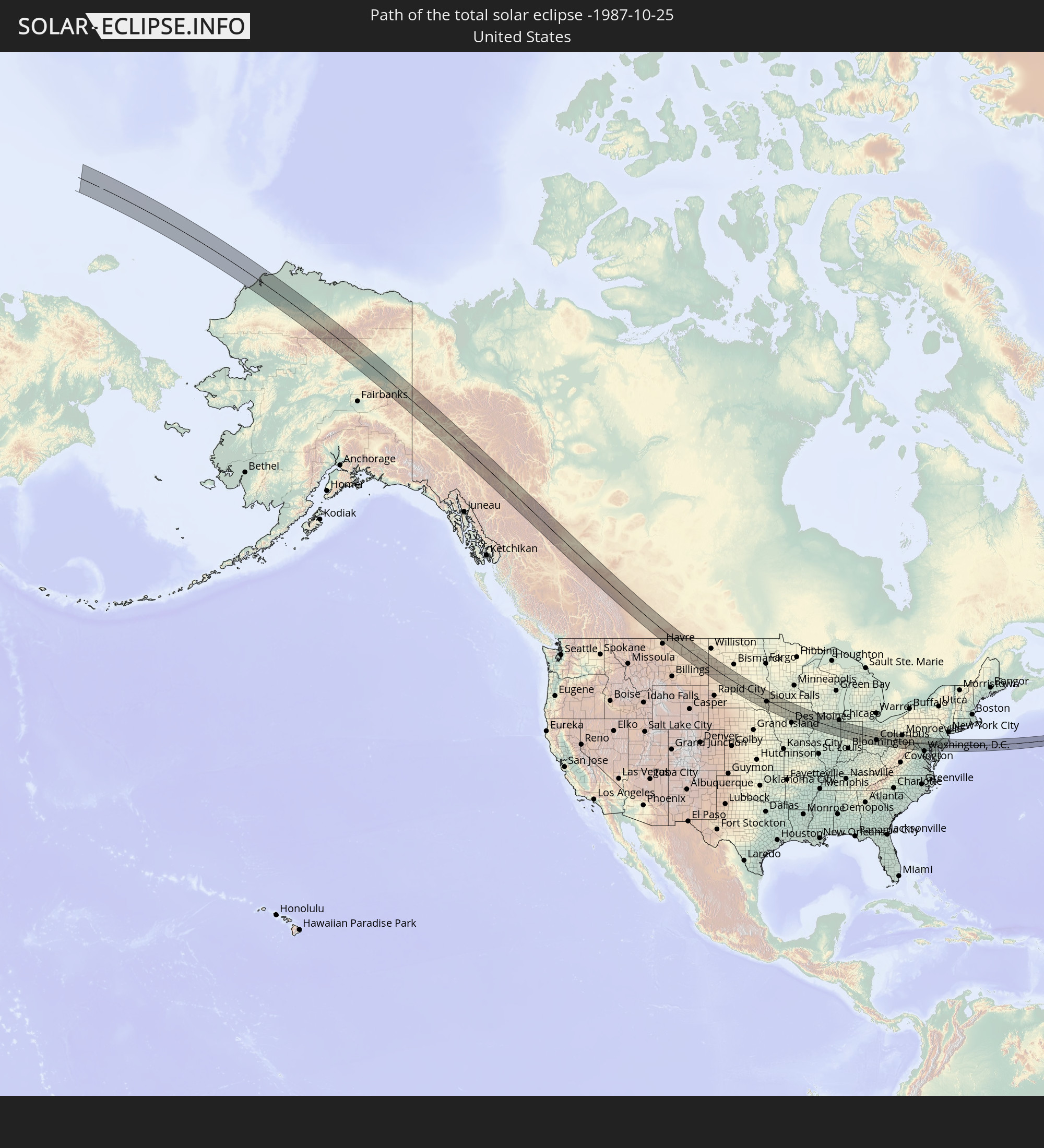 Vereinigte Staaten
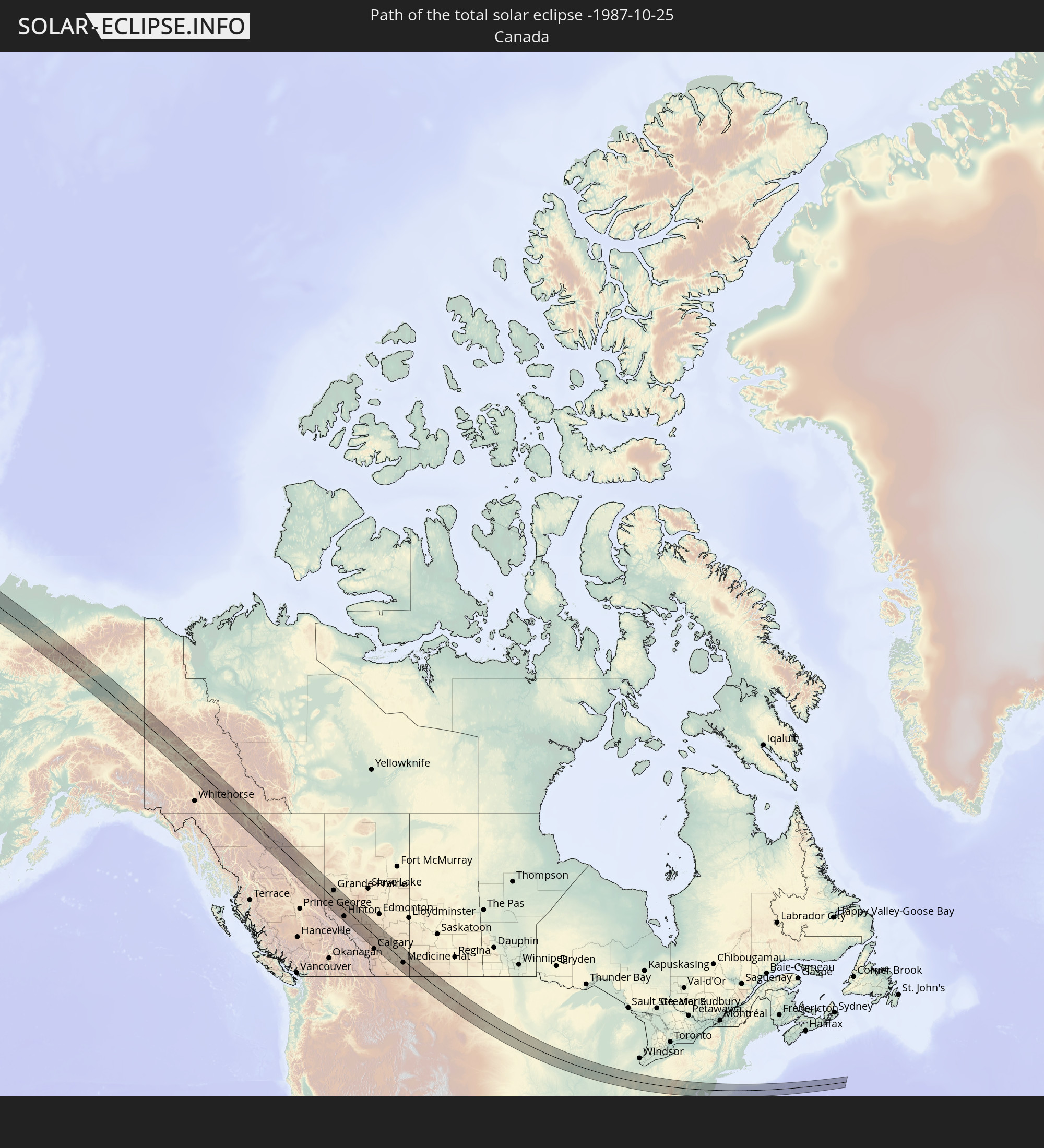 Kanada
In den folgenden Ländern ist die Sonnenfinsternis partiell zu sehen
 Russland
 Vereinigte Staaten
 United States Minor Outlying Islands
 Kanada
 Mexiko
 Grönland
 Guatemala
 Ecuador
 El Salvador
 Honduras
 Belize
 Nicaragua
 Costa Rica
 Kuba
Kuba
 Panama
 Kolumbien
 Kaimaninseln
 Peru
Peru
 Bahamas
 Jamaika
 Haiti
Haiti
 Brasilien
 Venezuela
 Turks- und Caicosinseln
 Dominikanische Republik
 Aruba
Aruba
 Puerto Rico
 Amerikanische Jungferninseln
 Bermuda
 Britische Jungferninseln
 Anguilla
 Saint-Martin
 Saint-Barthélemy
 St. Kitts und Nevis
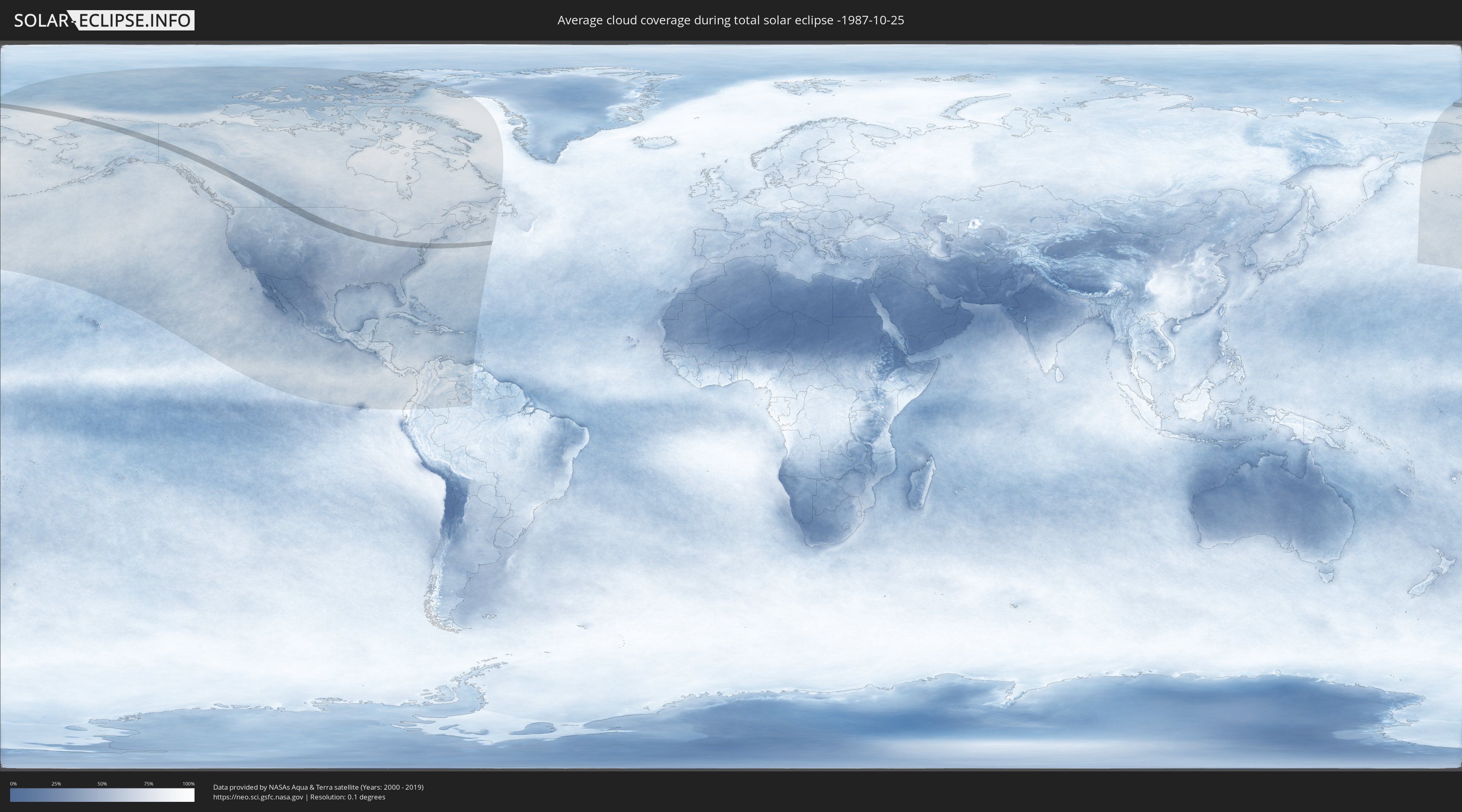
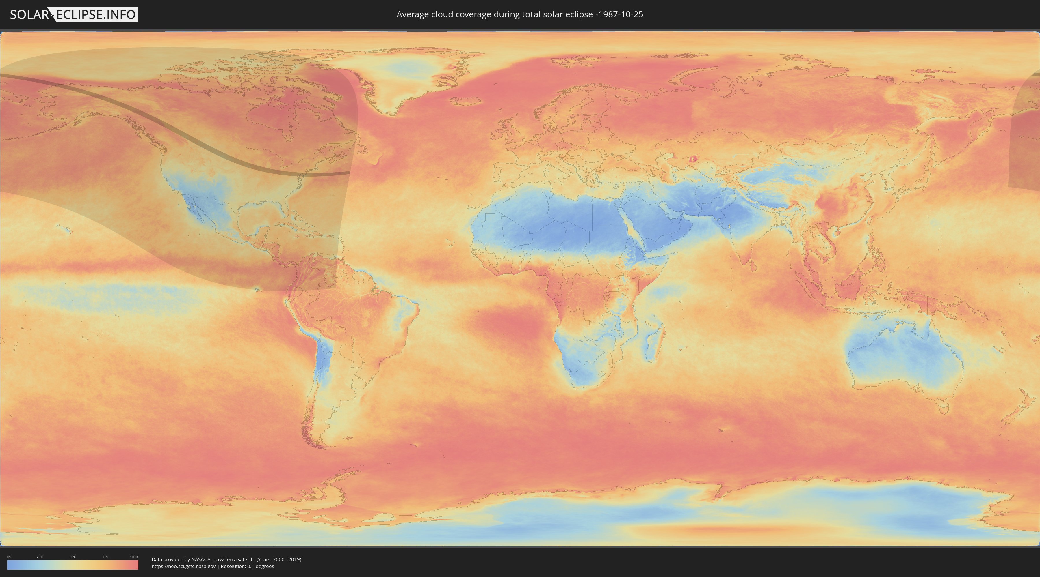
Wie wird das Wetter während der totalen Sonnenfinsternis am 25.10.-1987?
Wo ist der beste Ort, um die totale Sonnenfinsternis vom 25.10.-1987 zu beobachten?
Die folgenden Karten zeigen die durchschnittliche Bewölkung für den Tag, an dem die totale Sonnenfinsternis
stattfindet. Mit Hilfe der Karten lässt sich der Ort entlang des Finsternispfades eingrenzen,
der die besten Aussichen auf einen klaren wolkenfreien Himmel bietet.
Trotzdem muss man immer lokale Gegenenheiten beachten und sollte sich genau über das Wetter an seinem
gewählten Beobachtungsort informieren.
Die Daten stammen von den beiden NASA-Satelliten
AQUA und TERRA
und wurden über einen Zeitraum von 19 Jahren (2000 - 2019) gemittelt.
Detaillierte Länderkarten
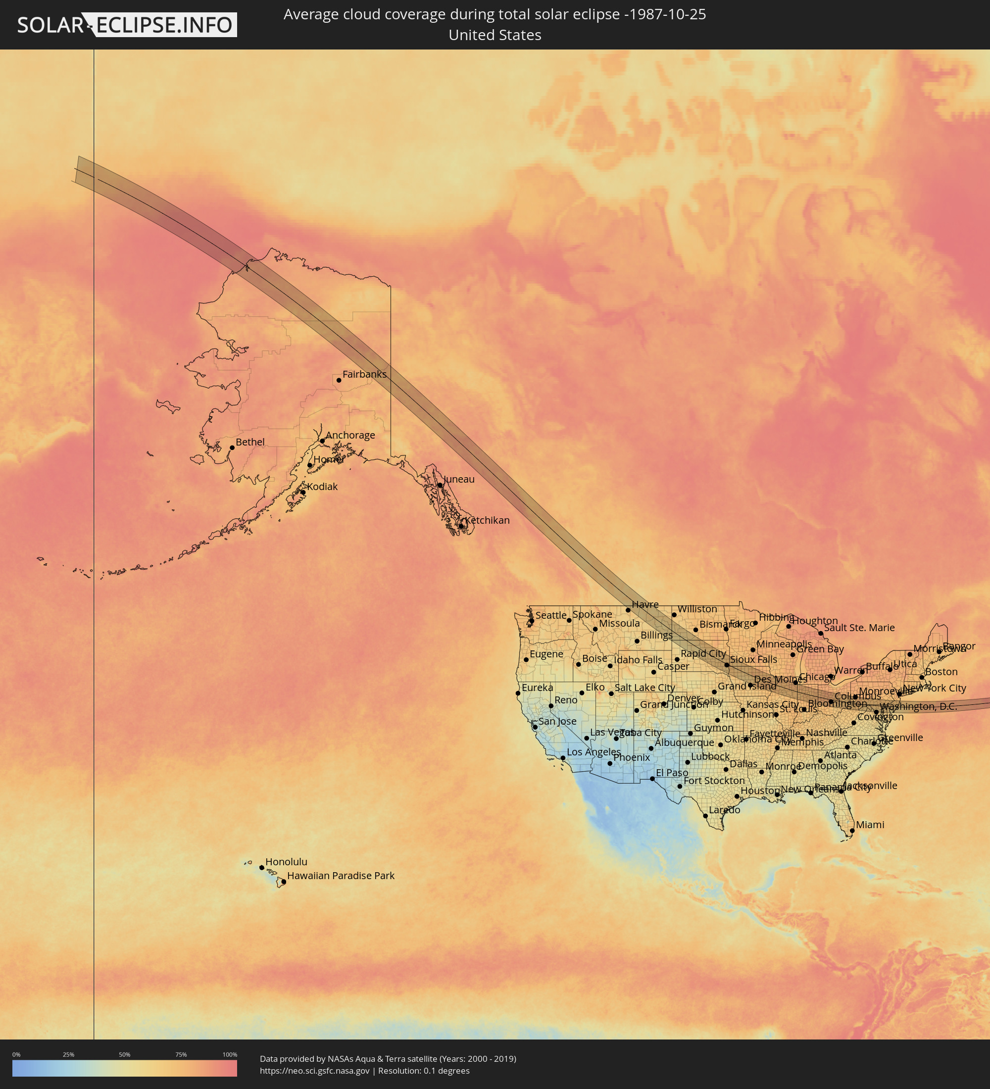 Vereinigte Staaten
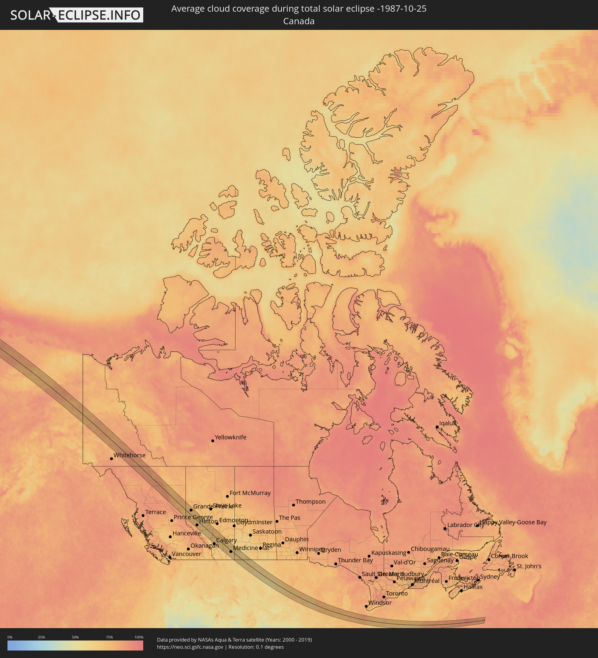 Kanada
Orte im Finsternispfad
Die nachfolgene Tabelle zeigt Städte und Orte mit mehr als 5.000 Einwohnern, die sich im Finsternispfad befinden. Städte mit mehr als 100.000 Einwohnern sind dick gekennzeichnet. Mit einem Klick auf den Ort öffnet sich eine Detailkarte die die Lage des jeweiligen Ortes zusammen mit dem Verlauf der zentralen Finsternis präsentiert.
| Ort | Typ | Dauer der Verfinsterung | Ortszeit bei maximaler Verfinsterung | Entfernung zur Zentrallinie | Ø Bewölkung |
|
Fort St. John, British Columbia
|
total | - | 12:06:41 UTC-08:00 | 44 km | 77% |
|
Dawson Creek, British Columbia
|
total | - | 12:07:42 UTC-08:00 | 30 km | 78% |
|
Grande Prairie, Alberta
|
total | - | 12:35:59 UTC-07:33 | 45 km | 73% |
|
Hinton, Alberta
|
total | - | 12:38:45 UTC-07:33 | 46 km | 71% |
|
Edson, Alberta
|
total | - | 12:40:08 UTC-07:33 | 21 km | 68% |
|
Drayton Valley, Alberta
|
total | - | 12:42:21 UTC-07:33 | 56 km | 72% |
|
Rocky Mountain House, Alberta
|
total | - | 12:43:09 UTC-07:33 | 11 km | 68% |
|
Olds, Alberta
|
total | - | 12:44:47 UTC-07:33 | 23 km | 71% |
|
Sylvan Lake, Alberta
|
total | - | 12:44:20 UTC-07:33 | 22 km | 74% |
|
Airdrie, Alberta
|
total | - | 12:45:19 UTC-07:33 | 61 km | 73% |
|
Red Deer, Alberta
|
total | - | 12:44:46 UTC-07:33 | 31 km | 71% |
|
Lacombe, Alberta
|
total | - | 12:44:40 UTC-07:33 | 50 km | 73% |
|
Ponoka, Alberta
|
total | - | 12:44:42 UTC-07:33 | 75 km | 73% |
|
Strathmore, Alberta
|
total | - | 12:46:27 UTC-07:33 | 52 km | 71% |
|
Brooks, Alberta
|
total | - | 12:49:01 UTC-07:33 | 23 km | 73% |
|
Medicine Hat, Alberta
|
total | - | 12:51:18 UTC-07:33 | 14 km | 69% |
|
Brookings, South Dakota
|
total | - | 14:52:11 UTC-06:00 | 58 km | 70% |
|
Sioux Falls, South Dakota
|
total | - | 14:53:30 UTC-06:00 | 13 km | 66% |
|
Fort Dodge, Iowa
|
total | - | 14:58:28 UTC-06:00 | 31 km | 65% |
|
Ames, Iowa
|
total | - | 14:59:54 UTC-06:00 | 61 km | 68% |
|
Mason City, Iowa
|
total | - | 14:58:37 UTC-06:00 | 67 km | 75% |
|
Marshalltown, Iowa
|
total | - | 15:00:46 UTC-06:00 | 37 km | 74% |
|
Waterloo, Iowa
|
total | - | 15:00:45 UTC-06:00 | 26 km | 74% |
|
Cedar Rapids, Iowa
|
total | - | 15:02:23 UTC-06:00 | 3 km | 75% |
|
Iowa City, Iowa
|
total | - | 15:03:05 UTC-06:00 | 36 km | 76% |
|
Muscatine, Iowa
|
total | - | 15:04:04 UTC-06:00 | 47 km | 72% |
|
Dubuque, Iowa
|
total | - | 15:02:44 UTC-06:00 | 77 km | 70% |
|
Davenport, Iowa
|
total | - | 15:04:27 UTC-06:00 | 23 km | 73% |
|
Galesburg, Illinois
|
total | - | 15:05:38 UTC-06:00 | 78 km | 74% |
|
Clinton, Iowa
|
total | - | 15:04:22 UTC-06:00 | 21 km | 73% |
|
Ottawa, Illinois
|
total | - | 15:06:44 UTC-06:00 | 3 km | 75% |
|
DeKalb, Illinois
|
total | - | 15:05:52 UTC-06:00 | 68 km | 76% |
|
Aurora, Illinois
|
total | - | 15:06:37 UTC-06:00 | 60 km | 78% |
|
Saint Charles, Illinois
|
total | - | 15:06:23 UTC-06:00 | 77 km | 78% |
|
Wheaton, Illinois
|
total | - | 15:06:41 UTC-06:00 | 77 km | 77% |
|
Joliet, Illinois
|
total | - | 15:07:16 UTC-06:00 | 41 km | 77% |
|
Bolingbrook, Illinois
|
total | - | 15:07:00 UTC-06:00 | 60 km | 78% |
|
Kankakee, Illinois
|
total | - | 15:08:12 UTC-06:00 | 3 km | 73% |
|
Orland Park, Illinois
|
total | - | 15:07:21 UTC-06:00 | 58 km | 77% |
|
Brookfield, Illinois
|
total | - | 15:07:02 UTC-06:00 | 78 km | 78% |
|
Evergreen Park, Illinois
|
total | - | 15:07:22 UTC-06:00 | 71 km | 77% |
|
Park Forest, Illinois
|
total | - | 15:07:46 UTC-06:00 | 47 km | 78% |
|
Hammond, Indiana
|
total | - | 15:07:49 UTC-06:00 | 61 km | 77% |
|
Merrillville, Indiana
|
total | - | 15:08:09 UTC-06:00 | 54 km | 77% |
|
Portage, Indiana
|
total | - | 15:08:10 UTC-06:00 | 68 km | 78% |
|
Lafayette, Indiana
|
total | - | 16:10:26 UTC-05:00 | 50 km | 74% |
|
Logansport, Indiana
|
total | - | 16:10:24 UTC-05:00 | 3 km | 76% |
|
Kokomo, Indiana
|
total | - | 16:11:05 UTC-05:00 | 27 km | 75% |
|
Noblesville, Indiana
|
total | - | 16:11:57 UTC-05:00 | 72 km | 74% |
|
Anderson, Indiana
|
total | - | 16:12:11 UTC-05:00 | 59 km | 75% |
|
Marion, Indiana
|
total | - | 16:11:27 UTC-05:00 | 10 km | 76% |
|
Muncie, Indiana
|
total | - | 16:12:20 UTC-05:00 | 44 km | 76% |
|
Fort Wayne, Indiana
|
total | - | 16:11:01 UTC-05:00 | 62 km | 78% |
|
Richmond, Indiana
|
total | - | 16:13:27 UTC-05:00 | 75 km | 74% |
|
Troy, Ohio
|
total | - | 16:13:46 UTC-05:00 | 39 km | 77% |
|
Dayton, Ohio
|
total | - | 16:14:15 UTC-05:00 | 70 km | 73% |
|
Sidney, Ohio
|
total | - | 16:13:24 UTC-05:00 | 12 km | 79% |
|
Lima, Ohio
|
total | - | 16:12:41 UTC-05:00 | 39 km | 80% |
|
Fairborn, Ohio
|
total | - | 16:14:19 UTC-05:00 | 60 km | 74% |
|
Xenia, Ohio
|
total | - | 16:14:38 UTC-05:00 | 74 km | 75% |
|
Springfield, Ohio
|
total | - | 16:14:20 UTC-05:00 | 45 km | 76% |
|
Marysville, Ohio
|
total | - | 16:14:14 UTC-05:00 | 4 km | 78% |
|
Marion, Ohio
|
total | - | 16:13:52 UTC-05:00 | 38 km | 79% |
|
Dublin, Ohio
|
total | - | 16:14:42 UTC-05:00 | 15 km | 76% |
|
Delaware, Ohio
|
total | - | 16:14:25 UTC-05:00 | 8 km | 77% |
|
Columbus, Ohio
|
total | - | 16:15:03 UTC-05:00 | 28 km | 75% |
|
Westerville, Ohio
|
total | - | 16:14:50 UTC-05:00 | 9 km | 74% |
|
Reynoldsburg, Ohio
|
total | - | 16:15:14 UTC-05:00 | 26 km | 73% |
|
Lancaster, Ohio
|
total | - | 16:15:50 UTC-05:00 | 49 km | 69% |
|
Mansfield, Ohio
|
total | - | 16:14:09 UTC-05:00 | 66 km | 76% |
|
Newark, Ohio
|
total | - | 16:15:26 UTC-05:00 | 9 km | 72% |
|
Zanesville, Ohio
|
total | - | 16:15:59 UTC-05:00 | 16 km | 69% |
|
Wheeling, West Virginia
|
total | - | 16:16:54 UTC-05:00 | 14 km | 71% |
|
Weirton, West Virginia
|
total | - | 16:16:25 UTC-05:00 | 55 km | 73% |
|
Fairmont, West Virginia
|
total | - | 16:18:21 UTC-05:00 | 43 km | 71% |
|
Pittsburgh, Pennsylvania
|
total | - | 16:16:52 UTC-05:00 | 64 km | 74% |
|
Morgantown, West Virginia
|
total | - | 16:18:16 UTC-05:00 | 25 km | 71% |
|
Monroeville, Pennsylvania
|
total | - | 16:17:04 UTC-05:00 | 64 km | 74% |
|
Johnstown, Pennsylvania
|
total | - | 16:17:56 UTC-05:00 | 63 km | 75% |
|
Cumberland, Maryland
|
total | - | 16:19:11 UTC-05:00 | 11 km | 68% |
|
Winchester, Virginia
|
total | - | 16:20:26 UTC-05:00 | 57 km | 65% |
|
Hagerstown, Maryland
|
total | - | 16:20:00 UTC-05:00 | 3 km | 71% |
|
Chambersburg, Pennsylvania
|
total | - | 16:19:33 UTC-05:00 | 30 km | 74% |
|
Ashburn, Virginia
|
total | - | 16:21:10 UTC-05:00 | 68 km | 70% |
|
Frederick, Maryland
|
total | - | 16:20:37 UTC-05:00 | 26 km | 68% |
|
Germantown, Maryland
|
total | - | 16:21:07 UTC-05:00 | 52 km | 67% |
|
Carlisle, Pennsylvania
|
total | - | 16:19:27 UTC-05:00 | 63 km | 72% |
|
Aspen Hill, Maryland
|
total | - | 16:21:25 UTC-05:00 | 61 km | 68% |
|
Westminster, Maryland
|
total | - | 16:20:39 UTC-05:00 | 5 km | 71% |
|
South Laurel, Maryland
|
total | - | 16:21:35 UTC-05:00 | 61 km | 69% |
|
Columbia, Maryland
|
total | - | 16:21:19 UTC-05:00 | 42 km | 69% |
|
Owings Mills, Maryland
|
total | - | 16:21:04 UTC-05:00 | 21 km | 69% |
|
York, Pennsylvania
|
total | - | 16:20:11 UTC-05:00 | 39 km | 74% |
|
Severn, Maryland
|
total | - | 16:21:35 UTC-05:00 | 52 km | 65% |
|
Crofton, Maryland
|
total | - | 16:21:49 UTC-05:00 | 67 km | 67% |
|
Baltimore, Maryland
|
total | - | 16:21:24 UTC-05:00 | 35 km | 66% |
|
Annapolis, Maryland
|
total | - | 16:22:00 UTC-05:00 | 68 km | 63% |
|
Perry Hall, Maryland
|
total | - | 16:21:18 UTC-05:00 | 20 km | 68% |
|
South Bel Air, Maryland
|
total | - | 16:21:11 UTC-05:00 | 6 km | 67% |
|
Lancaster, Pennsylvania
|
total | - | 16:20:22 UTC-05:00 | 50 km | 72% |
|
Newark, Delaware
|
total | - | 16:21:20 UTC-05:00 | 14 km | 70% |
|
Middletown, Delaware
|
total | - | 16:21:45 UTC-05:00 | 12 km | 68% |
|
West Chester, Pennsylvania
|
total | - | 16:20:58 UTC-05:00 | 45 km | 72% |
|
Wilmington, Delaware
|
total | - | 16:21:22 UTC-05:00 | 22 km | 69% |
|
Dover, Delaware
|
total | - | 16:22:22 UTC-05:00 | 43 km | 66% |
|
Chester, Pennsylvania
|
total | - | 16:21:20 UTC-05:00 | 34 km | 71% |
|
Norristown, Pennsylvania
|
total | - | 16:20:53 UTC-05:00 | 64 km | 72% |
|
Bridgeton, New Jersey
|
total | - | 16:22:07 UTC-05:00 | 12 km | 67% |
|
Philadelphia, Pennsylvania
|
total | - | 16:21:17 UTC-05:00 | 46 km | 71% |
|
Glassboro, New Jersey
|
total | - | 16:21:44 UTC-05:00 | 19 km | 71% |
|
Vineland, New Jersey
|
total | - | 16:22:09 UTC-05:00 | 5 km | 68% |
|
Mount Laurel, New Jersey
|
total | - | 16:21:30 UTC-05:00 | 45 km | 72% |
|
Jackson, New Jersey
|
total | - | 16:21:47 UTC-05:00 | 28 km | 72% |
|
Atlantic City, New Jersey
|
total | - | 16:22:45 UTC-05:00 | 16 km | 62% |
|
Lakewood, New Jersey
|
total | - | 16:21:39 UTC-05:00 | 66 km | 72% |
|
Toms River, New Jersey
|
total | - | 16:21:54 UTC-05:00 | 50 km | 72% |