Totale Sonnenfinsternis vom 20.03.-1994
| Wochentag: | Samstag |
| Maximale Dauer der Verfinsterung: | 02m35s |
| Maximale Breite des Finsternispfades: | 186 km |
| Saroszyklus: | 17 |
| Bedeckungsgrad: | 100% |
| Magnitude: | 1.0333 |
| Gamma: | 0.8091 |
Wo kann man die Sonnenfinsternis vom 20.03.-1994 sehen?
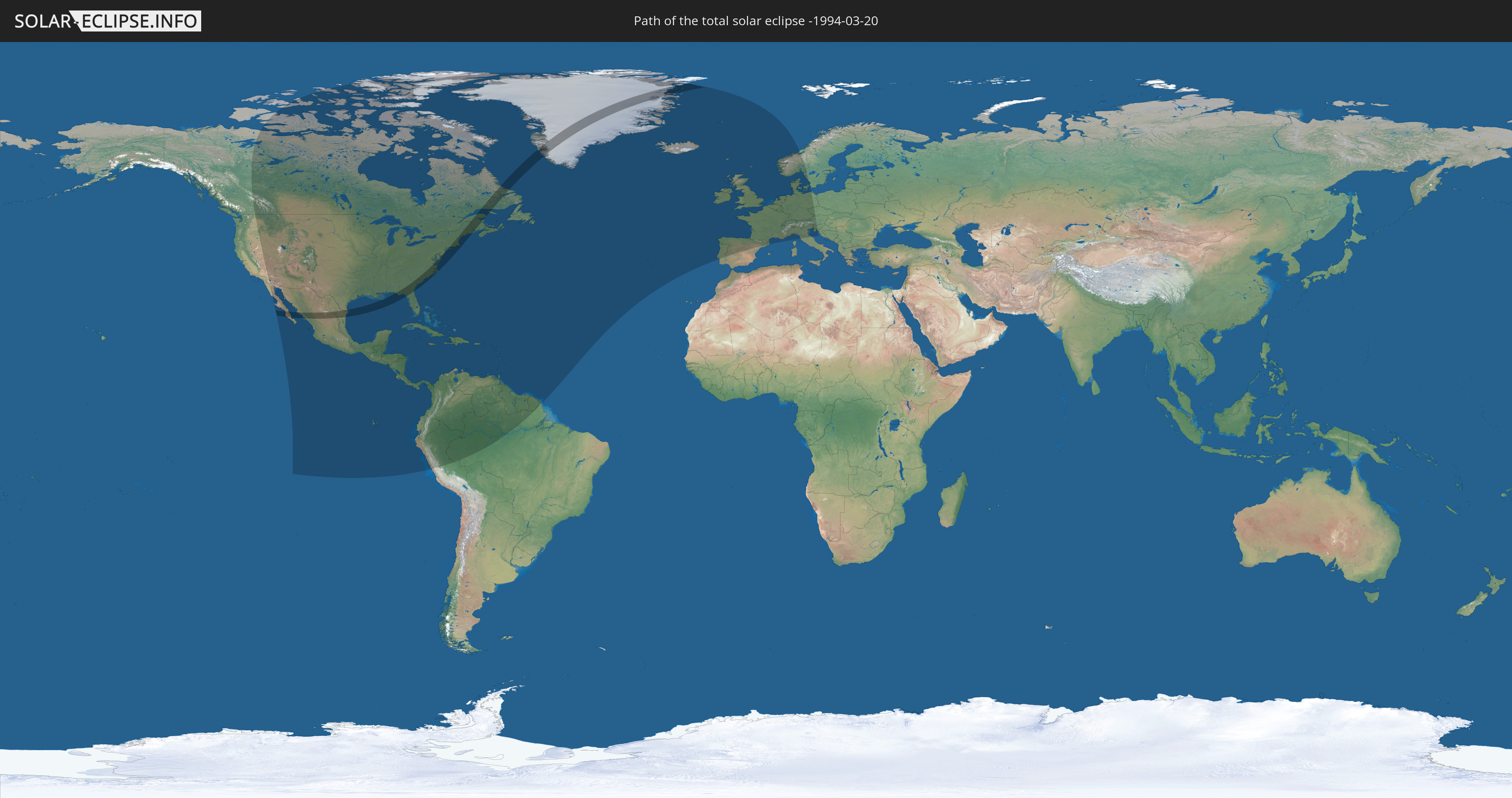
Die Sonnenfinsternis am 20.03.-1994 kann man in 75 Ländern als partielle Sonnenfinsternis beobachten.
Der Finsternispfad verläuft durch 4 Länder. Nur in diesen Ländern ist sie als totale Sonnenfinsternis zu sehen.
In den folgenden Ländern ist die Sonnenfinsternis total zu sehen
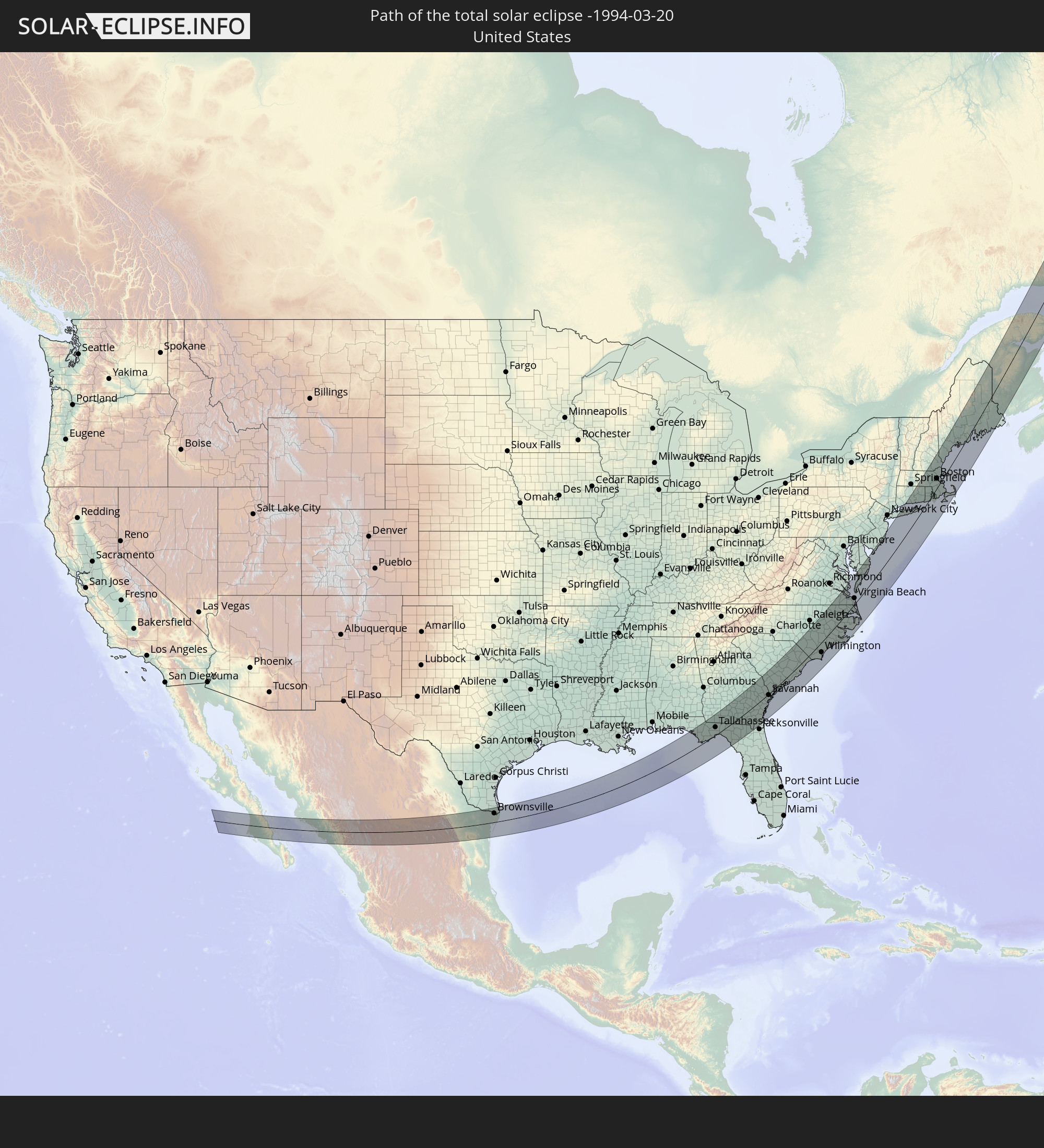 Vereinigte Staaten
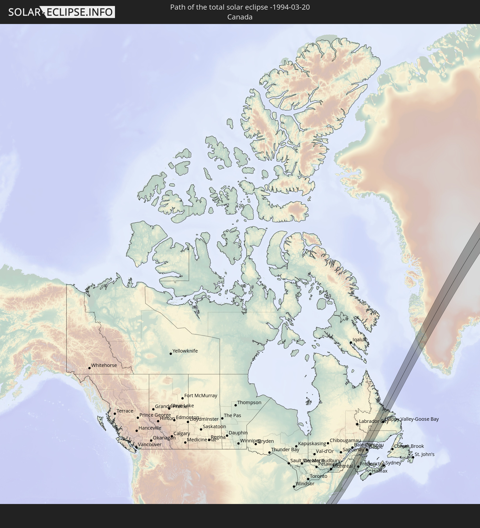 Kanada
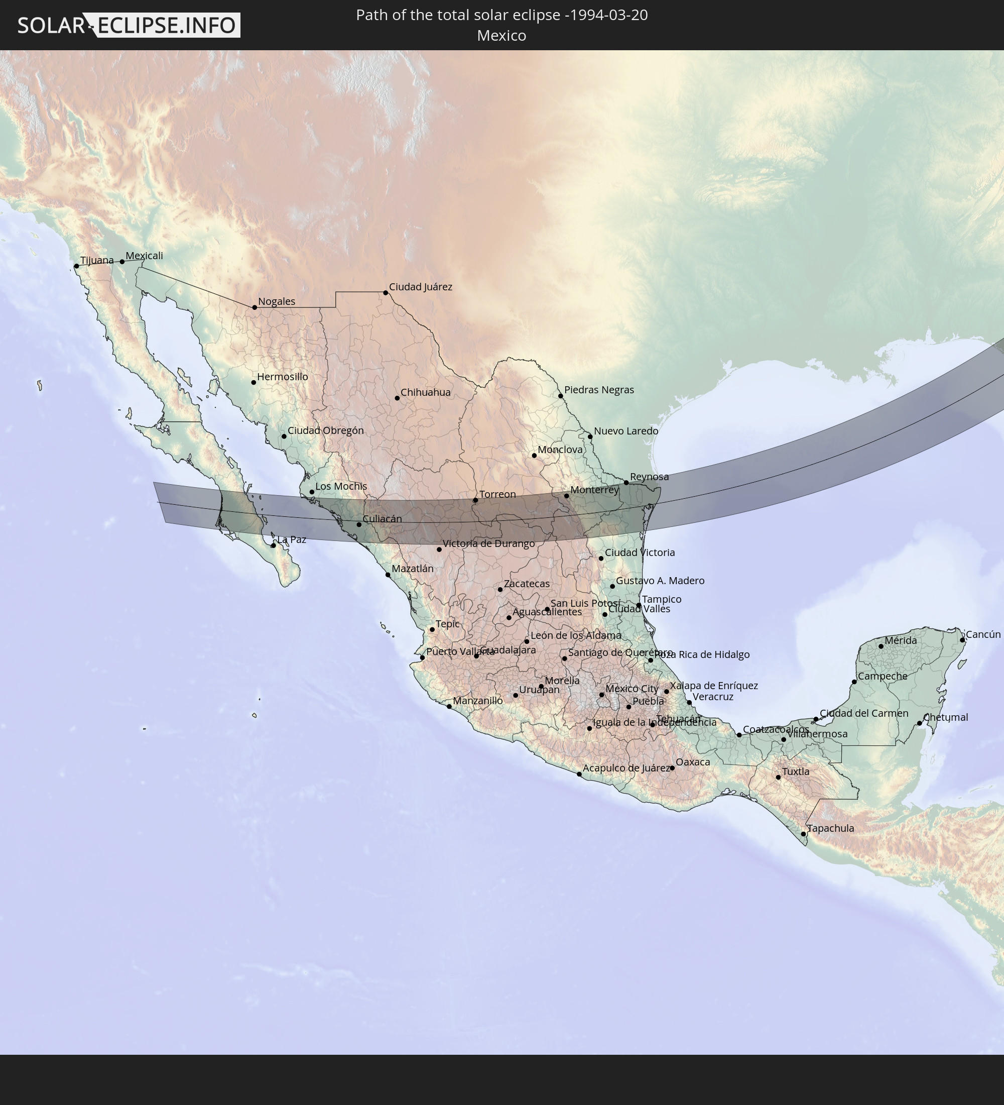 Mexiko
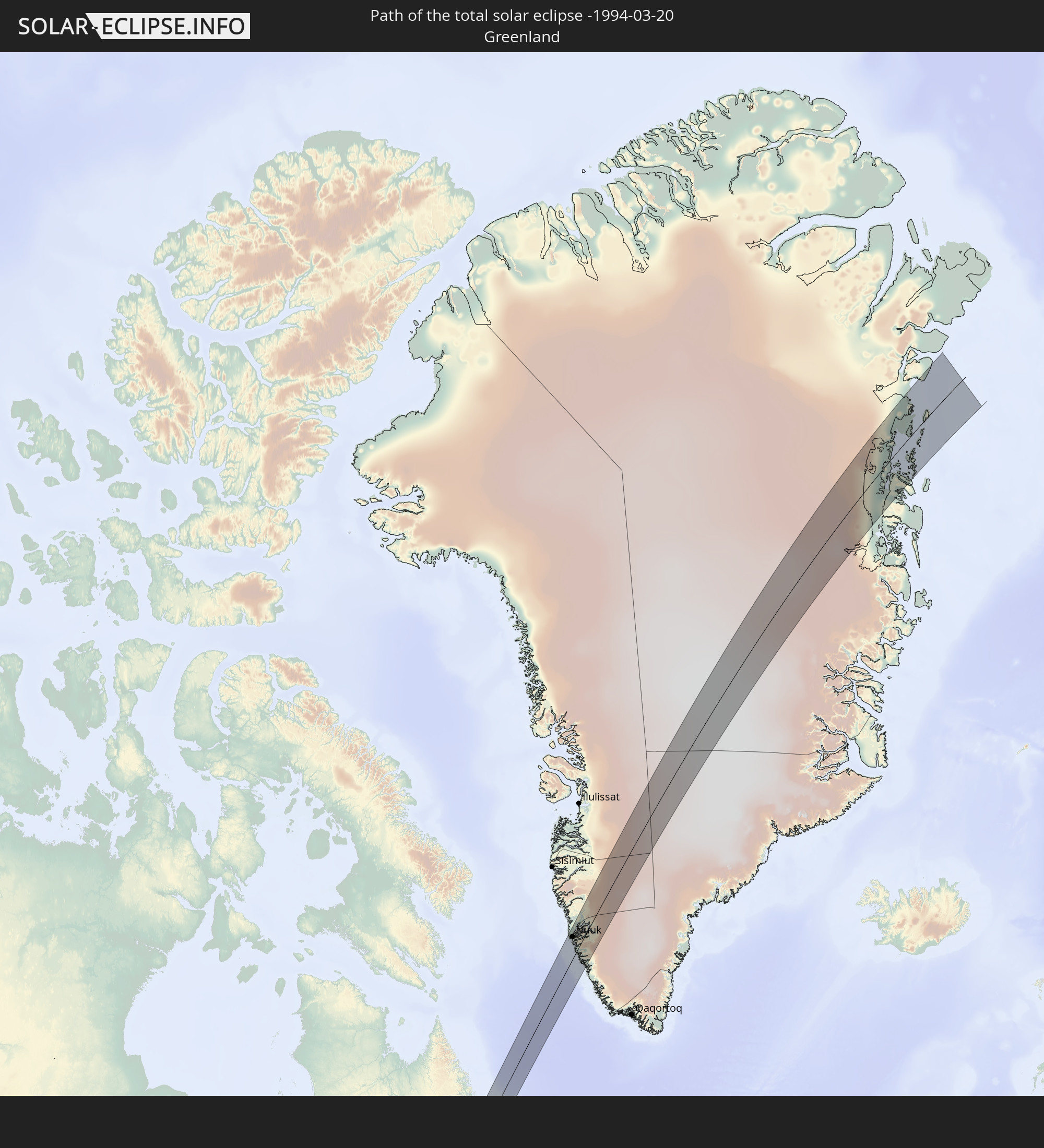 Grönland
In den folgenden Ländern ist die Sonnenfinsternis partiell zu sehen
 Vereinigte Staaten
 United States Minor Outlying Islands
 Kanada
 Mexiko
 Grönland
 Guatemala
 Ecuador
 El Salvador
 Honduras
 Belize
 Nicaragua
 Costa Rica
 Kuba
Kuba
 Panama
 Kolumbien
 Kaimaninseln
 Peru
Peru
 Bahamas
 Jamaika
 Haiti
Haiti
 Brasilien
 Venezuela
 Turks- und Caicosinseln
 Dominikanische Republik
 Aruba
Aruba
 Puerto Rico
 Amerikanische Jungferninseln
 Bermuda
 Britische Jungferninseln
 Anguilla
 Saint-Martin
 Saint-Barthélemy
 St. Kitts und Nevis
 Antigua und Barbuda
 Montserrat
 Trinidad und Tobago
 Guadeloupe
 Grenada
 Dominica
 St. Vincent und die Grenadinen
 Guyana
 Martinique
 St. Lucia
 Barbados
 Suriname
 Saint-Pierre und Miquelon
 Französisch-Guayana
 Portugal
 Island
 Spanien
 Irland
 Spitzbergen
 Vereinigtes Königreich
 Färöer
 Frankreich
 Isle of Man
 Guernsey
 Jersey
 Andorra
 Belgien
 Niederlande
 Norwegen
 Luxemburg
 Deutschland
 Schweiz
 Italien
 Monaco
 Dänemark
 Liechtenstein
 Österreich
 Schweden
 Tschechien
 San Marino
 Slowenien
 Kroatien
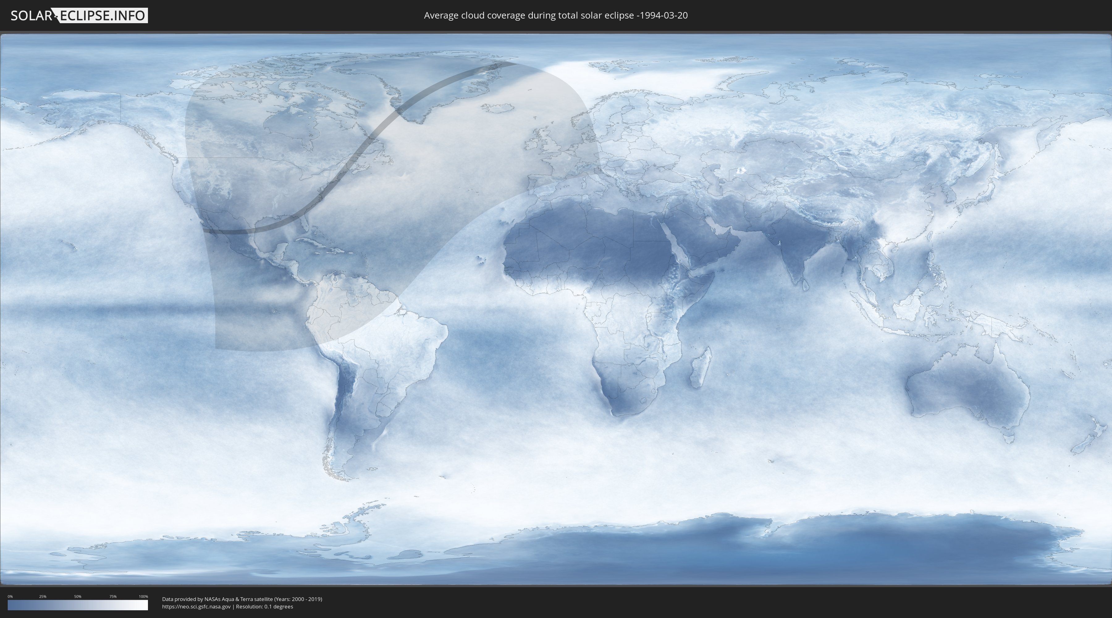
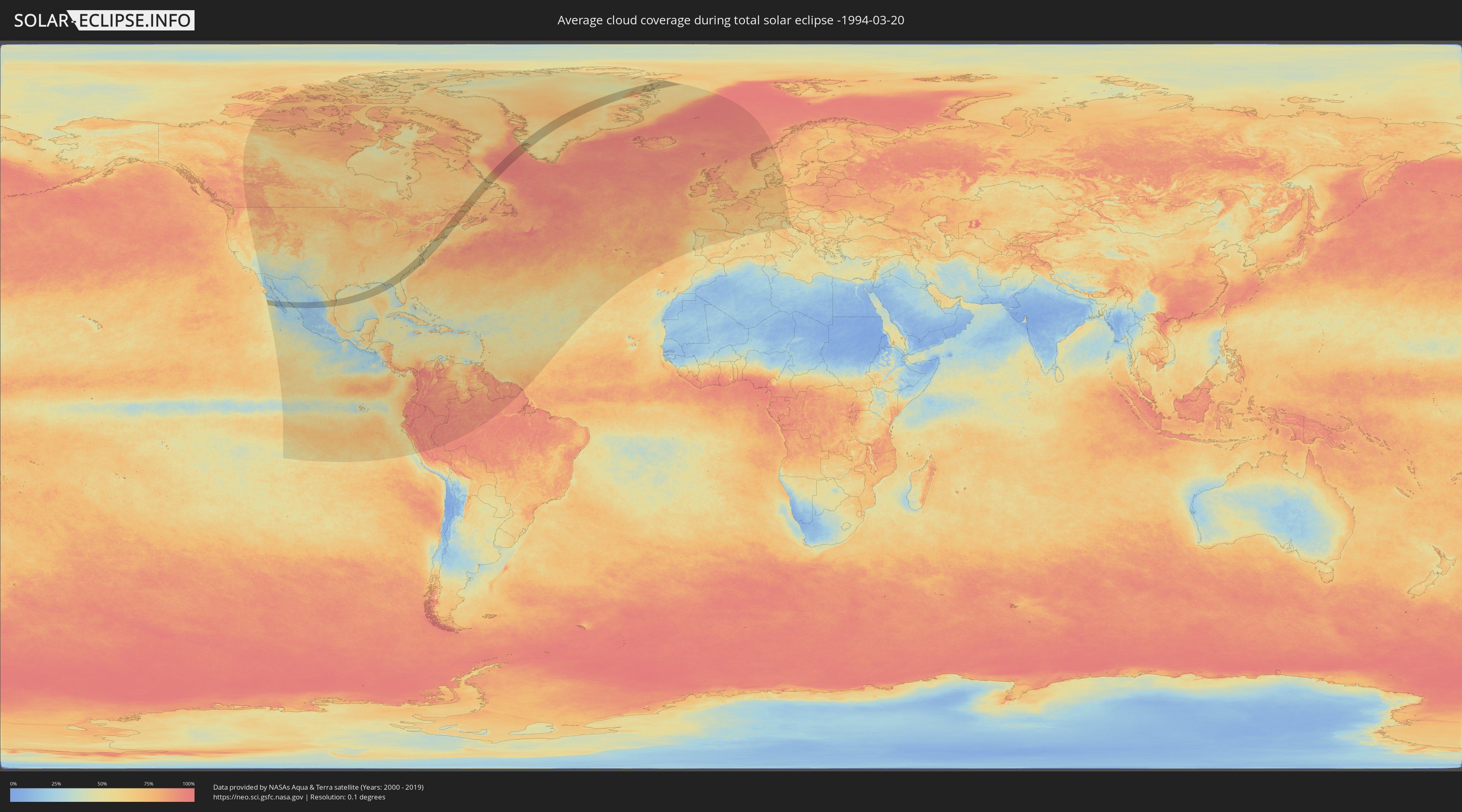
Wie wird das Wetter während der totalen Sonnenfinsternis am 20.03.-1994?
Wo ist der beste Ort, um die totale Sonnenfinsternis vom 20.03.-1994 zu beobachten?
Die folgenden Karten zeigen die durchschnittliche Bewölkung für den Tag, an dem die totale Sonnenfinsternis
stattfindet. Mit Hilfe der Karten lässt sich der Ort entlang des Finsternispfades eingrenzen,
der die besten Aussichen auf einen klaren wolkenfreien Himmel bietet.
Trotzdem muss man immer lokale Gegenenheiten beachten und sollte sich genau über das Wetter an seinem
gewählten Beobachtungsort informieren.
Die Daten stammen von den beiden NASA-Satelliten
AQUA und TERRA
und wurden über einen Zeitraum von 19 Jahren (2000 - 2019) gemittelt.
Detaillierte Länderkarten
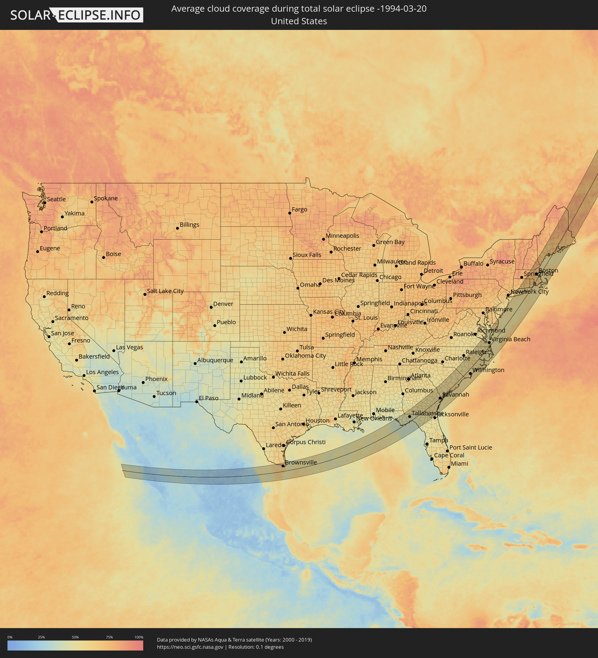 Vereinigte Staaten
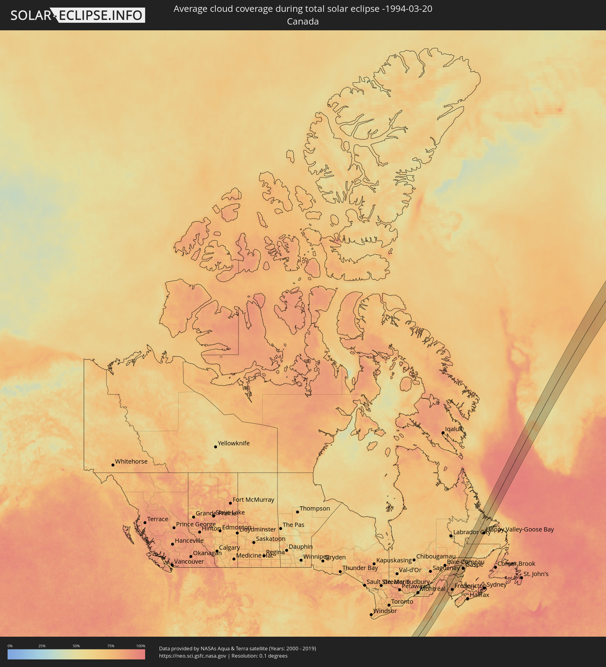 Kanada
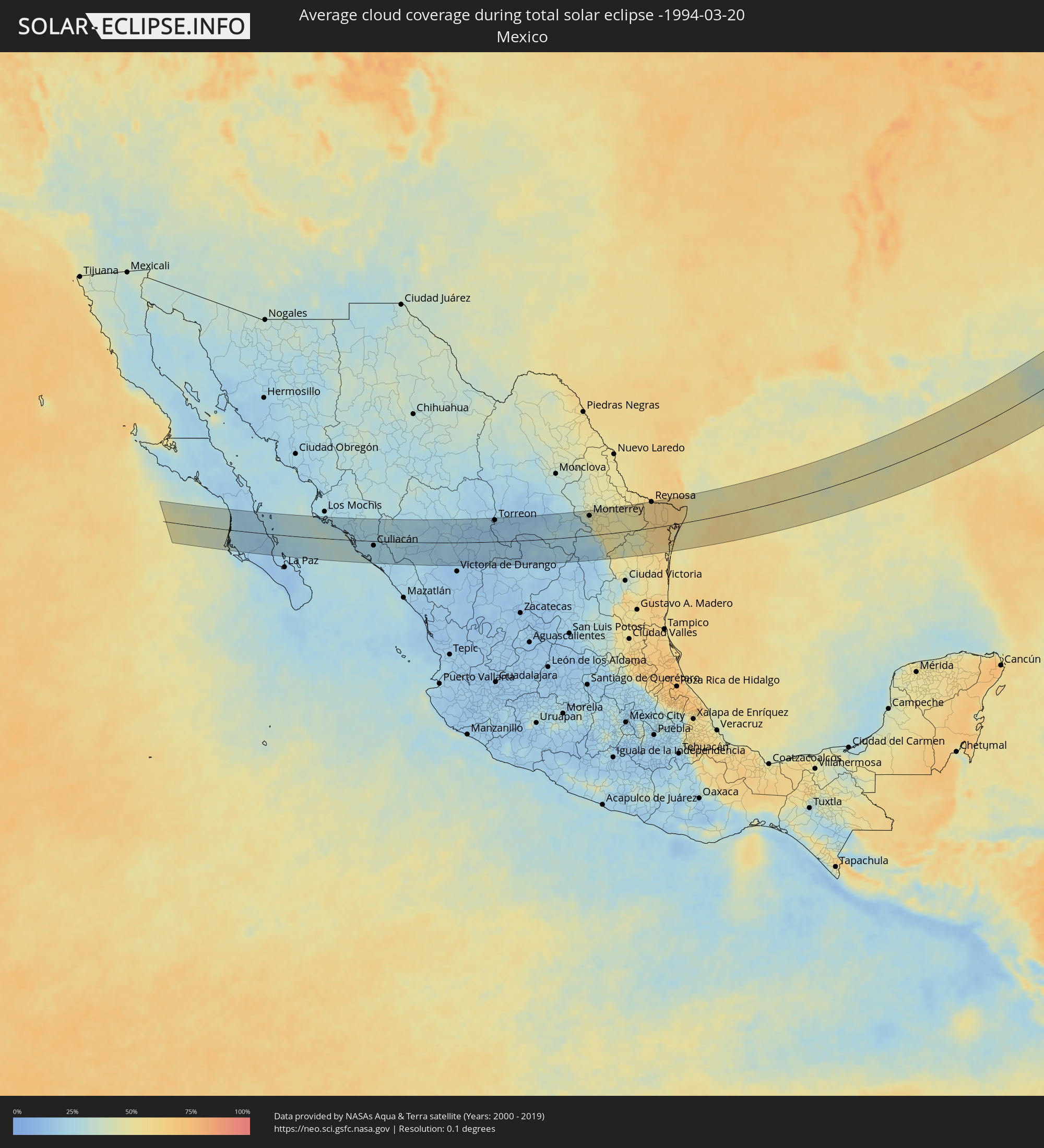 Mexiko
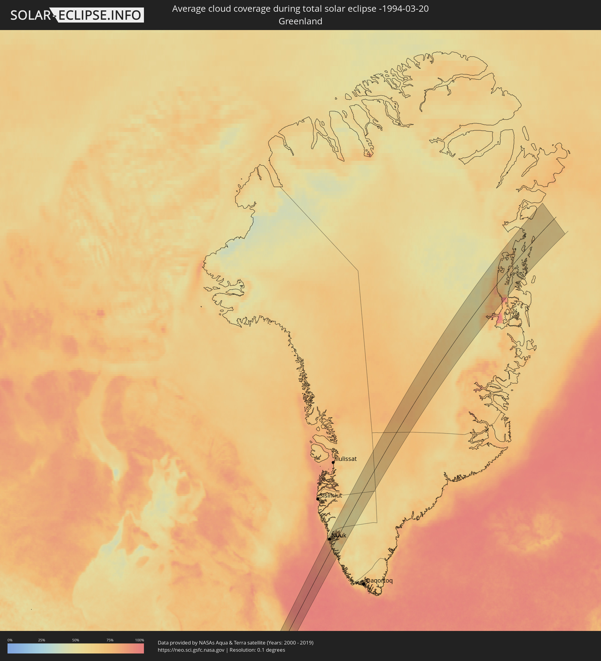 Grönland
Orte im Finsternispfad
Die nachfolgene Tabelle zeigt Städte und Orte mit mehr als 5.000 Einwohnern, die sich im Finsternispfad befinden. Städte mit mehr als 100.000 Einwohnern sind dick gekennzeichnet. Mit einem Klick auf den Ort öffnet sich eine Detailkarte die die Lage des jeweiligen Ortes zusammen mit dem Verlauf der zentralen Finsternis präsentiert.
| Ort | Typ | Dauer der Verfinsterung | Ortszeit bei maximaler Verfinsterung | Entfernung zur Zentrallinie | Ø Bewölkung |
|
Ciudad Insurgentes, Baja California Sur
|
total | - | 06:59:57 UTC-07:05 | 4 km | 20% |
|
Ciudad Constitución, Baja California Sur
|
total | - | 06:59:38 UTC-07:05 | 20 km | 19% |
|
Topolobampo, Sinaloa
|
total | - | 07:01:21 UTC-07:05 | 66 km | 28% |
|
Guasave, Sinaloa
|
total | - | 07:01:31 UTC-07:05 | 66 km | 24% |
|
Guamúchil, Sinaloa
|
total | - | 07:01:30 UTC-07:05 | 56 km | 24% |
|
La Reforma, Sinaloa
|
total | - | 07:00:54 UTC-07:05 | 14 km | 26% |
|
Navolato, Sinaloa
|
total | - | 07:00:33 UTC-07:05 | 19 km | 24% |
|
General Ángel Flores (La Palma), Sinaloa
|
total | - | 07:00:39 UTC-07:05 | 13 km | 24% |
|
Licenciado Benito Juárez (Campo Gobierno), Sinaloa
|
total | - | 07:00:26 UTC-07:05 | 30 km | 24% |
|
Villa Juárez, Sinaloa
|
total | - | 07:00:26 UTC-07:05 | 30 km | 24% |
|
El Diez, Sinaloa
|
total | - | 07:00:35 UTC-07:05 | 23 km | 24% |
|
Villa de Costa Rica, Sinaloa
|
total | - | 07:00:24 UTC-07:05 | 37 km | 23% |
|
Culiacán, Sinaloa
|
total | - | 07:00:43 UTC-07:05 | 15 km | 24% |
|
Eldorado, Sinaloa
|
total | - | 06:59:59 UTC-07:05 | 67 km | 30% |
|
El Dorado, Sinaloa
|
total | - | 06:59:59 UTC-07:05 | 67 km | 30% |
|
Santiago Papasquiaro, Durango
|
total | - | 07:31:04 UTC-06:36 | 18 km | 19% |
|
San Miguel de Papasquiaro, Durango
|
total | - | 07:30:46 UTC-06:36 | 6 km | 18% |
|
Nuevo Ideal, Durango
|
total | - | 07:30:59 UTC-06:36 | 1 km | 21% |
|
Canatlán, Durango
|
total | - | 07:30:33 UTC-06:36 | 40 km | 18% |
|
Guadalupe Victoria, Durango
|
total | - | 07:30:45 UTC-06:36 | 50 km | 13% |
|
Cuencamé, Durango
|
total | - | 07:31:40 UTC-06:36 | 3 km | 19% |
|
Miguel Auza, Zacatecas
|
total | - | 07:30:52 UTC-06:36 | 68 km | 18% |
|
Torreon, Coahuila
|
total | - | 07:32:56 UTC-06:36 | 71 km | 17% |
|
Juan Aldama, Zacatecas
|
total | - | 07:30:53 UTC-06:36 | 68 km | 17% |
|
Matamoros, Coahuila
|
total | - | 07:33:01 UTC-06:36 | 68 km | 16% |
|
Parras de la Fuente, Coahuila
|
total | - | 07:33:29 UTC-06:36 | 54 km | 19% |
|
Concepcion del Oro, Zacatecas
|
total | - | 07:32:34 UTC-06:36 | 43 km | 22% |
|
Saltillo, Coahuila
|
total | - | 07:34:12 UTC-06:36 | 43 km | 26% |
|
Ramos Arizpe, Coahuila
|
total | - | 07:34:26 UTC-06:36 | 56 km | 24% |
|
Arteaga, Coahuila
|
total | - | 07:34:20 UTC-06:36 | 44 km | 25% |
|
García, Nuevo León
|
total | - | 07:35:07 UTC-06:36 | 83 km | 39% |
|
Parque Industrial Ciudad Mitras, Nuevo León
|
total | - | 07:35:11 UTC-06:36 | 79 km | 44% |
|
Mitras Poniente, Nuevo León
|
total | - | 07:35:10 UTC-06:36 | 77 km | 44% |
|
Monterrey, Nuevo León
|
total | - | 07:35:04 UTC-06:36 | 65 km | 43% |
|
Apodaca, Nuevo León
|
total | - | 07:35:19 UTC-06:36 | 73 km | 47% |
|
Santiago, Nuevo León
|
total | - | 07:34:46 UTC-06:36 | 36 km | 46% |
|
Misión San Pablo, Nuevo León
|
total | - | 07:35:18 UTC-06:36 | 70 km | 49% |
|
Juárez, Nuevo León
|
total | - | 07:35:11 UTC-06:36 | 60 km | 50% |
|
Allende, Nuevo León
|
total | - | 07:34:36 UTC-06:36 | 18 km | 53% |
|
Cadereyta, Nuevo León
|
total | - | 07:35:09 UTC-06:36 | 51 km | 50% |
|
Montemorelos, Nuevo León
|
total | - | 07:34:35 UTC-06:36 | 6 km | 52% |
|
General Teran, Nuevo León
|
total | - | 07:34:48 UTC-06:36 | 12 km | 50% |
|
Hidalgo, Nuevo León
|
total | - | 07:35:52 UTC-06:36 | 78 km | 50% |
|
Linares, Nuevo León
|
total | - | 07:34:12 UTC-06:36 | 34 km | 50% |
|
China, Nuevo León
|
total | - | 07:35:52 UTC-06:36 | 55 km | 48% |
|
Reynosa, Tamaulipas
|
total | - | 07:37:13 UTC-06:36 | 84 km | 63% |
|
San Fernando, Tamaulipas
|
total | - | 07:35:12 UTC-06:36 | 54 km | 59% |
|
Río Bravo, Tamaulipas
|
total | - | 07:37:12 UTC-06:36 | 71 km | 60% |
|
Valle Hermoso, Tamaulipas
|
total | - | 07:36:52 UTC-06:36 | 32 km | 64% |
|
Harlingen, Texas
|
total | - | 08:14:28 UTC-06:00 | 87 km | 63% |
|
Heroica Matamoros, Tamaulipas
|
total | - | 07:37:28 UTC-06:36 | 50 km | 66% |
|
Brownsville, Texas
|
total | - | 08:14:07 UTC-06:00 | 52 km | 66% |
|
Panama City, Florida
|
total | - | 08:33:54 UTC-06:00 | 85 km | 44% |
|
Tallahassee, Florida
|
total | - | 09:36:09 UTC-05:00 | 37 km | 46% |
|
Valdosta, Georgia
|
total | - | 09:38:11 UTC-05:00 | 17 km | 49% |
|
Savannah, Georgia
|
total | - | 09:43:27 UTC-05:00 | 5 km | 55% |
|
Hilton Head Island, South Carolina
|
total | - | 09:44:10 UTC-05:00 | 15 km | 53% |
|
Sumter, South Carolina
|
total | - | 09:47:58 UTC-05:00 | 97 km | 56% |
|
Summerville, South Carolina
|
total | - | 09:46:29 UTC-05:00 | 14 km | 58% |
|
Charleston, South Carolina
|
total | - | 09:46:21 UTC-05:00 | 21 km | 56% |
|
Florence, South Carolina
|
total | - | 09:49:17 UTC-05:00 | 81 km | 56% |
|
Fayetteville, North Carolina
|
total | - | 09:52:07 UTC-05:00 | 88 km | 55% |
|
Goldsboro, North Carolina
|
total | - | 09:53:58 UTC-05:00 | 53 km | 58% |
|
Wilmington, North Carolina
|
total | - | 09:51:51 UTC-05:00 | 37 km | 58% |
|
Wilson, North Carolina
|
total | - | 09:54:42 UTC-05:00 | 73 km | 57% |
|
Rocky Mount, North Carolina
|
total | - | 09:55:16 UTC-05:00 | 80 km | 56% |
|
Jacksonville, North Carolina
|
total | - | 09:53:34 UTC-05:00 | 32 km | 56% |
|
Greenville, North Carolina
|
total | - | 09:55:16 UTC-05:00 | 27 km | 56% |
|
Suffolk, Virginia
|
total | - | 09:58:25 UTC-05:00 | 53 km | 53% |
|
Newport News, Virginia
|
total | - | 09:59:14 UTC-05:00 | 70 km | 52% |
|
Norfolk, Virginia
|
total | - | 09:59:03 UTC-05:00 | 41 km | 53% |
|
Virginia Beach, Virginia
|
total | - | 09:59:30 UTC-05:00 | 20 km | 53% |
|
Atlantic City, New Jersey
|
total | - | 10:06:12 UTC-05:00 | 78 km | 56% |
|
Brentwood, New York
|
total | - | 10:10:17 UTC-05:00 | 84 km | 57% |
|
Coram, New York
|
total | - | 10:10:47 UTC-05:00 | 72 km | 57% |
|
Middletown, Connecticut
|
total | - | 10:12:26 UTC-05:00 | 90 km | 72% |
|
Norwich, Connecticut
|
total | - | 10:13:10 UTC-05:00 | 47 km | 64% |
|
Worcester, Massachusetts
|
total | - | 10:14:46 UTC-05:00 | 72 km | 74% |
|
Leominster, Massachusetts
|
total | - | 10:15:15 UTC-05:00 | 84 km | 75% |
|
Coventry, Rhode Island
|
total | - | 10:14:01 UTC-05:00 | 30 km | 68% |
|
Woonsocket, Rhode Island
|
total | - | 10:14:44 UTC-05:00 | 36 km | 72% |
|
Nashua, New Hampshire
|
total | - | 10:16:03 UTC-05:00 | 78 km | 76% |
|
Manchester, New Hampshire
|
partiell | - | 10:16:26 UTC-05:00 | 90 km | 79% |
|
Framingham, Massachusetts
|
total | - | 10:15:20 UTC-05:00 | 46 km | 75% |
|
Providence, Rhode Island
|
total | - | 10:14:35 UTC-05:00 | 18 km | 63% |
|
Lowell, Massachusetts
|
total | - | 10:16:02 UTC-05:00 | 59 km | 74% |
|
Derry Village, New Hampshire
|
total | - | 10:16:28 UTC-05:00 | 74 km | 76% |
|
Attleboro, Massachusetts
|
total | - | 10:14:58 UTC-05:00 | 17 km | 67% |
|
Fall River, Massachusetts
|
total | - | 10:14:45 UTC-05:00 | 7 km | 61% |
|
Woburn, Massachusetts
|
total | - | 10:16:01 UTC-05:00 | 39 km | 73% |
|
Taunton, Massachusetts
|
total | - | 10:15:10 UTC-05:00 | 1 km | 67% |
|
Haverhill, Massachusetts
|
total | - | 10:16:36 UTC-05:00 | 51 km | 74% |
|
Boston, Massachusetts
|
total | - | 10:15:57 UTC-05:00 | 25 km | 70% |
|
Brockton, Massachusetts
|
total | - | 10:15:34 UTC-05:00 | 6 km | 70% |
|
Lynn, Massachusetts
|
total | - | 10:16:17 UTC-05:00 | 24 km | 62% |
|
Weymouth, Massachusetts
|
total | - | 10:15:54 UTC-05:00 | 9 km | 70% |
|
New Bedford, Massachusetts
|
total | - | 10:14:57 UTC-05:00 | 26 km | 63% |
|
Barnstable, Massachusetts
|
total | - | 10:15:57 UTC-05:00 | 67 km | 62% |
|
Portland, Maine
|
total | - | 10:19:08 UTC-05:00 | 45 km | 73% |
|
Lewiston, Maine
|
total | - | 10:19:52 UTC-05:00 | 67 km | 72% |
|
Campbellton, New Brunswick
|
total | - | 11:15:46 UTC-04:14 | 41 km | 81% |
|
Fredericton, New Brunswick
|
total | - | 11:12:58 UTC-04:14 | 71 km | 80% |
|
Bathurst, New Brunswick
|
total | - | 11:16:35 UTC-04:14 | 46 km | 74% |
|
Chandler, Quebec
|
total | - | 10:33:11 UTC-05:00 | 70 km | 73% |
|
Gaspé, Quebec
|
total | - | 10:34:02 UTC-05:00 | 57 km | 76% |
|
Happy Valley-Goose Bay, Newfoundland and Labrador
|
total | - | 11:29:33 UTC-04:14 | 75 km | 71% |
|
Nuuk, Sermersooq
|
total | - | 12:32:01 UTC-03:26 | 48 km | 73% |