Totale Sonnenfinsternis vom 04.10.-1996
| Wochentag: | Samstag |
| Maximale Dauer der Verfinsterung: | 02m04s |
| Maximale Breite des Finsternispfades: | 101 km |
| Saroszyklus: | 2 |
| Bedeckungsgrad: | 100% |
| Magnitude: | 1.0257 |
| Gamma: | 0.5166 |
Wo kann man die Sonnenfinsternis vom 04.10.-1996 sehen?
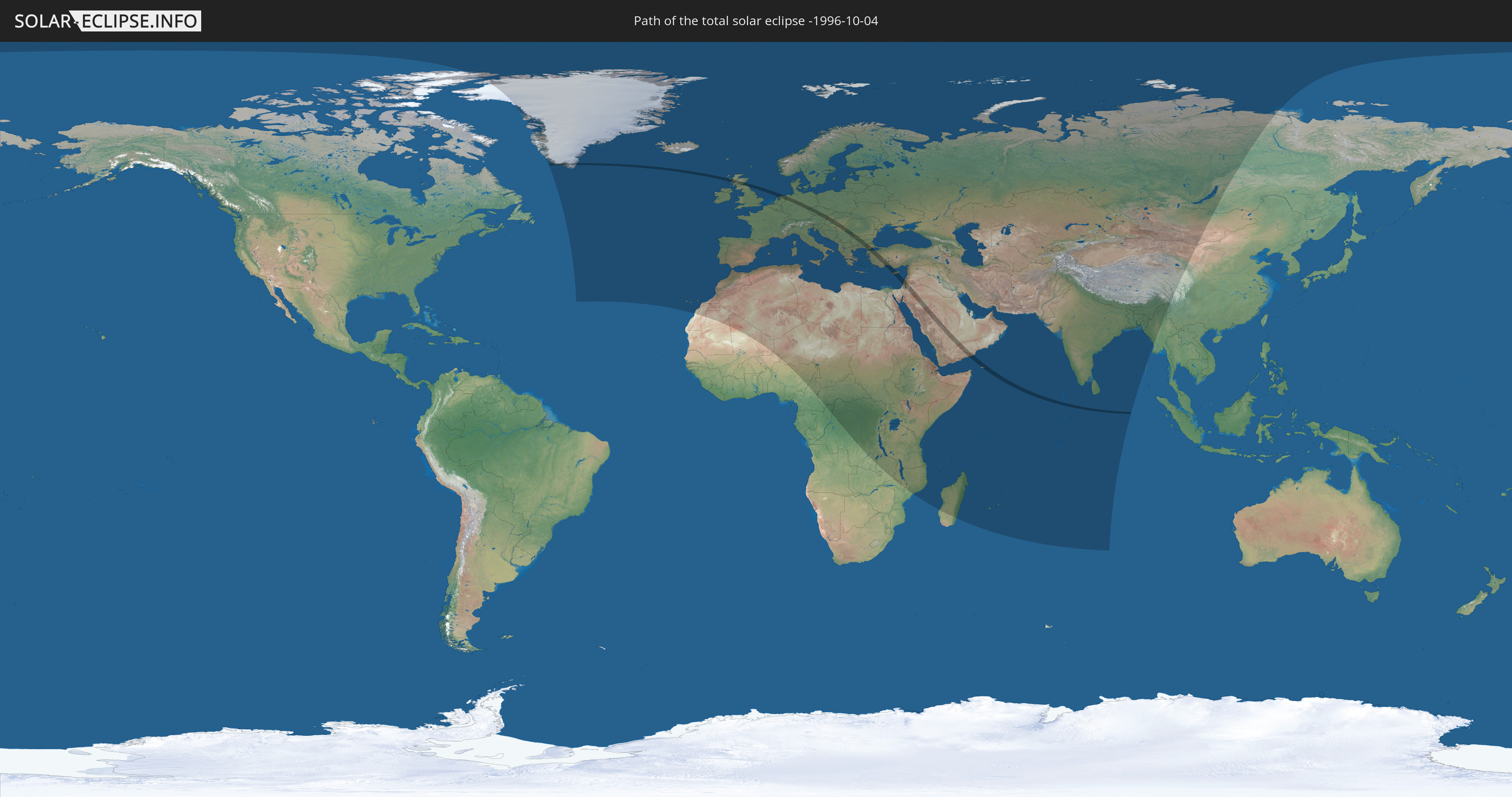
Die Sonnenfinsternis am 04.10.-1996 kann man in 123 Ländern als partielle Sonnenfinsternis beobachten.
Der Finsternispfad verläuft durch 21 Länder. Nur in diesen Ländern ist sie als totale Sonnenfinsternis zu sehen.
In den folgenden Ländern ist die Sonnenfinsternis total zu sehen
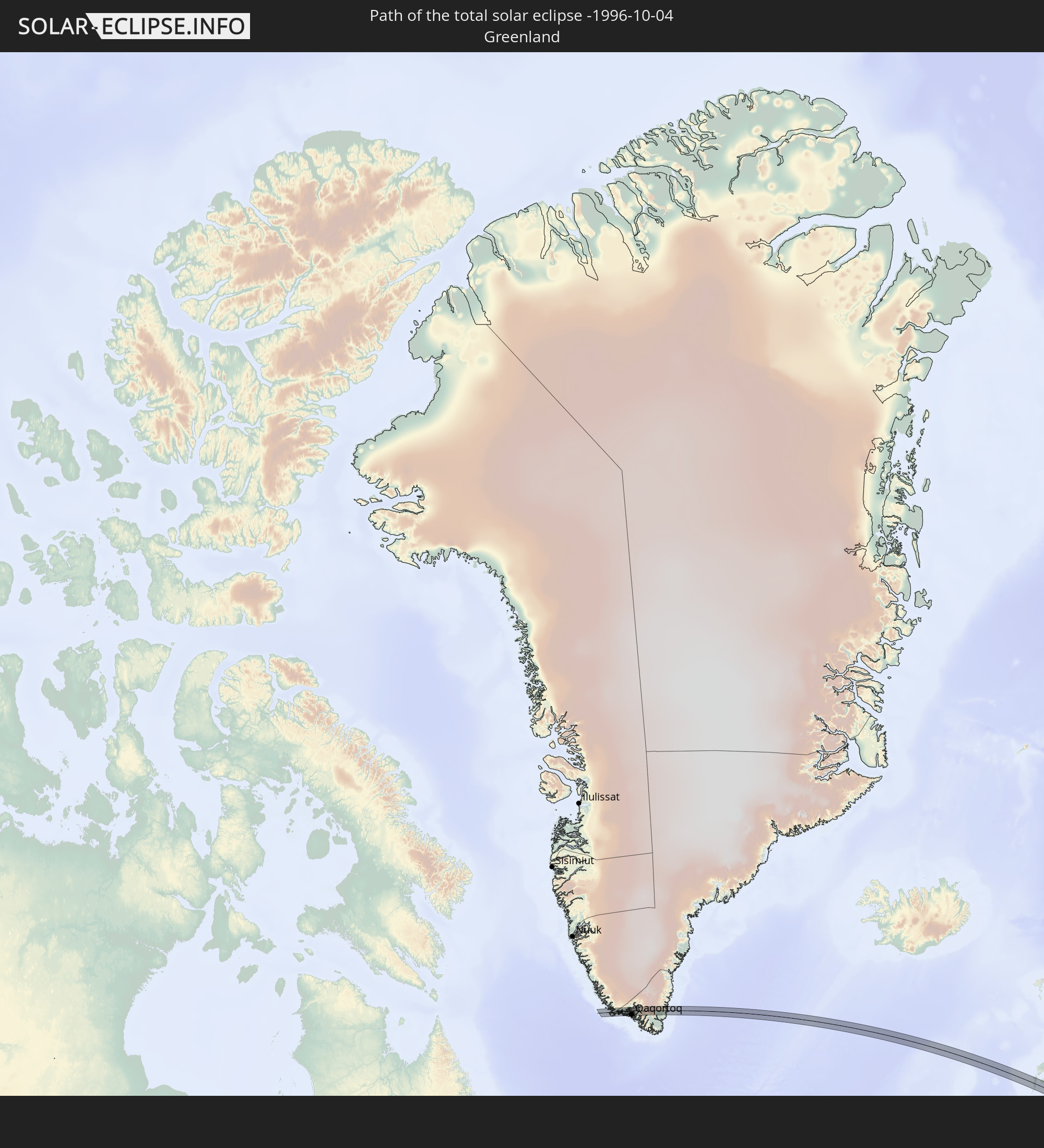 Grönland
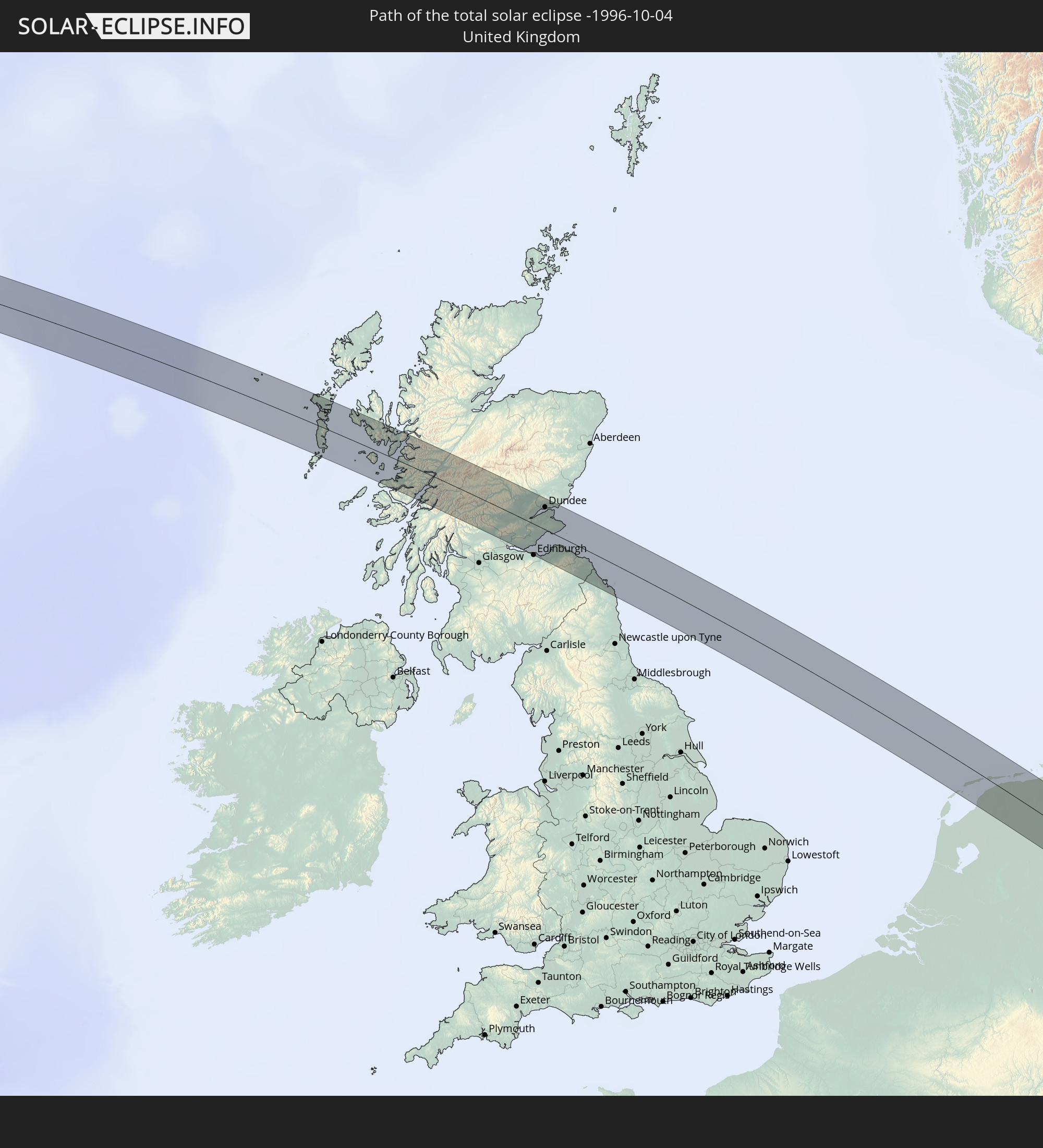 Vereinigtes Königreich
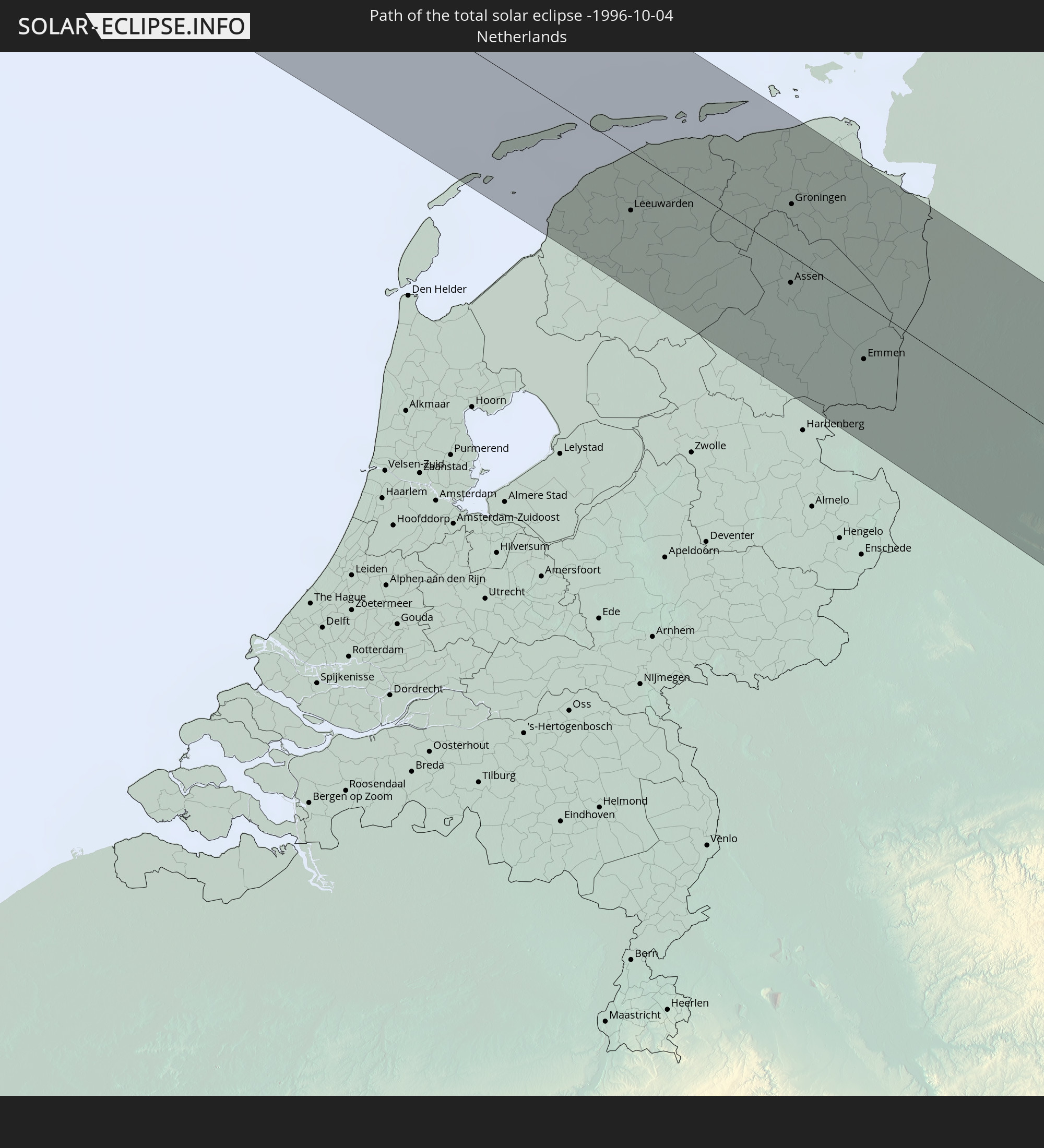 Niederlande
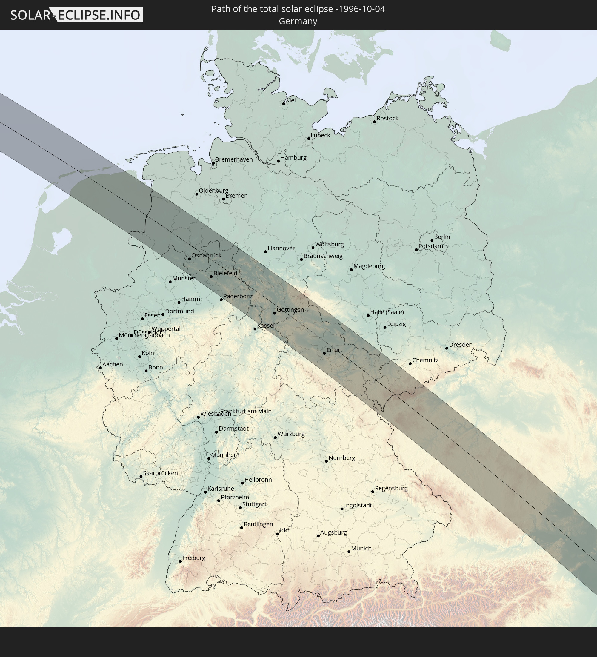 Deutschland
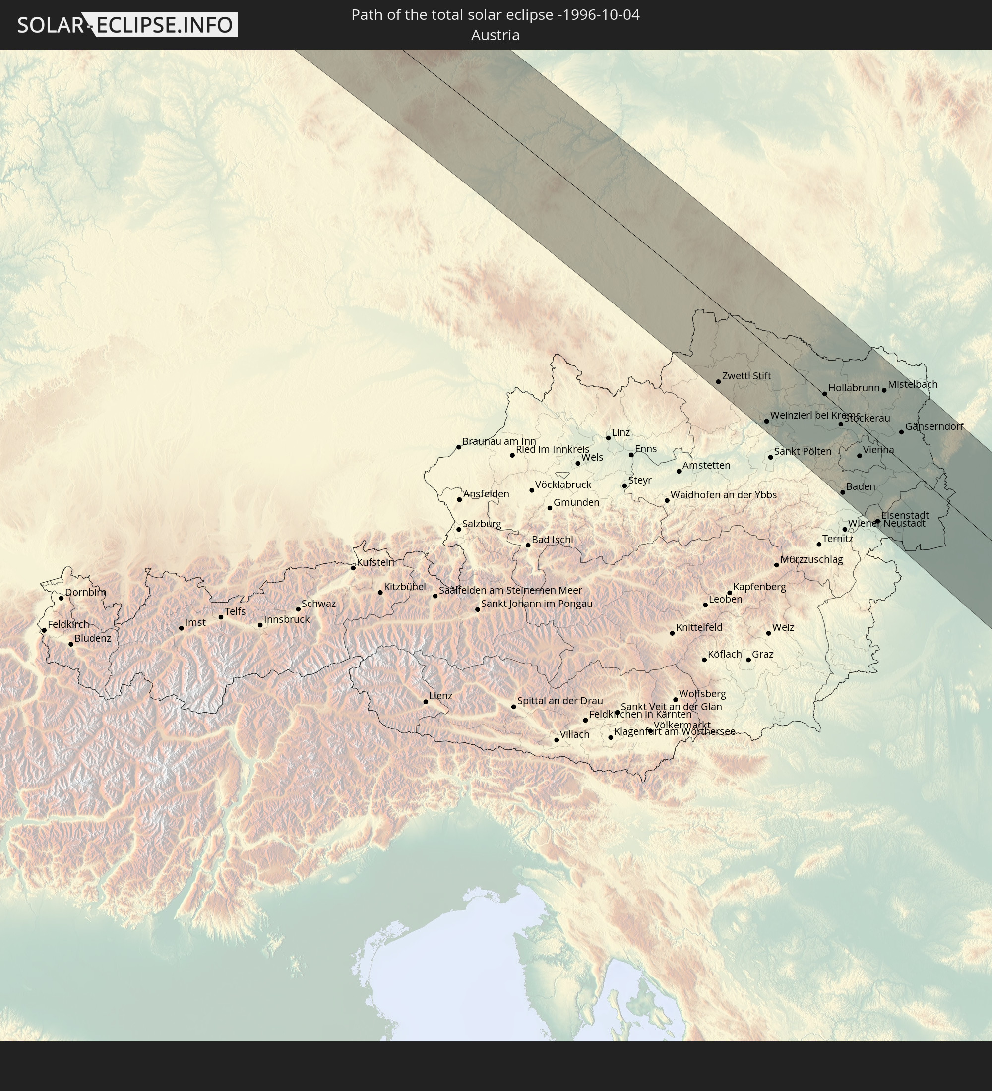 Österreich
 Tschechien
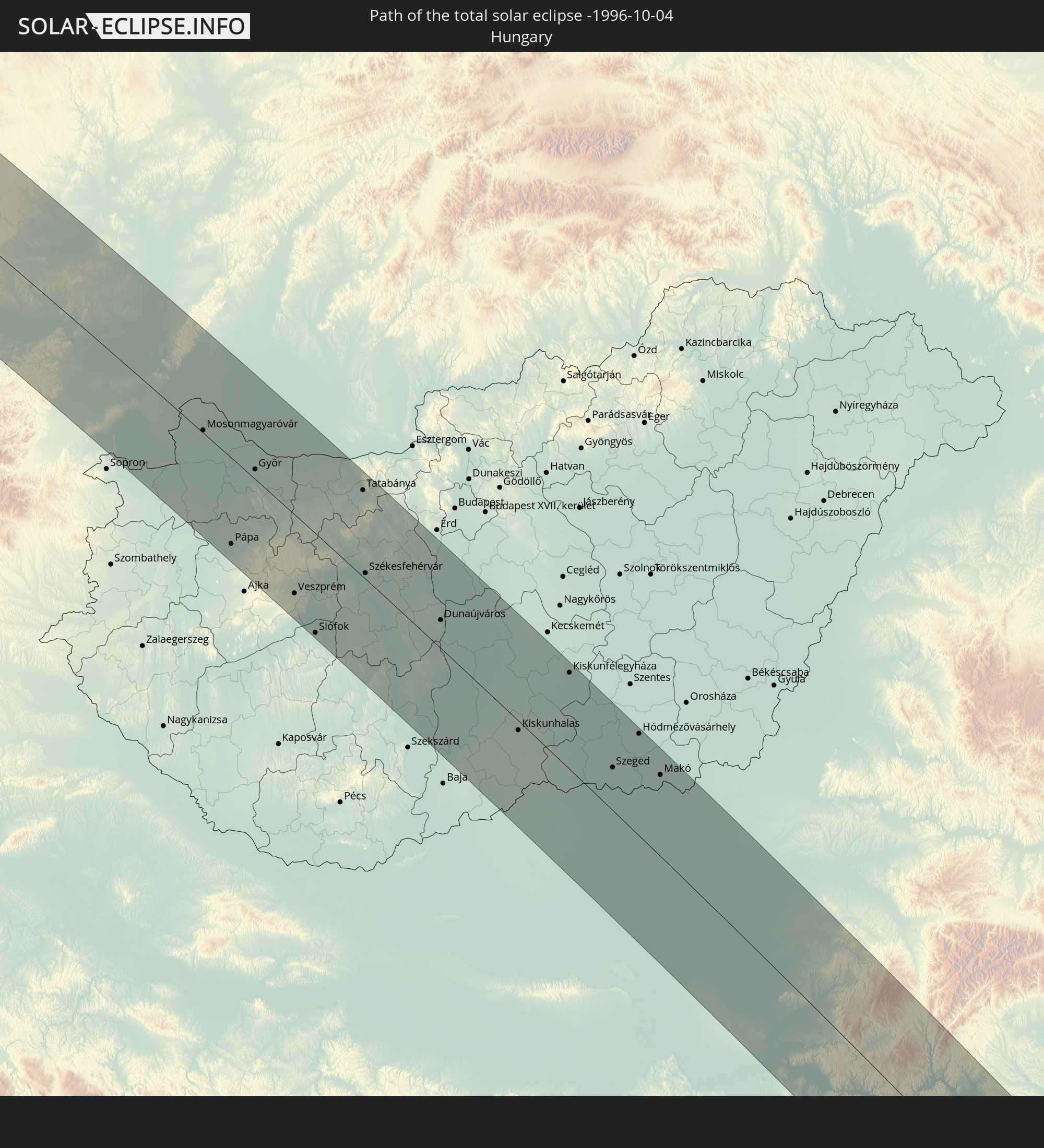 Ungarn
 Slowakei
 Serbien
 Griechenland
 Rumänien
 Bulgarien
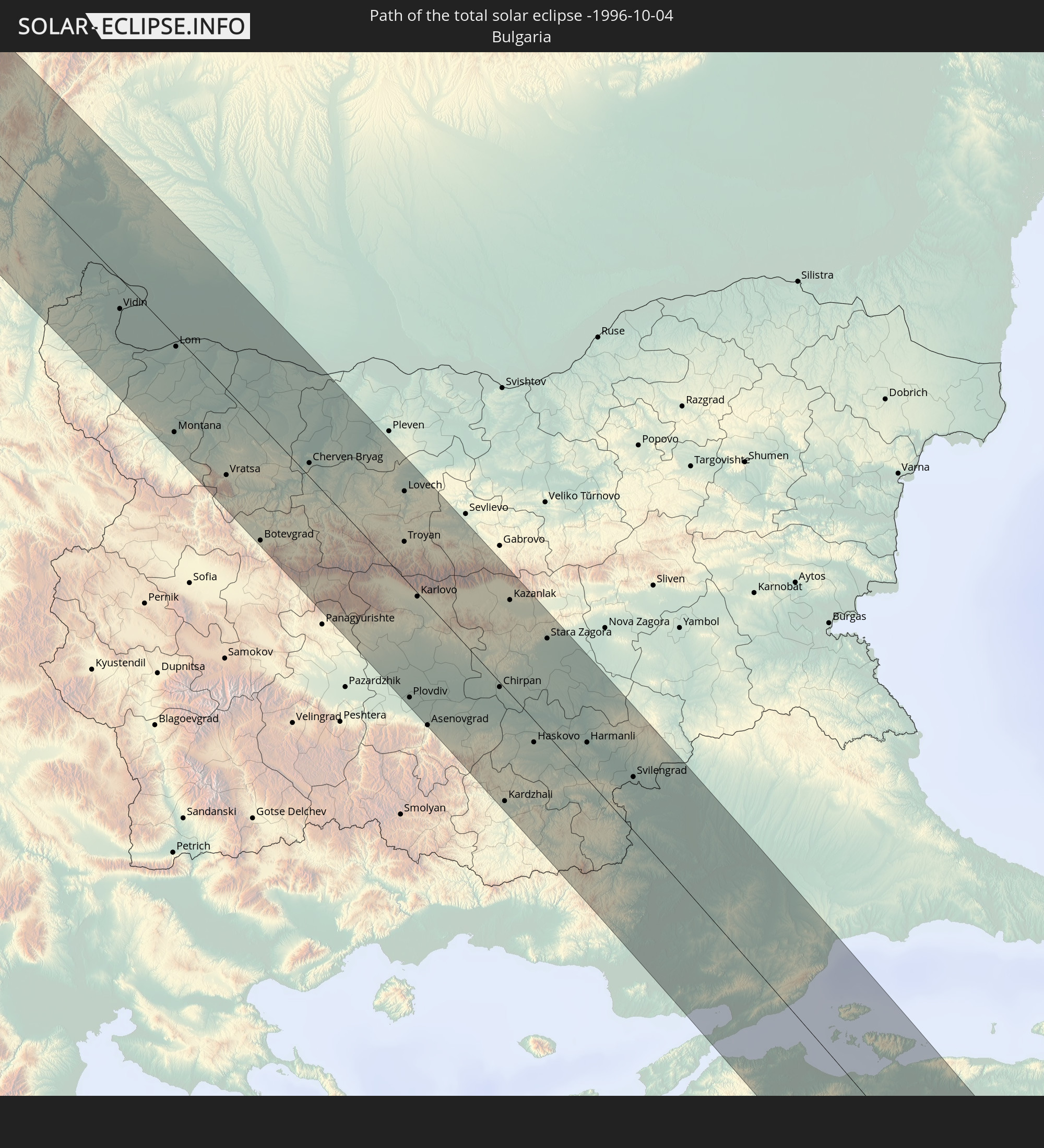
 Türkei
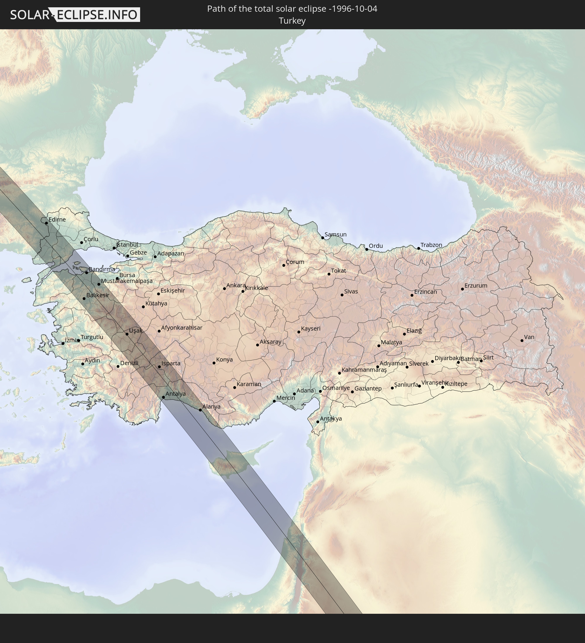
 Republik Zypern
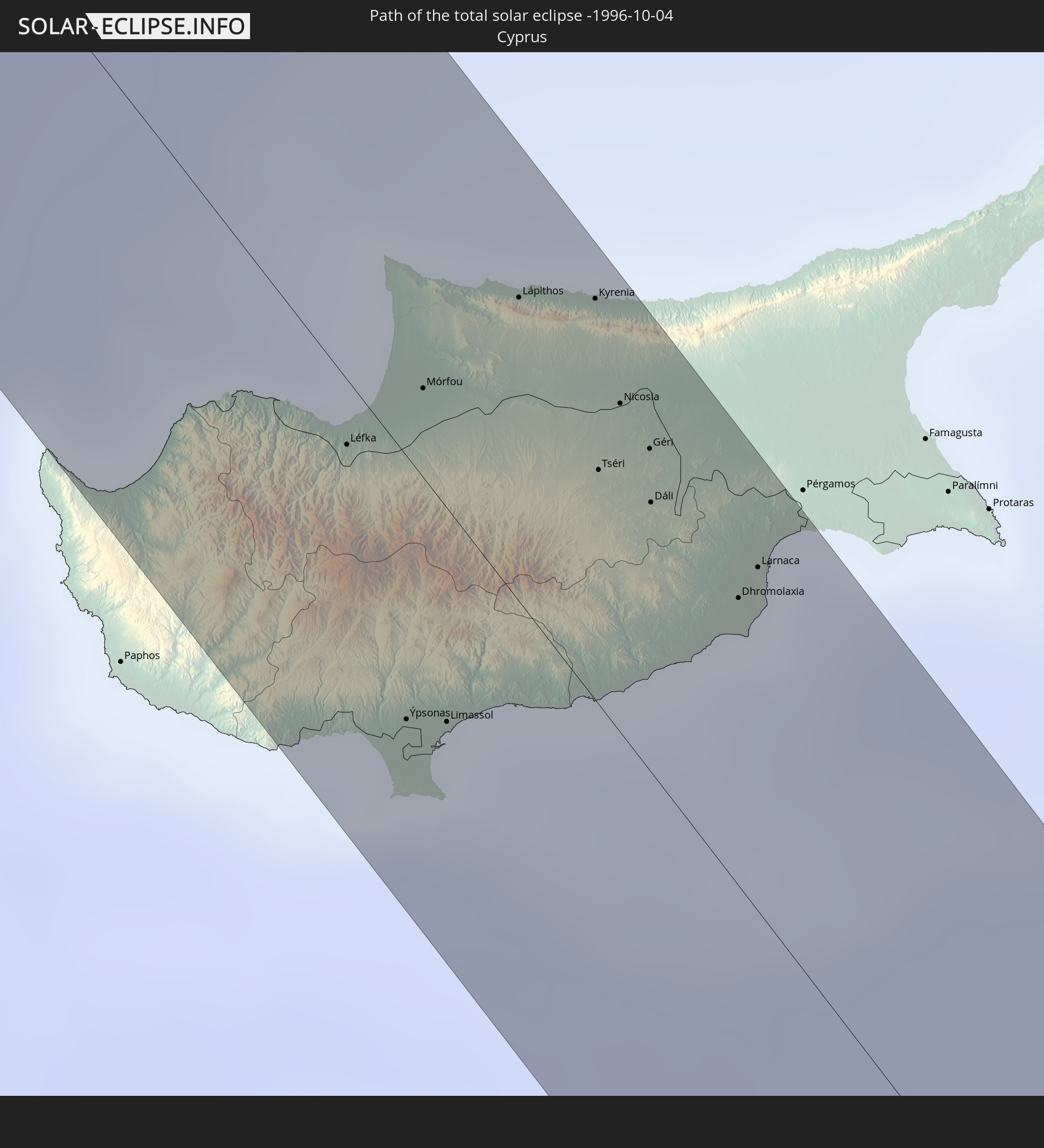
 Staat Palästina
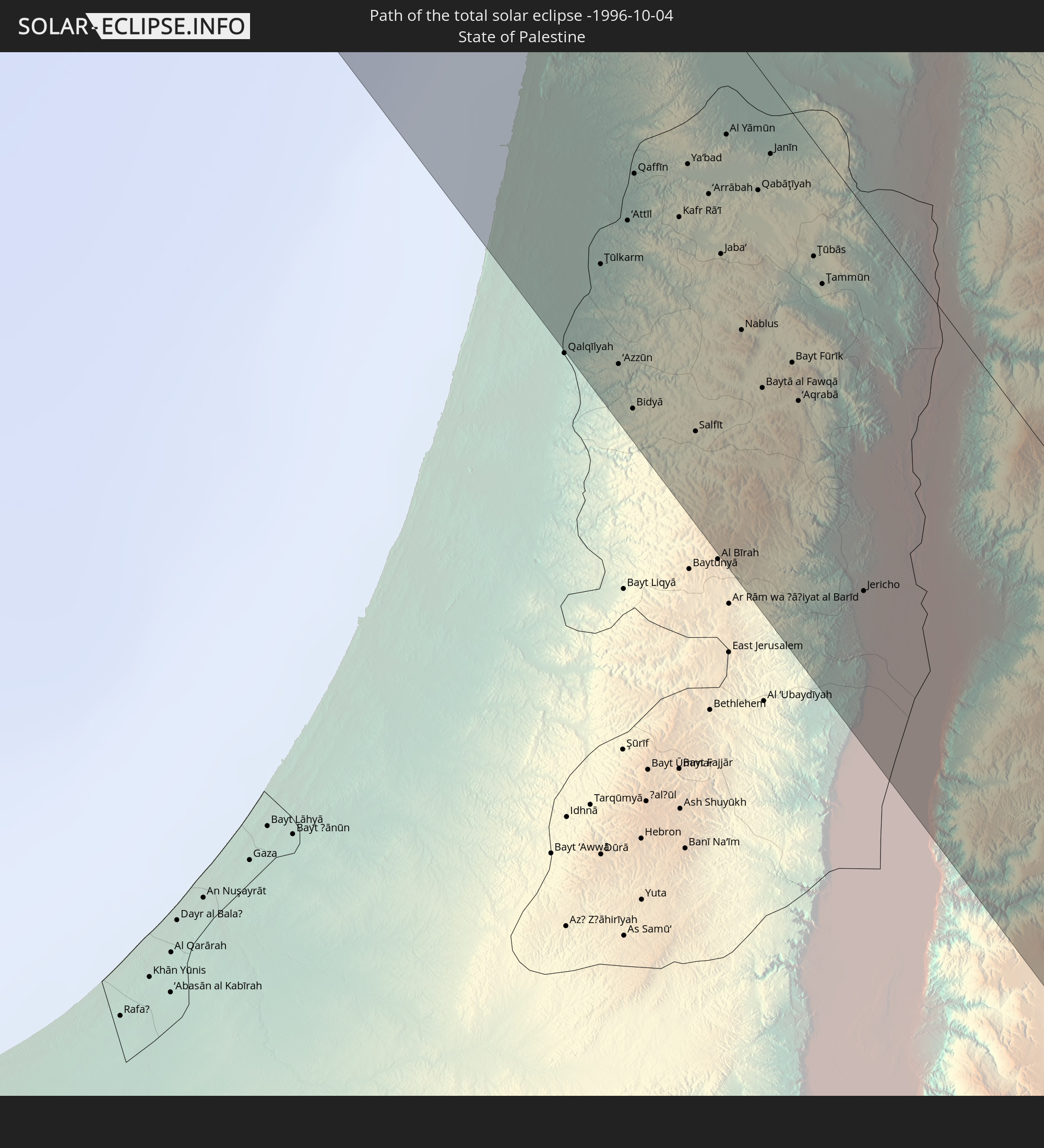
 Israel
 Saudi-Arabien
 Jordanien
 Libanon
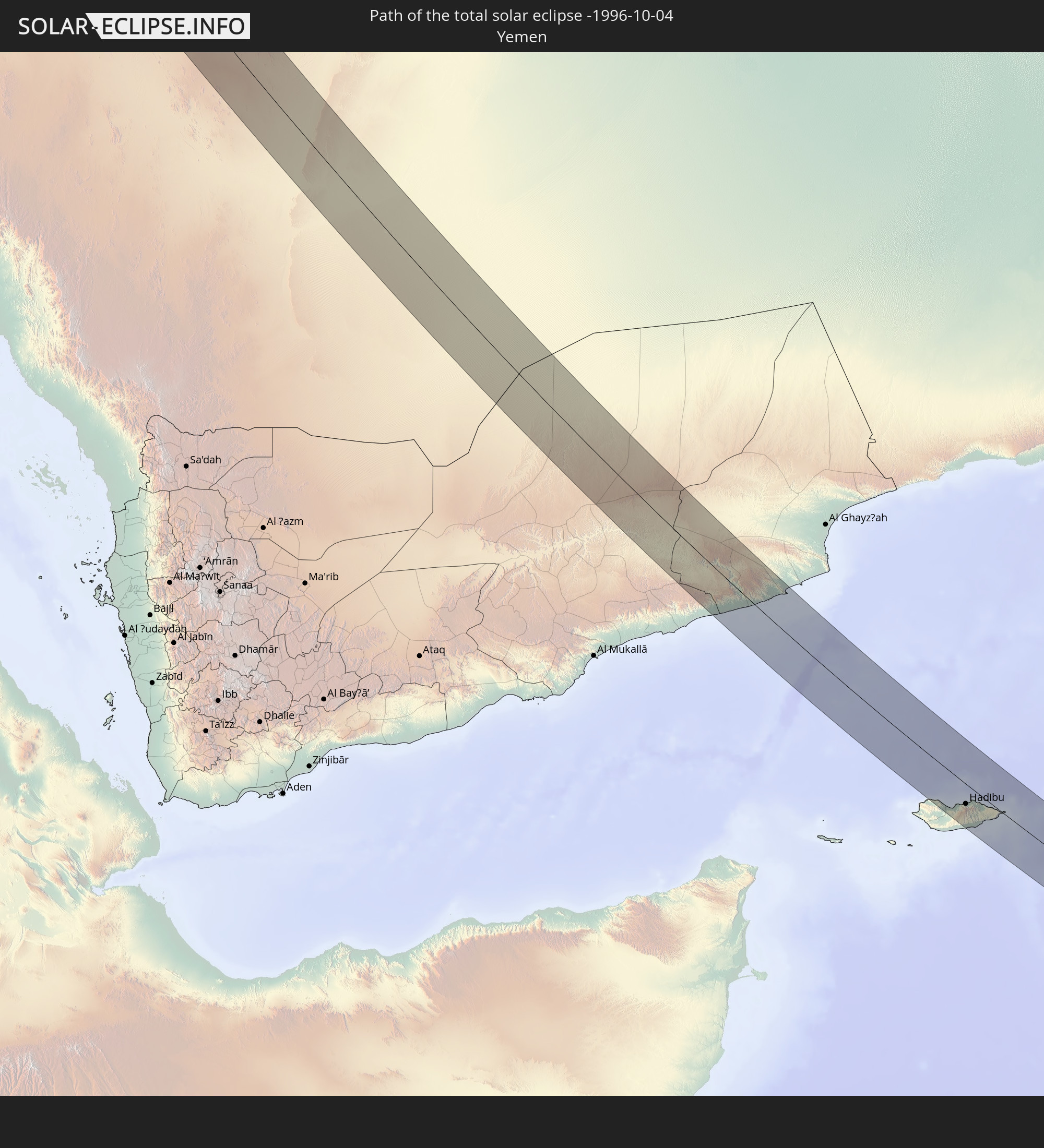 Jemen
Jemen
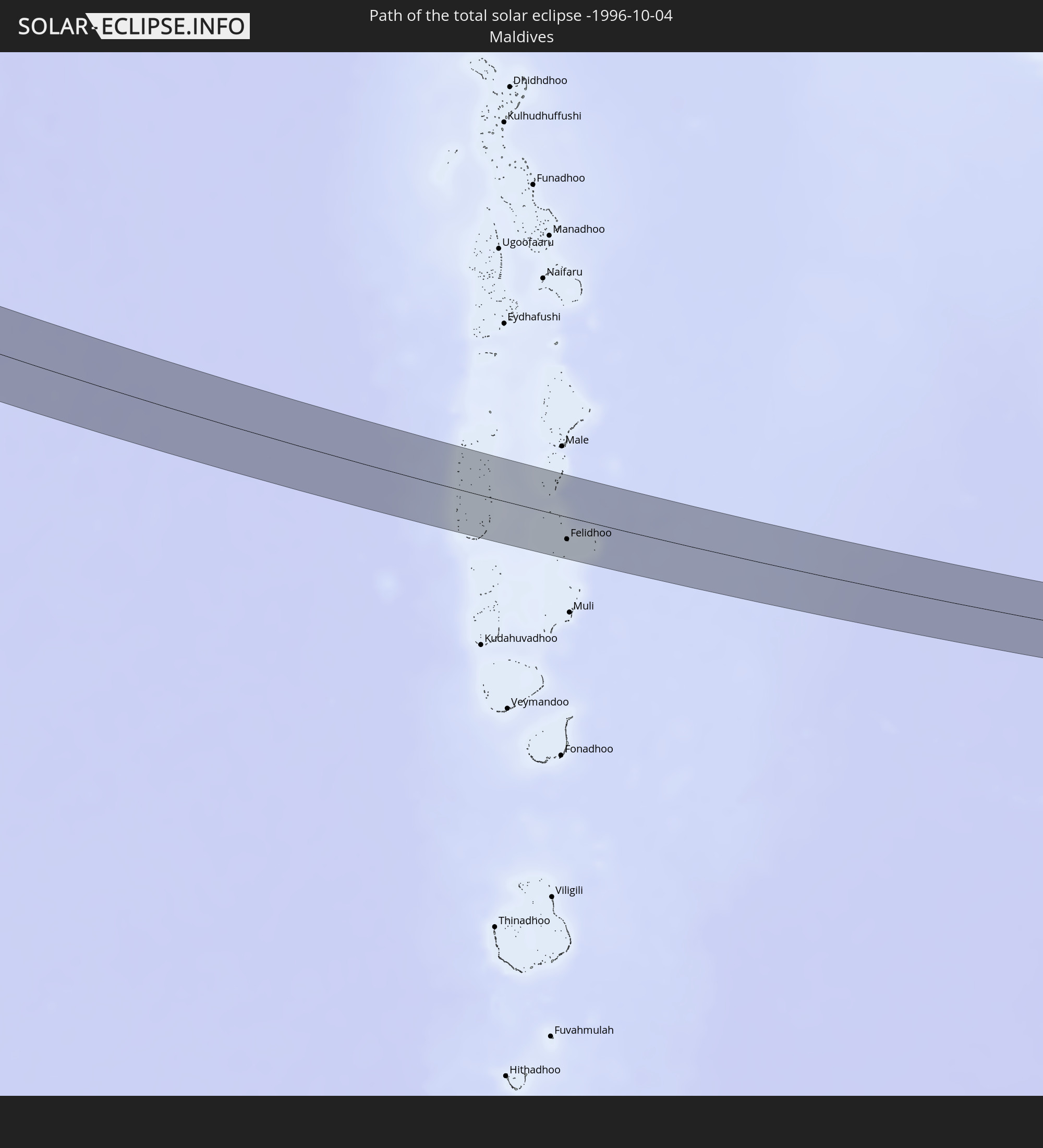 Malediven
In den folgenden Ländern ist die Sonnenfinsternis partiell zu sehen
 Russland
 Kanada
 Grönland
 Portugal
 Island
 Spanien
 Mauretanien
 Marokko
 Mali
Mali
 Irland
 Spitzbergen
 Algerien
 Vereinigtes Königreich
 Färöer
 Gibraltar
 Frankreich
 Isle of Man
 Guernsey
 Jersey
 Niger
Niger
 Andorra
 Belgien
 Nigeria
 Niederlande
 Norwegen
 Luxemburg
 Deutschland
 Schweiz
 Italien
 Monaco
 Tunesien
 Dänemark
 Kamerun
 Libyen
 Liechtenstein
 Österreich
 Schweden
 Republik Kongo
 Tschechien
 Demokratische Republik Kongo
 San Marino
 Vatikanstadt
 Slowenien
 Tschad
 Kroatien
 Polen
Polen
 Malta
Malta
 Zentralafrikanische Republik
 Bosnien und Herzegowina
 Ungarn
 Slowakei
 Montenegro
 Serbien
 Albanien
 Åland Islands
 Griechenland
 Rumänien
 Mazedonien
 Finnland
 Litauen
 Lettland
 Estland
 Sudan
Sudan
 Sambia
 Ukraine
 Bulgarien
 Weißrussland
 Ägypten
 Türkei
 Moldawien
 Ruanda
 Burundi
 Tansania
 Uganda
 Mosambik
 Republik Zypern
 Malawi
 Äthiopien
 Kenia
Kenia
 Staat Palästina
 Israel
 Saudi-Arabien
 Jordanien
 Libanon
 Syrien
 Eritrea
 Irak
Irak
 Georgien
 Französische Süd- und Antarktisgebiete
 Somalia
 Dschibuti
 Jemen
Jemen
 Madagaskar
 Komoren
 Armenien
 Iran
Iran
 Aserbaidschan
 Mayotte
 Seychellen
 Kasachstan
 Kuwait
 Bahrain
 Katar
Katar
 Vereinigte Arabische Emirate
 Oman
Oman
 Turkmenistan
 Réunion
 Usbekistan
 Mauritius
 Afghanistan
 Pakistan
 Tadschikistan
 Indien
 Kirgisistan
 Britisches Territorium im Indischen Ozean
 Malediven
 Volksrepublik China
 Sri Lanka
 Nepal
Nepal
 Mongolei
 Bangladesch
 Bhutan
 Myanmar
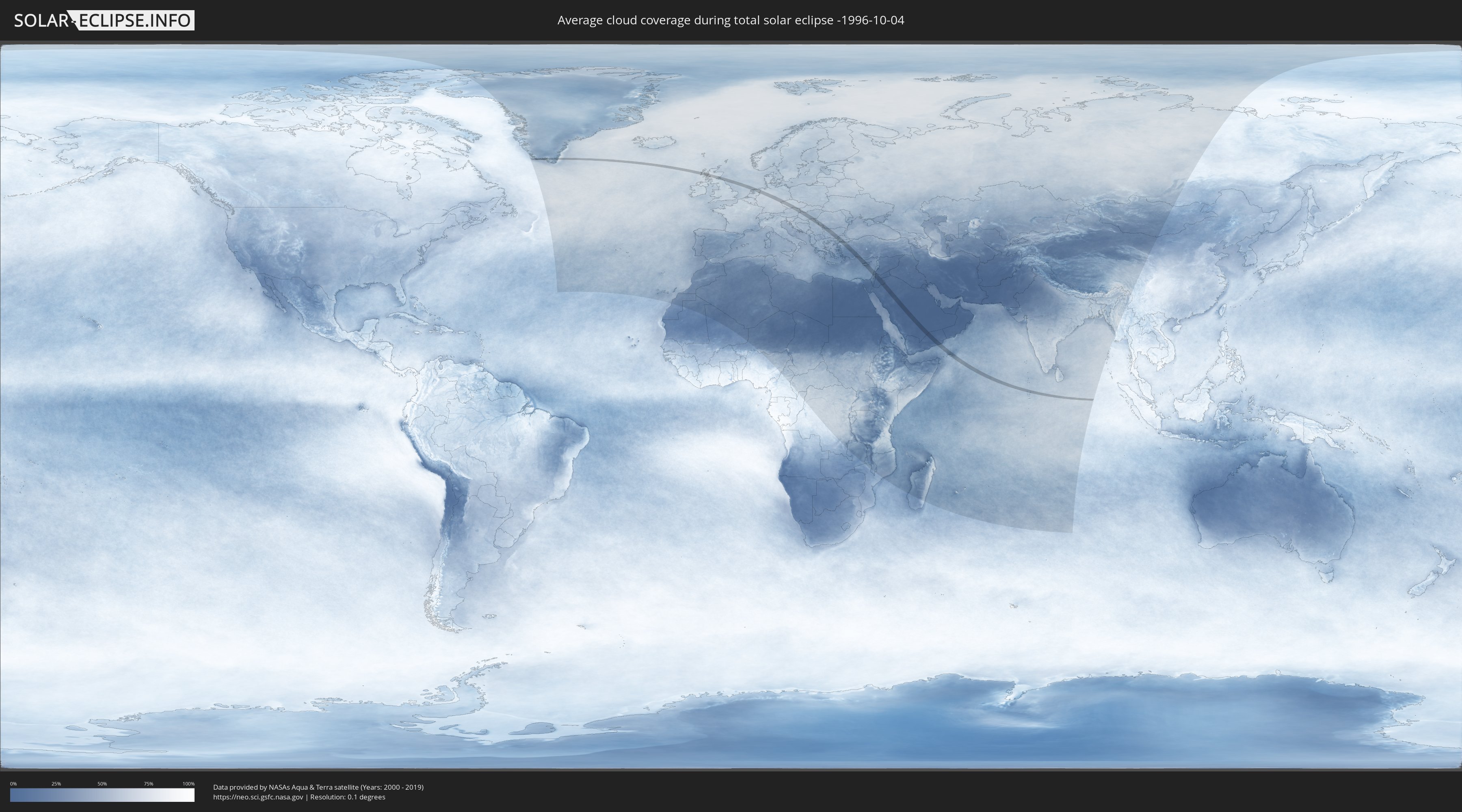
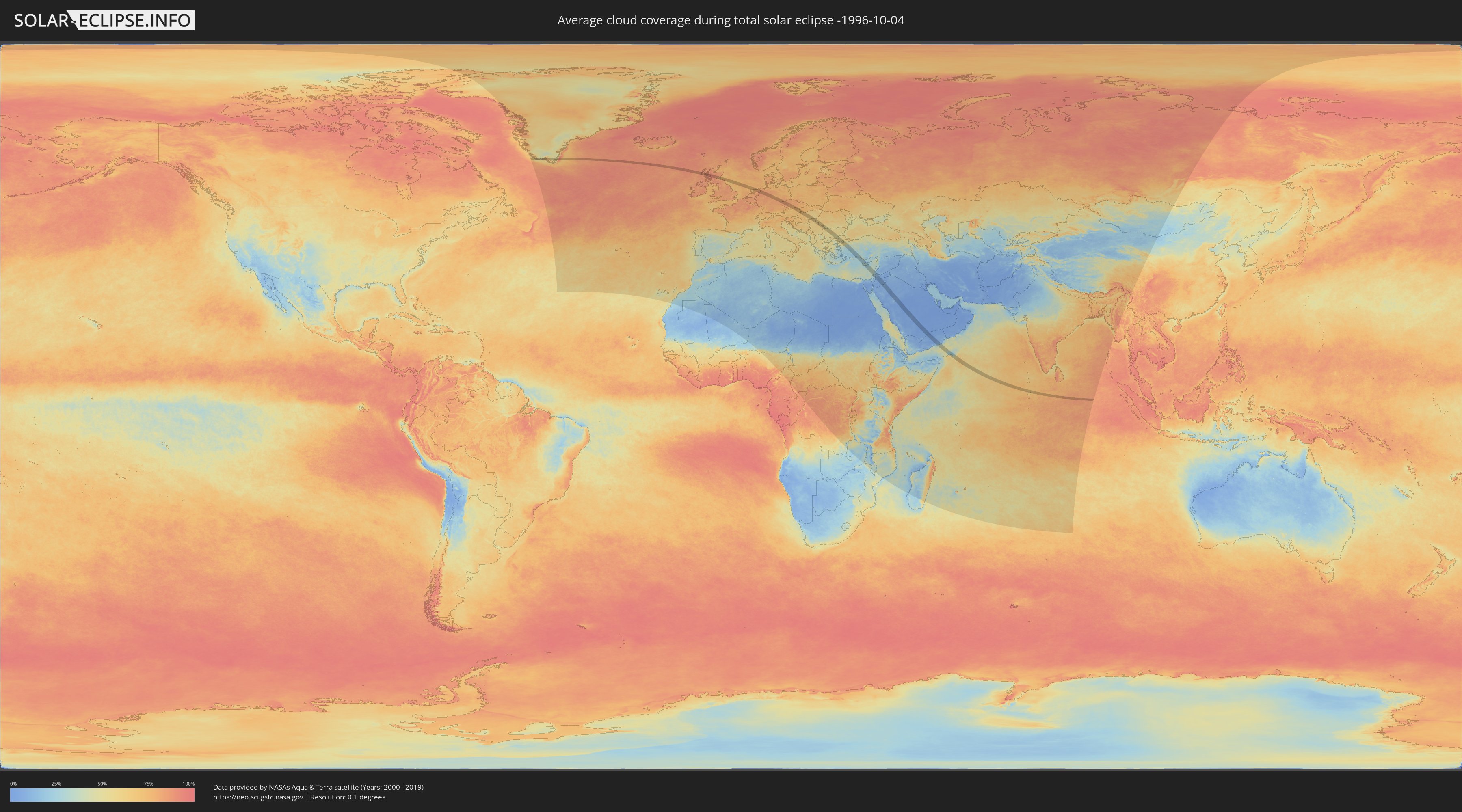
Wie wird das Wetter während der totalen Sonnenfinsternis am 04.10.-1996?
Wo ist der beste Ort, um die totale Sonnenfinsternis vom 04.10.-1996 zu beobachten?
Die folgenden Karten zeigen die durchschnittliche Bewölkung für den Tag, an dem die totale Sonnenfinsternis
stattfindet. Mit Hilfe der Karten lässt sich der Ort entlang des Finsternispfades eingrenzen,
der die besten Aussichen auf einen klaren wolkenfreien Himmel bietet.
Trotzdem muss man immer lokale Gegenenheiten beachten und sollte sich genau über das Wetter an seinem
gewählten Beobachtungsort informieren.
Die Daten stammen von den beiden NASA-Satelliten
AQUA und TERRA
und wurden über einen Zeitraum von 19 Jahren (2000 - 2019) gemittelt.
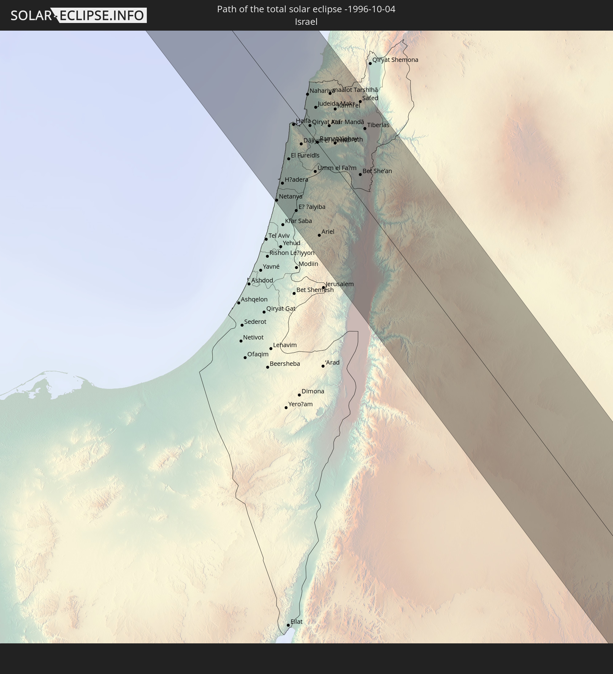
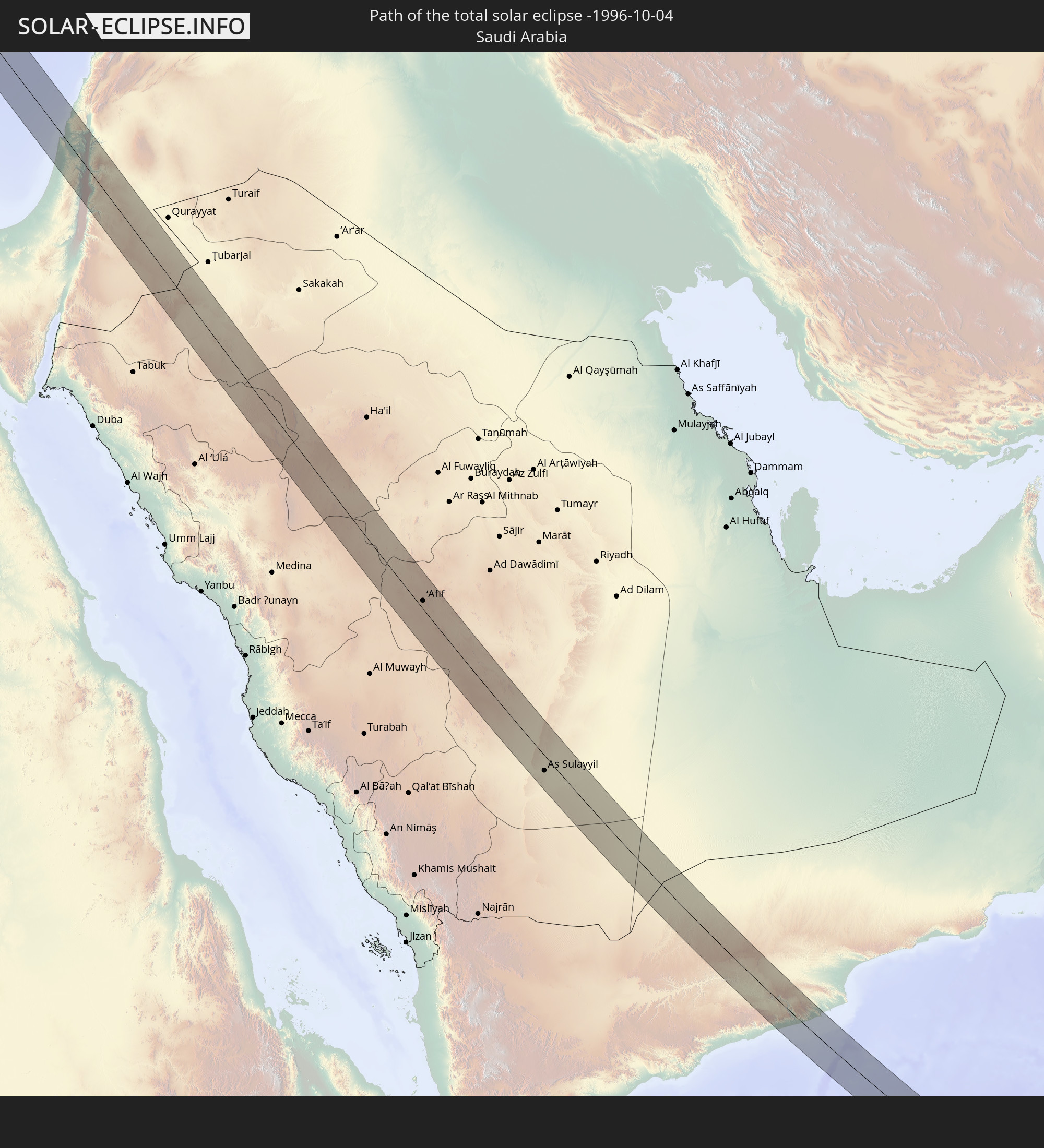
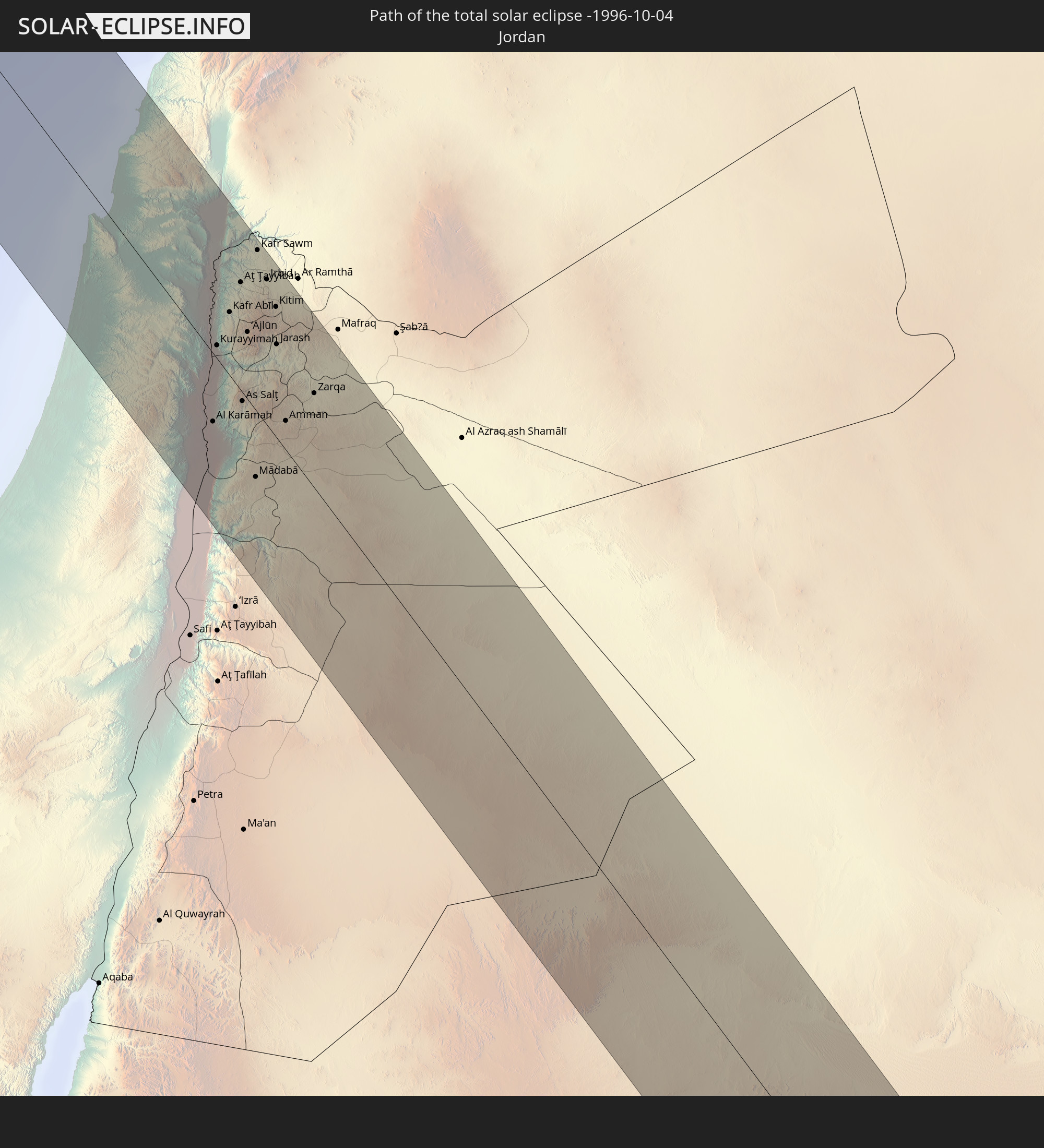
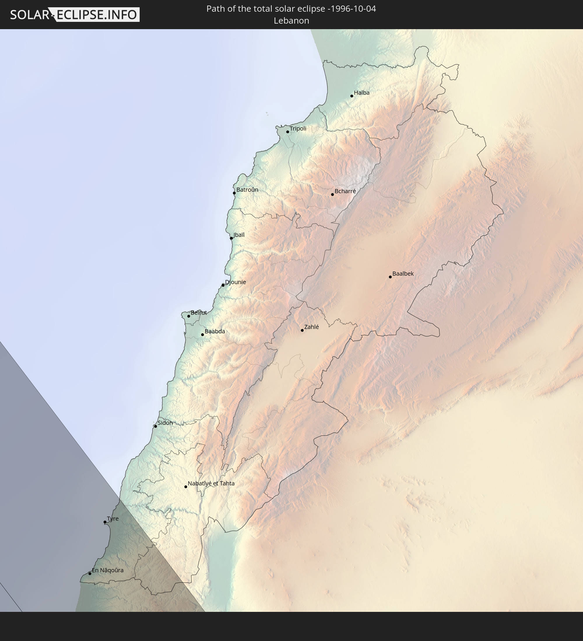
Detaillierte Länderkarten
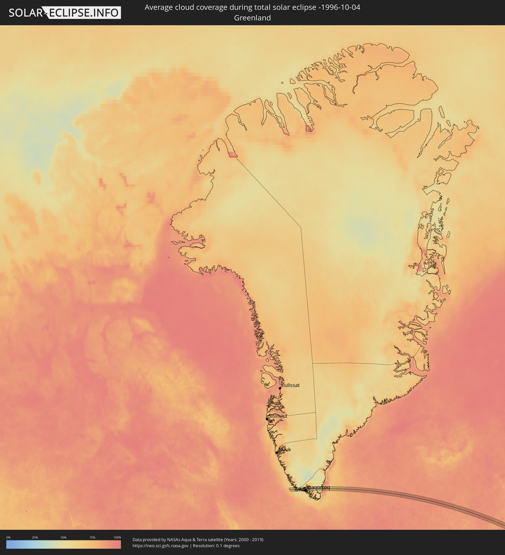 Grönland
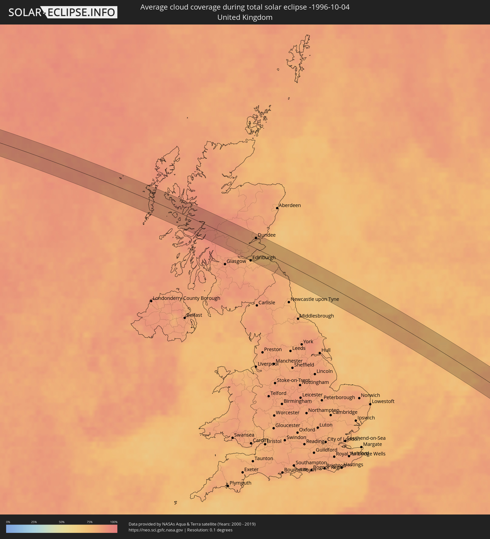 Vereinigtes Königreich
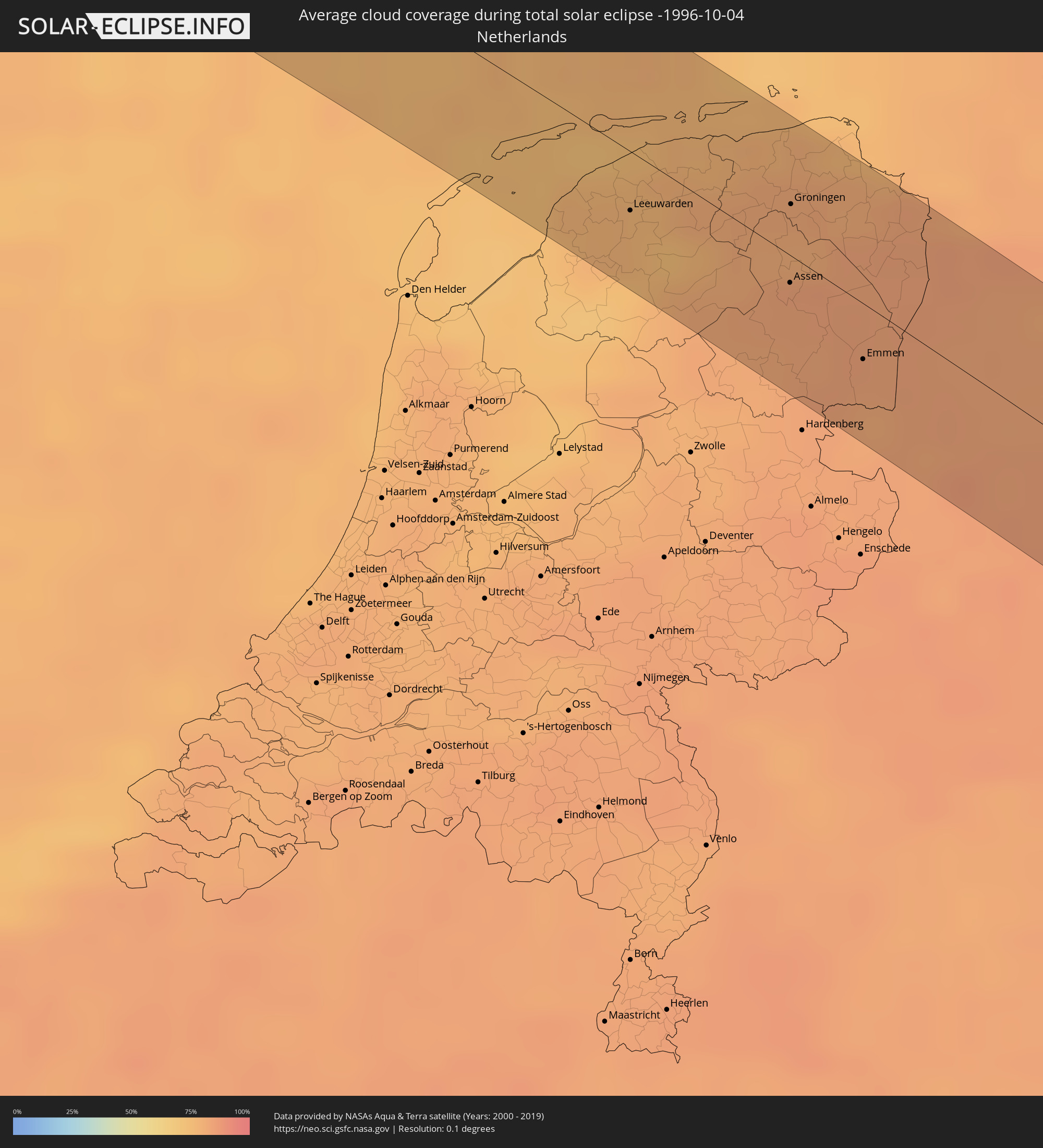 Niederlande
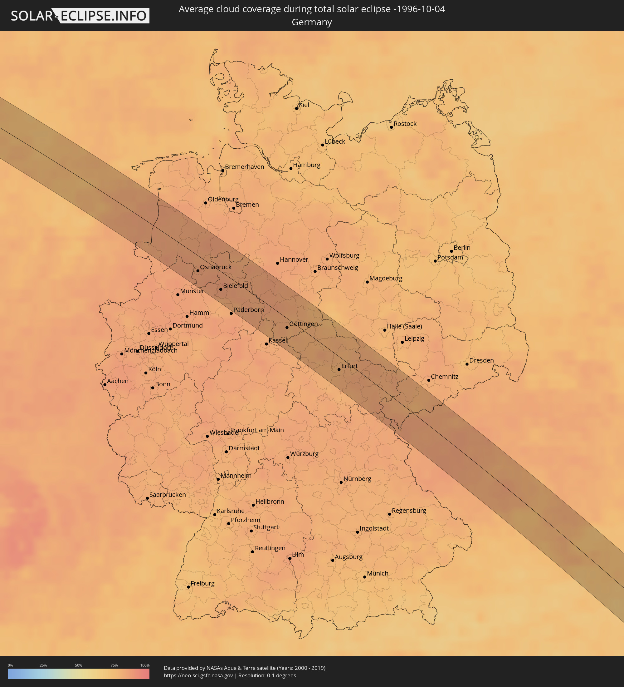 Deutschland
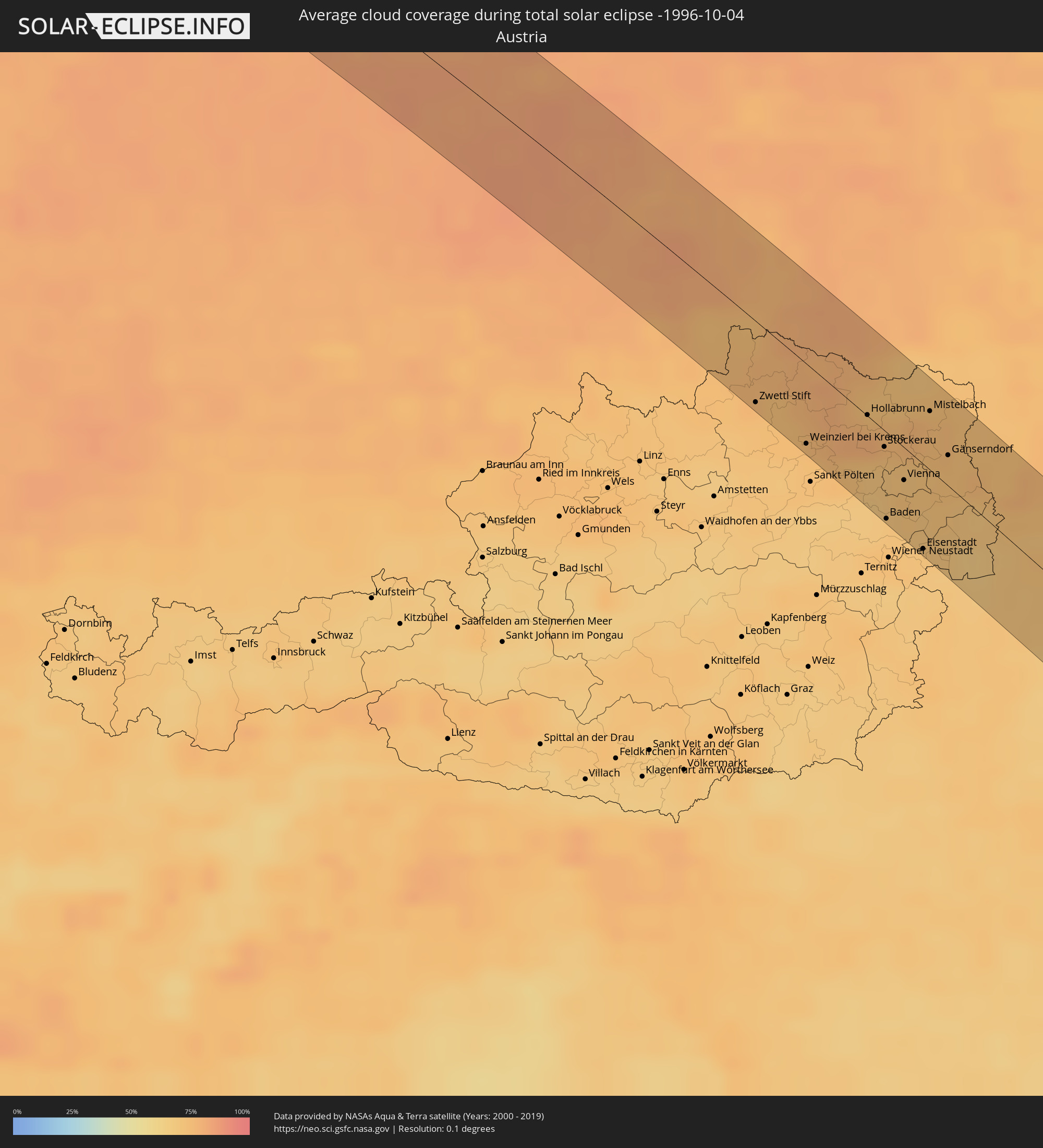 Österreich
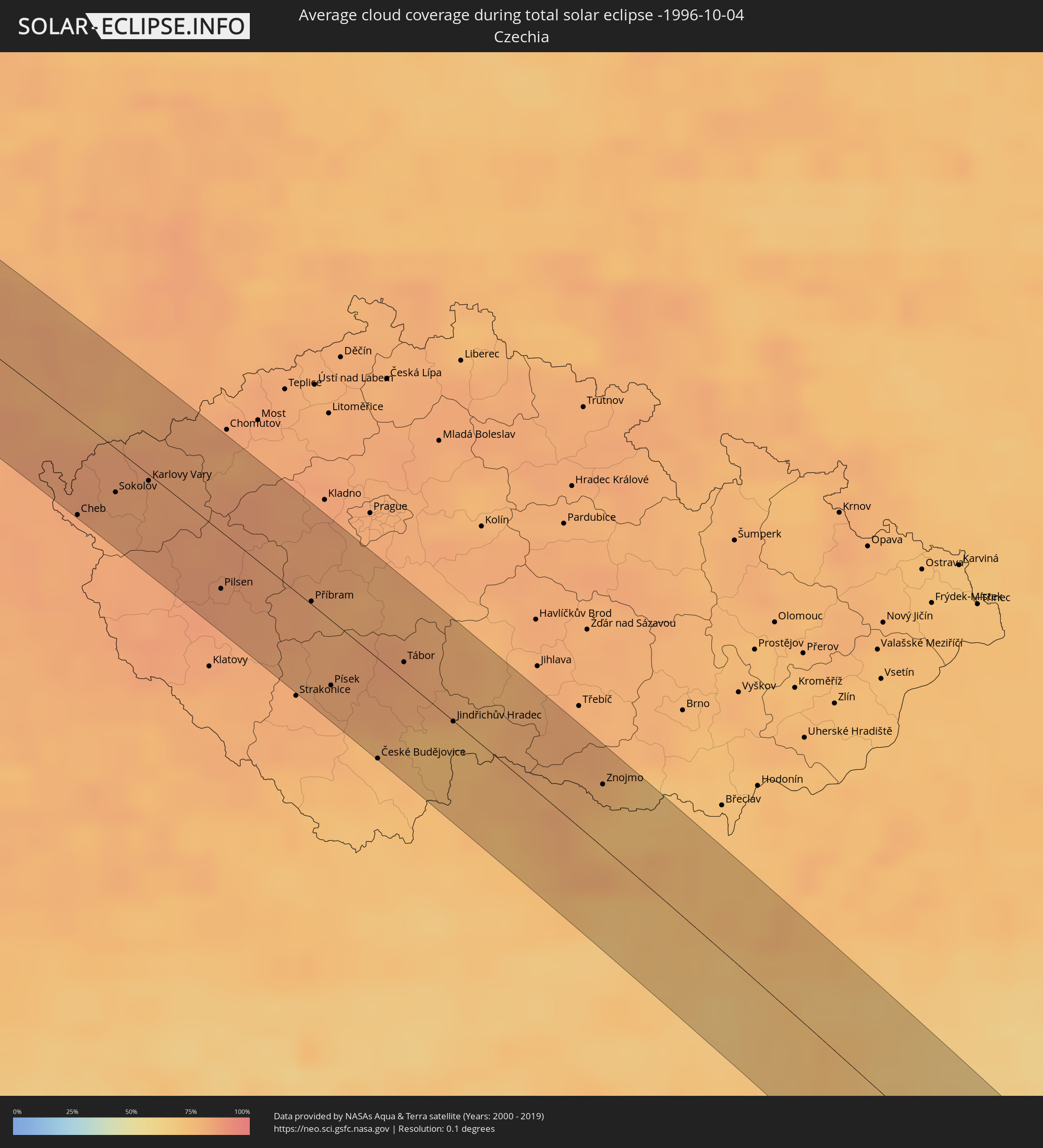 Tschechien
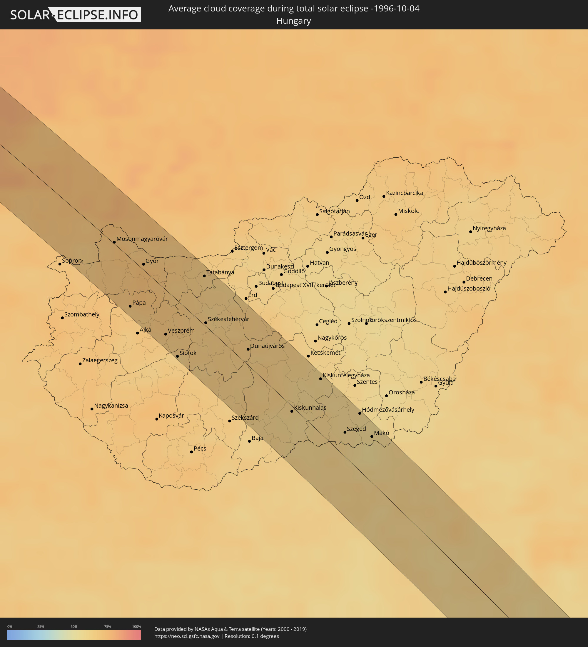 Ungarn
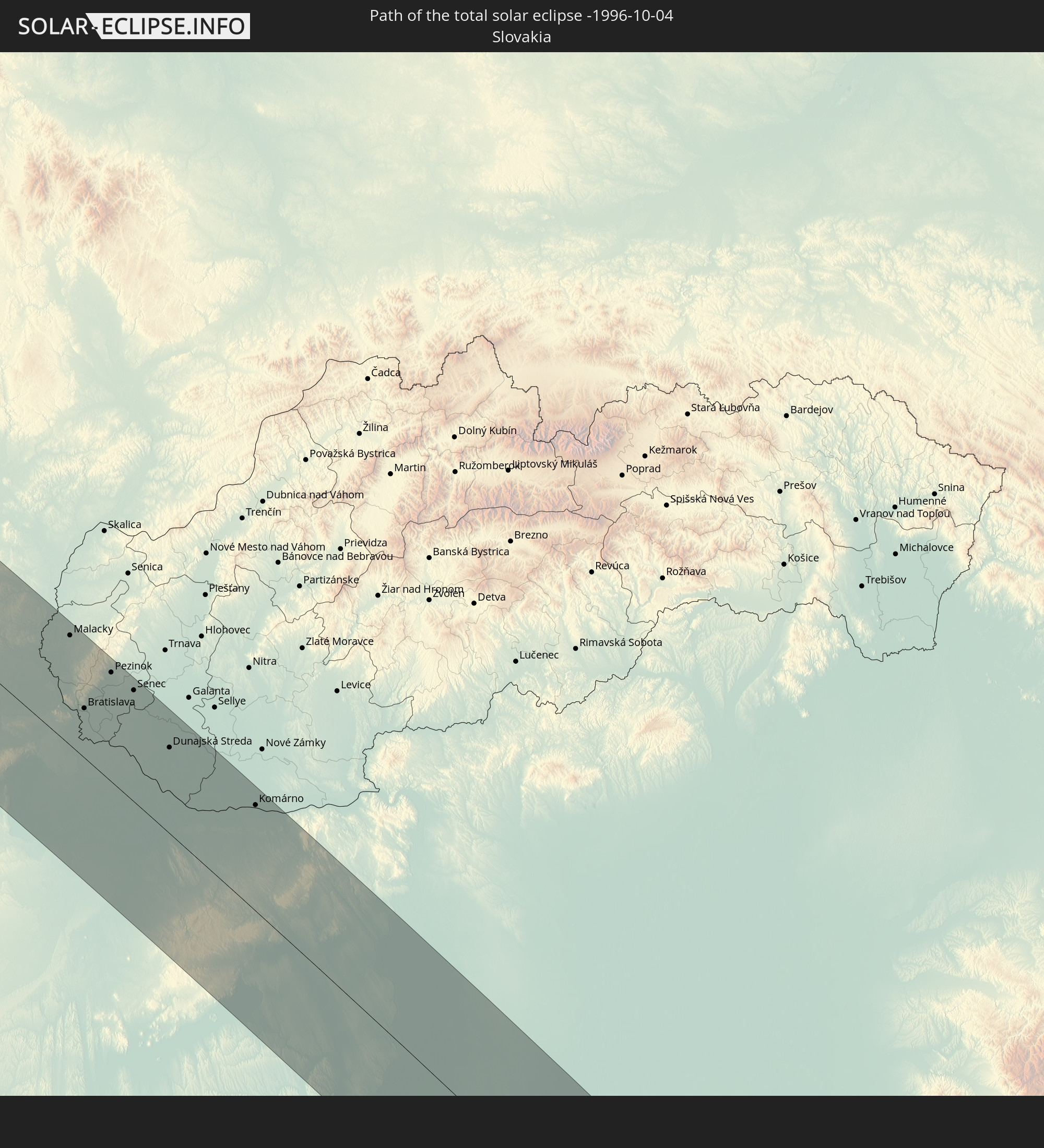
 Slowakei
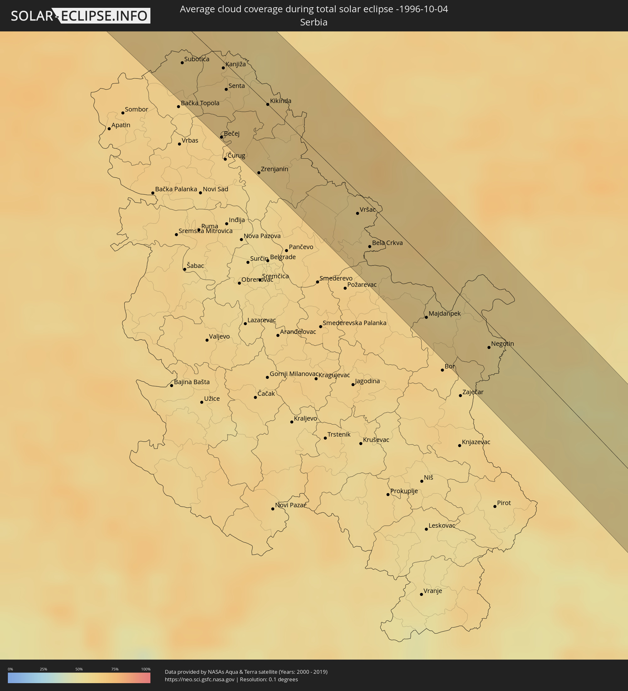 Serbien
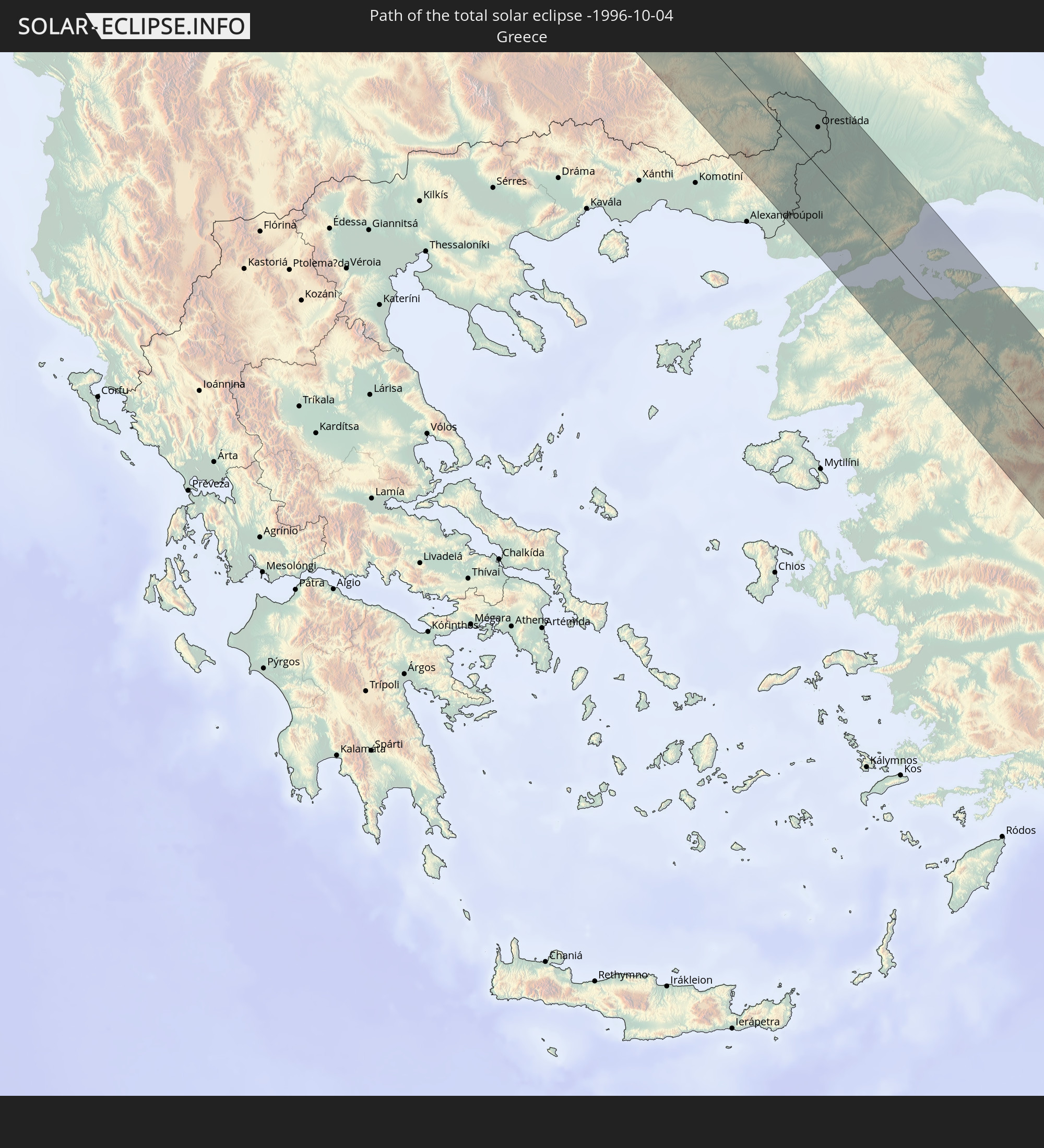
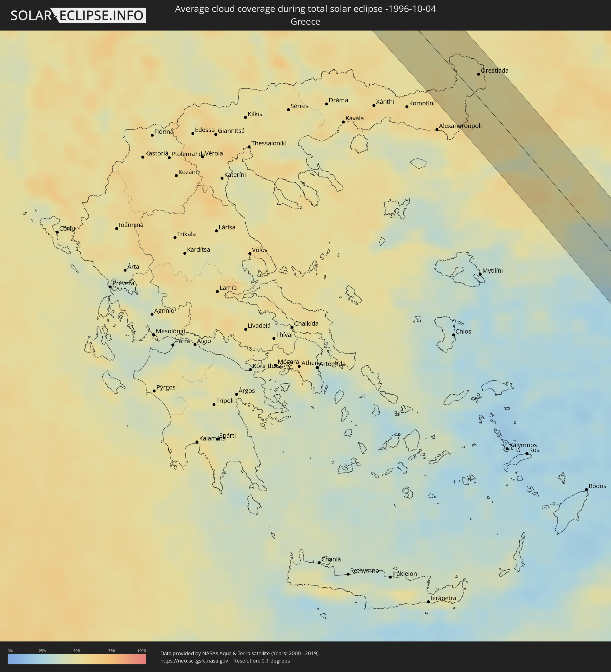 Griechenland
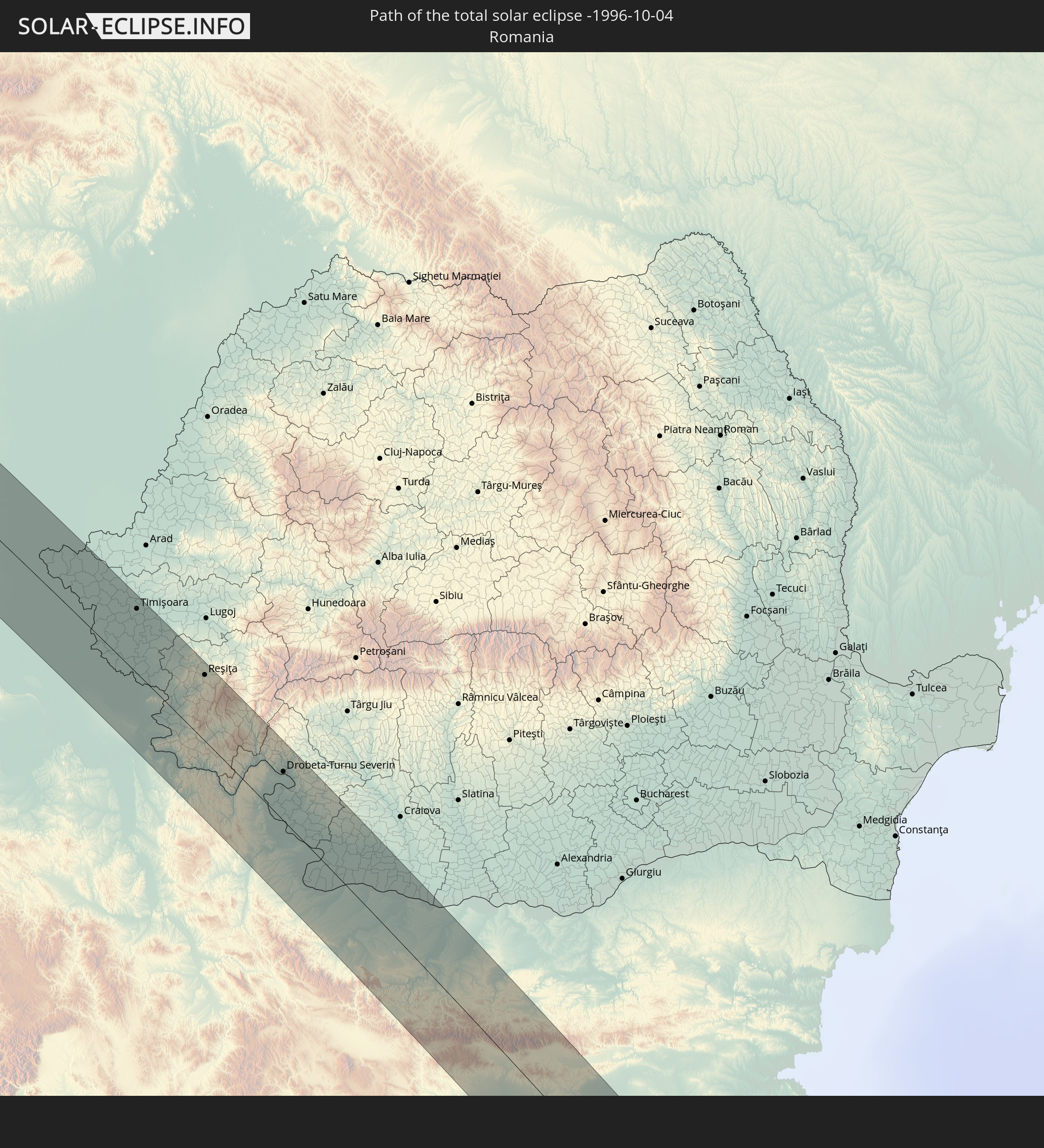
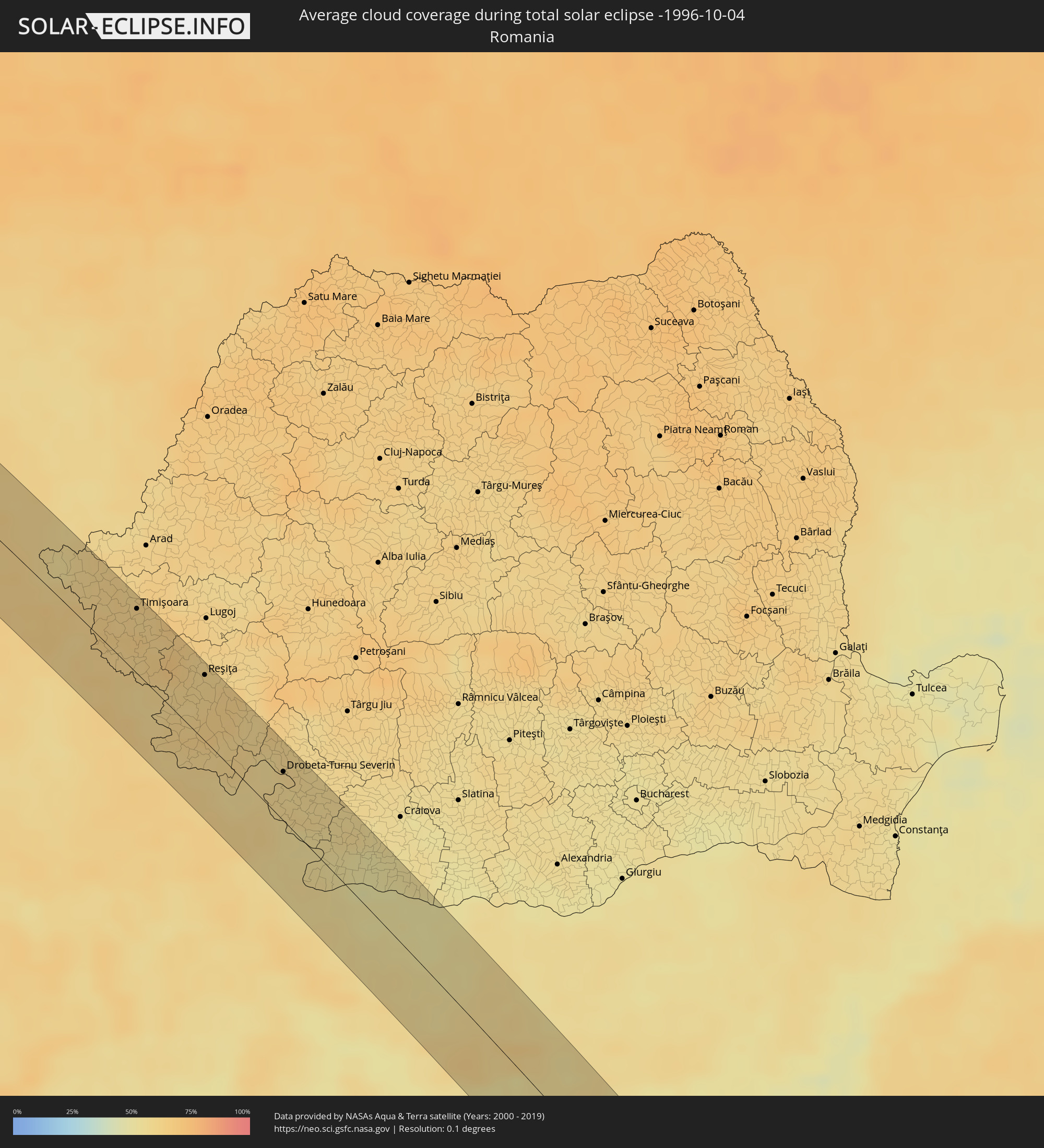 Rumänien
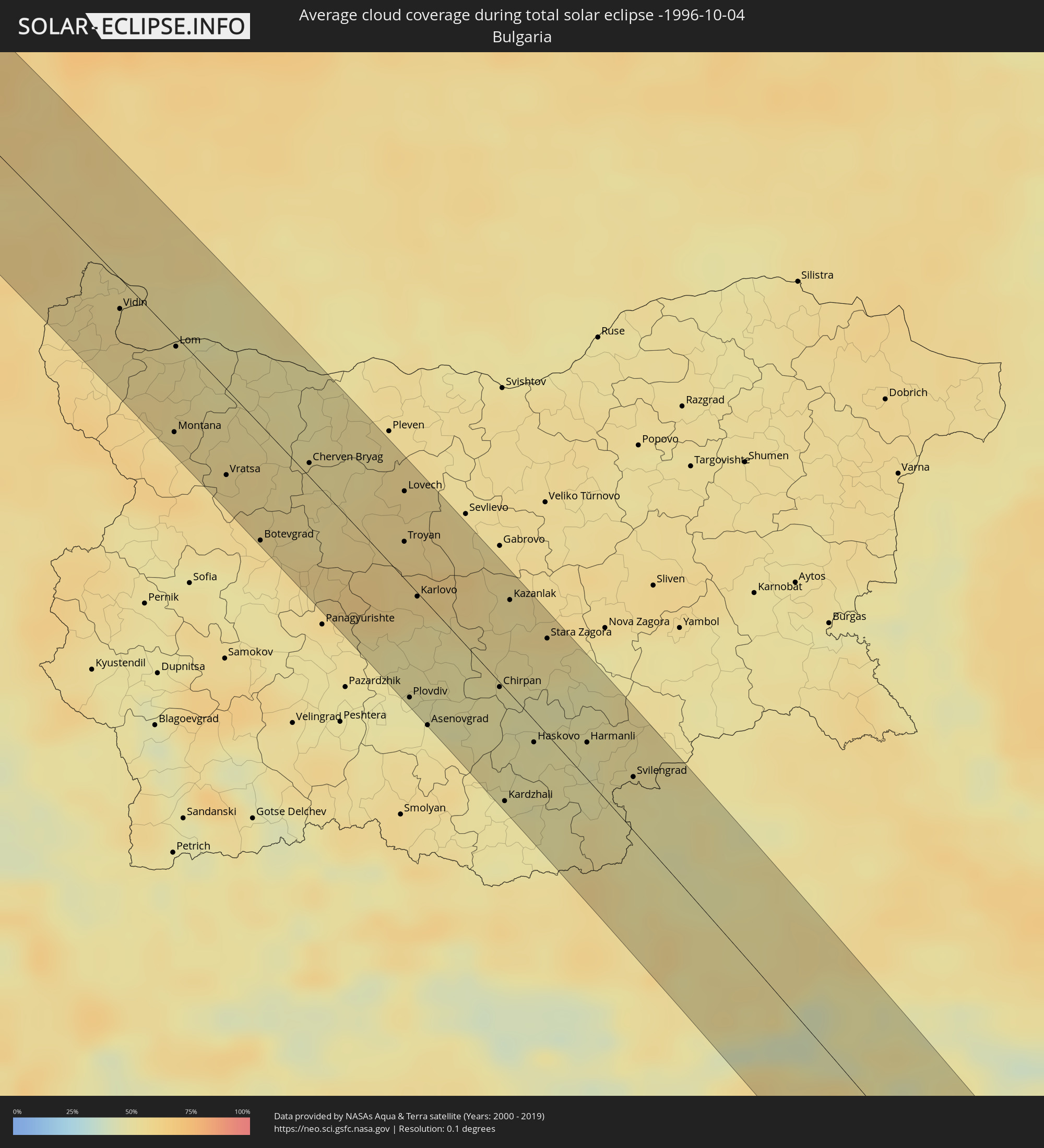 Bulgarien
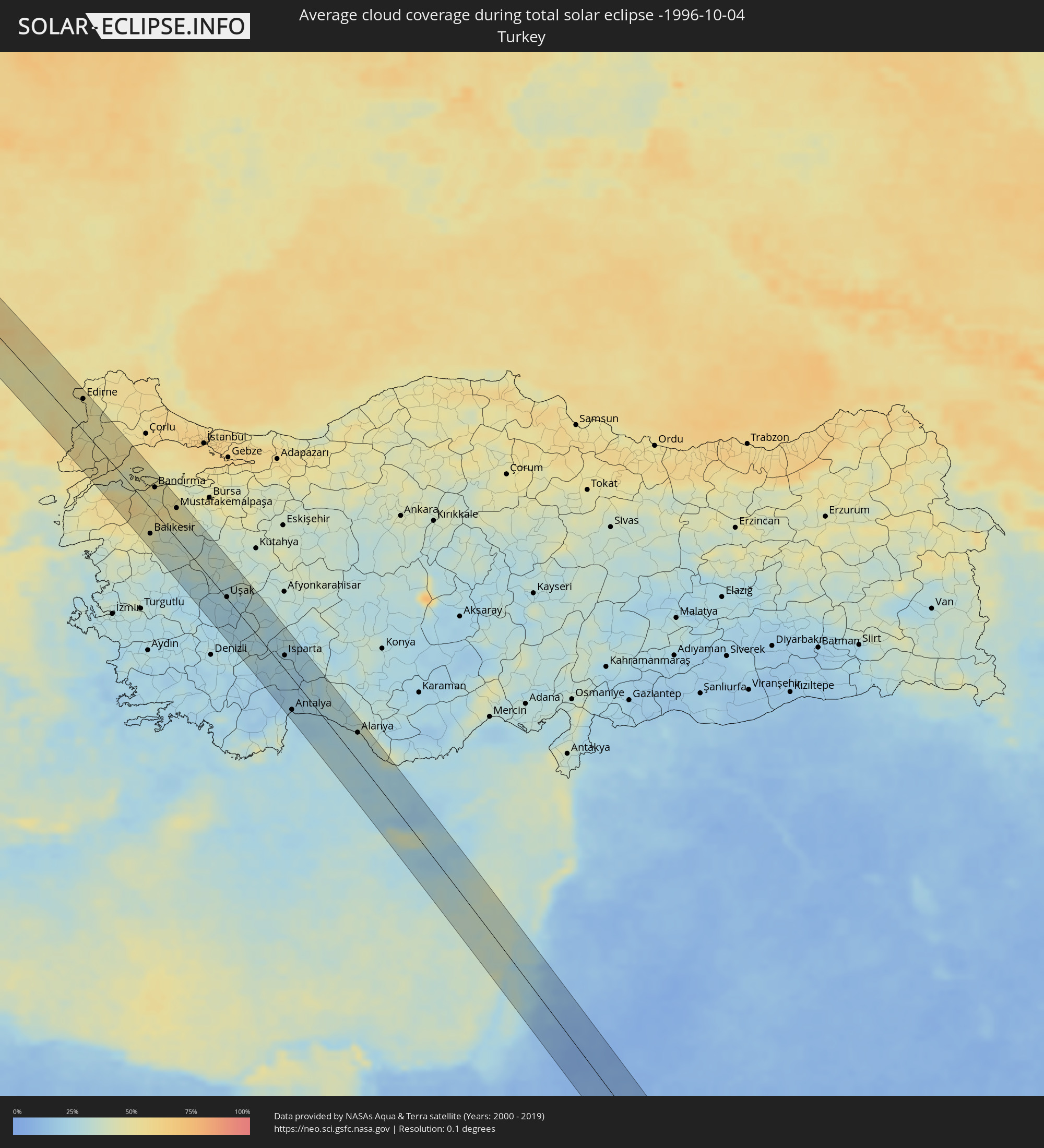 Türkei
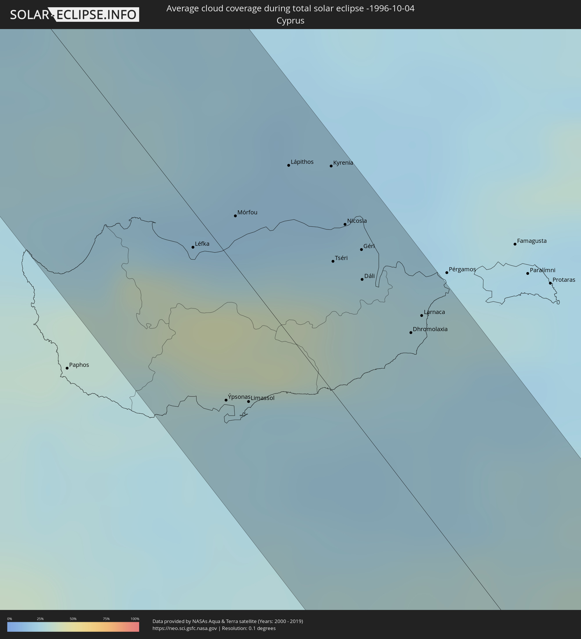 Republik Zypern
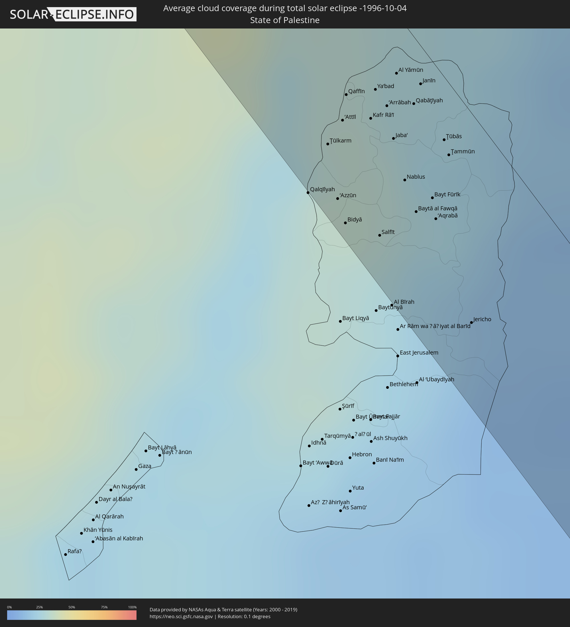 Staat Palästina
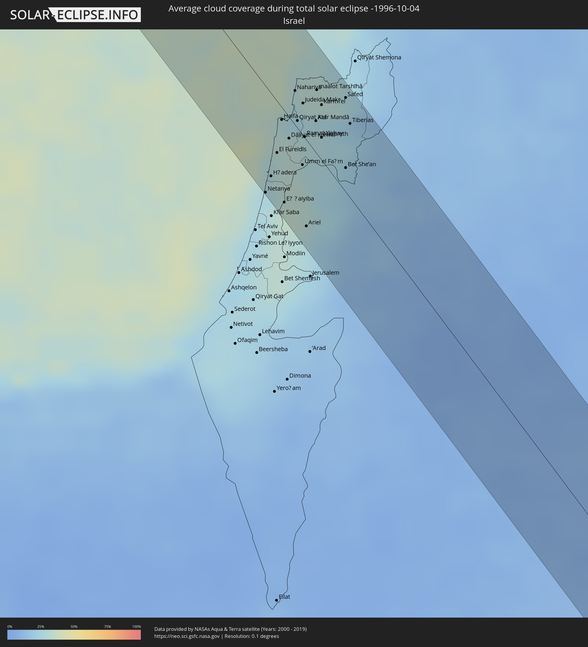 Israel
 Saudi-Arabien
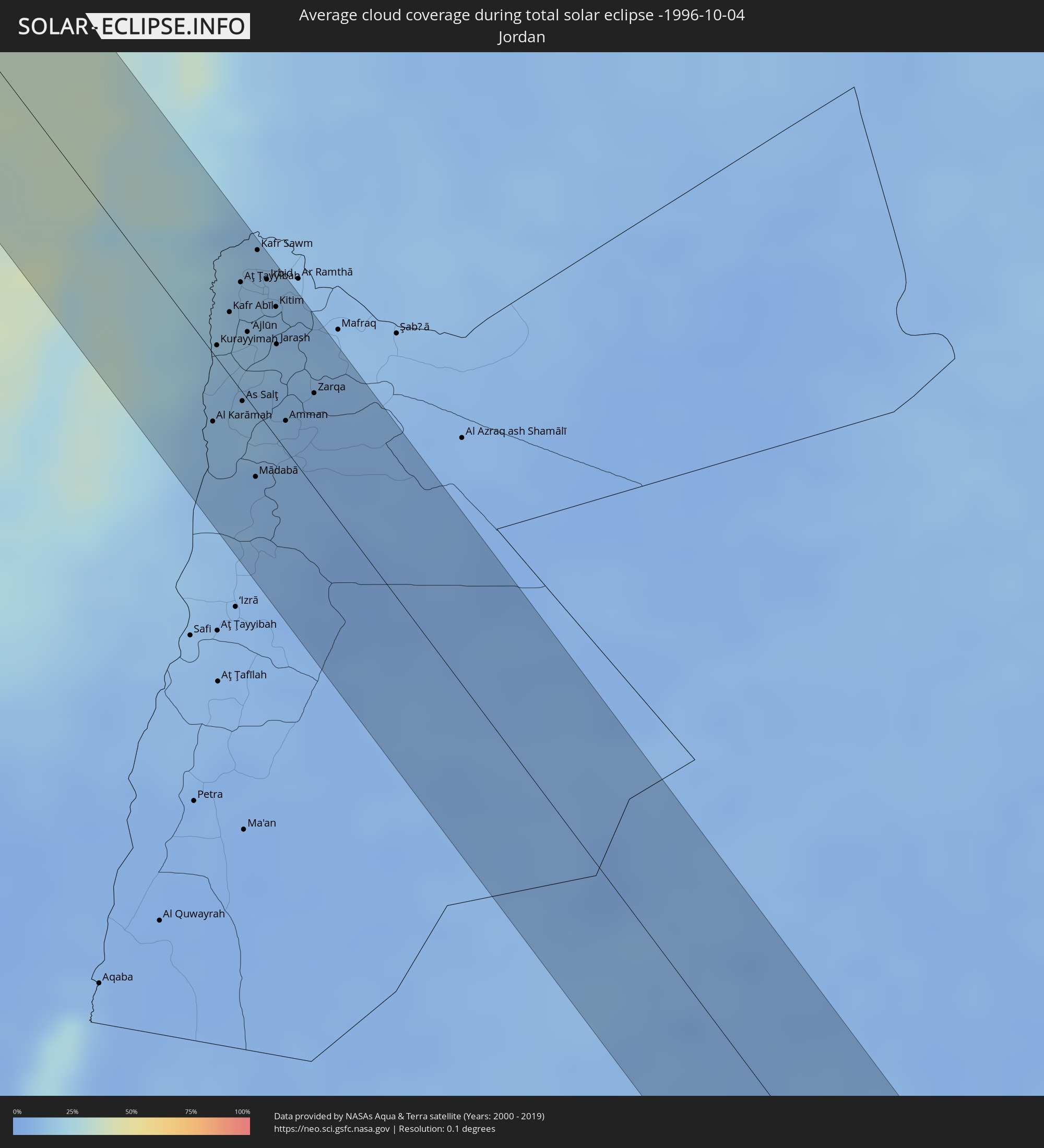 Jordanien
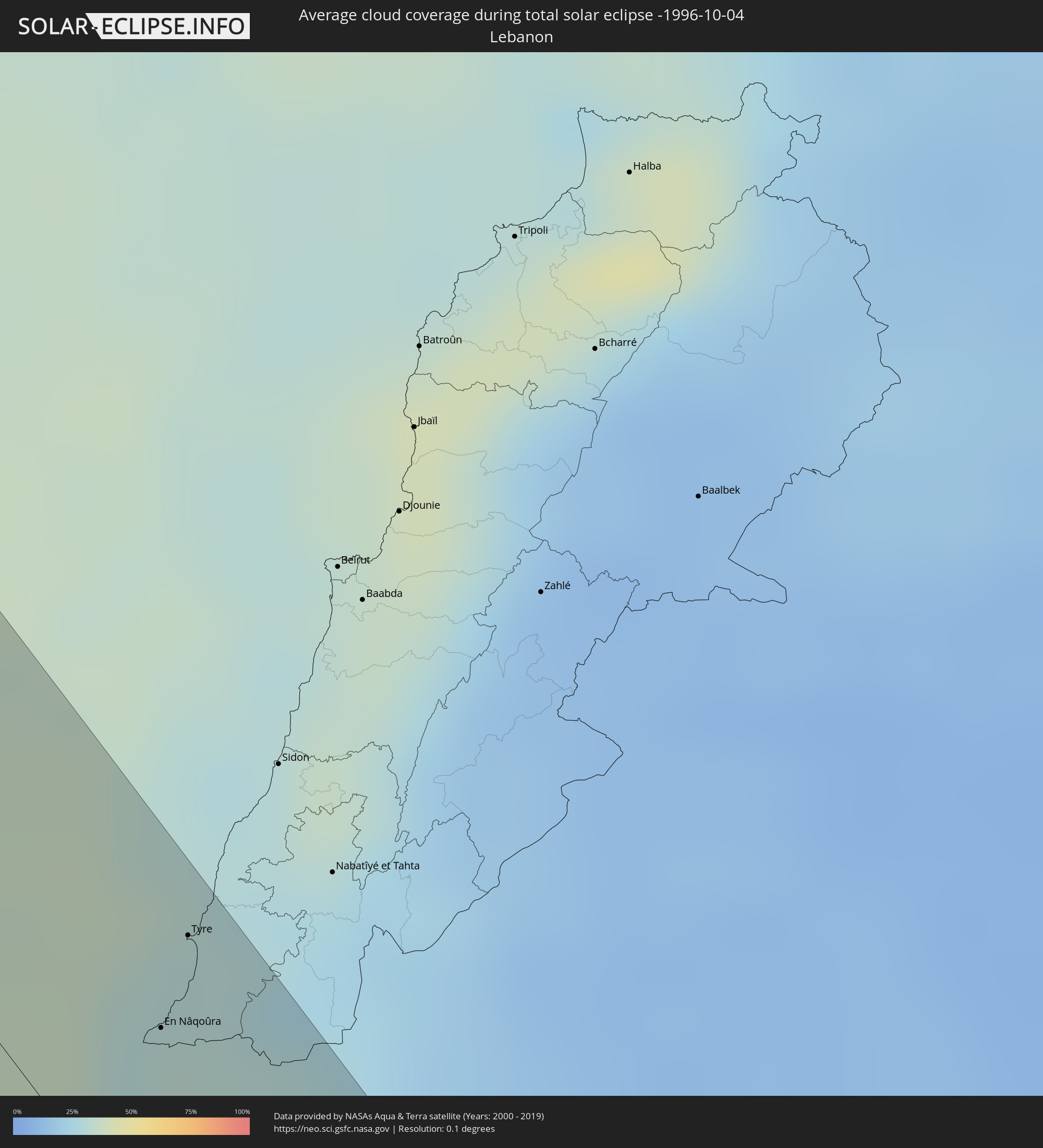 Libanon
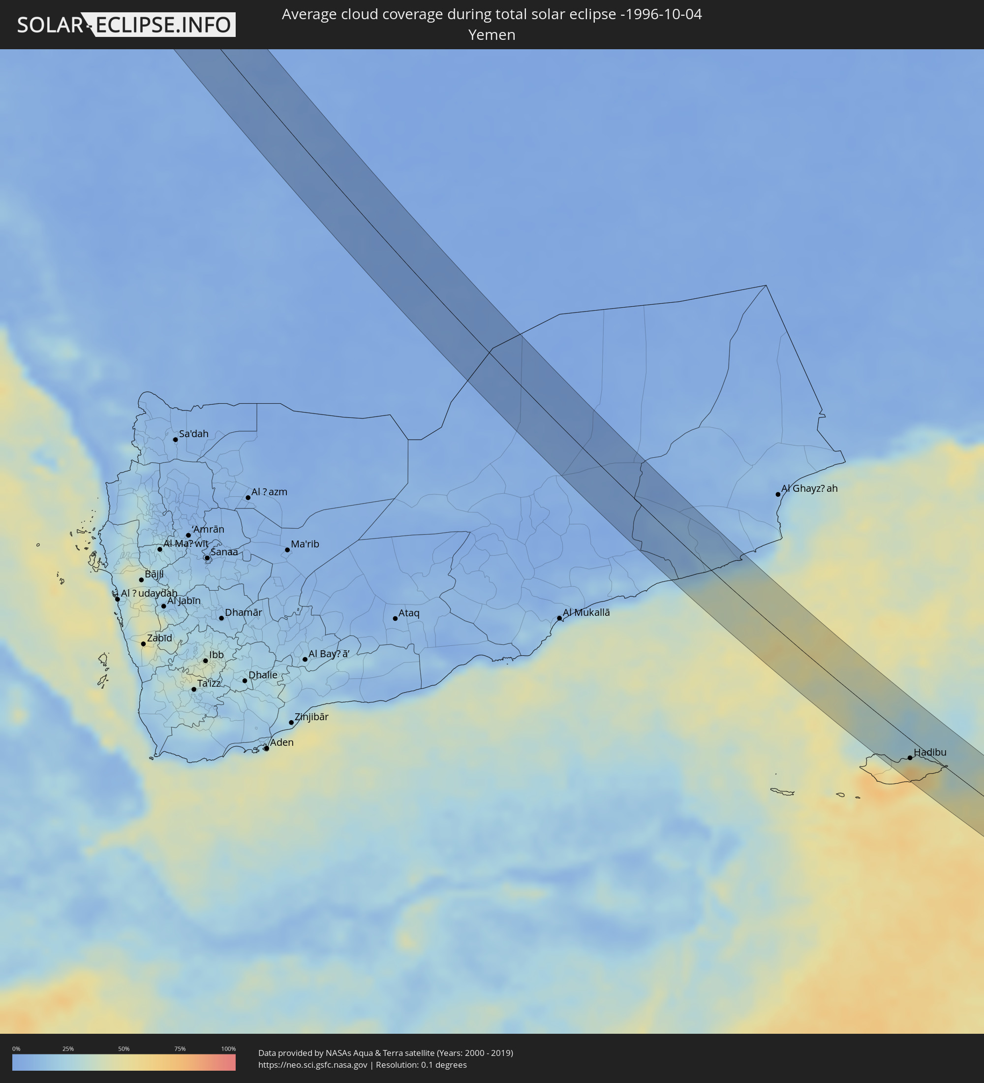 Jemen
Jemen
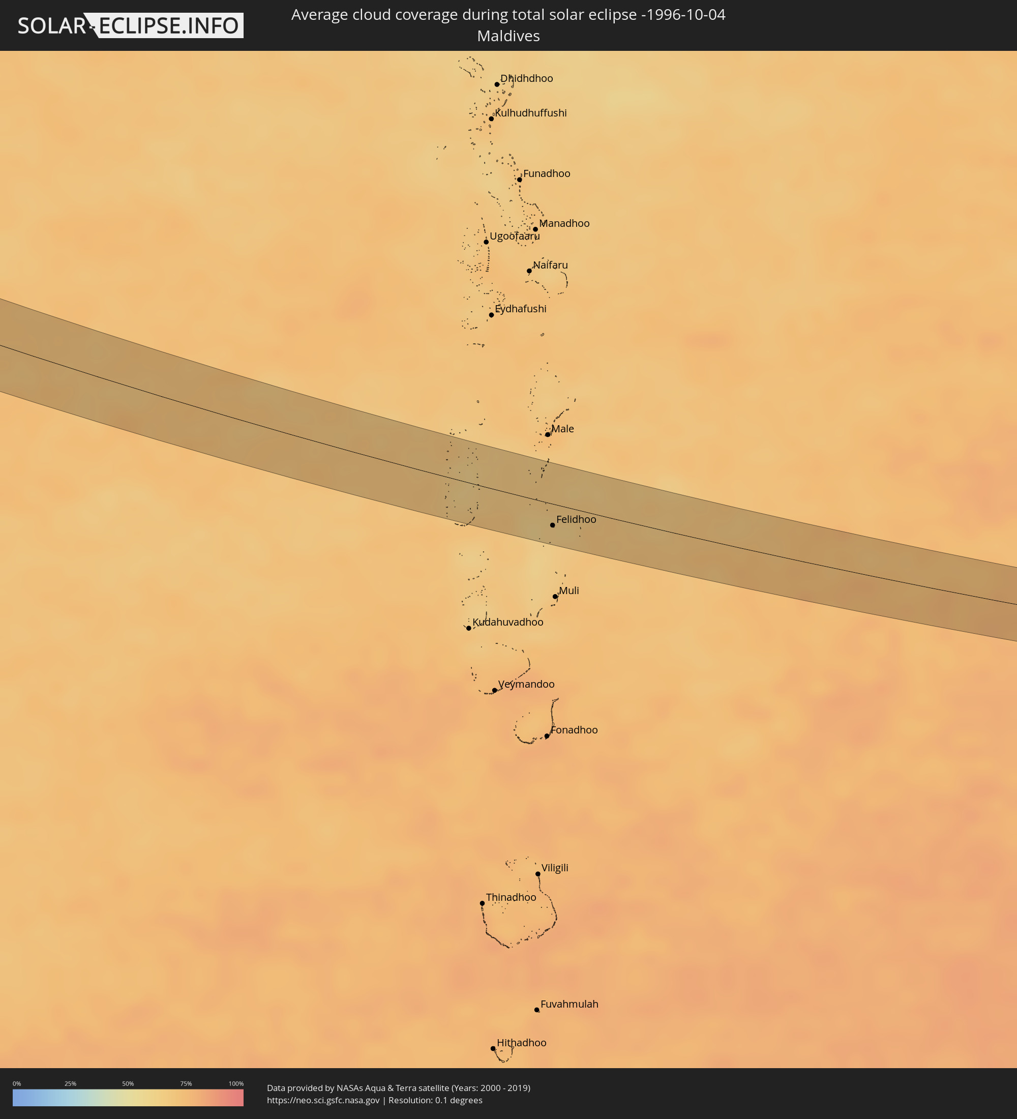 Malediven
Orte im Finsternispfad
Die nachfolgene Tabelle zeigt Städte und Orte mit mehr als 5.000 Einwohnern, die sich im Finsternispfad befinden. Städte mit mehr als 100.000 Einwohnern sind dick gekennzeichnet. Mit einem Klick auf den Ort öffnet sich eine Detailkarte die die Lage des jeweiligen Ortes zusammen mit dem Verlauf der zentralen Finsternis präsentiert.
| Ort | Typ | Dauer der Verfinsterung | Ortszeit bei maximaler Verfinsterung | Entfernung zur Zentrallinie | Ø Bewölkung |
|
Qaqortoq, Kujalleq
|
total | - | 05:34:07 UTC-03:26 | 20 km | 63% |
|
Isle of Skye, Scotland
|
total | - | 09:11:25 UTC+00:00 | 30 km | 86% |
|
Fort William, Scotland
|
total | - | 09:11:58 UTC+00:00 | 3 km | 91% |
|
Alloa, Scotland
|
total | - | 09:12:39 UTC+00:00 | 33 km | 83% |
|
Dunfermline, Scotland
|
total | - | 09:12:53 UTC+00:00 | 29 km | 81% |
|
Perth, Scotland
|
total | - | 09:13:00 UTC+00:00 | 4 km | 82% |
|
Kirkcaldy, Scotland
|
total | - | 09:13:06 UTC+00:00 | 16 km | 76% |
|
Musselburgh, Scotland
|
total | - | 09:13:08 UTC+00:00 | 31 km | 82% |
|
Dundee, Scotland
|
total | - | 09:13:21 UTC+00:00 | 24 km | 78% |
|
Saint Andrews, Scotland
|
total | - | 09:13:26 UTC+00:00 | 16 km | 78% |
|
Berwick-Upon-Tweed, England
|
total | - | 09:13:52 UTC+00:00 | 17 km | 78% |
|
Leeuwarden, Friesland
|
total | - | 09:39:41 UTC+00:19 | 16 km | 77% |
|
Heerenveen, Friesland
|
total | - | 09:39:48 UTC+00:19 | 34 km | 77% |
|
Drachten, Friesland
|
total | - | 09:39:58 UTC+00:19 | 13 km | 79% |
|
Hoogeveen, Drenthe
|
total | - | 09:40:21 UTC+00:19 | 36 km | 82% |
|
Assen, Drenthe
|
total | - | 09:40:24 UTC+00:19 | 7 km | 83% |
|
Groningen, Groningen
|
total | - | 09:40:23 UTC+00:19 | 14 km | 80% |
|
Borger, Drenthe
|
total | - | 09:40:38 UTC+00:19 | 6 km | 83% |
|
Veendam, Groningen
|
total | - | 09:40:41 UTC+00:19 | 15 km | 83% |
|
Emmen, Drenthe
|
total | - | 09:40:45 UTC+00:19 | 15 km | 82% |
|
Delfzijl, Groningen
|
total | - | 09:40:42 UTC+00:19 | 37 km | 81% |
|
Osnabrück, Lower Saxony
|
total | - | 10:22:23 UTC+01:00 | 18 km | 83% |
|
Bielefeld, North Rhine-Westphalia
|
total | - | 10:22:54 UTC+01:00 | 21 km | 80% |
|
Detmold, North Rhine-Westphalia
|
total | - | 10:23:15 UTC+01:00 | 17 km | 81% |
|
Minden, North Rhine-Westphalia
|
total | - | 10:23:14 UTC+01:00 | 17 km | 83% |
|
Göttingen, Lower Saxony
|
total | - | 10:24:25 UTC+01:00 | 11 km | 79% |
|
Erfurt, Thuringia
|
total | - | 10:25:42 UTC+01:00 | 15 km | 79% |
|
Jena, Thuringia
|
total | - | 10:26:18 UTC+01:00 | 4 km | 81% |
|
Gera, Thuringia
|
total | - | 10:26:50 UTC+01:00 | 20 km | 81% |
|
Plauen, Saxony
|
total | - | 10:27:02 UTC+01:00 | 11 km | 81% |
|
Cheb, Karlovarský
|
total | - | 10:27:27 UTC+01:00 | 38 km | 82% |
|
Zwickau, Saxony
|
total | - | 10:27:20 UTC+01:00 | 24 km | 80% |
|
Sokolov, Karlovarský
|
total | - | 10:27:42 UTC+01:00 | 17 km | 82% |
|
Karlovy Vary, Karlovarský
|
total | - | 10:27:56 UTC+01:00 | 2 km | 82% |
|
Pilsen, Plzeňský
|
total | - | 10:28:41 UTC+01:00 | 22 km | 84% |
|
Příbram, Central Bohemia
|
total | - | 10:29:25 UTC+01:00 | 1 km | 82% |
|
Písek, Jihočeský
|
total | - | 10:29:45 UTC+01:00 | 26 km | 81% |
|
České Budějovice, Jihočeský
|
total | - | 10:30:17 UTC+01:00 | 39 km | 76% |
|
Tábor, Jihočeský
|
total | - | 10:30:16 UTC+01:00 | 7 km | 81% |
|
Jindřichův Hradec, Jihočeský
|
total | - | 10:30:48 UTC+01:00 | 0 km | 74% |
|
Zwettl Stift, Lower Austria
|
total | - | 10:31:18 UTC+01:00 | 36 km | 73% |
|
Weinzierl bei Krems, Lower Austria
|
total | - | 10:31:53 UTC+01:00 | 35 km | 73% |
|
Znojmo, South Moravian
|
total | - | 10:32:09 UTC+01:00 | 25 km | 77% |
|
Hollabrunn, Lower Austria
|
total | - | 10:32:22 UTC+01:00 | 0 km | 74% |
|
Stockerau, Lower Austria
|
total | - | 10:32:37 UTC+01:00 | 7 km | 72% |
|
Baden, Lower Austria
|
total | - | 10:32:52 UTC+01:00 | 38 km | 70% |
|
Vienna, Vienna
|
total | - | 10:32:54 UTC+01:00 | 14 km | 72% |
|
Eisenstadt, Burgenland
|
total | - | 10:33:18 UTC+01:00 | 38 km | 69% |
|
Mistelbach, Lower Austria
|
total | - | 10:32:55 UTC+01:00 | 26 km | 74% |
|
Gänserndorf, Lower Austria
|
total | - | 10:33:14 UTC+01:00 | 13 km | 73% |
|
Bruck an der Leitha, Lower Austria
|
total | - | 10:33:29 UTC+01:00 | 11 km | 70% |
|
Malacky, Bratislavský
|
total | - | 10:33:31 UTC+01:00 | 36 km | 73% |
|
Stupava, Bratislavský
|
total | - | 10:33:38 UTC+01:00 | 23 km | 74% |
|
Bratislava, Bratislavský
|
total | - | 10:33:48 UTC+01:00 | 16 km | 72% |
|
Ivanka pri Dunaji, Bratislavský
|
total | - | 10:33:57 UTC+01:00 | 27 km | 77% |
|
Pezinok, Bratislavský
|
total | - | 10:33:54 UTC+01:00 | 36 km | 77% |
|
Mosonmagyaróvár, Győr-Moson-Sopron
|
total | - | 10:34:11 UTC+01:00 | 1 km | 72% |
|
Šamorín, Trnavský
|
total | - | 10:34:07 UTC+01:00 | 17 km | 71% |
|
Senec, Bratislavský
|
total | - | 10:34:06 UTC+01:00 | 37 km | 75% |
|
Pápa, Veszprém
|
total | - | 10:34:46 UTC+01:00 | 34 km | 68% |
|
Dunajská Streda, Trnavský
|
total | - | 10:34:30 UTC+01:00 | 28 km | 70% |
|
Győr, Győr-Moson-Sopron
|
total | - | 10:34:44 UTC+01:00 | 4 km | 73% |
|
Veľký Meder, Trnavský
|
total | - | 10:34:47 UTC+01:00 | 25 km | 69% |
|
Veszprém, Veszprém
|
total | - | 10:35:28 UTC+01:00 | 31 km | 67% |
|
Komárno, Nitriansky
|
total | - | 10:35:16 UTC+01:00 | 35 km | 69% |
|
Tatabánya, Komárom-Esztergom
|
total | - | 10:35:43 UTC+01:00 | 34 km | 65% |
|
Székesfehérvár, Fejér
|
total | - | 10:36:01 UTC+01:00 | 2 km | 67% |
|
Dunaújváros, Fejér
|
total | - | 10:36:49 UTC+01:00 | 11 km | 67% |
|
Subotica, Vojvodina
|
total | - | 10:38:24 UTC+01:00 | 21 km | 61% |
|
Kiskunfélegyháza, Bács-Kiskun
|
total | - | 10:38:08 UTC+01:00 | 38 km | 61% |
|
Bečej, Vojvodina
|
total | - | 10:39:16 UTC+01:00 | 40 km | 62% |
|
Kanjiža, Vojvodina
|
total | - | 10:38:54 UTC+01:00 | 3 km | 62% |
|
Senta, Vojvodina
|
total | - | 10:39:03 UTC+01:00 | 13 km | 63% |
|
Szeged, Csongrád
|
total | - | 10:38:53 UTC+01:00 | 17 km | 60% |
|
Hódmezővásárhely, Csongrád
|
total | - | 10:38:59 UTC+01:00 | 40 km | 58% |
|
Zrenjanin, Vojvodina
|
total | - | 10:39:54 UTC+01:00 | 40 km | 59% |
|
Kikinda, Vojvodina
|
total | - | 10:39:38 UTC+01:00 | 0 km | 63% |
|
Sânnicolau Mare, Timiş
|
total | - | 11:24:02 UTC+01:44 | 29 km | 59% |
|
Timişoara, Timiş
|
total | - | 11:25:04 UTC+01:44 | 35 km | 61% |
|
Vršac, Vojvodina
|
total | - | 10:41:20 UTC+01:00 | 11 km | 59% |
|
Bela Crkva, Vojvodina
|
total | - | 10:41:40 UTC+01:00 | 22 km | 59% |
|
Moldova Nouă, Caraş-Severin
|
total | - | 11:26:33 UTC+01:44 | 21 km | 60% |
|
Oraviţa, Caraş-Severin
|
total | - | 11:26:18 UTC+01:44 | 4 km | 63% |
|
Bocşa, Caraş-Severin
|
total | - | 11:26:01 UTC+01:44 | 32 km | 62% |
|
Reşiţa, Caraş-Severin
|
total | - | 11:26:19 UTC+01:44 | 36 km | 61% |
|
Majdanpek, Central Serbia
|
total | - | 10:42:48 UTC+01:00 | 30 km | 62% |
|
Orşova, Mehedinţi
|
total | - | 11:27:31 UTC+01:44 | 19 km | 57% |
|
Negotin, Central Serbia
|
total | - | 10:43:46 UTC+01:00 | 12 km | 57% |
|
Drobeta-Turnu Severin, Mehedinţi
|
total | - | 11:27:56 UTC+01:44 | 27 km | 57% |
|
Vidin, Vidin
|
total | - | 11:44:28 UTC+02:00 | 11 km | 56% |
|
Calafat, Dolj
|
total | - | 11:28:56 UTC+01:44 | 7 km | 56% |
|
Montana, Montana
|
total | - | 11:45:31 UTC+02:00 | 35 km | 57% |
|
Băileşti, Dolj
|
total | - | 11:29:28 UTC+01:44 | 19 km | 49% |
|
Vratsa, Vratsa
|
total | - | 11:46:12 UTC+02:00 | 31 km | 57% |
|
Lovech, Lovech
|
total | - | 11:47:50 UTC+02:00 | 31 km | 58% |
|
Plovdiv, Plovdiv
|
total | - | 11:48:59 UTC+02:00 | 41 km | 48% |
|
Asenovgrad, Plovdiv
|
total | - | 11:49:18 UTC+02:00 | 44 km | 51% |
|
Kardzhali, Kŭrdzhali
|
total | - | 11:50:26 UTC+02:00 | 41 km | 49% |
|
Kazanlak, Stara Zagora
|
total | - | 11:49:21 UTC+02:00 | 34 km | 52% |
|
Haskovo, Khaskovo
|
total | - | 11:50:21 UTC+02:00 | 8 km | 49% |
|
Stara Zagora, Stara Zagora
|
total | - | 11:49:53 UTC+02:00 | 35 km | 53% |
|
Didymóteicho, East Macedonia and Thrace
|
total | - | 11:27:14 UTC+01:34 | 7 km | 48% |
|
Orestiáda, East Macedonia and Thrace
|
total | - | 11:27:06 UTC+01:34 | 20 km | 47% |
|
Edirne, Edirne
|
total | - | 11:48:59 UTC+01:56 | 35 km | 49% |
|
Tekirdağ, Tekirdağ
|
total | - | 11:51:12 UTC+01:56 | 44 km | 54% |
|
Balıkesir, Balıkesir
|
total | - | 11:53:29 UTC+01:56 | 29 km | 43% |
|
Bandırma, Balıkesir
|
total | - | 11:52:40 UTC+01:56 | 28 km | 49% |
|
Mustafakemalpaşa, Bursa
|
total | - | 11:53:42 UTC+01:56 | 33 km | 51% |
|
Uşak, Uşak
|
total | - | 11:57:02 UTC+01:56 | 2 km | 26% |
|
Isparta, Isparta
|
total | - | 12:00:03 UTC+01:56 | 15 km | 26% |
|
Antalya, Antalya
|
total | - | 12:01:34 UTC+01:56 | 35 km | 24% |
|
Manavgat, Antalya
|
total | - | 12:02:52 UTC+01:56 | 9 km | 24% |
|
Alanya, Antalya
|
total | - | 12:04:04 UTC+01:56 | 31 km | 28% |
|
Léfka, Nicosia
|
total | - | 12:24:12 UTC+02:13 | 7 km | 32% |
|
Ýpsonas, Limassol
|
total | - | 12:25:05 UTC+02:13 | 28 km | 25% |
|
Mórfou, Nicosia
|
total | - | 12:24:16 UTC+02:13 | 9 km | 20% |
|
Limassol, Limassol
|
total | - | 12:25:12 UTC+02:13 | 22 km | 25% |
|
Kyrenia, Keryneia
|
total | - | 12:24:32 UTC+02:13 | 42 km | 19% |
|
Nicosia, Nicosia
|
total | - | 12:24:52 UTC+02:13 | 35 km | 23% |
|
Géri, Nicosia
|
total | - | 12:25:04 UTC+02:13 | 34 km | 26% |
|
Dáli, Nicosia
|
total | - | 12:25:13 UTC+02:13 | 28 km | 29% |
|
Aradíppou, Larnaka
|
total | - | 12:25:35 UTC+02:13 | 36 km | 27% |
|
Larnaca, Larnaka
|
total | - | 12:25:41 UTC+02:13 | 36 km | 26% |
|
Netanya, Central District
|
total | - | 12:39:15 UTC+02:20 | 48 km | 28% |
|
Haifa, Haifa
|
total | - | 12:38:35 UTC+02:20 | 6 km | 31% |
|
Eṭ Ṭaiyiba, Central District
|
total | - | 12:39:36 UTC+02:20 | 41 km | 33% |
|
Ţūlkarm, West Bank
|
total | - | 12:18:53 UTC+02:00 | 37 km | 33% |
|
‘Azzūn, West Bank
|
total | - | 12:19:11 UTC+02:00 | 44 km | 33% |
|
Nahariya, Northern District
|
total | - | 12:38:24 UTC+02:20 | 15 km | 27% |
|
En Nâqoûra, South Governorate
|
total | - | 12:17:37 UTC+02:00 | 26 km | 30% |
|
Umm el Faḥm, Haifa
|
total | - | 12:39:23 UTC+02:20 | 13 km | 29% |
|
Salfīt, West Bank
|
total | - | 12:19:32 UTC+02:00 | 41 km | 28% |
|
Sīlat az̧ Z̧ahr, West Bank
|
total | - | 12:19:07 UTC+02:00 | 24 km | 31% |
|
Ariel, Jerusalem
|
total | - | 12:19:30 UTC+02:00 | 39 km | 28% |
|
Tyre, South Governorate
|
total | - | 12:17:26 UTC+02:00 | 40 km | 30% |
|
Jammā‘īn, West Bank
|
total | - | 12:19:29 UTC+02:00 | 36 km | 28% |
|
Nablus, West Bank
|
total | - | 12:19:24 UTC+02:00 | 26 km | 27% |
|
Dayr Dibwān, West Bank
|
total | - | 12:19:59 UTC+02:00 | 46 km | 22% |
|
Janīn, West Bank
|
total | - | 12:19:02 UTC+02:00 | 6 km | 26% |
|
Nazareth, Northern District
|
total | - | 12:39:17 UTC+02:20 | 10 km | 28% |
|
Karmi’el, Northern District
|
total | - | 12:38:54 UTC+02:20 | 25 km | 25% |
|
Ţūbās, West Bank
|
total | - | 12:19:24 UTC+02:00 | 10 km | 24% |
|
Jericho, West Bank
|
total | - | 12:20:20 UTC+02:00 | 35 km | 13% |
|
Safed, Northern District
|
total | - | 12:39:06 UTC+02:20 | 42 km | 29% |
|
Tiberias, Northern District
|
total | - | 12:39:28 UTC+02:20 | 33 km | 23% |
|
Al Karāmah, Balqa
|
total | - | 12:44:07 UTC+02:23 | 19 km | 13% |
|
Kurayyimah, Irbid
|
total | - | 12:43:33 UTC+02:23 | 4 km | 17% |
|
Şammā, Irbid
|
total | - | 12:43:10 UTC+02:23 | 30 km | 16% |
|
As Salţ, Balqa
|
total | - | 12:44:11 UTC+02:23 | 2 km | 13% |
|
‘Ajlūn, Ajlun
|
total | - | 12:43:41 UTC+02:23 | 19 km | 15% |
|
Saḩam al Kaffārāt, Irbid
|
total | - | 12:43:04 UTC+02:23 | 45 km | 15% |
|
Mādabā, Madaba
|
total | - | 12:44:52 UTC+02:23 | 19 km | 10% |
|
Irbid, Irbid
|
total | - | 12:43:26 UTC+02:23 | 41 km | 13% |
|
Amman, Amman
|
total | - | 12:44:40 UTC+02:23 | 8 km | 12% |
|
Zarqa, Zarqa
|
total | - | 12:44:40 UTC+02:23 | 27 km | 9% |
|
‘Afīf, Ar Riyāḑ
|
total | - | 13:54:09 UTC+03:06 | 11 km | 1% |
|
As Sulayyil, Ar Riyāḑ
|
total | - | 14:05:09 UTC+03:06 | 23 km | 2% |
|
Hadibu, Soqatra Governorate
|
total | - | 14:31:55 UTC+03:06 | 22 km | 64% |
|
Felidhoo, Vaavu Atholhu
|
total | - | 16:49:50 UTC+04:54 | 18 km | 64% |