Totale Sonnenfinsternis vom 21.06.0019
| Wochentag: | Freitag |
| Maximale Dauer der Verfinsterung: | 04m26s |
| Maximale Breite des Finsternispfades: | 212 km |
| Saroszyklus: | 66 |
| Bedeckungsgrad: | 100% |
| Magnitude: | 1.0577 |
| Gamma: | 0.4376 |
Wo kann man die Sonnenfinsternis vom 21.06.0019 sehen?
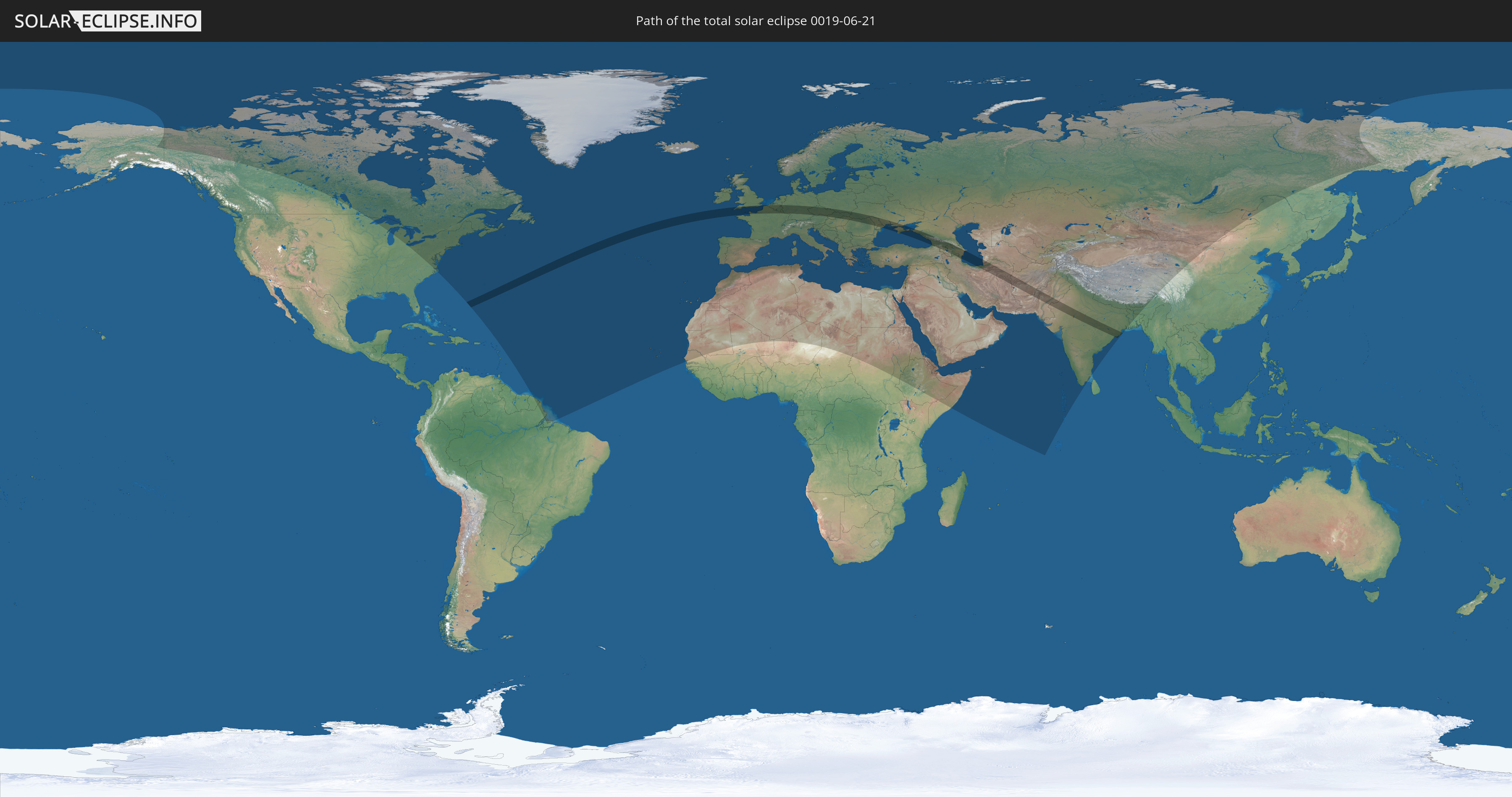
Die Sonnenfinsternis am 21.06.0019 kann man in 107 Ländern als partielle Sonnenfinsternis beobachten.
Der Finsternispfad verläuft durch 26 Länder. Nur in diesen Ländern ist sie als totale Sonnenfinsternis zu sehen.
In den folgenden Ländern ist die Sonnenfinsternis total zu sehen
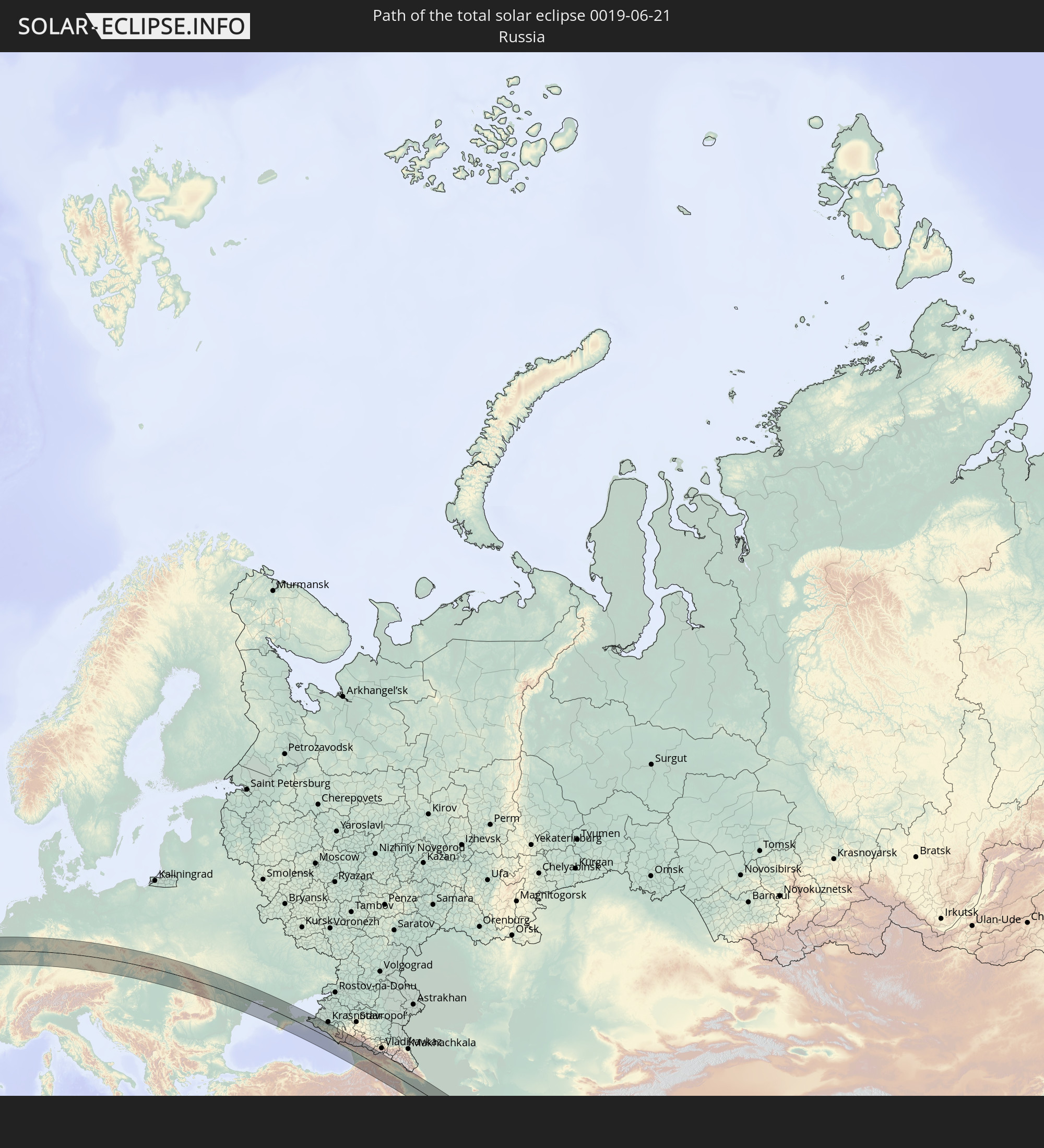 Russland
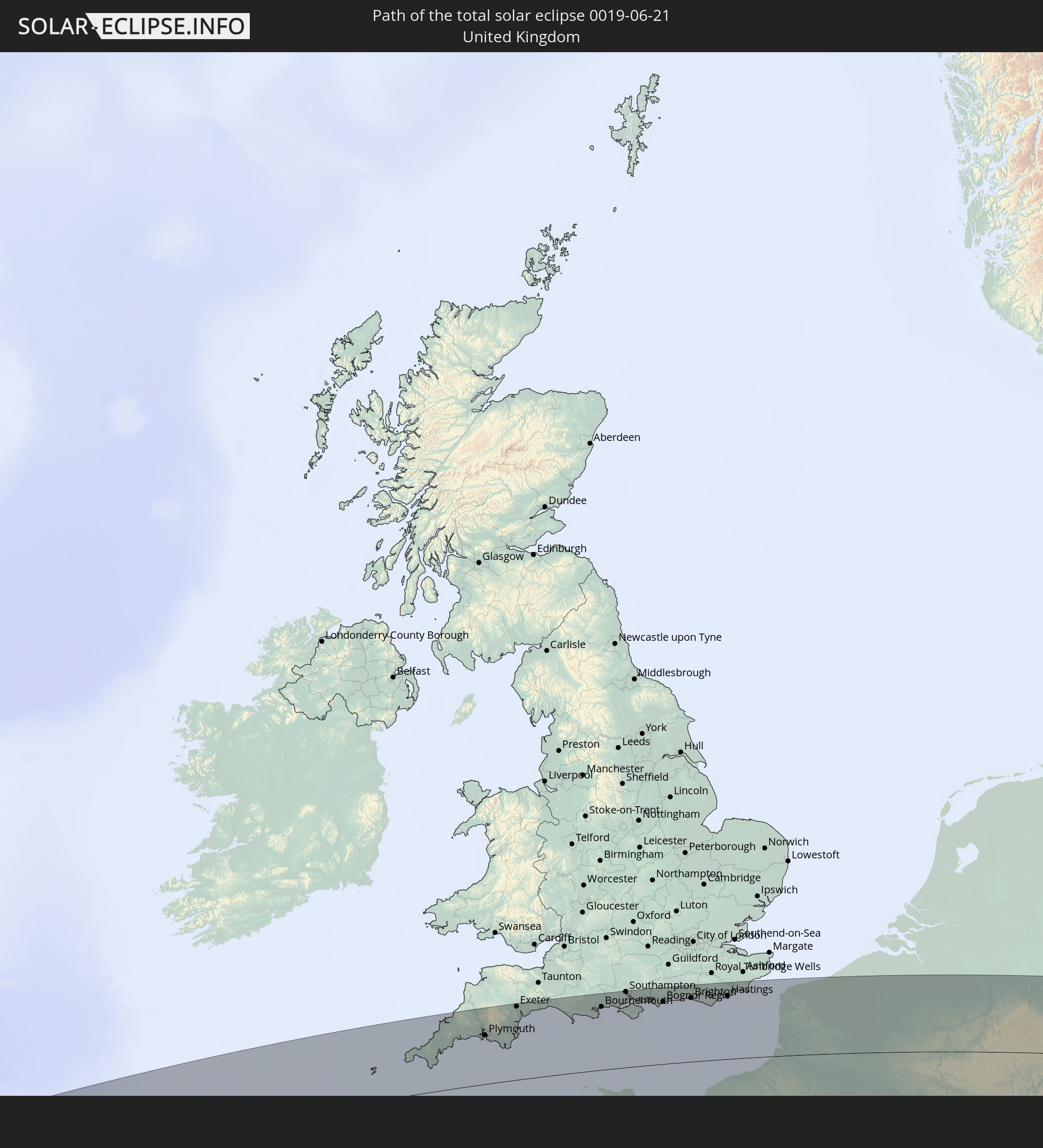 Vereinigtes Königreich
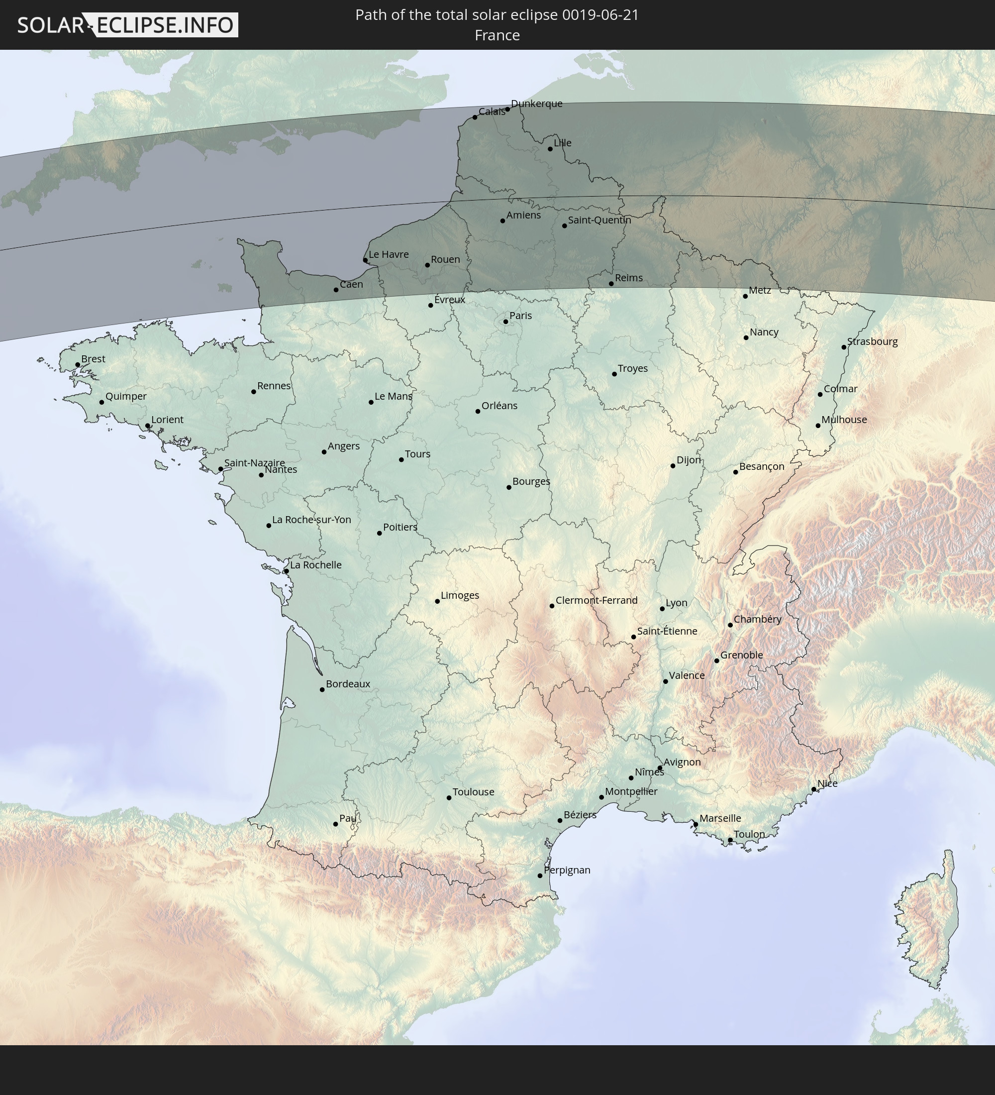 Frankreich
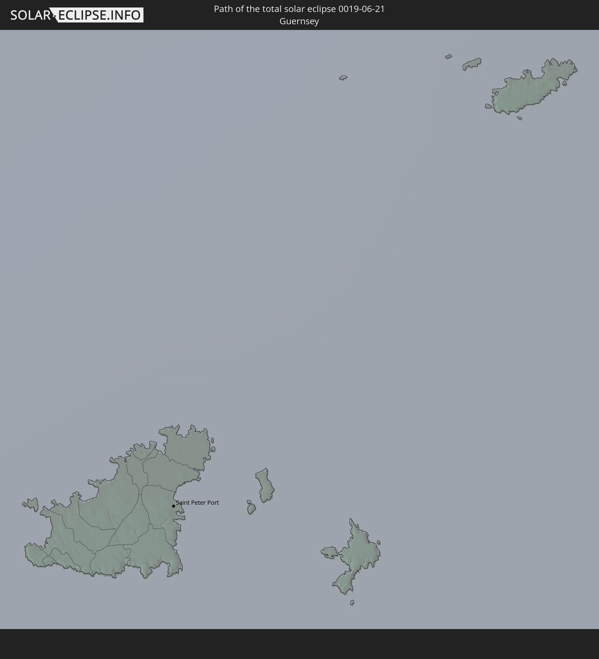 Guernsey
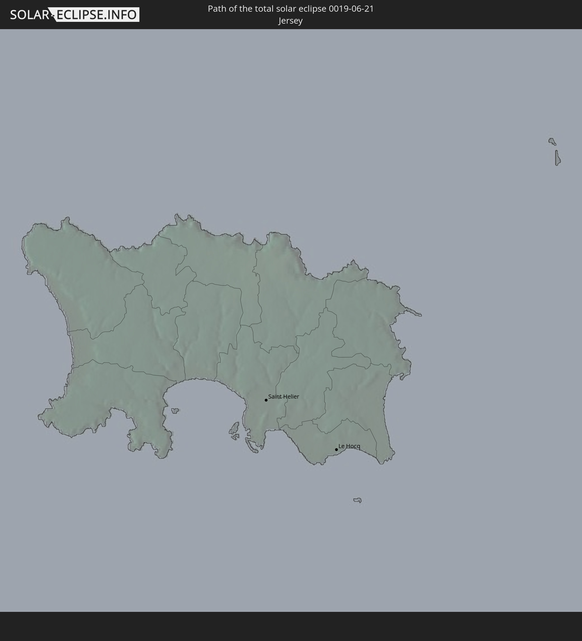 Jersey
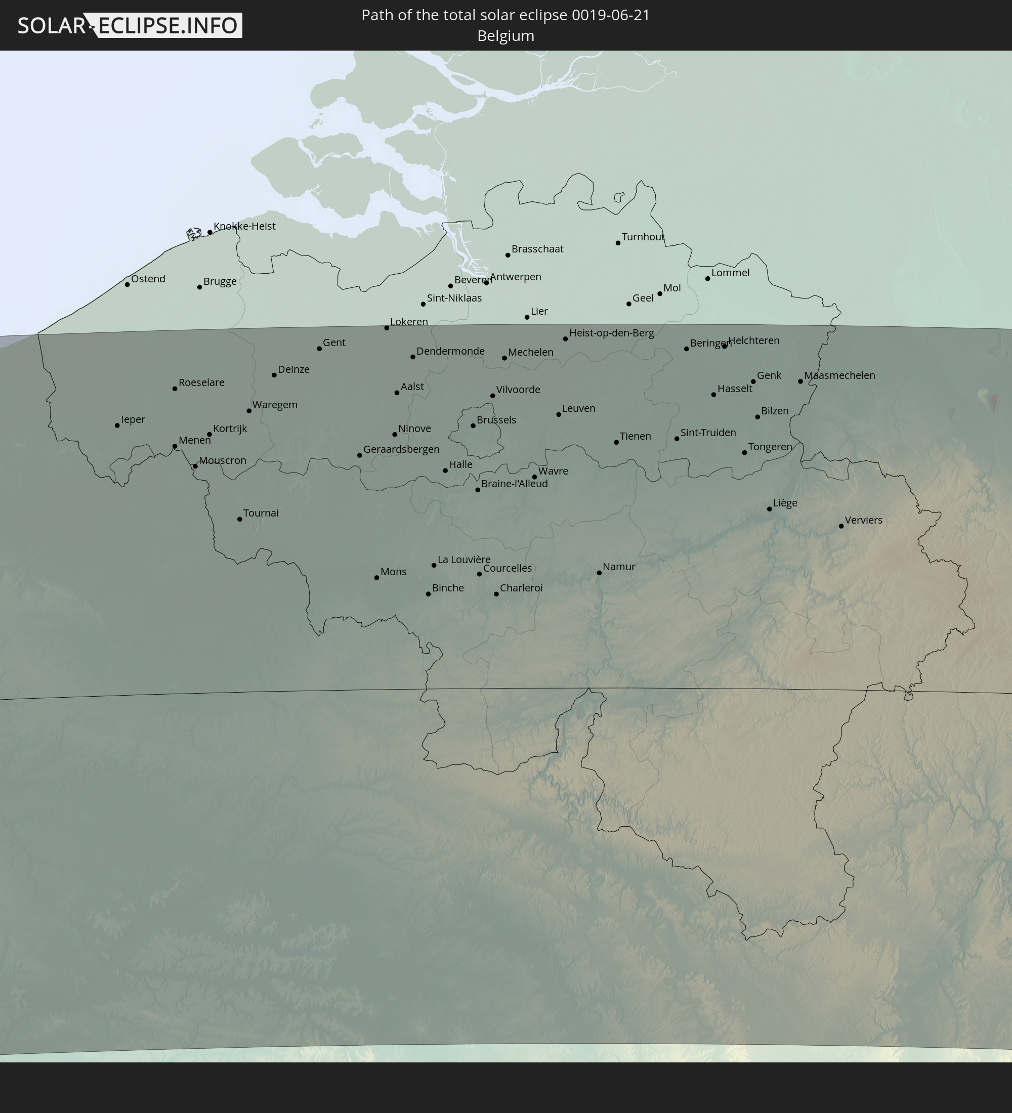 Belgien
 Niederlande
 Luxemburg
 Deutschland
 Österreich
 Tschechien
 Polen
Polen
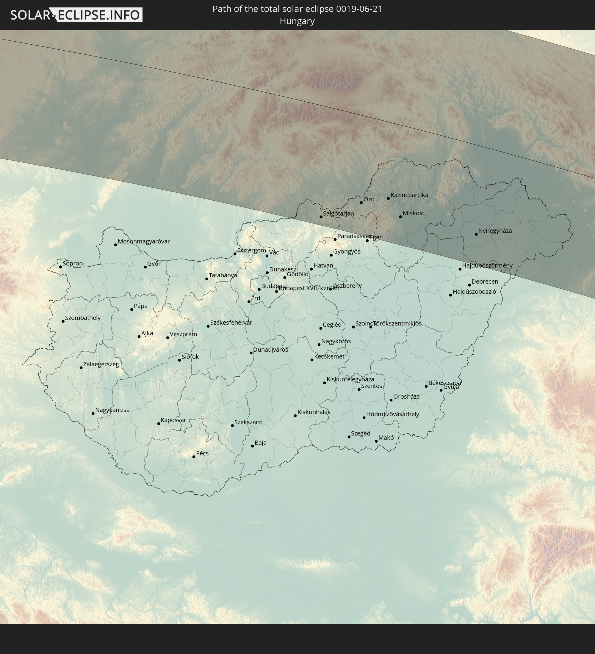 Ungarn
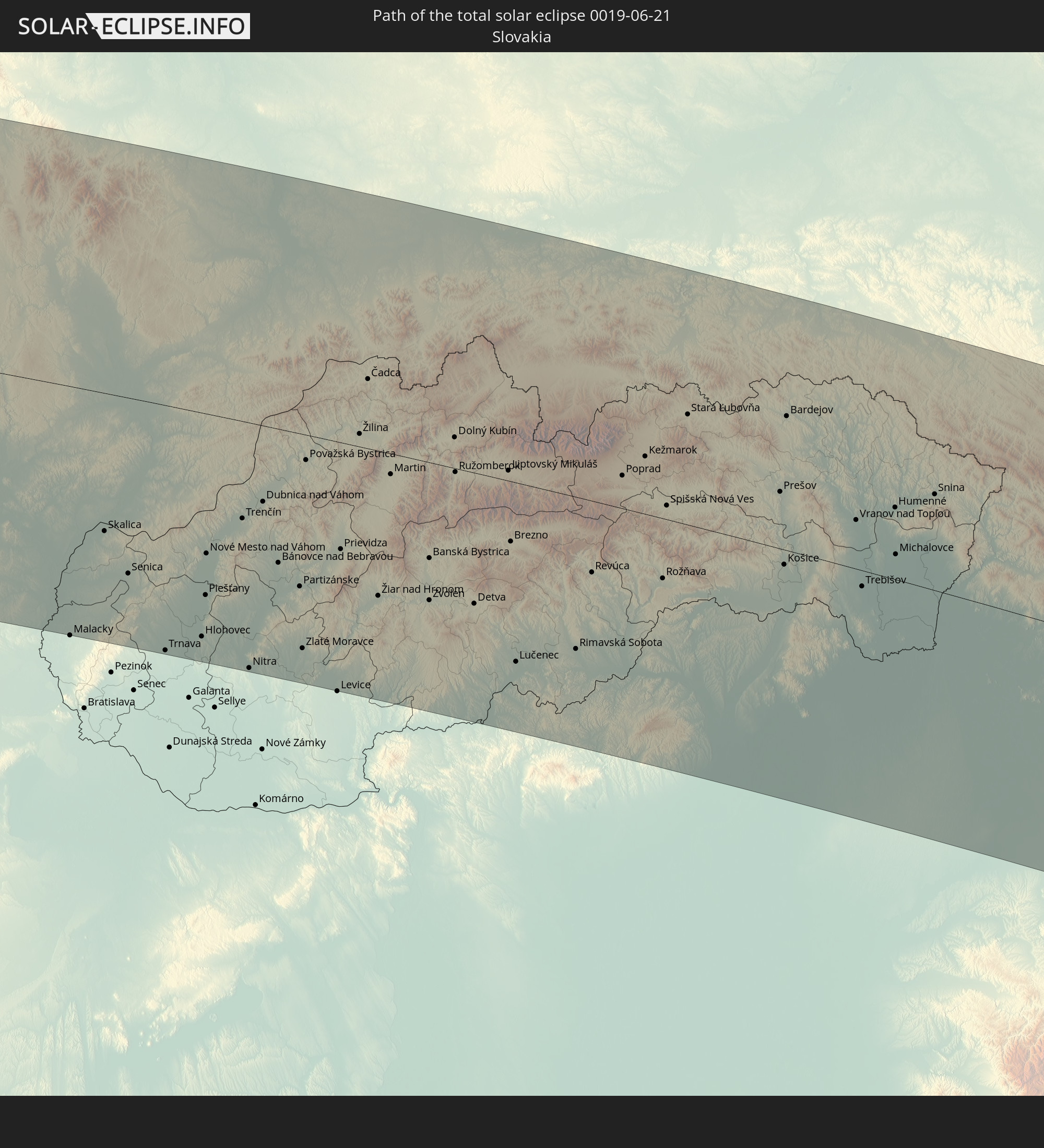 Slowakei
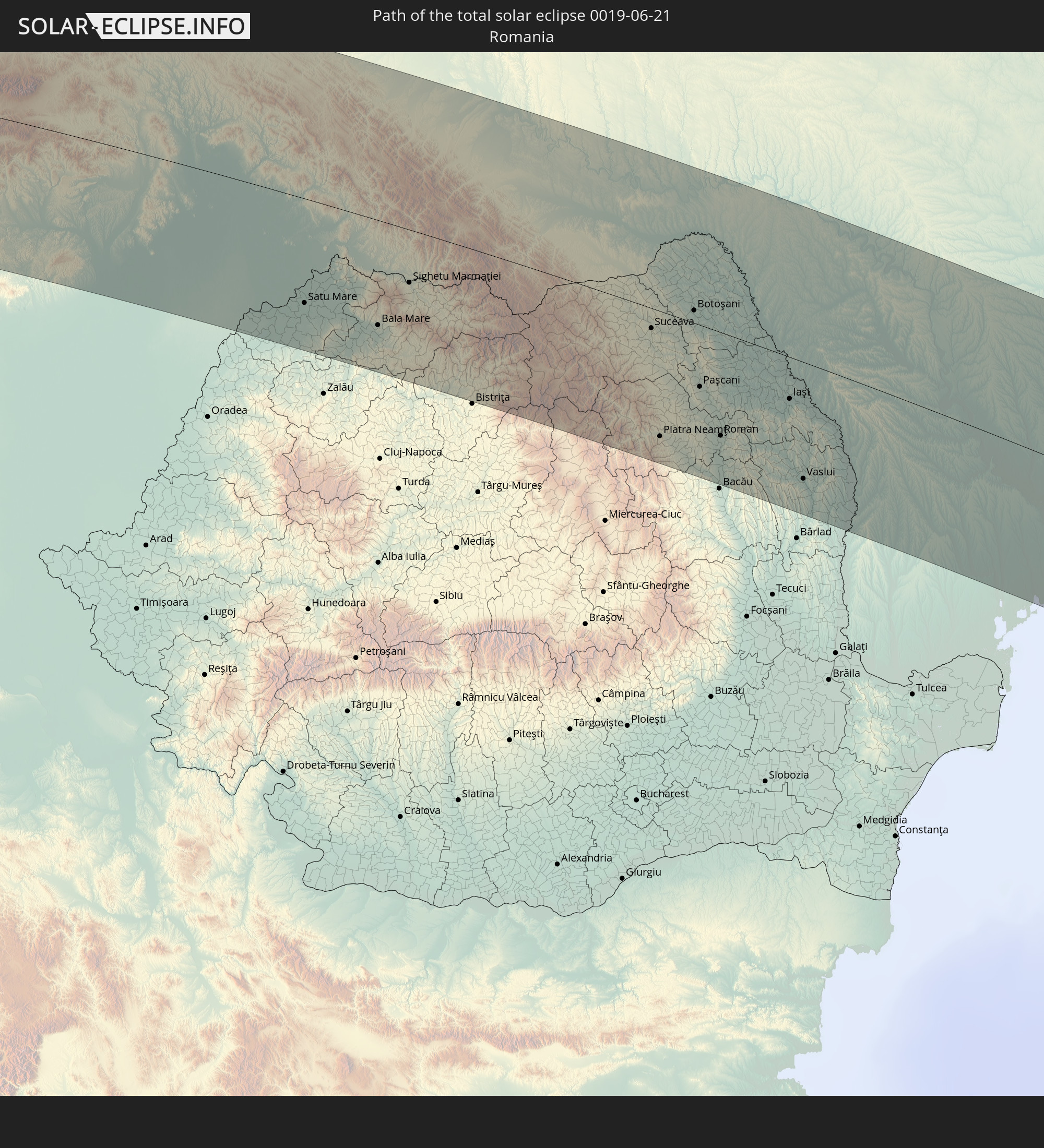 Rumänien
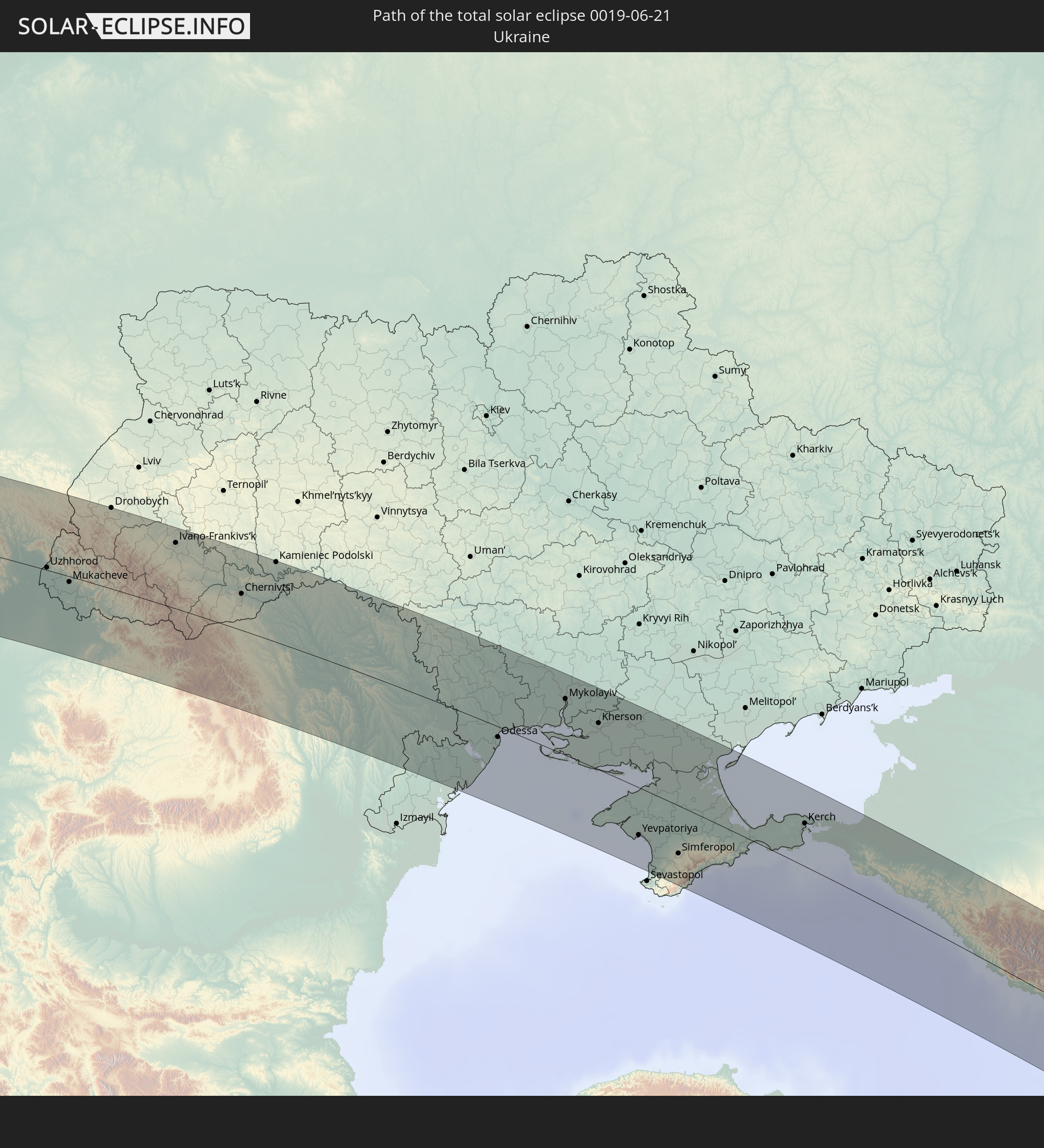 Ukraine
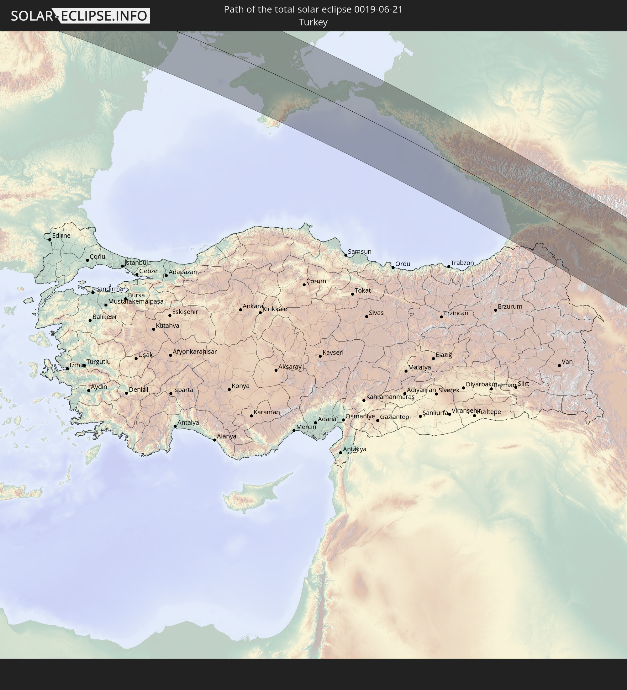 Türkei
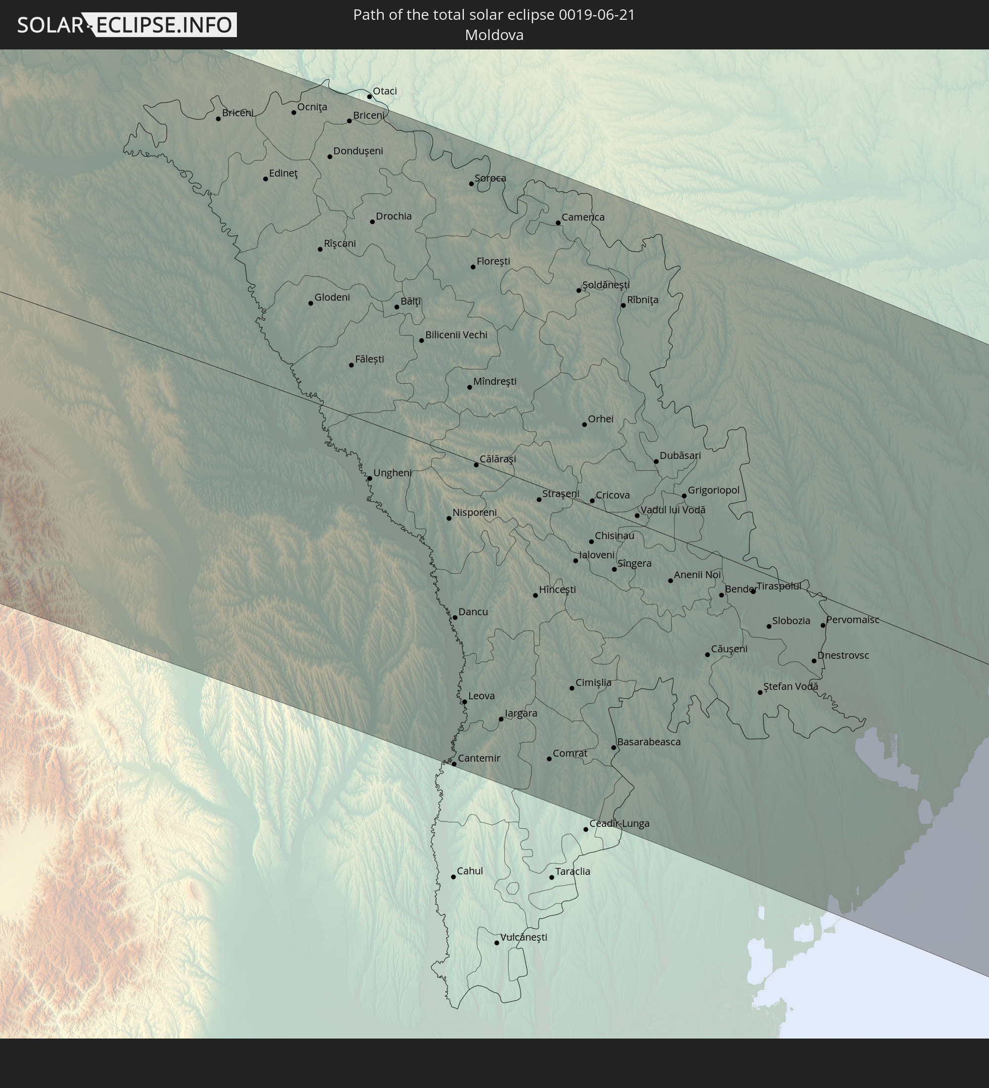 Moldawien
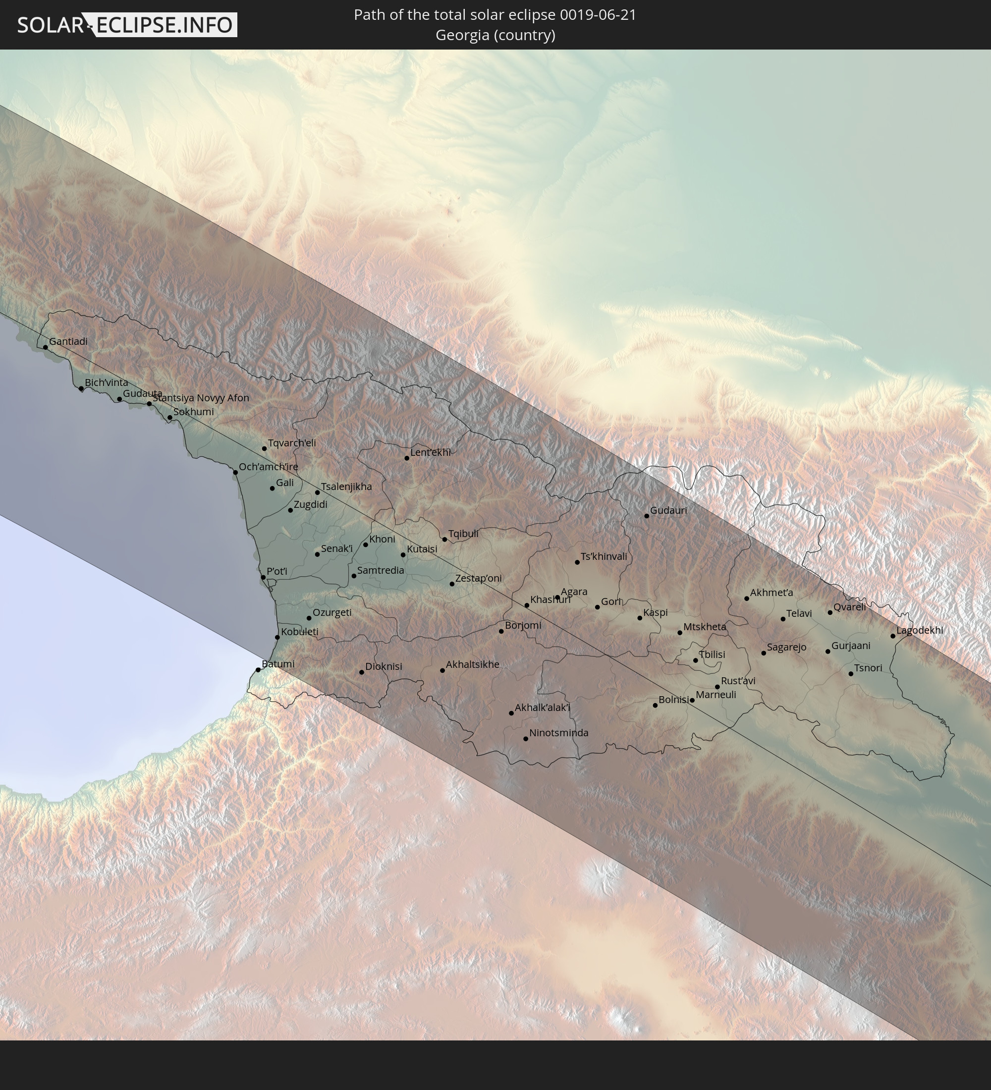 Georgien
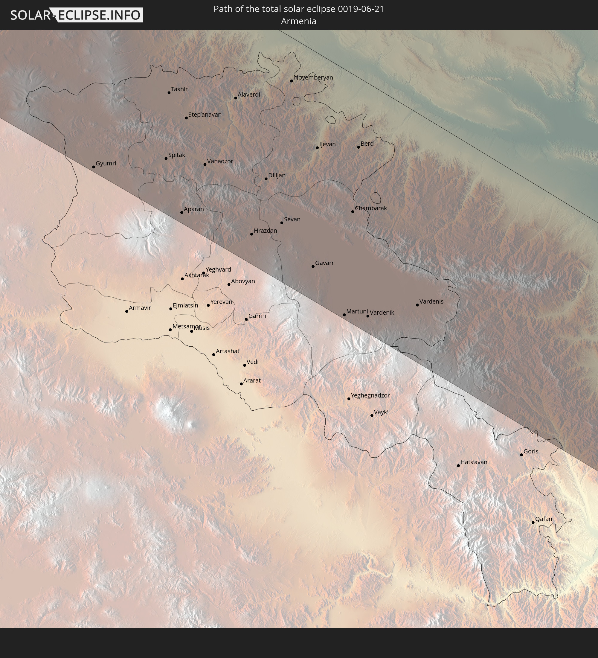 Armenien
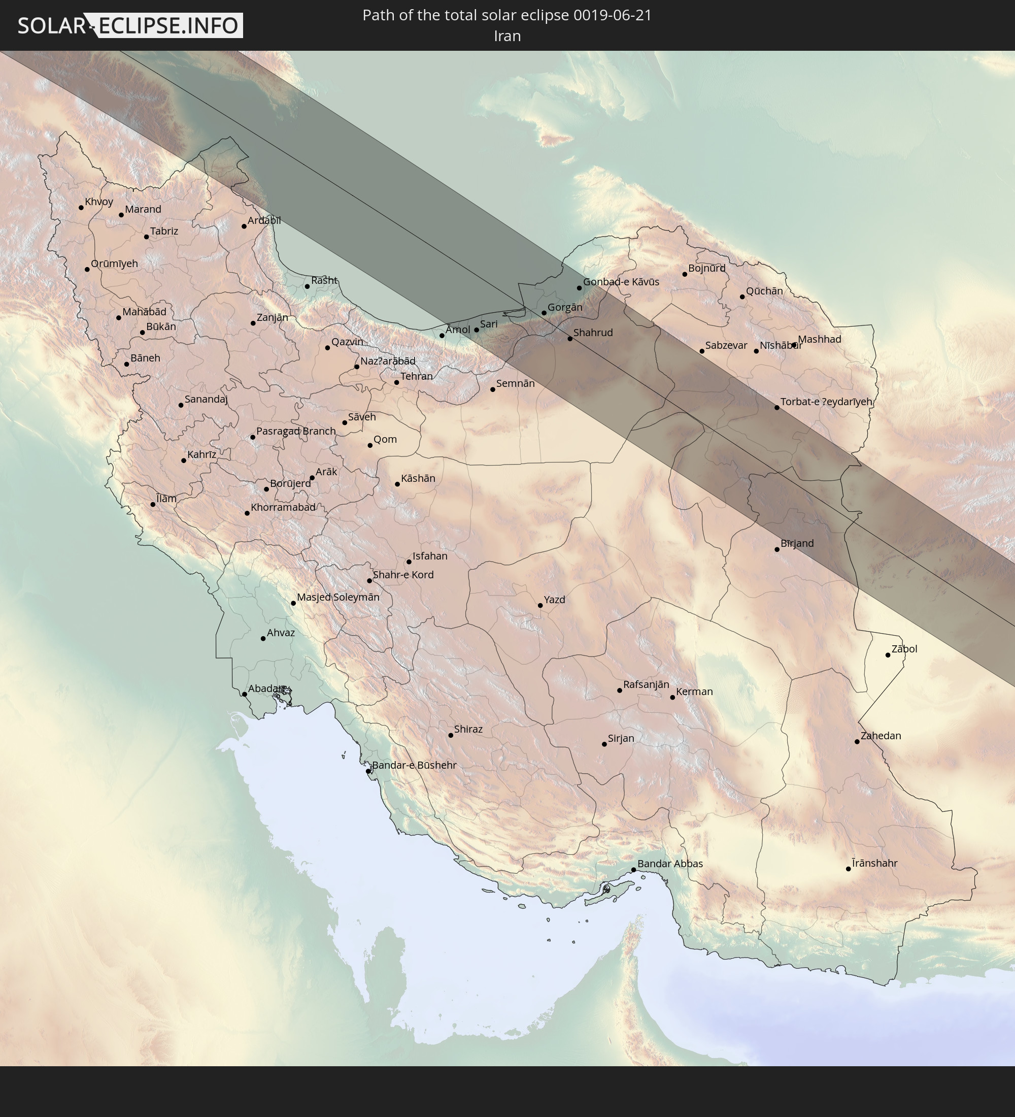 Iran
Iran
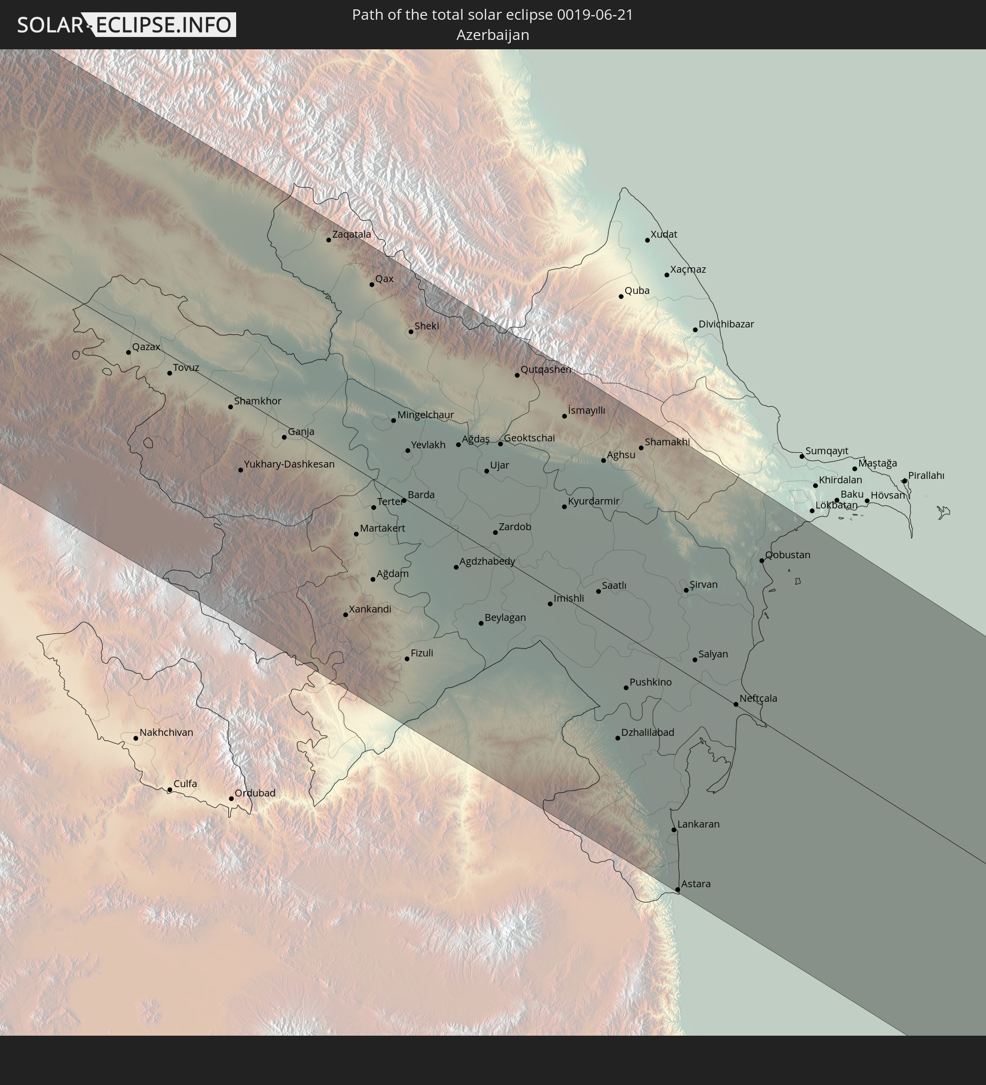 Aserbaidschan
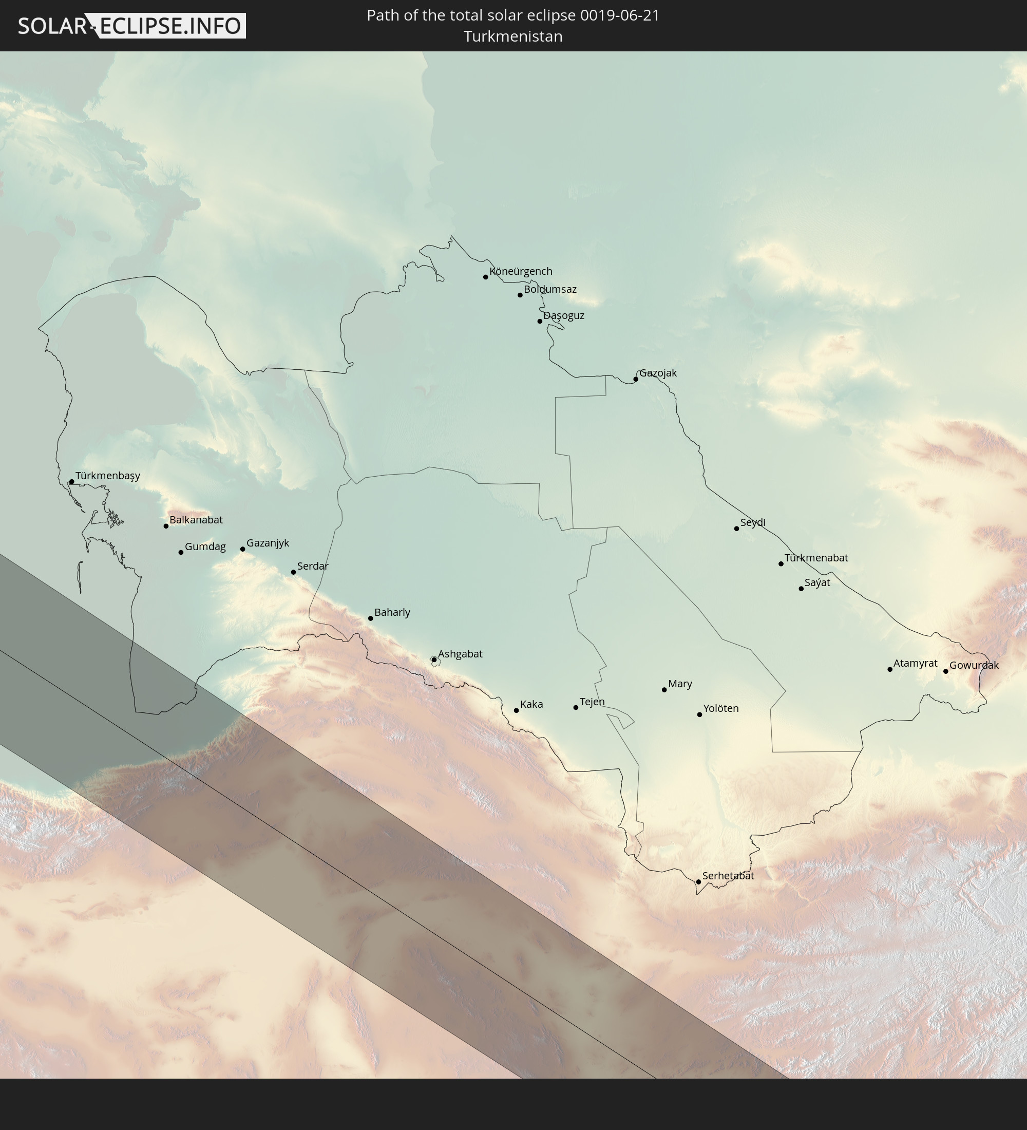 Turkmenistan
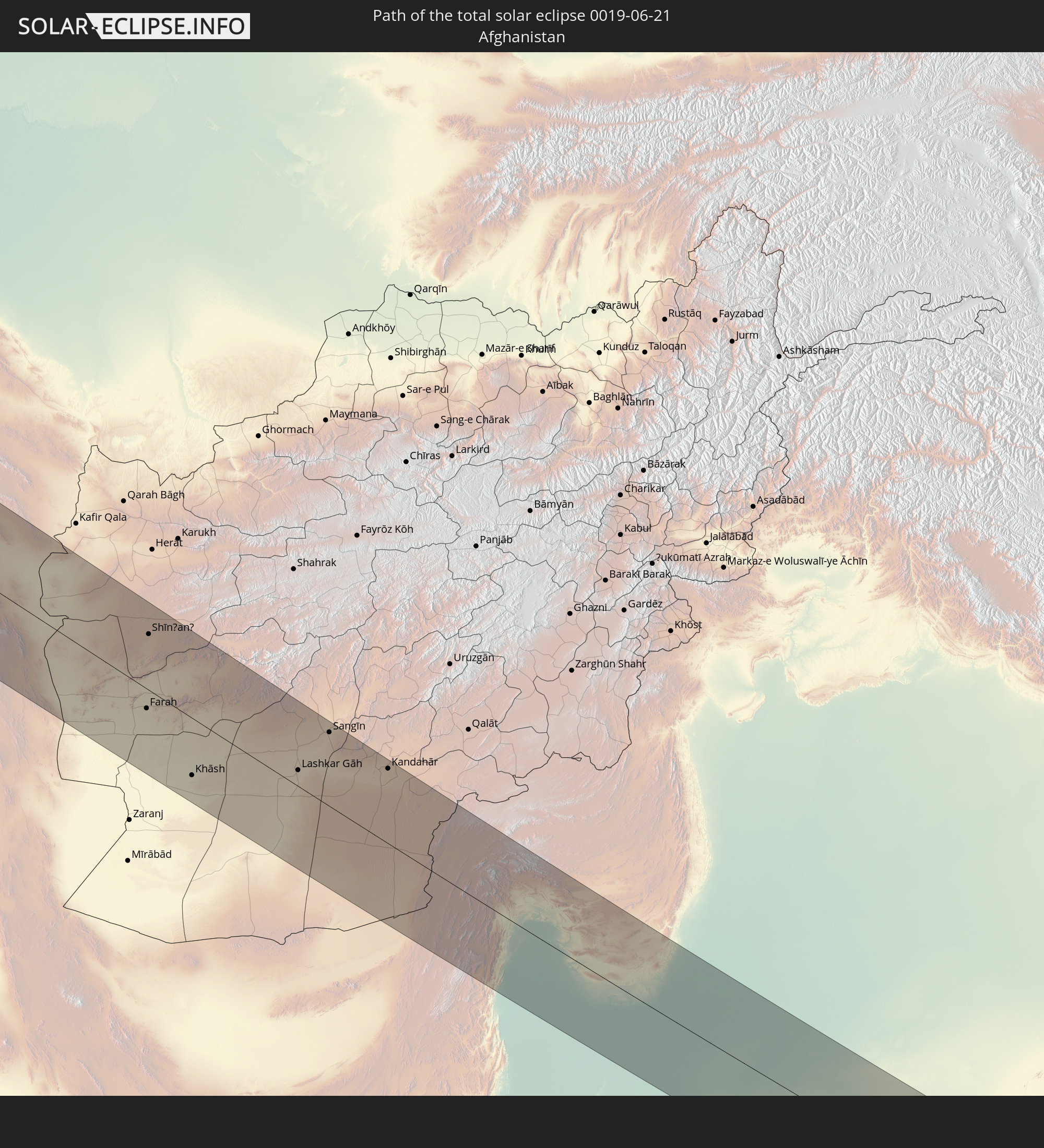 Afghanistan
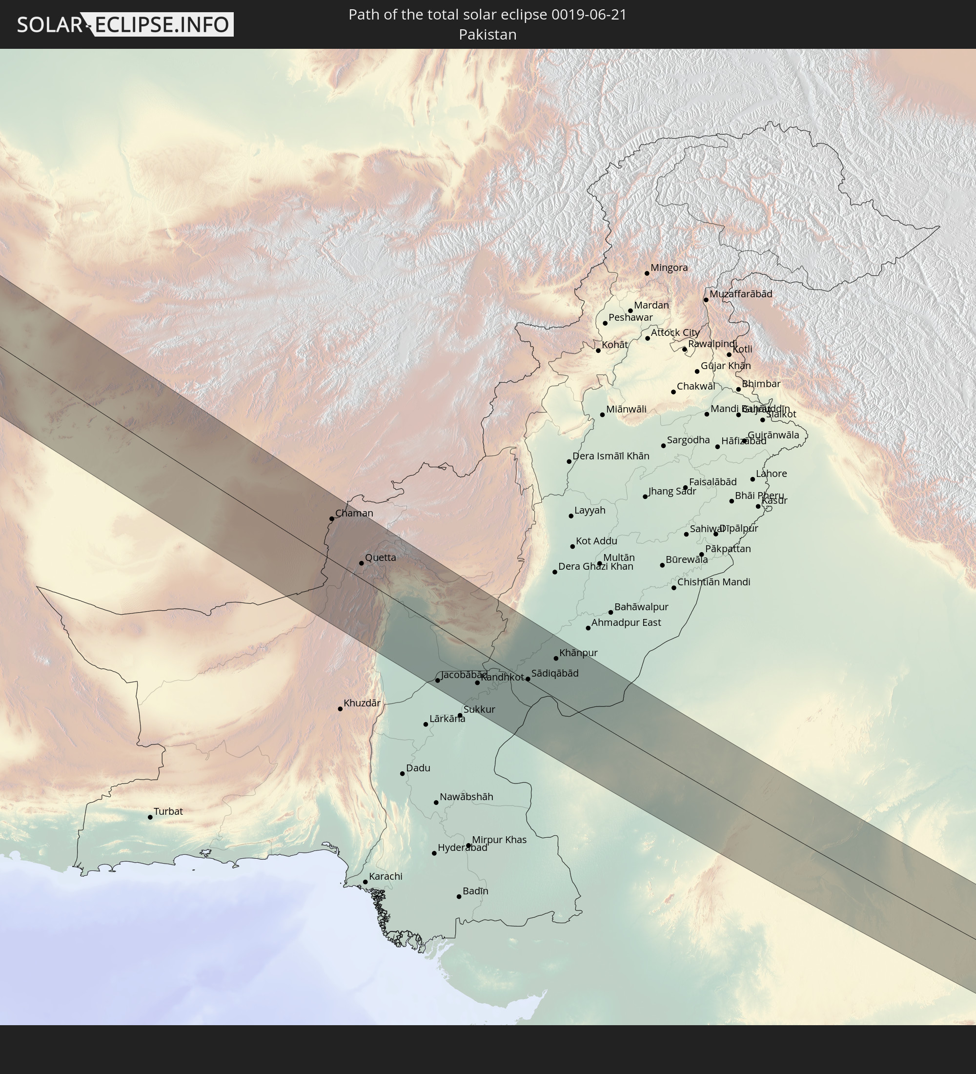 Pakistan
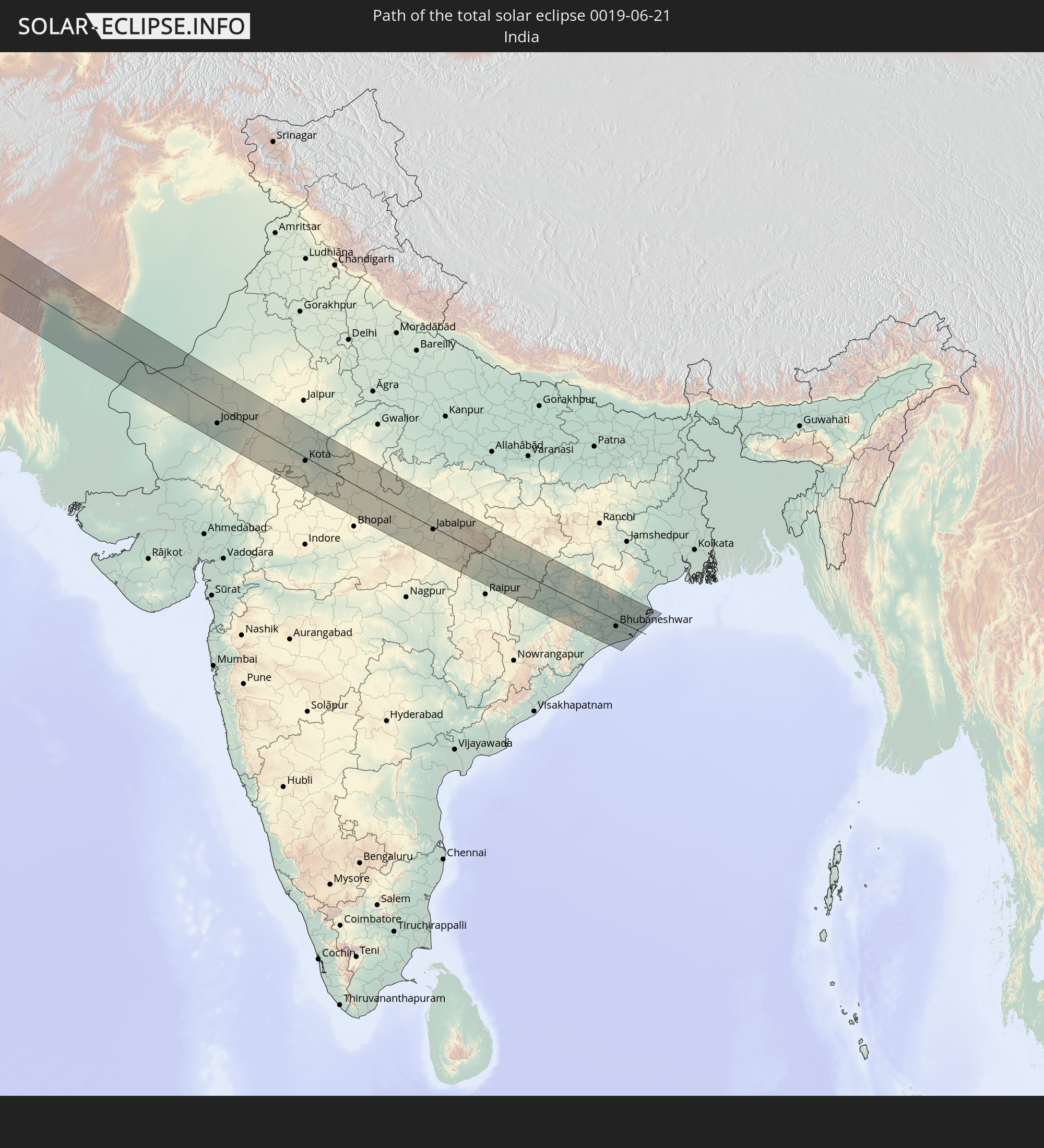 Indien
In den folgenden Ländern ist die Sonnenfinsternis partiell zu sehen
 Russland
 Vereinigte Staaten
 Kanada
 Grönland
 Brasilien
 Bermuda
 Saint-Pierre und Miquelon
 Französisch-Guayana
 Portugal
 Kap Verde
 Island
 Spanien
 Senegal
 Mauretanien
 Marokko
 Mali
Mali
 Irland
 Spitzbergen
 Algerien
 Vereinigtes Königreich
 Färöer
 Gibraltar
 Frankreich
 Isle of Man
 Guernsey
 Jersey
 Niger
Niger
 Andorra
 Belgien
 Niederlande
 Norwegen
 Luxemburg
 Deutschland
 Schweiz
 Italien
 Monaco
 Tunesien
 Dänemark
 Libyen
 Liechtenstein
 Österreich
 Schweden
 Tschechien
 San Marino
 Vatikanstadt
 Slowenien
 Tschad
 Kroatien
 Polen
Polen
 Malta
Malta
 Bosnien und Herzegowina
 Ungarn
 Slowakei
 Montenegro
 Serbien
 Albanien
 Åland Islands
 Griechenland
 Rumänien
 Mazedonien
 Finnland
 Litauen
 Lettland
 Estland
 Sudan
Sudan
 Ukraine
 Bulgarien
 Weißrussland
 Ägypten
 Türkei
 Moldawien
 Republik Zypern
 Äthiopien
 Staat Palästina
 Israel
 Saudi-Arabien
 Jordanien
 Libanon
 Syrien
 Eritrea
 Irak
Irak
 Georgien
 Somalia
 Dschibuti
 Jemen
Jemen
 Armenien
 Iran
Iran
 Aserbaidschan
 Kasachstan
 Kuwait
 Bahrain
 Katar
Katar
 Vereinigte Arabische Emirate
 Oman
Oman
 Turkmenistan
 Usbekistan
 Afghanistan
 Pakistan
 Tadschikistan
 Indien
 Kirgisistan
 Malediven
 Volksrepublik China
 Nepal
Nepal
 Mongolei
 Bangladesch
 Bhutan
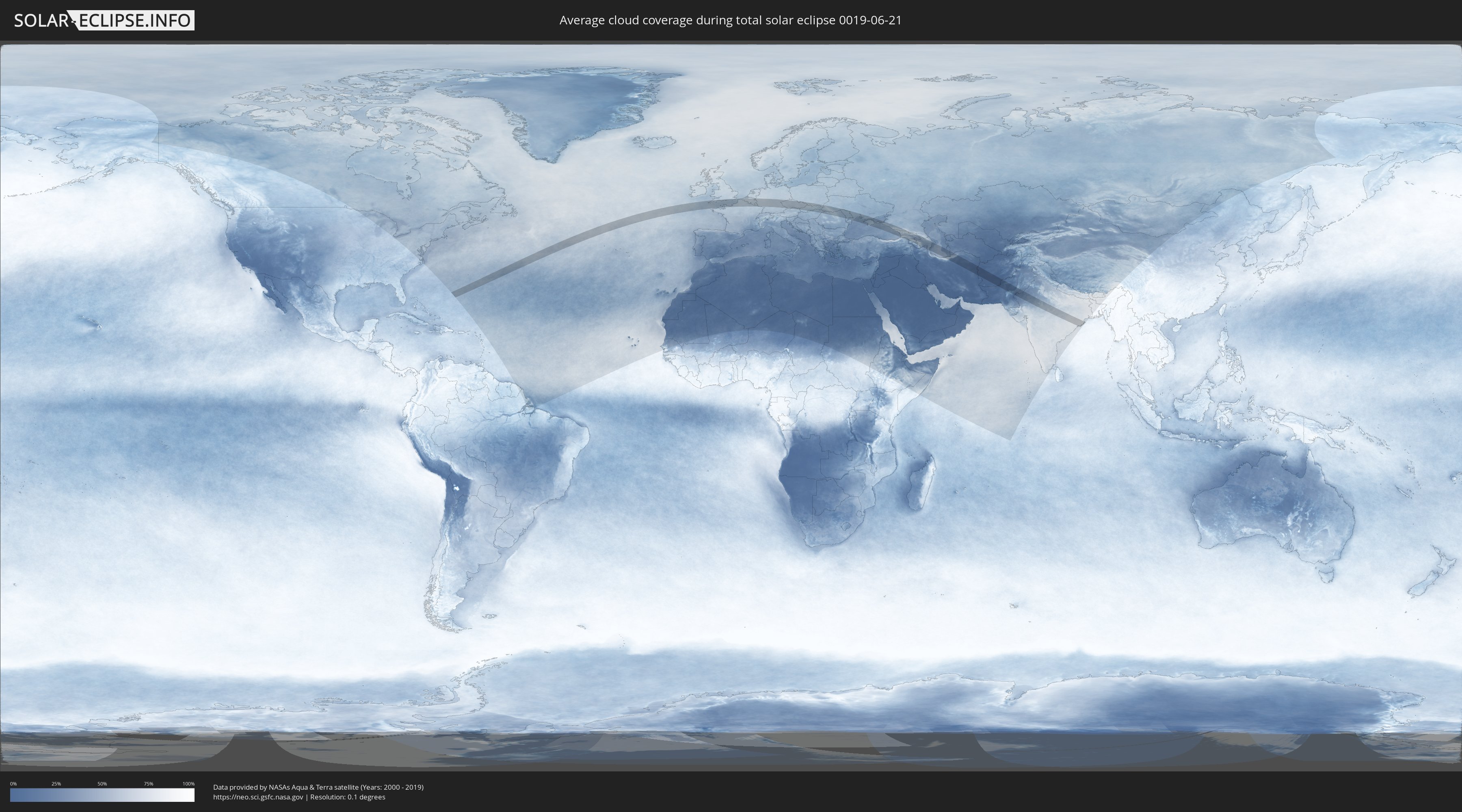
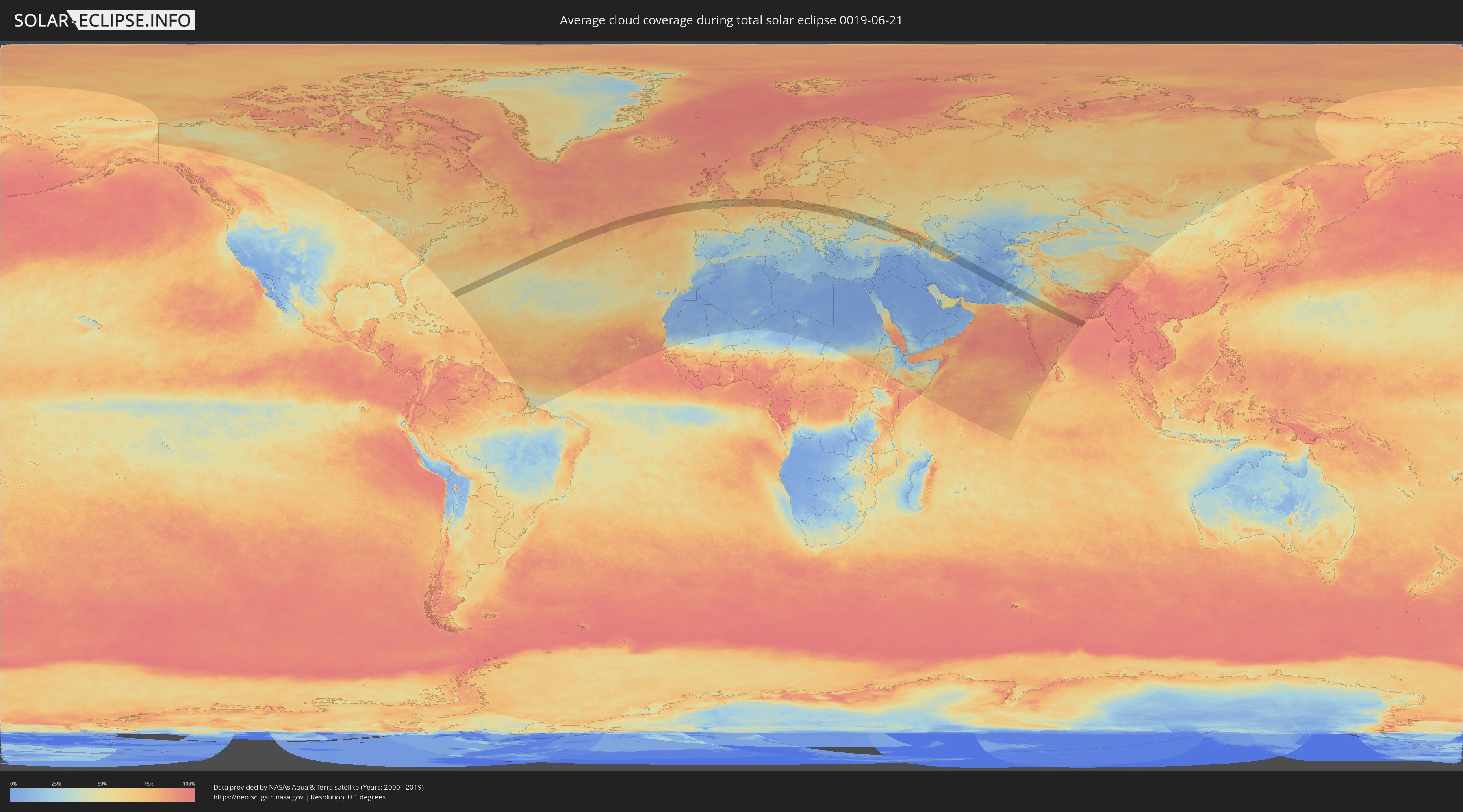
Wie wird das Wetter während der totalen Sonnenfinsternis am 21.06.0019?
Wo ist der beste Ort, um die totale Sonnenfinsternis vom 21.06.0019 zu beobachten?
Die folgenden Karten zeigen die durchschnittliche Bewölkung für den Tag, an dem die totale Sonnenfinsternis
stattfindet. Mit Hilfe der Karten lässt sich der Ort entlang des Finsternispfades eingrenzen,
der die besten Aussichen auf einen klaren wolkenfreien Himmel bietet.
Trotzdem muss man immer lokale Gegenenheiten beachten und sollte sich genau über das Wetter an seinem
gewählten Beobachtungsort informieren.
Die Daten stammen von den beiden NASA-Satelliten
AQUA und TERRA
und wurden über einen Zeitraum von 19 Jahren (2000 - 2019) gemittelt.
Detaillierte Länderkarten
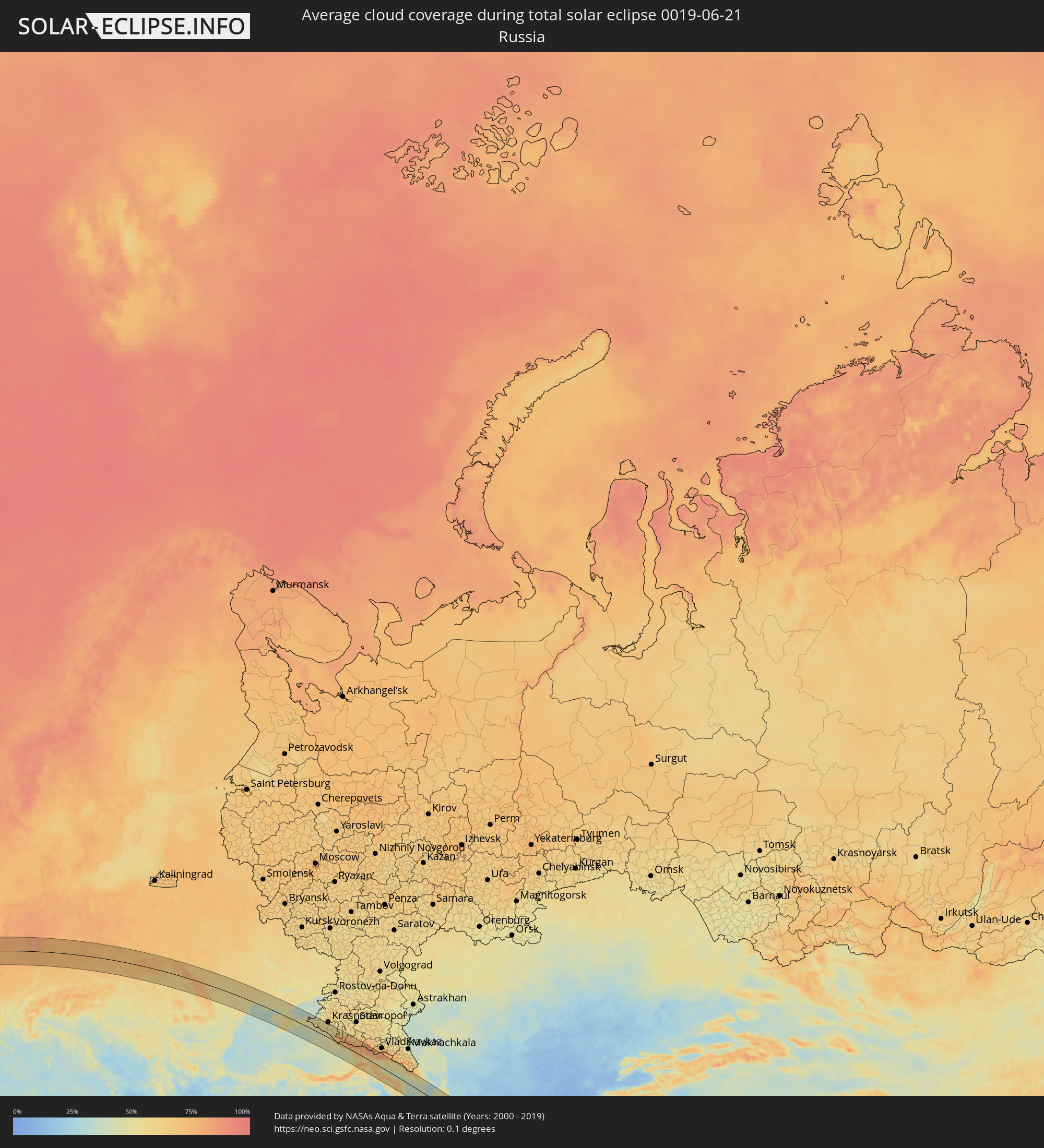 Russland
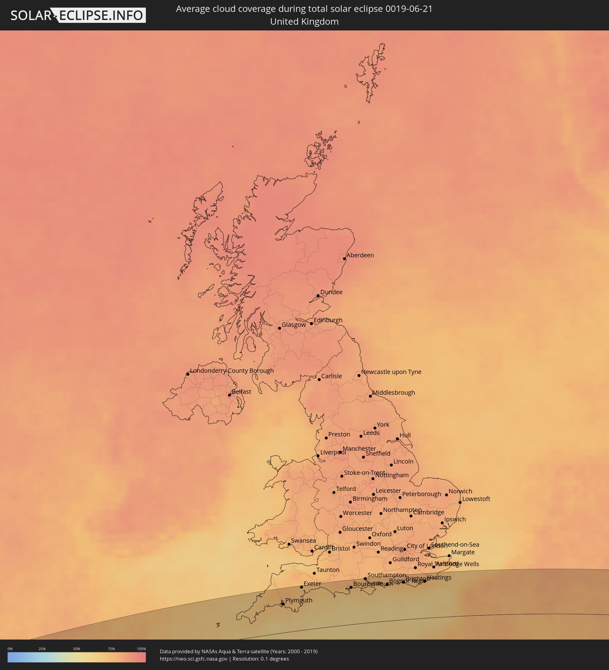 Vereinigtes Königreich
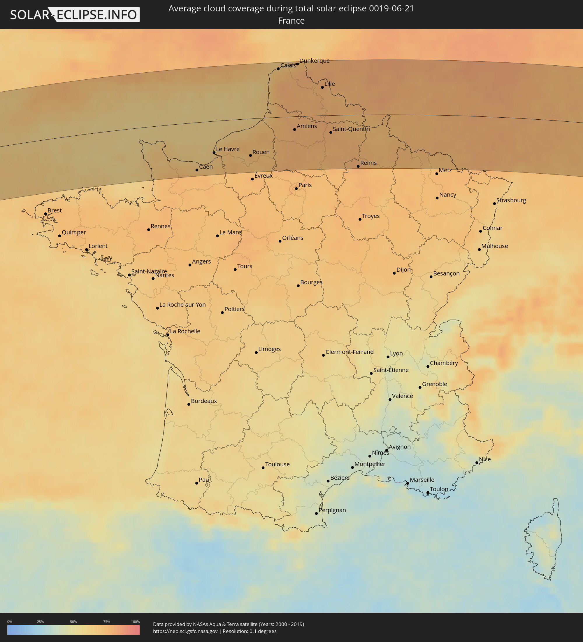 Frankreich
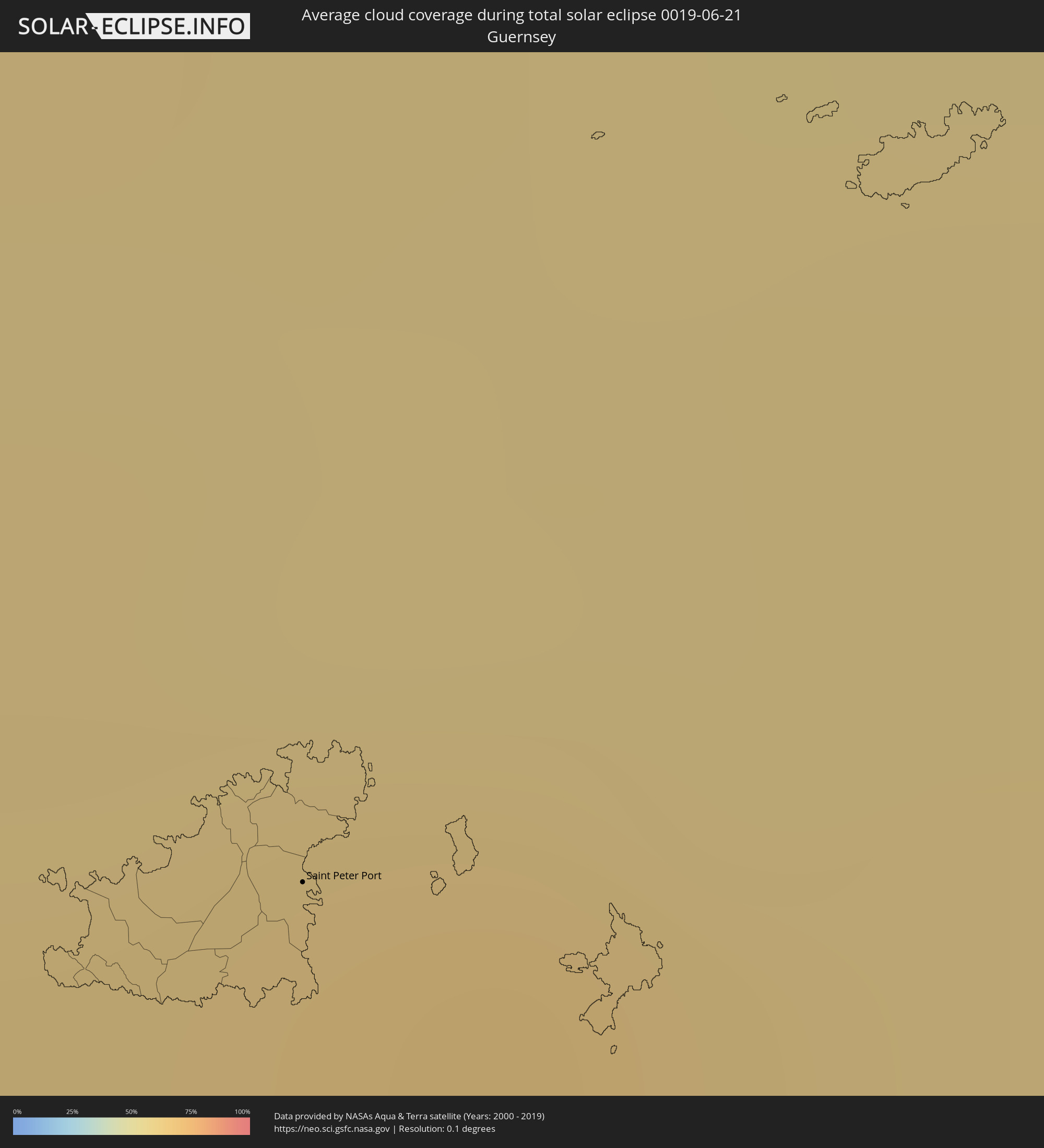 Guernsey
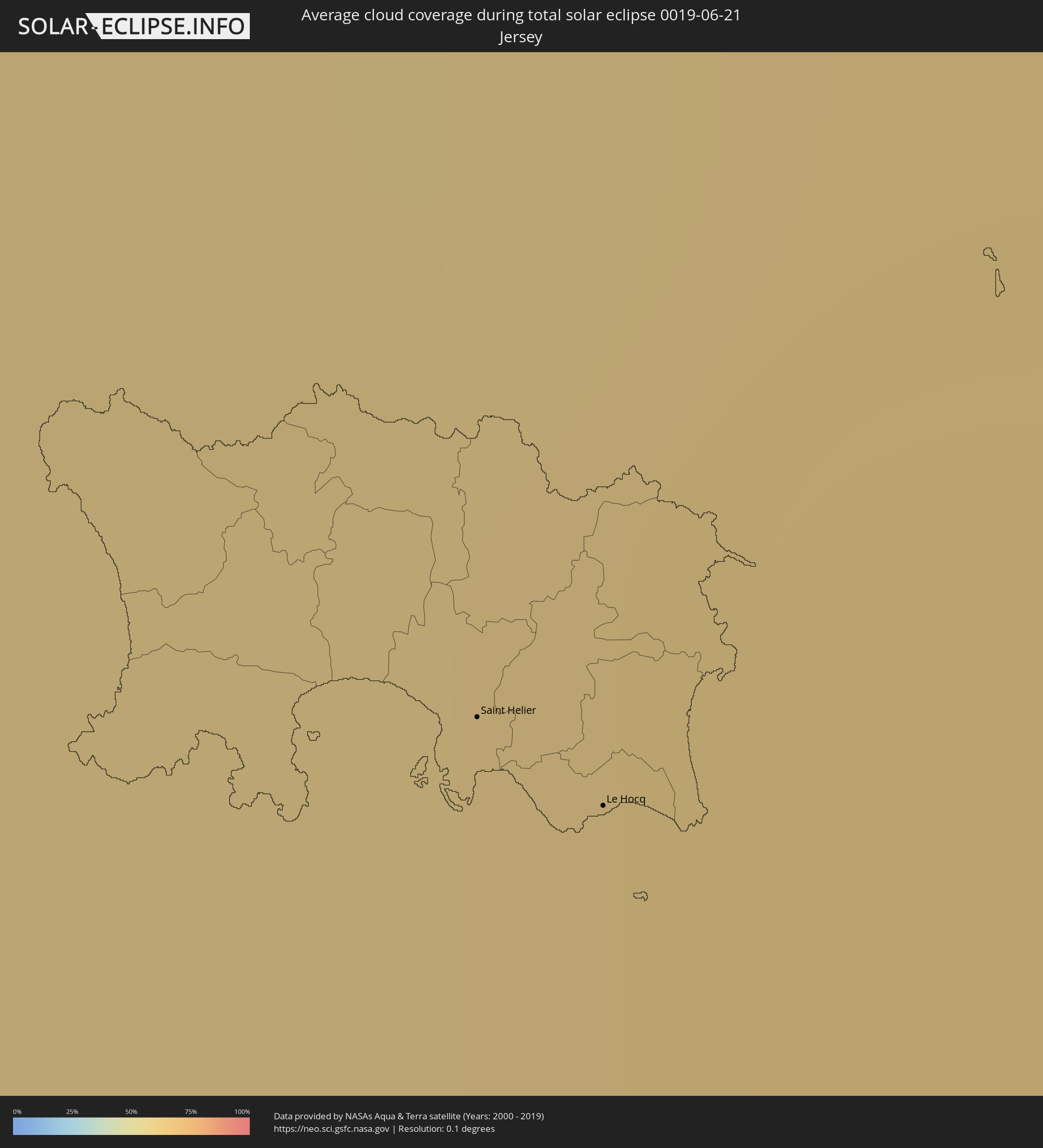 Jersey
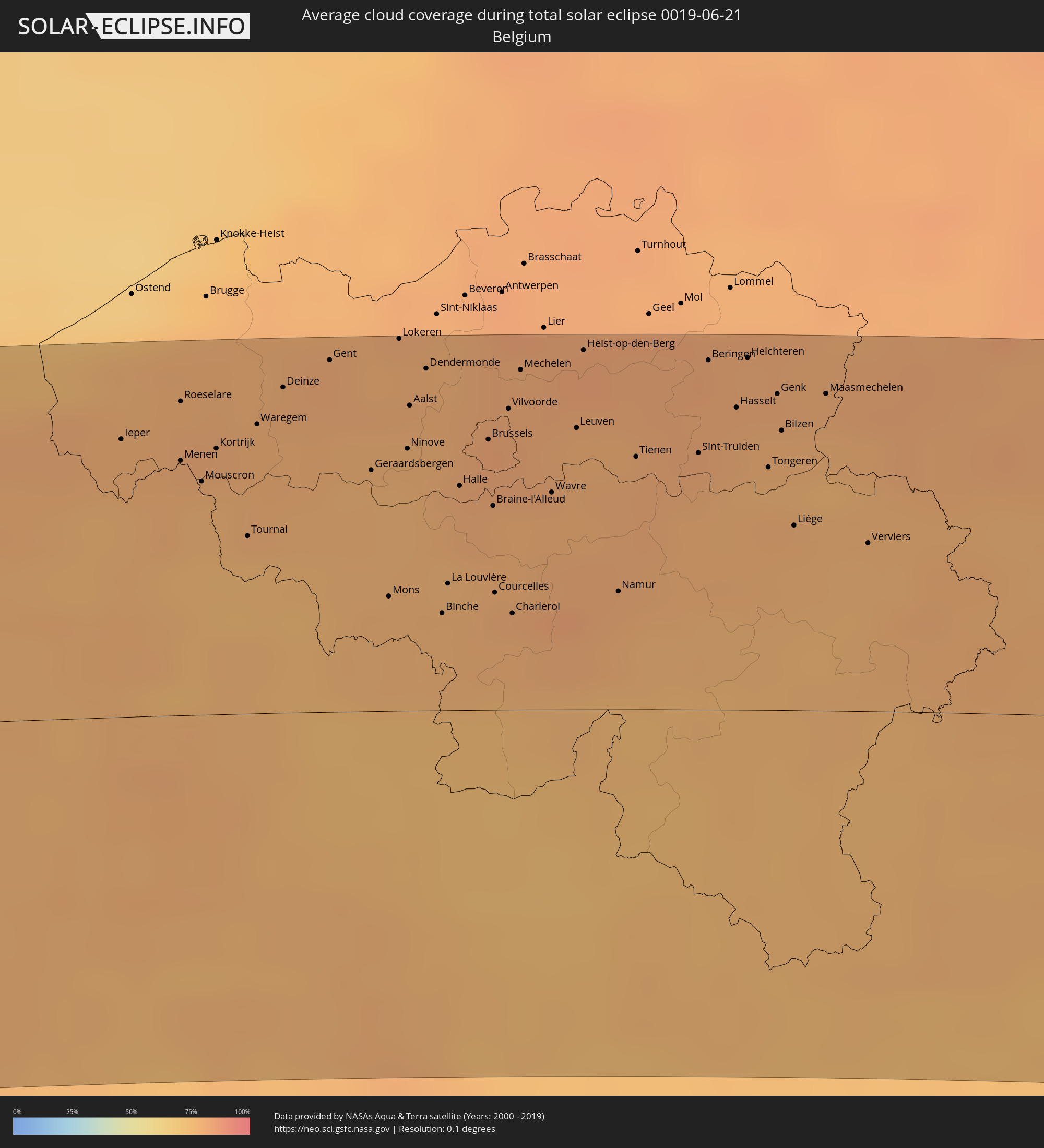 Belgien
 Niederlande
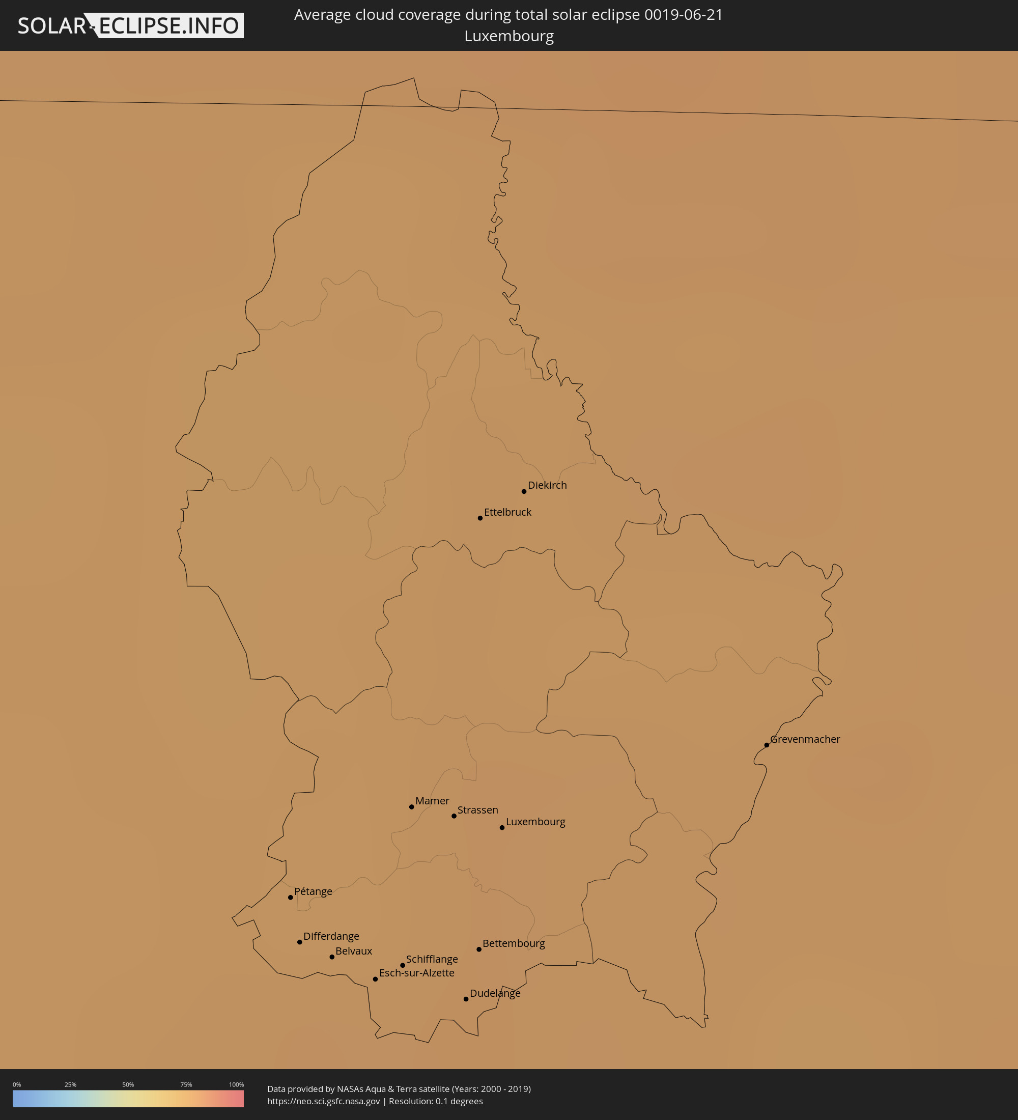 Luxemburg
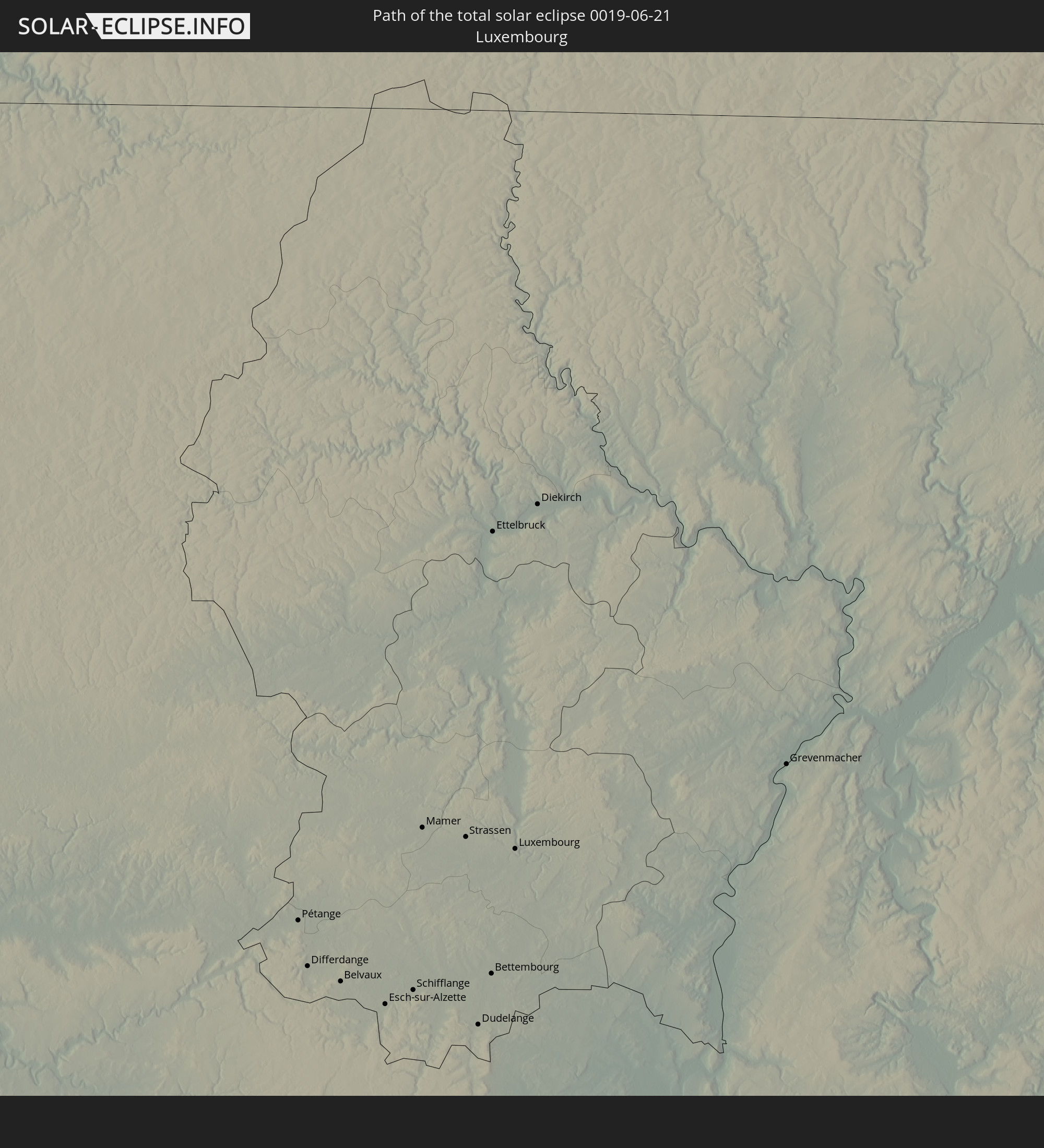
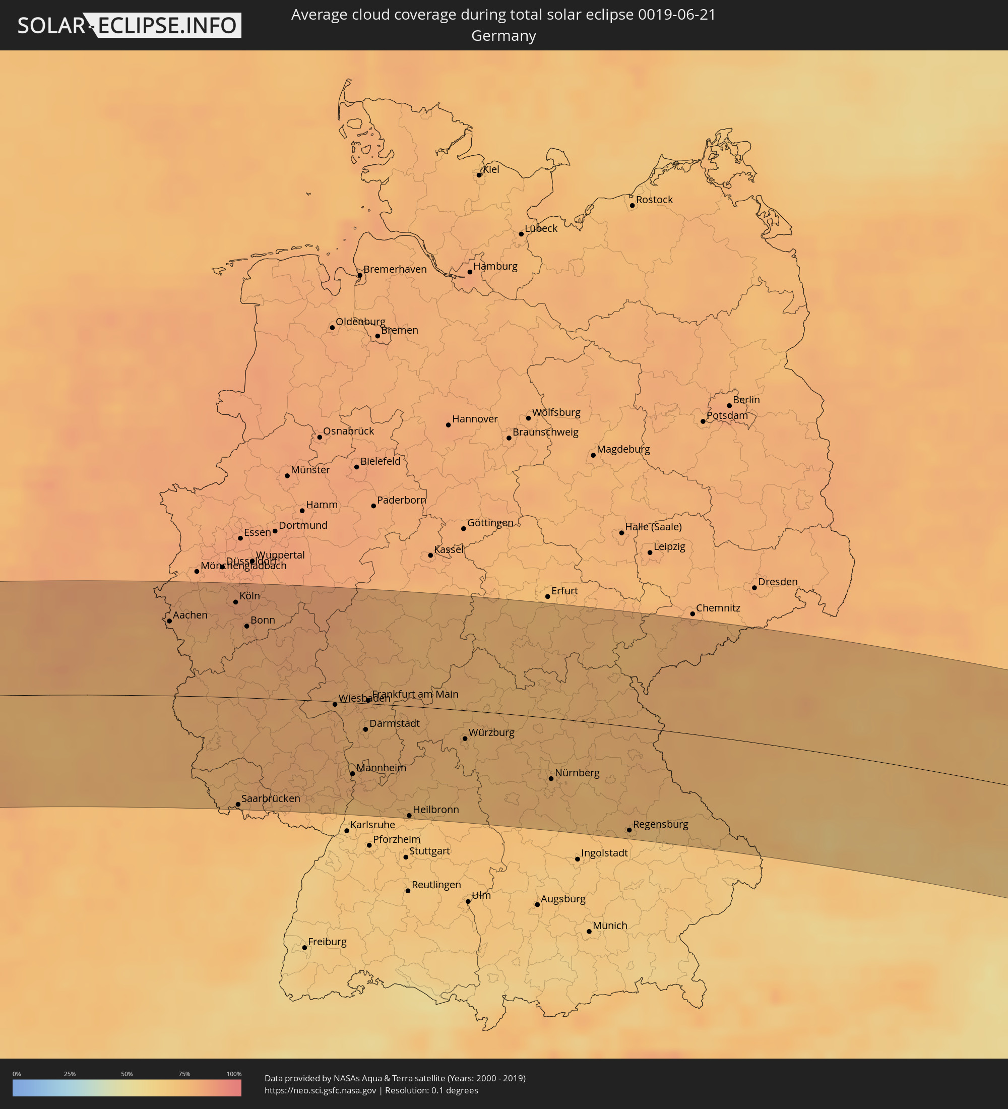 Deutschland
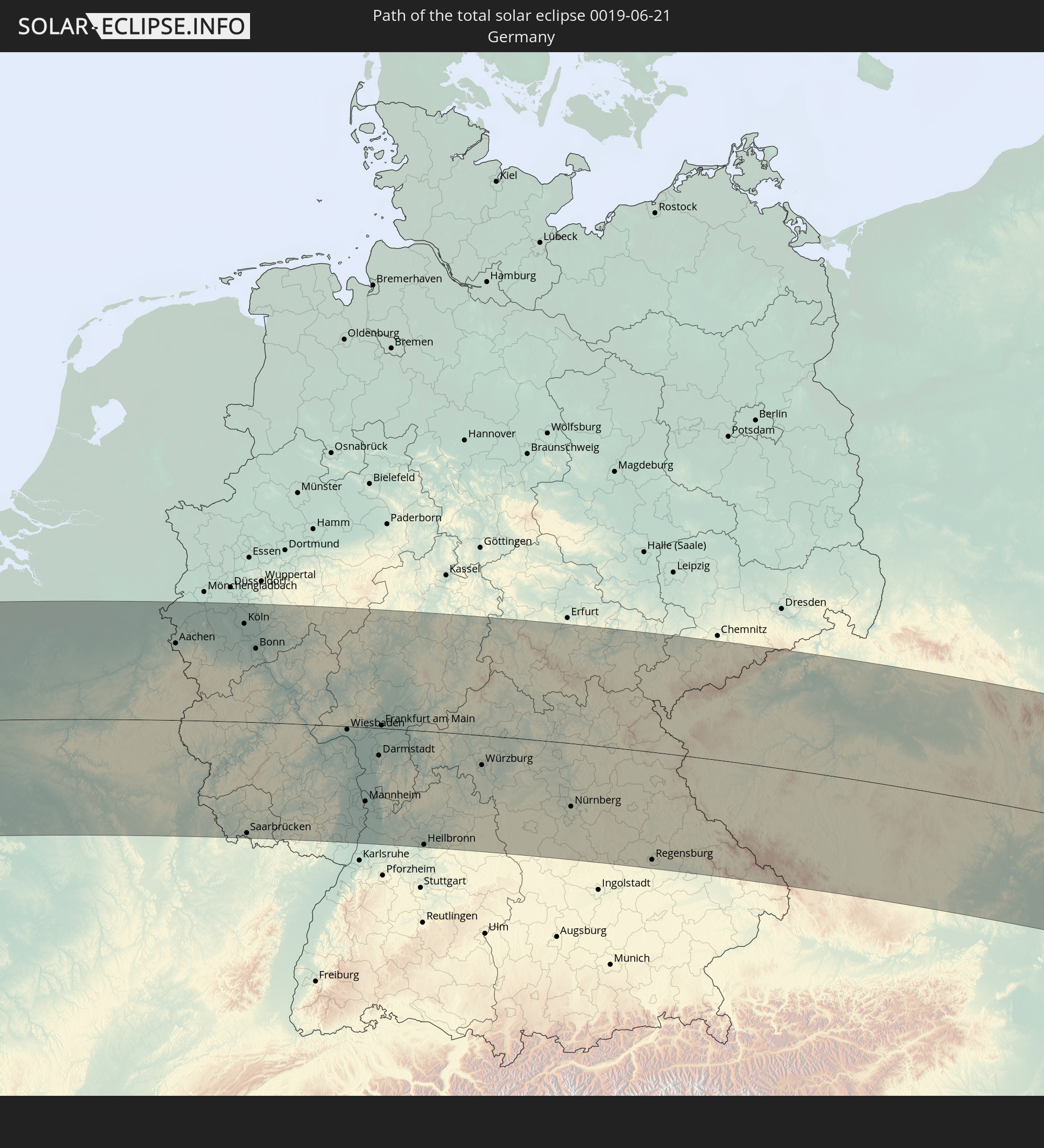
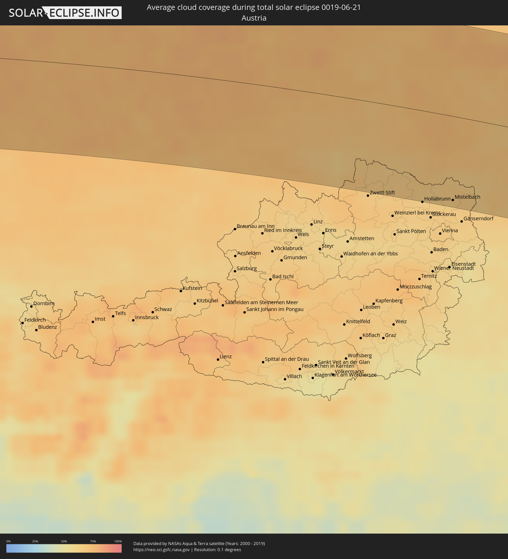 Österreich
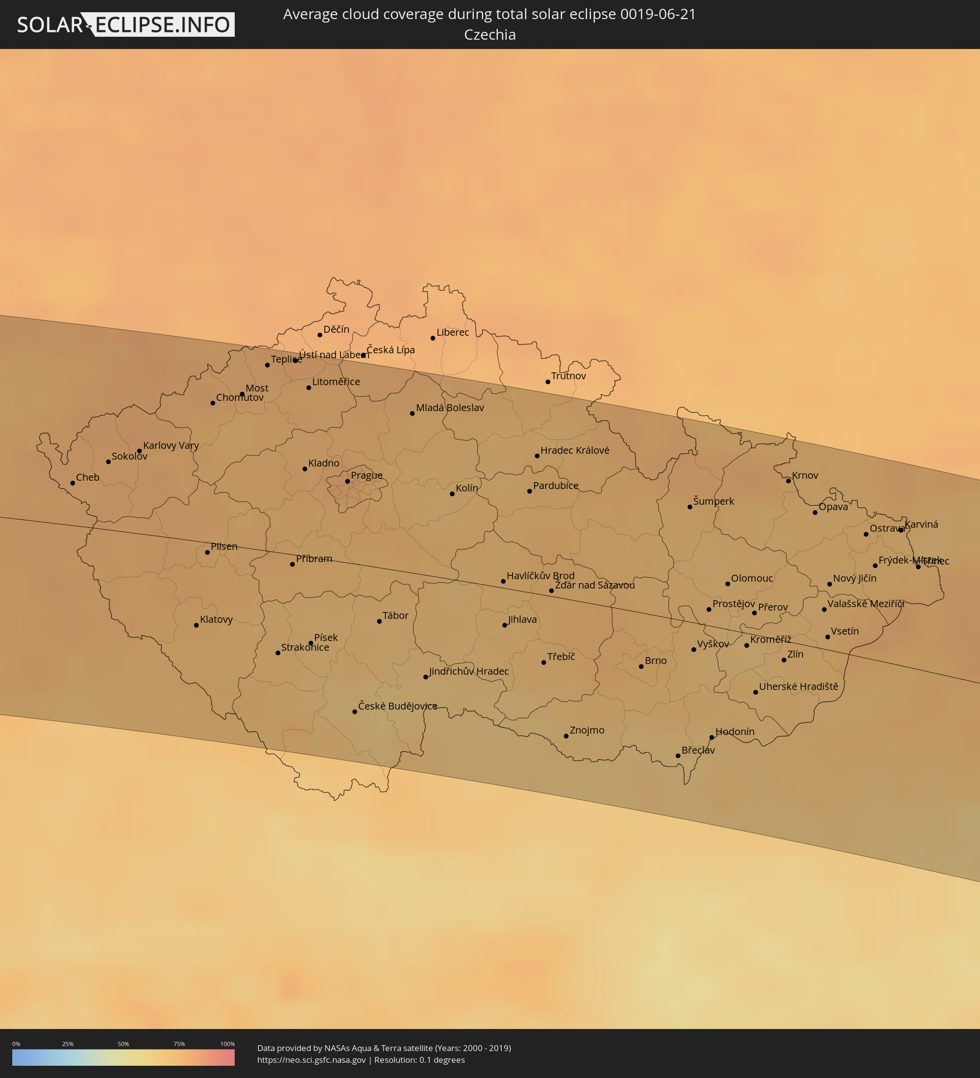 Tschechien
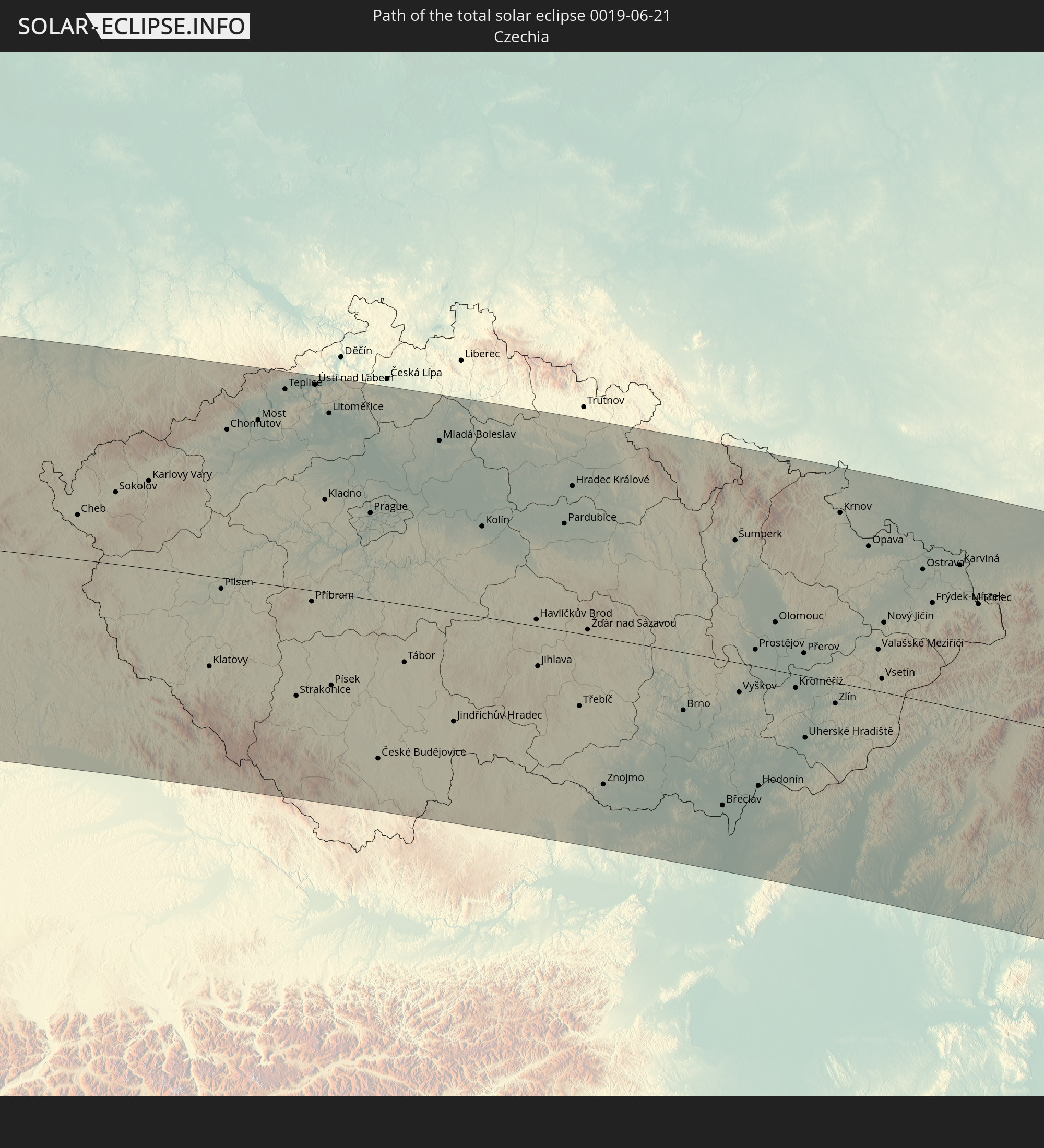
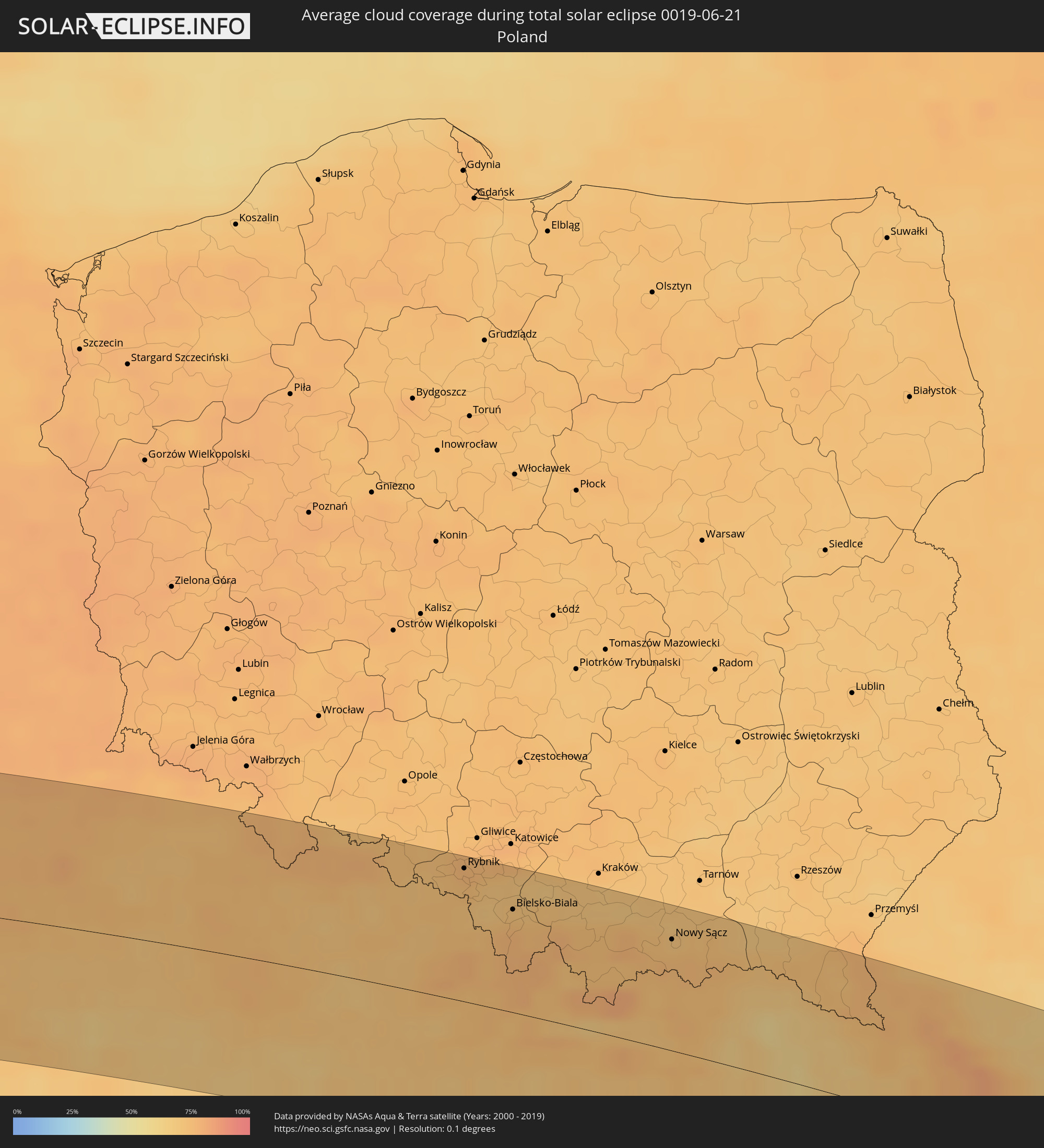 Polen
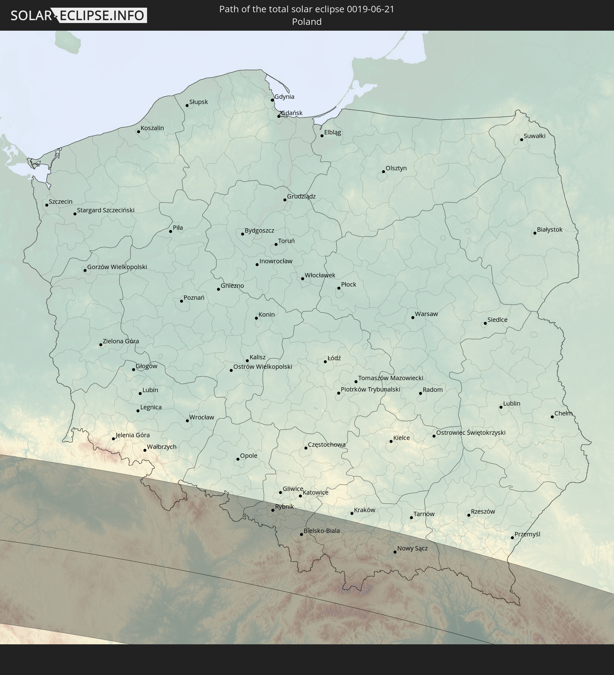
Polen
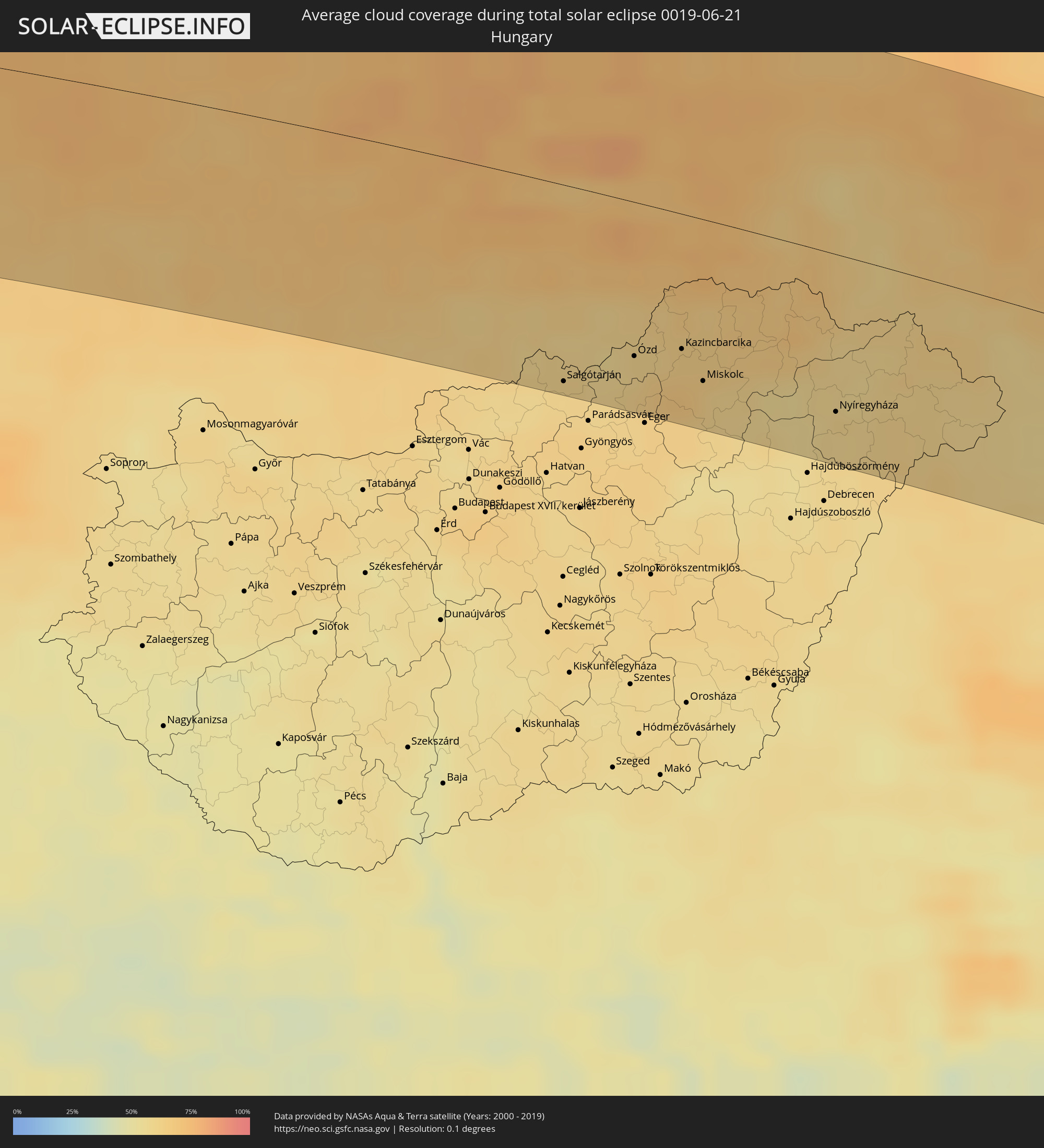 Ungarn
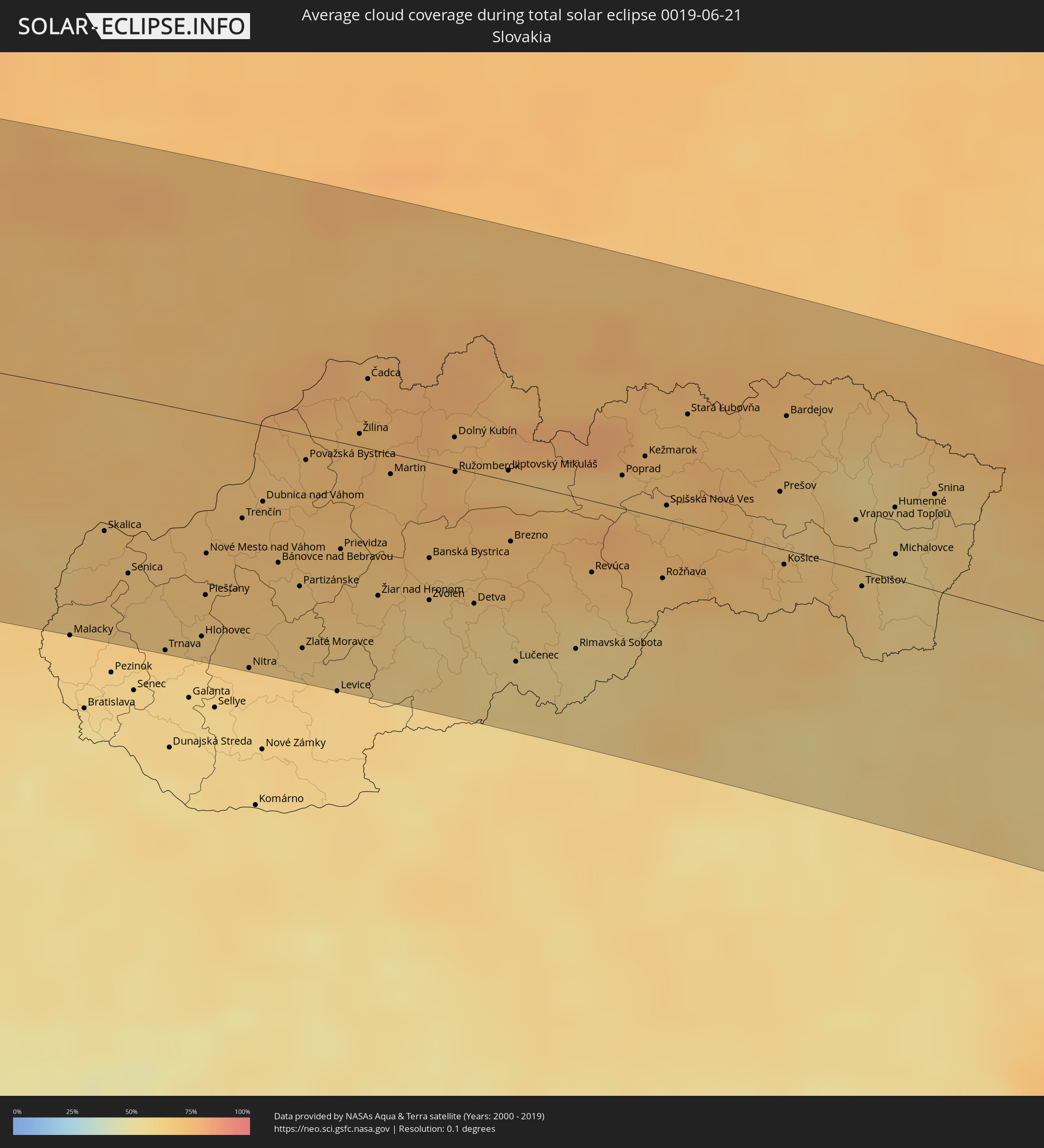 Slowakei
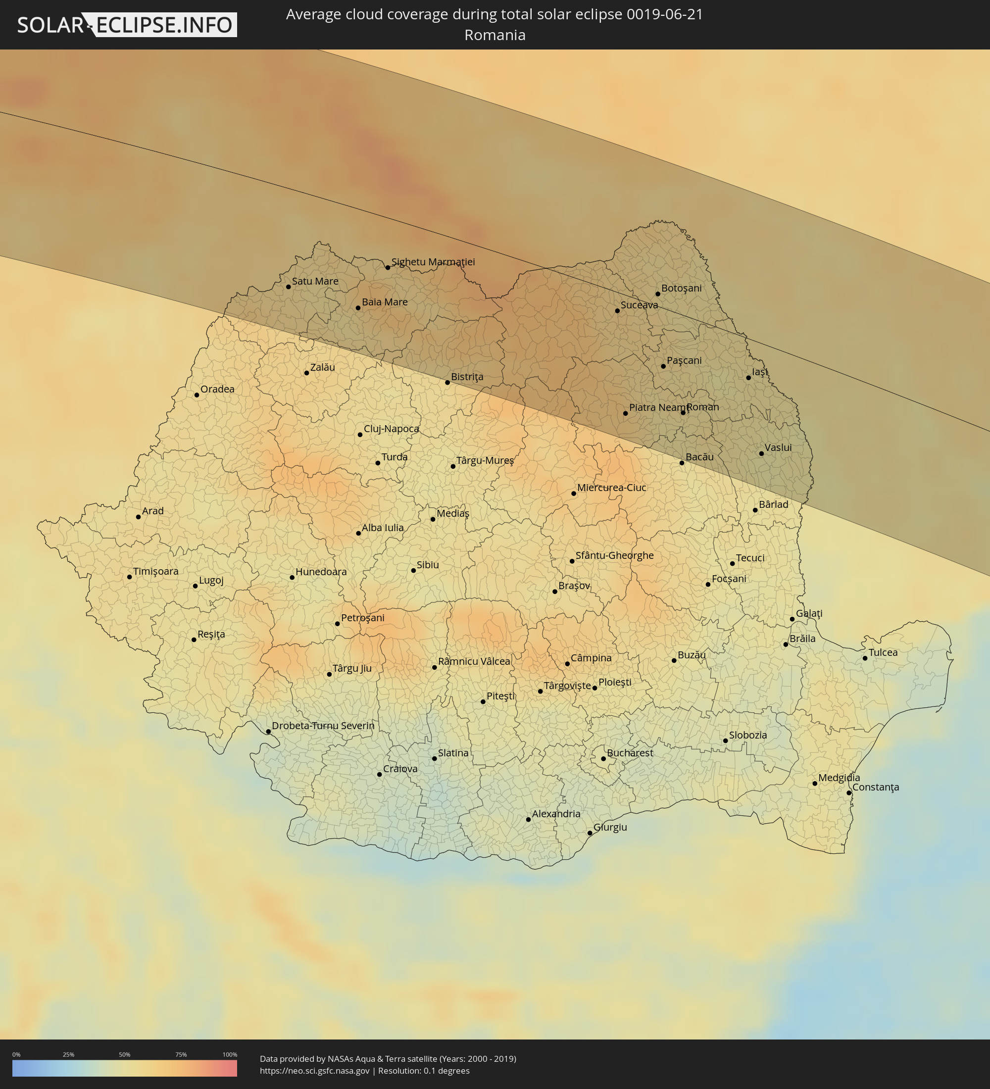 Rumänien
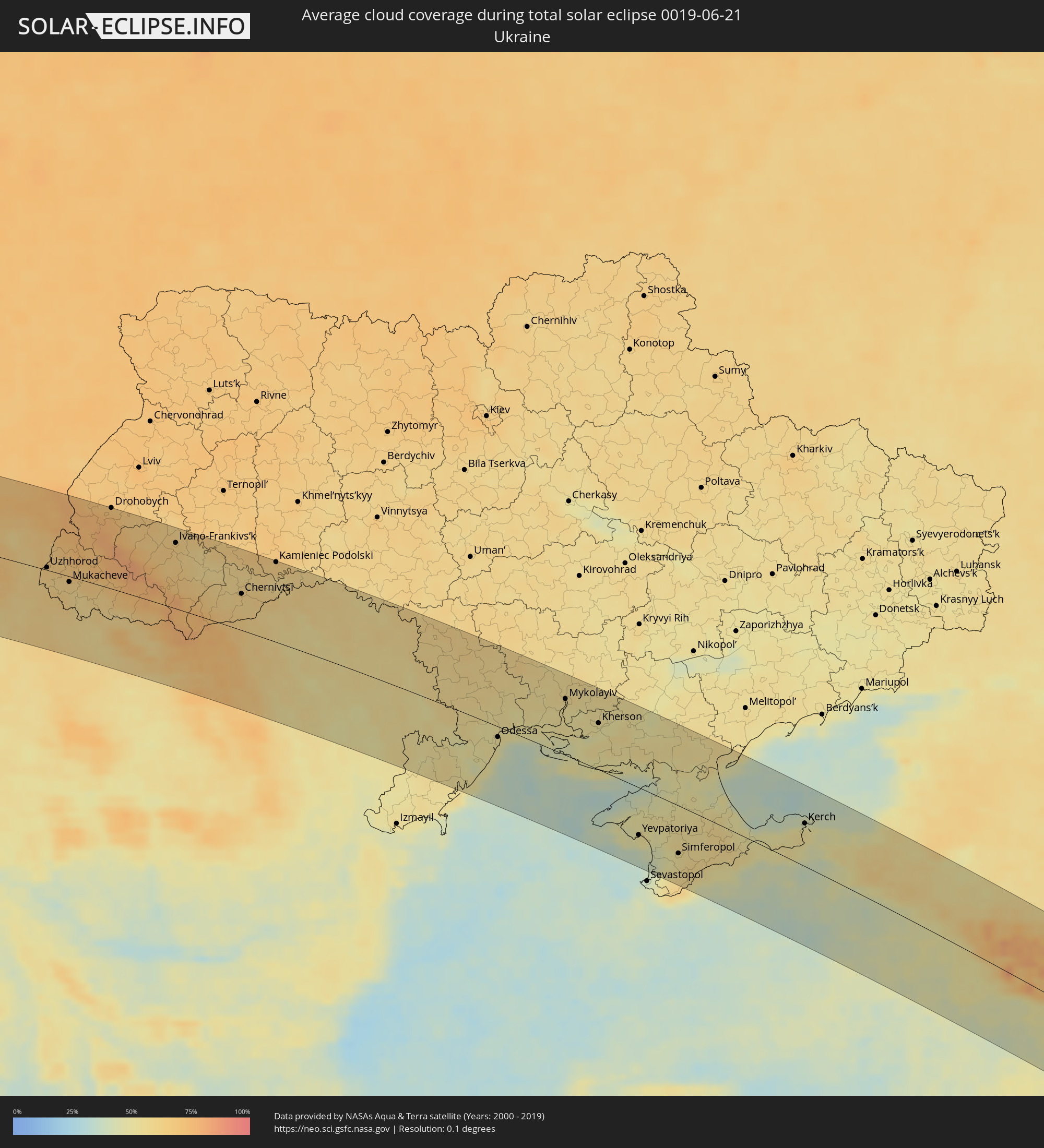 Ukraine
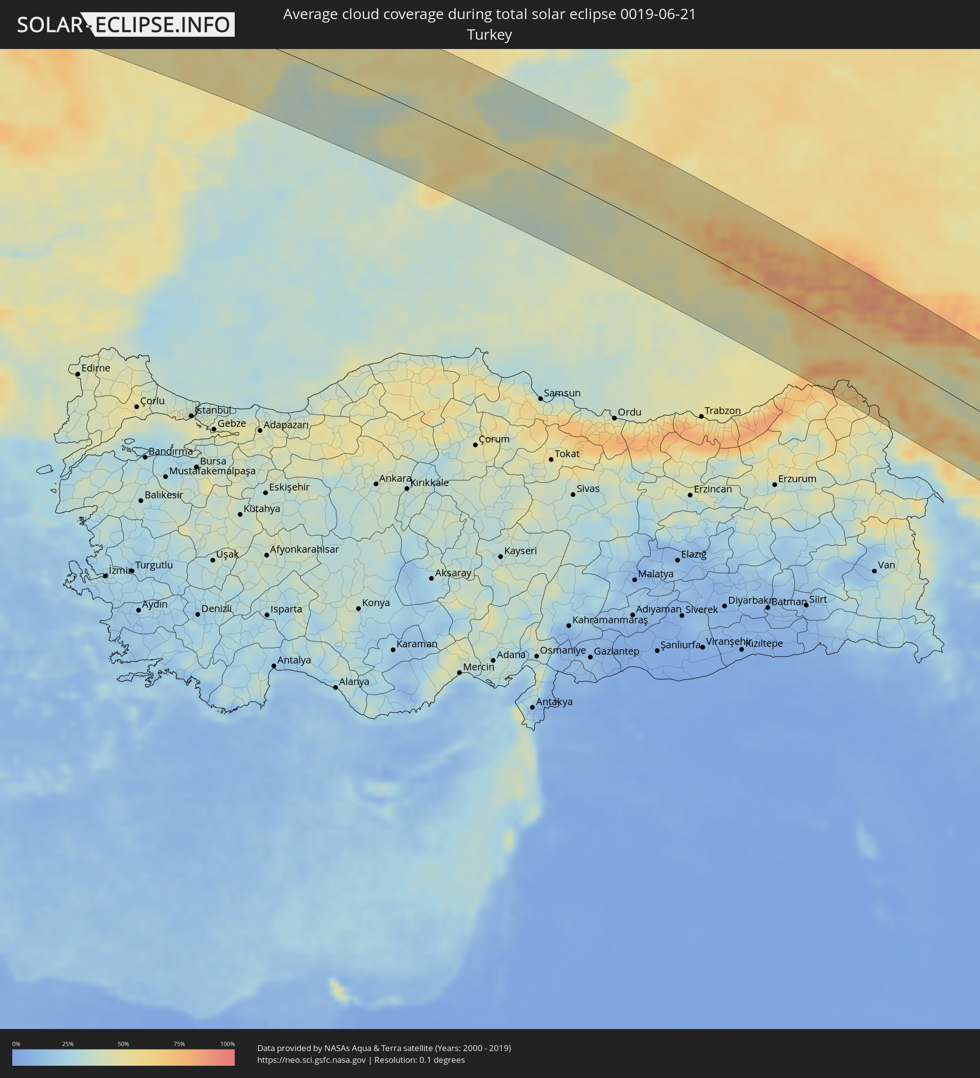 Türkei
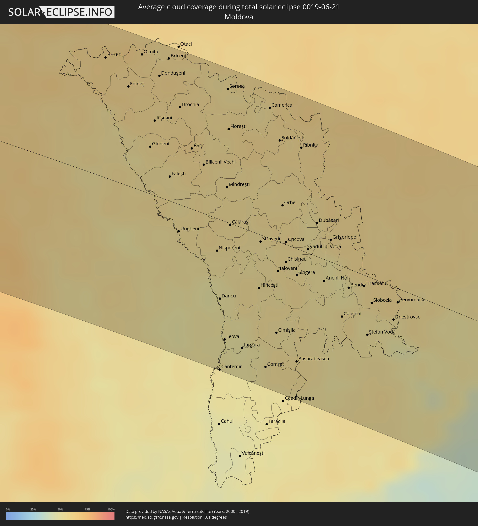 Moldawien
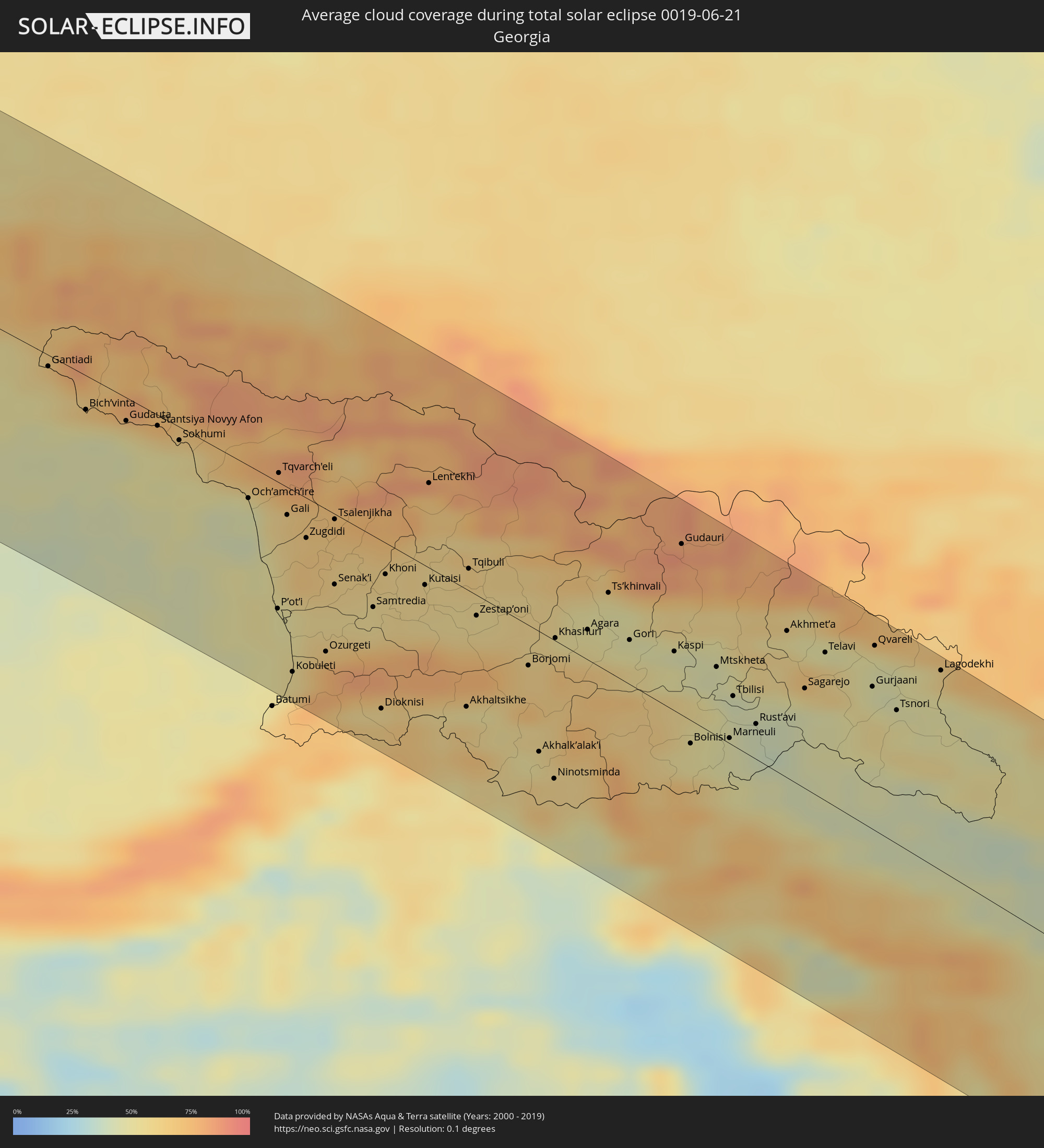 Georgien
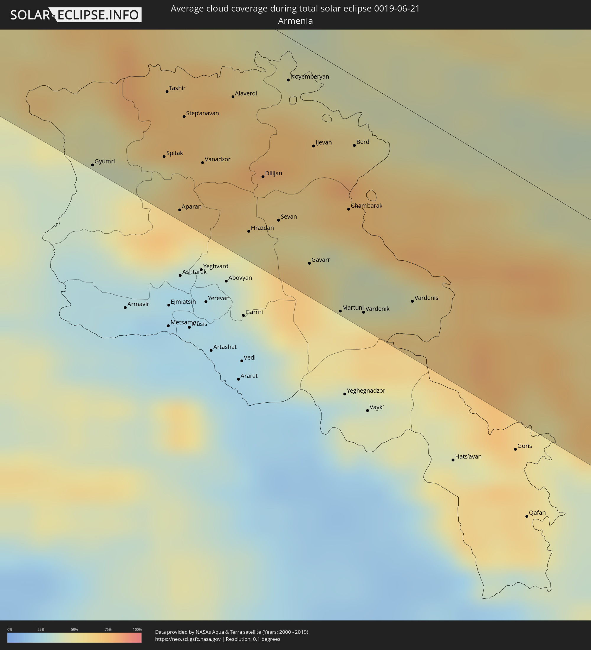 Armenien
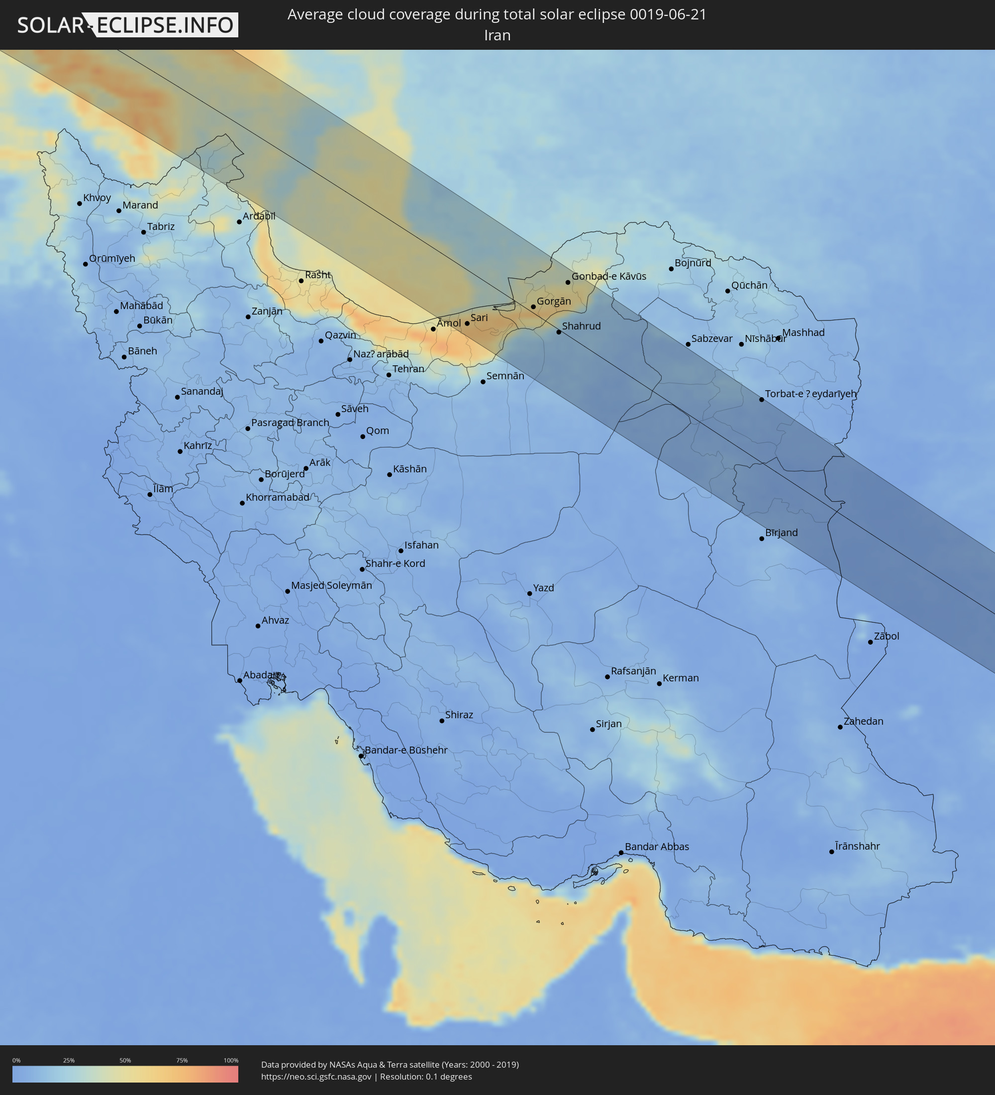 Iran
Iran
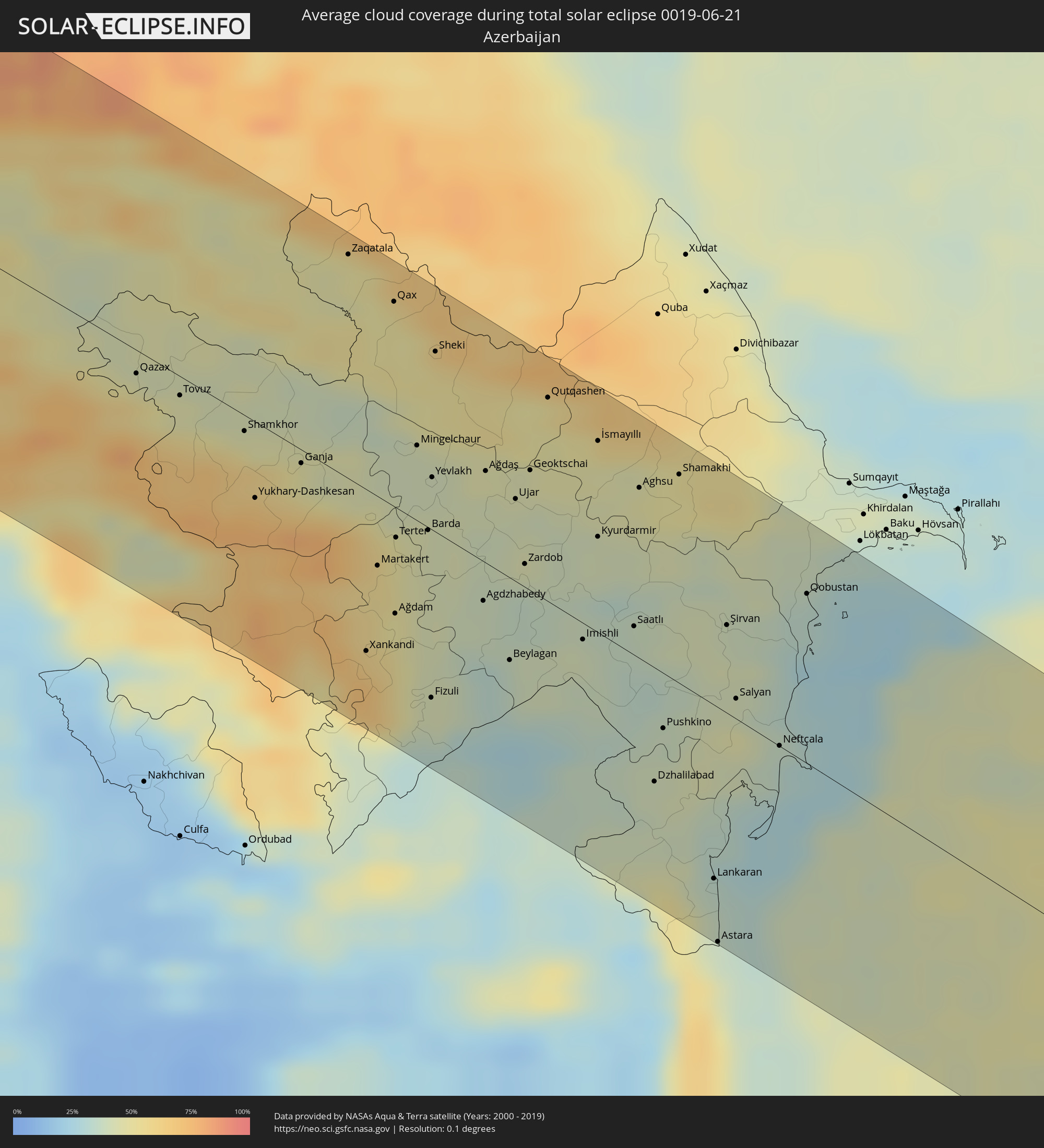 Aserbaidschan
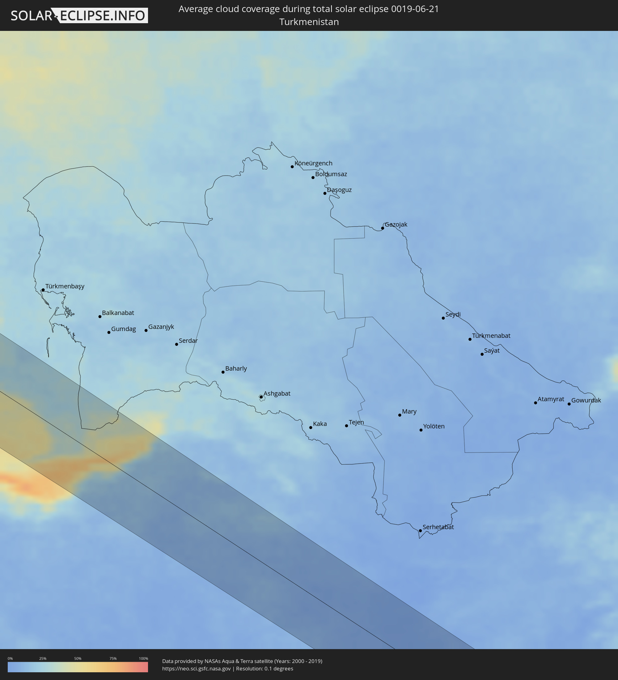 Turkmenistan
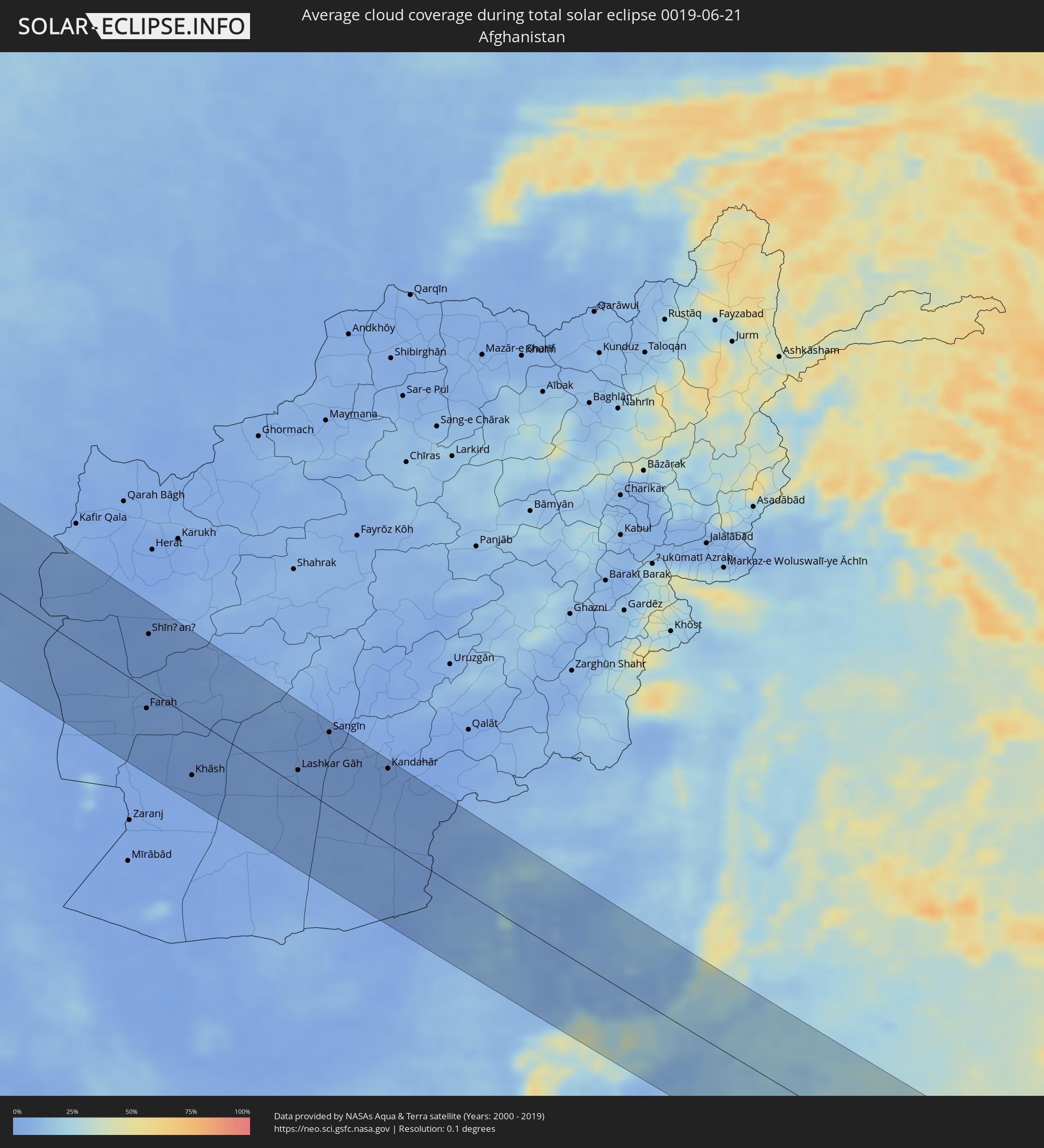 Afghanistan
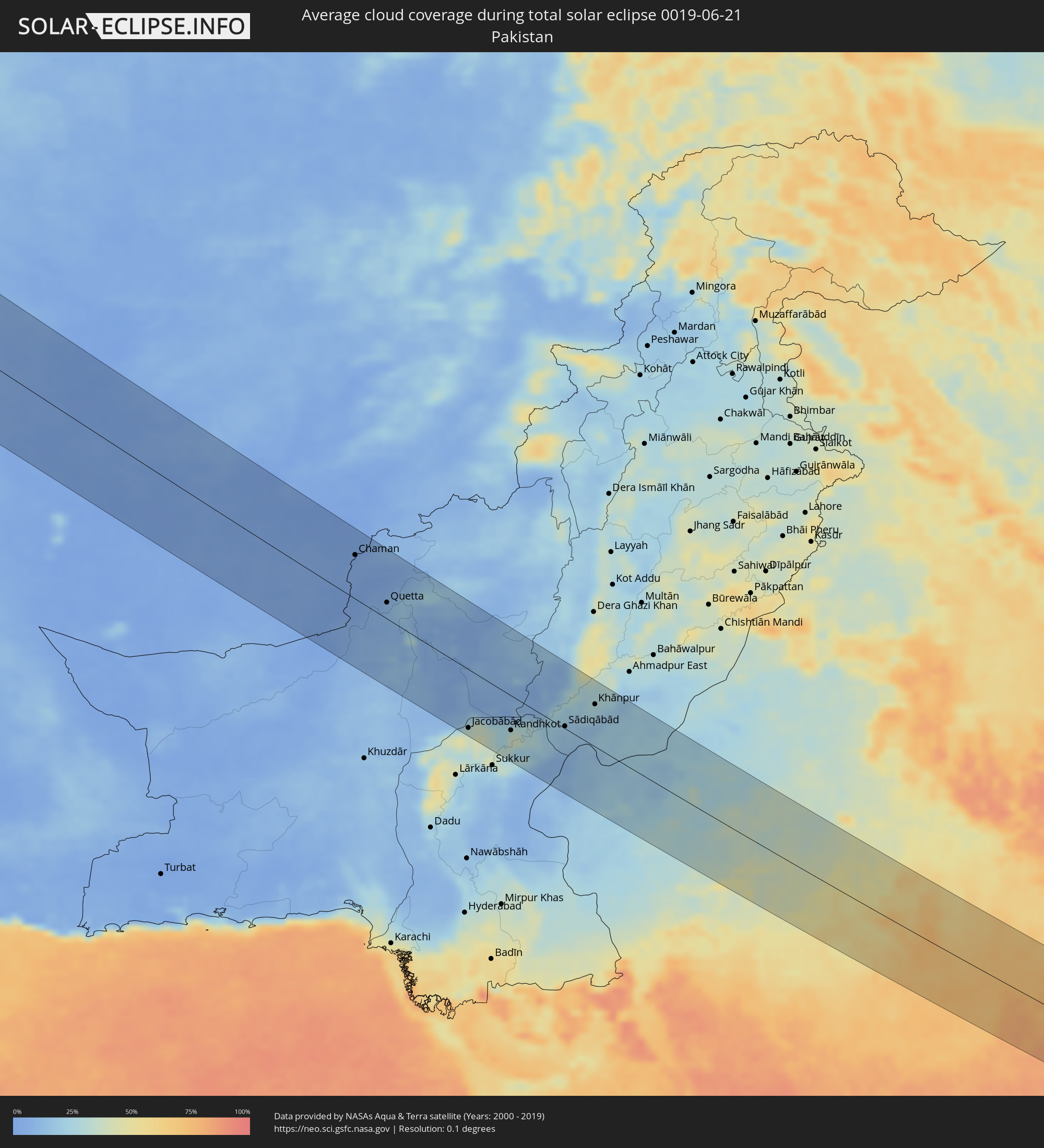 Pakistan
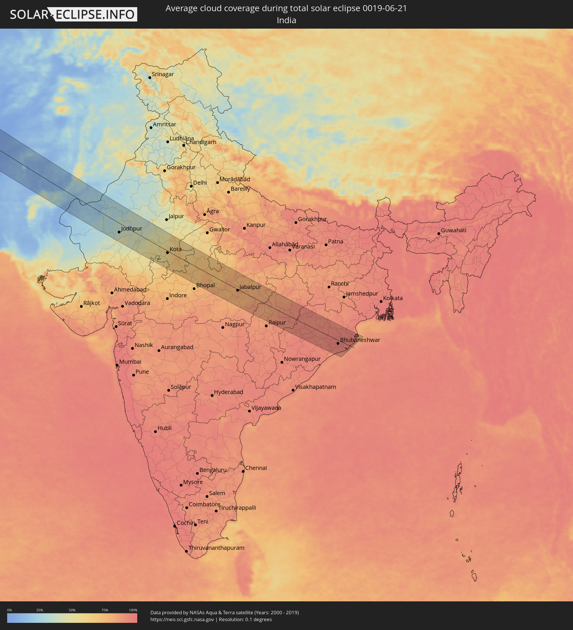 Indien
Orte im Finsternispfad
Die nachfolgene Tabelle zeigt Städte und Orte mit mehr als 5.000 Einwohnern, die sich im Finsternispfad befinden. Städte mit mehr als 100.000 Einwohnern sind dick gekennzeichnet. Mit einem Klick auf den Ort öffnet sich eine Detailkarte die die Lage des jeweiligen Ortes zusammen mit dem Verlauf der zentralen Finsternis präsentiert.
| Ort | Typ | Dauer der Verfinsterung | Ortszeit bei maximaler Verfinsterung | Entfernung zur Zentrallinie | Ø Bewölkung |
|
Plymouth, England
|
total | - | 10:42:51 UTC+00:00 | 67 km | 70% |
|
Exeter, England
|
total | - | 10:44:00 UTC+00:00 | 100 km | 71% |
|
Saint Peter Port, St Peter Port
|
total | - | 10:44:44 UTC+00:00 | 48 km | 63% |
|
Saint Helier, St Helier
|
total | - | 10:45:15 UTC+00:00 | 81 km | 64% |
|
Le Hocq, St Clement
|
total | - | 10:45:19 UTC+00:00 | 84 km | 64% |
|
Bournemouth, England
|
total | - | 10:46:28 UTC+00:00 | 87 km | 69% |
|
Southampton, England
|
total | - | 10:47:17 UTC+00:00 | 104 km | 75% |
|
Portsmouth, England
|
total | - | 10:47:42 UTC+00:00 | 90 km | 72% |
|
Worthing, England
|
total | - | 10:48:48 UTC+00:00 | 88 km | 72% |
|
Caen, Normandy
|
total | - | 10:57:24 UTC+00:09 | 94 km | 73% |
|
Brighton, England
|
total | - | 10:49:10 UTC+00:00 | 87 km | 70% |
|
Le Havre, Normandy
|
total | - | 10:58:18 UTC+00:09 | 62 km | 67% |
|
Eastbourne, England
|
total | - | 10:49:48 UTC+00:00 | 79 km | 70% |
|
Rouen, Normandy
|
total | - | 10:59:53 UTC+00:09 | 72 km | 71% |
|
Calais, Hauts-de-France
|
total | - | 11:01:39 UTC+00:09 | 92 km | 70% |
|
Amiens, Hauts-de-France
|
total | - | 11:02:00 UTC+00:09 | 26 km | 77% |
|
Dunkerque, Hauts-de-France
|
total | - | 11:02:30 UTC+00:09 | 100 km | 76% |
|
Lille, Hauts-de-France
|
total | - | 11:03:27 UTC+00:09 | 54 km | 76% |
|
Gent, Flanders
|
total | - | 10:55:15 UTC+00:00 | 99 km | 80% |
|
Mons, Wallonia
|
total | - | 10:55:29 UTC+00:00 | 32 km | 77% |
|
Reims, Grand-Est
|
total | - | 11:04:41 UTC+00:09 | 102 km | 79% |
|
Aalst, Flanders
|
total | - | 10:55:43 UTC+00:00 | 86 km | 78% |
|
Brussels, Brussels Capital
|
total | - | 10:56:12 UTC+00:00 | 76 km | 81% |
|
Charleroi, Wallonia
|
total | - | 10:56:16 UTC+00:00 | 27 km | 78% |
|
Leuven, Flanders
|
total | - | 10:56:46 UTC+00:00 | 79 km | 79% |
|
Namur, Wallonia
|
total | - | 10:56:57 UTC+00:00 | 33 km | 79% |
|
Liège, Wallonia
|
total | - | 10:58:07 UTC+00:00 | 52 km | 77% |
|
Maastricht, Limburg
|
total | - | 11:17:52 UTC+00:19 | 76 km | 75% |
|
Eijsden, Limburg
|
total | - | 11:17:55 UTC+00:19 | 69 km | 75% |
|
Heer, Limburg
|
total | - | 11:17:56 UTC+00:19 | 75 km | 75% |
|
Stein, Limburg
|
total | - | 11:18:01 UTC+00:19 | 90 km | 80% |
|
Born, Limburg
|
total | - | 11:18:05 UTC+00:19 | 97 km | 80% |
|
Differdange, Luxembourg
|
total | - | 11:23:06 UTC+00:24 | 71 km | 75% |
|
Belvaux, Luxembourg
|
total | - | 11:23:10 UTC+00:24 | 72 km | 75% |
|
Esch-sur-Alzette, Luxembourg
|
total | - | 11:23:15 UTC+00:24 | 74 km | 75% |
|
Heerlen, Limburg
|
total | - | 11:18:21 UTC+00:19 | 80 km | 80% |
|
Simpelveld, Limburg
|
total | - | 11:18:20 UTC+00:19 | 75 km | 78% |
|
Vaals, Limburg
|
total | - | 11:18:24 UTC+00:19 | 68 km | 78% |
|
Bertrange, Luxembourg
|
total | - | 11:23:23 UTC+00:24 | 61 km | 77% |
|
Strassen, Luxembourg
|
total | - | 11:23:25 UTC+00:24 | 60 km | 77% |
|
Aachen, North Rhine-Westphalia
|
total | - | 11:58:58 UTC+01:00 | 69 km | 79% |
|
Ettelbruck, Diekirch
|
total | - | 11:23:30 UTC+00:24 | 35 km | 77% |
|
Luxembourg, Luxembourg
|
total | - | 11:23:31 UTC+00:24 | 61 km | 77% |
|
Diekirch, Diekirch
|
total | - | 11:23:35 UTC+00:24 | 32 km | 76% |
|
Köln, North Rhine-Westphalia
|
total | - | 12:00:22 UTC+01:00 | 88 km | 82% |
|
Saarbrücken, Saarland
|
total | - | 12:00:19 UTC+01:00 | 101 km | 76% |
|
Bonn, North Rhine-Westphalia
|
total | - | 12:00:35 UTC+01:00 | 66 km | 80% |
|
Wiesbaden, Hesse
|
total | - | 12:02:28 UTC+01:00 | 3 km | 79% |
|
Mannheim, Baden-Württemberg
|
total | - | 12:02:52 UTC+01:00 | 67 km | 78% |
|
Frankfurt am Main, Hesse
|
total | - | 12:03:11 UTC+01:00 | 3 km | 77% |
|
Nürnberg, Bavaria
|
total | - | 12:07:16 UTC+01:00 | 57 km | 75% |
|
Pilsen, Plzeňský
|
total | - | 12:11:04 UTC+01:00 | 5 km | 75% |
|
Ústí nad Labem, Ústecký
|
total | - | 12:11:50 UTC+01:00 | 102 km | 78% |
|
Prague, Praha
|
total | - | 12:12:40 UTC+01:00 | 43 km | 77% |
|
České Budějovice, Jihočeský
|
total | - | 12:13:11 UTC+01:00 | 79 km | 67% |
|
Gmünd, Lower Austria
|
total | - | 12:14:08 UTC+01:00 | 96 km | 69% |
|
Schrems, Lower Austria
|
total | - | 12:14:16 UTC+01:00 | 93 km | 69% |
|
Waidhofen an der Thaya, Lower Austria
|
total | - | 12:14:38 UTC+01:00 | 87 km | 66% |
|
Horn, Lower Austria
|
total | - | 12:15:20 UTC+01:00 | 100 km | 67% |
|
Hradec Králové, Královéhradecký
|
total | - | 12:14:56 UTC+01:00 | 72 km | 73% |
|
Laa an der Thaya, Lower Austria
|
total | - | 12:16:33 UTC+01:00 | 84 km | 67% |
|
Mistelbach, Lower Austria
|
total | - | 12:16:57 UTC+01:00 | 98 km | 66% |
|
Brno, South Moravian
|
total | - | 12:16:41 UTC+01:00 | 29 km | 72% |
|
Poysdorf, Lower Austria
|
total | - | 12:17:00 UTC+01:00 | 86 km | 67% |
|
Zistersdorf, Lower Austria
|
total | - | 12:17:16 UTC+01:00 | 99 km | 67% |
|
Olomouc, Olomoucký
|
total | - | 12:17:33 UTC+01:00 | 24 km | 71% |
|
Trnava, Trnavský
|
total | - | 12:18:47 UTC+01:00 | 104 km | 66% |
|
Trenčín, Trenčiansky
|
total | - | 12:19:15 UTC+01:00 | 41 km | 71% |
|
Nitra, Nitriansky
|
total | - | 12:19:40 UTC+01:00 | 104 km | 64% |
|
Racibórz, Silesian Voivodeship
|
total | - | 12:42:50 UTC+01:24 | 92 km | 72% |
|
Ostrava, Moravskoslezský
|
total | - | 12:19:05 UTC+01:00 | 65 km | 72% |
|
Rybnik, Silesian Voivodeship
|
total | - | 12:43:21 UTC+01:24 | 97 km | 75% |
|
Jastrzębie Zdrój, Silesian Voivodeship
|
total | - | 12:43:29 UTC+01:24 | 82 km | 74% |
|
Cieszyn, Silesian Voivodeship
|
total | - | 12:43:42 UTC+01:24 | 61 km | 71% |
|
Žilina, Žilinský
|
total | - | 12:20:12 UTC+01:00 | 5 km | 74% |
|
Martin, Žilinský
|
total | - | 12:20:36 UTC+01:00 | 9 km | 73% |
|
Bielsko-Biala, Silesian Voivodeship
|
total | - | 12:44:19 UTC+01:24 | 75 km | 74% |
|
Banská Bystrica, Banskobystrický
|
total | - | 12:21:11 UTC+01:00 | 40 km | 67% |
|
Oświęcim, Lesser Poland Voivodeship
|
total | - | 12:44:27 UTC+01:24 | 101 km | 69% |
|
Salgótarján, Nógrád
|
total | - | 12:22:42 UTC+01:00 | 99 km | 60% |
|
Ózd, Borsod-Abaúj-Zemplén
|
total | - | 12:23:27 UTC+01:00 | 77 km | 60% |
|
Kazincbarcika, Borsod-Abaúj-Zemplén
|
total | - | 12:23:59 UTC+01:00 | 68 km | 64% |
|
Nowy Sącz, Lesser Poland Voivodeship
|
total | - | 12:47:05 UTC+01:24 | 81 km | 73% |
|
Miskolc, Borsod-Abaúj-Zemplén
|
total | - | 12:24:21 UTC+01:00 | 81 km | 62% |
|
Prešov, Prešovský
|
total | - | 12:24:24 UTC+01:00 | 24 km | 68% |
|
Košice, Košický
|
total | - | 12:24:39 UTC+01:00 | 6 km | 67% |
|
Sátoraljaújhely, Borsod-Abaúj-Zemplén
|
total | - | 12:25:33 UTC+01:00 | 33 km | 62% |
|
Nyíregyháza, Szabolcs-Szatmár-Bereg
|
total | - | 12:26:00 UTC+01:00 | 79 km | 61% |
|
Kisvárda, Szabolcs-Szatmár-Bereg
|
total | - | 12:26:23 UTC+01:00 | 44 km | 62% |
|
Sanok, Subcarpathian Voivodeship
|
total | - | 12:49:31 UTC+01:24 | 102 km | 73% |
|
Uzhhorod, Zakarpattia
|
total | - | 13:28:29 UTC+02:02 | 3 km | 64% |
|
Mátészalka, Szabolcs-Szatmár-Bereg
|
total | - | 12:27:00 UTC+01:00 | 67 km | 61% |
|
Satu Mare, Satu Mare
|
total | - | 13:12:25 UTC+01:44 | 73 km | 58% |
|
Baia Mare, Satu Mare
|
total | - | 13:13:42 UTC+01:44 | 73 km | 61% |
|
Ivano-Frankivs’k, Ivano-Frankivsk
|
total | - | 13:32:00 UTC+02:02 | 86 km | 65% |
|
Chernivtsi, Chernivtsi
|
total | - | 13:34:30 UTC+02:02 | 48 km | 62% |
|
Suceava, Suceava
|
total | - | 13:17:58 UTC+01:44 | 14 km | 61% |
|
Piatra Neamţ, Neamţ
|
total | - | 13:18:50 UTC+01:44 | 87 km | 65% |
|
Botoşani, Botoşani
|
total | - | 13:18:30 UTC+01:44 | 9 km | 54% |
|
Roman, Neamţ
|
total | - | 13:19:46 UTC+01:44 | 72 km | 51% |
|
Iaşi, Iaşi
|
total | - | 13:20:33 UTC+01:44 | 29 km | 54% |
|
Vaslui, Vaslui
|
total | - | 13:21:20 UTC+01:44 | 81 km | 50% |
|
Ungheni, Ungheni
|
total | - | 13:31:24 UTC+01:55 | 19 km | 53% |
|
Bălţi, Bălţi
|
total | - | 13:31:00 UTC+01:55 | 42 km | 58% |
|
Soroca, Raionul Soroca
|
total | - | 13:31:06 UTC+01:55 | 92 km | 54% |
|
Orhei, Orhei
|
total | - | 13:32:46 UTC+01:55 | 26 km | 57% |
|
Chisinau, Chişinău
|
total | - | 13:33:14 UTC+01:55 | 12 km | 57% |
|
Rîbniţa, Stînga Nistrului
|
total | - | 13:32:36 UTC+01:55 | 71 km | 57% |
|
Dubăsari, Teleneşti
|
total | - | 13:33:24 UTC+01:55 | 23 km | 54% |
|
Tiraspolul, Stînga Nistrului
|
total | - | 13:34:35 UTC+01:55 | 8 km | 54% |
|
Odessa, Odessa
|
total | - | 13:43:43 UTC+02:02 | 14 km | 51% |
|
Mykolayiv, Mykolaiv
|
total | - | 13:44:56 UTC+02:02 | 74 km | 52% |
|
Kherson, Kherson
|
total | - | 13:46:12 UTC+02:02 | 61 km | 51% |
|
Simferopol, Republic of Crimea
|
total | - | 14:04:26 UTC+02:16 | 63 km | 53% |
|
Kerch, Republic of Crimea
|
total | - | 14:07:05 UTC+02:16 | 57 km | 51% |
|
Anapa, Krasnodarskiy
|
total | - | 14:23:07 UTC+02:30 | 41 km | 52% |
|
Novorossiysk, Krasnodarskiy
|
total | - | 14:23:55 UTC+02:30 | 40 km | 59% |
|
Krymsk, Krasnodarskiy
|
total | - | 14:23:54 UTC+02:30 | 68 km | 61% |
|
Gelendzhik, Krasnodarskiy
|
total | - | 14:24:33 UTC+02:30 | 36 km | 56% |
|
Slavyansk-na-Kubani, Krasnodarskiy
|
total | - | 14:23:36 UTC+02:30 | 106 km | 56% |
|
Tuapse, Krasnodarskiy
|
total | - | 14:26:27 UTC+02:30 | 27 km | 53% |
|
Sochi, Krasnodarskiy
|
total | - | 14:27:59 UTC+02:30 | 2 km | 51% |
|
Adler, Krasnodarskiy
|
total | - | 14:28:29 UTC+02:30 | 7 km | 55% |
|
Sokhumi, Abkhazia
|
total | - | 14:59:17 UTC+02:59 | 7 km | 52% |
|
P’ot’i, Samegrelo and Zemo Svaneti
|
total | - | 15:01:23 UTC+02:59 | 63 km | 50% |
|
Zugdidi, Samegrelo and Zemo Svaneti
|
total | - | 15:01:04 UTC+02:59 | 20 km | 66% |
|
Kutaisi, Imereti
|
total | - | 15:02:22 UTC+02:59 | 10 km | 59% |
|
Hanak, Ardahan
|
total | - | 14:01:52 UTC+01:56 | 104 km | 54% |
|
Gyumri, Shirak Province
|
total | - | 15:04:43 UTC+02:58 | 104 km | 40% |
|
Ts’khinvali, Shida Kartli
|
total | - | 15:03:49 UTC+02:59 | 39 km | 48% |
|
Gori, Shida Kartli
|
total | - | 15:04:21 UTC+02:59 | 22 km | 49% |
|
Spitak, Lori Province
|
total | - | 15:05:07 UTC+02:58 | 82 km | 63% |
|
Step’anavan, Lori Province
|
total | - | 15:04:58 UTC+02:58 | 60 km | 69% |
|
Vanadzor, Lori Province
|
total | - | 15:05:24 UTC+02:58 | 75 km | 73% |
|
Hrazdan, Kotayk Province
|
total | - | 15:06:10 UTC+02:58 | 93 km | 52% |
|
Tbilisi, T'bilisi
|
total | - | 15:05:34 UTC+02:59 | 25 km | 44% |
|
Sevan, Gegharkunik Province
|
total | - | 15:06:16 UTC+02:58 | 81 km | 56% |
|
Rust’avi, Kvemo Kartli
|
total | - | 15:05:57 UTC+02:59 | 18 km | 39% |
|
Gavarr, Gegharkunik Province
|
total | - | 15:06:46 UTC+02:58 | 91 km | 57% |
|
Ijevan, Tavush Province
|
total | - | 15:05:58 UTC+02:58 | 40 km | 66% |
|
Ganja, Gǝncǝ
|
total | - | 15:28:54 UTC+03:19 | 6 km | 46% |
|
Xankandi, Xankǝndi
|
total | - | 15:30:38 UTC+03:19 | 71 km | 61% |
|
Mingelchaur, Mingǝcevir
|
total | - | 15:29:27 UTC+03:19 | 33 km | 42% |
|
Yevlakh, Yevlax City
|
total | - | 15:29:46 UTC+03:19 | 23 km | 41% |
|
Sheki, Shaki City
|
total | - | 15:28:54 UTC+03:19 | 78 km | 54% |
|
Pārsābād, Ardabīl
|
total | - | 15:38:21 UTC+03:25 | 35 km | 35% |
|
Saatlı, Saatlı
|
total | - | 15:31:59 UTC+03:19 | 13 km | 37% |
|
Lankaran, Lənkəran
|
total | - | 15:34:16 UTC+03:19 | 77 km | 33% |
|
Şirvan, Shirvan
|
total | - | 15:32:29 UTC+03:19 | 38 km | 41% |
|
Bābol, Māzandarān
|
total | - | 15:47:10 UTC+03:25 | 104 km | 60% |
|
Sari, Māzandarān
|
total | - | 15:47:26 UTC+03:25 | 84 km | 69% |
|
Gorgān, Golestān
|
total | - | 15:47:59 UTC+03:25 | 9 km | 69% |
|
Shahrud, Semnān
|
total | - | 15:48:59 UTC+03:25 | 4 km | 14% |
|
Gonbad-e Kāvūs, Golestān
|
total | - | 15:47:50 UTC+03:25 | 82 km | 46% |
|
Kāshmar, Razavi Khorasan
|
total | - | 15:52:50 UTC+03:25 | 59 km | 7% |
|
Torbat-e Ḩeydarīyeh, Razavi Khorasan
|
total | - | 15:53:10 UTC+03:25 | 100 km | 7% |
|
Kushk, Herat
|
total | - | 16:31:32 UTC+04:00 | 55 km | 1% |
|
Farah, Farah
|
total | - | 16:32:55 UTC+04:00 | 23 km | 2% |
|
Shīnḏanḏ, Herat
|
total | - | 16:31:36 UTC+04:00 | 65 km | 1% |
|
Khāsh, Nimroz
|
total | - | 16:34:21 UTC+04:00 | 68 km | 1% |
|
Lashkar Gāh, Helmand
|
total | - | 16:34:46 UTC+04:00 | 19 km | 2% |
|
Gereshk, Helmand
|
total | - | 16:34:31 UTC+04:00 | 51 km | 1% |
|
Sangīn, Helmand
|
total | - | 16:34:14 UTC+04:00 | 88 km | 1% |
|
Kandahār, Kandahar
|
total | - | 16:35:07 UTC+04:00 | 90 km | 0% |
|
Chaman, Balochistān
|
total | - | 17:04:26 UTC+04:28 | 62 km | 4% |
|
Quetta, Balochistān
|
total | - | 17:05:30 UTC+04:28 | 23 km | 9% |
|
Jacobābād, Sindh
|
total | - | 17:08:14 UTC+04:28 | 85 km | 33% |
|
Pāno Āqil, Sindh
|
total | - | 17:08:51 UTC+04:28 | 91 km | 26% |
|
Kandhkot, Sindh
|
total | - | 17:08:22 UTC+04:28 | 51 km | 35% |
|
Ghotki, Sindh
|
total | - | 17:08:41 UTC+04:28 | 67 km | 22% |
|
Sādiqābād, Punjab
|
total | - | 17:08:24 UTC+04:28 | 3 km | 18% |
|
Khānpur, Punjab
|
total | - | 17:08:01 UTC+04:28 | 62 km | 24% |
|
Jodhpur, Rajasthan
|
total | - | 18:03:56 UTC+05:21 | 46 km | 36% |
|
Ajmer, Rajasthan
|
total | - | 18:03:41 UTC+05:21 | 53 km | 38% |
|
Bhīlwāra, Rajasthan
|
total | - | 18:04:56 UTC+05:21 | 53 km | 52% |
|
Kota, Rajasthan
|
total | - | 18:05:02 UTC+05:21 | 10 km | 57% |
|
Jabalpur, Madhya Pradesh
|
total | - | 18:06:32 UTC+05:21 | 6 km | 82% |
|
Korba, Chhattisgarh
|
total | - | 18:06:40 UTC+05:21 | 43 km | 88% |
|
Bhubaneshwar, Odisha
|
total | - | 18:07:34 UTC+05:21 | 19 km | 96% |
|
Cuttack, Odisha
|
total | - | 18:07:23 UTC+05:21 | 2 km | 93% |