Totale Sonnenfinsternis vom 10.05.0077
| Wochentag: | Montag |
| Maximale Dauer der Verfinsterung: | 02m10s |
| Maximale Breite des Finsternispfades: | 86 km |
| Saroszyklus: | 68 |
| Bedeckungsgrad: | 100% |
| Magnitude: | 1.0238 |
| Gamma: | 0.3493 |
Wo kann man die Sonnenfinsternis vom 10.05.0077 sehen?
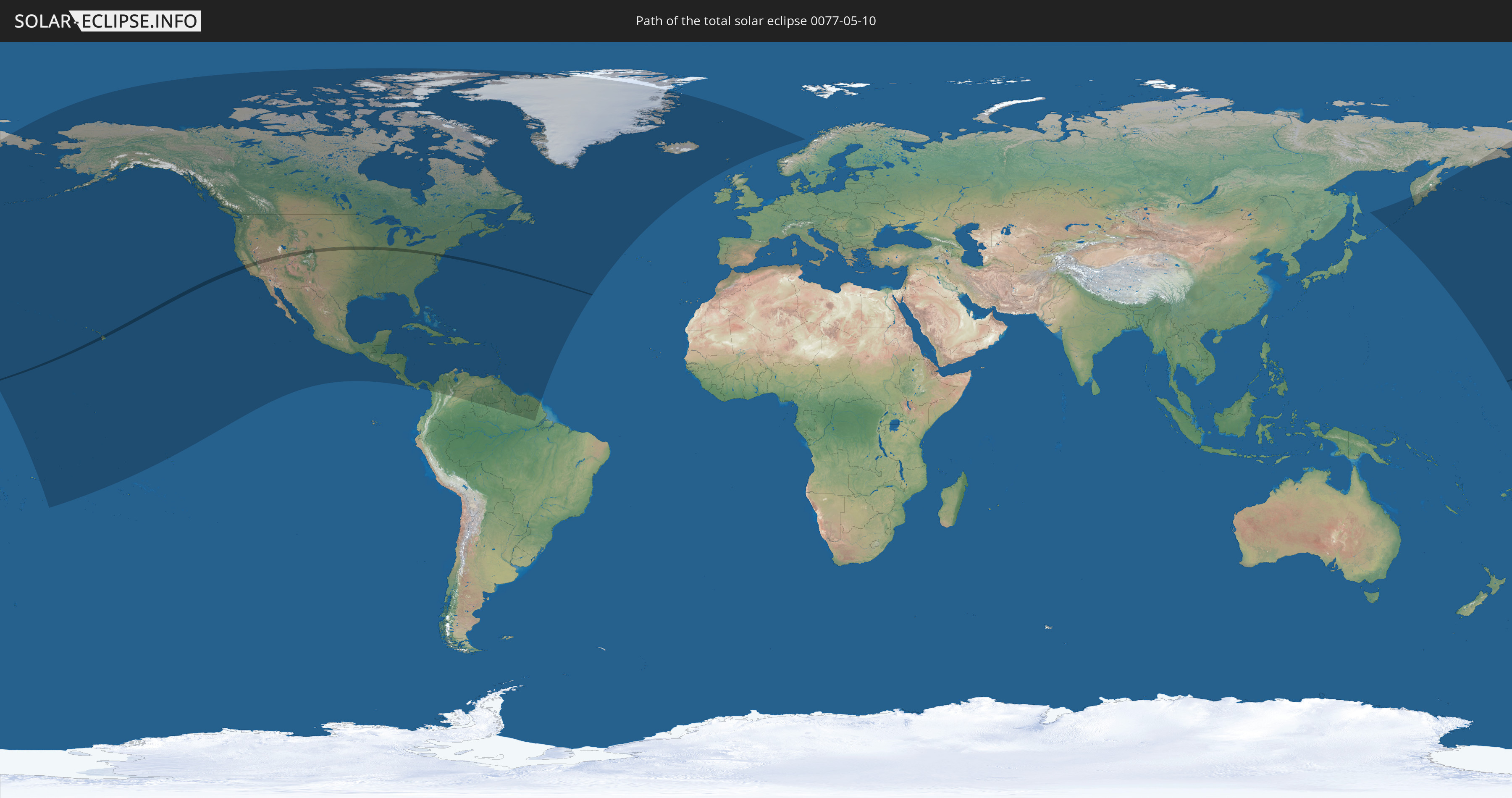
Die Sonnenfinsternis am 10.05.0077 kann man in 54 Ländern als partielle Sonnenfinsternis beobachten.
Der Finsternispfad verläuft durch ein Land. Nur in diesem Land ist sie als totale Sonnenfinsternis zu sehen.
In den folgenden Ländern ist die Sonnenfinsternis total zu sehen
 Vereinigte Staaten
In den folgenden Ländern ist die Sonnenfinsternis partiell zu sehen
 Russland
 Vereinigte Staaten
 United States Minor Outlying Islands
 Kiribati
 Tokelau
 Amerikanisch-Samoa
 Cookinseln
 Französisch-Polynesien
 Kanada
 Mexiko
 Grönland
 Guatemala
 El Salvador
 Honduras
 Belize
 Nicaragua
 Costa Rica
 Kuba
Kuba
 Panama
 Kolumbien
 Kaimaninseln
 Bahamas
 Jamaika
 Haiti
Haiti
 Brasilien
 Venezuela
 Turks- und Caicosinseln
 Dominikanische Republik
 Aruba
Aruba
 Puerto Rico
 Amerikanische Jungferninseln
 Bermuda
 Britische Jungferninseln
 Anguilla
 Saint-Martin
 Saint-Barthélemy
 St. Kitts und Nevis
 Antigua und Barbuda
 Montserrat
 Trinidad und Tobago
 Guadeloupe
 Grenada
 Dominica
 St. Vincent und die Grenadinen
 Guyana
 Martinique
 St. Lucia
 Barbados
 Suriname
 Saint-Pierre und Miquelon
 Französisch-Guayana
 Island
 Spitzbergen
 Färöer
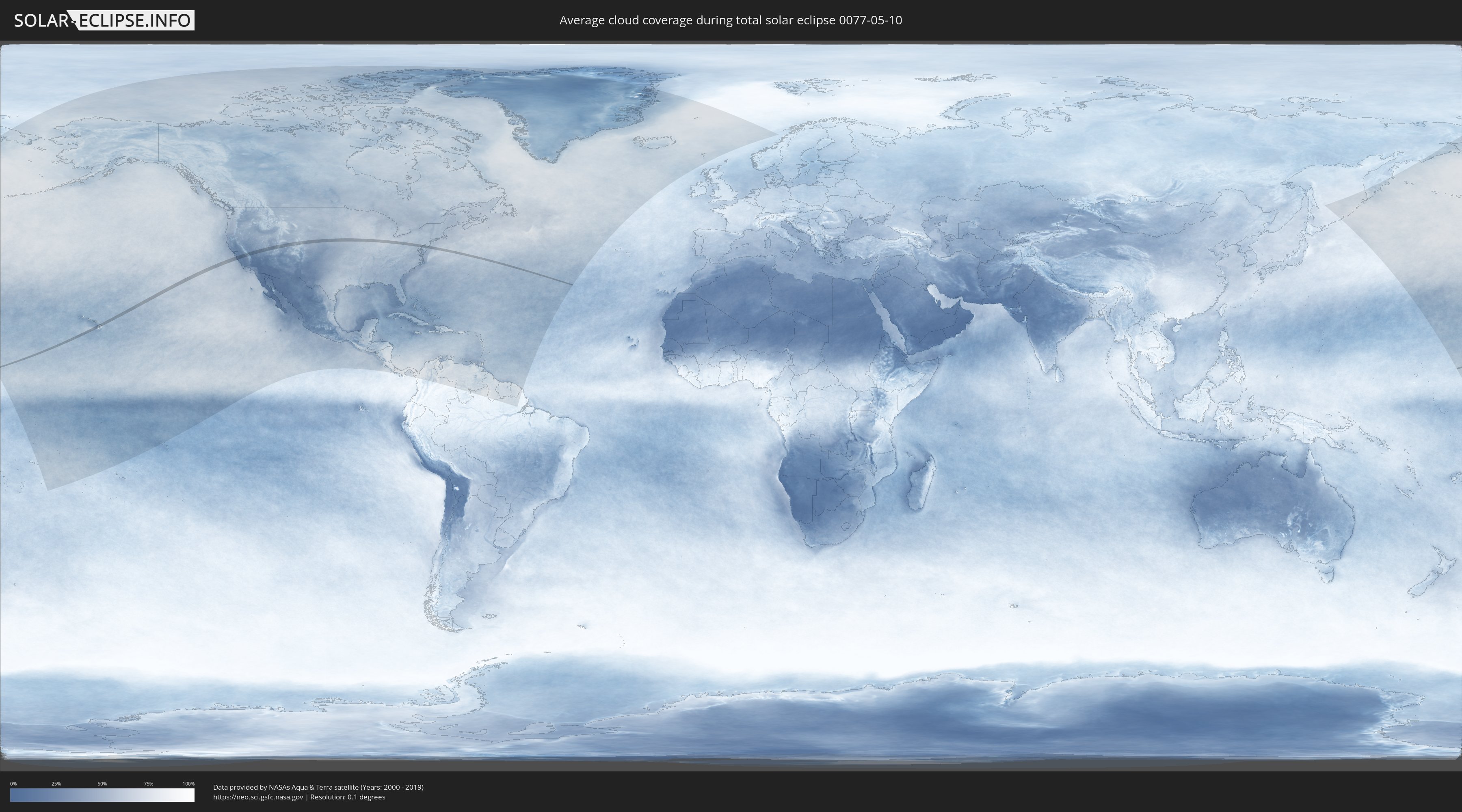
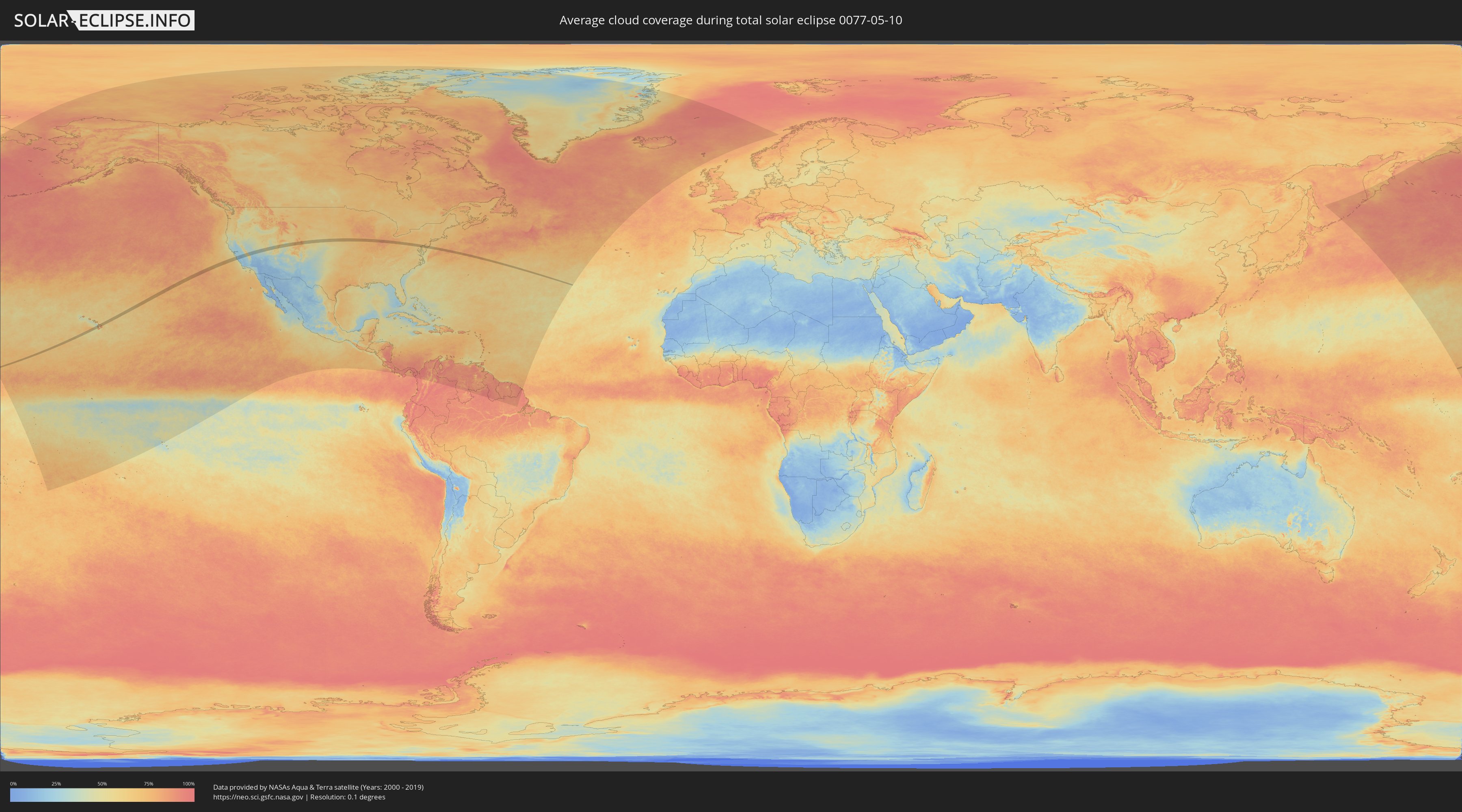
Wie wird das Wetter während der totalen Sonnenfinsternis am 10.05.0077?
Wo ist der beste Ort, um die totale Sonnenfinsternis vom 10.05.0077 zu beobachten?
Die folgenden Karten zeigen die durchschnittliche Bewölkung für den Tag, an dem die totale Sonnenfinsternis
stattfindet. Mit Hilfe der Karten lässt sich der Ort entlang des Finsternispfades eingrenzen,
der die besten Aussichen auf einen klaren wolkenfreien Himmel bietet.
Trotzdem muss man immer lokale Gegenenheiten beachten und sollte sich genau über das Wetter an seinem
gewählten Beobachtungsort informieren.
Die Daten stammen von den beiden NASA-Satelliten
AQUA und TERRA
und wurden über einen Zeitraum von 19 Jahren (2000 - 2019) gemittelt.
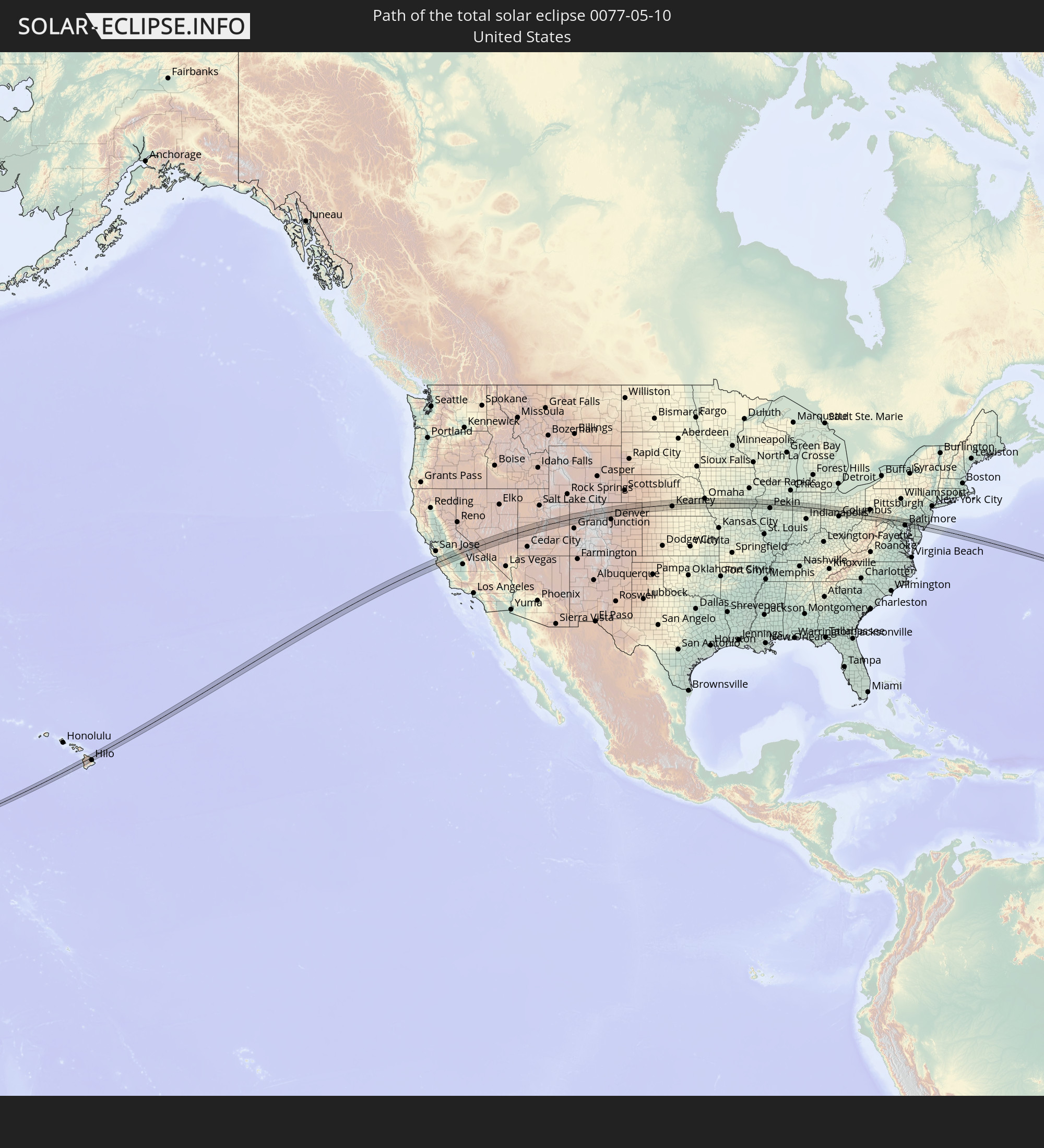
Detaillierte Länderkarten
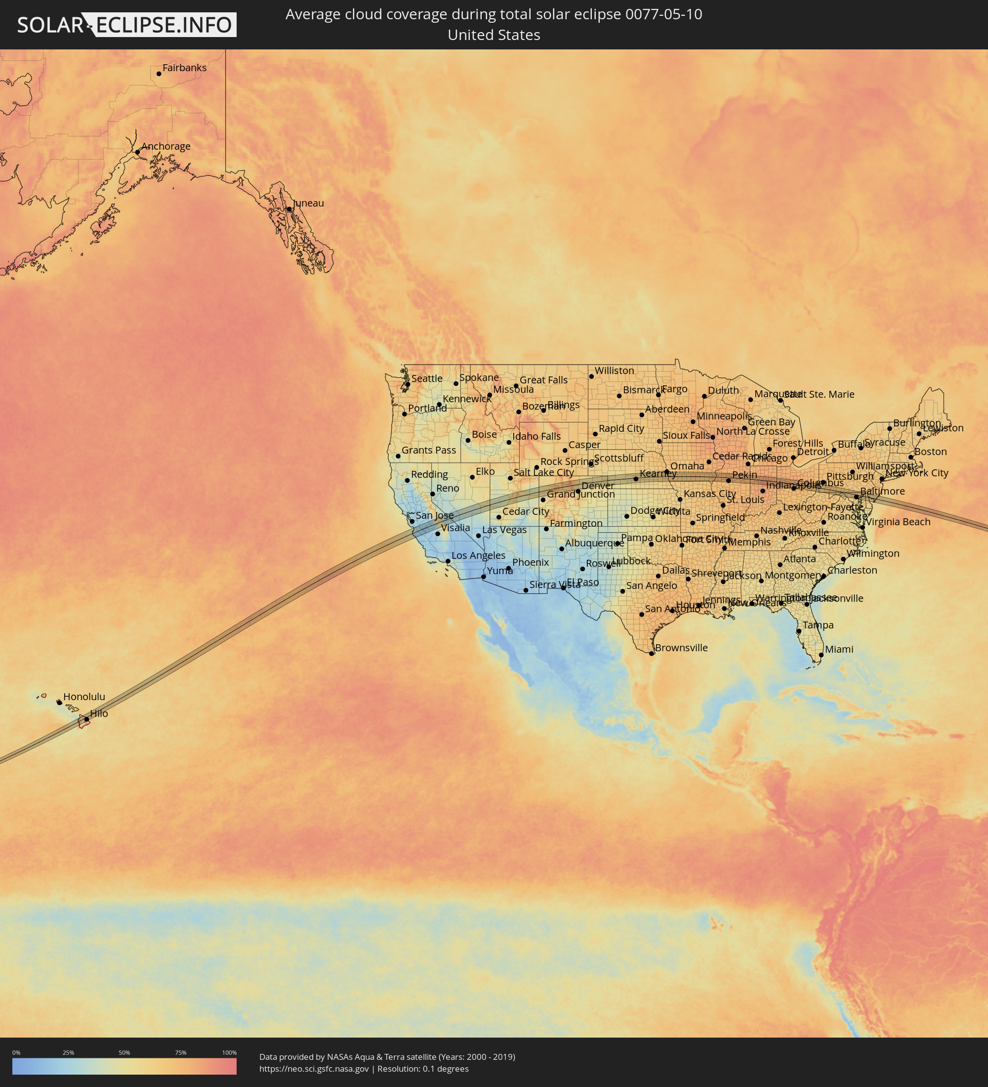 Vereinigte Staaten
Orte im Finsternispfad
Die nachfolgene Tabelle zeigt Städte und Orte mit mehr als 5.000 Einwohnern, die sich im Finsternispfad befinden. Städte mit mehr als 100.000 Einwohnern sind dick gekennzeichnet. Mit einem Klick auf den Ort öffnet sich eine Detailkarte die die Lage des jeweiligen Ortes zusammen mit dem Verlauf der zentralen Finsternis präsentiert.
| Ort | Typ | Dauer der Verfinsterung | Ortszeit bei maximaler Verfinsterung | Entfernung zur Zentrallinie | Ø Bewölkung |
|
Kailua-Kona, Hawaii
|
total | - | 07:32:36 UTC-10:30 | 8 km | 69% |
|
Kalaoa, Hawaii
|
total | - | 07:32:45 UTC-10:30 | 16 km | 80% |
|
Hōlualoa, Hawaii
|
total | - | 07:32:37 UTC-10:30 | 3 km | 87% |
|
Waikoloa Village, Hawaii
|
total | - | 07:33:08 UTC-10:30 | 28 km | 73% |
|
Waimea, Hawaii
|
total | - | 07:33:22 UTC-10:30 | 29 km | 64% |
|
Hilo, Hawaii
|
total | - | 07:33:22 UTC-10:30 | 29 km | 85% |
|
Pacific Grove, California
|
total | - | 11:20:29 UTC-08:00 | 20 km | 44% |
|
Monterey, California
|
total | - | 11:20:31 UTC-08:00 | 18 km | 44% |
|
Seaside, California
|
total | - | 11:20:37 UTC-08:00 | 17 km | 44% |
|
Marina, California
|
total | - | 11:20:49 UTC-08:00 | 23 km | 39% |
|
Castroville, California
|
total | - | 11:21:00 UTC-08:00 | 30 km | 42% |
|
Prunedale, California
|
total | - | 11:21:12 UTC-08:00 | 28 km | 37% |
|
Salinas, California
|
total | - | 11:21:07 UTC-08:00 | 17 km | 33% |
|
Gonzales, California
|
total | - | 11:21:23 UTC-08:00 | 8 km | 23% |
|
Hollister, California
|
total | - | 11:21:53 UTC-08:00 | 26 km | 27% |
|
Soledad, California
|
total | - | 11:21:33 UTC-08:00 | 20 km | 22% |
|
Greenfield, California
|
total | - | 11:21:36 UTC-08:00 | 34 km | 20% |
|
Los Banos, California
|
total | - | 11:23:19 UTC-08:00 | 29 km | 22% |
|
Merced, California
|
total | - | 11:24:23 UTC-08:00 | 41 km | 24% |
|
Firebaugh, California
|
total | - | 11:23:57 UTC-08:00 | 5 km | 18% |
|
Mendota, California
|
total | - | 11:24:00 UTC-08:00 | 19 km | 22% |
|
Chowchilla, California
|
total | - | 11:24:41 UTC-08:00 | 15 km | 25% |
|
Madera Acres, California
|
total | - | 11:25:00 UTC-08:00 | 2 km | 26% |
|
Madera, California
|
total | - | 11:24:57 UTC-08:00 | 8 km | 26% |
|
Kerman, California
|
total | - | 11:24:41 UTC-08:00 | 33 km | 24% |
|
Bonadelle Ranchos-Madera Ranchos, California
|
total | - | 11:25:23 UTC-08:00 | 12 km | 26% |
|
Fresno, California
|
total | - | 11:25:21 UTC-08:00 | 40 km | 26% |
|
Mammoth Lakes, California
|
total | - | 11:28:04 UTC-08:00 | 28 km | 60% |
|
Richfield, Utah
|
total | - | 12:44:22 UTC-07:00 | 42 km | 54% |
|
Price, Utah
|
total | - | 12:47:38 UTC-07:00 | 19 km | 51% |
|
Boulder, Colorado
|
total | - | 12:59:46 UTC-07:00 | 31 km | 65% |
|
Gunbarrel, Colorado
|
total | - | 12:59:59 UTC-07:00 | 27 km | 60% |
|
Superior, Colorado
|
total | - | 12:59:59 UTC-07:00 | 39 km | 60% |
|
Louisville, Colorado
|
total | - | 13:00:03 UTC-07:00 | 37 km | 57% |
|
Longmont, Colorado
|
total | - | 13:00:09 UTC-07:00 | 16 km | 60% |
|
Lafayette, Colorado
|
total | - | 13:00:09 UTC-07:00 | 36 km | 57% |
|
Fort Collins, Colorado
|
total | - | 13:00:14 UTC-07:00 | 29 km | 62% |
|
Loveland, Colorado
|
total | - | 13:00:14 UTC-07:00 | 8 km | 60% |
|
Erie, Colorado
|
total | - | 13:00:14 UTC-07:00 | 30 km | 56% |
|
Frederick, Colorado
|
total | - | 13:00:29 UTC-07:00 | 26 km | 54% |
|
Firestone, Colorado
|
total | - | 13:00:29 UTC-07:00 | 25 km | 54% |
|
Johnstown, Colorado
|
total | - | 13:00:34 UTC-07:00 | 0 km | 53% |
|
Windsor, Colorado
|
total | - | 13:00:36 UTC-07:00 | 15 km | 57% |
|
Brighton, Colorado
|
total | - | 13:00:43 UTC-07:00 | 40 km | 54% |
|
Fort Lupton, Colorado
|
total | - | 13:00:45 UTC-07:00 | 29 km | 54% |
|
Greeley, Colorado
|
total | - | 13:01:00 UTC-07:00 | 7 km | 53% |
|
Evans, Colorado
|
total | - | 13:01:02 UTC-07:00 | 1 km | 53% |
|
Fort Morgan, Colorado
|
total | - | 13:02:53 UTC-07:00 | 24 km | 54% |
|
Sterling, Colorado
|
total | - | 13:04:07 UTC-07:00 | 11 km | 55% |
|
Lexington, Nebraska
|
total | - | 14:11:04 UTC-06:00 | 2 km | 53% |
|
Kearney, Nebraska
|
total | - | 14:12:22 UTC-06:00 | 15 km | 58% |
|
Hastings, Nebraska
|
total | - | 14:13:45 UTC-06:00 | 31 km | 56% |
|
Grand Island, Nebraska
|
total | - | 14:13:44 UTC-06:00 | 6 km | 56% |
|
York, Nebraska
|
total | - | 14:15:11 UTC-06:00 | 3 km | 61% |
|
Seward, Nebraska
|
total | - | 14:16:06 UTC-06:00 | 1 km | 63% |
|
Crete, Nebraska
|
total | - | 14:16:27 UTC-06:00 | 32 km | 59% |
|
Lincoln, Nebraska
|
total | - | 14:16:56 UTC-06:00 | 14 km | 62% |
|
Elkhorn, Nebraska
|
total | - | 14:17:33 UTC-06:00 | 39 km | 66% |
|
Chalco, Nebraska
|
total | - | 14:17:45 UTC-06:00 | 27 km | 67% |
|
Papillion, Nebraska
|
total | - | 14:17:57 UTC-06:00 | 24 km | 67% |
|
La Vista, Nebraska
|
total | - | 14:17:58 UTC-06:00 | 27 km | 67% |
|
Omaha, Nebraska
|
total | - | 14:18:06 UTC-06:00 | 35 km | 67% |
|
Plattsmouth, Nebraska
|
total | - | 14:18:18 UTC-06:00 | 8 km | 65% |
|
Nebraska City, Nebraska
|
total | - | 14:18:29 UTC-06:00 | 30 km | 66% |
|
Creston, Iowa
|
total | - | 14:21:01 UTC-06:00 | 11 km | 68% |
|
Ottumwa, Iowa
|
total | - | 14:24:26 UTC-06:00 | 9 km | 70% |
|
Fairfield, Iowa
|
total | - | 14:25:12 UTC-06:00 | 9 km | 73% |
|
Mount Pleasant, Iowa
|
total | - | 14:25:54 UTC-06:00 | 5 km | 74% |
|
Fort Madison, Iowa
|
total | - | 14:26:31 UTC-06:00 | 31 km | 70% |
|
Burlington, Iowa
|
total | - | 14:26:45 UTC-06:00 | 11 km | 73% |
|
Monmouth, Illinois
|
total | - | 14:27:27 UTC-06:00 | 2 km | 76% |
|
Galesburg, Illinois
|
total | - | 14:27:52 UTC-06:00 | 8 km | 76% |
|
Canton, Illinois
|
total | - | 14:28:41 UTC-06:00 | 34 km | 73% |
|
Bartonville, Illinois
|
total | - | 14:29:14 UTC-06:00 | 22 km | 75% |
|
Peoria, Illinois
|
total | - | 14:29:18 UTC-06:00 | 17 km | 74% |
|
East Peoria, Illinois
|
total | - | 14:29:20 UTC-06:00 | 20 km | 74% |
|
Morton, Illinois
|
total | - | 14:29:34 UTC-06:00 | 25 km | 74% |
|
Washington, Illinois
|
total | - | 14:29:35 UTC-06:00 | 15 km | 75% |
|
Normal, Illinois
|
total | - | 14:30:23 UTC-06:00 | 34 km | 76% |
|
Streator, Illinois
|
total | - | 14:30:11 UTC-06:00 | 35 km | 78% |
|
Pontiac, Illinois
|
total | - | 14:30:41 UTC-06:00 | 9 km | 77% |
|
West Lafayette, Indiana
|
total | - | 15:33:40 UTC-05:00 | 29 km | 80% |
|
Lafayette, Indiana
|
total | - | 15:33:43 UTC-05:00 | 30 km | 80% |
|
Logansport, Indiana
|
total | - | 15:34:13 UTC-05:00 | 12 km | 82% |
|
Kokomo, Indiana
|
total | - | 15:34:45 UTC-05:00 | 16 km | 83% |
|
Peru, Indiana
|
total | - | 15:34:38 UTC-05:00 | 14 km | 82% |
|
Mount Vernon, Indiana
|
total | - | 15:35:03 UTC-05:00 | 7 km | 84% |
|
Wabash, Indiana
|
total | - | 15:34:57 UTC-05:00 | 21 km | 84% |
|
Marion, Indiana
|
total | - | 15:35:23 UTC-05:00 | 4 km | 84% |
|
Huntington, Indiana
|
total | - | 15:35:21 UTC-05:00 | 33 km | 82% |
|
Bluffton, Indiana
|
total | - | 15:35:56 UTC-05:00 | 20 km | 80% |
|
Decatur, Indiana
|
total | - | 15:36:12 UTC-05:00 | 33 km | 80% |
|
Celina, Ohio
|
total | - | 15:36:56 UTC-05:00 | 5 km | 80% |
|
Saint Marys, Ohio
|
total | - | 15:37:11 UTC-05:00 | 7 km | 78% |
|
Wapakoneta, Ohio
|
total | - | 15:37:26 UTC-05:00 | 11 km | 79% |
|
Sidney, Ohio
|
total | - | 15:37:44 UTC-05:00 | 20 km | 79% |
|
Lima, Ohio
|
total | - | 15:37:24 UTC-05:00 | 32 km | 79% |
|
Bellefontaine, Ohio
|
total | - | 15:38:13 UTC-05:00 | 7 km | 76% |
|
Urbana, Ohio
|
total | - | 15:38:27 UTC-05:00 | 35 km | 74% |
|
Kenton, Ohio
|
total | - | 15:38:10 UTC-05:00 | 26 km | 79% |
|
Marysville, Ohio
|
total | - | 15:38:51 UTC-05:00 | 16 km | 74% |
|
Marion, Ohio
|
total | - | 15:38:52 UTC-05:00 | 25 km | 77% |
|
Dublin, Ohio
|
total | - | 15:39:19 UTC-05:00 | 28 km | 71% |
|
Powell, Ohio
|
total | - | 15:39:19 UTC-05:00 | 22 km | 73% |
|
Delaware, Ohio
|
total | - | 15:39:12 UTC-05:00 | 6 km | 73% |
|
Worthington, Ohio
|
total | - | 15:39:27 UTC-05:00 | 28 km | 72% |
|
Lewis Center, Ohio
|
total | - | 15:39:22 UTC-05:00 | 16 km | 74% |
|
Westerville, Ohio
|
total | - | 15:39:33 UTC-05:00 | 23 km | 73% |
|
New Albany, Ohio
|
total | - | 15:39:45 UTC-05:00 | 27 km | 74% |
|
Mount Vernon, Ohio
|
total | - | 15:39:53 UTC-05:00 | 11 km | 76% |
|
Heath, Ohio
|
total | - | 15:40:17 UTC-05:00 | 29 km | 75% |
|
Newark, Ohio
|
total | - | 15:40:18 UTC-05:00 | 25 km | 73% |
|
Zanesville, Ohio
|
total | - | 15:40:55 UTC-05:00 | 33 km | 73% |
|
Coshocton, Ohio
|
total | - | 15:40:48 UTC-05:00 | 6 km | 73% |
|
Cambridge, Ohio
|
total | - | 15:41:22 UTC-05:00 | 17 km | 71% |
|
Moundsville, West Virginia
|
total | - | 15:42:32 UTC-05:00 | 18 km | 67% |
|
Martins Ferry, Ohio
|
total | - | 15:42:24 UTC-05:00 | 1 km | 67% |
|
Wheeling, West Virginia
|
total | - | 15:42:26 UTC-05:00 | 2 km | 67% |
|
Steubenville, Ohio
|
total | - | 15:42:15 UTC-05:00 | 33 km | 66% |
|
Washington, Pennsylvania
|
total | - | 15:42:54 UTC-05:00 | 16 km | 69% |
|
Canonsburg, Pennsylvania
|
total | - | 15:42:53 UTC-05:00 | 27 km | 69% |
|
Maple Glen, Pennsylvania
|
total | - | 15:43:23 UTC-05:00 | 3 km | 65% |
|
California, Pennsylvania
|
total | - | 15:43:26 UTC-05:00 | 10 km | 67% |
|
Monessen, Pennsylvania
|
total | - | 15:43:22 UTC-05:00 | 19 km | 67% |
|
Cheat Lake, West Virginia
|
total | - | 15:43:52 UTC-05:00 | 33 km | 64% |
|
Uniontown, Pennsylvania
|
total | - | 15:43:48 UTC-05:00 | 6 km | 70% |
|
Connellsville, Pennsylvania
|
total | - | 15:43:51 UTC-05:00 | 9 km | 69% |
|
Somerset, Pennsylvania
|
total | - | 15:44:27 UTC-05:00 | 15 km | 73% |
|
Frostburg, Maryland
|
total | - | 15:44:58 UTC-05:00 | 21 km | 68% |
|
Cumberland, Maryland
|
total | - | 15:45:10 UTC-05:00 | 19 km | 66% |
|
Martinsburg, West Virginia
|
total | - | 15:46:16 UTC-05:00 | 28 km | 64% |
|
Halfway, Maryland
|
total | - | 15:46:20 UTC-05:00 | 7 km | 62% |
|
Hagerstown, Maryland
|
total | - | 15:46:22 UTC-05:00 | 4 km | 64% |
|
Chambersburg, Pennsylvania
|
total | - | 15:46:08 UTC-05:00 | 30 km | 65% |
|
Robinwood, Maryland
|
total | - | 15:46:26 UTC-05:00 | 3 km | 64% |
|
Waynesboro, Pennsylvania
|
total | - | 15:46:24 UTC-05:00 | 11 km | 65% |
|
Ballenger Creek, Maryland
|
total | - | 15:46:57 UTC-05:00 | 29 km | 65% |
|
Frederick, Maryland
|
total | - | 15:46:56 UTC-05:00 | 24 km | 65% |
|
Urbana, Maryland
|
total | - | 15:47:05 UTC-05:00 | 32 km | 63% |
|
Gettysburg, Pennsylvania
|
total | - | 15:46:42 UTC-05:00 | 25 km | 67% |
|
Linganore, Maryland
|
total | - | 15:47:08 UTC-05:00 | 17 km | 64% |
|
Taneytown, Maryland
|
total | - | 15:46:57 UTC-05:00 | 7 km | 65% |
|
Mount Airy, Maryland
|
total | - | 15:47:15 UTC-05:00 | 23 km | 64% |
|
Westminster, Maryland
|
total | - | 15:47:13 UTC-05:00 | 1 km | 67% |
|
Hanover, Pennsylvania
|
total | - | 15:47:00 UTC-05:00 | 26 km | 66% |
|
Parkville, Pennsylvania
|
total | - | 15:47:03 UTC-05:00 | 24 km | 66% |
|
Hampstead, Maryland
|
total | - | 15:47:21 UTC-05:00 | 7 km | 67% |
|
Reisterstown, Maryland
|
total | - | 15:47:30 UTC-05:00 | 8 km | 67% |
|
Ellicott City, Maryland
|
total | - | 15:47:45 UTC-05:00 | 29 km | 65% |
|
Owings Mills, Maryland
|
total | - | 15:47:37 UTC-05:00 | 12 km | 66% |
|
Milford Mill, Maryland
|
total | - | 15:47:42 UTC-05:00 | 20 km | 65% |
|
Ilchester, Maryland
|
total | - | 15:47:48 UTC-05:00 | 31 km | 65% |
|
Garrison, Maryland
|
total | - | 15:47:39 UTC-05:00 | 14 km | 66% |
|
Lochearn, Maryland
|
total | - | 15:47:45 UTC-05:00 | 20 km | 65% |
|
Arbutus, Maryland
|
total | - | 15:47:52 UTC-05:00 | 29 km | 65% |
|
Lansdowne, Maryland
|
total | - | 15:47:55 UTC-05:00 | 29 km | 64% |
|
Mays Chapel, Maryland
|
total | - | 15:47:44 UTC-05:00 | 9 km | 65% |
|
Cockeysville, Maryland
|
total | - | 15:47:42 UTC-05:00 | 3 km | 65% |
|
Hunt Valley, Maryland
|
total | - | 15:47:41 UTC-05:00 | 1 km | 65% |
|
Baltimore Highlands, Maryland
|
total | - | 15:47:57 UTC-05:00 | 30 km | 61% |
|
Lutherville, Maryland
|
total | - | 15:47:46 UTC-05:00 | 10 km | 65% |
|
Timonium, Maryland
|
total | - | 15:47:46 UTC-05:00 | 8 km | 65% |
|
Brooklyn Park, Maryland
|
total | - | 15:47:59 UTC-05:00 | 31 km | 61% |
|
Baltimore, Maryland
|
total | - | 15:47:55 UTC-05:00 | 24 km | 63% |
|
Overlea, Maryland
|
total | - | 15:47:57 UTC-05:00 | 14 km | 64% |
|
Rosedale, Maryland
|
total | - | 15:48:00 UTC-05:00 | 19 km | 62% |
|
Rossville, Maryland
|
total | - | 15:48:01 UTC-05:00 | 16 km | 62% |
|
Perry Hall, Maryland
|
total | - | 15:47:57 UTC-05:00 | 8 km | 64% |
|
Edgemere, Maryland
|
total | - | 15:48:09 UTC-05:00 | 26 km | 57% |
|
Middle River, Maryland
|
total | - | 15:48:04 UTC-05:00 | 16 km | 61% |
|
White Marsh, Maryland
|
total | - | 15:48:01 UTC-05:00 | 10 km | 63% |
|
Fallston, Maryland
|
total | - | 15:47:54 UTC-05:00 | 4 km | 63% |
|
Bowleys Quarters, Maryland
|
total | - | 15:48:07 UTC-05:00 | 15 km | 61% |
|
Joppatowne, Maryland
|
total | - | 15:48:01 UTC-05:00 | 1 km | 63% |
|
Bel Air, Maryland
|
total | - | 15:47:57 UTC-05:00 | 8 km | 63% |
|
South Bel Air, Maryland
|
total | - | 15:47:58 UTC-05:00 | 8 km | 63% |
|
Edgewood, Maryland
|
total | - | 15:48:08 UTC-05:00 | 4 km | 63% |
|
Riverside, Maryland
|
total | - | 15:48:07 UTC-05:00 | 3 km | 62% |
|
Aberdeen, Maryland
|
total | - | 15:48:10 UTC-05:00 | 8 km | 62% |
|
Havre de Grace, Maryland
|
total | - | 15:48:12 UTC-05:00 | 14 km | 63% |
|
Elkton, Maryland
|
total | - | 15:48:25 UTC-05:00 | 24 km | 63% |
|
Glasgow, Delaware
|
total | - | 15:48:30 UTC-05:00 | 26 km | 64% |
|
Middletown, Delaware
|
total | - | 15:48:42 UTC-05:00 | 9 km | 64% |
|
Bear, Delaware
|
total | - | 15:48:34 UTC-05:00 | 30 km | 64% |
|
Smyrna, Delaware
|
total | - | 15:48:58 UTC-05:00 | 5 km | 65% |
|
Dover, Delaware
|
total | - | 15:49:11 UTC-05:00 | 19 km | 63% |
|
Bridgeton, New Jersey
|
total | - | 15:49:12 UTC-05:00 | 15 km | 60% |
|
Millville, New Jersey
|
total | - | 15:49:26 UTC-05:00 | 16 km | 62% |
|
Vineland, New Jersey
|
total | - | 15:49:21 UTC-05:00 | 26 km | 69% |
|
Villas, New Jersey
|
total | - | 15:49:55 UTC-05:00 | 23 km | 56% |
|
Somers Point, New Jersey
|
total | - | 15:49:57 UTC-05:00 | 15 km | 66% |
|
Linwood, New Jersey
|
total | - | 15:49:57 UTC-05:00 | 18 km | 66% |
|
Ocean City, New Jersey
|
total | - | 15:50:01 UTC-05:00 | 11 km | 66% |
|
Northfield, New Jersey
|
total | - | 15:49:56 UTC-05:00 | 22 km | 65% |
|
Pleasantville, New Jersey
|
total | - | 15:49:57 UTC-05:00 | 24 km | 65% |
|
Margate City, New Jersey
|
total | - | 15:50:02 UTC-05:00 | 18 km | 66% |
|
Absecon, New Jersey
|
total | - | 15:49:56 UTC-05:00 | 29 km | 65% |
|
Ventnor City, New Jersey
|
total | - | 15:50:03 UTC-05:00 | 20 km | 66% |
|
Atlantic City, New Jersey
|
total | - | 15:50:04 UTC-05:00 | 23 km | 65% |
|
Brigantine, New Jersey
|
total | - | 15:50:05 UTC-05:00 | 30 km | 65% |