Totale Sonnenfinsternis vom 23.08.0081
| Wochentag: | Samstag |
| Maximale Dauer der Verfinsterung: | 06m08s |
| Maximale Breite des Finsternispfades: | 221 km |
| Saroszyklus: | 75 |
| Bedeckungsgrad: | 100% |
| Magnitude: | 1.0675 |
| Gamma: | -0.1052 |
Wo kann man die Sonnenfinsternis vom 23.08.0081 sehen?
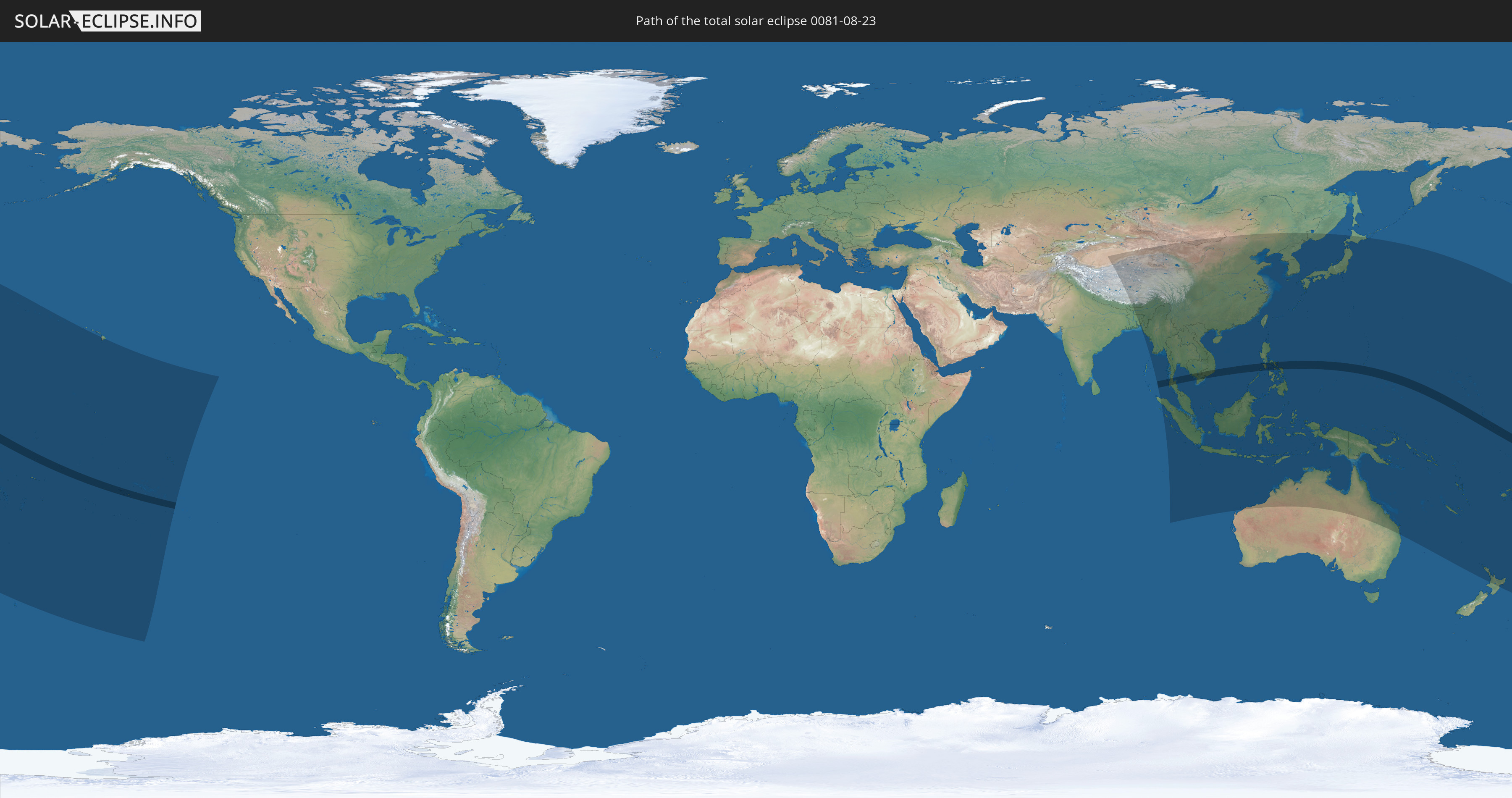
Die Sonnenfinsternis am 23.08.0081 kann man in 50 Ländern als partielle Sonnenfinsternis beobachten.
Der Finsternispfad verläuft durch 10 Länder. Nur in diesen Ländern ist sie als totale Sonnenfinsternis zu sehen.
In den folgenden Ländern ist die Sonnenfinsternis total zu sehen
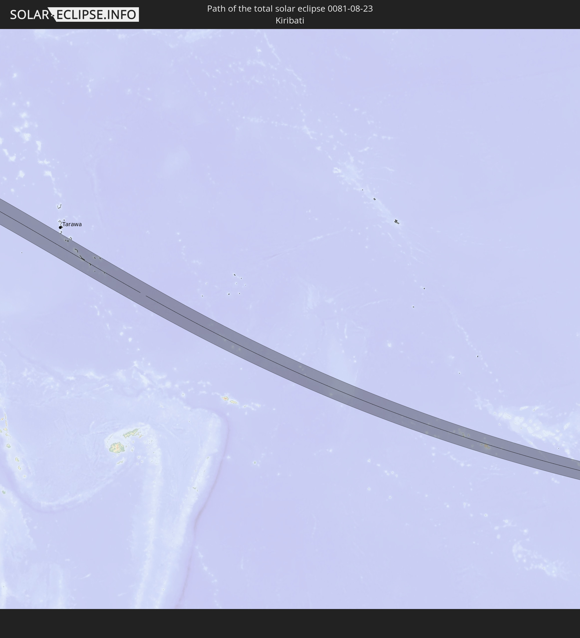 Kiribati
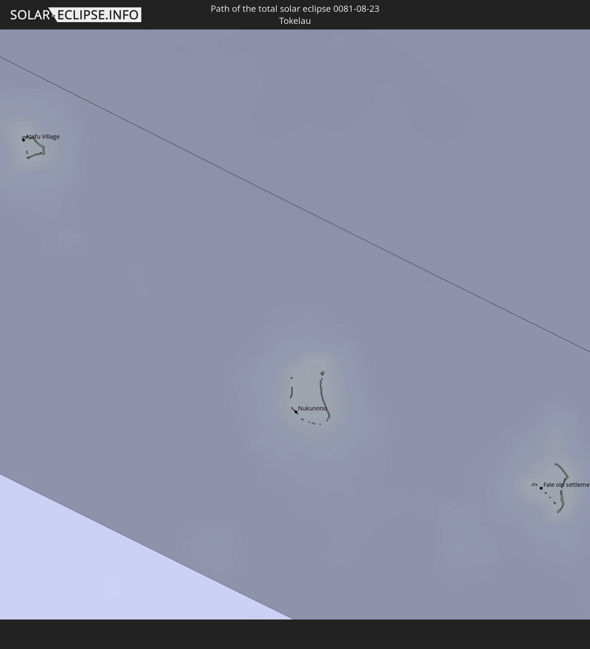 Tokelau
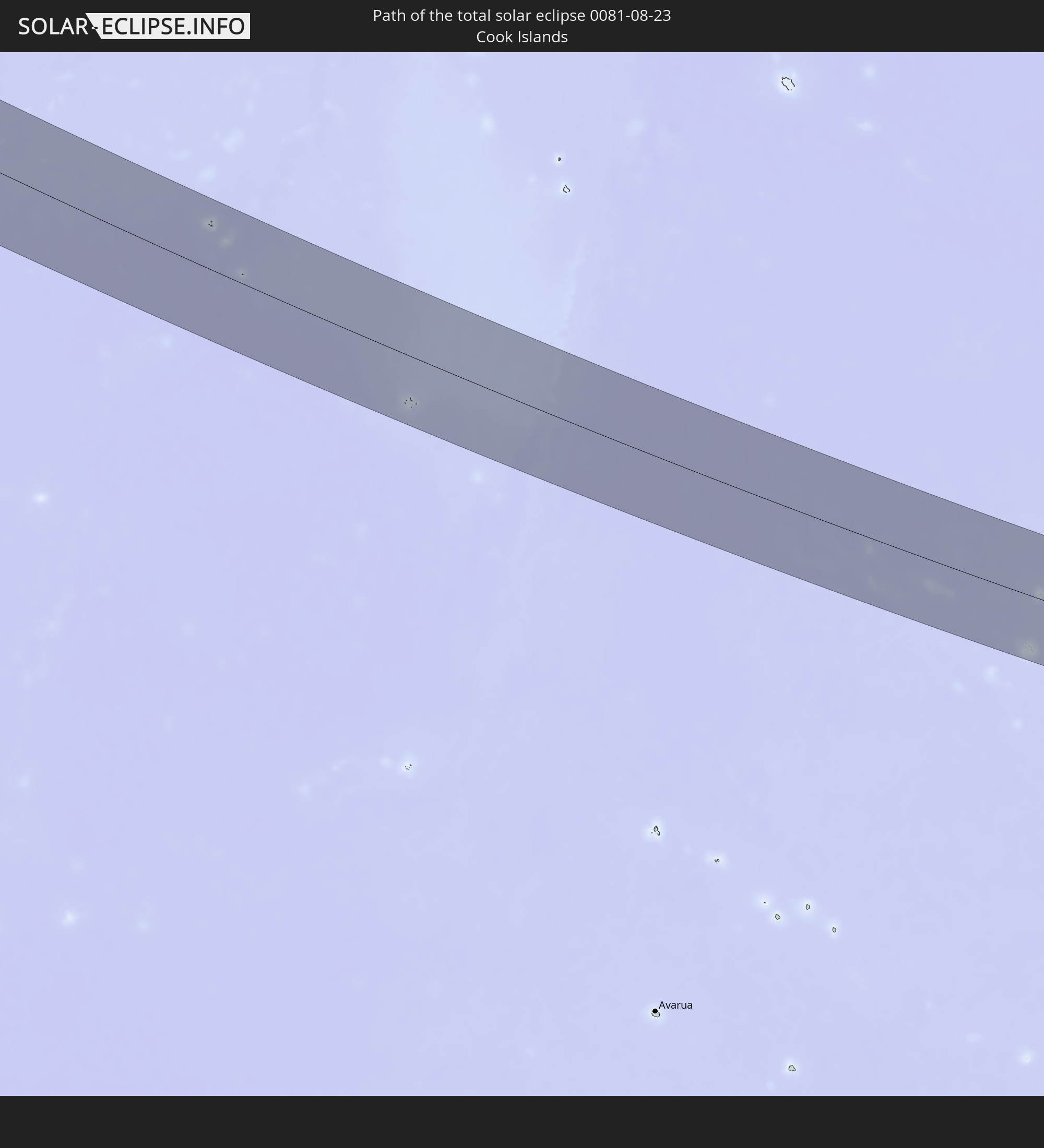 Cookinseln
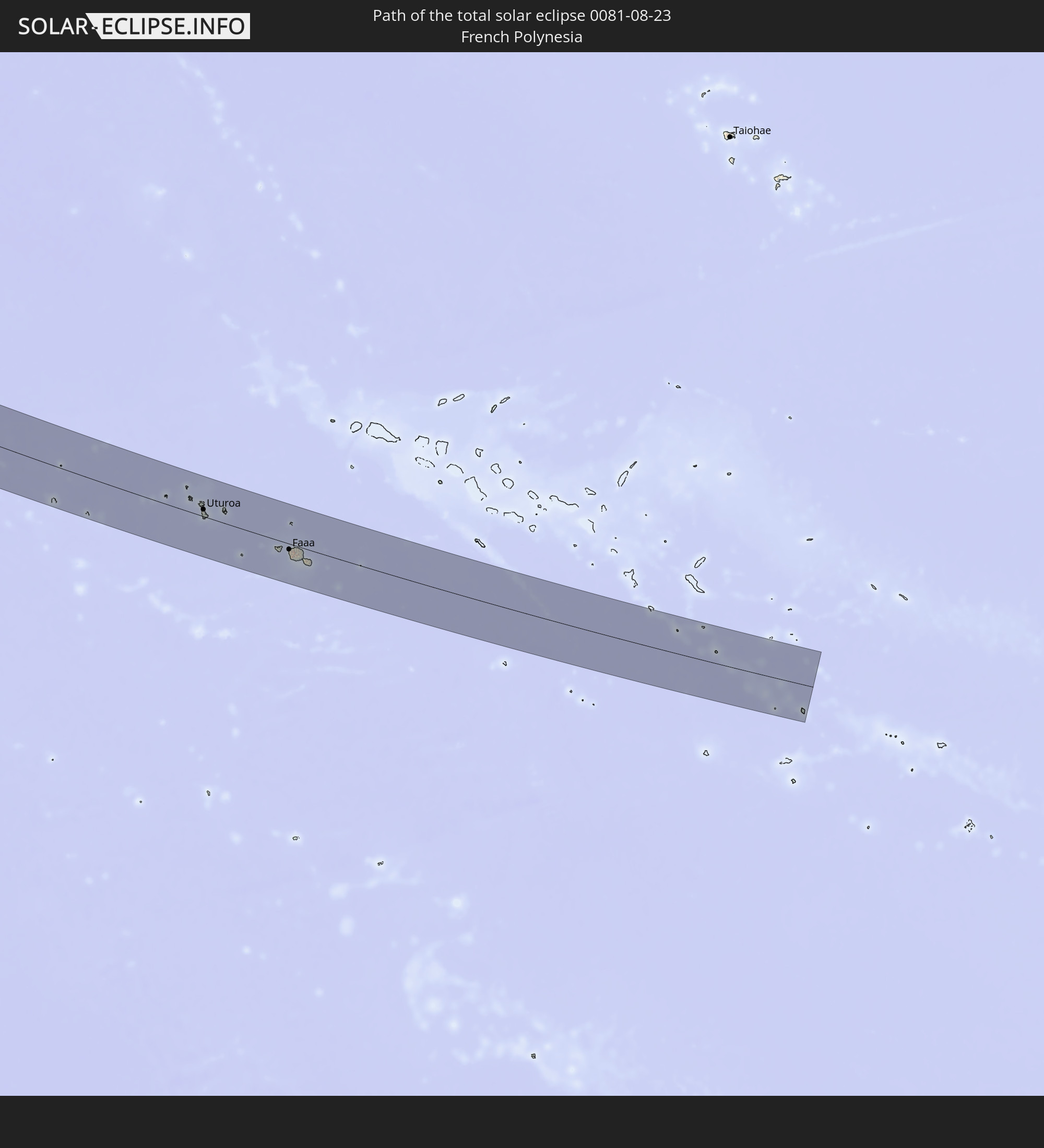 Französisch-Polynesien
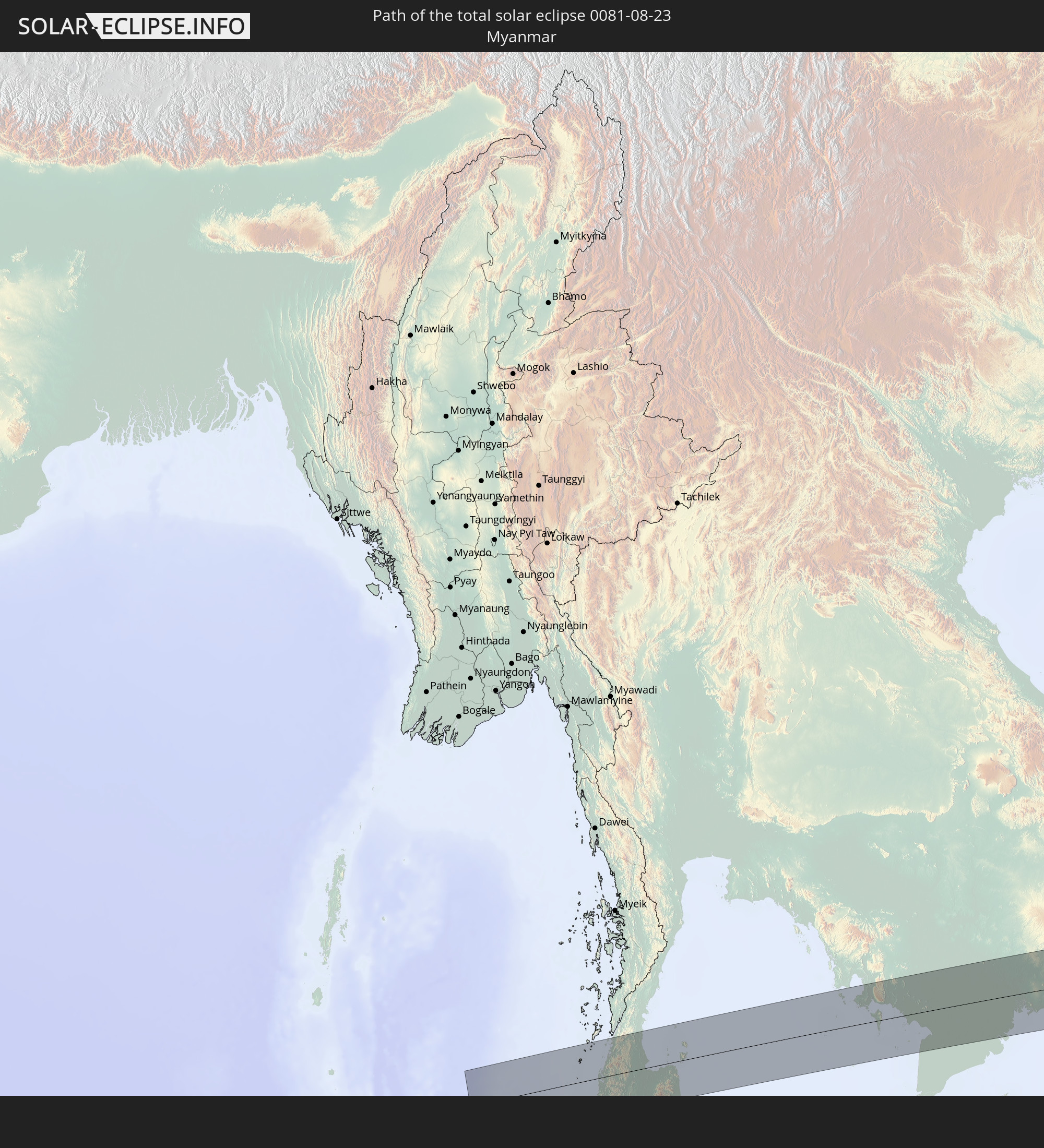 Myanmar
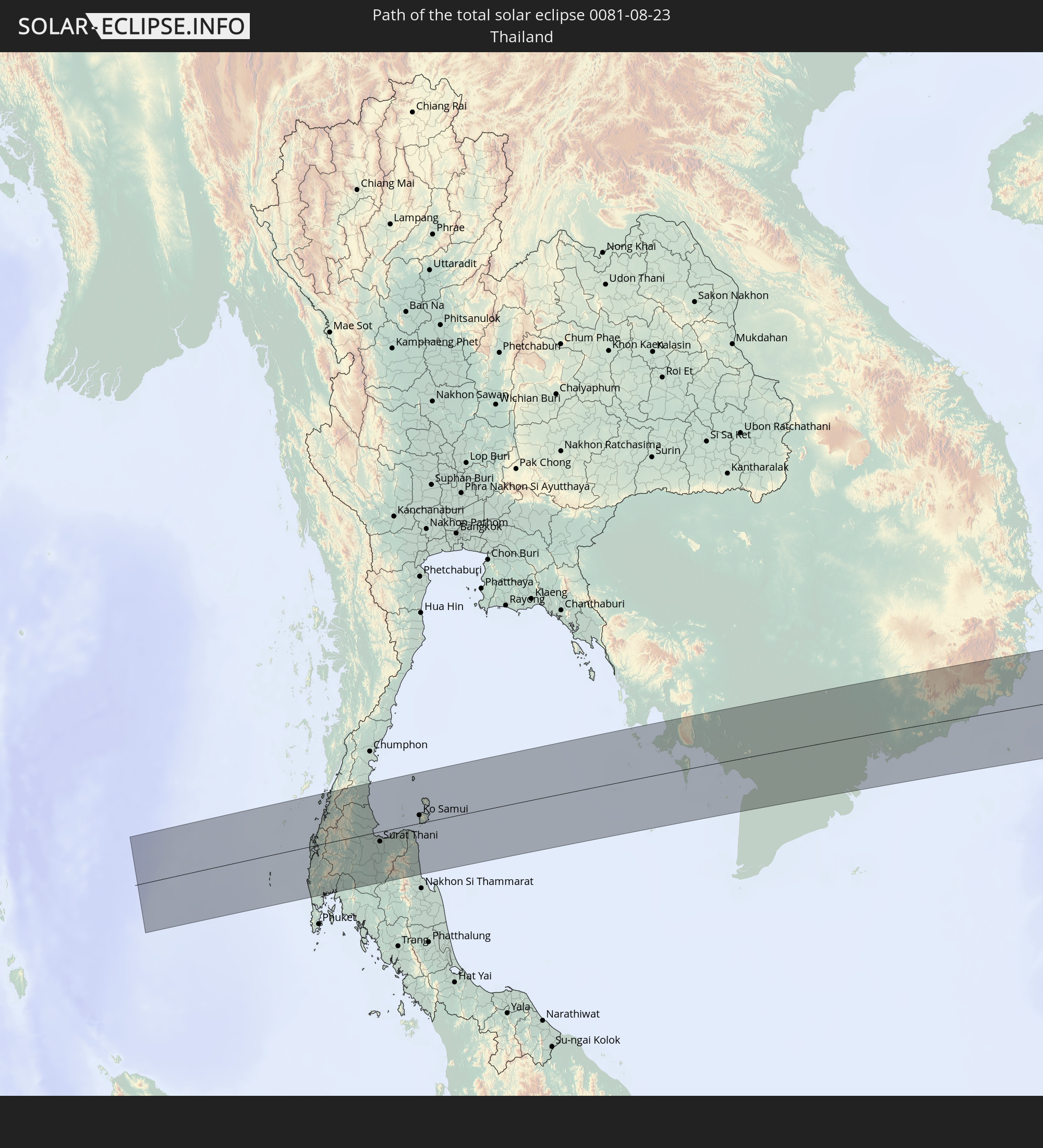 Thailand
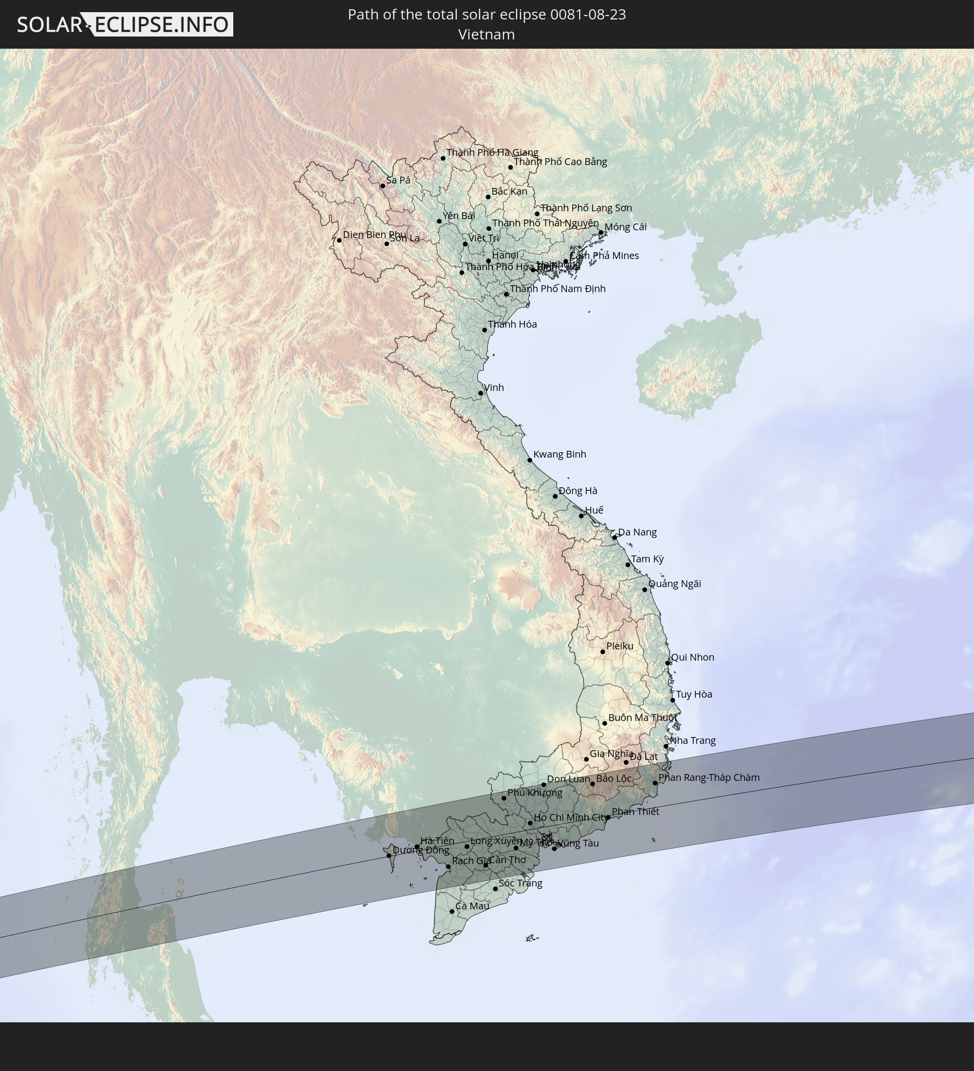 Vietnam
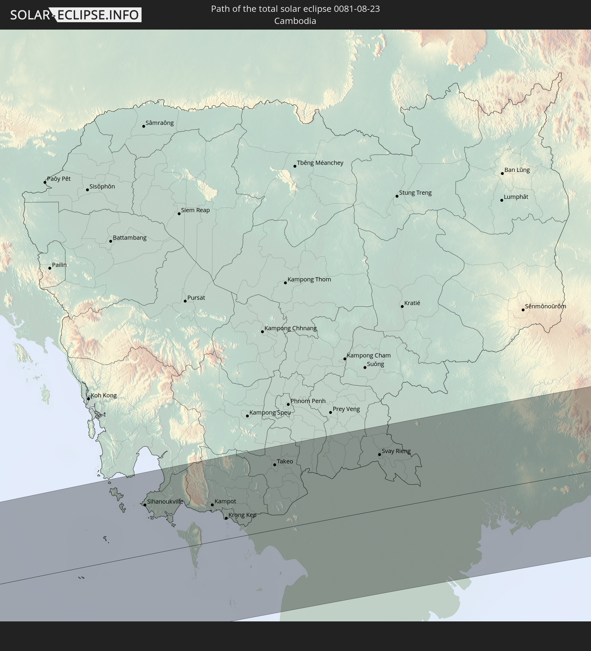 Kambodscha
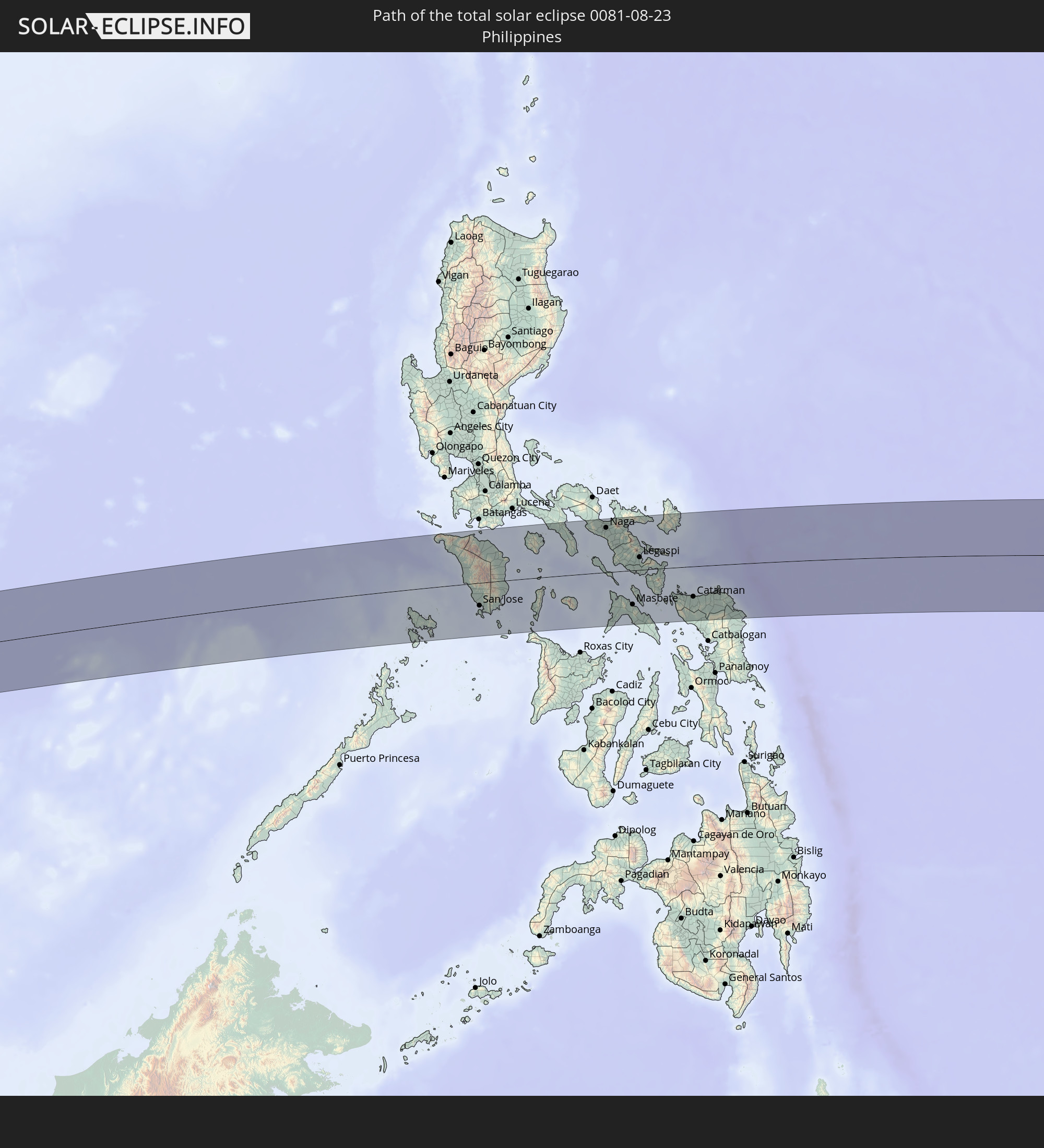 Philippinen
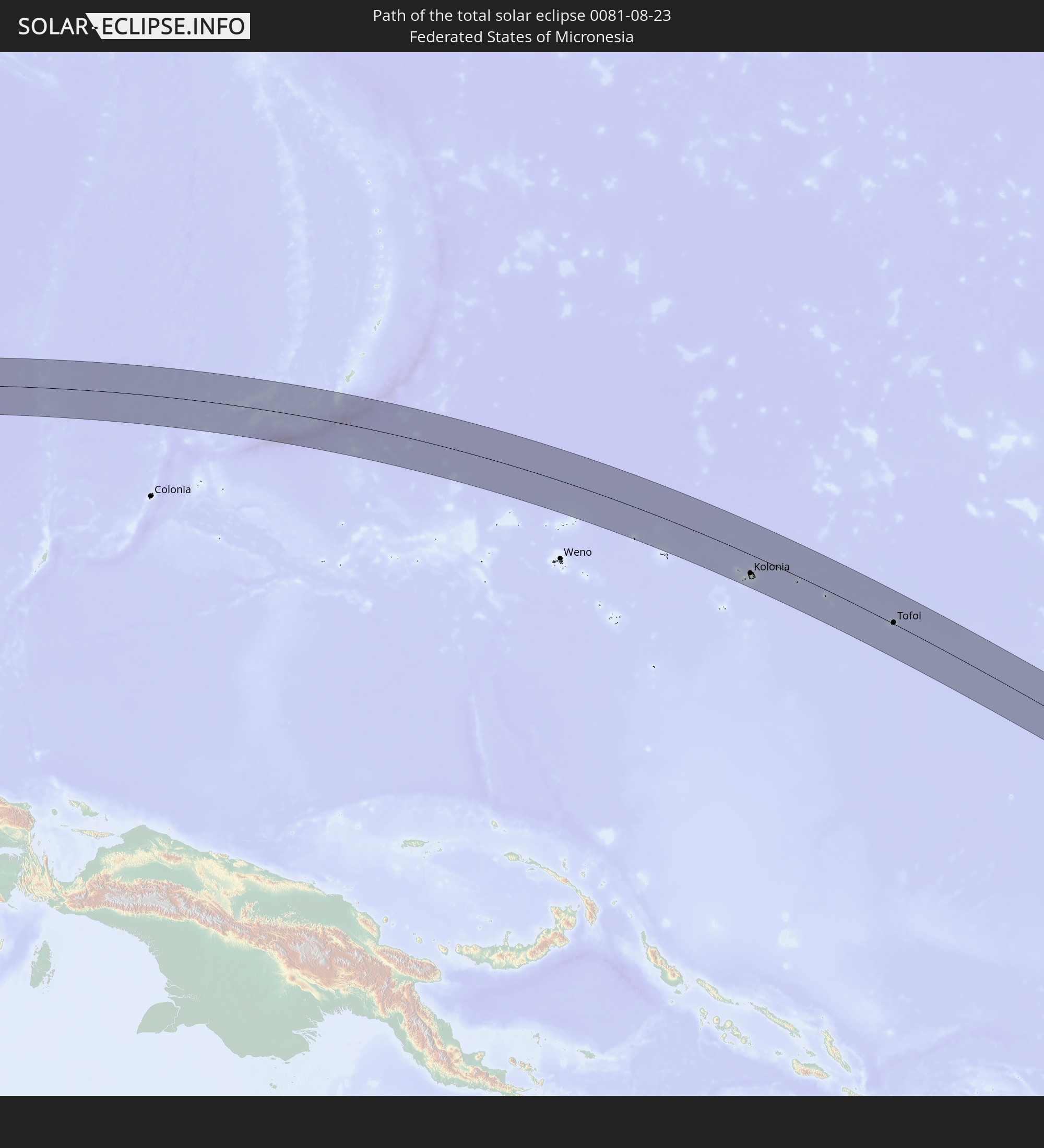 Föderierte Staaten von Mikronesien
In den folgenden Ländern ist die Sonnenfinsternis partiell zu sehen
 Fidschi
 Russland
 Vereinigte Staaten
 Neuseeland
 United States Minor Outlying Islands
 Wallis und Futuna
 Tonga
Tonga
 Kiribati
 Samoa
Samoa
 Tokelau
 Amerikanisch-Samoa
 Niue
Niue
 Cookinseln
 Französisch-Polynesien
 Indien
 Volksrepublik China
 Mongolei
 Bangladesch
 Bhutan
 Myanmar
 Indonesien
 Thailand
 Malaysia
 Laos
Laos
 Vietnam
 Kambodscha
 Singapur
 Weihnachtsinsel
 Australien
 Macau
Macau
 Hongkong
 Brunei
 Taiwan
 Philippinen
 Japan
Japan
 Osttimor
 Nordkorea
 Südkorea
 Palau
Palau
 Föderierte Staaten von Mikronesien
 Papua-Neuguinea
 Guam
Guam
 Nördliche Marianen
 Salomonen
 Neukaledonien
 Marshallinseln
 Vanuatu
 Nauru
Nauru
 Norfolkinsel
 Tuvalu
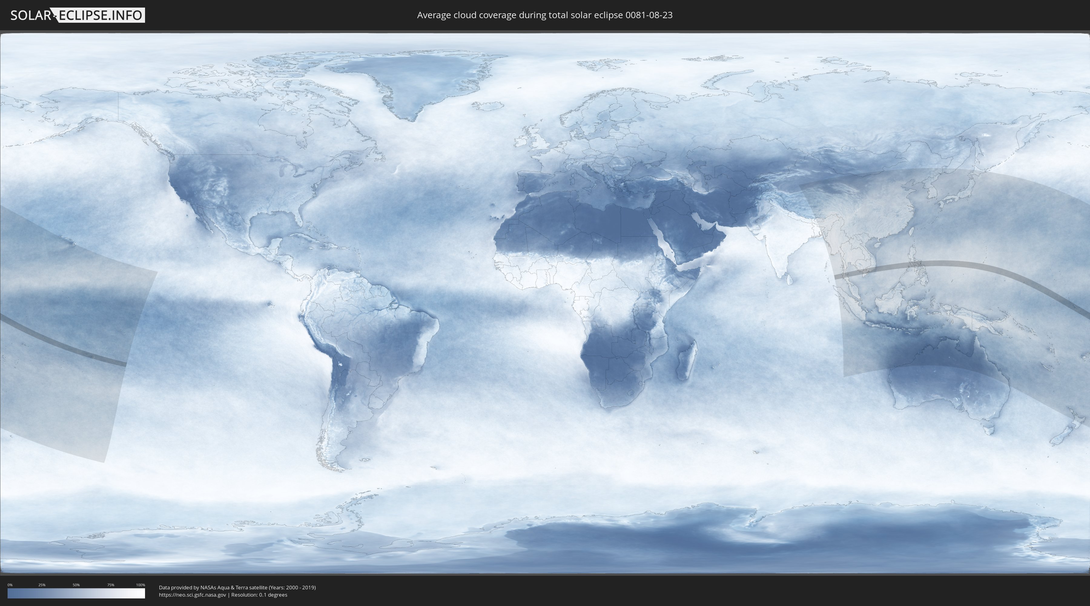
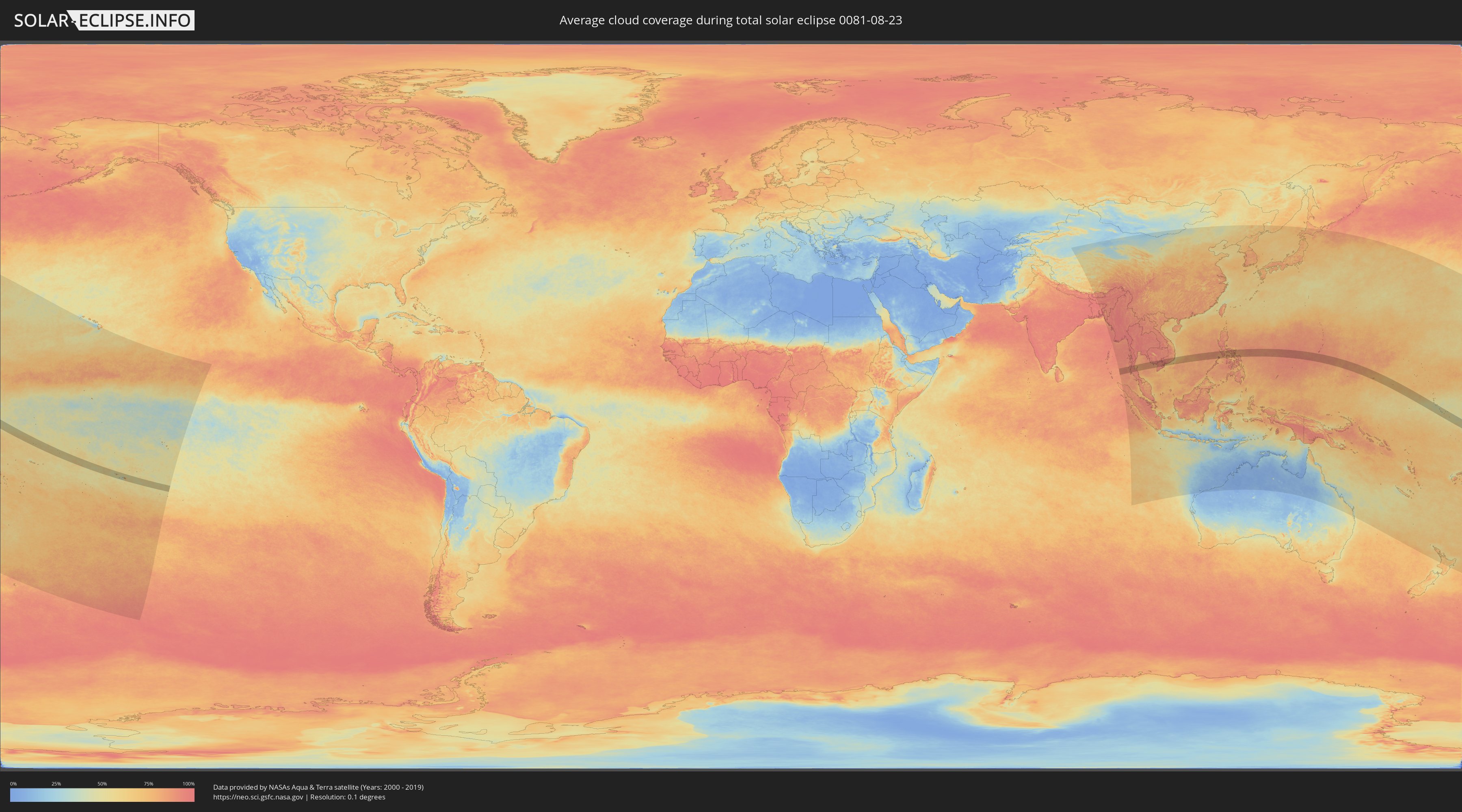
Wie wird das Wetter während der totalen Sonnenfinsternis am 23.08.0081?
Wo ist der beste Ort, um die totale Sonnenfinsternis vom 23.08.0081 zu beobachten?
Die folgenden Karten zeigen die durchschnittliche Bewölkung für den Tag, an dem die totale Sonnenfinsternis
stattfindet. Mit Hilfe der Karten lässt sich der Ort entlang des Finsternispfades eingrenzen,
der die besten Aussichen auf einen klaren wolkenfreien Himmel bietet.
Trotzdem muss man immer lokale Gegenenheiten beachten und sollte sich genau über das Wetter an seinem
gewählten Beobachtungsort informieren.
Die Daten stammen von den beiden NASA-Satelliten
AQUA und TERRA
und wurden über einen Zeitraum von 19 Jahren (2000 - 2019) gemittelt.
Detaillierte Länderkarten
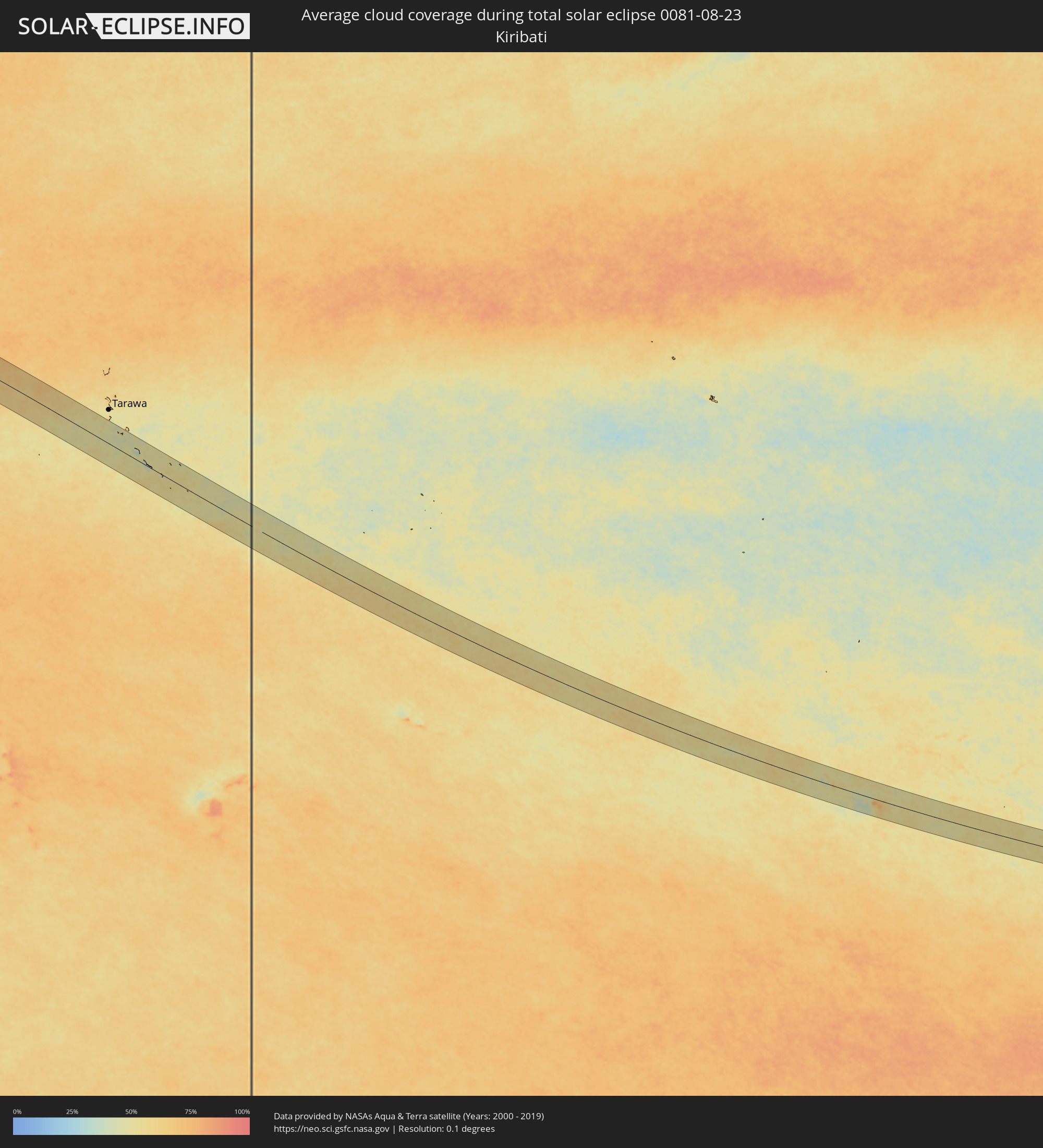 Kiribati
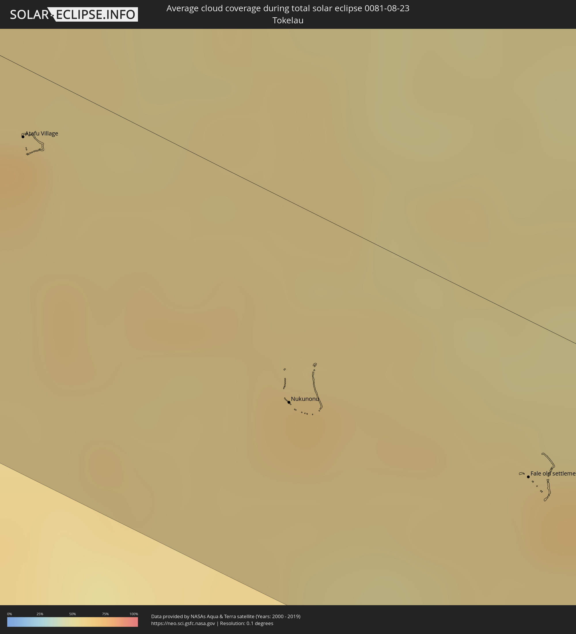 Tokelau
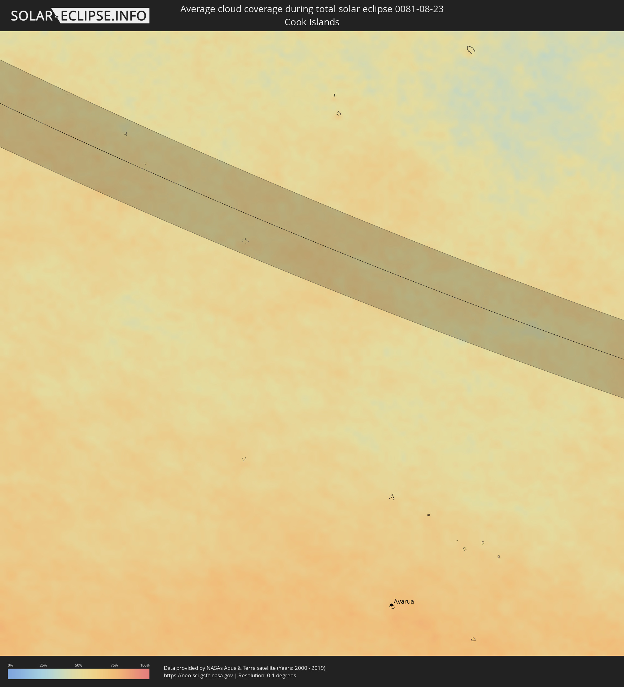 Cookinseln
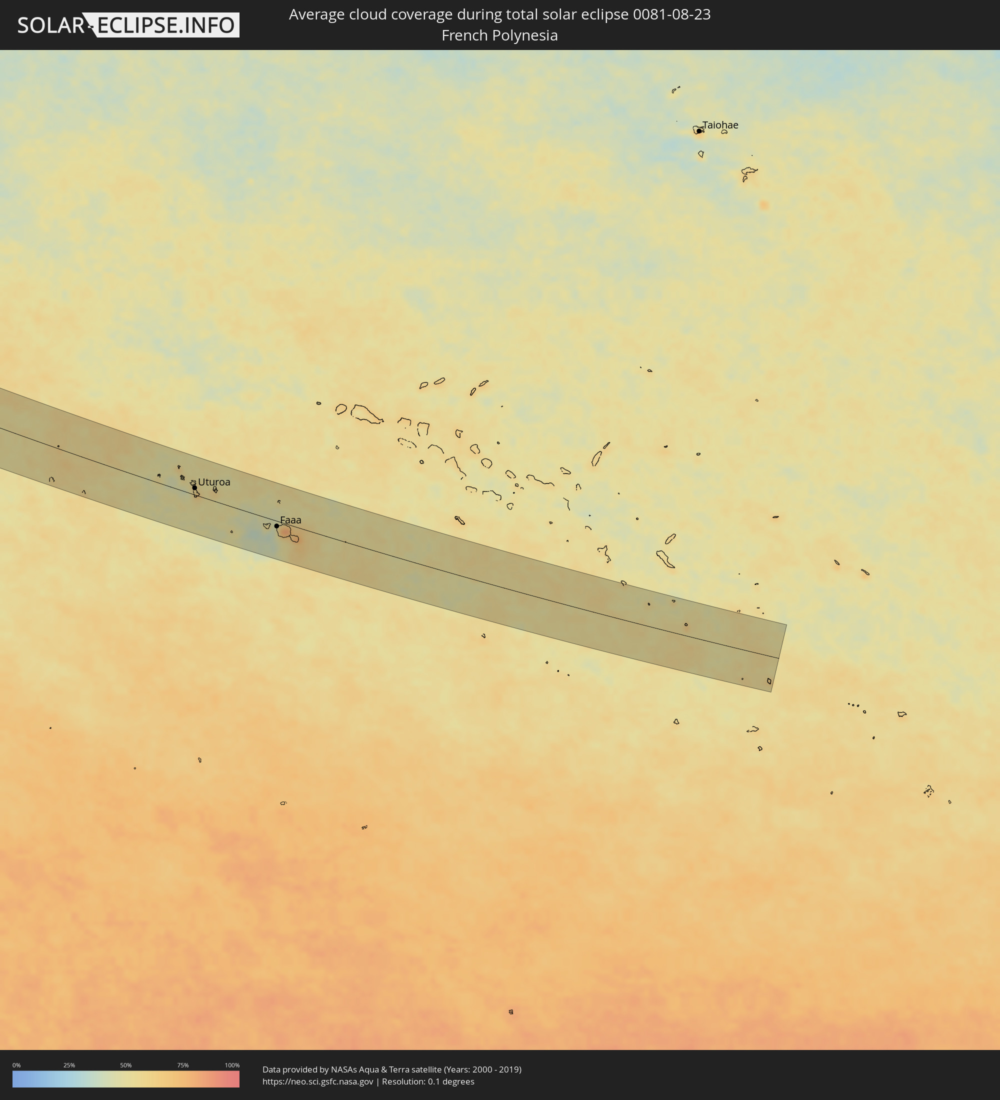 Französisch-Polynesien
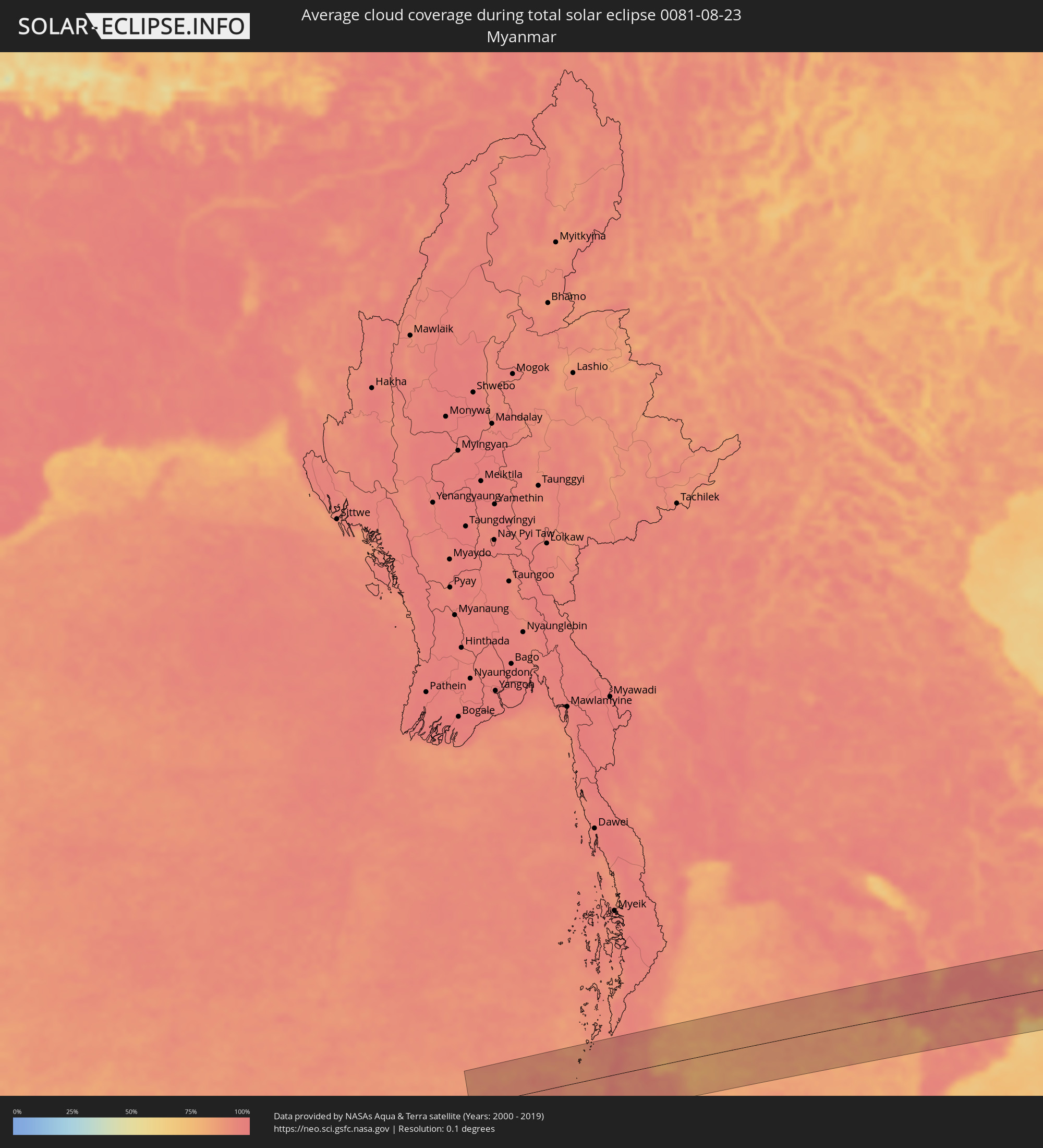 Myanmar
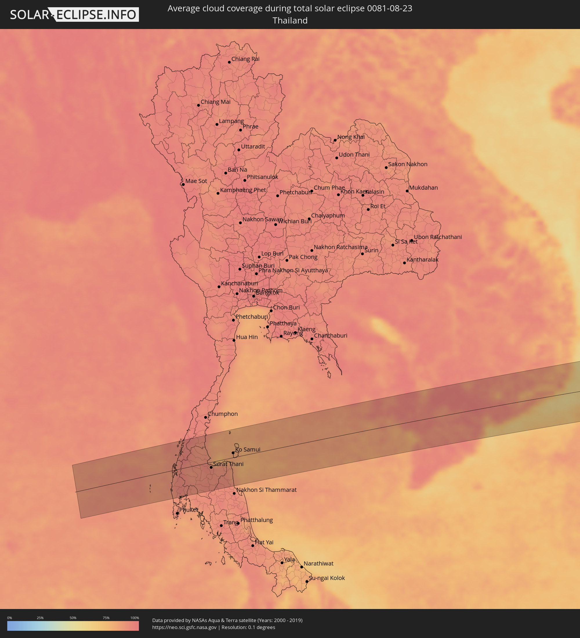 Thailand
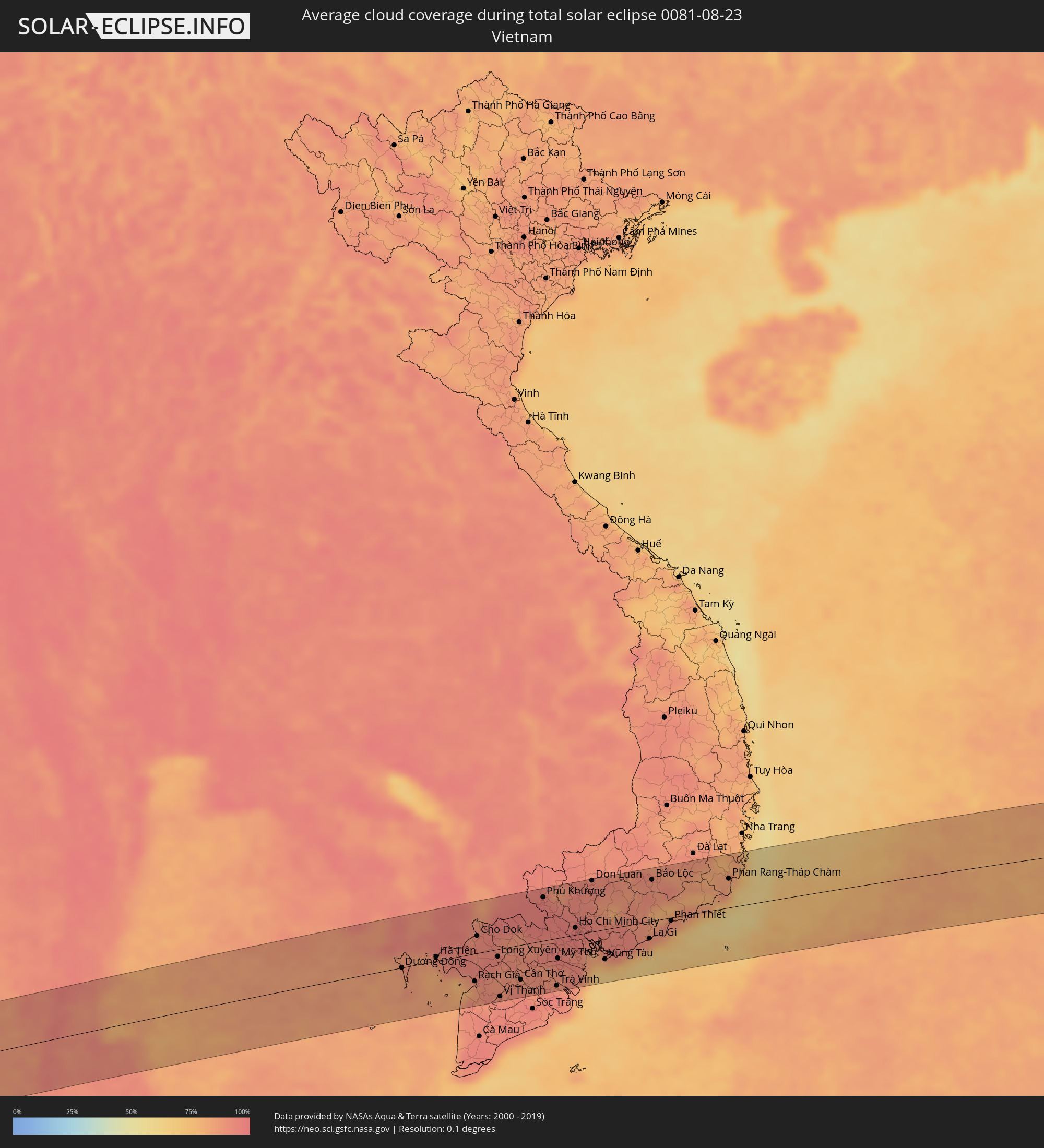 Vietnam
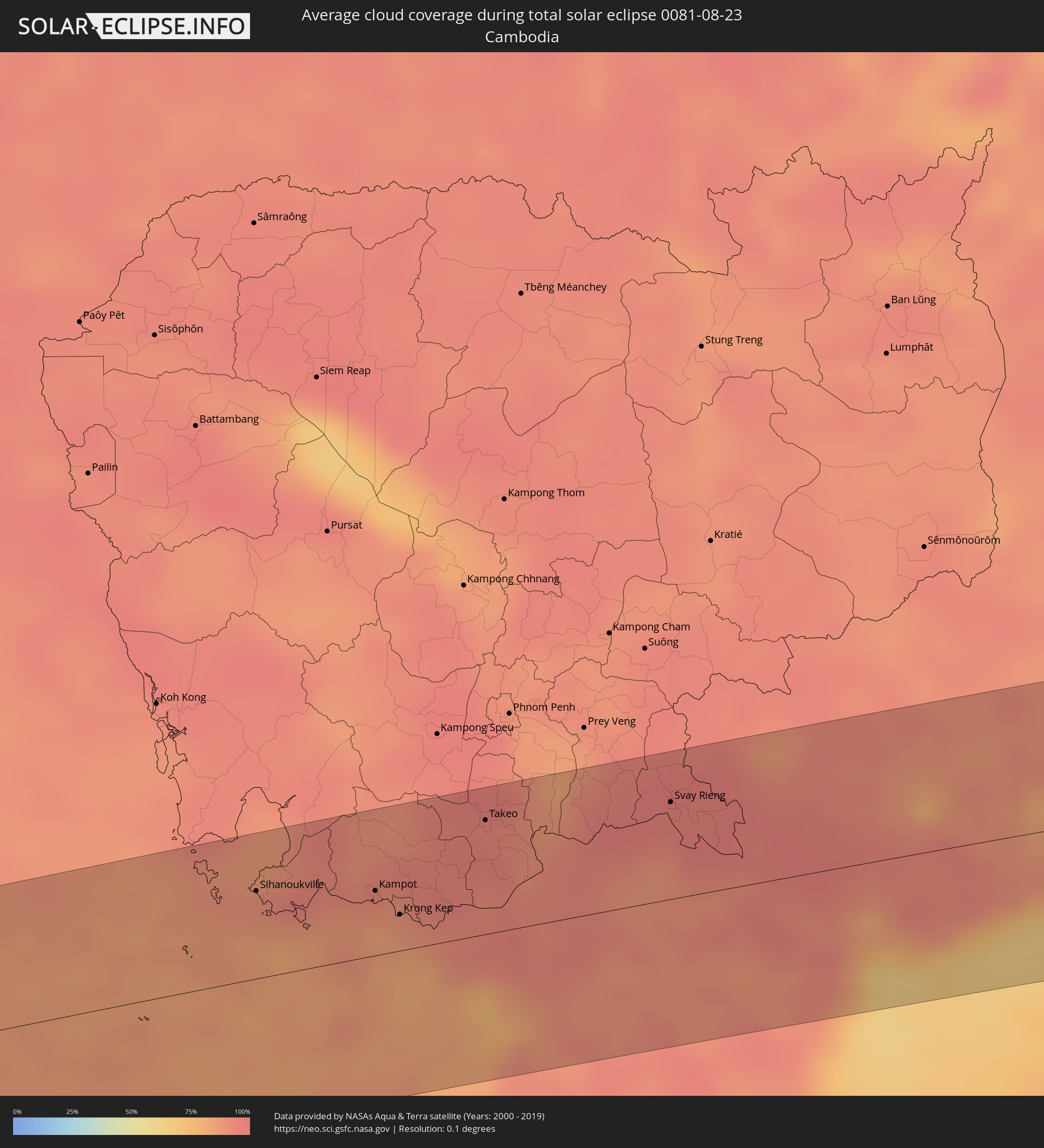 Kambodscha
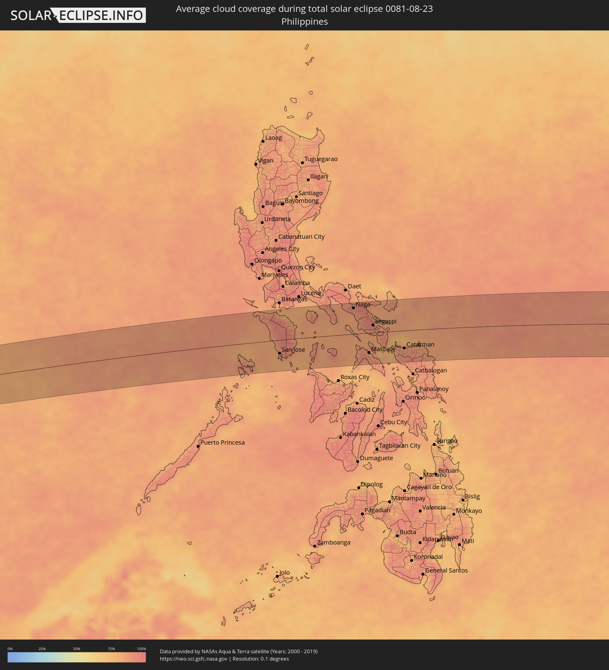 Philippinen
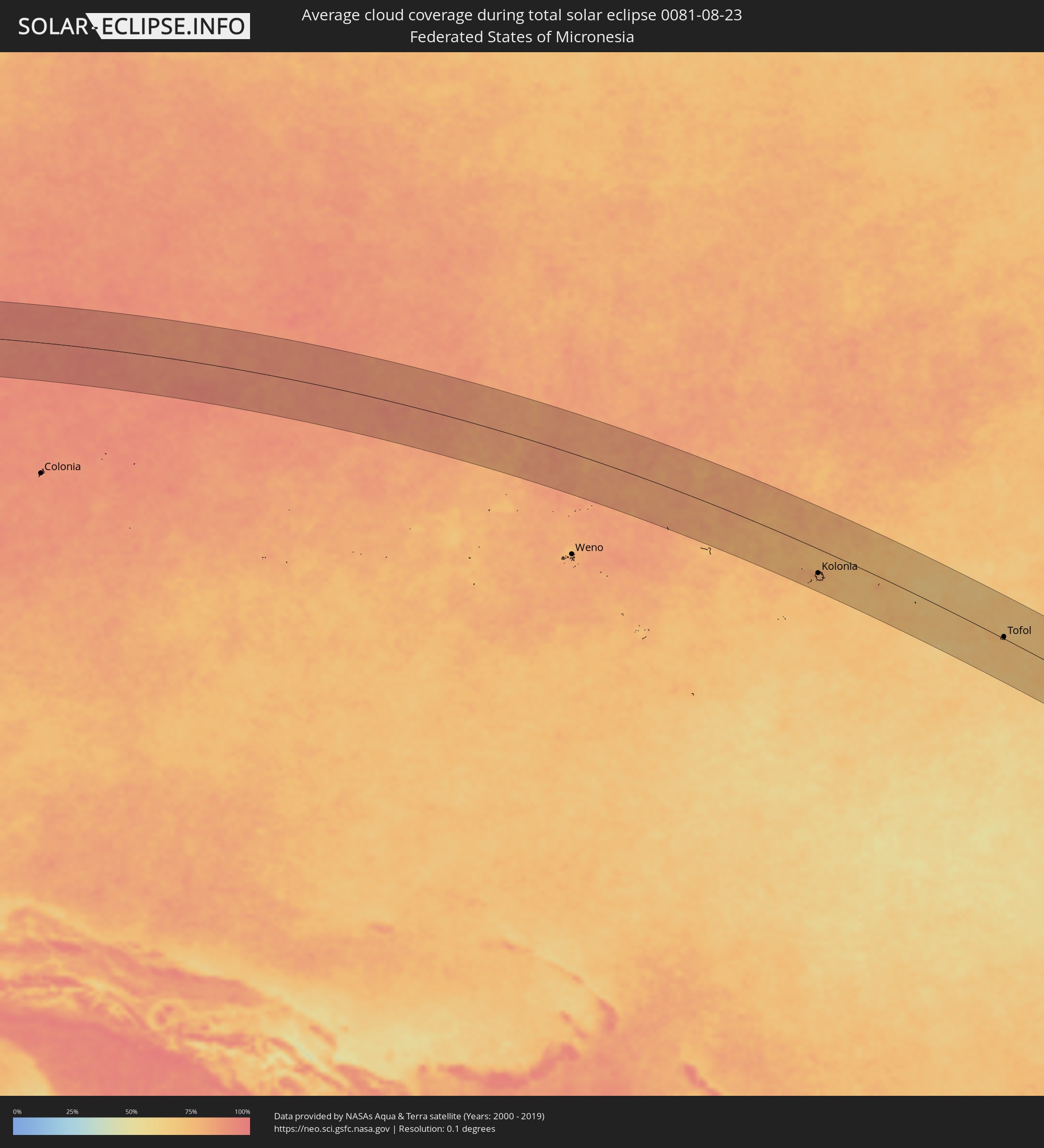 Föderierte Staaten von Mikronesien
Orte im Finsternispfad
Die nachfolgene Tabelle zeigt Städte und Orte mit mehr als 5.000 Einwohnern, die sich im Finsternispfad befinden. Städte mit mehr als 100.000 Einwohnern sind dick gekennzeichnet. Mit einem Klick auf den Ort öffnet sich eine Detailkarte die die Lage des jeweiligen Ortes zusammen mit dem Verlauf der zentralen Finsternis präsentiert.
| Ort | Typ | Dauer der Verfinsterung | Ortszeit bei maximaler Verfinsterung | Entfernung zur Zentrallinie | Ø Bewölkung |
|
Atafu Village, Atafu
|
total | - | 15:30:56 UTC-11:00 | 17 km | 66% |
|
Nukunonu, Nukunonu
|
total | - | 15:32:21 UTC-11:00 | 50 km | 61% |
|
Fale old settlement, Fakaofo
|
total | - | 15:33:17 UTC-11:00 | 39 km | 64% |
|
Uturoa, Leeward Islands
|
total | - | 16:54:50 UTC-09:58 | 15 km | 59% |
|
Punaauia, Îles du Vent
|
total | - | 16:55:41 UTC-09:58 | 21 km | 55% |
|
Faaa, Îles du Vent
|
total | - | 16:55:41 UTC-09:58 | 12 km | 55% |
|
Paea, Îles du Vent
|
total | - | 16:55:42 UTC-09:58 | 26 km | 51% |
|
Papeete, Îles du Vent
|
total | - | 16:55:41 UTC-09:58 | 10 km | 53% |
|
Papao, Îles du Vent
|
total | - | 16:55:43 UTC-09:58 | 32 km | 47% |
|
Pirae, Îles du Vent
|
total | - | 02:53:58 UTC+00:00 | 7 km | 66% |
|
Arue, Îles du Vent
|
total | - | 16:55:42 UTC-09:58 | 6 km | 66% |
|
Mahina, Îles du Vent
|
total | - | 16:55:43 UTC-09:58 | 4 km | 66% |
|
Afaahiti
|
total | - | 16:55:49 UTC-09:58 | 24 km | 64% |
|
Phang Nga, Phangnga
|
total | - | 06:13:49 UTC+06:42 | 73 km | 92% |
|
Ban Nam Yuen, Chumphon
|
total | - | 06:13:51 UTC+06:42 | 75 km | 93% |
|
Lang Suan, Chumphon
|
total | - | 06:13:52 UTC+06:42 | 77 km | 91% |
|
Chaiya, Surat Thani
|
total | - | 06:13:53 UTC+06:42 | 14 km | 91% |
|
Phunphin, Surat Thani
|
total | - | 06:13:53 UTC+06:42 | 17 km | 93% |
|
Surat Thani, Surat Thani
|
total | - | 06:13:54 UTC+06:42 | 16 km | 92% |
|
Ban Na San, Surat Thani
|
total | - | 06:13:54 UTC+06:42 | 54 km | 90% |
|
Wiang Sa, Surat Thani
|
total | - | 06:13:54 UTC+06:42 | 72 km | 92% |
|
Don Sak, Surat Thani
|
total | - | 06:13:56 UTC+06:42 | 5 km | 86% |
|
Ko Samui, Surat Thani
|
total | - | 06:13:59 UTC+06:42 | 13 km | 83% |
|
Ko Pha Ngan, Nakhon Si Thammarat
|
total | - | 06:14:00 UTC+06:42 | 35 km | 81% |
|
Sihanoukville, Preah Sihanouk
|
total | - | 06:14:45 UTC+06:42 | 52 km | 89% |
|
Kampot, Kampot
|
total | - | 06:14:56 UTC+06:42 | 38 km | 87% |
|
Krong Kep, Kep
|
total | - | 06:14:58 UTC+06:42 | 21 km | 85% |
|
Hà Tiên, Kiến Giang
|
total | - | 06:39:37 UTC+07:06 | 7 km | 87% |
|
Phumĭ Véal Srê, Takeo
|
total | - | 06:15:08 UTC+06:42 | 66 km | 95% |
|
Takeo, Takeo
|
total | - | 06:15:08 UTC+06:42 | 67 km | 95% |
|
Rạch Giá, Kiến Giang
|
total | - | 06:39:48 UTC+07:06 | 46 km | 87% |
|
Cho Dok, An Giang
|
total | - | 06:39:50 UTC+07:06 | 29 km | 93% |
|
Long Xuyên, An Giang
|
total | - | 06:39:56 UTC+07:06 | 12 km | 93% |
|
Vị Thanh, Hau Giang
|
total | - | 06:39:57 UTC+07:06 | 79 km | 94% |
|
Cao Lãnh, Đồng Tháp
|
total | - | 06:40:00 UTC+07:06 | 8 km | 91% |
|
Sadek, Đồng Tháp
|
total | - | 06:40:03 UTC+07:06 | 29 km | 89% |
|
Cần Thơ, Cần Thơ
|
total | - | 06:40:03 UTC+07:06 | 58 km | 93% |
|
Svay Rieng, Svay Rieng
|
total | - | 06:15:29 UTC+06:42 | 57 km | 96% |
|
Vĩnh Long, Vĩnh Long
|
total | - | 06:40:07 UTC+07:06 | 38 km | 90% |
|
Tây Ninh, Tây Ninh
|
total | - | 06:40:12 UTC+07:06 | 75 km | 97% |
|
Phú Khương, Tây Ninh
|
total | - | 06:40:13 UTC+07:06 | 72 km | 97% |
|
Trà Vinh, Trà Vinh
|
total | - | 06:40:16 UTC+07:06 | 79 km | 95% |
|
Mỹ Tho, Tiền Giang
|
total | - | 06:40:16 UTC+07:06 | 34 km | 93% |
|
Bến Tre, Bến Tre
|
total | - | 06:40:17 UTC+07:06 | 47 km | 90% |
|
Tân An, Long An
|
total | - | 06:40:18 UTC+07:06 | 16 km | 96% |
|
Củ Chi, Ho Chi Minh City
|
total | - | 06:40:20 UTC+07:06 | 31 km | 96% |
|
Ho Chi Minh City, Ho Chi Minh City
|
total | - | 06:40:23 UTC+07:06 | 12 km | 97% |
|
Thủ Dầu Một, Bình Dương
|
total | - | 06:40:24 UTC+07:06 | 28 km | 95% |
|
Cần Giuộc, Long An
|
total | - | 06:40:24 UTC+07:06 | 13 km | 92% |
|
Biên Hòa, Đồng Nai
|
total | - | 06:40:28 UTC+07:06 | 21 km | 96% |
|
Don Luan, Bình Phước
|
total | - | 06:40:31 UTC+07:06 | 85 km | 93% |
|
Cần Giờ, Ho Chi Minh City
|
total | - | 06:40:31 UTC+07:06 | 40 km | 74% |
|
Vũng Tàu, Bà Rịa-Vũng Tàu
|
total | - | 06:40:34 UTC+07:06 | 50 km | 66% |
|
La Gi, Bình Thuận
|
total | - | 06:40:52 UTC+07:06 | 28 km | 81% |
|
Bảo Lộc, Lâm Đồng
|
total | - | 06:40:54 UTC+07:06 | 68 km | 90% |
|
Phan Thiết, Bình Thuận
|
total | - | 06:41:01 UTC+07:06 | 5 km | 80% |
|
Đinh Văn, Lâm Đồng
|
total | - | 06:41:06 UTC+07:06 | 86 km | 85% |
|
Phan Rang-Tháp Chàm, Ninh Thuận
|
total | - | 06:41:27 UTC+07:06 | 48 km | 81% |
|
Cam Ranh, Khánh Hòa
|
total | - | 06:41:33 UTC+07:06 | 84 km | 76% |
|
Mamburao, Mimaropa
|
total | - | 07:43:32 UTC+08:00 | 60 km | 83% |
|
Sablayan, Mimaropa
|
total | - | 07:43:44 UTC+08:00 | 15 km | 83% |
|
Calintaan, Mimaropa
|
total | - | 07:43:55 UTC+08:00 | 16 km | 82% |
|
San Jose, Mimaropa
|
total | - | 07:44:04 UTC+08:00 | 41 km | 85% |
|
Calapan, Mimaropa
|
total | - | 07:44:09 UTC+08:00 | 75 km | 79% |
|
Bulalacao, Mimaropa
|
total | - | 07:44:22 UTC+08:00 | 47 km | 83% |
|
Mansalay, Mimaropa
|
total | - | 07:44:27 UTC+08:00 | 26 km | 86% |
|
Bansud, Mimaropa
|
total | - | 07:44:28 UTC+08:00 | 12 km | 84% |
|
Pinamalayan, Mimaropa
|
total | - | 07:44:27 UTC+08:00 | 32 km | 84% |
|
Romblon, Mimaropa
|
total | - | 07:45:23 UTC+08:00 | 28 km | 84% |
|
Catanauan, Calabarzon
|
total | - | 07:45:23 UTC+08:00 | 85 km | 85% |
|
Aurora, Calabarzon
|
total | - | 07:45:37 UTC+08:00 | 56 km | 84% |
|
San Narciso, Calabarzon
|
total | - | 07:45:40 UTC+08:00 | 80 km | 87% |
|
Naga, Bicol
|
total | - | 07:46:22 UTC+08:00 | 80 km | 91% |
|
Bula, Bicol
|
total | - | 07:46:30 UTC+08:00 | 63 km | 86% |
|
Iriga City, Bicol
|
total | - | 07:46:39 UTC+08:00 | 58 km | 88% |
|
Pio Duran, Bicol
|
total | - | 07:46:43 UTC+08:00 | 13 km | 85% |
|
Polangui, Bicol
|
total | - | 07:46:45 UTC+08:00 | 42 km | 92% |
|
Goa, Bicol
|
total | - | 07:46:44 UTC+08:00 | 87 km | 90% |
|
Masbate, Bicol
|
total | - | 07:46:59 UTC+08:00 | 62 km | 88% |
|
Tabaco, Bicol
|
total | - | 07:47:02 UTC+08:00 | 47 km | 90% |
|
Legaspi, Bicol
|
total | - | 07:47:04 UTC+08:00 | 23 km | 89% |
|
Bulan, Bicol
|
total | - | 07:47:16 UTC+08:00 | 30 km | 83% |
|
Sorsogon, Bicol
|
total | - | 07:47:23 UTC+08:00 | 2 km | 84% |
|
Irosin, Bicol
|
total | - | 07:47:27 UTC+08:00 | 28 km | 87% |
|
Gubat, Bicol
|
total | - | 07:47:33 UTC+08:00 | 4 km | 85% |
|
Virac, Bicol
|
total | - | 07:47:38 UTC+08:00 | 69 km | 83% |
|
Catarman, Eastern Visayas
|
total | - | 07:48:14 UTC+08:00 | 55 km | 87% |
|
Laoang, Eastern Visayas
|
total | - | 07:48:42 UTC+08:00 | 49 km | 83% |
|
Palikir - National Government Center, Pohnpei
|
total | - | 12:07:14 UTC+11:00 | 69 km | 81% |
|
Kolonia Town, Pohnpei
|
total | - | 12:07:18 UTC+11:00 | 63 km | 82% |
|
Kolonia, Pohnpei
|
total | - | 12:07:18 UTC+11:00 | 63 km | 82% |
|
Tofol, Kosrae
|
total | - | 12:22:49 UTC+11:00 | 5 km | 72% |