Totale Sonnenfinsternis vom 27.12.0083
| Wochentag: | Montag |
| Maximale Dauer der Verfinsterung: | 02m44s |
| Maximale Breite des Finsternispfades: | 147 km |
| Saroszyklus: | 62 |
| Bedeckungsgrad: | 100% |
| Magnitude: | 1.029 |
| Gamma: | 0.7435 |
Wo kann man die Sonnenfinsternis vom 27.12.0083 sehen?
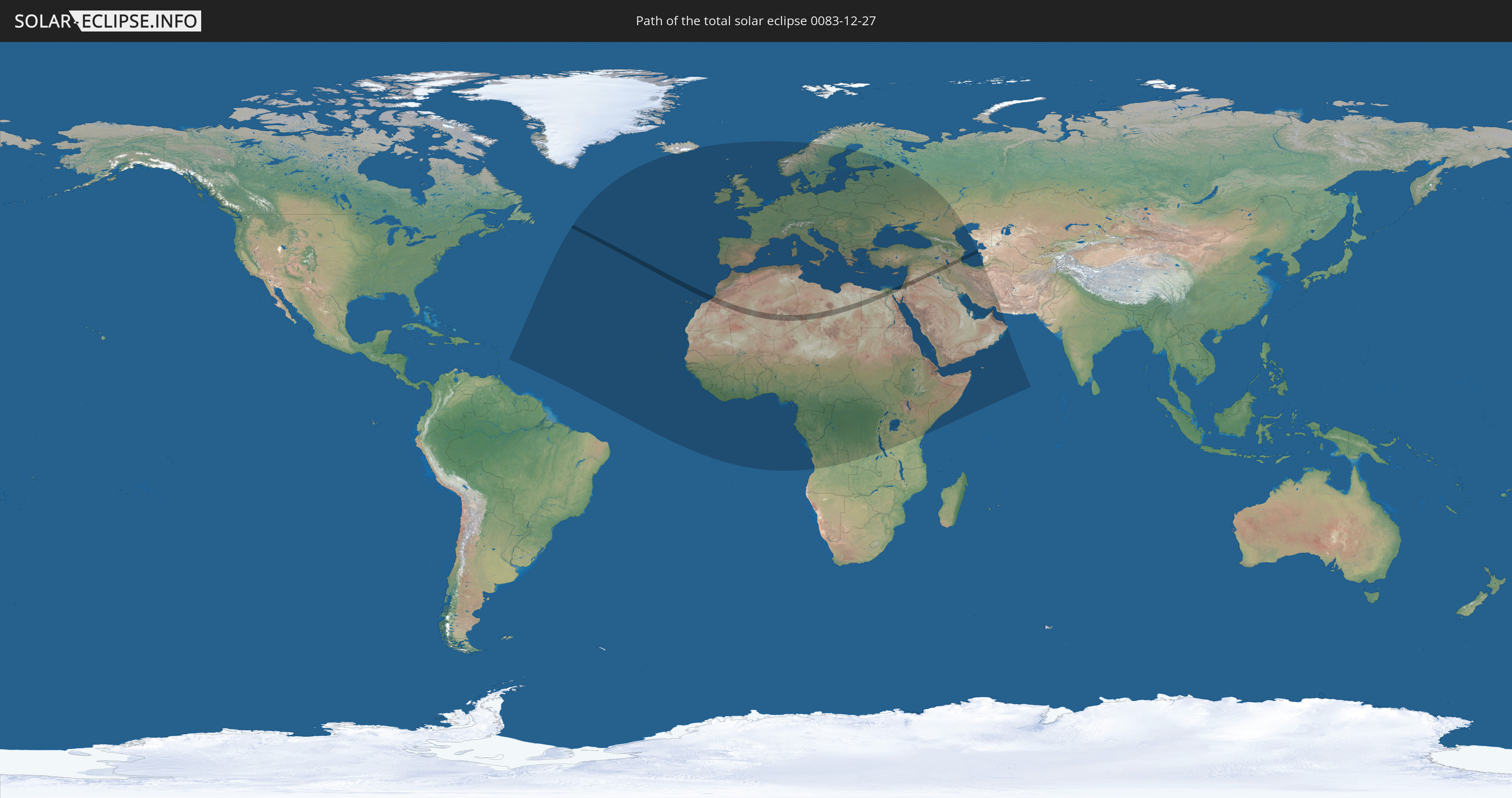
Die Sonnenfinsternis am 27.12.0083 kann man in 111 Ländern als partielle Sonnenfinsternis beobachten.
Der Finsternispfad verläuft durch 13 Länder. Nur in diesen Ländern ist sie als totale Sonnenfinsternis zu sehen.
In den folgenden Ländern ist die Sonnenfinsternis total zu sehen
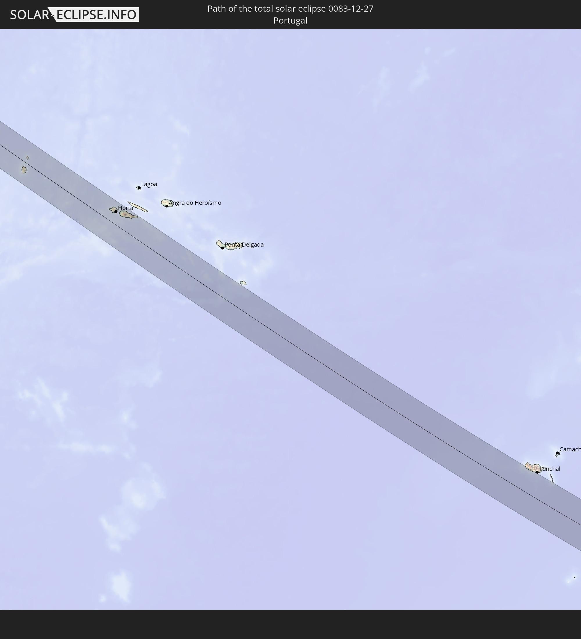 Portugal
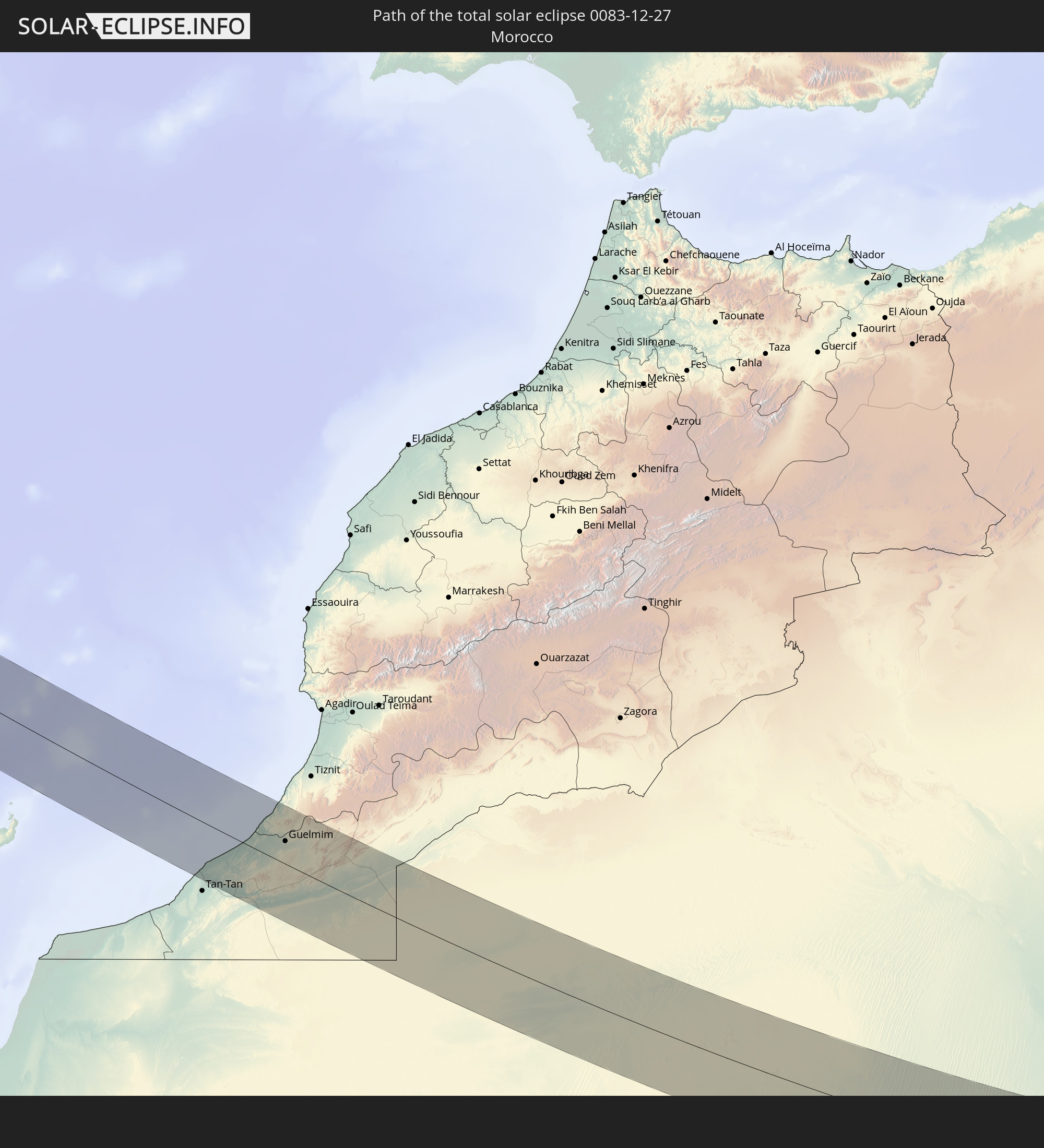 Marokko
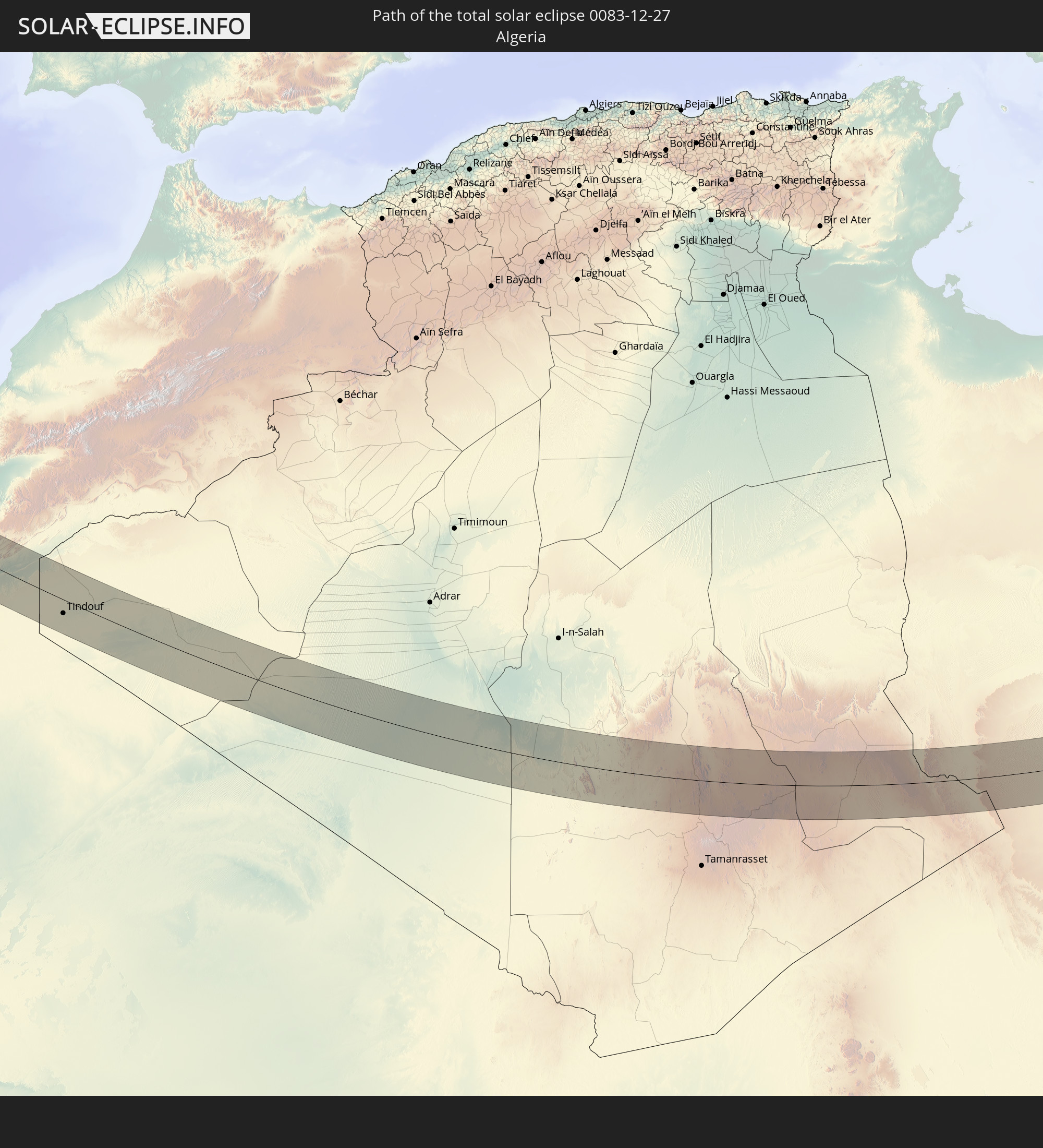 Algerien
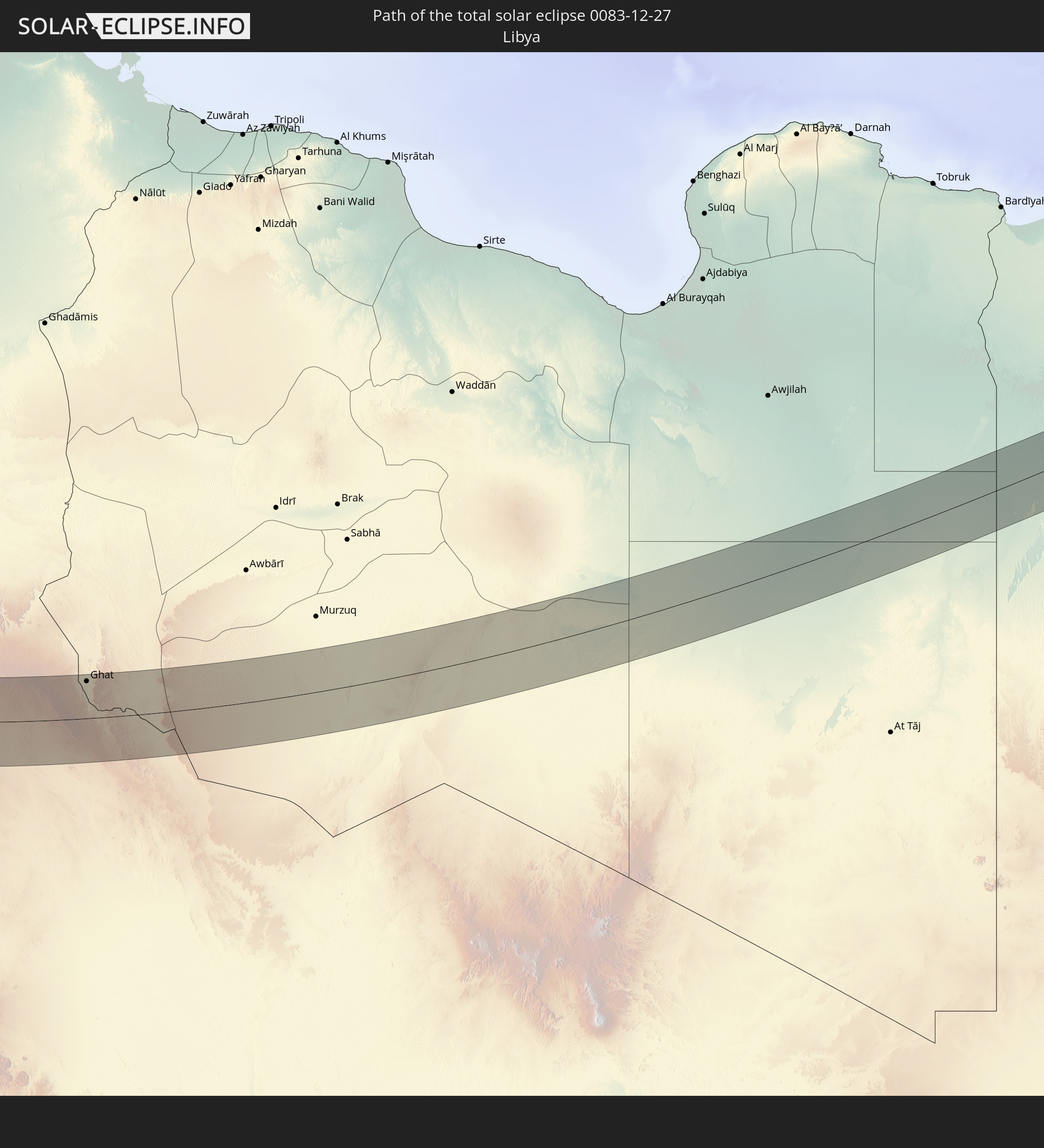 Libyen
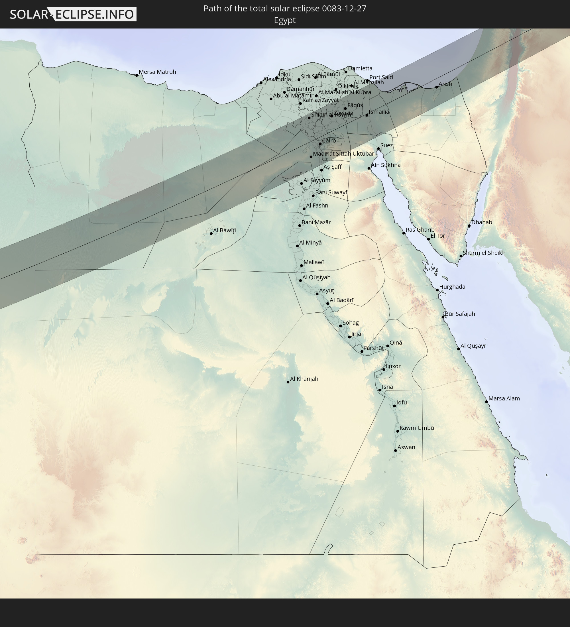 Ägypten
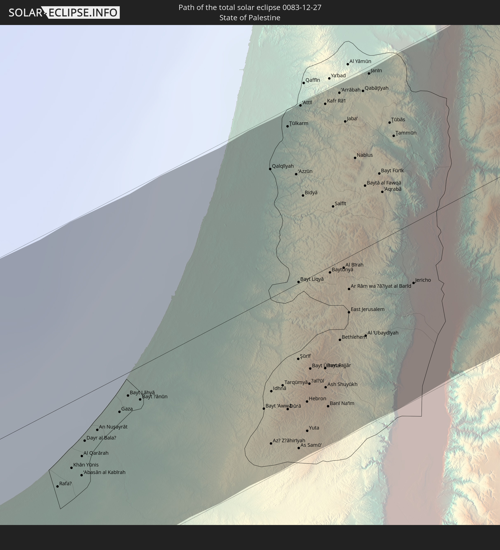 Staat Palästina
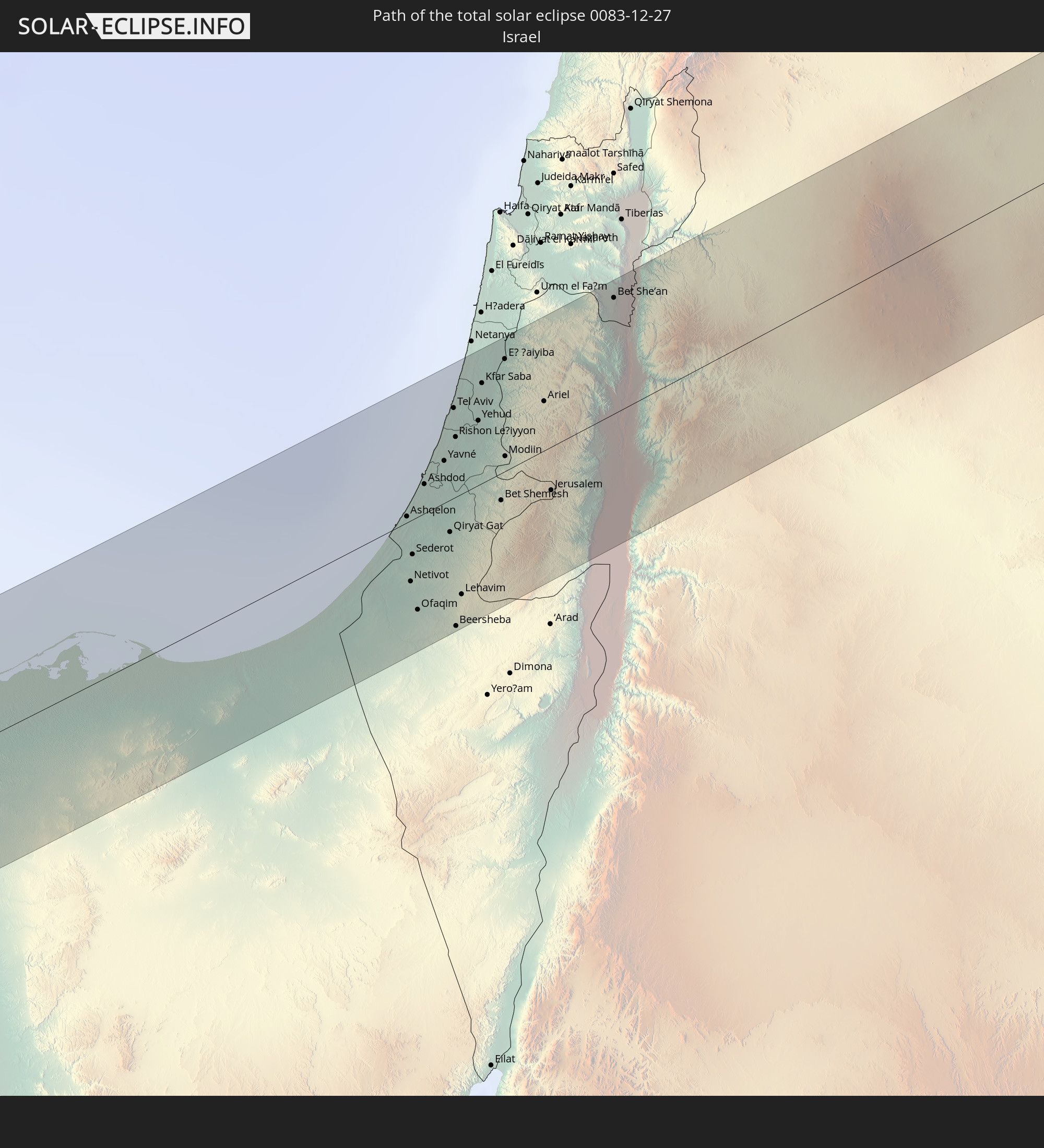 Israel
 Jordanien
 Syrien
 Irak
Irak
 Iran
Iran
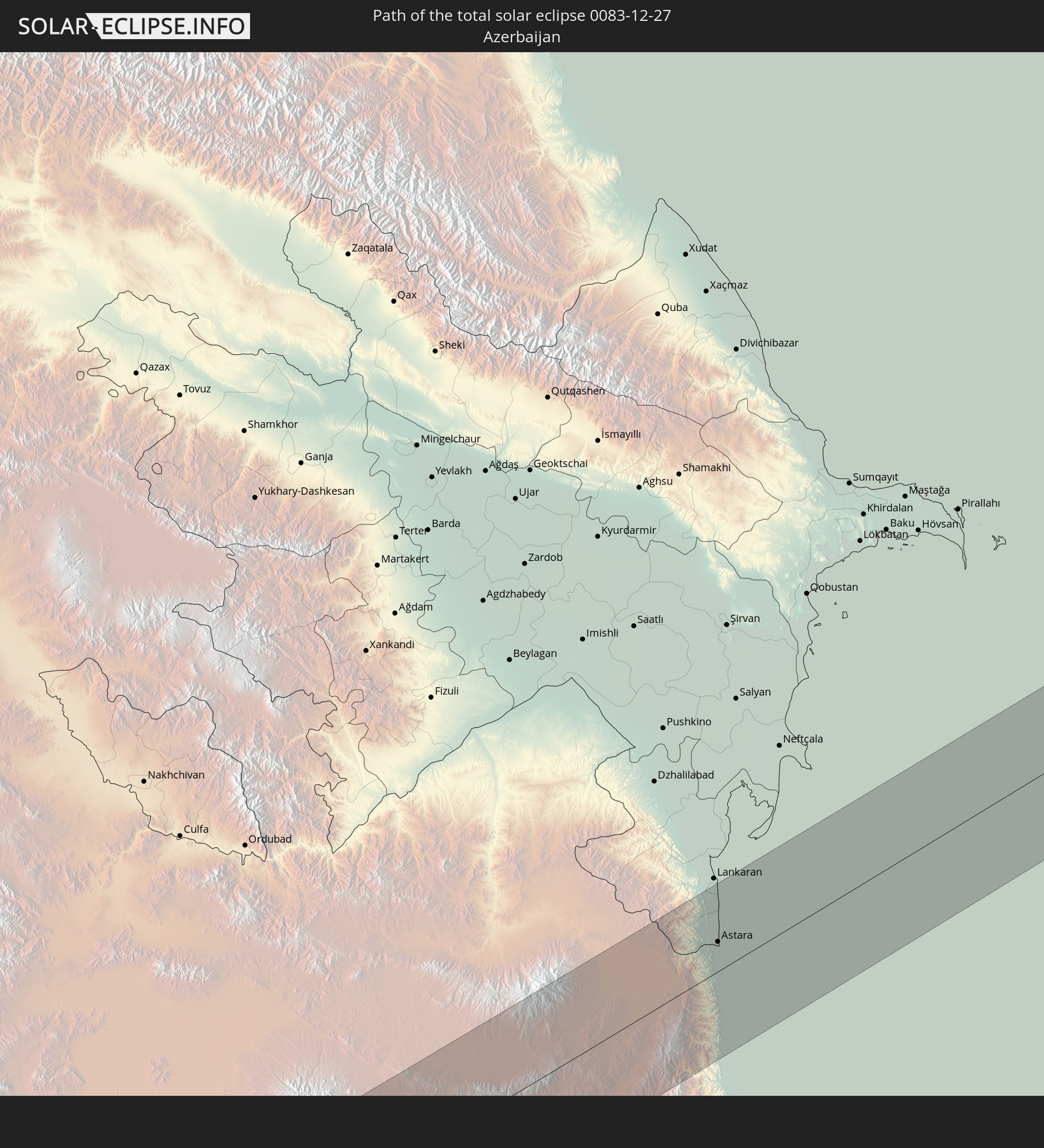 Aserbaidschan
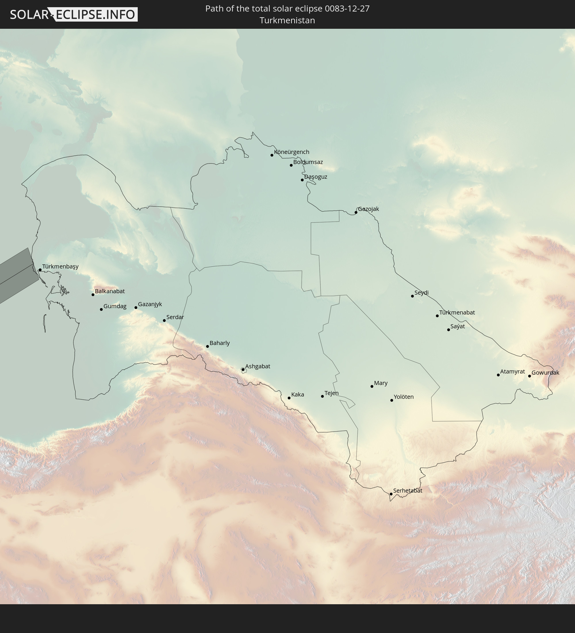 Turkmenistan
In den folgenden Ländern ist die Sonnenfinsternis partiell zu sehen
 Russland
 Portugal
 Kap Verde
 Island
 Spanien
 Senegal
 Mauretanien
 Gambia
 Guinea-Bissau
 Guinea
 Sierra Leone
 Marokko
 Mali
Mali
 Liberia
 Irland
 Algerien
 Vereinigtes Königreich
 Elfenbeinküste
 Färöer
 Burkina Faso
 Gibraltar
 Frankreich
 Isle of Man
 Ghana
Ghana
 Guernsey
 Jersey
 Togo
Togo
 Niger
Niger
 Benin
Benin
 Andorra
 Belgien
 Nigeria
 Niederlande
 Norwegen
 Äquatorialguinea
 Luxemburg
 Deutschland
 Schweiz
 São Tomé und Príncipe
 Italien
 Monaco
 Tunesien
 Dänemark
 Kamerun
 Gabun
Gabun
 Libyen
 Liechtenstein
 Österreich
 Schweden
 Republik Kongo
 Angola
 Tschechien
 Demokratische Republik Kongo
 San Marino
 Vatikanstadt
 Slowenien
 Tschad
 Kroatien
 Polen
Polen
 Malta
Malta
 Zentralafrikanische Republik
 Bosnien und Herzegowina
 Ungarn
 Slowakei
 Montenegro
 Serbien
 Albanien
 Åland Islands
 Griechenland
 Rumänien
 Mazedonien
 Finnland
 Litauen
 Lettland
 Estland
 Sudan
Sudan
 Ukraine
 Bulgarien
 Weißrussland
 Ägypten
 Türkei
 Moldawien
 Ruanda
 Burundi
 Tansania
 Uganda
 Republik Zypern
 Äthiopien
 Kenia
Kenia
 Staat Palästina
 Israel
 Saudi-Arabien
 Jordanien
 Libanon
 Syrien
 Eritrea
 Irak
Irak
 Georgien
 Somalia
 Dschibuti
 Jemen
Jemen
 Armenien
 Iran
Iran
 Aserbaidschan
 Kasachstan
 Kuwait
 Bahrain
 Katar
Katar
 Vereinigte Arabische Emirate
 Oman
Oman
 Turkmenistan
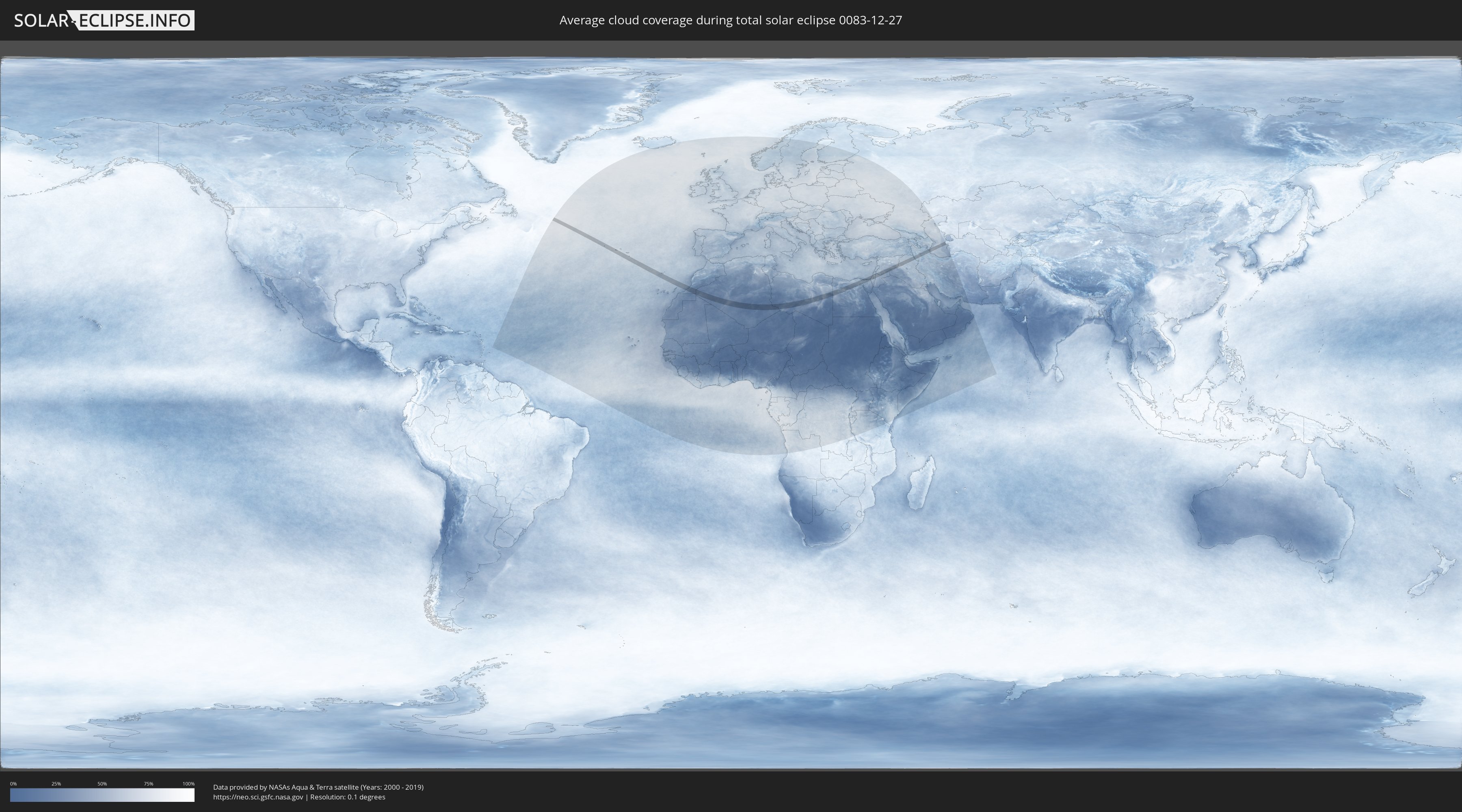
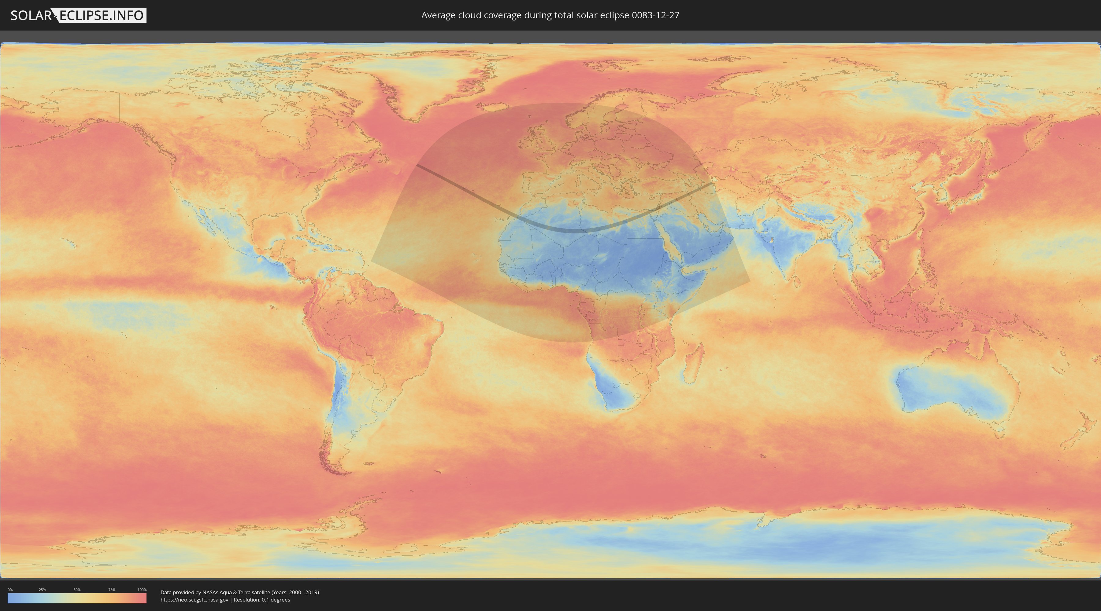
Wie wird das Wetter während der totalen Sonnenfinsternis am 27.12.0083?
Wo ist der beste Ort, um die totale Sonnenfinsternis vom 27.12.0083 zu beobachten?
Die folgenden Karten zeigen die durchschnittliche Bewölkung für den Tag, an dem die totale Sonnenfinsternis
stattfindet. Mit Hilfe der Karten lässt sich der Ort entlang des Finsternispfades eingrenzen,
der die besten Aussichen auf einen klaren wolkenfreien Himmel bietet.
Trotzdem muss man immer lokale Gegenenheiten beachten und sollte sich genau über das Wetter an seinem
gewählten Beobachtungsort informieren.
Die Daten stammen von den beiden NASA-Satelliten
AQUA und TERRA
und wurden über einen Zeitraum von 19 Jahren (2000 - 2019) gemittelt.
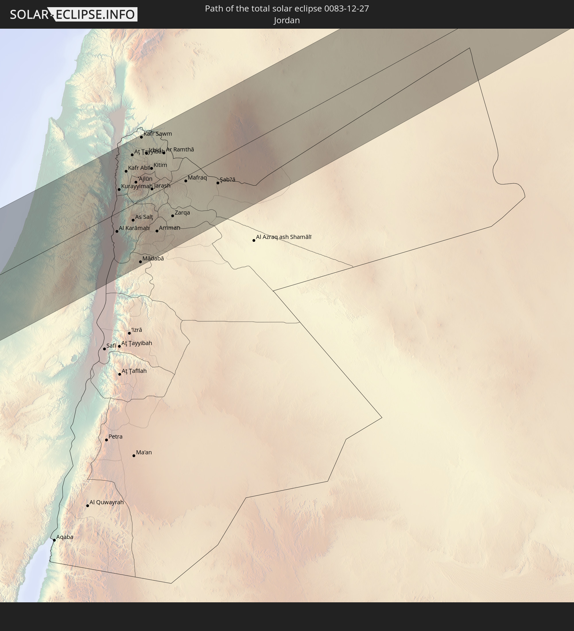
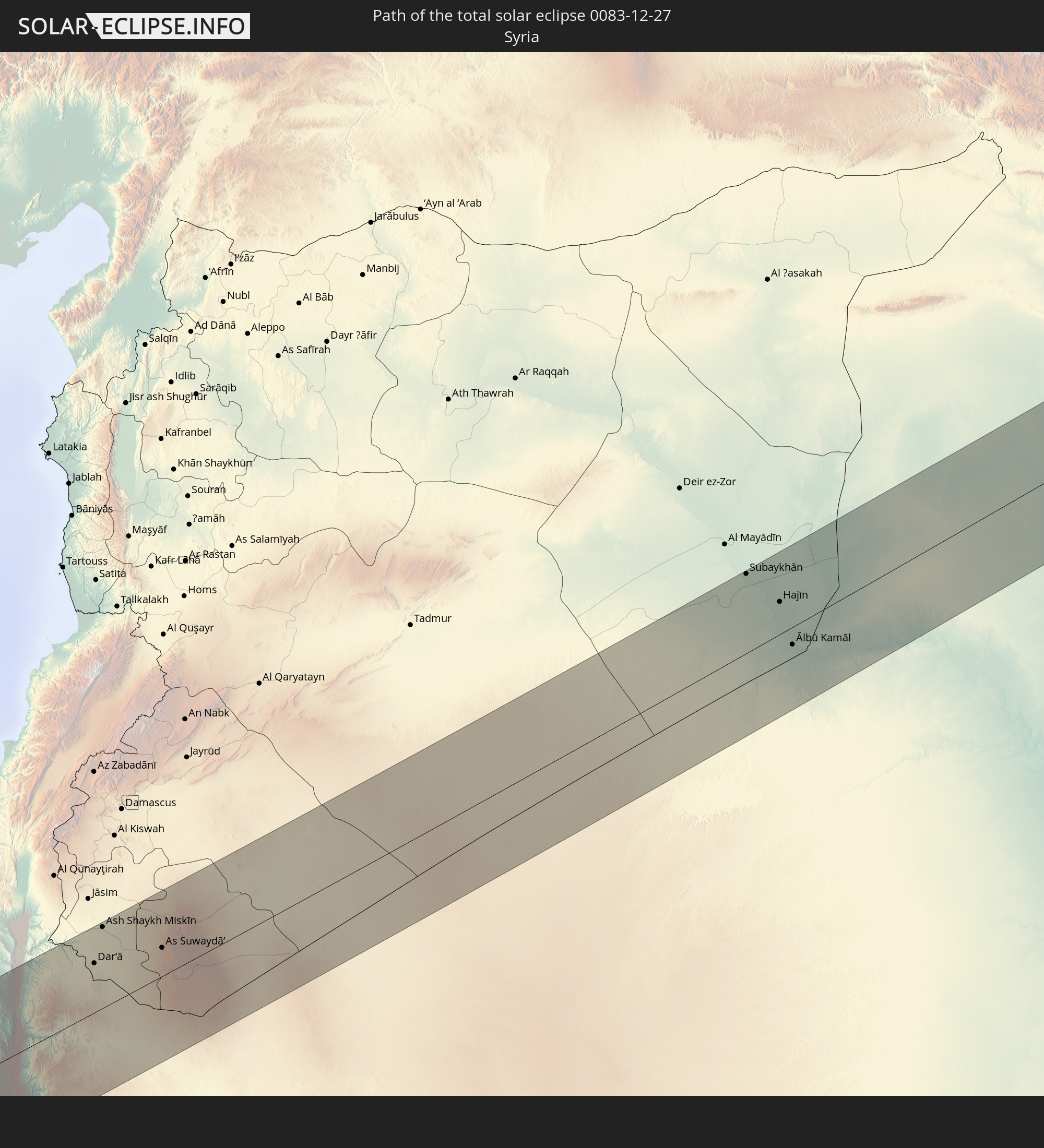
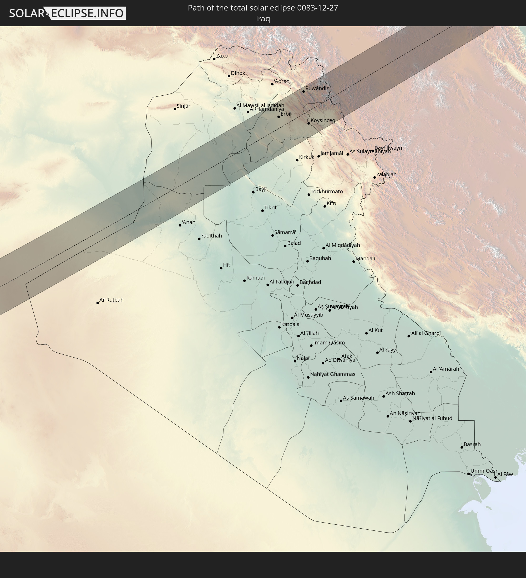
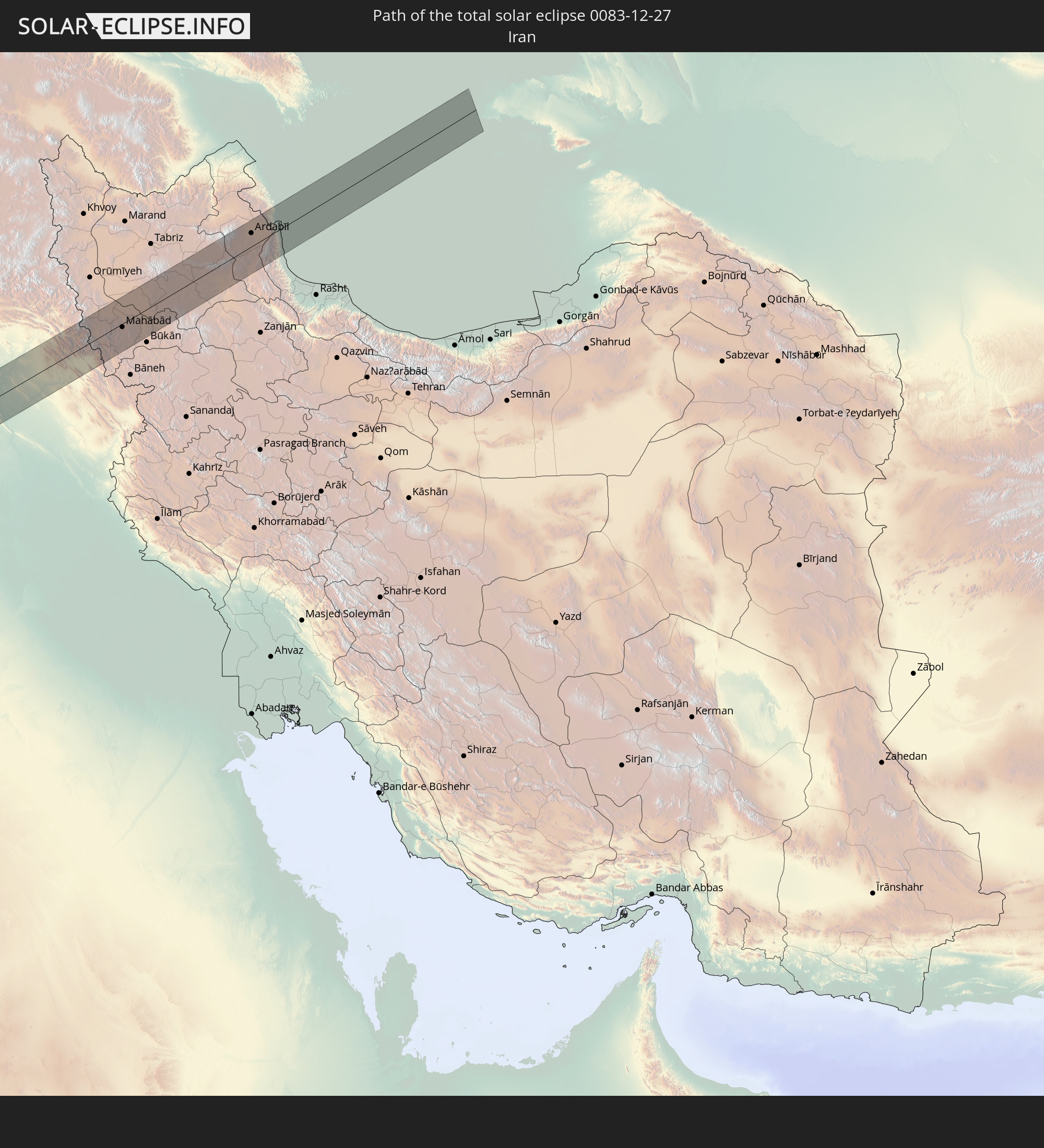
Detaillierte Länderkarten
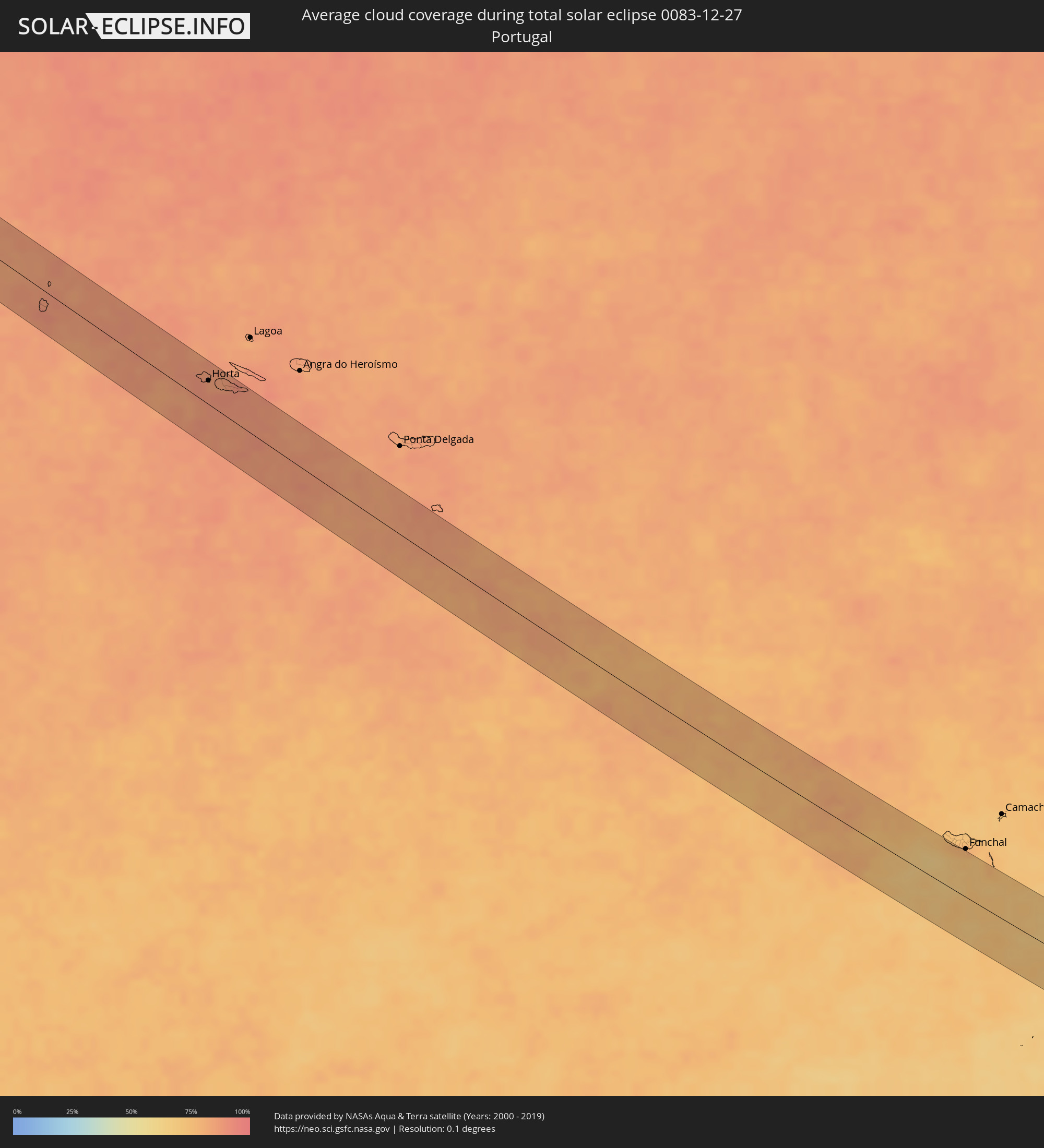 Portugal
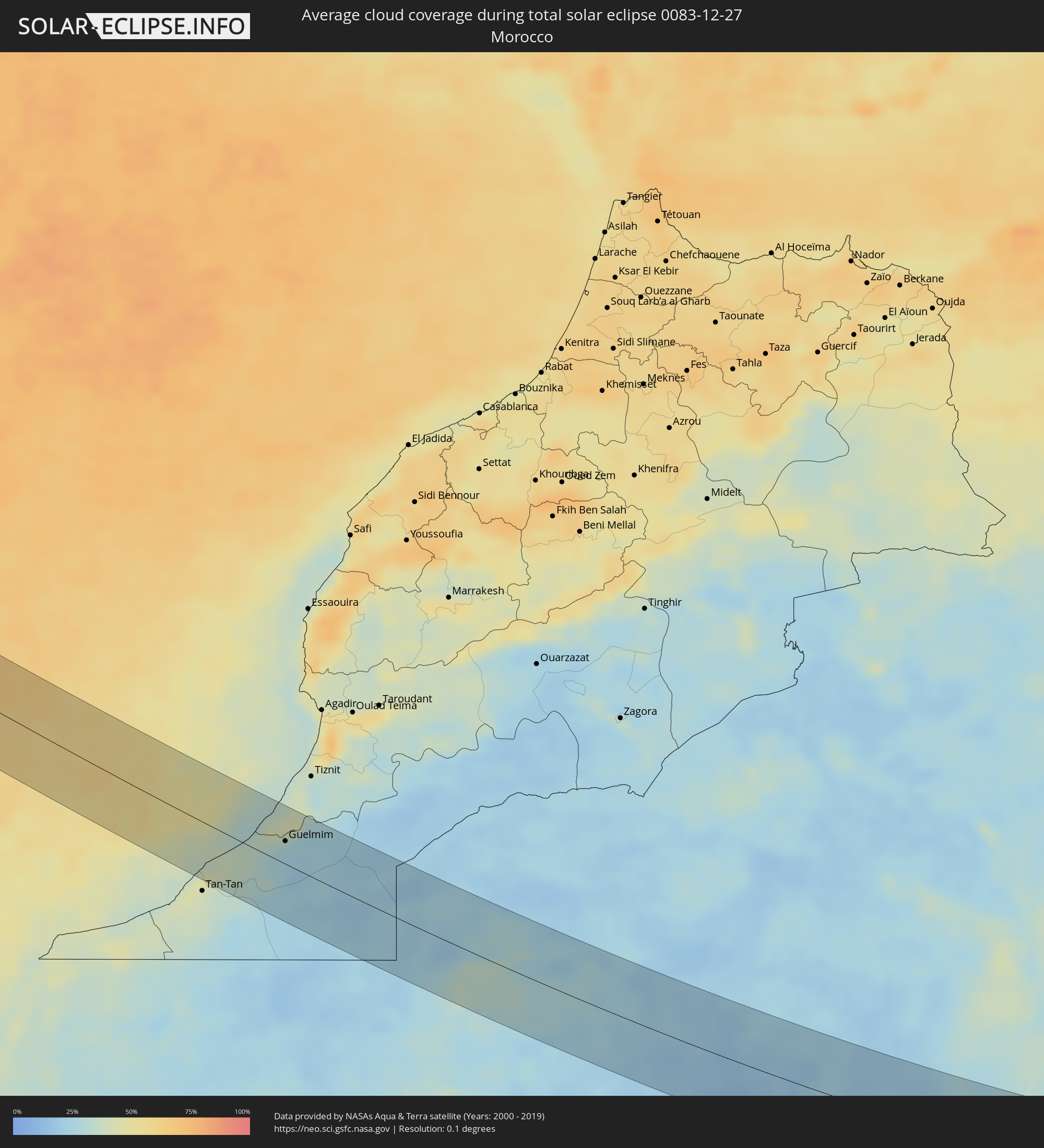 Marokko
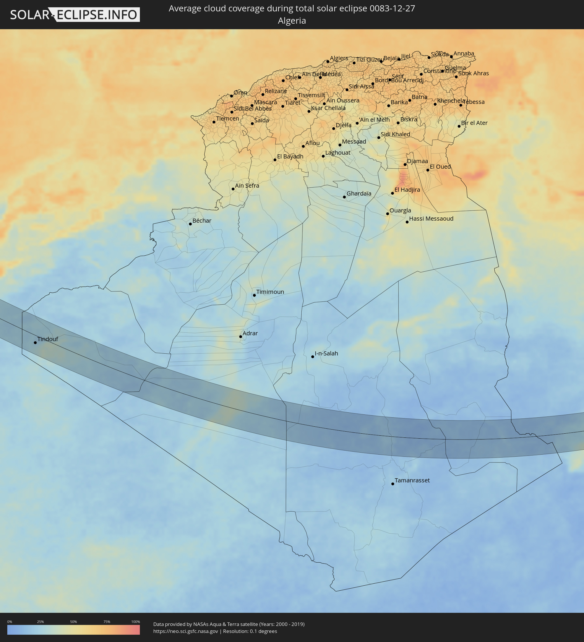 Algerien
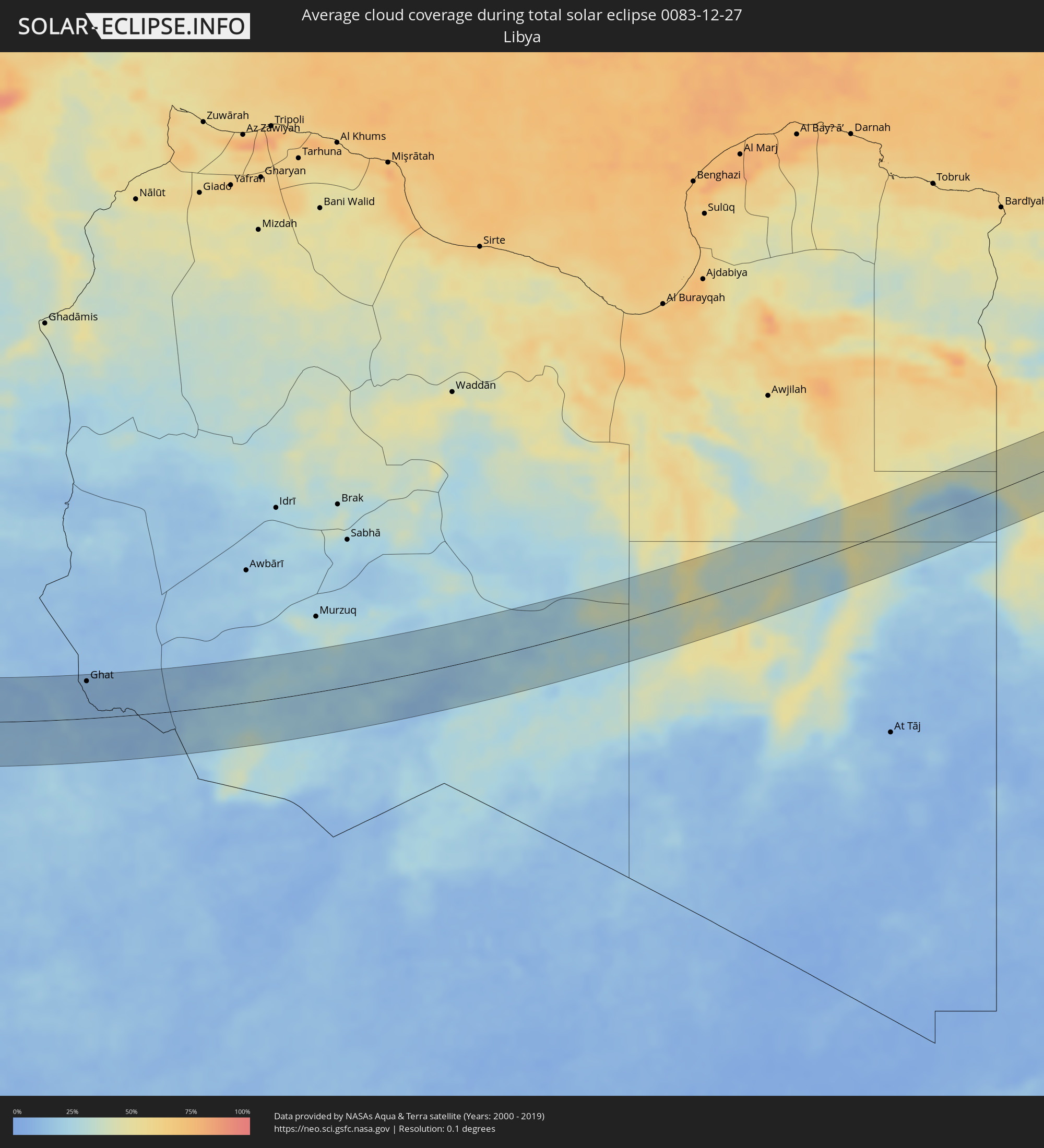 Libyen
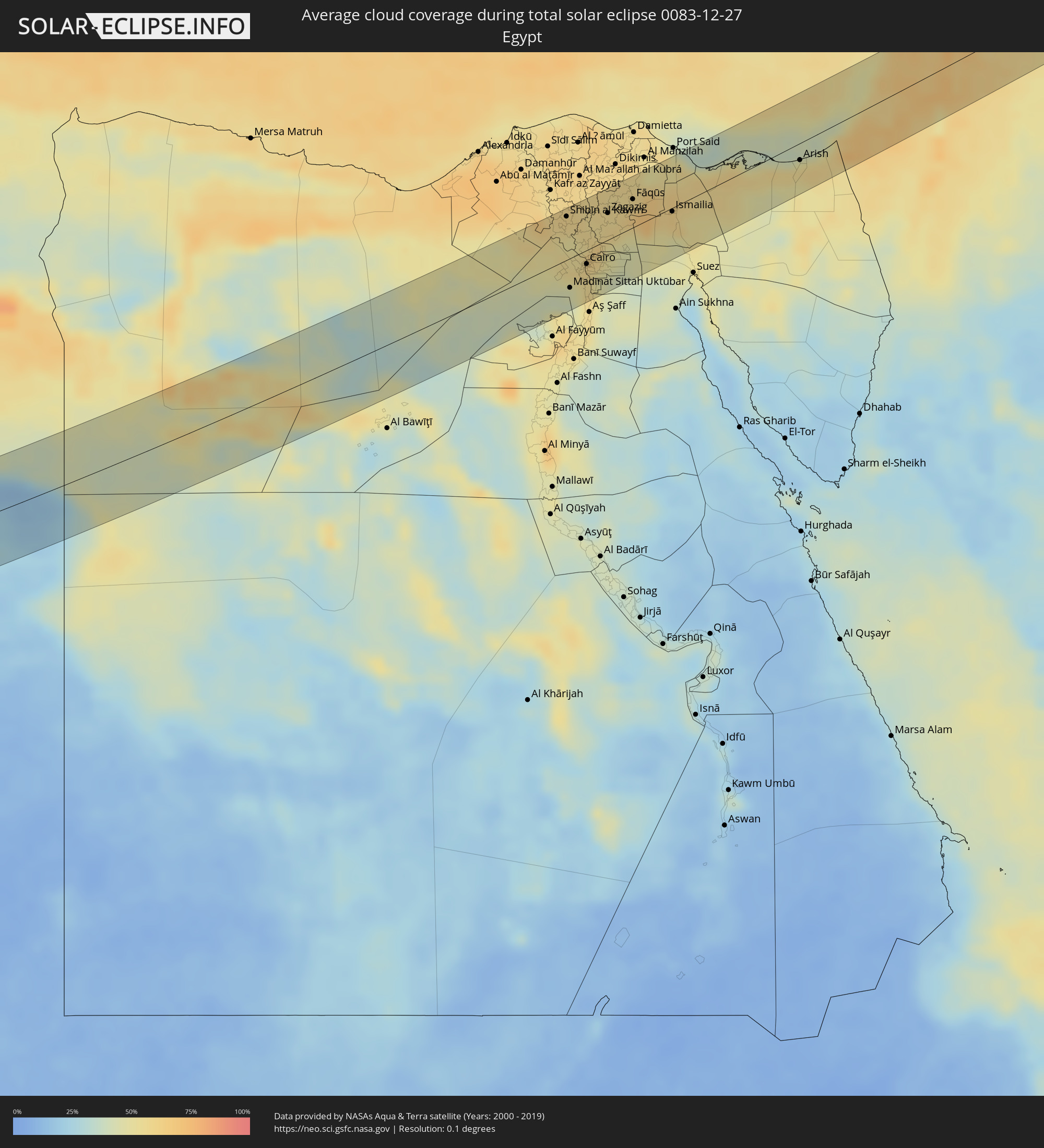 Ägypten
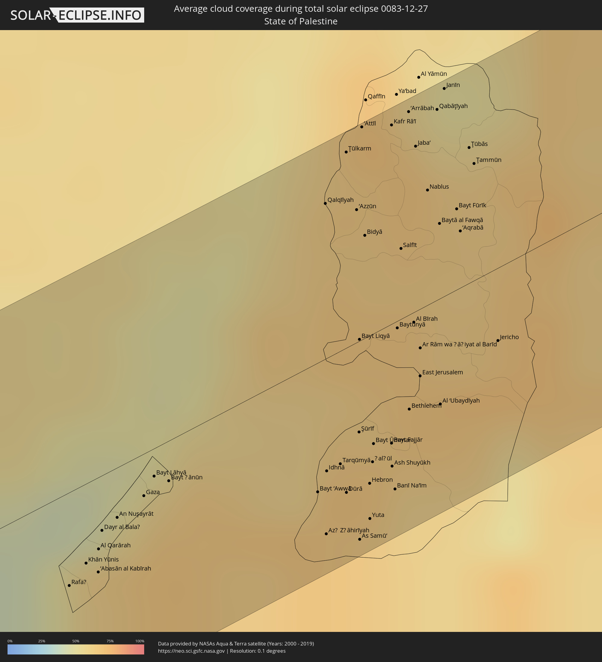 Staat Palästina
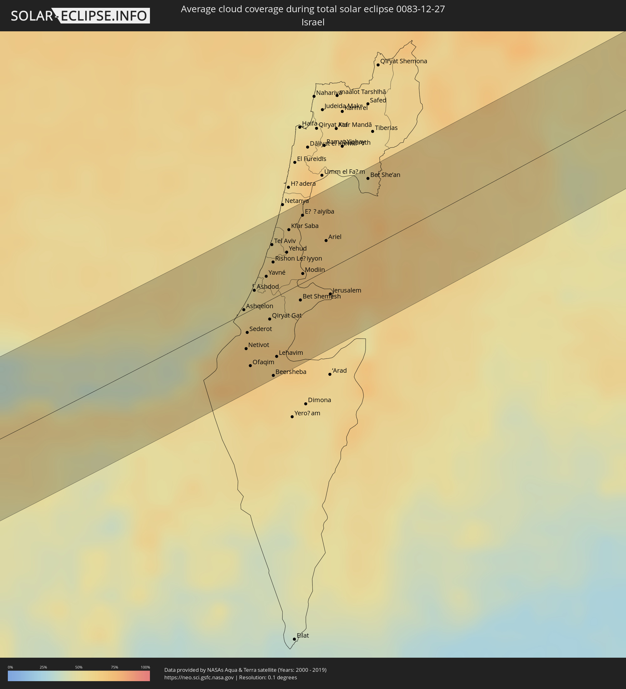 Israel
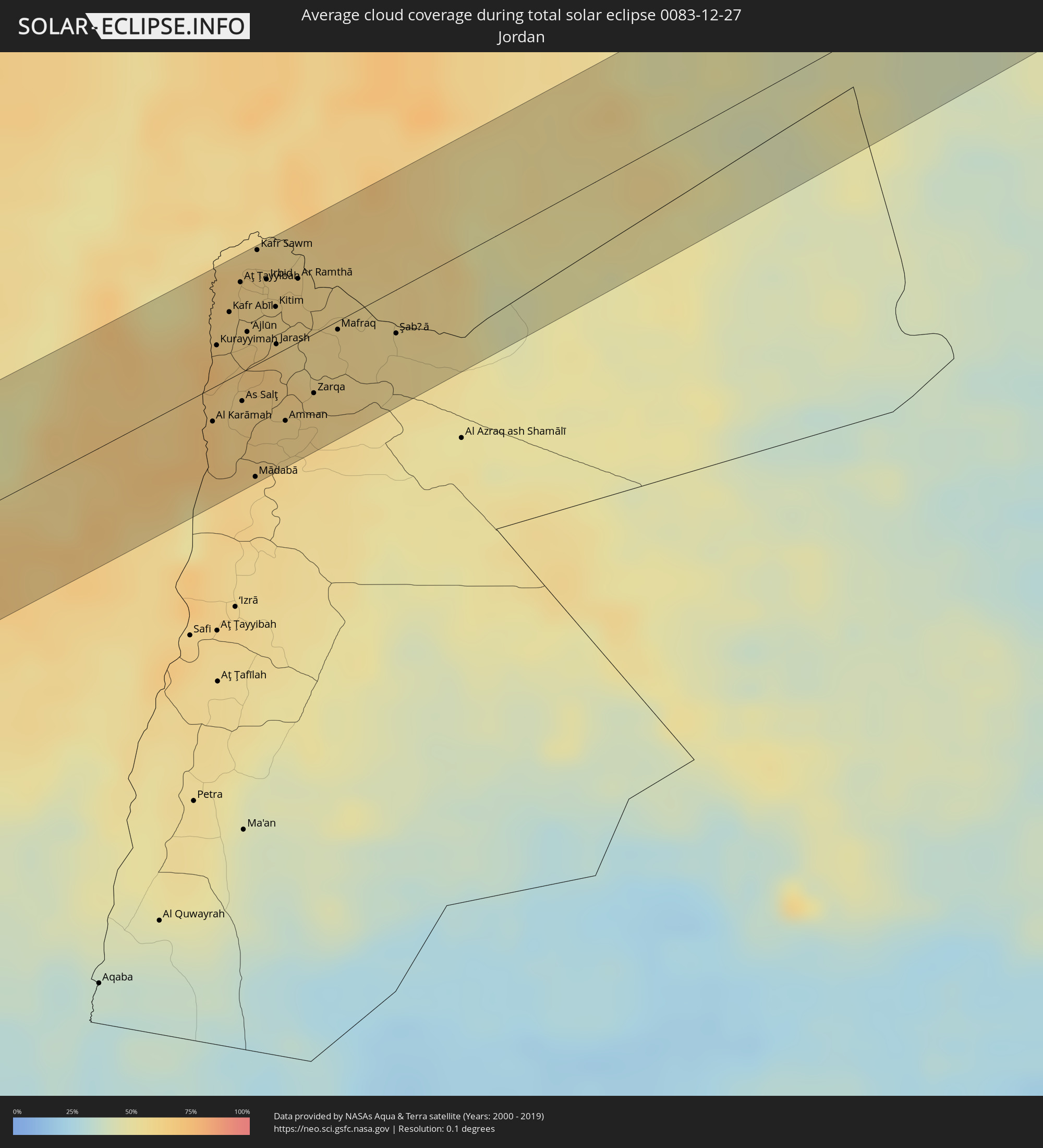 Jordanien
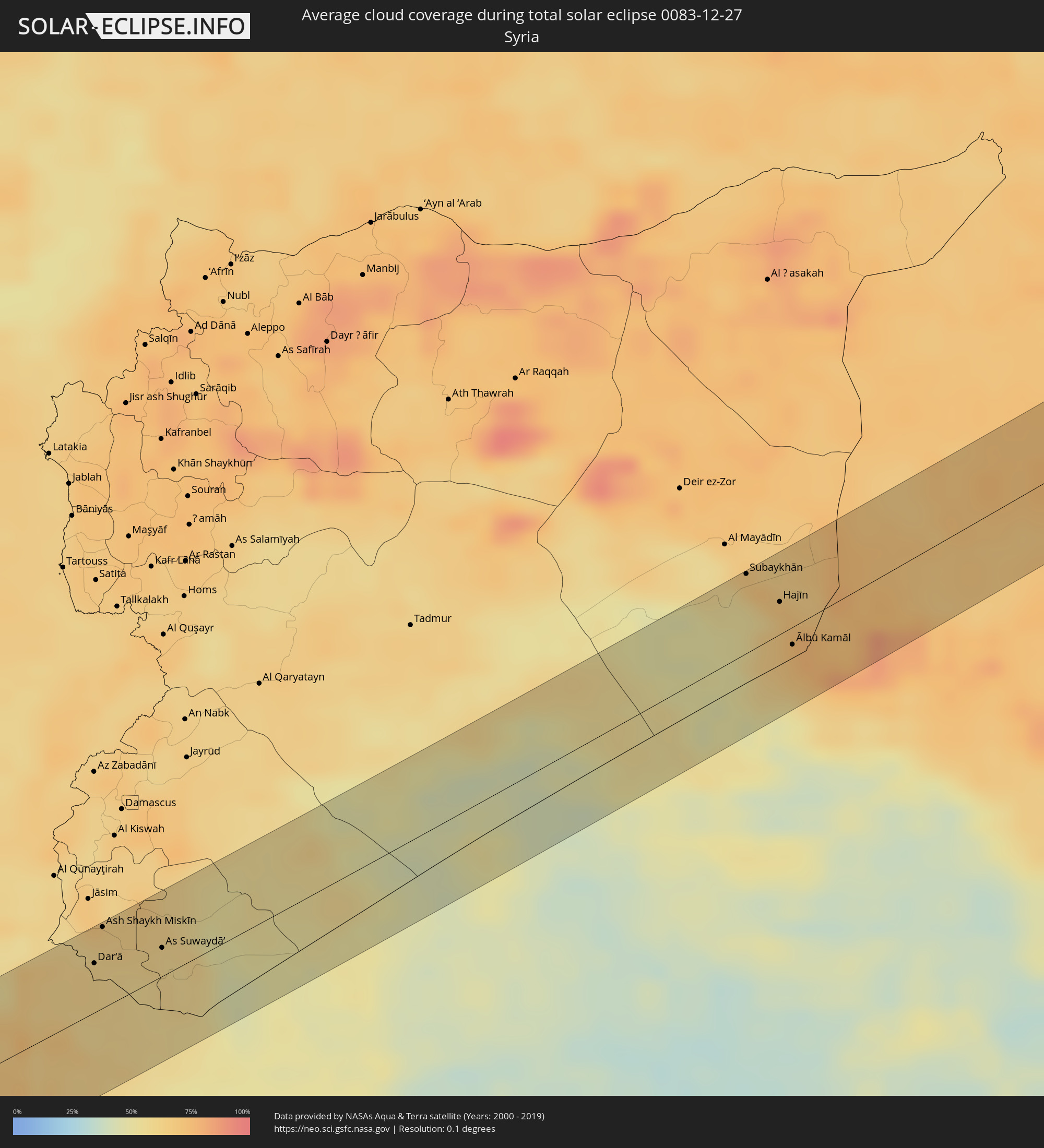 Syrien
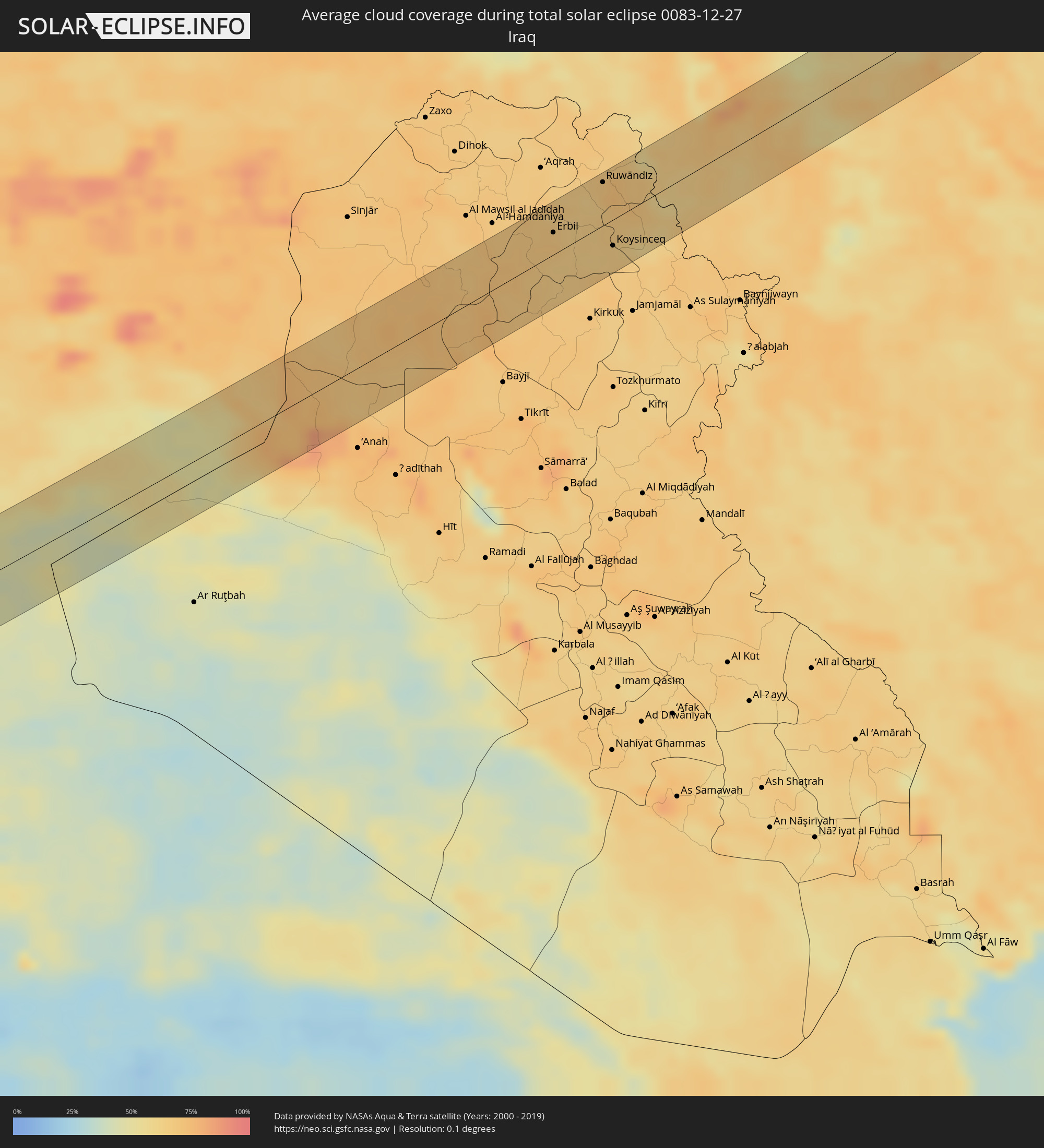 Irak
Irak
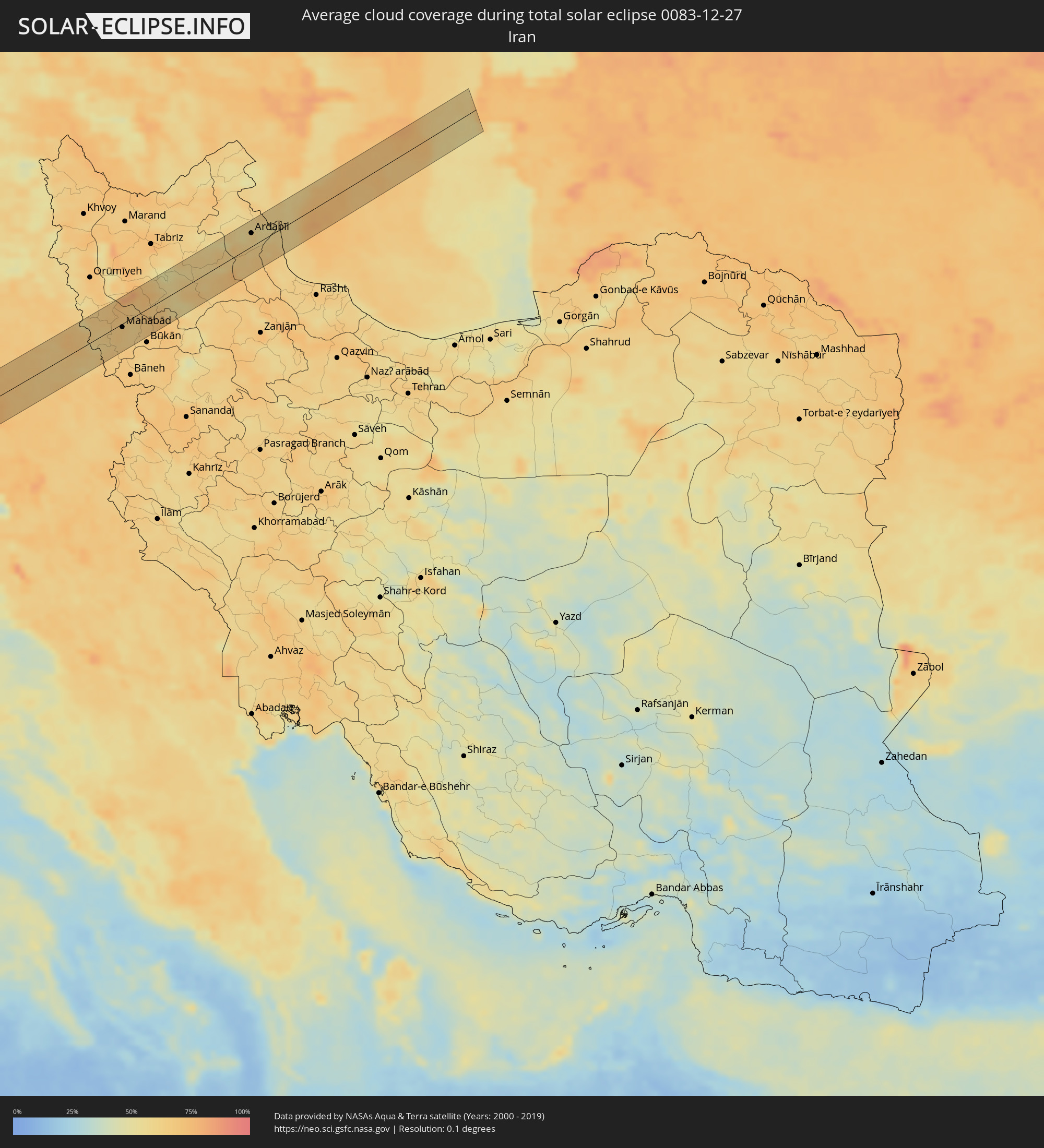 Iran
Iran
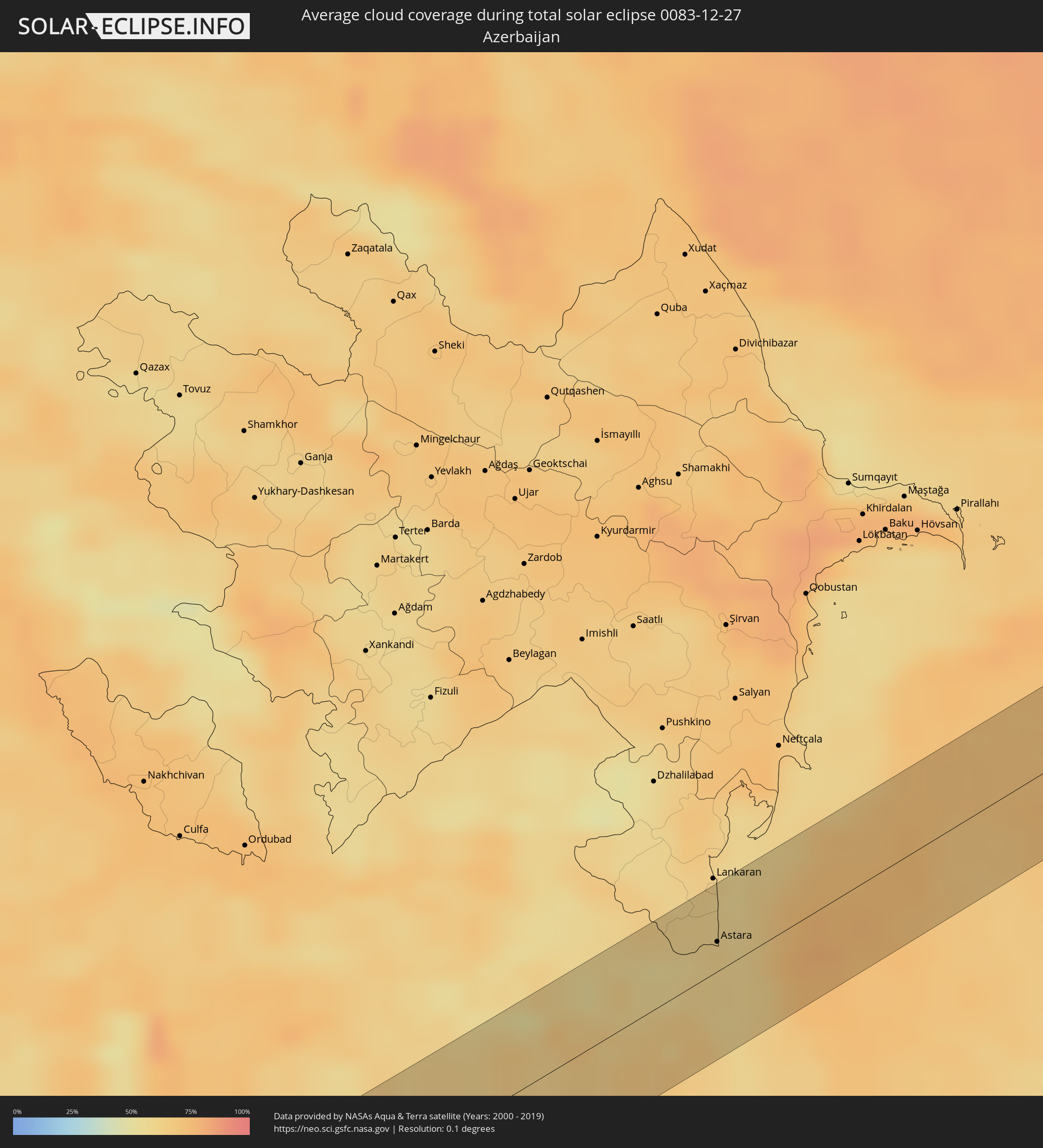 Aserbaidschan
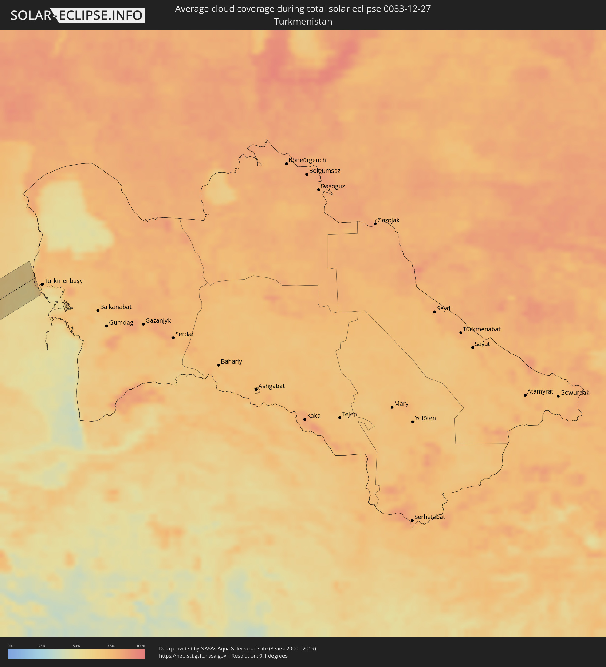 Turkmenistan
Orte im Finsternispfad
Die nachfolgene Tabelle zeigt Städte und Orte mit mehr als 5.000 Einwohnern, die sich im Finsternispfad befinden. Städte mit mehr als 100.000 Einwohnern sind dick gekennzeichnet. Mit einem Klick auf den Ort öffnet sich eine Detailkarte die die Lage des jeweiligen Ortes zusammen mit dem Verlauf der zentralen Finsternis präsentiert.
| Ort | Typ | Dauer der Verfinsterung | Ortszeit bei maximaler Verfinsterung | Entfernung zur Zentrallinie | Ø Bewölkung |
|
Ribeira Grande, Azores
|
total | - | 10:53:45 UTC+00:00 | 22 km | 89% |
|
Horta, Azores
|
total | - | 08:59:19 UTC-01:54 | 26 km | 88% |
|
Madalena, Azores
|
total | - | 08:59:26 UTC-01:54 | 32 km | 90% |
|
Ribeira Brava, Madeira
|
total | - | 11:06:56 UTC+00:00 | 53 km | 74% |
|
Câmara de Lobos, Madeira
|
total | - | 11:07:06 UTC+00:00 | 57 km | 70% |
|
Sidi Ifni, Souss-Massa-Drâa
|
total | - | 10:49:18 UTC-00:30 | 59 km | 36% |
|
Guelmim, Guelmim-Es Smara
|
total | - | 10:49:30 UTC-00:30 | 25 km | 26% |
|
Tindouf, Tindouf
|
total | - | 11:33:23 UTC+00:09 | 26 km | 26% |
|
Ghat, Sha‘bīyat Ghāt
|
total | - | 13:06:02 UTC+00:52 | 61 km | 11% |
|
Ashmūn, Monufia
|
total | - | 14:55:36 UTC+02:00 | 21 km | 51% |
|
Shibīn al Kawm, Monufia
|
total | - | 14:55:27 UTC+02:00 | 45 km | 59% |
|
Awsīm, Giza
|
total | - | 14:55:59 UTC+02:00 | 3 km | 56% |
|
Al Qanāţir al Khayrīyah, Qalyubia
|
total | - | 14:55:55 UTC+02:00 | 4 km | 53% |
|
Banhā, Qalyubia
|
total | - | 14:55:47 UTC+02:00 | 28 km | 57% |
|
Ziftá, Gharbia
|
total | - | 14:55:41 UTC+02:00 | 51 km | 56% |
|
Cairo, Cairo
|
total | - | 14:56:12 UTC+02:00 | 14 km | 57% |
|
Ḩalwān, Cairo
|
total | - | 14:56:27 UTC+02:00 | 39 km | 58% |
|
Shibīn al Qanāţir, Qalyubia
|
total | - | 14:56:07 UTC+02:00 | 8 km | 56% |
|
Al Khānkah, Qalyubia
|
total | - | 14:56:16 UTC+02:00 | 5 km | 58% |
|
Zagazig, Sharqia
|
total | - | 14:56:11 UTC+02:00 | 28 km | 56% |
|
Bilbays, Sharqia
|
total | - | 14:56:24 UTC+02:00 | 8 km | 56% |
|
Abū Kabīr, Sharqia
|
total | - | 14:56:20 UTC+02:00 | 34 km | 58% |
|
Al Qurayn, Sharqia
|
total | - | 14:56:30 UTC+02:00 | 20 km | 59% |
|
Fāqūs, Sharqia
|
total | - | 14:56:31 UTC+02:00 | 29 km | 61% |
|
Ismailia, Ismailia
|
total | - | 14:57:19 UTC+02:00 | 4 km | 61% |
|
Arish, North Sinai
|
total | - | 14:59:05 UTC+02:00 | 17 km | 56% |
|
Khān Yūnis, Gaza Strip
|
total | - | 14:59:37 UTC+02:00 | 19 km | 63% |
|
‘Abasān al Jadīdah
|
total | - | 14:59:40 UTC+02:00 | 20 km | 63% |
|
Gaza, Gaza Strip
|
total | - | 14:59:42 UTC+02:00 | 10 km | 64% |
|
Ashqelon, Southern District
|
total | - | 15:20:22 UTC+02:20 | 2 km | 59% |
|
Netivot, Southern District
|
total | - | 15:20:36 UTC+02:20 | 23 km | 67% |
|
Ashdod, Southern District
|
total | - | 15:20:22 UTC+02:20 | 11 km | 54% |
|
Gan Yavne, Central District
|
total | - | 15:20:27 UTC+02:20 | 8 km | 57% |
|
Qiryat Gat, Southern District
|
total | - | 15:20:40 UTC+02:20 | 12 km | 61% |
|
Gedera, Central District
|
total | - | 15:20:31 UTC+02:20 | 7 km | 59% |
|
Tel Aviv, Tel Aviv
|
total | - | 15:20:18 UTC+02:20 | 34 km | 58% |
|
Beersheba, Southern District
|
total | - | 15:21:00 UTC+02:20 | 49 km | 62% |
|
Ness Ziona, Central District
|
total | - | 15:20:27 UTC+02:20 | 18 km | 60% |
|
Ganné Tiqwa, Central District
|
total | - | 15:20:26 UTC+02:20 | 28 km | 62% |
|
Kfar Saba, Central District
|
total | - | 15:20:23 UTC+02:20 | 37 km | 62% |
|
Kefar Yona, Central District
|
total | - | 15:20:18 UTC+02:20 | 50 km | 61% |
|
Az̧ Z̧āhirīyah, West Bank
|
total | - | 15:00:27 UTC+02:00 | 41 km | 66% |
|
Ḩablah, West Bank
|
total | - | 14:59:49 UTC+02:00 | 33 km | 64% |
|
Bet Shemesh, Jerusalem
|
total | - | 15:20:53 UTC+02:20 | 10 km | 65% |
|
Modiin, Central District
|
total | - | 15:20:45 UTC+02:20 | 6 km | 62% |
|
Ţūlkarm, West Bank
|
total | - | 14:59:46 UTC+02:00 | 45 km | 65% |
|
‘Azzūn, West Bank
|
total | - | 14:59:55 UTC+02:00 | 31 km | 64% |
|
Bayt Liqyā, West Bank
|
total | - | 15:00:11 UTC+02:00 | 0 km | 65% |
|
Hebron, West Bank
|
total | - | 15:00:31 UTC+02:00 | 34 km | 64% |
|
Naḩḩālīn, West Bank
|
total | - | 15:00:25 UTC+02:00 | 20 km | 66% |
|
Salfīt, West Bank
|
total | - | 15:00:09 UTC+02:00 | 16 km | 64% |
|
Ariel, Jerusalem
|
total | - | 15:00:08 UTC+02:00 | 18 km | 64% |
|
Jerusalem, Jerusalem
|
total | - | 15:21:08 UTC+02:20 | 16 km | 67% |
|
East Jerusalem, West Bank
|
total | - | 15:21:09 UTC+02:20 | 16 km | 67% |
|
Nablus, West Bank
|
total | - | 15:00:08 UTC+02:00 | 27 km | 64% |
|
Ḩizmā, West Bank
|
total | - | 15:00:29 UTC+02:00 | 12 km | 68% |
|
Janīn, West Bank
|
total | - | 14:59:59 UTC+02:00 | 48 km | 57% |
|
Ţūbās, West Bank
|
total | - | 15:00:12 UTC+02:00 | 31 km | 62% |
|
Jericho, West Bank
|
total | - | 15:00:42 UTC+02:00 | 17 km | 69% |
|
Bet She’an, Northern District
|
total | - | 15:20:53 UTC+02:20 | 43 km | 62% |
|
Al Karāmah, Balqa
|
total | - | 15:24:31 UTC+02:23 | 14 km | 69% |
|
Kurayyimah, Irbid
|
total | - | 15:24:16 UTC+02:23 | 17 km | 73% |
|
Waqqāş, Irbid
|
total | - | 15:24:03 UTC+02:23 | 43 km | 65% |
|
Kafr Abīl, Irbid
|
total | - | 15:24:14 UTC+02:23 | 28 km | 64% |
|
Şammā, Irbid
|
total | - | 15:24:07 UTC+02:23 | 42 km | 63% |
|
As Salţ, Balqa
|
total | - | 15:24:38 UTC+02:23 | 12 km | 63% |
|
Malkā, Irbid
|
total | - | 15:24:07 UTC+02:23 | 49 km | 64% |
|
‘Ajlūn, Ajlun
|
total | - | 15:24:25 UTC+02:23 | 16 km | 67% |
|
Mādabā, Madaba
|
total | - | 15:25:00 UTC+02:23 | 47 km | 60% |
|
Dayr Yūsuf, Irbid
|
total | - | 15:24:20 UTC+02:23 | 29 km | 62% |
|
Raymūn, Jerash
|
total | - | 15:24:33 UTC+02:23 | 7 km | 67% |
|
Irbid, Irbid
|
total | - | 15:24:21 UTC+02:23 | 33 km | 61% |
|
Amman, Amman
|
total | - | 15:24:59 UTC+02:23 | 30 km | 62% |
|
Aţ Ţurrah, Irbid
|
total | - | 15:24:27 UTC+02:23 | 35 km | 62% |
|
Ţafas, Daraa
|
total | - | 15:25:56 UTC+02:25 | 41 km | 61% |
|
Zarqa, Zarqa
|
total | - | 15:25:04 UTC+02:23 | 25 km | 62% |
|
Dar‘ā, Daraa
|
total | - | 15:26:05 UTC+02:25 | 28 km | 61% |
|
Al Ḩamrā’, Mafraq
|
total | - | 15:24:50 UTC+02:23 | 8 km | 59% |
|
Ash Shaykh Miskīn, Daraa
|
total | - | 15:25:58 UTC+02:25 | 46 km | 62% |
|
Mafraq, Mafraq
|
total | - | 15:24:59 UTC+02:23 | 4 km | 60% |
|
Izra‘, Daraa
|
total | - | 15:26:03 UTC+02:25 | 46 km | 63% |
|
Al Ḩarāk, Daraa
|
total | - | 15:26:13 UTC+02:25 | 32 km | 60% |
|
As Suwaydā’, As-Suwayda
|
total | - | 15:26:35 UTC+02:25 | 16 km | 58% |
|
Şalākhid, As-Suwayda
|
total | - | 15:26:26 UTC+02:25 | 32 km | 61% |
|
Shahbā, As-Suwayda
|
total | - | 15:26:31 UTC+02:25 | 28 km | 61% |
|
Subaykhān, Deir ez-Zor
|
total | - | 15:29:09 UTC+02:25 | 44 km | 65% |
|
Hajīn, Deir ez-Zor
|
total | - | 15:29:33 UTC+02:25 | 18 km | 64% |
|
Ālbū Kamāl, Deir ez-Zor
|
total | - | 15:29:52 UTC+02:25 | 10 km | 69% |
|
Erbil, Arbīl
|
total | - | 16:03:29 UTC+02:57 | 18 km | 69% |
|
Ruwāndiz, Arbīl
|
total | - | 16:03:29 UTC+02:57 | 35 km | 70% |
|
Koysinceq, Arbīl
|
total | - | 16:04:07 UTC+02:57 | 21 km | 65% |
|
Piranshahr, Āz̄ārbāyjān-e Gharbī
|
total | - | 16:32:03 UTC+03:25 | 15 km | 64% |
|
Naqadeh, Āz̄ārbāyjān-e Gharbī
|
total | - | 16:31:59 UTC+03:25 | 28 km | 68% |
|
Mahābād, Āz̄ārbāyjān-e Gharbī
|
total | - | 16:32:28 UTC+03:25 | 5 km | 66% |
|
Bonāb, East Azerbaijan
|
total | - | 16:32:07 UTC+03:25 | 35 km | 72% |
|
Mīāndoāb, Āz̄ārbāyjān-e Gharbī
|
total | - | 16:32:33 UTC+03:25 | 3 km | 68% |
|
Hashtrūd, East Azerbaijan
|
total | - | 16:32:44 UTC+03:25 | 3 km | 64% |
|
Ardabīl, Ardabīl
|
total | - | 16:32:49 UTC+03:25 | 20 km | 60% |
|
Āstārā, Gīlān
|
total | - | 16:33:01 UTC+03:25 | 11 km | 61% |
|
Astara, Astara
|
total | - | 16:26:39 UTC+03:19 | 13 km | 60% |