Totale Sonnenfinsternis vom 06.02.0129
| Wochentag: | Sonntag |
| Maximale Dauer der Verfinsterung: | 03m10s |
| Maximale Breite des Finsternispfades: | 144 km |
| Saroszyklus: | 81 |
| Bedeckungsgrad: | 100% |
| Magnitude: | 1.0354 |
| Gamma: | 0.582 |
Wo kann man die Sonnenfinsternis vom 06.02.0129 sehen?
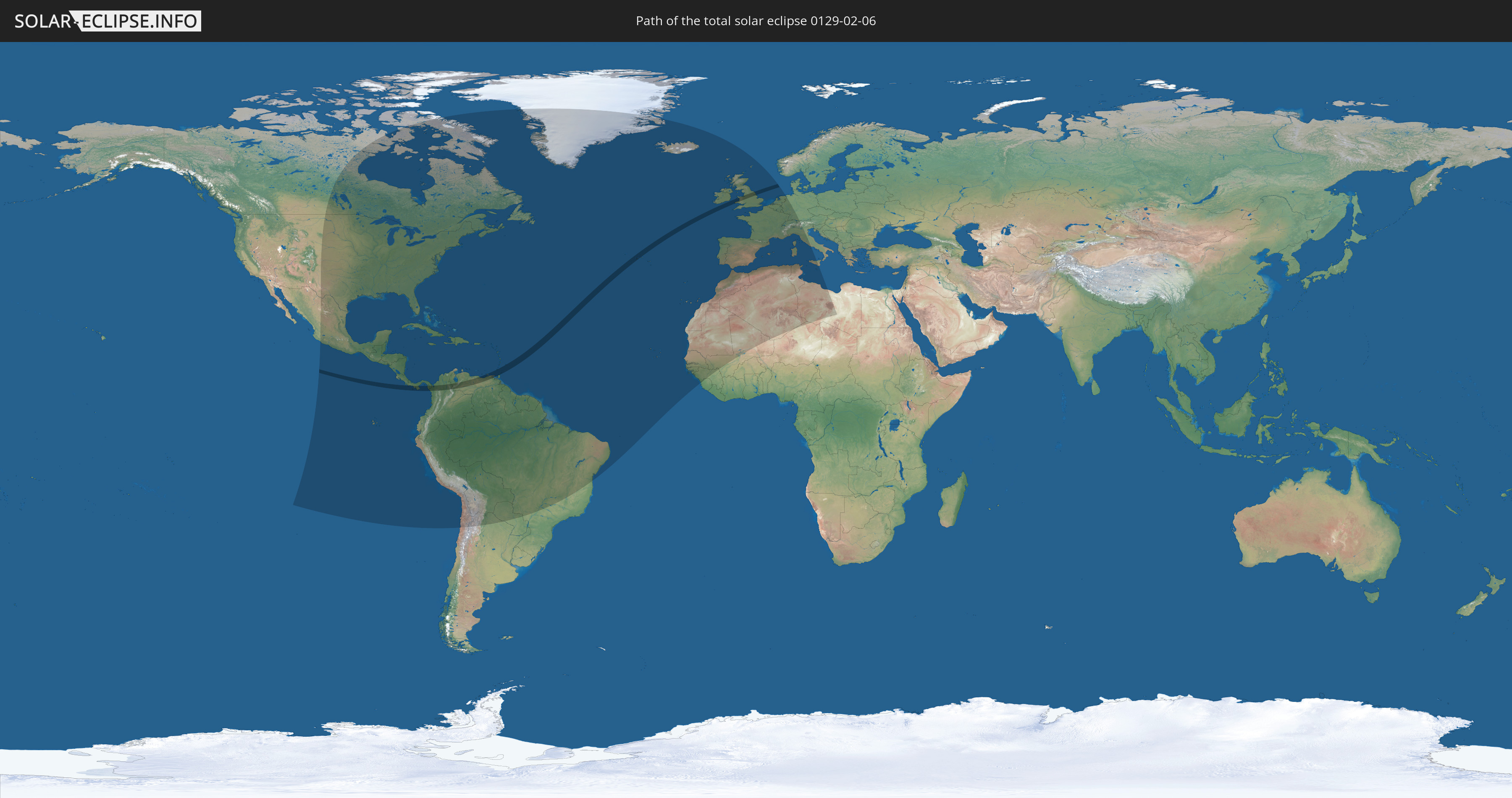
Die Sonnenfinsternis am 06.02.0129 kann man in 87 Ländern als partielle Sonnenfinsternis beobachten.
Der Finsternispfad verläuft durch 9 Länder. Nur in diesen Ländern ist sie als totale Sonnenfinsternis zu sehen.
In den folgenden Ländern ist die Sonnenfinsternis total zu sehen
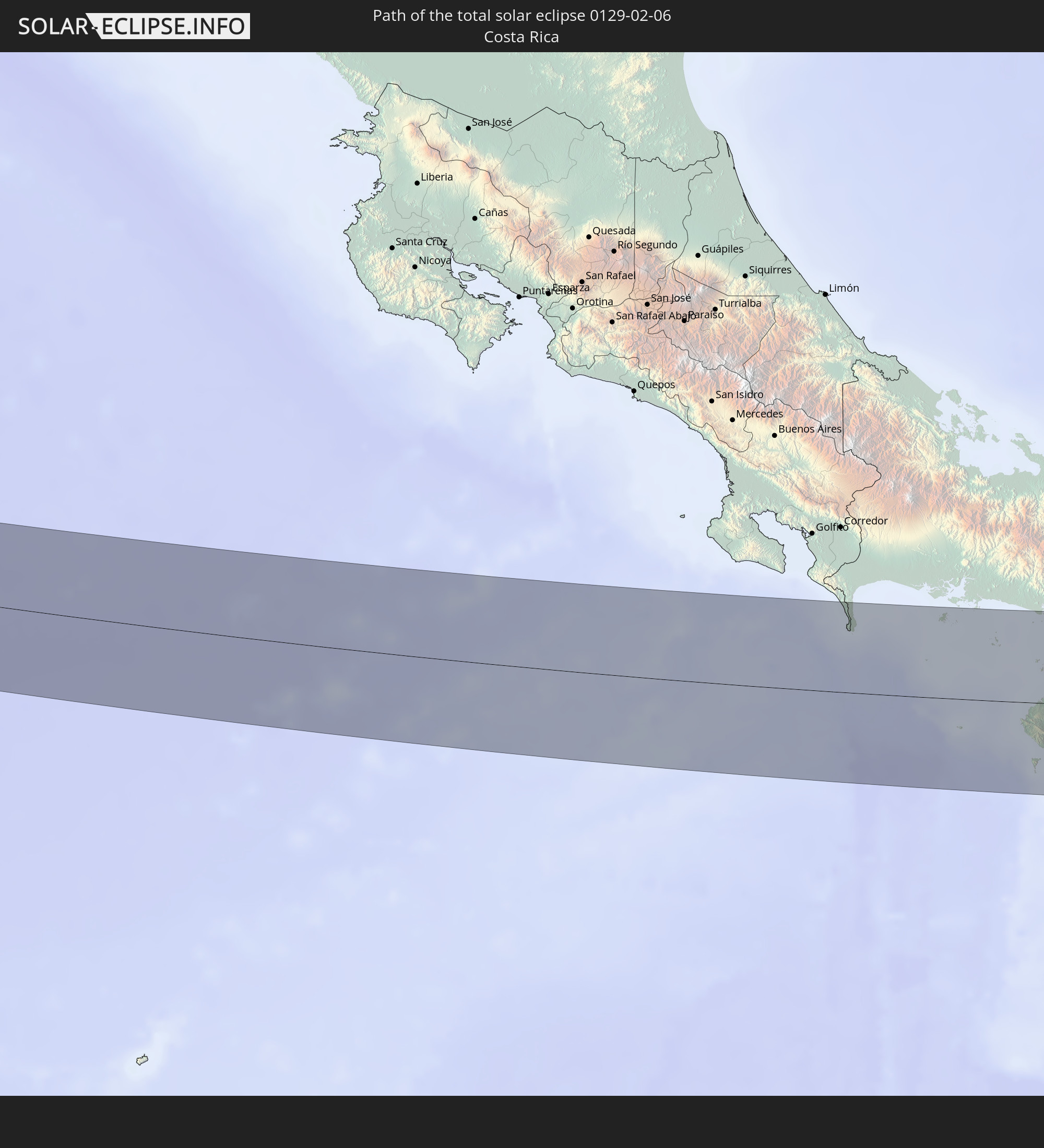 Costa Rica
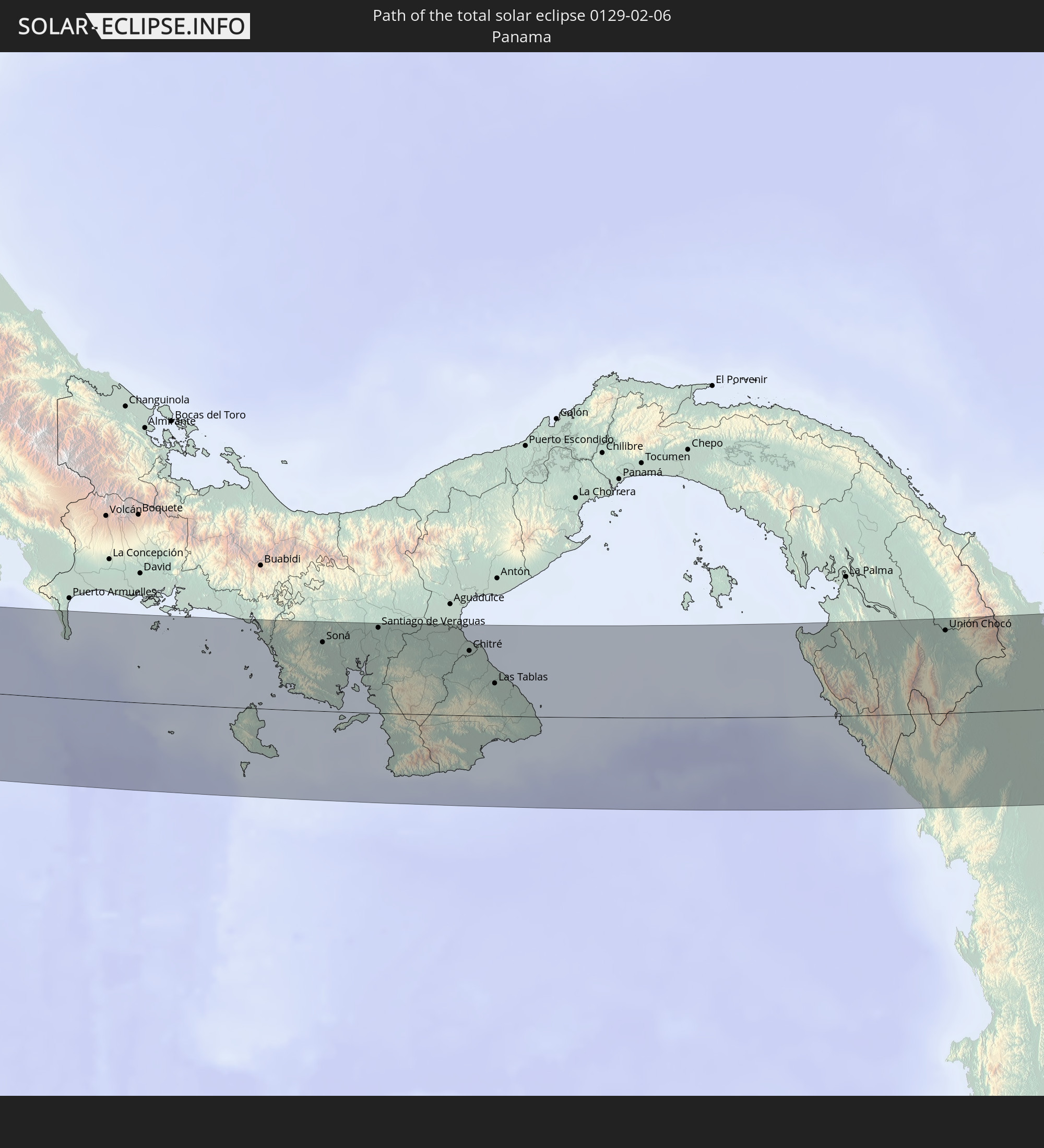 Panama
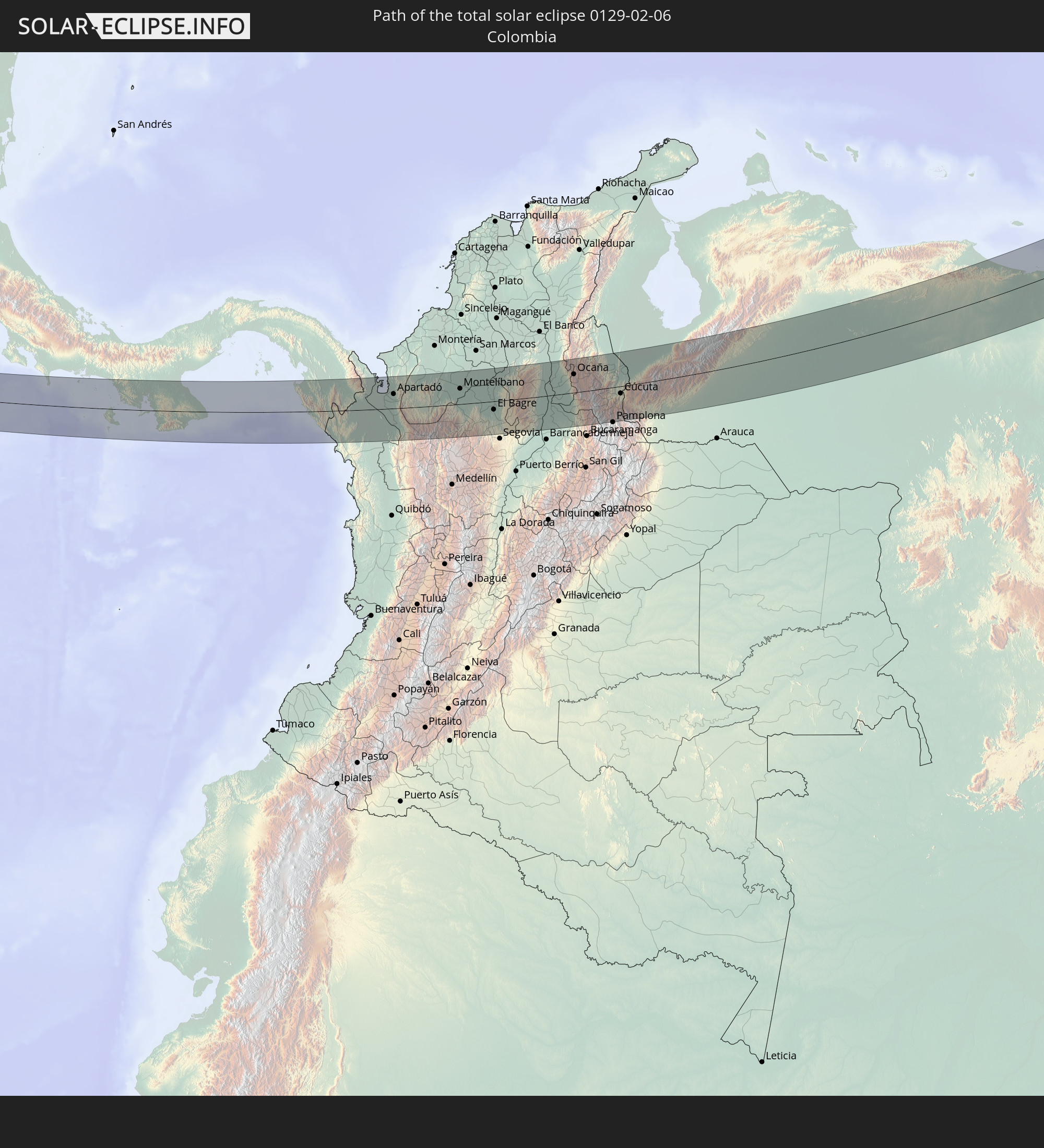 Kolumbien
 Venezuela
 Trinidad und Tobago
 Grenada
 Barbados
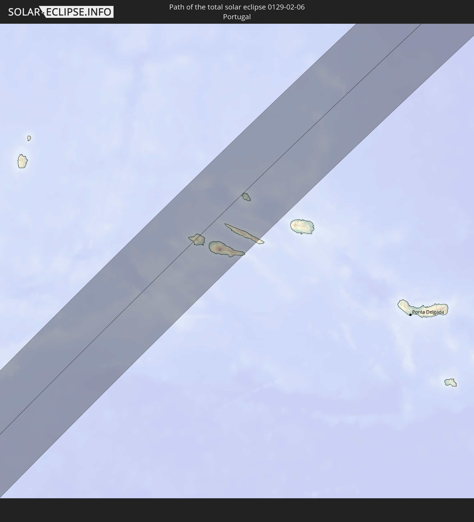 Portugal
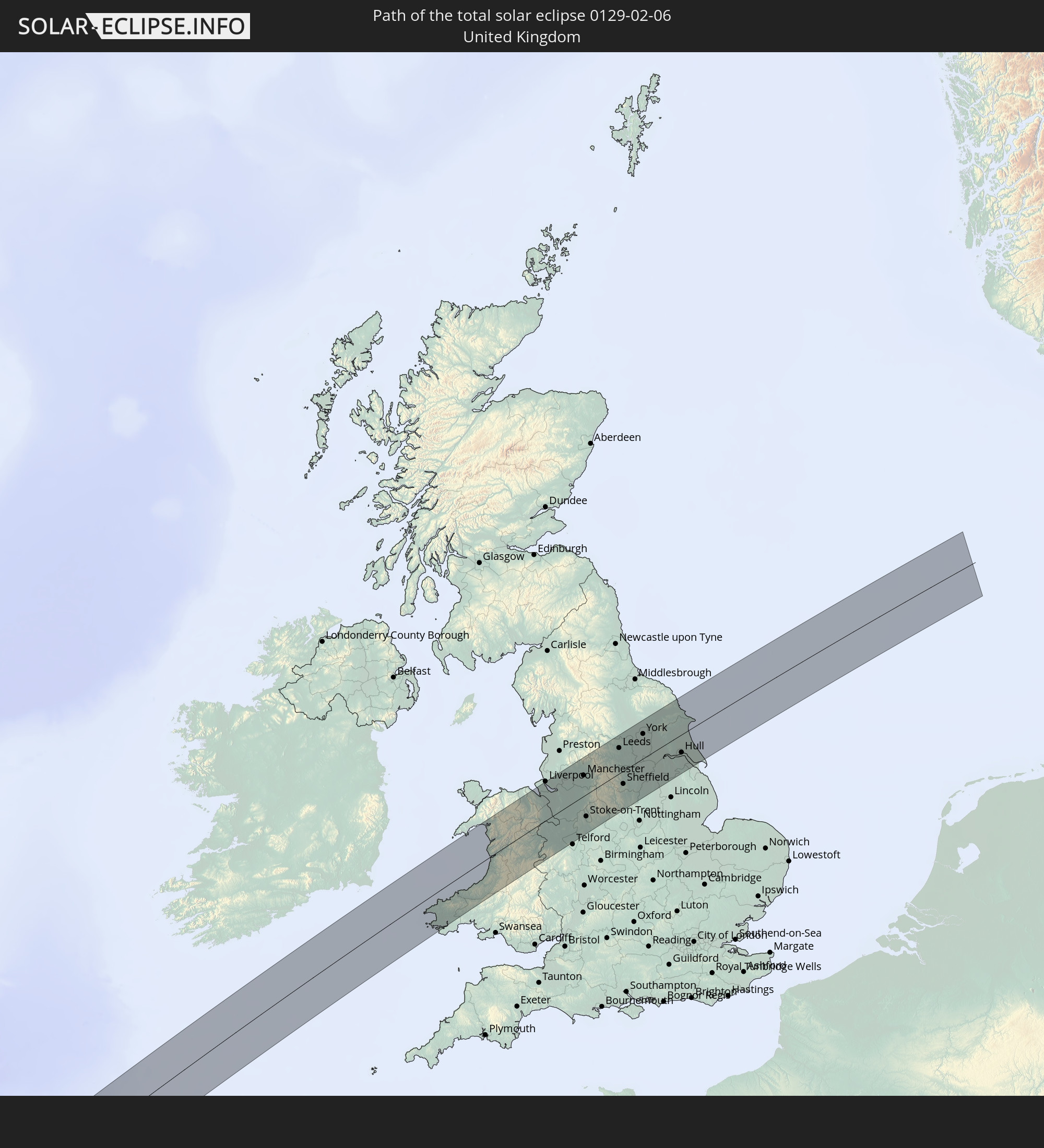 Vereinigtes Königreich
In den folgenden Ländern ist die Sonnenfinsternis partiell zu sehen
 Vereinigte Staaten
 United States Minor Outlying Islands
 Kanada
 Mexiko
 Chile
Chile
 Grönland
 Guatemala
 Ecuador
 El Salvador
 Honduras
 Belize
 Nicaragua
 Costa Rica
 Kuba
Kuba
 Panama
 Kolumbien
 Kaimaninseln
 Peru
Peru
 Bahamas
 Jamaika
 Haiti
Haiti
 Brasilien
 Argentinien
 Venezuela
 Turks- und Caicosinseln
 Dominikanische Republik
 Aruba
Aruba
 Bolivien
 Puerto Rico
 Amerikanische Jungferninseln
 Bermuda
 Britische Jungferninseln
 Anguilla
 Saint-Martin
 Saint-Barthélemy
 St. Kitts und Nevis
 Paraguay
 Antigua und Barbuda
 Montserrat
 Trinidad und Tobago
 Guadeloupe
 Grenada
 Dominica
 St. Vincent und die Grenadinen
 Guyana
 Martinique
 St. Lucia
 Barbados
 Suriname
 Saint-Pierre und Miquelon
 Französisch-Guayana
 Portugal
 Kap Verde
 Island
 Spanien
 Senegal
 Mauretanien
 Gambia
 Guinea-Bissau
 Guinea
 Sierra Leone
 Marokko
 Mali
Mali
 Irland
 Algerien
 Vereinigtes Königreich
 Färöer
 Gibraltar
 Frankreich
 Isle of Man
 Guernsey
 Jersey
 Niger
Niger
 Andorra
 Belgien
 Niederlande
 Luxemburg
 Deutschland
 Schweiz
 Italien
 Monaco
 Tunesien
 Libyen
 Liechtenstein
 Österreich
 Vatikanstadt
 Malta
Malta
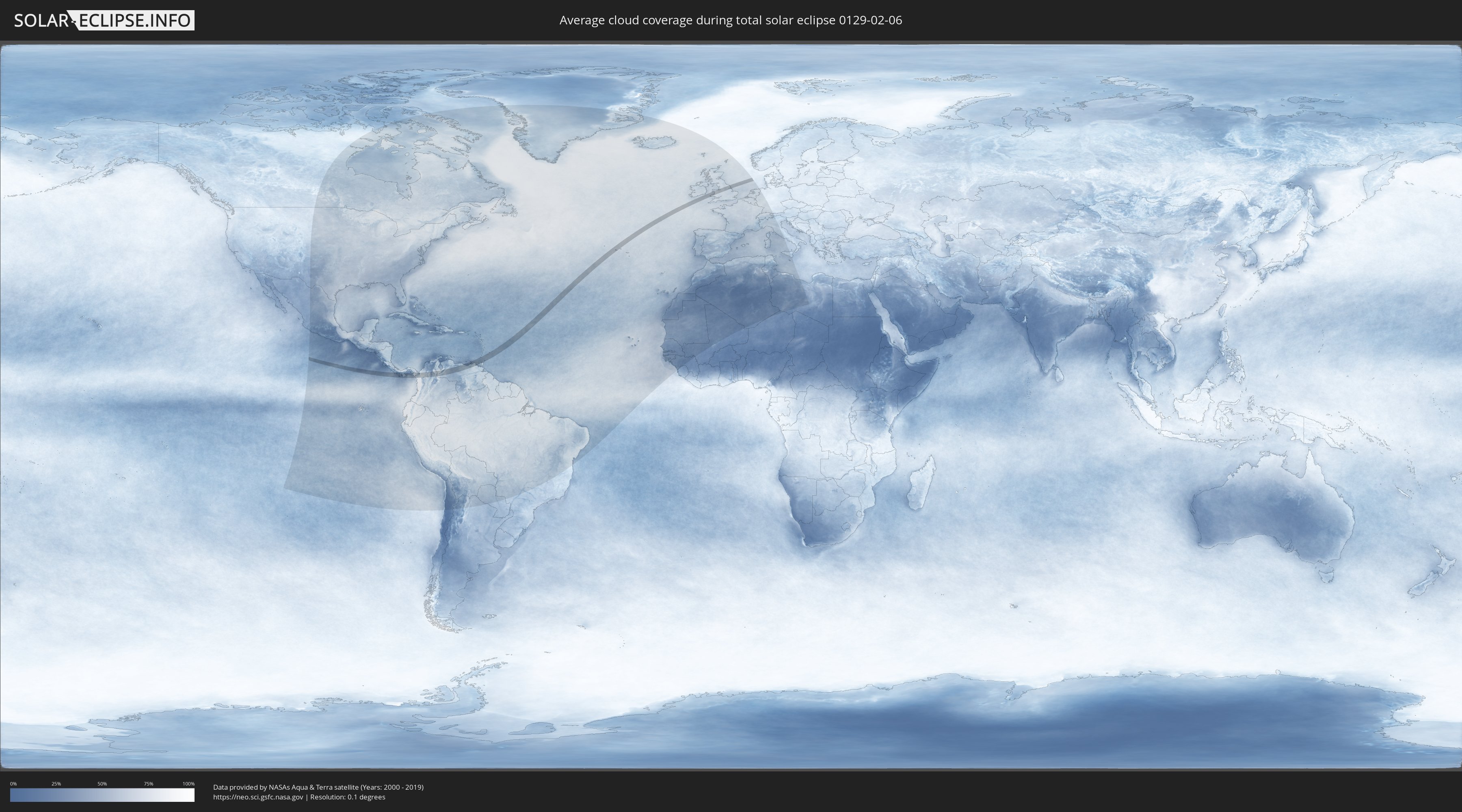
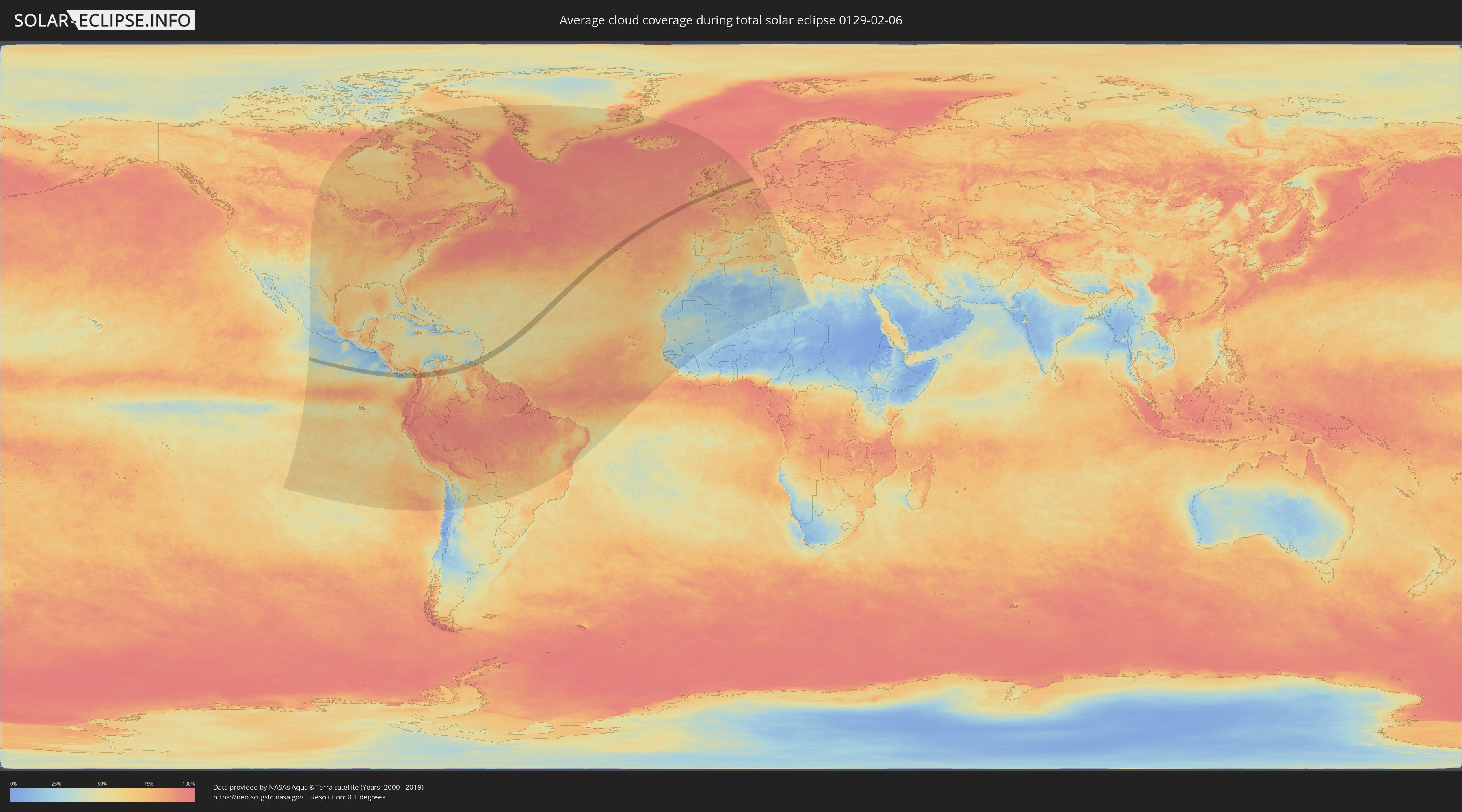
Wie wird das Wetter während der totalen Sonnenfinsternis am 06.02.0129?
Wo ist der beste Ort, um die totale Sonnenfinsternis vom 06.02.0129 zu beobachten?
Die folgenden Karten zeigen die durchschnittliche Bewölkung für den Tag, an dem die totale Sonnenfinsternis
stattfindet. Mit Hilfe der Karten lässt sich der Ort entlang des Finsternispfades eingrenzen,
der die besten Aussichen auf einen klaren wolkenfreien Himmel bietet.
Trotzdem muss man immer lokale Gegenenheiten beachten und sollte sich genau über das Wetter an seinem
gewählten Beobachtungsort informieren.
Die Daten stammen von den beiden NASA-Satelliten
AQUA und TERRA
und wurden über einen Zeitraum von 19 Jahren (2000 - 2019) gemittelt.
Detaillierte Länderkarten
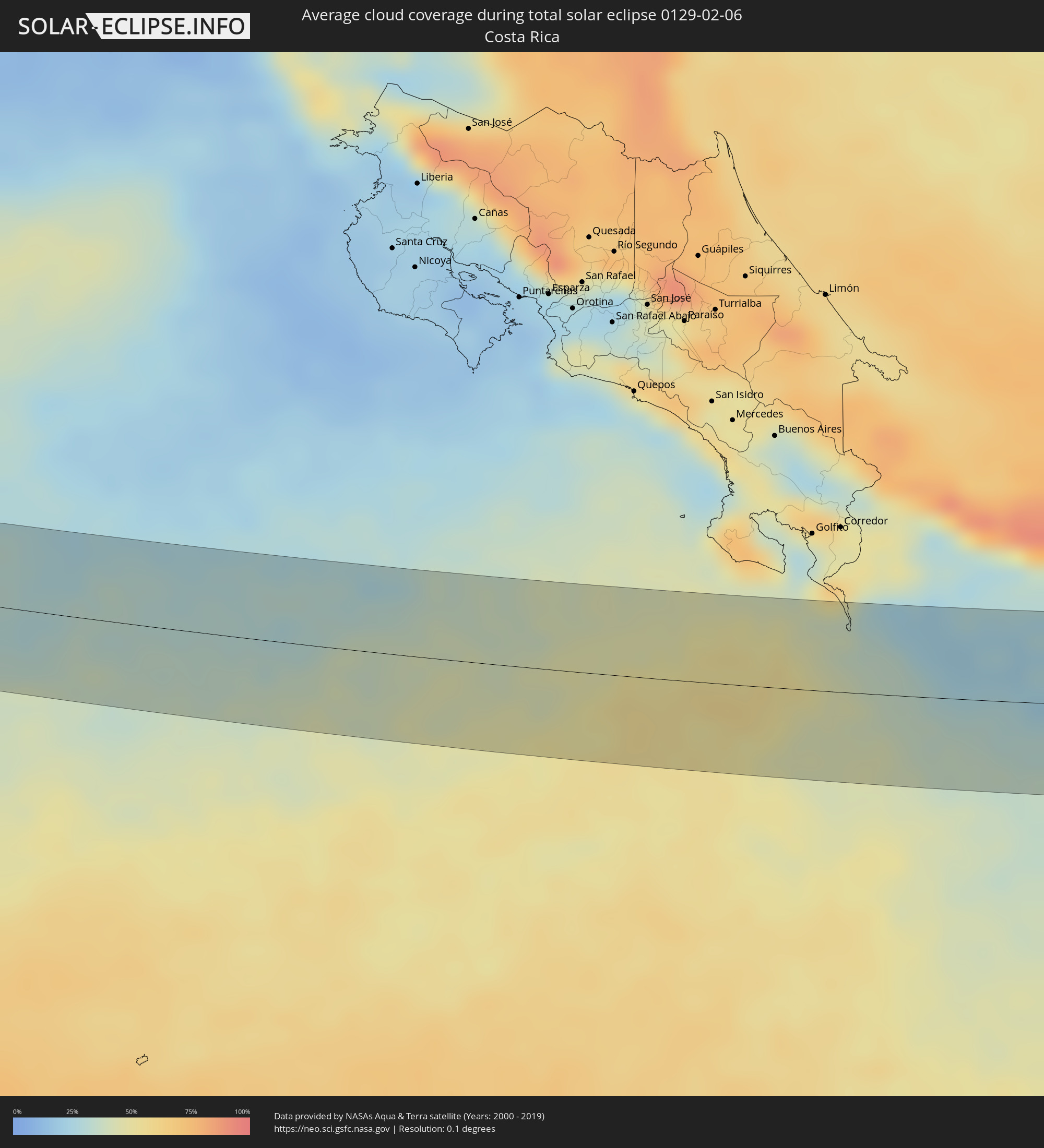 Costa Rica
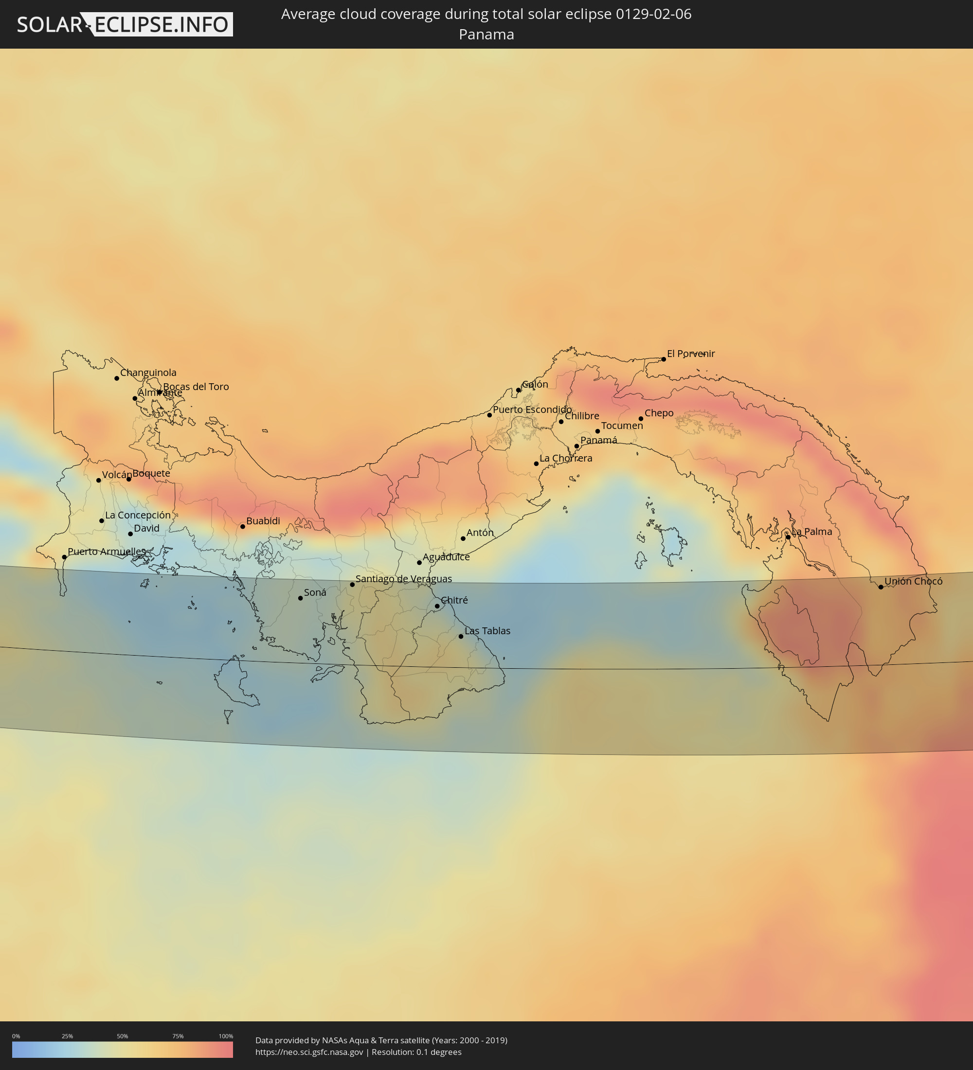 Panama
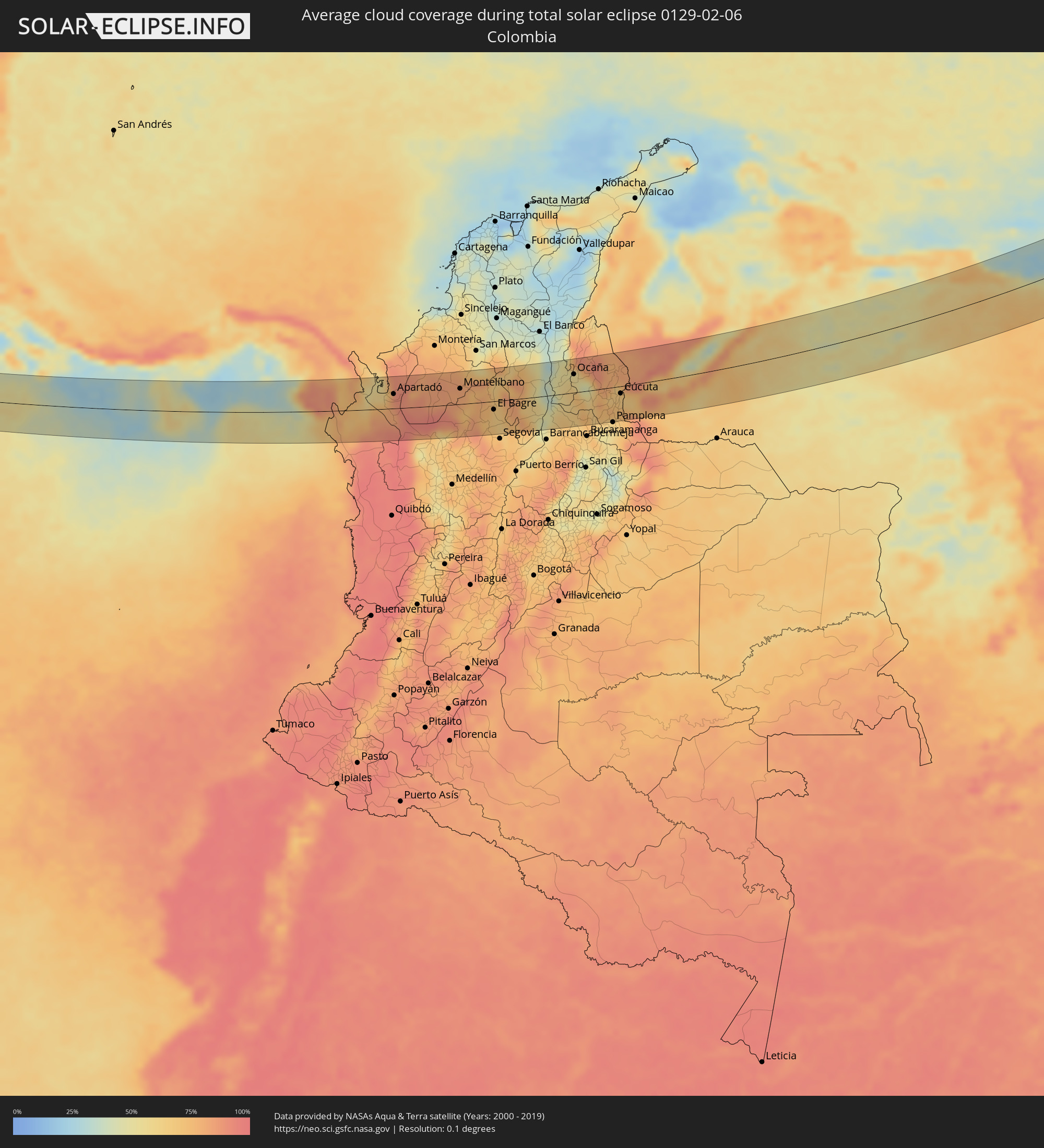 Kolumbien
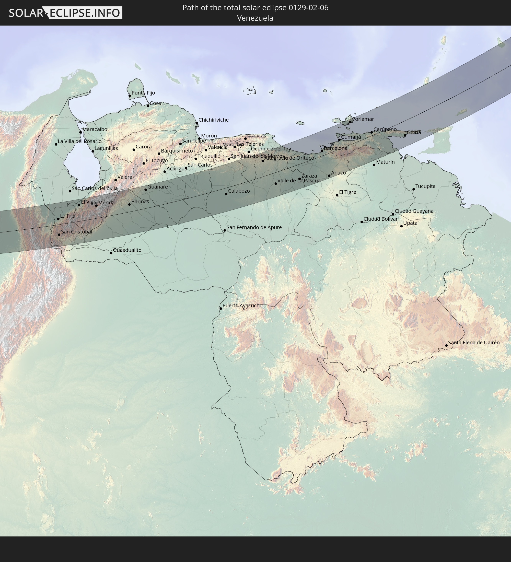
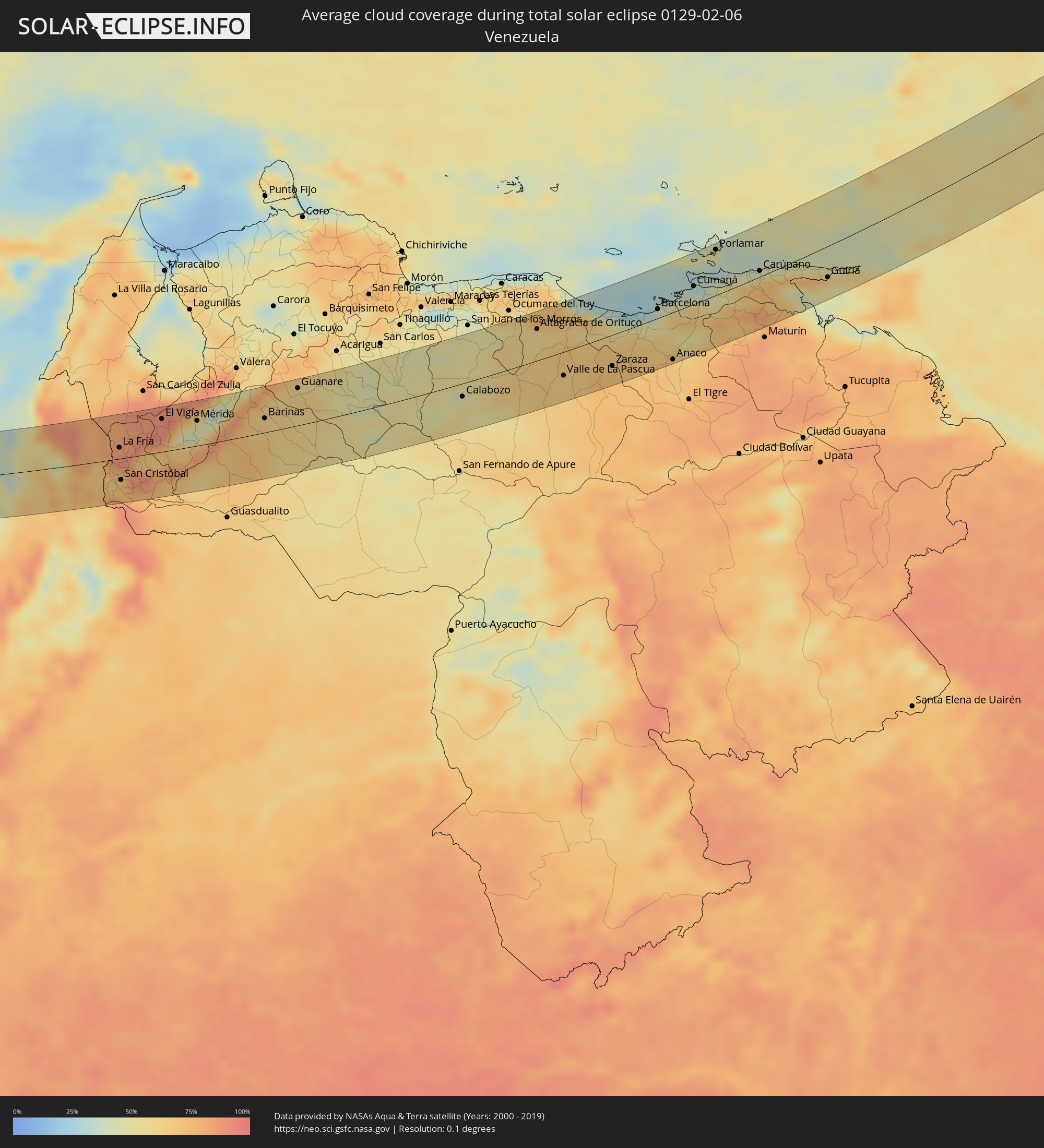 Venezuela
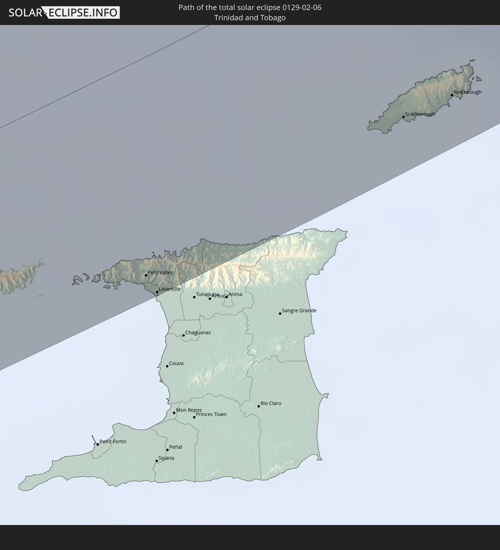
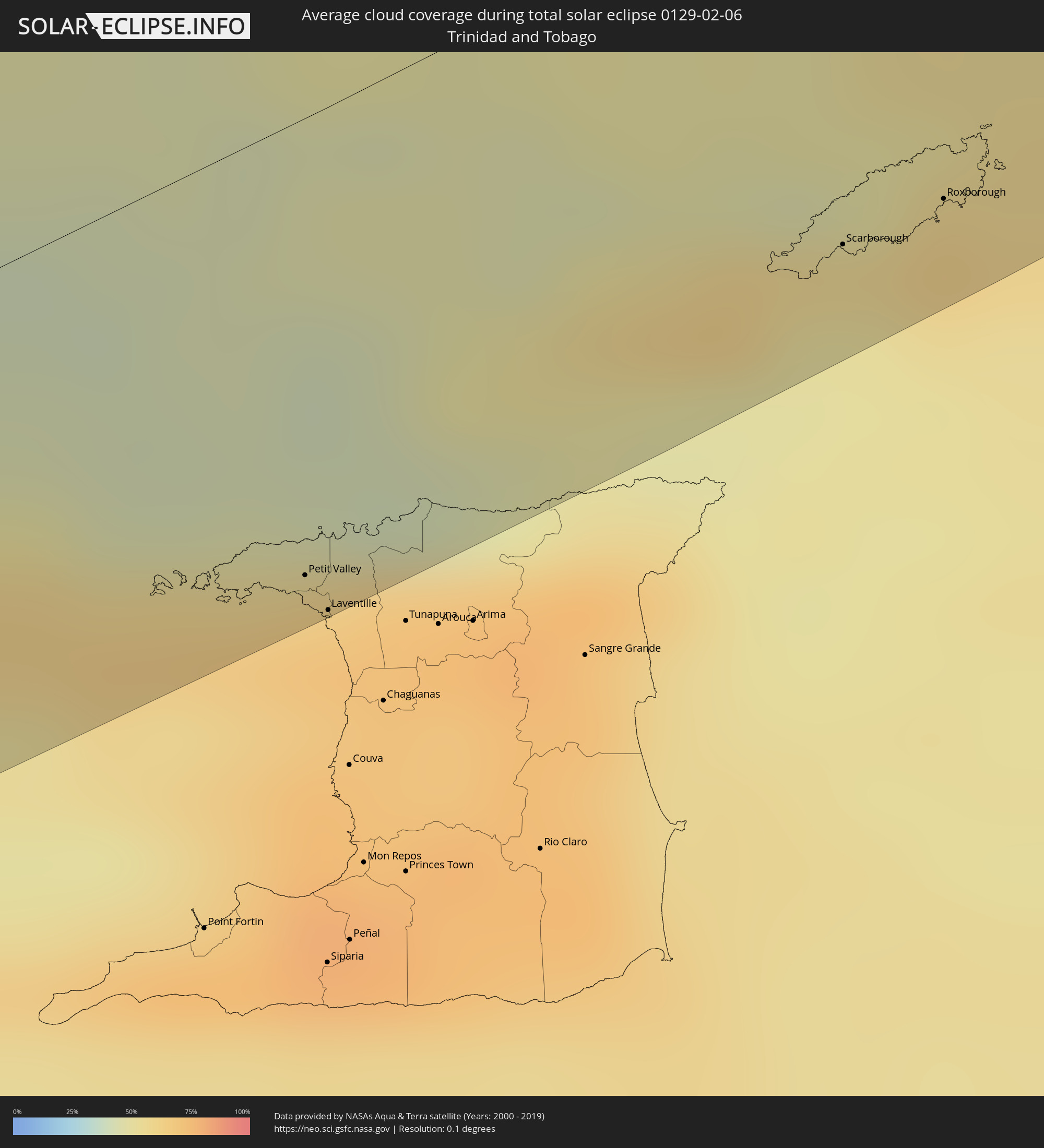 Trinidad und Tobago
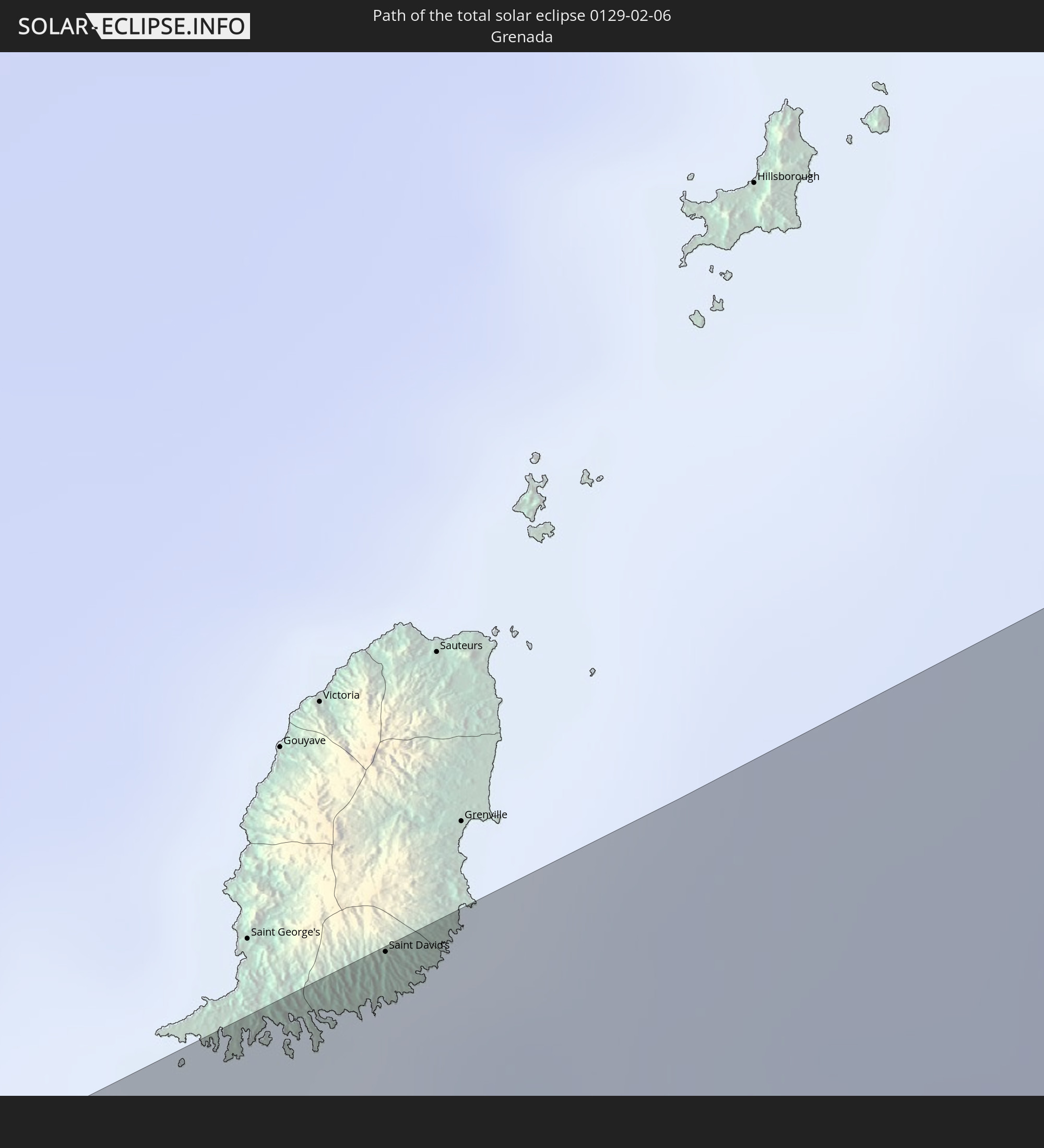
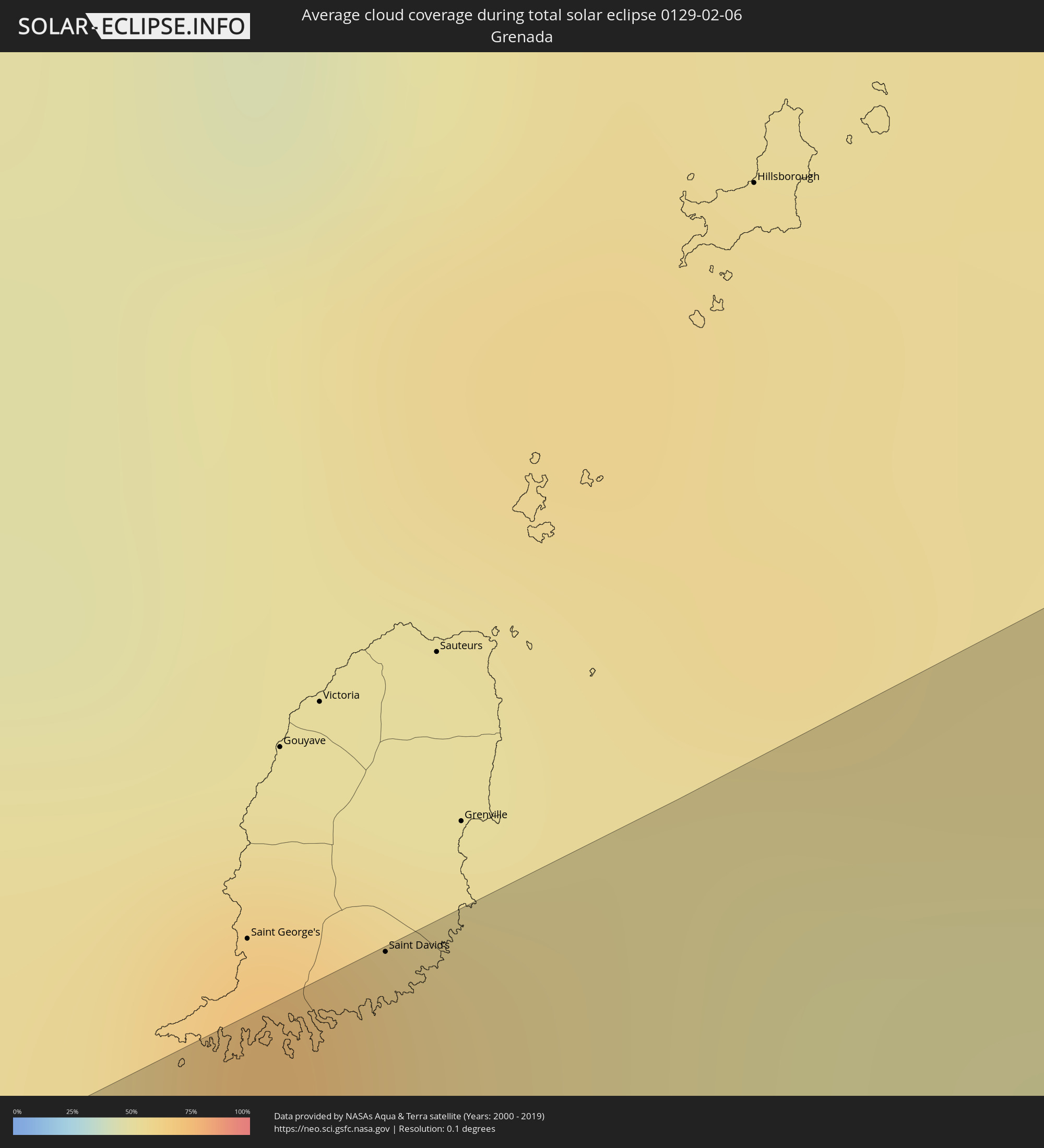 Grenada
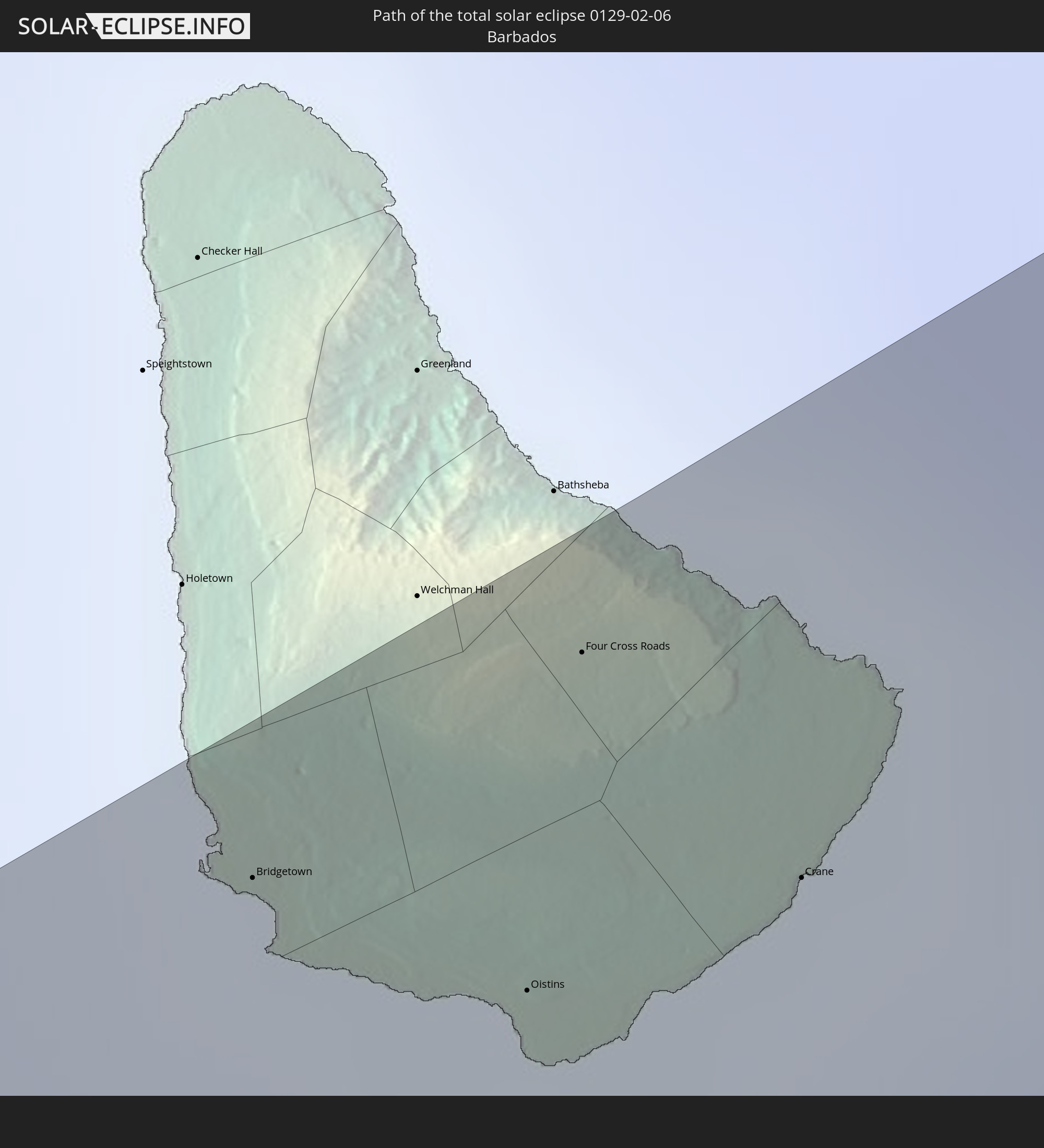
 Barbados
 Portugal
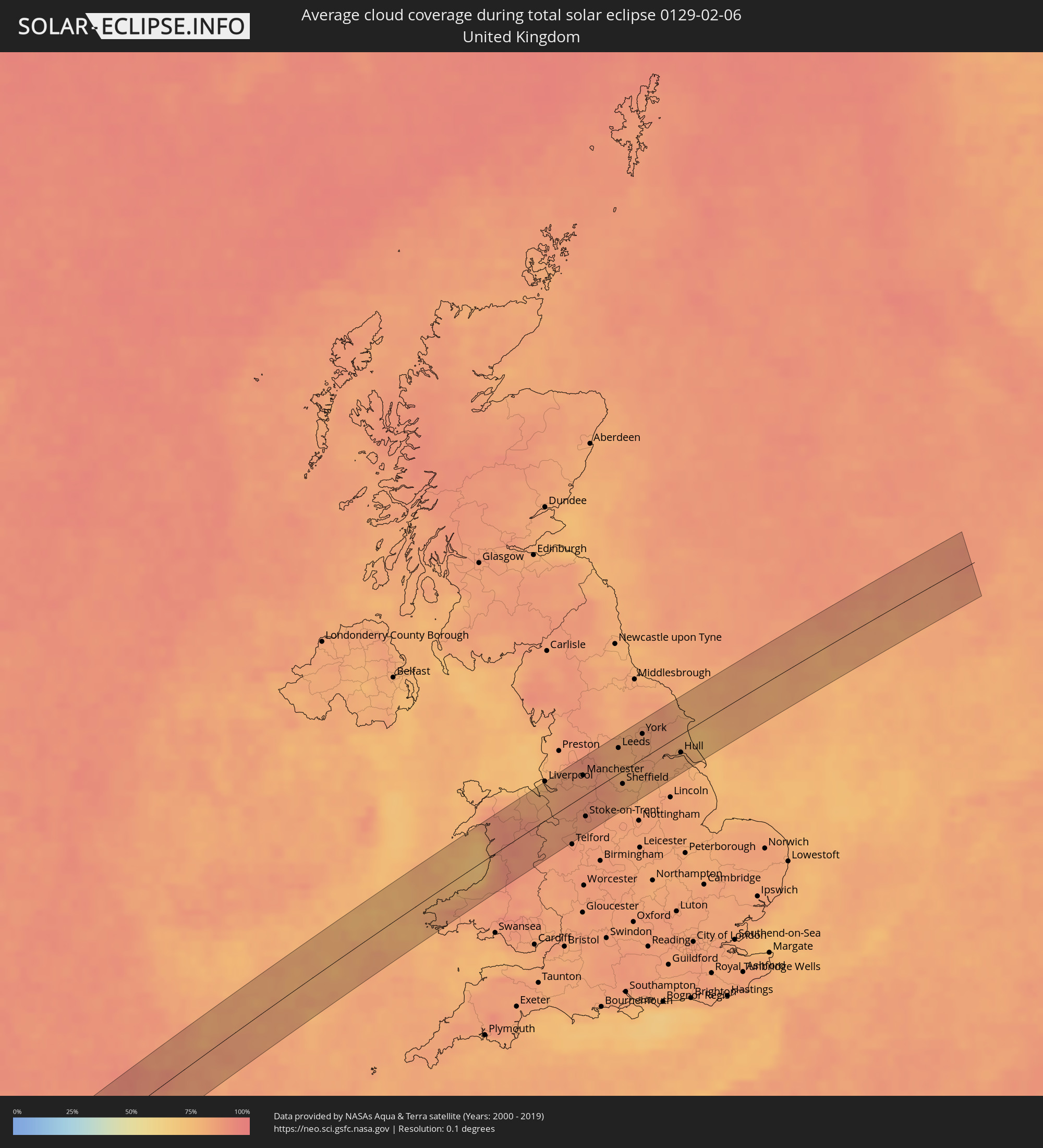 Vereinigtes Königreich
Orte im Finsternispfad
Die nachfolgene Tabelle zeigt Städte und Orte mit mehr als 5.000 Einwohnern, die sich im Finsternispfad befinden. Städte mit mehr als 100.000 Einwohnern sind dick gekennzeichnet. Mit einem Klick auf den Ort öffnet sich eine Detailkarte die die Lage des jeweiligen Ortes zusammen mit dem Verlauf der zentralen Finsternis präsentiert.
| Ort | Typ | Dauer der Verfinsterung | Ortszeit bei maximaler Verfinsterung | Entfernung zur Zentrallinie | Ø Bewölkung |
|
Soná, Veraguas
|
total | - | 08:21:05 UTC-05:19 | 46 km | 36% |
|
Santiago de Veraguas, Veraguas
|
total | - | 08:21:38 UTC-05:19 | 57 km | 47% |
|
Chitré, Herrera
|
total | - | 08:22:13 UTC-05:19 | 43 km | 40% |
|
Los Santos, Los Santos
|
total | - | 08:22:12 UTC-05:19 | 40 km | 46% |
|
Las Tablas, Los Santos
|
total | - | 08:22:12 UTC-05:19 | 22 km | 50% |
|
Unión Chocó, Emberá
|
total | - | 08:26:34 UTC-05:19 | 55 km | 74% |
|
Turbo, Antioquia
|
total | - | 08:51:10 UTC-04:56 | 53 km | 77% |
|
Chigorodó, Antioquia
|
total | - | 08:50:42 UTC-04:56 | 5 km | 81% |
|
Carepa, Antioquia
|
total | - | 08:50:52 UTC-04:56 | 15 km | 79% |
|
Apartadó, Antioquia
|
total | - | 08:51:04 UTC-04:56 | 29 km | 88% |
|
Tierralta, Córdoba
|
total | - | 08:52:20 UTC-04:56 | 57 km | 82% |
|
Ituango, Antioquia
|
total | - | 08:51:33 UTC-04:56 | 56 km | 65% |
|
Montelíbano, Córdoba
|
total | - | 08:53:08 UTC-04:56 | 31 km | 82% |
|
Caucasia, Antioquia
|
total | - | 08:53:31 UTC-04:56 | 30 km | 74% |
|
Ayapel, Córdoba
|
total | - | 08:54:01 UTC-04:56 | 65 km | 72% |
|
Pueblo Nuevo, Córdoba
|
total | - | 08:54:14 UTC-04:56 | 56 km | 85% |
|
Zaragoza, Antioquia
|
total | - | 08:53:25 UTC-04:56 | 29 km | 70% |
|
El Bagre, Antioquia
|
total | - | 08:53:40 UTC-04:56 | 17 km | 66% |
|
San Carlos, Antioquia
|
total | - | 08:53:58 UTC-04:56 | 4 km | 68% |
|
Santa Rosa del Sur, Bolívar
|
total | - | 08:55:25 UTC-04:56 | 15 km | 57% |
|
Puerto Wilches, Santander
|
total | - | 08:54:53 UTC-04:56 | 55 km | 47% |
|
Morales, Bolívar
|
total | - | 08:56:09 UTC-04:56 | 47 km | 38% |
|
Aguachica, Cesar
|
total | - | 08:56:38 UTC-04:56 | 48 km | 52% |
|
Sabana de Torres, Santander
|
total | - | 08:55:38 UTC-04:56 | 55 km | 70% |
|
San Alberto, Cesar
|
total | - | 08:56:18 UTC-04:56 | 16 km | 63% |
|
Ocaña, Norte de Santander
|
total | - | 08:57:00 UTC-04:56 | 36 km | 60% |
|
Ábrego, Norte de Santander
|
total | - | 08:57:02 UTC-04:56 | 17 km | 44% |
|
El Zulia, Norte de Santander
|
total | - | 08:57:56 UTC-04:56 | 9 km | 68% |
|
Chinácota, Norte de Santander
|
total | - | 08:57:30 UTC-04:56 | 44 km | 72% |
|
Cúcuta, Norte de Santander
|
total | - | 08:58:03 UTC-04:56 | 14 km | 66% |
|
San Antonio del Táchira, Táchira
|
total | - | 09:26:40 UTC-04:27 | 24 km | 67% |
|
Puerto Santander, Norte de Santander
|
total | - | 08:58:52 UTC-04:56 | 36 km | 80% |
|
Rubio, Táchira
|
total | - | 09:26:40 UTC-04:27 | 38 km | 74% |
|
San Juan de Colón, Táchira
|
total | - | 09:27:17 UTC-04:27 | 3 km | 75% |
|
La Fría, Táchira
|
total | - | 09:27:33 UTC-04:27 | 17 km | 89% |
|
San Cristóbal, Táchira
|
total | - | 09:27:00 UTC-04:27 | 33 km | 73% |
|
Táriba, Táchira
|
total | - | 09:27:04 UTC-04:27 | 27 km | 73% |
|
El Vigía, Mérida
|
total | - | 09:29:12 UTC-04:27 | 50 km | 89% |
|
Ejido, Mérida
|
total | - | 09:29:53 UTC-04:27 | 35 km | 40% |
|
Mérida, Mérida
|
total | - | 09:30:06 UTC-04:27 | 38 km | 44% |
|
Mucumpiz, Mérida
|
total | - | 09:29:54 UTC-04:27 | 19 km | 69% |
|
Barinitas, Barinas
|
total | - | 09:31:46 UTC-04:27 | 41 km | 65% |
|
Alto Barinas, Barinas
|
total | - | 09:31:53 UTC-04:27 | 19 km | 62% |
|
Barinas, Barinas
|
total | - | 09:31:57 UTC-04:27 | 21 km | 62% |
|
Guanare, Portuguesa
|
total | - | 09:33:28 UTC-04:27 | 56 km | 64% |
|
Calabozo, Guárico
|
total | - | 09:37:57 UTC-04:27 | 19 km | 55% |
|
Altagracia de Orituco, Guárico
|
total | - | 09:41:34 UTC-04:27 | 46 km | 58% |
|
Valle de La Pascua, Guárico
|
total | - | 09:41:23 UTC-04:27 | 35 km | 62% |
|
Zaraza, Guárico
|
total | - | 09:43:03 UTC-04:27 | 45 km | 72% |
|
Barcelona, Anzoátegui
|
total | - | 09:45:39 UTC-04:27 | 13 km | 49% |
|
Anaco, Anzoátegui
|
total | - | 09:45:02 UTC-04:27 | 68 km | 70% |
|
Cumaná, Sucre
|
total | - | 09:47:15 UTC-04:27 | 26 km | 37% |
|
Porlamar, Nueva Esparta
|
total | - | 09:48:45 UTC-04:27 | 65 km | 46% |
|
La Asunción, Nueva Esparta
|
total | - | 09:48:53 UTC-04:27 | 72 km | 46% |
|
Carúpano, Sucre
|
total | - | 09:49:40 UTC-04:27 | 8 km | 61% |
|
Güiria, Sucre
|
total | - | 09:51:40 UTC-04:27 | 43 km | 51% |
|
Saint David’s, Saint David
|
total | - | 10:17:06 UTC-04:06 | 74 km | 51% |
|
Petit Valley, Diego Martin
|
total | - | 10:15:12 UTC-04:06 | 67 km | 69% |
|
Port of Spain, City of Port of Spain
|
total | - | 10:15:11 UTC-04:06 | 71 km | 69% |
|
Laventille, San Juan/Laventille
|
total | - | 10:15:12 UTC-04:06 | 74 km | 67% |
|
Scarborough, Tobago
|
total | - | 10:17:50 UTC-04:06 | 58 km | 51% |
|
Roxborough, Eastern Tobago
|
total | - | 10:18:17 UTC-04:06 | 59 km | 61% |
|
Bridgetown, Saint Michael
|
total | - | 10:31:11 UTC-03:58 | 70 km | 61% |
|
Oistins, Christ Church
|
total | - | 10:31:20 UTC-03:58 | 63 km | 58% |
|
Four Cross Roads, Saint John
|
total | - | 10:31:32 UTC-03:58 | 71 km | 65% |
|
Crane, Saint Philip
|
total | - | 10:31:35 UTC-03:58 | 61 km | 58% |
|
Ribeira Grande, Azores
|
total | - | 15:59:07 UTC+00:00 | 7 km | 81% |
|
Horta, Azores
|
total | - | 14:04:40 UTC-01:54 | 10 km | 81% |
|
Madalena, Azores
|
total | - | 14:04:48 UTC-01:54 | 16 km | 83% |
|
Lagoa, Azores
|
total | - | 14:05:37 UTC-01:54 | 8 km | 83% |
|
Wrexham, Wales
|
total | - | 16:16:39 UTC+00:00 | 9 km | 83% |
|
Liverpool, England
|
total | - | 16:16:24 UTC+00:00 | 43 km | 80% |
|
Chester, England
|
total | - | 16:16:35 UTC+00:00 | 19 km | 82% |
|
Shrewsbury, England
|
total | - | 16:16:59 UTC+00:00 | 31 km | 85% |
|
St Helens, England
|
total | - | 16:16:29 UTC+00:00 | 37 km | 85% |
|
Northwich, England
|
total | - | 16:16:42 UTC+00:00 | 12 km | 86% |
|
Crewe, England
|
total | - | 16:16:51 UTC+00:00 | 6 km | 86% |
|
Bolton, England
|
total | - | 16:16:31 UTC+00:00 | 39 km | 86% |
|
Manchester, England
|
total | - | 16:16:40 UTC+00:00 | 22 km | 84% |
|
Stoke-on-Trent, England
|
total | - | 16:17:01 UTC+00:00 | 24 km | 86% |
|
Rochdale, England
|
total | - | 16:16:36 UTC+00:00 | 32 km | 86% |
|
Macclesfield, England
|
total | - | 16:16:52 UTC+00:00 | 2 km | 89% |
|
High Peak, England
|
total | - | 16:16:54 UTC+00:00 | 2 km | 87% |
|
Huddersfield, England
|
total | - | 16:16:44 UTC+00:00 | 22 km | 84% |
|
Leeds, England
|
total | - | 16:16:43 UTC+00:00 | 28 km | 81% |
|
Barnsley, England
|
total | - | 16:16:55 UTC+00:00 | 2 km | 79% |
|
Sheffield, England
|
total | - | 16:17:03 UTC+00:00 | 14 km | 83% |
|
Chesterfield, England
|
total | - | 16:17:10 UTC+00:00 | 28 km | 80% |
|
Doncaster, England
|
total | - | 16:17:05 UTC+00:00 | 13 km | 79% |
|
Worksop, England
|
total | - | 16:17:14 UTC+00:00 | 34 km | 79% |
|
York, England
|
total | - | 16:16:47 UTC+00:00 | 26 km | 82% |
|
Scunthorpe, England
|
total | - | 16:17:14 UTC+00:00 | 24 km | 80% |
|
Scarborough, England
|
total | - | 16:16:48 UTC+00:00 | 33 km | 81% |
|
Hull, England
|
total | - | 16:17:14 UTC+00:00 | 20 km | 81% |
|
Bridlington, England
|
total | - | 16:17:02 UTC+00:00 | 8 km | 77% |