Totale Sonnenfinsternis vom 01.06.0132
| Wochentag: | Sonntag |
| Maximale Dauer der Verfinsterung: | 07m14s |
| Maximale Breite des Finsternispfades: | 255 km |
| Saroszyklus: | 78 |
| Bedeckungsgrad: | 100% |
| Magnitude: | 1.0775 |
| Gamma: | -0.1932 |
Wo kann man die Sonnenfinsternis vom 01.06.0132 sehen?
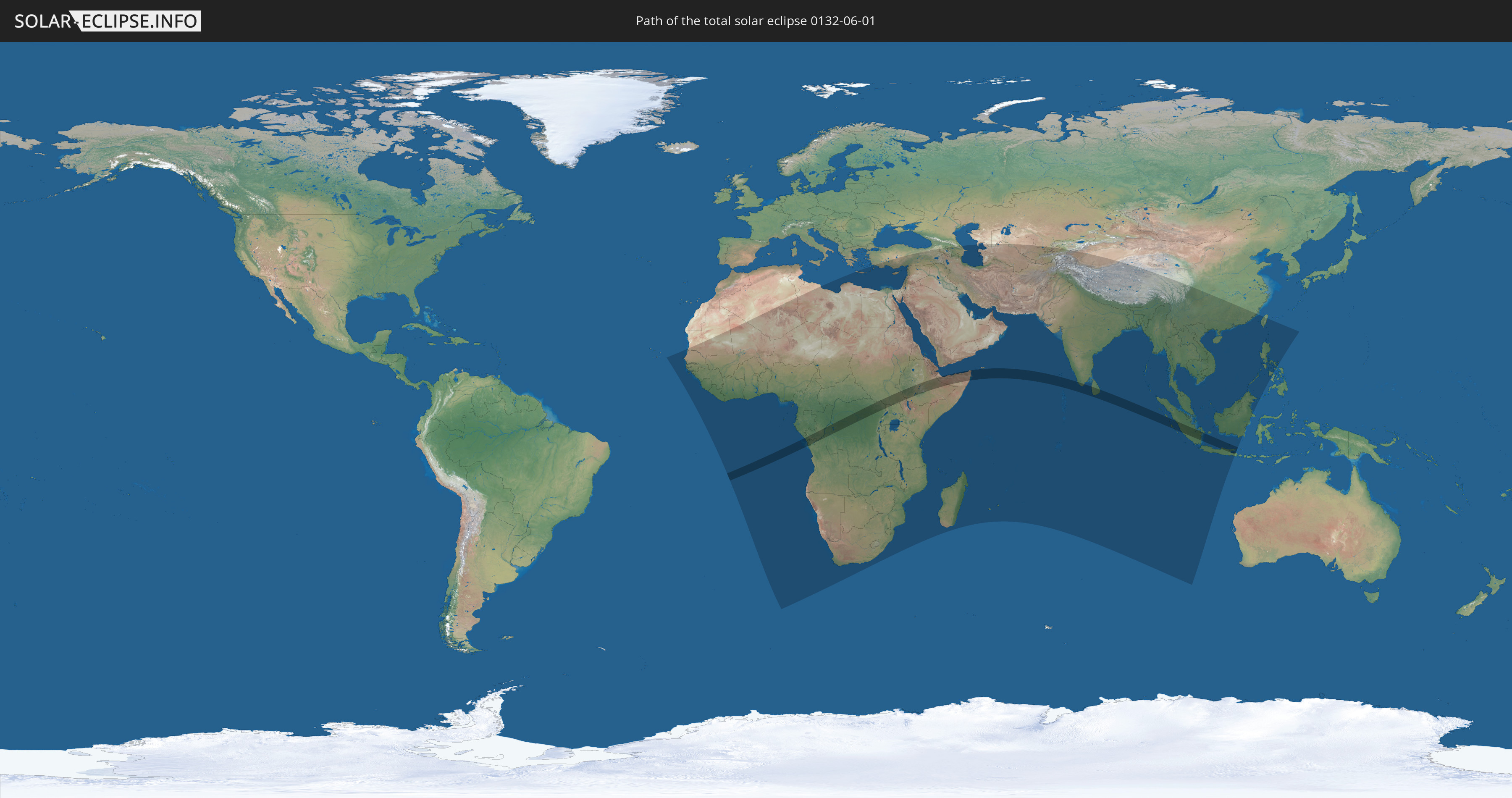
Die Sonnenfinsternis am 01.06.0132 kann man in 104 Ländern als partielle Sonnenfinsternis beobachten.
Der Finsternispfad verläuft durch 11 Länder. Nur in diesen Ländern ist sie als totale Sonnenfinsternis zu sehen.
In den folgenden Ländern ist die Sonnenfinsternis total zu sehen
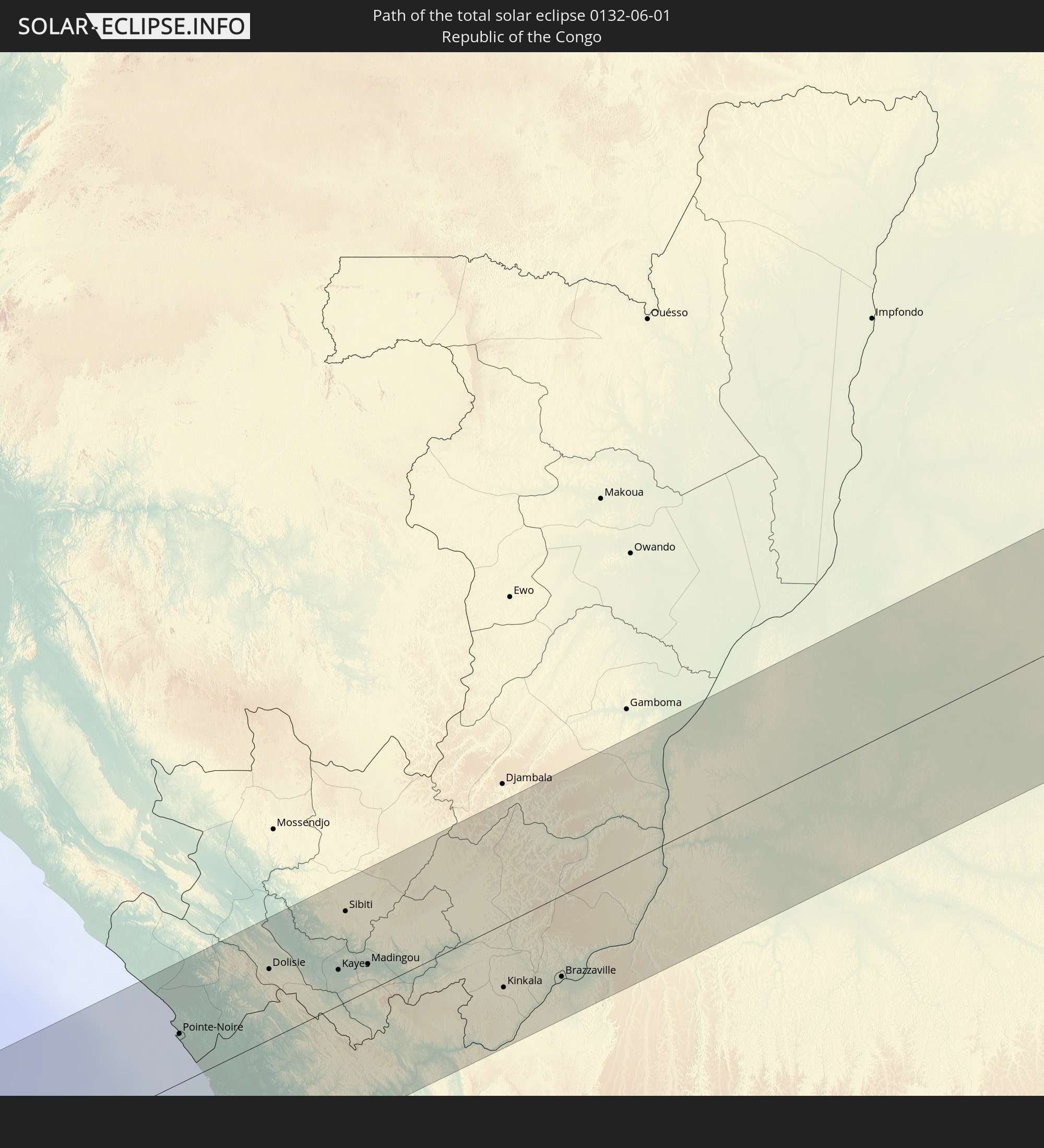 Republik Kongo
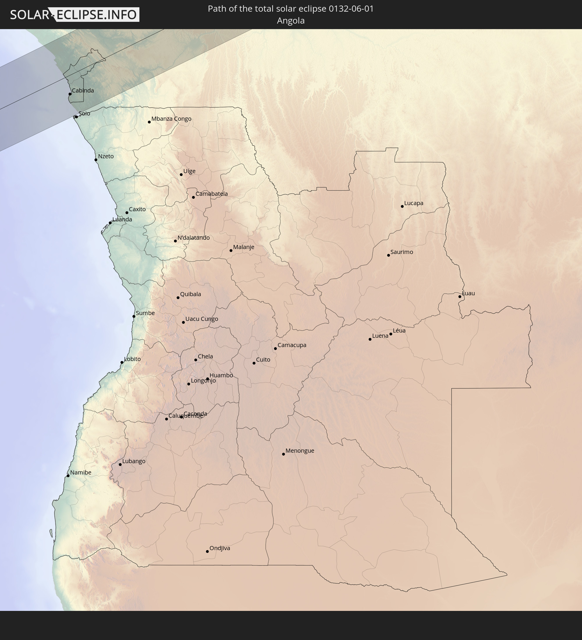 Angola
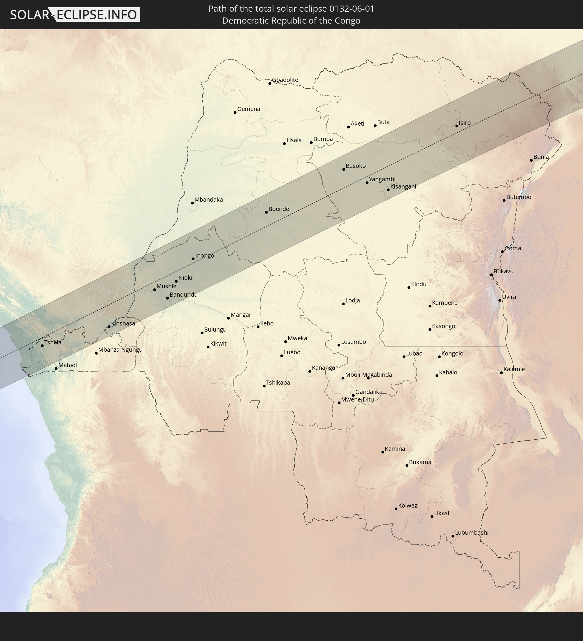 Demokratische Republik Kongo
 Südsudan
 Uganda
 Äthiopien
 Kenia
Kenia
 Somalia
 Indien
 Sri Lanka
 Indonesien
In den folgenden Ländern ist die Sonnenfinsternis partiell zu sehen
 Russland
 Senegal
 Mauretanien
 Gambia
 Guinea-Bissau
 Guinea
 Sierra Leone
 Mali
Mali
 Liberia
 Algerien
 Elfenbeinküste
 Burkina Faso
 Ghana
Ghana
 Togo
Togo
 Niger
Niger
 Benin
Benin
 Nigeria
 Äquatorialguinea
 São Tomé und Príncipe
 Kamerun
 Gabun
Gabun
 Libyen
 Republik Kongo
 Angola
 Namibia
 Demokratische Republik Kongo
 Tschad
 Zentralafrikanische Republik
 Südafrika
 Griechenland
 Botswana
 Sudan
Sudan
 Sambia
 Ägypten
 Simbabwe
 Türkei
 Lesotho
 Ruanda
 Burundi
 Tansania
 Uganda
 Mosambik
 Swasiland
 Republik Zypern
 Malawi
 Äthiopien
 Kenia
Kenia
 Staat Palästina
 Israel
 Saudi-Arabien
 Jordanien
 Libanon
 Syrien
 Eritrea
 Irak
Irak
 Georgien
 Französische Süd- und Antarktisgebiete
 Somalia
 Dschibuti
 Jemen
Jemen
 Madagaskar
 Komoren
 Armenien
 Iran
Iran
 Aserbaidschan
 Mayotte
 Seychellen
 Kasachstan
 Kuwait
 Bahrain
 Katar
Katar
 Vereinigte Arabische Emirate
 Oman
Oman
 Turkmenistan
 Réunion
 Usbekistan
 Mauritius
 Afghanistan
 Pakistan
 Tadschikistan
 Indien
 Kirgisistan
 Britisches Territorium im Indischen Ozean
 Malediven
 Volksrepublik China
 Sri Lanka
 Nepal
Nepal
 Bangladesch
 Bhutan
 Myanmar
 Indonesien
 Kokosinseln
 Thailand
 Malaysia
 Laos
Laos
 Vietnam
 Kambodscha
 Singapur
 Weihnachtsinsel
 Macau
Macau
 Hongkong
 Brunei
 Taiwan
 Philippinen
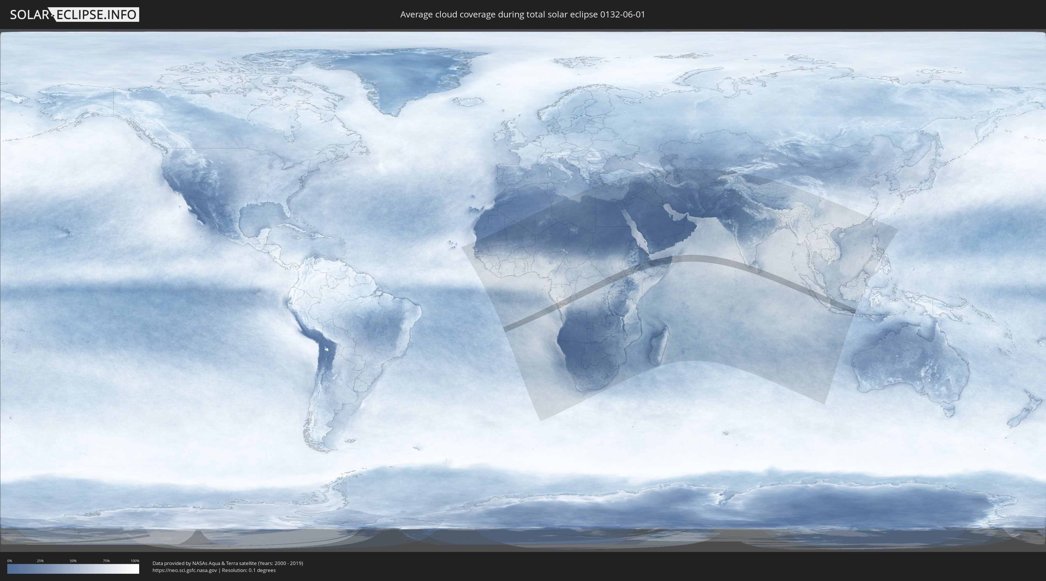
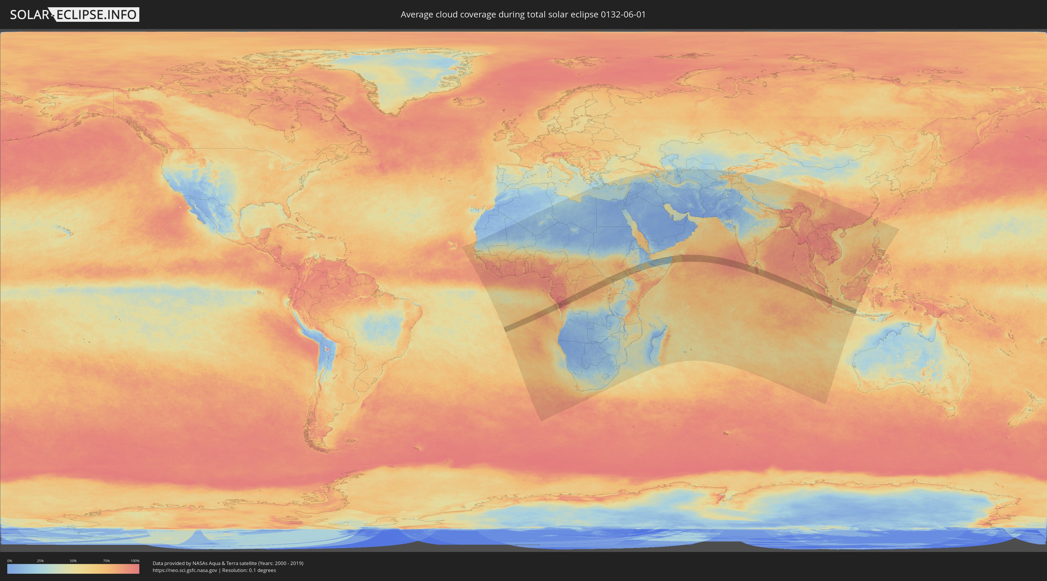
Wie wird das Wetter während der totalen Sonnenfinsternis am 01.06.0132?
Wo ist der beste Ort, um die totale Sonnenfinsternis vom 01.06.0132 zu beobachten?
Die folgenden Karten zeigen die durchschnittliche Bewölkung für den Tag, an dem die totale Sonnenfinsternis
stattfindet. Mit Hilfe der Karten lässt sich der Ort entlang des Finsternispfades eingrenzen,
der die besten Aussichen auf einen klaren wolkenfreien Himmel bietet.
Trotzdem muss man immer lokale Gegenenheiten beachten und sollte sich genau über das Wetter an seinem
gewählten Beobachtungsort informieren.
Die Daten stammen von den beiden NASA-Satelliten
AQUA und TERRA
und wurden über einen Zeitraum von 19 Jahren (2000 - 2019) gemittelt.
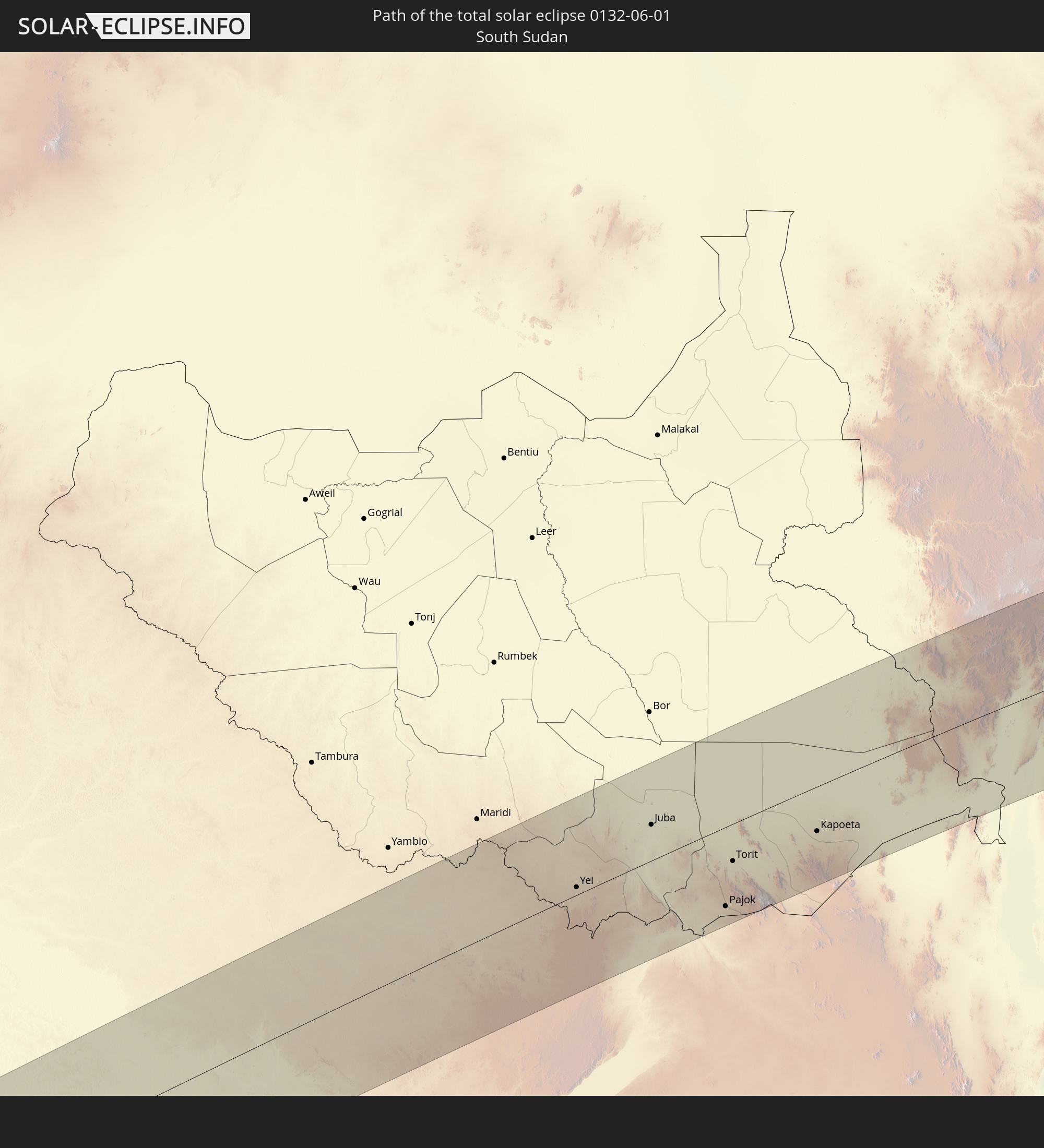
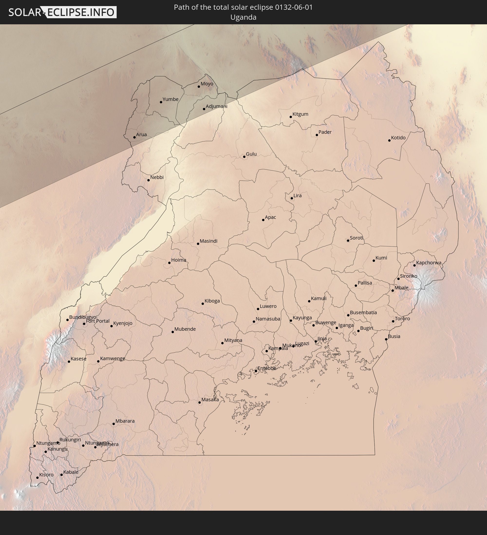
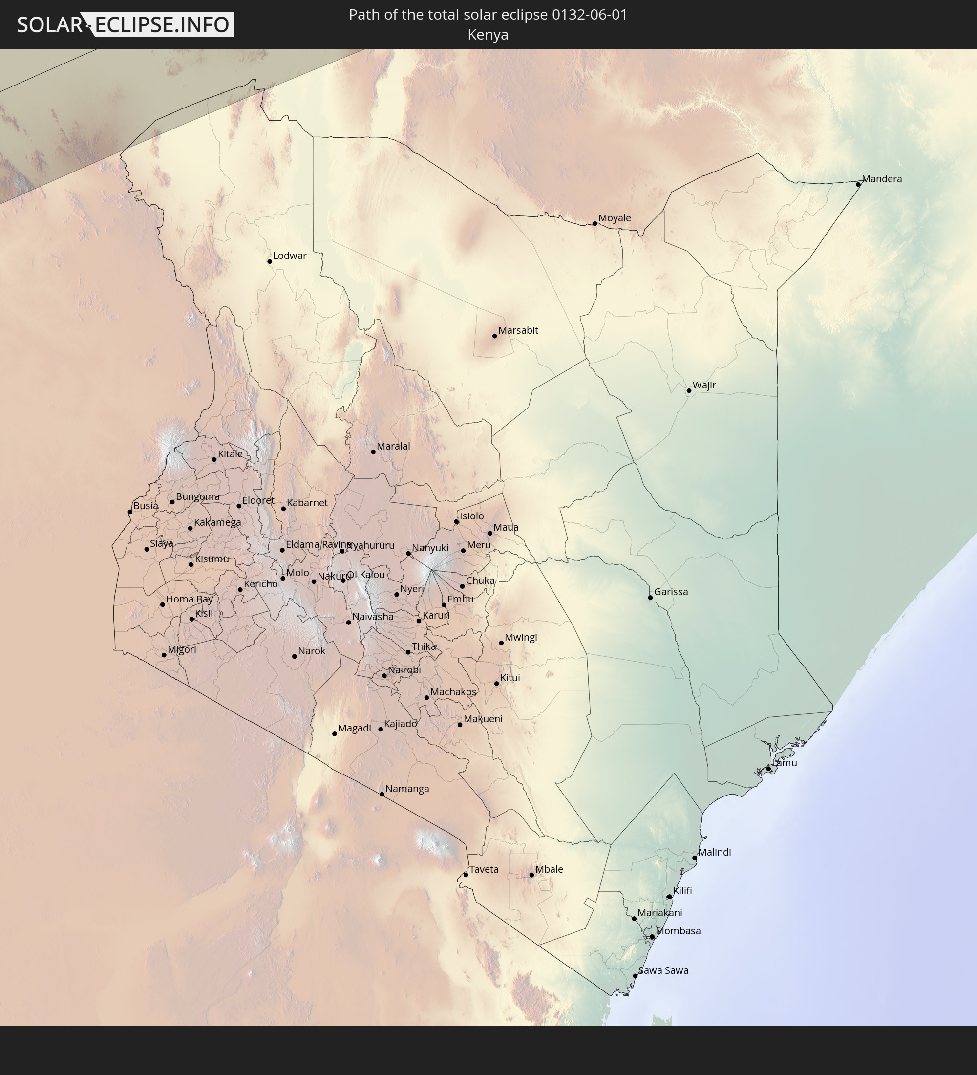
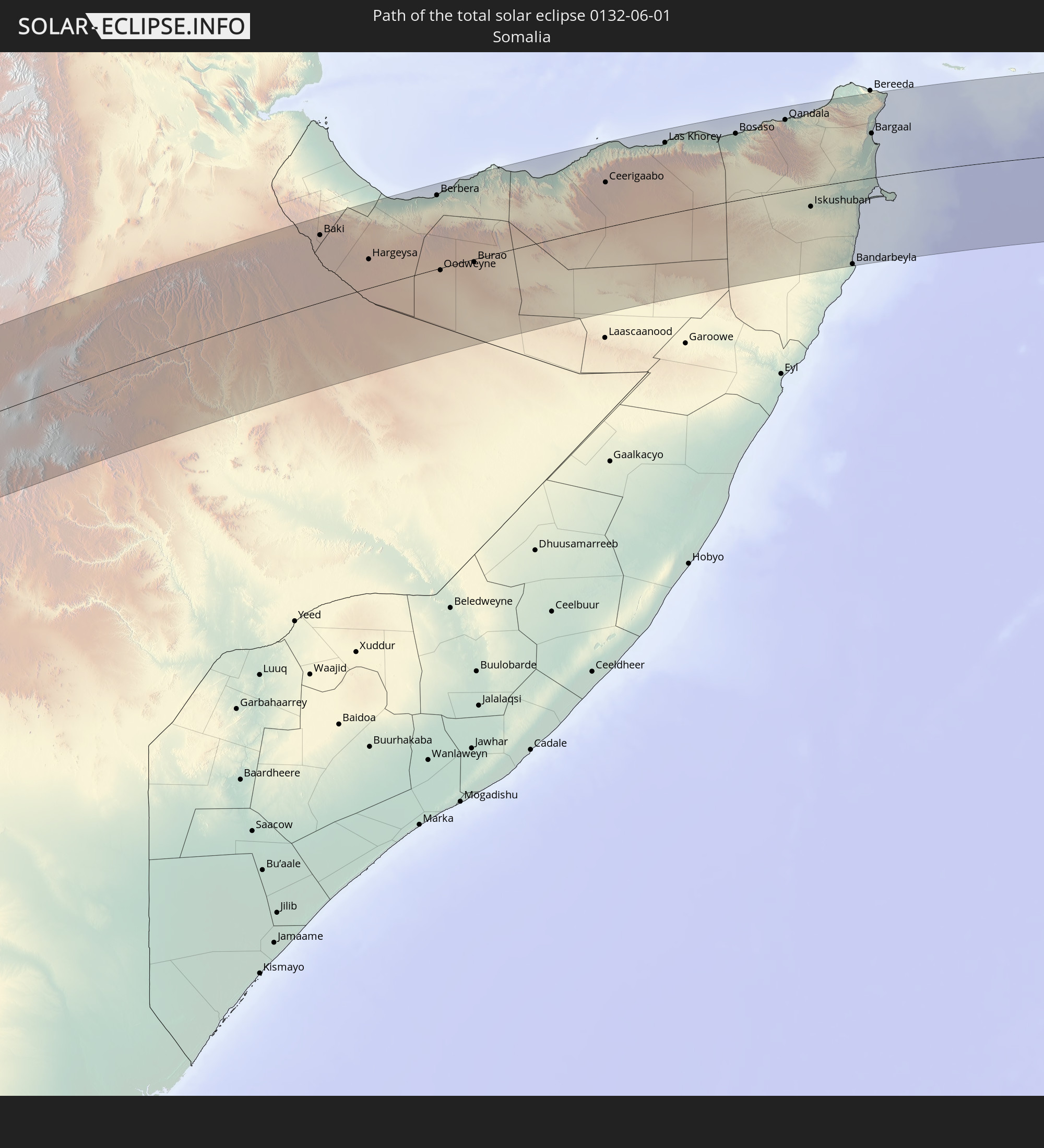
Detaillierte Länderkarten
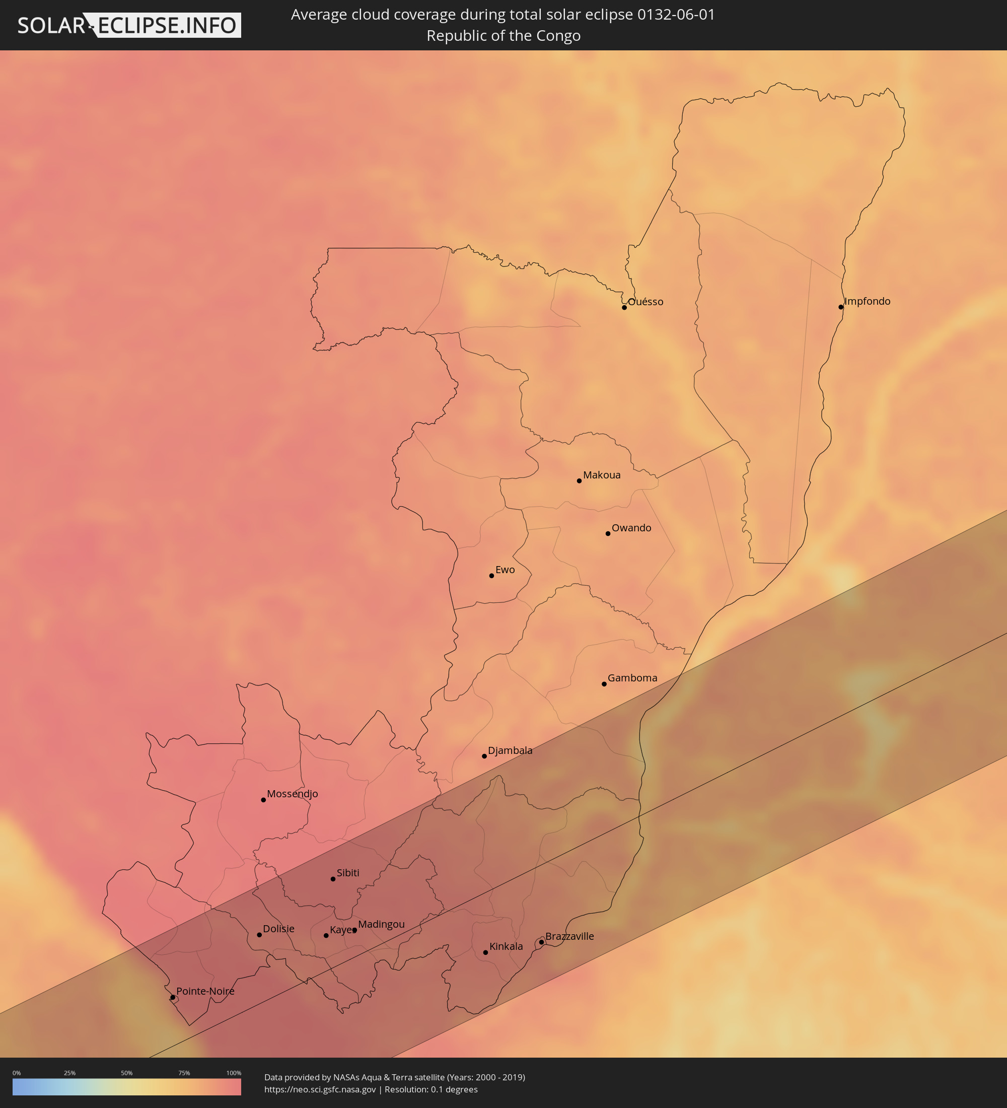 Republik Kongo
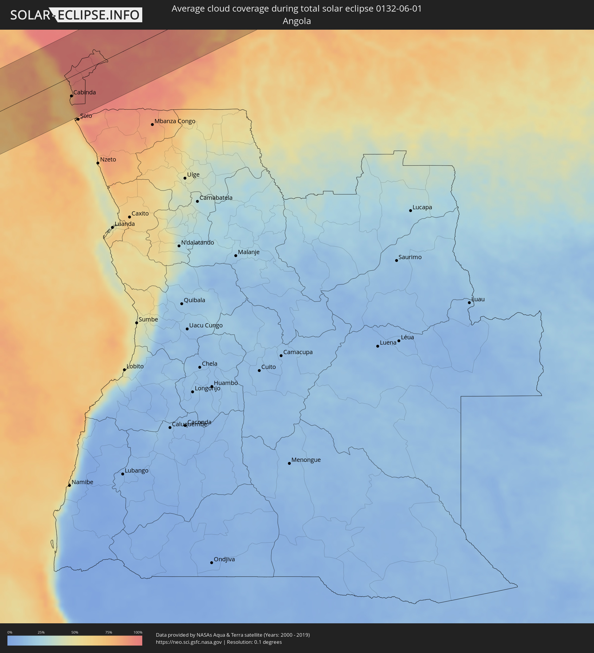 Angola
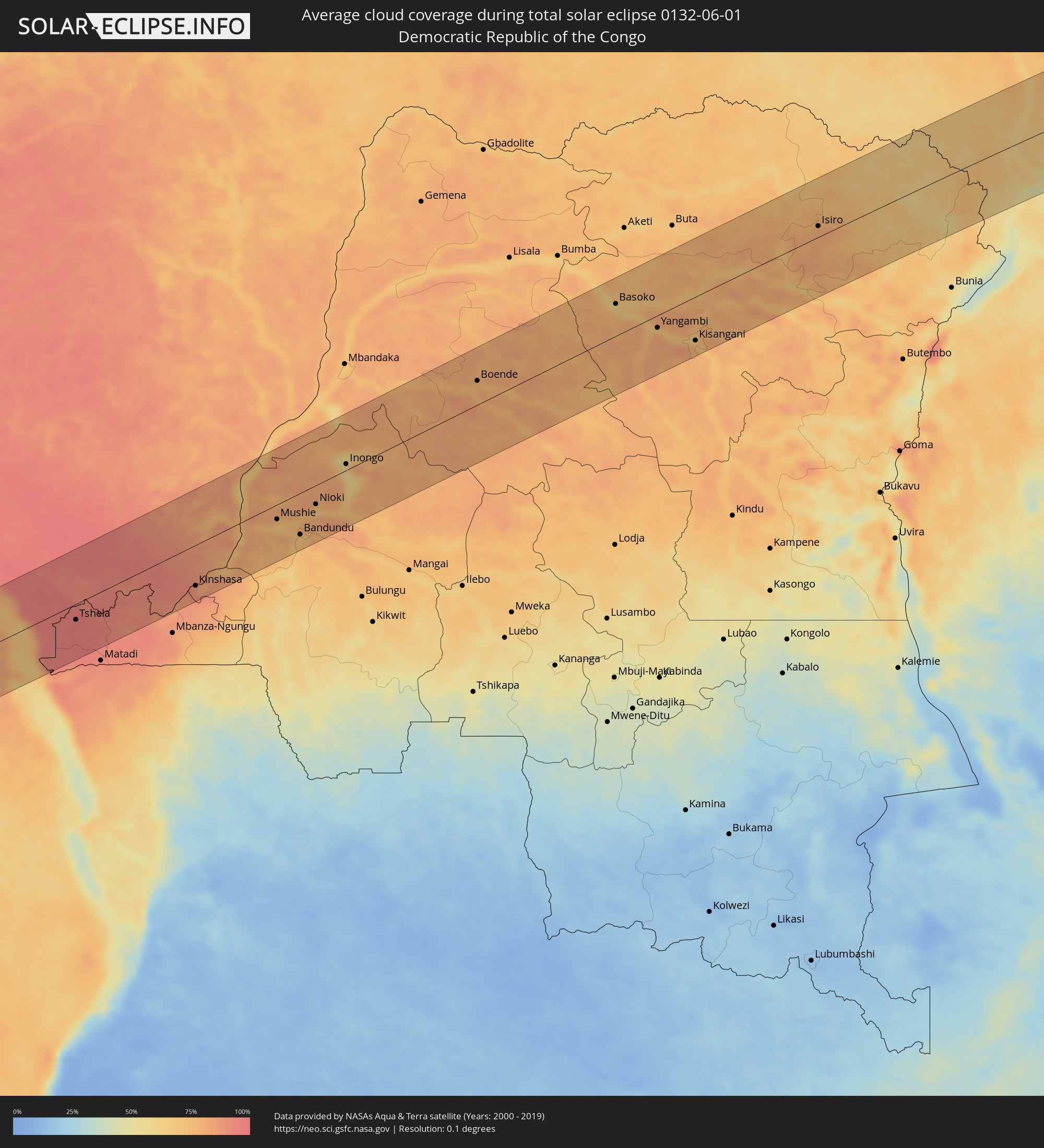 Demokratische Republik Kongo
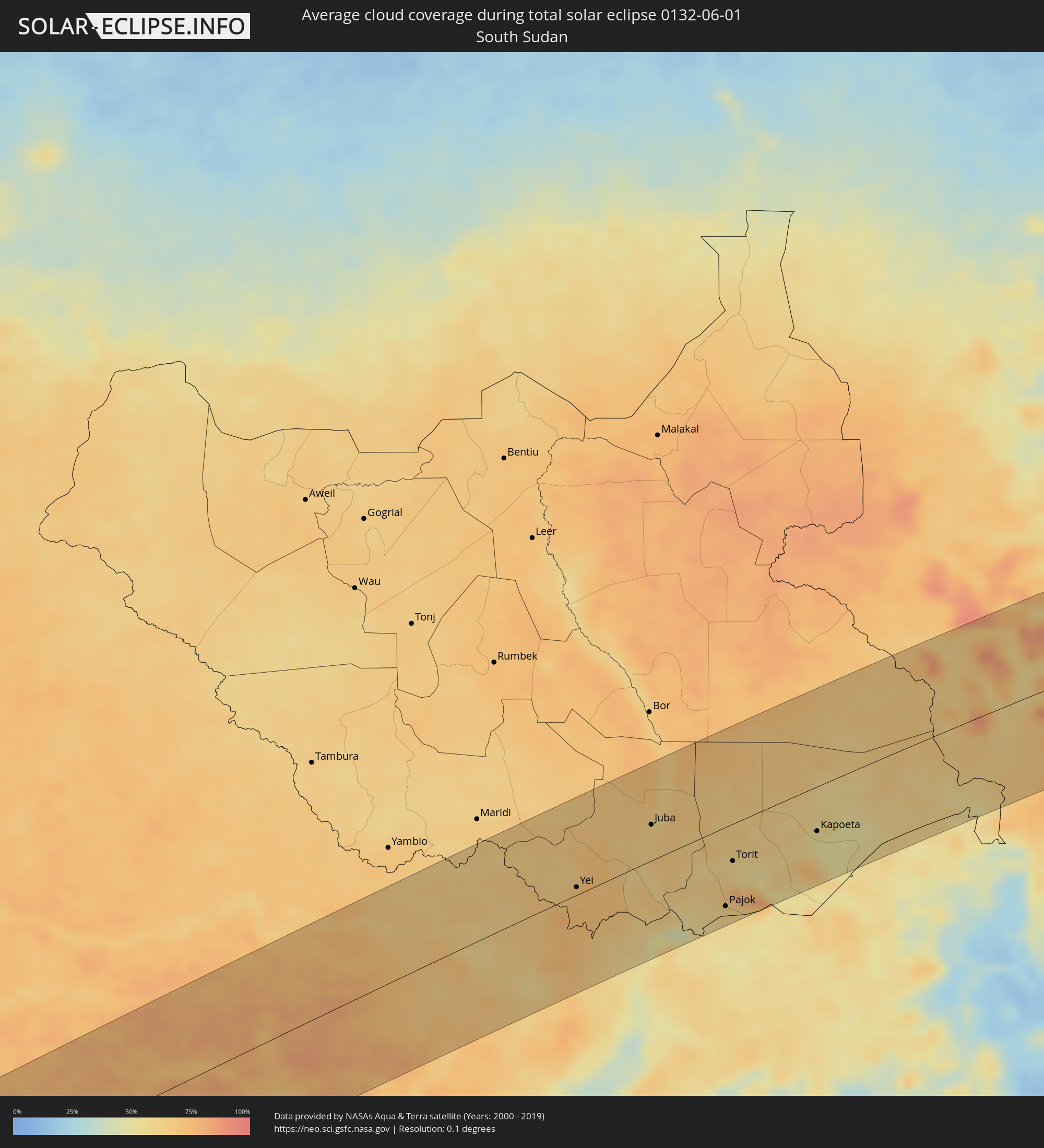 Südsudan
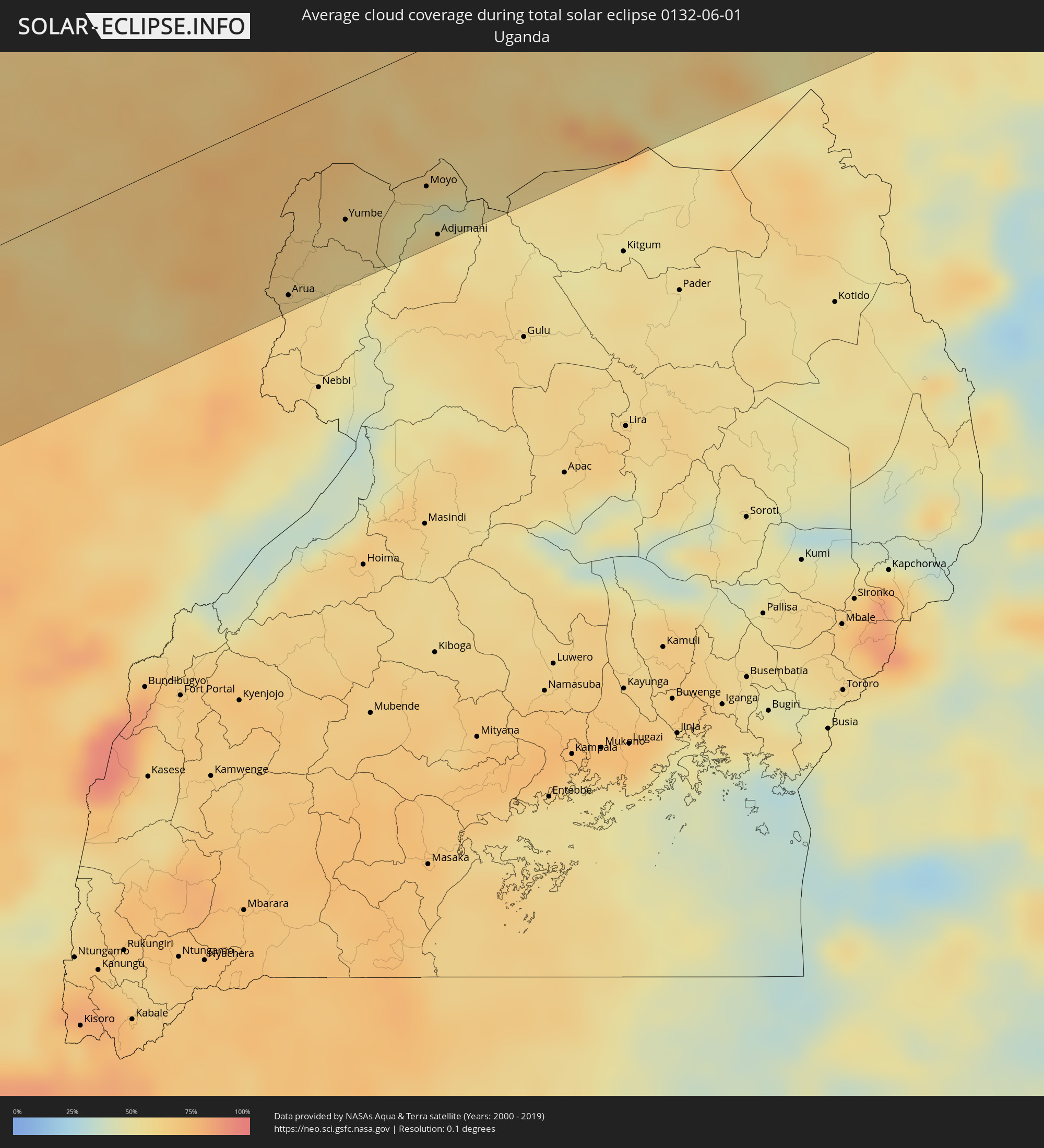 Uganda
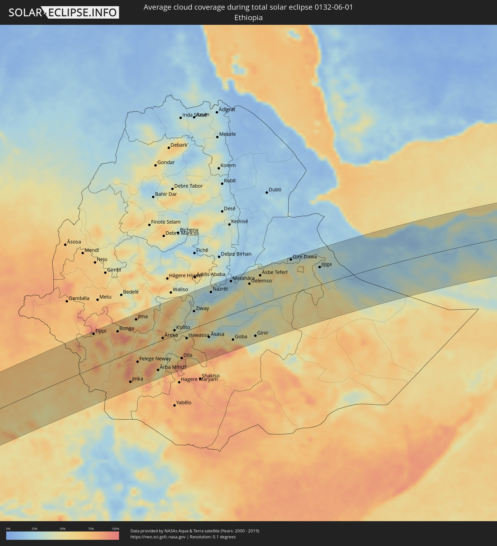 Äthiopien
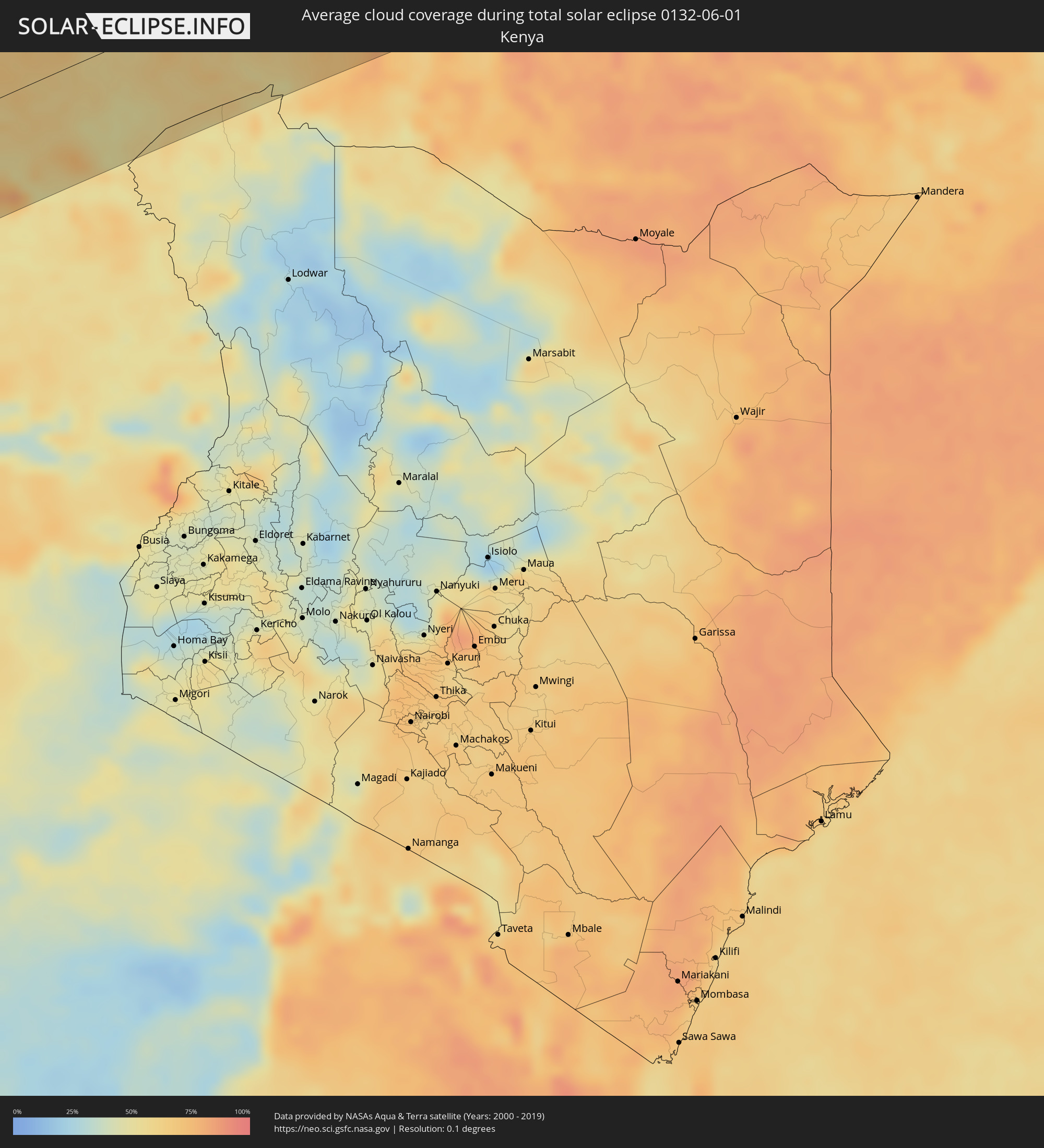 Kenia
Kenia
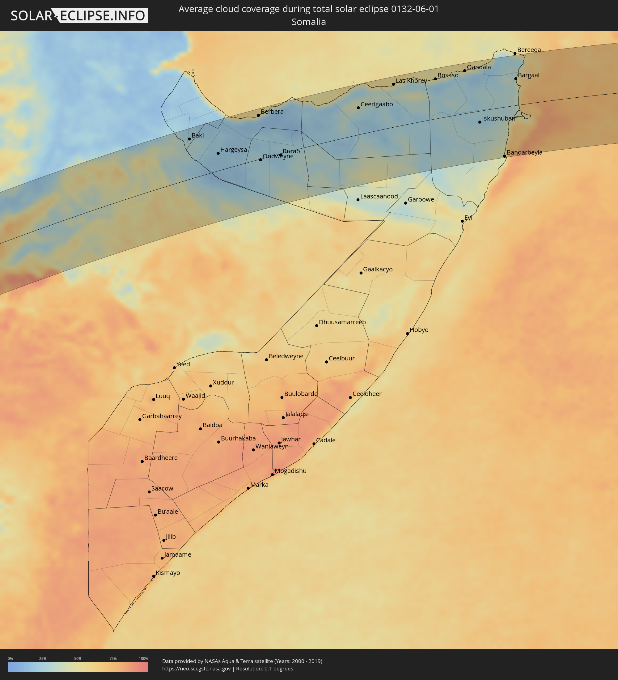 Somalia
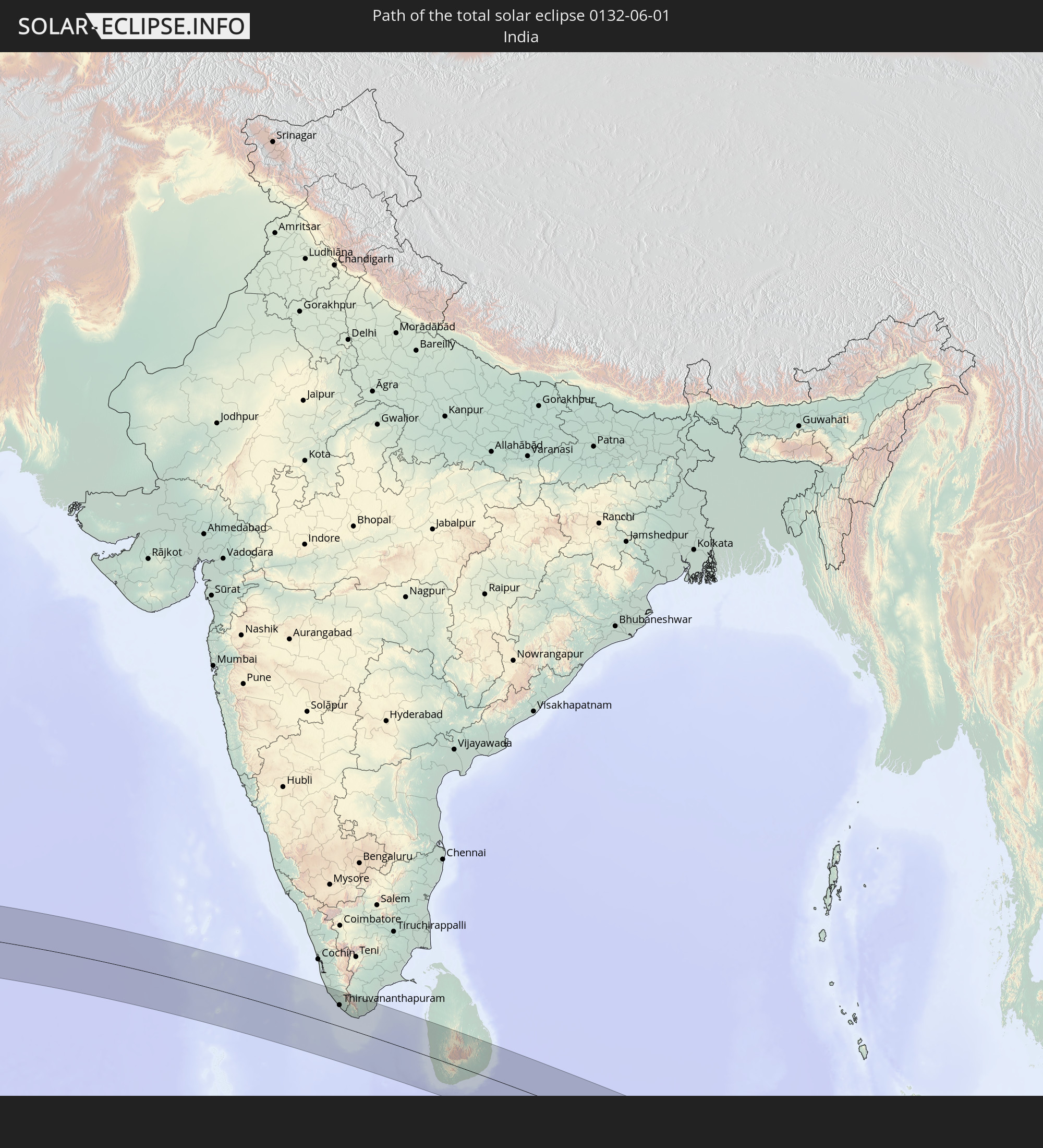
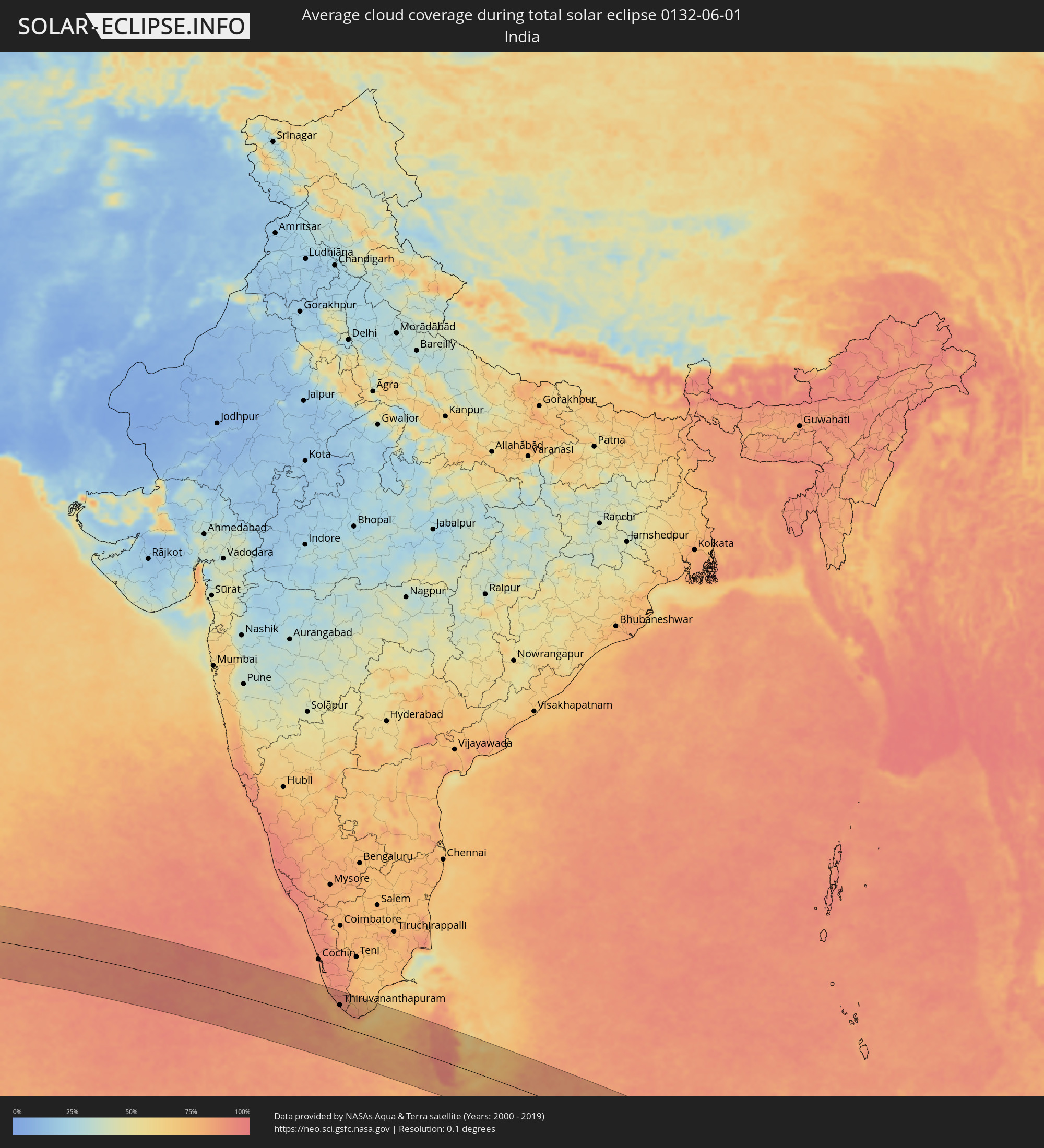 Indien
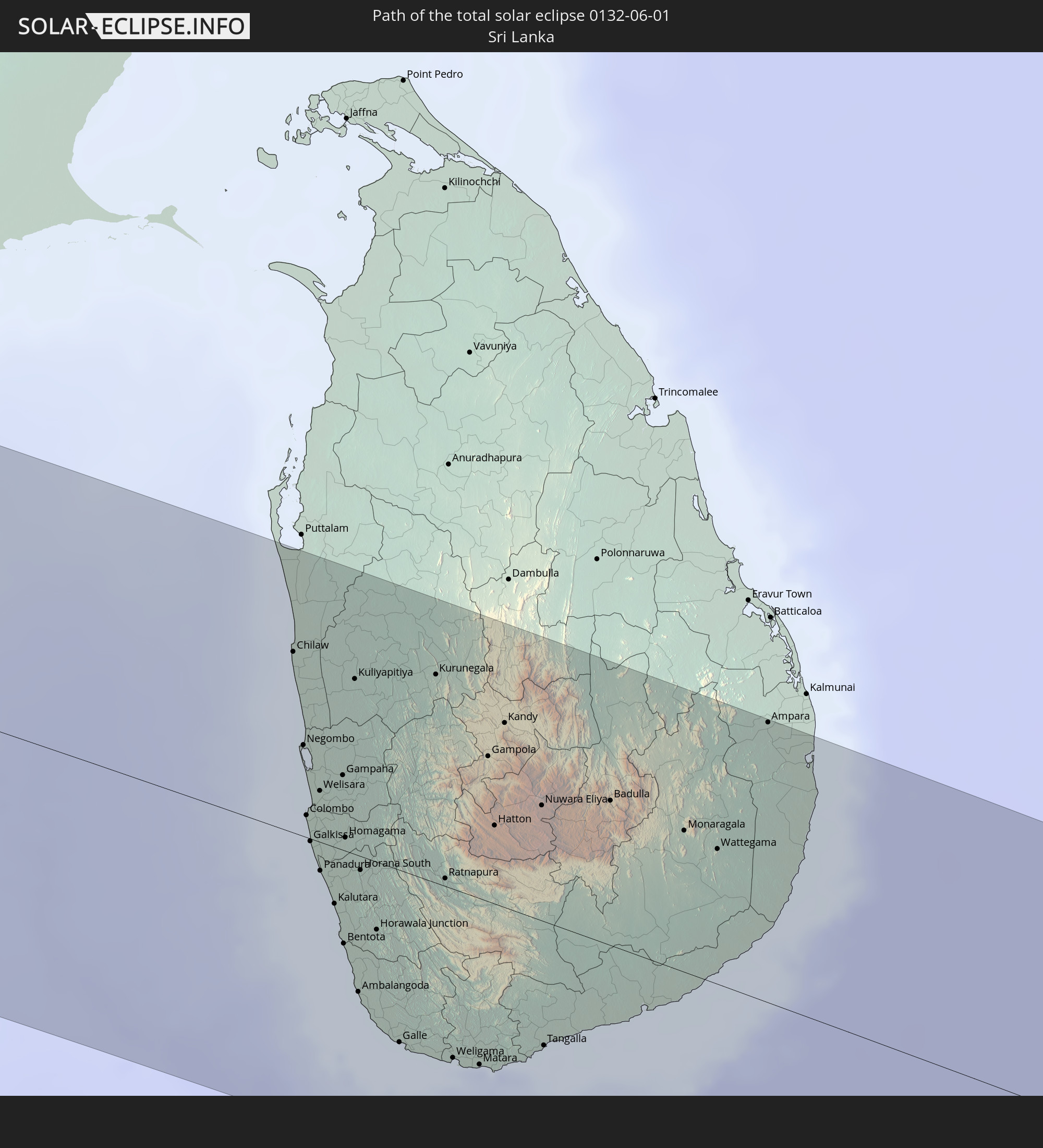
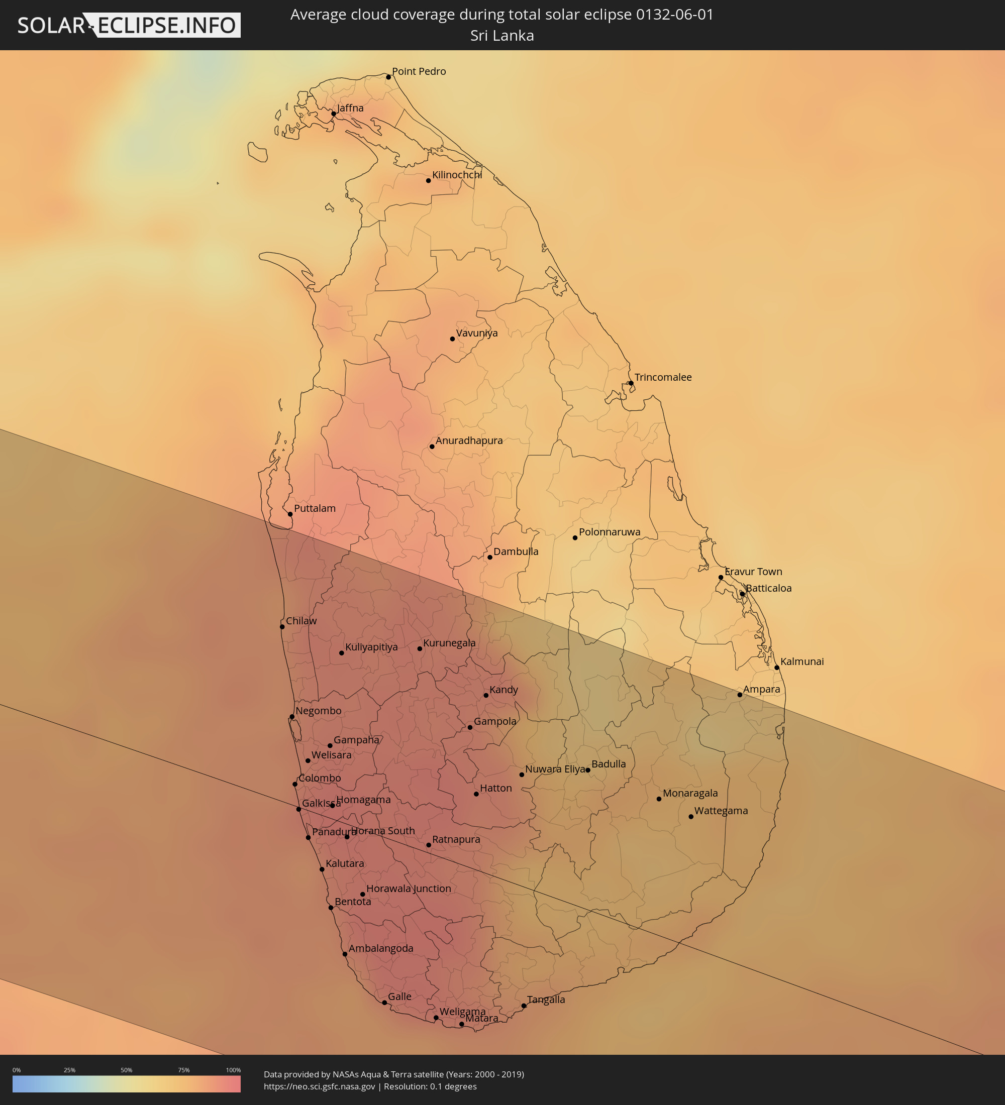 Sri Lanka
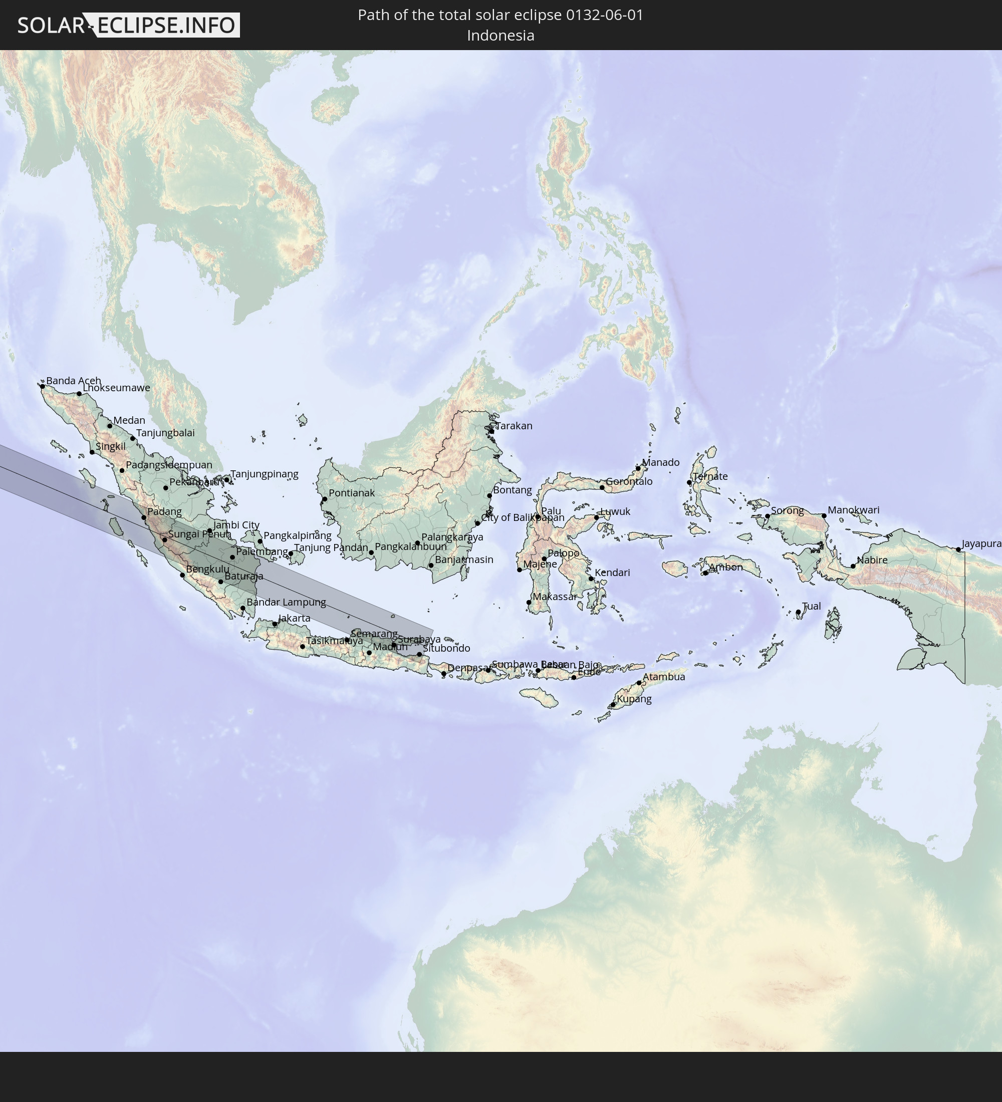
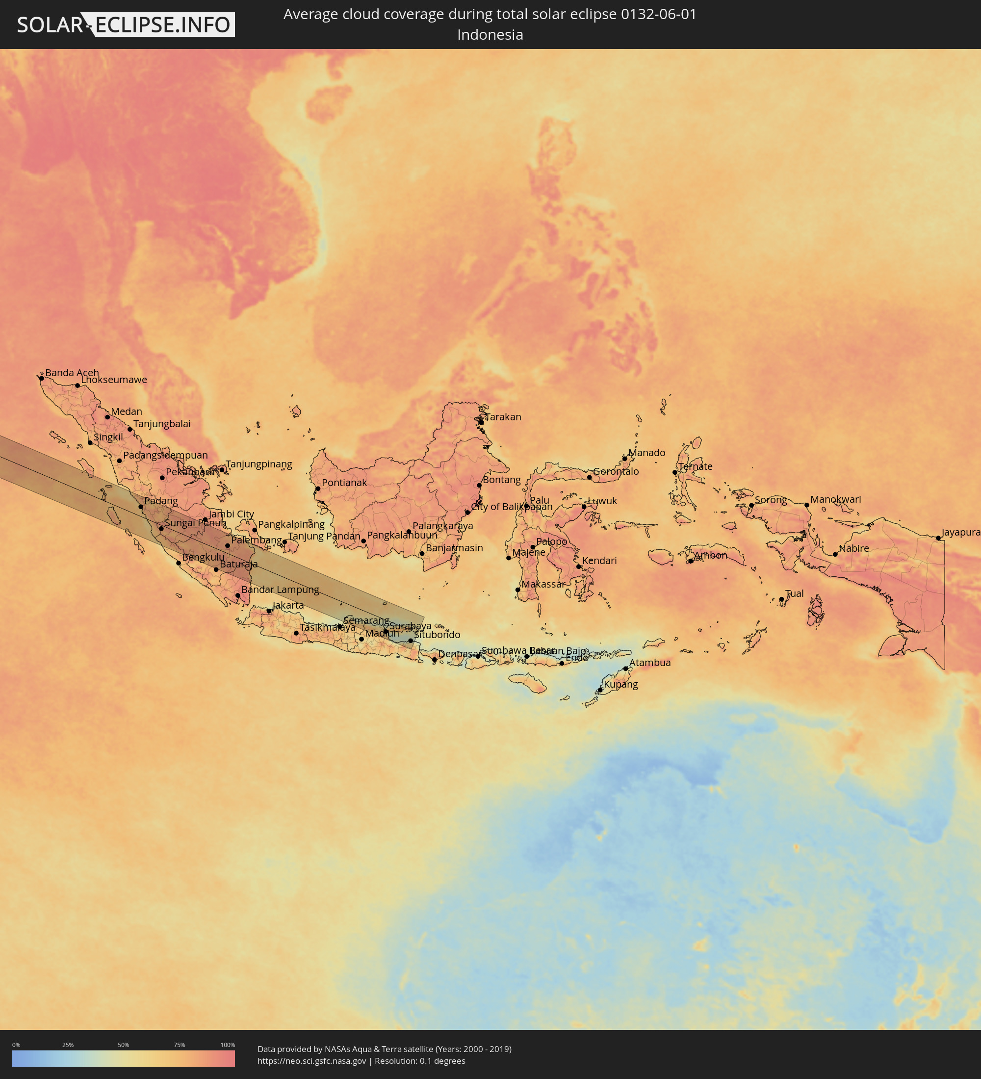 Indonesien
Orte im Finsternispfad
Die nachfolgene Tabelle zeigt Städte und Orte mit mehr als 5.000 Einwohnern, die sich im Finsternispfad befinden. Städte mit mehr als 100.000 Einwohnern sind dick gekennzeichnet. Mit einem Klick auf den Ort öffnet sich eine Detailkarte die die Lage des jeweiligen Ortes zusammen mit dem Verlauf der zentralen Finsternis präsentiert.
| Ort | Typ | Dauer der Verfinsterung | Ortszeit bei maximaler Verfinsterung | Entfernung zur Zentrallinie | Ø Bewölkung |
|
Loango, Kouilou
|
total | - | 07:03:13 UTC+00:13 | 59 km | 82% |
|
Loandjili, Pointe-Noire
|
total | - | 07:03:13 UTC+00:13 | 46 km | 85% |
|
Pointe-Noire, Pointe-Noire
|
total | - | 07:03:12 UTC+00:13 | 44 km | 85% |
|
Cabinda, Cabinda
|
total | - | 07:03:12 UTC+00:13 | 50 km | 85% |
|
Dolisie, Niari
|
total | - | 07:04:01 UTC+00:13 | 63 km | 92% |
|
Tshela, Bas-Congo
|
total | - | 07:03:57 UTC+00:13 | 31 km | 98% |
|
Kayes, Bouenza
|
total | - | 07:04:30 UTC+00:13 | 32 km | 92% |
|
Sibiti, Lékoumou
|
total | - | 07:04:45 UTC+00:13 | 81 km | 97% |
|
Madingou, Bouenza
|
total | - | 07:04:44 UTC+00:13 | 24 km | 93% |
|
Kinkala, Pool
|
total | - | 07:05:40 UTC+00:13 | 56 km | 92% |
|
Kasangulu, Bas-Congo
|
total | - | 07:05:57 UTC+00:13 | 98 km | 87% |
|
Brazzaville, Brazzaville
|
total | - | 07:06:10 UTC+00:13 | 73 km | 88% |
|
Kinshasa, Kinshasa
|
total | - | 07:06:10 UTC+00:13 | 80 km | 88% |
|
Masina, Kinshasa
|
total | - | 07:06:13 UTC+00:13 | 90 km | 92% |
|
Bolobo, Bandundu
|
total | - | 07:07:56 UTC+00:13 | 91 km | 63% |
|
Mushie, Bandundu
|
total | - | 07:08:14 UTC+00:13 | 29 km | 67% |
|
Bandundu, Bandundu
|
total | - | 07:08:34 UTC+00:13 | 82 km | 72% |
|
Nioki, Bandundu
|
total | - | 07:09:08 UTC+00:13 | 37 km | 72% |
|
Inongo, Bandundu
|
total | - | 07:10:08 UTC+00:13 | 12 km | 62% |
|
Boende, Équateur
|
total | - | 07:13:59 UTC+00:13 | 47 km | 78% |
|
Basoko, Orientale
|
total | - | 09:15:15 UTC+02:10 | 63 km | 65% |
|
Yangambi, Orientale
|
total | - | 09:16:08 UTC+02:10 | 24 km | 73% |
|
Kisangani, Orientale
|
total | - | 09:17:06 UTC+02:10 | 86 km | 72% |
|
Isiro, Orientale
|
total | - | 09:22:27 UTC+02:10 | 22 km | 81% |
|
Wamba, Orientale
|
total | - | 09:22:39 UTC+02:10 | 59 km | 79% |
|
Watsa, Orientale
|
total | - | 09:25:59 UTC+02:10 | 44 km | 65% |
 Yei, Central Equatoria
|
total | - | 09:25:01 UTC+02:06 | 9 km | 72% |
|
Arua, Northern Region
|
total | - | 09:45:29 UTC+02:27 | 110 km | 62% |
|
Yumbe, Northern Region
|
total | - | 09:46:27 UTC+02:27 | 81 km | 63% |
|
Juba, Central Equatoria
|
total | - | 09:27:20 UTC+02:06 | 44 km | 62% |
|
Moyo, Northern Region
|
total | - | 09:47:32 UTC+02:27 | 83 km | 60% |
|
Adjumani, Northern Region
|
total | - | 09:47:28 UTC+02:27 | 115 km | 60% |
|
Pajok, Eastern Equatoria
|
total | - | 09:28:25 UTC+02:06 | 97 km | 62% |
|
Torit, Eastern Equatoria
|
total | - | 09:29:00 UTC+02:06 | 46 km | 58% |
|
Kapoeta, Eastern Equatoria
|
total | - | 09:31:24 UTC+02:06 | 55 km | 54% |
|
Jinka, Southern Nations, Nationalities, and People's Region
|
total | - | 09:59:43 UTC+02:27 | 97 km | 70% |
|
Jīma, Oromiya
|
total | - | 10:01:42 UTC+02:27 | 103 km | 52% |
|
Felege Neway, Southern Nations, Nationalities, and People's Region
|
total | - | 10:00:45 UTC+02:27 | 40 km | 67% |
|
Ārba Minch’, Southern Nations, Nationalities, and People's Region
|
total | - | 10:02:09 UTC+02:27 | 95 km | 45% |
|
Āreka, Southern Nations, Nationalities, and People's Region
|
total | - | 10:03:18 UTC+02:27 | 6 km | 72% |
|
Bodītī, Southern Nations, Nationalities, and People's Region
|
total | - | 10:03:38 UTC+02:27 | 11 km | 64% |
|
K’olīto, Southern Nations, Nationalities, and People's Region
|
total | - | 10:04:26 UTC+02:27 | 17 km | 52% |
|
Dīla, Southern Nations, Nationalities, and People's Region
|
total | - | 10:04:20 UTC+02:27 | 86 km | 75% |
|
Butajīra, Southern Nations, Nationalities, and People's Region
|
total | - | 10:05:45 UTC+02:27 | 89 km | 40% |
|
Yirga ‘Alem, Southern Nations, Nationalities, and People's Region
|
total | - | 10:04:50 UTC+02:27 | 55 km | 73% |
|
Hawassa, Southern Nations, Nationalities, and People's Region
|
total | - | 10:05:13 UTC+02:27 | 25 km | 54% |
|
Shashemenē, Oromiya
|
total | - | 10:05:37 UTC+02:27 | 16 km | 58% |
|
Ziway, Oromiya
|
total | - | 10:06:28 UTC+02:27 | 56 km | 38% |
|
Mojo, Oromiya
|
total | - | 10:07:59 UTC+02:27 | 109 km | 21% |
|
Nazrēt, Oromiya
|
total | - | 10:08:20 UTC+02:27 | 100 km | 21% |
|
Goba, Oromiya
|
total | - | 10:09:01 UTC+02:27 | 88 km | 60% |
|
Āsbe Teferī, Oromiya
|
total | - | 10:12:51 UTC+02:27 | 97 km | 54% |
|
Dire Dawa, Dire Dawa
|
total | - | 10:15:53 UTC+02:27 | 116 km | 36% |
|
Harar, Harari
|
total | - | 10:16:22 UTC+02:27 | 78 km | 53% |
|
Jijiga, Somali
|
total | - | 10:18:15 UTC+02:27 | 60 km | 29% |
|
Baki, Awdal
|
total | - | 10:20:15 UTC+02:27 | 99 km | 31% |
|
Hargeysa, Woqooyi Galbeed
|
total | - | 10:21:56 UTC+02:27 | 42 km | 20% |
|
Berbera, Woqooyi Galbeed
|
total | - | 10:25:13 UTC+02:27 | 109 km | 18% |
|
Oodweyne, Togdheer
|
total | - | 10:24:42 UTC+02:27 | 3 km | 25% |
|
Burao, Togdheer
|
total | - | 10:26:09 UTC+02:27 | 4 km | 22% |
|
Ceerigaabo, Sanaag
|
total | - | 10:32:13 UTC+02:27 | 67 km | 28% |
|
Las Khorey, Sanaag
|
total | - | 10:34:59 UTC+02:27 | 107 km | 41% |
|
Bosaso, Bari
|
total | - | 10:38:01 UTC+02:27 | 100 km | 28% |
|
Qandala, Bari
|
total | - | 10:40:13 UTC+02:27 | 108 km | 30% |
|
Iskushuban, Bari
|
total | - | 10:40:46 UTC+02:27 | 29 km | 27% |
|
Bandarbeyla, Bari
|
total | - | 10:42:15 UTC+02:27 | 126 km | 45% |
|
Bargaal, Bari
|
total | - | 10:43:50 UTC+02:27 | 67 km | 52% |
|
Panmana, Kerala
|
total | - | 14:48:38 UTC+05:21 | 113 km | 79% |
|
Kollam, Kerala
|
total | - | 14:48:50 UTC+05:21 | 101 km | 83% |
|
Varkala, Kerala
|
total | - | 14:49:10 UTC+05:21 | 90 km | 77% |
|
Kadakkavoor, Kerala
|
total | - | 14:49:17 UTC+05:21 | 86 km | 80% |
|
Thiruvananthapuram, Kerala
|
total | - | 14:49:44 UTC+05:21 | 71 km | 83% |
|
Neyyāttinkara, Kerala
|
total | - | 14:50:03 UTC+05:21 | 67 km | 81% |
|
Kuzhithurai, Tamil Nadu
|
total | - | 14:50:18 UTC+05:21 | 62 km | 79% |
|
Colachel, Tamil Nadu
|
total | - | 14:50:29 UTC+05:21 | 49 km | 78% |
|
Padmanābhapuram, Tamil Nadu
|
total | - | 14:50:35 UTC+05:21 | 59 km | 78% |
|
Nāgercoil, Tamil Nadu
|
total | - | 14:50:50 UTC+05:21 | 55 km | 83% |
|
Ambasamudram, Tamil Nadu
|
total | - | 14:50:37 UTC+05:21 | 112 km | 80% |
|
Kallidaikurichchi, Tamil Nadu
|
total | - | 14:50:39 UTC+05:21 | 110 km | 80% |
|
Viravanallūr, Tamil Nadu
|
total | - | 14:50:45 UTC+05:21 | 113 km | 80% |
|
Kanniyākumāri, Tamil Nadu
|
total | - | 14:51:04 UTC+05:21 | 50 km | 78% |
|
Kalakkādu, Tamil Nadu
|
total | - | 14:50:54 UTC+05:21 | 95 km | 83% |
|
Vadakku Valliyūr, Tamil Nadu
|
total | - | 14:51:05 UTC+05:21 | 83 km | 83% |
|
Tisaiyanvilai, Tamil Nadu
|
total | - | 14:51:35 UTC+05:21 | 86 km | 72% |
|
Sathankulam, Tamil Nadu
|
total | - | 14:51:38 UTC+05:21 | 100 km | 75% |
|
Udankudi, Tamil Nadu
|
total | - | 14:51:51 UTC+05:21 | 102 km | 75% |
|
Tiruchchendur, Tamil Nadu
|
total | - | 14:51:59 UTC+05:21 | 113 km | 71% |
|
Chilaw, North Western
|
total | - | 14:53:51 UTC+05:19 | 75 km | 85% |
|
Negombo, Western
|
total | - | 14:54:05 UTC+05:19 | 38 km | 86% |
|
Colombo, Western
|
total | - | 14:54:14 UTC+05:19 | 9 km | 88% |
|
Moratuwa, Western
|
total | - | 14:54:21 UTC+05:19 | 6 km | 87% |
|
Peliyagoda, Western
|
total | - | 14:54:17 UTC+05:19 | 14 km | 92% |
|
Ja Ela, Western
|
total | - | 14:54:15 UTC+05:19 | 26 km | 89% |
|
Kelaniya, Western
|
total | - | 14:54:21 UTC+05:19 | 14 km | 92% |
|
Kalutara, Western
|
total | - | 14:54:35 UTC+05:19 | 23 km | 89% |
|
Bentota, Southern
|
total | - | 14:54:43 UTC+05:19 | 39 km | 85% |
|
Homagama, Western
|
total | - | 14:54:32 UTC+05:19 | 6 km | 93% |
|
Hanwella Ihala, Western
|
total | - | 14:54:40 UTC+05:19 | 15 km | 94% |
|
Galle, Southern
|
total | - | 14:55:16 UTC+05:19 | 71 km | 80% |
|
Kurunegala, North Western
|
total | - | 14:54:53 UTC+05:19 | 86 km | 91% |
|
Ratnapura, Sabaragamuwa
|
total | - | 14:55:18 UTC+05:19 | 3 km | 92% |
|
Weligama, Southern
|
total | - | 14:55:39 UTC+05:19 | 70 km | 81% |
|
Matara, Southern
|
total | - | 14:55:51 UTC+05:19 | 69 km | 82% |
|
Gampola, Central
|
total | - | 14:55:23 UTC+05:19 | 60 km | 90% |
|
Kandy, Central
|
total | - | 14:55:26 UTC+05:19 | 76 km | 89% |
|
Nuwara Eliya, Central
|
total | - | 14:55:50 UTC+05:19 | 48 km | 82% |
|
Badulla, Uva
|
total | - | 14:56:17 UTC+05:19 | 60 km | 77% |
|
Pariaman, West Sumatra
|
total | - | 17:07:11 UTC+07:07 | 72 km | 64% |
|
Padang, West Sumatra
|
total | - | 17:07:22 UTC+07:07 | 48 km | 77% |
|
Sungai Penuh, Jambi
|
total | - | 17:08:07 UTC+07:07 | 20 km | 78% |
|
Lubuklinggau, South Sumatra
|
total | - | 17:08:58 UTC+07:07 | 83 km | 80% |
|
Prabumulih, South Sumatra
|
total | - | 17:09:32 UTC+07:07 | 37 km | 87% |
|
Palembang, South Sumatra
|
total | - | 17:09:40 UTC+07:07 | 38 km | 90% |
|
Batang, Central Java
|
total | - | 17:11:19 UTC+07:07 | 71 km | 59% |
|
Kudus, Central Java
|
total | - | 17:11:20 UTC+07:07 | 98 km | 70% |
|
Pati, Central Java
|
total | - | 17:11:21 UTC+07:07 | 84 km | 71% |
|
Bojonegoro, East Java
|
total | - | 17:11:26 UTC+07:07 | 89 km | 66% |
|
Tuban, East Java
|
total | - | 17:11:27 UTC+07:07 | 55 km | 68% |
|
Kebomas, East Java
|
total | - | 17:11:30 UTC+07:07 | 59 km | 67% |
|
Sidoarjo, East Java
|
total | - | 17:11:29 UTC+07:07 | 84 km | 66% |
|
Surabaya, East Java
|
total | - | 17:11:30 UTC+07:07 | 63 km | 48% |
|
Pasuruan, East Java
|
total | - | 17:11:30 UTC+07:07 | 97 km | 53% |
|
Probolinggo, East Java
|
total | - | 17:11:30 UTC+07:07 | 95 km | 58% |
|
Pamekasan, East Java
|
total | - | 17:11:33 UTC+07:07 | 23 km | 50% |
|
Bondowoso, East Java
|
total | - | 17:11:31 UTC+07:07 | 86 km | 63% |
|
Sumenep, East Java
|
total | - | 17:11:34 UTC+07:07 | 8 km | 61% |
|
Situbondo, East Java
|
total | - | 17:11:32 UTC+07:07 | 57 km | 59% |