Totale Sonnenfinsternis vom 19.02.0174
| Wochentag: | Samstag |
| Maximale Dauer der Verfinsterung: | 03m43s |
| Maximale Breite des Finsternispfades: | 272 km |
| Saroszyklus: | 62 |
| Bedeckungsgrad: | 100% |
| Magnitude: | 1.0472 |
| Gamma: | 0.8182 |
Wo kann man die Sonnenfinsternis vom 19.02.0174 sehen?
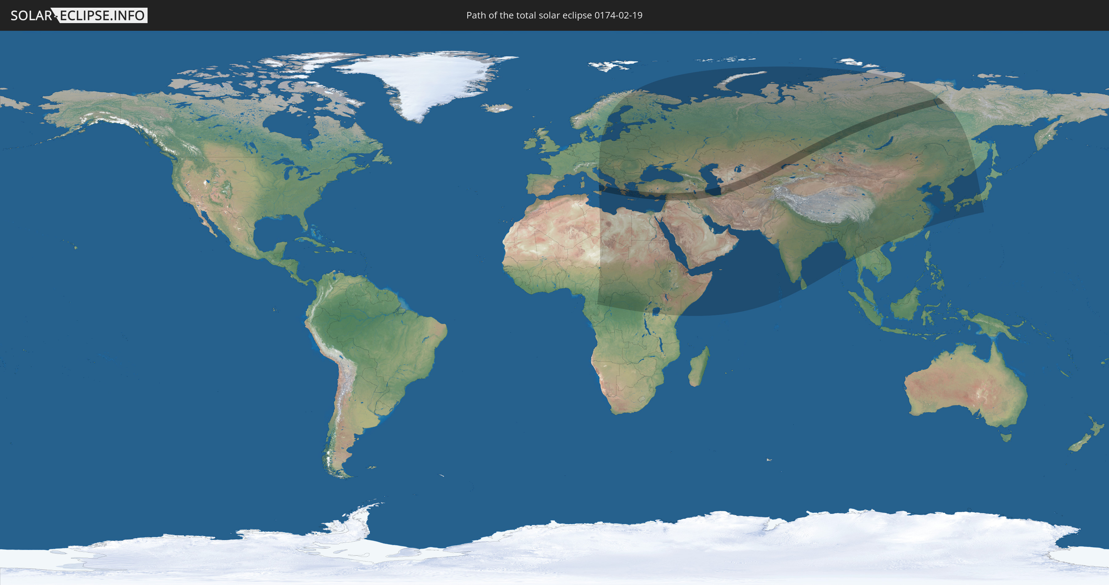
Die Sonnenfinsternis am 19.02.0174 kann man in 89 Ländern als partielle Sonnenfinsternis beobachten.
Der Finsternispfad verläuft durch 10 Länder. Nur in diesen Ländern ist sie als totale Sonnenfinsternis zu sehen.
In den folgenden Ländern ist die Sonnenfinsternis total zu sehen
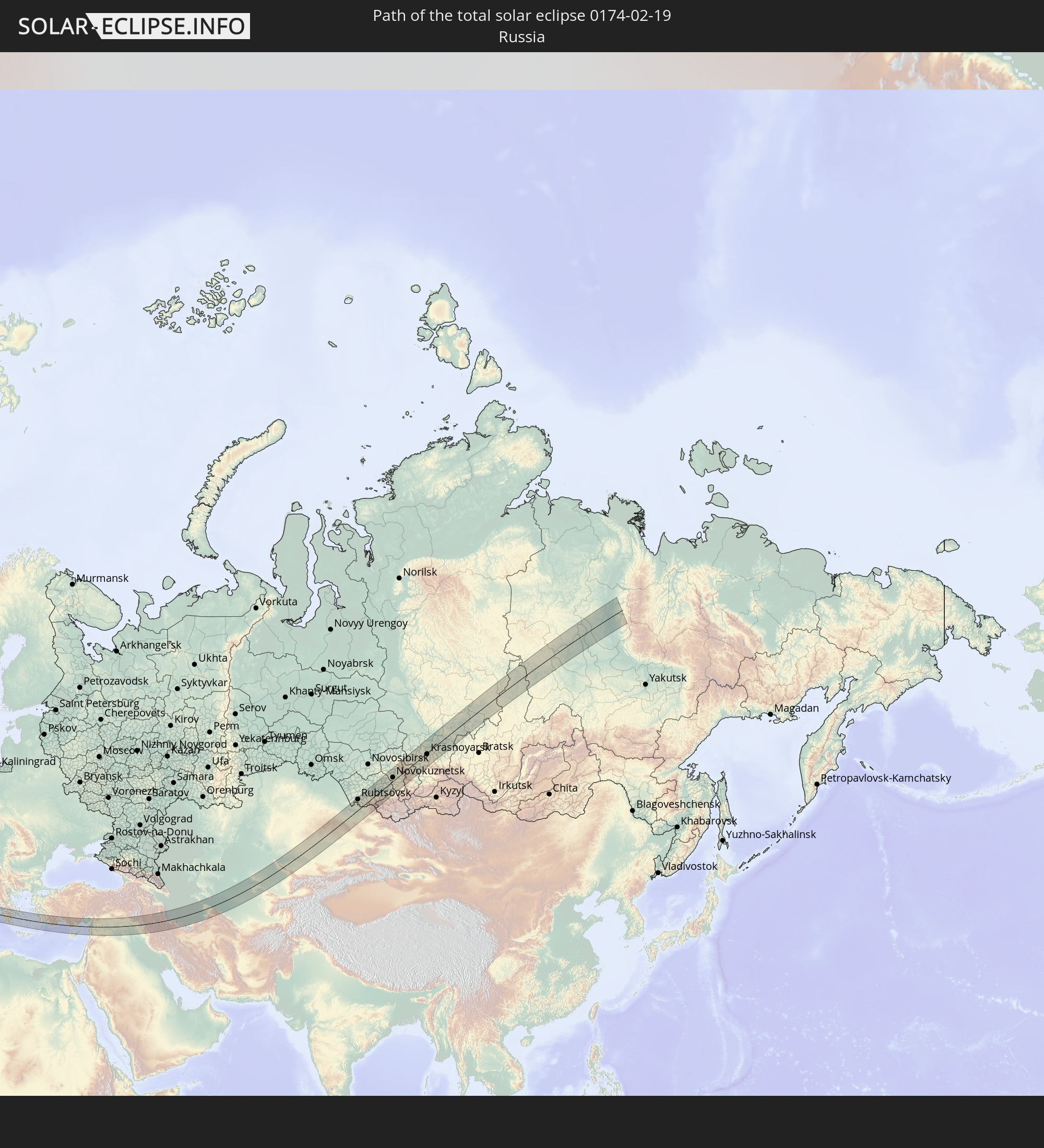 Russland
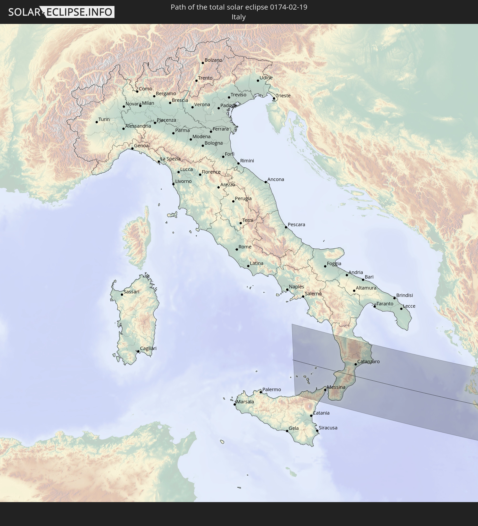 Italien
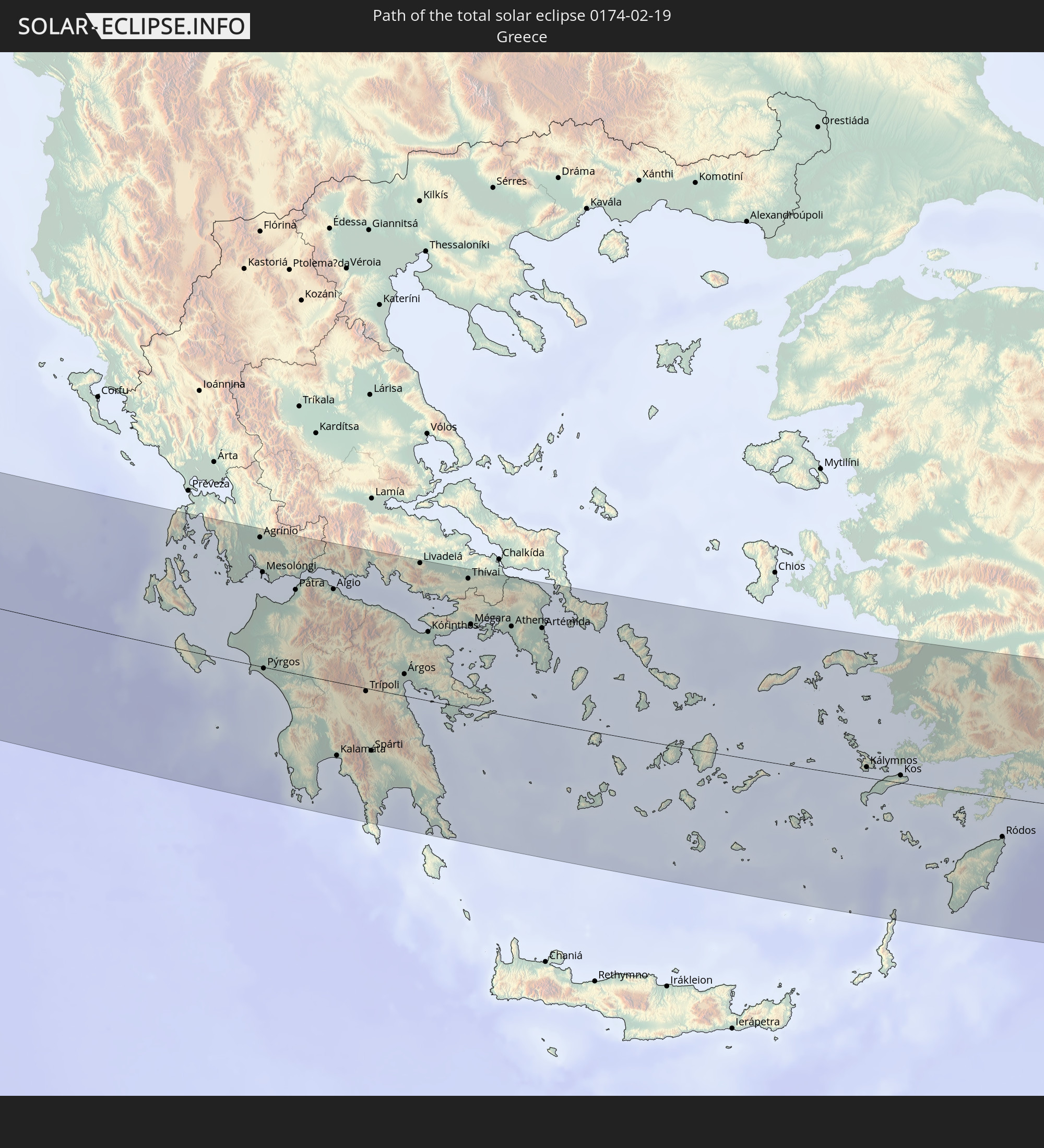 Griechenland
 Türkei
 Syrien
 Irak
Irak
 Iran
Iran
 Kasachstan
 Turkmenistan
 Usbekistan
In den folgenden Ländern ist die Sonnenfinsternis partiell zu sehen
 Russland
 Niger
Niger
 Norwegen
 Deutschland
 Italien
 Kamerun
 Gabun
Gabun
 Libyen
 Österreich
 Schweden
 Republik Kongo
 Tschechien
 Demokratische Republik Kongo
 Slowenien
 Tschad
 Kroatien
 Polen
Polen
 Malta
Malta
 Zentralafrikanische Republik
 Bosnien und Herzegowina
 Ungarn
 Slowakei
 Montenegro
 Serbien
 Albanien
 Åland Islands
 Griechenland
 Rumänien
 Mazedonien
 Finnland
 Litauen
 Lettland
 Estland
 Sudan
Sudan
 Ukraine
 Bulgarien
 Weißrussland
 Ägypten
 Türkei
 Moldawien
 Ruanda
 Tansania
 Uganda
 Republik Zypern
 Äthiopien
 Kenia
Kenia
 Staat Palästina
 Israel
 Saudi-Arabien
 Jordanien
 Libanon
 Syrien
 Eritrea
 Irak
Irak
 Georgien
 Somalia
 Dschibuti
 Jemen
Jemen
 Armenien
 Iran
Iran
 Aserbaidschan
 Kasachstan
 Kuwait
 Bahrain
 Katar
Katar
 Vereinigte Arabische Emirate
 Oman
Oman
 Turkmenistan
 Usbekistan
 Afghanistan
 Pakistan
 Tadschikistan
 Indien
 Kirgisistan
 Malediven
 Volksrepublik China
 Sri Lanka
 Nepal
Nepal
 Mongolei
 Bangladesch
 Bhutan
 Myanmar
 Thailand
 Laos
Laos
 Vietnam
 Taiwan
 Japan
Japan
 Nordkorea
 Südkorea
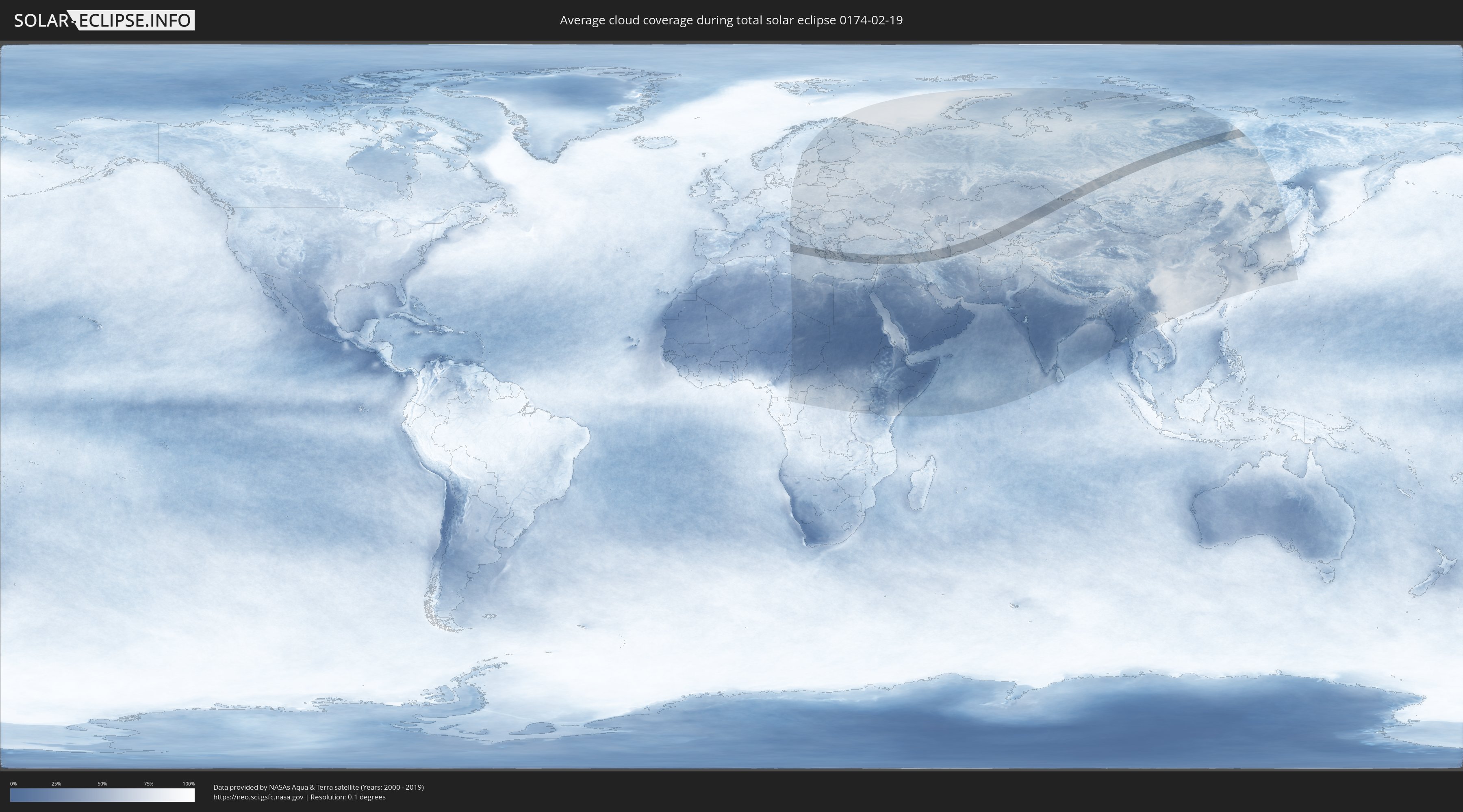
Wie wird das Wetter während der totalen Sonnenfinsternis am 19.02.0174?
Wo ist der beste Ort, um die totale Sonnenfinsternis vom 19.02.0174 zu beobachten?
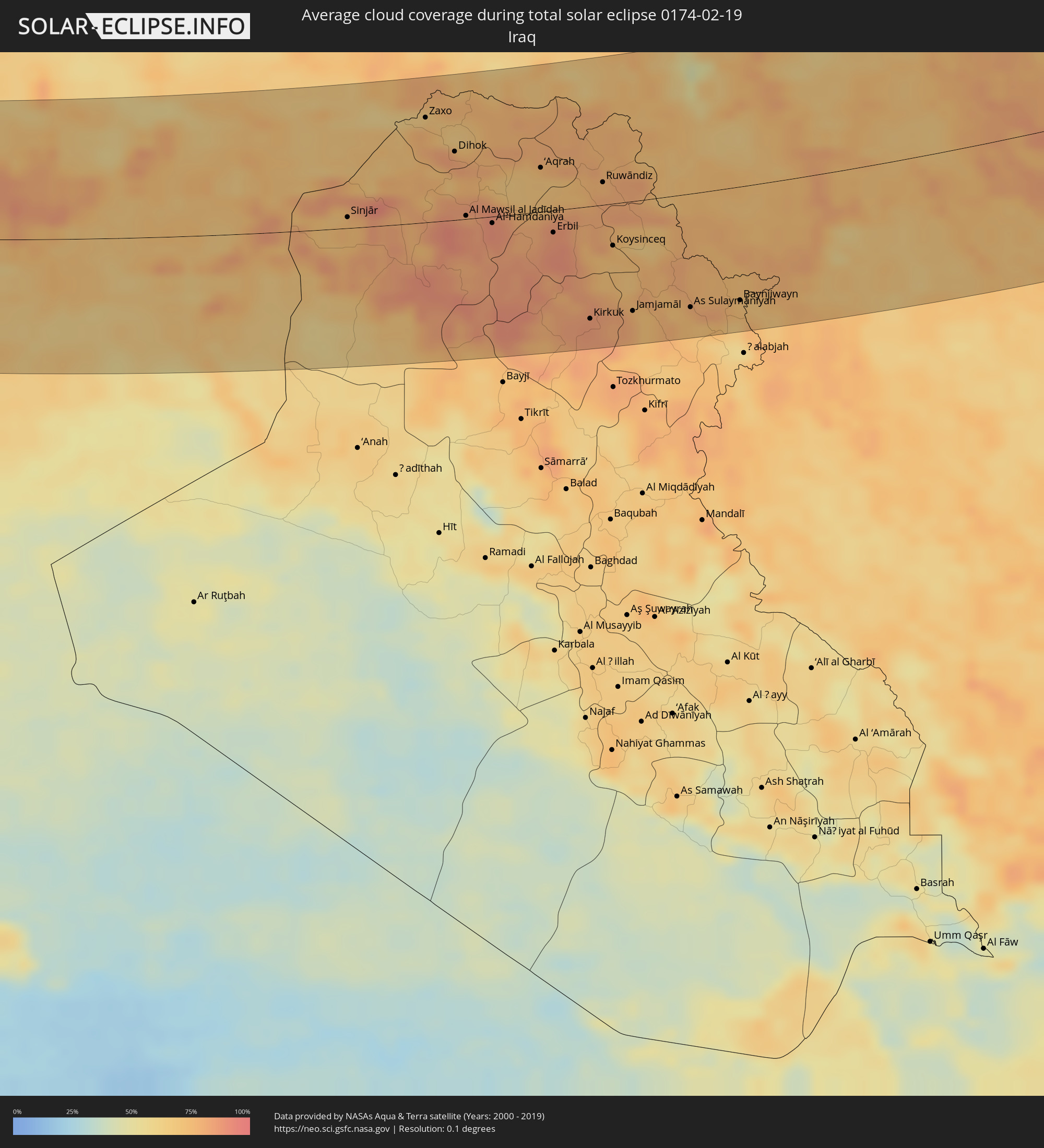
Die folgenden Karten zeigen die durchschnittliche Bewölkung für den Tag, an dem die totale Sonnenfinsternis
stattfindet. Mit Hilfe der Karten lässt sich der Ort entlang des Finsternispfades eingrenzen,
der die besten Aussichen auf einen klaren wolkenfreien Himmel bietet.
Trotzdem muss man immer lokale Gegenenheiten beachten und sollte sich genau über das Wetter an seinem
gewählten Beobachtungsort informieren.
Die Daten stammen von den beiden NASA-Satelliten
AQUA und TERRA
und wurden über einen Zeitraum von 19 Jahren (2000 - 2019) gemittelt.

Detaillierte Länderkarten
 Russland
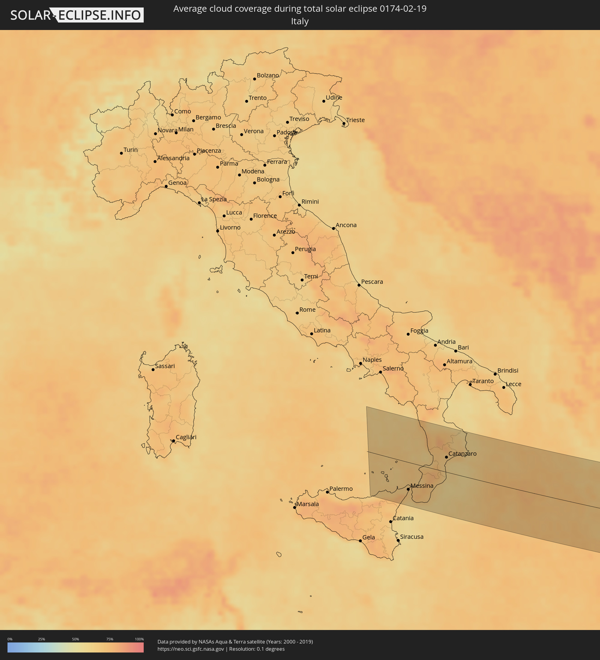 Italien
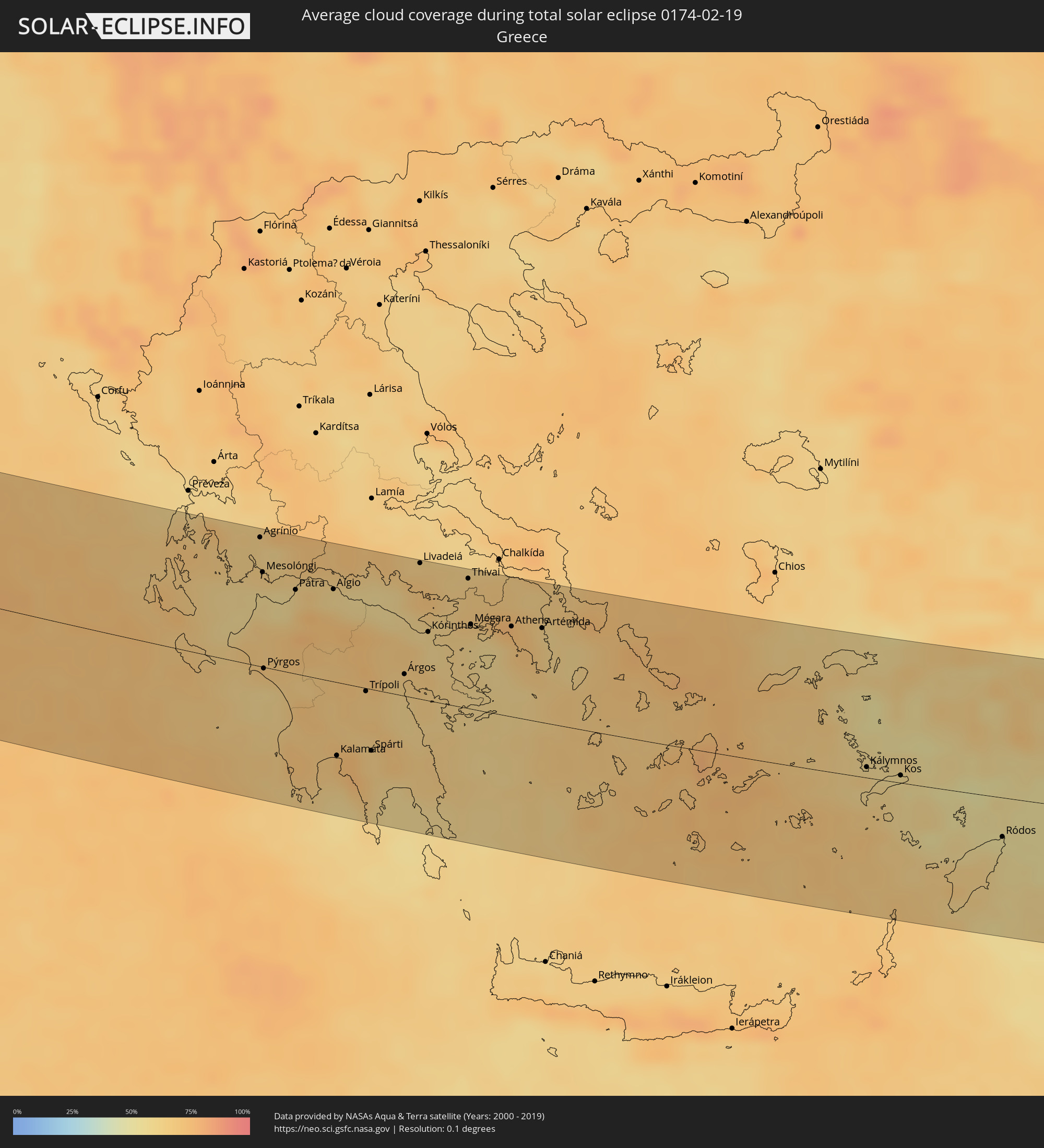 Griechenland
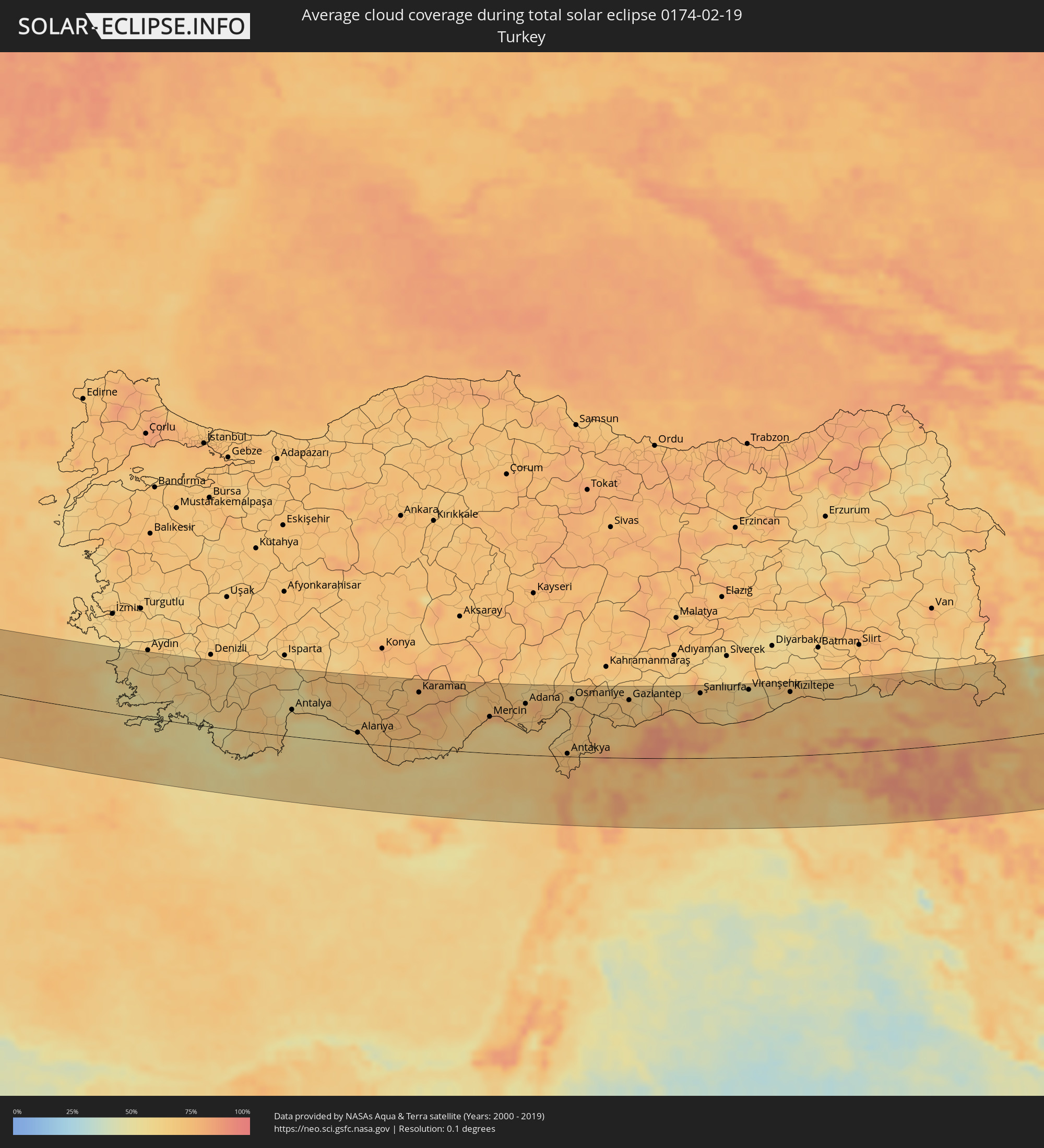 Türkei
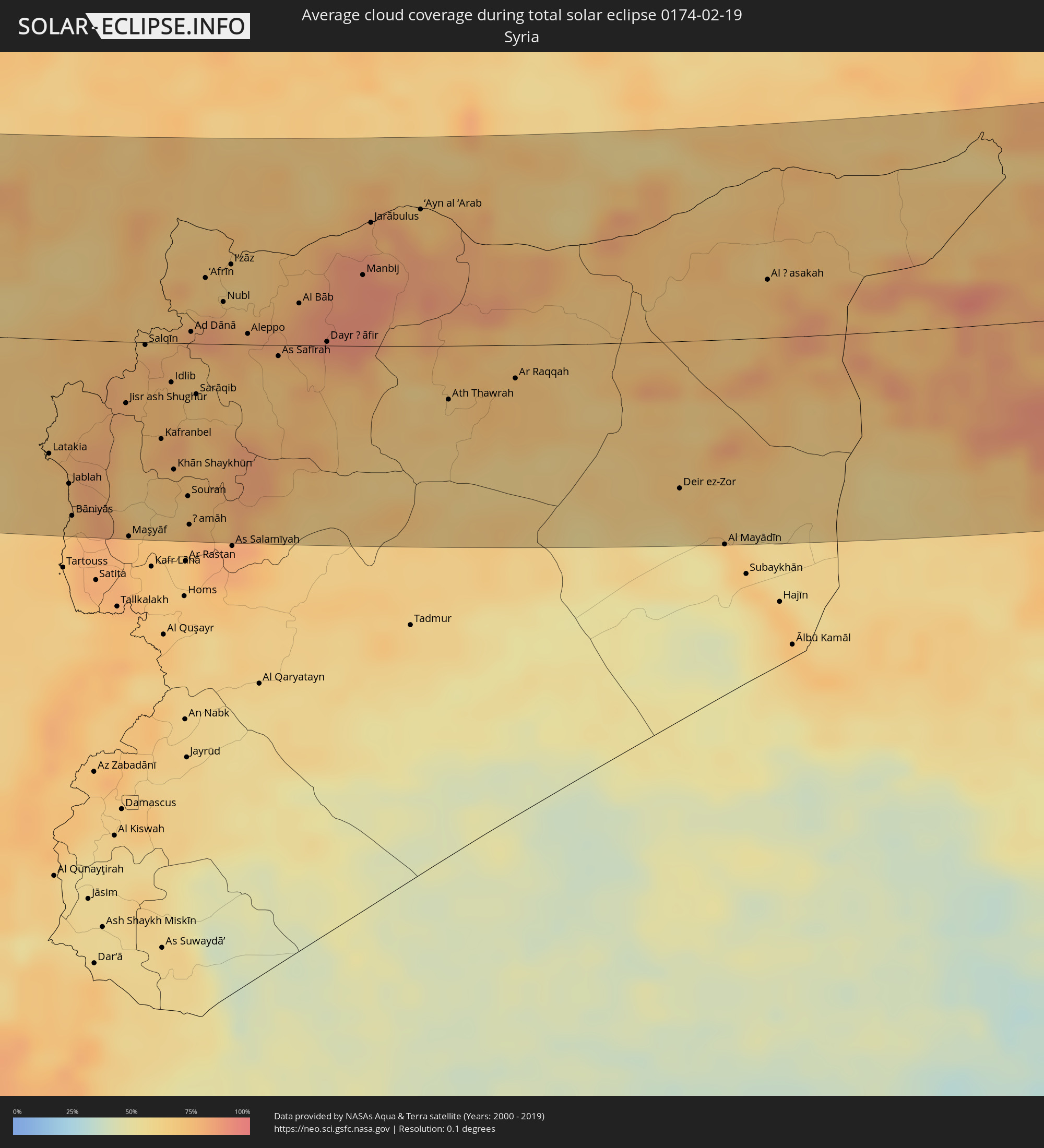 Syrien
 Irak
Irak
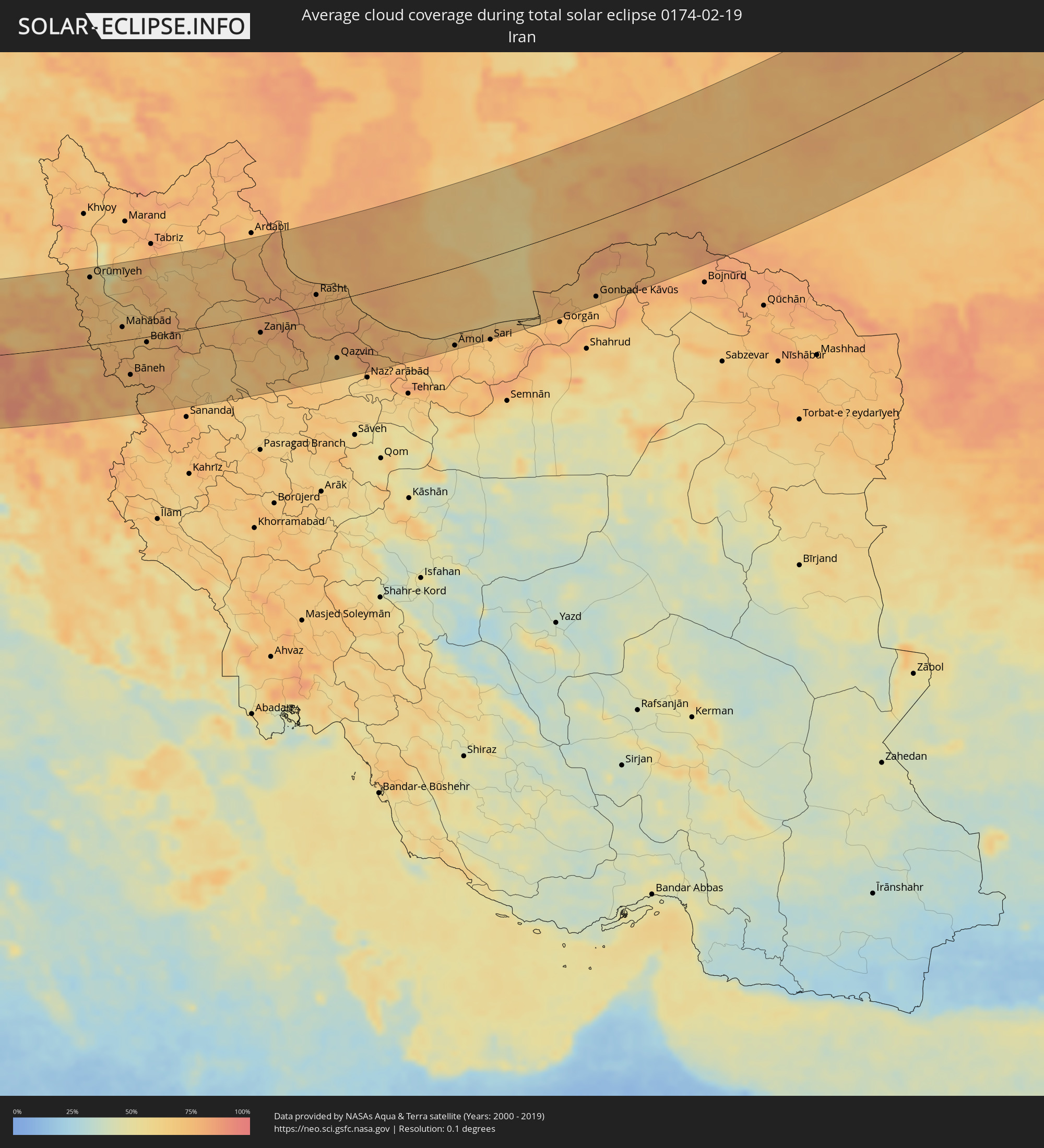 Iran
Iran
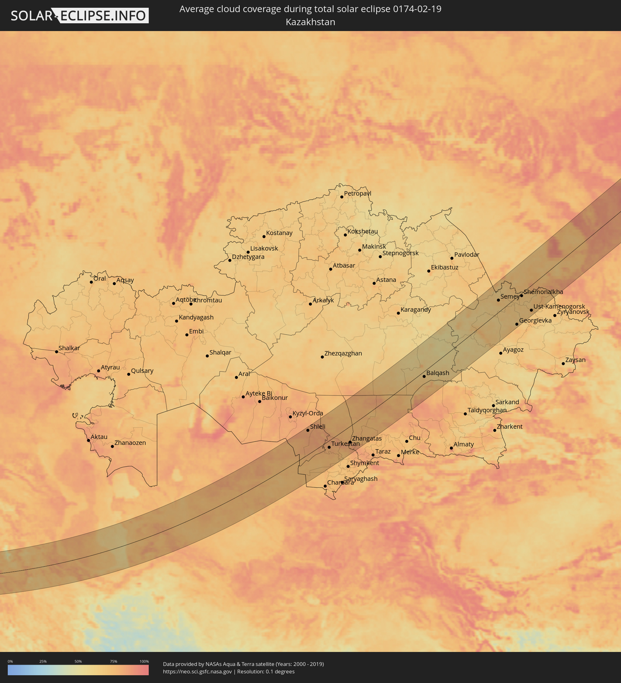 Kasachstan
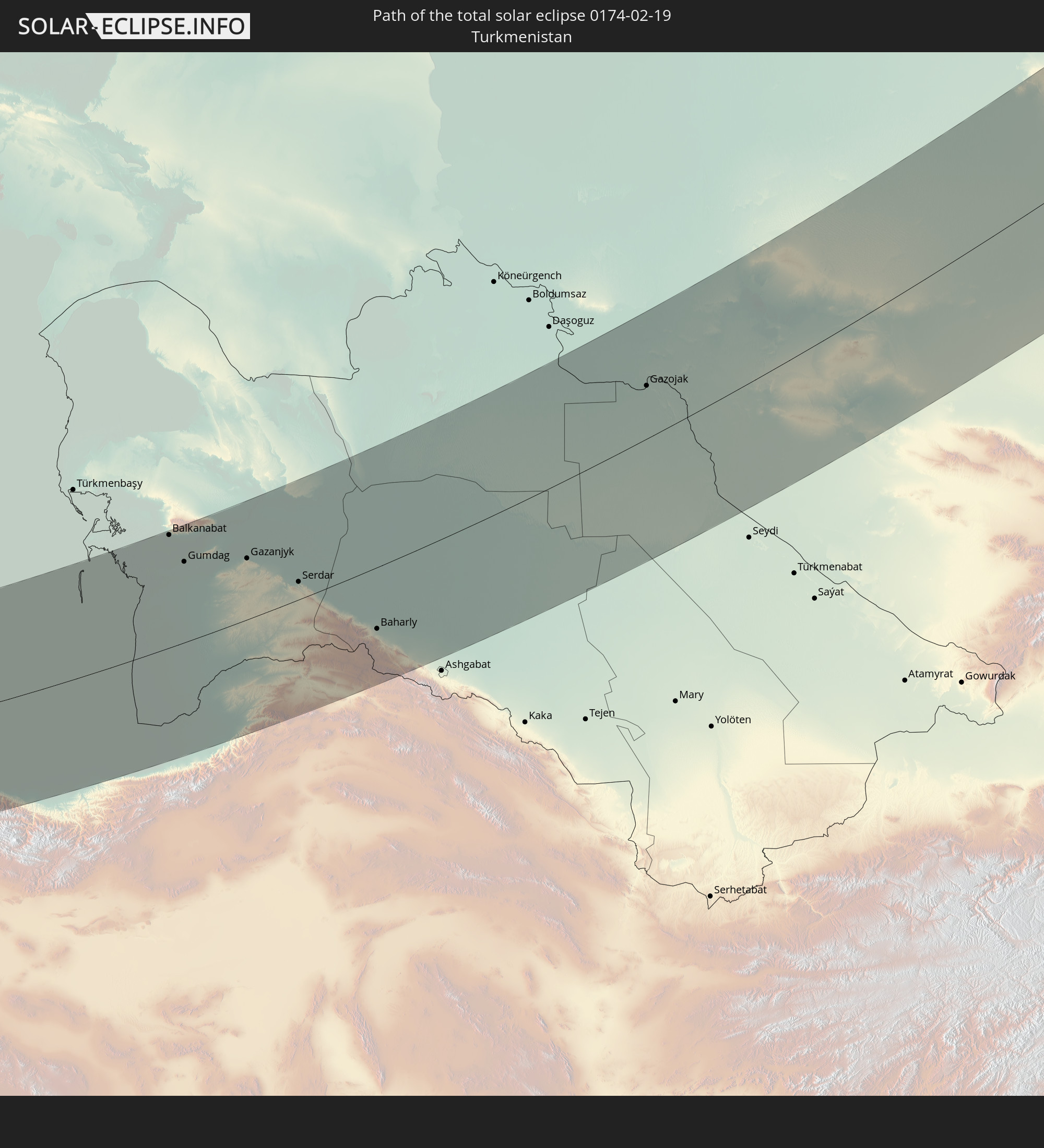
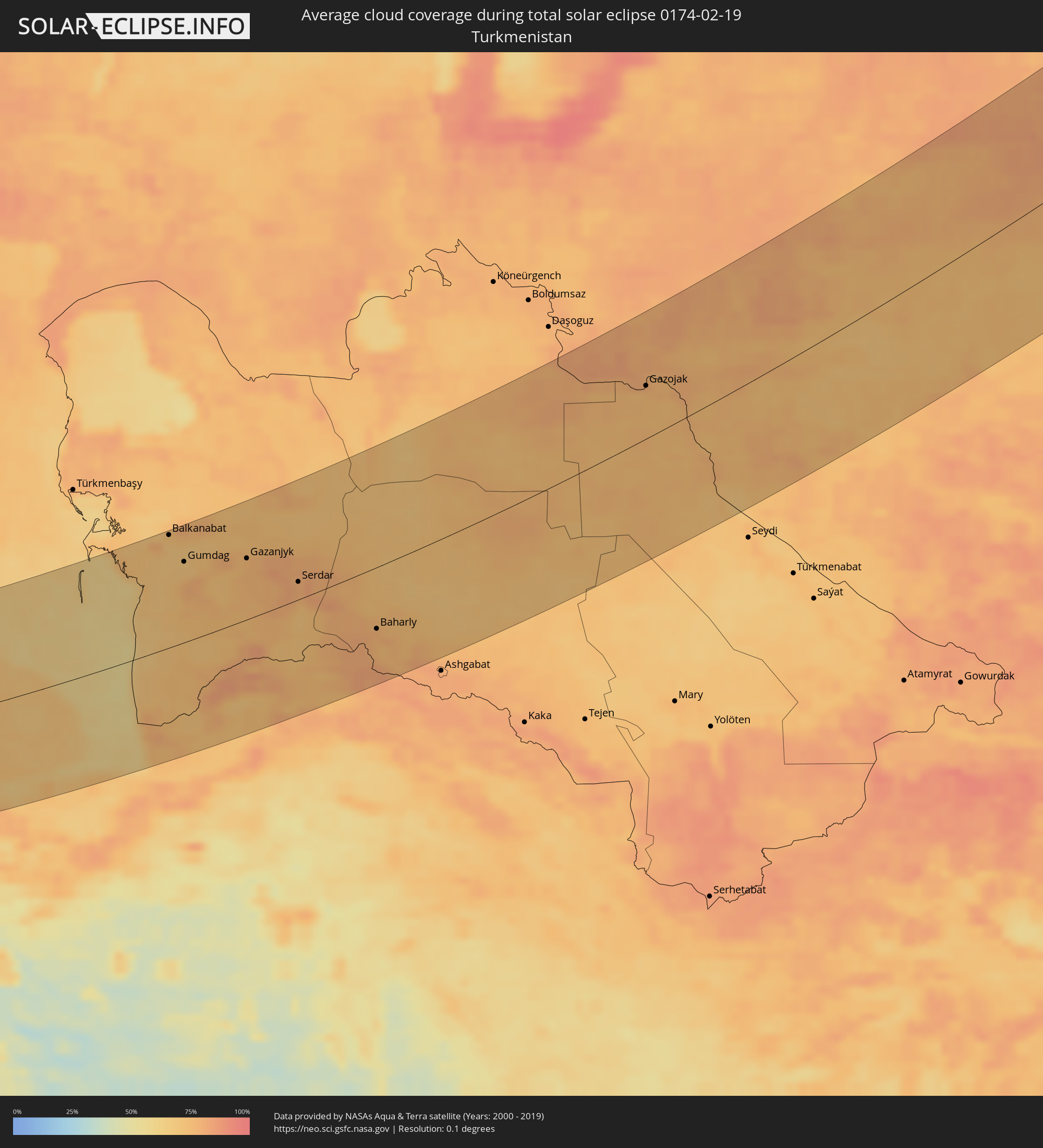 Turkmenistan
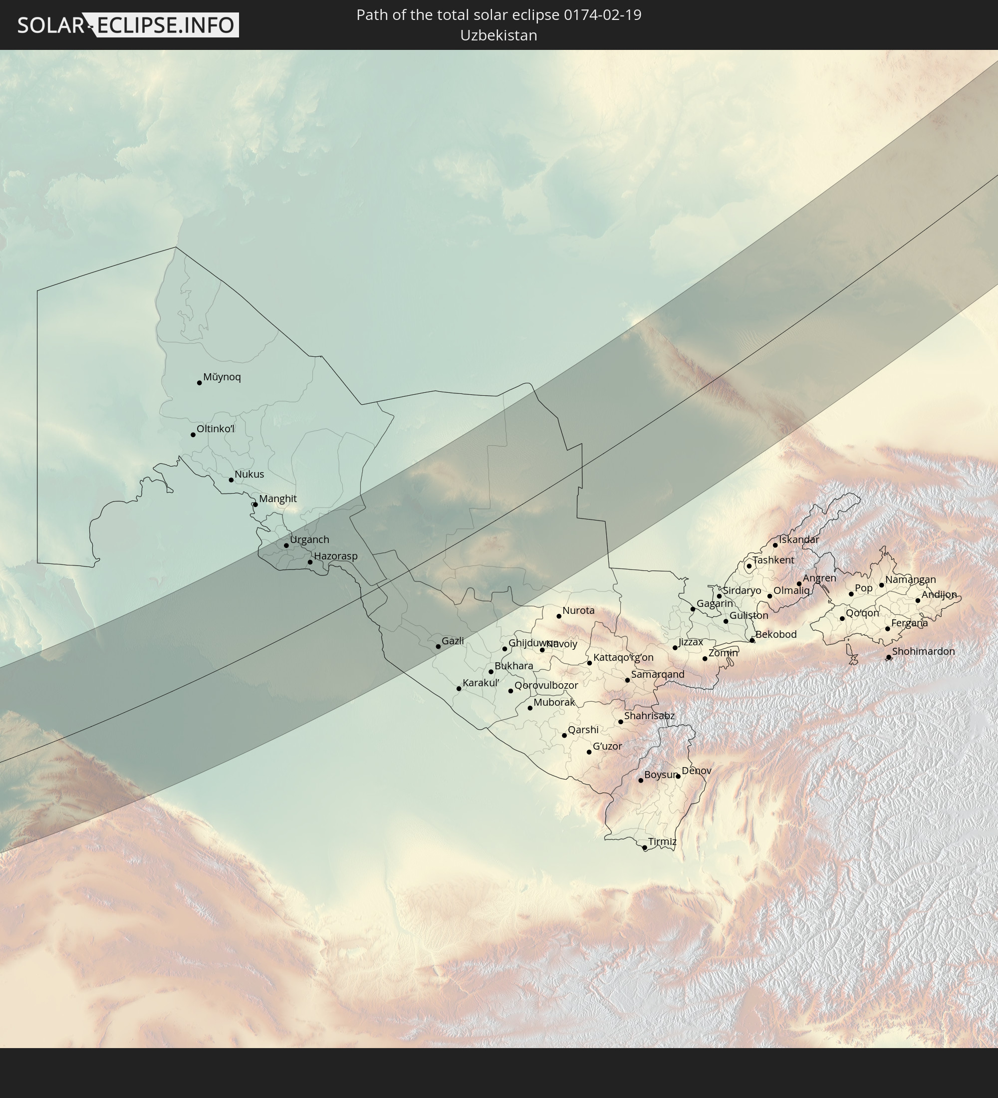
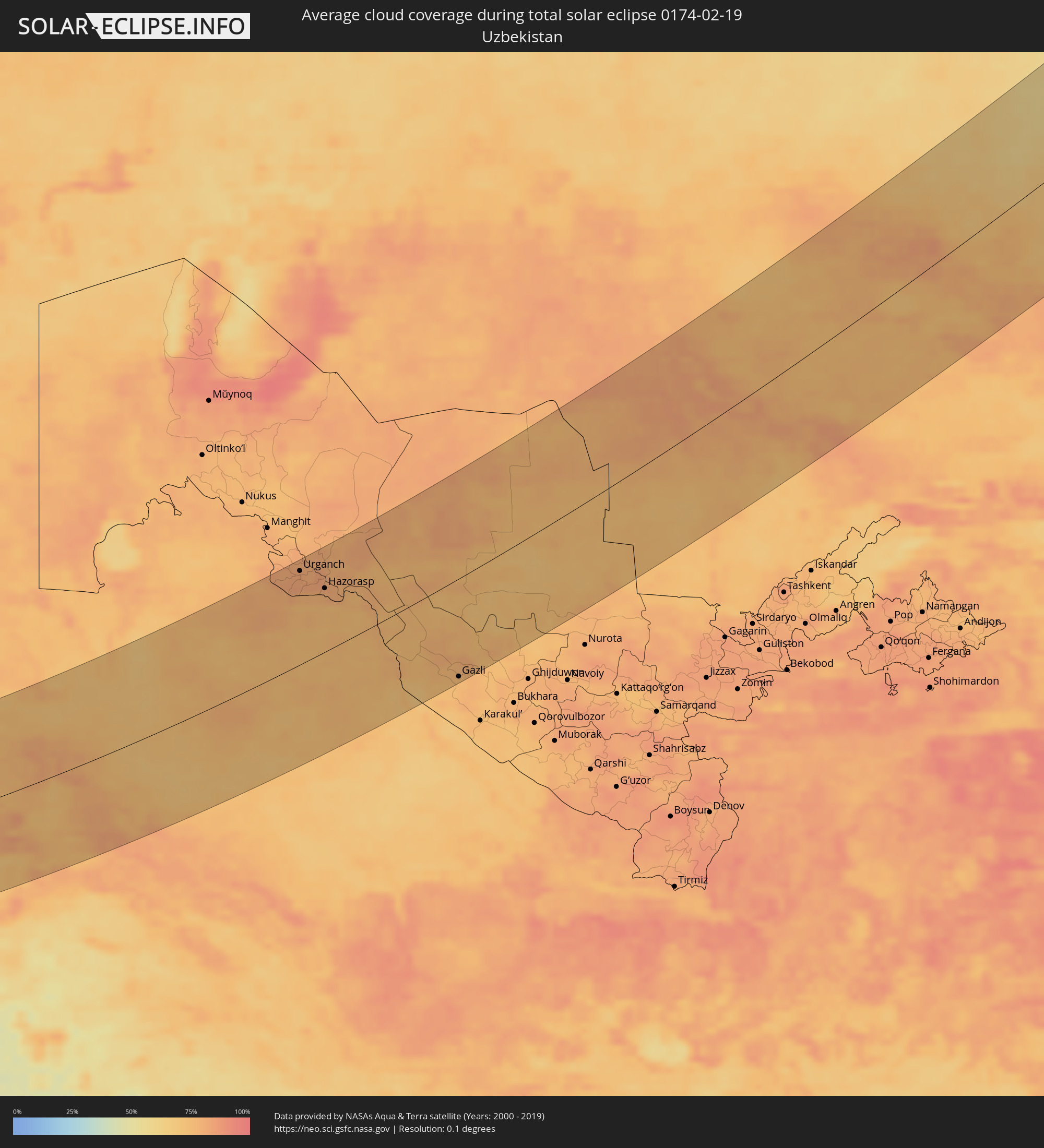 Usbekistan
Orte im Finsternispfad
Die nachfolgene Tabelle zeigt Städte und Orte mit mehr als 5.000 Einwohnern, die sich im Finsternispfad befinden. Städte mit mehr als 100.000 Einwohnern sind dick gekennzeichnet. Mit einem Klick auf den Ort öffnet sich eine Detailkarte die die Lage des jeweiligen Ortes zusammen mit dem Verlauf der zentralen Finsternis präsentiert.
| Ort | Typ | Dauer der Verfinsterung | Ortszeit bei maximaler Verfinsterung | Entfernung zur Zentrallinie | Ø Bewölkung |
|
Capo d'Orlando, Sicily
|
total | - | 06:56:09 UTC+01:00 | 87 km | 72% |
|
Patti, Sicily
|
total | - | 06:56:14 UTC+01:00 | 81 km | 75% |
|
Barcellona Pozzo di Gotto, Sicily
|
total | - | 06:56:19 UTC+01:00 | 75 km | 75% |
|
Messina, Sicily
|
total | - | 06:56:30 UTC+01:00 | 63 km | 68% |
|
Melito di Porto Salvo, Calabria
|
total | - | 06:56:10 UTC+01:00 | 88 km | 60% |
|
Bagnara Calabra, Calabria
|
total | - | 06:56:43 UTC+01:00 | 47 km | 71% |
|
Gioia Tauro, Calabria
|
total | - | 06:56:57 UTC+01:00 | 31 km | 68% |
|
Paola, Calabria
|
total | - | 06:58:24 UTC+01:00 | 74 km | 69% |
|
Polistena, Calabria
|
total | - | 06:56:59 UTC+01:00 | 29 km | 76% |
|
Amantea, Calabria
|
total | - | 06:58:03 UTC+01:00 | 49 km | 64% |
|
Vibo Valentia, Calabria
|
total | - | 06:57:24 UTC+01:00 | 1 km | 72% |
|
Cosenza, Calabria
|
total | - | 06:58:23 UTC+01:00 | 71 km | 72% |
|
Siderno, Calabria
|
total | - | 06:56:52 UTC+01:00 | 39 km | 65% |
|
Lamezia Terme, Calabria
|
total | - | 06:57:54 UTC+01:00 | 36 km | 70% |
|
Acri, Calabria
|
total | - | 06:58:43 UTC+01:00 | 95 km | 71% |
|
Catanzaro, Calabria
|
total | - | 06:57:53 UTC+01:00 | 34 km | 66% |
|
San Giovanni in Fiore, Calabria
|
total | - | 06:58:29 UTC+01:00 | 76 km | 70% |
|
Cirò Marina, Calabria
|
total | - | 06:58:49 UTC+01:00 | 97 km | 60% |
|
Crotone, Calabria
|
total | - | 06:58:23 UTC+01:00 | 66 km | 66% |
|
Amaliáda, West Greece
|
total | - | 07:33:16 UTC+01:34 | 11 km | 68% |
|
Agrínio, West Greece
|
total | - | 07:34:32 UTC+01:34 | 101 km | 64% |
|
Pýrgos, West Greece
|
total | - | 07:33:08 UTC+01:34 | 1 km | 64% |
|
Pátra, West Greece
|
total | - | 07:34:08 UTC+01:34 | 66 km | 59% |
|
Aígio, West Greece
|
total | - | 07:34:20 UTC+01:34 | 73 km | 68% |
|
Kalamáta, Peloponnese
|
total | - | 07:32:33 UTC+01:34 | 58 km | 65% |
|
Trípoli, Peloponnese
|
total | - | 07:33:23 UTC+01:34 | 3 km | 66% |
|
Spárti, Peloponnese
|
total | - | 07:32:46 UTC+01:34 | 49 km | 67% |
|
Árgos, Peloponnese
|
total | - | 07:33:46 UTC+01:34 | 17 km | 63% |
|
Livadeiá, Central Greece
|
total | - | 07:35:04 UTC+01:34 | 107 km | 69% |
|
Kórinthos, Peloponnese
|
total | - | 07:34:22 UTC+01:34 | 54 km | 60% |
|
Thívai, Central Greece
|
total | - | 07:35:10 UTC+01:34 | 103 km | 65% |
|
Salamína, Attica
|
total | - | 07:34:43 UTC+01:34 | 66 km | 61% |
|
Athens, Attica
|
total | - | 07:34:52 UTC+01:34 | 72 km | 72% |
|
Voúla, Attica
|
total | - | 07:34:42 UTC+01:34 | 58 km | 65% |
|
Néa Erythraía, Attica
|
total | - | 07:35:07 UTC+01:34 | 86 km | 72% |
|
Artémida, Attica
|
total | - | 07:35:02 UTC+01:34 | 75 km | 64% |
|
Kos, South Aegean
|
total | - | 07:35:38 UTC+01:34 | 6 km | 58% |
|
Ródos, South Aegean
|
total | - | 07:35:39 UTC+01:34 | 32 km | 58% |
|
Antalya, Antalya
|
total | - | 08:00:26 UTC+01:56 | 47 km | 61% |
|
Manavgat, Antalya
|
total | - | 08:00:54 UTC+01:56 | 41 km | 57% |
|
Alanya, Antalya
|
total | - | 08:01:02 UTC+01:56 | 19 km | 59% |
|
Lápithos, Keryneia
|
total | - | 08:16:51 UTC+02:13 | 106 km | 74% |
|
Karaman, Karaman
|
total | - | 08:03:08 UTC+01:56 | 99 km | 72% |
|
Kyrenia, Keryneia
|
total | - | 08:16:59 UTC+02:13 | 105 km | 74% |
|
Rizokárpaso, Ammochostos
|
total | - | 08:18:26 UTC+02:13 | 70 km | 66% |
|
Mercin, Mersin
|
total | - | 08:03:56 UTC+01:56 | 64 km | 64% |
|
Tarsus, Mersin
|
total | - | 08:04:24 UTC+01:56 | 79 km | 76% |
|
Adana, Adana
|
total | - | 08:04:59 UTC+01:56 | 90 km | 70% |
|
Latakia, Latakia
|
total | - | 08:31:31 UTC+02:25 | 71 km | 68% |
|
Ceyhan, Adana
|
total | - | 08:05:32 UTC+01:56 | 95 km | 68% |
|
Jablah, Latakia
|
total | - | 08:31:25 UTC+02:25 | 90 km | 67% |
|
Antakya, Hatay
|
total | - | 08:04:40 UTC+01:56 | 5 km | 74% |
|
İskenderun, Hatay
|
total | - | 08:05:15 UTC+01:56 | 47 km | 69% |
|
Osmaniye, Osmaniye
|
total | - | 08:06:04 UTC+01:56 | 102 km | 66% |
|
Jisr ash Shughūr, Idlib
|
total | - | 08:32:31 UTC+02:25 | 38 km | 73% |
|
Kafranbel, Idlib
|
total | - | 08:32:29 UTC+02:25 | 60 km | 78% |
|
Idlib, Idlib
|
total | - | 08:33:02 UTC+02:25 | 24 km | 75% |
|
Khān Shaykhūn, Idlib
|
total | - | 08:32:19 UTC+02:25 | 79 km | 66% |
|
Ḩamāh, Hama
|
total | - | 08:31:58 UTC+02:25 | 113 km | 77% |
|
‘Afrīn, Aleppo
|
total | - | 08:34:10 UTC+02:25 | 41 km | 71% |
|
I‘zāz, Aleppo
|
total | - | 08:34:28 UTC+02:25 | 49 km | 64% |
|
Kilis, Kilis
|
total | - | 08:06:29 UTC+01:56 | 64 km | 67% |
|
Aleppo, Aleppo
|
total | - | 08:34:01 UTC+02:25 | 7 km | 74% |
|
As Safīrah, Aleppo
|
total | - | 08:34:04 UTC+02:25 | 7 km | 71% |
|
Gaziantep, Gaziantep
|
total | - | 08:07:18 UTC+01:56 | 102 km | 71% |
|
Al Bāb, Aleppo
|
total | - | 08:34:40 UTC+02:25 | 26 km | 81% |
|
Nizip, Gaziantep
|
total | - | 08:07:41 UTC+01:56 | 97 km | 71% |
|
Manbij, Aleppo
|
total | - | 08:35:25 UTC+02:25 | 44 km | 89% |
|
‘Ayn al ‘Arab, Aleppo
|
total | - | 08:36:25 UTC+02:25 | 84 km | 69% |
|
Ath Thawrah, Ar-Raqqah
|
total | - | 08:35:04 UTC+02:25 | 33 km | 68% |
|
Şanlıurfa, Şanlıurfa
|
total | - | 08:09:05 UTC+01:56 | 115 km | 69% |
|
Ar Raqqah, Ar-Raqqah
|
total | - | 08:35:47 UTC+02:25 | 21 km | 71% |
|
Viranşehir, Şanlıurfa
|
total | - | 08:10:20 UTC+01:56 | 119 km | 61% |
|
Deir ez-Zor, Deir ez-Zor
|
total | - | 08:36:15 UTC+02:25 | 92 km | 61% |
|
Al Mayādīn, Deir ez-Zor
|
total | - | 08:36:10 UTC+02:25 | 128 km | 67% |
|
Kızıltepe, Mardin
|
total | - | 08:11:17 UTC+01:56 | 113 km | 66% |
|
Al Ḩasakah, Al-Hasakah
|
total | - | 08:38:45 UTC+02:25 | 36 km | 71% |
|
Nusaybin, Mardin
|
total | - | 08:11:55 UTC+01:56 | 97 km | 71% |
|
Sinjār, Nīnawá
|
total | - | 09:12:19 UTC+02:57 | 10 km | 74% |
|
Cizre, Şırnak
|
total | - | 08:13:34 UTC+01:56 | 120 km | 61% |
|
Zaxo, Dahūk
|
total | - | 09:14:38 UTC+02:57 | 97 km | 75% |
|
Dihok, Dahūk
|
total | - | 09:14:37 UTC+02:57 | 63 km | 81% |
|
Sīnah, Dahūk
|
total | - | 09:14:36 UTC+02:57 | 56 km | 82% |
|
Al Mawşil al Jadīdah, Nīnawá
|
total | - | 09:13:59 UTC+02:57 | 3 km | 87% |
|
Mosul, Nīnawá
|
total | - | 09:14:00 UTC+02:57 | 3 km | 87% |
|
Tallkayf, Nīnawá
|
total | - | 09:14:14 UTC+02:57 | 20 km | 86% |
|
Al-Hamdaniya, Nīnawá
|
total | - | 09:14:16 UTC+02:57 | 6 km | 88% |
|
‘Aqrah, Nīnawá
|
total | - | 09:15:38 UTC+02:57 | 41 km | 69% |
|
Erbil, Arbīl
|
total | - | 09:15:01 UTC+02:57 | 20 km | 88% |
|
Kirkuk, At Taʼmīm
|
total | - | 09:14:30 UTC+02:57 | 104 km | 85% |
|
Ruwāndiz, Arbīl
|
total | - | 09:16:21 UTC+02:57 | 21 km | 80% |
|
Koysinceq, Arbīl
|
total | - | 09:15:44 UTC+02:57 | 39 km | 74% |
|
Jamjamāl, As Sulaymānīyah
|
total | - | 09:15:13 UTC+02:57 | 102 km | 78% |
|
Orūmīyeh, Āz̄ārbāyjān-e Gharbī
|
total | - | 09:46:39 UTC+03:25 | 118 km | 70% |
|
Naqadeh, Āz̄ārbāyjān-e Gharbī
|
total | - | 09:46:14 UTC+03:25 | 49 km | 71% |
|
As Sulaymānīyah, As Sulaymānīyah
|
total | - | 09:16:08 UTC+02:57 | 105 km | 76% |
|
Mahābād, Āz̄ārbāyjān-e Gharbī
|
total | - | 09:46:26 UTC+03:25 | 24 km | 74% |
|
Bāneh, Kordestān
|
total | - | 09:45:33 UTC+03:25 | 63 km | 74% |
|
Baynjiwayn, As Sulaymānīyah
|
total | - | 09:16:58 UTC+02:57 | 105 km | 73% |
|
Bonāb, East Azerbaijan
|
total | - | 09:47:46 UTC+03:25 | 83 km | 73% |
|
Mīāndoāb, Āz̄ārbāyjān-e Gharbī
|
total | - | 09:47:18 UTC+03:25 | 41 km | 69% |
|
Būkān, Āz̄ārbāyjān-e Gharbī
|
total | - | 09:46:48 UTC+03:25 | 10 km | 72% |
|
Saqqez, Kordestān
|
total | - | 09:46:30 UTC+03:25 | 40 km | 74% |
|
Zanjān, Zanjan
|
total | - | 09:50:28 UTC+03:25 | 28 km | 79% |
|
Alvand, Zanjan
|
total | - | 09:51:02 UTC+03:25 | 79 km | 72% |
|
Abhar, Zanjan
|
total | - | 09:50:53 UTC+03:25 | 99 km | 71% |
|
Bandar-e Anzalī, Gīlān
|
total | - | 09:53:08 UTC+03:25 | 40 km | 77% |
|
Rasht, Gīlān
|
total | - | 09:53:04 UTC+03:25 | 16 km | 77% |
|
Tākestān, Qazvīn
|
total | - | 09:51:32 UTC+03:25 | 117 km | 68% |
|
Qazvin, Qazvīn
|
total | - | 09:52:19 UTC+03:25 | 101 km | 67% |
|
Āmol, Māzandarān
|
total | - | 09:56:29 UTC+03:25 | 132 km | 71% |
|
Bābol, Māzandarān
|
total | - | 09:57:09 UTC+03:25 | 131 km | 71% |
|
Behshahr, Māzandarān
|
total | - | 09:58:51 UTC+03:25 | 139 km | 69% |
|
Balkanabat, Balkan
|
total | - | 10:31:48 UTC+03:53 | 136 km | 70% |
|
Gumdag, Balkan
|
total | - | 10:31:47 UTC+03:53 | 97 km | 69% |
|
Gonbad-e Kāvūs, Golestān
|
total | - | 10:02:25 UTC+03:25 | 125 km | 72% |
|
Gazanjyk, Balkan
|
total | - | 10:33:25 UTC+03:53 | 73 km | 76% |
|
Serdar, Balkan
|
total | - | 10:34:24 UTC+03:53 | 21 km | 78% |
|
Baharly, Ahal
|
total | - | 10:35:47 UTC+03:53 | 73 km | 76% |
|
Abadan, Ahal
|
total | - | 10:36:41 UTC+03:53 | 138 km | 83% |
|
Qŭshkŭpir, Xorazm
|
total | - | 11:19:02 UTC+04:27 | 134 km | 81% |
|
Khiwa, Xorazm
|
total | - | 11:18:53 UTC+04:27 | 118 km | 81% |
|
Urganch, Xorazm
|
total | - | 11:19:33 UTC+04:27 | 124 km | 82% |
|
Beruniy, Karakalpakstan
|
total | - | 11:19:56 UTC+04:27 | 133 km | 80% |
|
Novyy Turtkul’, Karakalpakstan
|
total | - | 11:20:14 UTC+04:27 | 109 km | 83% |
|
Hazorasp, Xorazm
|
total | - | 11:20:05 UTC+04:27 | 84 km | 78% |
|
Gazojak, Lebap
|
total | - | 10:46:11 UTC+03:53 | 58 km | 75% |
|
Gazli, Bukhara
|
total | - | 11:23:08 UTC+04:27 | 128 km | 75% |
|
Shīeli, Qyzylorda
|
total | - | 11:26:54 UTC+04:21 | 114 km | 82% |
|
Yanykurgan, Qyzylorda
|
total | - | 11:27:34 UTC+04:21 | 67 km | 82% |
|
Turkestan, Ongtüstik Qazaqstan
|
total | - | 11:28:50 UTC+04:21 | 34 km | 78% |
|
Kentau, Ongtüstik Qazaqstan
|
total | - | 11:29:28 UTC+04:21 | 25 km | 79% |
|
Kantagi, Ongtüstik Qazaqstan
|
total | - | 11:29:37 UTC+04:21 | 28 km | 79% |
|
Chulakkurgan, Ongtüstik Qazaqstan
|
total | - | 11:30:51 UTC+04:21 | 33 km | 77% |
|
Chayan, Ongtüstik Qazaqstan
|
total | - | 11:30:38 UTC+04:21 | 109 km | 73% |
|
Zhangatas, Zhambyl
|
total | - | 11:31:41 UTC+04:21 | 77 km | 81% |
|
Priozersk
|
total | - | 11:40:06 UTC+04:21 | 36 km | 72% |
|
Balqash, Qaraghandy
|
total | - | 11:42:37 UTC+04:21 | 24 km | 67% |
|
Semey, East Kazakhstan
|
total | - | 11:51:48 UTC+04:21 | 46 km | 72% |
|
Shar, East Kazakhstan
|
total | - | 11:52:47 UTC+04:21 | 62 km | 66% |
|
Rubtsovsk, Altai Krai
|
total | - | 13:42:49 UTC+06:11 | 96 km | 72% |
|
Zhezkent, East Kazakhstan
|
total | - | 11:53:25 UTC+04:21 | 40 km | 69% |
|
Georgīevka, East Kazakhstan
|
total | - | 11:53:30 UTC+04:21 | 109 km | 71% |
|
Shemonaīkha, East Kazakhstan
|
total | - | 11:54:09 UTC+04:21 | 11 km | 68% |
|
Glubokoye, East Kazakhstan
|
total | - | 11:54:40 UTC+04:21 | 71 km | 67% |
|
Belūsovka, East Kazakhstan
|
total | - | 11:54:58 UTC+04:21 | 81 km | 70% |
|
Ust-Kamenogorsk, East Kazakhstan
|
total | - | 11:55:04 UTC+04:21 | 99 km | 74% |
|
Aleysk, Altai Krai
|
total | - | 13:45:00 UTC+06:11 | 110 km | 70% |
|
Ridder, East Kazakhstan
|
total | - | 11:56:21 UTC+04:21 | 107 km | 70% |
|
Biysk, Altai Krai
|
total | - | 13:48:09 UTC+06:11 | 8 km | 77% |
|
Gorno-Altaysk, Altai Republic
|
total | - | 13:49:07 UTC+06:11 | 73 km | 74% |
|
Prokop’yevsk, Kemerovo
|
total | - | 13:49:53 UTC+06:11 | 60 km | 83% |
|
Novokuznetsk, Kemerovo
|
total | - | 13:50:23 UTC+06:11 | 30 km | 85% |
|
Osinniki, Kemerovo
|
total | - | 13:50:42 UTC+06:11 | 9 km | 85% |
|
Myski, Kemerovo
|
total | - | 13:51:13 UTC+06:11 | 3 km | 87% |
|
Tashtagol, Kemerovo
|
total | - | 13:51:30 UTC+06:11 | 88 km | 79% |
|
Mezhdurechensk, Kemerovo
|
total | - | 13:51:32 UTC+06:11 | 15 km | 85% |
|
Sharypovo, Krasnoyarskiy
|
total | - | 13:52:24 UTC+06:11 | 95 km | 81% |
|
Nazarovo, Krasnoyarskiy
|
total | - | 13:53:34 UTC+06:11 | 87 km | 78% |
|
Achinsk, Krasnoyarskiy
|
total | - | 13:53:35 UTC+06:11 | 105 km | 84% |
|
Divnogorsk, Krasnoyarskiy
|
total | - | 13:55:42 UTC+06:11 | 3 km | 86% |
|
Krasnoyarsk, Krasnoyarskiy
|
total | - | 13:56:12 UTC+06:11 | 11 km | 87% |
|
Sosnovoborsk, Krasnoyarskiy
|
total | - | 13:56:39 UTC+06:11 | 21 km | 85% |
|
Zheleznogorsk, Krasnoyarskiy
|
total | - | 13:56:47 UTC+06:11 | 17 km | 86% |
|
Zelenogorsk, Krasnoyarskiy
|
total | - | 13:57:56 UTC+06:11 | 71 km | 82% |
|
Kansk, Krasnoyarskiy
|
total | - | 13:59:01 UTC+06:11 | 106 km | 78% |