Hybride Sonnenfinsternis vom 16.10.0190
| Wochentag: | Samstag |
| Maximale Dauer der Verfinsterung: | 01m30s |
| Maximale Breite des Finsternispfades: | 57 km |
| Saroszyklus: | 85 |
| Bedeckungsgrad: | 100% |
| Magnitude: | 1.0152 |
| Gamma: | 0.4293 |
Wo kann man die Sonnenfinsternis vom 16.10.0190 sehen?
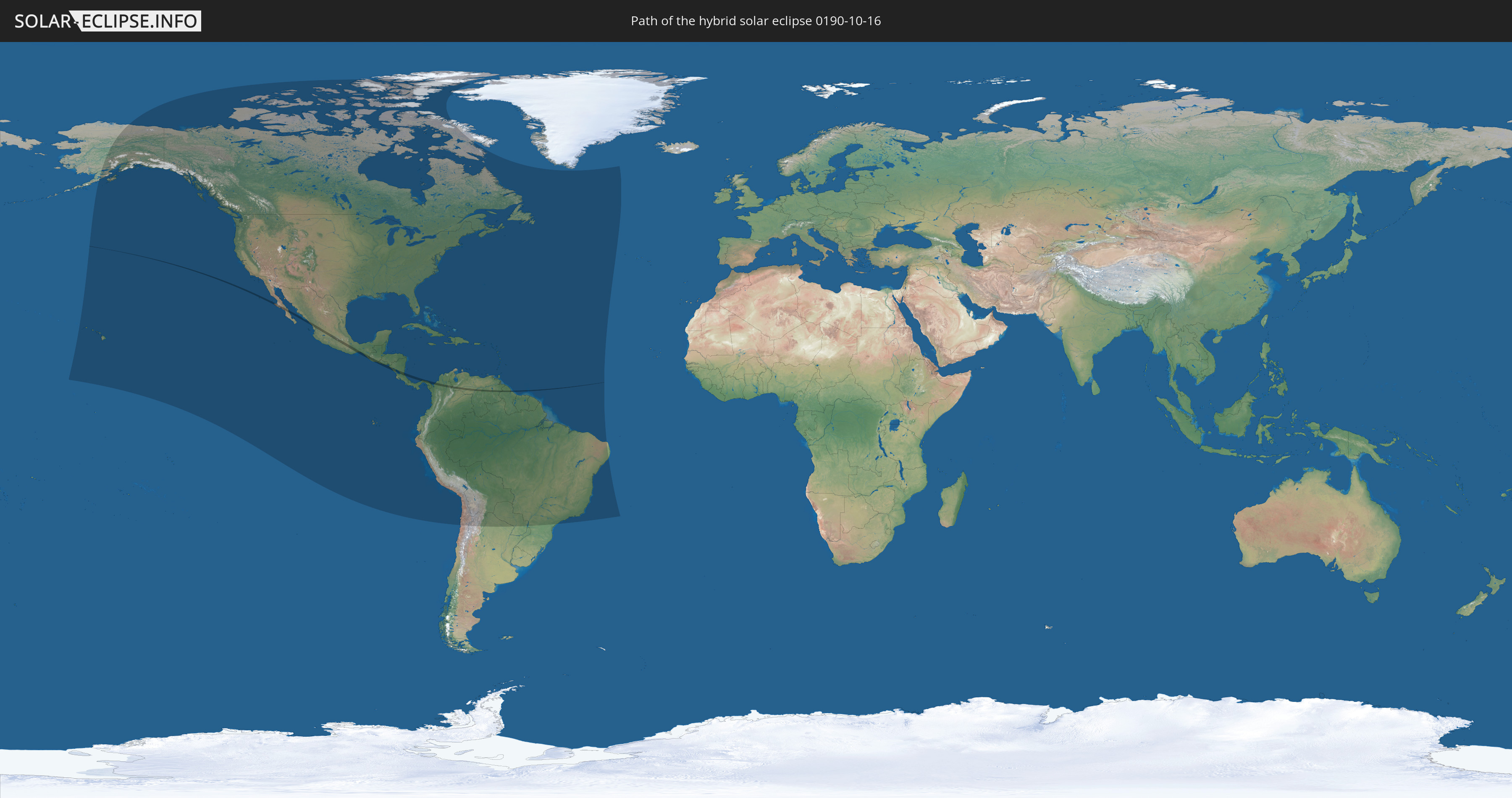
Die Sonnenfinsternis am 16.10.0190 kann man in 51 Ländern als partielle Sonnenfinsternis beobachten.
Der Finsternispfad verläuft durch 9 Länder. Nur in diesen Ländern ist sie als hybride Sonnenfinsternis zu sehen.
In den folgenden Ländern ist die Sonnenfinsternis hybrid zu sehen
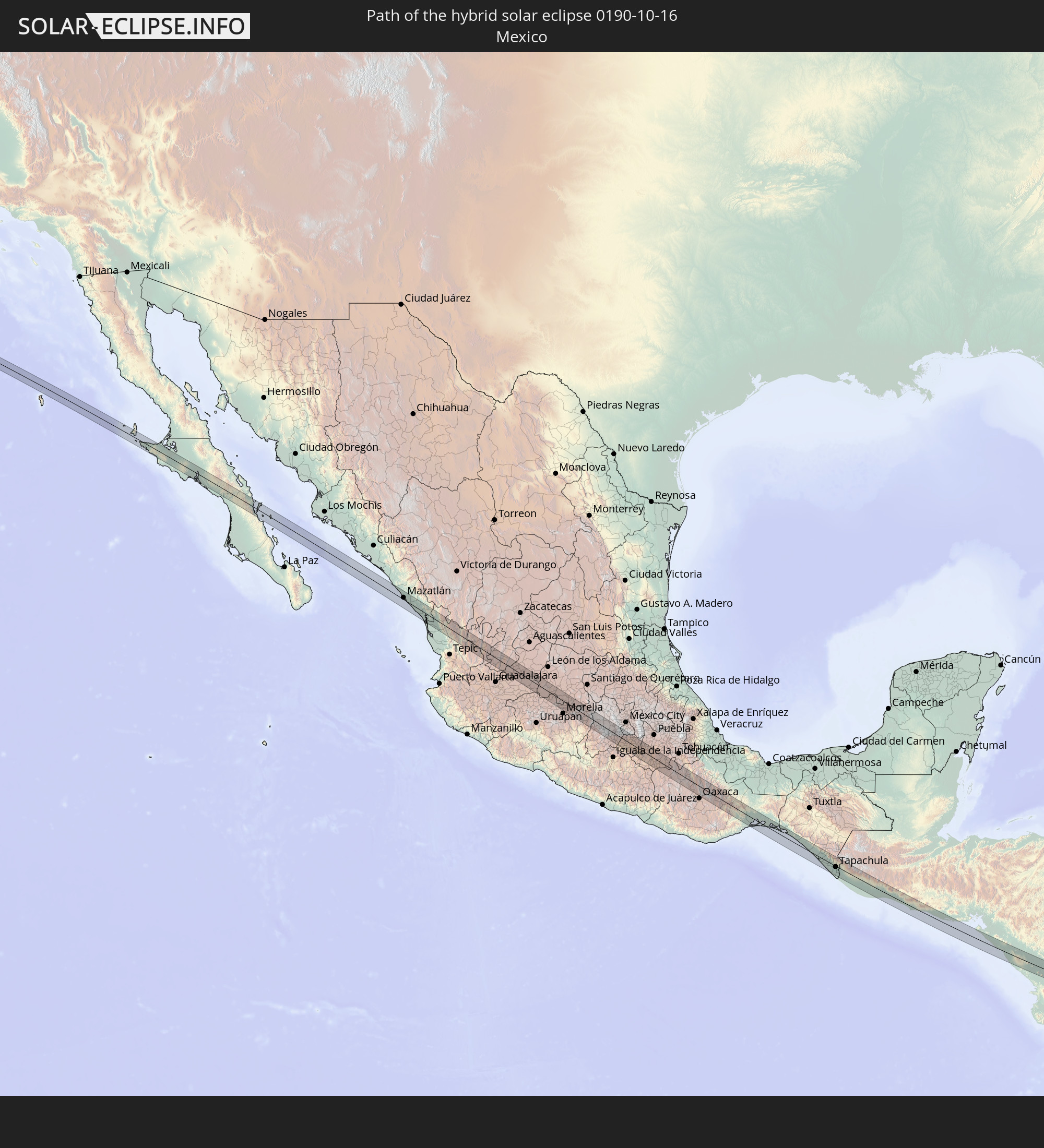 Mexiko
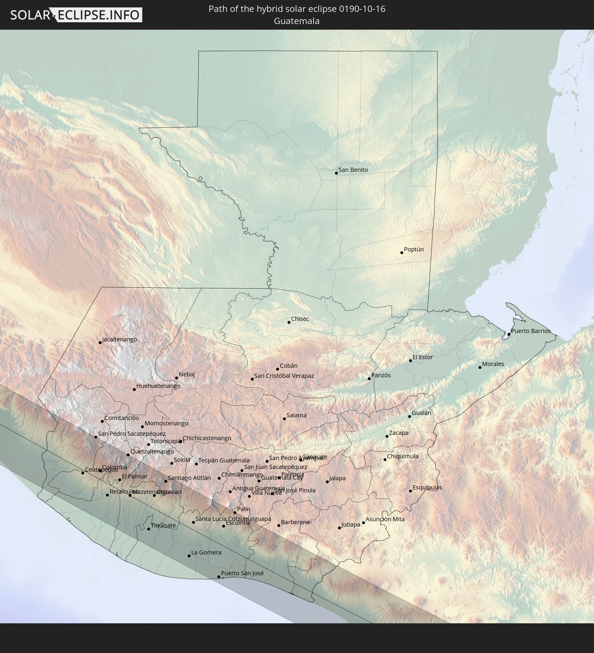 Guatemala
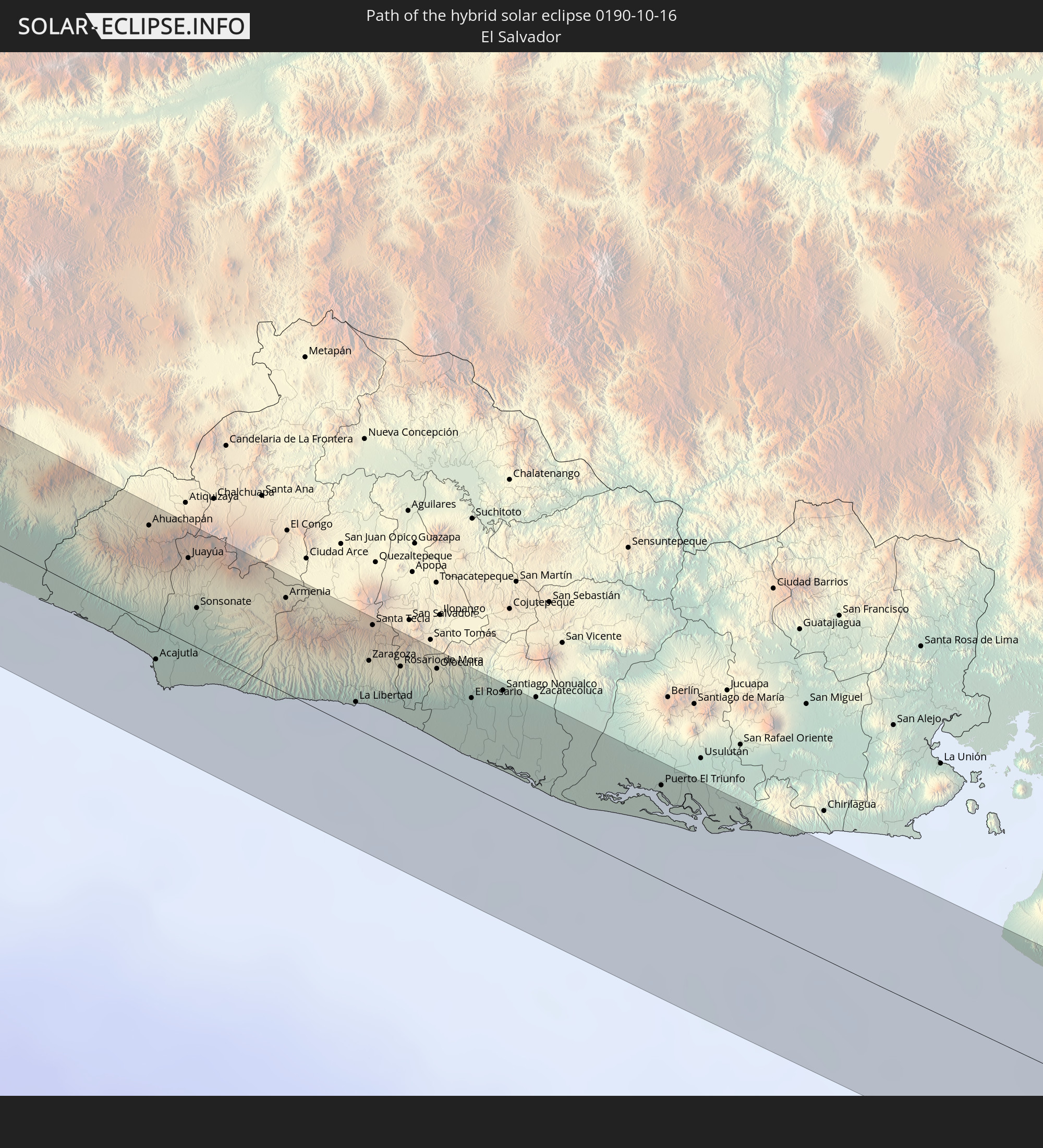 El Salvador
 Nicaragua
 Costa Rica
 Panama
 Kolumbien
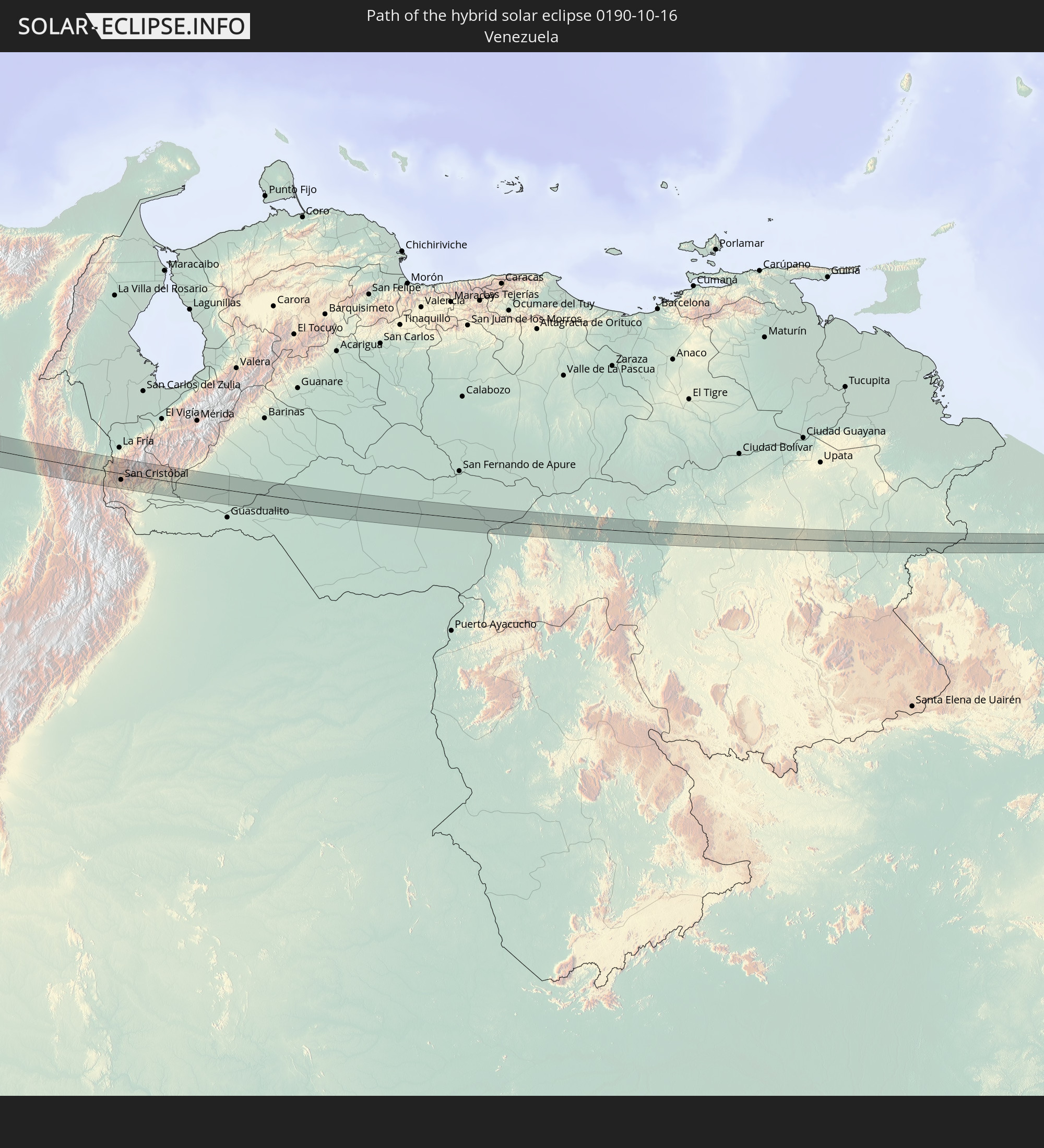 Venezuela
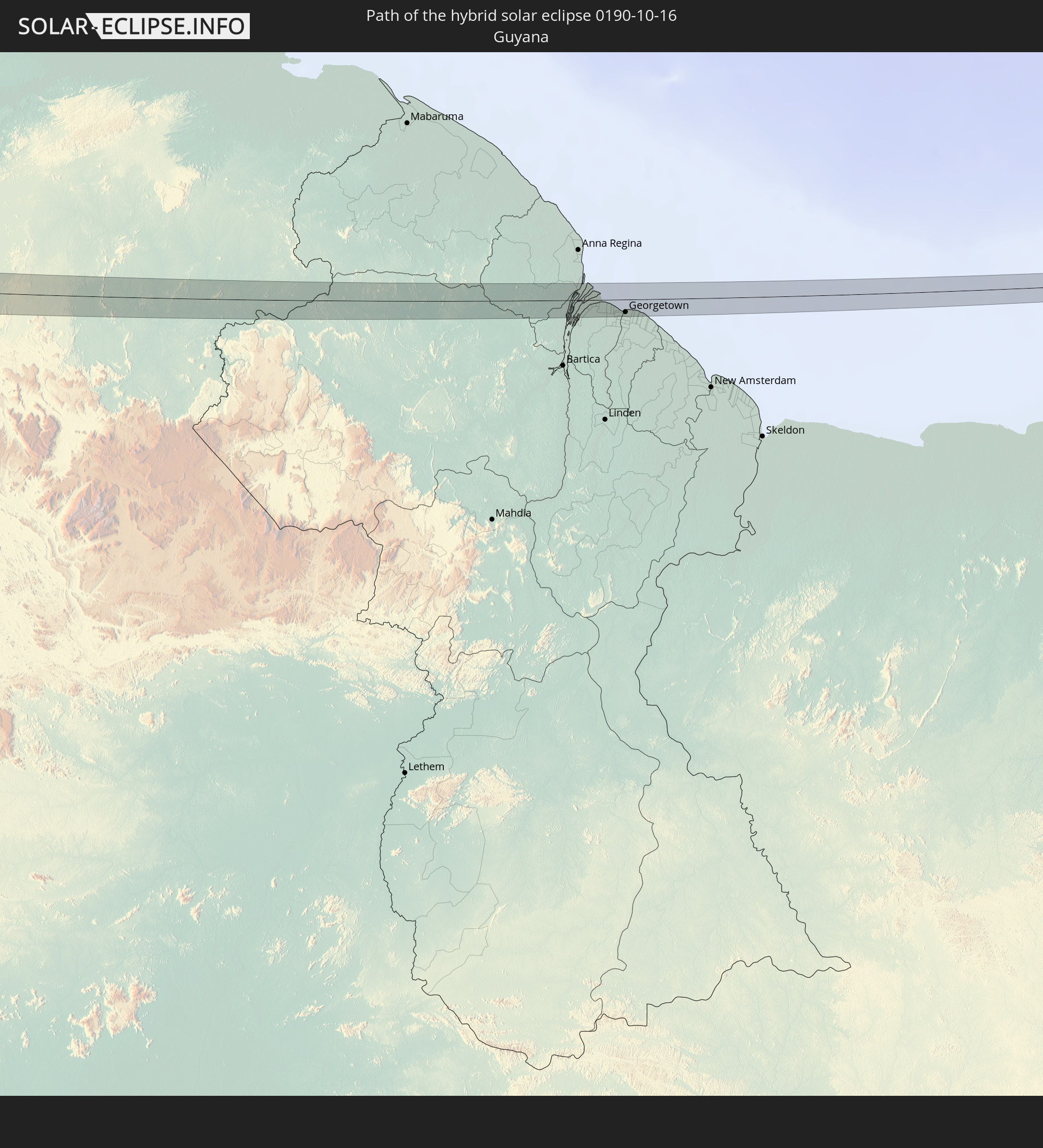 Guyana
In den folgenden Ländern ist die Sonnenfinsternis partiell zu sehen
 Vereinigte Staaten
 United States Minor Outlying Islands
 Kanada
 Mexiko
 Chile
Chile
 Grönland
 Guatemala
 Ecuador
 El Salvador
 Honduras
 Belize
 Nicaragua
 Costa Rica
 Kuba
Kuba
 Panama
 Kolumbien
 Kaimaninseln
 Peru
Peru
 Bahamas
 Jamaika
 Haiti
Haiti
 Brasilien
 Argentinien
 Venezuela
 Turks- und Caicosinseln
 Dominikanische Republik
 Aruba
Aruba
 Bolivien
 Puerto Rico
 Amerikanische Jungferninseln
 Bermuda
 Britische Jungferninseln
 Anguilla
 Saint-Martin
 Saint-Barthélemy
 St. Kitts und Nevis
 Paraguay
 Antigua und Barbuda
 Montserrat
 Trinidad und Tobago
 Guadeloupe
 Grenada
 Dominica
 St. Vincent und die Grenadinen
 Guyana
 Martinique
 St. Lucia
 Barbados
 Suriname
 Saint-Pierre und Miquelon
 Französisch-Guayana
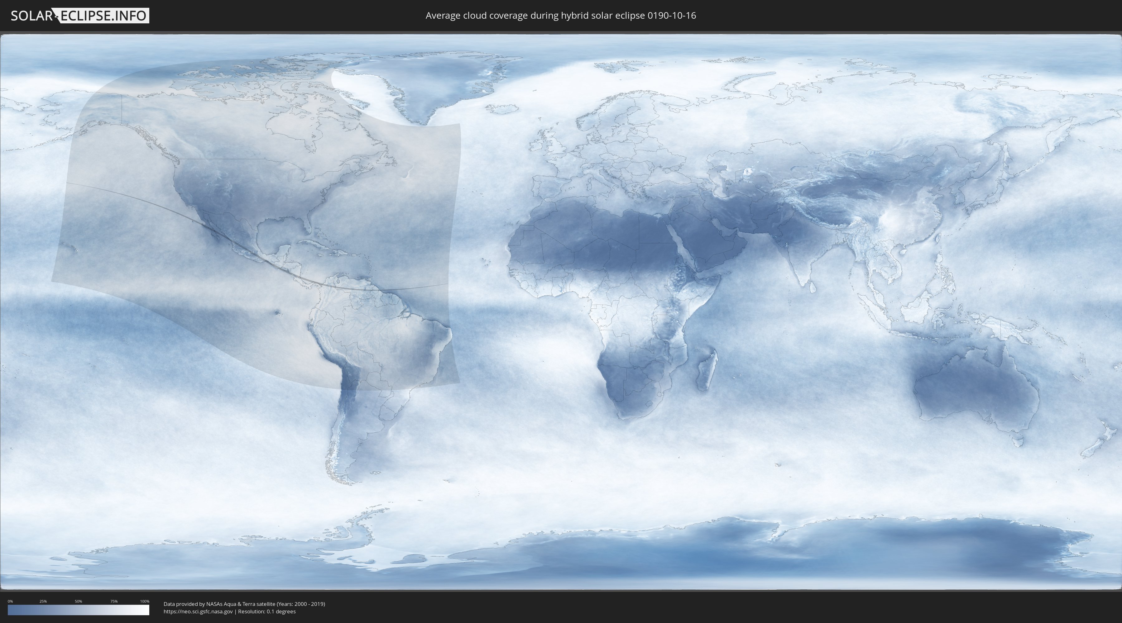
Wie wird das Wetter während der hybriden Sonnenfinsternis am 16.10.0190?
Wo ist der beste Ort, um die hybride Sonnenfinsternis vom 16.10.0190 zu beobachten?
Die folgenden Karten zeigen die durchschnittliche Bewölkung für den Tag, an dem die hybride Sonnenfinsternis
stattfindet. Mit Hilfe der Karten lässt sich der Ort entlang des Finsternispfades eingrenzen,
der die besten Aussichen auf einen klaren wolkenfreien Himmel bietet.
Trotzdem muss man immer lokale Gegenenheiten beachten und sollte sich genau über das Wetter an seinem
gewählten Beobachtungsort informieren.
Die Daten stammen von den beiden NASA-Satelliten
AQUA und TERRA
und wurden über einen Zeitraum von 19 Jahren (2000 - 2019) gemittelt.

Detaillierte Länderkarten
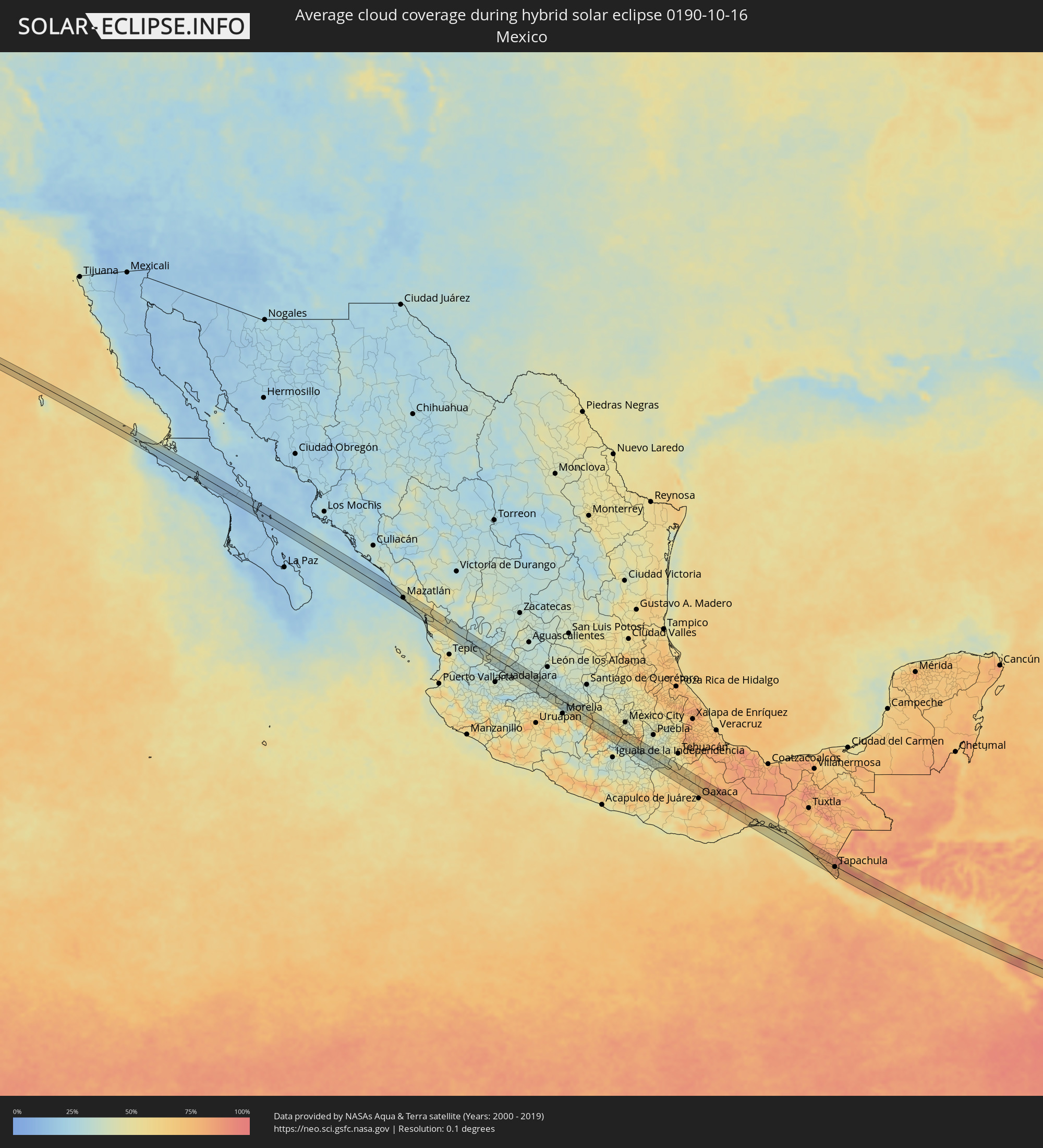 Mexiko
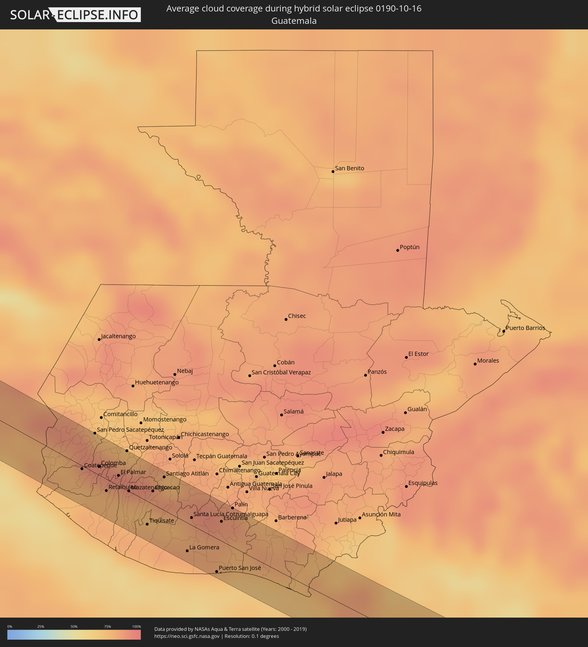 Guatemala
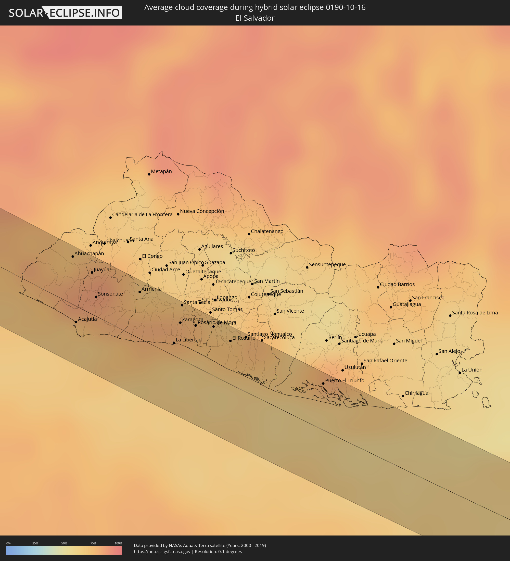 El Salvador
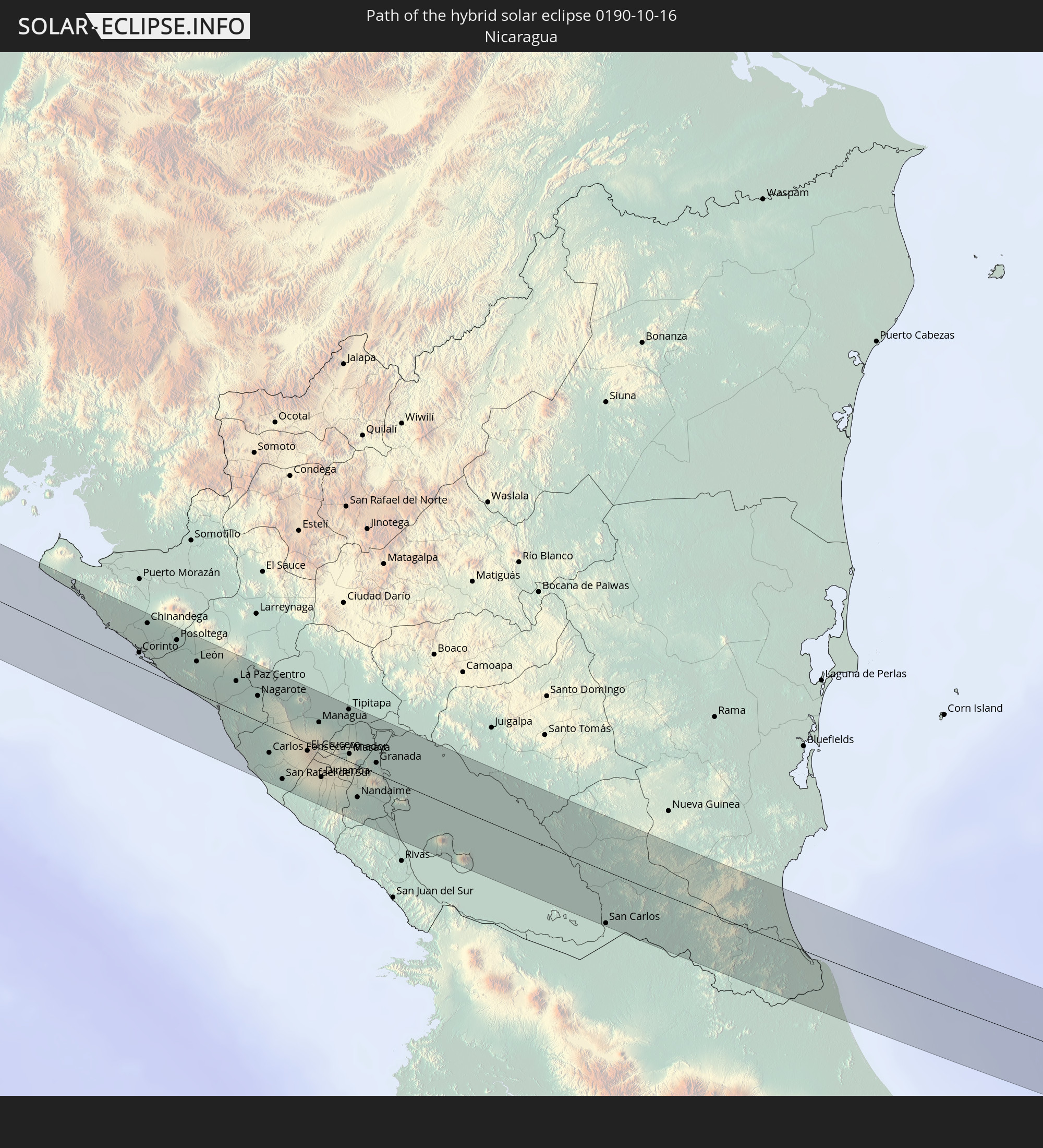
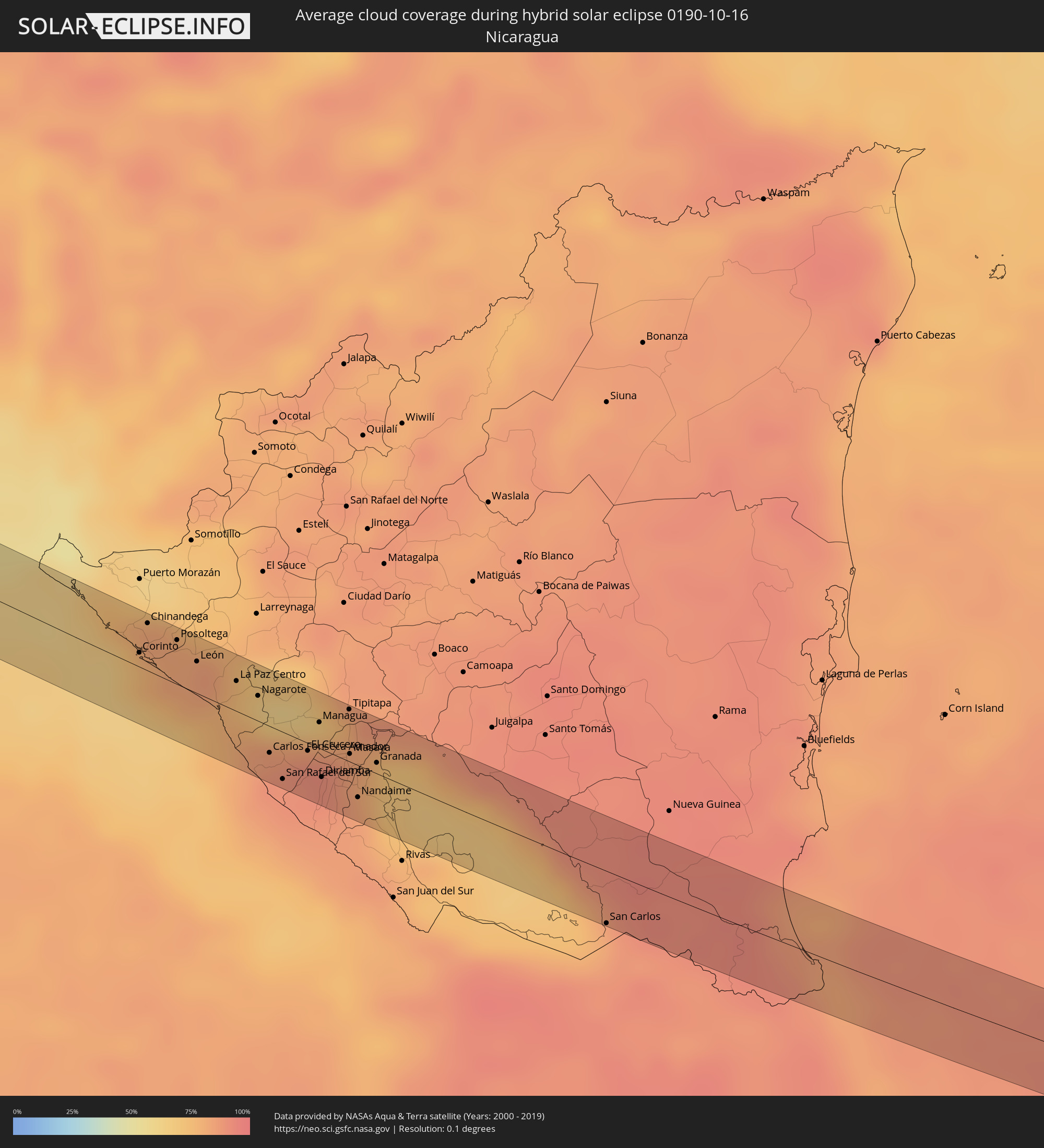 Nicaragua
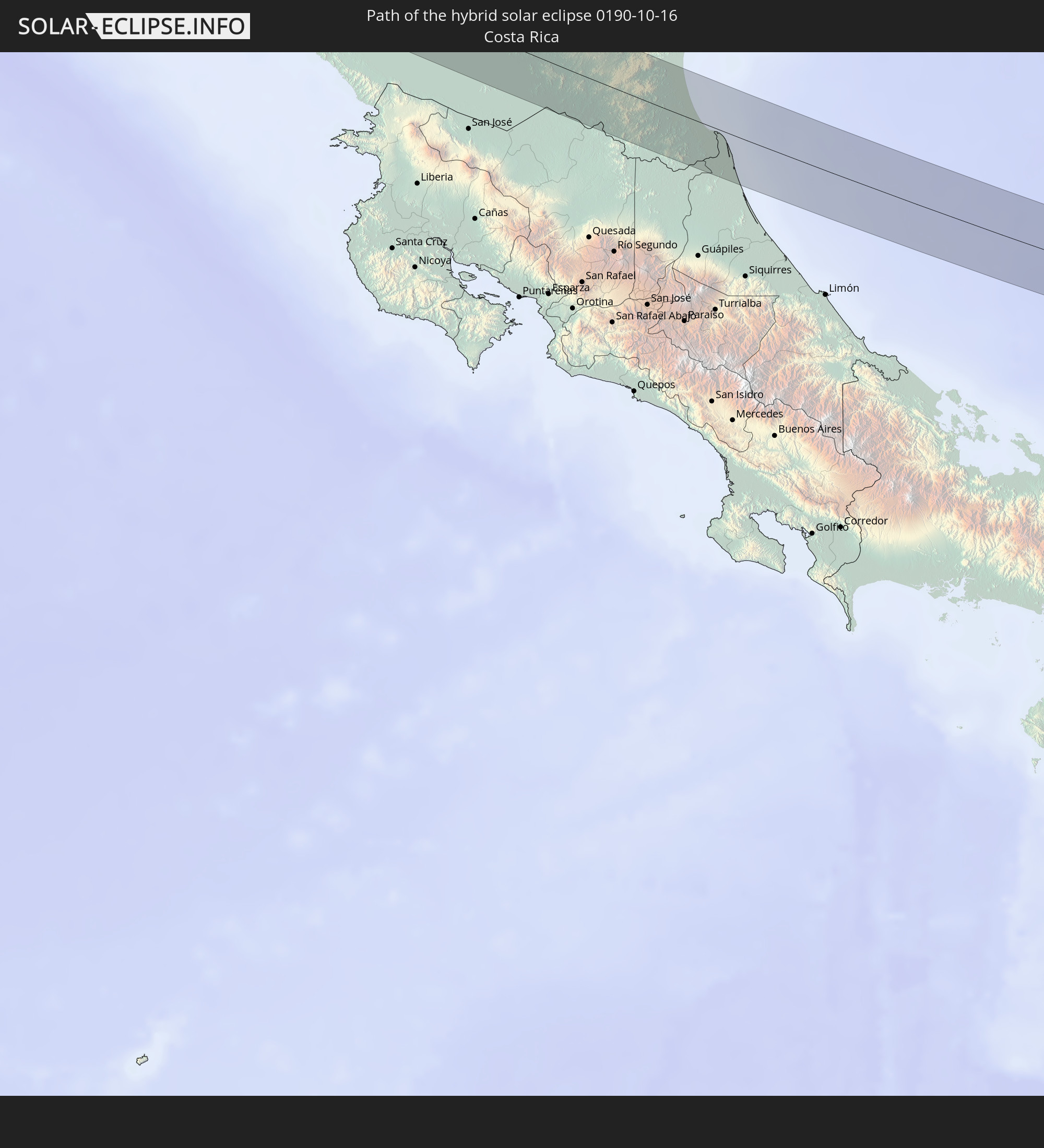
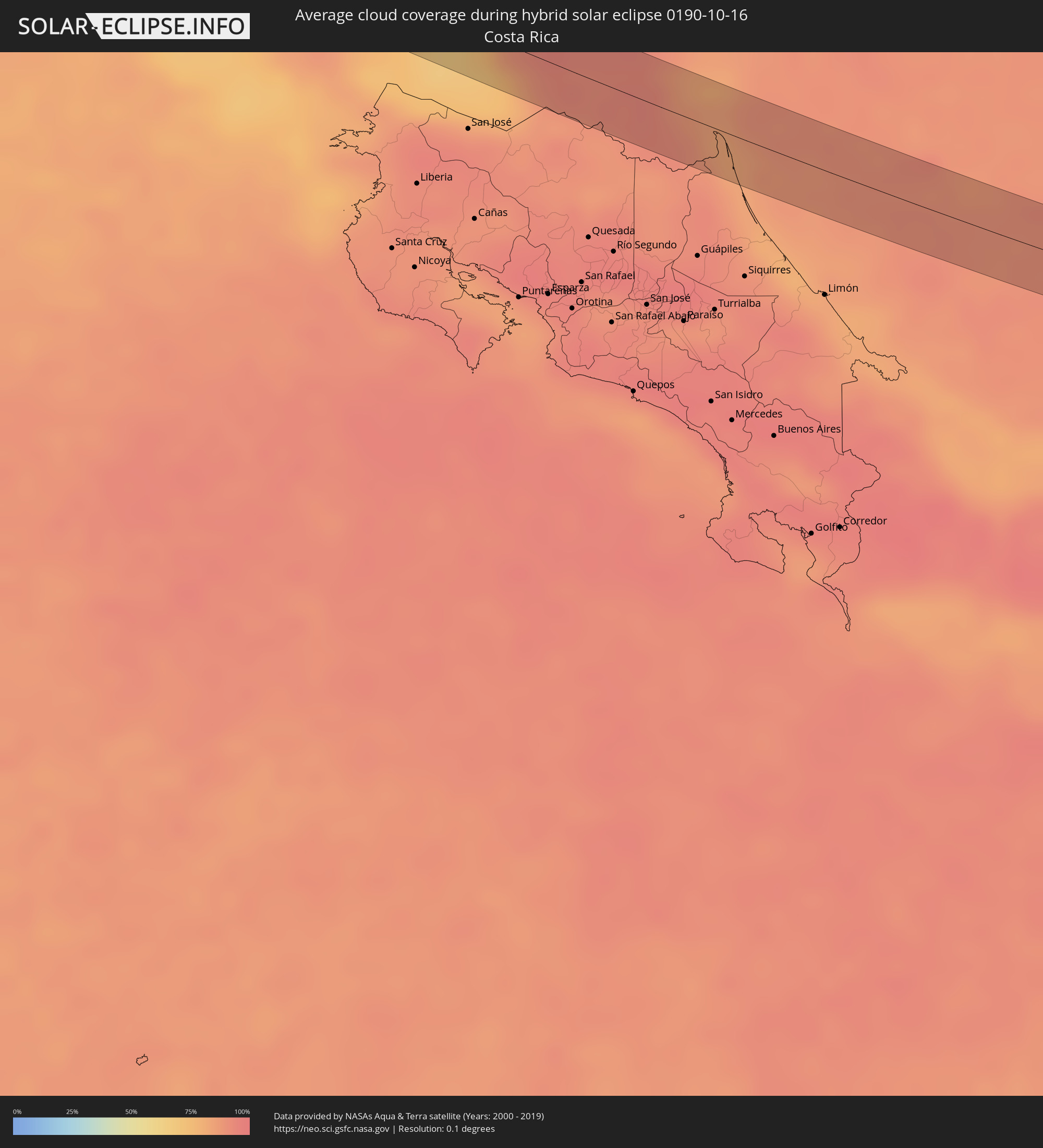 Costa Rica
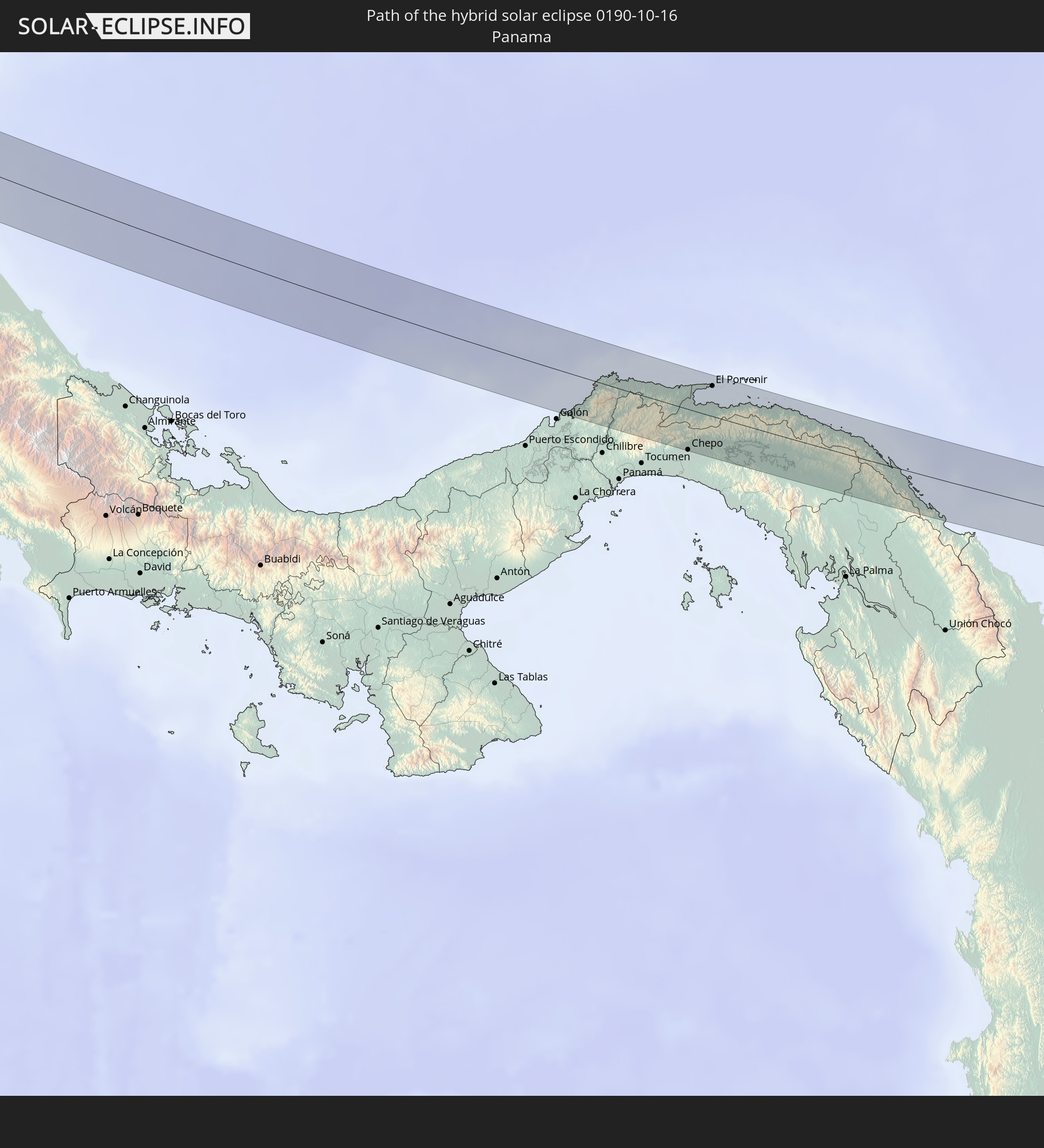
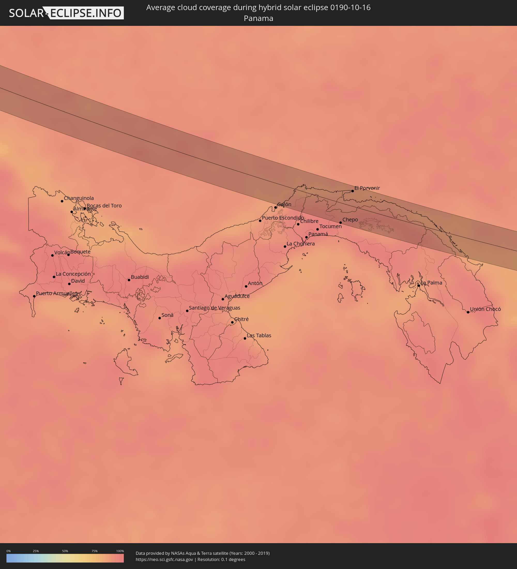 Panama
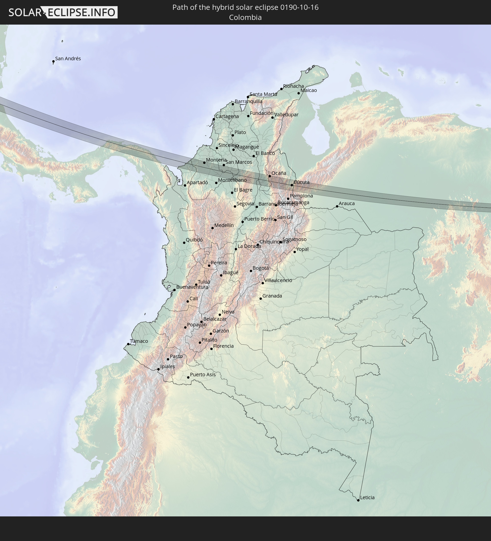
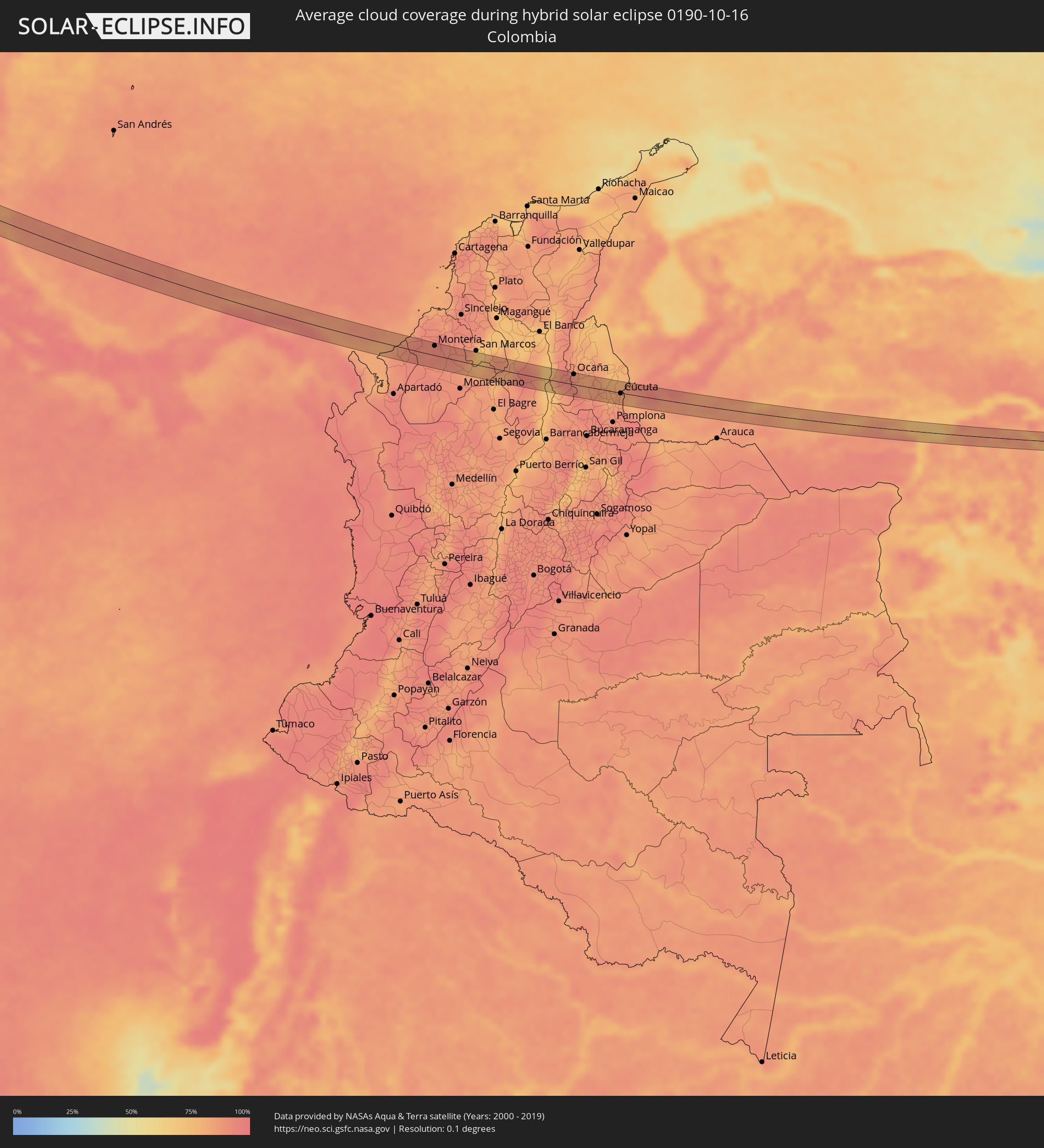 Kolumbien
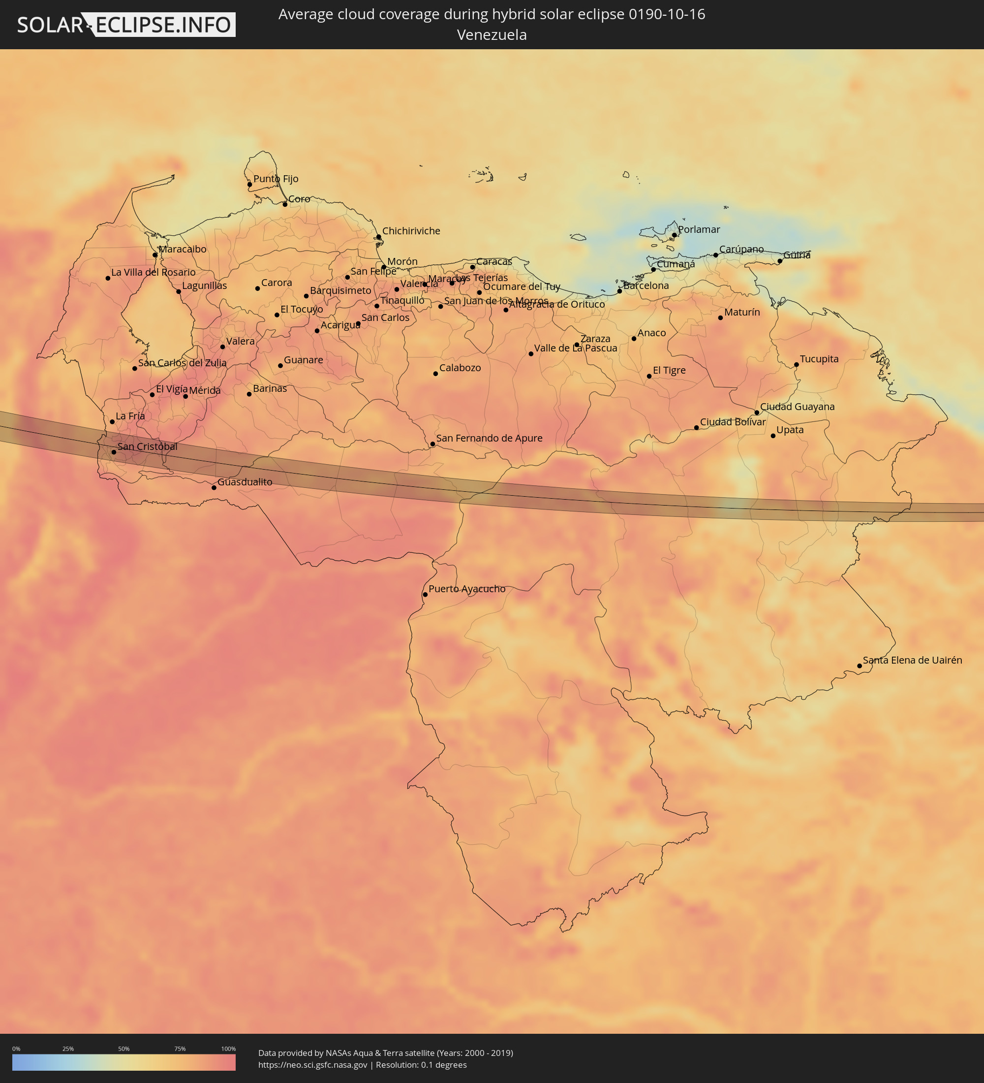 Venezuela
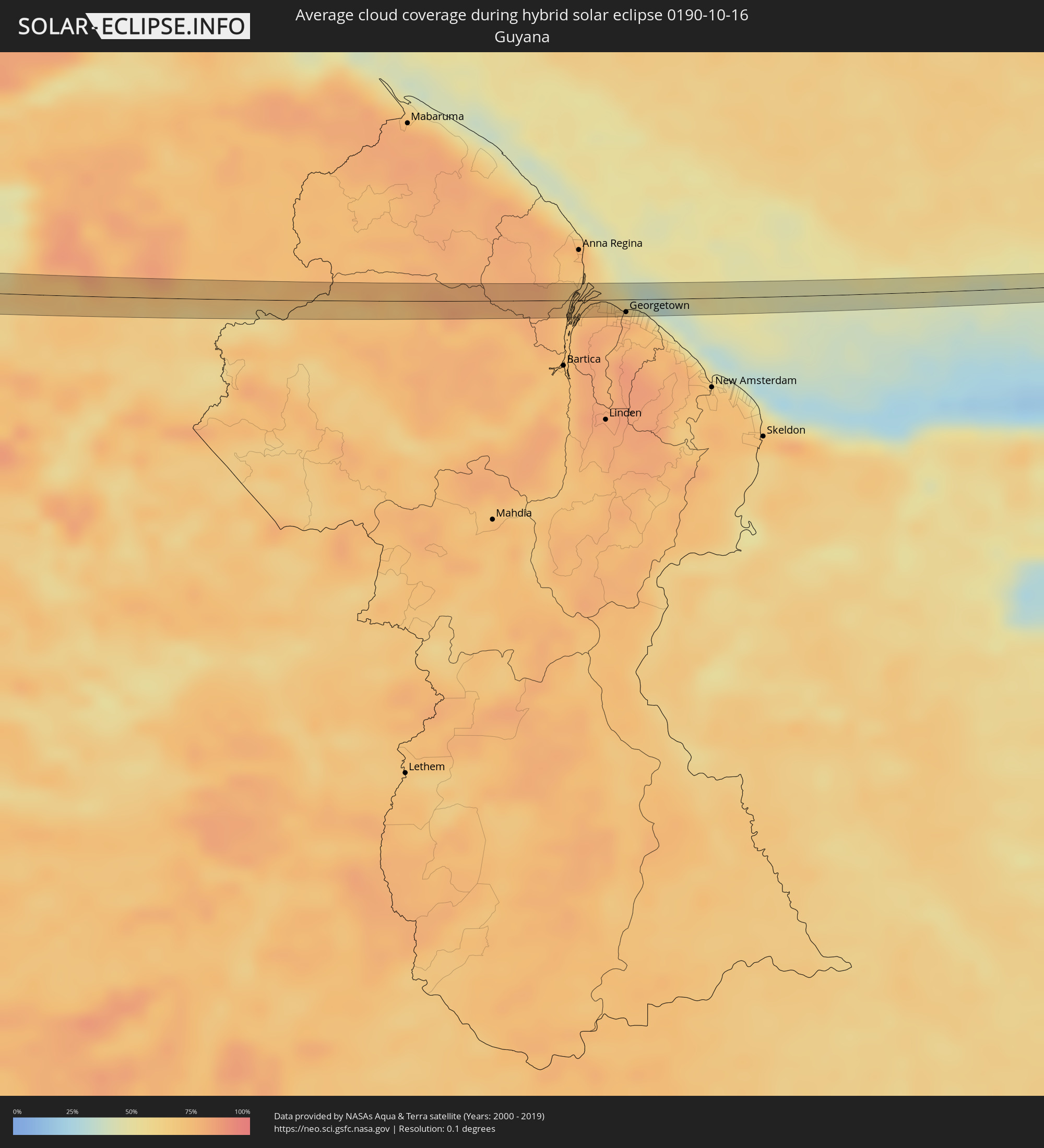 Guyana
Orte im Finsternispfad
Die nachfolgene Tabelle zeigt Städte und Orte mit mehr als 5.000 Einwohnern, die sich im Finsternispfad befinden. Städte mit mehr als 100.000 Einwohnern sind dick gekennzeichnet. Mit einem Klick auf den Ort öffnet sich eine Detailkarte die die Lage des jeweiligen Ortes zusammen mit dem Verlauf der zentralen Finsternis präsentiert.
| Ort | Typ | Dauer der Verfinsterung | Ortszeit bei maximaler Verfinsterung | Entfernung zur Zentrallinie | Ø Bewölkung |
|
Mazatlán, Sinaloa
|
total | - | 10:42:22 UTC-07:05 | 5 km | 28% |
|
Escuinapa de Hidalgo, Sinaloa
|
total | - | 10:44:11 UTC-07:05 | 2 km | 36% |
|
Tepatitlán de Morelos, Jalisco
|
total | - | 11:22:28 UTC-06:36 | 20 km | 37% |
|
Arandas, Jalisco
|
total | - | 11:23:37 UTC-06:36 | 7 km | 38% |
|
La Piedad, Michoacán
|
total | - | 11:24:49 UTC-06:36 | 24 km | 36% |
|
Pénjamo, Guanajuato
|
total | - | 11:25:29 UTC-06:36 | 2 km | 36% |
|
Abasolo, Guanajuato
|
total | - | 11:25:56 UTC-06:36 | 14 km | 35% |
|
Puruándiro, Michoacán
|
total | - | 11:26:24 UTC-06:36 | 19 km | 44% |
|
Uriangato, Guanajuato
|
total | - | 11:27:10 UTC-06:36 | 5 km | 36% |
|
Acámbaro, Guanajuato
|
total | - | 11:28:28 UTC-06:36 | 20 km | 40% |
|
Ciudad Hidalgo, Michoacán
|
total | - | 11:29:17 UTC-06:36 | 2 km | 48% |
|
Maravatío de Ocampo, Michoacán
|
total | - | 11:29:20 UTC-06:36 | 23 km | 40% |
|
Heróica Zitácuaro, Michoacán
|
total | - | 11:30:07 UTC-06:36 | 15 km | 57% |
|
Valle de Bravo, México
|
total | - | 11:30:59 UTC-06:36 | 25 km | 62% |
|
Toluca, México
|
total | - | 11:32:06 UTC-06:36 | 11 km | 44% |
|
Ocoyoacac, México
|
total | - | 11:32:37 UTC-06:36 | 20 km | 46% |
|
Cuernavaca, Morelos
|
total | - | 11:33:39 UTC-06:36 | 0 km | 42% |
|
Yautepec, Morelos
|
total | - | 11:34:07 UTC-06:36 | 5 km | 42% |
|
Cuautla Morelos, Morelos
|
total | - | 11:34:32 UTC-06:36 | 5 km | 41% |
|
Izúcar de Matamoros, Puebla
|
total | - | 11:36:04 UTC-06:36 | 13 km | 36% |
|
Ciudad de Huajuapan de León, Oaxaca
|
total | - | 11:38:54 UTC-06:36 | 24 km | 55% |
|
Santo Domingo Tehuantepec, Oaxaca
|
total | - | 11:47:45 UTC-06:36 | 25 km | 64% |
|
Juchitán de Zaragoza, Oaxaca
|
total | - | 11:48:11 UTC-06:36 | 2 km | 58% |
|
Huixtla, Chiapas
|
total | - | 11:57:01 UTC-06:36 | 9 km | 77% |
|
Tapachula, Chiapas
|
total | - | 11:57:57 UTC-06:36 | 3 km | 81% |
|
Ayutla, San Marcos
|
total | - | 12:33:08 UTC-06:02 | 19 km | 76% |
|
Malacatán, San Marcos
|
total | - | 12:33:01 UTC-06:02 | 8 km | 75% |
|
Coatepeque, Quetzaltenango
|
total | - | 12:33:51 UTC-06:02 | 2 km | 76% |
|
San Cristóbal Cucho, San Marcos
|
total | - | 12:33:47 UTC-06:02 | 21 km | 91% |
|
San Pedro Sacatepéquez, San Marcos
|
total | - | 12:33:44 UTC-06:02 | 29 km | 84% |
|
Retalhuleu, Retalhuleu
|
total | - | 12:34:36 UTC-06:02 | 9 km | 78% |
|
San Felipe, Retalhuleu
|
total | - | 12:34:42 UTC-06:02 | 3 km | 77% |
|
El Palmar, Quetzaltenango
|
total | - | 12:34:42 UTC-06:02 | 7 km | 85% |
|
Cuyotenango, Suchitepeque
|
total | - | 12:34:55 UTC-06:02 | 3 km | 75% |
|
Quetzaltenango, Quetzaltenango
|
total | - | 12:34:36 UTC-06:02 | 29 km | 89% |
|
Mazatenango, Suchitepeque
|
total | - | 12:35:05 UTC-06:02 | 1 km | 75% |
|
Zunil, Quetzaltenango
|
total | - | 12:34:46 UTC-06:02 | 26 km | 89% |
|
Samayac, Quetzaltenango
|
total | - | 12:35:08 UTC-06:02 | 7 km | 79% |
|
Tiquisate, Escuintla
|
total | - | 12:35:51 UTC-06:02 | 17 km | 80% |
|
Chicacao, Suchitepeque
|
total | - | 12:35:36 UTC-06:02 | 10 km | 76% |
|
San Pedro La Laguna, Sololá
|
total | - | 12:35:29 UTC-06:02 | 28 km | 82% |
|
Santiago Atitlán, Sololá
|
total | - | 12:35:41 UTC-06:02 | 24 km | 87% |
|
Patulul, Suchitepeque
|
total | - | 12:36:11 UTC-06:02 | 6 km | 75% |
|
La Gomera, Escuintla
|
total | - | 12:37:00 UTC-06:02 | 21 km | 77% |
|
Santa Lucía Cotzumalguapa, Escuintla
|
total | - | 12:36:43 UTC-06:02 | 5 km | 80% |
|
Yepocapa, Chimaltenango
|
total | - | 12:36:38 UTC-06:02 | 25 km | 89% |
|
Masagua, Escuintla
|
total | - | 12:37:23 UTC-06:02 | 1 km | 79% |
|
Puerto San José, Escuintla
|
total | - | 12:37:52 UTC-06:02 | 25 km | 63% |
|
Escuintla, Escuintla
|
total | - | 12:37:24 UTC-06:02 | 14 km | 82% |
|
Chiquimulilla, Santa Rosa
|
total | - | 12:38:49 UTC-06:02 | 13 km | 80% |
|
Tacuba, Ahuachapán
|
total | - | 12:45:36 UTC-05:56 | 18 km | 81% |
|
Concepción de Ataco, Ahuachapán
|
total | - | 12:45:52 UTC-05:56 | 18 km | 83% |
|
Ahuachapán, Ahuachapán
|
total | - | 12:45:48 UTC-05:56 | 24 km | 83% |
|
Acajutla, Sonsonate
|
total | - | 12:46:21 UTC-05:56 | 8 km | 66% |
|
Juayúa, Sonsonate
|
total | - | 12:46:12 UTC-05:56 | 21 km | 82% |
|
San Antonio del Monte, Sonsonate
|
total | - | 12:46:24 UTC-05:56 | 9 km | 78% |
|
Nahuizalco, Sonsonate
|
total | - | 12:46:19 UTC-05:56 | 15 km | 82% |
|
Sonsonate, Sonsonate
|
total | - | 12:46:26 UTC-05:56 | 10 km | 78% |
|
Sonzacate, Sonsonate
|
total | - | 12:46:27 UTC-05:56 | 12 km | 78% |
|
Izalco, Sonsonate
|
total | - | 12:46:33 UTC-05:56 | 15 km | 78% |
|
Armenia, Sonsonate
|
total | - | 12:47:01 UTC-05:56 | 23 km | 79% |
|
La Libertad, La Libertad
|
total | - | 12:47:53 UTC-05:56 | 6 km | 65% |
|
Zaragoza, La Libertad
|
total | - | 12:47:49 UTC-05:56 | 18 km | 76% |
|
Santa Tecla, La Libertad
|
total | - | 12:47:43 UTC-05:56 | 27 km | 78% |
|
Nuevo Cuscatlán, La Libertad
|
total | - | 12:47:48 UTC-05:56 | 25 km | 76% |
|
Antiguo Cuscatlán, La Libertad
|
total | - | 12:47:48 UTC-05:56 | 27 km | 78% |
|
Rosario de Mora, San Salvador
|
total | - | 12:48:04 UTC-05:56 | 21 km | 73% |
|
Panchimalco, San Salvador
|
total | - | 12:48:05 UTC-05:56 | 26 km | 73% |
|
Olocuilta, La Paz
|
total | - | 12:48:19 UTC-05:56 | 25 km | 73% |
|
El Rosario, La Paz
|
total | - | 12:48:40 UTC-05:56 | 22 km | 72% |
|
Santiago Nonualco, La Paz
|
total | - | 12:48:51 UTC-05:56 | 27 km | 72% |
|
Jiquilisco, Usulután
|
total | - | 12:50:09 UTC-05:56 | 25 km | 63% |
|
Puerto El Triunfo, Usulután
|
total | - | 12:50:18 UTC-05:56 | 23 km | 63% |
|
Corinto, Chinandega
|
total | - | 13:06:49 UTC-05:45 | 7 km | 71% |
|
Chinandega, Chinandega
|
total | - | 13:06:43 UTC-05:45 | 24 km | 82% |
|
Chichigalpa, Chinandega
|
total | - | 13:07:04 UTC-05:45 | 23 km | 82% |
|
León, León
|
total | - | 13:07:40 UTC-05:45 | 16 km | 80% |
|
Telica, León
|
total | - | 13:07:36 UTC-05:45 | 26 km | 82% |
|
La Paz Centro, León
|
total | - | 13:08:22 UTC-05:45 | 15 km | 78% |
|
Nagarote, León
|
total | - | 13:08:46 UTC-05:45 | 13 km | 77% |
|
San Rafael del Sur, Managua
|
total | - | 13:09:44 UTC-05:45 | 24 km | 87% |
|
El Crucero, Managua
|
total | - | 13:09:52 UTC-05:45 | 4 km | 90% |
|
Managua, Managua
|
total | - | 13:09:48 UTC-05:45 | 13 km | 90% |
|
Diriamba, Carazo
|
total | - | 13:10:15 UTC-05:45 | 14 km | 90% |
|
Dolores, Carazo
|
total | - | 13:10:19 UTC-05:45 | 13 km | 90% |
|
Ticuantepe, Managua
|
total | - | 13:10:06 UTC-05:45 | 4 km | 91% |
|
San Marcos, Carazo
|
total | - | 13:10:16 UTC-05:45 | 7 km | 90% |
|
Jinotepe, Carazo
|
total | - | 13:10:22 UTC-05:45 | 13 km | 87% |
|
La Concepción, Masaya
|
total | - | 13:10:16 UTC-05:45 | 4 km | 90% |
|
Masatepe, Masaya
|
total | - | 13:10:24 UTC-05:45 | 4 km | 87% |
|
Nindirí, Masaya
|
total | - | 13:10:21 UTC-05:45 | 6 km | 85% |
|
Tipitapa, Managua
|
total | - | 13:10:07 UTC-05:45 | 27 km | 81% |
|
Niquinohomo, Masaya
|
total | - | 13:10:34 UTC-05:45 | 3 km | 87% |
|
Masaya, Masaya
|
total | - | 13:10:28 UTC-05:45 | 4 km | 85% |
|
Nandaime, Granada
|
total | - | 13:10:53 UTC-05:45 | 16 km | 85% |
|
Diriomo, Granada
|
total | - | 13:10:43 UTC-05:45 | 4 km | 87% |
|
Granada, Granada
|
total | - | 13:10:54 UTC-05:45 | 6 km | 80% |
|
San Carlos, Río San Juan
|
total | - | 13:15:11 UTC-05:45 | 27 km | 83% |
|
Chepo, Panamá
|
total | - | 13:57:43 UTC-05:19 | 26 km | 92% |
|
El Porvenir, Guna Yala
|
total | - | 13:57:34 UTC-05:19 | 19 km | 87% |
|
San Juan de Urabá, Antioquia
|
total | - | 14:27:29 UTC-04:56 | 3 km | 88% |
|
Arboletes, Antioquia
|
total | - | 14:27:36 UTC-04:56 | 16 km | 87% |
|
Montería, Córdoba
|
total | - | 14:28:55 UTC-04:56 | 18 km | 92% |
|
Planeta Rica, Córdoba
|
total | - | 14:29:59 UTC-04:56 | 11 km | 89% |
|
Ayapel, Córdoba
|
total | - | 14:31:04 UTC-04:56 | 11 km | 81% |
|
Pueblo Nuevo, Córdoba
|
total | - | 14:31:32 UTC-04:56 | 14 km | 89% |
|
Montecristo, Bolívar
|
total | - | 14:32:30 UTC-04:56 | 3 km | 83% |
|
Simití, Bolívar
|
total | - | 14:34:00 UTC-04:56 | 23 km | 69% |
|
Morales, Bolívar
|
total | - | 14:33:46 UTC-04:56 | 13 km | 73% |
|
Gamarra, Cesar
|
total | - | 14:33:58 UTC-04:56 | 21 km | 84% |
|
Aguachica, Cesar
|
total | - | 14:34:15 UTC-04:56 | 22 km | 90% |
|
San Martín, Cesar
|
total | - | 14:34:50 UTC-04:56 | 9 km | 88% |
|
Ocaña, Norte de Santander
|
total | - | 14:34:52 UTC-04:56 | 20 km | 93% |
|
Ábrego, Norte de Santander
|
total | - | 14:35:20 UTC-04:56 | 6 km | 84% |
|
Sardinata, Norte de Santander
|
total | - | 14:36:10 UTC-04:56 | 14 km | 82% |
|
El Zulia, Norte de Santander
|
total | - | 14:36:44 UTC-04:56 | 1 km | 84% |
|
Cúcuta, Norte de Santander
|
total | - | 14:36:58 UTC-04:56 | 1 km | 84% |
|
Los Patios, Norte de Santander
|
total | - | 14:37:02 UTC-04:56 | 7 km | 83% |
|
Villa del Rosario, Norte de Santander
|
total | - | 14:37:06 UTC-04:56 | 7 km | 83% |
|
San Antonio del Táchira, Táchira
|
total | - | 15:05:47 UTC-04:27 | 9 km | 80% |
|
Rubio, Táchira
|
total | - | 15:06:05 UTC-04:27 | 19 km | 85% |
|
San Juan de Colón, Táchira
|
total | - | 15:05:53 UTC-04:27 | 19 km | 83% |
|
San Cristóbal, Táchira
|
total | - | 15:06:16 UTC-04:27 | 10 km | 86% |
|
Táriba, Táchira
|
total | - | 15:06:12 UTC-04:27 | 4 km | 86% |
|
Vreed-en-Hoop, Essequibo Islands-West Demerara
|
total | - | 16:03:23 UTC-03:52 | 10 km | 80% |
|
Georgetown, Demerara-Mahaica
|
total | - | 16:03:26 UTC-03:52 | 10 km | 80% |