Totale Sonnenfinsternis vom 14.08.0212
| Wochentag: | Freitag |
| Maximale Dauer der Verfinsterung: | 02m12s |
| Maximale Breite des Finsternispfades: | 96 km |
| Saroszyklus: | 87 |
| Bedeckungsgrad: | 100% |
| Magnitude: | 1.0255 |
| Gamma: | 0.433 |
Wo kann man die Sonnenfinsternis vom 14.08.0212 sehen?
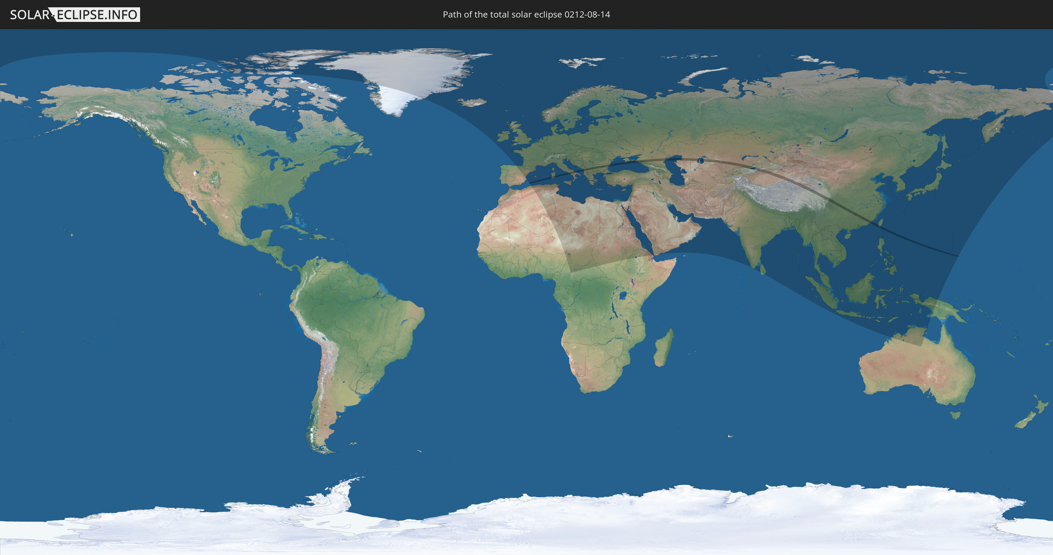
Die Sonnenfinsternis am 14.08.0212 kann man in 119 Ländern als partielle Sonnenfinsternis beobachten.
Der Finsternispfad verläuft durch 15 Länder. Nur in diesen Ländern ist sie als totale Sonnenfinsternis zu sehen.
In den folgenden Ländern ist die Sonnenfinsternis total zu sehen
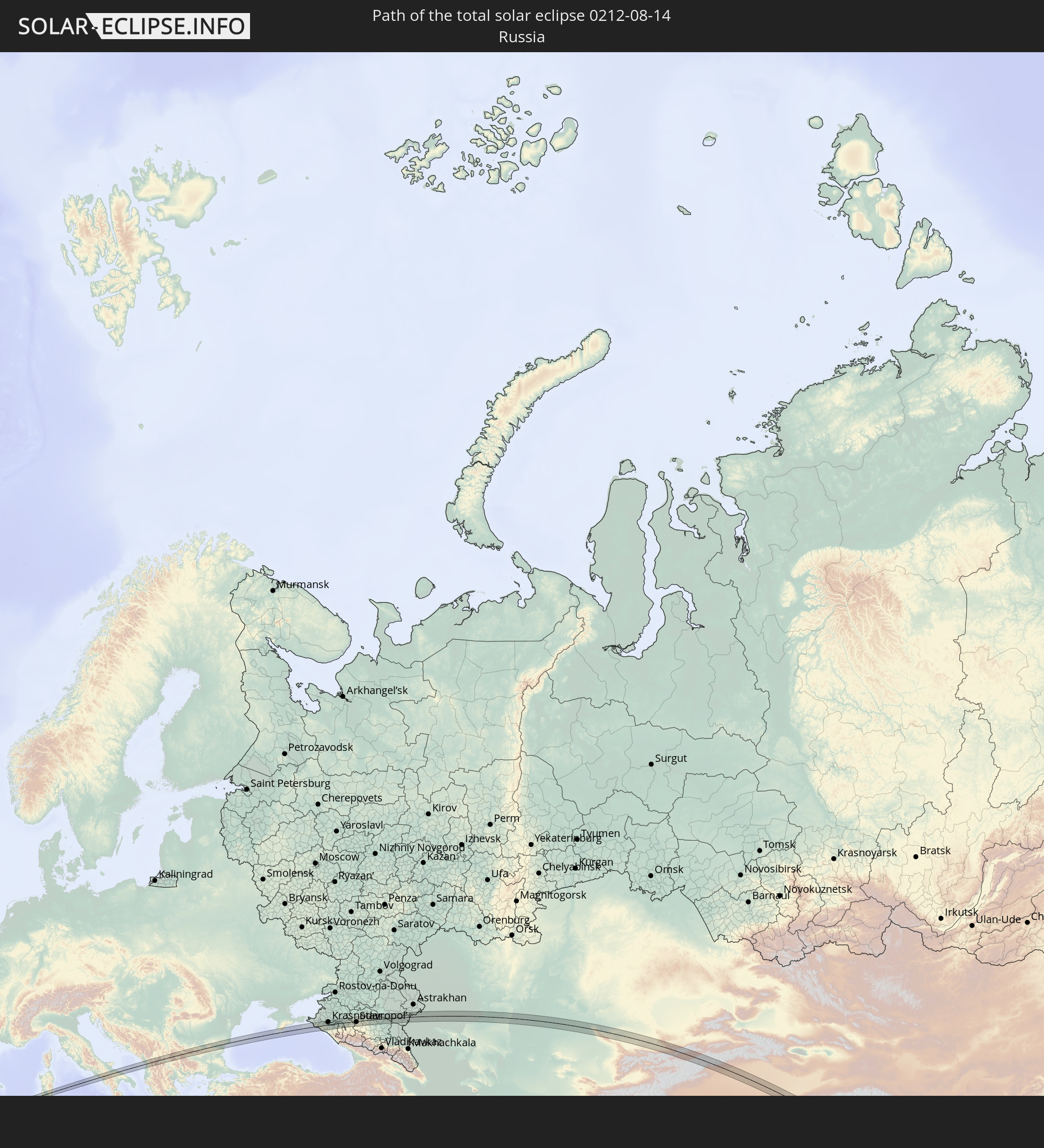 Russland
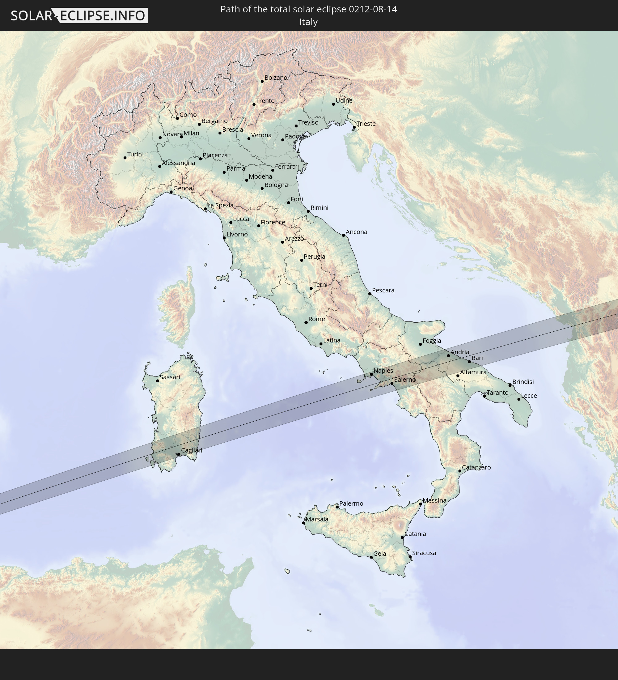 Italien
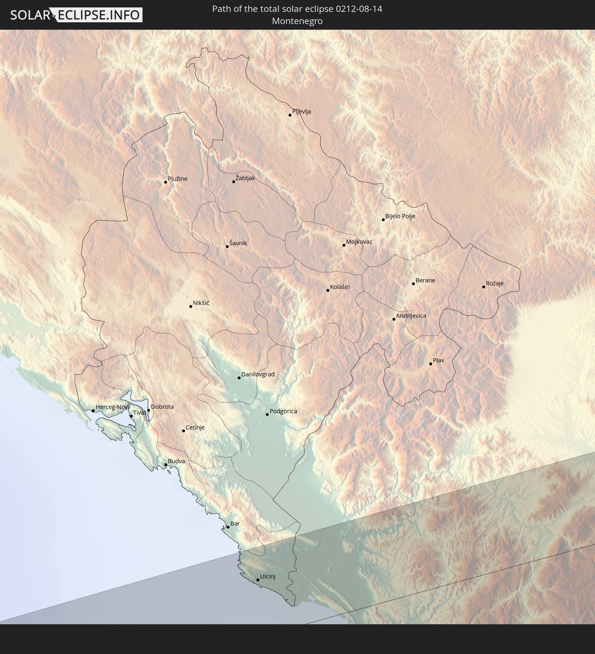 Montenegro
 Serbien
 Albanien
 Rumänien
 Mazedonien
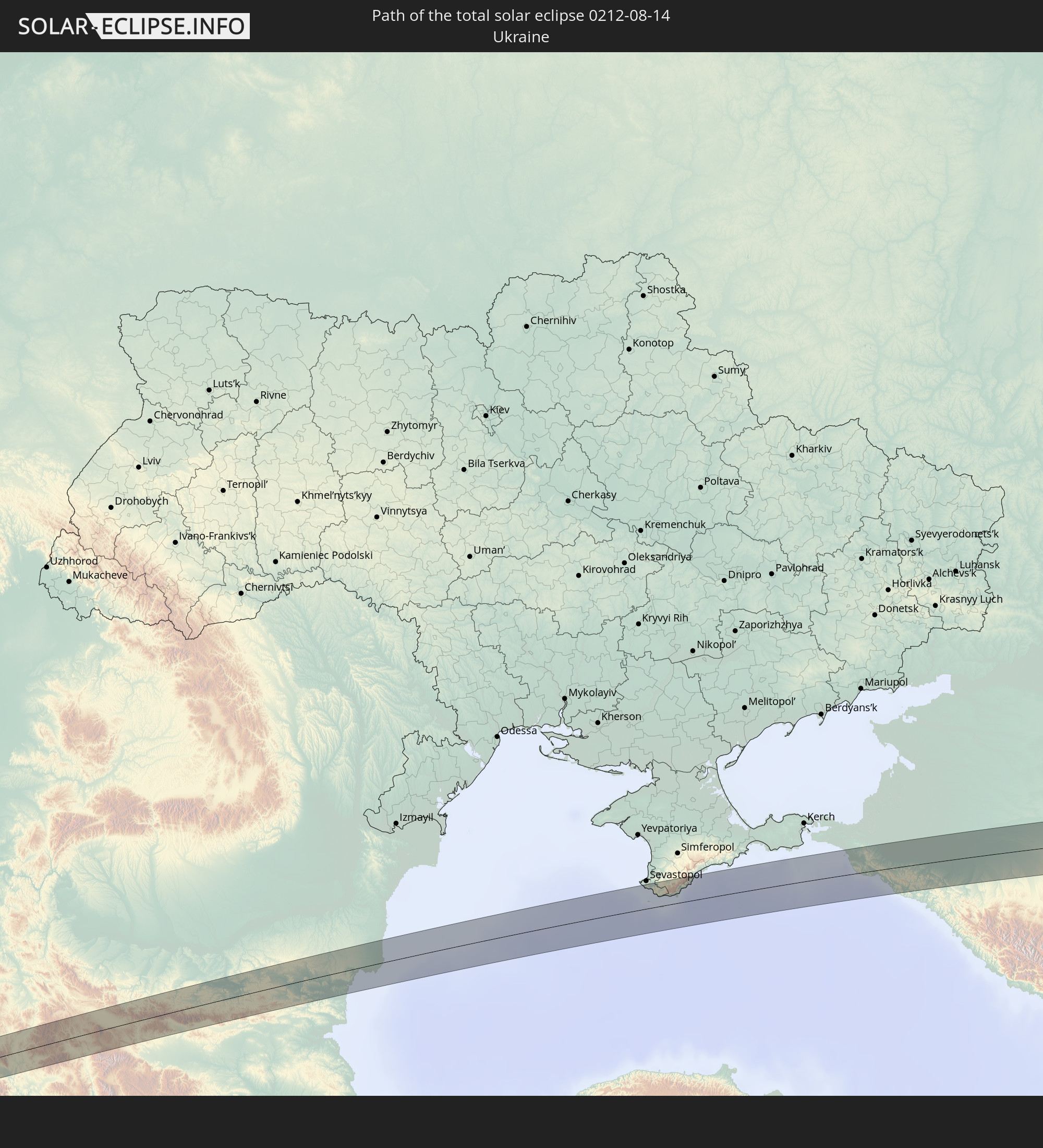 Ukraine
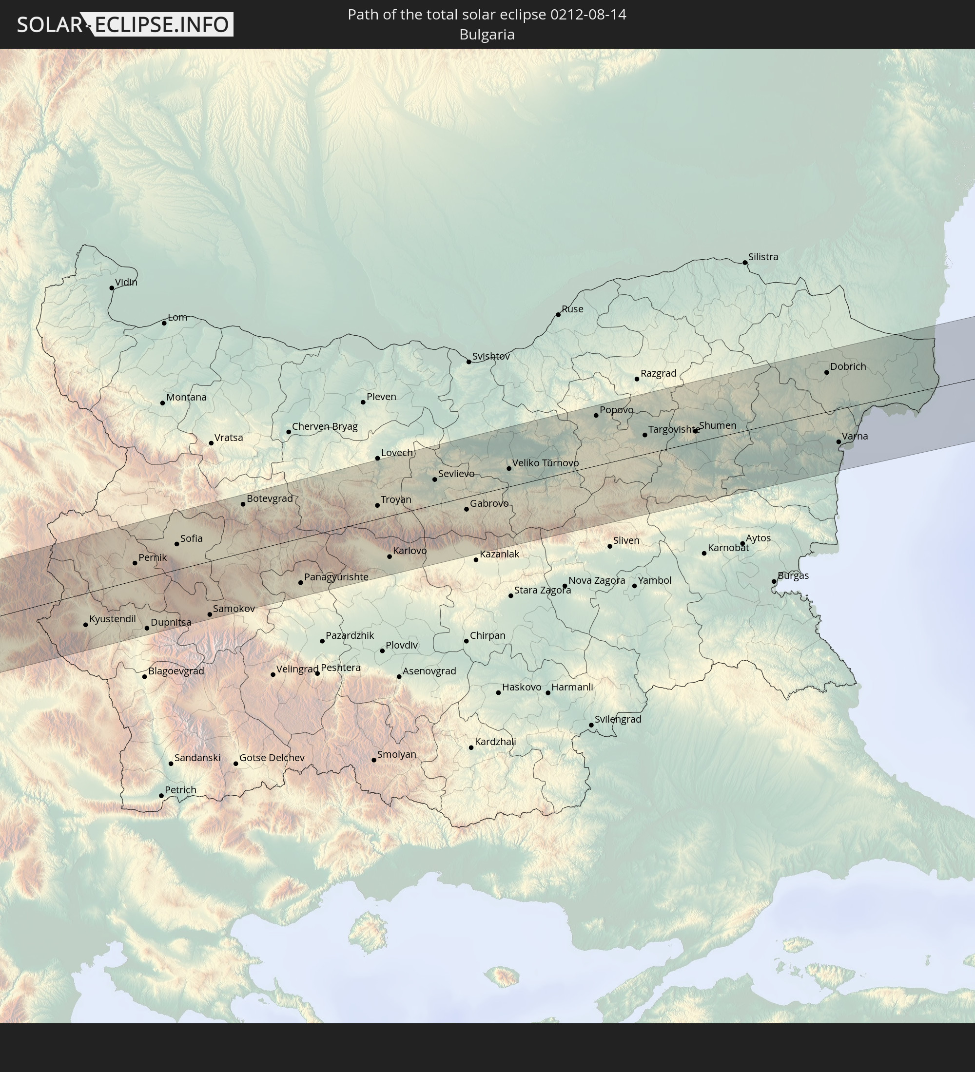 Bulgarien
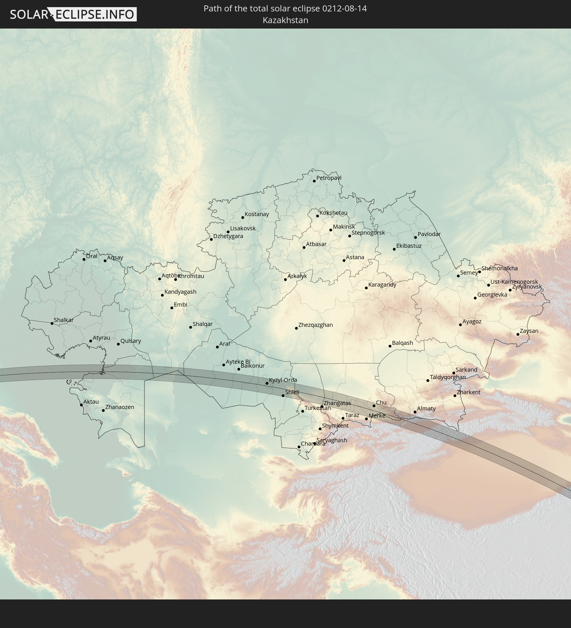 Kasachstan
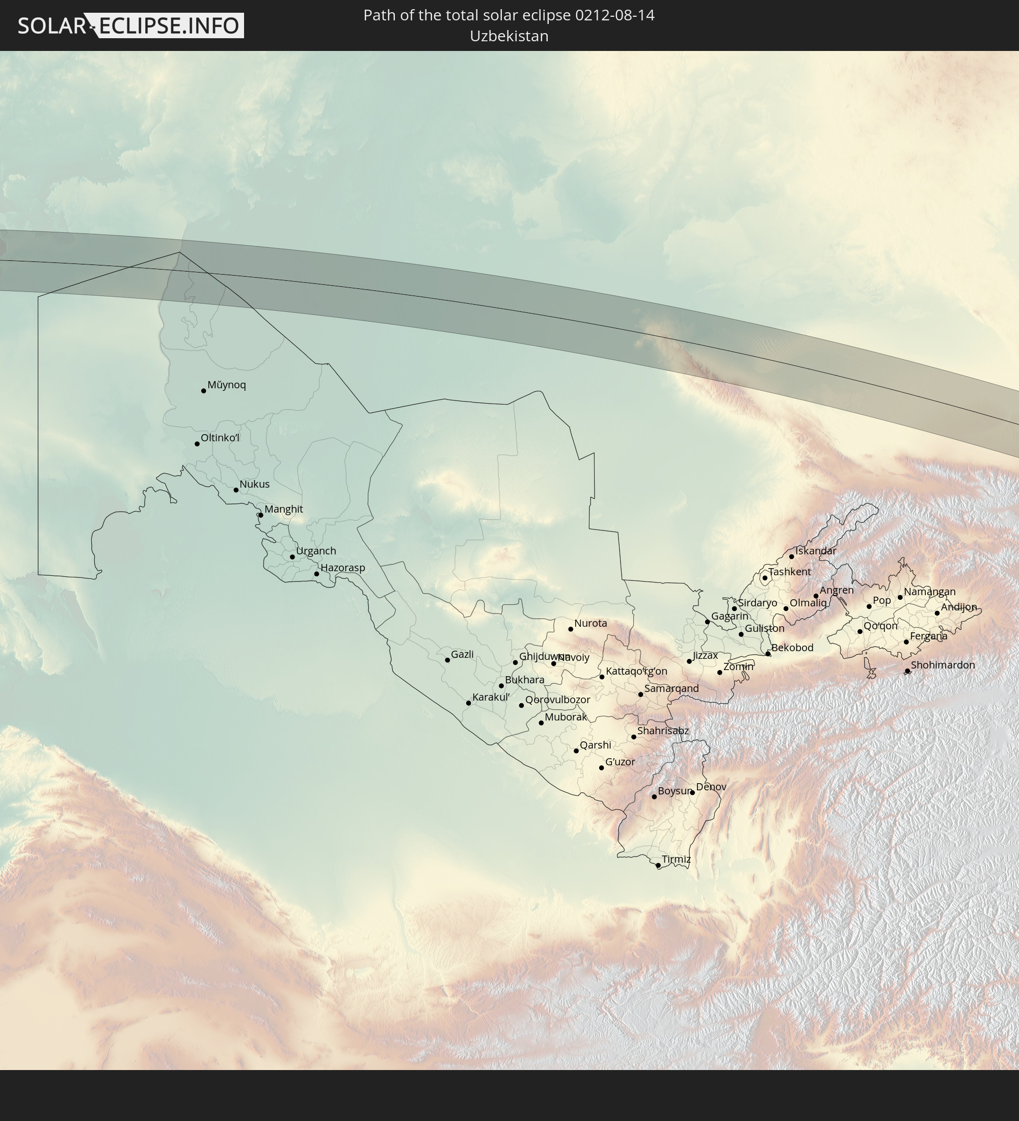 Usbekistan
 Kirgisistan
 Volksrepublik China
 Taiwan
 Guam
Guam
In den folgenden Ländern ist die Sonnenfinsternis partiell zu sehen
 Russland
 Vereinigte Staaten
 Kanada
 Grönland
 Island
 Spanien
 Irland
 Spitzbergen
 Algerien
 Vereinigtes Königreich
 Färöer
 Frankreich
 Isle of Man
 Guernsey
 Jersey
 Niger
Niger
 Andorra
 Belgien
 Nigeria
 Niederlande
 Norwegen
 Luxemburg
 Deutschland
 Schweiz
 Italien
 Monaco
 Tunesien
 Dänemark
 Kamerun
 Libyen
 Liechtenstein
 Österreich
 Schweden
 Tschechien
 San Marino
 Vatikanstadt
 Slowenien
 Tschad
 Kroatien
 Polen
Polen
 Malta
Malta
 Zentralafrikanische Republik
 Bosnien und Herzegowina
 Ungarn
 Slowakei
 Montenegro
 Serbien
 Albanien
 Åland Islands
 Griechenland
 Rumänien
 Mazedonien
 Finnland
 Litauen
 Lettland
 Estland
 Sudan
Sudan
 Ukraine
 Bulgarien
 Weißrussland
 Ägypten
 Türkei
 Moldawien
 Republik Zypern
 Äthiopien
 Staat Palästina
 Israel
 Saudi-Arabien
 Jordanien
 Libanon
 Syrien
 Eritrea
 Irak
Irak
 Georgien
 Jemen
Jemen
 Armenien
 Iran
Iran
 Aserbaidschan
 Kasachstan
 Kuwait
 Bahrain
 Katar
Katar
 Vereinigte Arabische Emirate
 Oman
Oman
 Turkmenistan
 Usbekistan
 Afghanistan
 Pakistan
 Tadschikistan
 Indien
 Kirgisistan
 Volksrepublik China
 Sri Lanka
 Nepal
Nepal
 Mongolei
 Bangladesch
 Bhutan
 Myanmar
 Indonesien
 Thailand
 Malaysia
 Laos
Laos
 Vietnam
 Kambodscha
 Singapur
 Australien
 Macau
Macau
 Hongkong
 Brunei
 Taiwan
 Philippinen
 Japan
Japan
 Osttimor
 Nordkorea
 Südkorea
 Palau
Palau
 Föderierte Staaten von Mikronesien
 Guam
Guam
 Nördliche Marianen
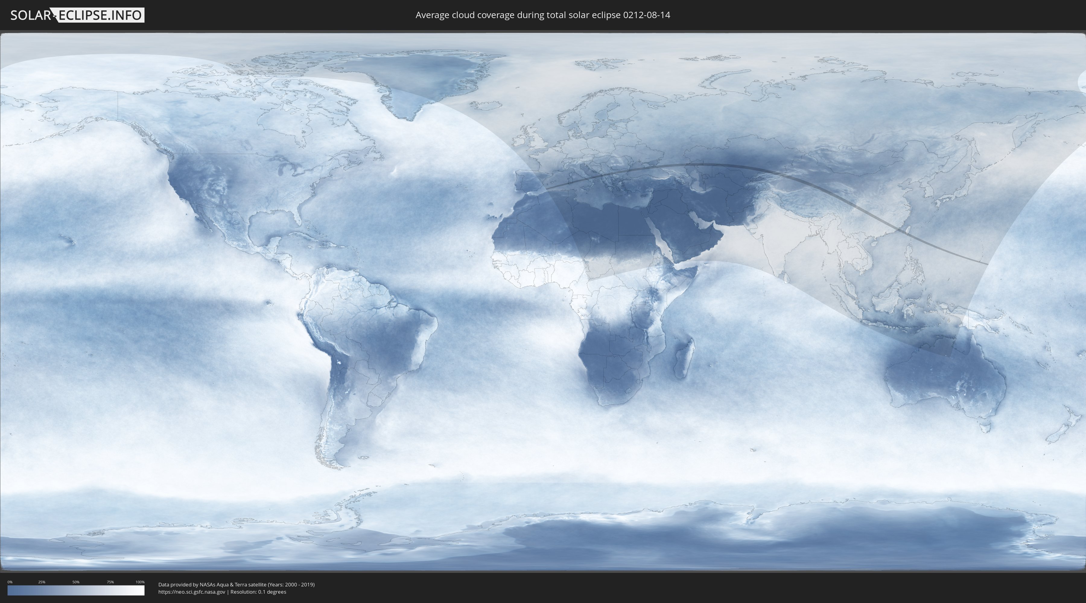
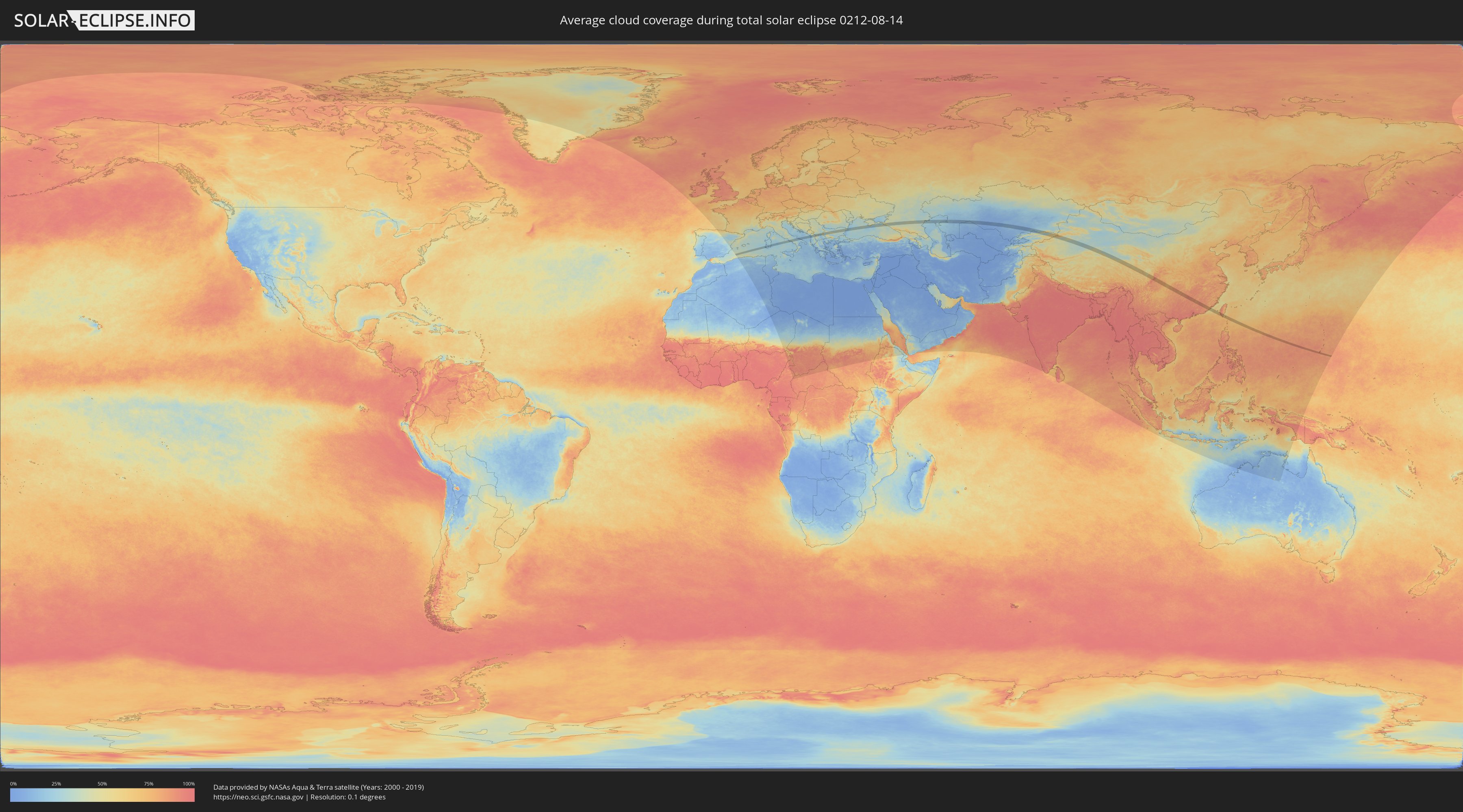
Wie wird das Wetter während der totalen Sonnenfinsternis am 14.08.0212?
Wo ist der beste Ort, um die totale Sonnenfinsternis vom 14.08.0212 zu beobachten?
Die folgenden Karten zeigen die durchschnittliche Bewölkung für den Tag, an dem die totale Sonnenfinsternis
stattfindet. Mit Hilfe der Karten lässt sich der Ort entlang des Finsternispfades eingrenzen,
der die besten Aussichen auf einen klaren wolkenfreien Himmel bietet.
Trotzdem muss man immer lokale Gegenenheiten beachten und sollte sich genau über das Wetter an seinem
gewählten Beobachtungsort informieren.
Die Daten stammen von den beiden NASA-Satelliten
AQUA und TERRA
und wurden über einen Zeitraum von 19 Jahren (2000 - 2019) gemittelt.
Detaillierte Länderkarten
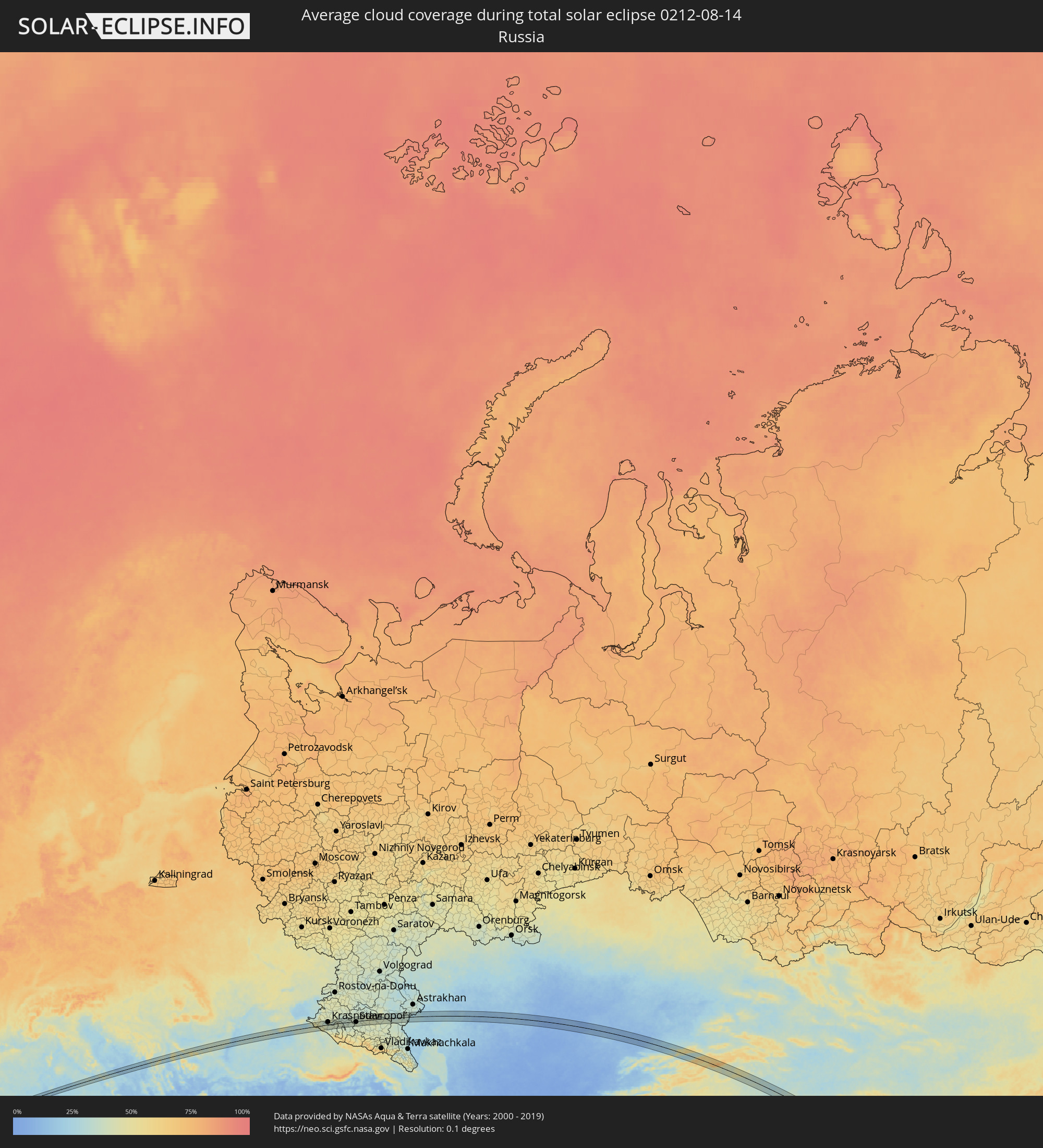 Russland
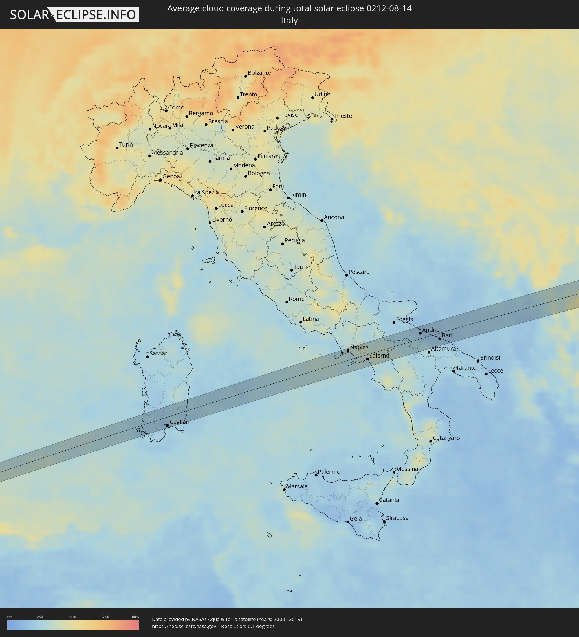 Italien
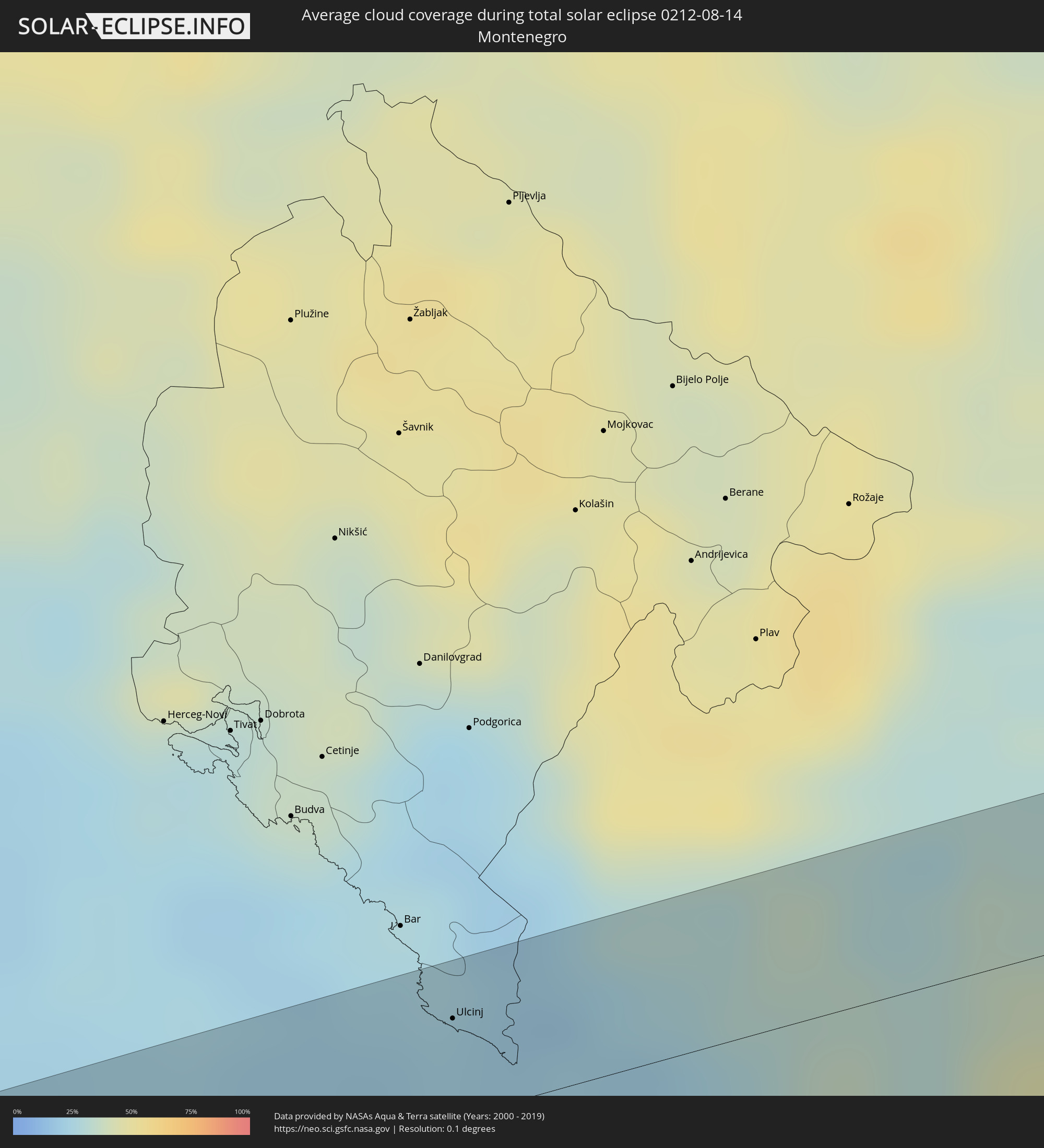 Montenegro
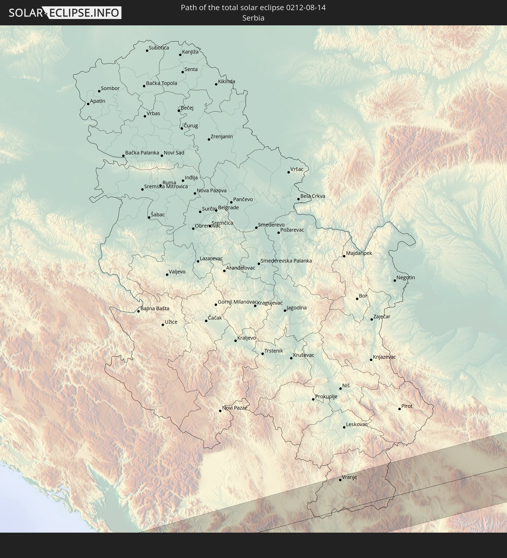
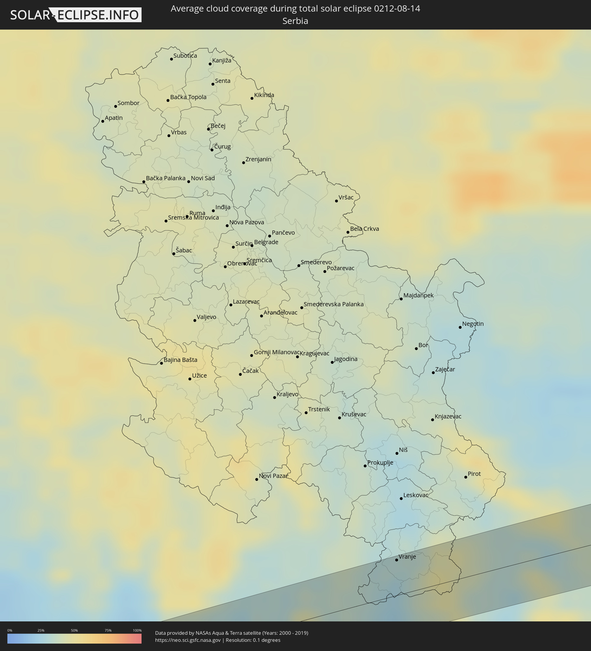 Serbien
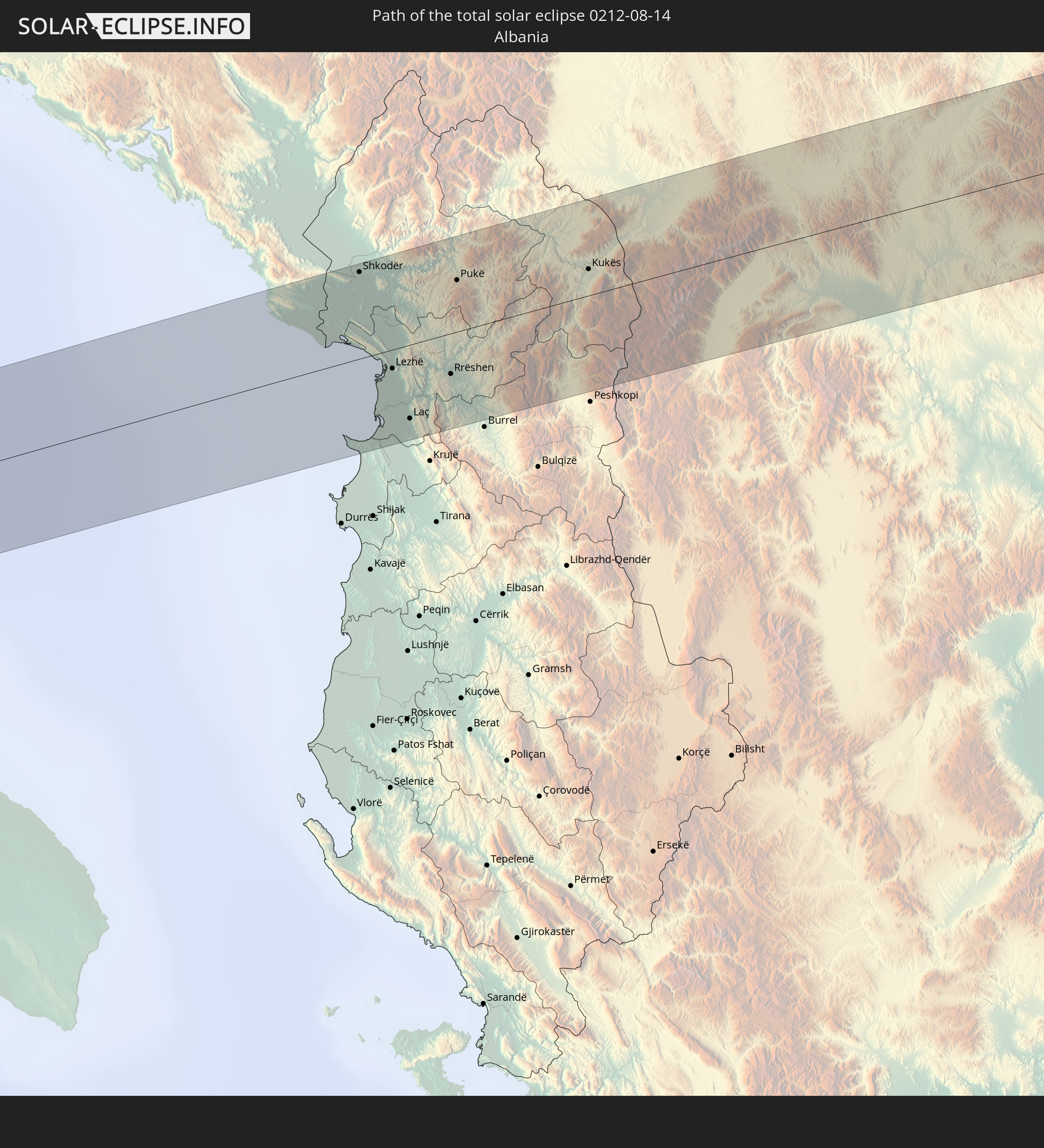
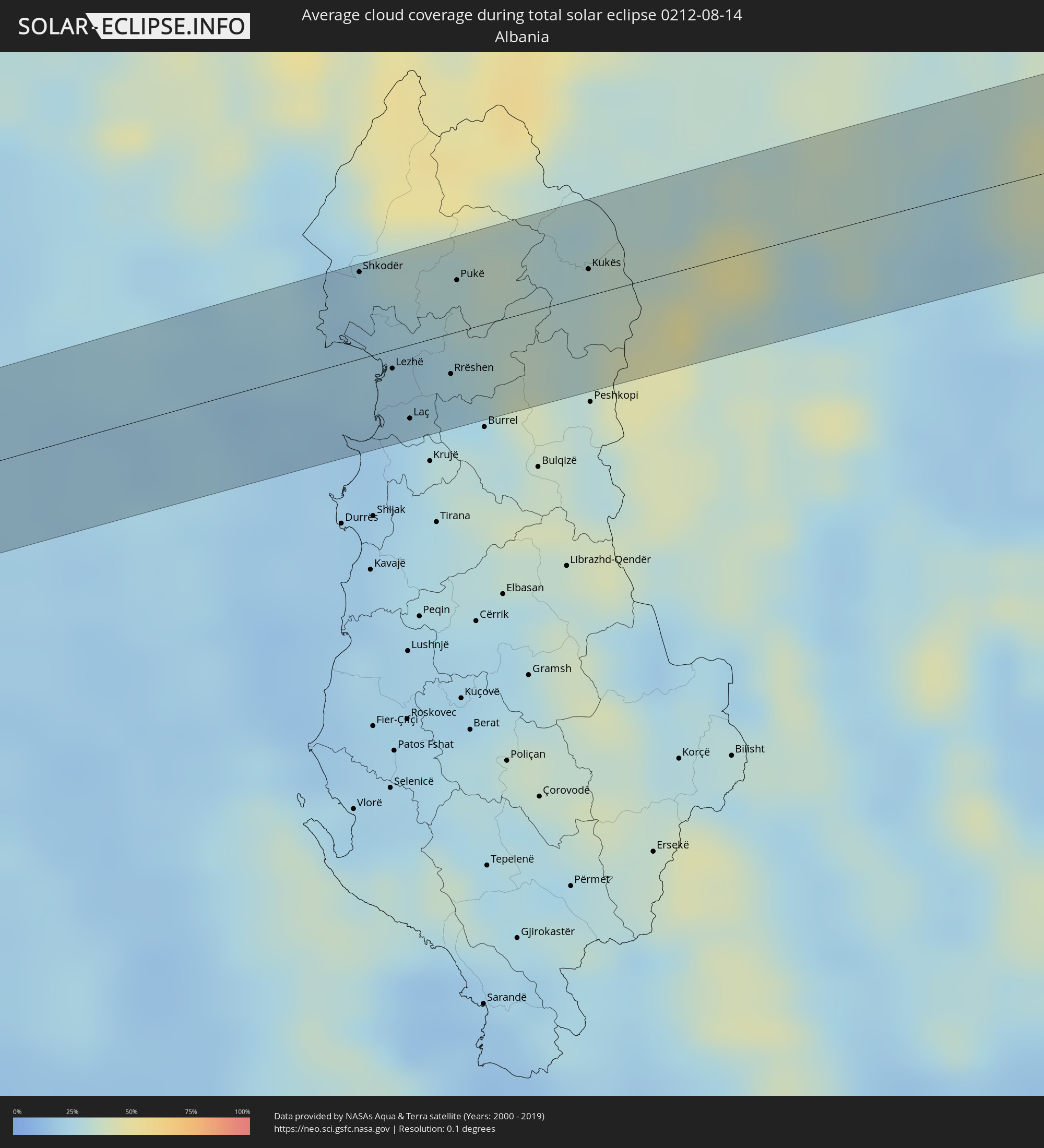 Albanien
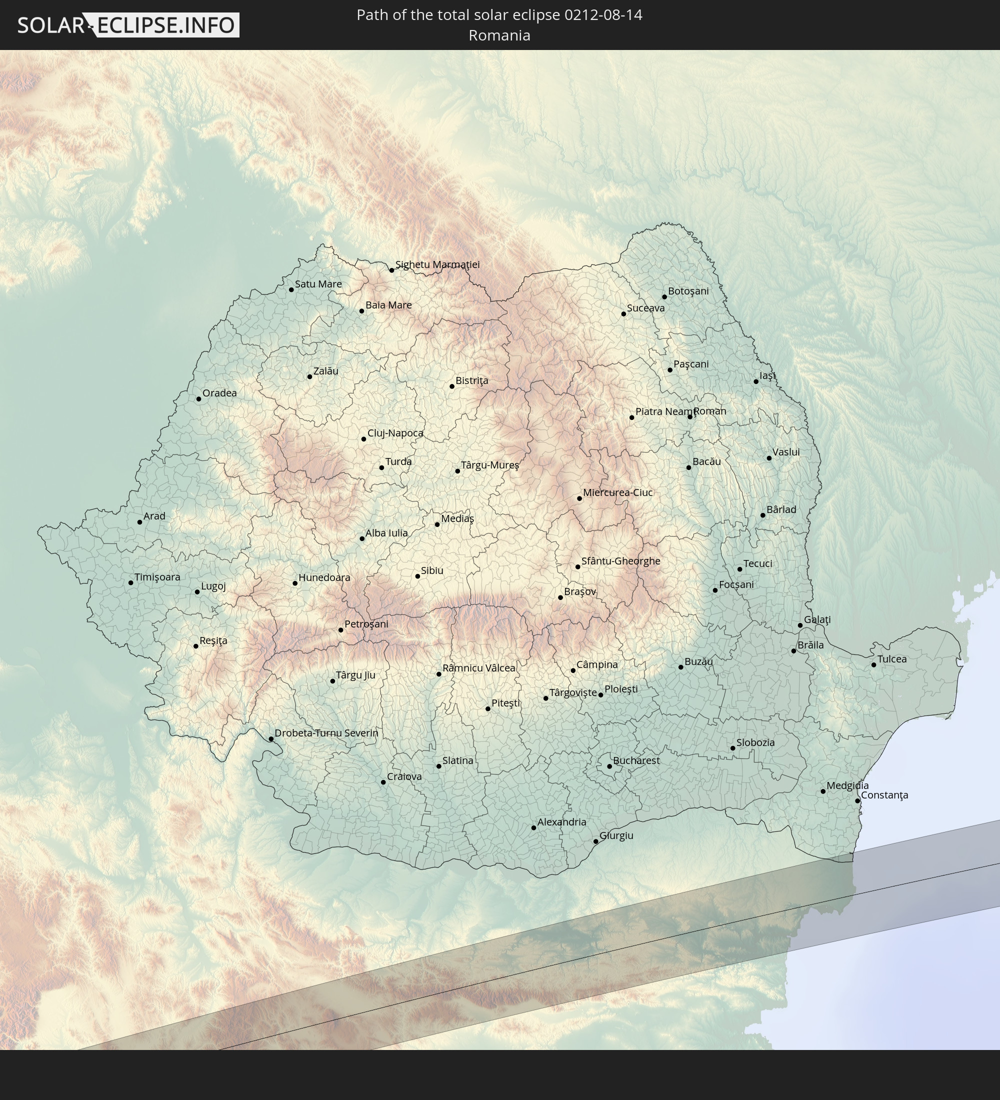
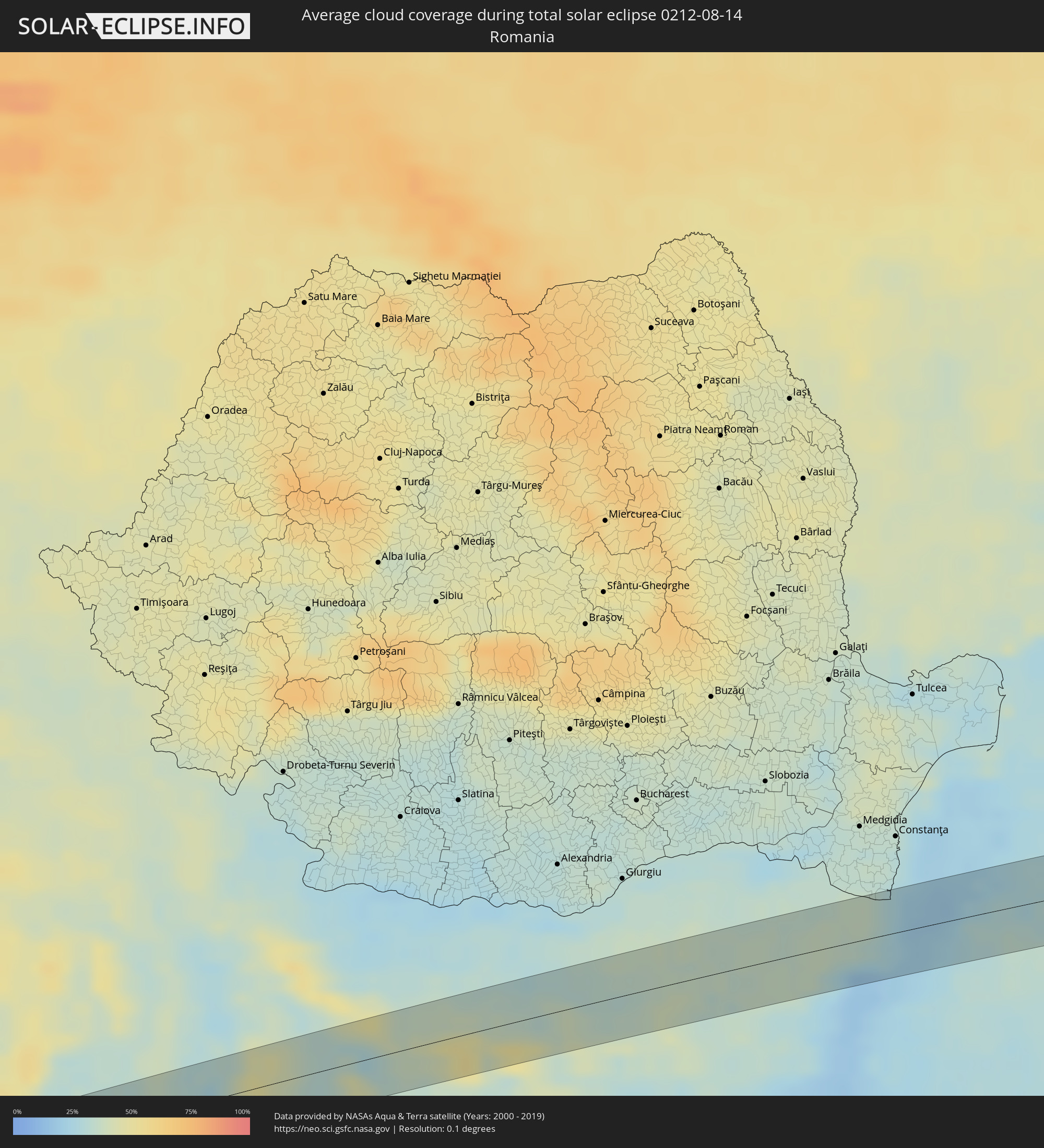 Rumänien
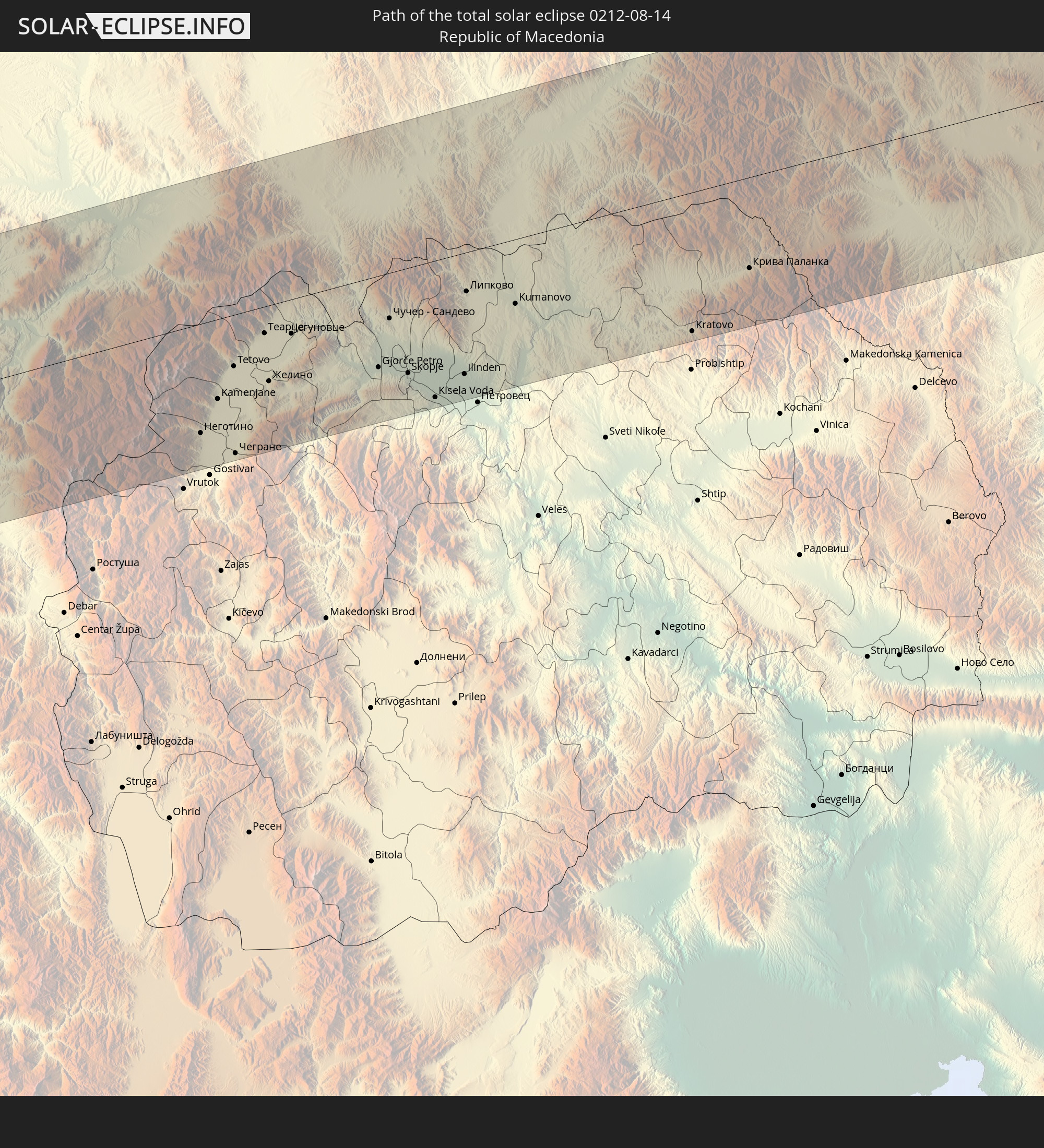
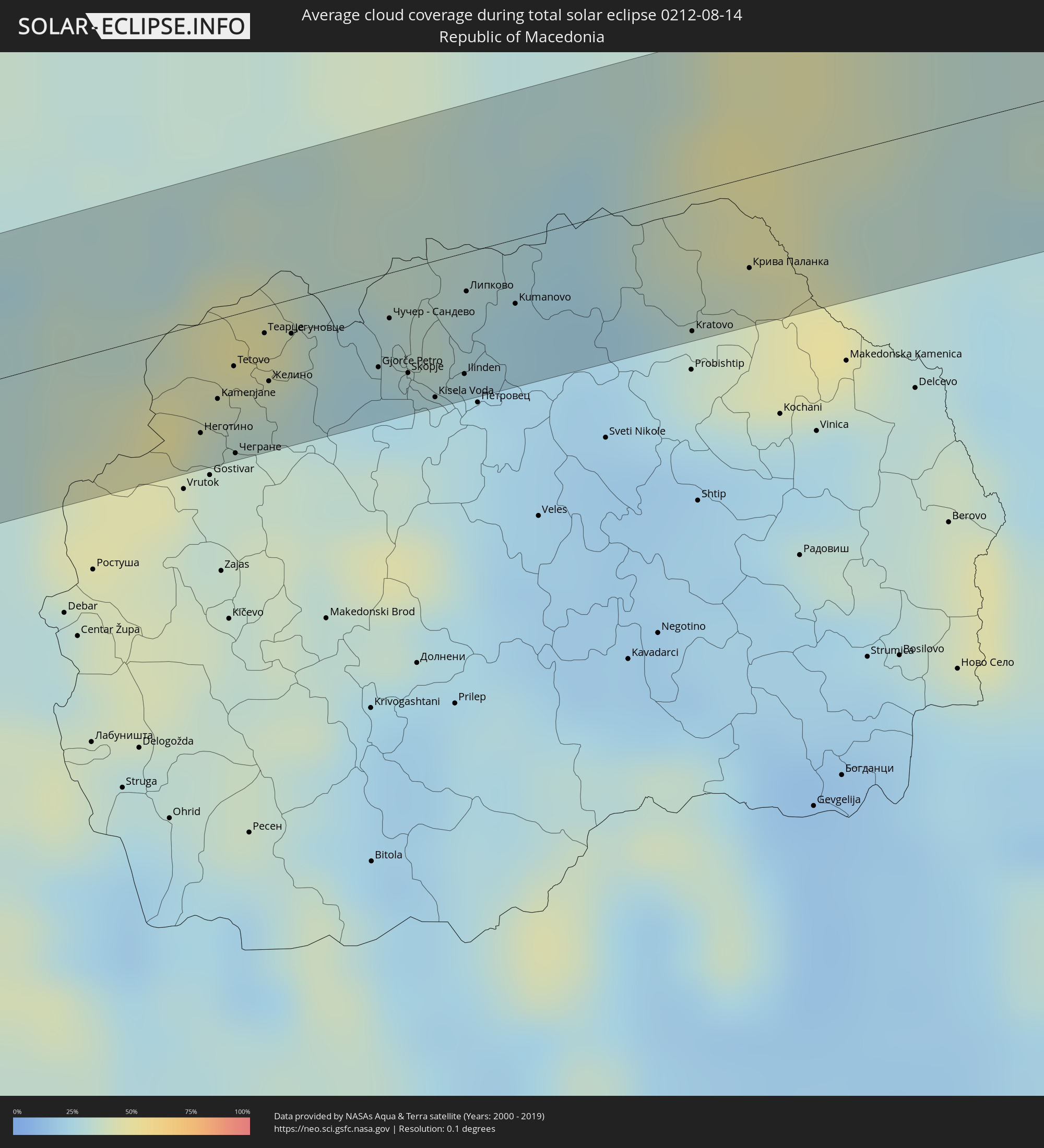 Mazedonien
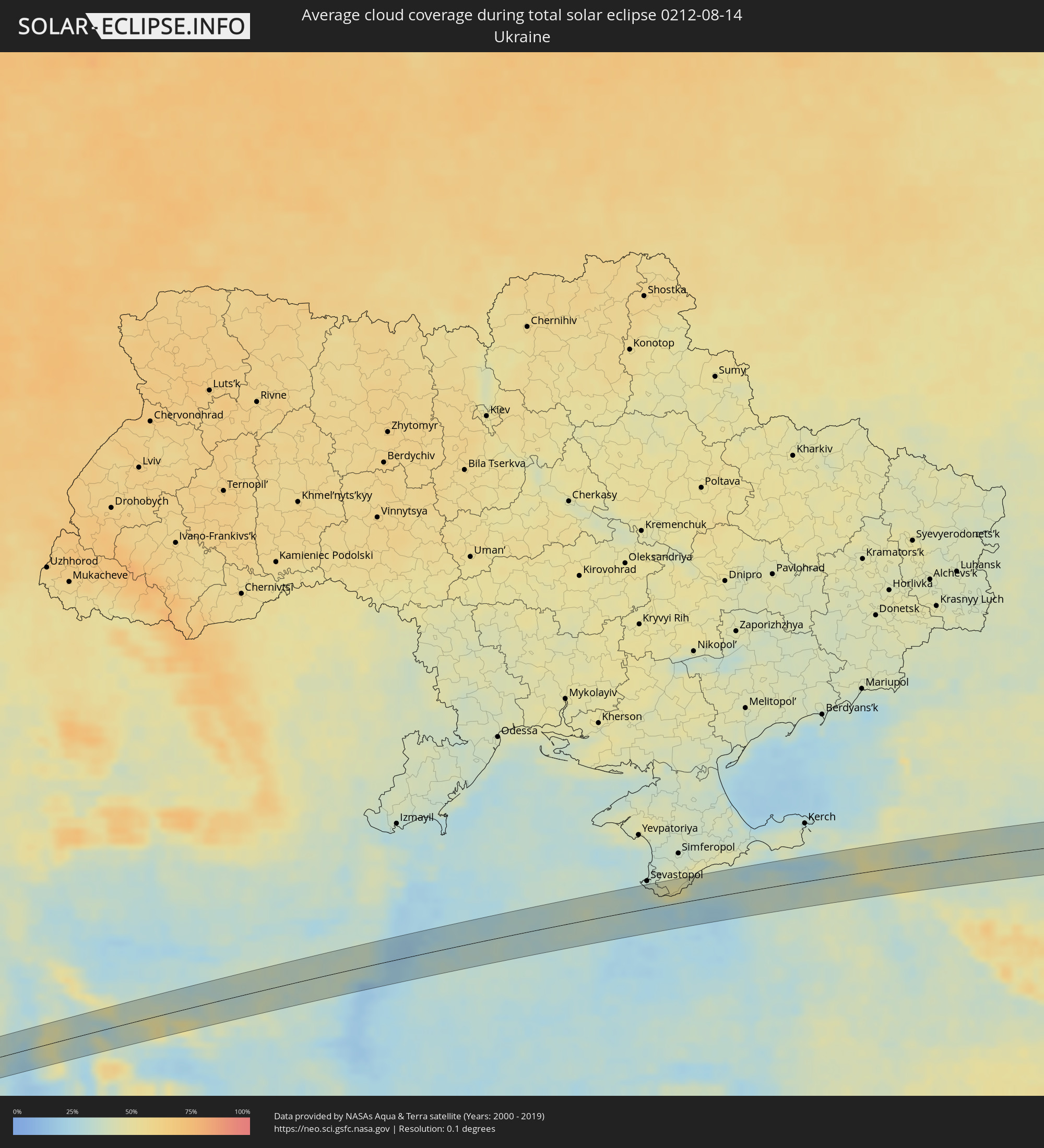 Ukraine
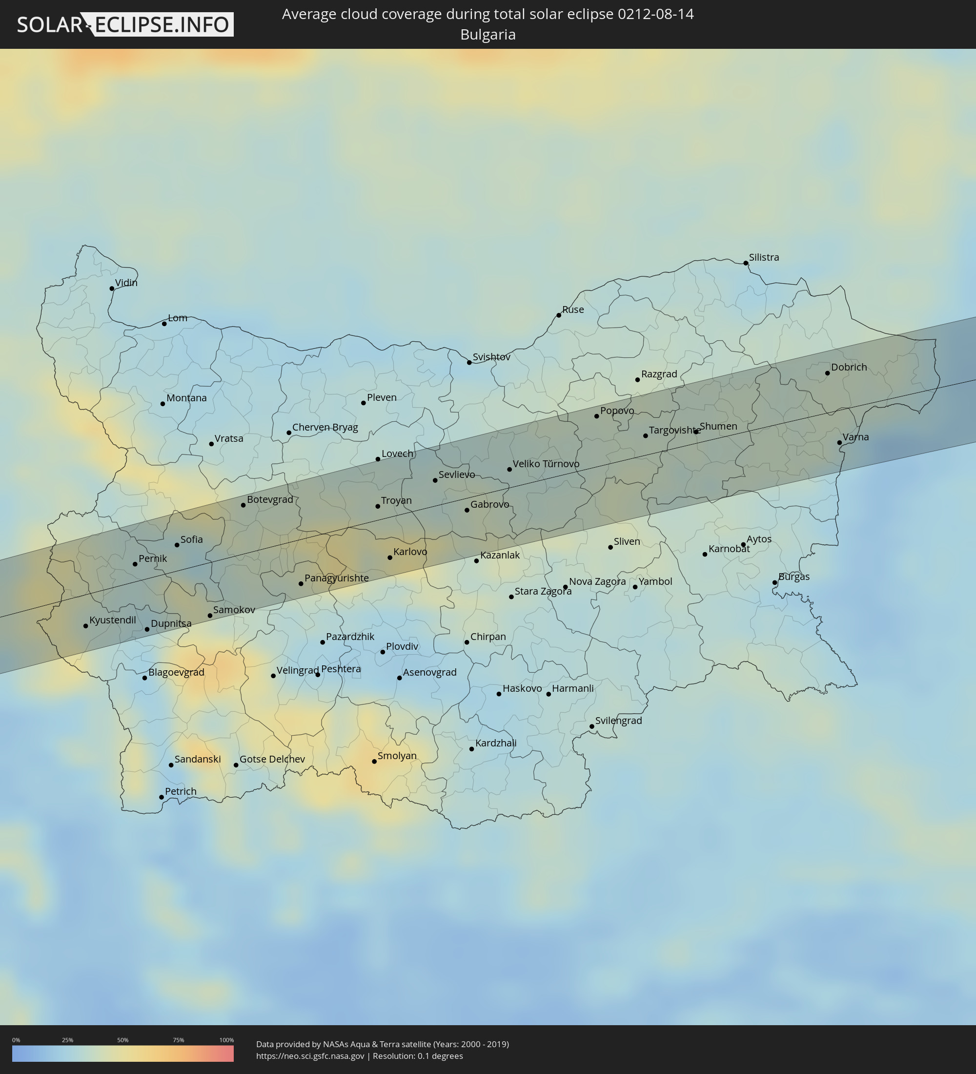 Bulgarien
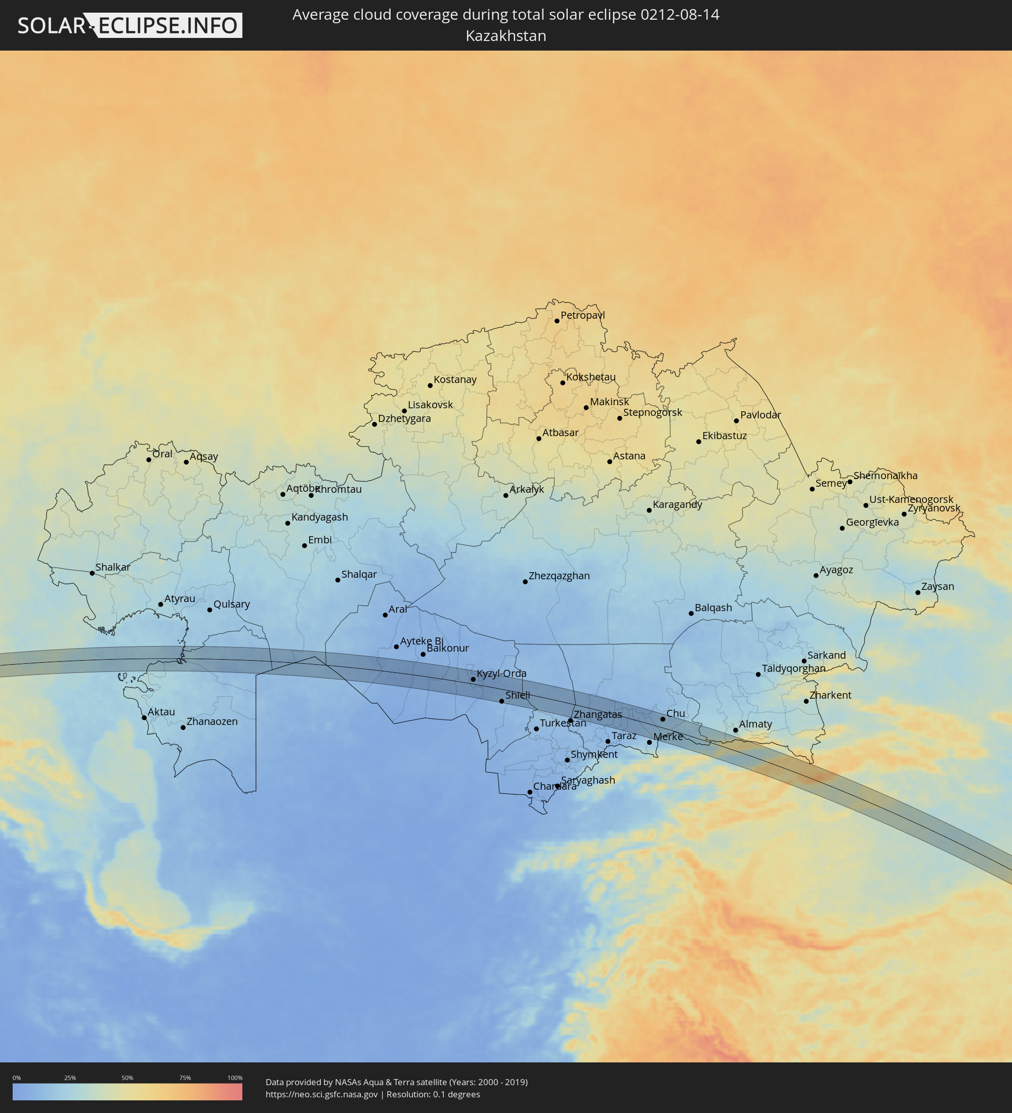 Kasachstan
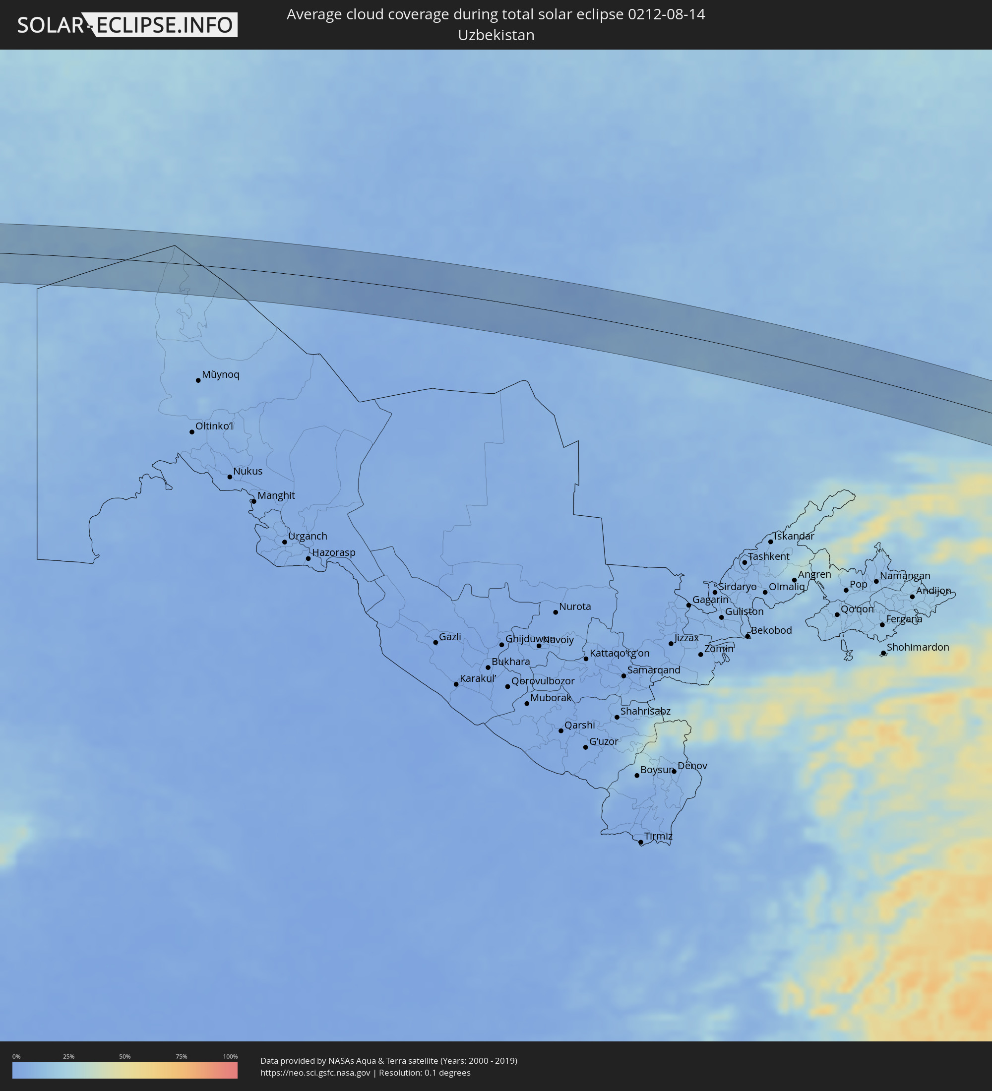 Usbekistan
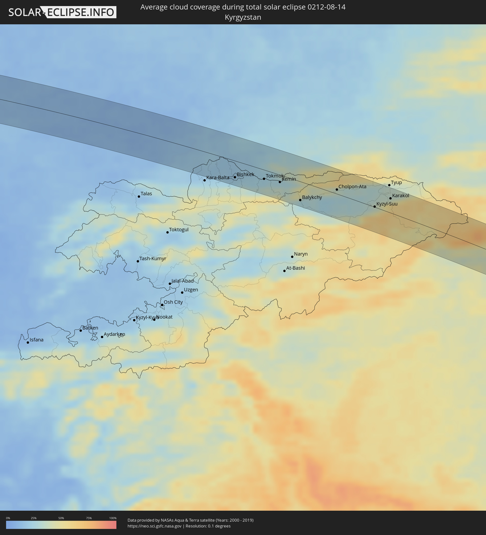 Kirgisistan
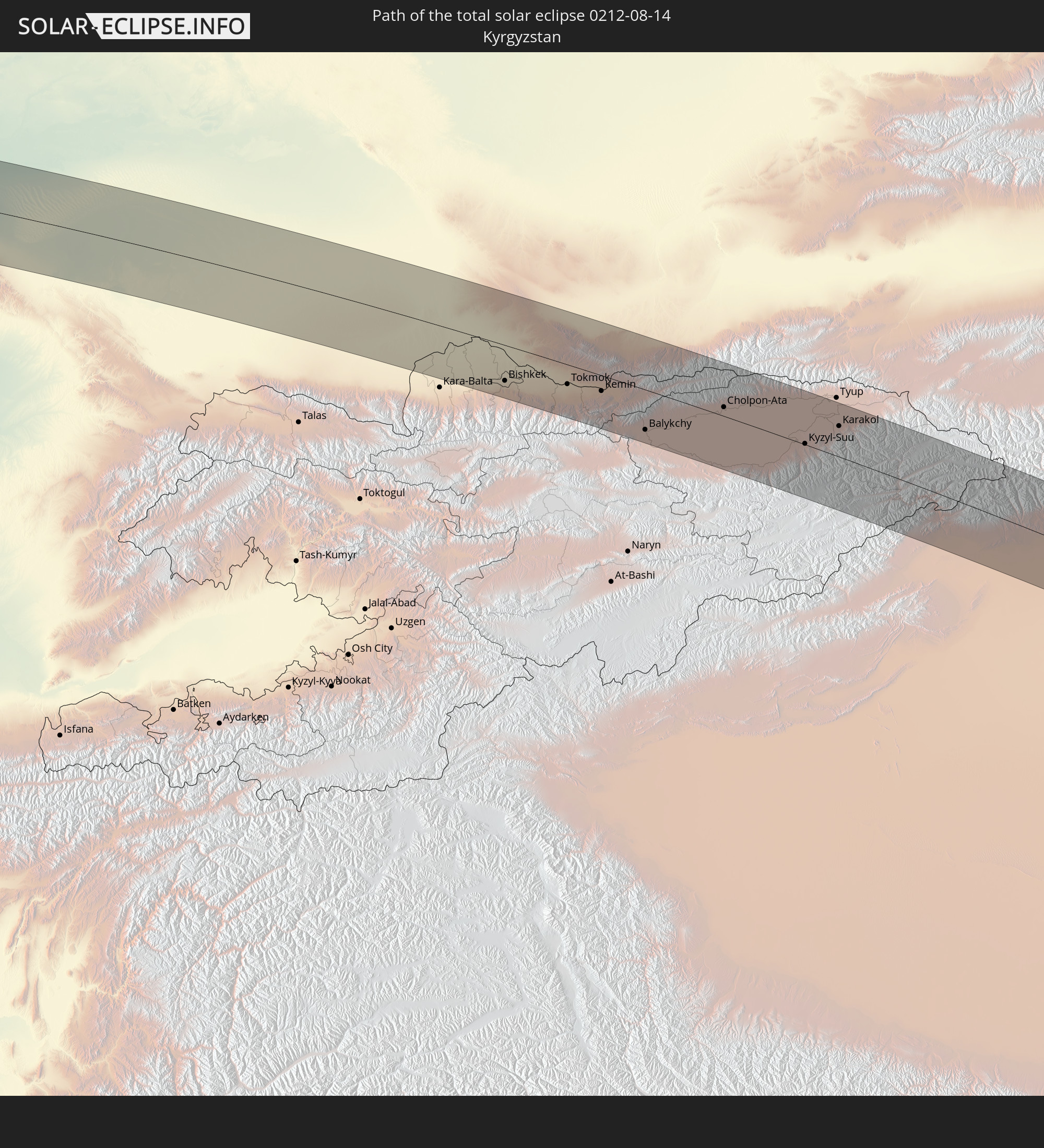
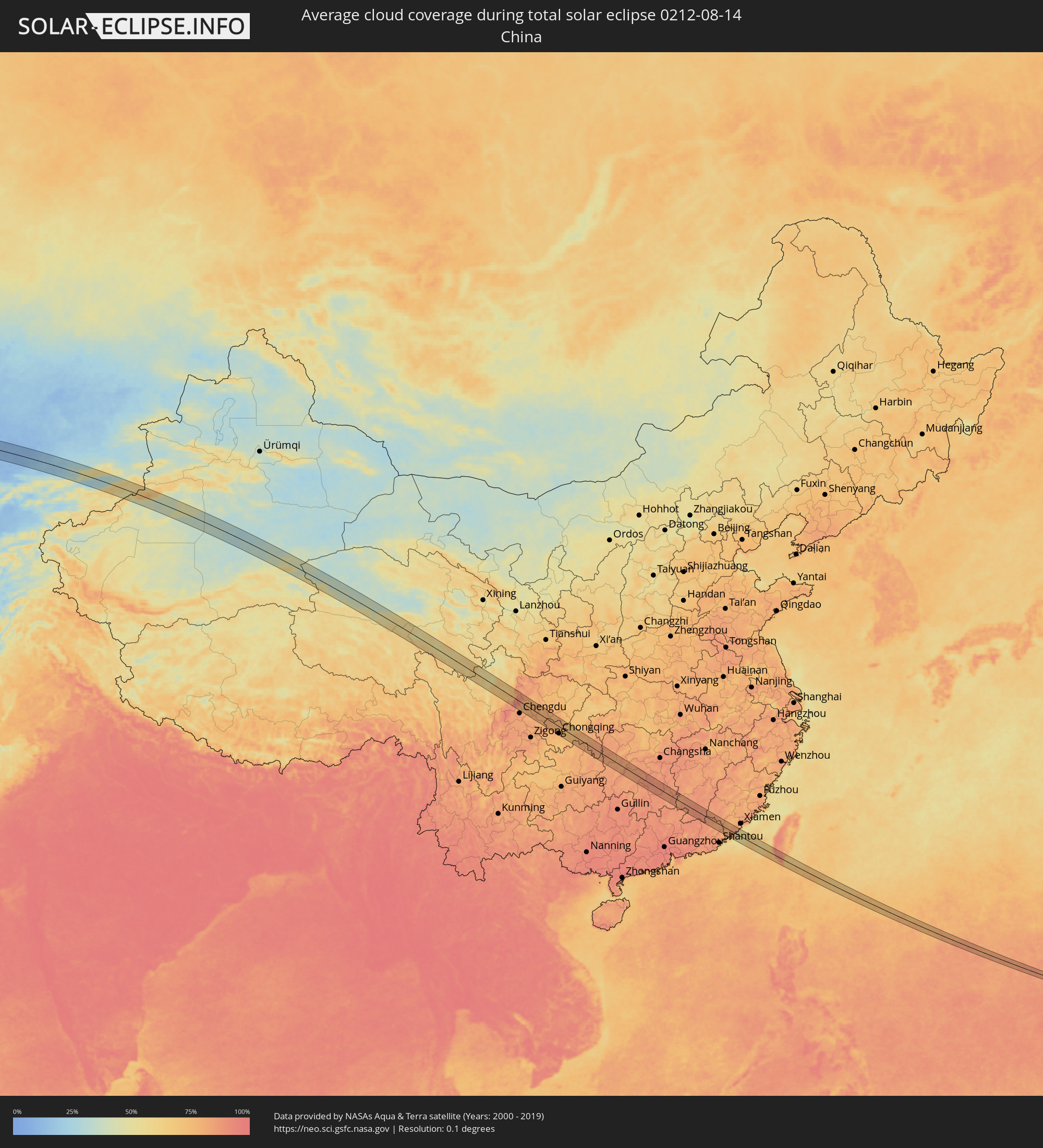 Volksrepublik China
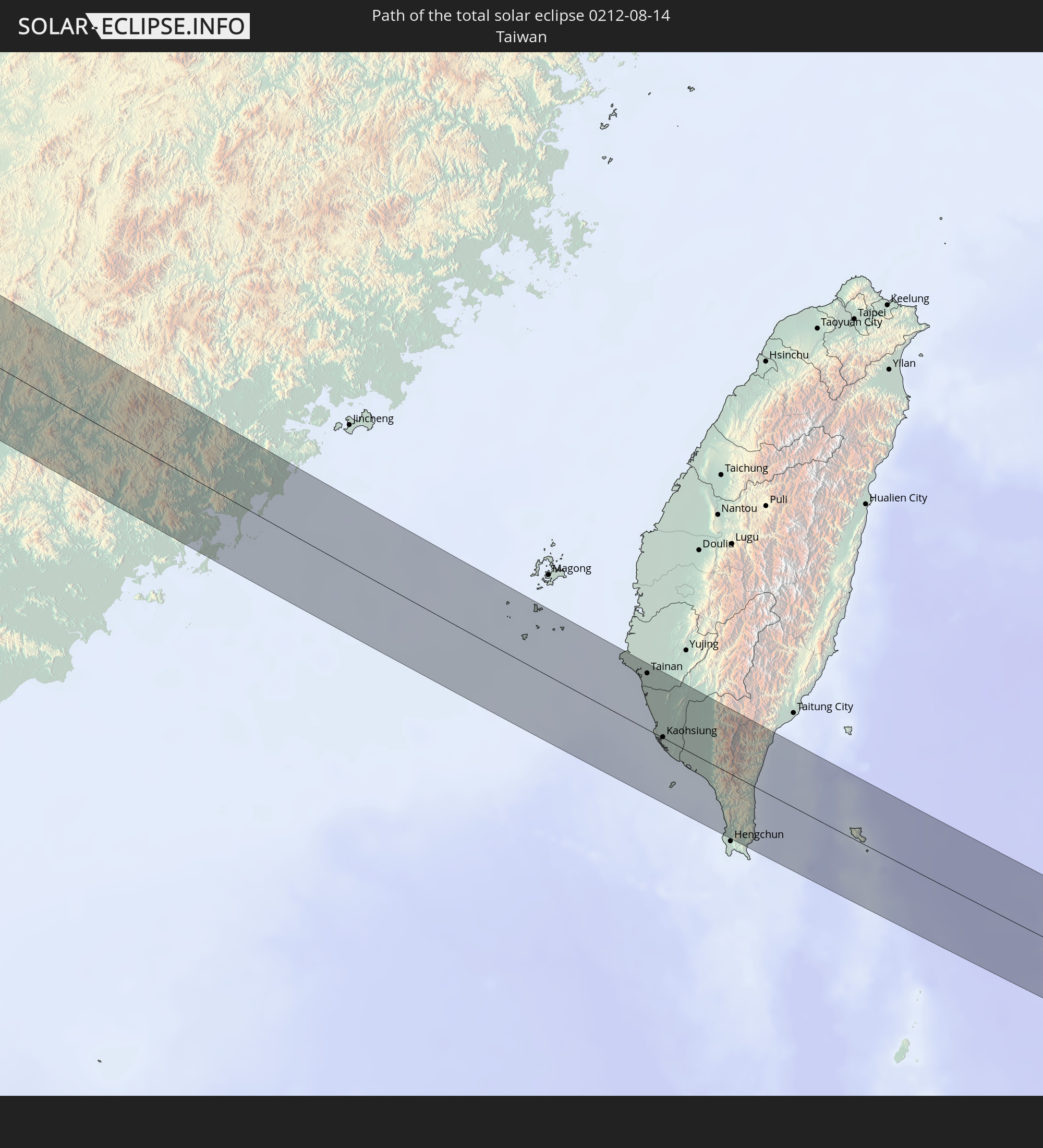
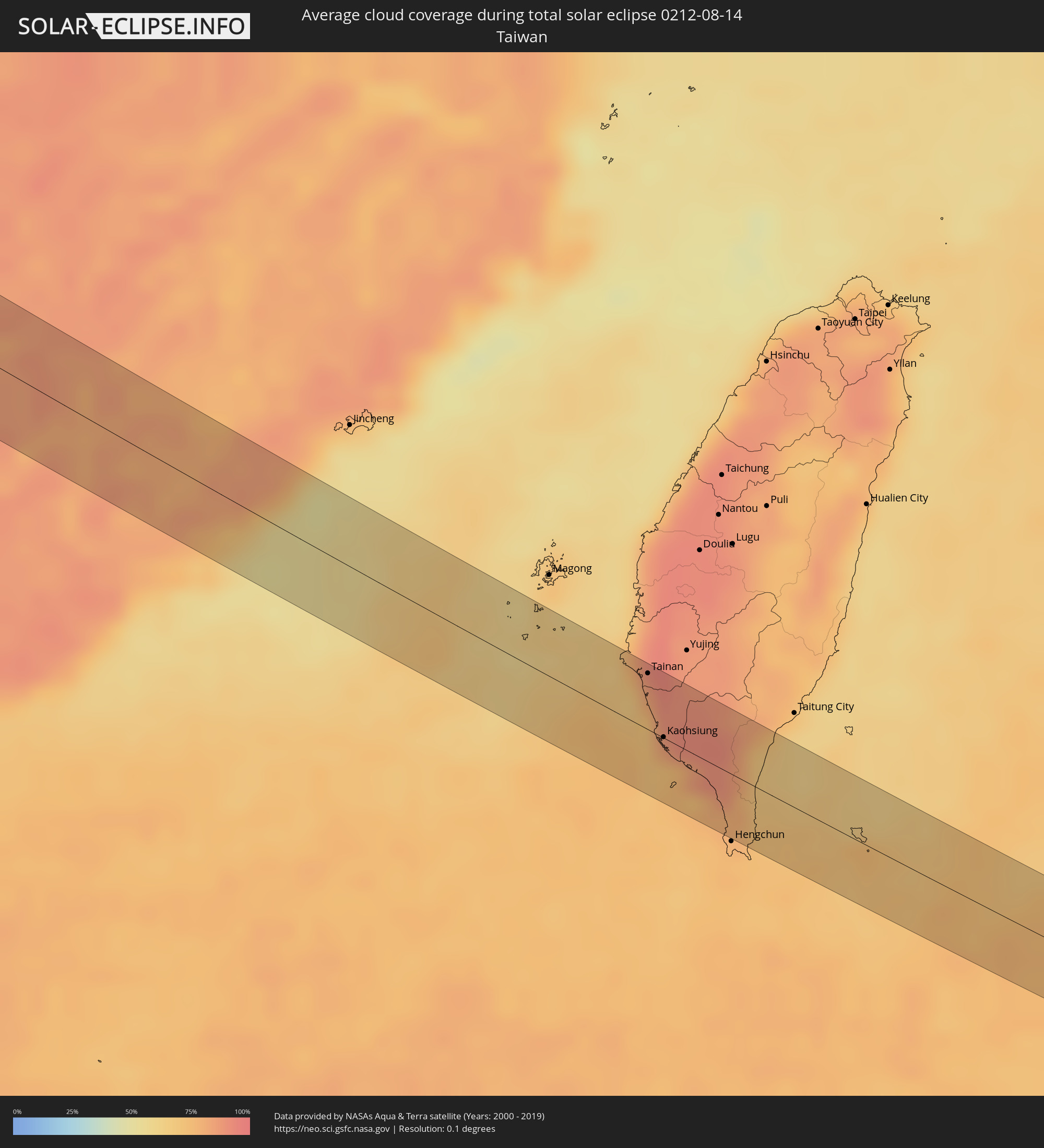 Taiwan
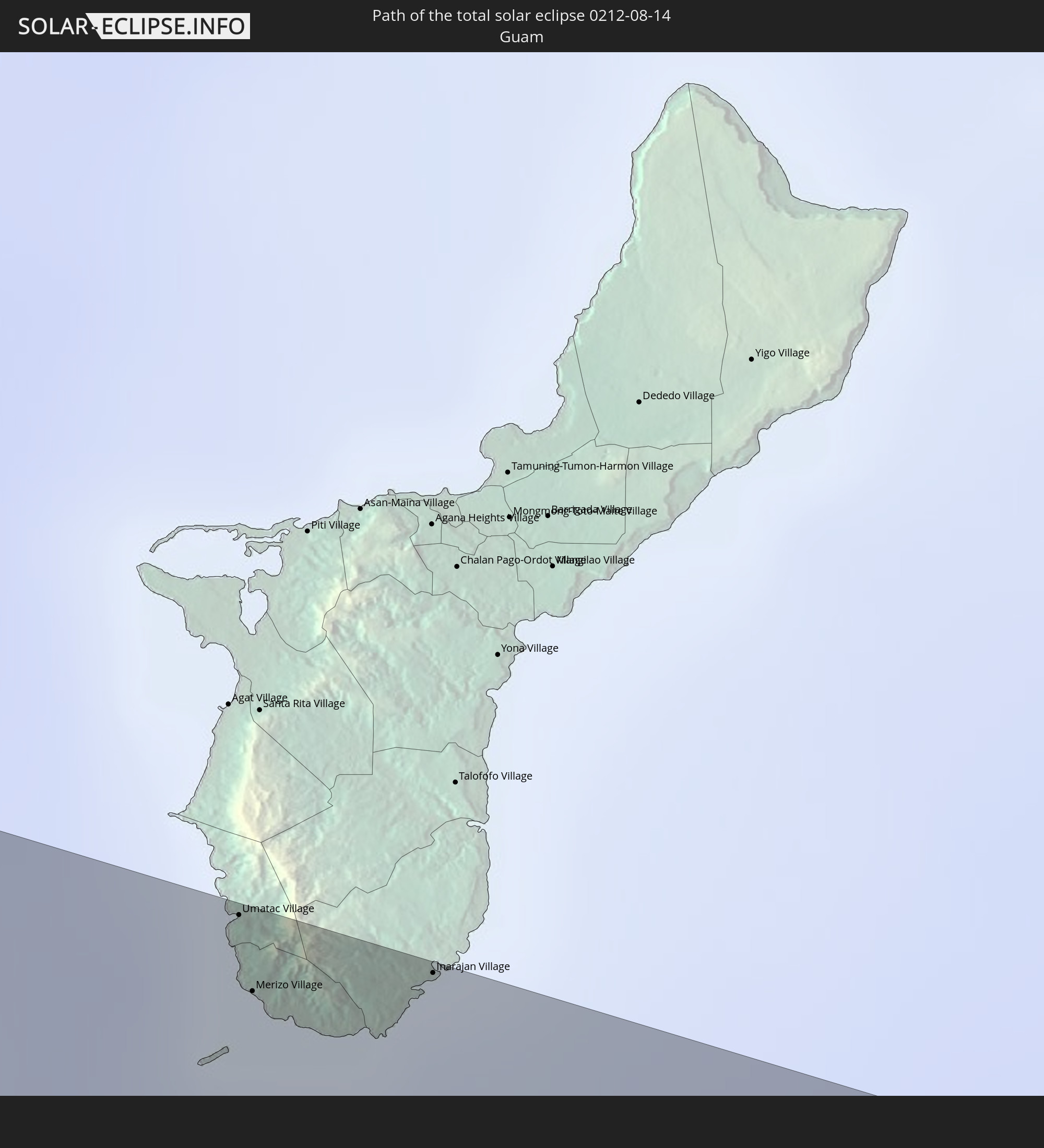
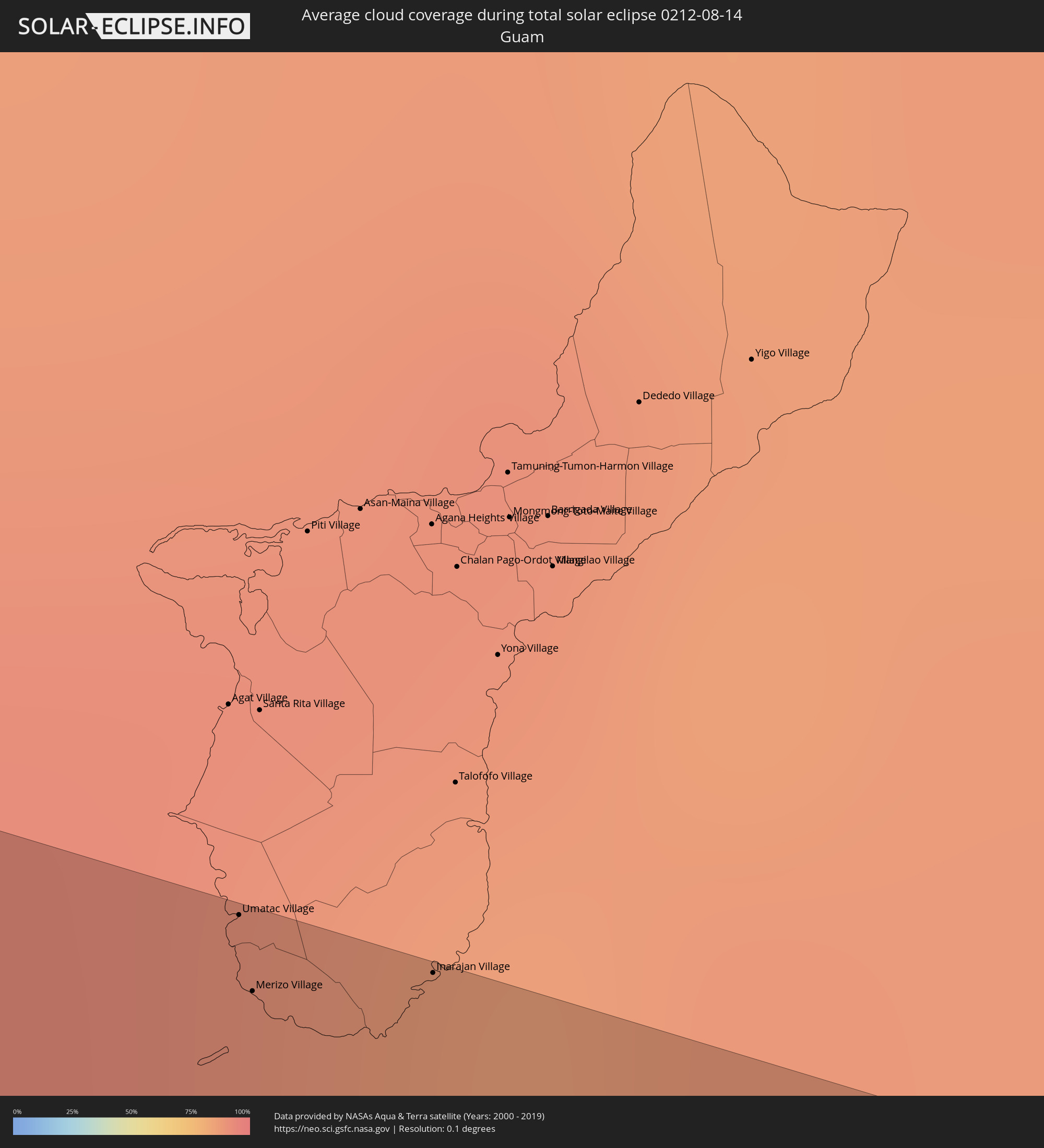 Guam
Guam
Orte im Finsternispfad
Die nachfolgene Tabelle zeigt Städte und Orte mit mehr als 5.000 Einwohnern, die sich im Finsternispfad befinden. Städte mit mehr als 100.000 Einwohnern sind dick gekennzeichnet. Mit einem Klick auf den Ort öffnet sich eine Detailkarte die die Lage des jeweiligen Ortes zusammen mit dem Verlauf der zentralen Finsternis präsentiert.
| Ort | Typ | Dauer der Verfinsterung | Ortszeit bei maximaler Verfinsterung | Entfernung zur Zentrallinie | Ø Bewölkung |
|
Cagliari, Sardinia
|
total | - | 06:12:46 UTC+01:00 | 21 km | 26% |
|
Bacoli, Campania
|
total | - | 06:14:32 UTC+01:00 | 19 km | 32% |
|
Naples, Campania
|
total | - | 06:14:37 UTC+01:00 | 21 km | 29% |
|
Somma Vesuviana, Campania
|
total | - | 06:14:39 UTC+01:00 | 18 km | 29% |
|
Castellammare di Stabia, Campania
|
total | - | 06:14:29 UTC+01:00 | 1 km | 31% |
|
Sarno, Campania
|
total | - | 06:14:36 UTC+01:00 | 7 km | 30% |
|
Avellino, Campania
|
total | - | 06:14:44 UTC+01:00 | 14 km | 34% |
|
Salerno, Campania
|
total | - | 06:14:29 UTC+01:00 | 11 km | 28% |
|
Battipaglia, Campania
|
total | - | 06:14:26 UTC+01:00 | 23 km | 24% |
|
Cerignola, Apulia
|
total | - | 06:15:16 UTC+01:00 | 25 km | 23% |
|
Canosa di Puglia, Apulia
|
total | - | 06:15:15 UTC+01:00 | 16 km | 25% |
|
Andria, Apulia
|
total | - | 06:15:18 UTC+01:00 | 12 km | 23% |
|
Molfetta, Apulia
|
total | - | 06:15:19 UTC+01:00 | 1 km | 19% |
|
Bari, Apulia
|
total | - | 06:15:16 UTC+01:00 | 14 km | 21% |
|
Mola di Bari, Apulia
|
total | - | 06:15:15 UTC+01:00 | 25 km | 19% |
|
Ulcinj, Ulcinj
|
total | - | 06:16:40 UTC+01:00 | 19 km | 23% |
|
Shkodër, Shkodër
|
total | - | 06:36:13 UTC+01:19 | 27 km | 22% |
|
Lezhë, Lezhë
|
total | - | 06:35:57 UTC+01:19 | 6 km | 20% |
|
Mamurras, Lezhë
|
total | - | 06:35:44 UTC+01:19 | 29 km | 22% |
|
Laç, Lezhë
|
total | - | 06:35:48 UTC+01:19 | 23 km | 22% |
|
Rrëshen, Lezhë
|
total | - | 06:35:59 UTC+01:19 | 13 km | 23% |
|
Pukë, Shkodër
|
total | - | 06:36:18 UTC+01:19 | 16 km | 30% |
|
Kukës, Kukës
|
total | - | 06:36:29 UTC+01:19 | 8 km | 31% |
|
Неготино, Vrapčište
|
total | - | 06:17:04 UTC+01:00 | 23 km | 35% |
|
Vrapčište, Vrapčište
|
total | - | 06:17:01 UTC+01:00 | 28 km | 33% |
|
Bogovinje, Bogovinje
|
total | - | 06:17:07 UTC+01:00 | 19 km | 35% |
|
Šipkovica, Tetovo
|
total | - | 06:17:15 UTC+01:00 | 7 km | 38% |
|
Kamenjane, Bogovinje
|
total | - | 06:17:09 UTC+01:00 | 17 km | 35% |
|
Tetovo, Tetovo
|
total | - | 06:17:14 UTC+01:00 | 11 km | 32% |
|
Чегране
|
total | - | 06:17:03 UTC+01:00 | 29 km | 37% |
|
Кондово
|
total | - | 06:17:21 UTC+01:00 | 18 km | 27% |
|
Чучер - Сандево, Čučer-Sandevo
|
total | - | 06:17:28 UTC+01:00 | 10 km | 25% |
|
Сопиште, Sopište
|
total | - | 06:17:19 UTC+01:00 | 27 km | 26% |
|
Skopje, Karpoš
|
total | - | 06:17:22 UTC+01:00 | 22 km | 26% |
|
Арачиново, Aračinovo
|
total | - | 06:17:26 UTC+01:00 | 22 km | 26% |
|
Kumanovo, Kumanovo
|
total | - | 06:17:36 UTC+01:00 | 14 km | 22% |
|
Vranje, Central Serbia
|
total | - | 06:18:08 UTC+01:00 | 28 km | 30% |
|
Kratovo, Kratovo
|
total | - | 06:17:42 UTC+01:00 | 29 km | 33% |
|
Крива Паланка, Kriva Palanka
|
total | - | 06:17:53 UTC+01:00 | 19 km | 37% |
|
Kyustendil, Kyustendil
|
total | - | 07:18:06 UTC+02:00 | 18 km | 34% |
|
Pernik, Pernik
|
total | - | 07:18:35 UTC+02:00 | 9 km | 31% |
|
Dupnitsa, Kyustendil
|
total | - | 07:18:15 UTC+02:00 | 28 km | 29% |
|
Sofia, Sofia-Capital
|
total | - | 07:18:48 UTC+02:00 | 14 km | 33% |
|
Samokov, Sofia Province
|
total | - | 07:18:29 UTC+02:00 | 30 km | 48% |
|
Botevgrad, Sofia Province
|
total | - | 07:19:12 UTC+02:00 | 26 km | 37% |
|
Troyan, Lovech
|
total | - | 07:19:34 UTC+02:00 | 7 km | 39% |
|
Karlovo, Plovdiv
|
total | - | 07:19:19 UTC+02:00 | 23 km | 33% |
|
Sevlievo, Gabrovo
|
total | - | 07:19:53 UTC+02:00 | 14 km | 32% |
|
Gabrovo, Gabrovo
|
total | - | 07:19:49 UTC+02:00 | 7 km | 36% |
|
Veliko Tŭrnovo, Veliko Tŭrnovo
|
total | - | 07:20:11 UTC+02:00 | 10 km | 32% |
|
Targovishte, Tŭrgovishte
|
total | - | 07:20:48 UTC+02:00 | 10 km | 36% |
|
Shumen, Shumen
|
total | - | 07:21:00 UTC+02:00 | 6 km | 37% |
|
Dobrich, Dobrich
|
total | - | 07:21:47 UTC+02:00 | 21 km | 37% |
|
Varna, Varna
|
total | - | 07:21:27 UTC+02:00 | 18 km | 26% |
|
Mangalia, Constanța
|
total | - | 07:06:51 UTC+01:44 | 33 km | 26% |
|
Balaklava, Gorod Sevastopol
|
total | - | 07:42:22 UTC+02:16 | 31 km | 34% |
|
Alupka, Republic of Crimea
|
total | - | 07:42:36 UTC+02:16 | 14 km | 30% |
|
Koreiz, Republic of Crimea
|
total | - | 07:42:38 UTC+02:16 | 15 km | 30% |
|
Gaspra, Republic of Crimea
|
total | - | 07:42:39 UTC+02:16 | 15 km | 30% |
|
Yalta, Republic of Crimea
|
total | - | 07:42:46 UTC+02:16 | 22 km | 38% |
|
Massandra, Republic of Crimea
|
total | - | 07:42:48 UTC+02:16 | 22 km | 38% |
|
Gurzuf, Republic of Crimea
|
total | - | 07:42:54 UTC+02:16 | 25 km | 33% |
|
Partenit, Republic of Crimea
|
total | - | 07:42:59 UTC+02:16 | 27 km | 42% |
|
Anapa, Krasnodarskiy
|
total | - | 07:59:56 UTC+02:30 | 23 km | 37% |
|
Novorossiysk, Krasnodarskiy
|
total | - | 08:00:08 UTC+02:30 | 0 km | 40% |
|
Krymsk, Krasnodarskiy
|
total | - | 08:00:32 UTC+02:30 | 20 km | 46% |
|
Gelendzhik, Krasnodarskiy
|
total | - | 08:00:14 UTC+02:30 | 22 km | 41% |
|
Krasnodar, Krasnodarskiy
|
total | - | 08:01:31 UTC+02:30 | 22 km | 36% |
|
Ust’-Labinsk, Krasnodarskiy
|
total | - | 08:02:20 UTC+02:30 | 33 km | 37% |
|
Belorechensk, Krasnodarskiy
|
total | - | 08:02:04 UTC+02:30 | 18 km | 37% |
|
Maykop, Adygeya
|
total | - | 08:02:06 UTC+02:30 | 38 km | 39% |
|
Kurganinsk, Krasnodarskiy
|
total | - | 08:02:51 UTC+02:30 | 13 km | 37% |
|
Novokubansk, Krasnodarskiy
|
total | - | 08:03:29 UTC+02:30 | 9 km | 36% |
|
Armavir, Krasnodarskiy
|
total | - | 08:03:27 UTC+02:30 | 6 km | 36% |
|
Izobil’nyy, Stavropol'skiy
|
total | - | 08:04:24 UTC+02:30 | 31 km | 37% |
|
Stavropol’, Stavropol'skiy
|
total | - | 08:04:21 UTC+02:30 | 7 km | 39% |
|
Svetlograd, Stavropol'skiy
|
total | - | 08:05:31 UTC+02:30 | 18 km | 39% |
|
Blagodarnyy, Stavropol'skiy
|
total | - | 08:05:54 UTC+02:30 | 13 km | 41% |
|
Beyneu, Mangghystaū
|
total | - | 09:15:55 UTC+03:25 | 17 km | 12% |
|
Dzhalagash, Qyzylorda
|
total | - | 10:27:20 UTC+04:21 | 29 km | 10% |
|
Terenozek, Qyzylorda
|
total | - | 10:27:52 UTC+04:21 | 29 km | 10% |
|
Kyzyl-Orda, Qyzylorda
|
total | - | 10:28:44 UTC+04:21 | 14 km | 9% |
|
Kyzylorda, Qyzylorda
|
total | - | 10:28:45 UTC+04:21 | 14 km | 8% |
|
Tasböget, Qyzylorda
|
total | - | 10:28:49 UTC+04:21 | 6 km | 8% |
|
Shīeli, Qyzylorda
|
total | - | 10:30:54 UTC+04:21 | 43 km | 11% |
|
Chu, Zhambyl
|
total | - | 10:44:04 UTC+04:21 | 27 km | 17% |
|
Bishkek, Bishkek
|
total | - | 11:22:31 UTC+04:58 | 32 km | 21% |
|
Georgiyevka, Zhambyl
|
total | - | 10:46:09 UTC+04:21 | 11 km | 20% |
|
Kant, Chüy
|
total | - | 11:23:01 UTC+04:58 | 23 km | 24% |
|
Tokmok, Chüy
|
total | - | 11:23:56 UTC+04:58 | 17 km | 25% |
|
Kemin, Chüy
|
total | - | 11:24:43 UTC+04:58 | 14 km | 27% |
|
Balykchy, Issyk-Kul Region
|
total | - | 11:25:52 UTC+04:58 | 35 km | 28% |
|
Cholpon-Ata, Issyk-Kul Region
|
total | - | 11:27:32 UTC+04:58 | 8 km | 29% |
|
Kyzyl-Suu, Issyk-Kul Region
|
total | - | 11:29:33 UTC+04:58 | 1 km | 45% |
|
Karakol, Issyk-Kul Region
|
total | - | 11:30:12 UTC+04:58 | 27 km | 40% |
|
Ak-Suu, Issyk-Kul Region
|
total | - | 11:30:28 UTC+04:58 | 32 km | 44% |
|
Tianpeng, Sichuan
|
total | - | 15:35:22 UTC+08:00 | 37 km | 82% |
|
Deyang, Sichuan
|
total | - | 15:35:47 UTC+08:00 | 1 km | 81% |
|
Tongchuan, Sichuan
|
total | - | 15:36:53 UTC+08:00 | 32 km | 79% |
|
Suining, Sichuan
|
total | - | 15:38:36 UTC+08:00 | 2 km | 80% |
|
Hechuan, Chongqing
|
total | - | 15:40:28 UTC+08:00 | 11 km | 78% |
|
Beibei, Chongqing
|
total | - | 15:41:00 UTC+08:00 | 18 km | 77% |
|
Chongqing, Chongqing
|
total | - | 15:41:37 UTC+08:00 | 36 km | 76% |
|
Fuling, Chongqing
|
total | - | 15:42:31 UTC+08:00 | 21 km | 71% |
|
Fenghuang, Hunan
|
total | - | 15:48:25 UTC+08:00 | 32 km | 82% |
|
Qianzhou, Hunan
|
total | - | 15:47:55 UTC+08:00 | 12 km | 82% |
|
Shangmei, Hunan
|
total | - | 15:50:47 UTC+08:00 | 38 km | 82% |
|
Lengshuijiang, Hunan
|
total | - | 15:51:01 UTC+08:00 | 40 km | 83% |
|
Wuxi, Hunan
|
total | - | 15:53:22 UTC+08:00 | 43 km | 85% |
|
Hengyang, Hunan
|
total | - | 15:53:43 UTC+08:00 | 26 km | 89% |
|
Leiyang, Hunan
|
total | - | 15:54:47 UTC+08:00 | 8 km | 86% |
|
Tainan, Taiwan
|
total | - | 16:06:56 UTC+08:00 | 32 km | 84% |
|
Kaohsiung, Takao
|
total | - | 16:07:35 UTC+08:00 | 0 km | 81% |
|
Umatac Village, Umatac
|
total | - | 18:25:16 UTC+10:00 | 20 km | 88% |
|
Merizo Village, Merizo
|
total | - | 18:25:18 UTC+10:00 | 17 km | 88% |
|
Inarajan Village, Inarajan
|
total | - | 18:25:17 UTC+10:00 | 20 km | 88% |