Totale Sonnenfinsternis vom 12.04.0237
| Wochentag: | Mittwoch |
| Maximale Dauer der Verfinsterung: | 05m18s |
| Maximale Breite des Finsternispfades: | 232 km |
| Saroszyklus: | 81 |
| Bedeckungsgrad: | 100% |
| Magnitude: | 1.0677 |
| Gamma: | 0.3138 |
Wo kann man die Sonnenfinsternis vom 12.04.0237 sehen?
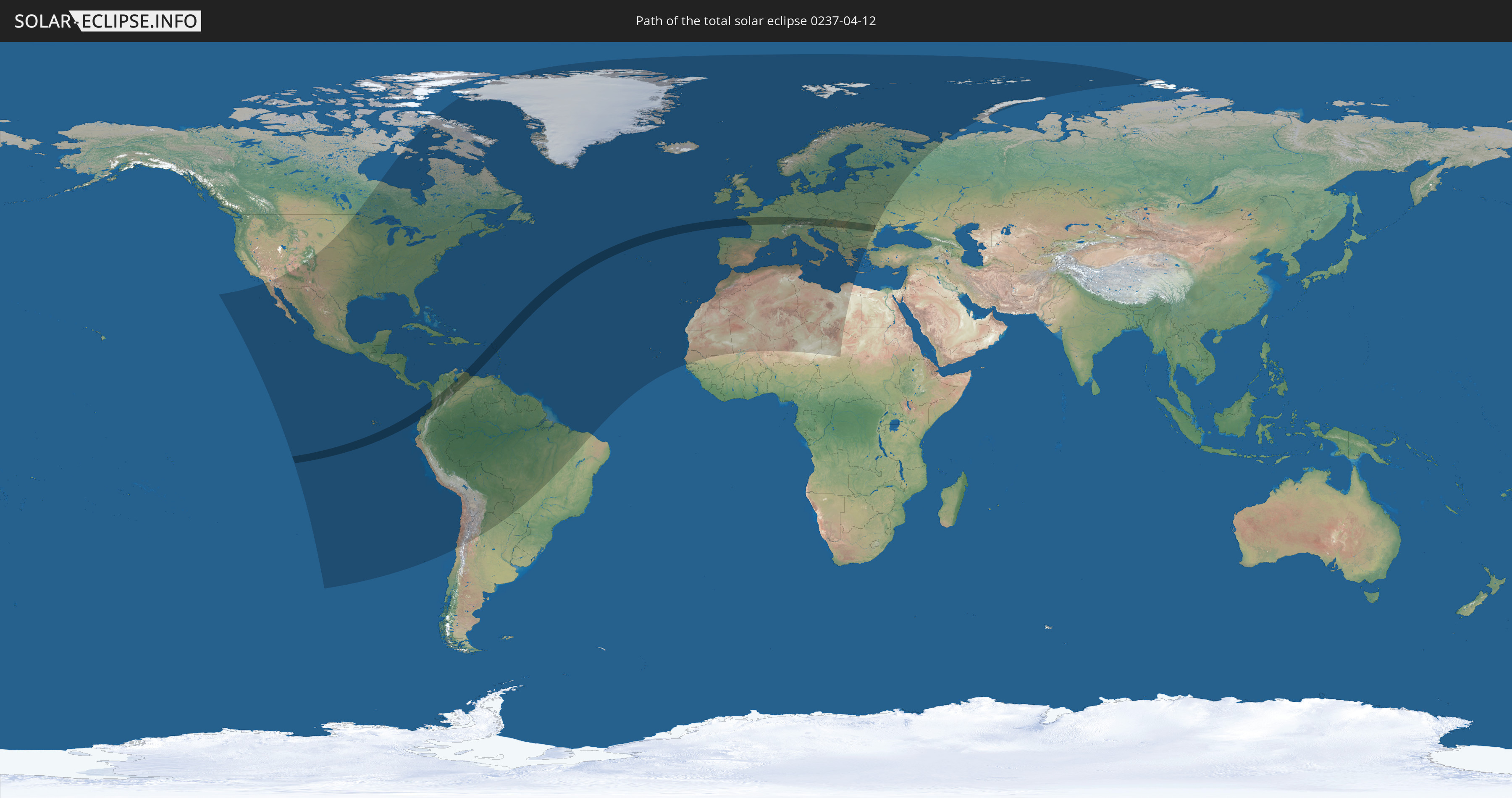
Die Sonnenfinsternis am 12.04.0237 kann man in 114 Ländern als partielle Sonnenfinsternis beobachten.
Der Finsternispfad verläuft durch 25 Länder. Nur in diesen Ländern ist sie als totale Sonnenfinsternis zu sehen.
In den folgenden Ländern ist die Sonnenfinsternis total zu sehen
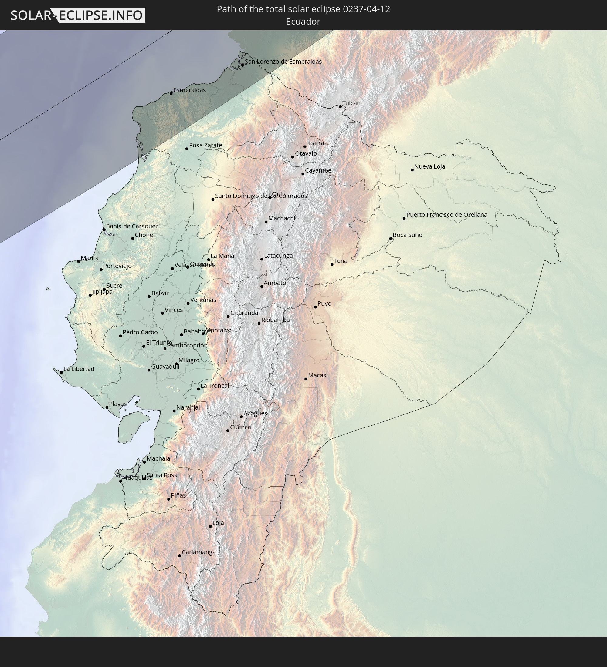 Ecuador
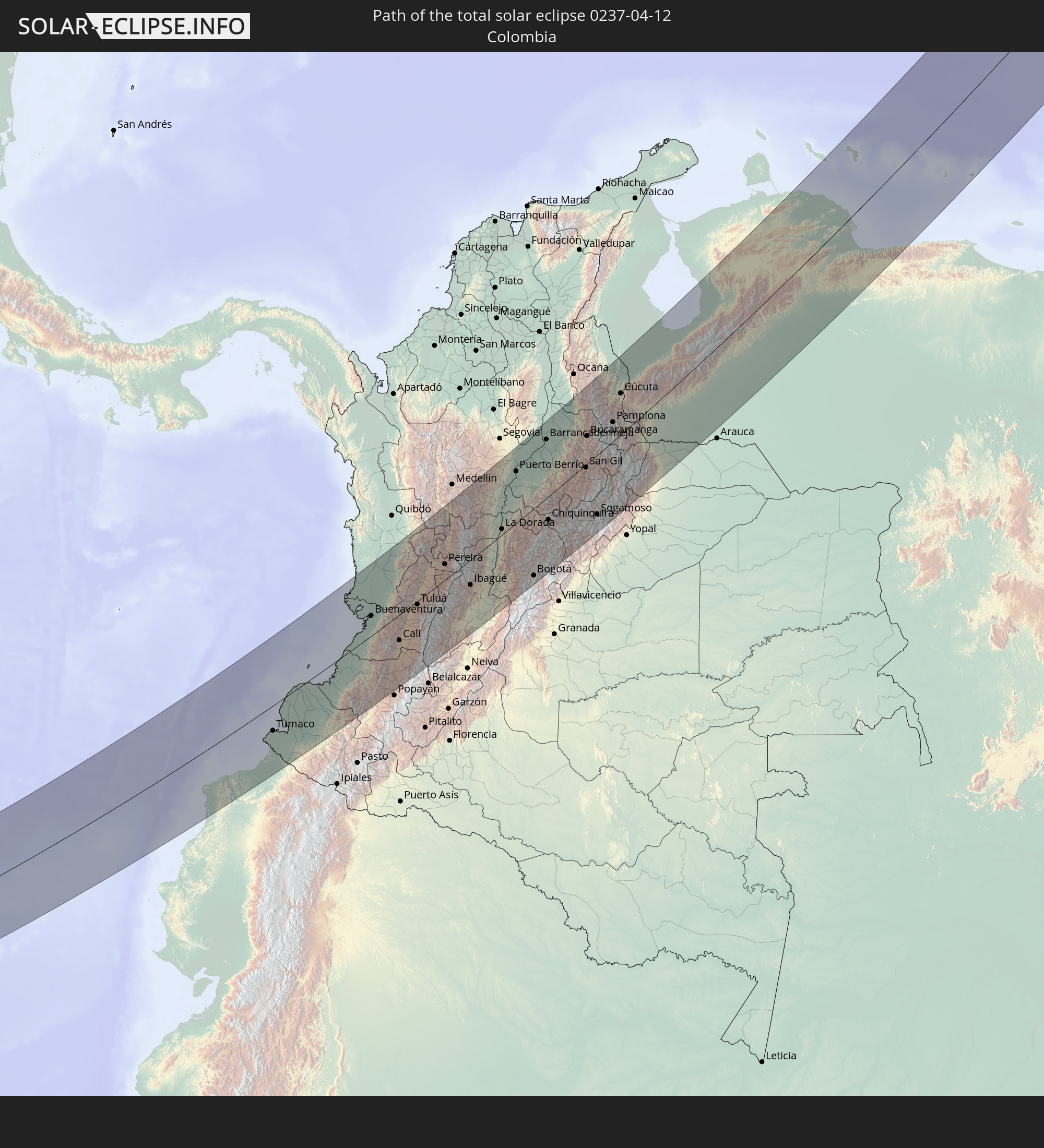 Kolumbien
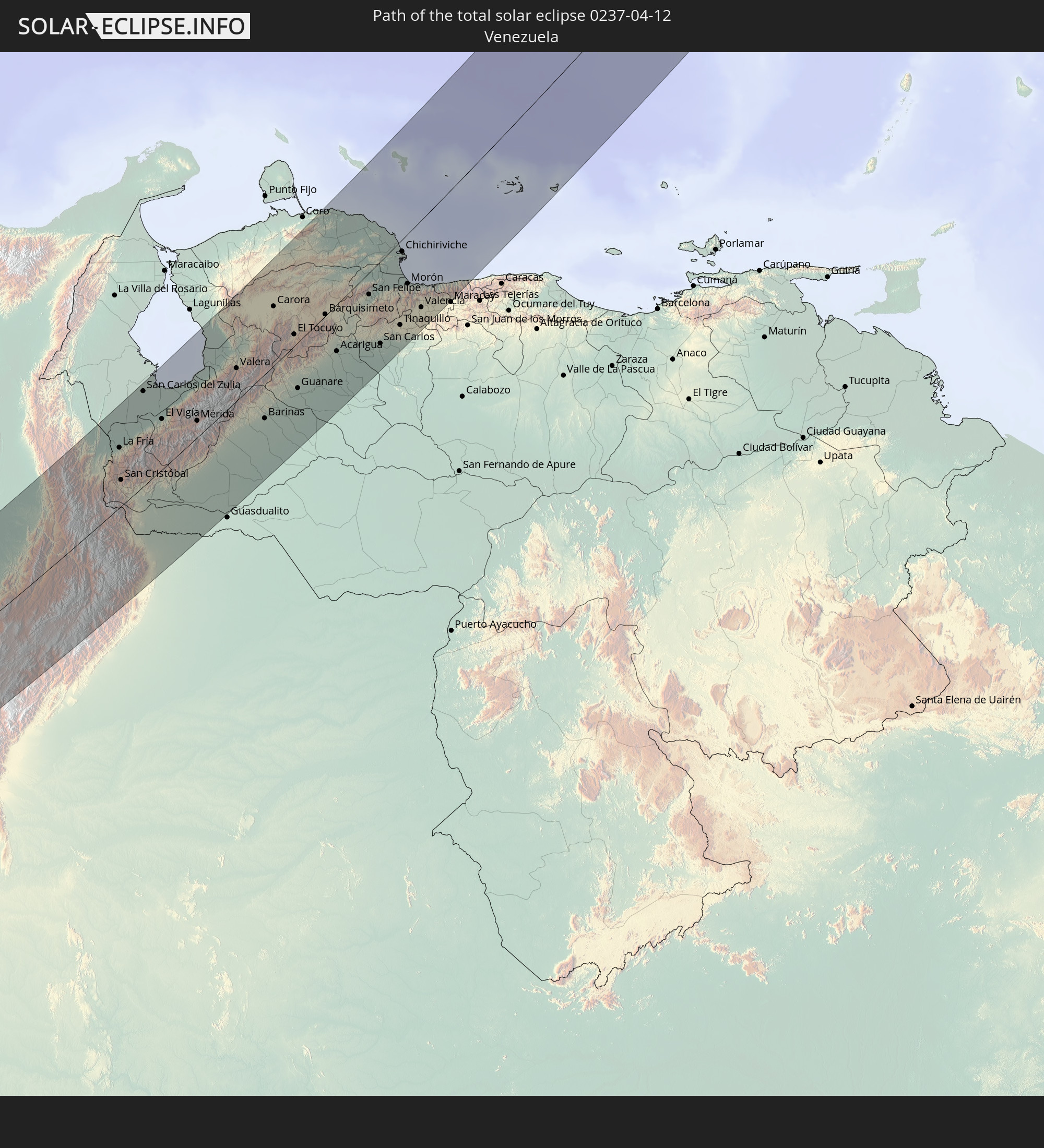 Venezuela
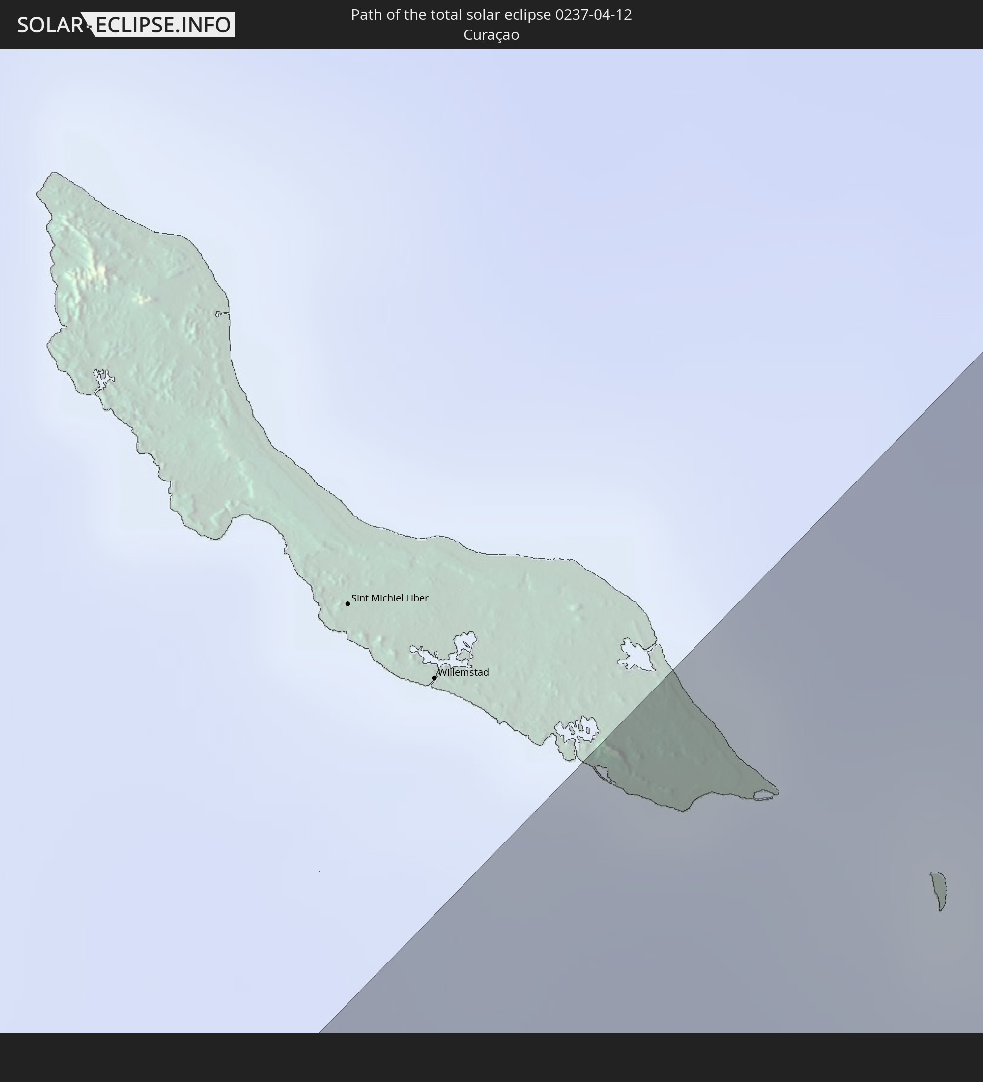 Curaçao
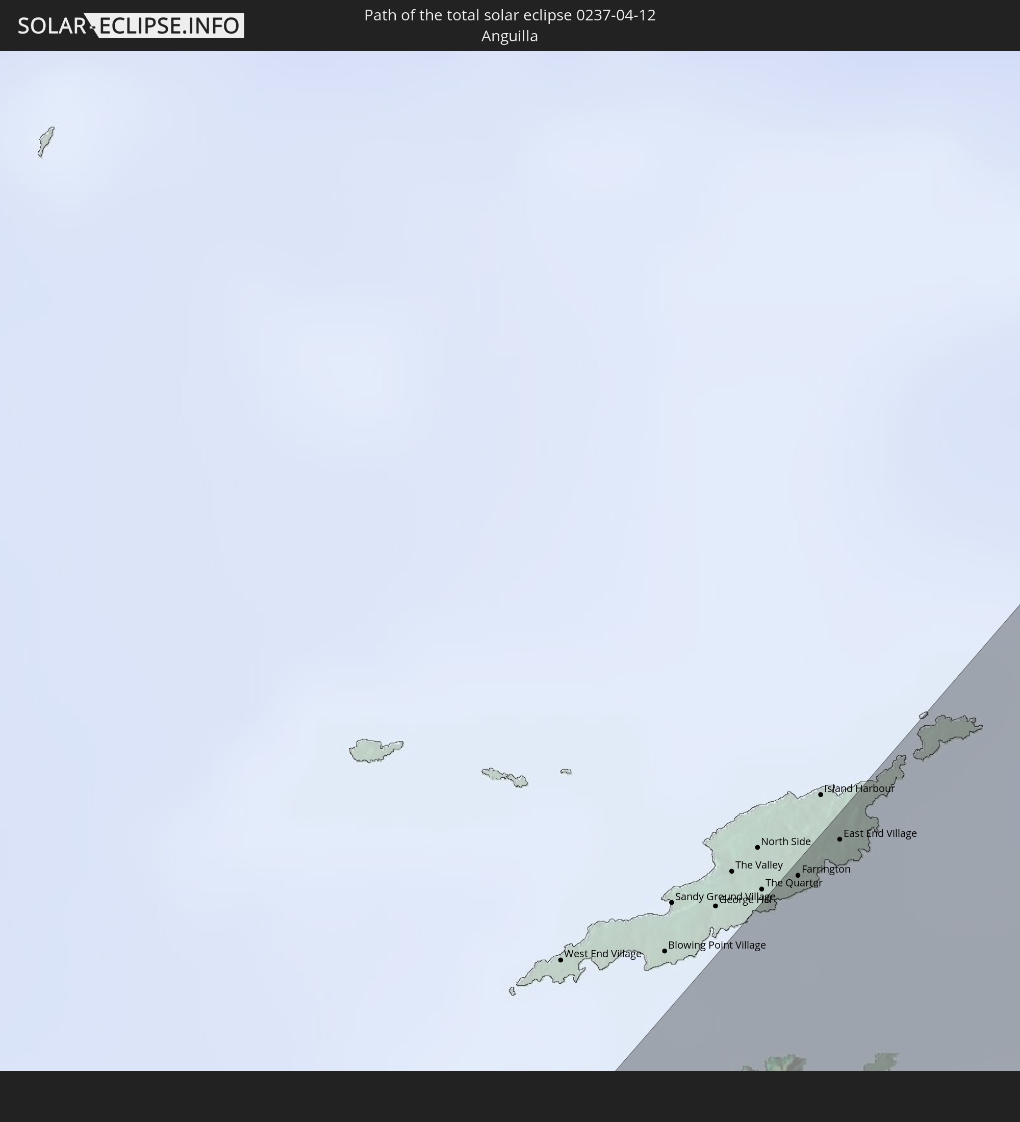 Anguilla
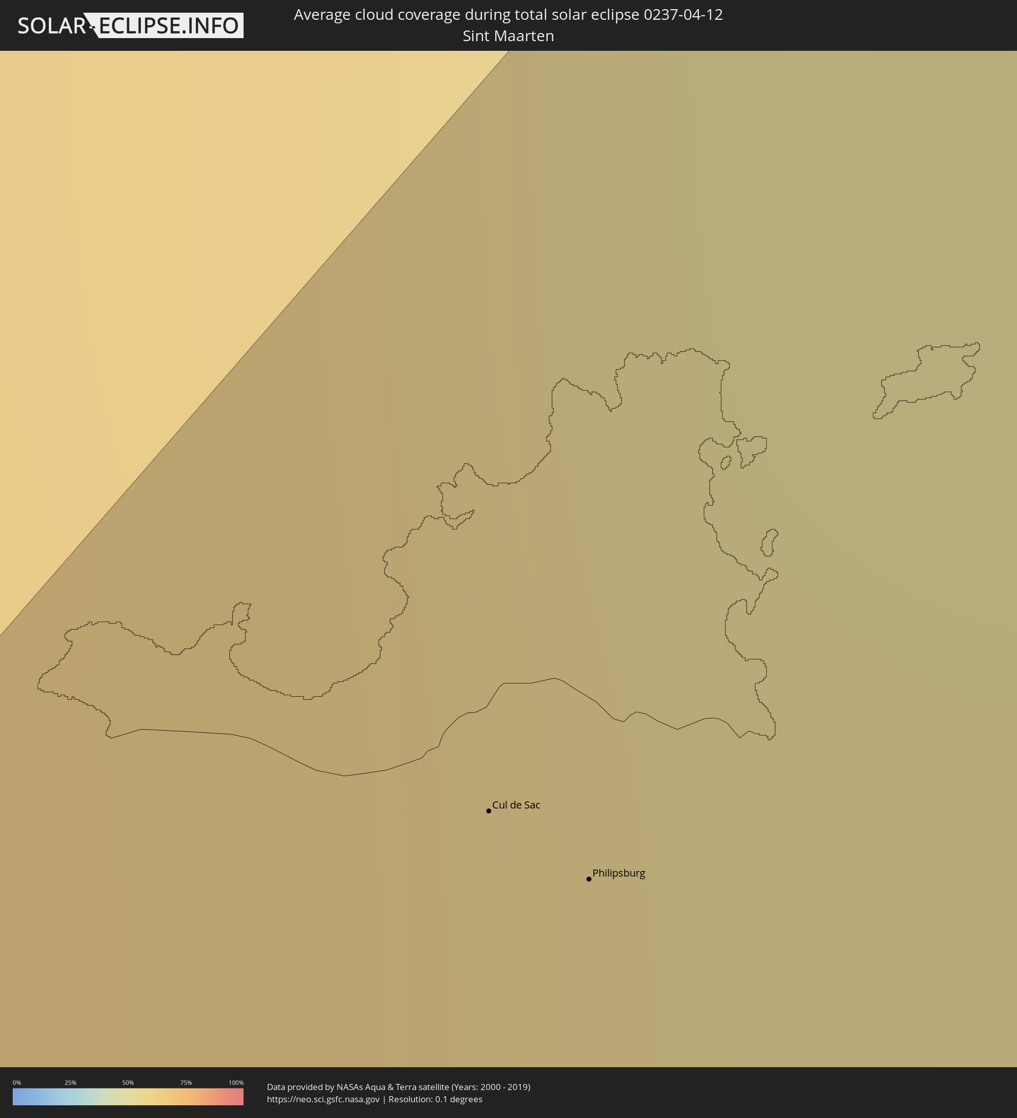
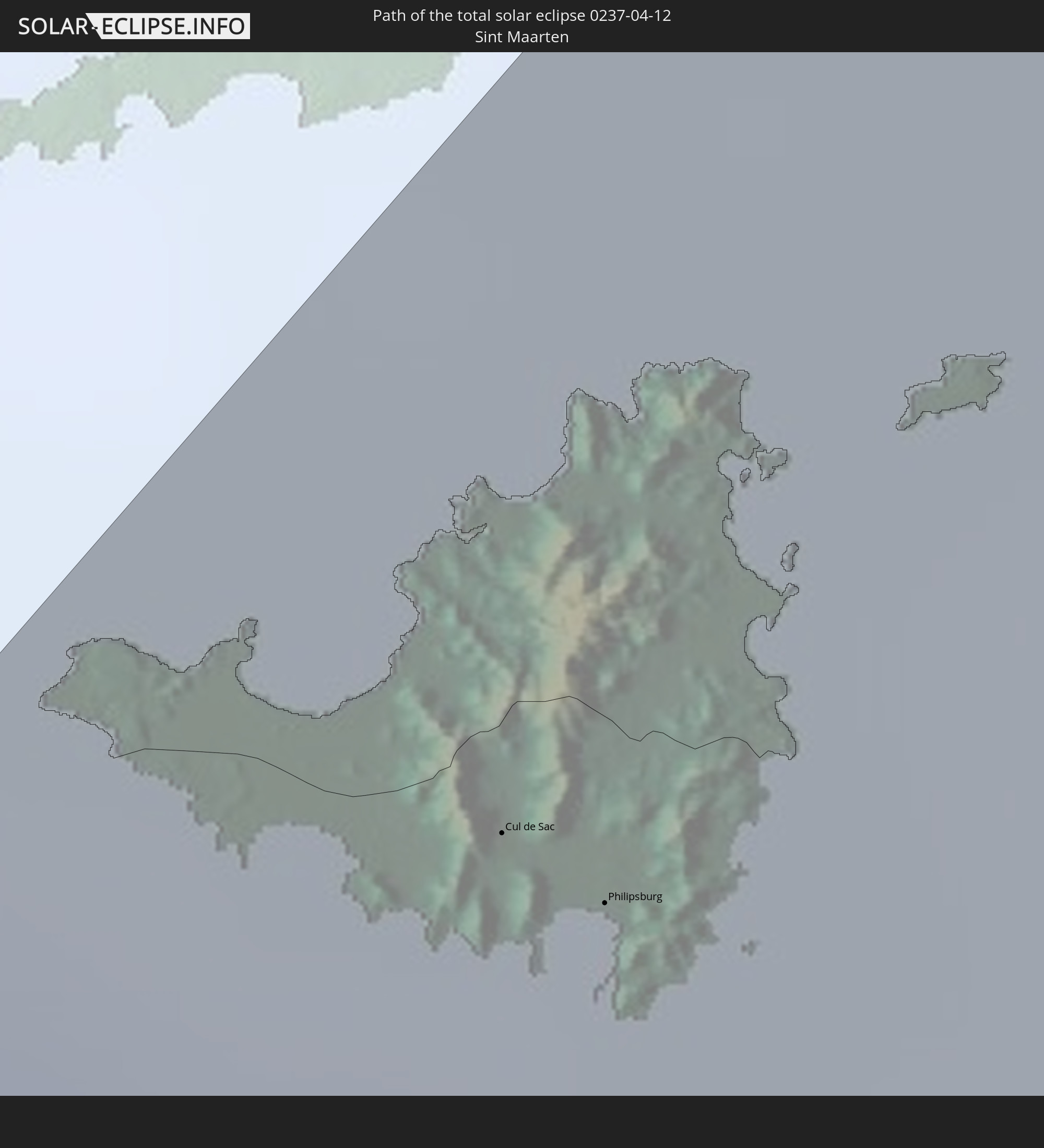 Sint Maarten
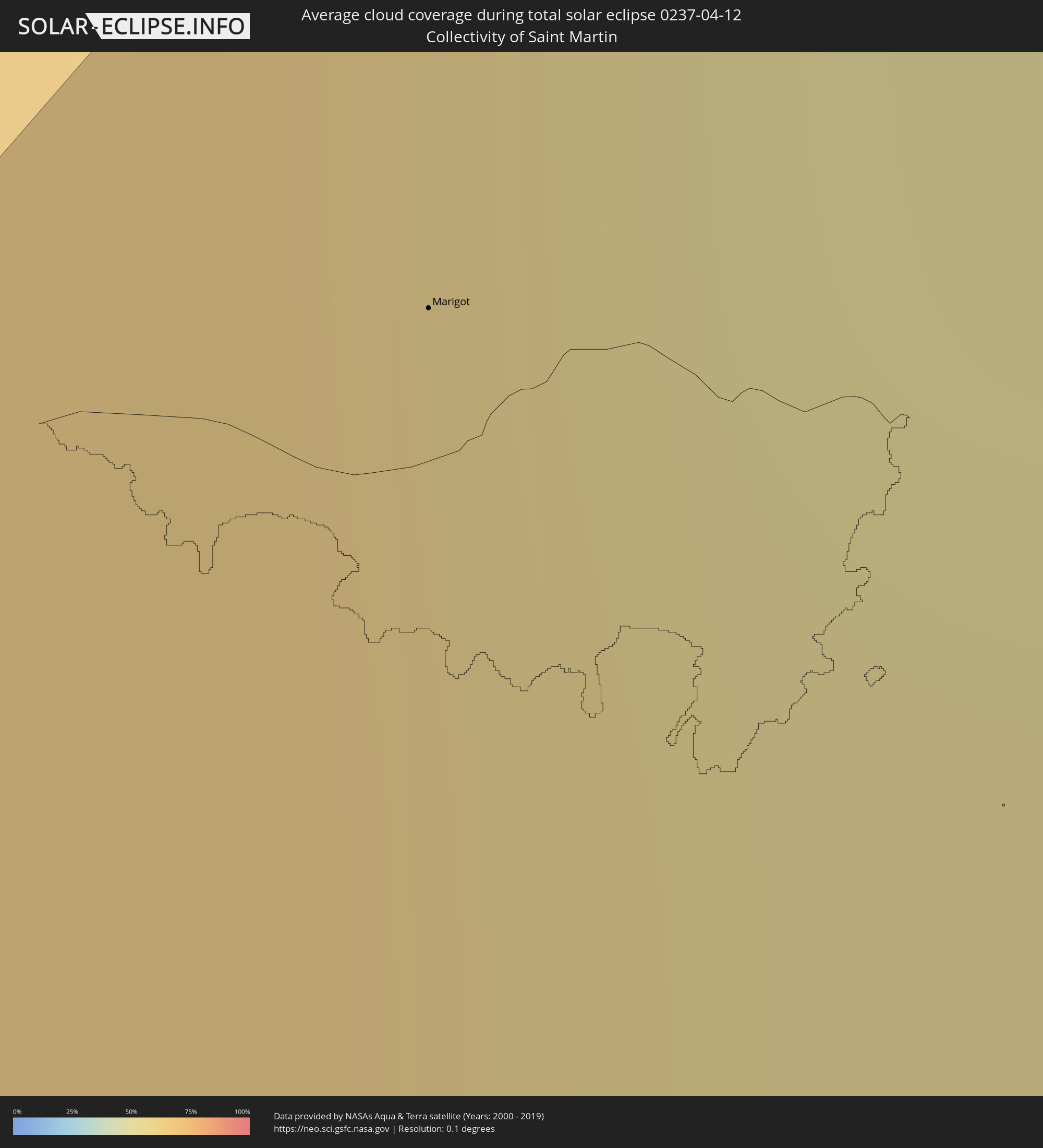
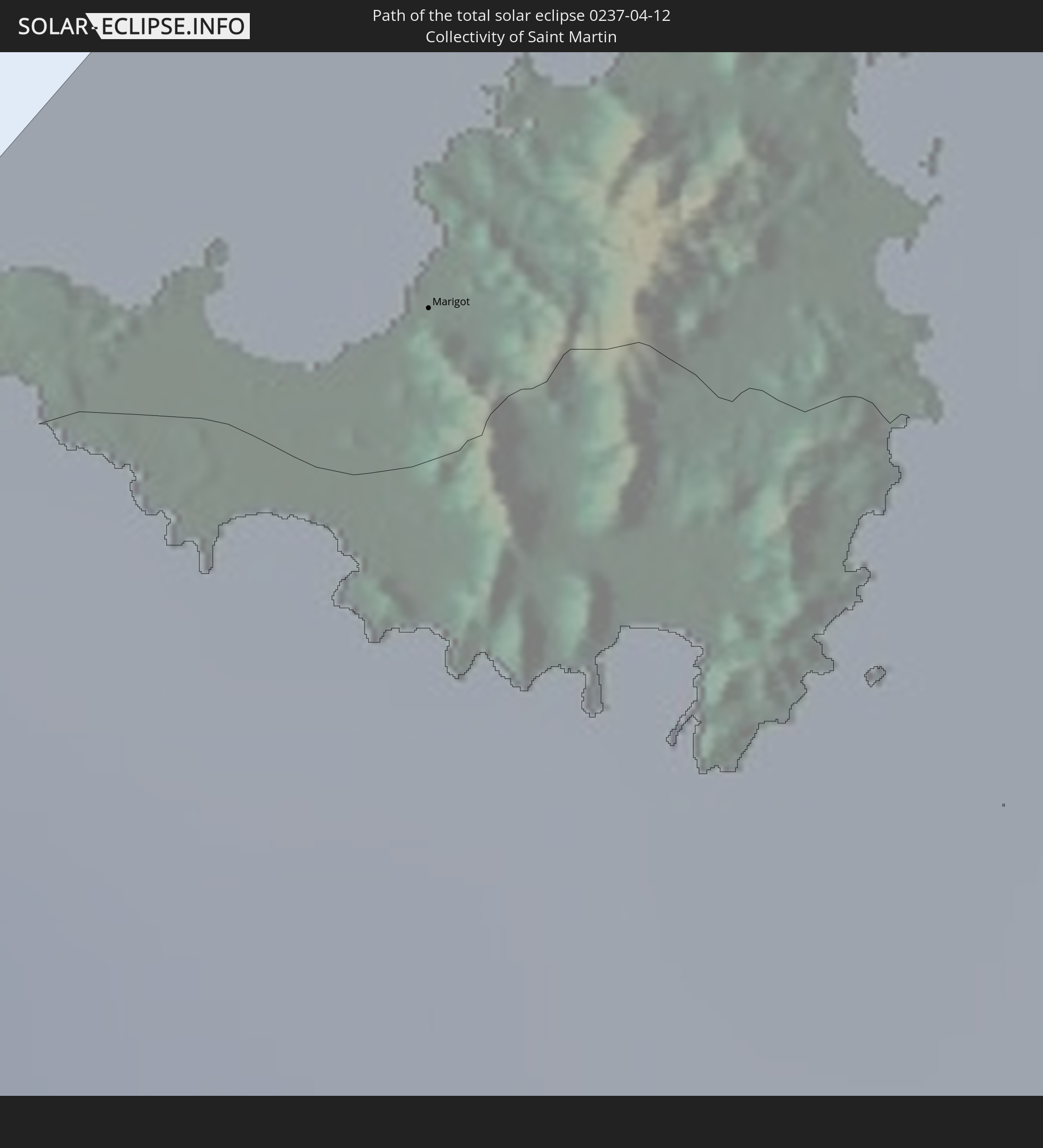 Saint-Martin
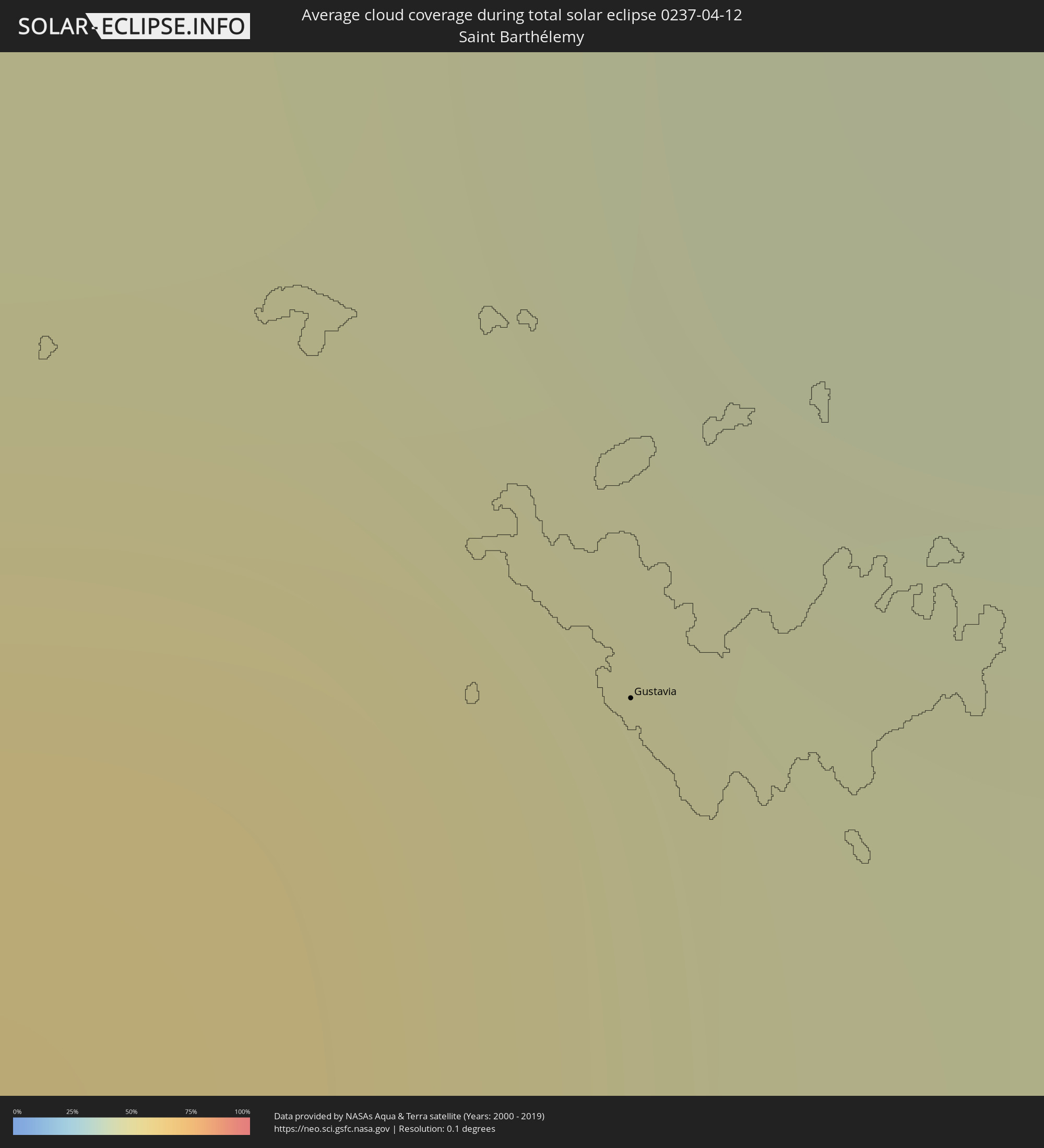
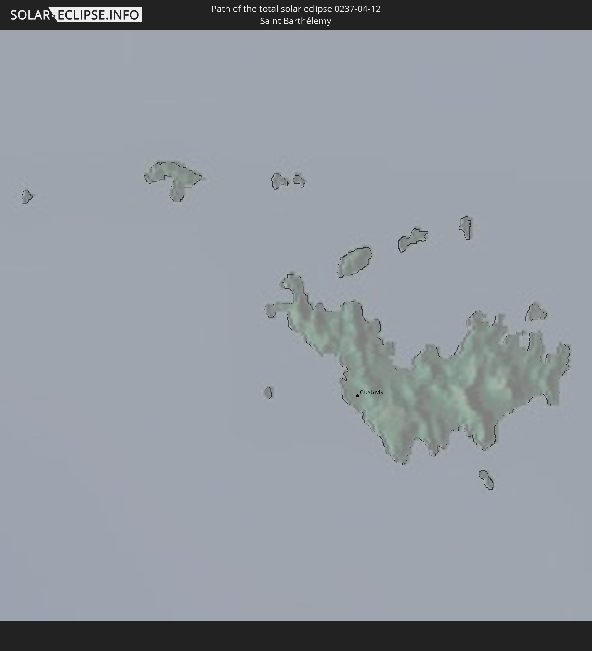 Saint-Barthélemy
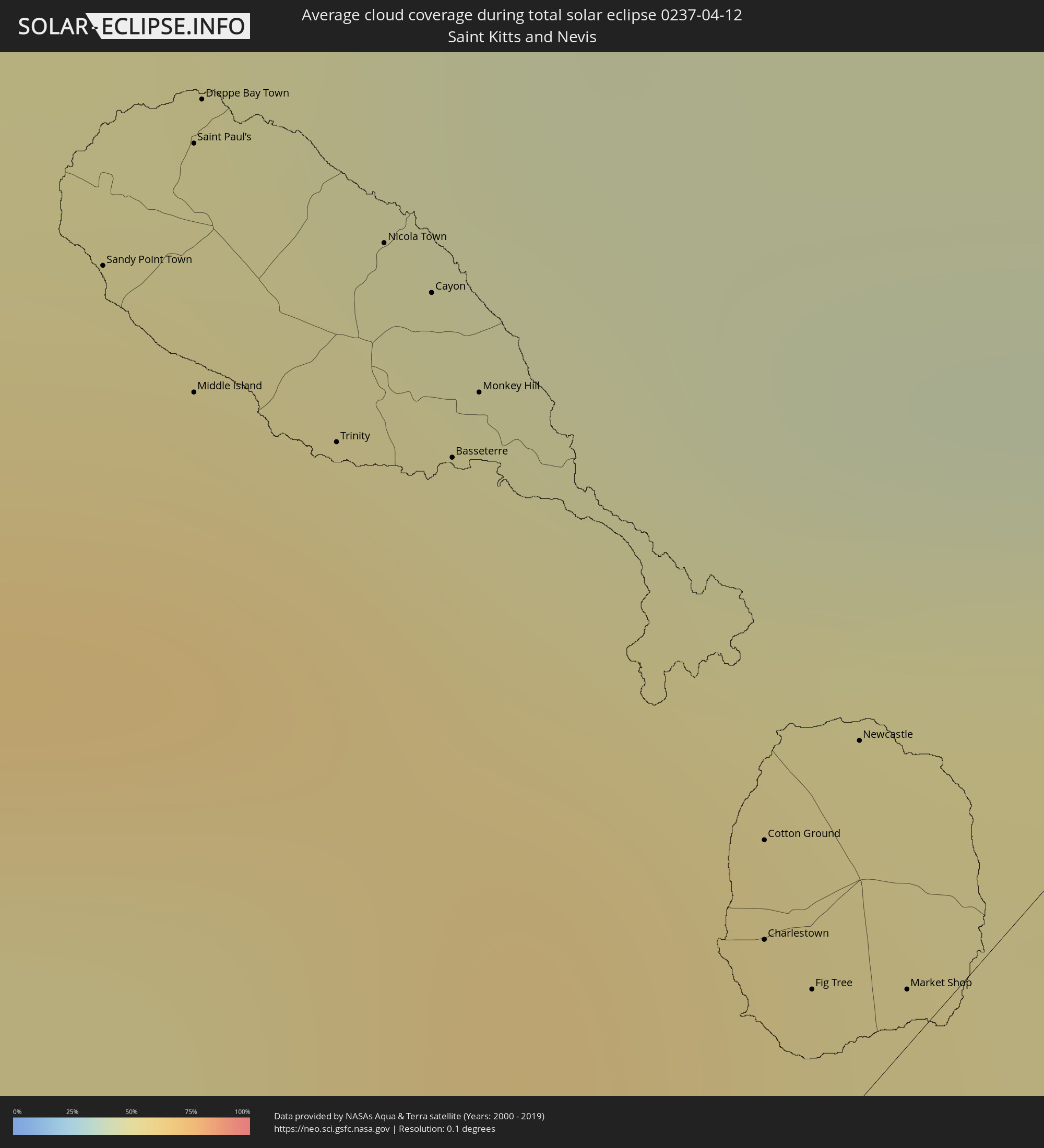
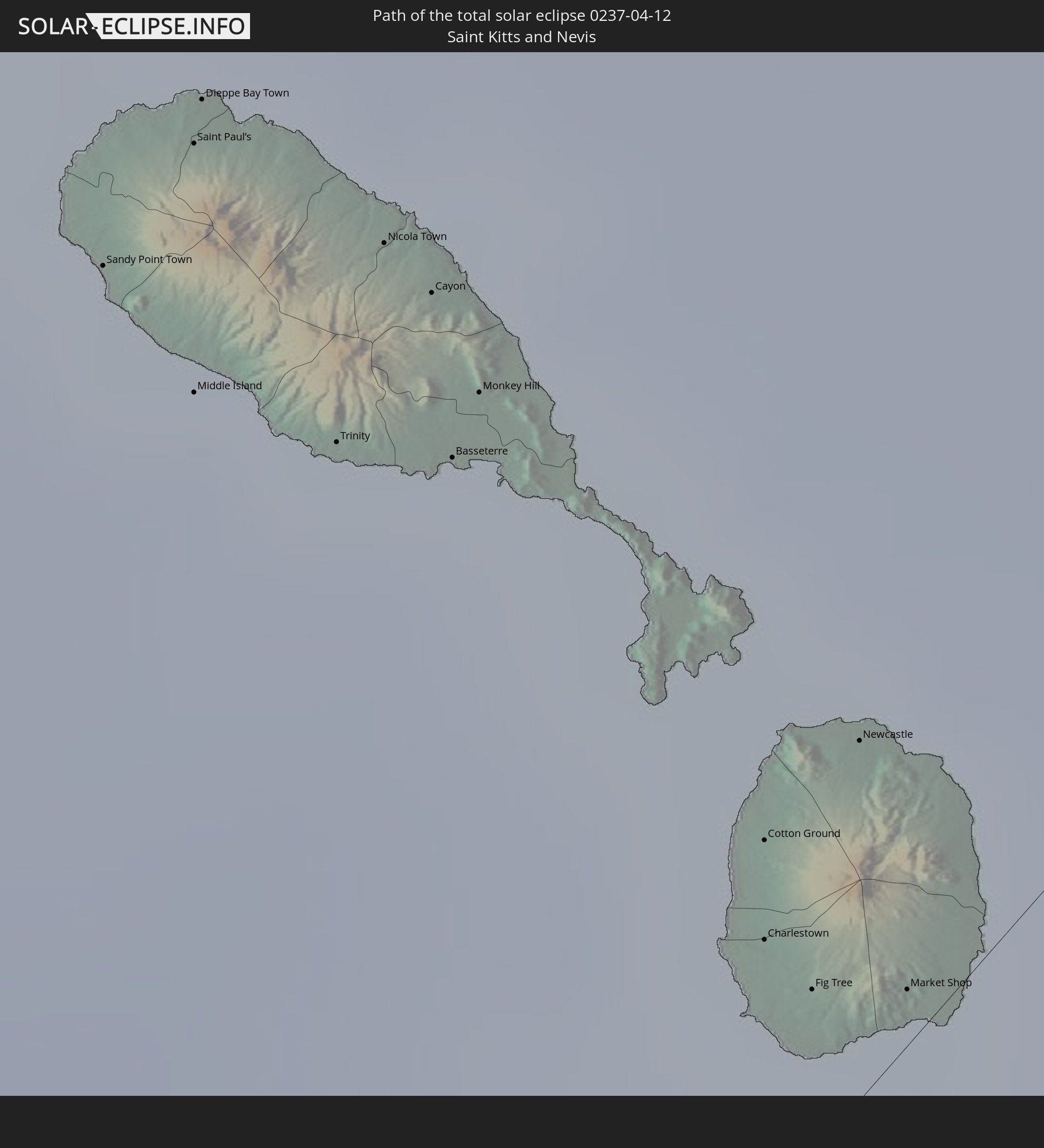 St. Kitts und Nevis
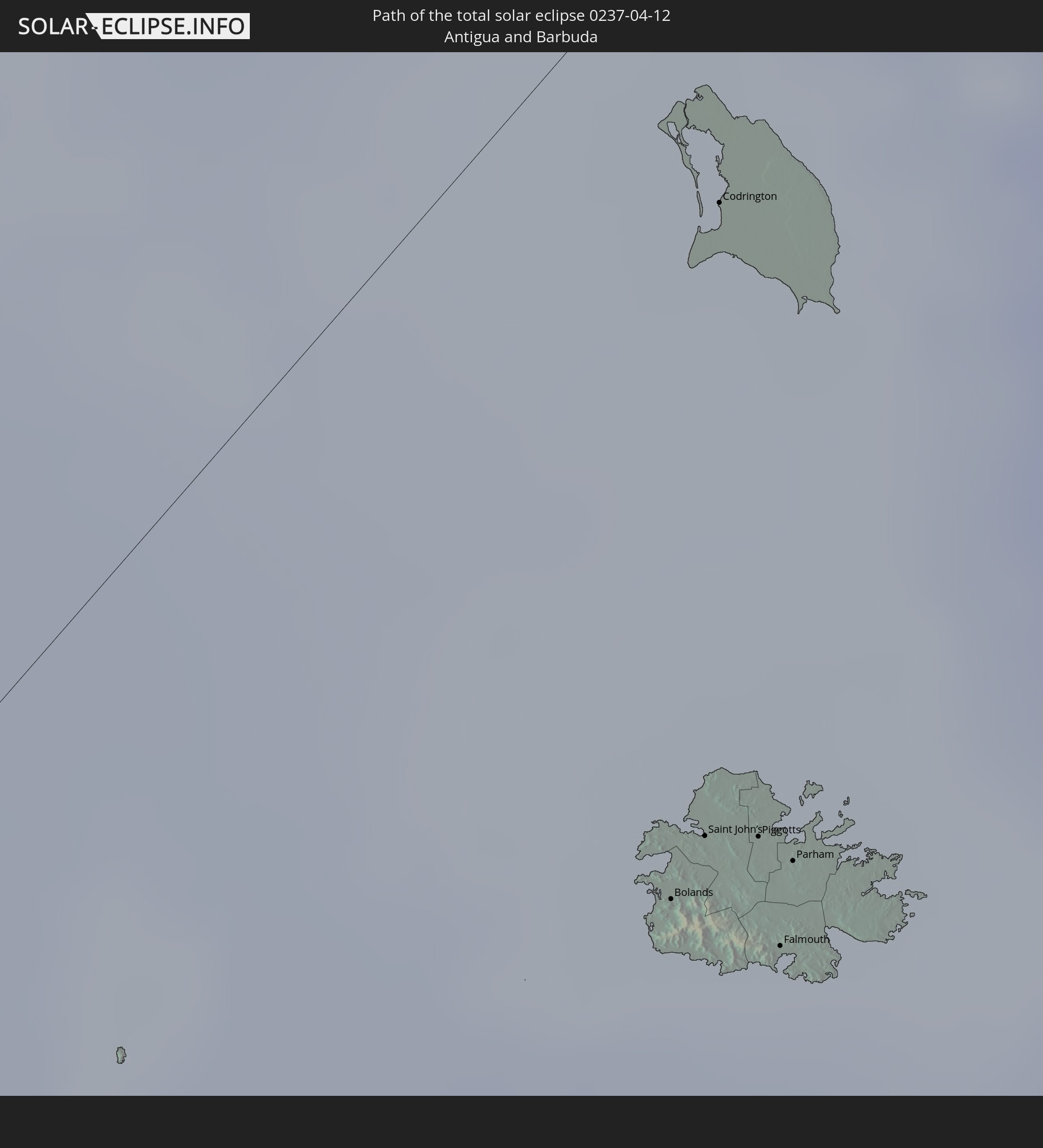 Antigua und Barbuda
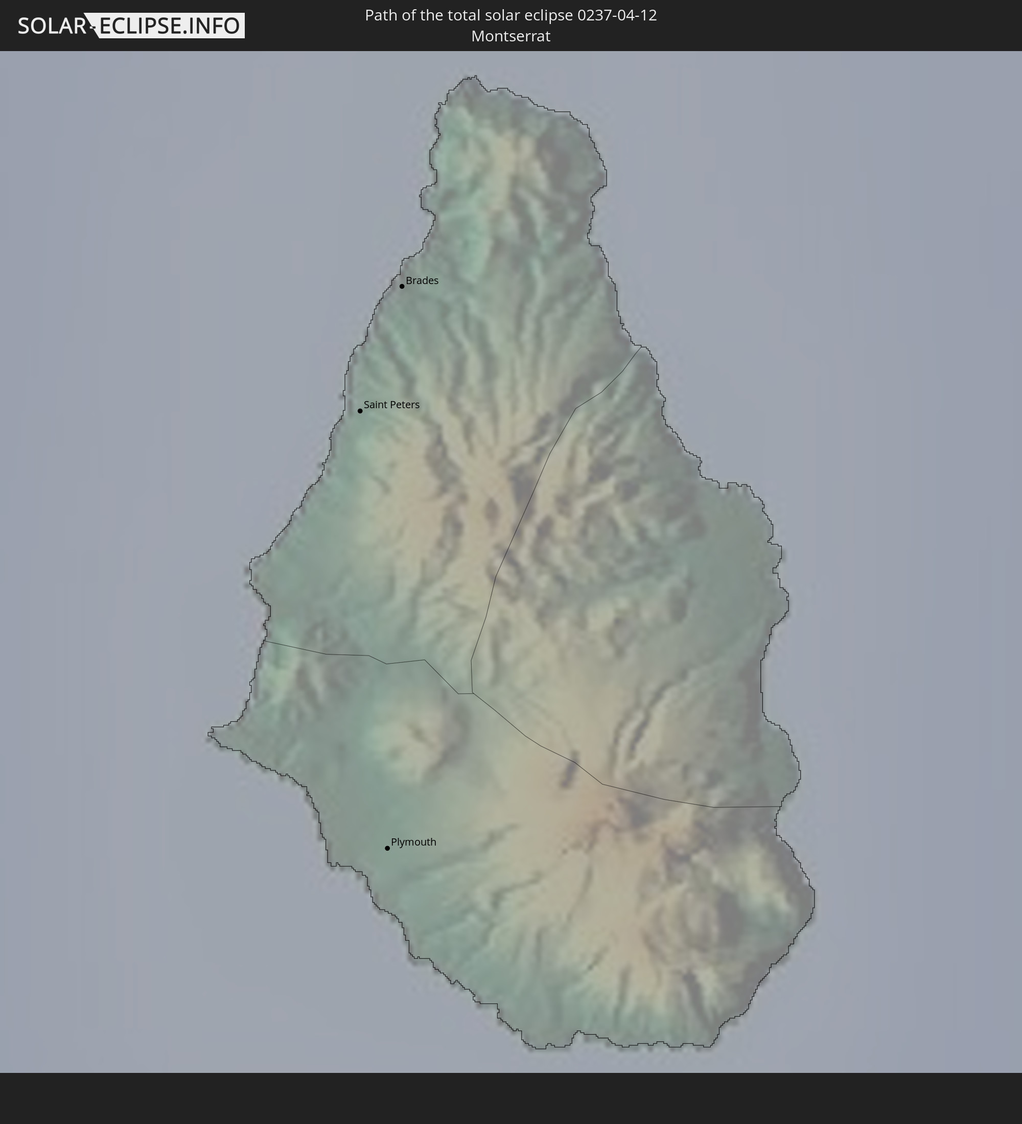 Montserrat
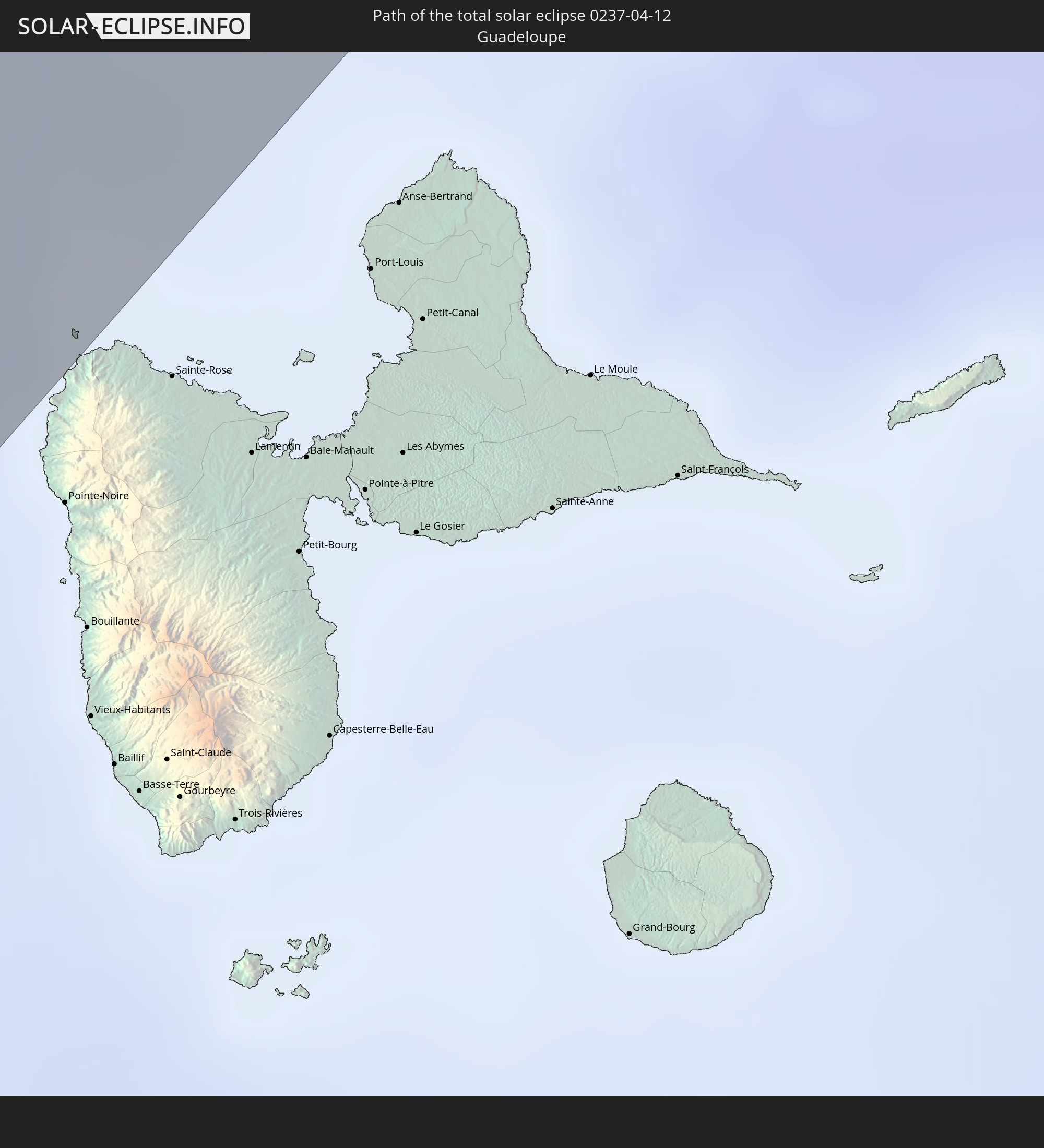 Guadeloupe
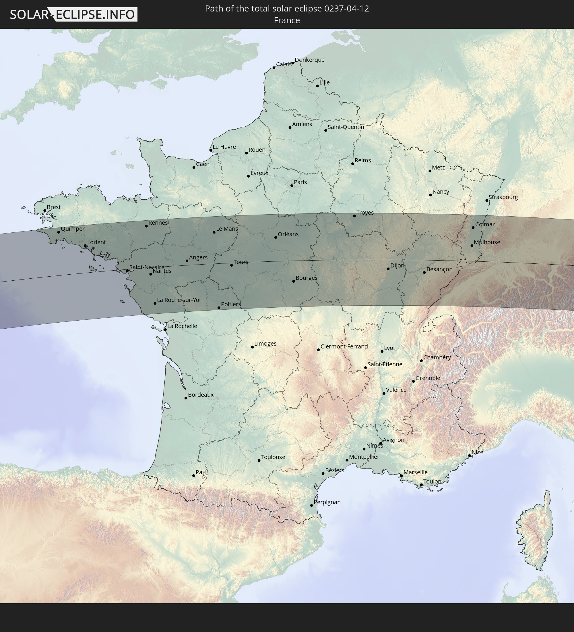 Frankreich
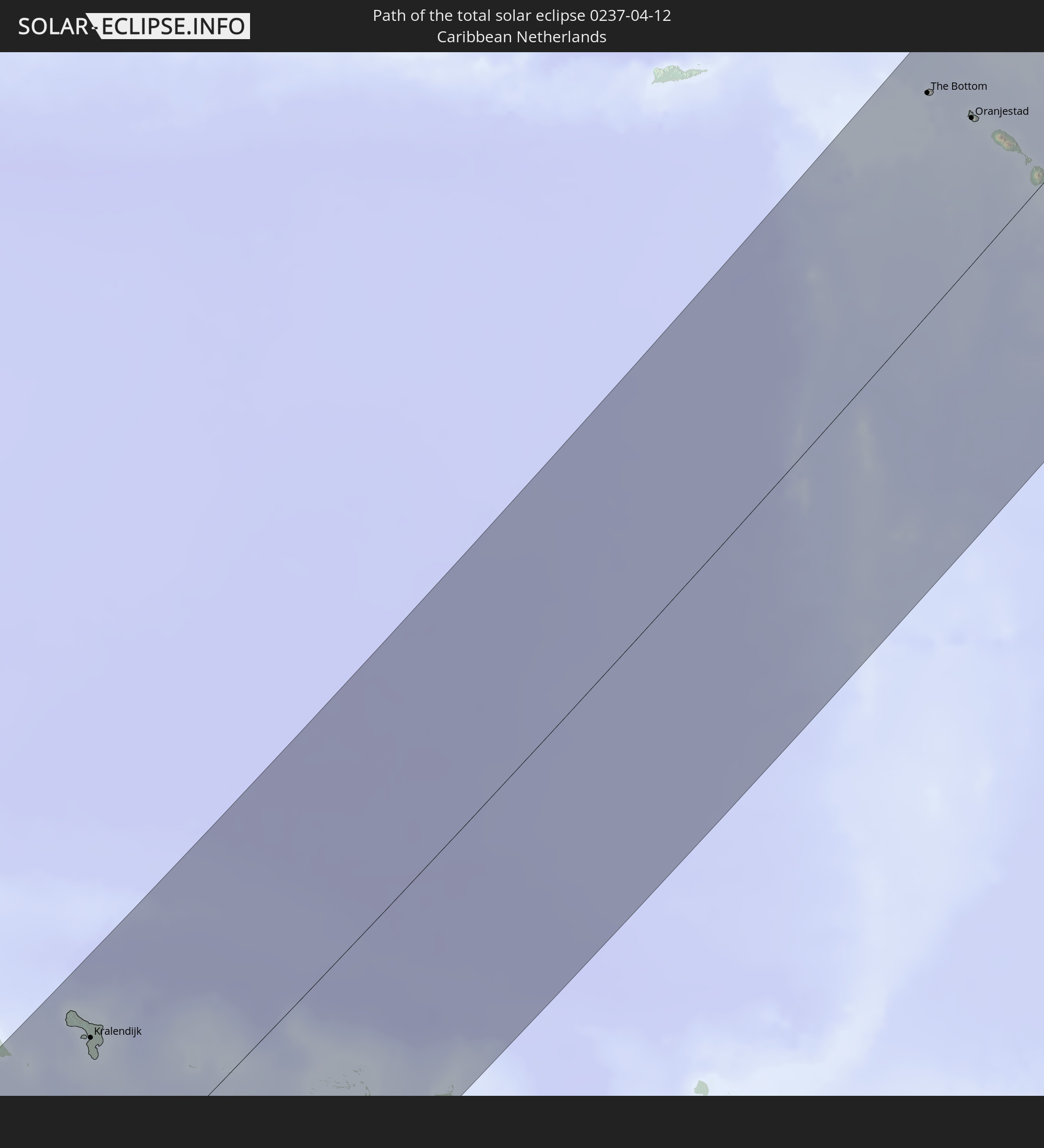 Besondere Gemeinde (Niederlande)
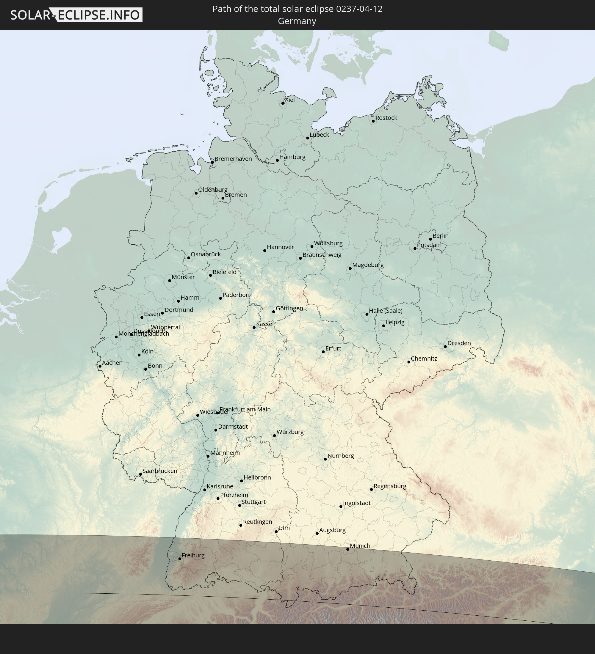 Deutschland
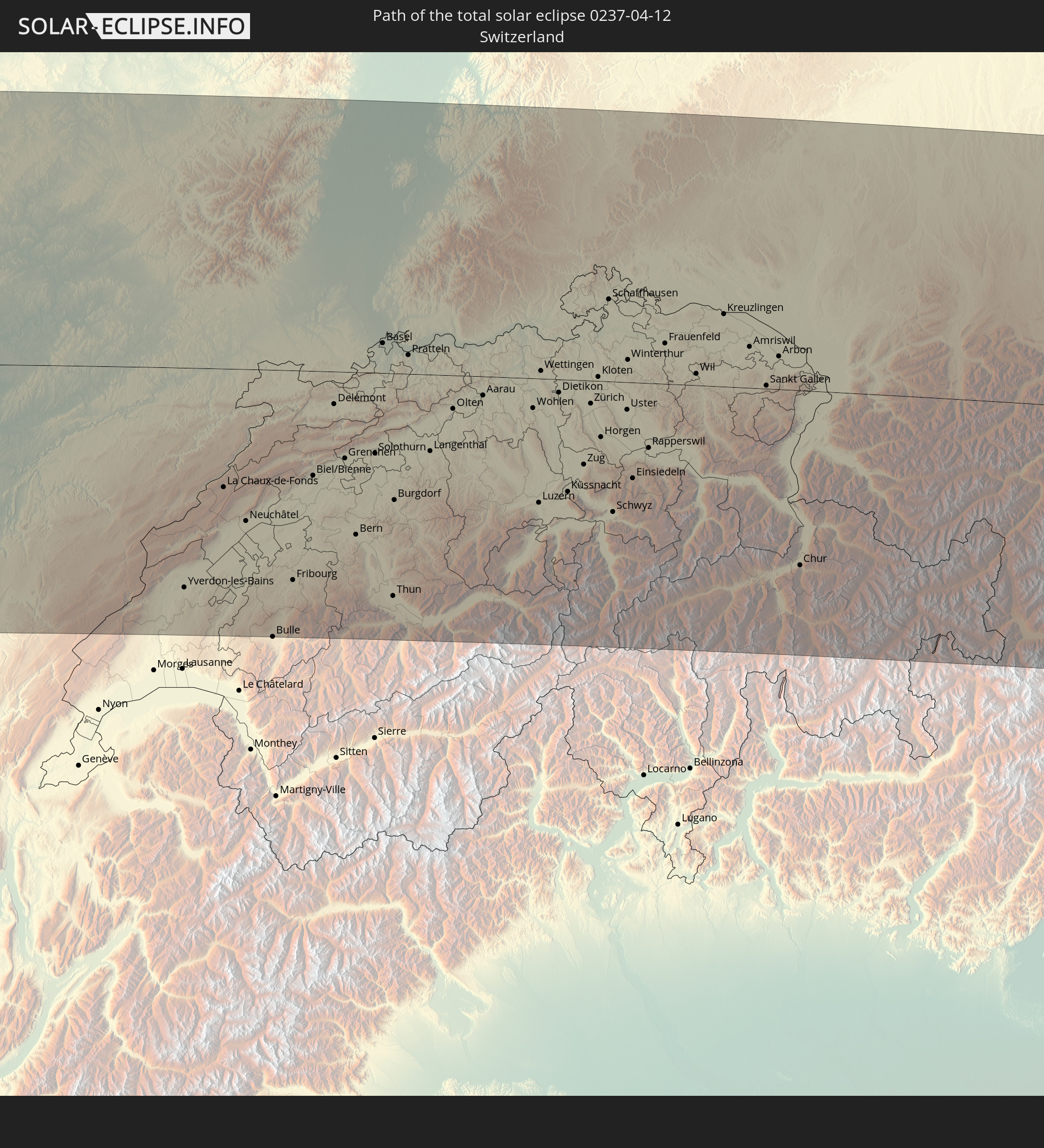 Schweiz
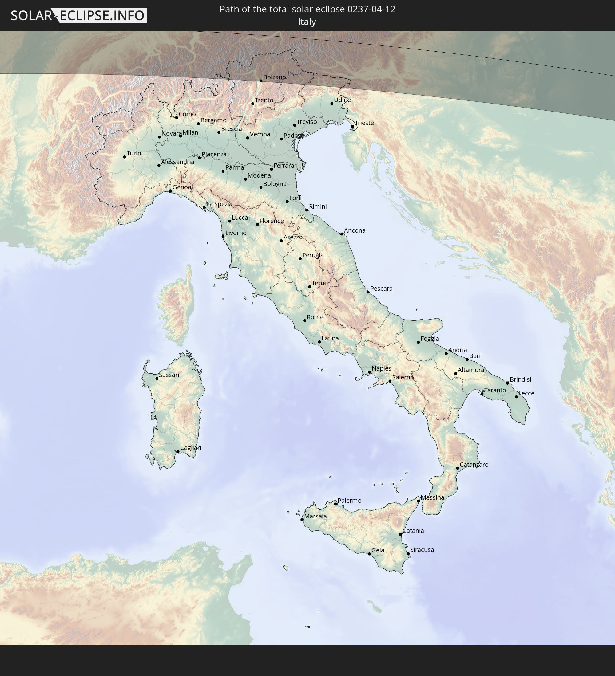 Italien
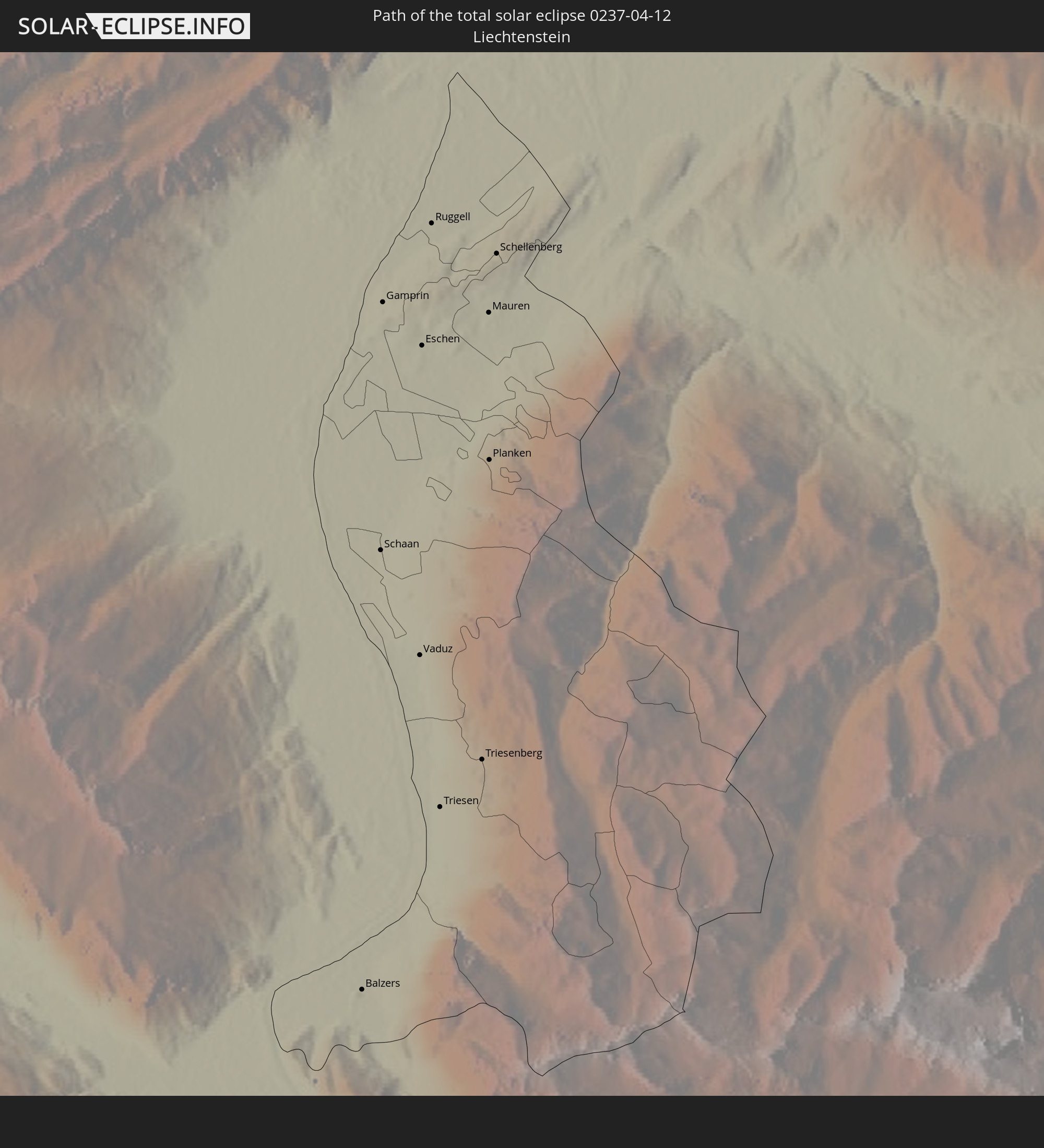 Liechtenstein
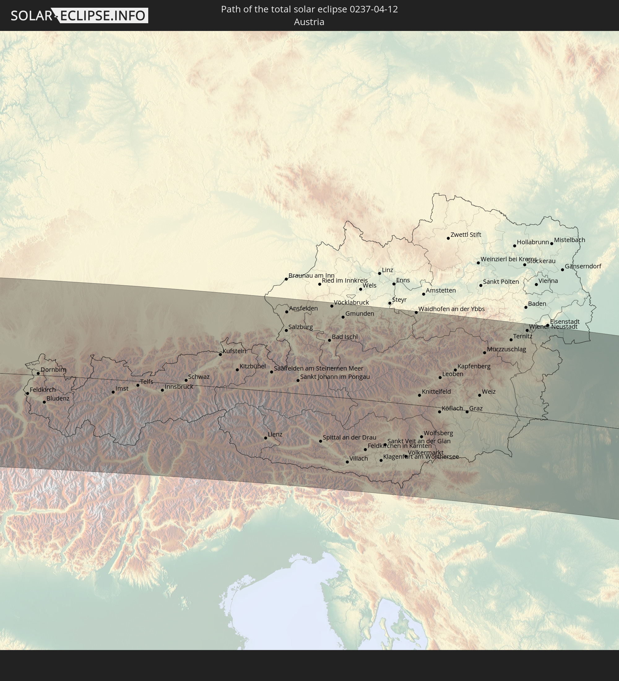 Österreich
 Slowenien
 Kroatien
 Ungarn
 Serbien
 Rumänien
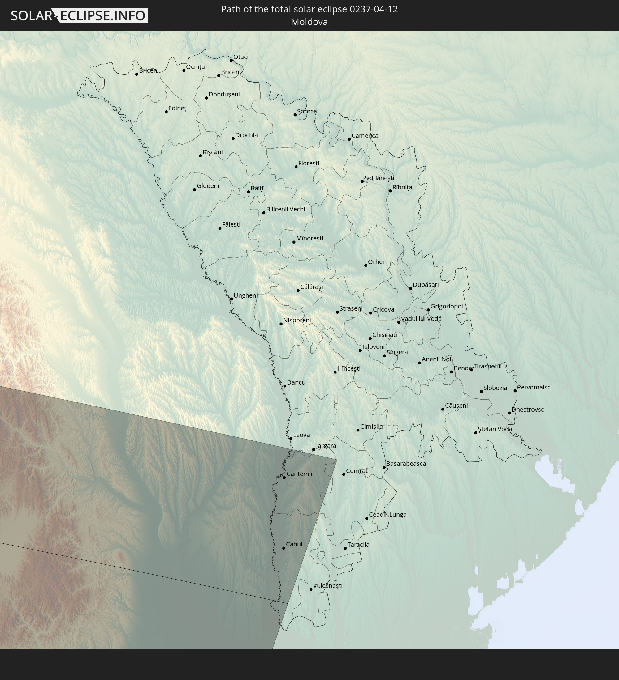 Moldawien
In den folgenden Ländern ist die Sonnenfinsternis partiell zu sehen
 Russland
 Vereinigte Staaten
 United States Minor Outlying Islands
 Kanada
 Mexiko
 Chile
Chile
 Grönland
 Guatemala
 Ecuador
 El Salvador
 Honduras
 Belize
 Nicaragua
 Costa Rica
 Kuba
Kuba
 Panama
 Kolumbien
 Kaimaninseln
 Peru
Peru
 Bahamas
 Jamaika
 Haiti
Haiti
 Brasilien
 Argentinien
 Venezuela
 Turks- und Caicosinseln
 Dominikanische Republik
 Aruba
Aruba
 Bolivien
 Puerto Rico
 Amerikanische Jungferninseln
 Bermuda
 Britische Jungferninseln
 Anguilla
 Saint-Martin
 Saint-Barthélemy
 St. Kitts und Nevis
 Paraguay
 Antigua und Barbuda
 Montserrat
 Trinidad und Tobago
 Guadeloupe
 Grenada
 Dominica
 St. Vincent und die Grenadinen
 Guyana
 Martinique
 St. Lucia
 Barbados
 Suriname
 Saint-Pierre und Miquelon
 Französisch-Guayana
 Portugal
 Kap Verde
 Island
 Spanien
 Senegal
 Mauretanien
 Gambia
 Marokko
 Mali
Mali
 Irland
 Spitzbergen
 Algerien
 Vereinigtes Königreich
 Färöer
 Gibraltar
 Frankreich
 Isle of Man
 Guernsey
 Jersey
 Niger
Niger
 Andorra
 Belgien
 Niederlande
 Norwegen
 Luxemburg
 Deutschland
 Schweiz
 Italien
 Monaco
 Tunesien
 Dänemark
 Libyen
 Liechtenstein
 Österreich
 Schweden
 Tschechien
 San Marino
 Vatikanstadt
 Slowenien
 Tschad
 Kroatien
 Polen
Polen
 Malta
Malta
 Bosnien und Herzegowina
 Ungarn
 Slowakei
 Montenegro
 Serbien
 Albanien
 Åland Islands
 Griechenland
 Rumänien
 Mazedonien
 Finnland
 Litauen
 Lettland
 Estland
 Ukraine
 Bulgarien
 Weißrussland
 Türkei
 Moldawien
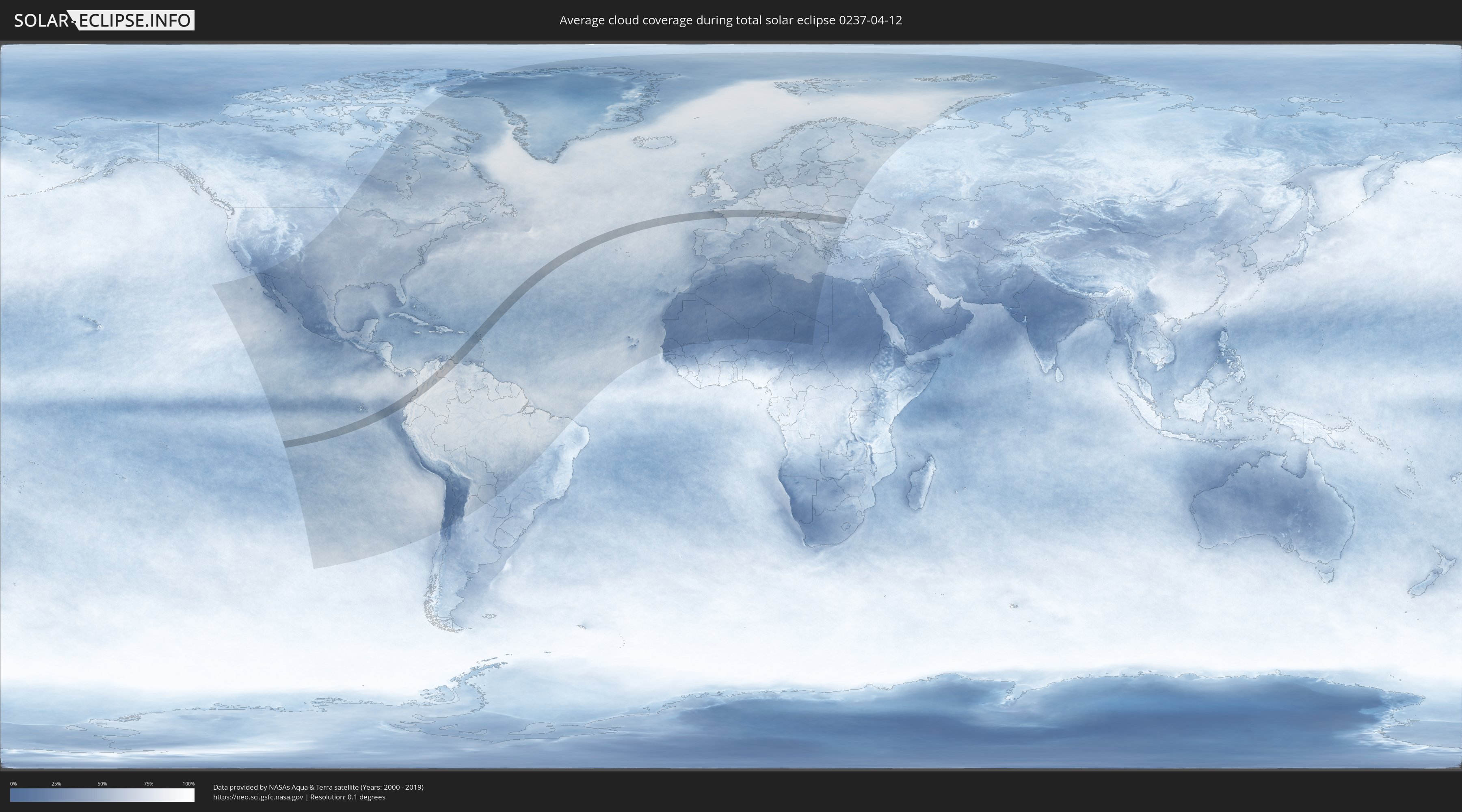
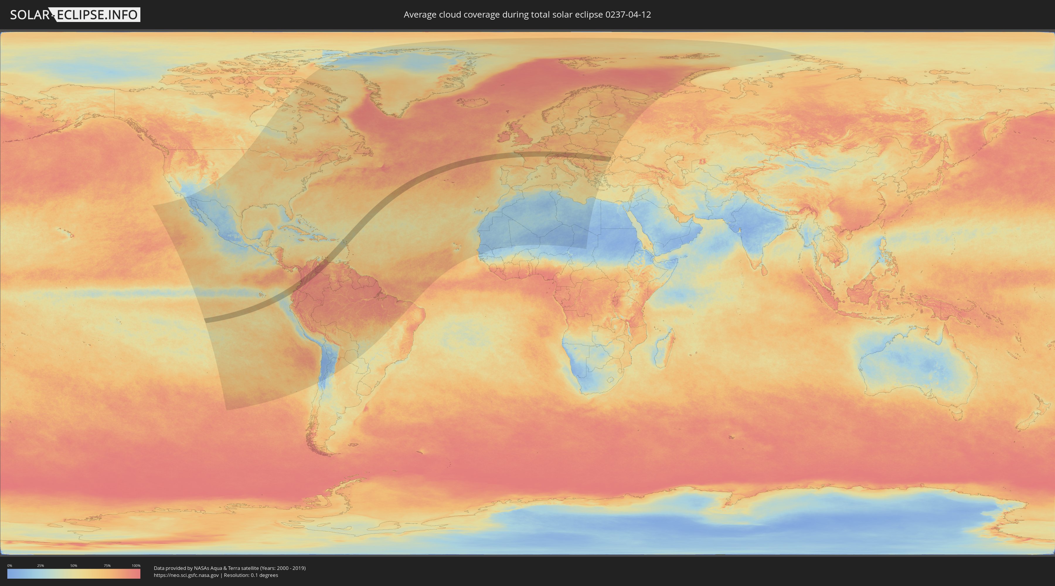
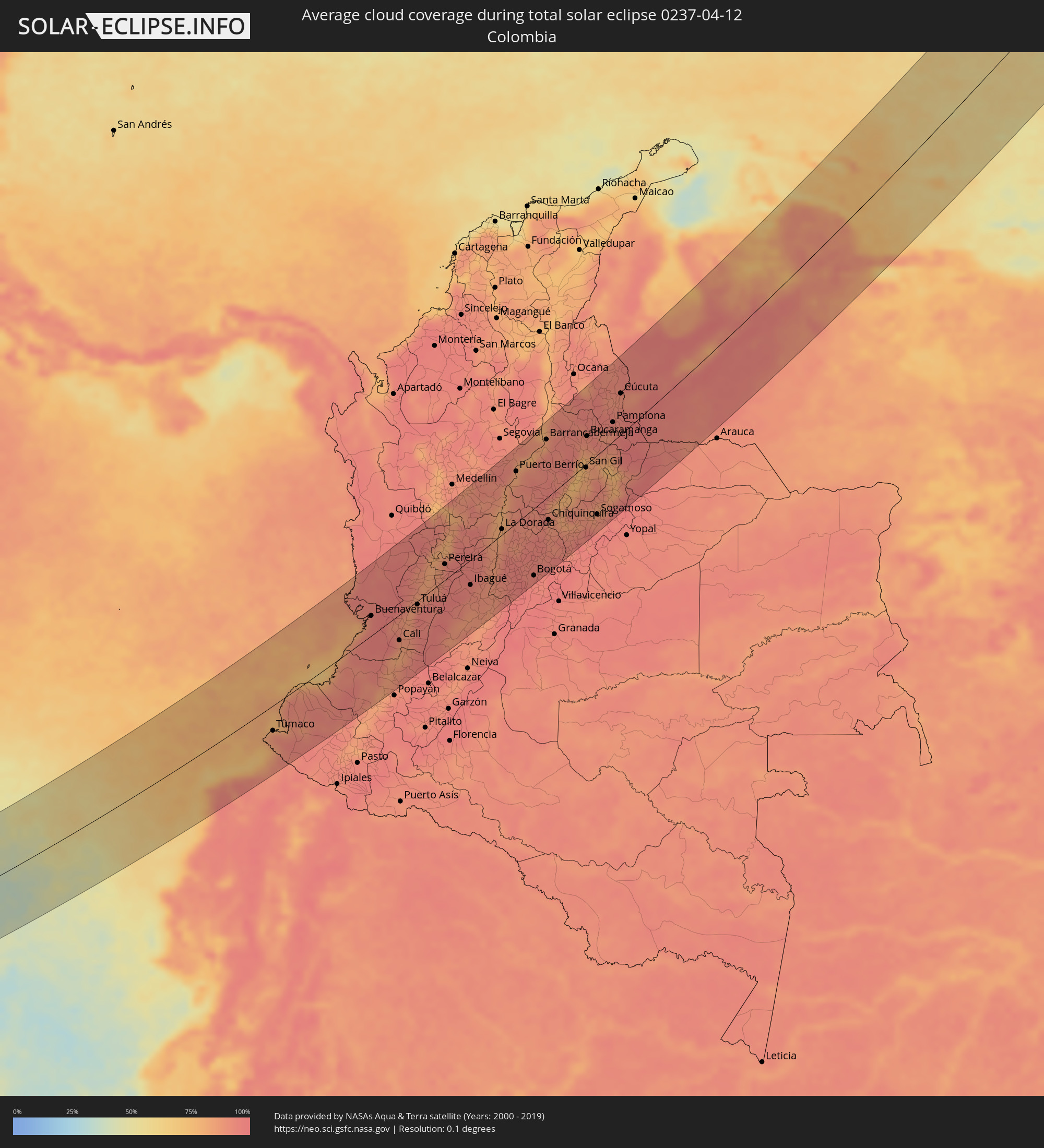
Wie wird das Wetter während der totalen Sonnenfinsternis am 12.04.0237?
Wo ist der beste Ort, um die totale Sonnenfinsternis vom 12.04.0237 zu beobachten?
Die folgenden Karten zeigen die durchschnittliche Bewölkung für den Tag, an dem die totale Sonnenfinsternis
stattfindet. Mit Hilfe der Karten lässt sich der Ort entlang des Finsternispfades eingrenzen,
der die besten Aussichen auf einen klaren wolkenfreien Himmel bietet.
Trotzdem muss man immer lokale Gegenenheiten beachten und sollte sich genau über das Wetter an seinem
gewählten Beobachtungsort informieren.
Die Daten stammen von den beiden NASA-Satelliten
AQUA und TERRA
und wurden über einen Zeitraum von 19 Jahren (2000 - 2019) gemittelt.
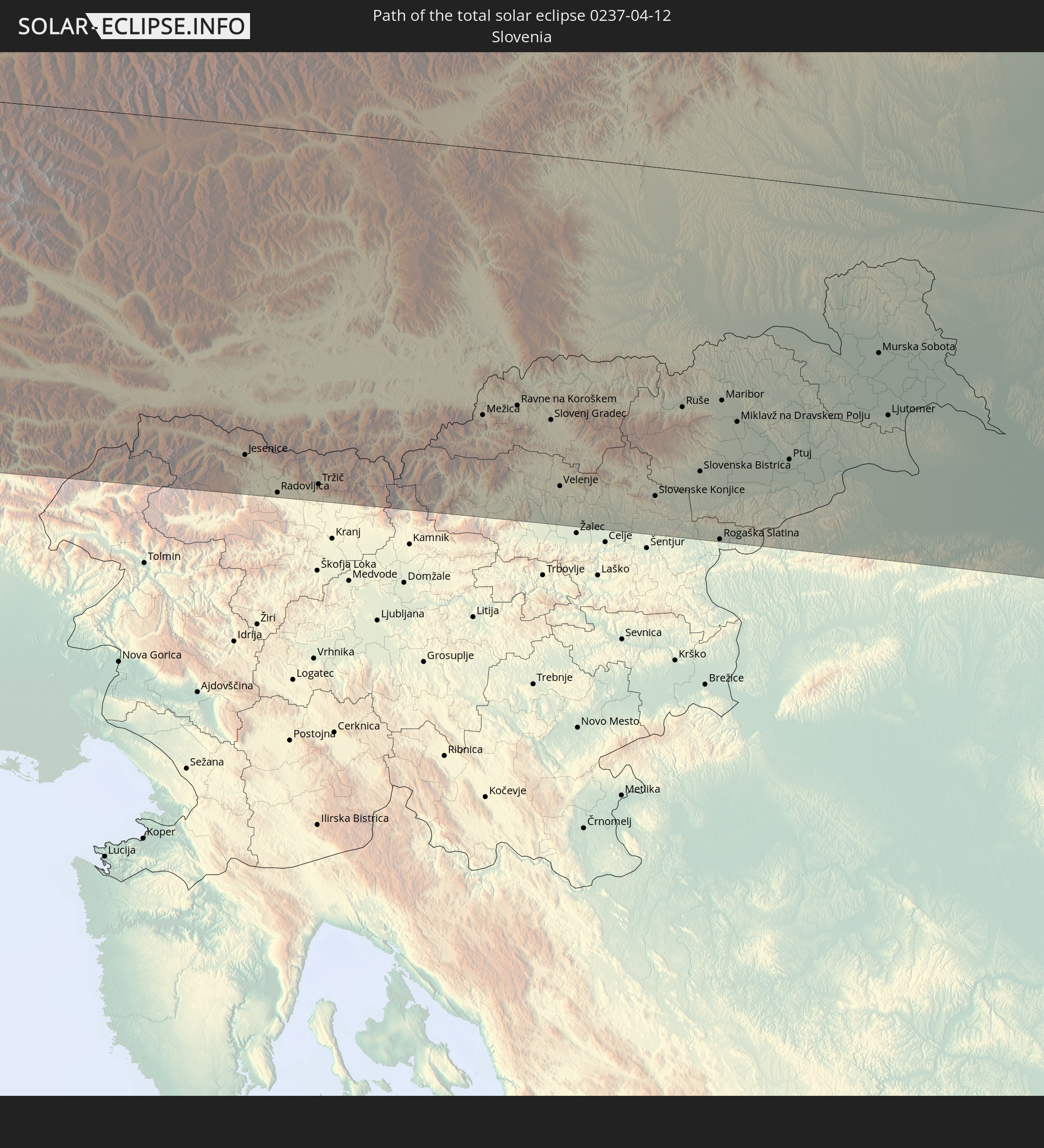
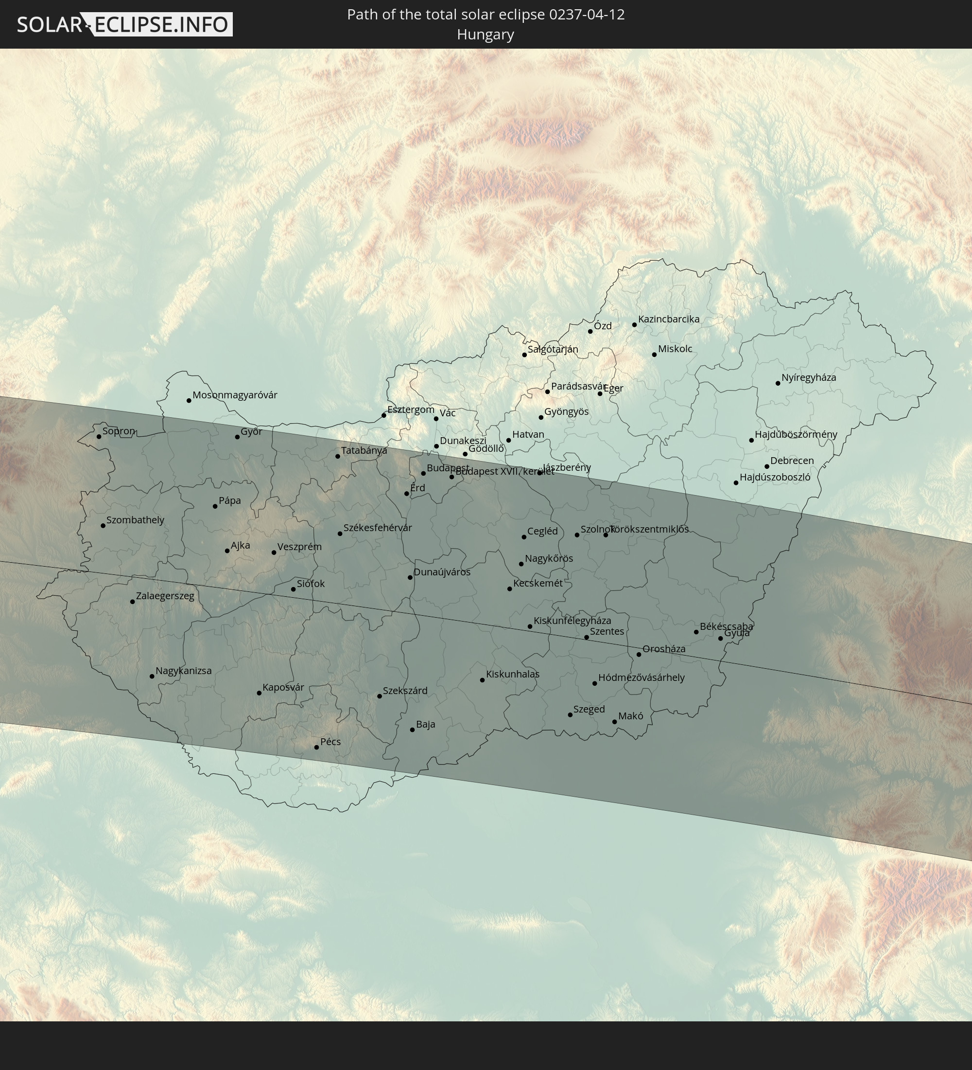
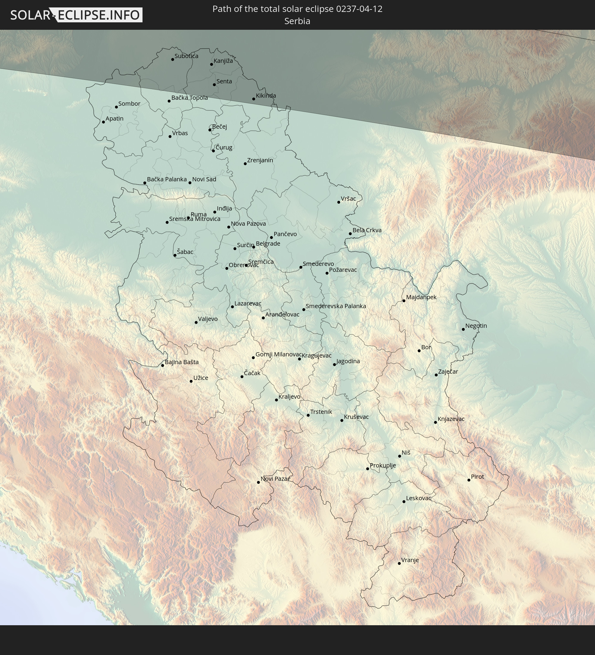
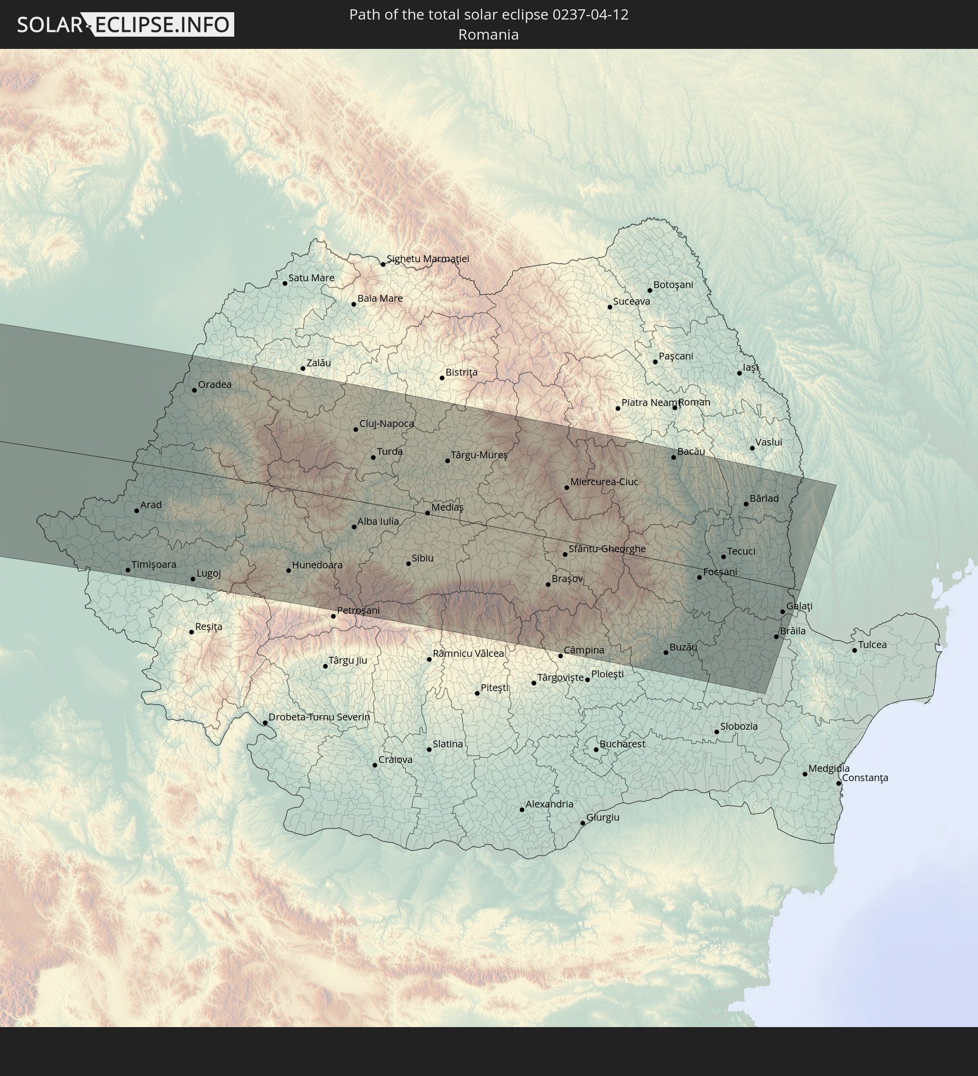
Detaillierte Länderkarten
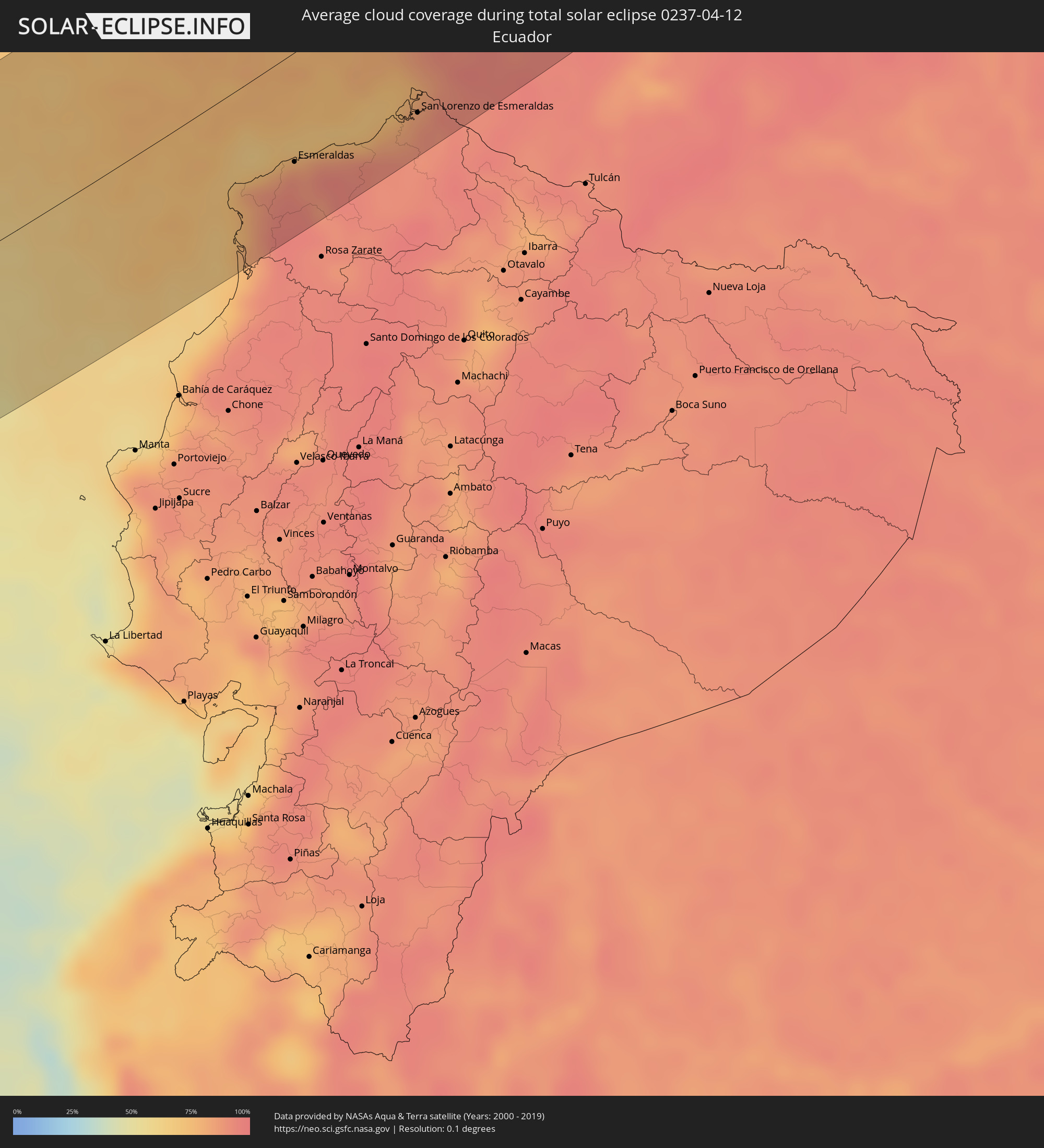 Ecuador
 Kolumbien
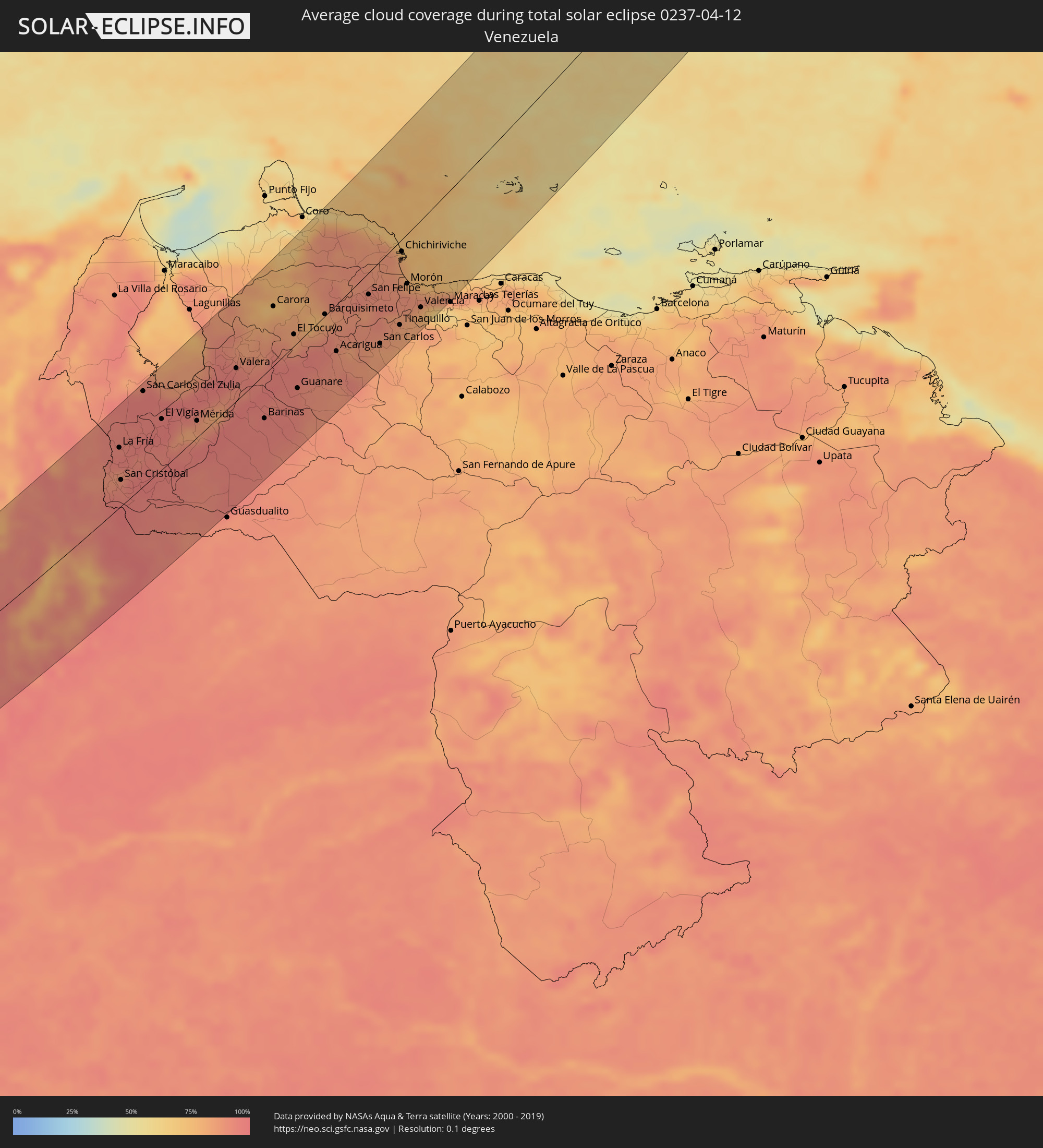 Venezuela
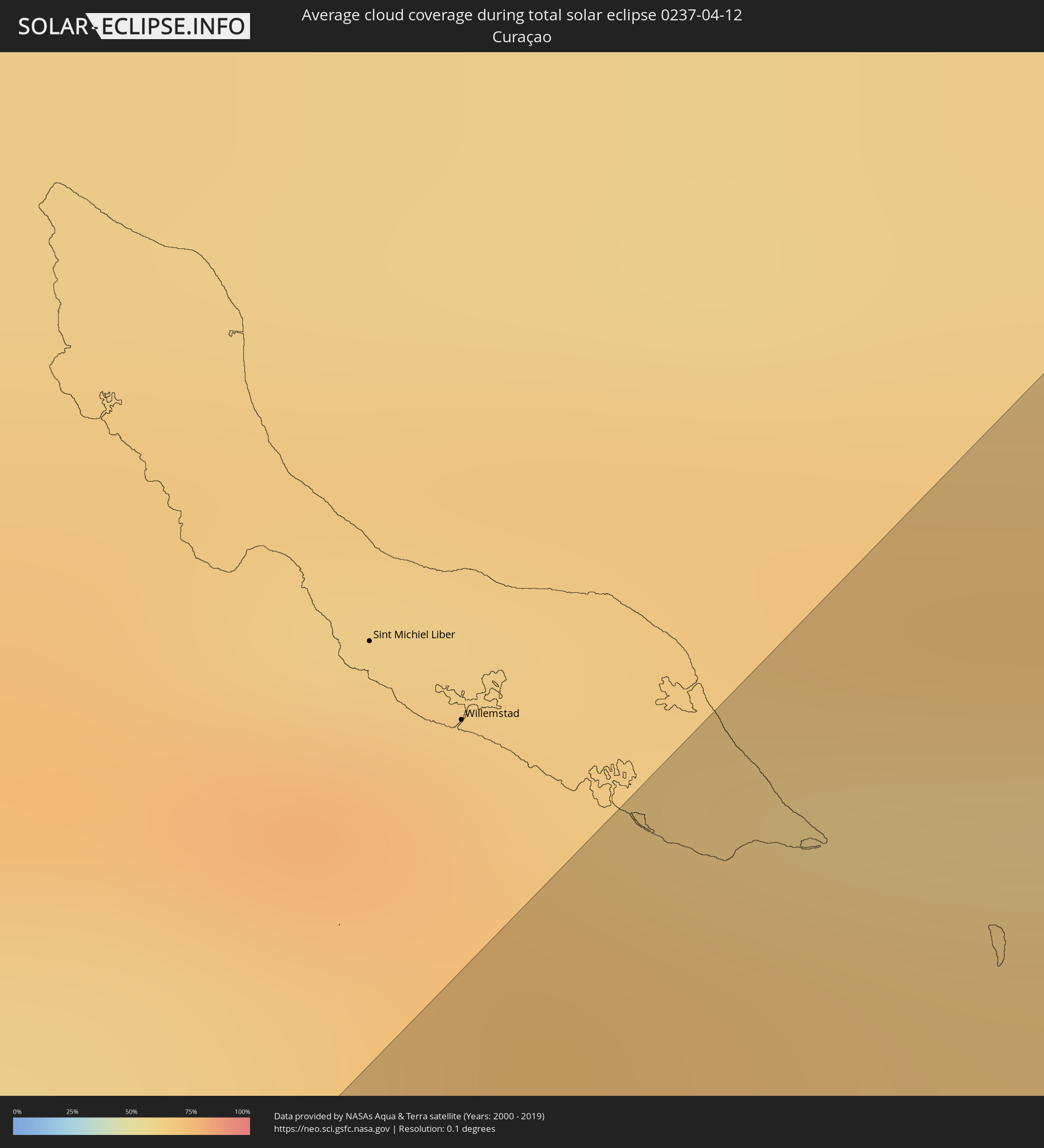 Curaçao
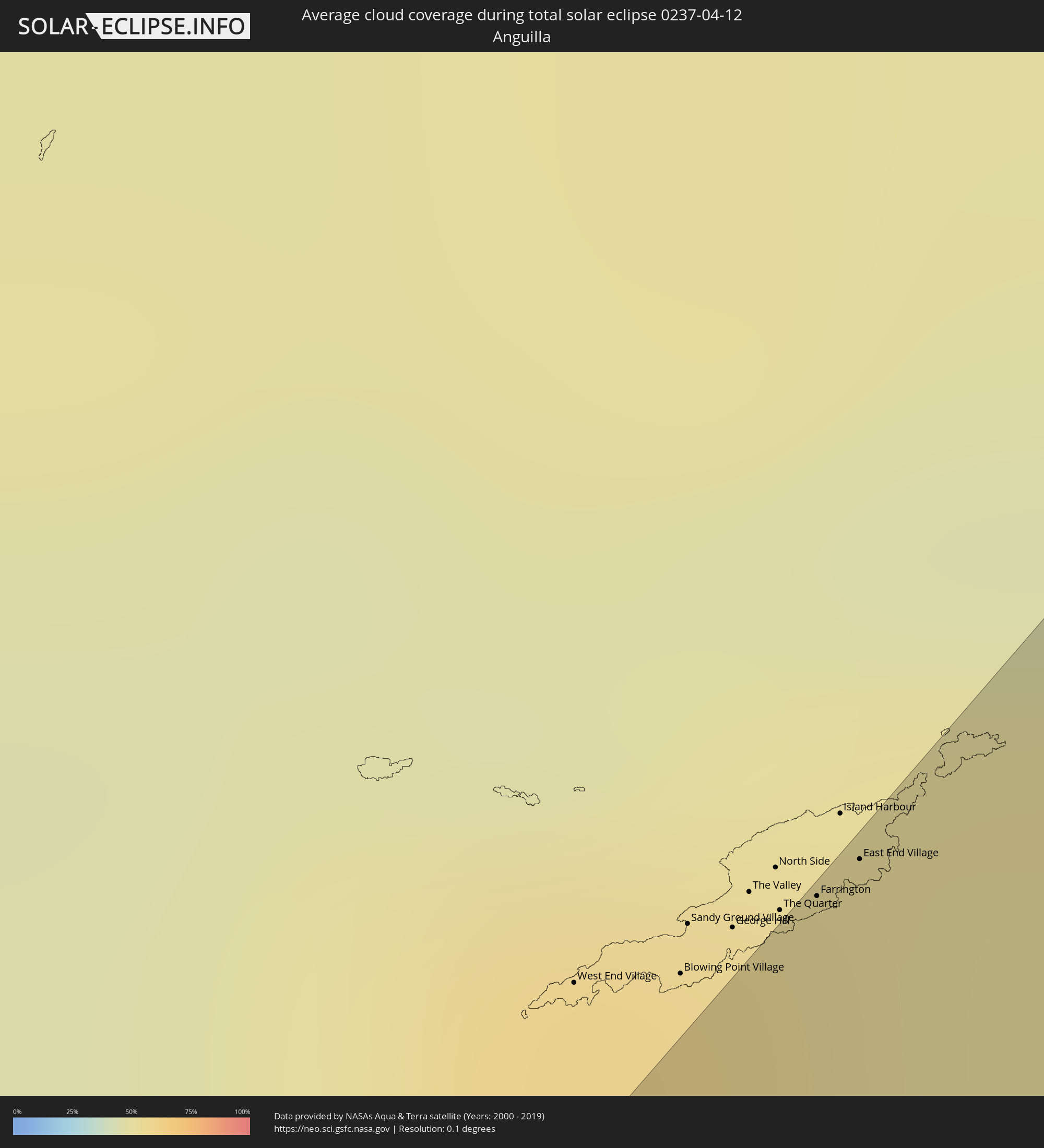 Anguilla
 Sint Maarten
 Saint-Martin
 Saint-Barthélemy
 St. Kitts und Nevis
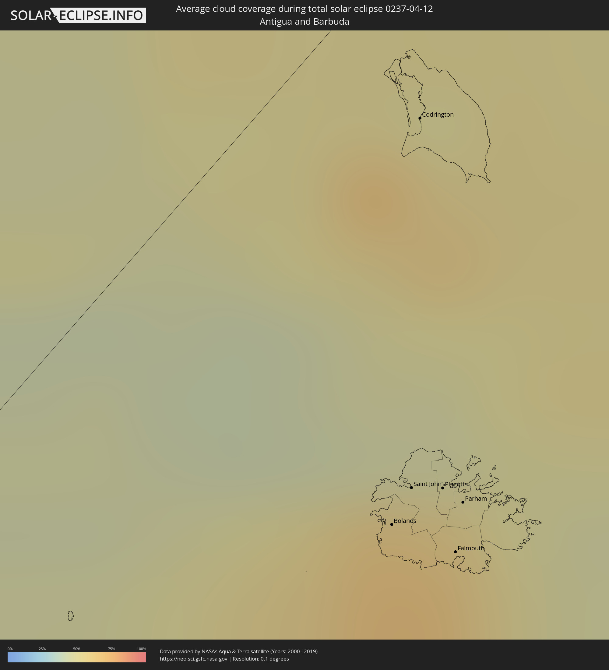 Antigua und Barbuda
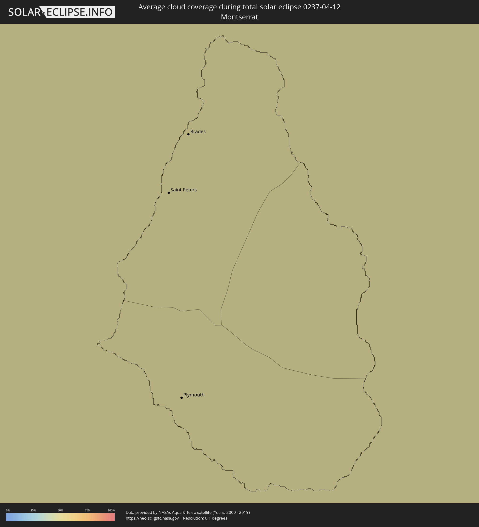 Montserrat
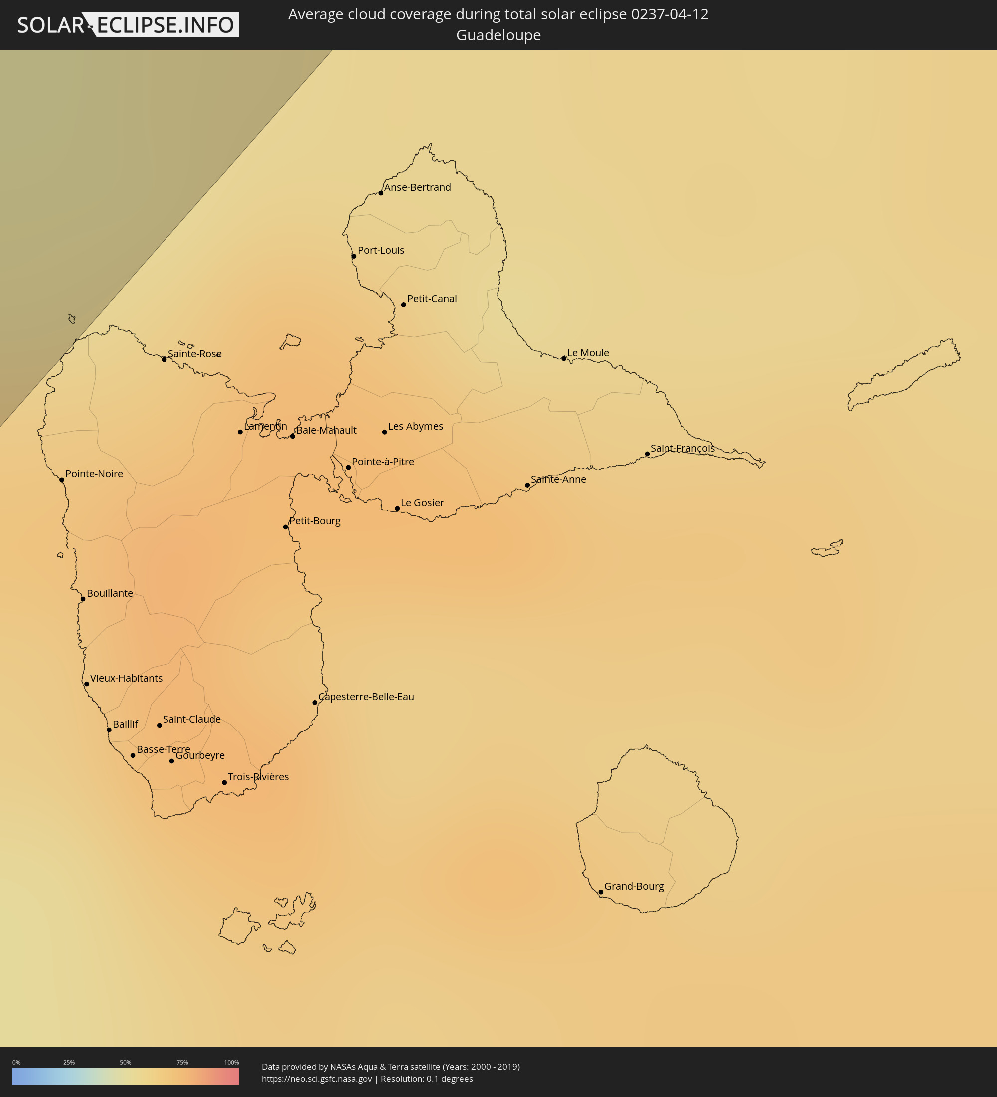 Guadeloupe
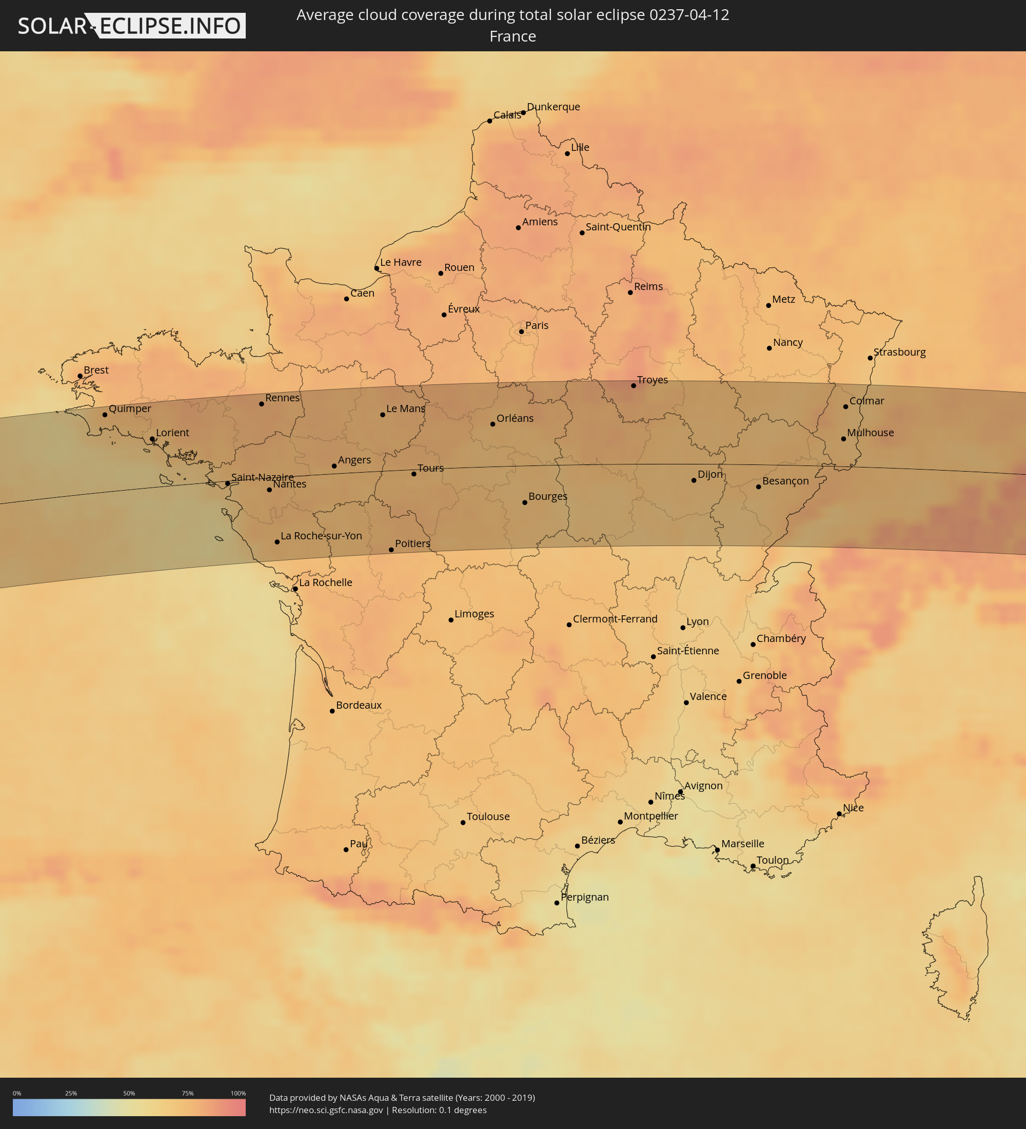 Frankreich
 Besondere Gemeinde (Niederlande)
 Deutschland
 Schweiz
 Italien
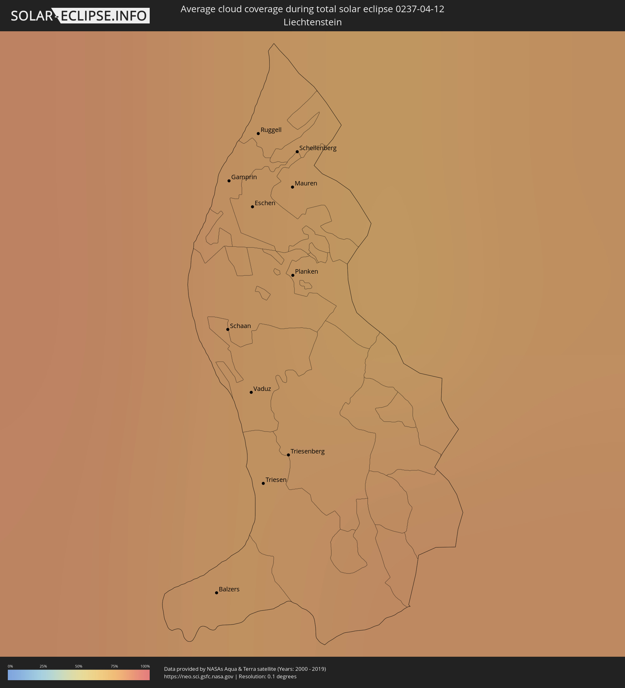 Liechtenstein
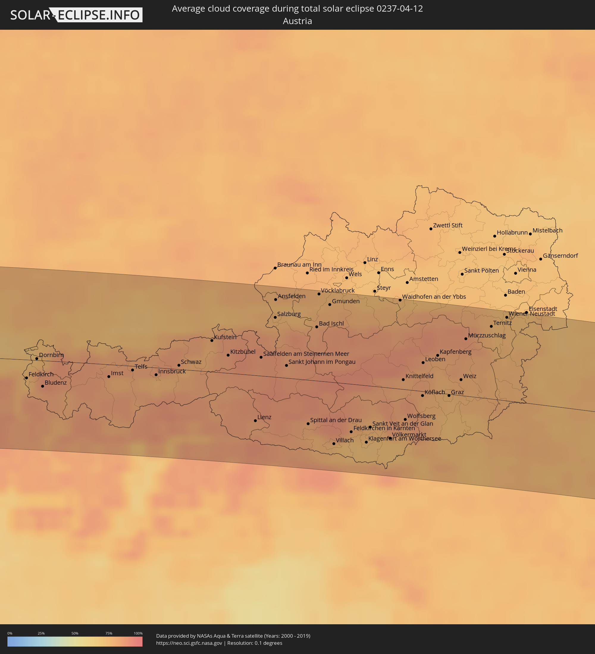 Österreich
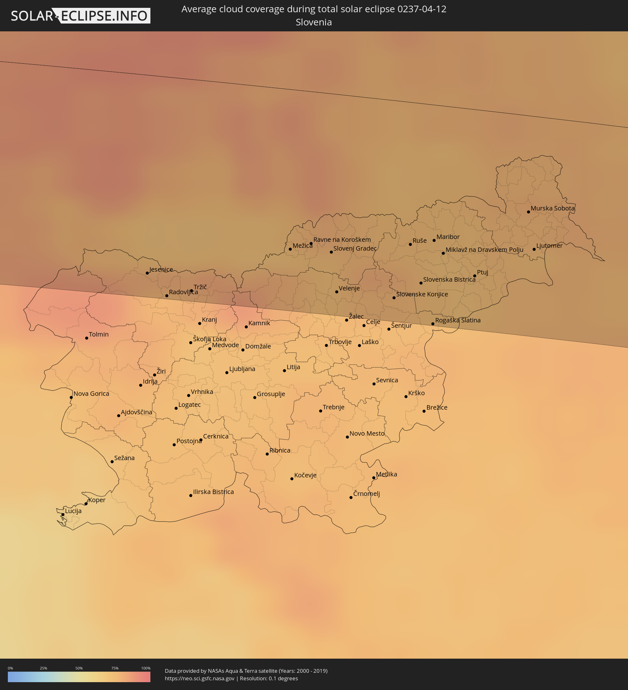 Slowenien
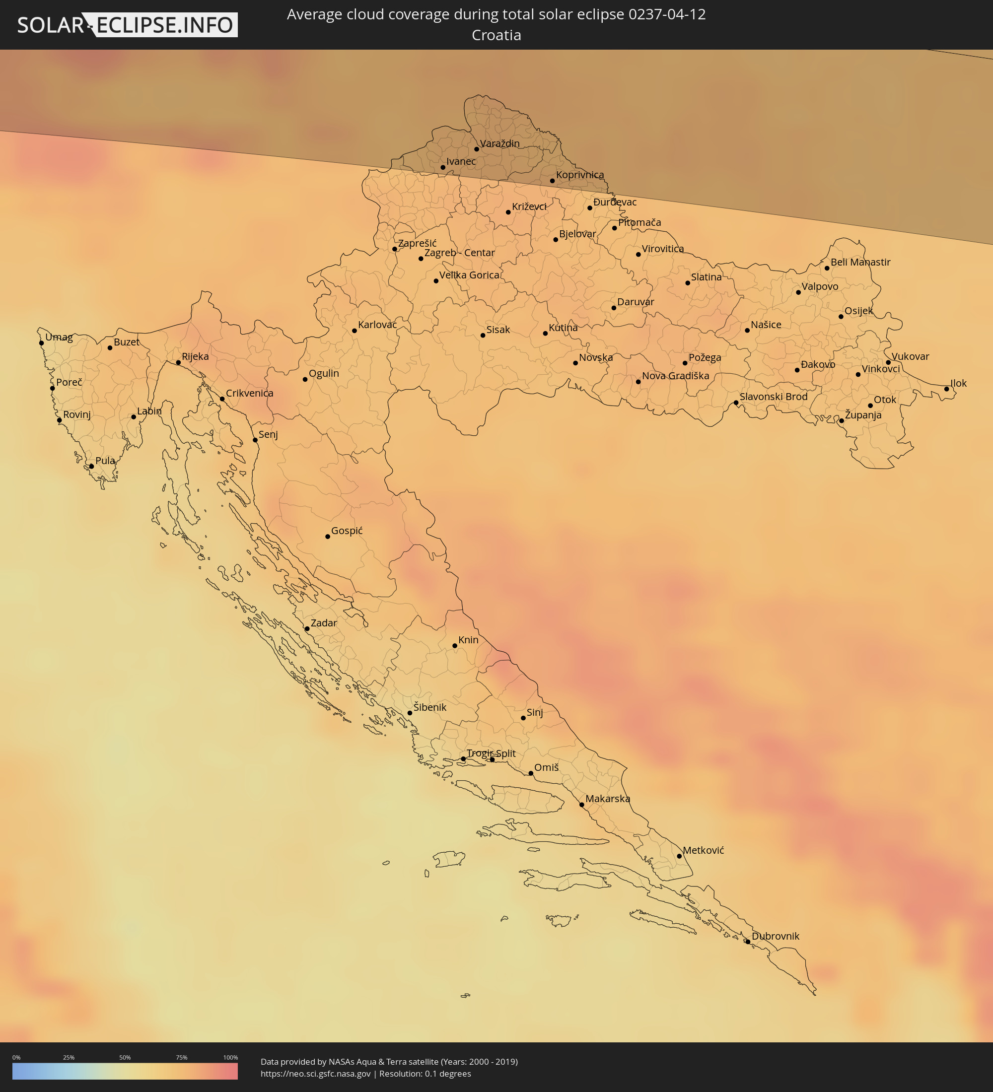 Kroatien
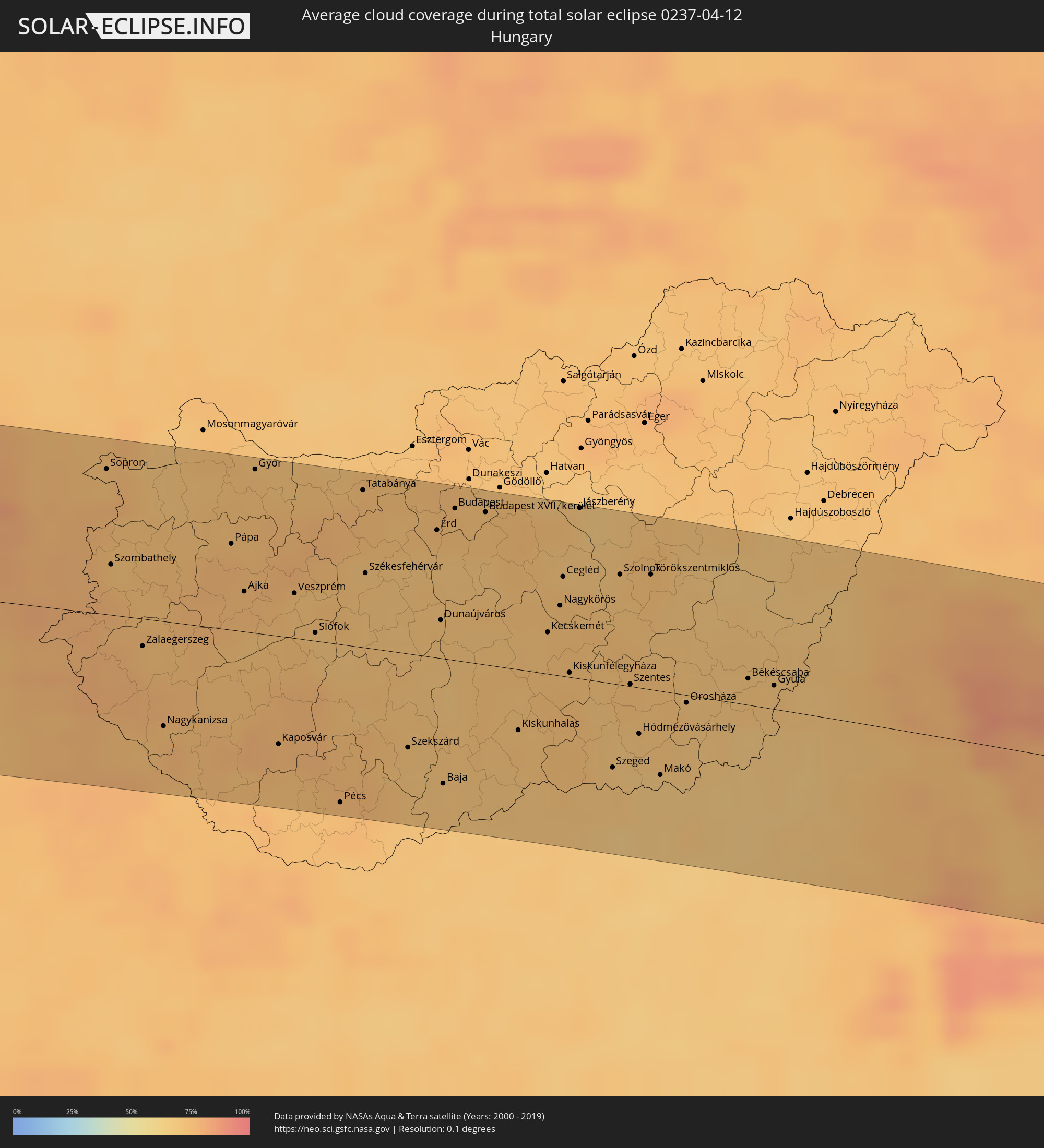 Ungarn
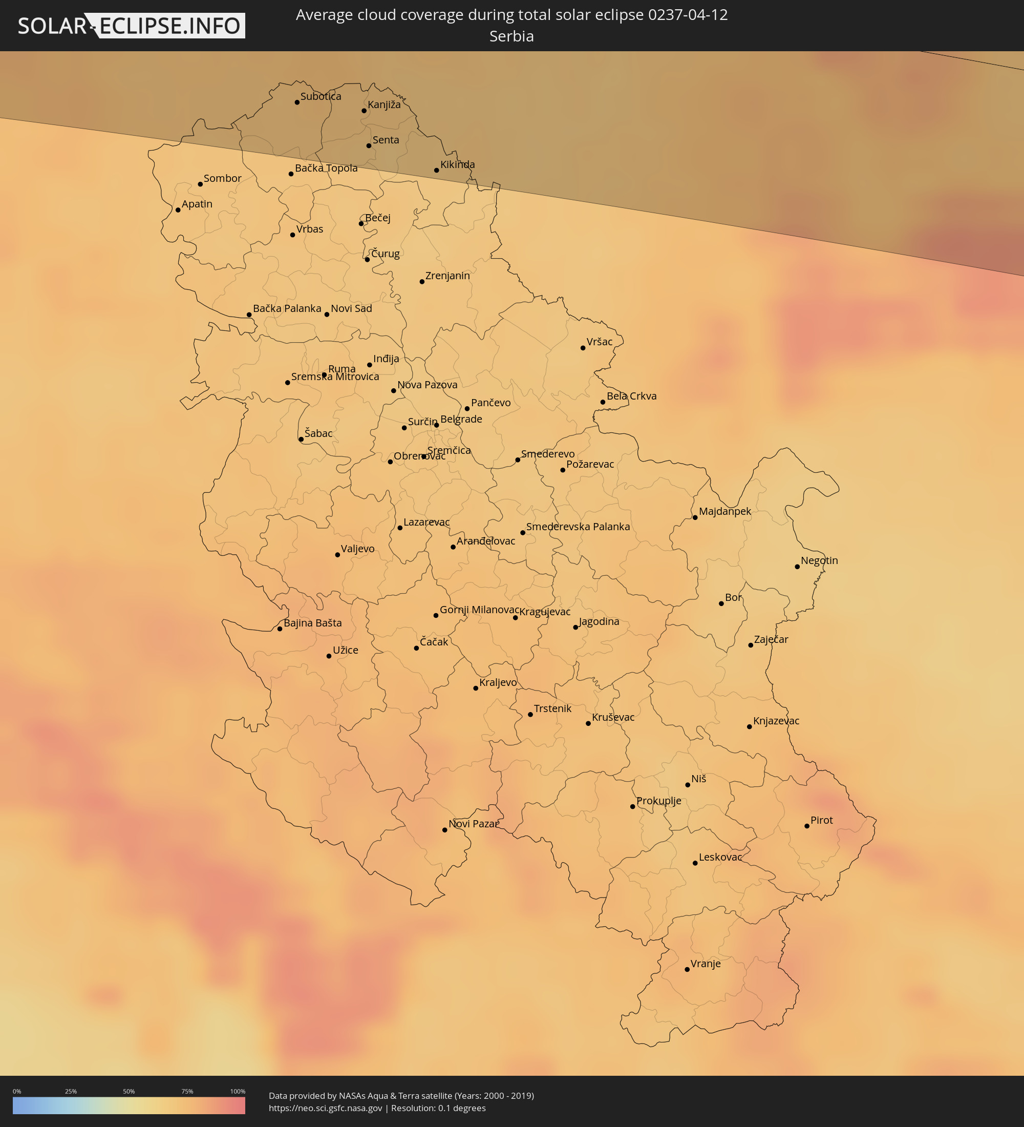 Serbien
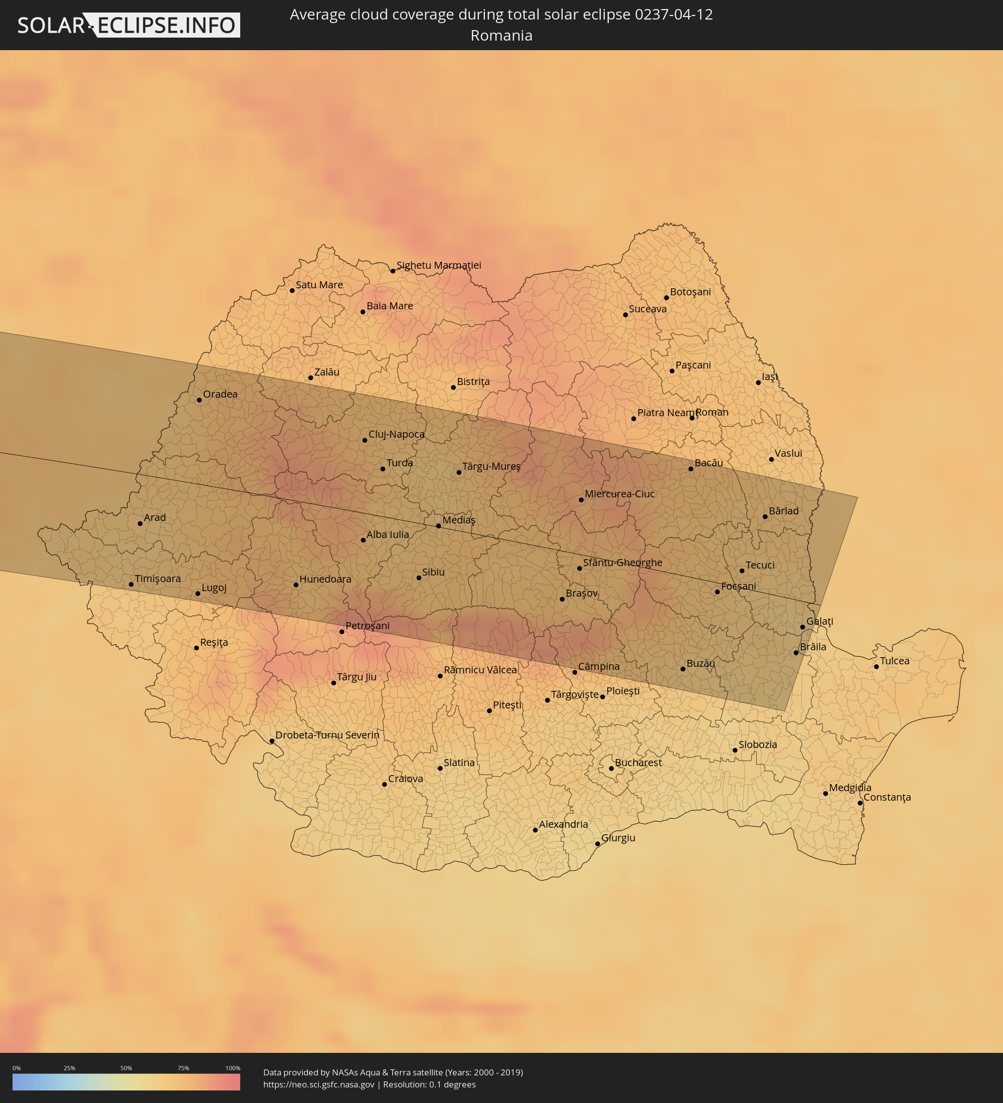 Rumänien
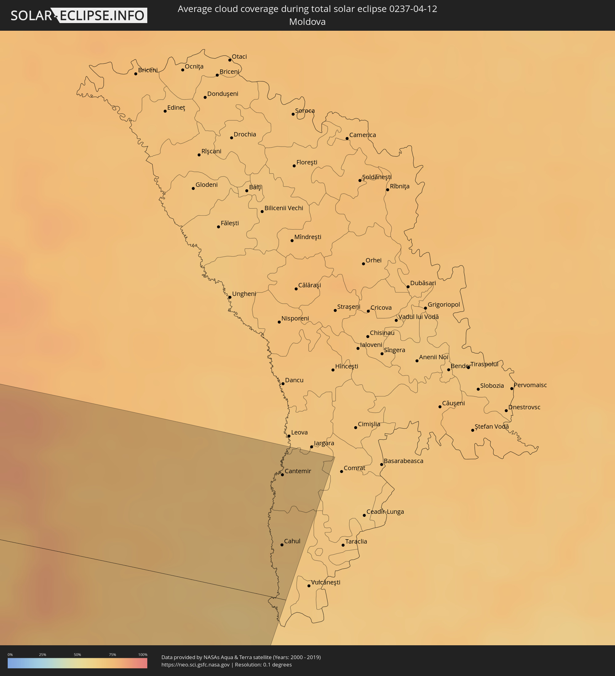 Moldawien
Orte im Finsternispfad
Die nachfolgene Tabelle zeigt Städte und Orte mit mehr als 5.000 Einwohnern, die sich im Finsternispfad befinden. Städte mit mehr als 100.000 Einwohnern sind dick gekennzeichnet. Mit einem Klick auf den Ort öffnet sich eine Detailkarte die die Lage des jeweiligen Ortes zusammen mit dem Verlauf der zentralen Finsternis präsentiert.
| Ort | Typ | Dauer der Verfinsterung | Ortszeit bei maximaler Verfinsterung | Entfernung zur Zentrallinie | Ø Bewölkung |
|
Muisne, Esmeraldas
|
total | - | 08:33:14 UTC-05:14 | 78 km | 78% |
|
Esmeraldas, Esmeraldas
|
total | - | 08:34:03 UTC-05:14 | 68 km | 78% |
|
Valdez, Esmeraldas
|
total | - | 08:35:04 UTC-05:14 | 82 km | 80% |
|
San Lorenzo de Esmeraldas, Esmeraldas
|
total | - | 08:35:15 UTC-05:14 | 88 km | 87% |
|
Cali, Valle del Cauca
|
total | - | 08:58:28 UTC-04:56 | 41 km | 86% |
|
Pereira, Risaralda
|
total | - | 09:01:32 UTC-04:56 | 25 km | 91% |
|
Armenia, Quindío
|
total | - | 09:01:05 UTC-04:56 | 1 km | 93% |
|
Manizales, Caldas
|
total | - | 09:02:08 UTC-04:56 | 35 km | 92% |
|
Ibagué, Tolima
|
total | - | 09:01:24 UTC-04:56 | 40 km | 93% |
|
Soacha, Cundinamarca
|
total | - | 09:02:42 UTC-04:56 | 98 km | 93% |
|
Bogotá, Bogota D.C.
|
total | - | 09:02:54 UTC-04:56 | 104 km | 94% |
|
Bucaramanga, Santander
|
total | - | 09:08:17 UTC-04:56 | 42 km | 91% |
|
Cúcuta, Norte de Santander
|
total | - | 09:10:21 UTC-04:56 | 62 km | 90% |
|
San Cristóbal, Táchira
|
total | - | 09:39:03 UTC-04:27 | 30 km | 93% |
|
Mérida, Mérida
|
total | - | 09:41:49 UTC-04:27 | 19 km | 85% |
|
Mucumpiz, Mérida
|
total | - | 09:41:32 UTC-04:27 | 3 km | 95% |
|
Barinas, Barinas
|
total | - | 09:43:02 UTC-04:27 | 50 km | 95% |
|
Barquisimeto, Lara
|
total | - | 09:46:48 UTC-04:27 | 2 km | 78% |
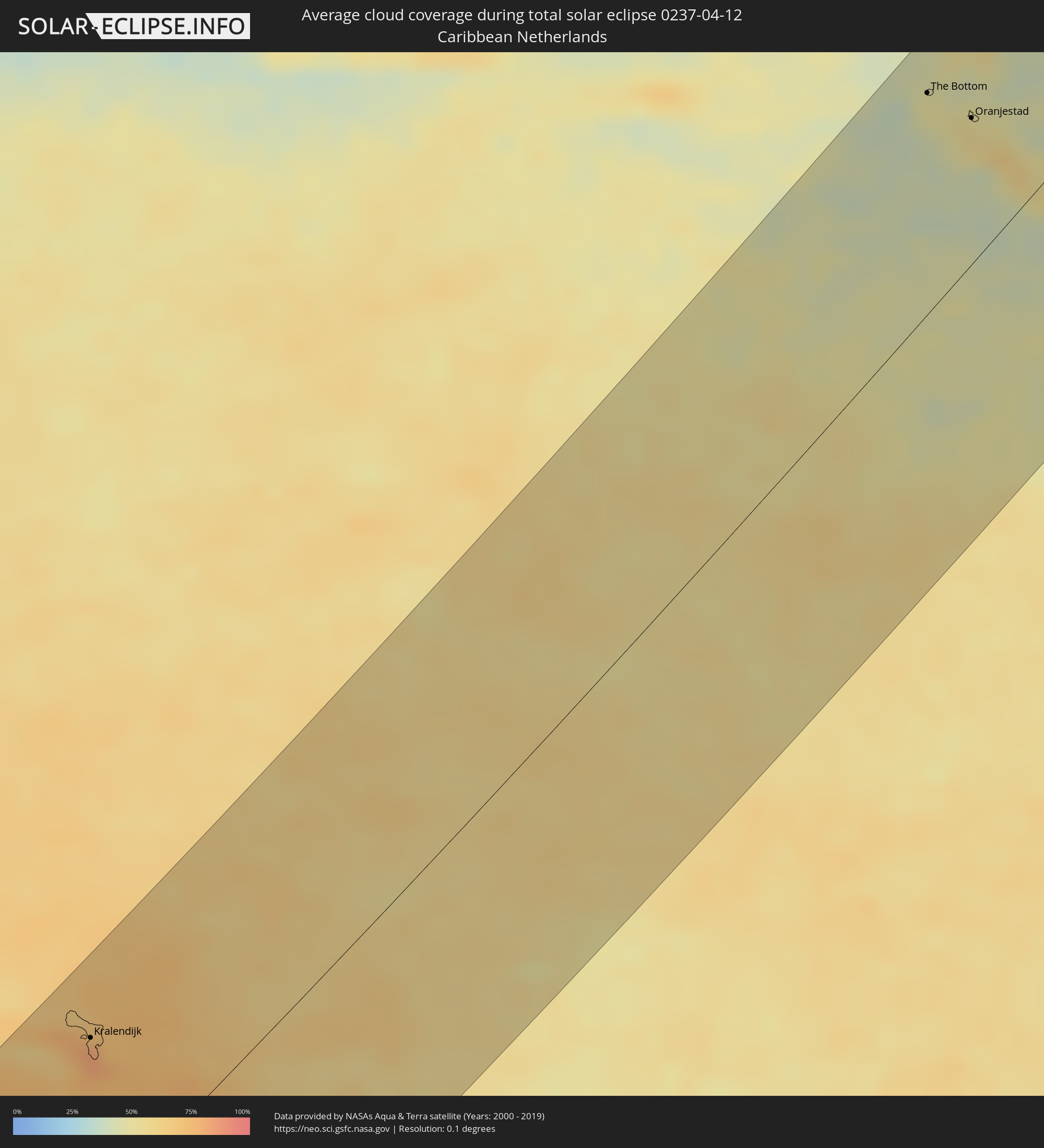
") Kralendijk, Bonaire
Kralendijk, Bonaire
|
total | - | 09:44:05 UTC-04:35 | 81 km | 81% |
|
Puerto Cabello, Carabobo
|
total | - | 09:49:17 UTC-04:27 | 69 km | 85% |
|
Valencia, Carabobo
|
total | - | 09:48:44 UTC-04:27 | 95 km | 77% |
|
Guacara, Carabobo
|
total | - | 09:49:01 UTC-04:27 | 100 km | 68% |
|
El Limón, Aragua
|
total | - | 09:49:30 UTC-04:27 | 112 km | 65% |
|
The Bottom, Saba
|
total | - | 10:02:05 UTC-04:35 | 93 km | 49% |
|
Marigot
|
total | - | 10:32:56 UTC-04:06 | 112 km | 61% |
 Cul de Sac
|
total | - | 10:03:11 UTC-04:35 | 109 km | 52% |
|
Philipsburg
|
total | - | 10:03:11 UTC-04:35 | 106 km | 50% |
|
Farrington, The Farrington
|
total | - | 10:33:19 UTC-04:06 | 118 km | 52% |
|
Sandy Hill, Sandy Hill
|
total | - | 10:33:21 UTC-04:06 | 118 km | 52% |
|
East End Village, East End
|
total | - | 10:33:24 UTC-04:06 | 118 km | 52% |
|
Oranjestad, Sint Eustatius
|
total | - | 10:02:11 UTC-04:35 | 62 km | 55% |
|
Gustavia
|
total | - | 10:32:56 UTC-04:06 | 81 km | 45% |
|
Sandy Point Town, Saint Anne Sandy Point
|
total | - | 10:31:51 UTC-04:06 | 42 km | 62% |
|
Saint Paul’s, Saint Paul Capesterre
|
total | - | 10:31:59 UTC-04:06 | 42 km | 62% |
|
Dieppe Bay Town, Saint John Capesterre
|
total | - | 10:32:01 UTC-04:06 | 43 km | 62% |
|
Trinity, Trinity Palmetto Point
|
total | - | 10:31:52 UTC-04:06 | 31 km | 53% |
|
Cayon, Saint Mary Cayon
|
total | - | 10:32:01 UTC-04:06 | 32 km | 54% |
|
Basseterre, Saint George Basseterre
|
total | - | 10:31:55 UTC-04:06 | 27 km | 60% |
|
Monkey Hill, Saint Peter Basseterre
|
total | - | 10:31:58 UTC-04:06 | 28 km | 60% |
|
Charlestown, Saint Paul Charlestown
|
total | - | 10:31:45 UTC-04:06 | 7 km | 51% |
|
Fig Tree, Saint John Figtree
|
total | - | 10:31:44 UTC-04:06 | 4 km | 51% |
|
Saint Peters, Saint Peter
|
total | - | 10:31:37 UTC-04:06 | 52 km | 62% |
|
Plymouth, Saint Anthony
|
total | - | 10:31:30 UTC-04:06 | 57 km | 54% |
|
Brades, Saint Peter
|
total | - | 10:31:40 UTC-04:06 | 51 km | 62% |
|
Bolands, Saint Mary
|
total | - | 10:32:44 UTC-04:06 | 58 km | 65% |
|
Saint John’s, Saint John
|
total | - | 10:32:53 UTC-04:06 | 56 km | 64% |
|
Codrington, Barbuda
|
total | - | 10:33:57 UTC-04:06 | 19 km | 58% |
|
Piggotts, Saint George
|
total | - | 10:32:57 UTC-04:06 | 60 km | 64% |
|
Falmouth, Saint Paul
|
total | - | 10:32:48 UTC-04:06 | 68 km | 53% |
|
Parham, Saint Peter
|
total | - | 10:32:58 UTC-04:06 | 64 km | 64% |
|
Rennes, Brittany
|
total | - | 16:43:34 UTC+00:09 | 85 km | 77% |
|
Nantes, Pays de la Loire
|
total | - | 16:44:06 UTC+00:09 | 15 km | 75% |
|
Angers, Pays de la Loire
|
total | - | 16:44:32 UTC+00:09 | 8 km | 74% |
|
Le Mans, Pays de la Loire
|
total | - | 16:44:38 UTC+00:09 | 64 km | 74% |
|
Tours, Centre
|
total | - | 16:45:14 UTC+00:09 | 6 km | 71% |
|
Orléans, Centre
|
total | - | 16:45:32 UTC+00:09 | 48 km | 72% |
|
Dijon, Bourgogne-Franche-Comté
|
total | - | 16:47:16 UTC+00:09 | 20 km | 70% |
|
Besançon, Bourgogne-Franche-Comté
|
total | - | 16:47:42 UTC+00:09 | 27 km | 67% |
|
La Chaux-de-Fonds, Neuchâtel
|
total | - | 17:38:45 UTC+01:00 | 42 km | 79% |
|
Biel/Bienne, Bern
|
total | - | 17:38:53 UTC+01:00 | 37 km | 66% |
|
Mulhouse, Grand-Est
|
total | - | 16:47:53 UTC+00:09 | 31 km | 71% |
|
Bern, Bern
|
total | - | 17:39:04 UTC+01:00 | 58 km | 72% |
|
Basel, Basel-City
|
total | - | 17:38:44 UTC+01:00 | 11 km | 70% |
|
Thun, Bern
|
total | - | 17:39:15 UTC+01:00 | 79 km | 74% |
|
Lörrach, Baden-Württemberg
|
total | - | 17:38:44 UTC+01:00 | 17 km | 70% |
|
Freiburg, Baden-Württemberg
|
total | - | 17:38:33 UTC+01:00 | 60 km | 75% |
|
Luzern, Lucerne
|
total | - | 17:39:18 UTC+01:00 | 44 km | 70% |
|
Villingen-Schwenningen, Baden-Württemberg
|
total | - | 17:38:43 UTC+01:00 | 69 km | 76% |
|
Zürich, Zurich
|
total | - | 17:39:11 UTC+01:00 | 8 km | 68% |
|
Winterthur, Zurich
|
total | - | 17:39:09 UTC+01:00 | 8 km | 72% |
|
Konstanz, Baden-Württemberg
|
total | - | 17:39:12 UTC+01:00 | 27 km | 69% |
|
Sankt Gallen, Saint Gallen
|
total | - | 17:39:25 UTC+01:00 | 1 km | 76% |
|
Friedrichshafen, Baden-Württemberg
|
total | - | 17:39:17 UTC+01:00 | 27 km | 70% |
|
Balzers, Balzers
|
total | - | 17:39:41 UTC+01:00 | 38 km | 78% |
|
Schaan, Schaan
|
total | - | 17:39:37 UTC+01:00 | 27 km | 77% |
|
Gamprin, Gamprin
|
total | - | 17:39:35 UTC+01:00 | 21 km | 77% |
|
Eschen, Eschen
|
total | - | 17:39:35 UTC+01:00 | 22 km | 77% |
|
Ruggell, Ruggell
|
total | - | 17:39:34 UTC+01:00 | 19 km | 77% |
|
Triesenberg, Triesenberg
|
total | - | 17:39:39 UTC+01:00 | 32 km | 78% |
|
Mauren, Mauren
|
total | - | 17:39:36 UTC+01:00 | 21 km | 77% |
|
Planken, Planken
|
total | - | 17:39:37 UTC+01:00 | 25 km | 77% |
|
Schellenberg, Schellenberg
|
total | - | 17:39:35 UTC+01:00 | 20 km | 77% |
|
Feldkirch, Vorarlberg
|
total | - | 17:39:36 UTC+01:00 | 19 km | 80% |
|
Ravensburg, Baden-Württemberg
|
total | - | 17:39:15 UTC+01:00 | 42 km | 75% |
|
Dornbirn, Vorarlberg
|
total | - | 17:39:32 UTC+01:00 | 1 km | 78% |
|
Kempten (Allgäu), Bavaria
|
total | - | 17:39:29 UTC+01:00 | 39 km | 74% |
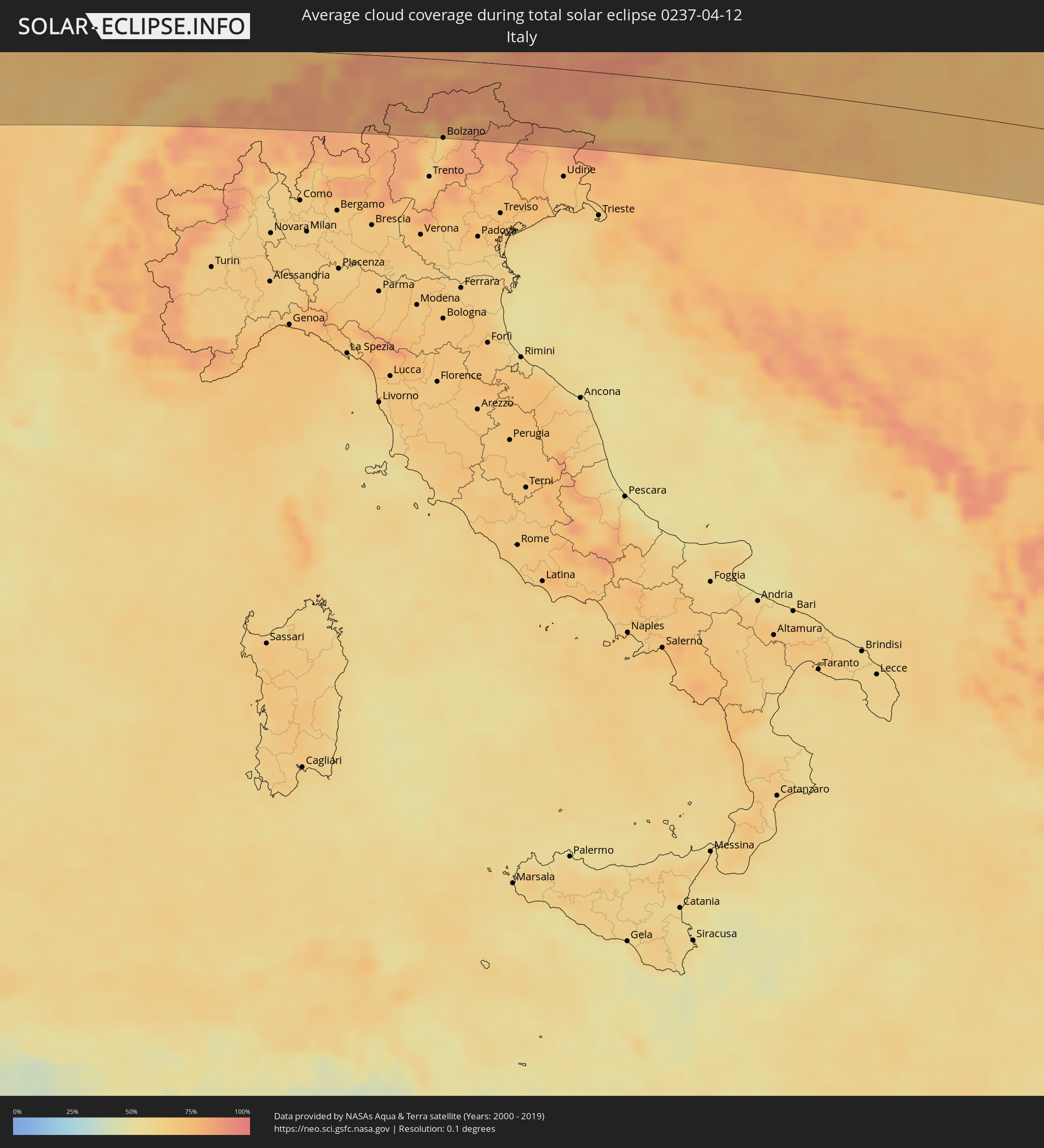
|
Lana, Trentino-Alto Adige
|
total | - | 17:40:27 UTC+01:00 | 81 km | 67% |
|
Merano, Trentino-Alto Adige
|
total | - | 17:40:25 UTC+01:00 | 75 km | 72% |
|
Bolzano, Trentino-Alto Adige
|
total | - | 17:40:34 UTC+01:00 | 94 km | 64% |
|
Innsbruck, Tyrol
|
total | - | 17:40:05 UTC+01:00 | 8 km | 76% |
|
Vipiteno, Trentino-Alto Adige
|
total | - | 17:40:20 UTC+01:00 | 48 km | 85% |
|
Renon - Ritten, Trentino-Alto Adige
|
total | - | 17:40:34 UTC+01:00 | 87 km | 72% |
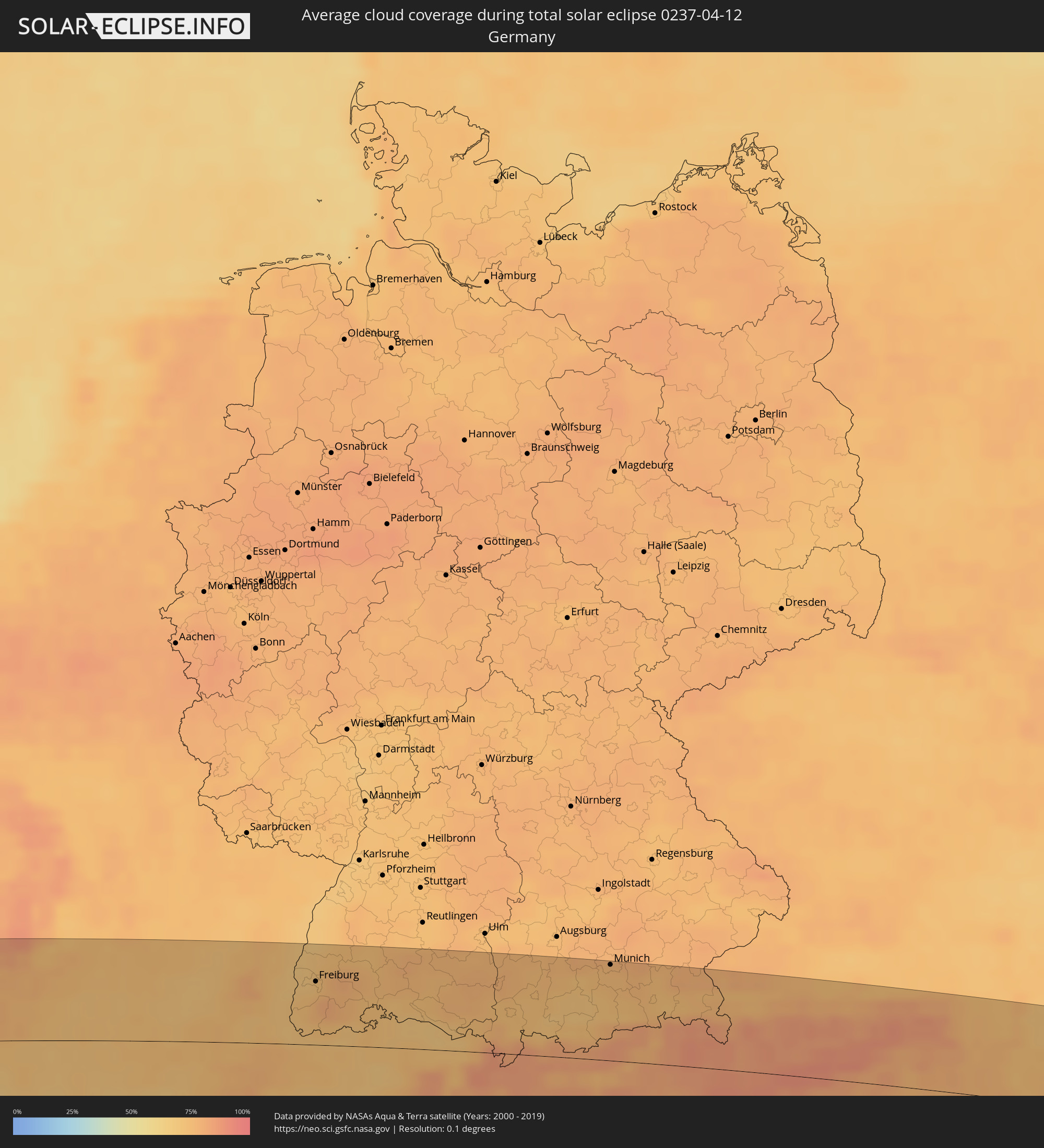
|
Munich, Bavaria
|
total | - | 17:39:33 UTC+01:00 | 90 km | 75% |
|
Bressanone, Trentino-Alto Adige
|
total | - | 17:40:31 UTC+01:00 | 67 km | 80% |
|
Brunico, Trentino-Alto Adige
|
total | - | 17:40:32 UTC+01:00 | 56 km | 76% |
|
Valle Aurina - Ahrntal, Trentino-Alto Adige
|
total | - | 17:40:25 UTC+01:00 | 34 km | 85% |
|
Rosenheim, Bavaria
|
total | - | 17:39:52 UTC+01:00 | 62 km | 74% |
|
Cortina d'Ampezzo, Veneto
|
total | - | 17:40:45 UTC+01:00 | 84 km | 85% |
|
Salzburg, Salzburg
|
total | - | 17:40:07 UTC+01:00 | 62 km | 78% |
|
Villach, Carinthia
|
total | - | 17:41:05 UTC+01:00 | 65 km | 75% |
|
Jesenice, Jesenice
|
total | - | 17:41:15 UTC+01:00 | 83 km | 76% |
|
Klagenfurt am Wörthersee, Carinthia
|
total | - | 17:41:10 UTC+01:00 | 60 km | 72% |
|
Tržič, Tržič
|
total | - | 17:41:20 UTC+01:00 | 89 km | 78% |
|
Wolfsberg, Carinthia
|
total | - | 17:41:08 UTC+01:00 | 32 km | 76% |
|
Slovenj Gradec, Slovenj Gradec
|
total | - | 17:41:23 UTC+01:00 | 66 km | 73% |
|
Velenje, Velenje
|
total | - | 17:41:30 UTC+01:00 | 83 km | 74% |
|
Graz, Styria
|
total | - | 17:41:05 UTC+01:00 | 2 km | 75% |
|
Slovenska Bistrica, Slovenska Bistrica
|
total | - | 17:41:33 UTC+01:00 | 75 km | 74% |
|
Rogaška Slatina, Rogaška Slatina
|
total | - | 17:41:40 UTC+01:00 | 92 km | 76% |
|
Maribor, Maribor
|
total | - | 17:41:28 UTC+01:00 | 57 km | 74% |
|
Ptuj, Ptuj
|
total | - | 17:41:35 UTC+01:00 | 70 km | 72% |
|
Ivanec, Varaždinska
|
total | - | 17:41:45 UTC+01:00 | 89 km | 77% |
|
Murska Sobota, Murska Sobota
|
total | - | 17:41:28 UTC+01:00 | 40 km | 76% |
|
Wiener Neustadt, Lower Austria
|
total | - | 17:40:43 UTC+01:00 | 86 km | 75% |
|
Varaždin, Varaždinska
|
total | - | 17:41:44 UTC+01:00 | 78 km | 77% |
|
Čakovec, Međimurska
|
total | - | 17:41:42 UTC+01:00 | 69 km | 76% |
|
Szombathely, Vas
|
total | - | 17:41:09 UTC+01:00 | 27 km | 76% |
|
Koprivnica, Koprivničko-Križevačka
|
total | - | 17:41:54 UTC+01:00 | 90 km | 78% |
|
Győr, Győr-Moson-Sopron
|
total | - | 17:40:59 UTC+01:00 | 86 km | 72% |
|
Pécs, Baranya
|
total | - | 17:42:08 UTC+01:00 | 84 km | 73% |
|
Székesfehérvár, Fejér
|
total | - | 17:41:24 UTC+01:00 | 39 km | 72% |
|
Budapest, Budapest
|
total | - | 17:41:15 UTC+01:00 | 80 km | 74% |
|
Stanišić
|
total | - | 17:42:19 UTC+01:00 | 90 km | 70% |
|
Budapest XVII. kerület, Budapest
|
total | - | 17:41:17 UTC+01:00 | 80 km | 73% |
|
Subotica, Vojvodina
|
total | - | 17:42:15 UTC+01:00 | 67 km | 70% |
|
Kecskemét, Bács-Kiskun
|
total | - | 17:41:43 UTC+01:00 | 22 km | 72% |
|
Kanjiža, Vojvodina
|
total | - | 17:42:18 UTC+01:00 | 66 km | 70% |
|
Senta, Vojvodina
|
total | - | 17:42:24 UTC+01:00 | 81 km | 67% |
|
Novi Kneževac, Vojvodina
|
total | - | 17:42:19 UTC+01:00 | 68 km | 70% |
|
Čoka, Vojvodina
|
total | - | 17:42:23 UTC+01:00 | 79 km | 67% |
|
Szeged, Csongrád
|
total | - | 17:42:11 UTC+01:00 | 45 km | 70% |
|
Szolnok, Jász-Nagykun-Szolnok
|
total | - | 17:41:34 UTC+01:00 | 58 km | 72% |
|
Mokrin
|
total | - | 17:42:25 UTC+01:00 | 77 km | 67% |
|
Kikinda, Vojvodina
|
total | - | 17:42:29 UTC+01:00 | 88 km | 66% |
|
Timişoara, Timiş
|
total | - | 18:26:59 UTC+01:44 | 87 km | 67% |
|
Arad, Arad
|
total | - | 18:26:42 UTC+01:44 | 38 km | 68% |
|
Oradea, Bihor
|
total | - | 18:26:08 UTC+01:44 | 64 km | 72% |
|
Cluj-Napoca, Cluj
|
total | - | 18:26:21 UTC+01:44 | 55 km | 73% |
|
Sibiu, Sibiu
|
total | - | 18:26:59 UTC+01:44 | 43 km | 72% |
|
Braşov, Braşov
|
total | - | 18:27:02 UTC+01:44 | 38 km | 81% |
|
Bacău, Bacău
|
total | - | 18:26:21 UTC+01:44 | 83 km | 72% |
|
Brăila, Brăila
|
total | - | 18:27:07 UTC+01:44 | 42 km | 64% |
|
Galaţi, Galaţi
|
total | - | 18:26:59 UTC+01:44 | 20 km | 64% |
|
Cahul, Cahul
|
total | - | 18:37:17 UTC+01:55 | 31 km | 66% |
|
Cantemir, Cantemir
|
total | - | 18:37:02 UTC+01:55 | 72 km | 69% |