Totale Sonnenfinsternis vom 16.08.0239
| Wochentag: | Freitag |
| Maximale Dauer der Verfinsterung: | 01m45s |
| Maximale Breite des Finsternispfades: | 392 km |
| Saroszyklus: | 68 |
| Bedeckungsgrad: | 100% |
| Magnitude: | 1.0313 |
| Gamma: | 0.9611 |
Wo kann man die Sonnenfinsternis vom 16.08.0239 sehen?
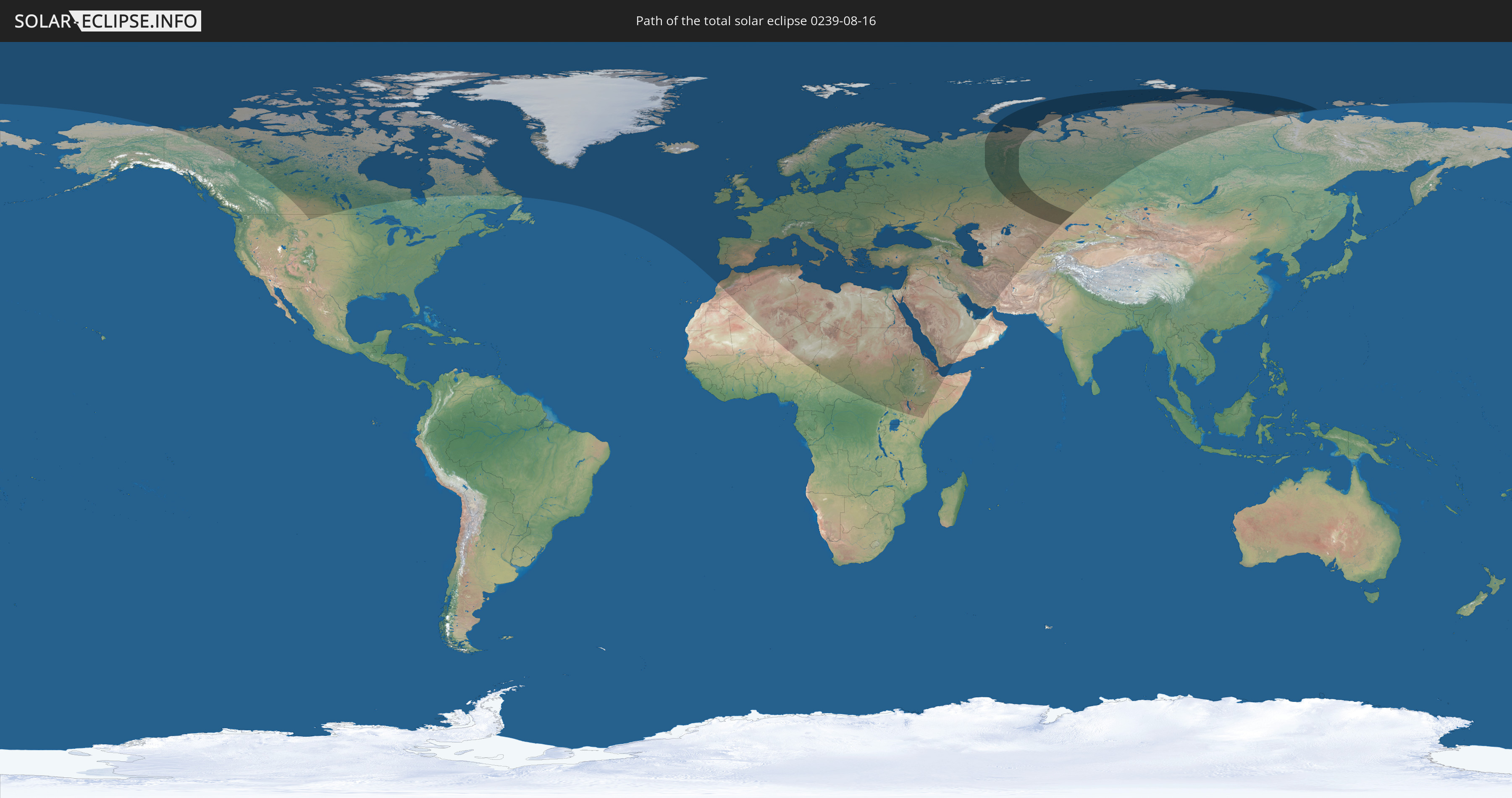
Die Sonnenfinsternis am 16.08.0239 kann man in 94 Ländern als partielle Sonnenfinsternis beobachten.
Der Finsternispfad verläuft durch 2 Länder. Nur in diesen Ländern ist sie als totale Sonnenfinsternis zu sehen.
In den folgenden Ländern ist die Sonnenfinsternis total zu sehen
 Russland
 Kasachstan
In den folgenden Ländern ist die Sonnenfinsternis partiell zu sehen
 Russland
 Vereinigte Staaten
 Kanada
 Grönland
 Portugal
 Island
 Spanien
 Marokko
 Irland
 Spitzbergen
 Algerien
 Vereinigtes Königreich
 Färöer
 Gibraltar
 Frankreich
 Isle of Man
 Guernsey
 Jersey
 Niger
Niger
 Andorra
 Belgien
 Nigeria
 Niederlande
 Norwegen
 Luxemburg
 Deutschland
 Schweiz
 Italien
 Monaco
 Tunesien
 Dänemark
 Kamerun
 Libyen
 Liechtenstein
 Österreich
 Schweden
 Tschechien
 Demokratische Republik Kongo
 San Marino
 Vatikanstadt
 Slowenien
 Tschad
 Kroatien
 Polen
Polen
 Malta
Malta
 Zentralafrikanische Republik
 Bosnien und Herzegowina
 Ungarn
 Slowakei
 Montenegro
 Serbien
 Albanien
 Åland Islands
 Griechenland
 Rumänien
 Mazedonien
 Finnland
 Litauen
 Lettland
 Estland
 Sudan
Sudan
 Ukraine
 Bulgarien
 Weißrussland
 Ägypten
 Türkei
 Moldawien
 Uganda
 Republik Zypern
 Äthiopien
 Kenia
Kenia
 Staat Palästina
 Israel
 Saudi-Arabien
 Jordanien
 Libanon
 Syrien
 Eritrea
 Irak
Irak
 Georgien
 Somalia
 Dschibuti
 Jemen
Jemen
 Armenien
 Iran
Iran
 Aserbaidschan
 Kasachstan
 Kuwait
 Bahrain
 Katar
Katar
 Vereinigte Arabische Emirate
 Turkmenistan
 Usbekistan
 Afghanistan
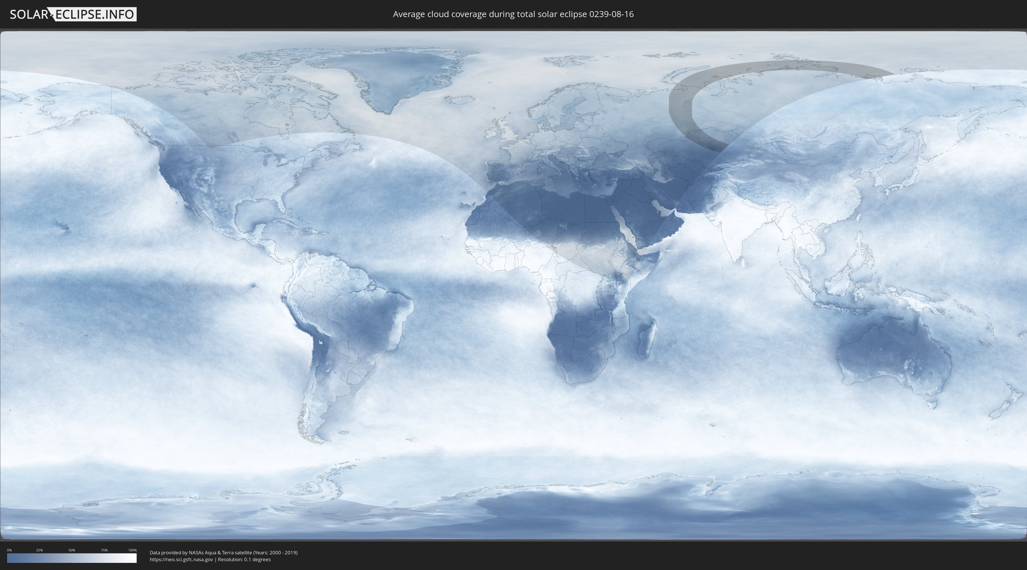
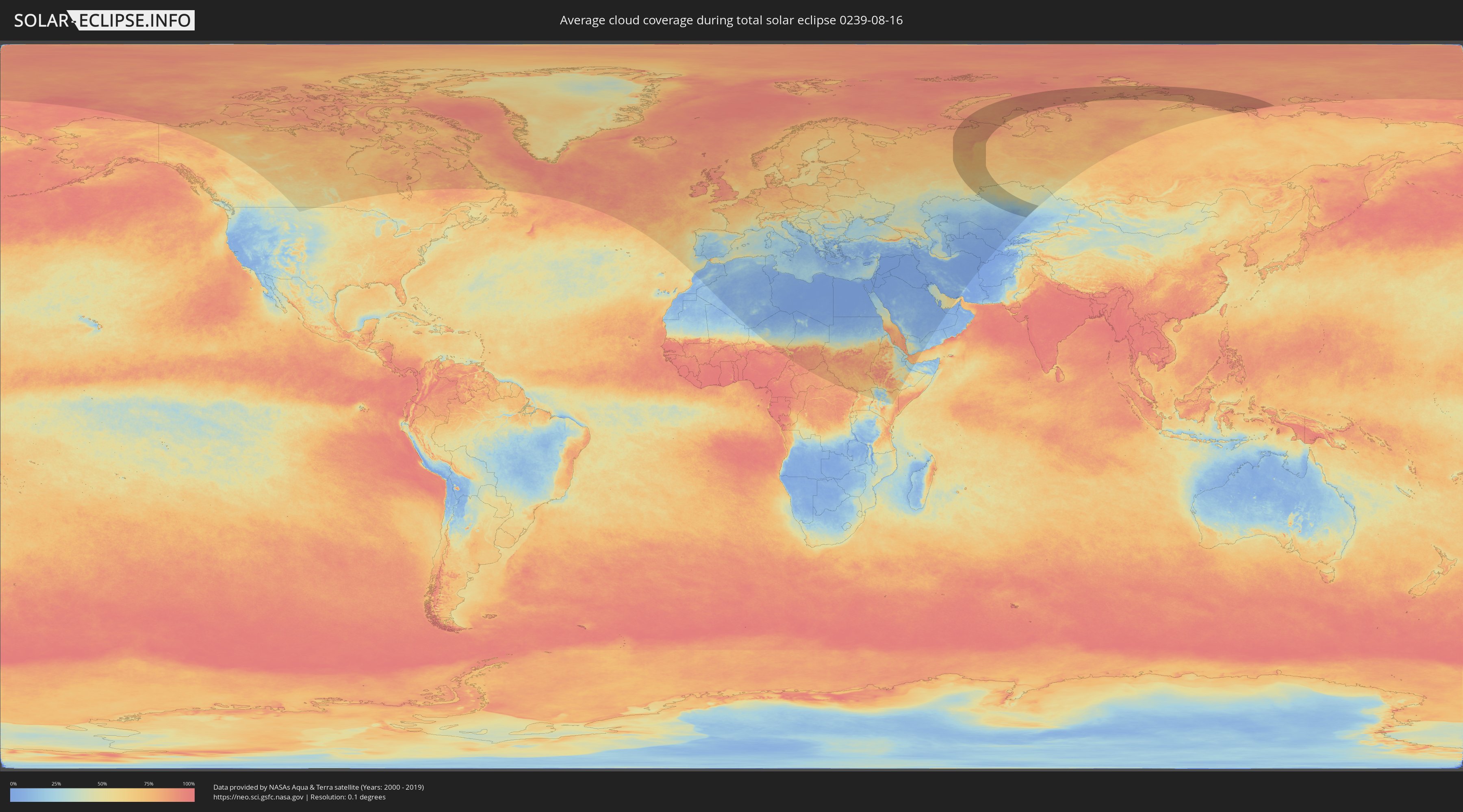
Wie wird das Wetter während der totalen Sonnenfinsternis am 16.08.0239?
Wo ist der beste Ort, um die totale Sonnenfinsternis vom 16.08.0239 zu beobachten?
Die folgenden Karten zeigen die durchschnittliche Bewölkung für den Tag, an dem die totale Sonnenfinsternis
stattfindet. Mit Hilfe der Karten lässt sich der Ort entlang des Finsternispfades eingrenzen,
der die besten Aussichen auf einen klaren wolkenfreien Himmel bietet.
Trotzdem muss man immer lokale Gegenenheiten beachten und sollte sich genau über das Wetter an seinem
gewählten Beobachtungsort informieren.
Die Daten stammen von den beiden NASA-Satelliten
AQUA und TERRA
und wurden über einen Zeitraum von 19 Jahren (2000 - 2019) gemittelt.
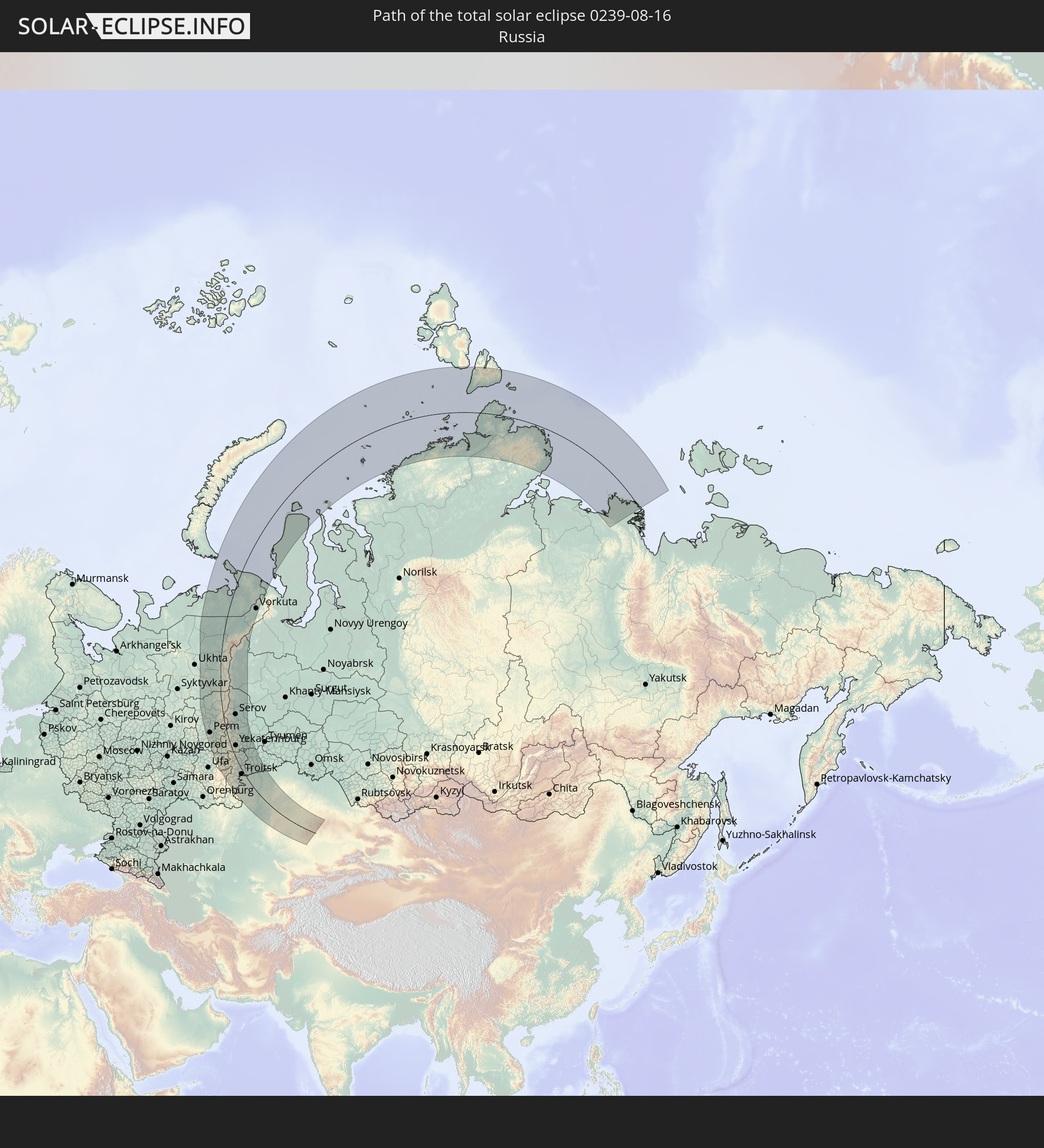
Detaillierte Länderkarten
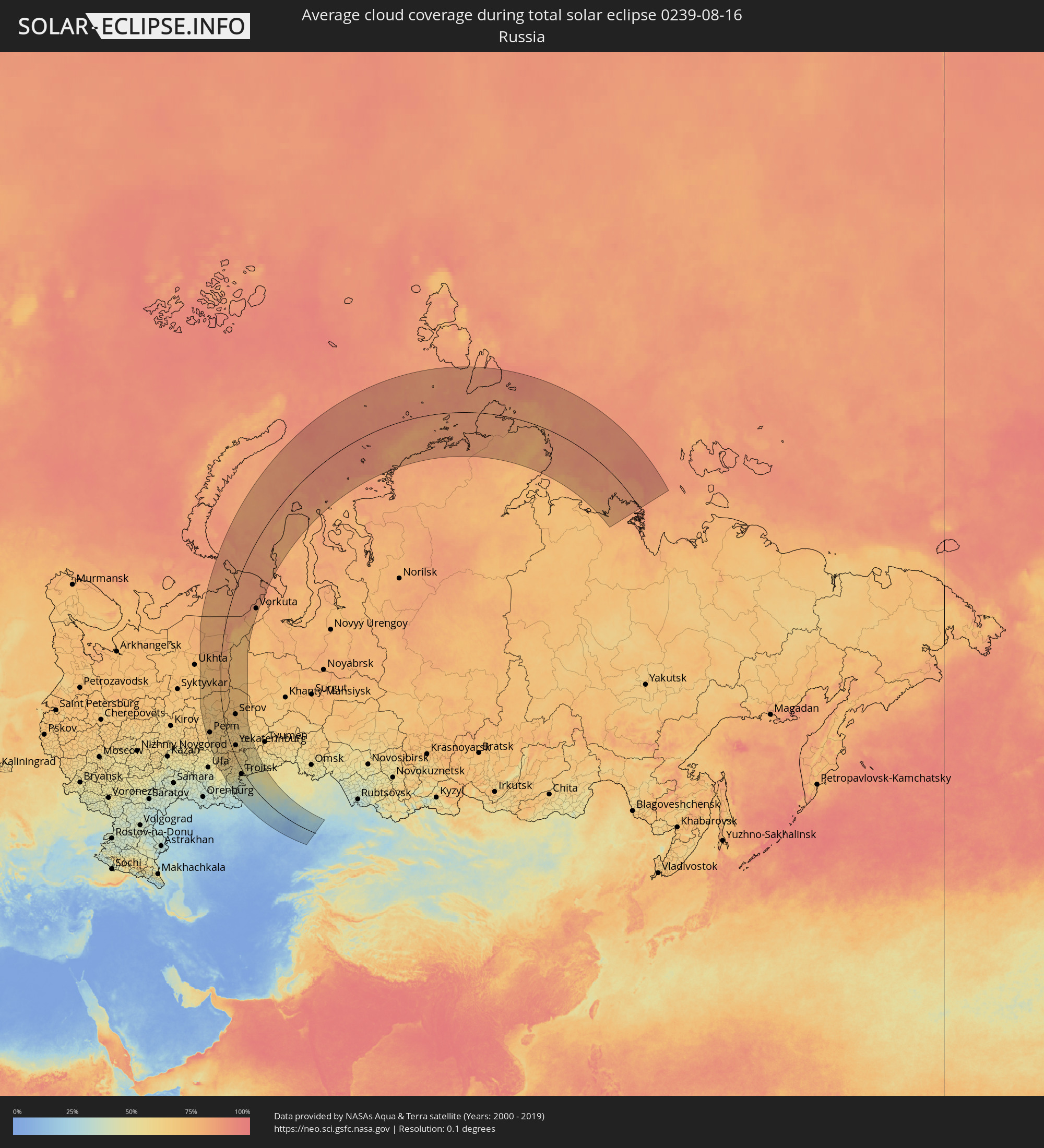 Russland
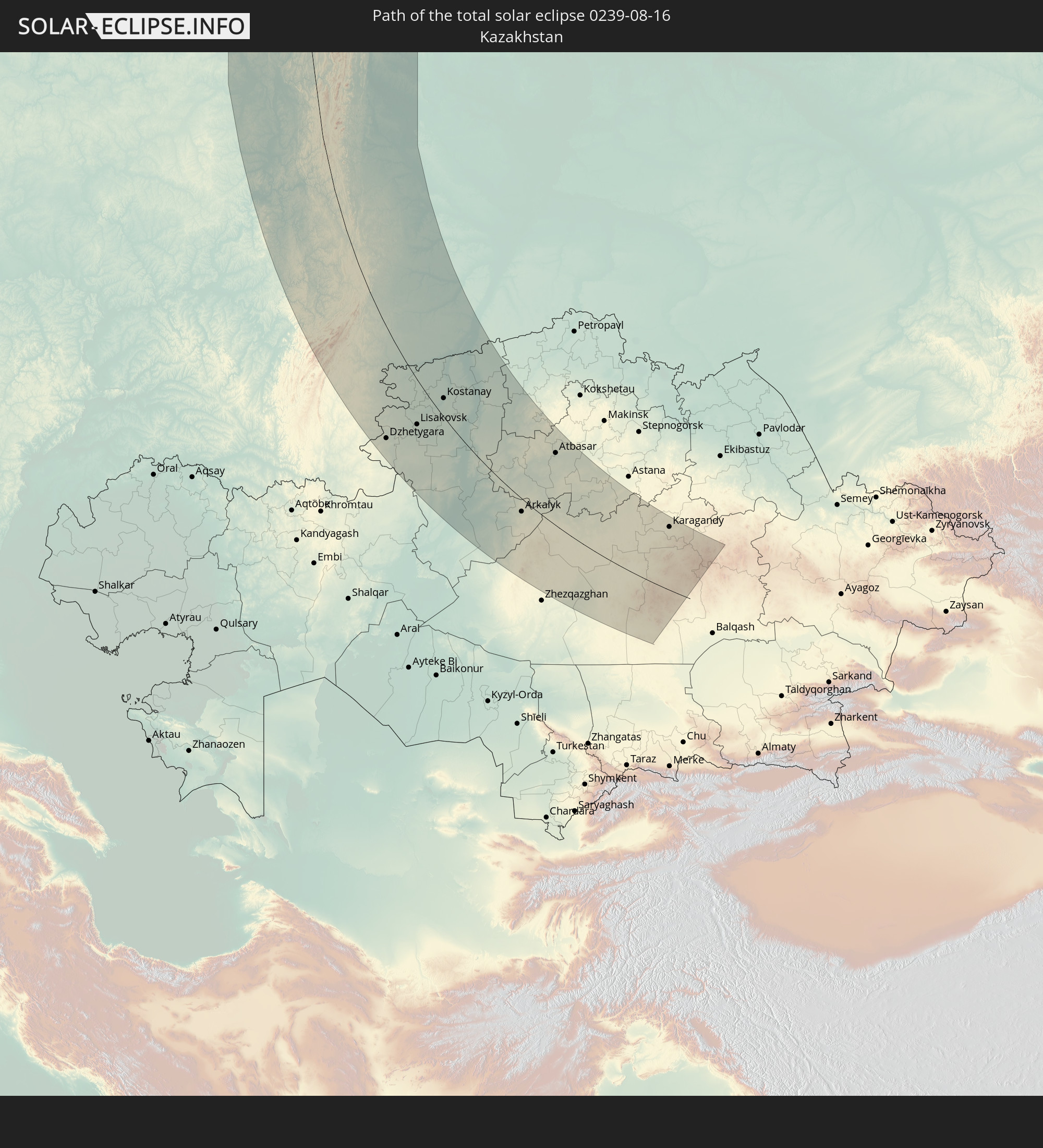
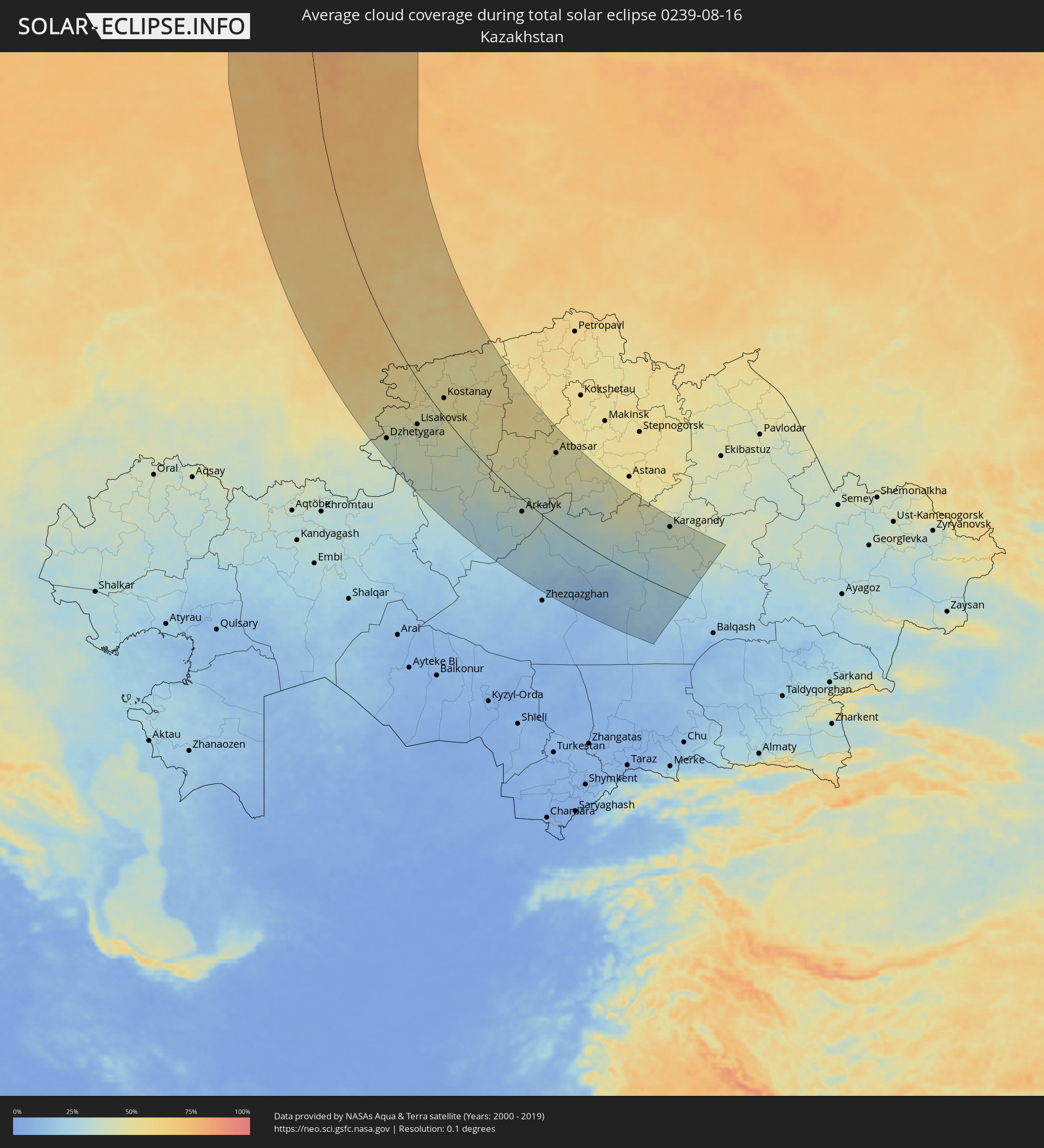 Kasachstan
Orte im Finsternispfad
Die nachfolgene Tabelle zeigt Städte und Orte mit mehr als 5.000 Einwohnern, die sich im Finsternispfad befinden. Städte mit mehr als 100.000 Einwohnern sind dick gekennzeichnet. Mit einem Klick auf den Ort öffnet sich eine Detailkarte die die Lage des jeweiligen Ortes zusammen mit dem Verlauf der zentralen Finsternis präsentiert.
| Ort | Typ | Dauer der Verfinsterung | Ortszeit bei maximaler Verfinsterung | Entfernung zur Zentrallinie | Ø Bewölkung |
|
Nizhniy Odes, Komi Republic
|
total | - | 16:18:27 UTC+02:30 | 158 km | 78% |
|
Krasnokamsk, Perm
|
total | - | 18:00:57 UTC+04:02 | 188 km | 66% |
|
Perm, Perm
|
total | - | 18:01:03 UTC+04:02 | 161 km | 68% |
|
Dobryanka, Perm
|
total | - | 18:00:13 UTC+04:02 | 139 km | 66% |
|
Polazna, Perm
|
total | - | 18:00:32 UTC+04:02 | 144 km | 67% |
|
Solikamsk, Perm
|
total | - | 17:58:05 UTC+04:02 | 92 km | 71% |
|
Berezniki, Perm
|
total | - | 17:58:29 UTC+04:02 | 96 km | 69% |
|
Kungur, Perm
|
total | - | 18:02:04 UTC+04:02 | 140 km | 67% |
|
Krasnovishersk, Perm
|
total | - | 17:56:39 UTC+04:02 | 62 km | 76% |
|
Pechora, Komi Republic
|
total | - | 16:15:41 UTC+02:30 | 52 km | 80% |
|
Yayva, Perm
|
total | - | 17:58:36 UTC+04:02 | 70 km | 75% |
|
Vuktyl, Komi Republic
|
total | - | 16:18:04 UTC+02:30 | 35 km | 79% |
|
Usinsk, Komi Republic
|
total | - | 16:14:07 UTC+02:30 | 49 km | 78% |
|
Gubakha, Perm
|
total | - | 17:59:29 UTC+04:02 | 65 km | 70% |
|
Aleksandrovsk, Perm
|
total | - | 17:58:55 UTC+04:02 | 56 km | 75% |
|
Kizel, Perm
|
total | - | 17:59:06 UTC+04:02 | 55 km | 71% |
|
Sim, Chelyabinsk
|
total | - | 18:06:23 UTC+04:02 | 199 km | 61% |
|
Krasnoufimsk, Sverdlovsk
|
total | - | 18:03:30 UTC+04:02 | 124 km | 67% |
|
Lys’va, Perm
|
total | - | 18:00:48 UTC+04:02 | 71 km | 67% |
|
Chusovoy, Perm
|
total | - | 18:00:27 UTC+04:02 | 64 km | 69% |
|
Gremyachinsk, Perm
|
total | - | 17:59:59 UTC+04:02 | 56 km | 73% |
|
Ust’-Katav, Chelyabinsk
|
total | - | 18:06:27 UTC+04:02 | 175 km | 63% |
|
Katav-Ivanovsk, Chelyabinsk
|
total | - | 18:06:46 UTC+04:02 | 183 km | 61% |
|
Gornozavodsk, Perm
|
total | - | 18:00:17 UTC+04:02 | 34 km | 72% |
|
Yuryuzan’, Chelyabinsk
|
total | - | 18:06:33 UTC+04:02 | 164 km | 63% |
|
Trëkhgornyy, Chelyabinsk
|
total | - | 18:06:38 UTC+04:02 | 165 km | 64% |
|
Arti, Sverdlovsk
|
total | - | 18:03:46 UTC+04:02 | 87 km | 65% |
|
Bakal, Chelyabinsk
|
total | - | 18:06:22 UTC+04:02 | 138 km | 68% |
|
Satka, Chelyabinsk
|
total | - | 18:06:10 UTC+04:02 | 120 km | 68% |
|
Magnitogorsk, Chelyabinsk
|
total | - | 18:09:01 UTC+04:02 | 208 km | 54% |
|
Bisert’, Sverdlovsk
|
total | - | 18:02:56 UTC+04:02 | 40 km | 64% |
|
Nizhniye Sergi, Sverdlovsk
|
total | - | 18:03:16 UTC+04:02 | 34 km | 65% |
|
Kusa, Chelyabinsk
|
total | - | 18:05:36 UTC+04:02 | 83 km | 67% |
|
Uchaly, Bashkortostan
|
total | - | 18:07:26 UTC+04:02 | 135 km | 61% |
|
Kachkanar, Sverdlovsk
|
total | - | 17:59:37 UTC+04:02 | 40 km | 73% |
|
Nyazepetrovsk, Chelyabinsk
|
total | - | 18:04:19 UTC+04:02 | 41 km | 66% |
|
Zlatoust, Chelyabinsk
|
total | - | 18:05:52 UTC+04:02 | 79 km | 68% |
|
Baranchinskiy, Sverdlovsk
|
total | - | 18:00:33 UTC+04:02 | 39 km | 70% |
|
Kushva, Sverdlovsk
|
total | - | 18:00:19 UTC+04:02 | 46 km | 71% |
|
Lesnoy, Sverdlovsk
|
total | - | 17:59:42 UTC+04:02 | 57 km | 73% |
|
Pervoural’sk, Sverdlovsk
|
total | - | 18:02:46 UTC+04:02 | 12 km | 67% |
|
Severoural’sk, Sverdlovsk
|
total | - | 17:56:58 UTC+04:02 | 92 km | 73% |
|
Verkhniy Tagil, Sverdlovsk
|
total | - | 18:01:56 UTC+04:02 | 30 km | 66% |
|
Nizhniy Tagil, Sverdlovsk
|
total | - | 18:00:58 UTC+04:02 | 47 km | 69% |
|
Krasnoural’sk, Sverdlovsk
|
total | - | 18:00:10 UTC+04:02 | 65 km | 73% |
|
Novoural’sk, Sverdlovsk
|
total | - | 18:02:09 UTC+04:02 | 33 km | 64% |
|
Degtyarsk, Sverdlovsk
|
total | - | 18:03:07 UTC+04:02 | 13 km | 63% |
|
Miass, Chelyabinsk
|
total | - | 18:06:02 UTC+04:02 | 59 km | 65% |
|
Polevskoy, Sverdlovsk
|
total | - | 18:03:34 UTC+04:02 | 9 km | 65% |
|
Krasnotur’insk, Sverdlovsk
|
total | - | 17:57:38 UTC+04:02 | 108 km | 74% |
|
Nev’yansk, Sverdlovsk
|
total | - | 18:01:42 UTC+04:02 | 48 km | 67% |
|
Karabash, Chelyabinsk
|
total | - | 18:05:16 UTC+04:02 | 32 km | 66% |
|
Verkhniy Ufaley, Chelyabinsk
|
total | - | 18:04:15 UTC+04:02 | 5 km | 67% |
|
Chebarkul’, Chelyabinsk
|
total | - | 18:06:08 UTC+04:02 | 48 km | 64% |
|
Ivdel’, Sverdlovsk
|
total | - | 17:55:57 UTC+04:02 | 123 km | 72% |
|
Sredneuralsk, Sverdlovsk
|
total | - | 18:02:34 UTC+04:02 | 45 km | 64% |
|
Verkhnyaya Salda, Sverdlovsk
|
total | - | 18:00:41 UTC+04:02 | 85 km | 67% |
|
Lokomotivnyy, Chelyabinsk
|
total | - | 18:09:31 UTC+04:02 | 148 km | 53% |
|
Serov, Sverdlovsk
|
total | - | 17:57:54 UTC+04:02 | 121 km | 73% |
|
Novaya Lyalya, Sverdlovsk
|
total | - | 17:58:53 UTC+04:02 | 111 km | 73% |
|
Yekaterinburg, Sverdlovsk
|
total | - | 18:02:48 UTC+04:02 | 49 km | 66% |
|
Kartaly, Chelyabinsk
|
total | - | 18:09:26 UTC+04:02 | 141 km | 53% |
|
Ozersk, Chelyabinsk
|
total | - | 18:04:43 UTC+04:02 | 9 km | 61% |
|
Nizhnyaya Salda, Sverdlovsk
|
total | - | 18:00:36 UTC+04:02 | 95 km | 70% |
|
Snezhinsk, Chelyabinsk
|
total | - | 18:04:08 UTC+04:02 | 25 km | 62% |
|
Kasli, Chelyabinsk
|
total | - | 18:04:28 UTC+04:02 | 19 km | 60% |
|
Plast, Chelyabinsk
|
total | - | 18:07:08 UTC+04:02 | 54 km | 65% |
|
Sysert’, Sverdlovsk
|
total | - | 18:03:23 UTC+04:02 | 47 km | 65% |
|
Aramil, Sverdlovsk
|
total | - | 18:03:02 UTC+04:02 | 56 km | 67% |
|
Dzhetygara, Qostanay
|
total | - | 18:30:09 UTC+04:21 | 167 km | 39% |
|
Krasnogorskiy, Chelyabinsk
|
total | - | 18:06:40 UTC+04:02 | 18 km | 62% |
|
Yuzhnoural’sk, Chelyabinsk
|
total | - | 18:06:56 UTC+04:02 | 25 km | 62% |
|
Yemanzhelinsk, Chelyabinsk
|
total | - | 18:06:23 UTC+04:02 | 5 km | 61% |
|
Zarechnyy, Sverdlovsk
|
total | - | 18:02:47 UTC+04:02 | 88 km | 63% |
|
Uvel’skiy, Chelyabinsk
|
total | - | 18:06:55 UTC+04:02 | 20 km | 60% |
|
Novosineglazovskiy, Chelyabinsk
|
total | - | 18:05:53 UTC+04:02 | 13 km | 59% |
|
Korkino, Chelyabinsk
|
total | - | 18:06:08 UTC+04:02 | 6 km | 59% |
|
Rezh, Sverdlovsk
|
total | - | 18:01:47 UTC+04:02 | 112 km | 65% |
|
Beloyarskiy, Sverdlovsk
|
total | - | 18:02:52 UTC+04:02 | 92 km | 61% |
|
Chelyabinsk, Chelyabinsk
|
total | - | 18:05:40 UTC+04:02 | 22 km | 64% |
|
Asbest, Sverdlovsk
|
total | - | 18:02:25 UTC+04:02 | 103 km | 65% |
|
Roza, Chelyabinsk
|
total | - | 18:06:05 UTC+04:02 | 11 km | 58% |
|
Troitsk, Chelyabinsk
|
total | - | 18:07:29 UTC+04:02 | 27 km | 55% |
|
Starokamyshinsk, Chelyabinsk
|
total | - | 18:05:51 UTC+04:02 | 25 km | 56% |
|
Bazhovo, Chelyabinsk
|
total | - | 18:05:49 UTC+04:02 | 27 km | 59% |
|
Verkhnyaya Sinyachikha, Sverdlovsk
|
total | - | 18:00:41 UTC+04:02 | 146 km | 69% |
|
Reftinskiy, Sverdlovsk
|
total | - | 18:02:15 UTC+04:02 | 118 km | 65% |
|
Gornyak, Chelyabinsk
|
total | - | 18:05:40 UTC+04:02 | 35 km | 58% |
|
Alapayevsk, Sverdlovsk
|
total | - | 18:00:54 UTC+04:02 | 144 km | 67% |
|
Artëmovskiy, Sverdlovsk
|
total | - | 18:01:45 UTC+04:02 | 138 km | 65% |
|
Kamensk-Ural’skiy, Sverdlovsk
|
total | - | 18:03:23 UTC+04:02 | 108 km | 59% |
|
Bulanash, Sverdlovsk
|
total | - | 18:01:52 UTC+04:02 | 143 km | 65% |
|
Sukhoy Log, Sverdlovsk
|
total | - | 18:02:31 UTC+04:02 | 133 km | 63% |
|
Komsomolets, Qostanay
|
total | - | 18:27:19 UTC+04:21 | 20 km | 53% |
|
Lisakovsk, Qostanay
|
total | - | 18:29:18 UTC+04:21 | 73 km | 42% |
|
Tobol, Qostanay
|
total | - | 18:29:02 UTC+04:21 | 59 km | 45% |
|
Kataysk, Kurgan
|
total | - | 18:03:32 UTC+04:02 | 140 km | 62% |
|
Fedorovka, Qostanay
|
total | - | 18:27:24 UTC+04:21 | 8 km | 53% |
|
Kamyshlov, Sverdlovsk
|
total | - | 18:02:32 UTC+04:02 | 169 km | 60% |
|
Kachar, Qostanay
|
total | - | 18:27:50 UTC+04:21 | 1 km | 50% |
|
Dalmatovo, Kurgan
|
total | - | 18:03:31 UTC+04:02 | 159 km | 63% |
|
Lesnoy, Sverdlovsk
|
total | - | 18:01:08 UTC+04:02 | 216 km | 68% |
|
Rudnyy, Qostanay
|
total | - | 18:28:28 UTC+04:21 | 11 km | 47% |
|
Shumikha, Kurgan
|
total | - | 18:05:16 UTC+04:02 | 131 km | 56% |
|
Kostanay, Qostanay
|
total | - | 18:27:58 UTC+04:21 | 32 km | 49% |
|
Shadrinsk, Kurgan
|
total | - | 18:03:43 UTC+04:02 | 191 km | 62% |
|
Vorkuta, Komi Republic
|
total | - | 16:11:10 UTC+02:30 | 186 km | 86% |
|
Borovskoy, Qostanay
|
total | - | 18:26:52 UTC+04:21 | 99 km | 49% |
|
Kurtamysh, Kurgan
|
total | - | 18:05:36 UTC+04:02 | 178 km | 58% |
|
Qusmuryn, Qostanay
|
total | - | 18:29:03 UTC+04:21 | 32 km | 47% |
|
Derzhavīnsk, Aqmola
|
total | - | 18:30:53 UTC+04:21 | 13 km | 41% |
|
Esil, Aqmola
|
total | - | 18:29:27 UTC+04:21 | 86 km | 50% |
|
Novoishimskiy, Soltüstik Qazaqstan
|
total | - | 18:27:19 UTC+04:21 | 197 km | 55% |
|
Arkalyk, Qostanay
|
total | - | 18:32:07 UTC+04:21 | 30 km | 35% |
|
Zhaqsy, Aqmola
|
total | - | 18:29:18 UTC+04:21 | 127 km | 50% |
|
Shantobe, Aqmola
|
total | - | 18:28:11 UTC+04:21 | 211 km | 53% |
|
Atbasar, Aqmola
|
total | - | 18:29:12 UTC+04:21 | 167 km | 46% |
|
Astrakhan, Aqmola
|
total | - | 18:29:14 UTC+04:21 | 208 km | 47% |
|
Qarazhal, Qaraghandy
|
total | - | 18:34:27 UTC+04:21 | 84 km | 18% |
|
Kīevka, Qaraghandy
|
total | - | 18:30:41 UTC+04:21 | 162 km | 44% |
|
Atasū, Qaraghandy
|
total | - | 18:33:06 UTC+04:21 | 12 km | 26% |
|
Shakhan, Qaraghandy
|
total | - | 18:31:00 UTC+04:21 | 158 km | 37% |
|
Novodolīnskīy, Qaraghandy
|
total | - | 18:31:09 UTC+04:21 | 149 km | 35% |
|
Aktau, Qaraghandy
|
total | - | 18:33:39 UTC+04:21 | 15 km | 22% |
|
Sorang, Qaraghandy
|
total | - | 18:30:58 UTC+04:21 | 161 km | 37% |
|
Aqadyr, Qaraghandy
|
total | - | 18:33:18 UTC+04:21 | 9 km | 28% |
|
Abay, Qaraghandy
|
total | - | 18:31:12 UTC+04:21 | 147 km | 36% |
|
Aqtas, Qaraghandy
|
total | - | 18:30:57 UTC+04:21 | 164 km | 36% |
|
Temirtau, Qaraghandy
|
total | - | 18:30:31 UTC+04:21 | 192 km | 39% |
|
Karagandy, Qaraghandy
|
total | - | 18:30:47 UTC+04:21 | 176 km | 37% |