Totale Sonnenfinsternis vom 20.01.0288
| Wochentag: | Freitag |
| Maximale Dauer der Verfinsterung: | 02m57s |
| Maximale Breite des Finsternispfades: | 133 km |
| Saroszyklus: | 84 |
| Bedeckungsgrad: | 100% |
| Magnitude: | 1.0362 |
| Gamma: | -0.3936 |
Wo kann man die Sonnenfinsternis vom 20.01.0288 sehen?
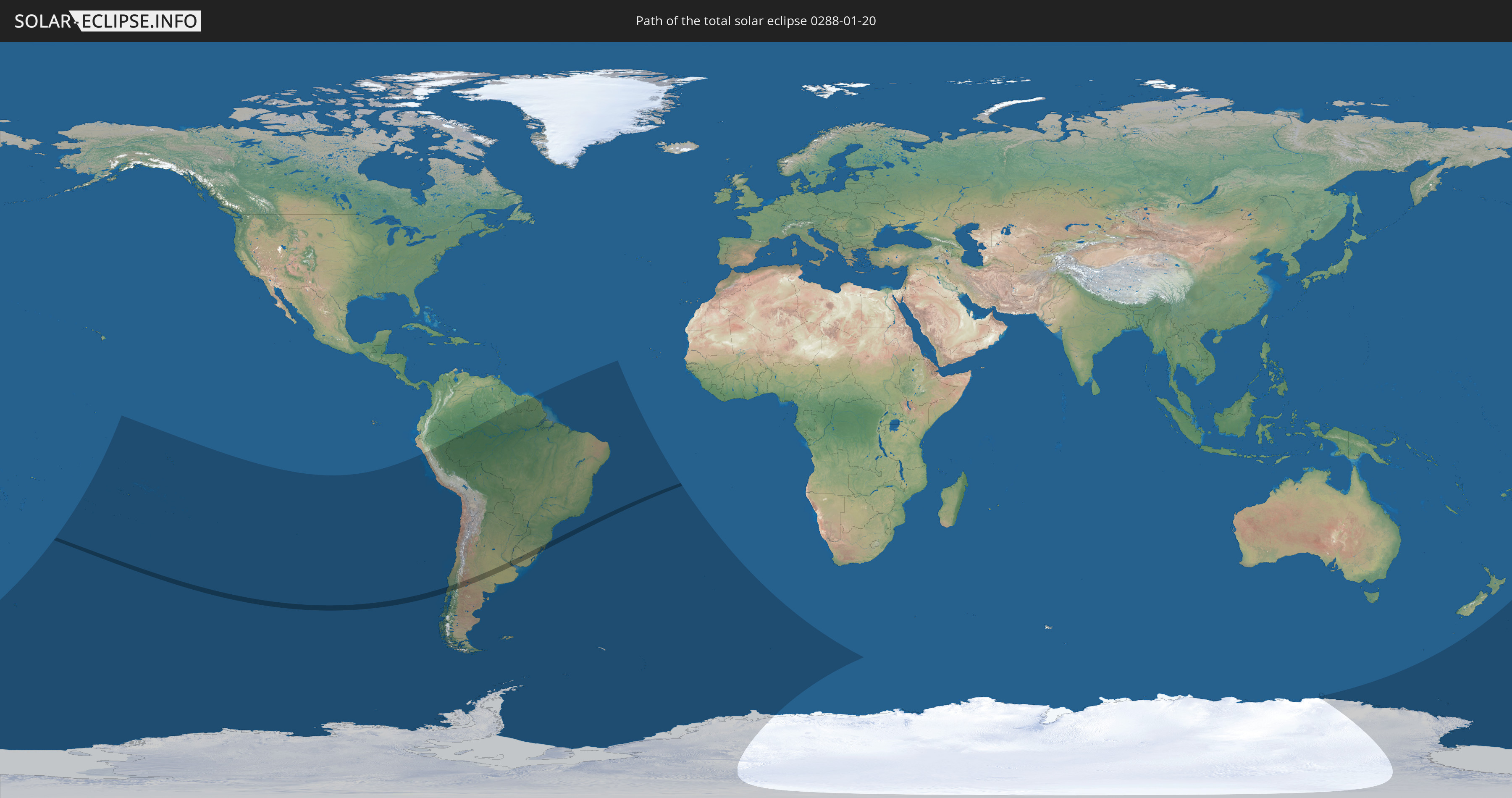
Die Sonnenfinsternis am 20.01.0288 kann man in 21 Ländern als partielle Sonnenfinsternis beobachten.
Der Finsternispfad verläuft durch 4 Länder. Nur in diesen Ländern ist sie als totale Sonnenfinsternis zu sehen.
In den folgenden Ländern ist die Sonnenfinsternis total zu sehen
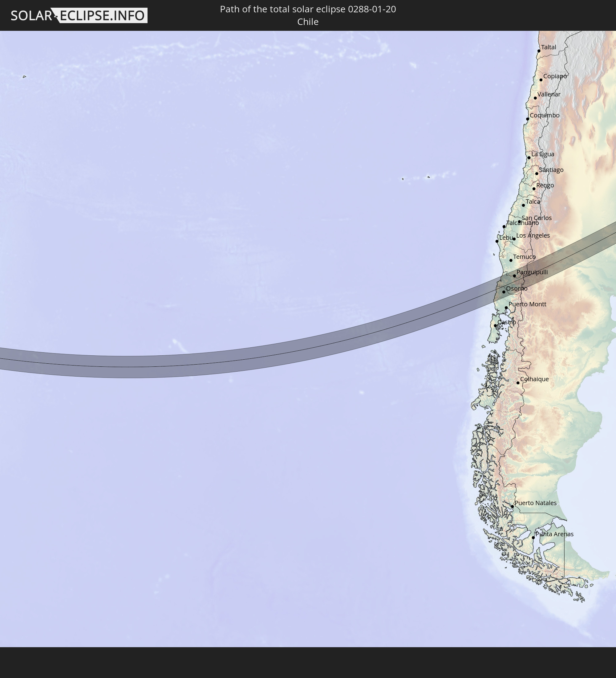 Chile
Chile
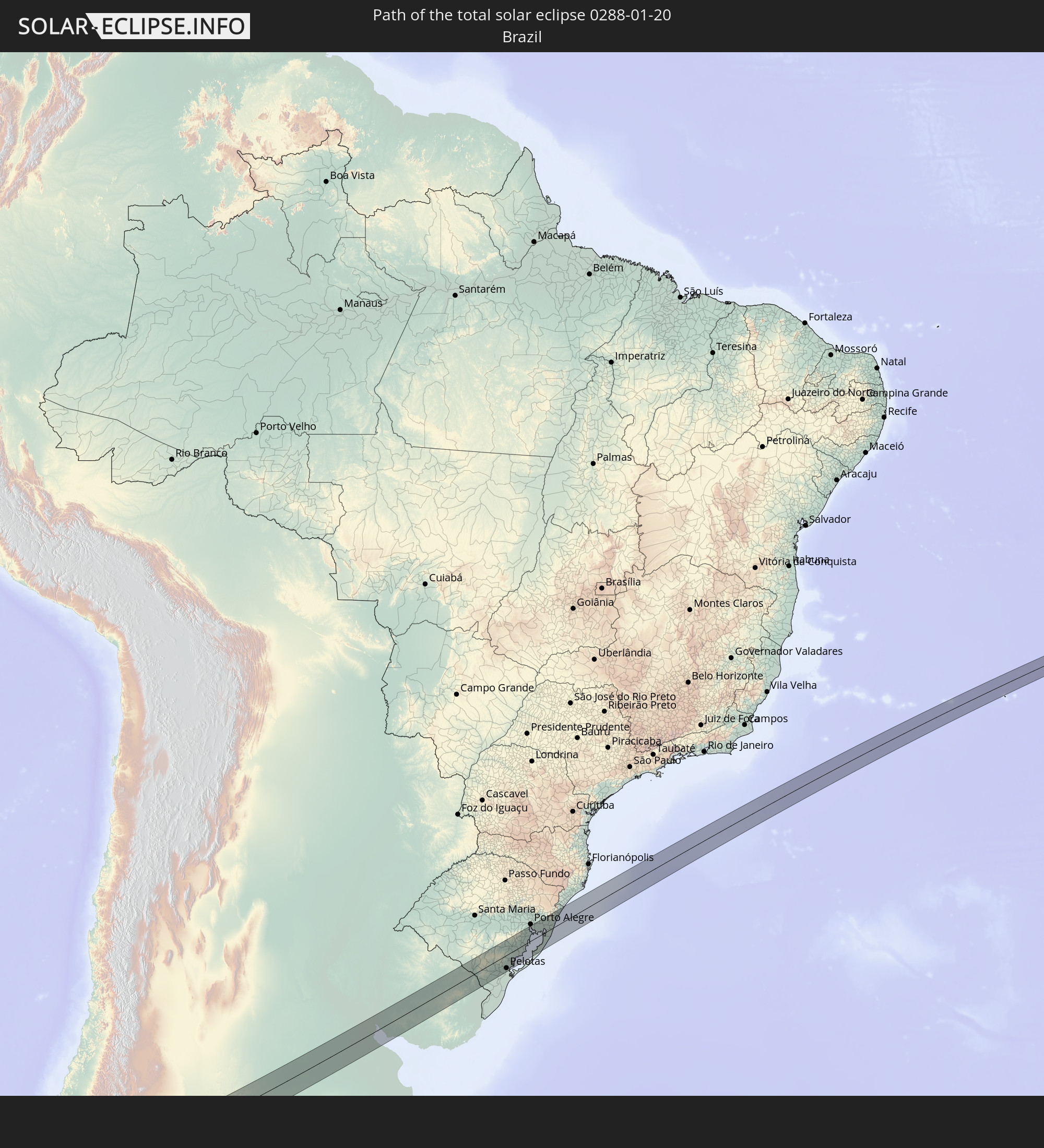 Brasilien
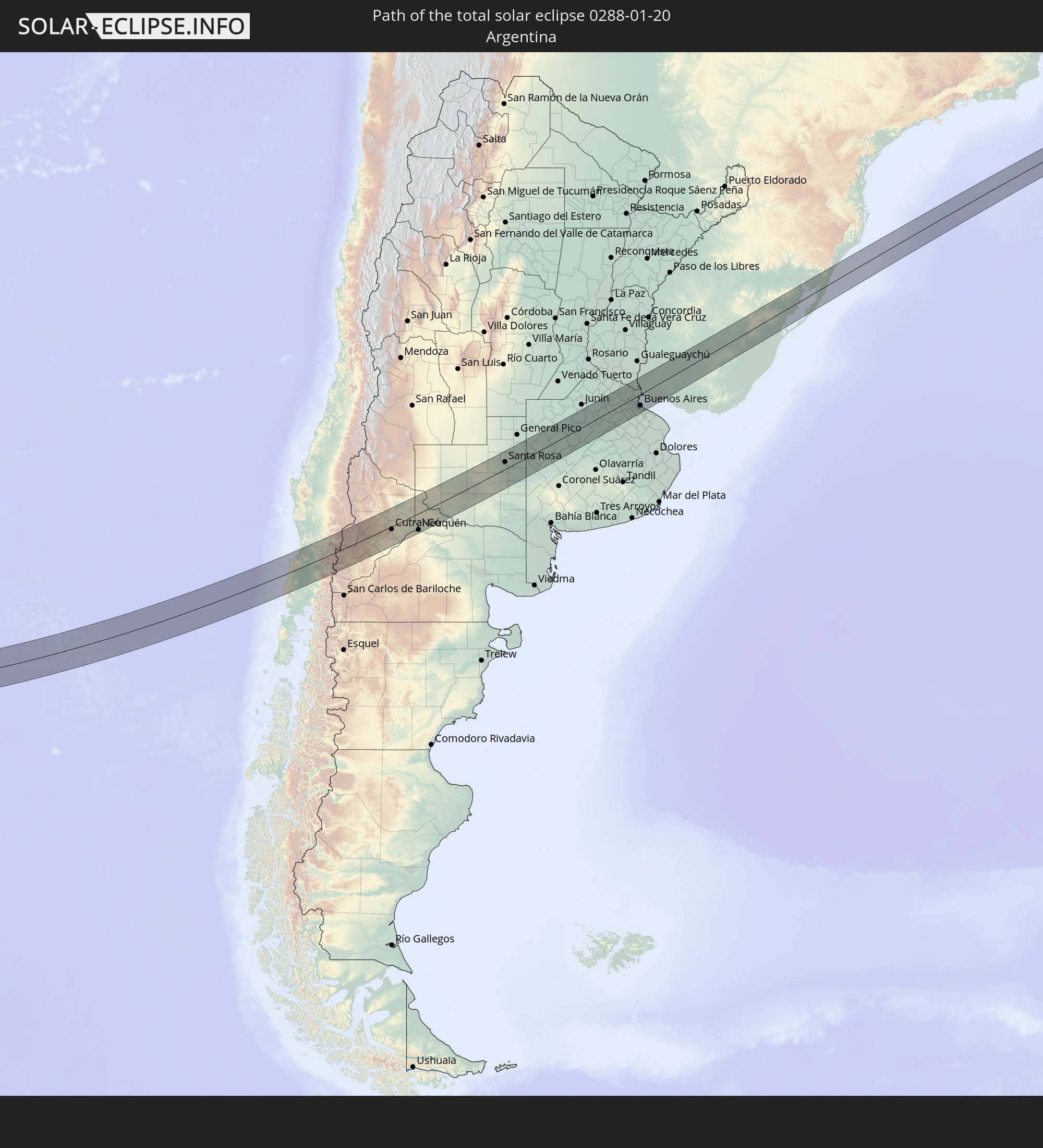 Argentinien
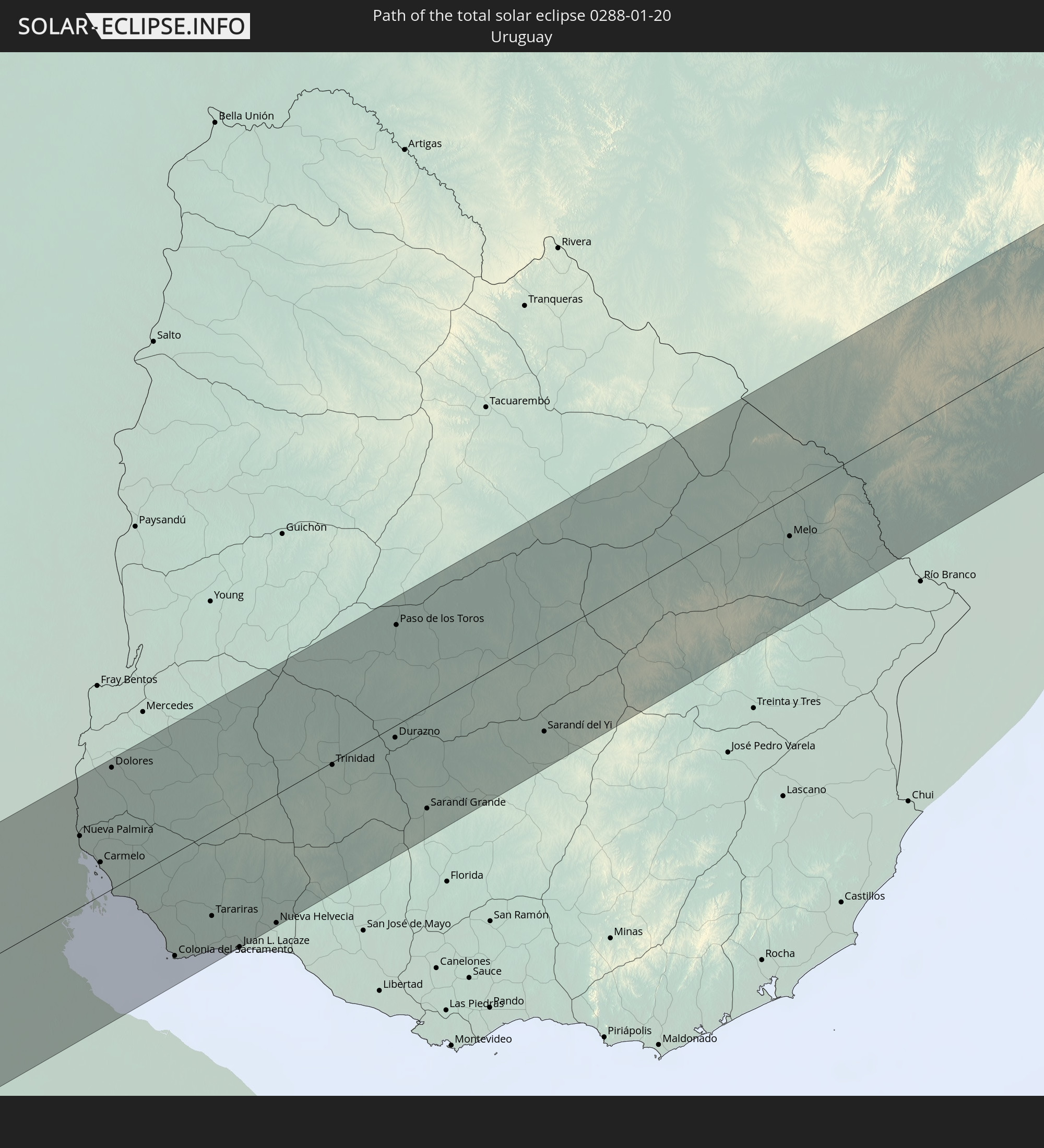 Uruguay
In den folgenden Ländern ist die Sonnenfinsternis partiell zu sehen


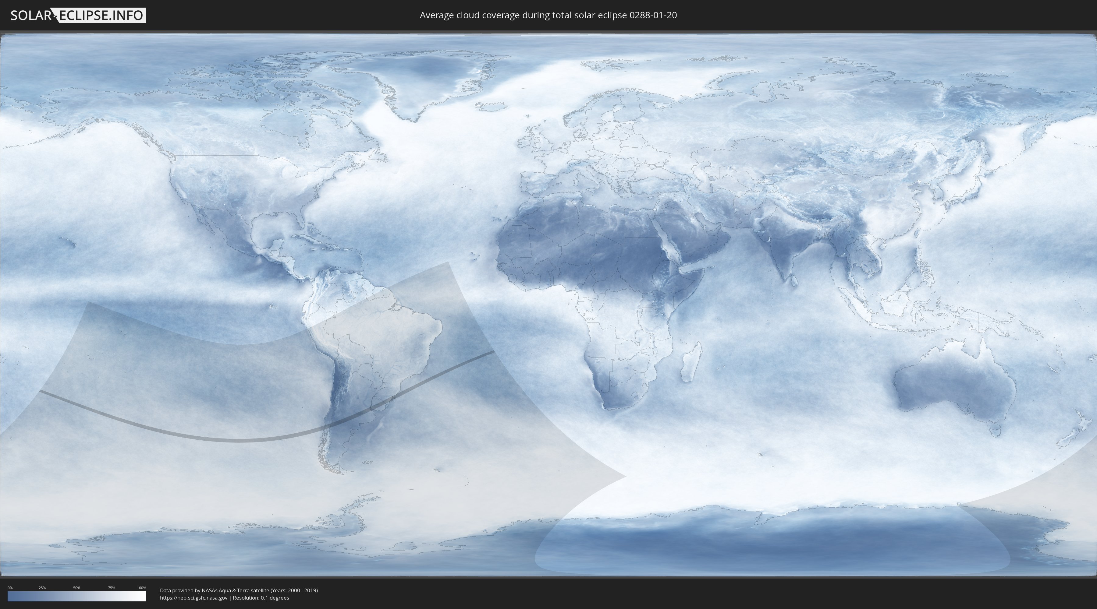
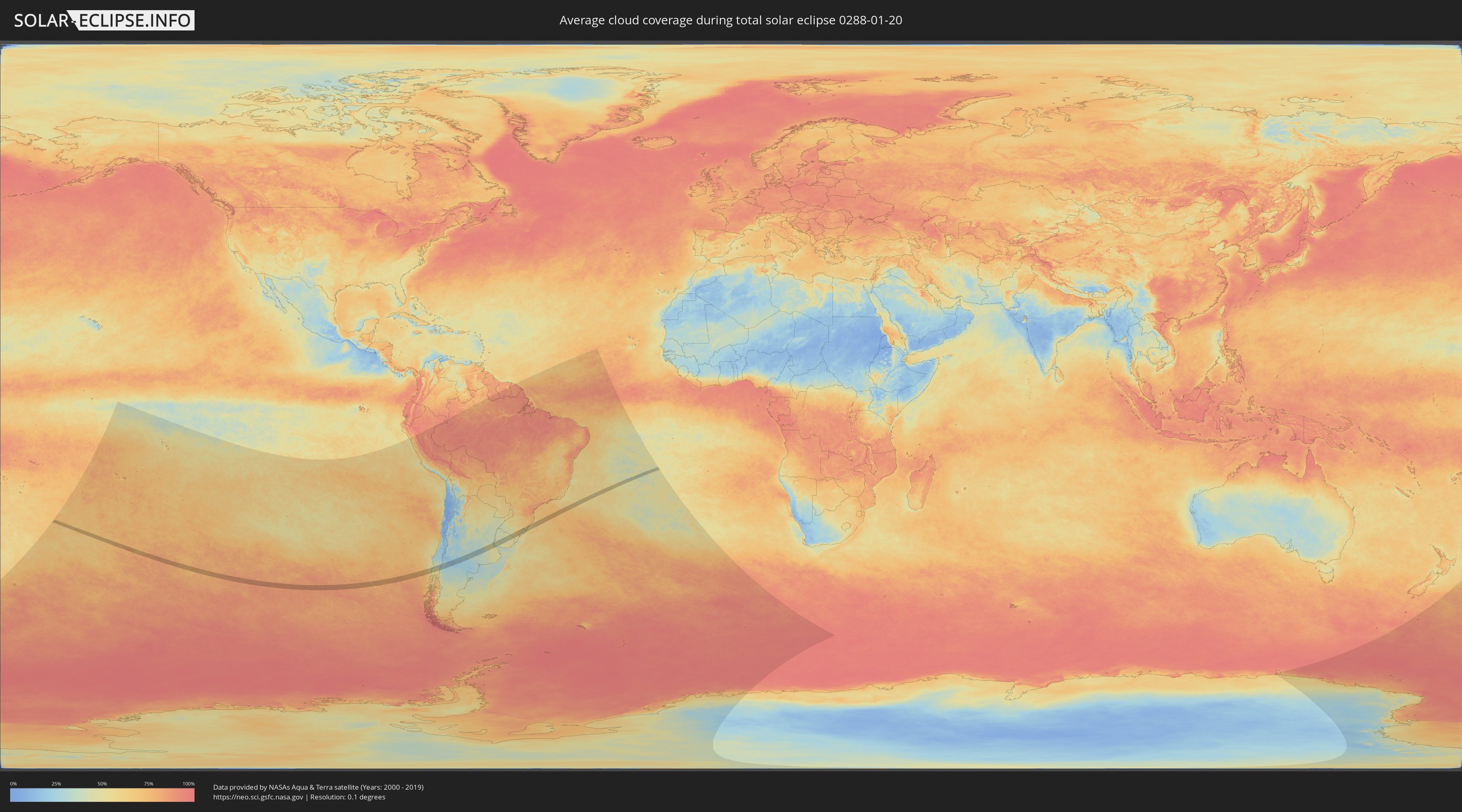
Wie wird das Wetter während der totalen Sonnenfinsternis am 20.01.0288?
Wo ist der beste Ort, um die totale Sonnenfinsternis vom 20.01.0288 zu beobachten?
Die folgenden Karten zeigen die durchschnittliche Bewölkung für den Tag, an dem die totale Sonnenfinsternis
stattfindet. Mit Hilfe der Karten lässt sich der Ort entlang des Finsternispfades eingrenzen,
der die besten Aussichen auf einen klaren wolkenfreien Himmel bietet.
Trotzdem muss man immer lokale Gegenenheiten beachten und sollte sich genau über das Wetter an seinem
gewählten Beobachtungsort informieren.
Die Daten stammen von den beiden NASA-Satelliten
AQUA und TERRA
und wurden über einen Zeitraum von 19 Jahren (2000 - 2019) gemittelt.
Detaillierte Länderkarten
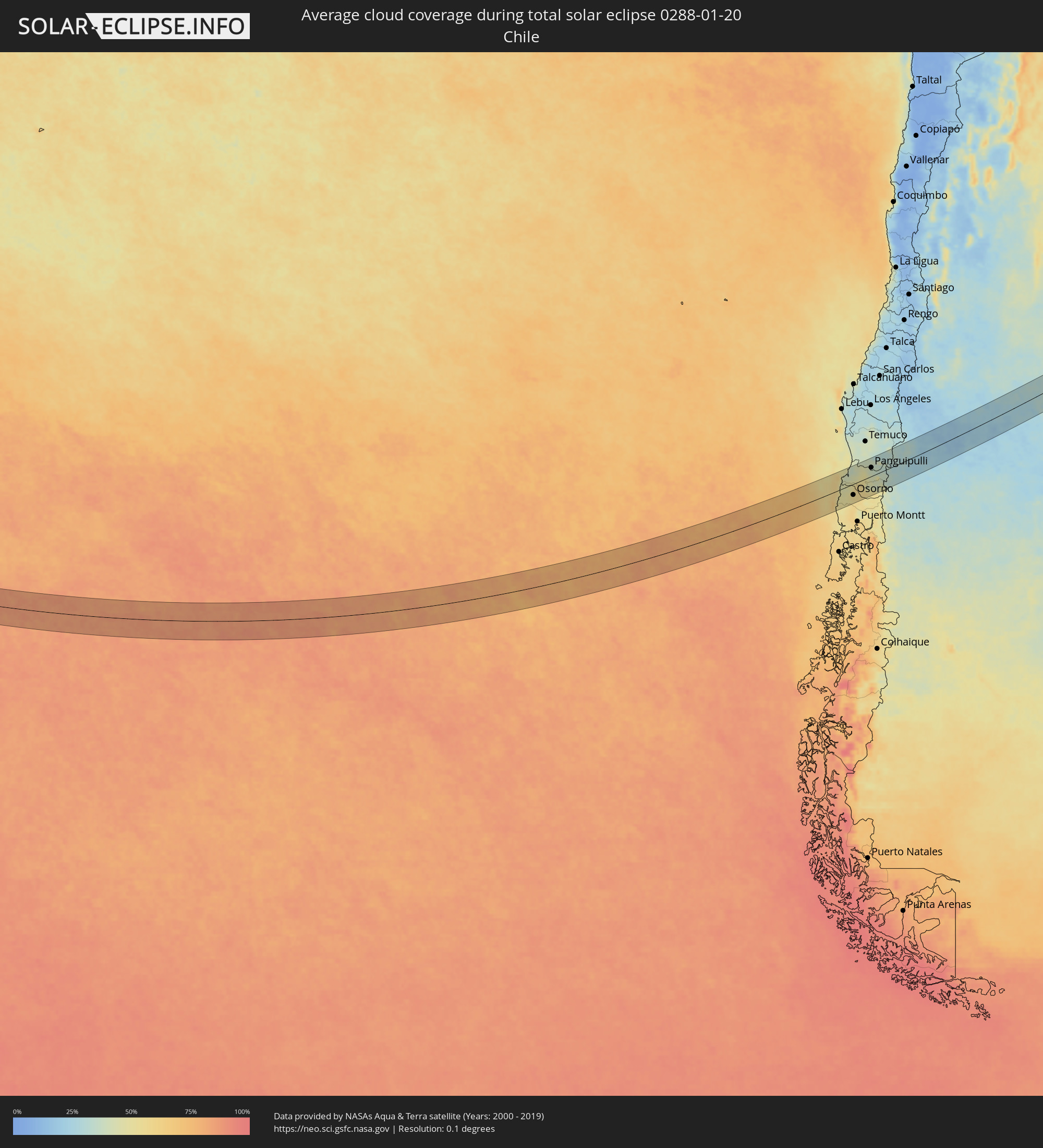 Chile
Chile
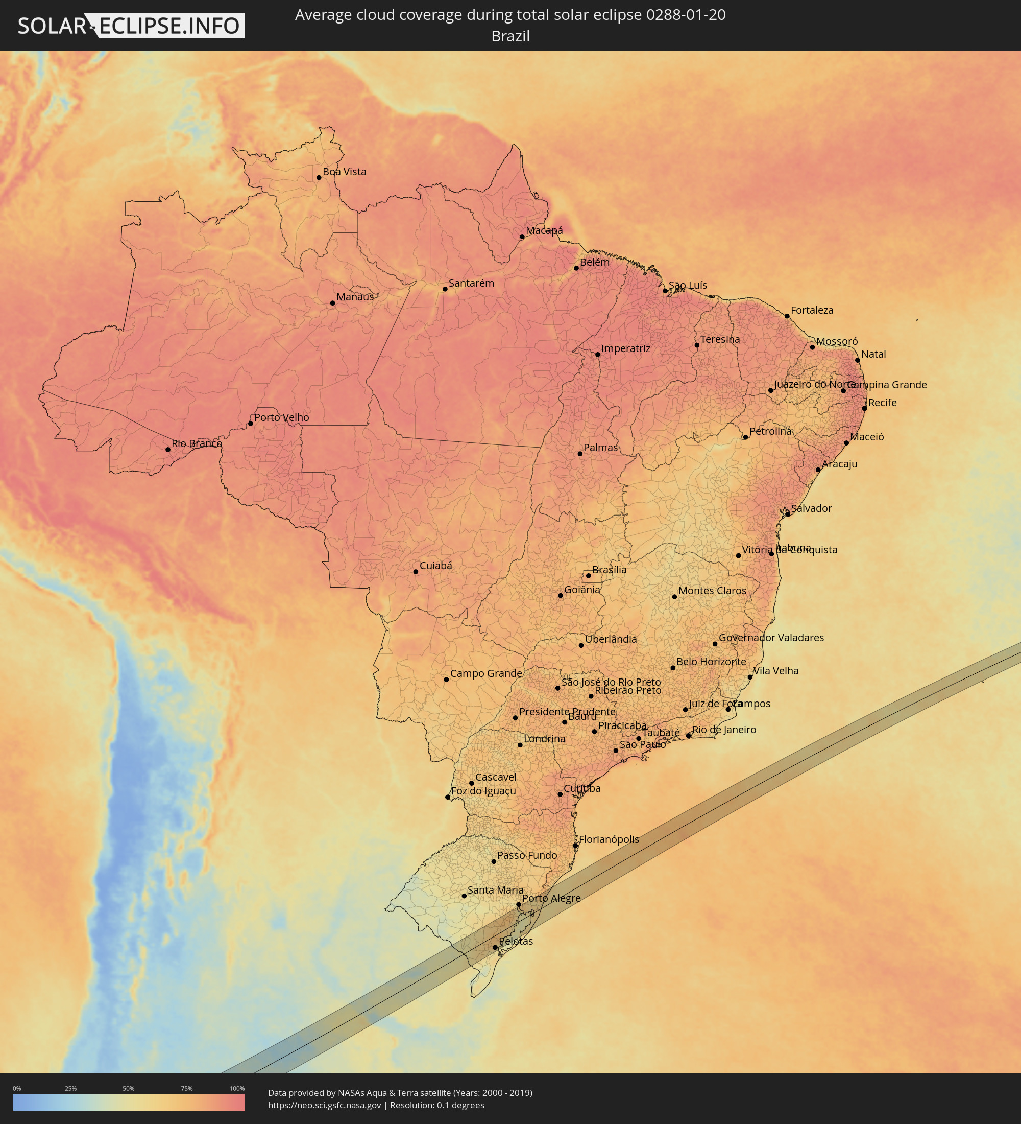 Brasilien
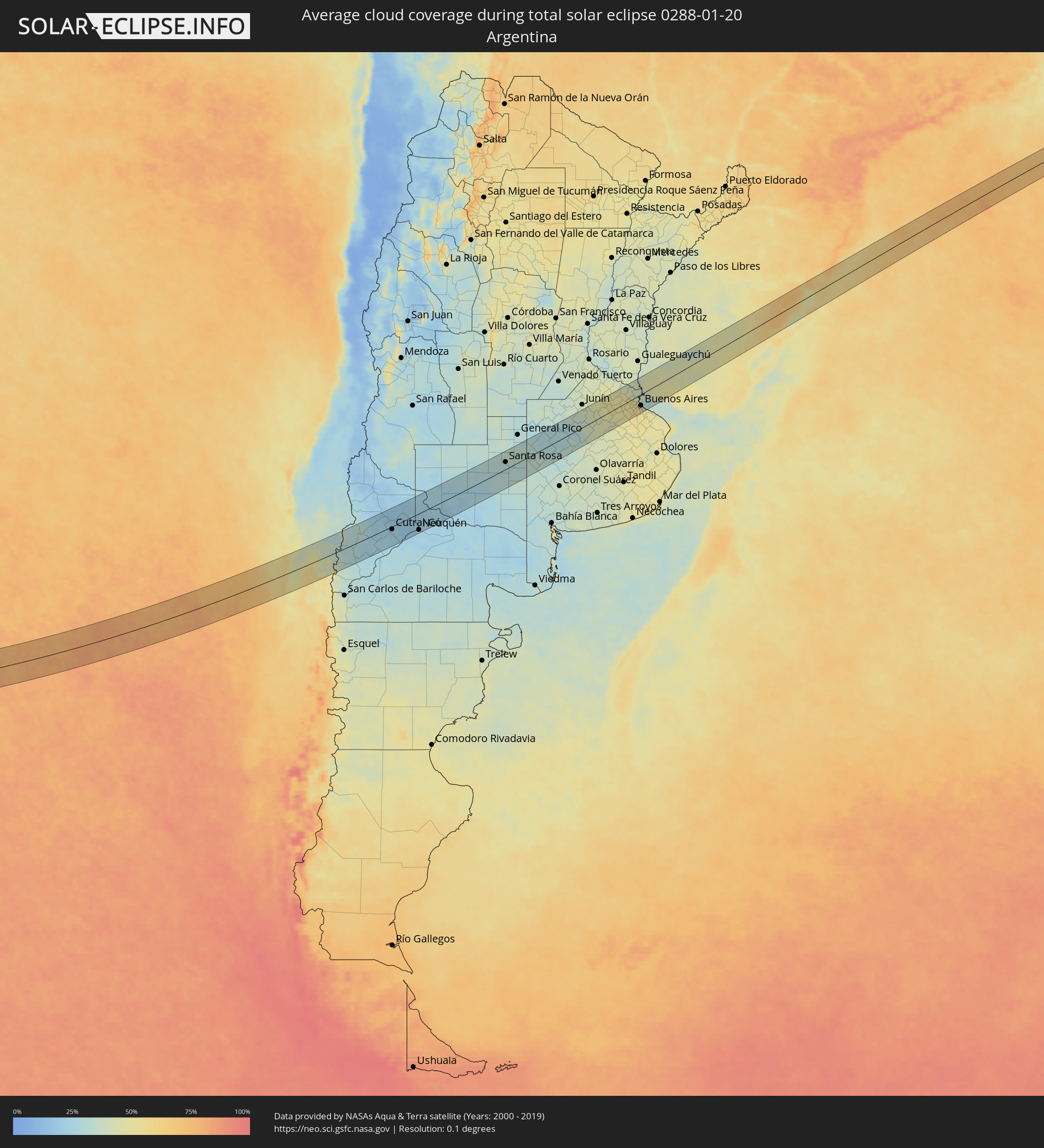 Argentinien
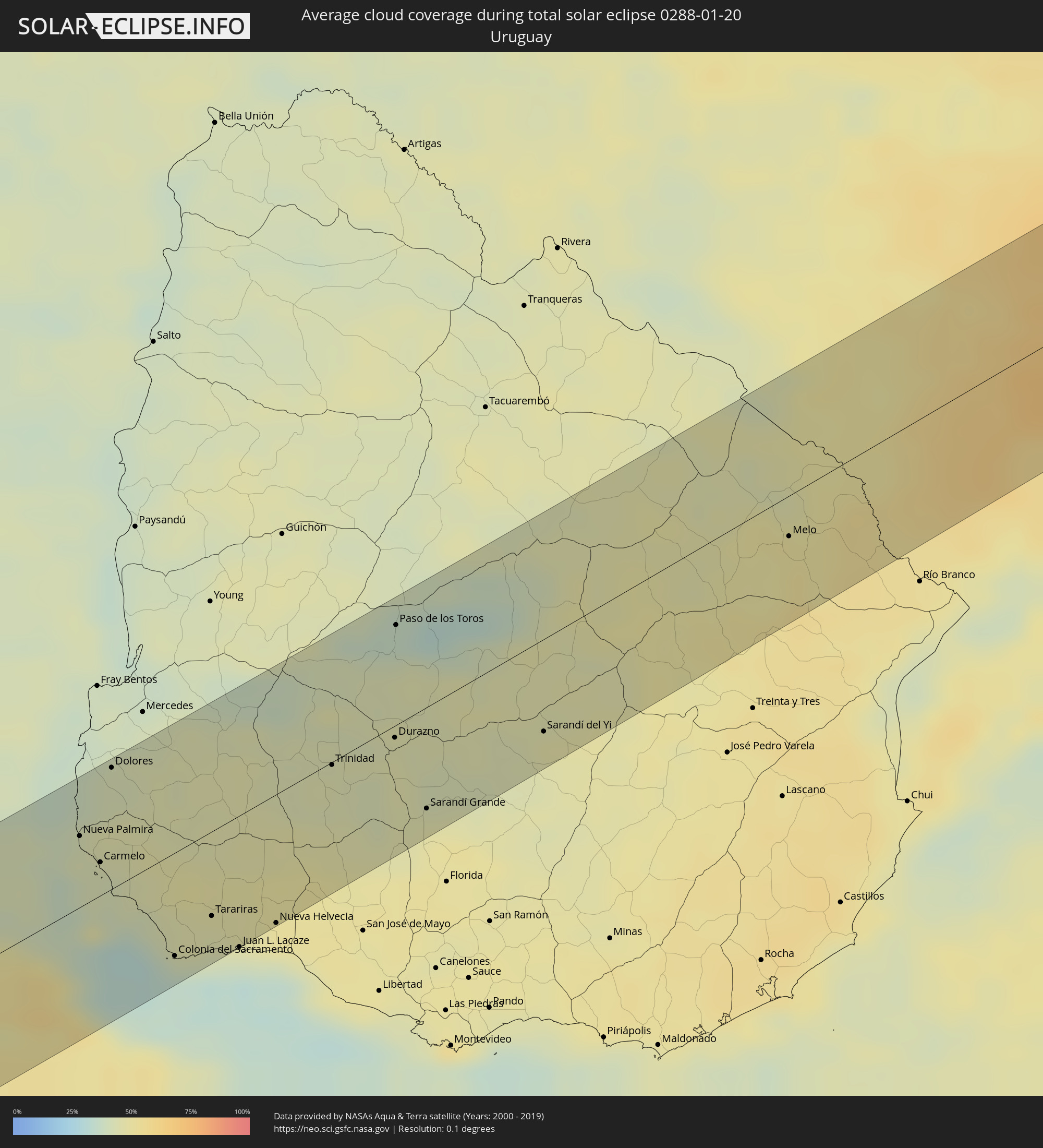 Uruguay
Orte im Finsternispfad
Die nachfolgene Tabelle zeigt Städte und Orte mit mehr als 5.000 Einwohnern, die sich im Finsternispfad befinden. Städte mit mehr als 100.000 Einwohnern sind dick gekennzeichnet. Mit einem Klick auf den Ort öffnet sich eine Detailkarte die die Lage des jeweiligen Ortes zusammen mit dem Verlauf der zentralen Finsternis präsentiert.
| Ort | Typ | Dauer der Verfinsterung | Ortszeit bei maximaler Verfinsterung | Entfernung zur Zentrallinie | Ø Bewölkung |
 Valdivia, Los Ríos
|
total | - | 13:57:28 UTC-04:42 | 44 km | 40% |
|
Las Animas, Los Lagos
|
total | - | 13:57:31 UTC-04:42 | 43 km | 40% |
|
Osorno, Los Lagos
|
total | - | 13:56:43 UTC-04:42 | 38 km | 55% |
|
La Unión, Los Ríos
|
total | - | 13:57:09 UTC-04:42 | 11 km | 54% |
|
Río Bueno, Los Ríos
|
total | - | 13:57:19 UTC-04:42 | 19 km | 58% |
|
Panguipulli, Araucanía
|
total | - | 13:59:16 UTC-04:42 | 30 km | 38% |
|
Villarrica, Araucanía
|
total | - | 13:59:54 UTC-04:42 | 63 km | 37% |
|
Pucón, Araucanía
|
total | - | 14:00:22 UTC-04:42 | 54 km | 38% |
 San Martín de los Andes, Neuquén Province
|
total | - | 14:26:13 UTC-04:16 | 56 km | 34% |
|
Junín de los Andes, Neuquén Province
|
total | - | 14:26:58 UTC-04:16 | 45 km | 29% |
|
Zapala, Neuquén Province
|
total | - | 14:30:02 UTC-04:16 | 24 km | 21% |
|
Cutral-Có, Neuquén Province
|
total | - | 14:31:20 UTC-04:16 | 10 km | 23% |
|
Plaza Huincul, Neuquén Province
|
total | - | 14:31:22 UTC-04:16 | 10 km | 23% |
|
Senillosa, Neuquén Province
|
total | - | 14:32:29 UTC-04:16 | 48 km | 21% |
|
Plottier, Neuquén Province
|
total | - | 14:32:52 UTC-04:16 | 50 km | 23% |
|
Centenario, Neuquén Province
|
total | - | 14:33:13 UTC-04:16 | 41 km | 22% |
|
Cinco Saltos, Río Negro Province
|
total | - | 14:33:20 UTC-04:16 | 43 km | 22% |
|
Neuquén, Neuquén Province
|
total | - | 14:33:10 UTC-04:16 | 56 km | 23% |
|
Cipolletti, Río Negro Province
|
total | - | 14:33:18 UTC-04:16 | 57 km | 26% |
|
General Fernández Oro, Río Negro Province
|
total | - | 14:33:22 UTC-04:16 | 61 km | 22% |
|
Catriel, Río Negro Province
|
total | - | 14:35:05 UTC-04:16 | 41 km | 25% |
|
Veinticinco de Mayo, La Pampa Province
|
total | - | 14:35:21 UTC-04:16 | 49 km | 26% |
|
General Acha, La Pampa Province
|
total | - | 14:40:38 UTC-04:16 | 37 km | 31% |
|
Santa Rosa, La Pampa Province
|
total | - | 14:42:13 UTC-04:16 | 24 km | 33% |
|
Nueve de Julio, Buenos Aires
|
total | - | 14:48:39 UTC-04:16 | 7 km | 40% |
|
Chacabuco, Buenos Aires
|
total | - | 14:50:25 UTC-04:16 | 53 km | 45% |
|
Veinticinco de Mayo, Buenos Aires
|
total | - | 14:49:35 UTC-04:16 | 38 km | 44% |
|
Chivilcoy, Buenos Aires
|
total | - | 14:50:37 UTC-04:16 | 8 km | 48% |
|
Mercedes, Buenos Aires
|
total | - | 14:51:43 UTC-04:16 | 5 km | 48% |
|
Luján, Buenos Aires
|
total | - | 14:52:15 UTC-04:16 | 2 km | 51% |
|
Zárate, Buenos Aires
|
total | - | 14:53:04 UTC-04:16 | 40 km | 47% |
|
Campana, Buenos Aires
|
total | - | 14:53:03 UTC-04:16 | 30 km | 50% |
|
Pontevedra, Buenos Aires
|
total | - | 14:52:28 UTC-04:16 | 37 km | 51% |
|
Morón, Buenos Aires
|
total | - | 14:52:43 UTC-04:16 | 32 km | 53% |
|
Tigre, Buenos Aires
|
total | - | 14:53:07 UTC-04:16 | 12 km | 49% |
|
San Isidro, Buenos Aires
|
total | - | 14:53:06 UTC-04:16 | 19 km | 51% |
|
Villa Santa Rita, Buenos Aires F.D.
|
total | - | 14:52:57 UTC-04:16 | 34 km | 55% |
|
Villa Lugano, Buenos Aires F.D.
|
total | - | 14:52:51 UTC-04:16 | 41 km | 52% |
|
Colegiales, Buenos Aires F.D.
|
total | - | 14:53:02 UTC-04:16 | 32 km | 51% |
 Nueva Palmira, Colonia
|
total | - | 15:26:07 UTC-03:44 | 34 km | 43% |
|
Adrogué, Buenos Aires
|
total | - | 14:52:46 UTC-04:16 | 57 km | 52% |
|
Retiro, Buenos Aires F.D.
|
total | - | 14:53:06 UTC-04:16 | 36 km | 51% |
|
Buenos Aires, Buenos Aires F.D.
|
total | - | 14:53:04 UTC-04:16 | 39 km | 51% |
|
Carmelo, Colonia
|
total | - | 15:26:04 UTC-03:44 | 16 km | 43% |
|
Quilmes, Buenos Aires
|
total | - | 14:53:01 UTC-04:16 | 55 km | 52% |
|
Dolores, Soriano
|
total | - | 15:26:52 UTC-03:44 | 58 km | 42% |
|
Colonia del Sacramento, Colonia
|
total | - | 15:25:53 UTC-03:44 | 49 km | 34% |
|
Tarariras, Colonia
|
total | - | 15:26:27 UTC-03:44 | 40 km | 44% |
|
Juan L. Lacaze, Colonia
|
total | - | 15:26:24 UTC-03:44 | 63 km | 39% |
|
Rosario, Colonia
|
total | - | 15:26:41 UTC-03:44 | 58 km | 45% |
|
Nueva Helvecia, Colonia
|
total | - | 15:26:50 UTC-03:44 | 61 km | 48% |
|
Trinidad, Flores
|
total | - | 15:28:26 UTC-03:44 | 1 km | 44% |
|
Trinidad, Flores
|
total | - | 15:28:24 UTC-03:44 | 4 km | 44% |
|
Durazno, Durazno
|
total | - | 15:29:03 UTC-03:44 | 6 km | 45% |
|
Paso de los Toros, Tacuarembó
|
total | - | 15:29:56 UTC-03:44 | 48 km | 36% |
|
Sarandí Grande, Florida
|
total | - | 15:28:44 UTC-03:44 | 49 km | 46% |
|
Sarandí del Yi, Durazno
|
total | - | 15:30:05 UTC-03:44 | 45 km | 46% |
|
Melo, Cerro Largo
|
total | - | 15:33:07 UTC-03:44 | 20 km | 50% |
 Herval, Rio Grande do Sul
|
total | - | 16:12:48 UTC-03:06 | 23 km | 57% |
|
Pinheiro Machado, Rio Grande do Sul
|
total | - | 16:13:30 UTC-03:06 | 19 km | 56% |
|
Arroio Grande, Rio Grande do Sul
|
total | - | 16:12:47 UTC-03:06 | 59 km | 56% |
|
Canguçu, Rio Grande do Sul
|
total | - | 16:14:27 UTC-03:06 | 3 km | 68% |
|
Pelotas, Rio Grande do Sul
|
total | - | 16:14:12 UTC-03:06 | 50 km | 53% |
|
São Lourenço do Sul, Rio Grande do Sul
|
total | - | 16:15:09 UTC-03:06 | 28 km | 54% |
|
Camaquã, Rio Grande do Sul
|
total | - | 16:16:05 UTC-03:06 | 13 km | 62% |
|
Tapes, Rio Grande do Sul
|
total | - | 16:16:43 UTC-03:06 | 10 km | 55% |
|
Viamão, Rio Grande do Sul
|
total | - | 16:17:56 UTC-03:06 | 49 km | 68% |
|
Palmares do Sul, Rio Grande do Sul
|
total | - | 16:18:07 UTC-03:06 | 7 km | 58% |
|
Osório, Rio Grande do Sul
|
total | - | 16:18:52 UTC-03:06 | 31 km | 59% |
|
Cidreira, Rio Grande do Sul
|
total | - | 16:18:29 UTC-03:06 | 1 km | 60% |
|
Tramandaí, Rio Grande do Sul
|
total | - | 16:18:50 UTC-03:06 | 15 km | 58% |
|
Capão da Canoa, Rio Grande do Sul
|
total | - | 16:19:18 UTC-03:06 | 32 km | 60% |
|
Torres, Rio Grande do Sul
|
total | - | 16:20:08 UTC-03:06 | 57 km | 63% |