Totale Sonnenfinsternis vom 07.09.0294
| Wochentag: | Freitag |
| Maximale Dauer der Verfinsterung: | 04m48s |
| Maximale Breite des Finsternispfades: | 218 km |
| Saroszyklus: | 78 |
| Bedeckungsgrad: | 100% |
| Magnitude: | 1.0621 |
| Gamma: | 0.3671 |
Wo kann man die Sonnenfinsternis vom 07.09.0294 sehen?
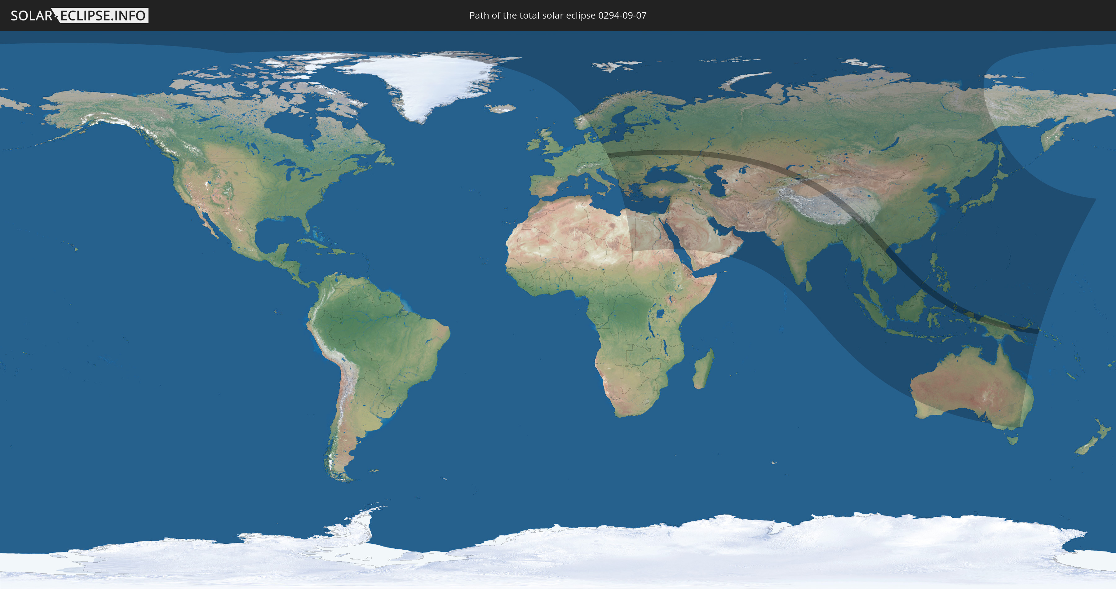
Die Sonnenfinsternis am 07.09.0294 kann man in 92 Ländern als partielle Sonnenfinsternis beobachten.
Der Finsternispfad verläuft durch 17 Länder. Nur in diesen Ländern ist sie als totale Sonnenfinsternis zu sehen.
In den folgenden Ländern ist die Sonnenfinsternis total zu sehen
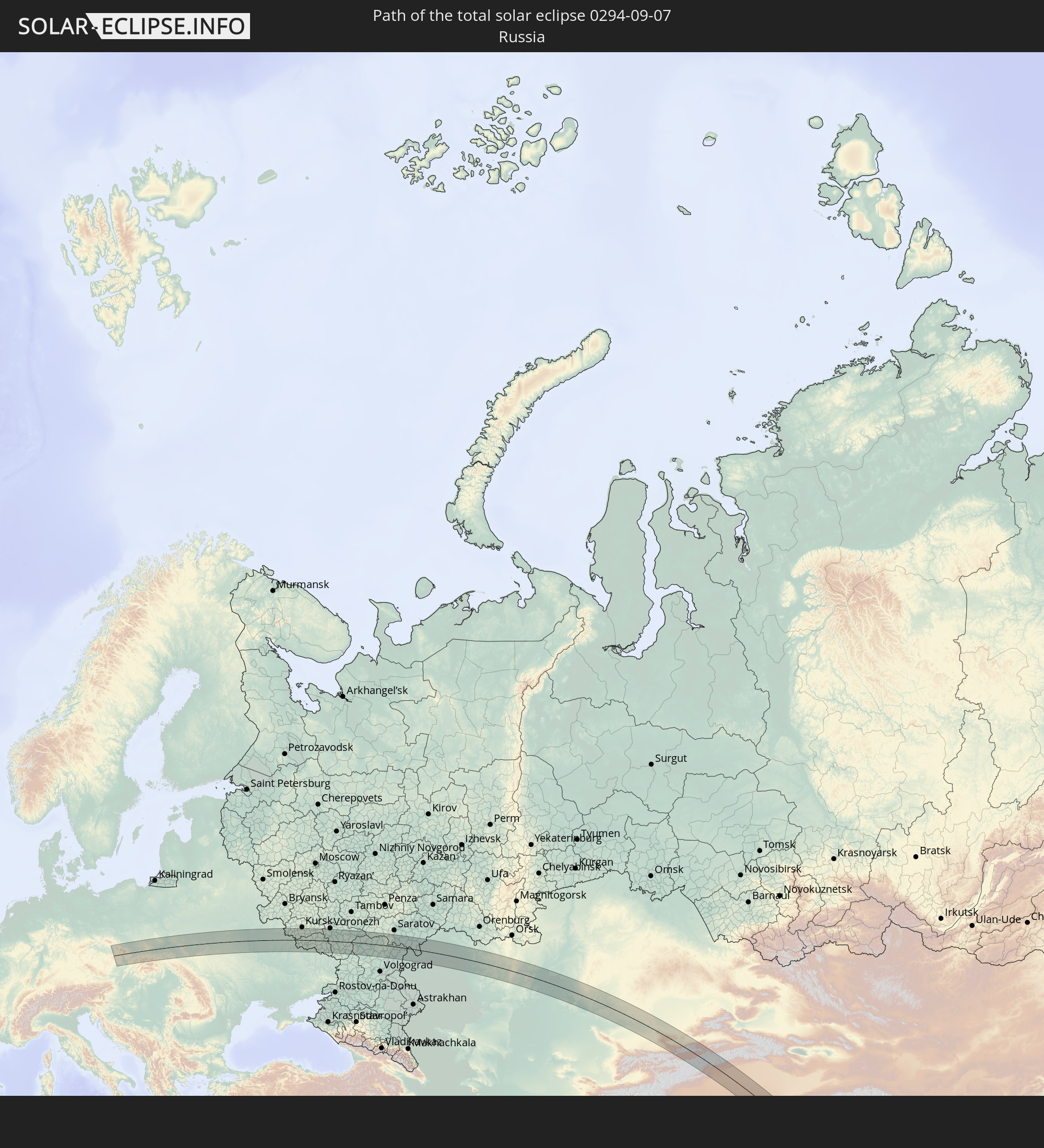 Russland
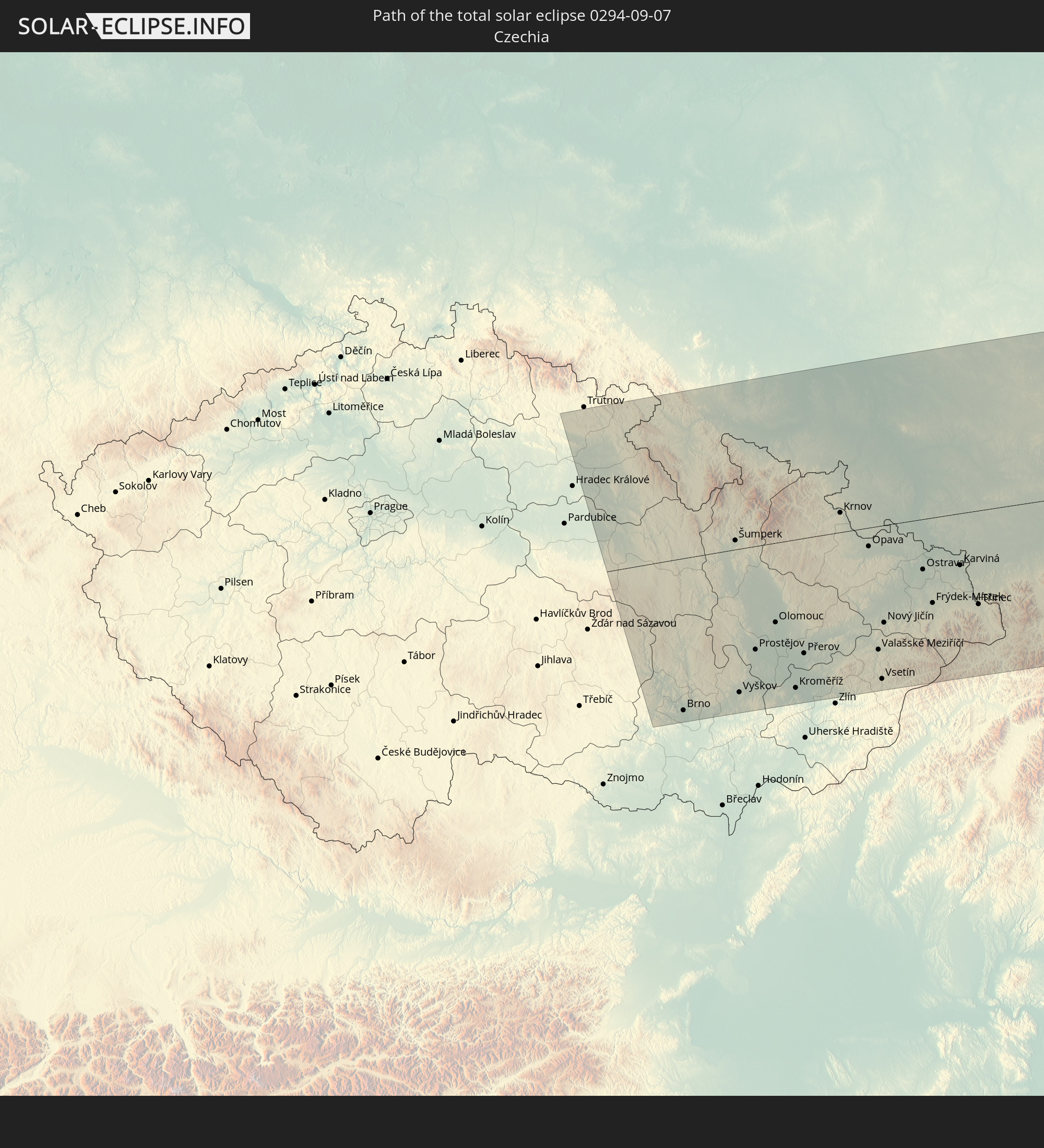 Tschechien
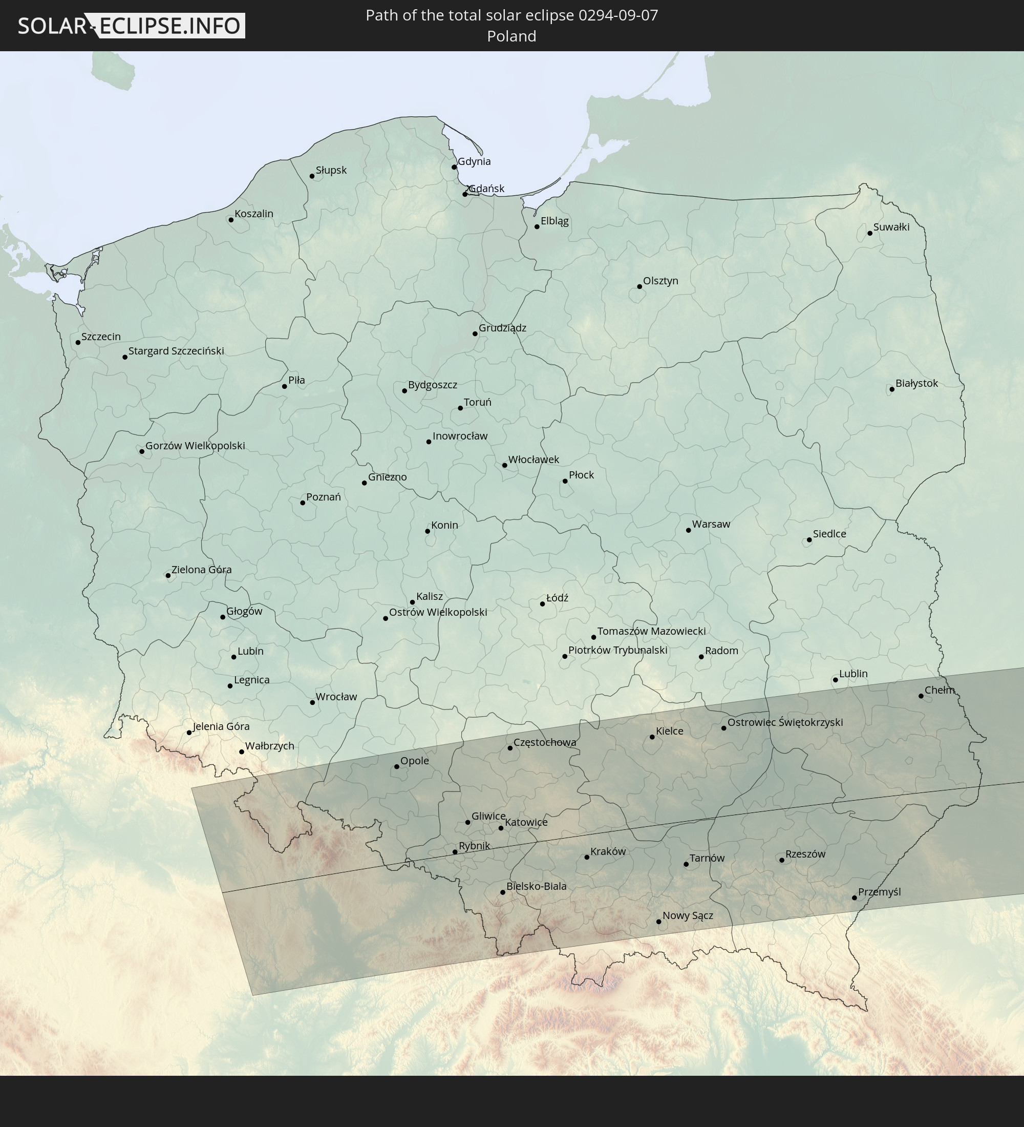 Polen
Polen
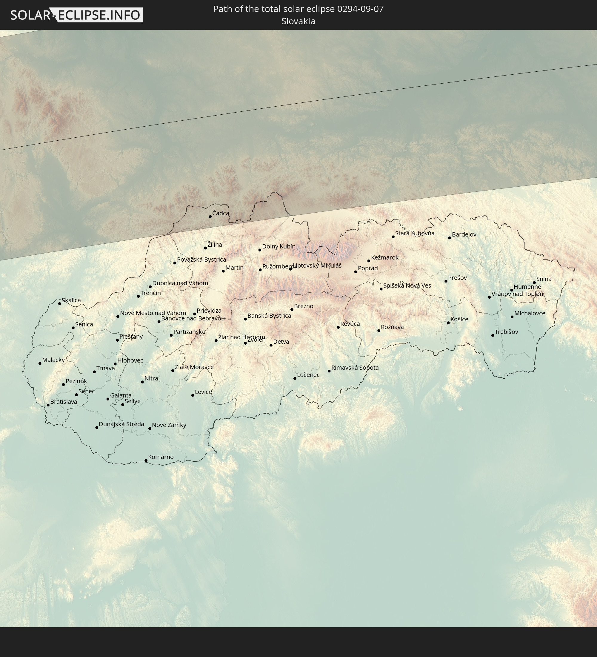 Slowakei
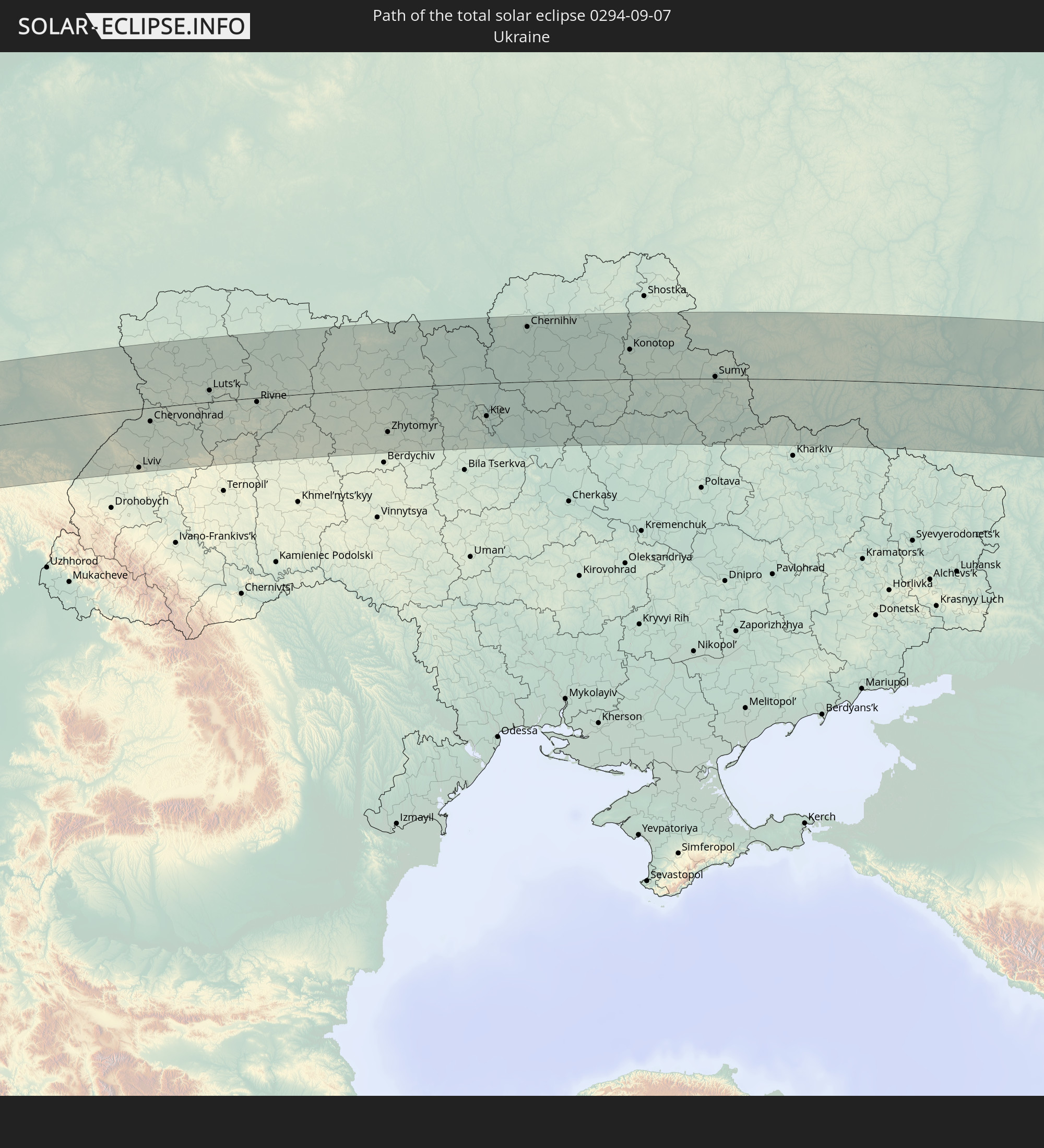 Ukraine
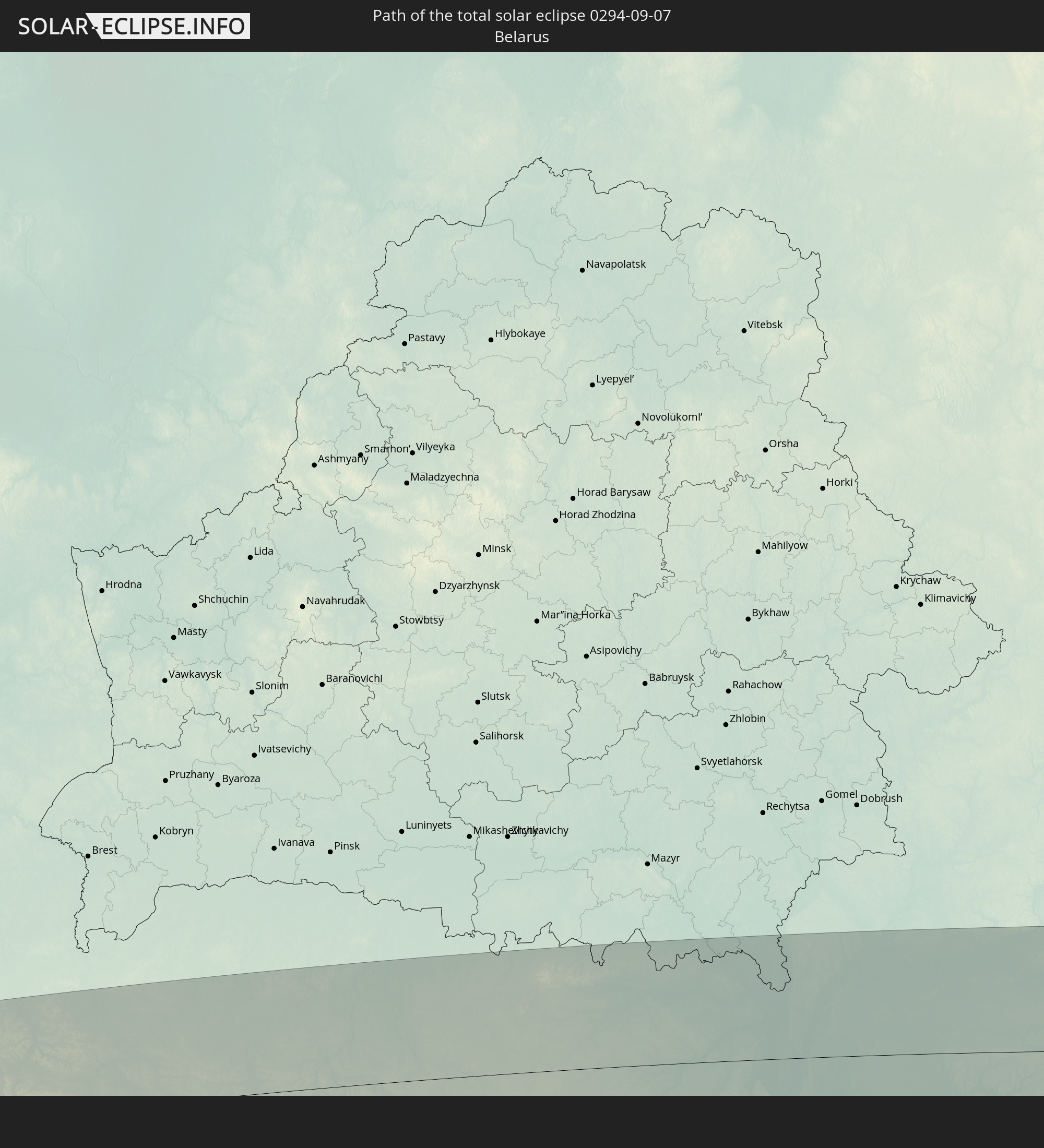 Weißrussland
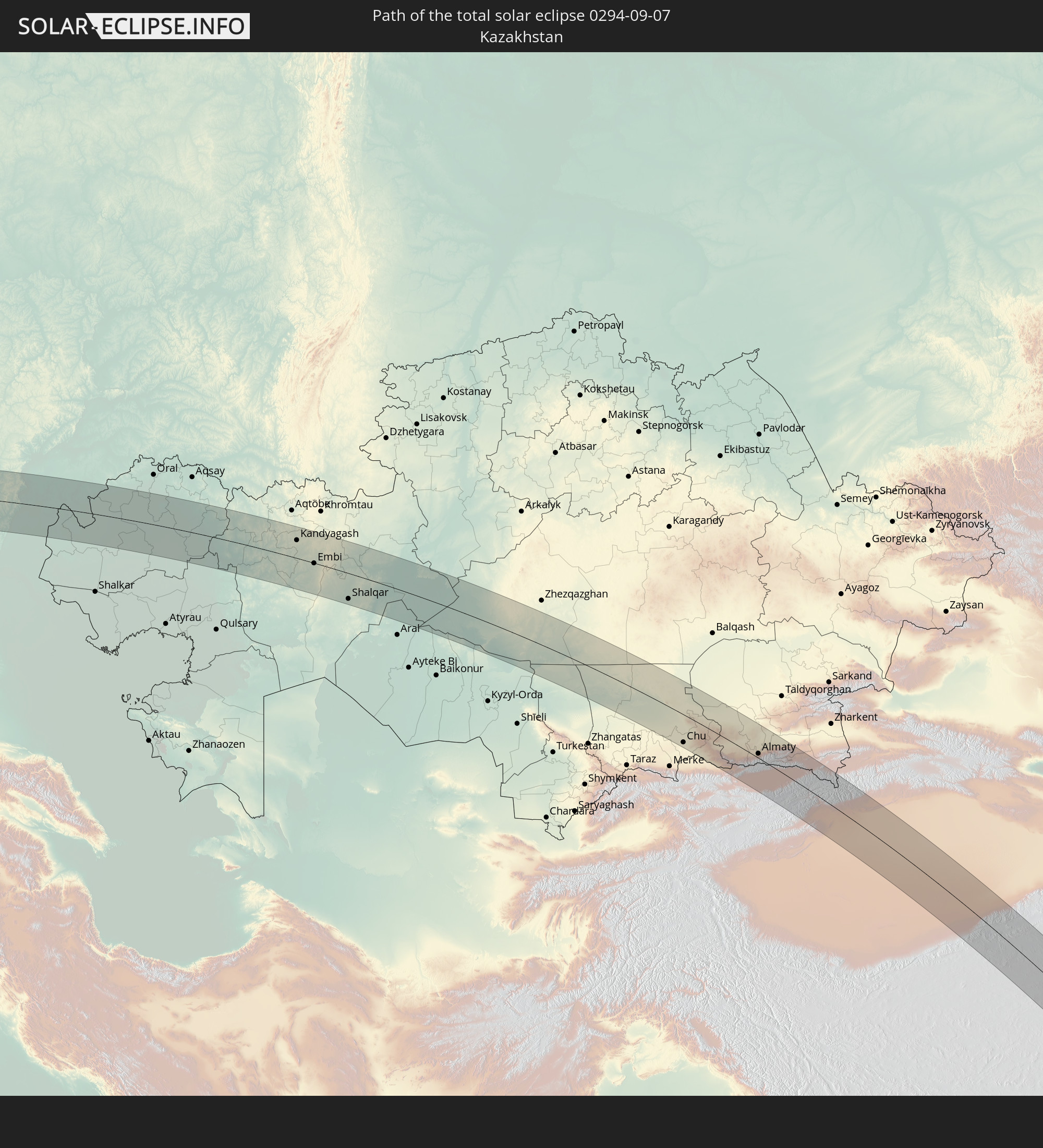 Kasachstan
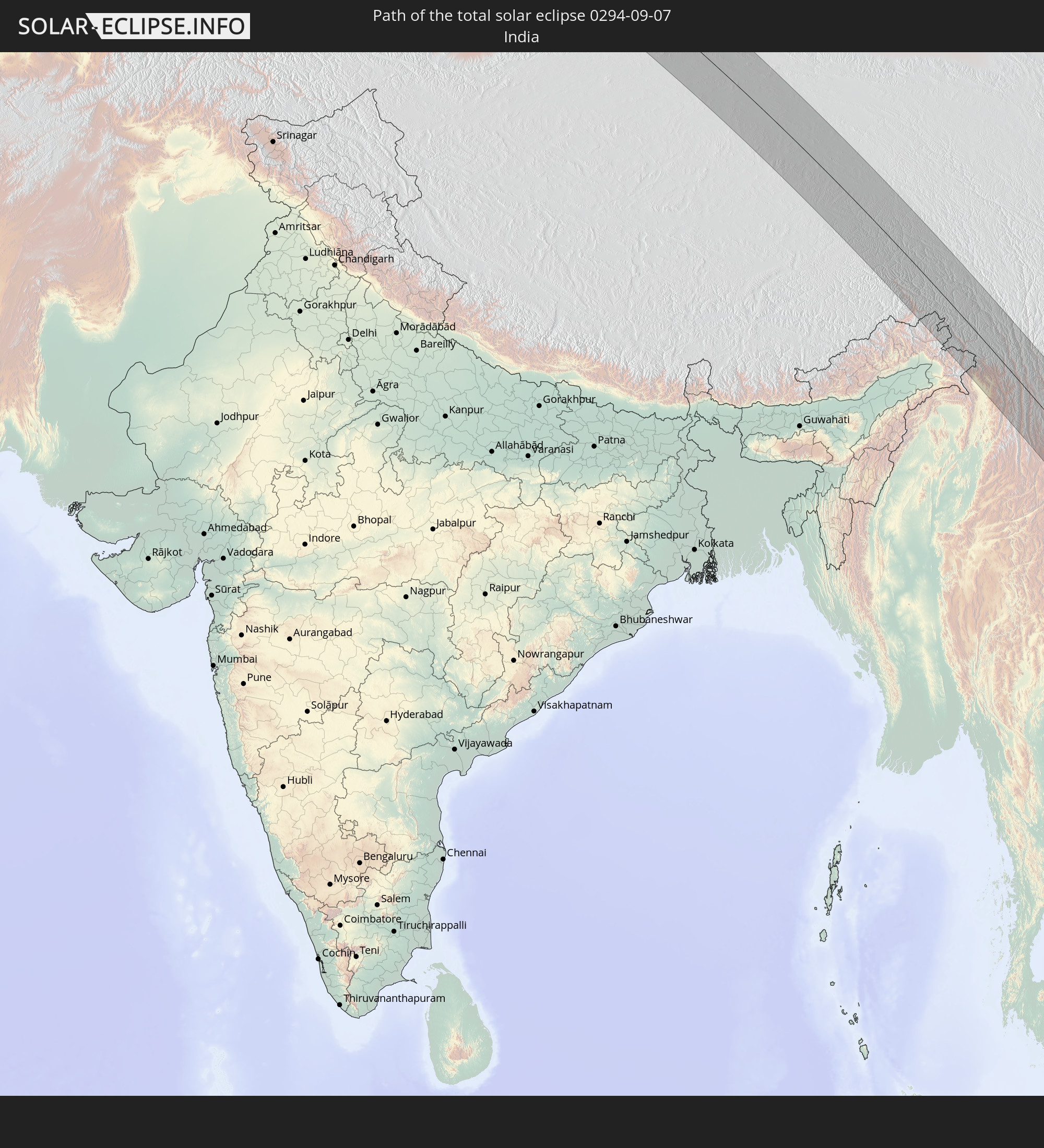 Indien
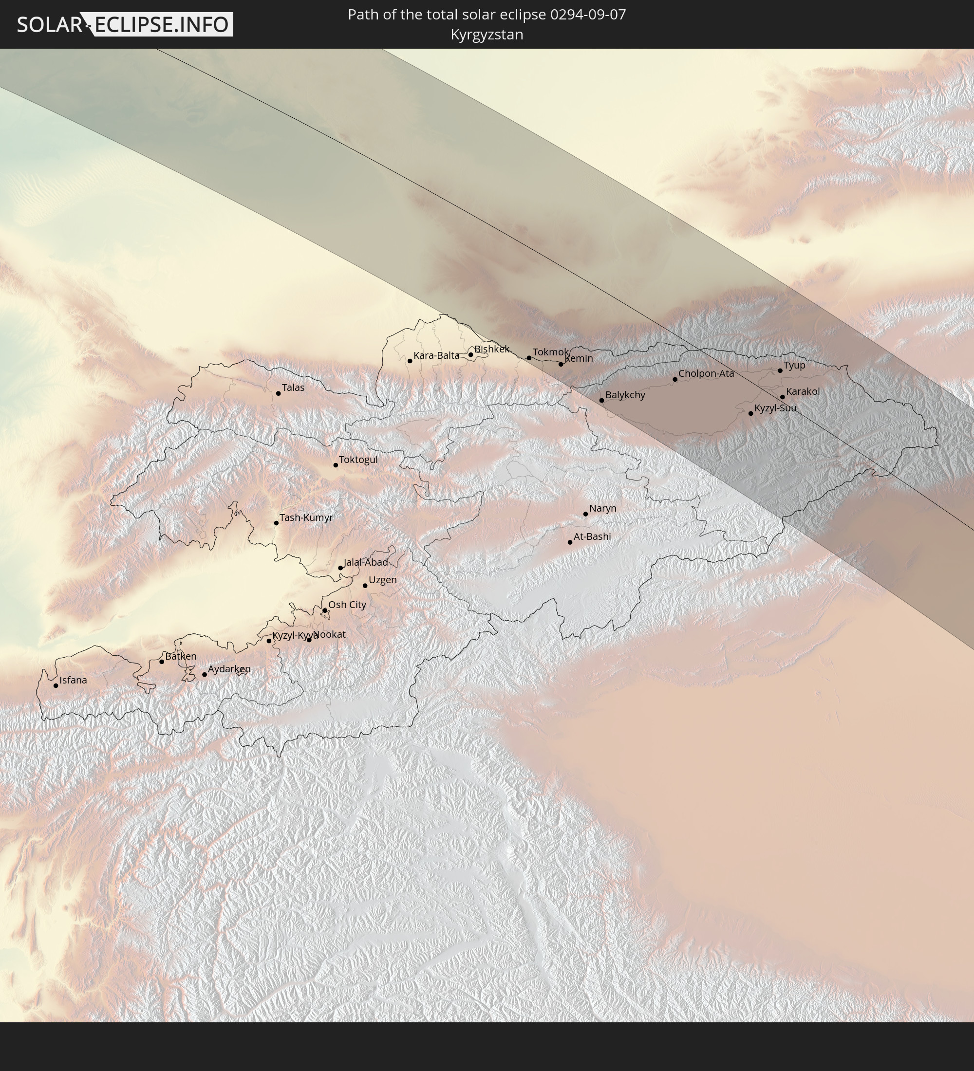 Kirgisistan
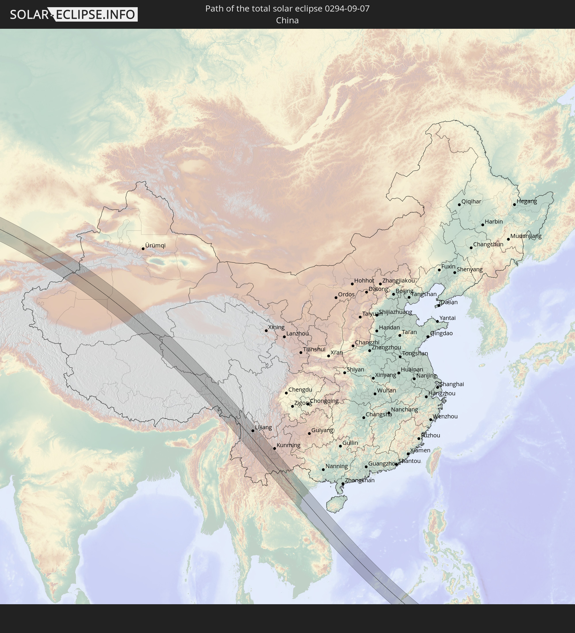 Volksrepublik China
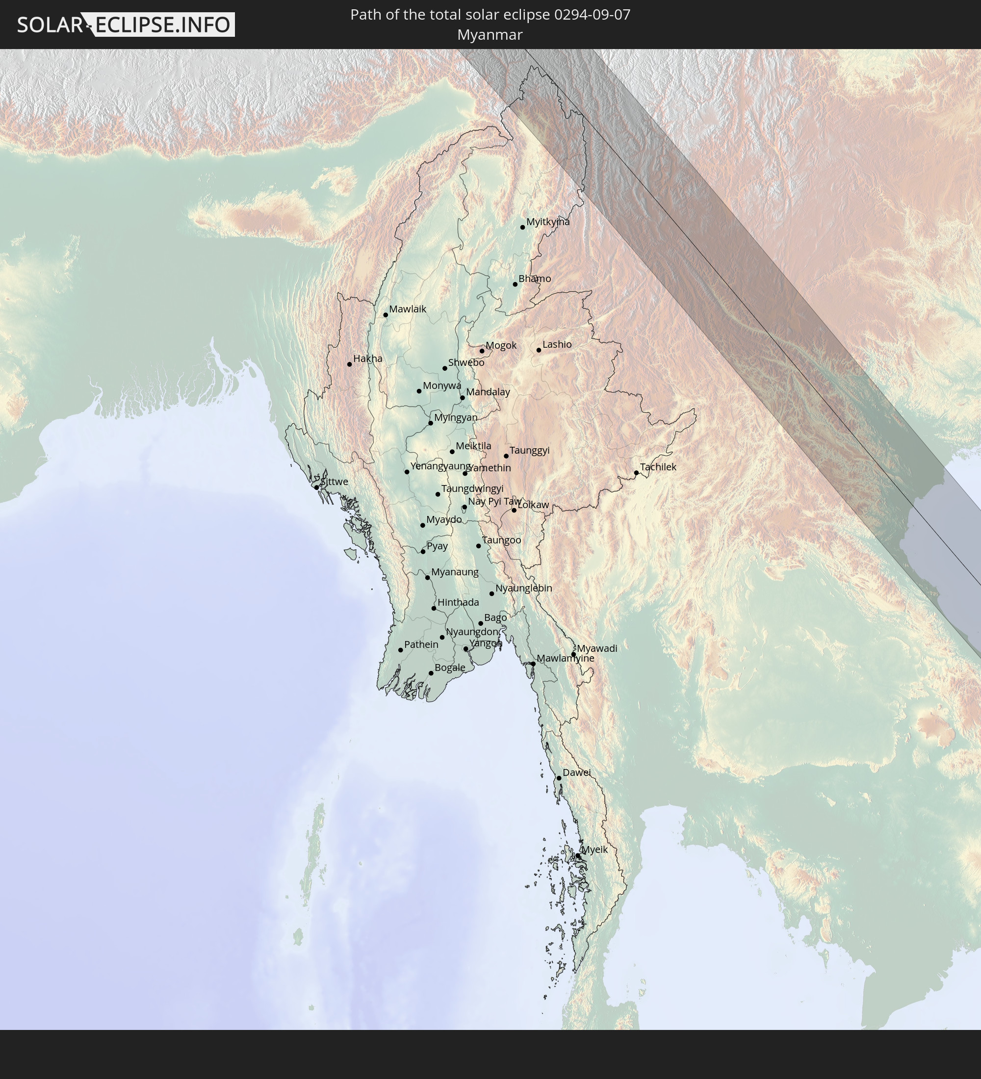 Myanmar
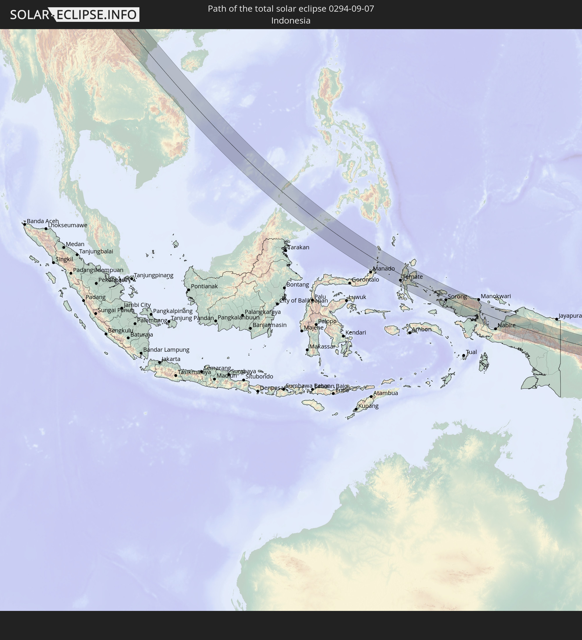 Indonesien
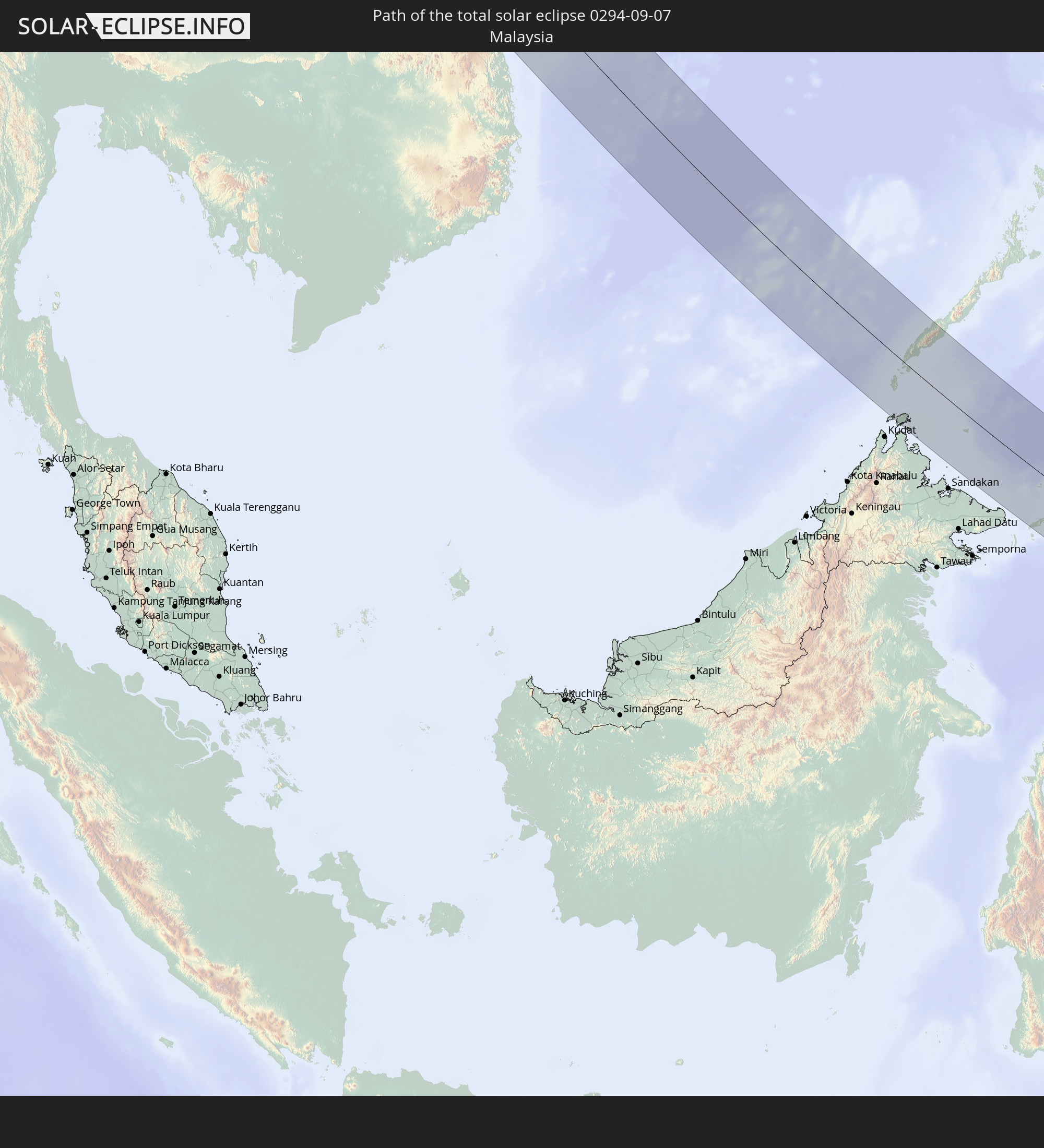 Malaysia
 Laos
Laos
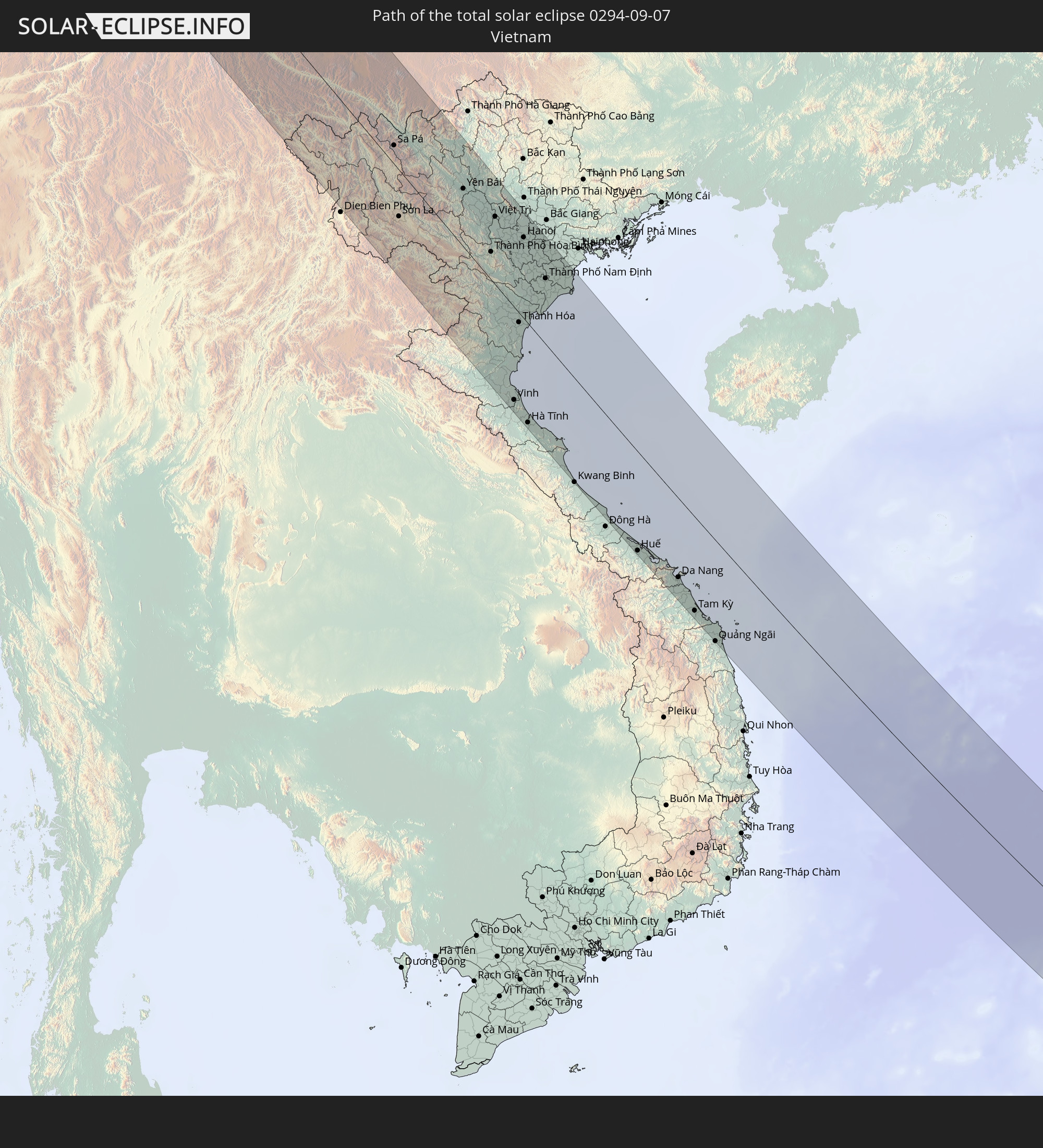 Vietnam
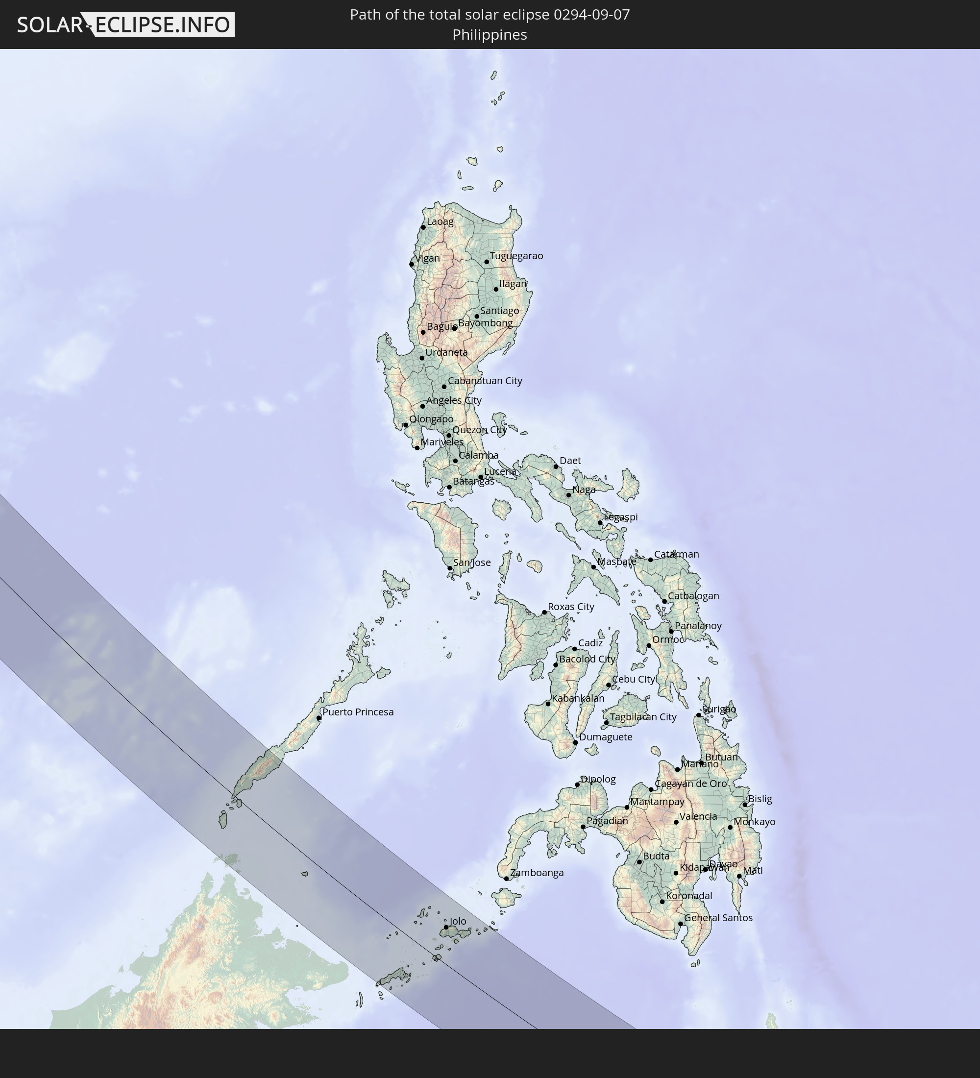 Philippinen
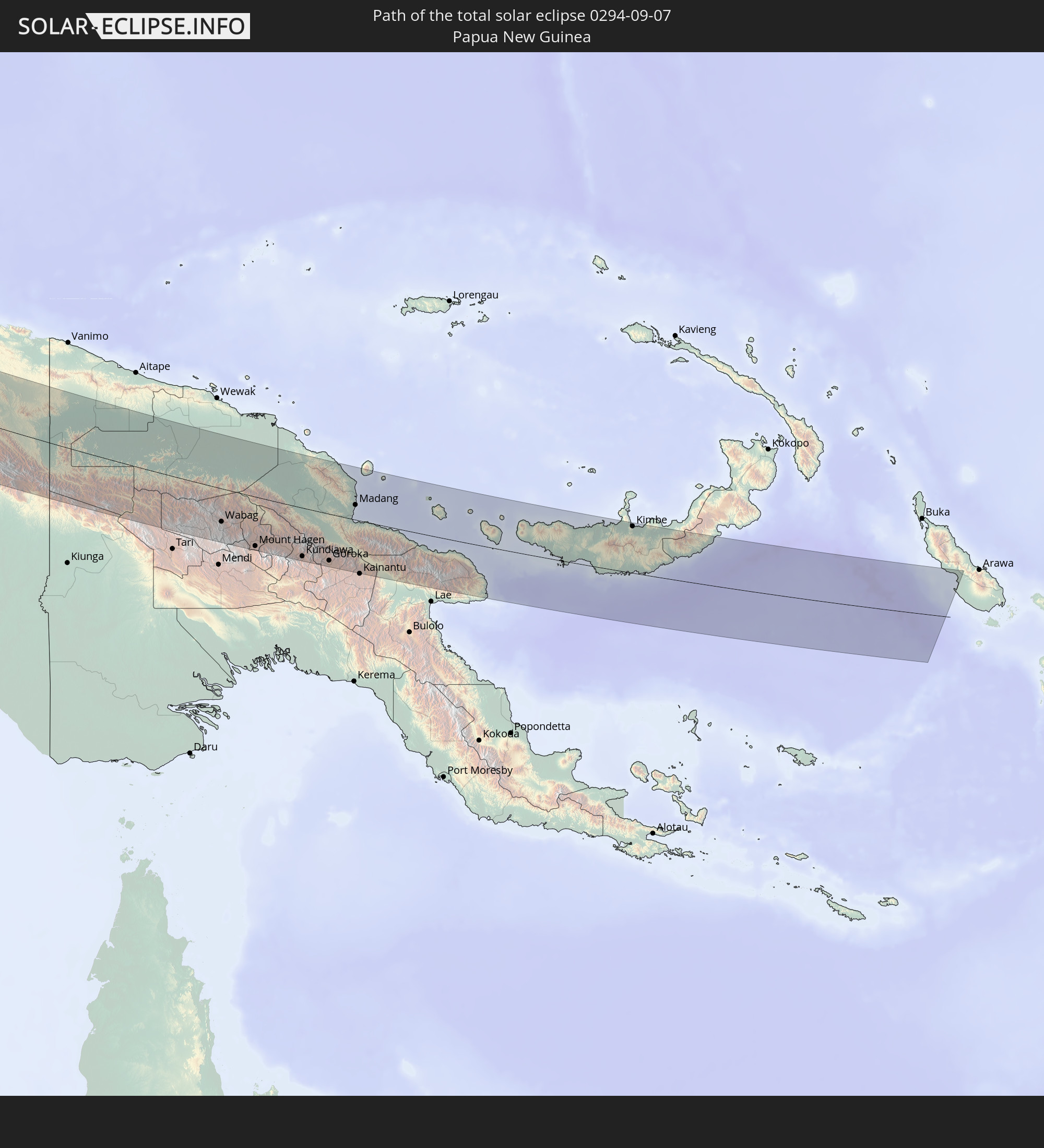 Papua-Neuguinea
In den folgenden Ländern ist die Sonnenfinsternis partiell zu sehen
 Russland
 Grönland
 Spitzbergen
 Norwegen
 Deutschland
 Dänemark
 Libyen
 Österreich
 Schweden
 Tschechien
 Tschad
 Kroatien
 Polen
Polen
 Bosnien und Herzegowina
 Ungarn
 Slowakei
 Montenegro
 Serbien
 Albanien
 Åland Islands
 Griechenland
 Rumänien
 Mazedonien
 Finnland
 Litauen
 Lettland
 Estland
 Sudan
Sudan
 Ukraine
 Bulgarien
 Weißrussland
 Ägypten
 Türkei
 Moldawien
 Republik Zypern
 Staat Palästina
 Israel
 Saudi-Arabien
 Jordanien
 Libanon
 Syrien
 Irak
Irak
 Georgien
 Jemen
Jemen
 Armenien
 Iran
Iran
 Aserbaidschan
 Kasachstan
 Kuwait
 Bahrain
 Katar
Katar
 Vereinigte Arabische Emirate
 Oman
Oman
 Turkmenistan
 Usbekistan
 Afghanistan
 Pakistan
 Tadschikistan
 Indien
 Kirgisistan
 Volksrepublik China
 Sri Lanka
 Nepal
Nepal
 Mongolei
 Bangladesch
 Bhutan
 Myanmar
 Indonesien
 Kokosinseln
 Thailand
 Malaysia
 Laos
Laos
 Vietnam
 Kambodscha
 Singapur
 Weihnachtsinsel
 Australien
 Macau
Macau
 Hongkong
 Brunei
 Taiwan
 Philippinen
 Japan
Japan
 Osttimor
 Nordkorea
 Südkorea
 Palau
Palau
 Föderierte Staaten von Mikronesien
 Papua-Neuguinea
 Guam
Guam
 Nördliche Marianen
 Marshallinseln
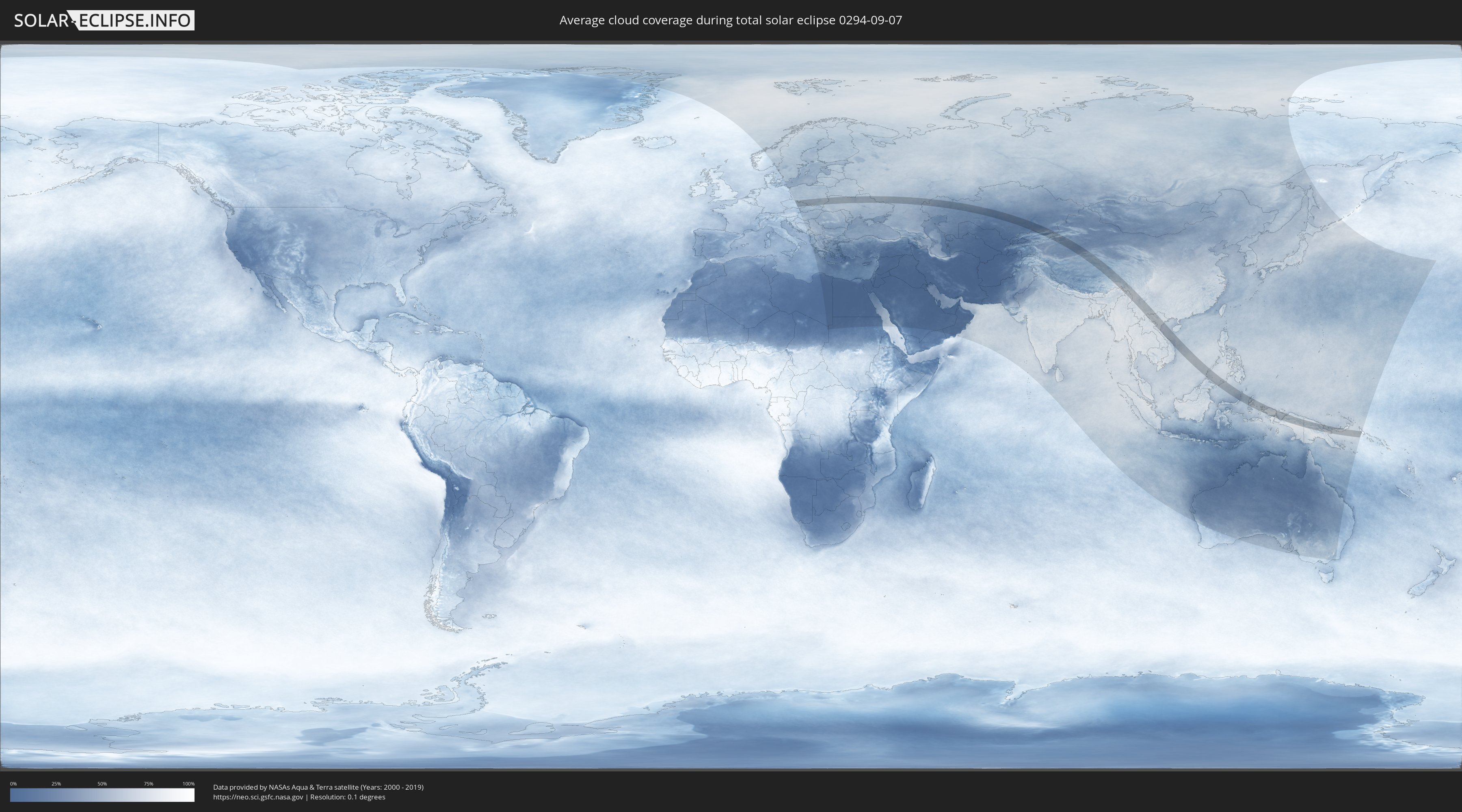
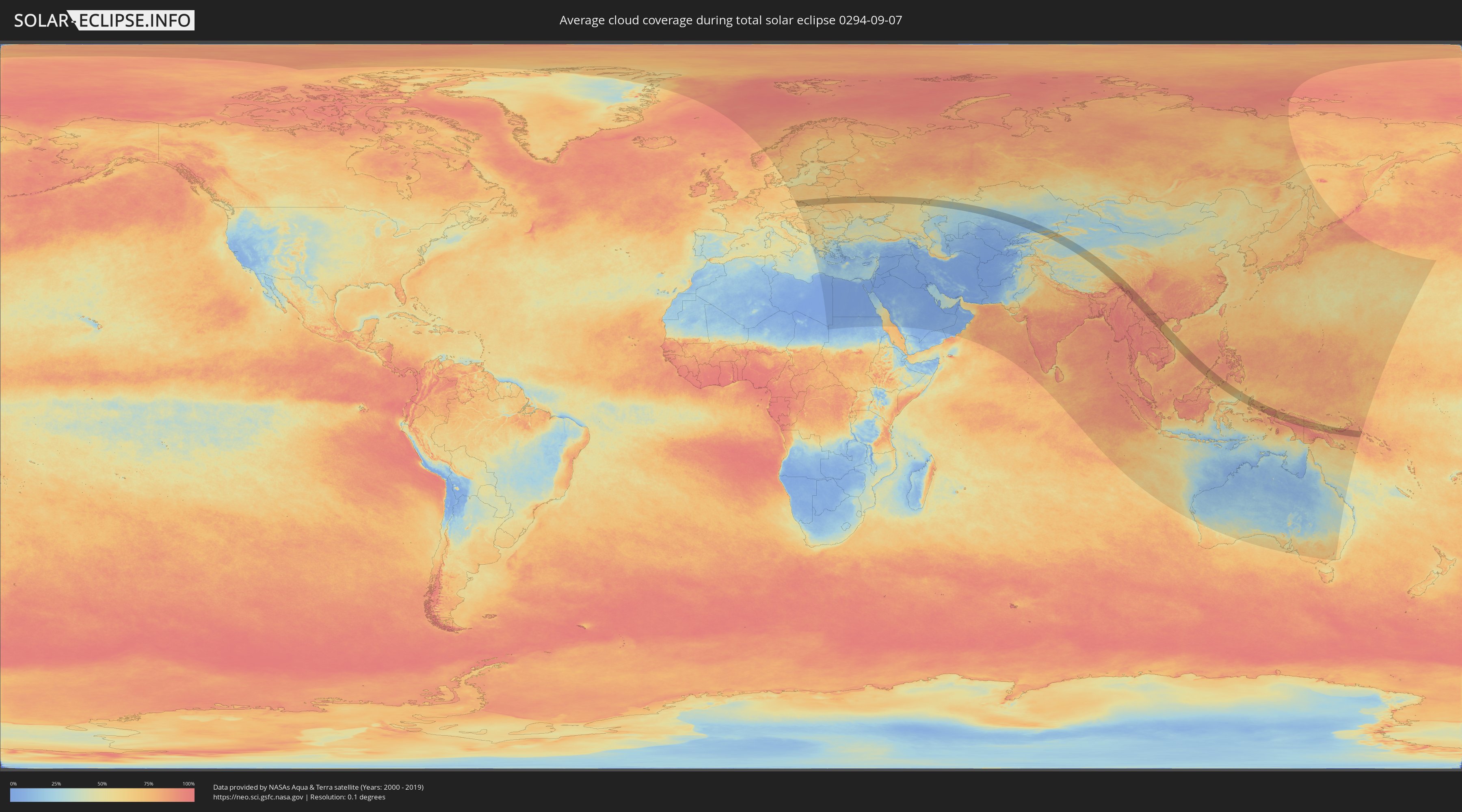
Wie wird das Wetter während der totalen Sonnenfinsternis am 07.09.0294?
Wo ist der beste Ort, um die totale Sonnenfinsternis vom 07.09.0294 zu beobachten?
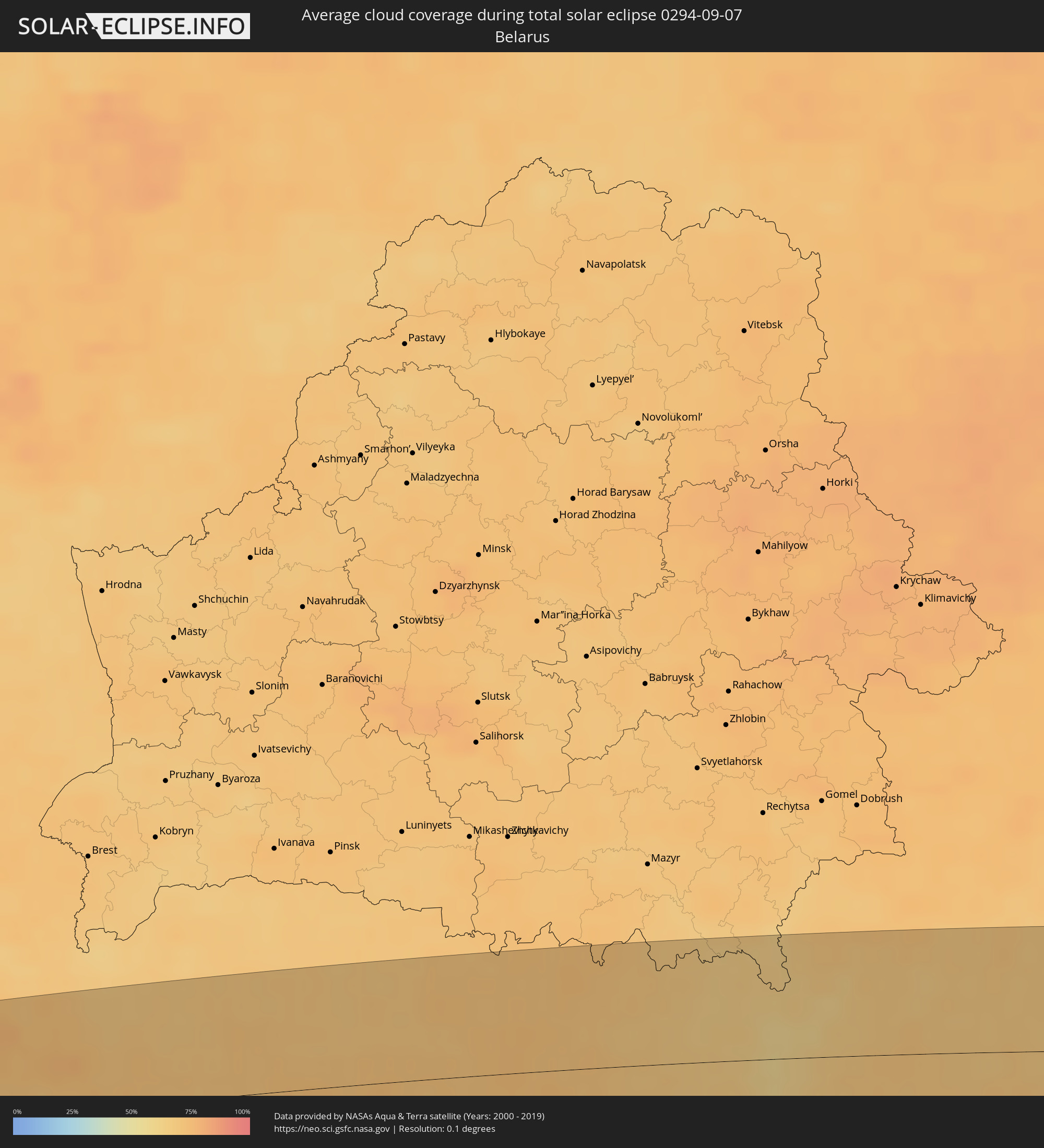
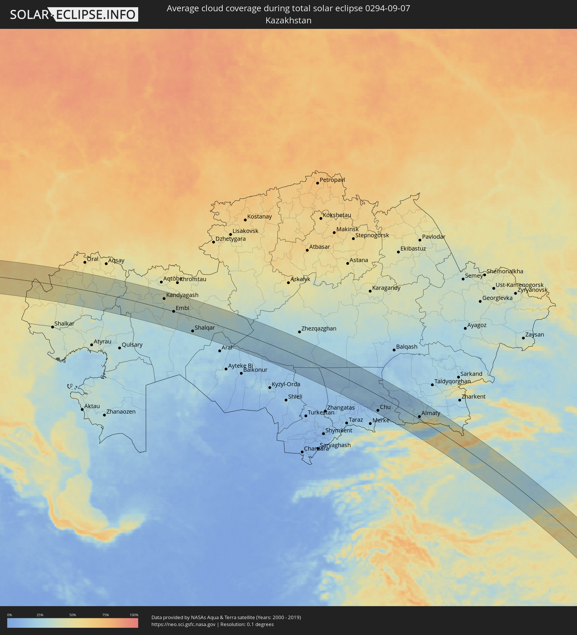
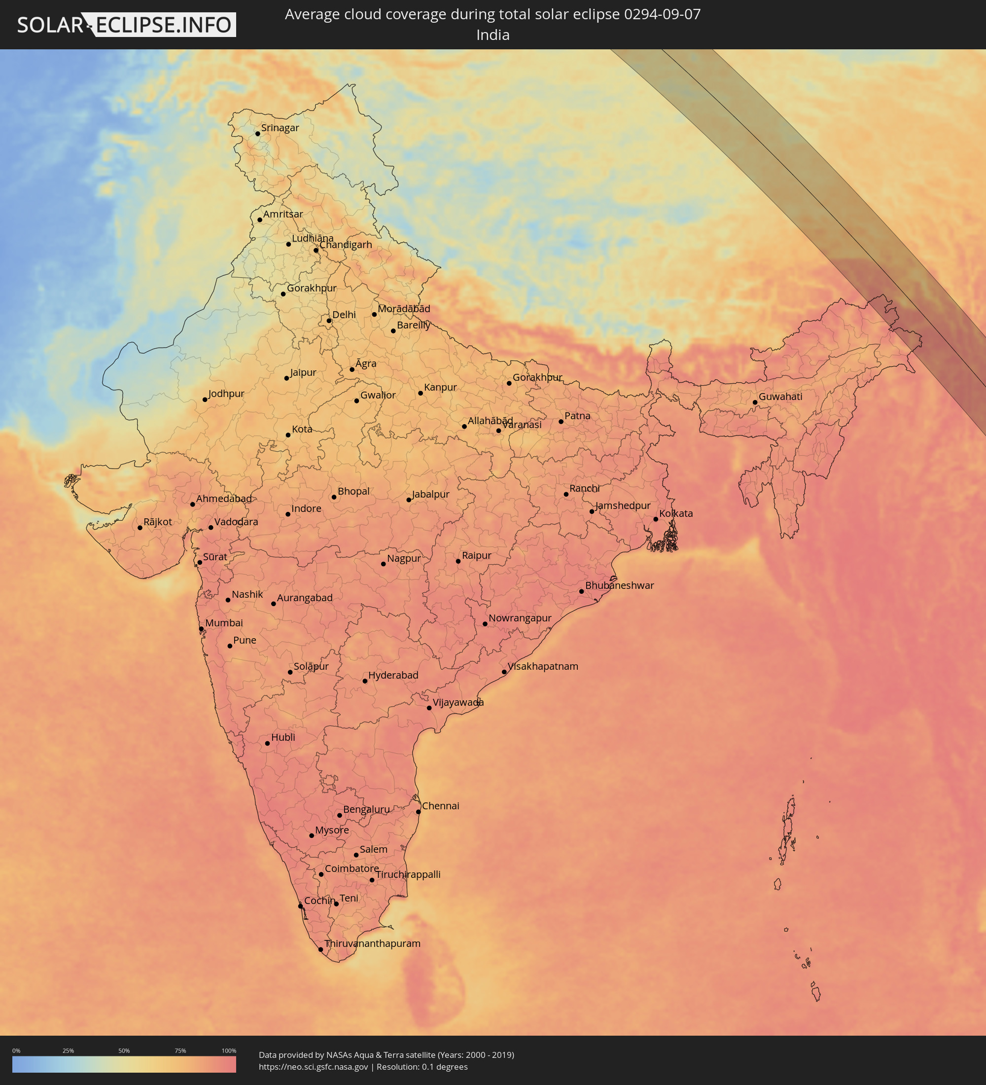
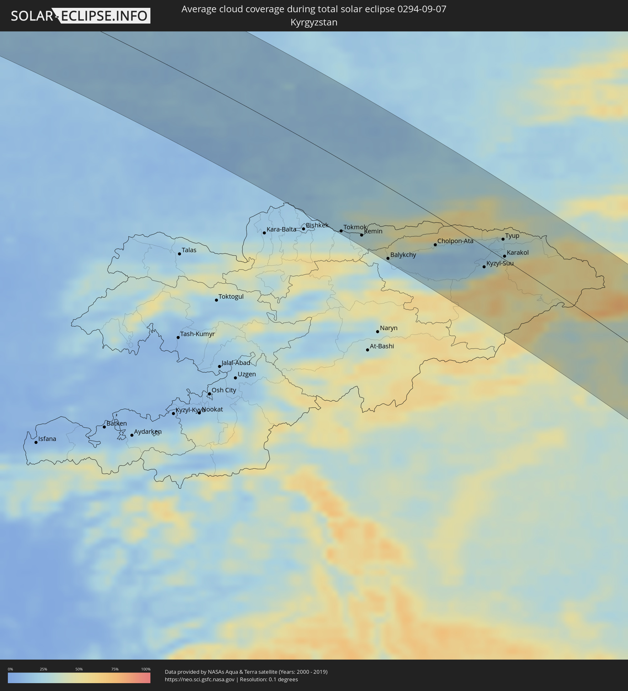
Die folgenden Karten zeigen die durchschnittliche Bewölkung für den Tag, an dem die totale Sonnenfinsternis
stattfindet. Mit Hilfe der Karten lässt sich der Ort entlang des Finsternispfades eingrenzen,
der die besten Aussichen auf einen klaren wolkenfreien Himmel bietet.
Trotzdem muss man immer lokale Gegenenheiten beachten und sollte sich genau über das Wetter an seinem
gewählten Beobachtungsort informieren.
Die Daten stammen von den beiden NASA-Satelliten
AQUA und TERRA
und wurden über einen Zeitraum von 19 Jahren (2000 - 2019) gemittelt.
Detaillierte Länderkarten
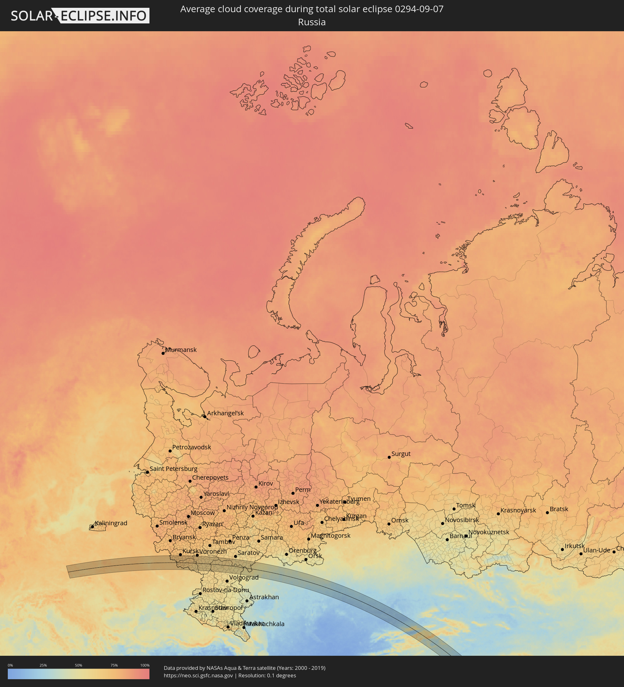 Russland
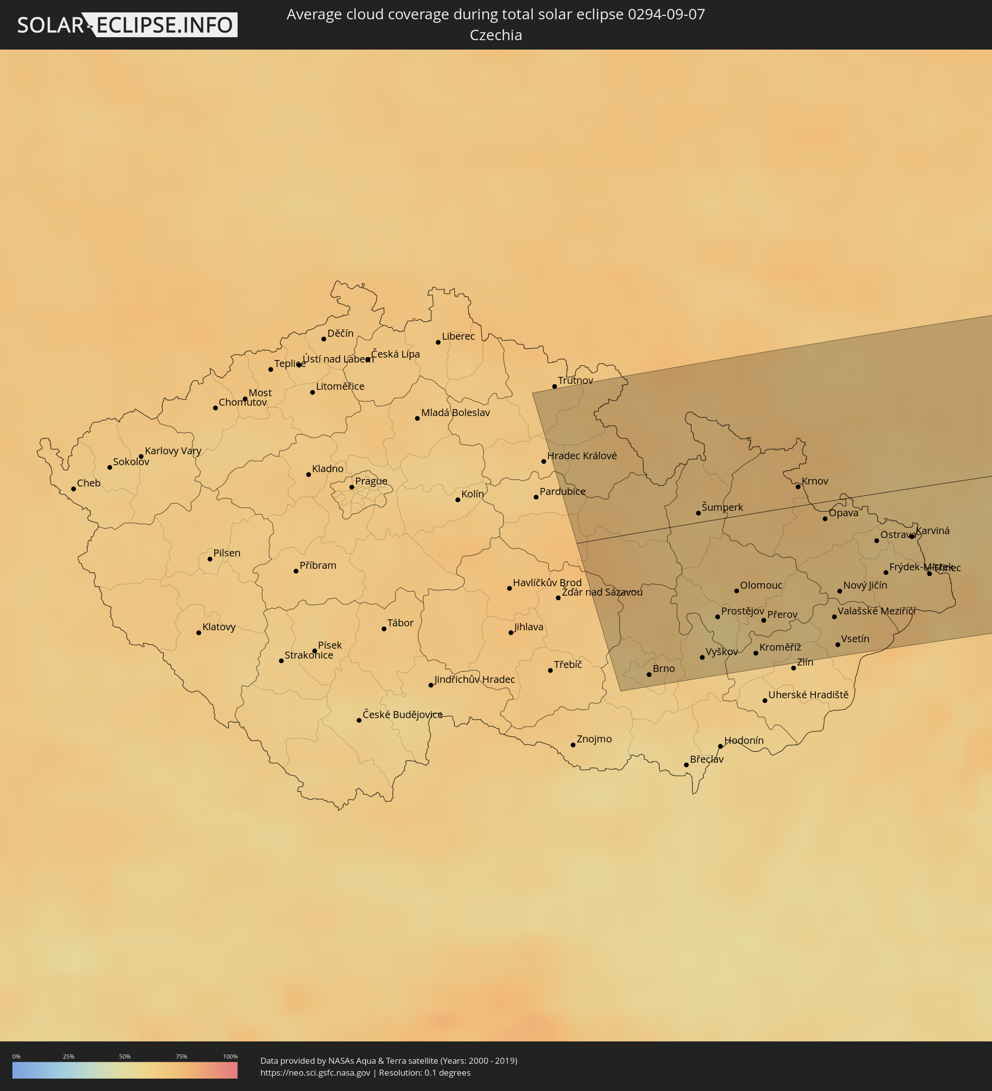 Tschechien
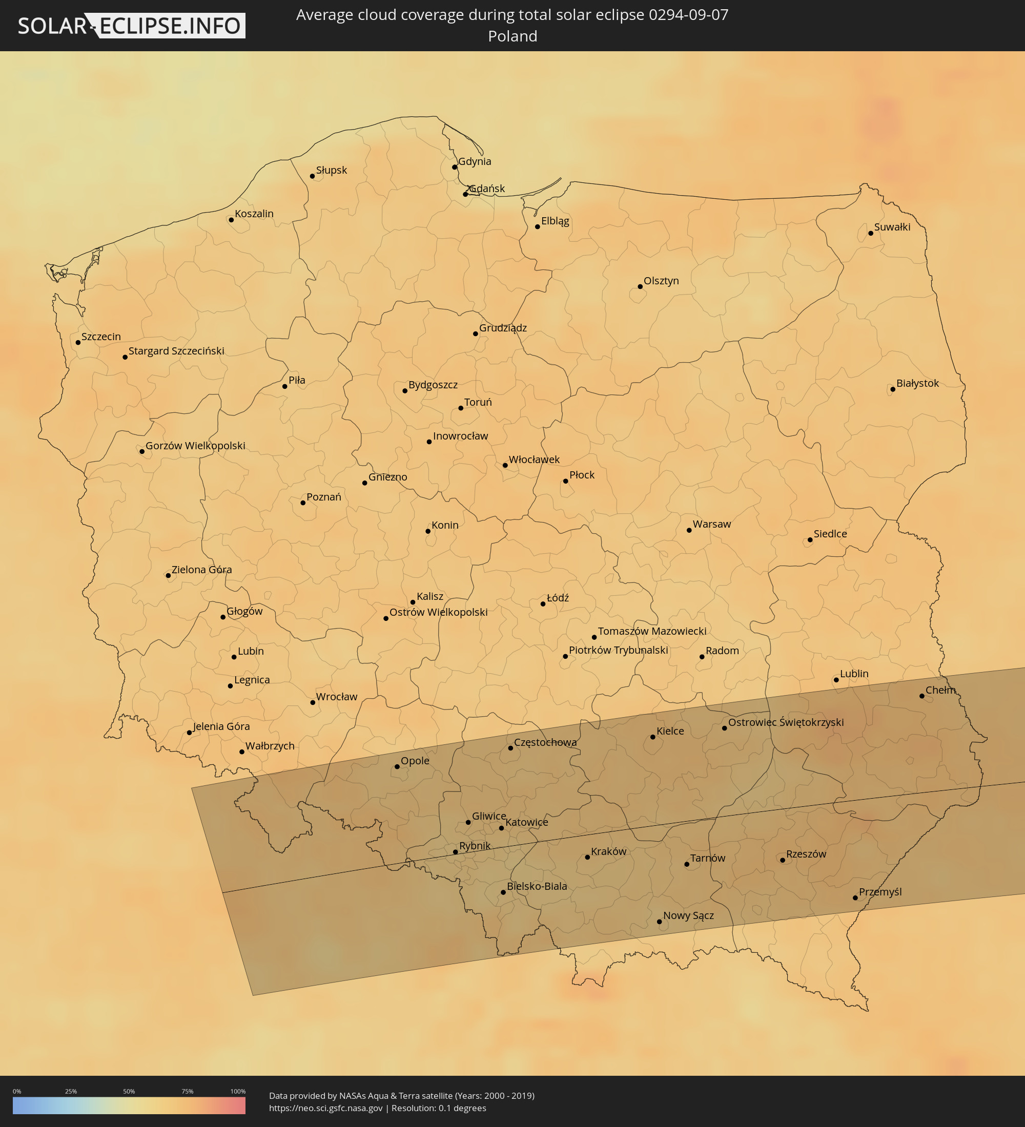 Polen
Polen
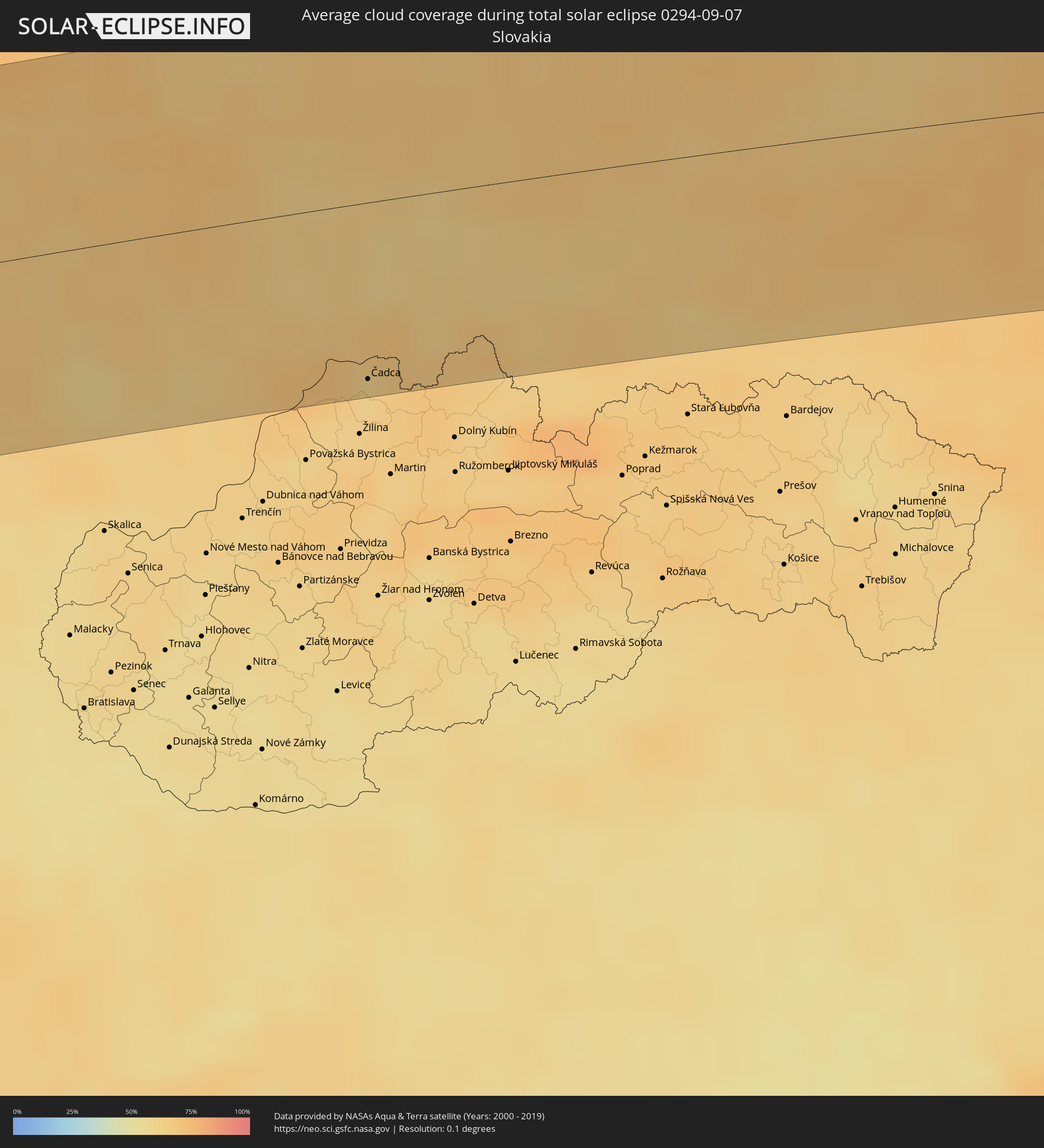 Slowakei
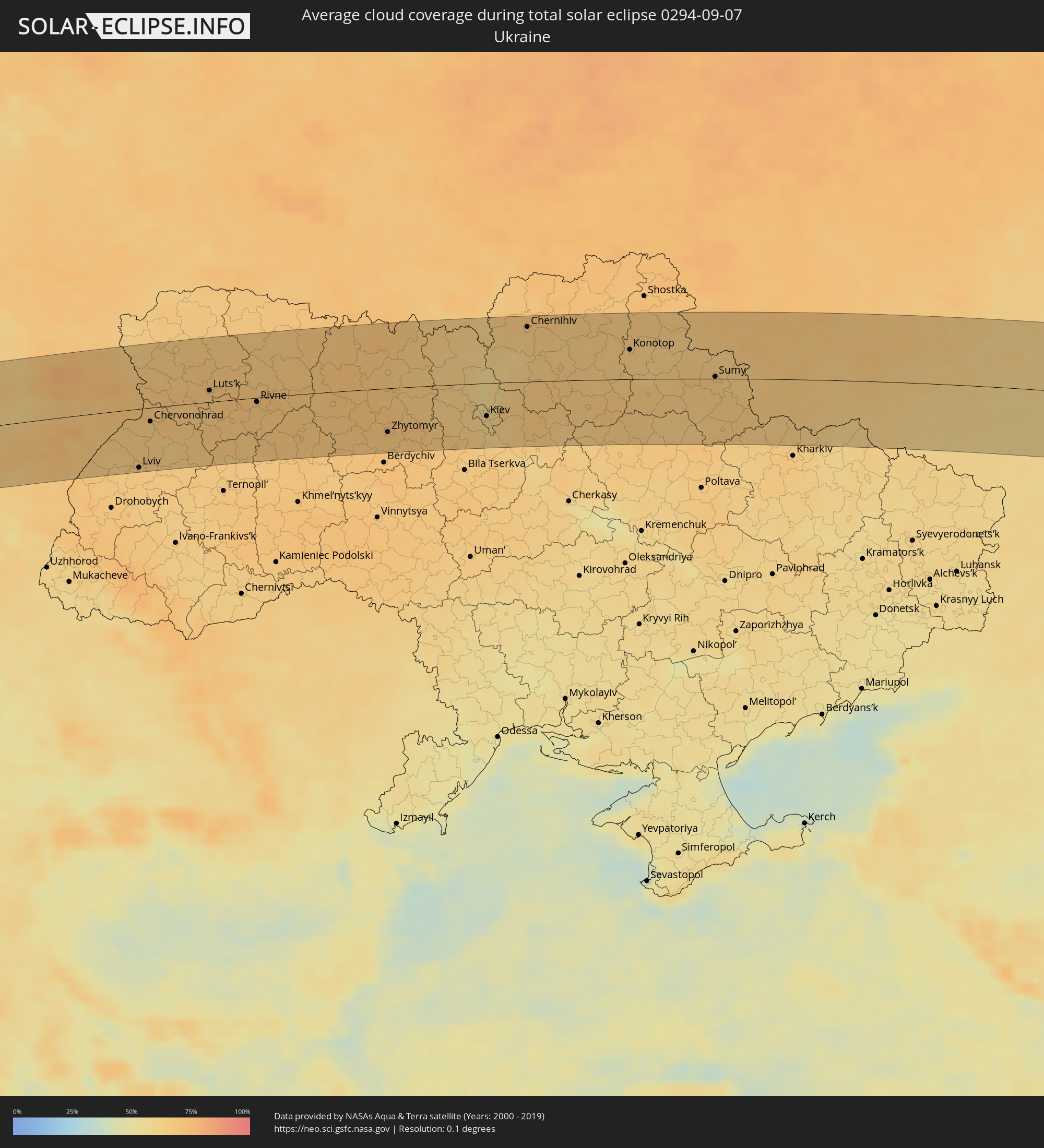 Ukraine
 Weißrussland
 Kasachstan
 Indien
 Kirgisistan
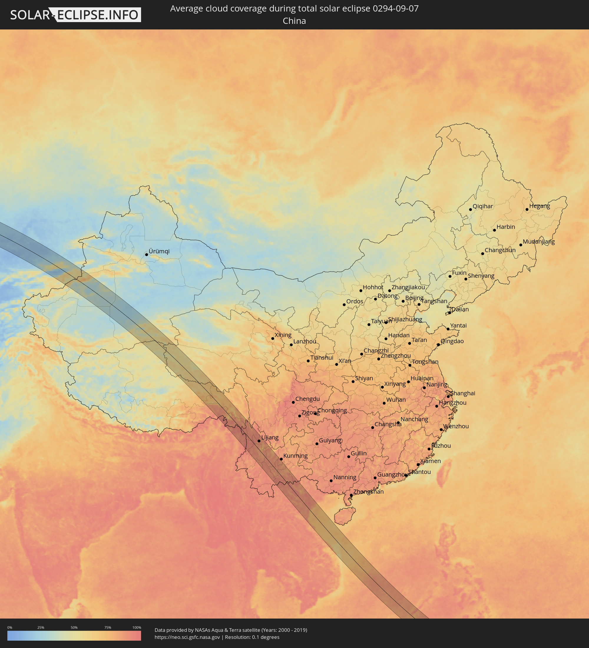 Volksrepublik China
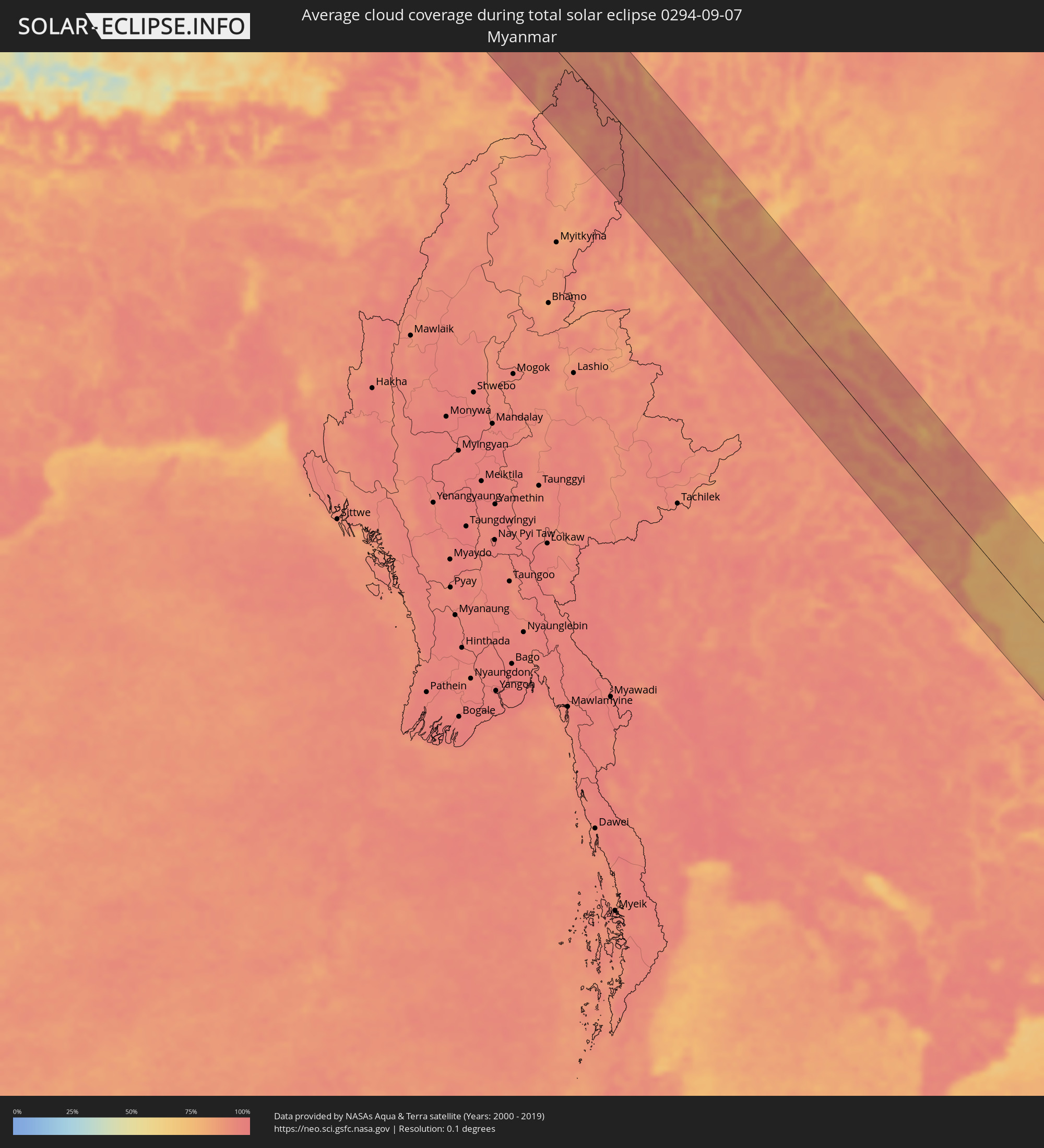 Myanmar
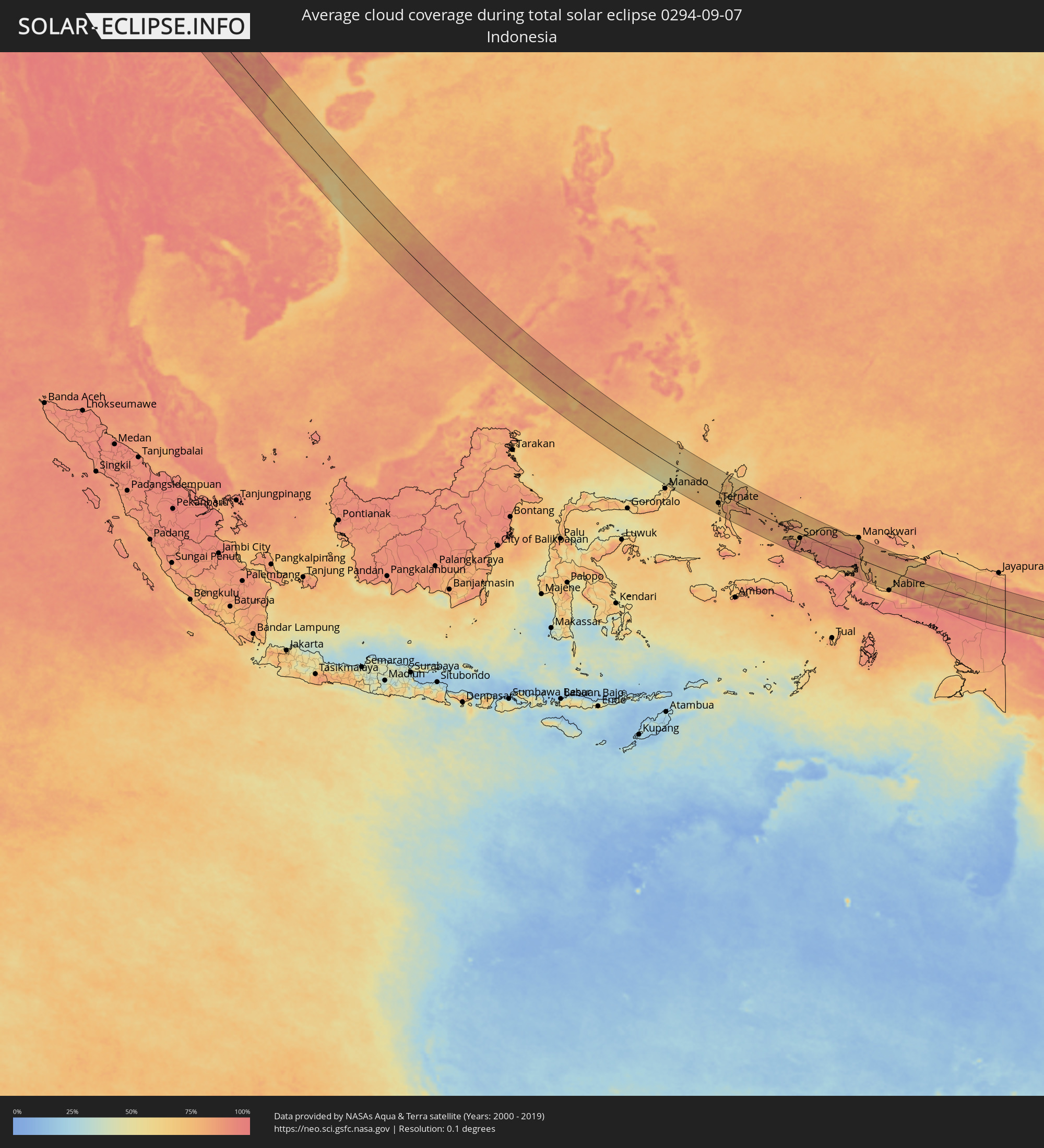 Indonesien
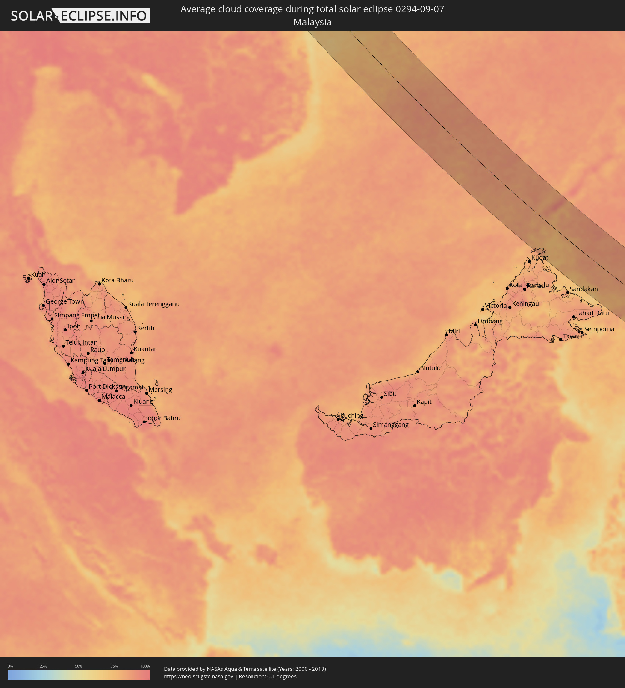 Malaysia
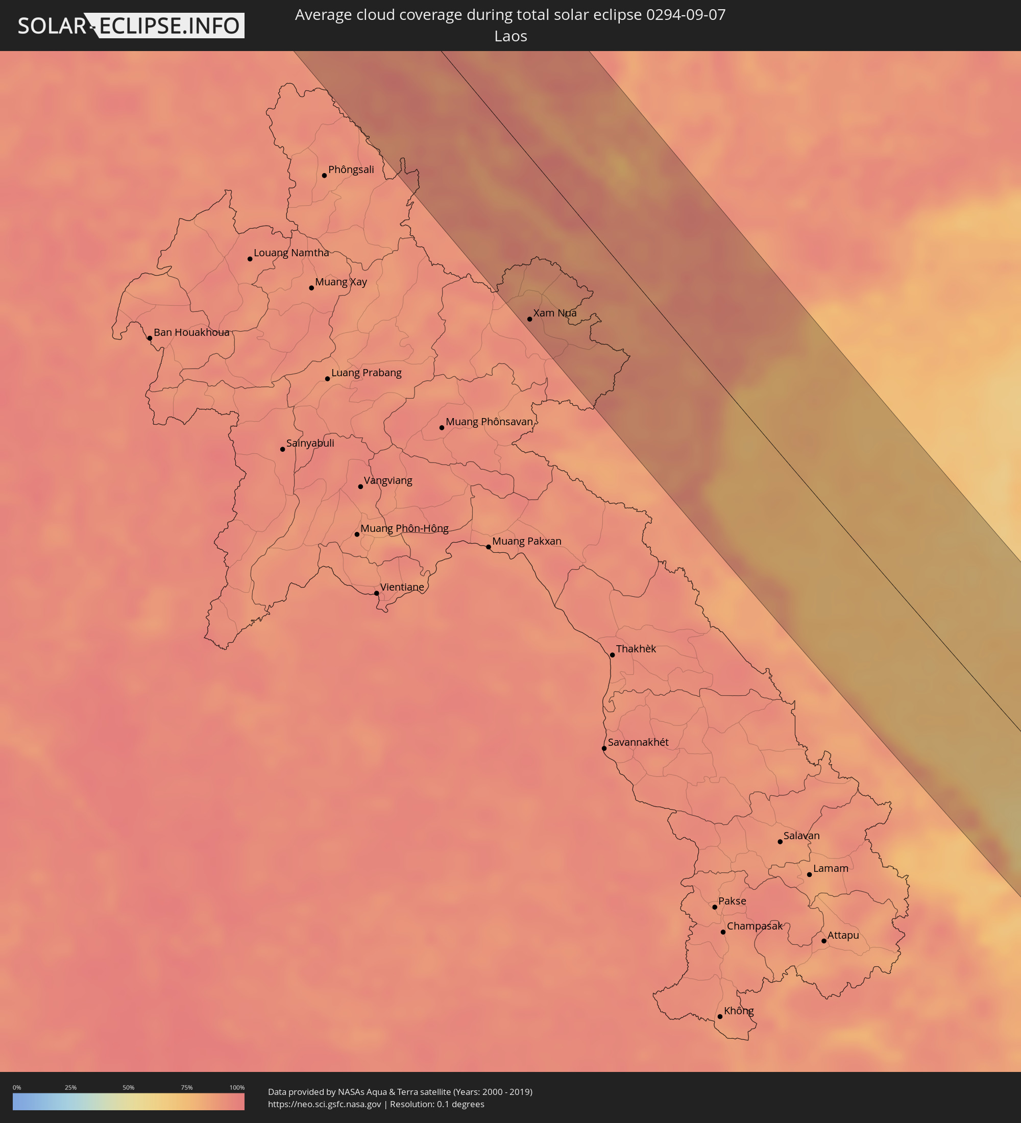 Laos
Laos
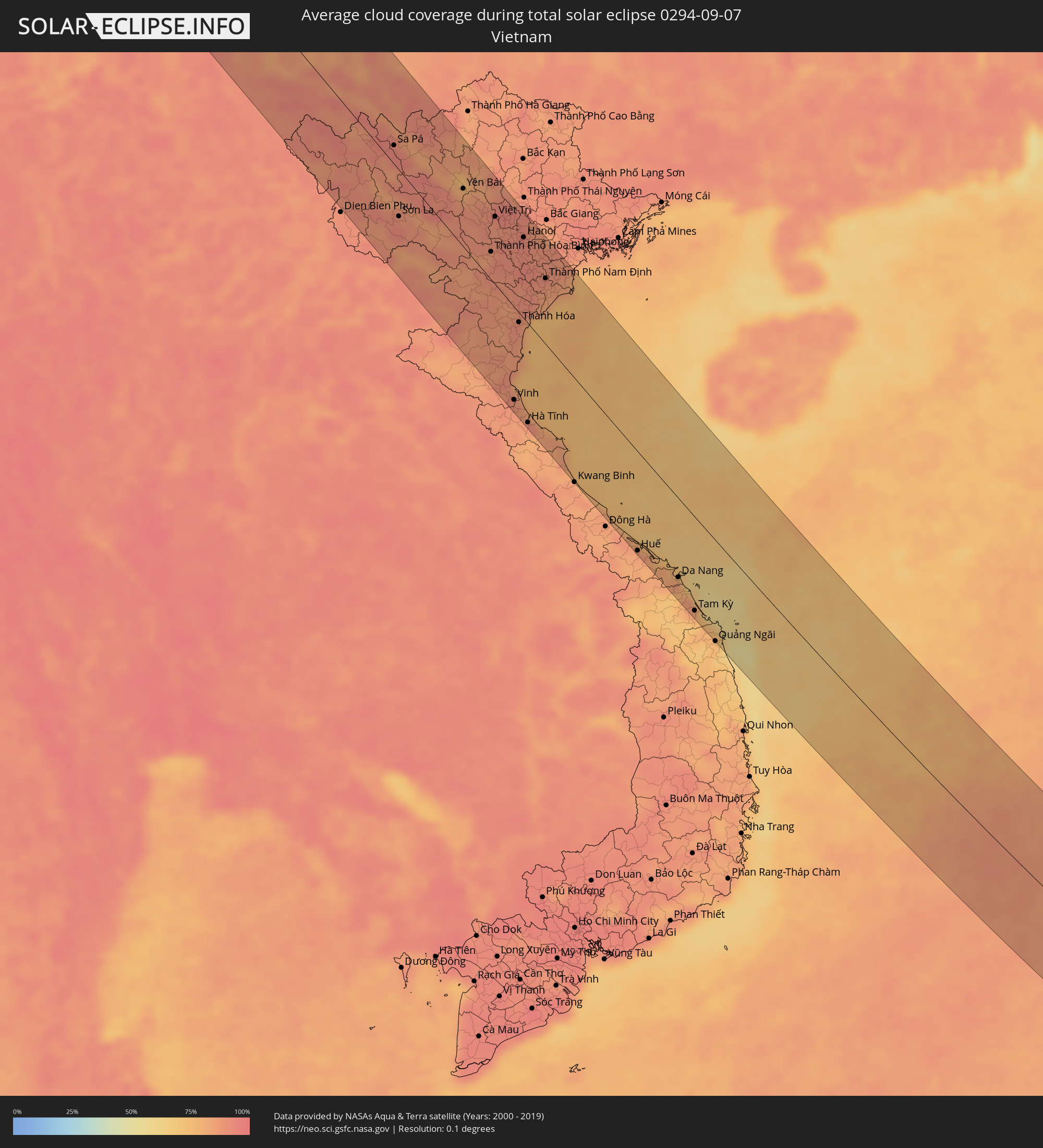 Vietnam
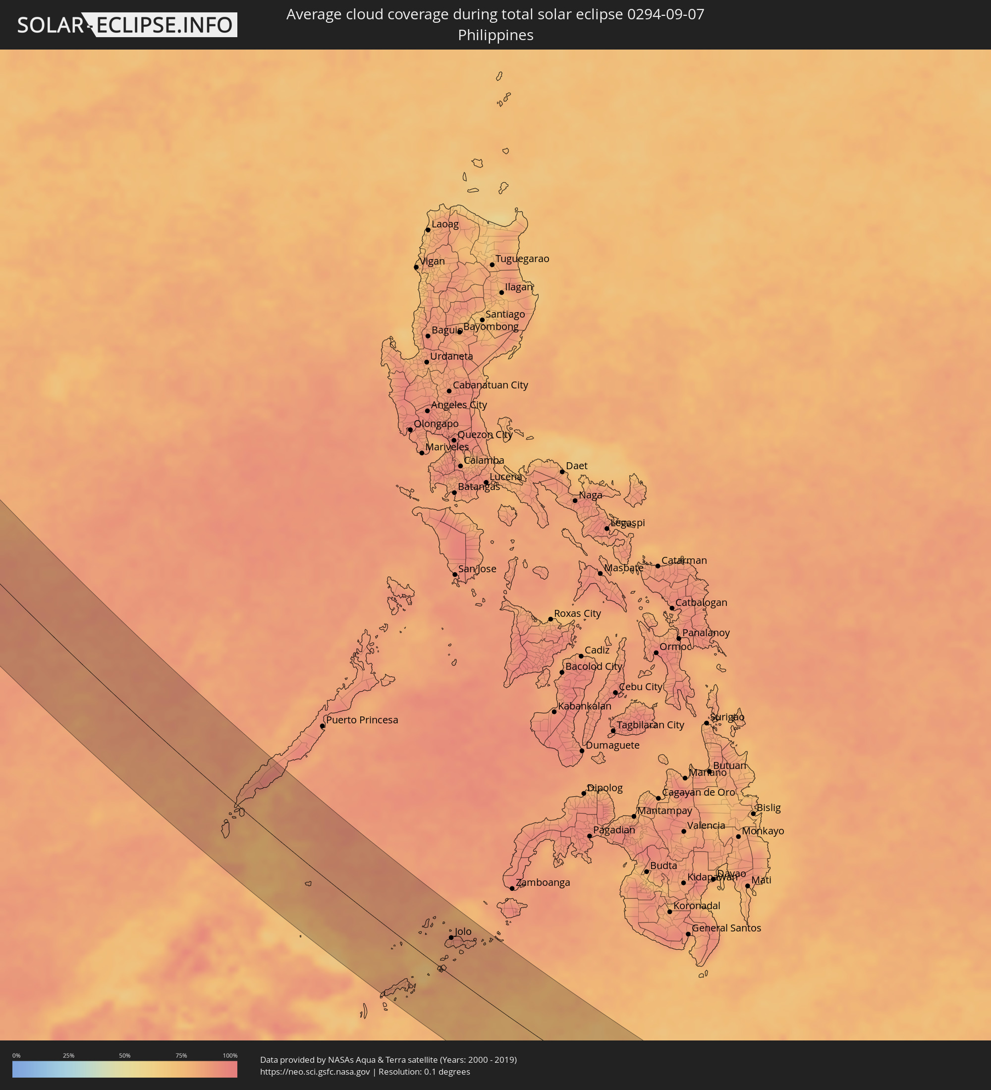 Philippinen
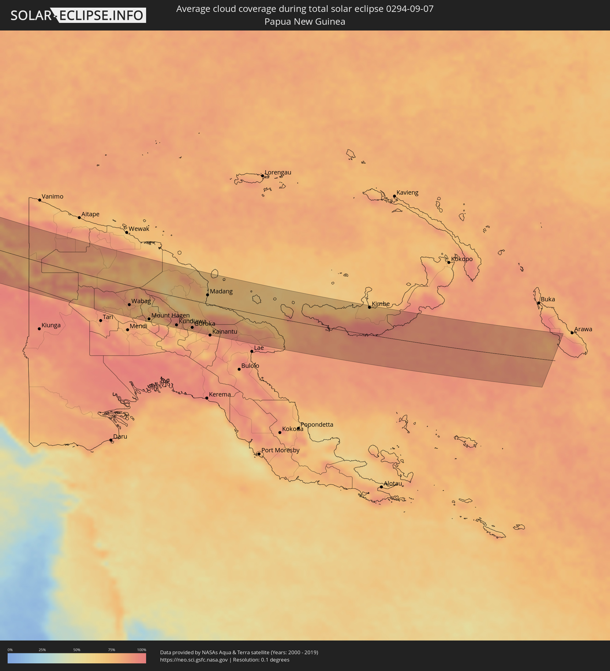 Papua-Neuguinea
Orte im Finsternispfad
Die nachfolgene Tabelle zeigt Städte und Orte mit mehr als 5.000 Einwohnern, die sich im Finsternispfad befinden. Städte mit mehr als 100.000 Einwohnern sind dick gekennzeichnet. Mit einem Klick auf den Ort öffnet sich eine Detailkarte die die Lage des jeweiligen Ortes zusammen mit dem Verlauf der zentralen Finsternis präsentiert.
| Ort | Typ | Dauer der Verfinsterung | Ortszeit bei maximaler Verfinsterung | Entfernung zur Zentrallinie | Ø Bewölkung |
|
Náchod, Královéhradecký
|
total | - | 05:23:09 UTC+01:00 | 64 km | 69% |
|
Brno, South Moravian
|
total | - | 05:22:15 UTC+01:00 | 76 km | 62% |
|
Šumperk, Olomoucký
|
total | - | 05:22:46 UTC+01:00 | 4 km | 65% |
|
Vyškov, South Moravian
|
total | - | 05:22:17 UTC+01:00 | 71 km | 65% |
|
Prostějov, Olomoucký
|
total | - | 05:22:24 UTC+01:00 | 51 km | 59% |
|
Olomouc, Olomoucký
|
total | - | 05:22:29 UTC+01:00 | 39 km | 65% |
|
Kroměříž, Zlín
|
total | - | 05:22:16 UTC+01:00 | 74 km | 62% |
|
Přerov, Olomoucký
|
total | - | 05:22:22 UTC+01:00 | 57 km | 65% |
|
Krnov, Moravskoslezský
|
total | - | 05:22:49 UTC+01:00 | 10 km | 71% |
|
Opava, Moravskoslezský
|
total | - | 05:22:42 UTC+01:00 | 9 km | 67% |
|
Opole, Opole Voivodeship
|
total | - | 05:47:14 UTC+01:24 | 71 km | 65% |
|
Vsetín, Zlín
|
total | - | 05:22:16 UTC+01:00 | 76 km | 64% |
|
Nový Jičín, Moravskoslezský
|
total | - | 05:22:27 UTC+01:00 | 48 km | 64% |
|
Ostrava, Moravskoslezský
|
total | - | 05:22:36 UTC+01:00 | 25 km | 64% |
|
Frýdek-Místek, Moravskoslezský
|
total | - | 05:22:30 UTC+01:00 | 42 km | 66% |
|
Karviná, Moravskoslezský
|
total | - | 05:22:37 UTC+01:00 | 26 km | 62% |
|
Rybnik, Silesian Voivodeship
|
total | - | 05:46:47 UTC+01:24 | 1 km | 63% |
|
Jastrzębie Zdrój, Silesian Voivodeship
|
total | - | 05:46:41 UTC+01:24 | 15 km | 63% |
|
Turzovka, Žilinský
|
total | - | 05:22:17 UTC+01:00 | 76 km | 66% |
|
Třinec, Moravskoslezský
|
total | - | 05:22:29 UTC+01:00 | 46 km | 66% |
|
Gliwice, Silesian Voivodeship
|
total | - | 05:46:56 UTC+01:24 | 22 km | 64% |
|
Čadca, Žilinský
|
total | - | 05:22:18 UTC+01:00 | 74 km | 63% |
|
Katowice, Silesian Voivodeship
|
total | - | 05:46:53 UTC+01:24 | 14 km | 66% |
|
Bielsko-Biala, Silesian Voivodeship
|
total | - | 05:46:34 UTC+01:24 | 35 km | 66% |
|
Częstochowa, Silesian Voivodeship
|
total | - | 05:47:17 UTC+01:24 | 72 km | 66% |
|
Dąbrowa Górnicza, Silesian Voivodeship
|
total | - | 05:46:56 UTC+01:24 | 18 km | 65% |
|
Kraków, Lesser Poland Voivodeship
|
total | - | 05:46:44 UTC+01:24 | 17 km | 65% |
|
Kielce, Świętokrzyskie
|
total | - | 05:47:19 UTC+01:24 | 65 km | 70% |
|
Nowy Sącz, Lesser Poland Voivodeship
|
total | - | 05:46:24 UTC+01:24 | 73 km | 65% |
|
Tarnów, Lesser Poland Voivodeship
|
total | - | 05:46:41 UTC+01:24 | 33 km | 67% |
|
Ostrowiec Świętokrzyski, Świętokrzyskie
|
total | - | 05:47:22 UTC+01:24 | 65 km | 68% |
|
Rzeszów, Subcarpathian Voivodeship
|
total | - | 05:46:44 UTC+01:24 | 39 km | 68% |
|
Przemyśl, Subcarpathian Voivodeship
|
total | - | 05:46:34 UTC+01:24 | 74 km | 70% |
|
Chełm, Lublin Voivodeship
|
total | - | 05:47:36 UTC+01:24 | 71 km | 72% |
|
Lviv, Lviv
|
total | - | 06:24:45 UTC+02:02 | 78 km | 67% |
|
Novovolyns’k, Volyn
|
total | - | 06:25:24 UTC+02:02 | 19 km | 71% |
|
Chervonohrad, Lviv
|
total | - | 06:25:10 UTC+02:02 | 18 km | 68% |
|
Kovel’, Volyn
|
total | - | 06:25:49 UTC+02:02 | 70 km | 67% |
|
Luts’k, Volyn
|
total | - | 06:25:31 UTC+02:02 | 15 km | 70% |
|
Rivne, Rivne
|
total | - | 06:25:31 UTC+02:02 | 6 km | 71% |
|
Novohrad-Volyns’kyy, Zhytomyr
|
total | - | 06:25:40 UTC+02:02 | 16 km | 71% |
|
Korosten’, Zhytomyr
|
total | - | 06:26:05 UTC+02:02 | 20 km | 71% |
|
Zhytomyr, Zhytomyr
|
total | - | 06:25:35 UTC+02:02 | 58 km | 71% |
|
Kiev, Kyiv City
|
total | - | 06:26:03 UTC+02:02 | 43 km | 61% |
|
Brovary, Kiev
|
total | - | 06:26:09 UTC+02:02 | 37 km | 68% |
|
Chernihiv, Chernihiv
|
total | - | 06:26:57 UTC+02:02 | 72 km | 67% |
|
Nizhyn, Chernihiv
|
total | - | 06:26:45 UTC+02:02 | 19 km | 70% |
|
Pryluky, Chernihiv
|
total | - | 06:26:33 UTC+02:02 | 32 km | 68% |
|
Konotop, Sumy
|
total | - | 06:27:12 UTC+02:02 | 39 km | 67% |
|
Sumy, Sumy
|
total | - | 06:27:23 UTC+02:02 | 3 km | 68% |
|
Kurchatov, Kursk
|
total | - | 06:56:22 UTC+02:30 | 85 km | 70% |
|
Belgorod, Belgorod
|
total | - | 06:55:56 UTC+02:30 | 31 km | 67% |
|
Shebekino, Belgorod
|
total | - | 06:55:54 UTC+02:30 | 53 km | 65% |
|
Gubkin, Belgorod
|
total | - | 06:56:42 UTC+02:30 | 46 km | 70% |
|
Staryy Oskol, Belgorod
|
total | - | 06:56:48 UTC+02:30 | 48 km | 69% |
|
Valuyki, Belgorod
|
total | - | 06:56:11 UTC+02:30 | 73 km | 63% |
|
Rossosh’, Voronezj
|
total | - | 06:56:55 UTC+02:30 | 30 km | 64% |
|
Alekseyevka, Belgorod
|
total | - | 06:56:40 UTC+02:30 | 24 km | 61% |
|
Ostrogozhsk, Voronezj
|
total | - | 06:56:58 UTC+02:30 | 4 km | 63% |
|
Novovoronezh, Voronezj
|
total | - | 06:57:18 UTC+02:30 | 53 km | 66% |
|
Liski, Voronezj
|
total | - | 06:57:12 UTC+02:30 | 18 km | 64% |
|
Rossosh’, Voronezj
|
total | - | 06:56:43 UTC+02:30 | 69 km | 60% |
|
Uryupinsk, Volgograd
|
total | - | 06:58:06 UTC+02:30 | 10 km | 59% |
|
Borisoglebsk, Voronezj
|
total | - | 06:58:29 UTC+02:30 | 73 km | 62% |
|
Mikhaylovka, Volgograd
|
total | - | 06:58:12 UTC+02:30 | 65 km | 59% |
|
Kamyshin, Volgograd
|
total | - | 06:59:18 UTC+02:30 | 44 km | 54% |
|
Shubarkuduk, Aqtöbe
|
total | - | 08:01:05 UTC+03:25 | 0 km | 33% |
|
Shubarshi, Aqtöbe
|
total | - | 08:01:29 UTC+03:25 | 47 km | 33% |
|
Kandyagash, Aqtöbe
|
total | - | 08:01:54 UTC+03:25 | 53 km | 41% |
|
Embi, Aqtöbe
|
total | - | 08:02:19 UTC+03:25 | 1 km | 34% |
|
Shalqar, Aqtöbe
|
total | - | 08:03:19 UTC+03:25 | 77 km | 27% |
|
Moyynkum, Zhambyl
|
total | - | 09:13:51 UTC+04:21 | 47 km | 16% |
|
Chu, Zhambyl
|
total | - | 09:15:07 UTC+04:21 | 82 km | 17% |
|
Tokmok, Chüy
|
total | - | 09:53:56 UTC+04:58 | 95 km | 28% |
|
Kemin, Chüy
|
total | - | 09:54:28 UTC+04:58 | 84 km | 28% |
|
Balykchy, Issyk-Kul Region
|
total | - | 09:55:17 UTC+04:58 | 94 km | 27% |
|
Burunday, Almaty Oblysy
|
total | - | 09:19:06 UTC+04:21 | 20 km | 25% |
|
Almaty, Almaty Qalasy
|
total | - | 09:19:15 UTC+04:21 | 13 km | 28% |
|
Pervomayskiy, Almaty Oblysy
|
total | - | 09:19:12 UTC+04:21 | 24 km | 25% |
|
Otegen Batyra, Almaty Oblysy
|
total | - | 09:19:17 UTC+04:21 | 32 km | 25% |
|
Kapshagay, Almaty Oblysy
|
total | - | 09:19:05 UTC+04:21 | 76 km | 24% |
|
Cholpon-Ata, Issyk-Kul Region
|
total | - | 09:56:20 UTC+04:58 | 38 km | 17% |
|
Talghar, Almaty Oblysy
|
total | - | 09:19:37 UTC+04:21 | 30 km | 33% |
|
Esik, Almaty Oblysy
|
total | - | 09:19:52 UTC+04:21 | 44 km | 31% |
|
Turgen, Almaty Oblysy
|
total | - | 09:20:01 UTC+04:21 | 55 km | 32% |
|
Kyzyl-Suu, Issyk-Kul Region
|
total | - | 09:57:43 UTC+04:58 | 27 km | 36% |
|
Tyup, Issyk-Kul Region
|
total | - | 09:57:57 UTC+04:58 | 25 km | 27% |
|
Karakol, Issyk-Kul Region
|
total | - | 09:58:08 UTC+04:58 | 4 km | 33% |
|
Ak-Suu, Issyk-Kul Region
|
total | - | 09:58:18 UTC+04:58 | 11 km | 37% |
|
Kegen, Almaty Oblysy
|
total | - | 09:22:21 UTC+04:21 | 90 km | 35% |
|
Aykol, Xinjiang Uyghur Autonomous Region
|
total | - | 13:03:10 UTC+08:00 | 58 km | 38% |
|
Aksu, Xinjiang Uyghur Autonomous Region
|
total | - | 13:03:11 UTC+08:00 | 30 km | 39% |
|
Aral, Xinjiang Uyghur Autonomous Region
|
total | - | 13:05:04 UTC+08:00 | 41 km | 37% |
|
Shangri-La, Yunnan
|
total | - | 13:51:20 UTC+08:00 | 92 km | 89% |
|
Dali, Yunnan
|
total | - | 13:56:19 UTC+08:00 | 31 km | 87% |
|
Lijiang, Yunnan
|
total | - | 13:53:55 UTC+08:00 | 62 km | 87% |
|
Longquan, Yunnan
|
total | - | 14:01:11 UTC+08:00 | 53 km | 85% |
|
Lianran, Yunnan
|
total | - | 14:01:12 UTC+08:00 | 96 km | 86% |
|
Yuxi, Yunnan
|
total | - | 14:02:24 UTC+08:00 | 60 km | 86% |
|
Haikou, Yunnan
|
total | - | 14:01:38 UTC+08:00 | 93 km | 85% |
|
Gejiu, Yunnan
|
total | - | 14:05:18 UTC+08:00 | 37 km | 89% |
|
Kaiyuan, Yunnan
|
total | - | 14:04:53 UTC+08:00 | 73 km | 83% |
|
Sa Pá, Lào Cai
|
total | - | 13:15:04 UTC+07:06 | 19 km | 93% |
|
Xam Nua, Houaphan
|
total | - | 12:54:37 UTC+06:42 | 103 km | 92% |
|
Yên Bái, Yên Bái
|
total | - | 13:17:57 UTC+07:06 | 60 km | 80% |
|
Thành Phố Hòa Bình, Hòa Bình
|
total | - | 13:20:25 UTC+07:06 | 29 km | 86% |
|
Việt Trì, Phú Thọ
|
total | - | 13:19:30 UTC+07:06 | 70 km | 89% |
|
Sơn Tây, Ha Nội
|
total | - | 13:20:02 UTC+07:06 | 65 km | 89% |
|
Vinh, Nghệ An
|
total | - | 13:25:16 UTC+07:06 | 97 km | 88% |
|
Thanh Hóa, Thanh Hóa
|
total | - | 13:23:07 UTC+07:06 | 10 km | 88% |
|
Hà Đông, Ha Nội
|
total | - | 13:20:47 UTC+07:06 | 75 km | 92% |
|
Hanoi, Ha Nội
|
total | - | 13:20:47 UTC+07:06 | 84 km | 92% |
|
Bỉm Sơn, Thanh Hóa
|
total | - | 13:22:42 UTC+07:06 | 18 km | 90% |
|
Hưng Yên, Hưng Yên
|
total | - | 13:21:51 UTC+07:06 | 74 km | 90% |
|
Thành Phố Nam Định, Nam Định
|
total | - | 13:22:28 UTC+07:06 | 68 km | 85% |
|
Thành Phố Thái Bình, Thái Bình
|
total | - | 13:22:41 UTC+07:06 | 83 km | 88% |
|
Huế, Thừa Thiên-Huế
|
total | - | 13:32:35 UTC+07:06 | 107 km | 85% |
|
Da Nang, Đà Nẵng
|
total | - | 13:34:18 UTC+07:06 | 86 km | 83% |
|
Tam Kỳ, Quảng Nam
|
total | - | 13:35:40 UTC+07:06 | 103 km | 78% |
|
Balabac, Mimaropa
|
total | - | 14:54:53 UTC+08:00 | 46 km | 81% |
|
Rio Tuba, Mimaropa
|
total | - | 14:54:25 UTC+08:00 | 25 km | 82% |
|
Batarasa, Mimaropa
|
total | - | 14:54:20 UTC+08:00 | 53 km | 84% |
|
Pañgobilian, Mimaropa
|
total | - | 14:54:23 UTC+08:00 | 81 km | 78% |
|
New Batu Batu, Autonomous Region in Muslim Mindanao
|
total | - | 15:03:06 UTC+08:00 | 103 km | 76% |
|
Balimbing, Autonomous Region in Muslim Mindanao
|
total | - | 15:03:10 UTC+08:00 | 97 km | 75% |
|
Languyan, Autonomous Region in Muslim Mindanao
|
total | - | 15:02:59 UTC+08:00 | 73 km | 83% |
|
Tongouson, Autonomous Region in Muslim Mindanao
|
total | - | 15:03:26 UTC+08:00 | 91 km | 77% |
|
Siasi, Autonomous Region in Muslim Mindanao
|
total | - | 15:03:17 UTC+08:00 | 1 km | 83% |
|
Lugus, Autonomous Region in Muslim Mindanao
|
total | - | 15:03:02 UTC+08:00 | 15 km | 81% |
|
Parang, Autonomous Region in Muslim Mindanao
|
total | - | 15:02:46 UTC+08:00 | 40 km | 82% |
|
Laminusa, Autonomous Region in Muslim Mindanao
|
total | - | 15:03:22 UTC+08:00 | 8 km | 85% |
|
Kulase, Autonomous Region in Muslim Mindanao
|
total | - | 15:02:50 UTC+08:00 | 42 km | 81% |
|
Jolo, Autonomous Region in Muslim Mindanao
|
total | - | 15:02:38 UTC+08:00 | 59 km | 89% |
|
Kansipati, Autonomous Region in Muslim Mindanao
|
total | - | 15:02:58 UTC+08:00 | 69 km | 84% |
|
Karungdong, Autonomous Region in Muslim Mindanao
|
total | - | 15:03:12 UTC+08:00 | 61 km | 83% |
|
Ternate, North Maluku
|
total | - | 16:39:22 UTC+09:22 | 51 km | 73% |
|
Sofifi, North Maluku
|
total | - | 16:39:34 UTC+09:22 | 47 km | 83% |
|
Tobelo, North Maluku
|
total | - | 16:38:32 UTC+09:22 | 74 km | 67% |
|
Sorong, West Papua
|
total | - | 16:44:21 UTC+09:22 | 23 km | 90% |
|
Nabire, Papua
|
total | - | 16:49:40 UTC+09:22 | 97 km | 78% |
|
Wabag, Enga
|
total | - | 17:31:53 UTC+10:00 | 56 km | 81% |
|
Mount Hagen, Western Highlands
|
total | - | 17:32:20 UTC+10:00 | 83 km | 77% |
|
Minj, Jiwaka
|
total | - | 17:32:28 UTC+10:00 | 77 km | 77% |
|
Kundiawa, Chimbu
|
total | - | 17:32:37 UTC+10:00 | 82 km | 75% |
|
Goroka, Eastern Highlands
|
total | - | 17:32:45 UTC+10:00 | 79 km | 71% |
|
Madang, Madang
|
total | - | 17:32:04 UTC+10:00 | 25 km | 65% |
|
Kimbe, West New Britain
|
total | - | 17:32:52 UTC+10:00 | 80 km | 78% |