Totale Sonnenfinsternis vom 06.05.0319
| Wochentag: | Dienstag |
| Maximale Dauer der Verfinsterung: | 03m56s |
| Maximale Breite des Finsternispfades: | 199 km |
| Saroszyklus: | 72 |
| Bedeckungsgrad: | 100% |
| Magnitude: | 1.0508 |
| Gamma: | 0.5318 |
Wo kann man die Sonnenfinsternis vom 06.05.0319 sehen?
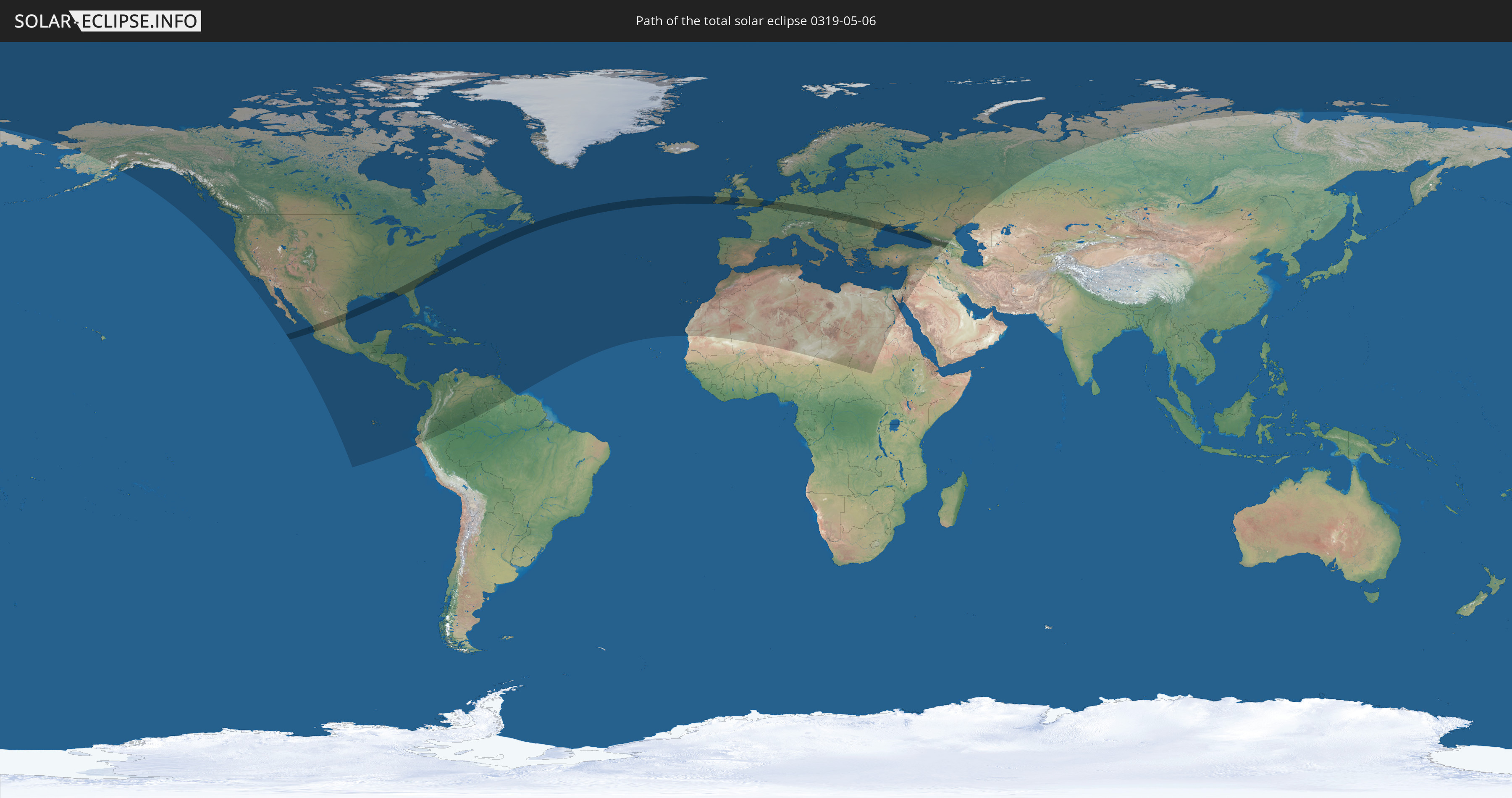
Die Sonnenfinsternis am 06.05.0319 kann man in 119 Ländern als partielle Sonnenfinsternis beobachten.
Der Finsternispfad verläuft durch 22 Länder. Nur in diesen Ländern ist sie als totale Sonnenfinsternis zu sehen.
In den folgenden Ländern ist die Sonnenfinsternis total zu sehen
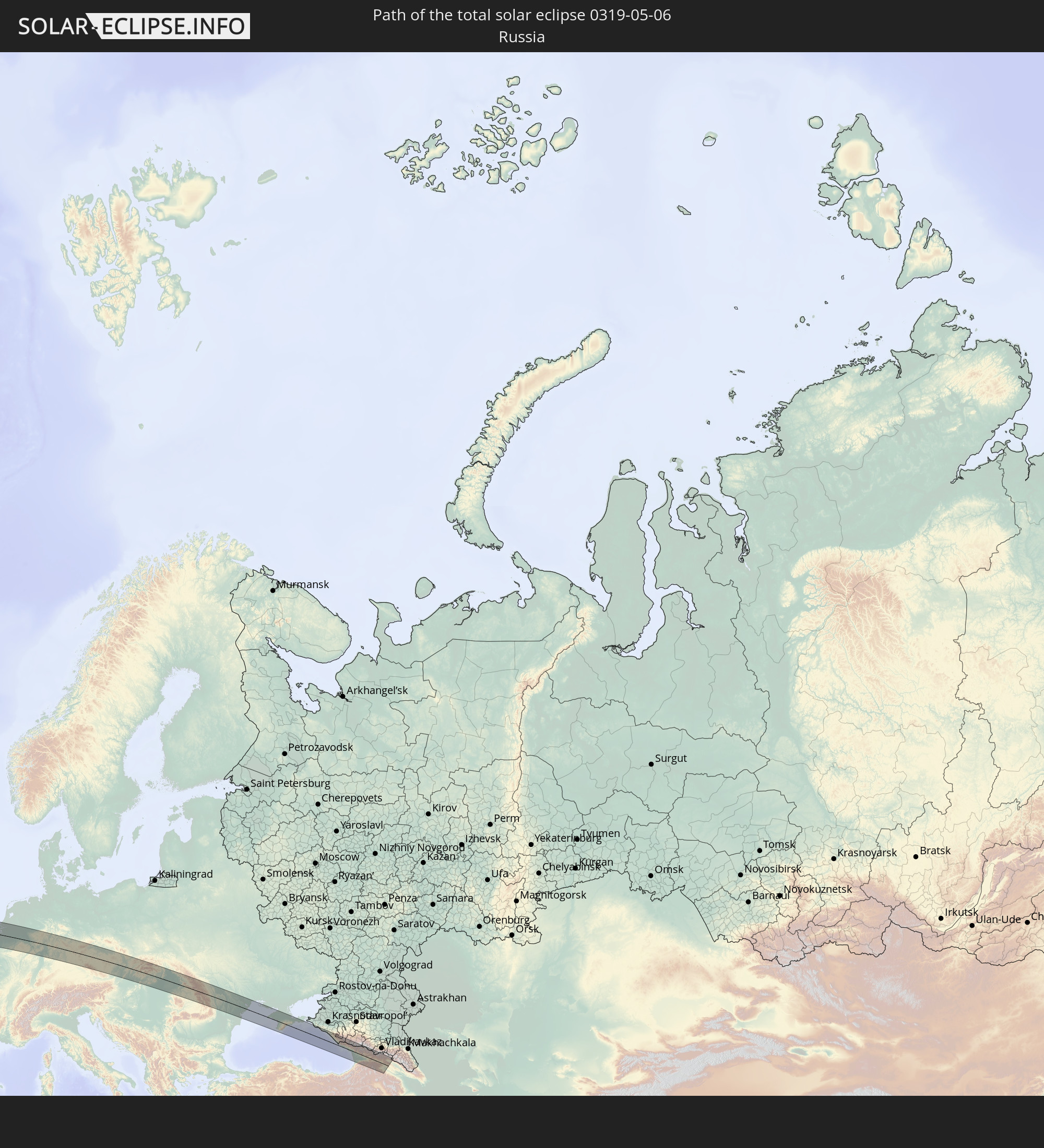 Russland
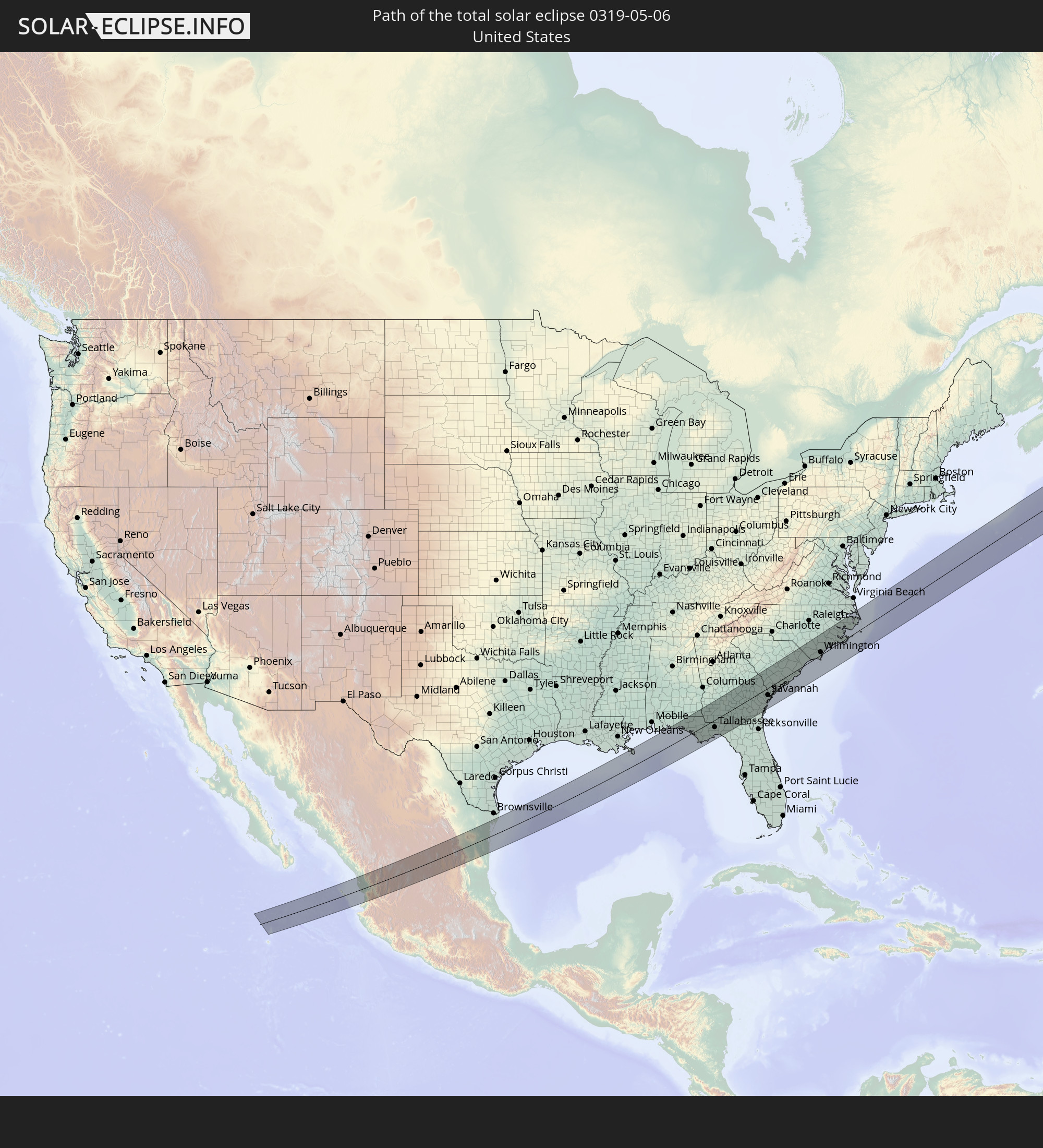 Vereinigte Staaten
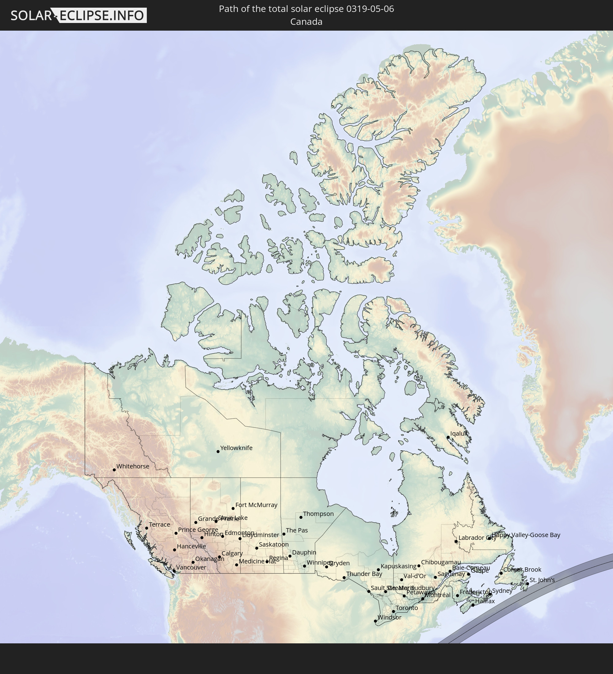 Kanada
 Mexiko
 Irland
 Vereinigtes Königreich
 Frankreich
 Belgien
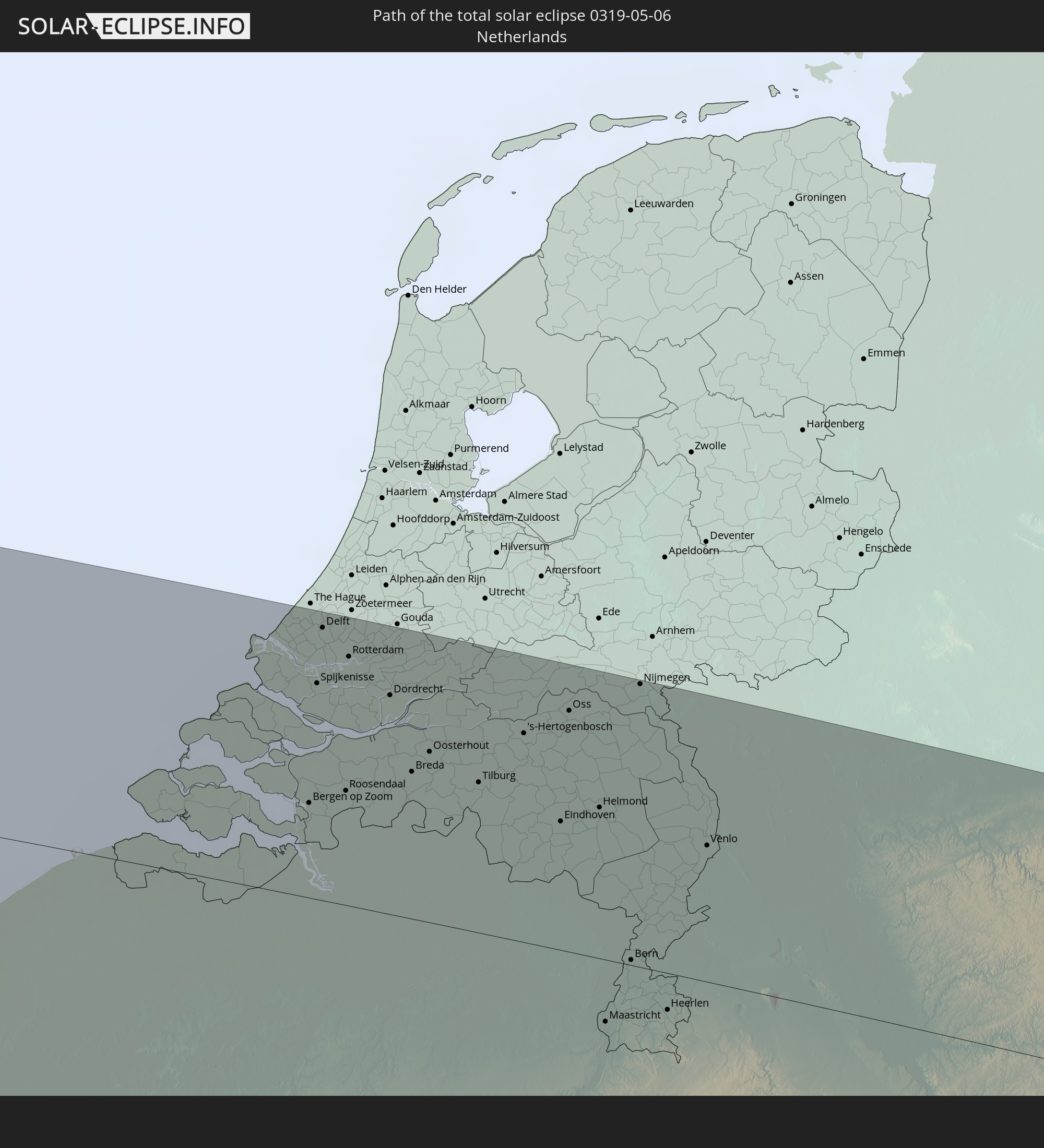 Niederlande
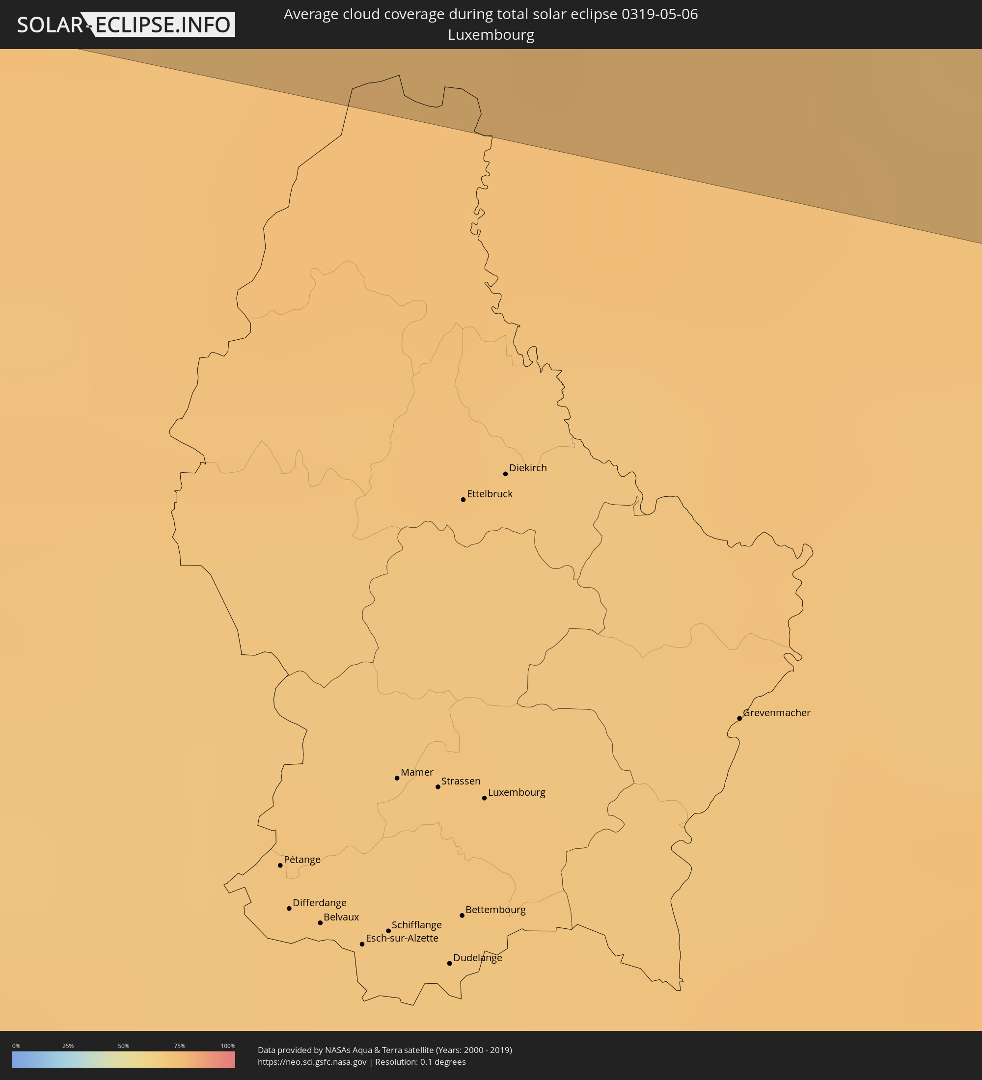
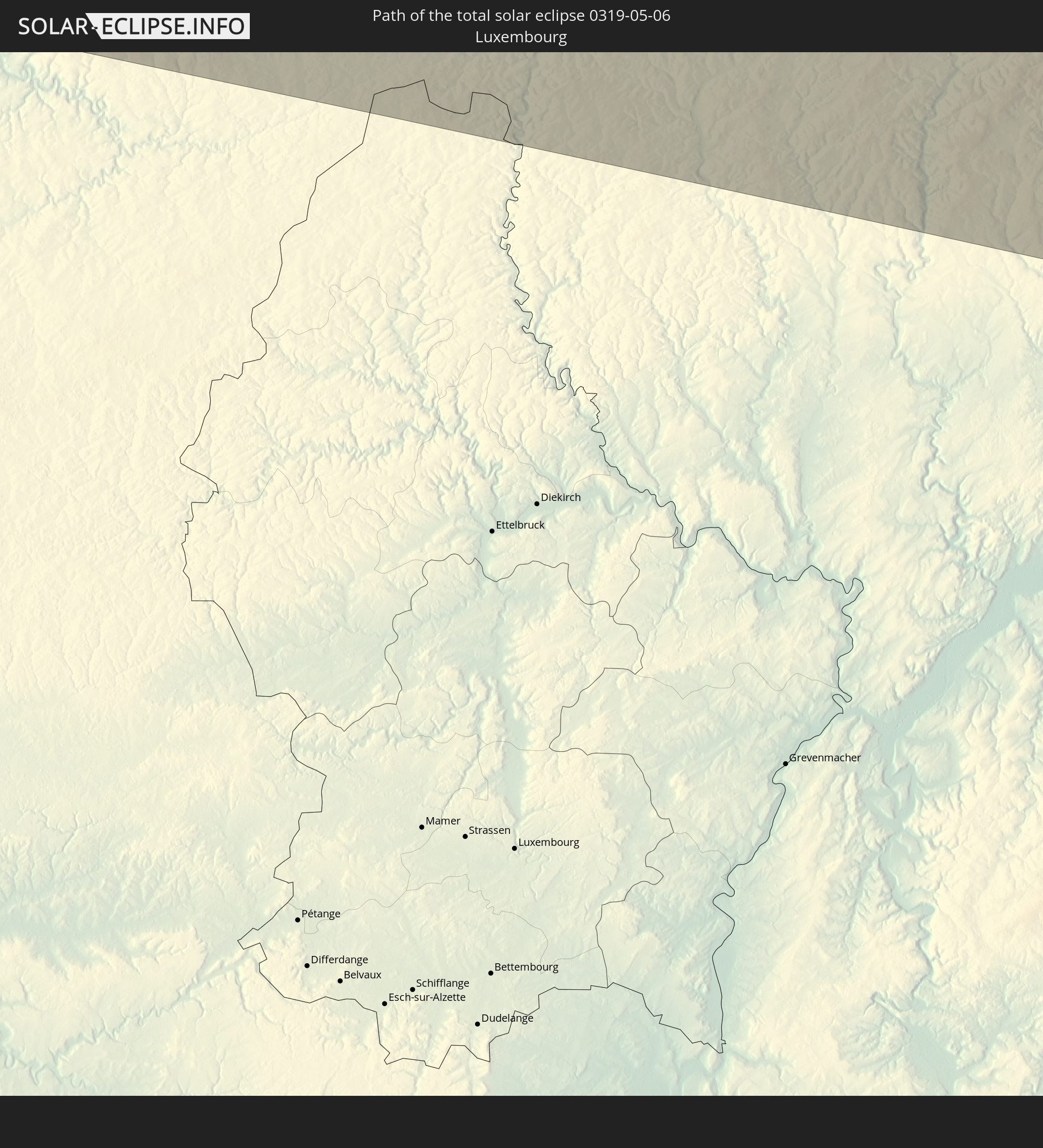 Luxemburg
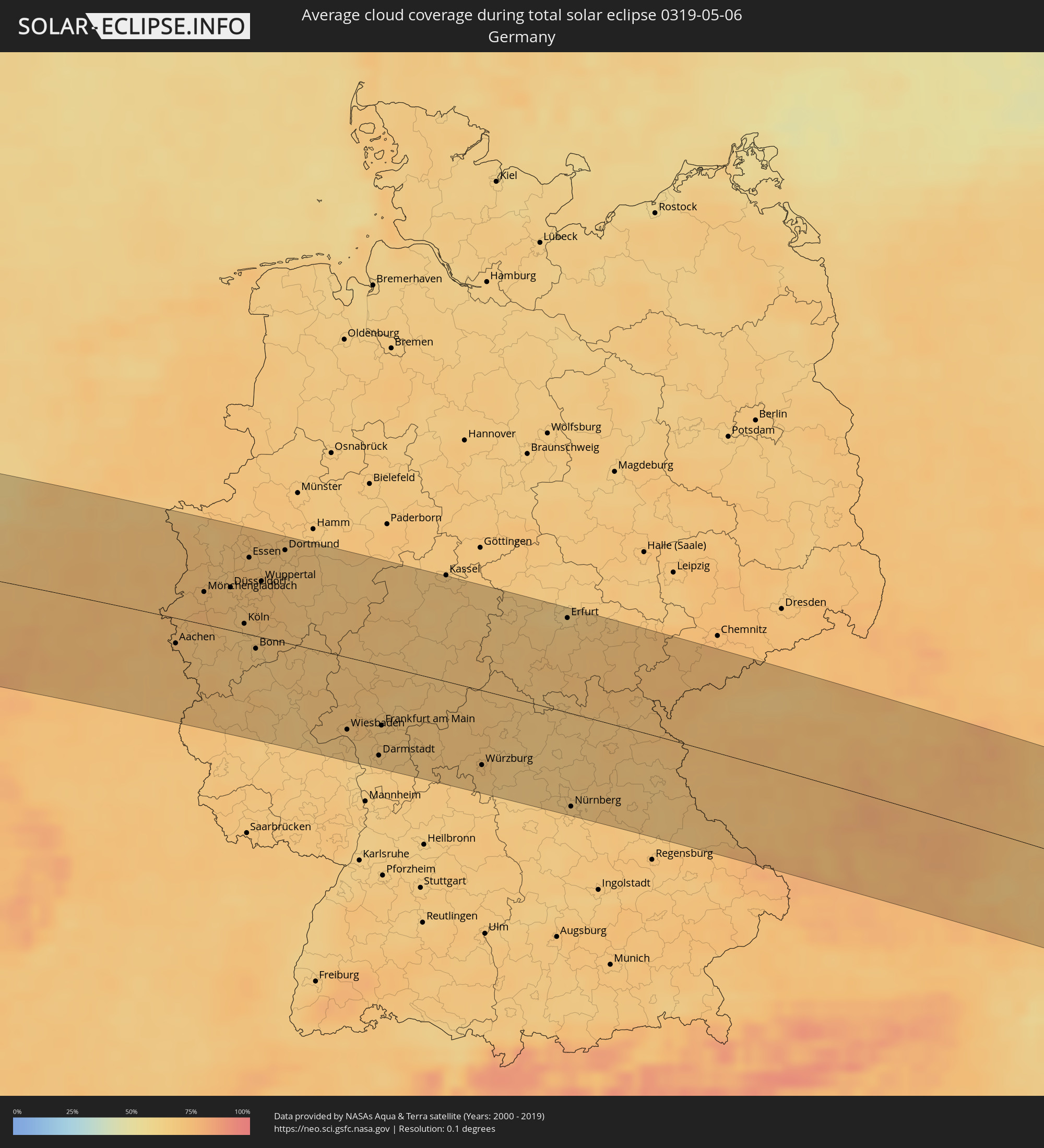
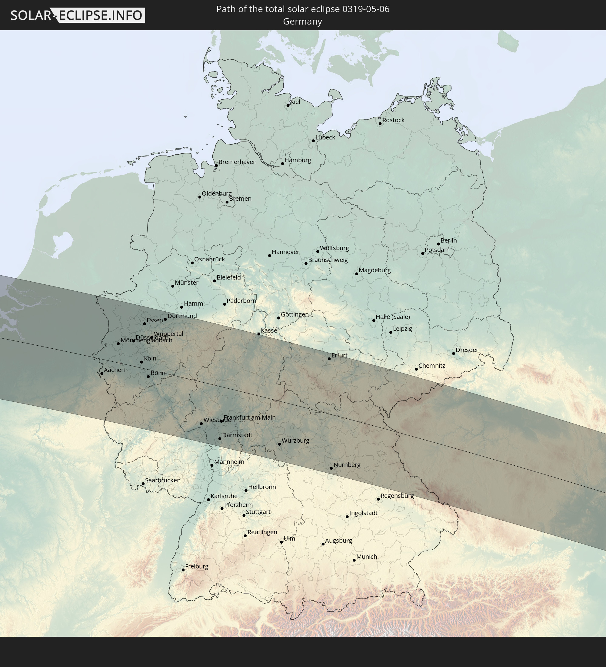 Deutschland
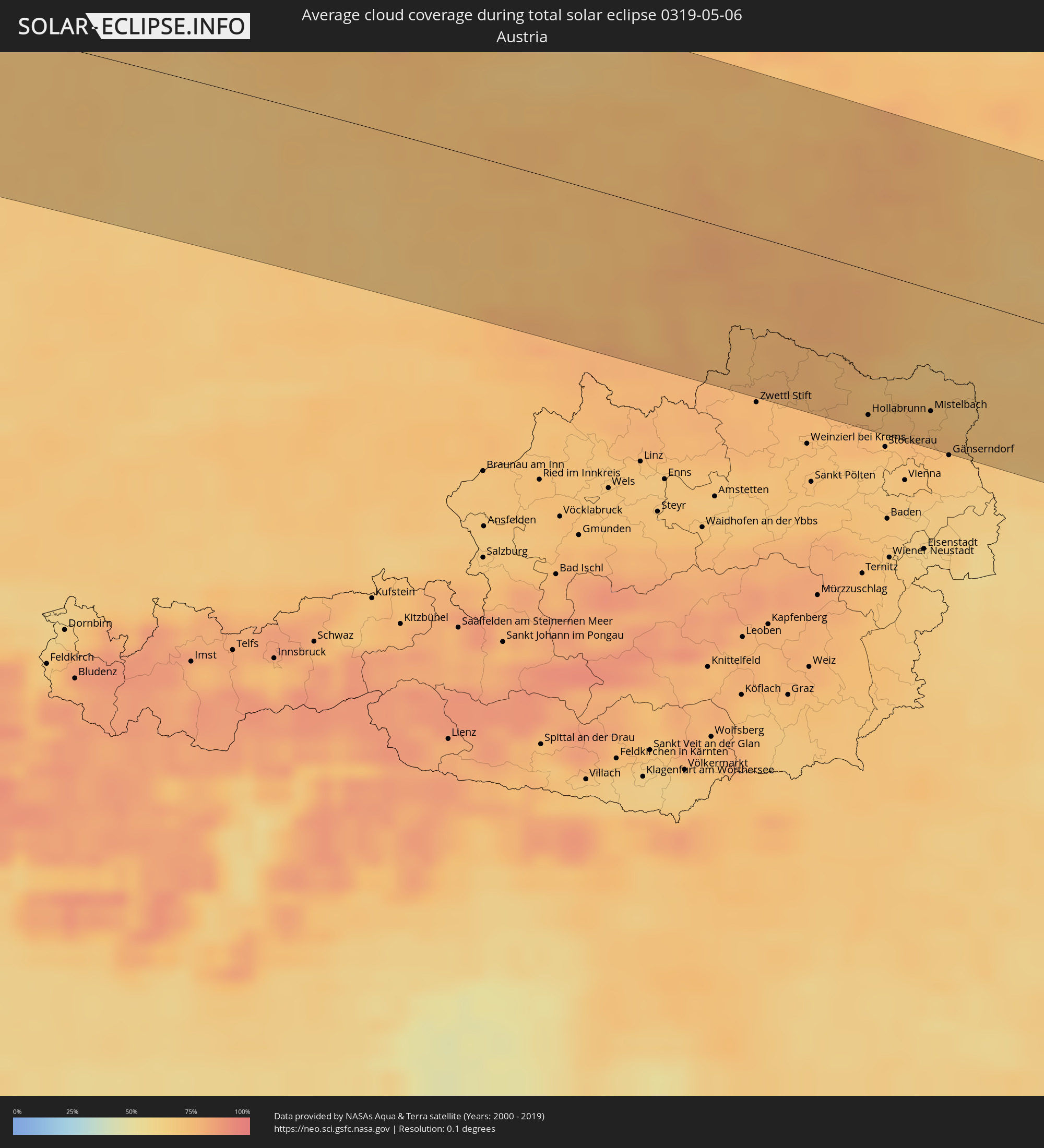
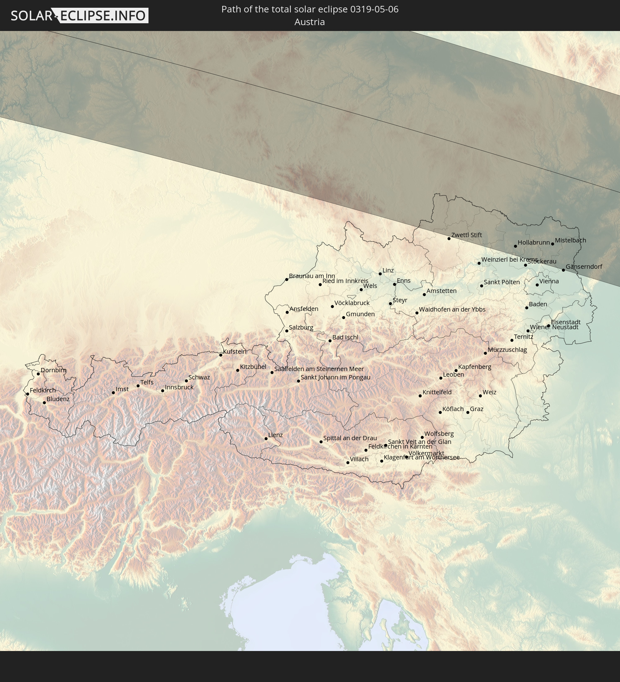 Österreich
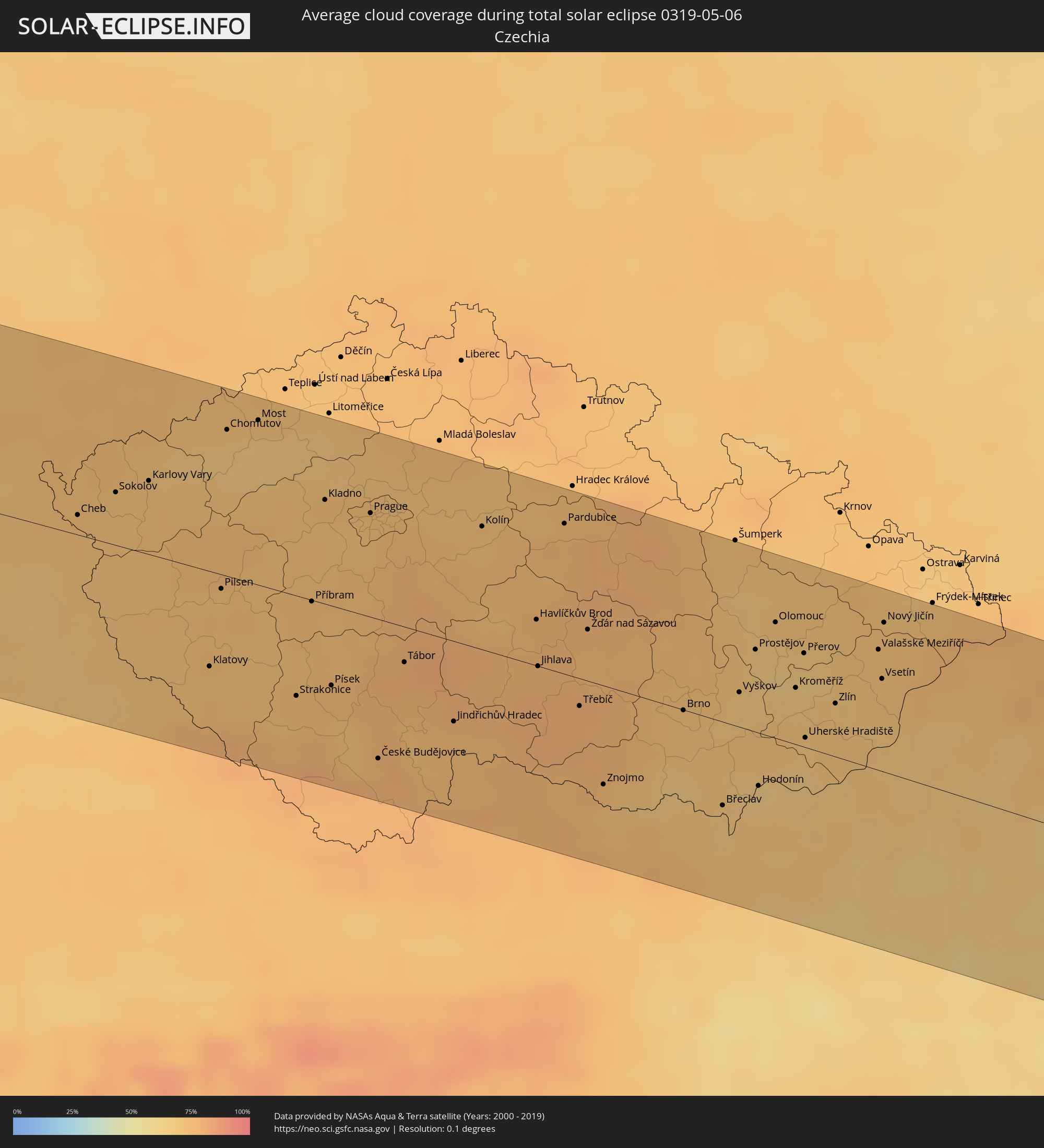
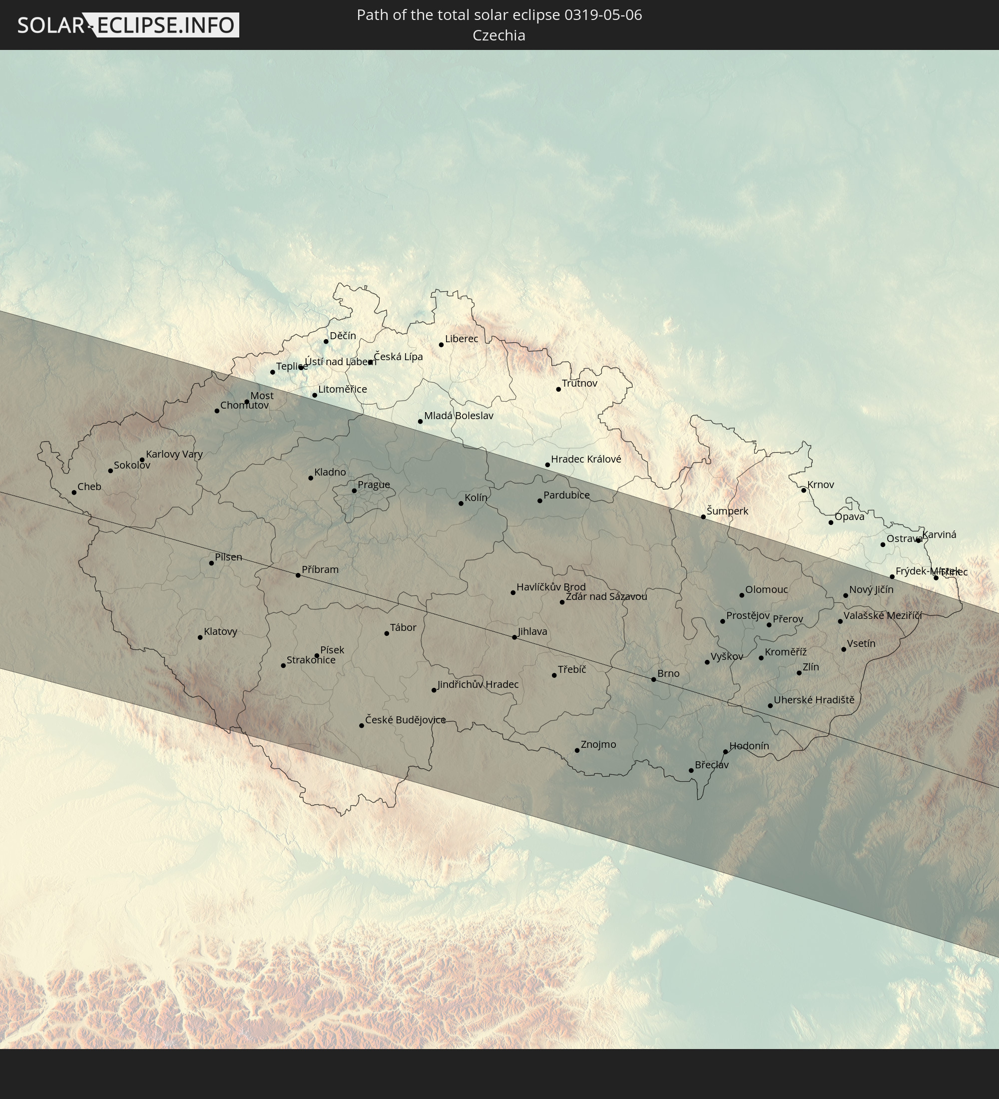 Tschechien
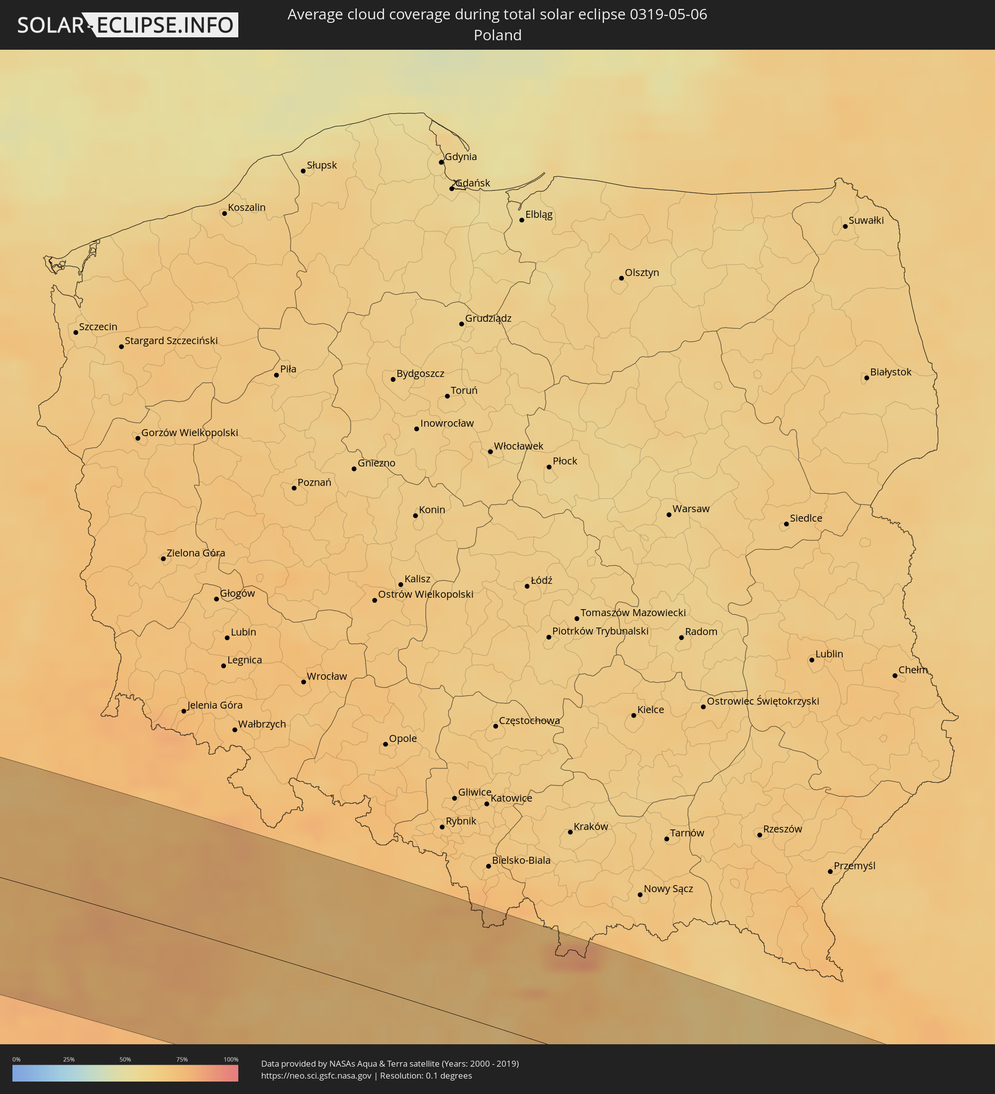
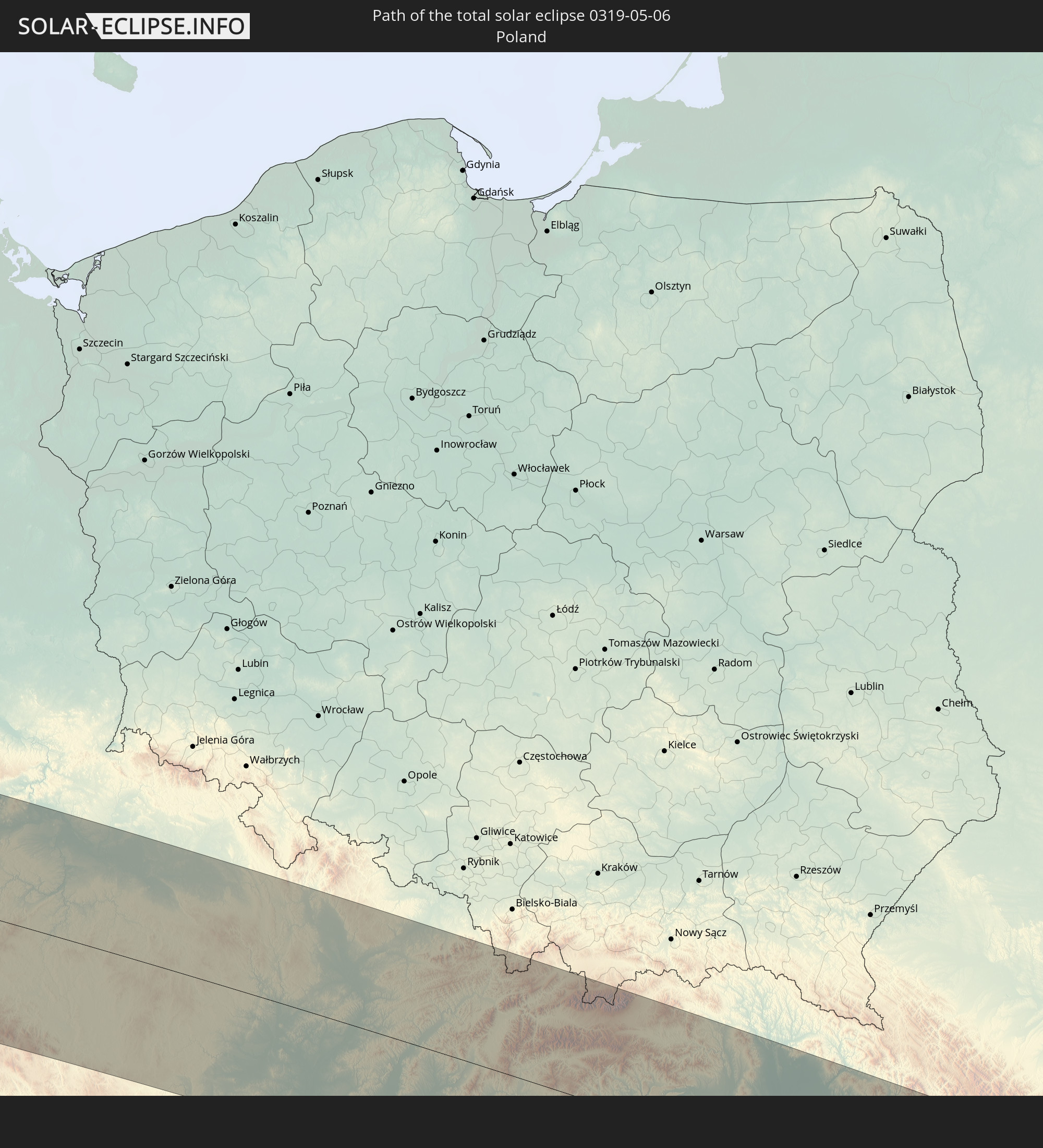 Polen
Polen
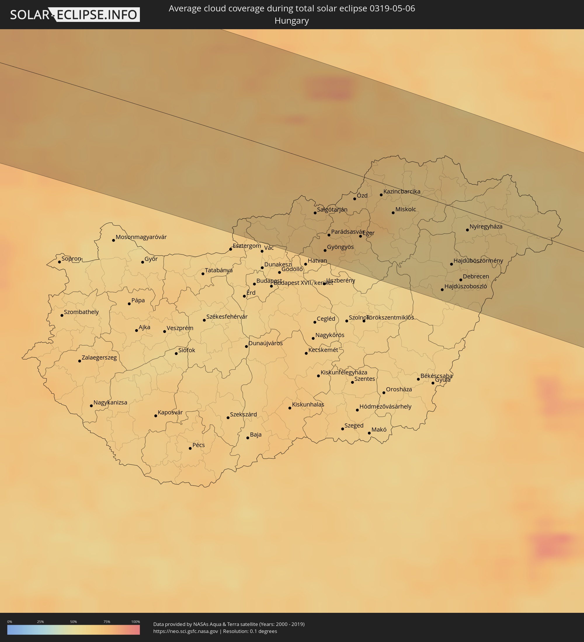
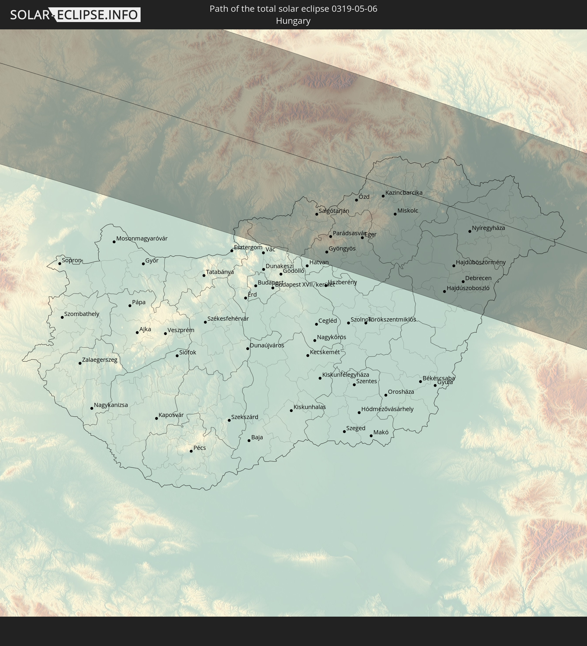 Ungarn
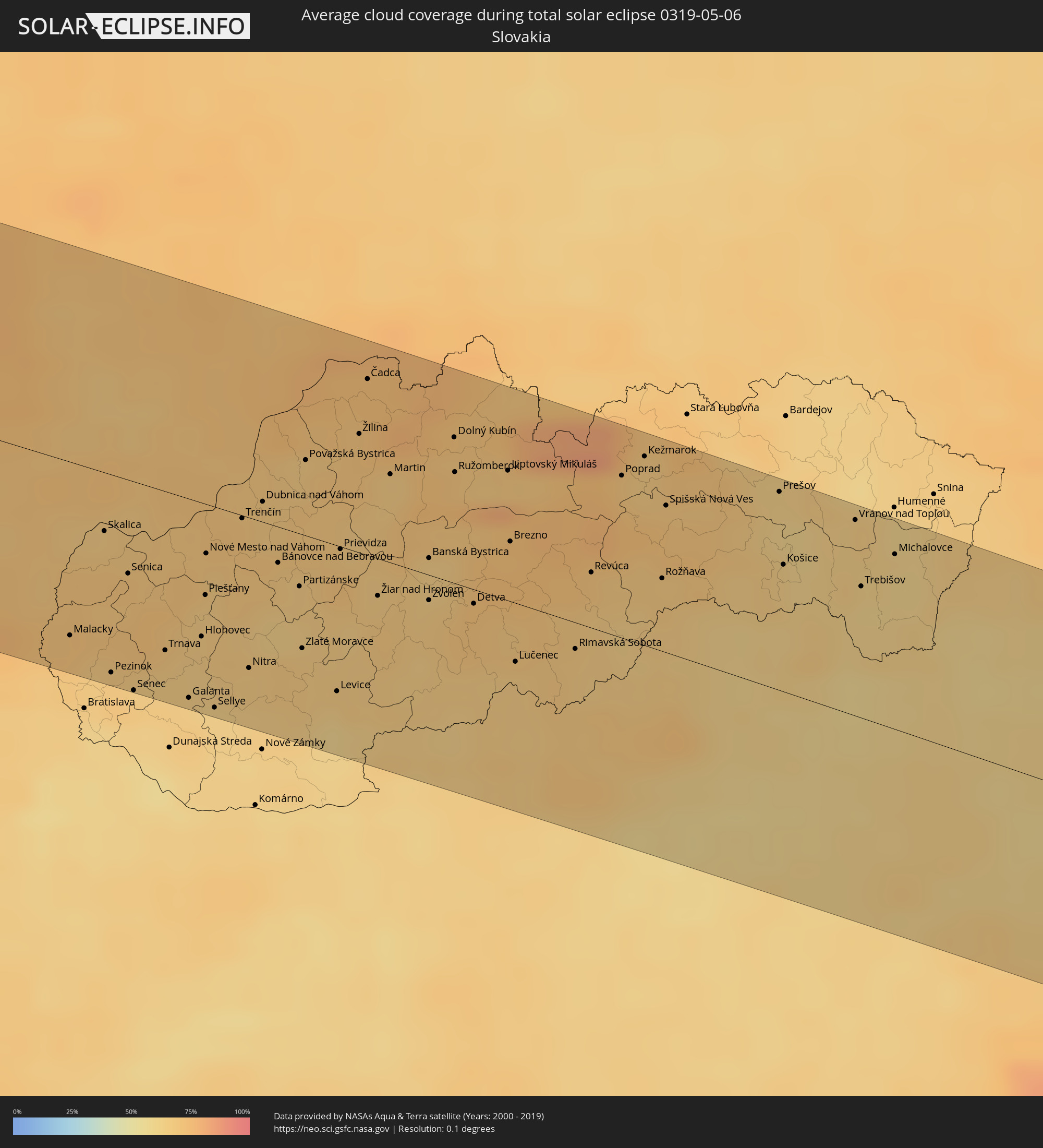
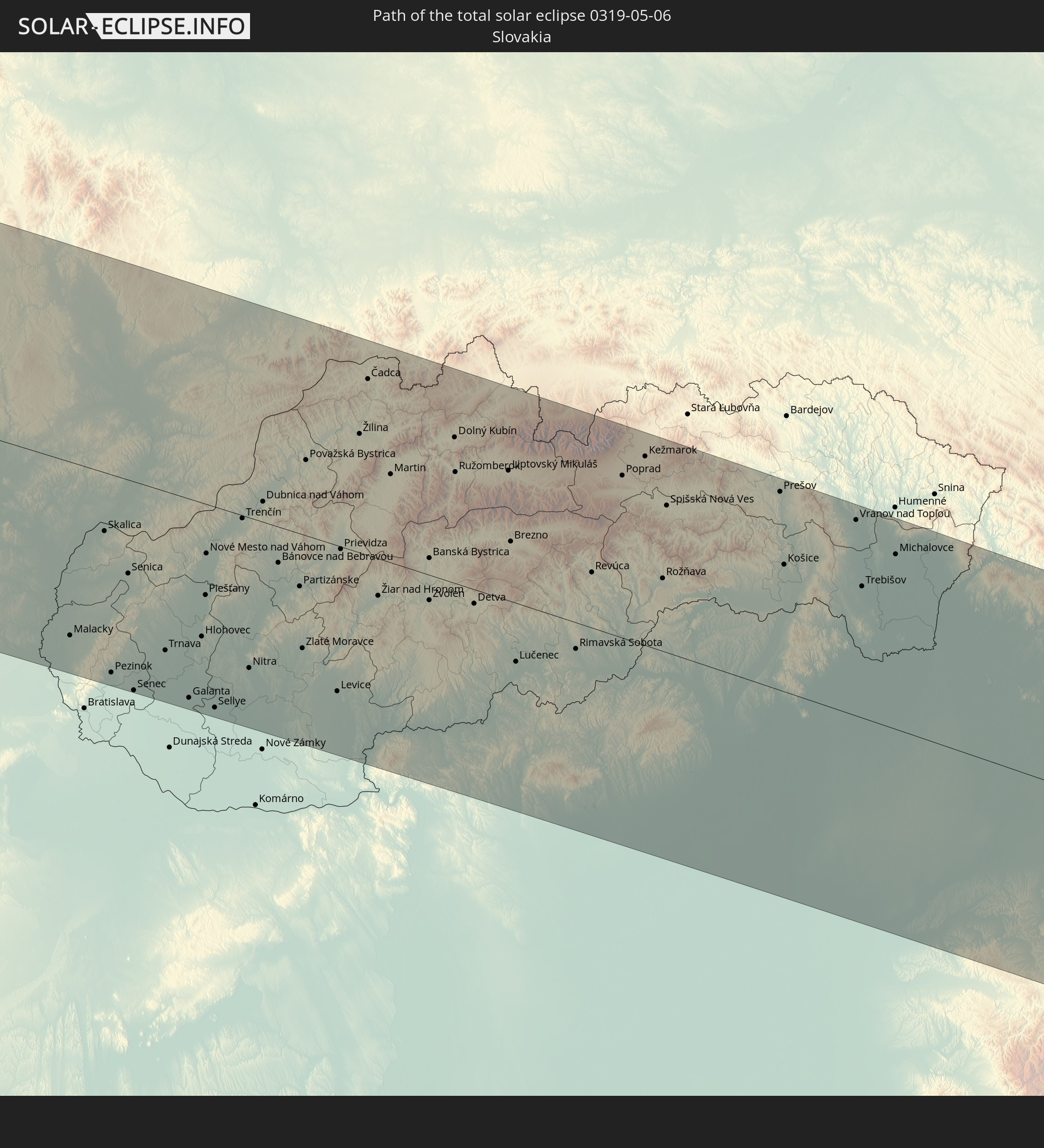 Slowakei
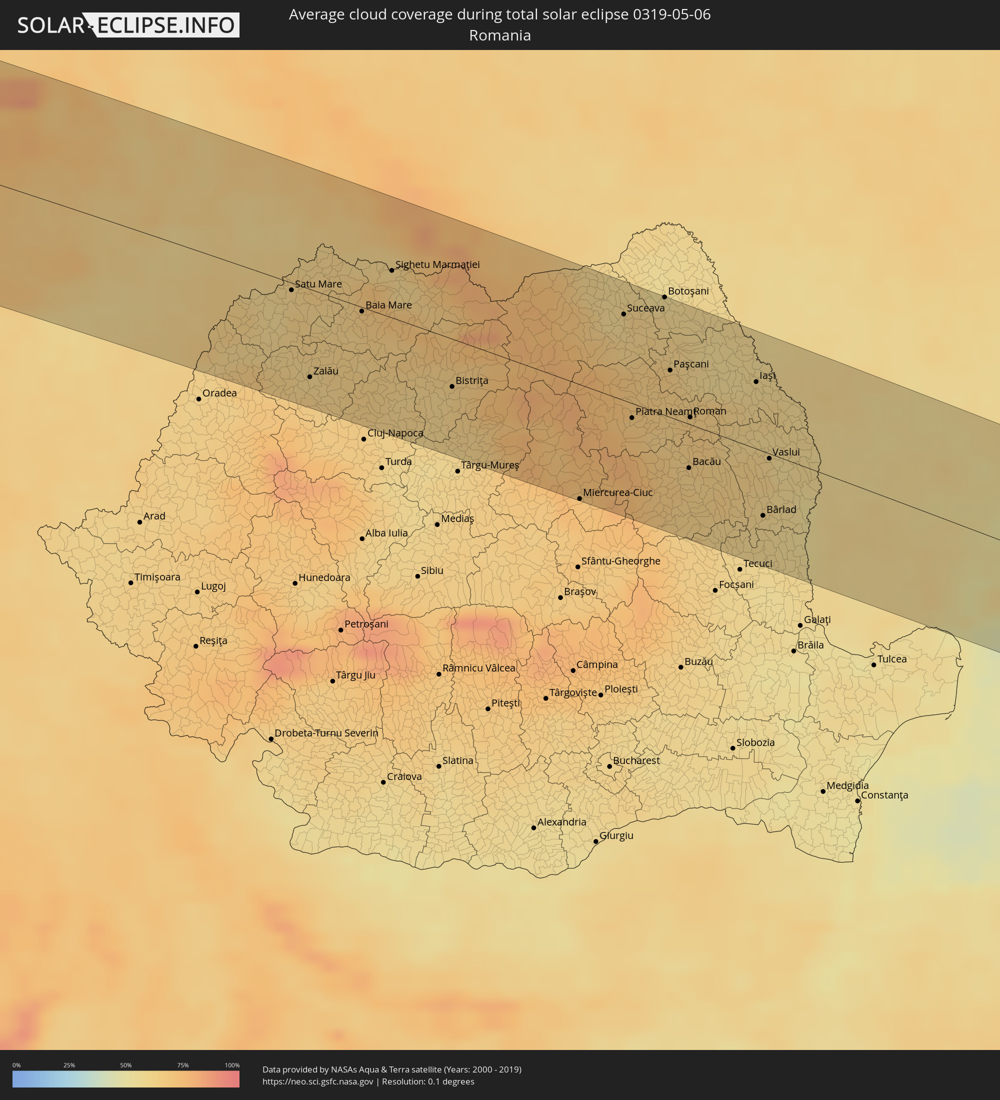
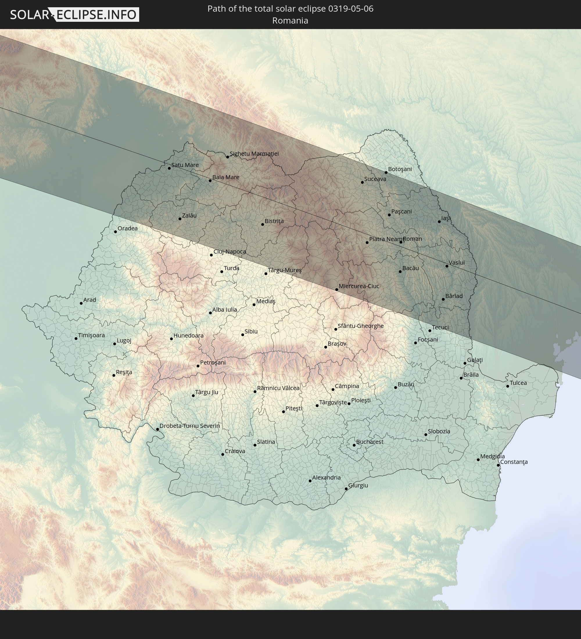 Rumänien
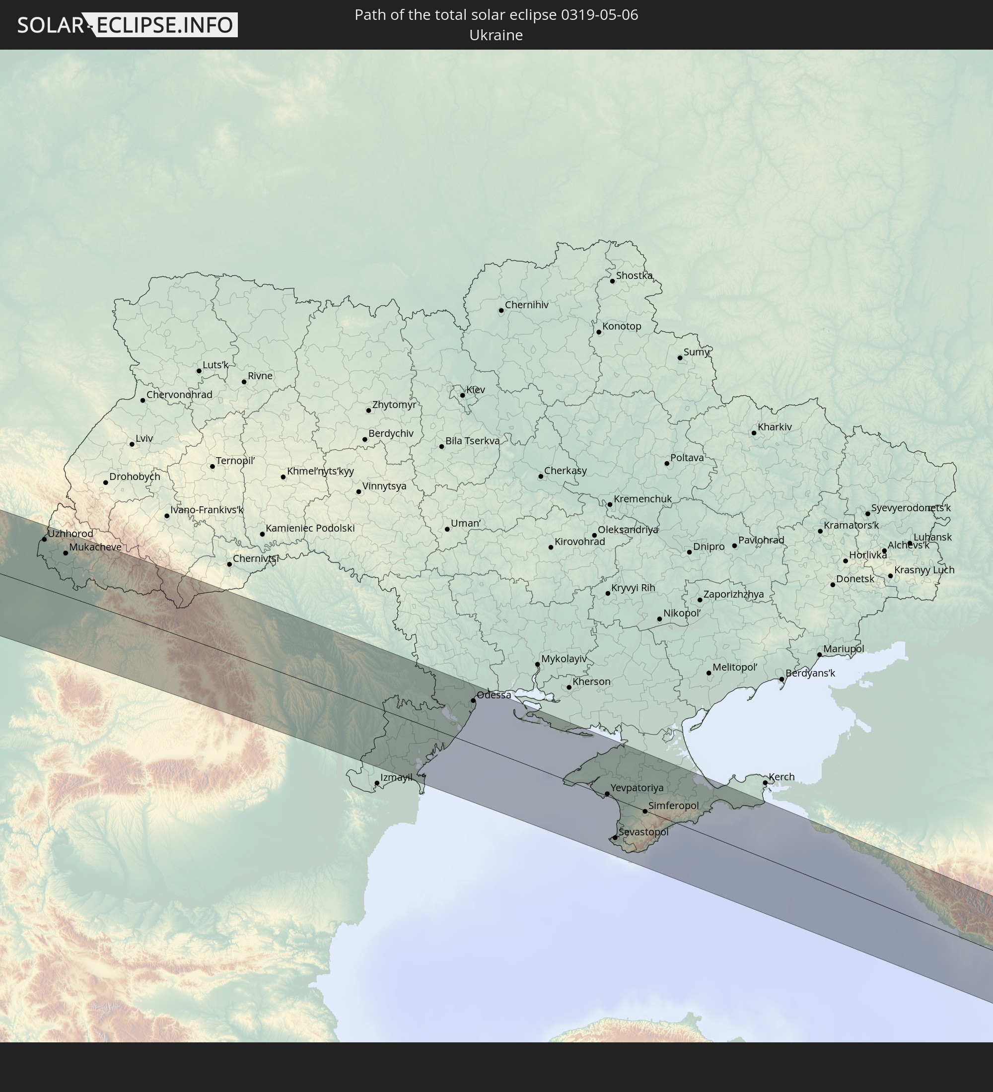 Ukraine
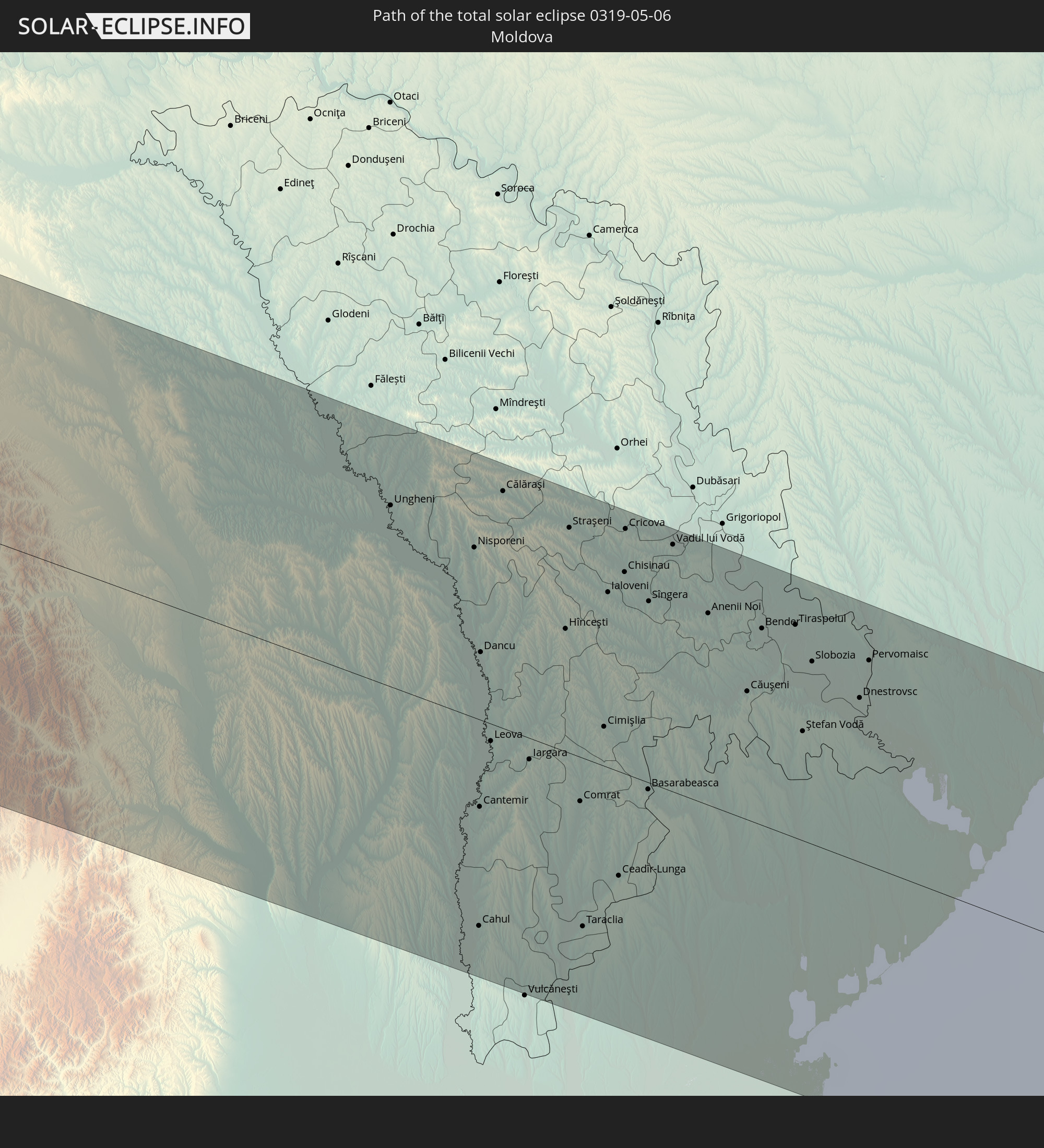 Moldawien
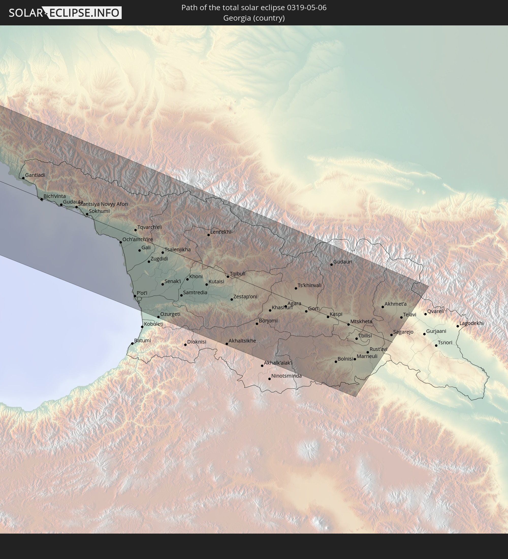 Georgien
 Armenien
 Aserbaidschan
In den folgenden Ländern ist die Sonnenfinsternis partiell zu sehen
 Russland
 Vereinigte Staaten
 United States Minor Outlying Islands
 Kanada
 Mexiko
 Grönland
 Guatemala
 Ecuador
 El Salvador
 Honduras
 Belize
 Nicaragua
 Costa Rica
 Kuba
Kuba
 Panama
 Kolumbien
 Kaimaninseln
 Peru
Peru
 Bahamas
 Jamaika
 Haiti
Haiti
 Brasilien
 Venezuela
 Turks- und Caicosinseln
 Dominikanische Republik
 Aruba
Aruba
 Puerto Rico
 Amerikanische Jungferninseln
 Bermuda
 Britische Jungferninseln
 Anguilla
 Saint-Martin
 Saint-Barthélemy
 St. Kitts und Nevis
 Antigua und Barbuda
 Montserrat
 Trinidad und Tobago
 Guadeloupe
 Grenada
 Dominica
 St. Vincent und die Grenadinen
 Guyana
 Martinique
 St. Lucia
 Barbados
 Saint-Pierre und Miquelon
 Portugal
 Island
 Spanien
 Mauretanien
 Marokko
 Mali
Mali
 Irland
 Spitzbergen
 Algerien
 Vereinigtes Königreich
 Färöer
 Gibraltar
 Frankreich
 Isle of Man
 Guernsey
 Jersey
 Niger
Niger
 Andorra
 Belgien
 Niederlande
 Norwegen
 Luxemburg
 Deutschland
 Schweiz
 Italien
 Monaco
 Tunesien
 Dänemark
 Libyen
 Liechtenstein
 Österreich
 Schweden
 Tschechien
 San Marino
 Vatikanstadt
 Slowenien
 Tschad
 Kroatien
 Polen
Polen
 Malta
Malta
 Bosnien und Herzegowina
 Ungarn
 Slowakei
 Montenegro
 Serbien
 Albanien
 Åland Islands
 Griechenland
 Rumänien
 Mazedonien
 Finnland
 Litauen
 Lettland
 Estland
 Sudan
Sudan
 Ukraine
 Bulgarien
 Weißrussland
 Ägypten
 Türkei
 Moldawien
 Republik Zypern
 Staat Palästina
 Israel
 Saudi-Arabien
 Jordanien
 Libanon
 Syrien
 Irak
Irak
 Georgien
 Armenien
 Aserbaidschan
 Kasachstan
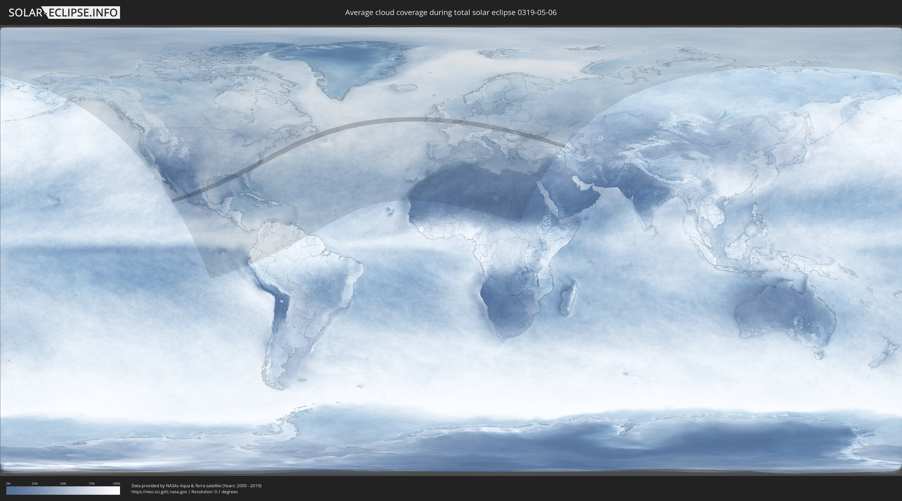
Wie wird das Wetter während der totalen Sonnenfinsternis am 06.05.0319?
Wo ist der beste Ort, um die totale Sonnenfinsternis vom 06.05.0319 zu beobachten?
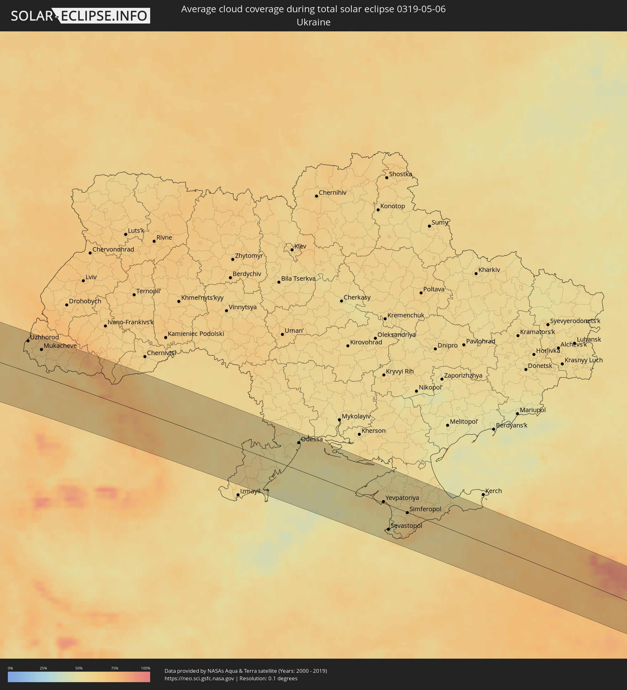
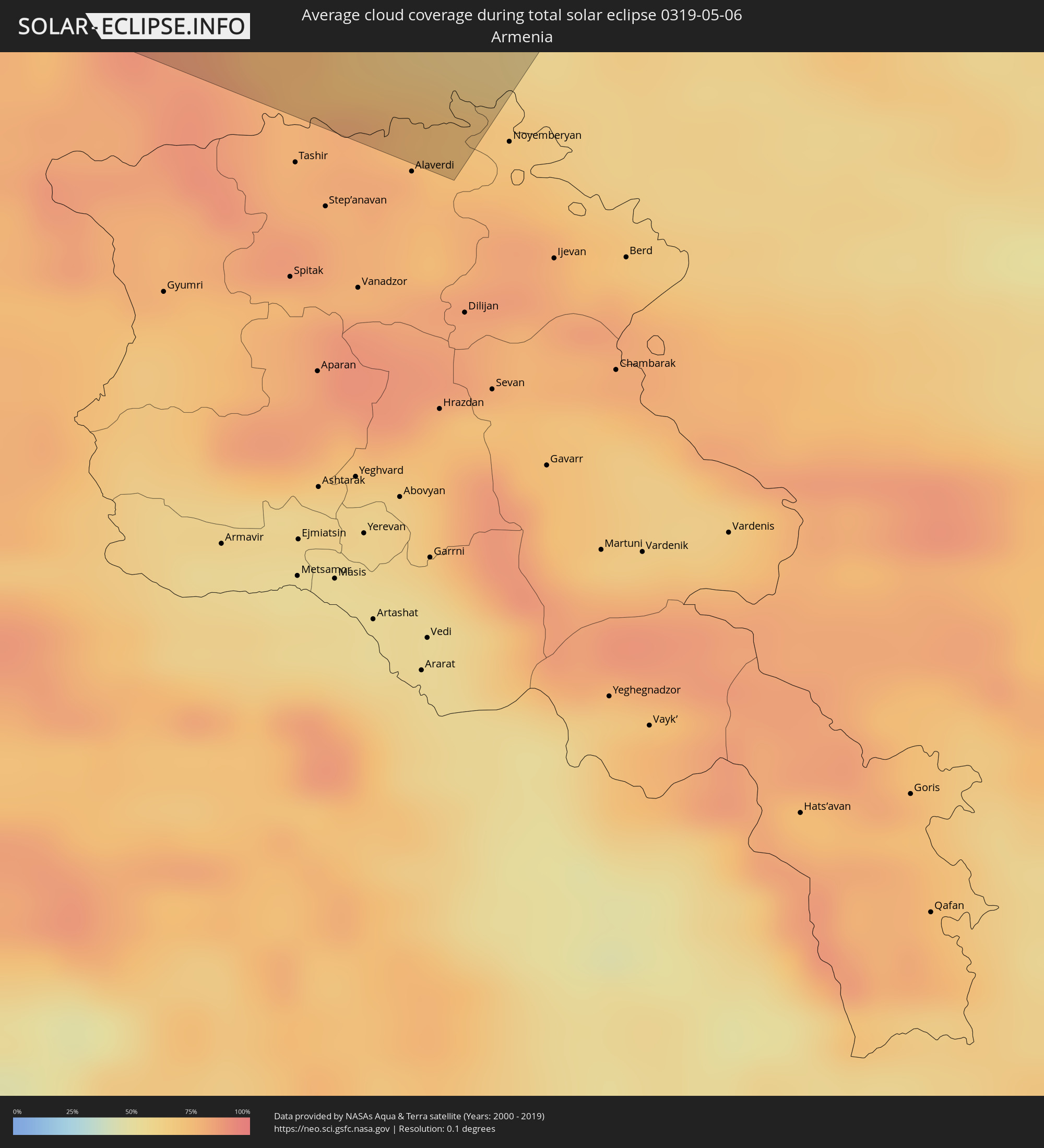
Die folgenden Karten zeigen die durchschnittliche Bewölkung für den Tag, an dem die totale Sonnenfinsternis
stattfindet. Mit Hilfe der Karten lässt sich der Ort entlang des Finsternispfades eingrenzen,
der die besten Aussichen auf einen klaren wolkenfreien Himmel bietet.
Trotzdem muss man immer lokale Gegenenheiten beachten und sollte sich genau über das Wetter an seinem
gewählten Beobachtungsort informieren.
Die Daten stammen von den beiden NASA-Satelliten
AQUA und TERRA
und wurden über einen Zeitraum von 19 Jahren (2000 - 2019) gemittelt.

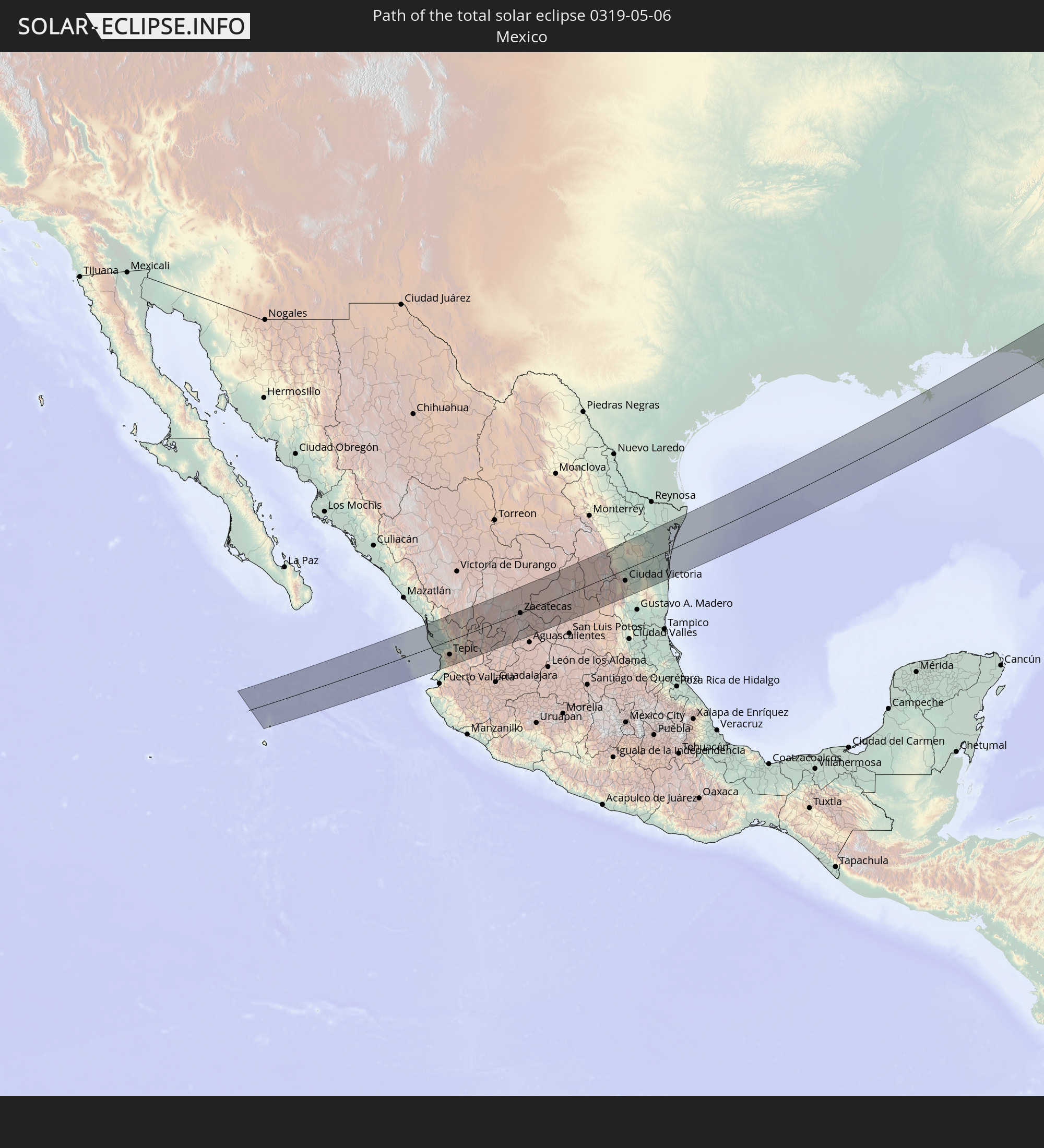
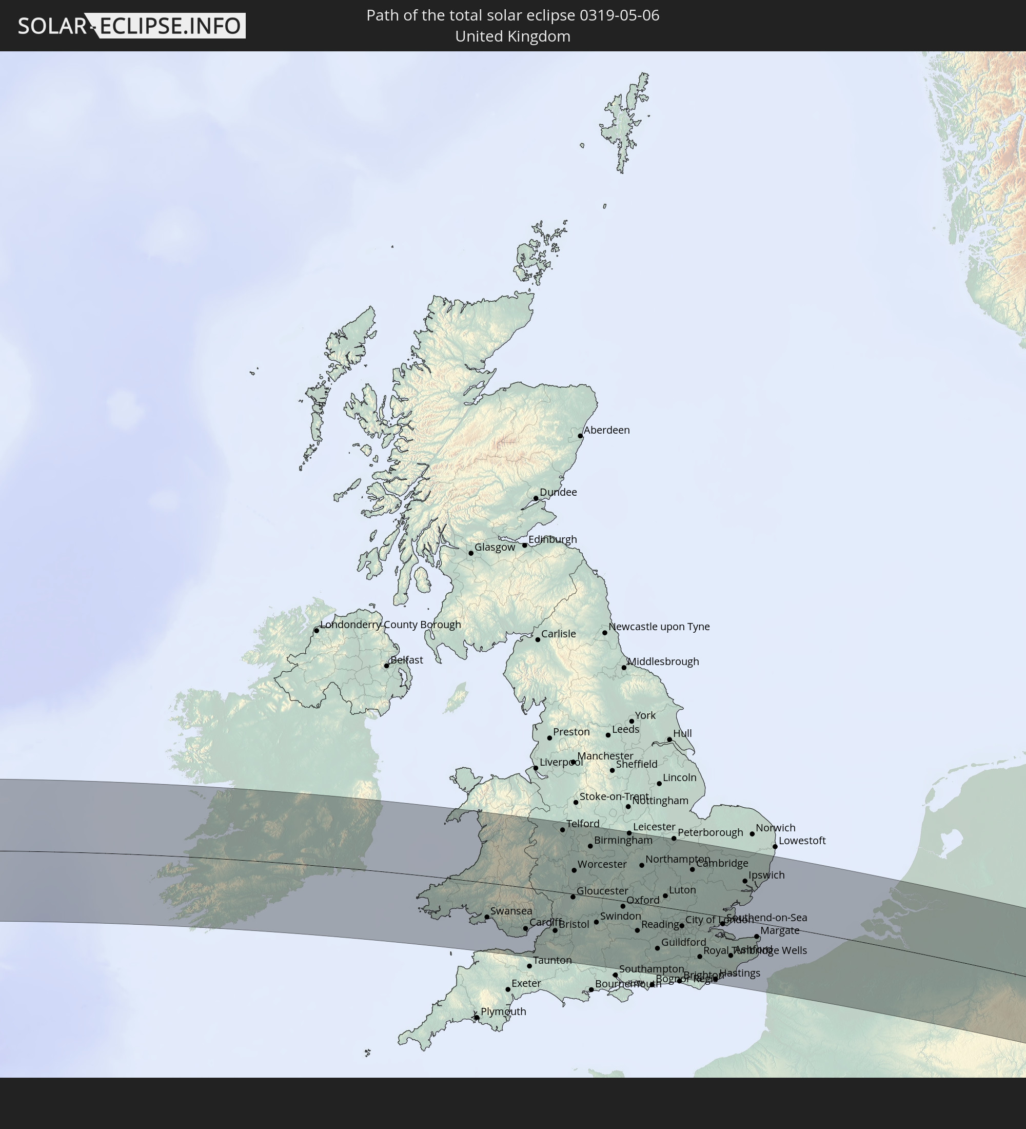
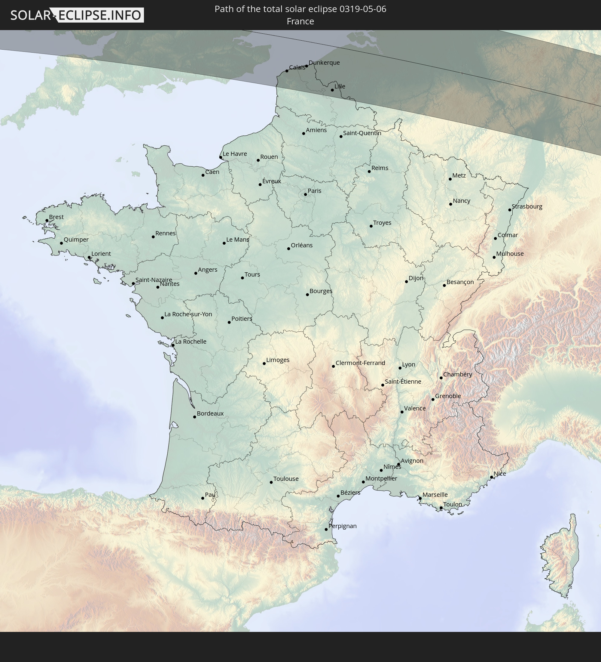
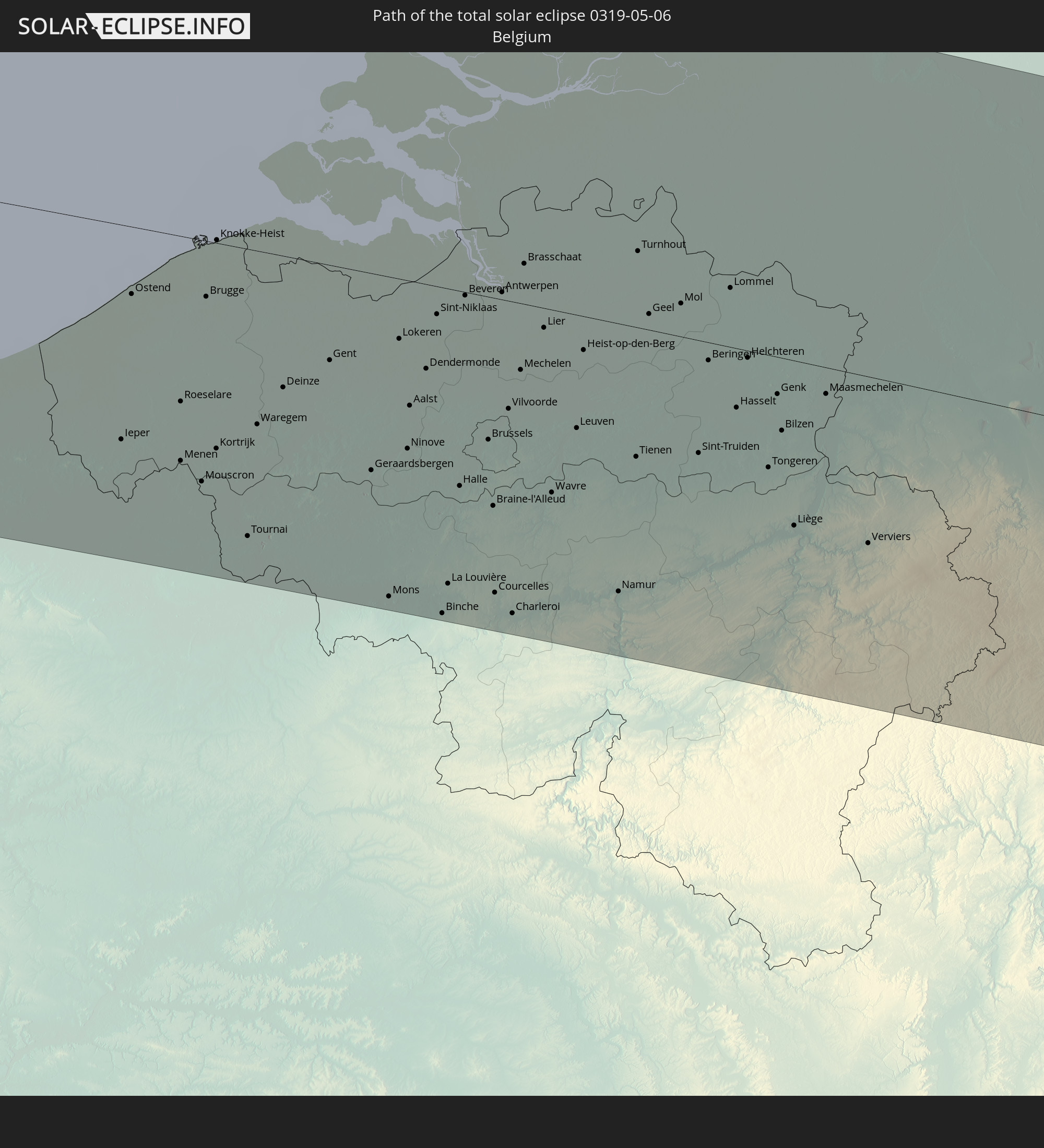
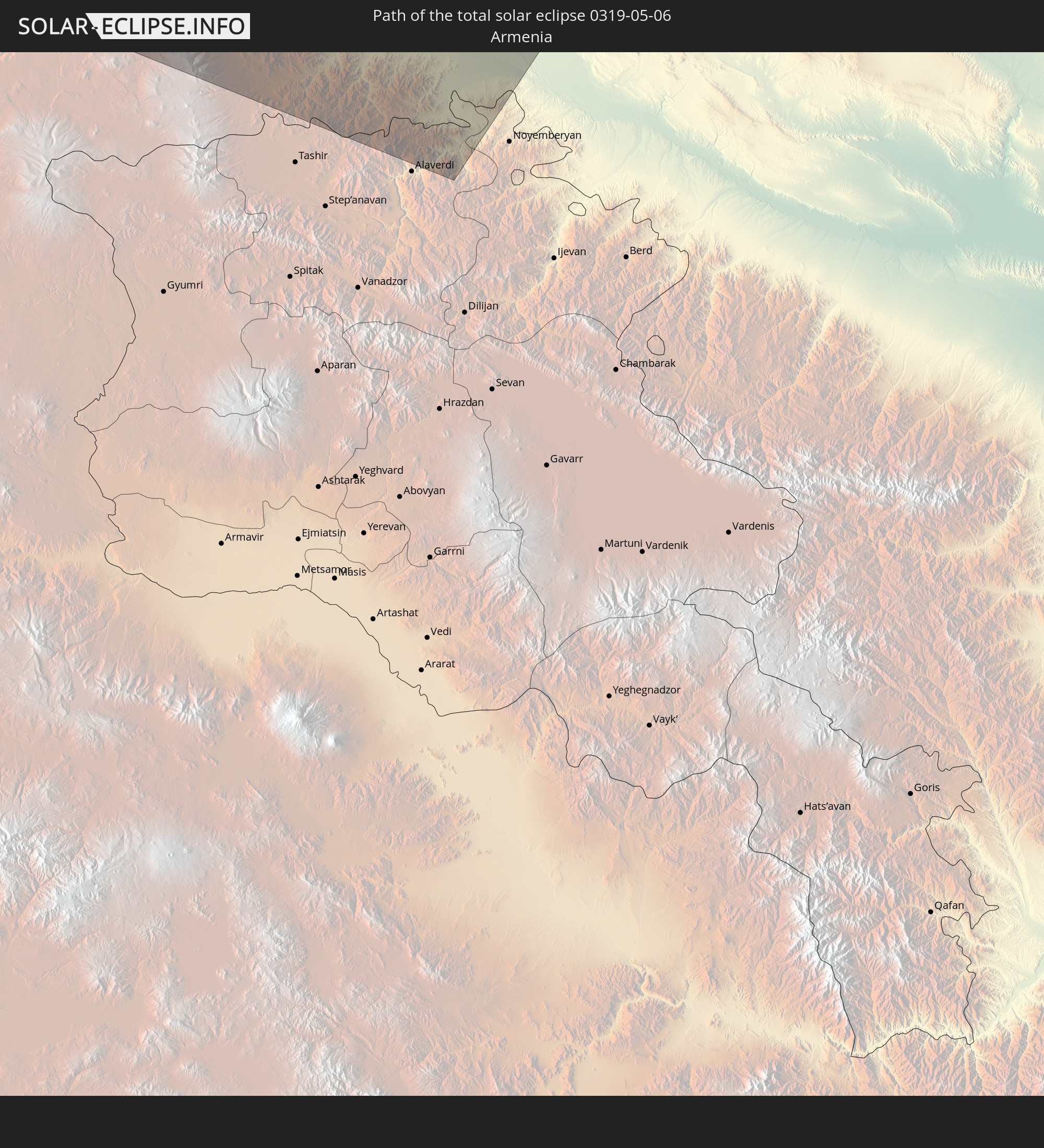
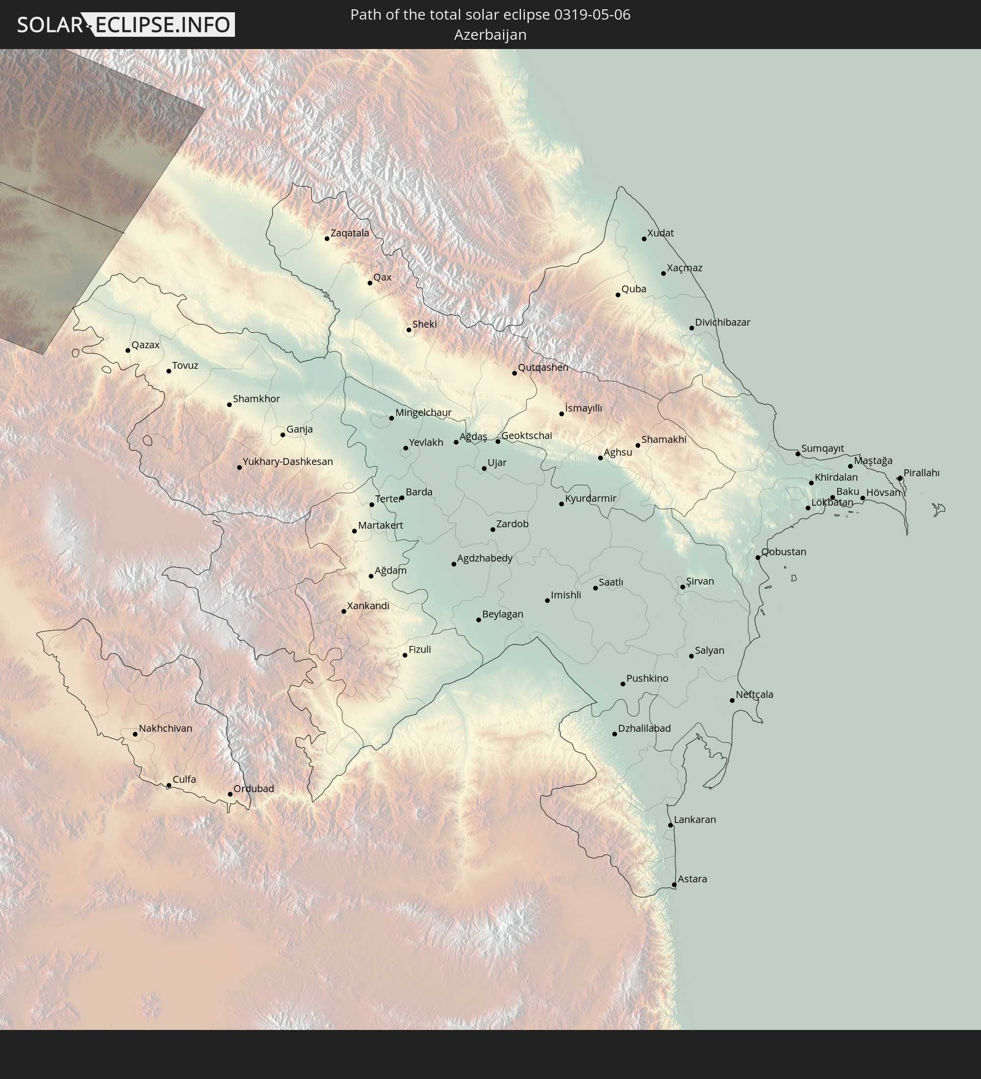
Detaillierte Länderkarten
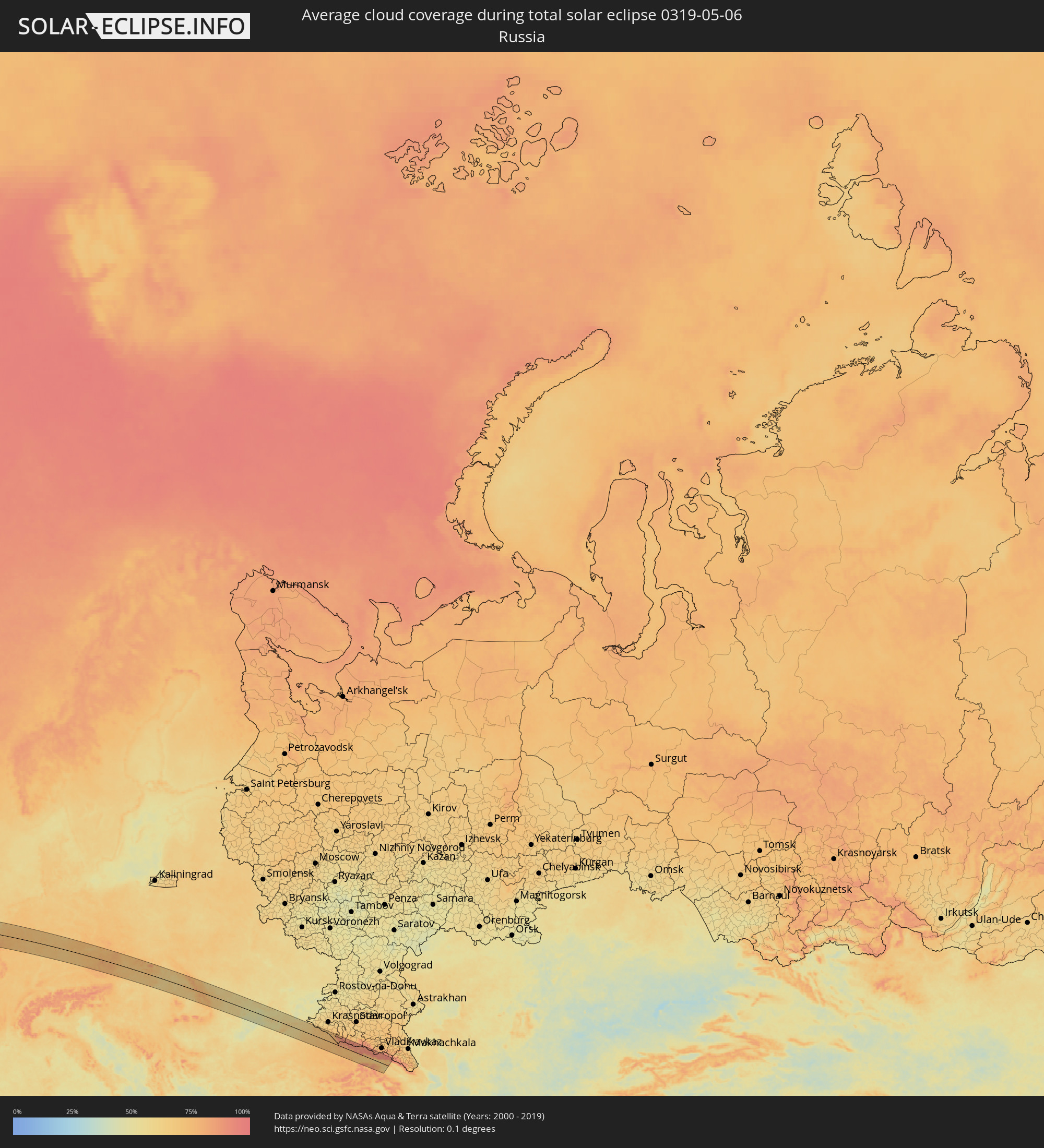 Russland
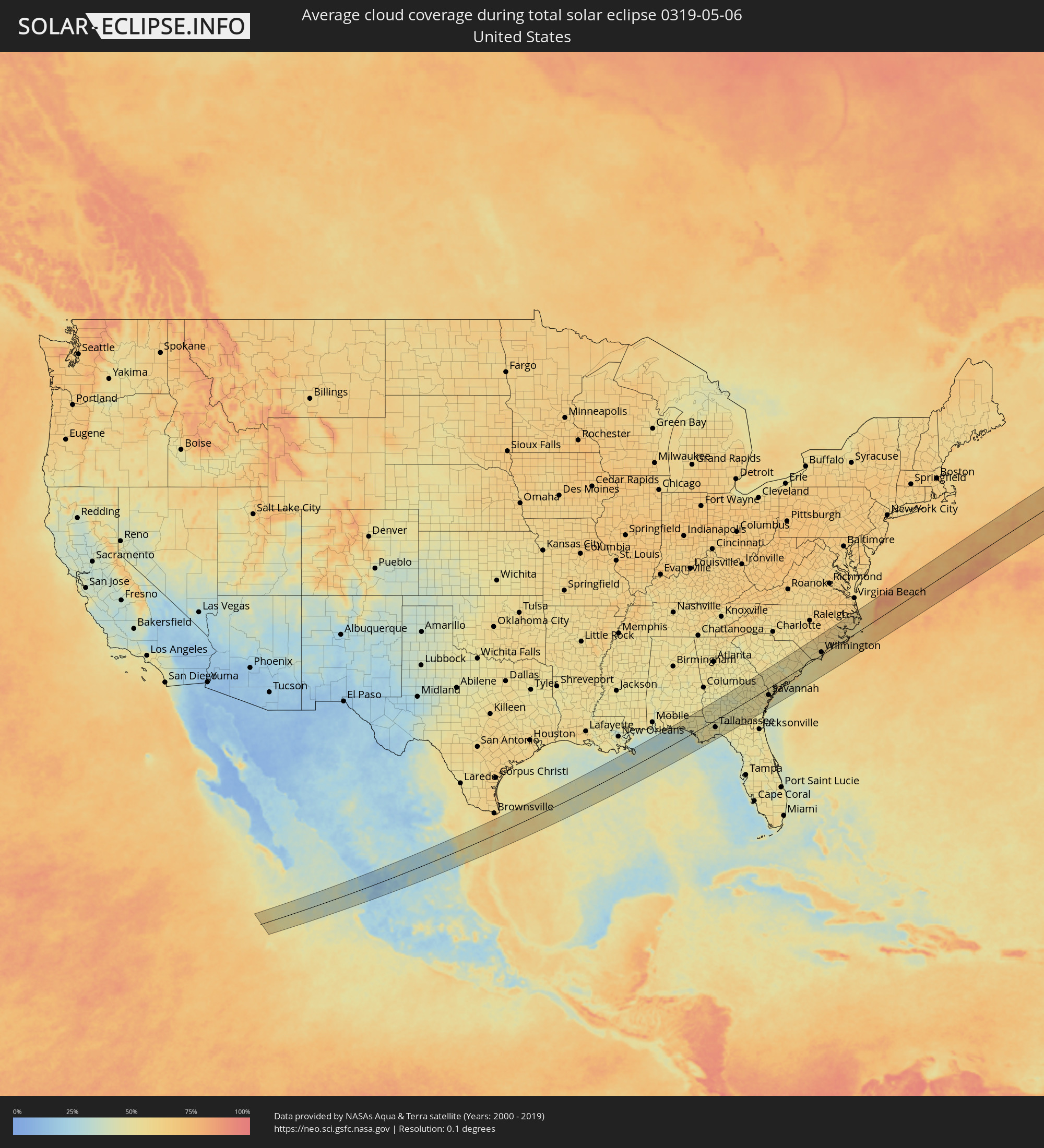 Vereinigte Staaten
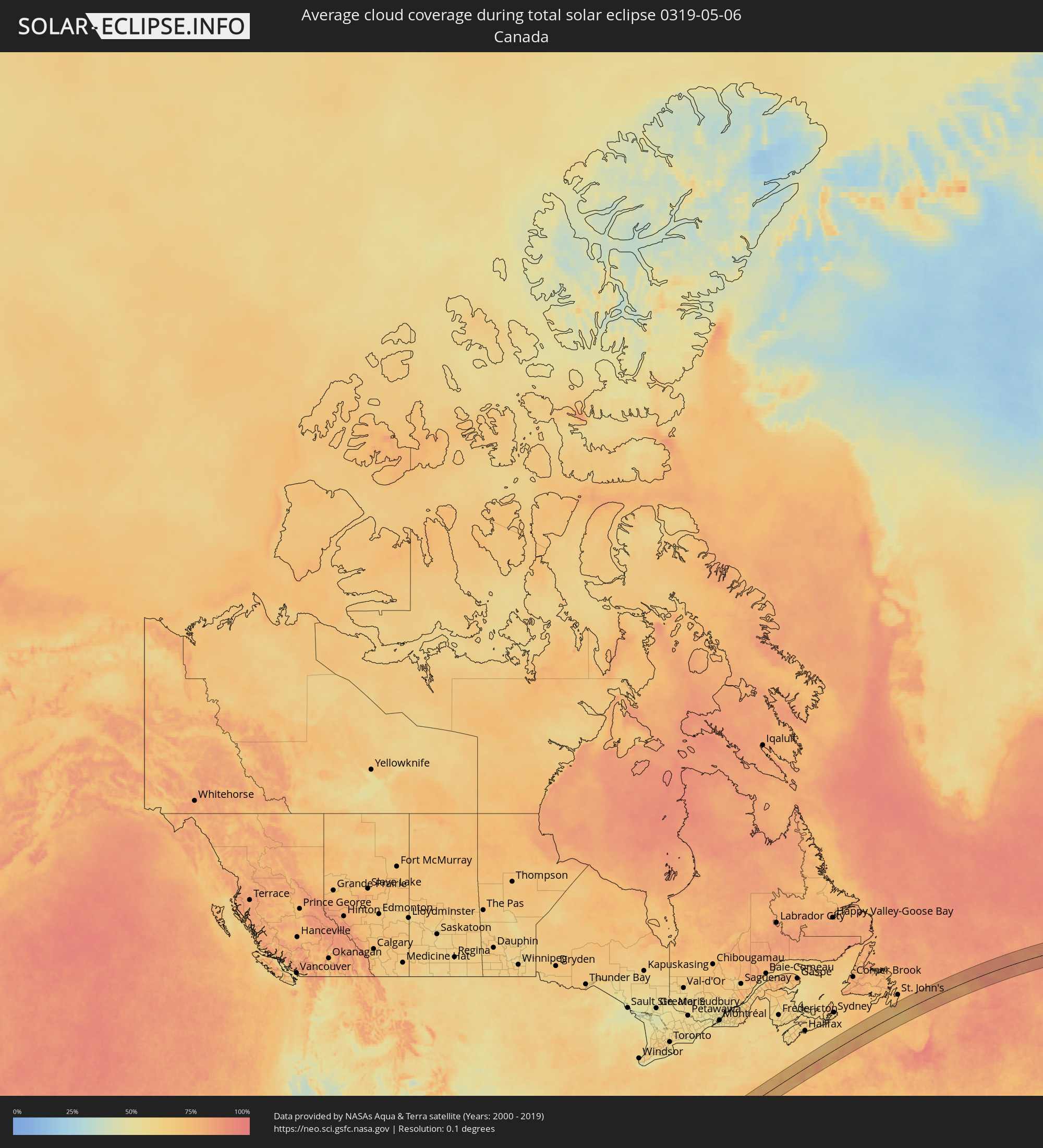 Kanada
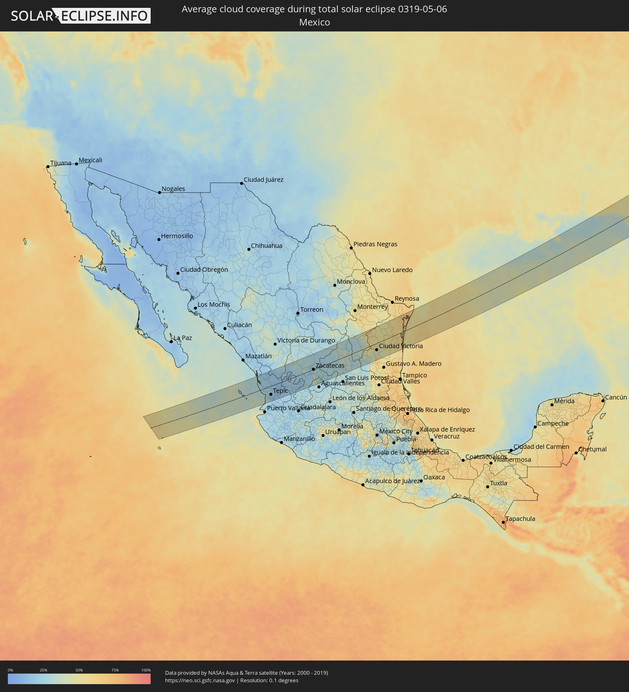 Mexiko
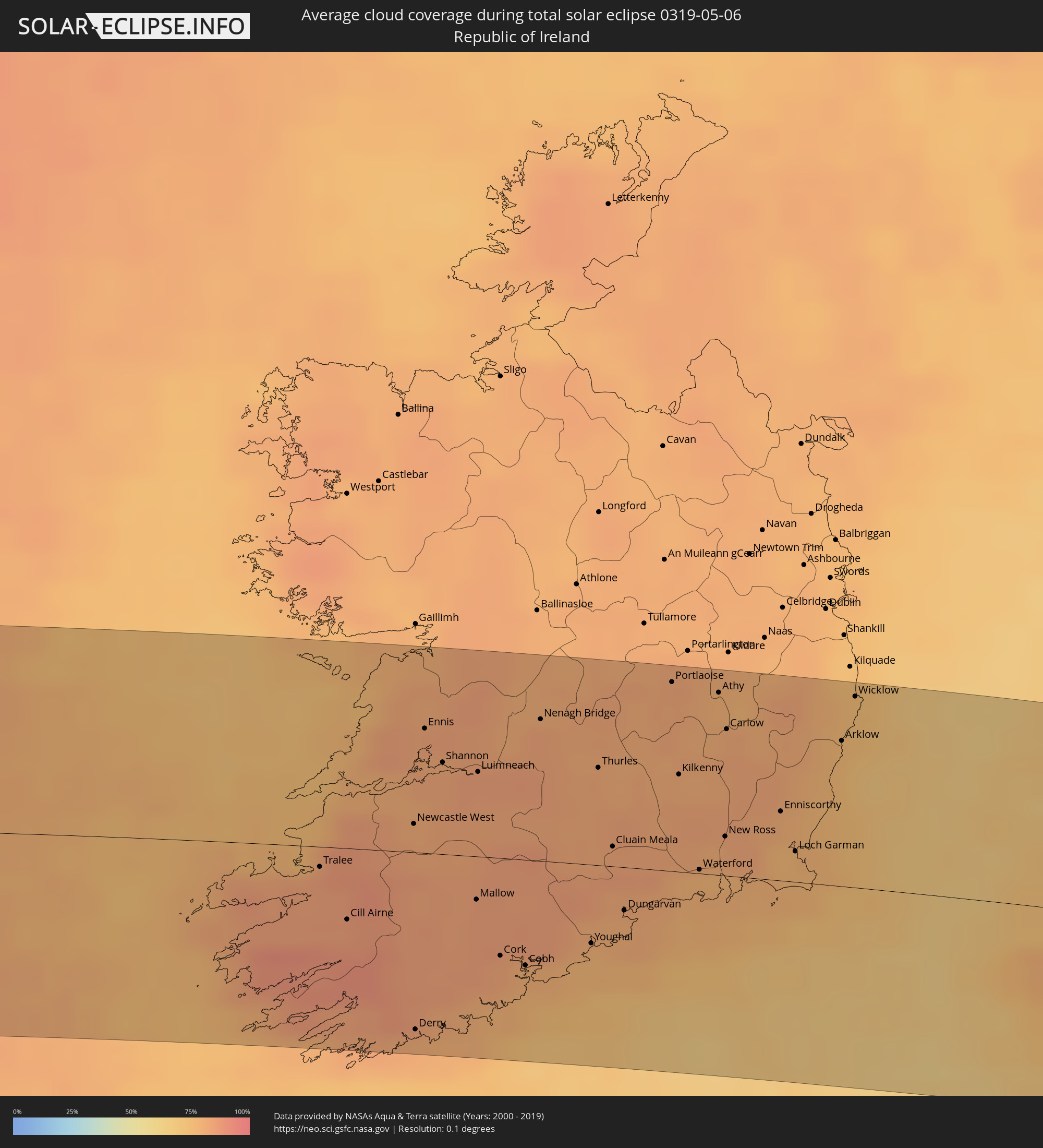 Irland
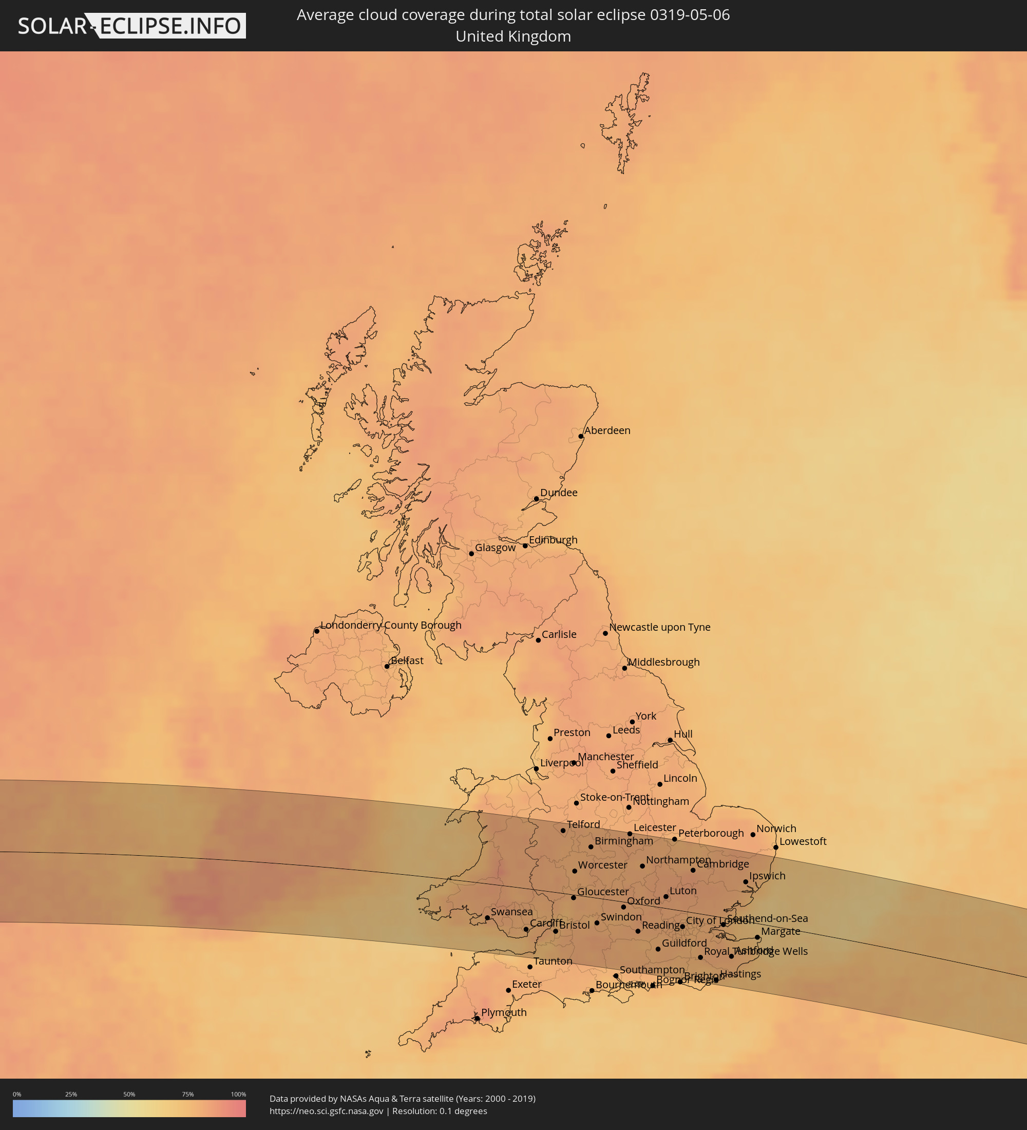 Vereinigtes Königreich
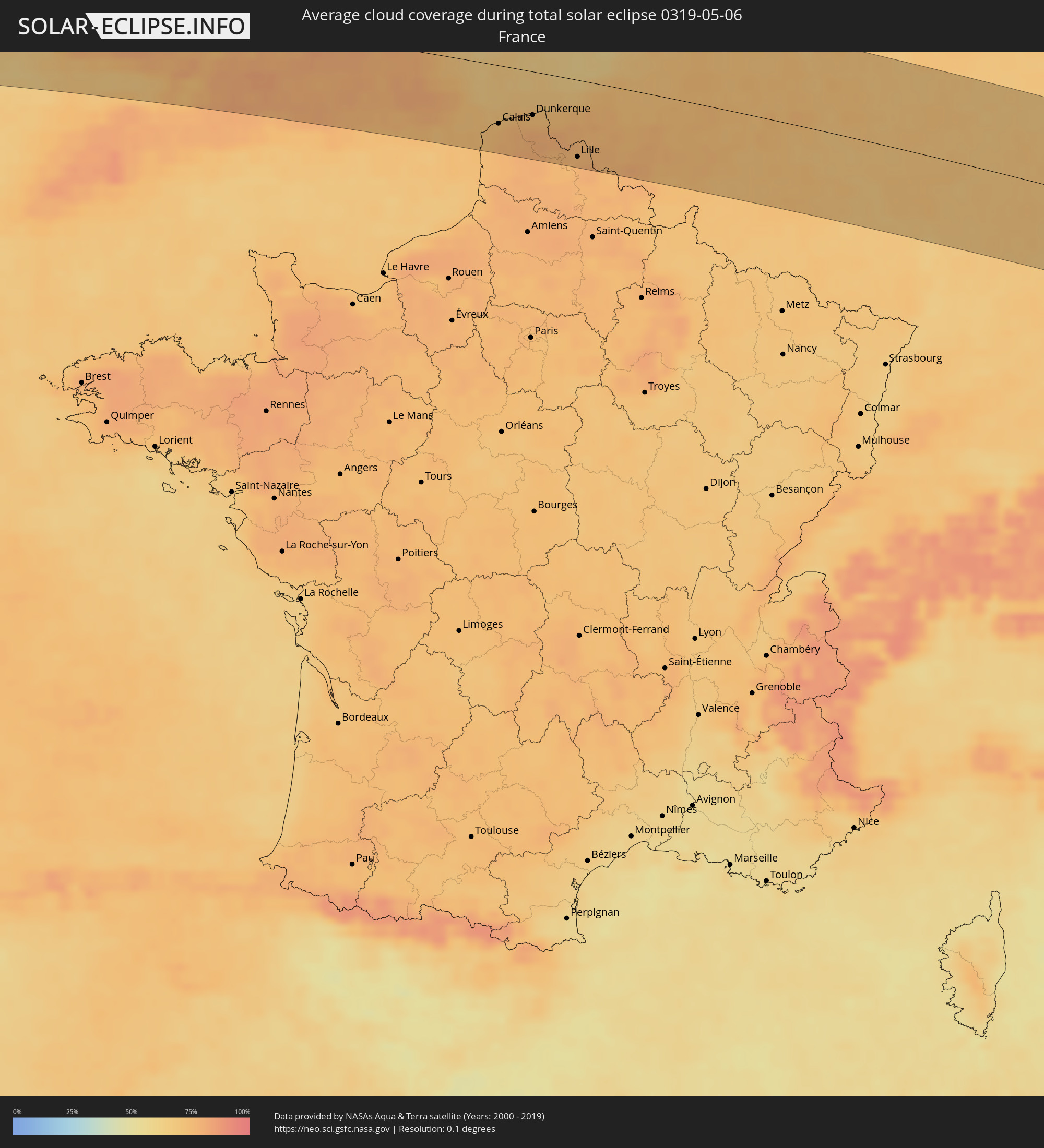 Frankreich
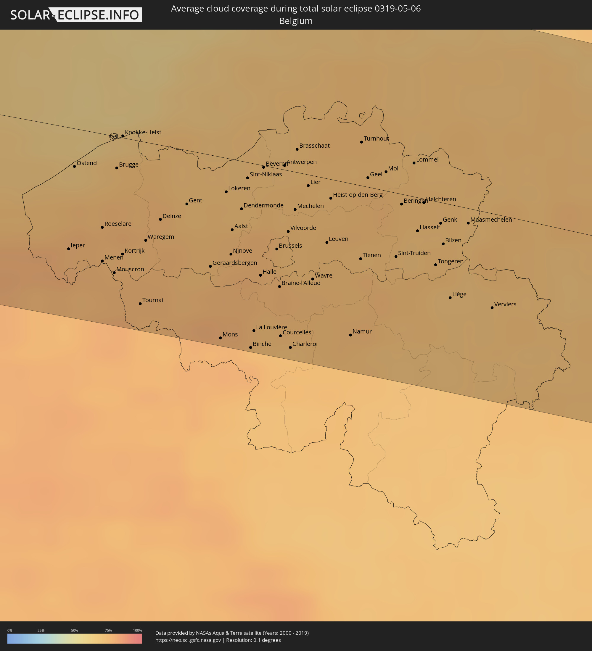 Belgien
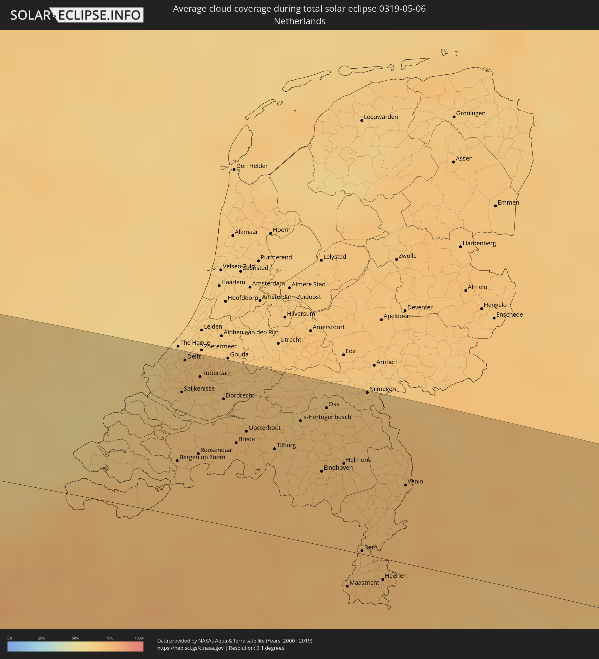 Niederlande
 Luxemburg
 Deutschland
 Österreich
 Tschechien
 Polen
Polen
 Ungarn
 Slowakei
 Rumänien
 Ukraine
 Moldawien
 Georgien
 Armenien
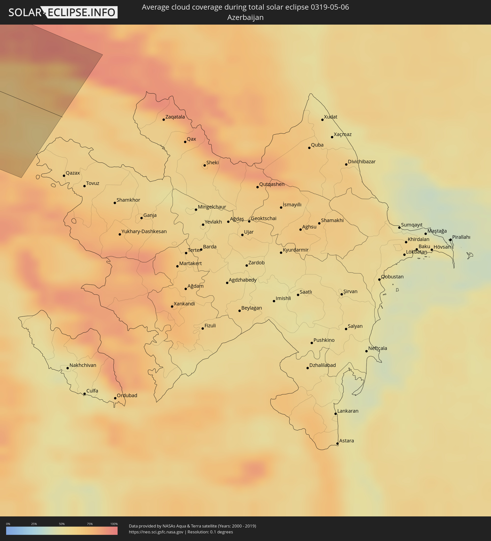 Aserbaidschan
Orte im Finsternispfad
Die nachfolgene Tabelle zeigt Städte und Orte mit mehr als 5.000 Einwohnern, die sich im Finsternispfad befinden. Städte mit mehr als 100.000 Einwohnern sind dick gekennzeichnet. Mit einem Klick auf den Ort öffnet sich eine Detailkarte die die Lage des jeweiligen Ortes zusammen mit dem Verlauf der zentralen Finsternis präsentiert.
| Ort | Typ | Dauer der Verfinsterung | Ortszeit bei maximaler Verfinsterung | Entfernung zur Zentrallinie | Ø Bewölkung |
|
Acaponeta, Nayarit
|
total | - | 05:51:29 UTC-07:05 | 75 km | 21% |
|
Santiago Ixcuintla, Nayarit
|
total | - | 05:50:41 UTC-07:05 | 2 km | 24% |
|
Tepic, Nayarit
|
total | - | 05:50:18 UTC-07:05 | 45 km | 19% |
|
Jerez de García Salinas, Zacatecas
|
total | - | 06:20:29 UTC-06:36 | 3 km | 25% |
|
Fresnillo, Zacatecas
|
total | - | 06:21:06 UTC-06:36 | 54 km | 31% |
|
Víctor Rosales, Zacatecas
|
total | - | 06:20:49 UTC-06:36 | 23 km | 25% |
|
Zacatecas, Zacatecas
|
total | - | 06:20:36 UTC-06:36 | 0 km | 30% |
|
Rincón de Romos, Aguascalientes
|
total | - | 06:19:57 UTC-06:36 | 66 km | 27% |
|
Loreto, Zacatecas
|
total | - | 06:19:58 UTC-06:36 | 74 km | 27% |
|
Matehuala, San Luis Potosí
|
total | - | 06:21:35 UTC-06:36 | 16 km | 33% |
|
Ciudad Victoria, Tamaulipas
|
total | - | 06:21:43 UTC-06:36 | 35 km | 41% |
|
San Fernando, Tamaulipas
|
total | - | 06:23:11 UTC-06:36 | 37 km | 54% |
|
Panama City, Florida
|
total | - | 07:10:57 UTC-06:00 | 3 km | 42% |
|
Dothan, Alabama
|
total | - | 07:12:46 UTC-06:00 | 93 km | 51% |
|
Tallahassee, Florida
|
total | - | 08:12:08 UTC-05:00 | 36 km | 52% |
|
Albany, Georgia
|
total | - | 08:14:01 UTC-05:00 | 67 km | 47% |
|
Valdosta, Georgia
|
total | - | 08:13:21 UTC-05:00 | 47 km | 45% |
|
Hinesville, Georgia
|
total | - | 08:16:03 UTC-05:00 | 32 km | 53% |
|
Savannah, Georgia
|
total | - | 08:16:46 UTC-05:00 | 34 km | 51% |
|
Hilton Head Island, South Carolina
|
total | - | 08:17:14 UTC-05:00 | 38 km | 49% |
|
Summerville, South Carolina
|
total | - | 08:18:57 UTC-05:00 | 9 km | 55% |
|
Charleston, South Carolina
|
total | - | 08:18:44 UTC-05:00 | 26 km | 53% |
|
Wilmington, North Carolina
|
total | - | 08:22:42 UTC-05:00 | 13 km | 54% |
|
Jacksonville, North Carolina
|
total | - | 08:24:01 UTC-05:00 | 37 km | 60% |
|
Tralee, Munster
|
total | - | 14:54:52 UTC-00:25 | 9 km | 85% |
|
Ennis, Munster
|
total | - | 14:55:08 UTC-00:25 | 57 km | 82% |
|
Luimneach, Munster
|
total | - | 14:55:41 UTC-00:25 | 39 km | 84% |
|
Cork, Munster
|
total | - | 14:56:34 UTC-00:25 | 45 km | 83% |
|
Cluain Meala, Munster
|
total | - | 14:56:57 UTC-00:25 | 9 km | 82% |
|
Portlaoise, Leinster
|
total | - | 14:56:43 UTC-00:25 | 87 km | 81% |
|
Kilkenny, Leinster
|
total | - | 14:57:08 UTC-00:25 | 45 km | 80% |
|
Waterford, Munster
|
total | - | 14:57:40 UTC-00:25 | 2 km | 77% |
|
Athy, Leinster
|
total | - | 14:57:05 UTC-00:25 | 84 km | 79% |
|
Carlow, Leinster
|
total | - | 14:57:17 UTC-00:25 | 67 km | 82% |
|
Loch Garman, Leinster
|
total | - | 14:58:16 UTC-00:25 | 14 km | 76% |
|
Wicklow, Leinster
|
total | - | 14:58:02 UTC-00:25 | 88 km | 73% |
|
Cardiff, Wales
|
total | - | 15:27:43 UTC+00:00 | 56 km | 75% |
|
Bristol, England
|
total | - | 15:28:17 UTC+00:00 | 53 km | 77% |
|
Wolverhampton, England
|
total | - | 15:27:30 UTC+00:00 | 76 km | 79% |
|
Birmingham, England
|
total | - | 15:27:49 UTC+00:00 | 66 km | 79% |
|
Coventry, England
|
total | - | 15:28:14 UTC+00:00 | 62 km | 79% |
|
Leicester, England
|
total | - | 15:28:19 UTC+00:00 | 91 km | 80% |
|
Reading, England
|
total | - | 15:29:46 UTC+00:00 | 37 km | 78% |
|
Northampton, England
|
total | - | 15:28:58 UTC+00:00 | 51 km | 80% |
|
Luton, England
|
total | - | 15:29:47 UTC+00:00 | 15 km | 81% |
|
Sutton, England
|
total | - | 15:30:34 UTC+00:00 | 41 km | 79% |
|
London, England
|
total | - | 15:30:27 UTC+00:00 | 23 km | 78% |
|
Bexley, England
|
total | - | 15:30:46 UTC+00:00 | 27 km | 77% |
|
Boulogne-sur-Mer, Hauts-de-France
|
total | - | 15:42:11 UTC+00:09 | 89 km | 73% |
|
Calais, Hauts-de-France
|
total | - | 15:42:06 UTC+00:09 | 61 km | 73% |
|
Coulogne, Hauts-de-France
|
total | - | 15:42:10 UTC+00:09 | 63 km | 75% |
|
Oye-Plage, Hauts-de-France
|
total | - | 15:42:14 UTC+00:09 | 56 km | 75% |
|
Gravelines, Hauts-de-France
|
total | - | 15:42:17 UTC+00:09 | 54 km | 76% |
|
Saint-Omer, Hauts-de-France
|
total | - | 15:42:40 UTC+00:09 | 78 km | 77% |
|
Dunkerque, Hauts-de-France
|
total | - | 15:42:26 UTC+00:09 | 45 km | 75% |
|
Hazebrouck, Hauts-de-France
|
total | - | 15:42:55 UTC+00:09 | 77 km | 78% |
|
Nieppe, Hauts-de-France
|
total | - | 15:43:11 UTC+00:09 | 75 km | 76% |
|
Lille, Hauts-de-France
|
total | - | 15:43:27 UTC+00:09 | 80 km | 78% |
|
Halluin, Hauts-de-France
|
total | - | 15:33:58 UTC+00:00 | 63 km | 77% |
|
Templeuve, Hauts-de-France
|
total | - | 15:43:40 UTC+00:09 | 91 km | 79% |
|
Brugge, Flanders
|
total | - | 15:33:32 UTC+00:00 | 15 km | 73% |
|
Gent, Flanders
|
total | - | 15:34:06 UTC+00:00 | 26 km | 73% |
|
Mons, Wallonia
|
total | - | 15:35:00 UTC+00:00 | 88 km | 77% |
|
Aalst, Flanders
|
total | - | 15:34:29 UTC+00:00 | 34 km | 75% |
|
La Louvière, Wallonia
|
total | - | 15:35:08 UTC+00:00 | 81 km | 74% |
|
Brussels, Brussels Capital
|
total | - | 15:34:49 UTC+00:00 | 39 km | 75% |
|
Antwerpen, Flanders
|
total | - | 15:34:25 UTC+00:00 | 2 km | 73% |
|
Charleroi, Wallonia
|
total | - | 15:35:25 UTC+00:00 | 86 km | 73% |
|
Roosendaal, North Brabant
|
total | - | 15:53:37 UTC+00:19 | 37 km | 72% |
|
Mechelen, Flanders
|
total | - | 15:34:42 UTC+00:00 | 18 km | 74% |
|
Rotterdam, South Holland
|
total | - | 15:53:09 UTC+00:19 | 80 km | 67% |
|
Dordrecht, South Holland
|
total | - | 15:53:26 UTC+00:19 | 70 km | 69% |
|
Leuven, Flanders
|
total | - | 15:35:03 UTC+00:00 | 31 km | 74% |
|
Breda, North Brabant
|
total | - | 15:53:47 UTC+00:19 | 47 km | 72% |
|
Namur, Wallonia
|
total | - | 15:35:40 UTC+00:00 | 74 km | 74% |
|
Tilburg, North Brabant
|
total | - | 15:54:03 UTC+00:19 | 48 km | 71% |
|
's-Hertogenbosch, North Brabant
|
total | - | 15:54:01 UTC+00:19 | 67 km | 70% |
|
Eindhoven, North Brabant
|
total | - | 15:54:27 UTC+00:19 | 41 km | 73% |
|
Liège, Wallonia
|
total | - | 15:35:58 UTC+00:00 | 45 km | 71% |
|
Maastricht, Limburg
|
total | - | 15:55:20 UTC+00:19 | 20 km | 70% |
|
Born, Limburg
|
total | - | 15:55:12 UTC+00:19 | 2 km | 71% |
|
Nijmegen, Gelderland
|
total | - | 15:54:13 UTC+00:19 | 91 km | 71% |
|
Heerlen, Limburg
|
total | - | 15:55:30 UTC+00:19 | 12 km | 73% |
|
Aachen, North Rhine-Westphalia
|
total | - | 16:36:10 UTC+01:00 | 22 km | 72% |
|
Venlo, Limburg
|
total | - | 15:55:01 UTC+00:19 | 44 km | 73% |
|
Mönchengladbach, North Rhine-Westphalia
|
total | - | 16:35:54 UTC+01:00 | 28 km | 72% |
|
Duisburg, North Rhine-Westphalia
|
total | - | 16:35:49 UTC+01:00 | 60 km | 71% |
|
Düsseldorf, North Rhine-Westphalia
|
total | - | 16:36:05 UTC+01:00 | 37 km | 71% |
|
Köln, North Rhine-Westphalia
|
total | - | 16:36:34 UTC+01:00 | 8 km | 68% |
|
Essen, North Rhine-Westphalia
|
total | - | 16:35:57 UTC+01:00 | 66 km | 70% |
|
Bonn, North Rhine-Westphalia
|
total | - | 16:36:54 UTC+01:00 | 11 km | 69% |
|
Wuppertal, North Rhine-Westphalia
|
total | - | 16:36:17 UTC+01:00 | 48 km | 72% |
|
Dortmund, North Rhine-Westphalia
|
total | - | 16:36:11 UTC+01:00 | 80 km | 69% |
|
Wiesbaden, Hesse
|
total | - | 16:38:28 UTC+01:00 | 63 km | 68% |
|
Frankfurt am Main, Hesse
|
total | - | 16:38:42 UTC+01:00 | 52 km | 69% |
|
Nürnberg, Bavaria
|
total | - | 16:40:58 UTC+01:00 | 82 km | 68% |
|
Karlovy Vary, Karlovarský
|
total | - | 16:40:56 UTC+01:00 | 35 km | 72% |
|
Pilsen, Plzeňský
|
total | - | 16:41:48 UTC+01:00 | 7 km | 73% |
|
Chomutov, Ústecký
|
total | - | 16:40:55 UTC+01:00 | 70 km | 70% |
|
Most, Ústecký
|
total | - | 16:40:58 UTC+01:00 | 79 km | 67% |
|
Kladno, Central Bohemia
|
total | - | 16:41:39 UTC+01:00 | 50 km | 72% |
|
Prague, Praha
|
total | - | 16:41:52 UTC+01:00 | 50 km | 72% |
|
České Budějovice, Jihočeský
|
total | - | 16:43:19 UTC+01:00 | 68 km | 75% |
|
Gmünd, Lower Austria
|
total | - | 16:43:49 UTC+01:00 | 80 km | 76% |
|
Schrems, Lower Austria
|
total | - | 16:43:50 UTC+01:00 | 76 km | 77% |
|
Waidhofen an der Thaya, Lower Austria
|
total | - | 16:43:54 UTC+01:00 | 68 km | 78% |
|
Jihlava, Vysočina
|
total | - | 16:43:17 UTC+01:00 | 0 km | 76% |
|
Horn, Lower Austria
|
total | - | 16:44:15 UTC+01:00 | 77 km | 76% |
|
Pardubice, Pardubický
|
total | - | 16:42:32 UTC+01:00 | 72 km | 75% |
|
Hollabrunn, Lower Austria
|
total | - | 16:44:35 UTC+01:00 | 80 km | 76% |
|
Laa an der Thaya, Lower Austria
|
total | - | 16:44:30 UTC+01:00 | 56 km | 75% |
|
Mistelbach, Lower Austria
|
total | - | 16:44:46 UTC+01:00 | 68 km | 74% |
|
Brno, South Moravian
|
total | - | 16:43:59 UTC+01:00 | 0 km | 72% |
|
Poysdorf, Lower Austria
|
total | - | 16:44:40 UTC+01:00 | 56 km | 72% |
|
Zistersdorf, Lower Austria
|
total | - | 16:44:53 UTC+01:00 | 68 km | 73% |
|
Olomouc, Olomoucký
|
total | - | 16:43:43 UTC+01:00 | 56 km | 70% |
|
Trnava, Trnavský
|
total | - | 16:45:25 UTC+01:00 | 66 km | 68% |
|
Zlín, Zlín
|
total | - | 16:44:21 UTC+01:00 | 26 km | 70% |
|
Trenčín, Trenčiansky
|
total | - | 16:44:55 UTC+01:00 | 1 km | 70% |
|
Nitra, Nitriansky
|
total | - | 16:45:41 UTC+01:00 | 63 km | 66% |
|
Považská Bystrica, Trenčiansky
|
total | - | 16:44:46 UTC+01:00 | 31 km | 67% |
|
Prievidza, Nitriansky
|
total | - | 16:45:17 UTC+01:00 | 1 km | 68% |
|
Žilina, Žilinský
|
total | - | 16:44:45 UTC+01:00 | 49 km | 70% |
|
Martin, Žilinský
|
total | - | 16:45:01 UTC+01:00 | 37 km | 67% |
|
Zvolen, Banskobystrický
|
total | - | 16:45:44 UTC+01:00 | 10 km | 66% |
|
Banská Bystrica, Banskobystrický
|
total | - | 16:45:31 UTC+01:00 | 7 km | 64% |
|
Salgótarján, Nógrád
|
total | - | 16:46:33 UTC+01:00 | 46 km | 66% |
|
Zakopane, Lesser Poland Voivodeship
|
total | - | 17:09:04 UTC+01:24 | 84 km | 81% |
|
Parádsasvár, Heves
|
total | - | 16:46:51 UTC+01:00 | 62 km | 70% |
|
Poprad, Prešovský
|
total | - | 16:45:29 UTC+01:00 | 67 km | 69% |
|
Ózd, Borsod-Abaúj-Zemplén
|
total | - | 16:46:34 UTC+01:00 | 22 km | 68% |
|
Eger, Heves
|
total | - | 16:46:59 UTC+01:00 | 54 km | 64% |
|
Kazincbarcika, Borsod-Abaúj-Zemplén
|
total | - | 16:46:37 UTC+01:00 | 11 km | 66% |
|
Miskolc, Borsod-Abaúj-Zemplén
|
total | - | 16:46:51 UTC+01:00 | 23 km | 64% |
|
Prešov, Prešovský
|
total | - | 16:45:50 UTC+01:00 | 82 km | 63% |
|
Košice, Košický
|
total | - | 16:46:13 UTC+01:00 | 53 km | 62% |
|
Hajdúszoboszló, Hajdú-Bihar
|
total | - | 16:47:51 UTC+01:00 | 77 km | 61% |
|
Hajdúböszörmény, Hajdú-Bihar
|
total | - | 16:47:37 UTC+01:00 | 52 km | 60% |
|
Debrecen, Hajdú-Bihar
|
total | - | 16:47:49 UTC+01:00 | 63 km | 61% |
|
Nyíregyháza, Szabolcs-Szatmár-Bereg
|
total | - | 16:47:18 UTC+01:00 | 16 km | 60% |
|
Kisvárda, Szabolcs-Szatmár-Bereg
|
total | - | 16:47:04 UTC+01:00 | 20 km | 62% |
|
Uzhhorod, Zakarpattia
|
total | - | 17:48:41 UTC+02:02 | 67 km | 62% |
|
Mátészalka, Szabolcs-Szatmár-Bereg
|
total | - | 16:47:28 UTC+01:00 | 2 km | 62% |
|
Mukacheve, Zakarpattia
|
total | - | 17:49:01 UTC+02:02 | 59 km | 61% |
|
Satu Mare, Satu Mare
|
total | - | 17:32:12 UTC+01:44 | 5 km | 62% |
|
Zalău, Sălaj
|
total | - | 17:33:00 UTC+01:44 | 64 km | 62% |
|
Baia Mare, Satu Mare
|
total | - | 17:32:33 UTC+01:44 | 3 km | 66% |
|
Bistriţa, Bistriţa-Năsăud
|
total | - | 17:33:24 UTC+01:44 | 35 km | 64% |
|
Suceava, Suceava
|
total | - | 17:33:05 UTC+01:44 | 62 km | 62% |
|
Piatra Neamţ, Neamţ
|
total | - | 17:33:59 UTC+01:44 | 11 km | 70% |
|
Botoşani, Botoşani
|
total | - | 17:33:00 UTC+01:44 | 85 km | 57% |
|
Bacău, Bacău
|
total | - | 17:34:30 UTC+01:44 | 32 km | 62% |
|
Roman, Neamţ
|
total | - | 17:34:04 UTC+01:44 | 5 km | 66% |
|
Iaşi, Iaşi
|
total | - | 17:33:51 UTC+01:44 | 49 km | 58% |
|
Bârlad, Vaslui
|
total | - | 17:35:00 UTC+01:44 | 47 km | 59% |
|
Vaslui, Vaslui
|
total | - | 17:34:31 UTC+01:44 | 4 km | 62% |
|
Ungheni, Ungheni
|
total | - | 17:44:25 UTC+01:55 | 58 km | 58% |
|
Cahul, Cahul
|
total | - | 17:46:03 UTC+01:55 | 67 km | 57% |
|
Leova, Leova
|
total | - | 17:45:22 UTC+01:55 | 6 km | 58% |
|
Călăraşi, Călăraşi
|
total | - | 17:44:25 UTC+01:55 | 76 km | 59% |
|
Hînceşti, Hînceşti
|
total | - | 17:44:58 UTC+01:55 | 40 km | 56% |
|
Straşeni, Strășeni
|
total | - | 17:44:35 UTC+01:55 | 73 km | 59% |
|
Comrat, Găgăuzia
|
total | - | 17:45:38 UTC+01:55 | 14 km | 59% |
|
Taraclia, Taraclia
|
total | - | 17:46:06 UTC+01:55 | 55 km | 58% |
|
Ceadîr-Lunga, Găgăuzia
|
total | - | 17:45:56 UTC+01:55 | 34 km | 59% |
|
Chisinau, Chişinău
|
total | - | 17:44:47 UTC+01:55 | 65 km | 57% |
|
Căuşeni, Căuşeni
|
total | - | 17:45:17 UTC+01:55 | 42 km | 57% |
|
Tiraspolul, Stînga Nistrului
|
total | - | 17:45:02 UTC+01:55 | 69 km | 56% |
|
Bilhorod-Dnistrovs’kyy, Odessa
|
total | - | 17:52:56 UTC+02:02 | 21 km | 50% |
|
Illichivs’k, Odessa
|
total | - | 17:52:49 UTC+02:02 | 41 km | 54% |
|
Odessa, Odessa
|
total | - | 17:52:37 UTC+02:02 | 61 km | 52% |
|
Yevpatoriya, Republic of Crimea
|
total | - | 18:08:05 UTC+02:16 | 3 km | 58% |
|
Sevastopol, Gorod Sevastopol
|
total | - | 18:08:47 UTC+02:16 | 56 km | 54% |
|
Saki, Republic of Crimea
|
total | - | 18:08:09 UTC+02:16 | 2 km | 52% |
|
Simferopol, Republic of Crimea
|
total | - | 18:08:20 UTC+02:16 | 1 km | 60% |
|
Yalta, Republic of Crimea
|
total | - | 18:08:51 UTC+02:16 | 47 km | 65% |
|
Alushta, Republic of Crimea
|
total | - | 18:08:39 UTC+02:16 | 22 km | 62% |
|
Feodosiya, Republic of Crimea
|
total | - | 18:08:10 UTC+02:16 | 44 km | 63% |
|
Kabardinka, Krasnodarskiy
|
total | - | 18:22:38 UTC+02:30 | 80 km | 71% |
|
Gelendzhik, Krasnodarskiy
|
total | - | 18:22:43 UTC+02:30 | 75 km | 71% |
|
Arkhipo-Osipovka, Krasnodarskiy
|
total | - | 18:22:52 UTC+02:30 | 68 km | 71% |
|
Novomikhaylovskiy, Krasnodarskiy
|
total | - | 18:22:56 UTC+02:30 | 67 km | 68% |
|
Tuapse, Krasnodarskiy
|
total | - | 18:23:05 UTC+02:30 | 57 km | 70% |
|
Lazarevskoye, Krasnodarskiy
|
total | - | 18:23:15 UTC+02:30 | 45 km | 71% |
|
Dagomys, Krasnodarskiy
|
total | - | 18:23:27 UTC+02:30 | 30 km | 75% |
|
Sochi, Krasnodarskiy
|
total | - | 18:23:31 UTC+02:30 | 25 km | 73% |
|
Khosta, Krasnodarskiy
|
total | - | 18:23:35 UTC+02:30 | 21 km | 76% |
|
Kudepsta, Krasnodarskiy
|
total | - | 18:23:36 UTC+02:30 | 19 km | 76% |
|
Adler, Krasnodarskiy
|
total | - | 18:23:40 UTC+02:30 | 13 km | 77% |
|
Sokhumi, Abkhazia
|
total | - | 18:52:48 UTC+02:59 | 3 km | 75% |
|
P’ot’i, Samegrelo and Zemo Svaneti
|
total | - | 18:53:33 UTC+02:59 | 65 km | 71% |
|
Teberda, Karachayevo-Cherkesiya
|
total | - | 18:23:17 UTC+02:30 | 71 km | 91% |
|
Zugdidi, Samegrelo and Zemo Svaneti
|
total | - | 18:53:08 UTC+02:59 | 22 km | 72% |
|
Senak’i, Samegrelo and Zemo Svaneti
|
total | - | 18:53:20 UTC+02:59 | 40 km | 68% |
|
Samtredia, Imereti
|
total | - | 18:53:23 UTC+02:59 | 44 km | 68% |
|
Kutaisi, Imereti
|
total | - | 18:53:11 UTC+02:59 | 21 km | 68% |
|
Zestap’oni, Imereti
|
total | - | 18:53:15 UTC+02:59 | 26 km | 71% |
|
Khashuri, Shida Kartli
|
total | - | 18:53:14 UTC+02:59 | 21 km | 73% |
|
Ts’khinvali, Shida Kartli
|
total | - | 18:52:54 UTC+02:59 | 15 km | 62% |
|
Gori, Shida Kartli
|
total | - | 18:53:06 UTC+02:59 | 5 km | 65% |
|
Tbilisi, T'bilisi
|
total | - | 18:53:11 UTC+02:59 | 13 km | 63% |
|
Rust’avi, Kvemo Kartli
|
total | - | 18:53:17 UTC+02:59 | 22 km | 59% |