Totale Sonnenfinsternis vom 16.06.0345
| Wochentag: | Samstag |
| Maximale Dauer der Verfinsterung: | 07m17s |
| Maximale Breite des Finsternispfades: | 263 km |
| Saroszyklus: | 81 |
| Bedeckungsgrad: | 100% |
| Magnitude: | 1.0811 |
| Gamma: | -0.1162 |
Wo kann man die Sonnenfinsternis vom 16.06.0345 sehen?
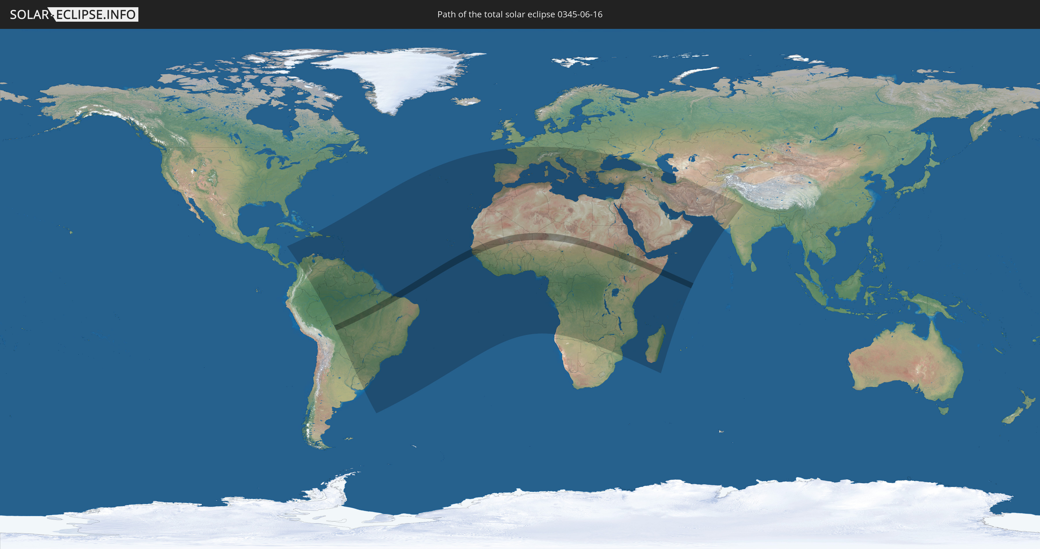
Die Sonnenfinsternis am 16.06.0345 kann man in 135 Ländern als partielle Sonnenfinsternis beobachten.
Der Finsternispfad verläuft durch 14 Länder. Nur in diesen Ländern ist sie als totale Sonnenfinsternis zu sehen.
In den folgenden Ländern ist die Sonnenfinsternis total zu sehen
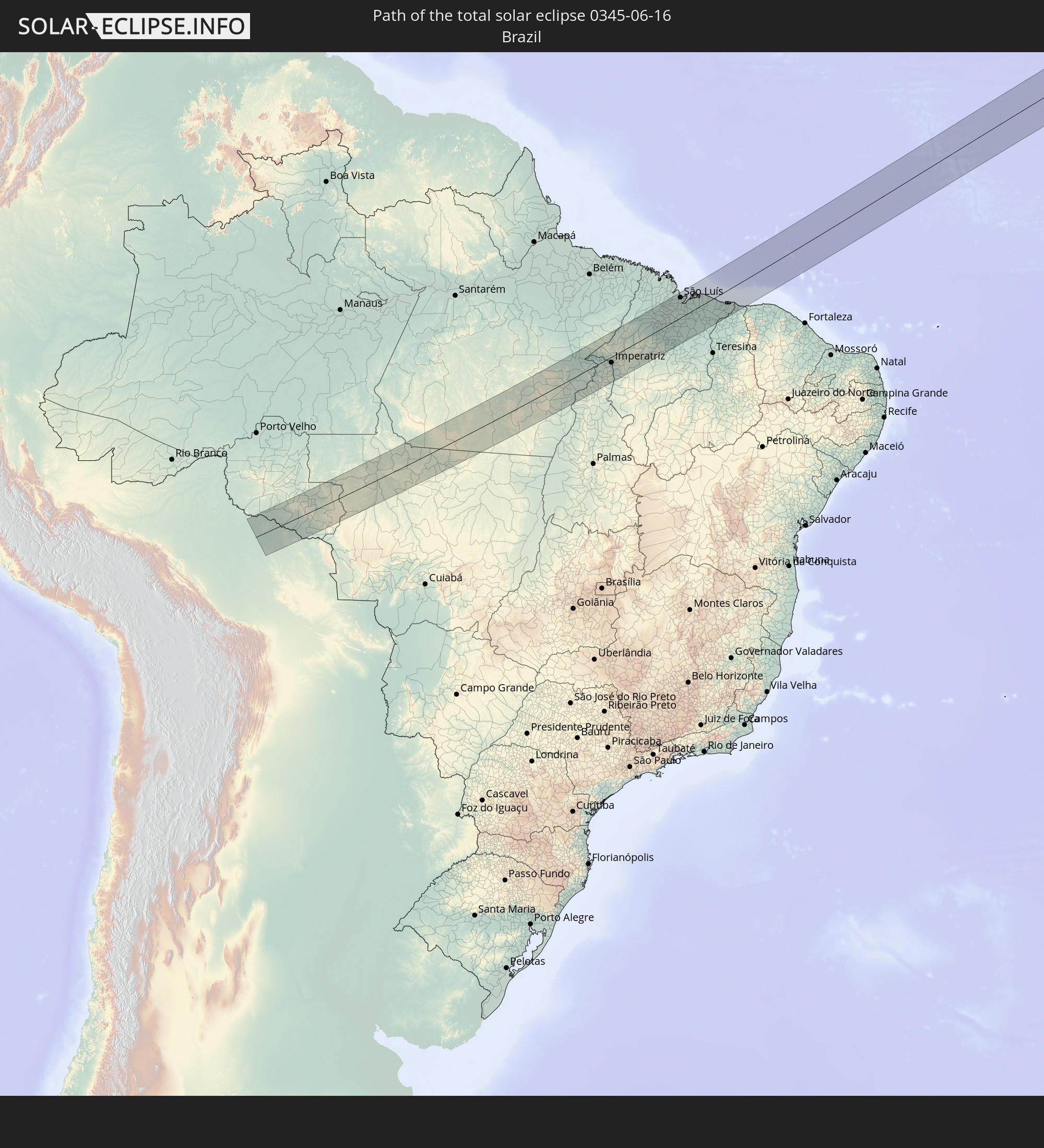 Brasilien
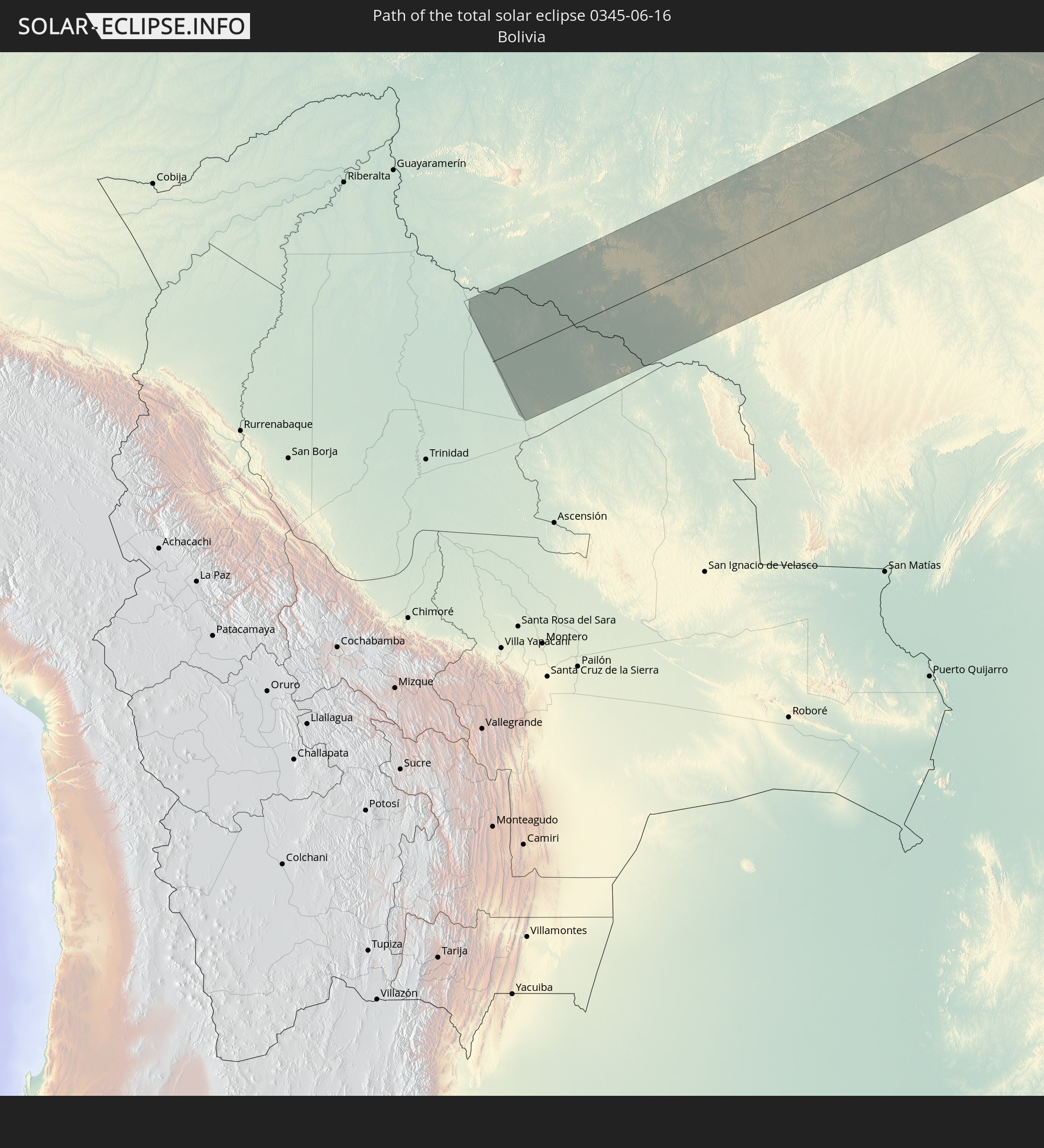 Bolivien
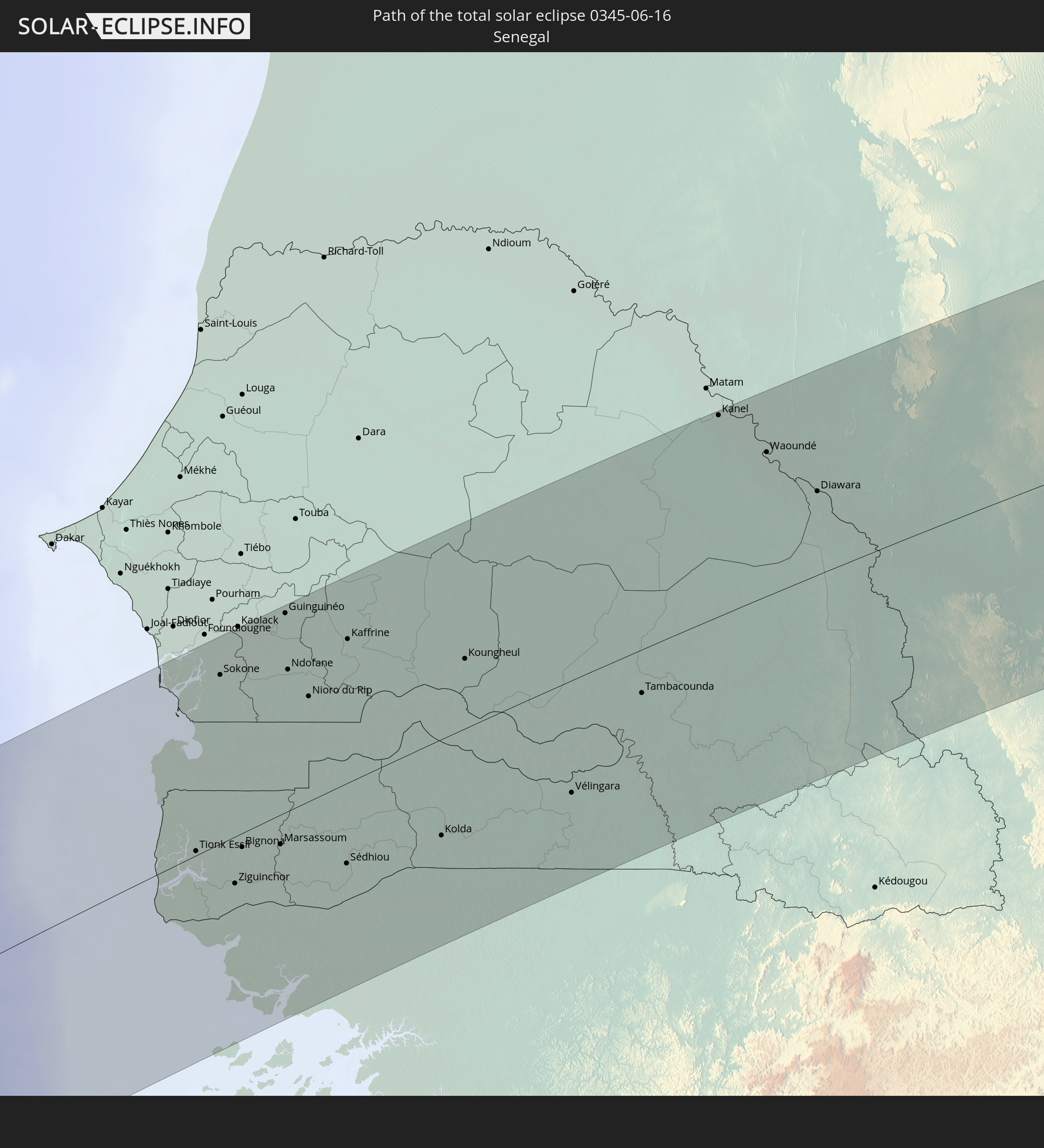 Senegal
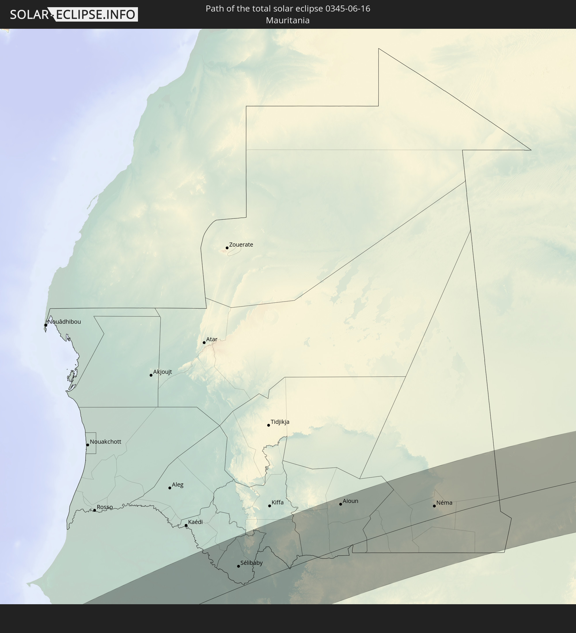 Mauretanien
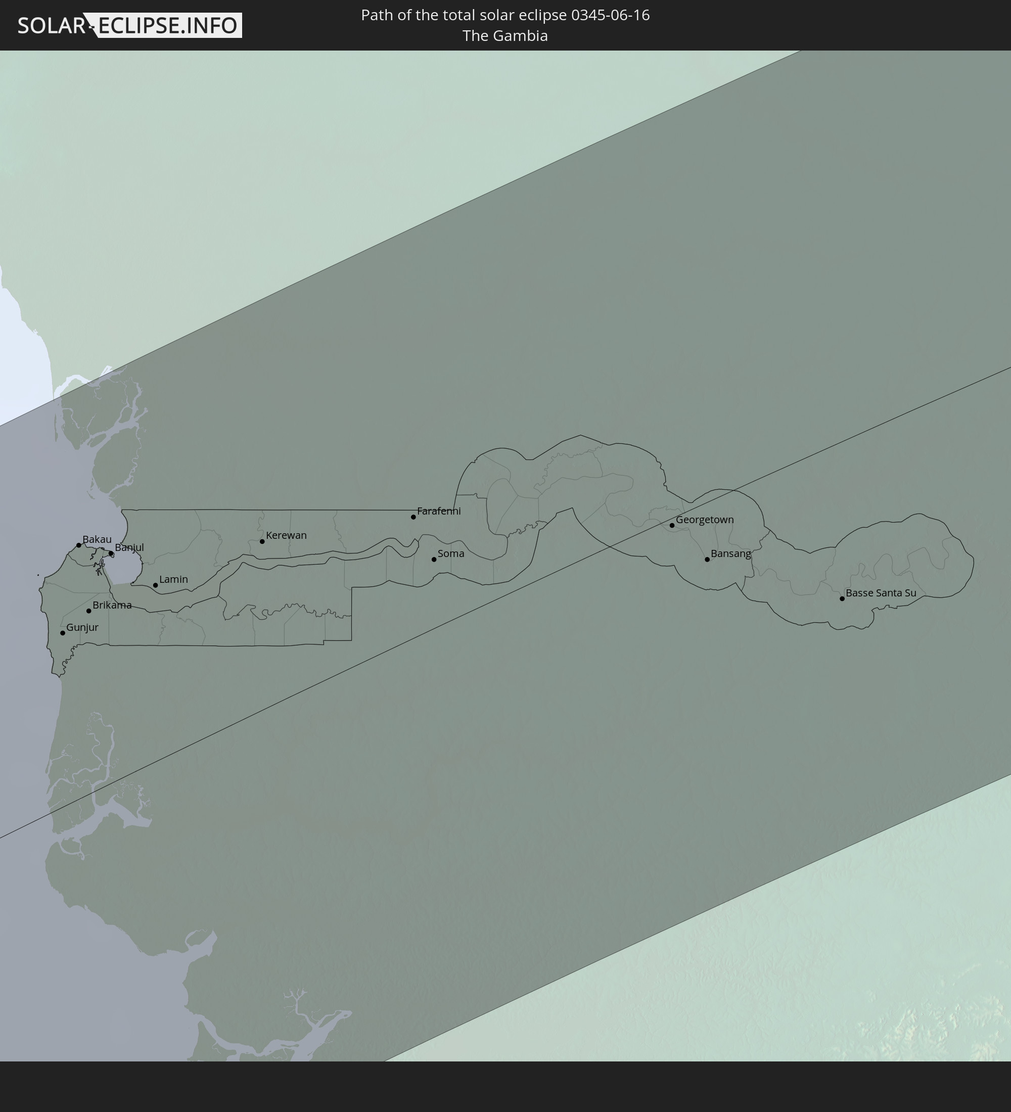 Gambia
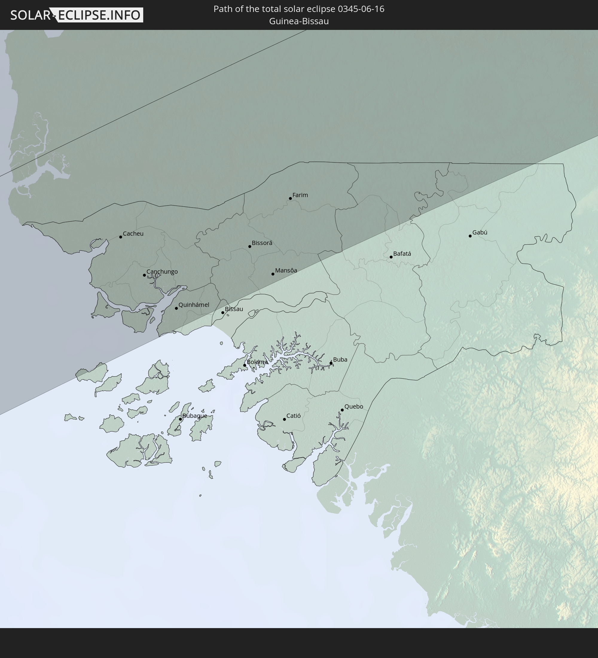 Guinea-Bissau
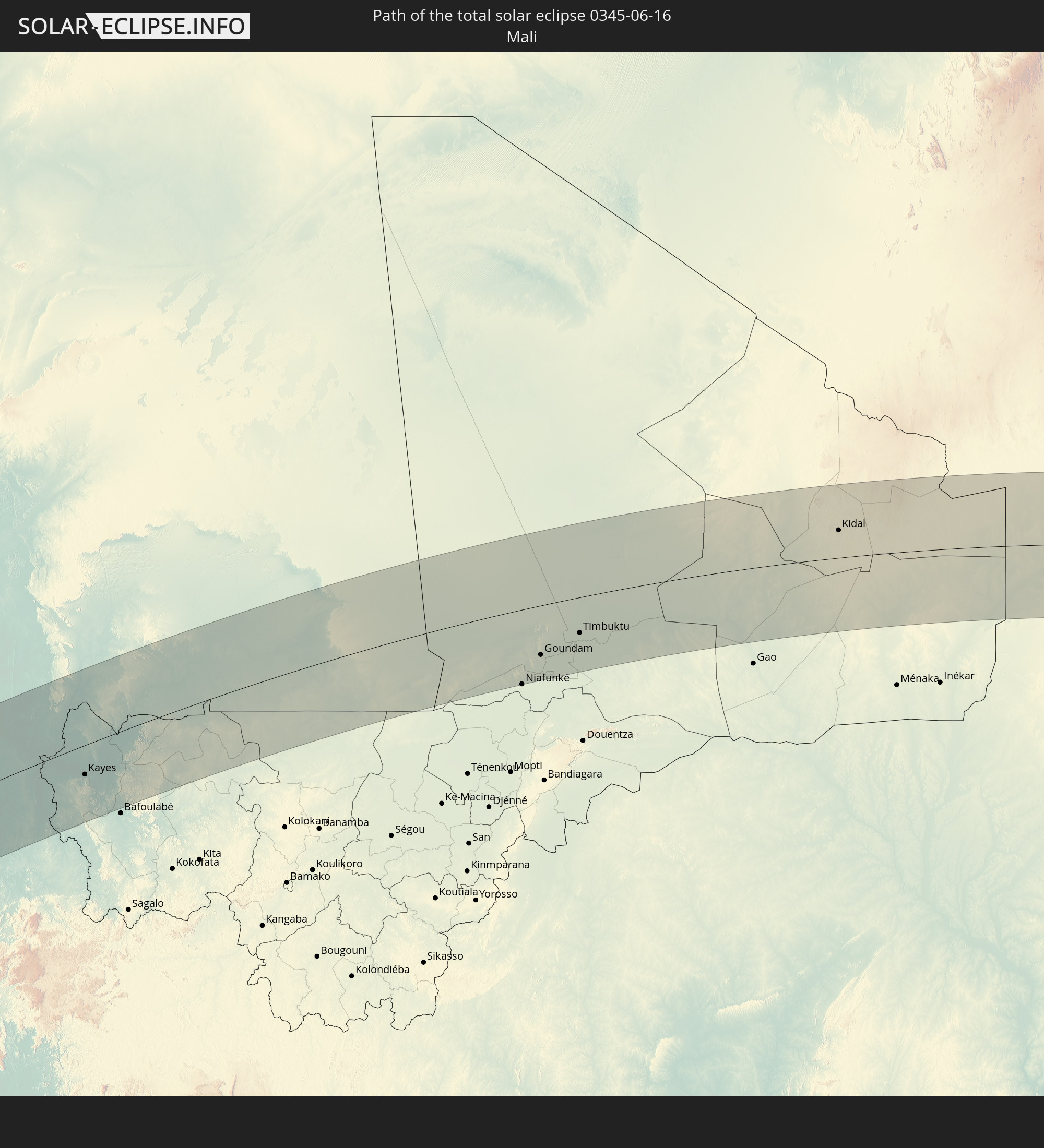 Mali
Mali
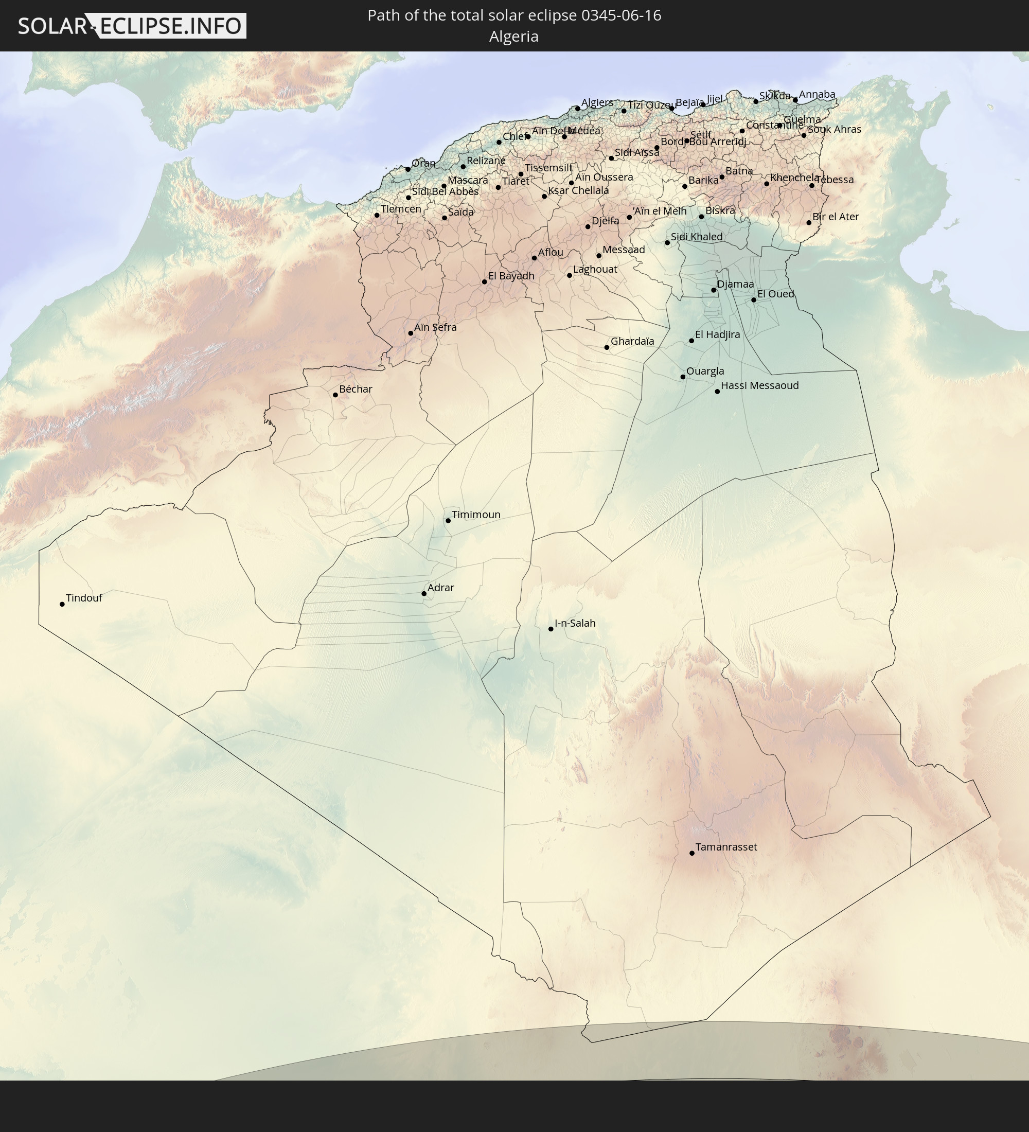 Algerien
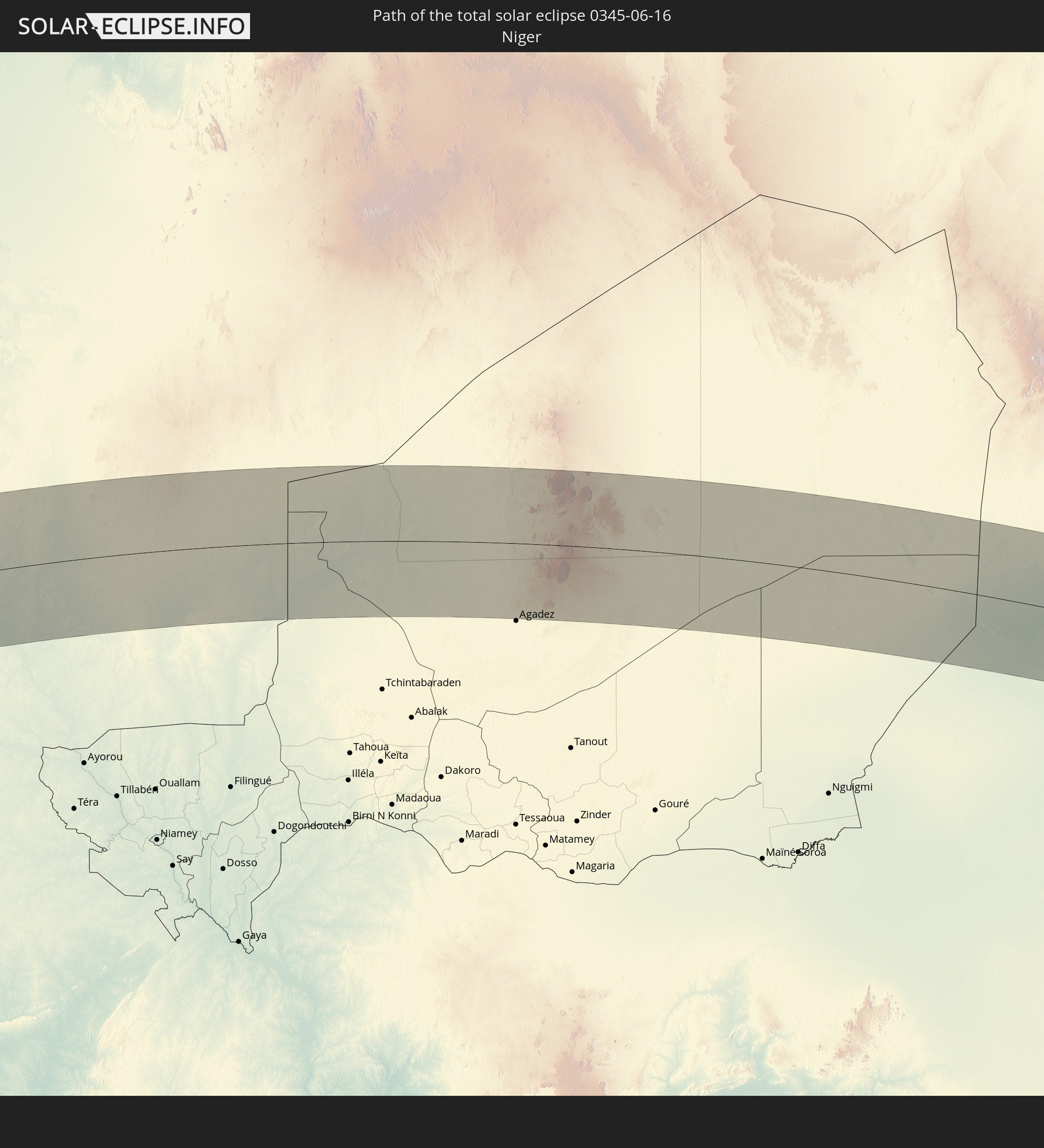 Niger
Niger
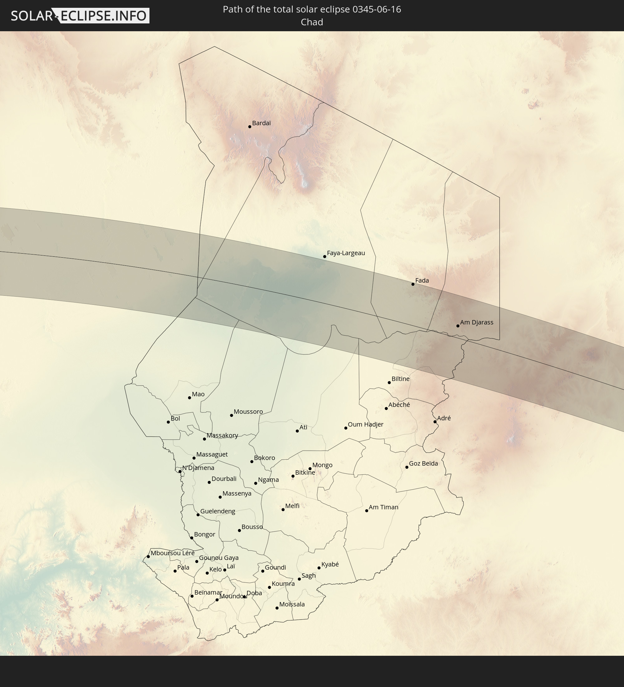 Tschad
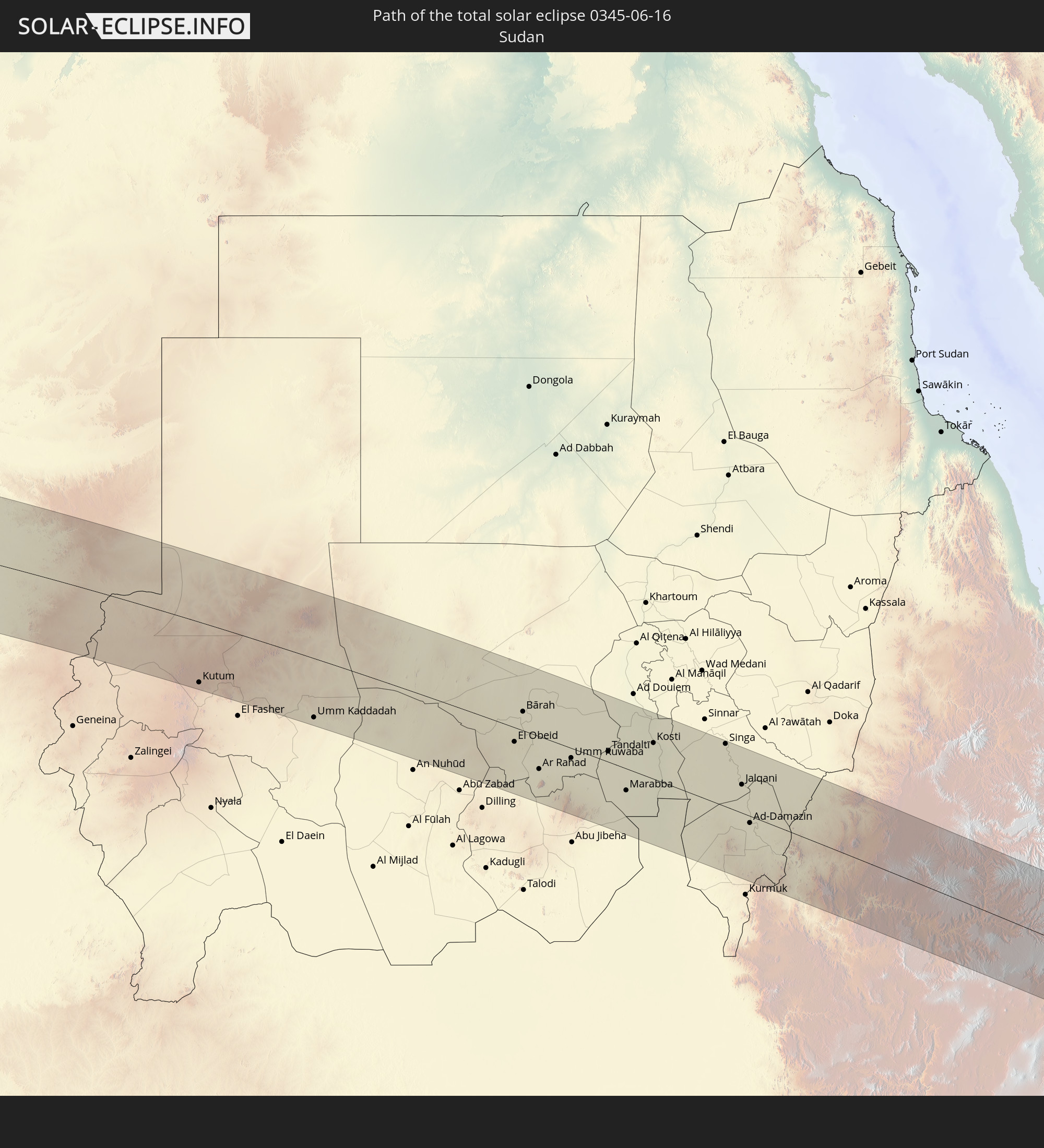 Sudan
Sudan
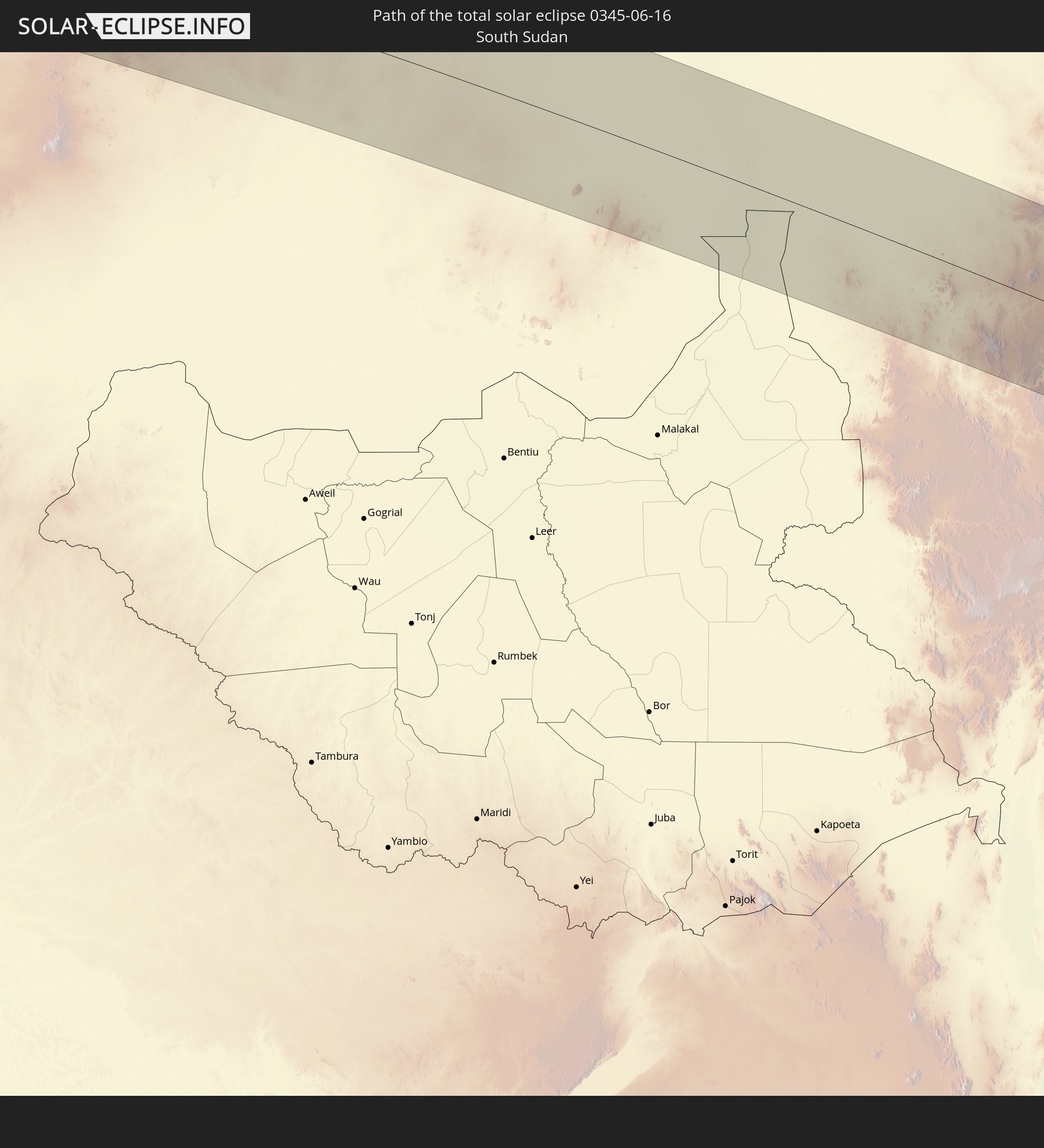 Südsudan
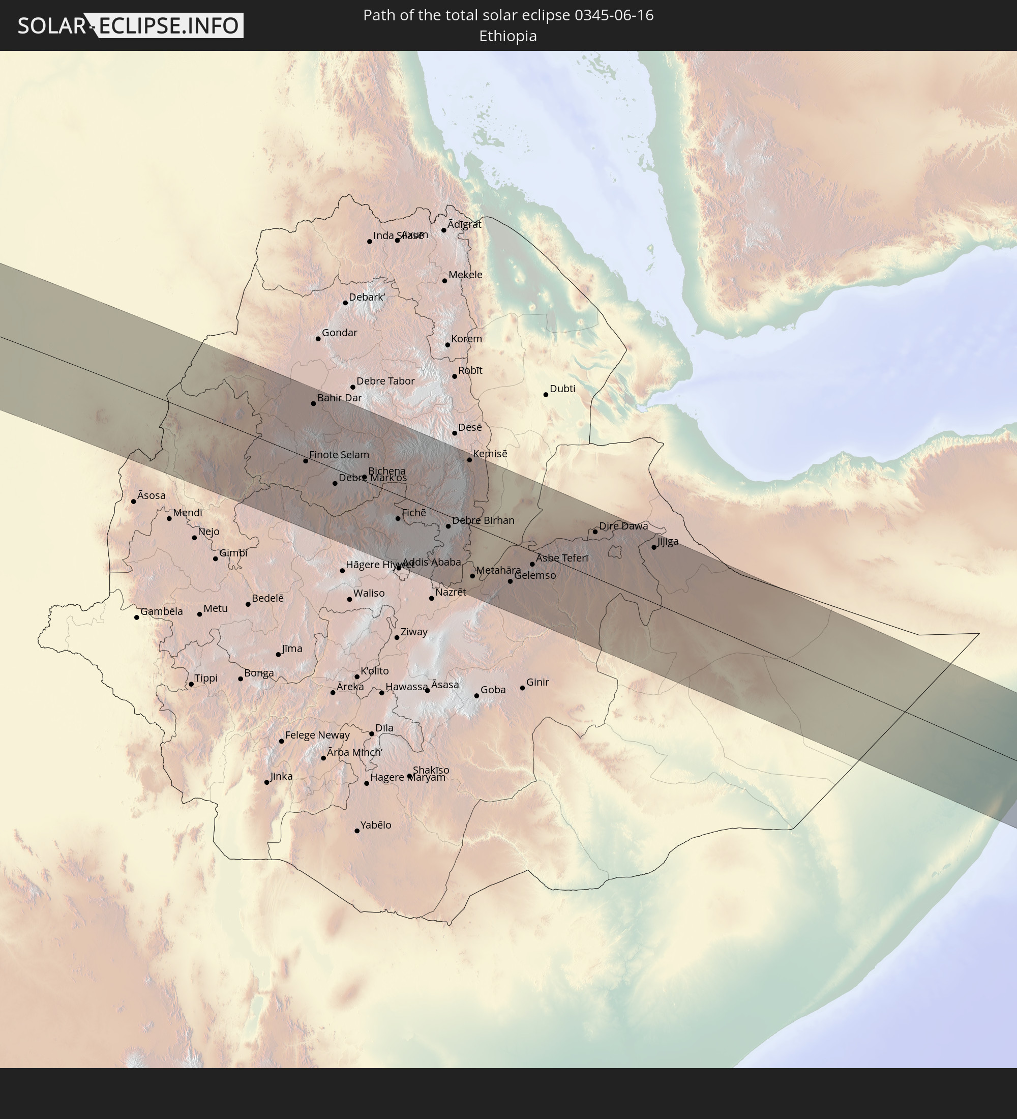 Äthiopien
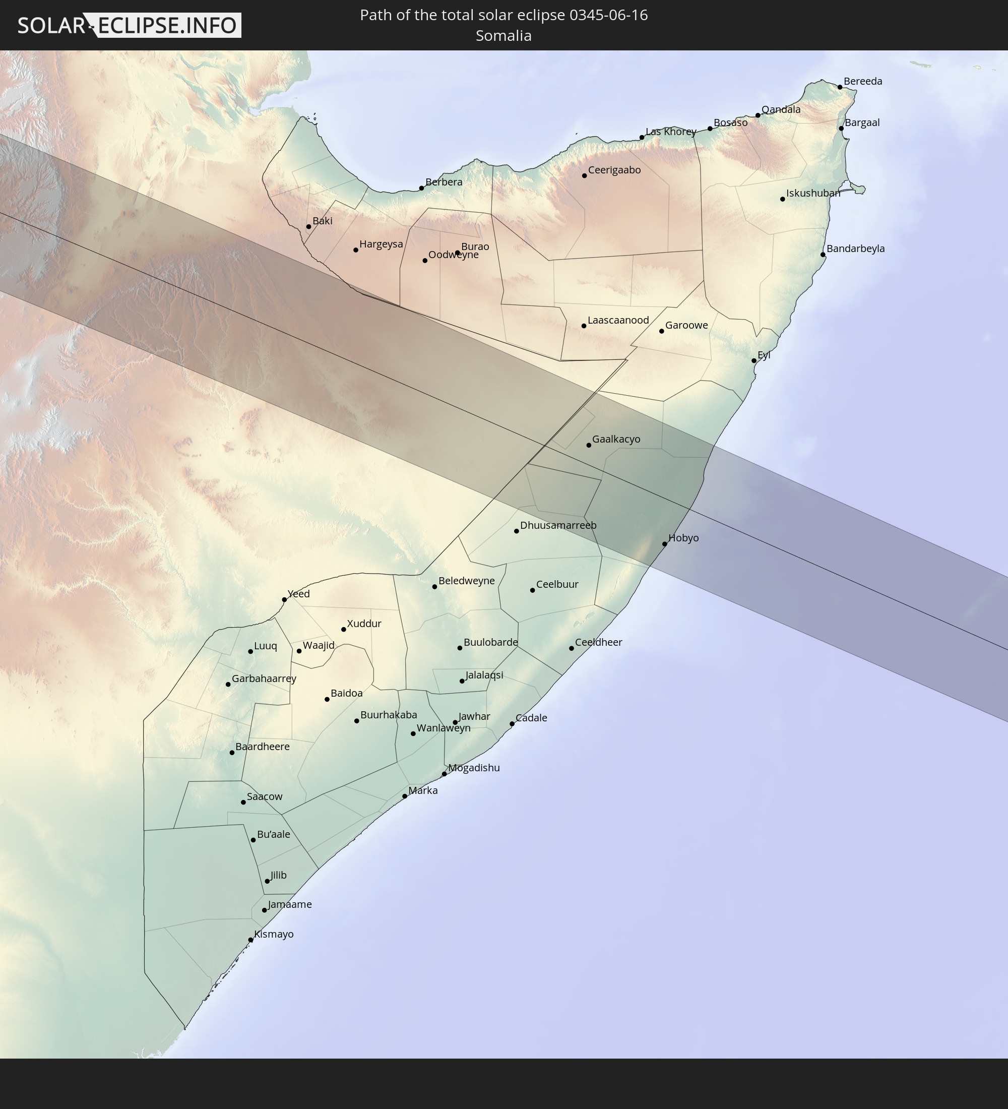 Somalia
In den folgenden Ländern ist die Sonnenfinsternis partiell zu sehen
 Russland
 Kolumbien
 Haiti
Haiti
 Brasilien
 Argentinien
 Venezuela
 Dominikanische Republik
 Aruba
Aruba
 Bolivien
 Puerto Rico
 Amerikanische Jungferninseln
 Britische Jungferninseln
 Anguilla
 Saint-Martin
 Saint-Barthélemy
 St. Kitts und Nevis
 Paraguay
 Antigua und Barbuda
 Montserrat
 Trinidad und Tobago
 Guadeloupe
 Grenada
 Dominica
 St. Vincent und die Grenadinen
 Guyana
 Martinique
 St. Lucia
 Barbados
 Uruguay
 Suriname
 Französisch-Guayana
 Portugal
 Kap Verde
 Spanien
 Senegal
 Mauretanien
 Gambia
 Guinea-Bissau
 Guinea
 St. Helena
 Sierra Leone
 Marokko
 Mali
Mali
 Liberia
 Algerien
 Elfenbeinküste
 Burkina Faso
 Gibraltar
 Frankreich
 Ghana
Ghana
 Togo
Togo
 Niger
Niger
 Benin
Benin
 Andorra
 Nigeria
 Äquatorialguinea
 Deutschland
 Schweiz
 São Tomé und Príncipe
 Italien
 Monaco
 Tunesien
 Kamerun
 Gabun
Gabun
 Libyen
 Liechtenstein
 Österreich
 Republik Kongo
 Angola
 Namibia
 Tschechien
 Demokratische Republik Kongo
 San Marino
 Vatikanstadt
 Slowenien
 Tschad
 Kroatien
 Malta
Malta
 Zentralafrikanische Republik
 Bosnien und Herzegowina
 Ungarn
 Slowakei
 Montenegro
 Serbien
 Albanien
 Griechenland
 Botswana
 Rumänien
 Mazedonien
 Sudan
Sudan
 Sambia
 Ukraine
 Bulgarien
 Ägypten
 Simbabwe
 Türkei
 Moldawien
 Ruanda
 Burundi
 Tansania
 Uganda
 Mosambik
 Republik Zypern
 Malawi
 Äthiopien
 Kenia
Kenia
 Staat Palästina
 Israel
 Saudi-Arabien
 Jordanien
 Libanon
 Syrien
 Eritrea
 Irak
Irak
 Georgien
 Französische Süd- und Antarktisgebiete
 Somalia
 Dschibuti
 Jemen
Jemen
 Madagaskar
 Komoren
 Armenien
 Iran
Iran
 Aserbaidschan
 Mayotte
 Seychellen
 Kuwait
 Bahrain
 Katar
Katar
 Vereinigte Arabische Emirate
 Oman
Oman
 Turkmenistan
 Afghanistan
 Pakistan
 Indien
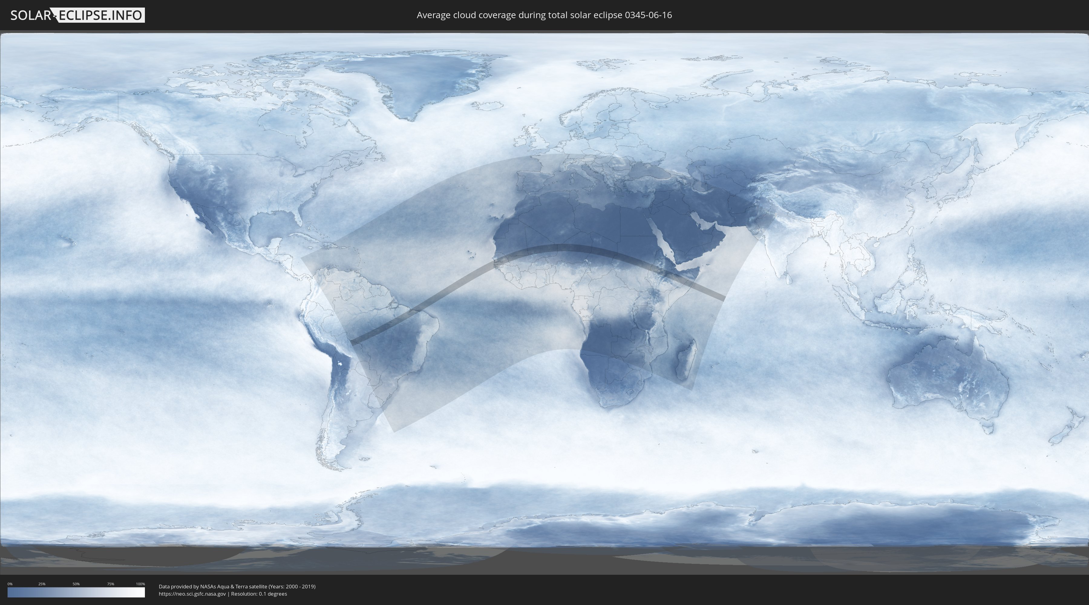
Wie wird das Wetter während der totalen Sonnenfinsternis am 16.06.0345?
Wo ist der beste Ort, um die totale Sonnenfinsternis vom 16.06.0345 zu beobachten?
Die folgenden Karten zeigen die durchschnittliche Bewölkung für den Tag, an dem die totale Sonnenfinsternis
stattfindet. Mit Hilfe der Karten lässt sich der Ort entlang des Finsternispfades eingrenzen,
der die besten Aussichen auf einen klaren wolkenfreien Himmel bietet.
Trotzdem muss man immer lokale Gegenenheiten beachten und sollte sich genau über das Wetter an seinem
gewählten Beobachtungsort informieren.
Die Daten stammen von den beiden NASA-Satelliten
AQUA und TERRA
und wurden über einen Zeitraum von 19 Jahren (2000 - 2019) gemittelt.

Detaillierte Länderkarten
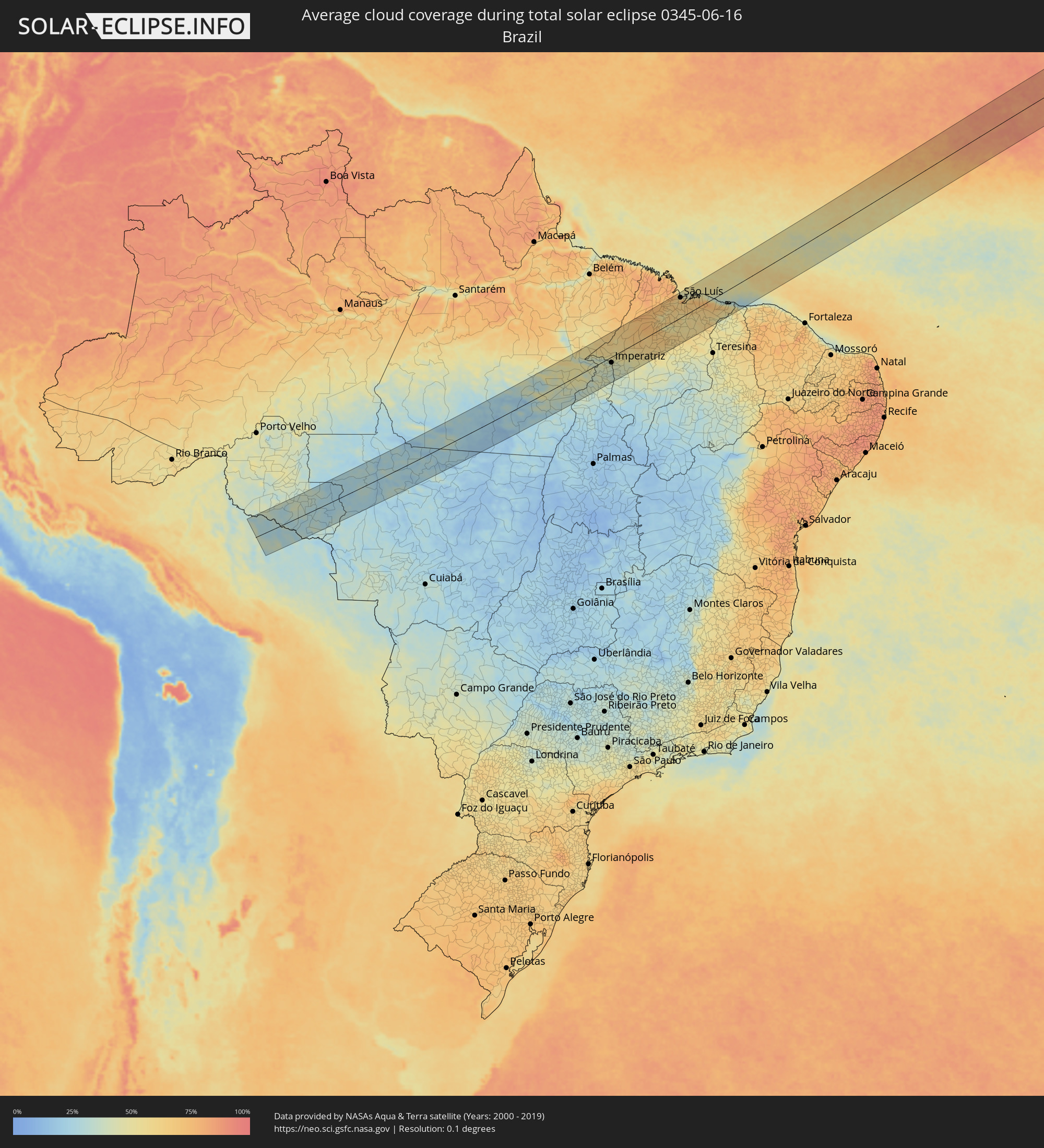 Brasilien
 Bolivien
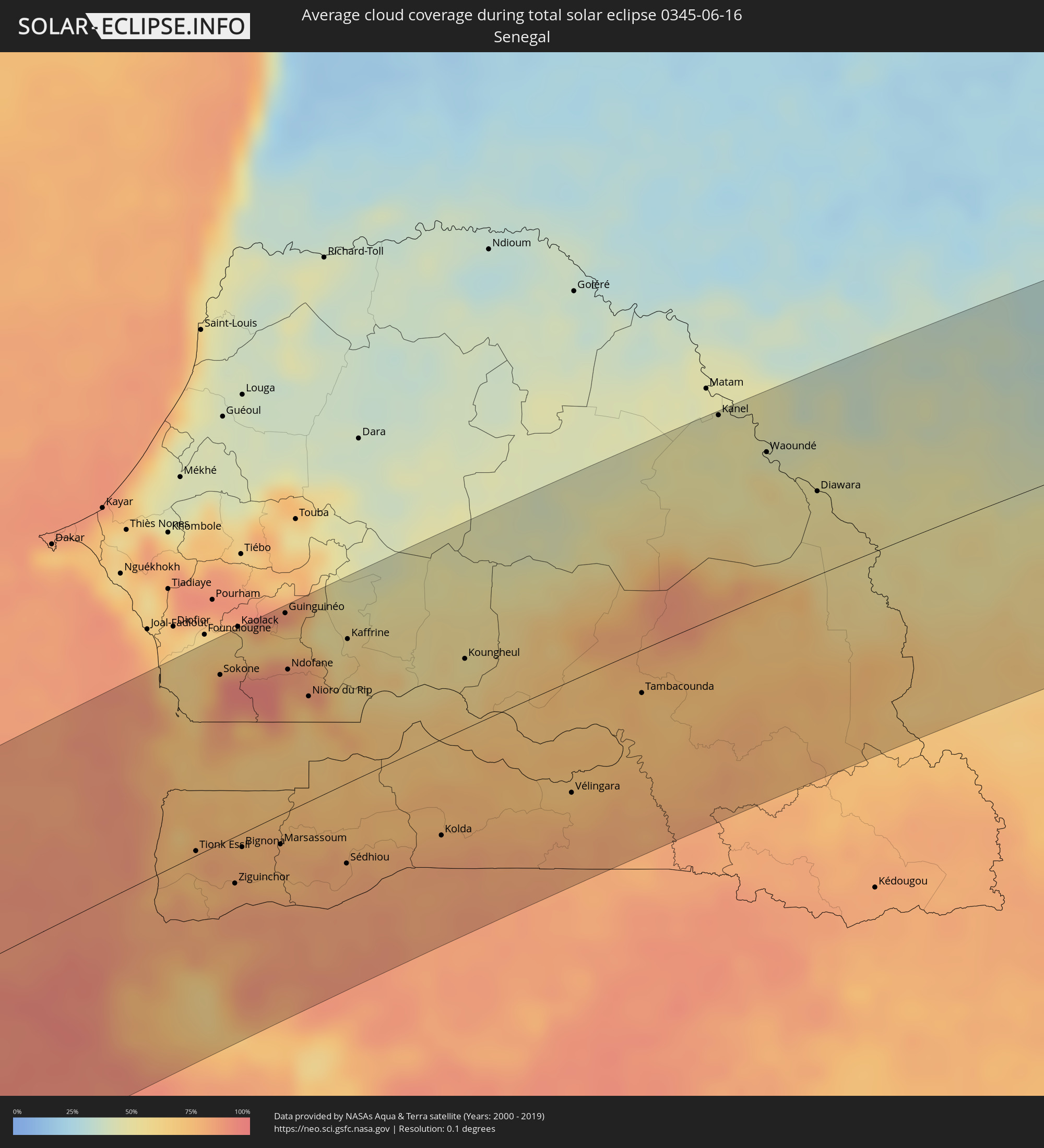 Senegal
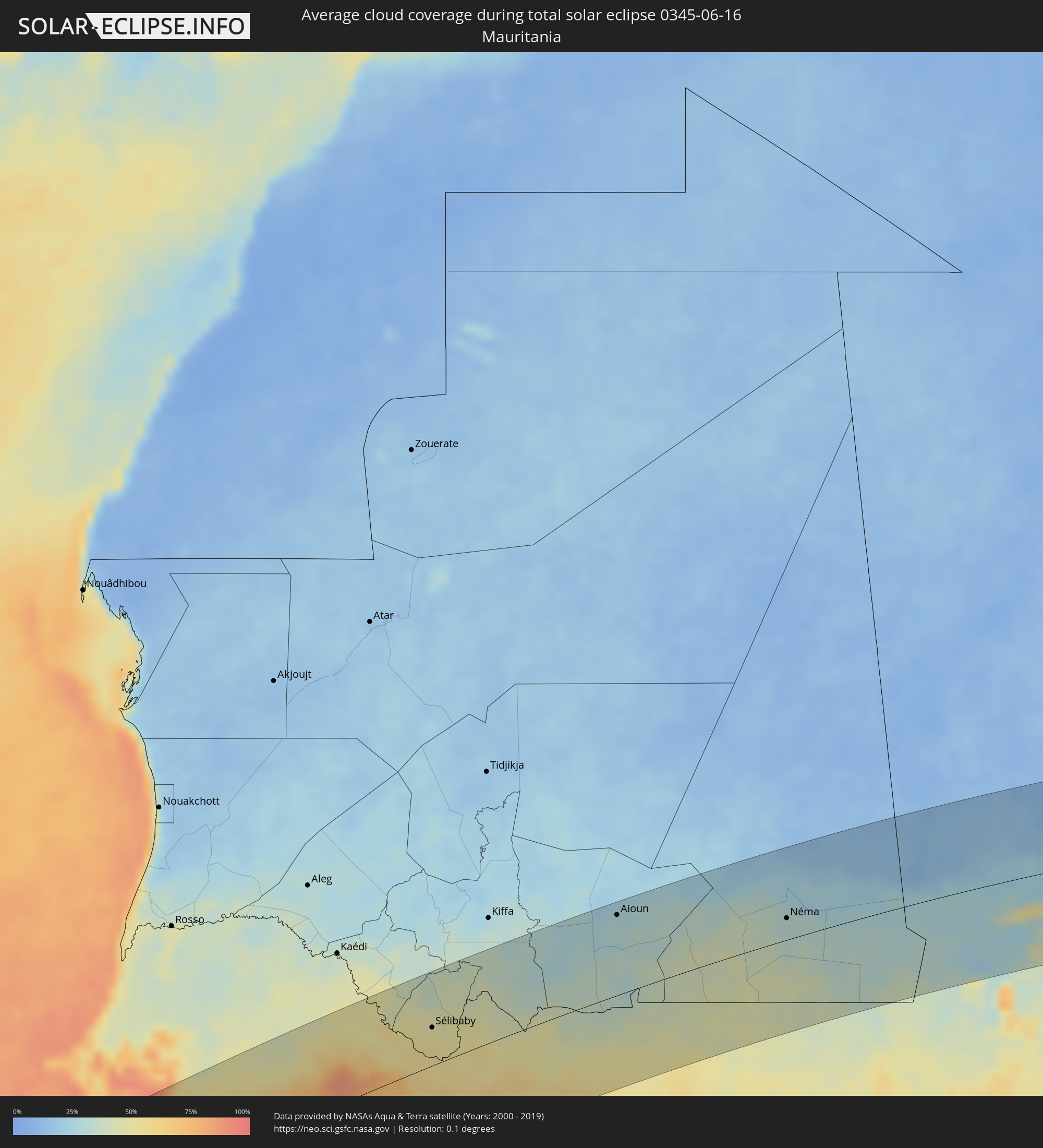 Mauretanien
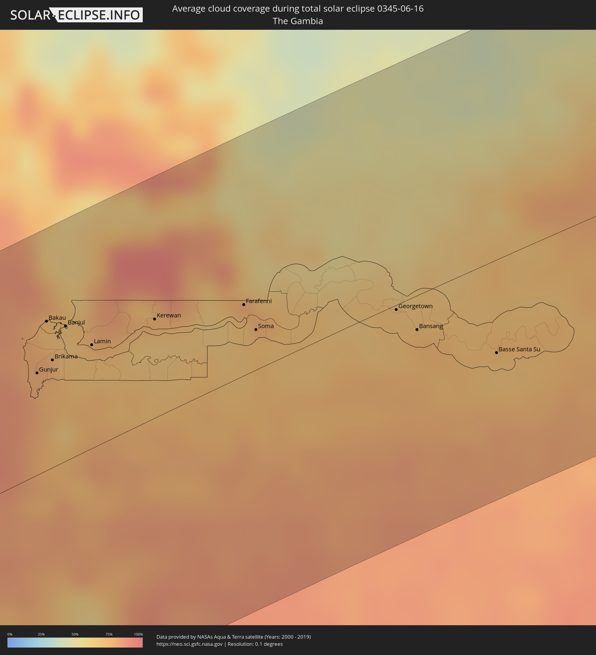 Gambia
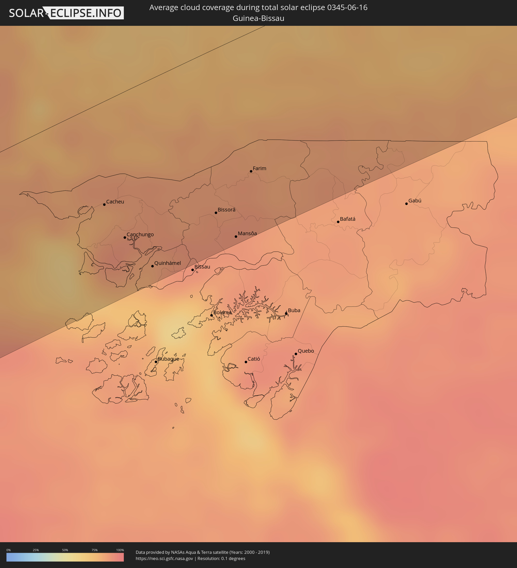 Guinea-Bissau
 Mali
Mali
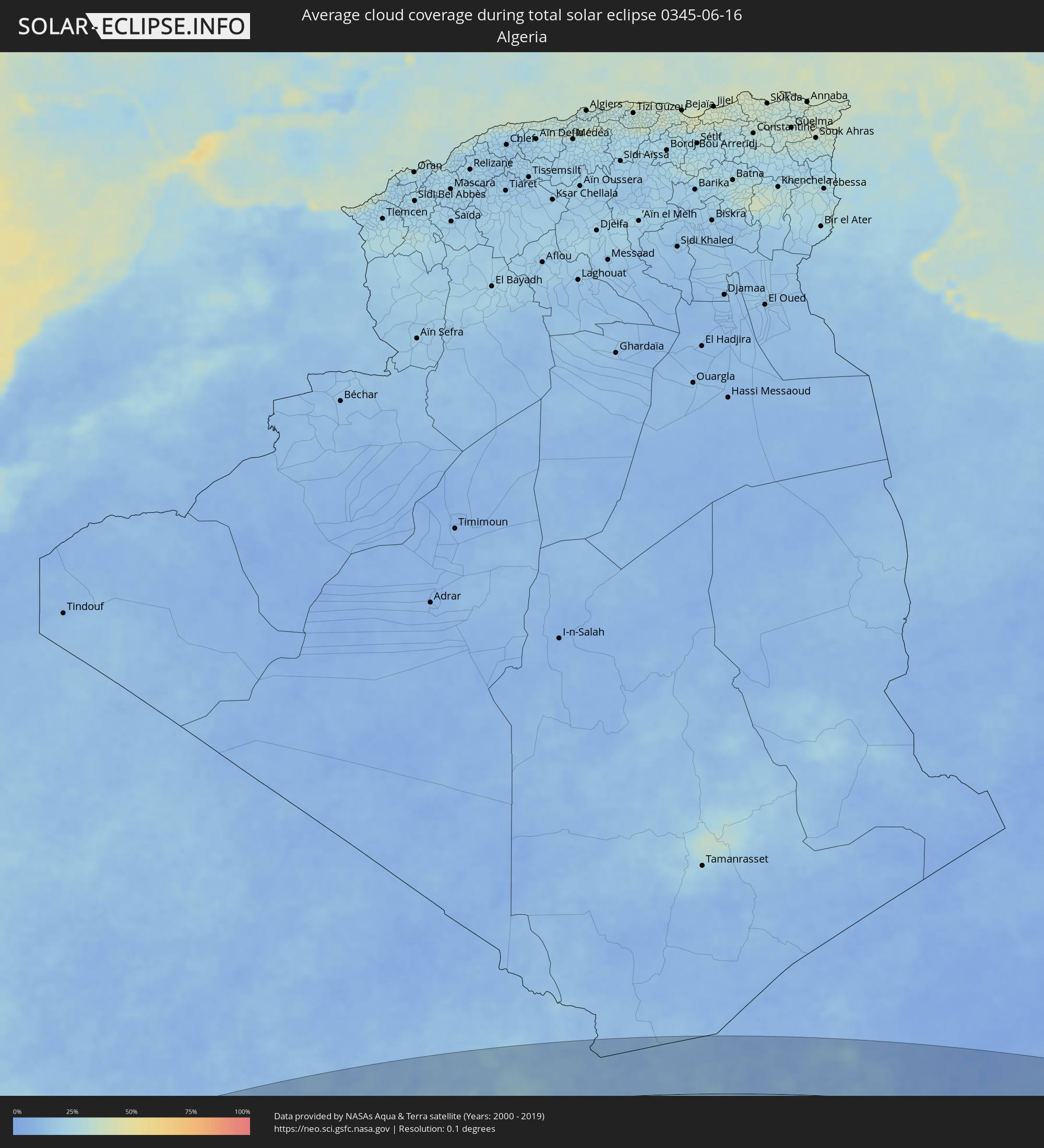 Algerien
 Niger
Niger
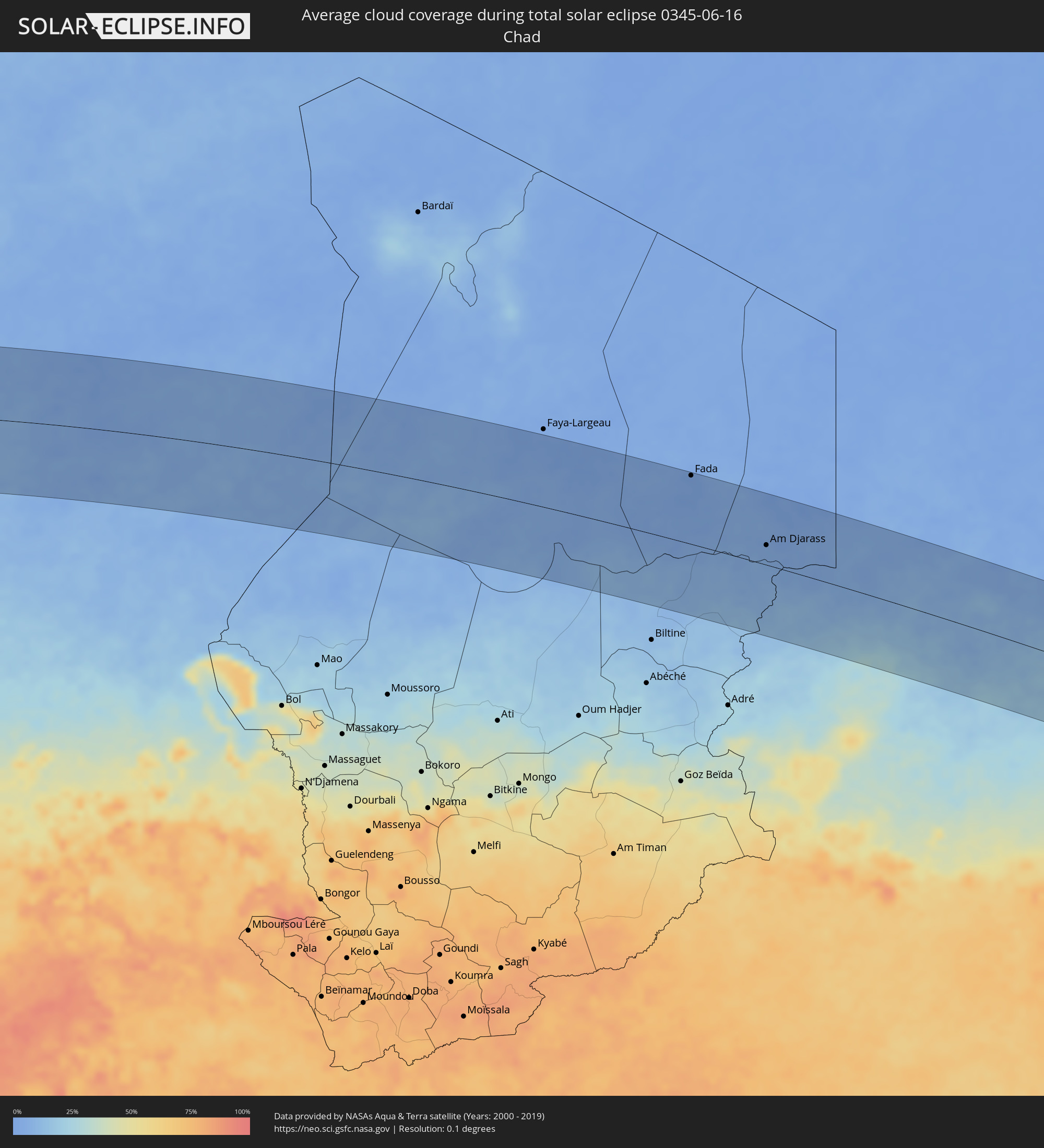 Tschad
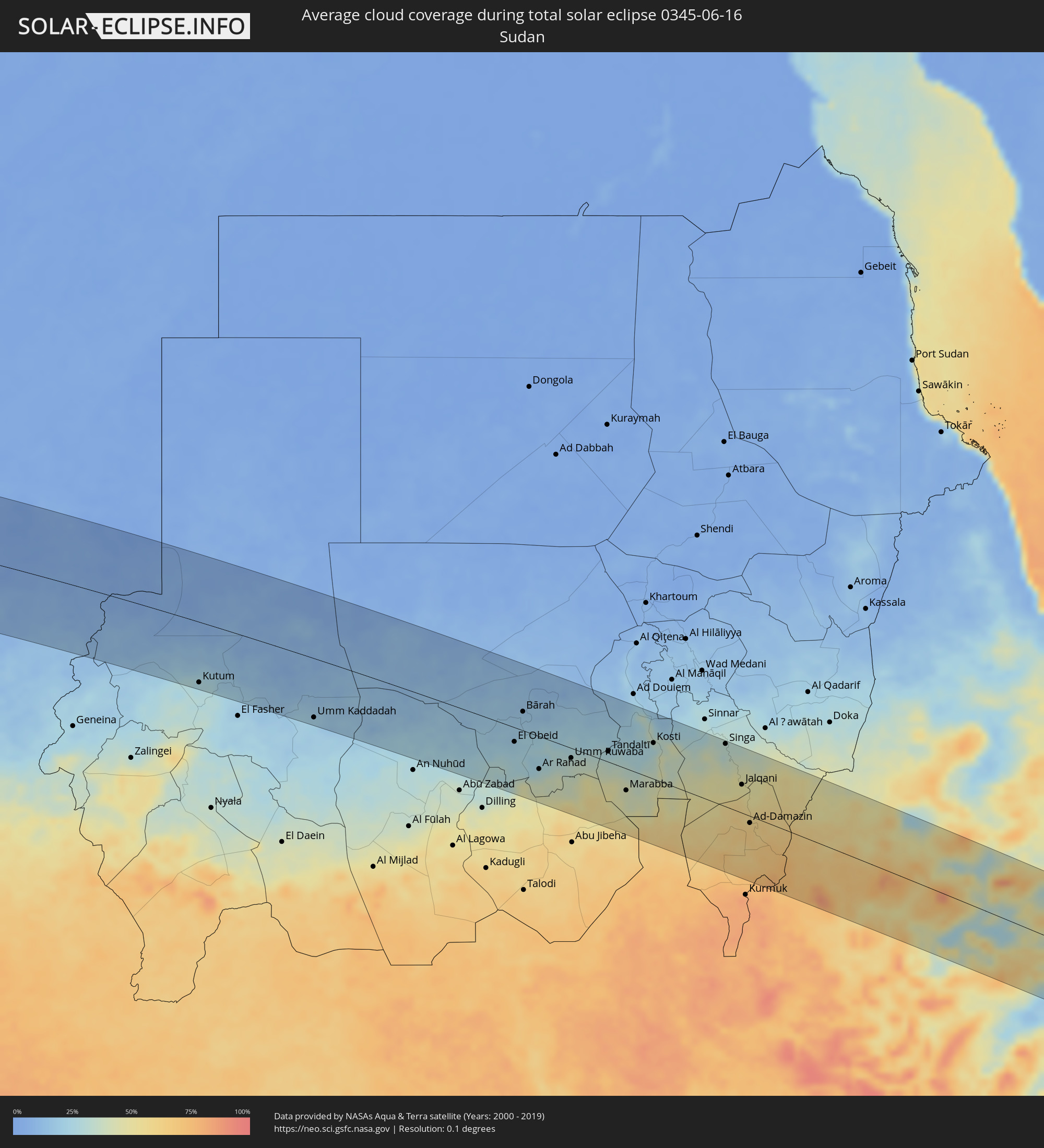 Sudan
Sudan
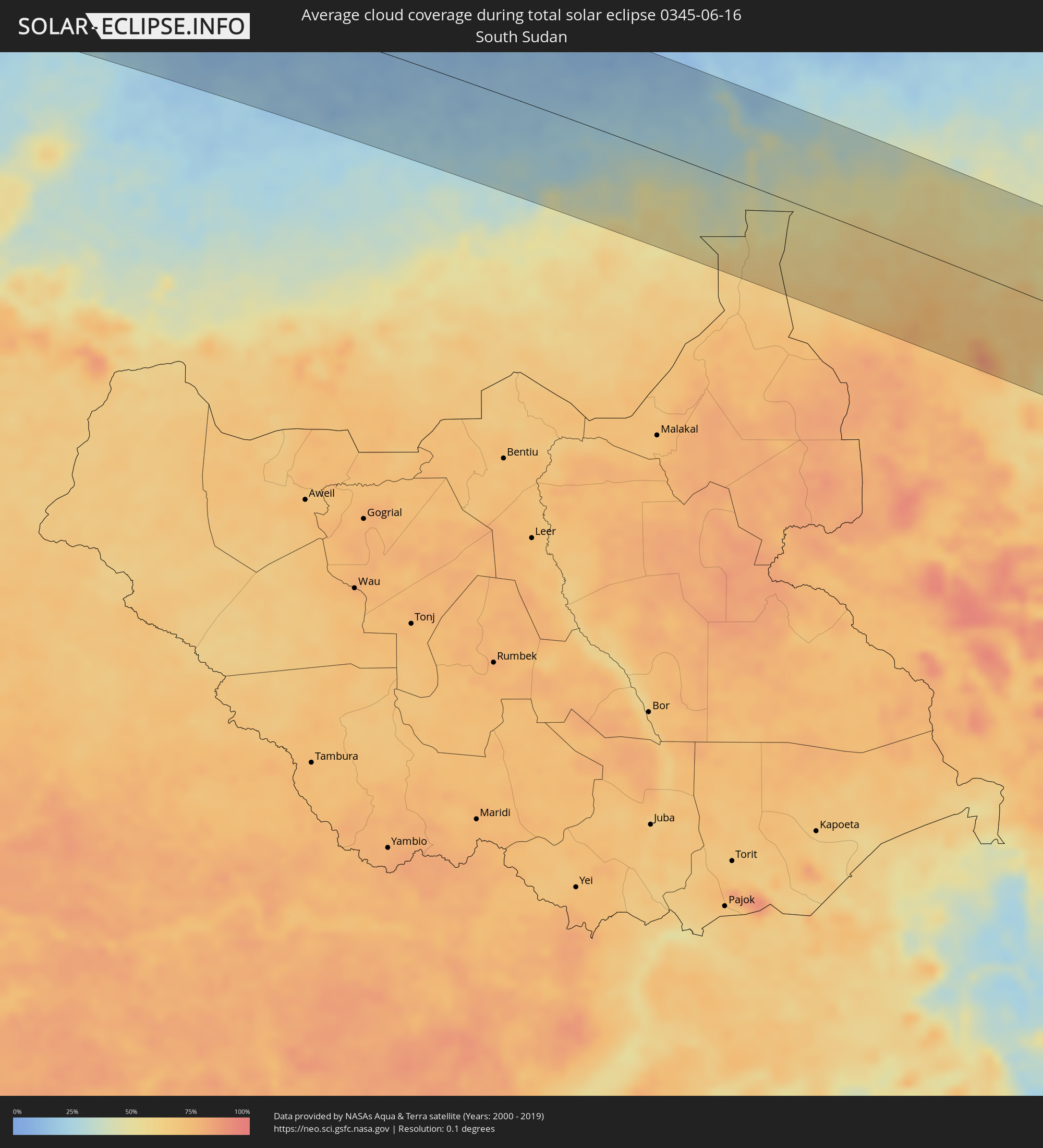 Südsudan
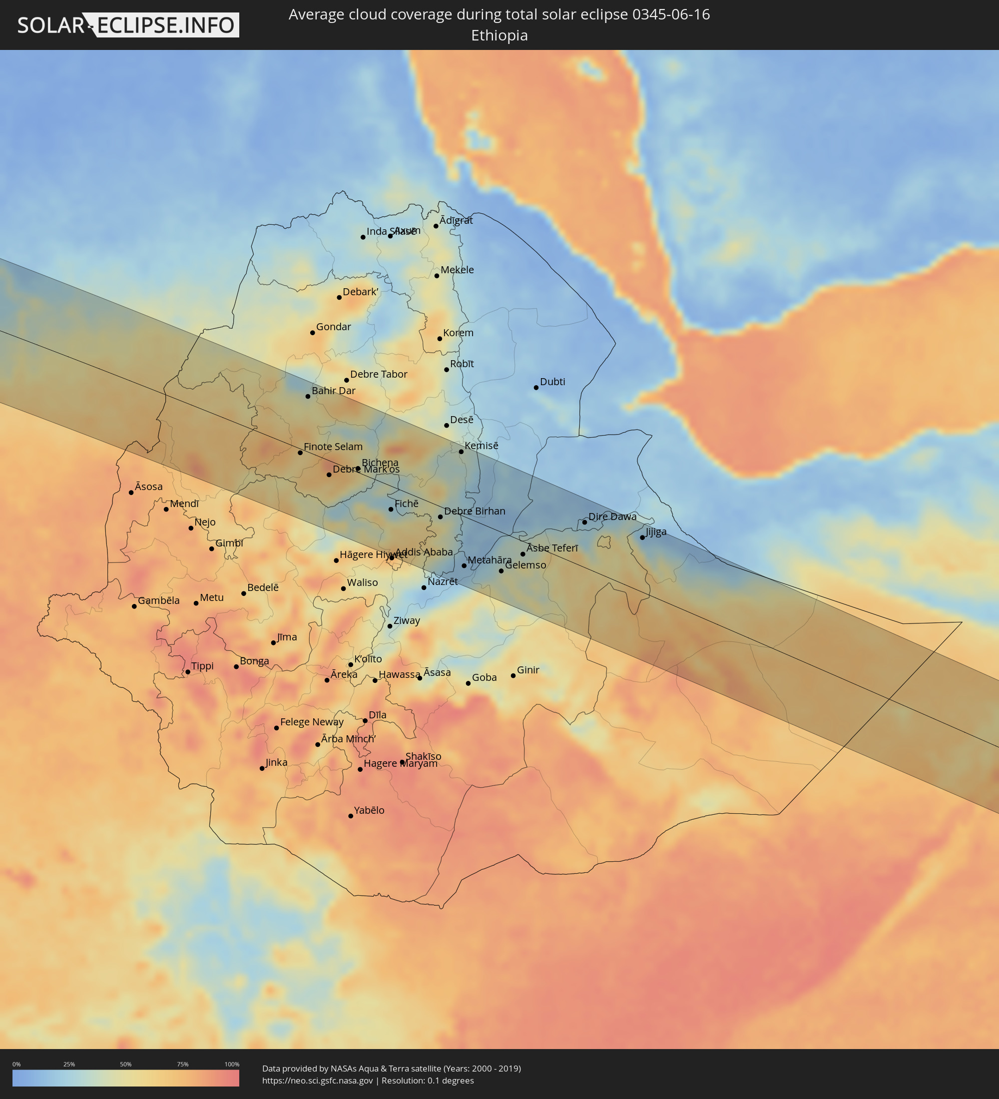 Äthiopien
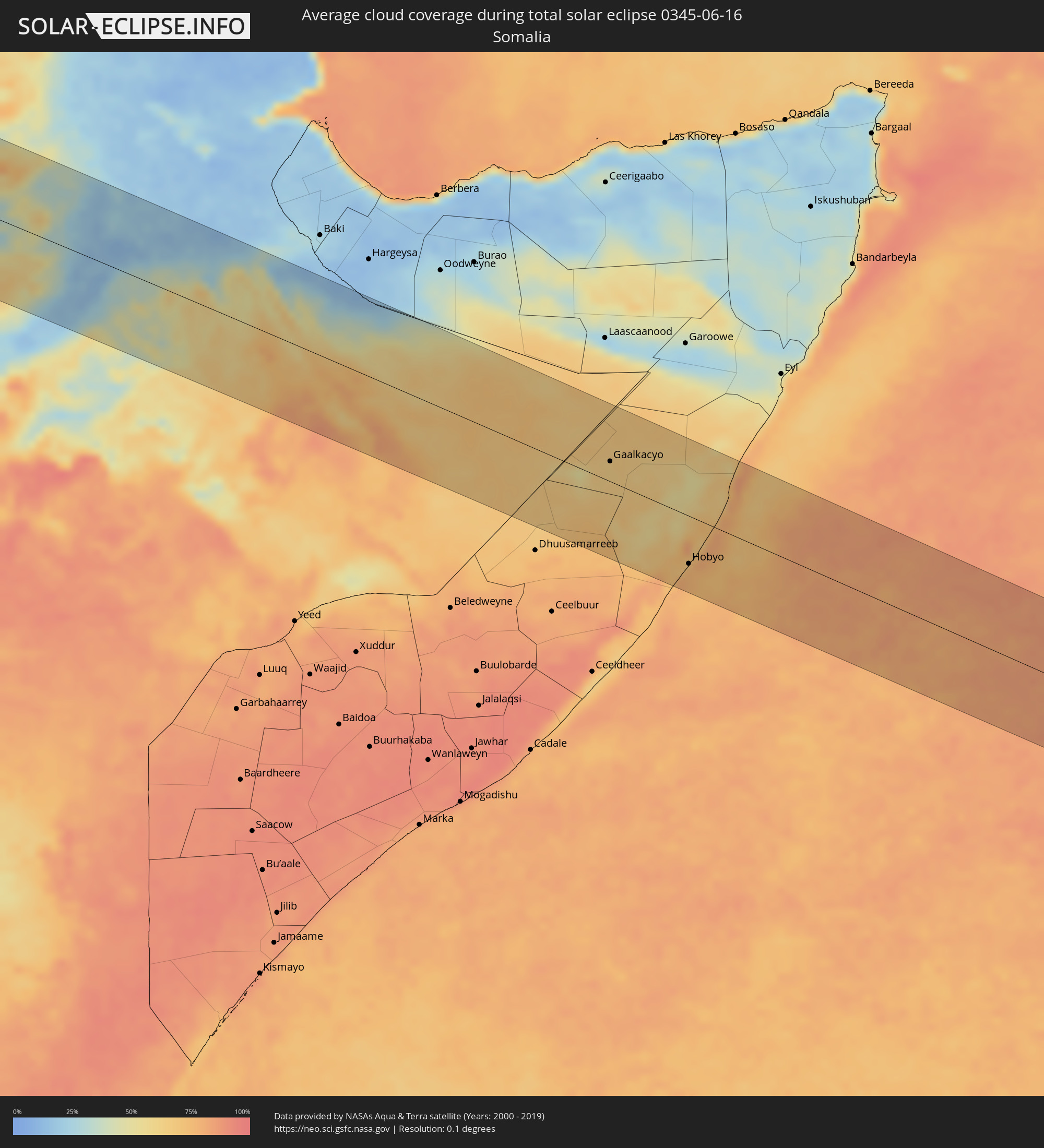 Somalia
Orte im Finsternispfad
Die nachfolgene Tabelle zeigt Städte und Orte mit mehr als 5.000 Einwohnern, die sich im Finsternispfad befinden. Städte mit mehr als 100.000 Einwohnern sind dick gekennzeichnet. Mit einem Klick auf den Ort öffnet sich eine Detailkarte die die Lage des jeweiligen Ortes zusammen mit dem Verlauf der zentralen Finsternis präsentiert.
| Ort | Typ | Dauer der Verfinsterung | Ortszeit bei maximaler Verfinsterung | Entfernung zur Zentrallinie | Ø Bewölkung |
|
Pôsto Fiscal Rolim de Moura, Rondônia
|
total | - | 06:34:03 UTC-04:02 | 35 km | 27% |
|
Cacoal, Rondônia
|
total | - | 06:34:19 UTC-04:02 | 93 km | 37% |
|
Pimenta Bueno, Rondônia
|
total | - | 06:34:17 UTC-04:02 | 57 km | 32% |
|
Vilhena, Rondônia
|
total | - | 06:34:10 UTC-04:02 | 99 km | 34% |
|
Itupiranga, Pará
|
total | - | 07:27:53 UTC-03:13 | 111 km | 40% |
|
Marabá, Pará
|
total | - | 07:27:51 UTC-03:13 | 77 km | 51% |
|
Imperatriz, Maranhão
|
total | - | 08:08:31 UTC-02:34 | 26 km | 42% |
|
Santa Inês, Maranhão
|
total | - | 08:10:41 UTC-02:34 | 39 km | 70% |
|
Lago da Pedra, Maranhão
|
total | - | 08:10:26 UTC-02:34 | 29 km | 68% |
|
Viana, Maranhão
|
total | - | 08:11:11 UTC-02:34 | 61 km | 58% |
|
Bacabal, Maranhão
|
total | - | 08:10:43 UTC-02:34 | 54 km | 61% |
|
São Mateus do Maranhão, Maranhão
|
total | - | 08:11:03 UTC-02:34 | 47 km | 58% |
|
Itapecuru Mirim, Maranhão
|
total | - | 08:11:30 UTC-02:34 | 9 km | 62% |
|
São Luís, Maranhão
|
total | - | 08:12:03 UTC-02:34 | 89 km | 76% |
|
Coroatá, Maranhão
|
total | - | 08:11:14 UTC-02:34 | 75 km | 56% |
|
São José de Ribamar, Maranhão
|
total | - | 08:12:12 UTC-02:34 | 72 km | 60% |
|
Vargem Grande, Maranhão
|
total | - | 08:11:43 UTC-02:34 | 30 km | 61% |
|
Chapadinha, Maranhão
|
total | - | 08:11:59 UTC-02:34 | 81 km | 58% |
|
Parnaíba, Piauí
|
total | - | 08:13:39 UTC-02:34 | 89 km | 57% |
|
Gunjur, Western
|
total | - | 11:25:56 UTC-00:16 | 54 km | 76% |
|
Sukuta, Western
|
total | - | 11:26:14 UTC-00:16 | 74 km | 79% |
|
Bakau, Banjul
|
total | - | 11:26:22 UTC-00:16 | 80 km | 74% |
|
Abuko, Western
|
total | - | 11:26:21 UTC-00:16 | 71 km | 79% |
|
Brikama, Western
|
total | - | 11:26:13 UTC-00:16 | 57 km | 74% |
|
Banjul, Banjul
|
total | - | 11:26:35 UTC-00:16 | 72 km | 70% |
|
Barra, North Bank
|
total | - | 11:26:42 UTC-00:16 | 74 km | 71% |
|
Essau, North Bank
|
total | - | 11:26:44 UTC-00:16 | 73 km | 71% |
|
Tionk Essil, Ziguinchor
|
total | - | 11:25:58 UTC-00:16 | 3 km | 78% |
|
Lamin, North Bank
|
total | - | 11:26:49 UTC-00:16 | 55 km | 72% |
|
Sokone, Fatick
|
total | - | 11:27:35 UTC-00:16 | 105 km | 75% |
|
Ziguinchor, Ziguinchor
|
total | - | 11:26:21 UTC-00:16 | 29 km | 79% |
|
Passi, Fatick
|
total | - | 11:27:56 UTC-00:16 | 111 km | 91% |
|
Bignona, Ziguinchor
|
total | - | 11:26:43 UTC-00:16 | 9 km | 80% |
|
Cacheu, Cacheu
|
total | - | 10:40:03 UTC-01:02 | 65 km | 80% |
|
Kerewan, North Bank
|
total | - | 11:27:48 UTC-00:16 | 53 km | 67% |
|
Canchungo, Cacheu
|
total | - | 10:40:09 UTC-01:02 | 92 km | 84% |
|
Marsassoum, Kolda
|
total | - | 11:27:20 UTC-00:16 | 19 km | 77% |
|
Guinguinéo, Fatick
|
total | - | 11:29:01 UTC-00:16 | 125 km | 75% |
|
Ndofane, Kaolack
|
total | - | 11:28:40 UTC-00:16 | 89 km | 81% |
|
Quinhámel, Biombo
|
total | - | 10:40:23 UTC-01:02 | 119 km | 80% |
|
Nioro du Rip, Kaolack
|
total | - | 11:28:48 UTC-00:16 | 66 km | 70% |
|
Farafenni, North Bank
|
total | - | 11:29:05 UTC-00:16 | 38 km | 73% |
|
Sédhiou, Sédhiou
|
total | - | 11:28:14 UTC-00:16 | 50 km | 80% |
|
Kaffrine, Kaffrine
|
total | - | 11:29:49 UTC-00:16 | 90 km | 59% |
|
Mansa Konko, Lower River
|
total | - | 11:29:06 UTC-00:16 | 26 km | 71% |
|
Soma, Lower River
|
total | - | 11:29:06 UTC-00:16 | 22 km | 74% |
|
Bissorã, Oio
|
total | - | 10:41:46 UTC-01:02 | 104 km | 88% |
|
Mansôa, Oio
|
total | - | 10:41:55 UTC-01:02 | 125 km | 88% |
|
Farim, Oio
|
total | - | 10:42:37 UTC-01:02 | 88 km | 85% |
|
Kolda, Kolda
|
total | - | 11:29:56 UTC-00:16 | 61 km | 80% |
|
Koungheul, Kaffrine
|
total | - | 11:31:32 UTC-00:16 | 44 km | 56% |
|
Georgetown, Central River
|
total | - | 11:31:08 UTC-00:16 | 3 km | 71% |
|
Bansang, Central River
|
total | - | 11:31:18 UTC-00:16 | 19 km | 72% |
|
Basse Santa Su, Upper River
|
total | - | 11:32:16 UTC-00:16 | 51 km | 70% |
|
Sabi, Upper River
|
total | - | 11:32:13 UTC-00:16 | 59 km | 73% |
|
Vélingara, Kolda
|
total | - | 11:32:21 UTC-00:16 | 71 km | 73% |
|
Tambacounda, Tambacounda
|
total | - | 11:34:10 UTC-00:16 | 28 km | 75% |
|
Kanel, Matam
|
total | - | 11:37:16 UTC-00:16 | 128 km | 48% |
|
Sémé, Matam
|
total | - | 11:37:33 UTC-00:16 | 88 km | 52% |
|
Waoundé, Matam
|
total | - | 11:37:49 UTC-00:16 | 91 km | 54% |
|
Diawara, Matam
|
total | - | 11:38:25 UTC-00:16 | 53 km | 53% |
|
Sélibaby, Guidimaka
|
total | - | 11:39:30 UTC-00:16 | 53 km | 48% |
|
Kayes, Kayes
|
total | - | 11:40:44 UTC-00:16 | 50 km | 60% |
|
Aioun, Hodh El Gharbi
|
total | - | 11:47:52 UTC-00:16 | 113 km | 27% |
|
Néma, Hodh ech Chargui
|
total | - | 11:54:22 UTC-00:16 | 31 km | 30% |
|
Goundam, Tombouctou
|
total | - | 12:04:33 UTC-00:16 | 88 km | 39% |
|
Timbuktu, Tombouctou
|
total | - | 12:06:44 UTC-00:16 | 63 km | 25% |
|
Kidal, Kidal
|
total | - | 12:20:22 UTC-00:16 | 49 km | 21% |
|
Alaghsas, Agadez
|
total | - | 13:08:18 UTC+00:13 | 130 km | 14% |
|
Fada, Ennedi-Ouest
|
total | - | 14:25:53 UTC+01:00 | 119 km | 1% |
|
Am Djarass, Ennedi-Est
|
total | - | 14:28:39 UTC+01:00 | 34 km | 5% |
|
Kutum, Northern Darfur
|
total | - | 15:42:32 UTC+02:10 | 110 km | 26% |
|
Umm Kaddadah, Northern Darfur
|
total | - | 15:46:01 UTC+02:10 | 107 km | 21% |
|
El Obeid, North Kordofan
|
total | - | 15:51:10 UTC+02:10 | 26 km | 21% |
|
Bārah, North Kordofan
|
total | - | 15:51:07 UTC+02:10 | 34 km | 17% |
|
Ar Rahad, North Kordofan
|
total | - | 15:51:57 UTC+02:10 | 59 km | 31% |
|
Umm Ruwaba, North Kordofan
|
total | - | 15:52:34 UTC+02:10 | 18 km | 33% |
|
Tandaltī, White Nile
|
total | - | 15:53:18 UTC+02:10 | 18 km | 28% |
|
Marabba, White Nile
|
total | - | 15:53:59 UTC+02:10 | 39 km | 41% |
|
Kosti, White Nile
|
total | - | 15:54:09 UTC+02:10 | 64 km | 33% |
|
Rabak, White Nile
|
total | - | 15:54:14 UTC+02:10 | 69 km | 33% |
|
Singa, Sinnār
|
total | - | 15:55:33 UTC+02:10 | 112 km | 33% |
|
Jalqani, Sinnār
|
total | - | 15:56:12 UTC+02:10 | 50 km | 53% |
|
Ad-Damazin, Blue Nile
|
total | - | 15:56:39 UTC+02:10 | 12 km | 64% |
|
Ar Ruseris, Blue Nile
|
total | - | 15:56:39 UTC+02:10 | 3 km | 60% |
|
Burē, Amhara
|
total | - | 16:16:53 UTC+02:27 | 15 km | 67% |
|
Finote Selam, Amhara
|
total | - | 16:17:04 UTC+02:27 | 7 km | 56% |
|
Bahir Dar, Amhara
|
total | - | 16:16:47 UTC+02:27 | 90 km | 46% |
|
Addiet Canna, Amhara
|
total | - | 16:17:00 UTC+02:27 | 60 km | 57% |
|
Debre Mark’os, Amhara
|
total | - | 16:17:37 UTC+02:27 | 24 km | 69% |
|
Bichena, Amhara
|
total | - | 16:17:58 UTC+02:27 | 6 km | 58% |
|
Gebre Guracha, Oromiya
|
total | - | 16:18:24 UTC+02:27 | 53 km | 52% |
|
Fichē, Oromiya
|
total | - | 16:18:41 UTC+02:27 | 39 km | 38% |
|
Debre Birhan, Amhara
|
total | - | 16:19:21 UTC+02:27 | 18 km | 49% |
|
Kemisē, Amhara
|
total | - | 16:19:11 UTC+02:27 | 103 km | 37% |
|
Metahāra, Oromiya
|
total | - | 16:19:57 UTC+02:27 | 81 km | 18% |
|
Abomsa, Amhara
|
total | - | 16:19:34 UTC+02:27 | 33 km | 24% |
|
Gelemso, Oromiya
|
total | - | 16:20:25 UTC+02:27 | 64 km | 41% |
|
Bedēsa, Oromiya
|
total | - | 16:20:34 UTC+02:27 | 44 km | 44% |
|
Āsbe Teferī, Oromiya
|
total | - | 16:20:34 UTC+02:27 | 22 km | 38% |
|
Hīrna, Oromiya
|
total | - | 16:20:40 UTC+02:27 | 2 km | 38% |
|
Dire Dawa, Dire Dawa
|
total | - | 16:21:02 UTC+02:27 | 73 km | 24% |
|
Harar, Harari
|
total | - | 16:21:18 UTC+02:27 | 55 km | 51% |
|
Jijiga, Somali
|
total | - | 16:21:43 UTC+02:27 | 89 km | 20% |
|
Gaalkacyo, Mudug
|
total | - | 16:24:54 UTC+02:27 | 28 km | 63% |
|
Hobyo, Mudug
|
total | - | 16:25:42 UTC+02:27 | 68 km | 69% |