Totale Sonnenfinsternis vom 28.05.0355
| Wochentag: | Samstag |
| Maximale Dauer der Verfinsterung: | 03m04s |
| Maximale Breite des Finsternispfades: | 204 km |
| Saroszyklus: | 72 |
| Bedeckungsgrad: | 100% |
| Magnitude: | 1.0446 |
| Gamma: | 0.6827 |
Wo kann man die Sonnenfinsternis vom 28.05.0355 sehen?
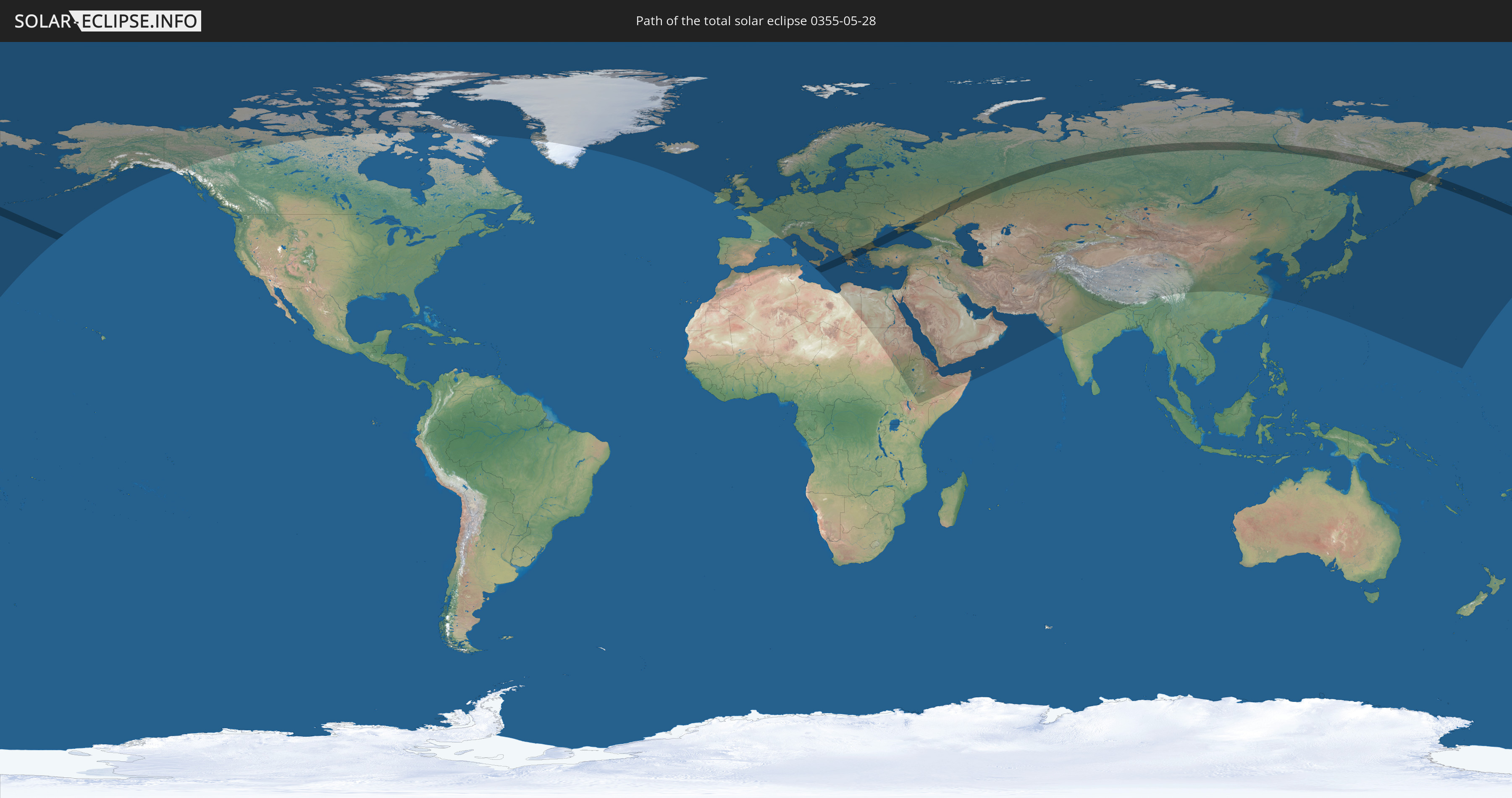
Die Sonnenfinsternis am 28.05.0355 kann man in 93 Ländern als partielle Sonnenfinsternis beobachten.
Der Finsternispfad verläuft durch 9 Länder. Nur in diesen Ländern ist sie als totale Sonnenfinsternis zu sehen.
In den folgenden Ländern ist die Sonnenfinsternis total zu sehen
 Russland
 Vereinigte Staaten
 Italien
 Malta
Malta
 Griechenland
 Ukraine
 Bulgarien
 Türkei
 Kasachstan
In den folgenden Ländern ist die Sonnenfinsternis partiell zu sehen
 Russland
 Vereinigte Staaten
 United States Minor Outlying Islands
 Kanada
 Grönland
 Island
 Irland
 Spitzbergen
 Vereinigtes Königreich
 Färöer
 Frankreich
 Isle of Man
 Guernsey
 Jersey
 Belgien
 Niederlande
 Norwegen
 Luxemburg
 Deutschland
 Schweiz
 Italien
 Monaco
 Dänemark
 Libyen
 Liechtenstein
 Österreich
 Schweden
 Tschechien
 San Marino
 Vatikanstadt
 Slowenien
 Kroatien
 Polen
Polen
 Malta
Malta
 Bosnien und Herzegowina
 Ungarn
 Slowakei
 Montenegro
 Serbien
 Albanien
 Åland Islands
 Griechenland
 Rumänien
 Mazedonien
 Finnland
 Litauen
 Lettland
 Estland
 Sudan
Sudan
 Ukraine
 Bulgarien
 Weißrussland
 Ägypten
 Türkei
 Moldawien
 Republik Zypern
 Äthiopien
 Staat Palästina
 Israel
 Saudi-Arabien
 Jordanien
 Libanon
 Syrien
 Eritrea
 Irak
Irak
 Georgien
 Somalia
 Dschibuti
 Jemen
Jemen
 Armenien
 Iran
Iran
 Aserbaidschan
 Kasachstan
 Kuwait
 Bahrain
 Katar
Katar
 Vereinigte Arabische Emirate
 Oman
Oman
 Turkmenistan
 Usbekistan
 Afghanistan
 Pakistan
 Tadschikistan
 Indien
 Kirgisistan
 Volksrepublik China
 Nepal
Nepal
 Mongolei
 Bhutan
 Japan
Japan
 Nordkorea
 Südkorea
 Marshallinseln
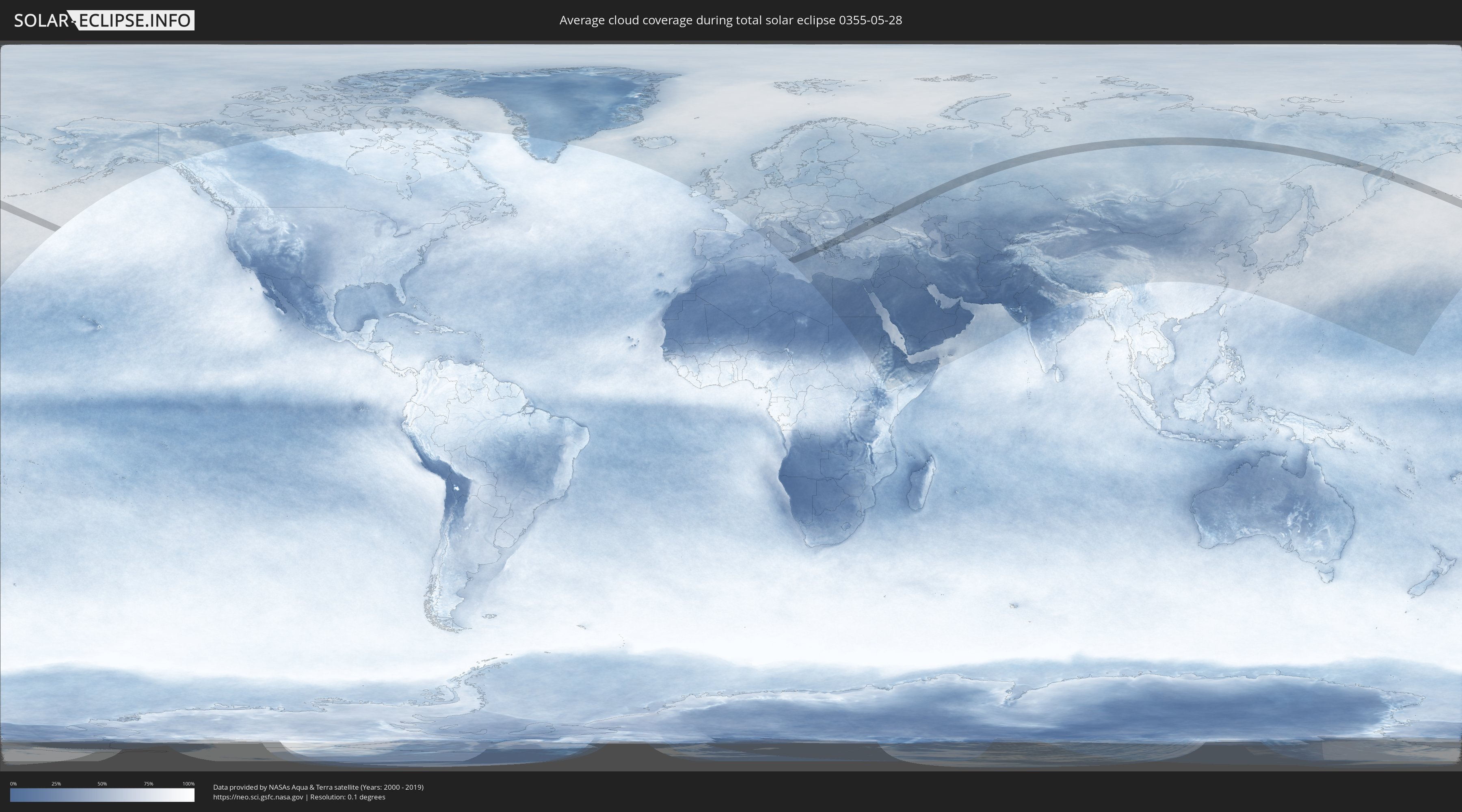
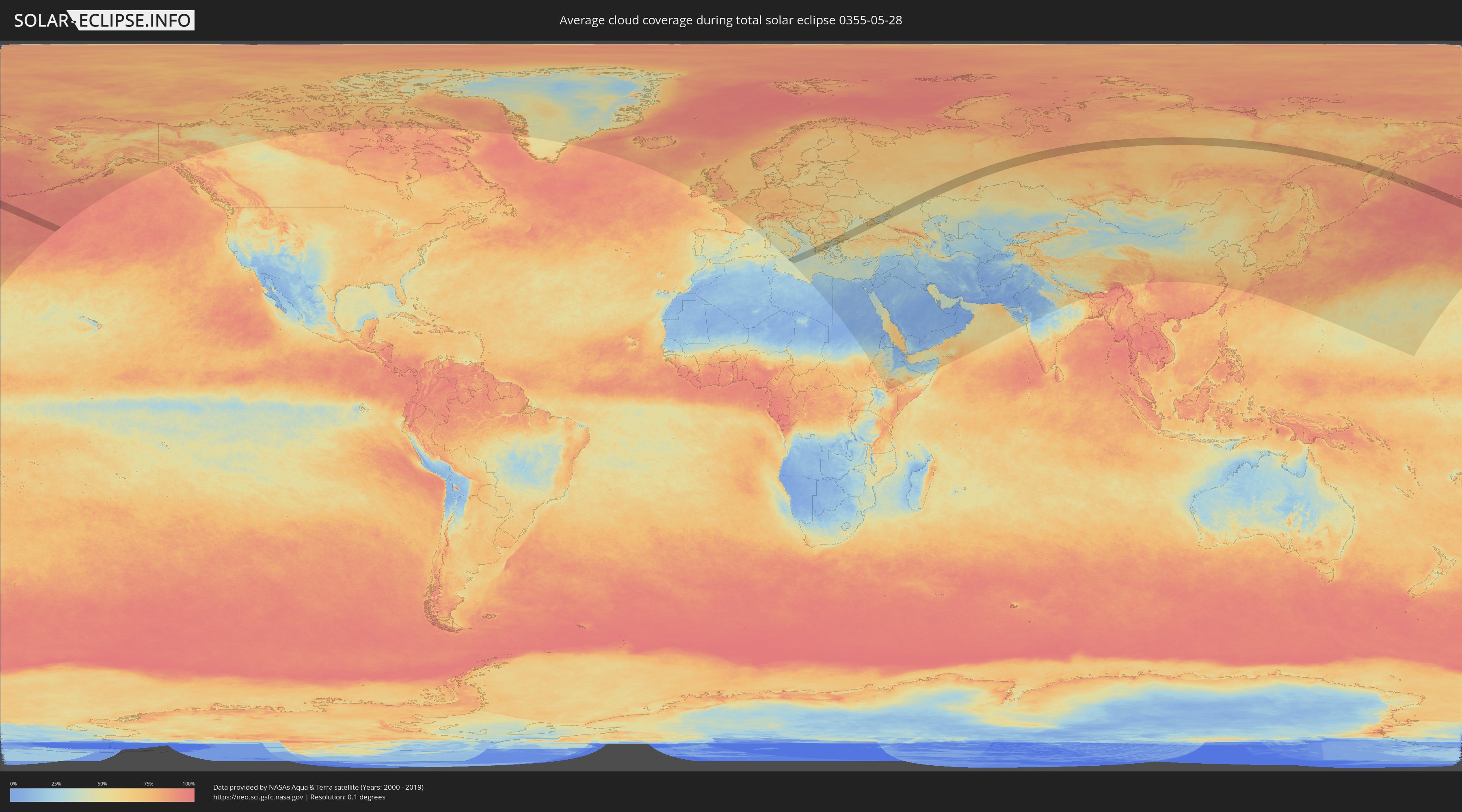
Wie wird das Wetter während der totalen Sonnenfinsternis am 28.05.0355?
Wo ist der beste Ort, um die totale Sonnenfinsternis vom 28.05.0355 zu beobachten?
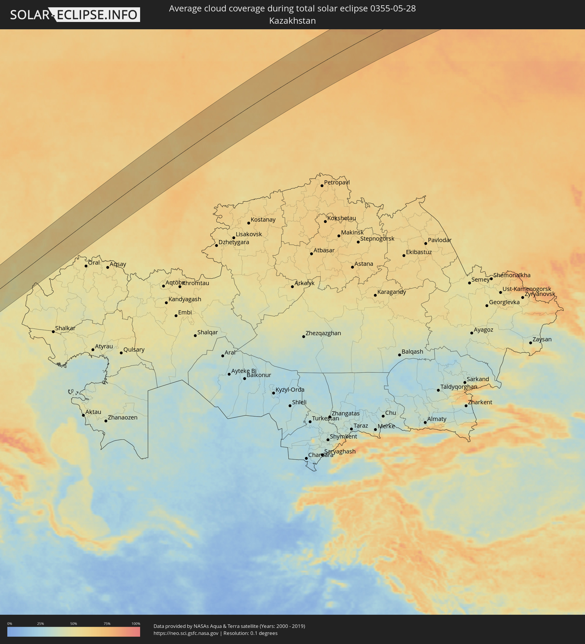
Die folgenden Karten zeigen die durchschnittliche Bewölkung für den Tag, an dem die totale Sonnenfinsternis
stattfindet. Mit Hilfe der Karten lässt sich der Ort entlang des Finsternispfades eingrenzen,
der die besten Aussichen auf einen klaren wolkenfreien Himmel bietet.
Trotzdem muss man immer lokale Gegenenheiten beachten und sollte sich genau über das Wetter an seinem
gewählten Beobachtungsort informieren.
Die Daten stammen von den beiden NASA-Satelliten
AQUA und TERRA
und wurden über einen Zeitraum von 19 Jahren (2000 - 2019) gemittelt.
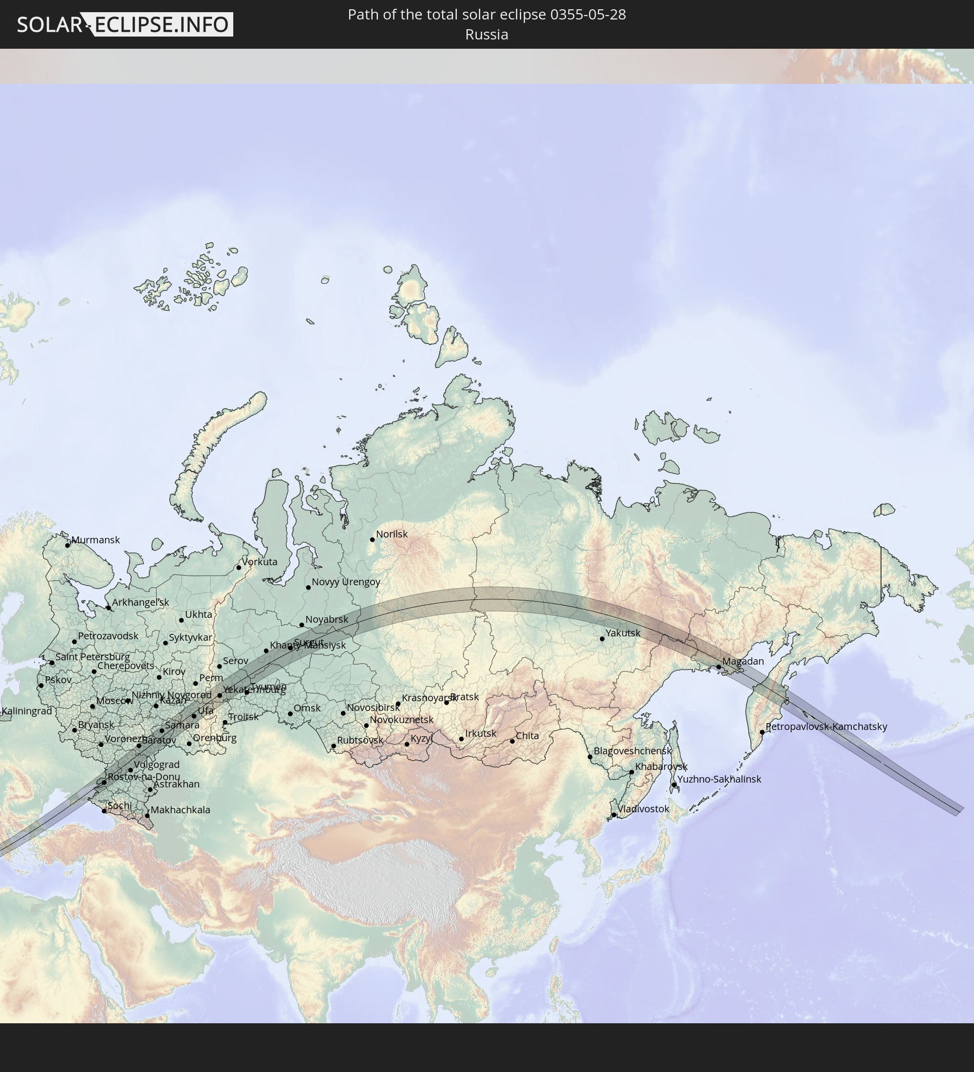
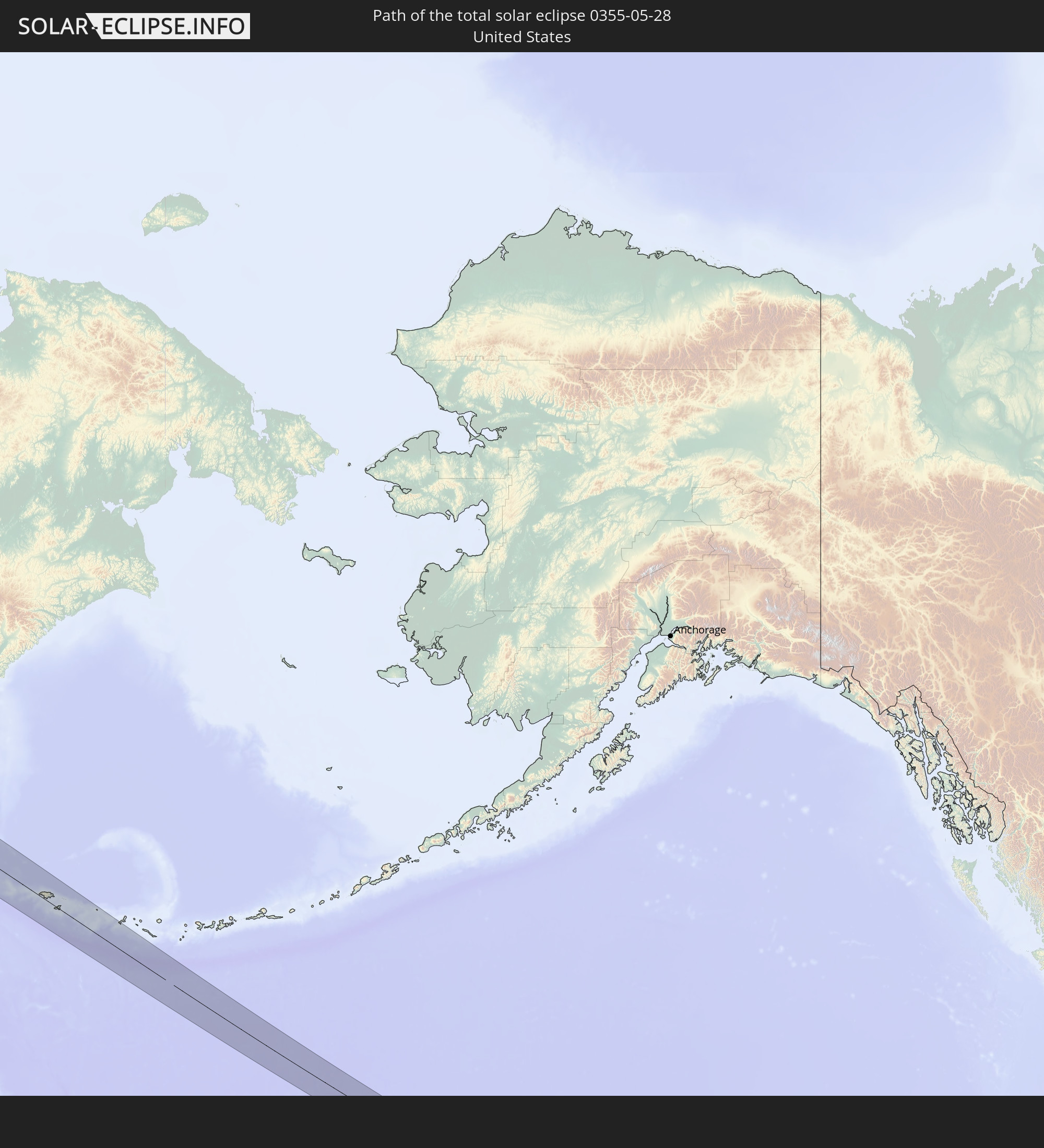
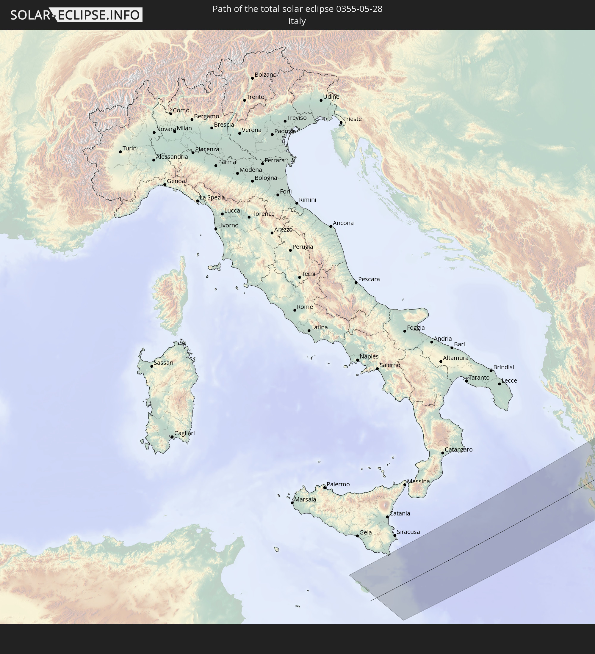
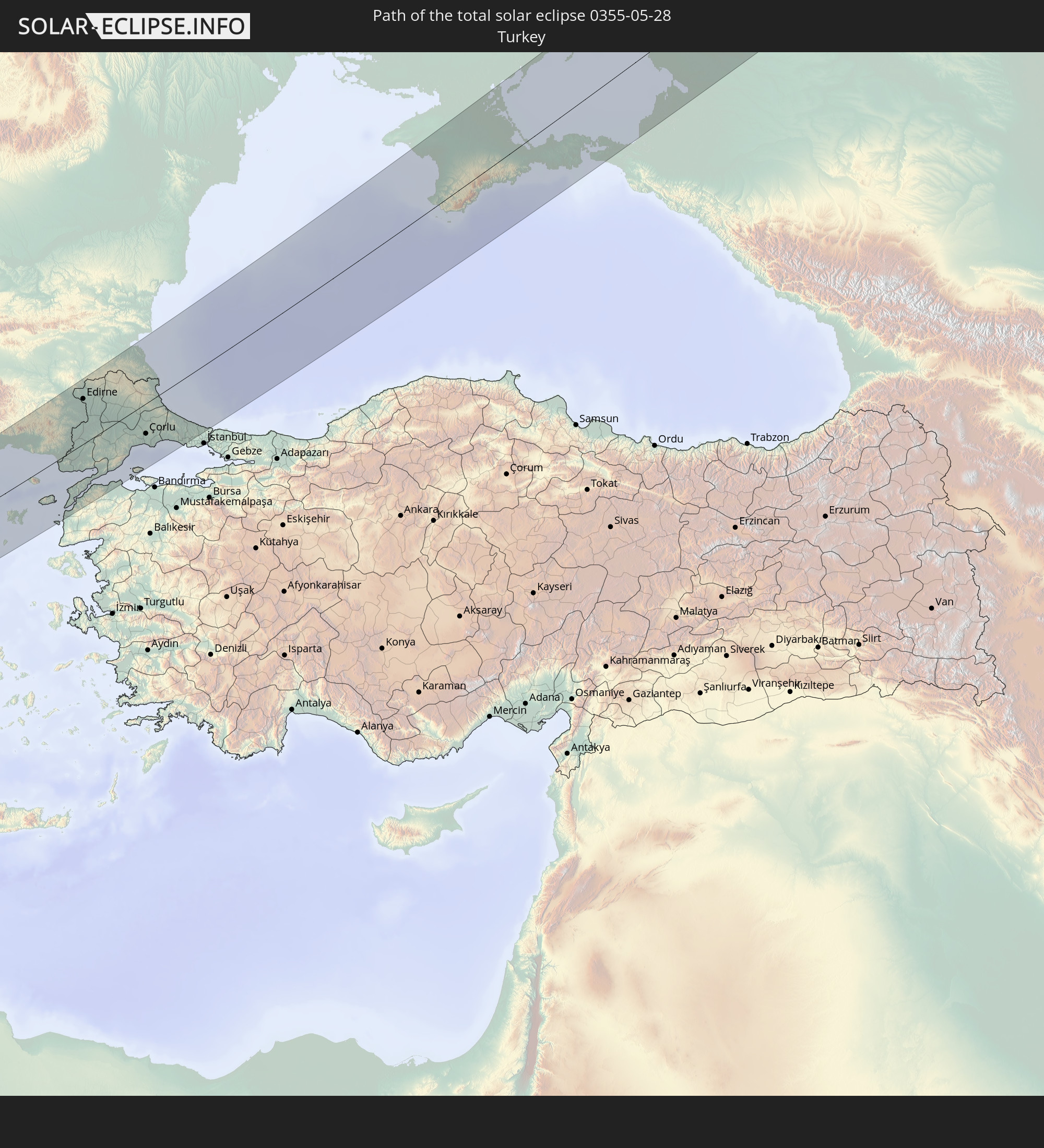
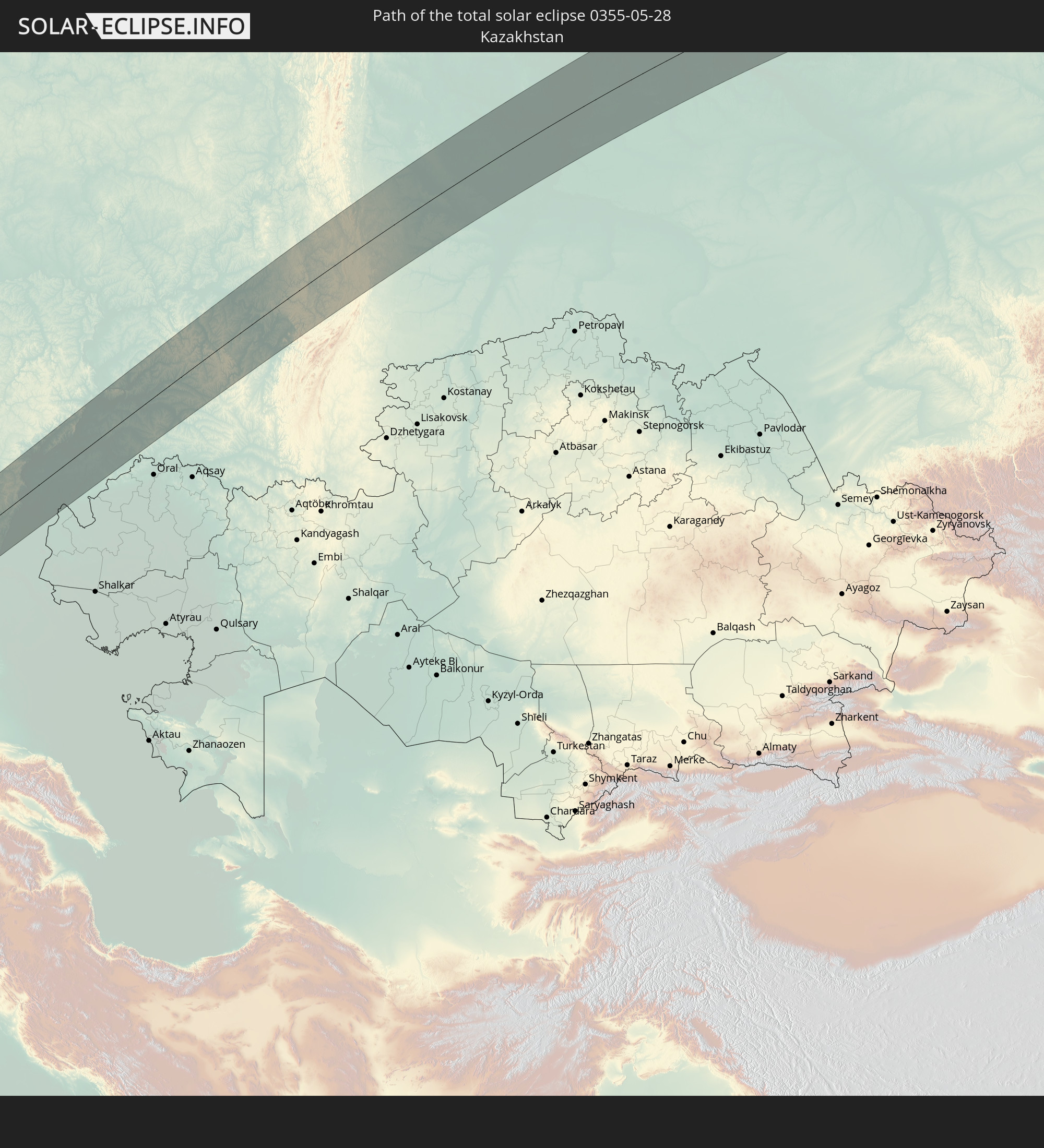
Detaillierte Länderkarten
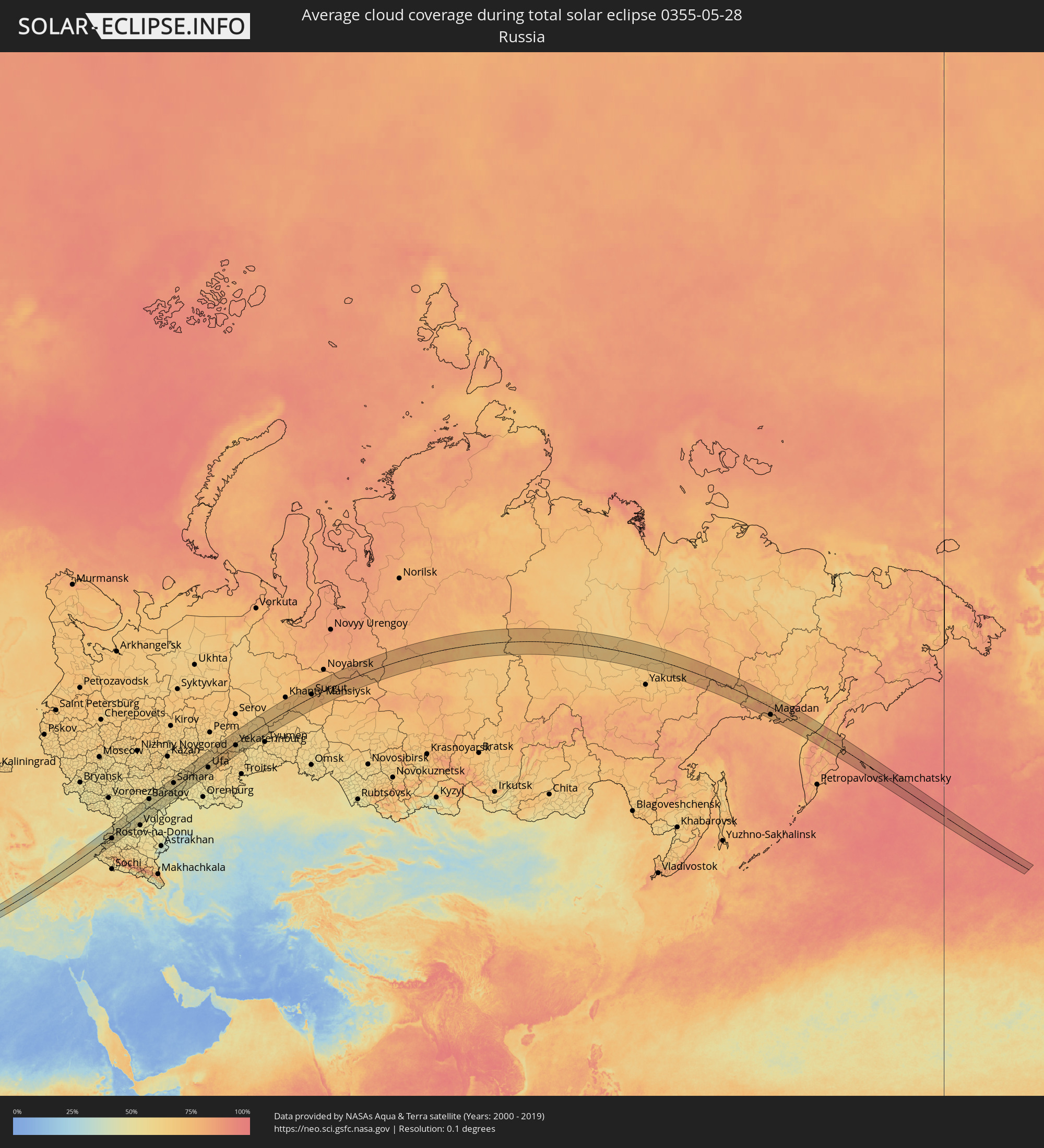 Russland
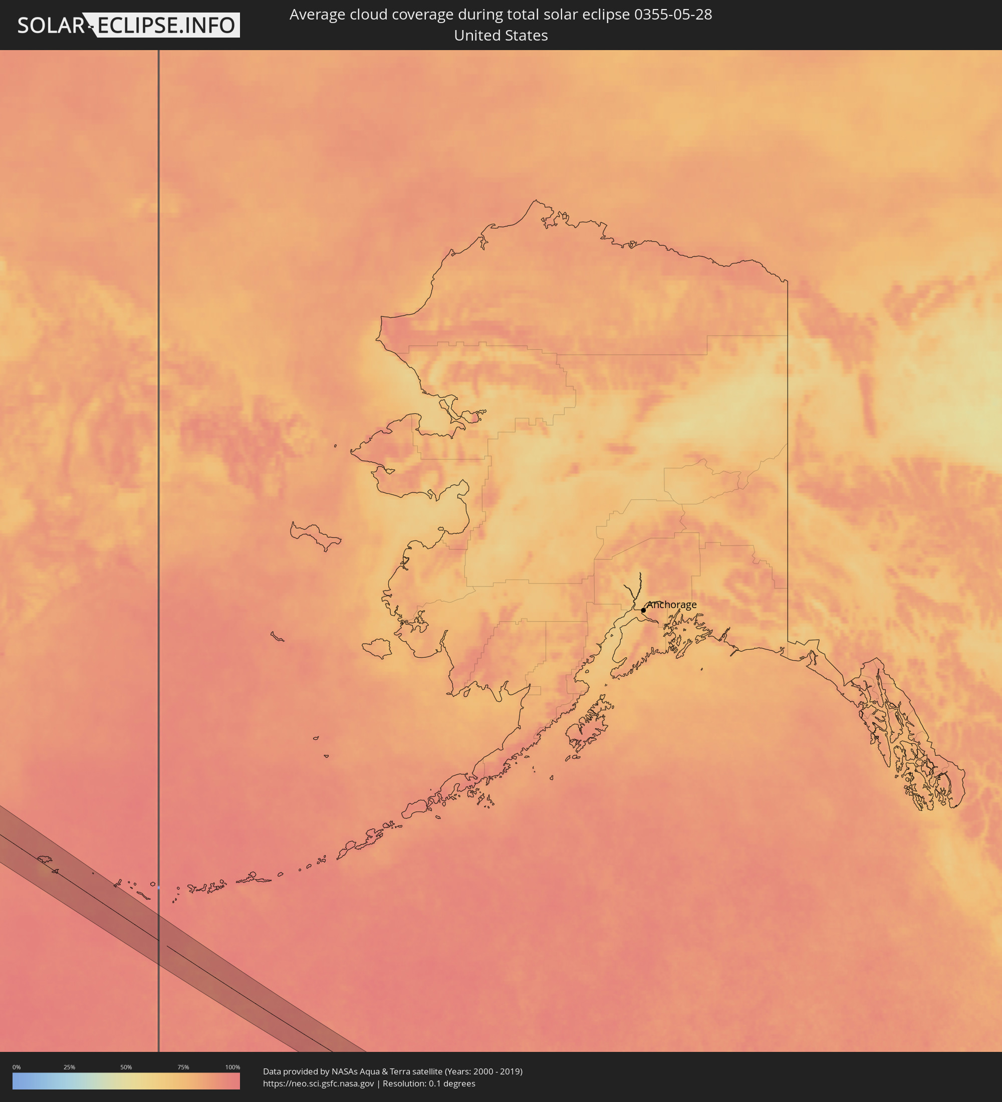 Vereinigte Staaten
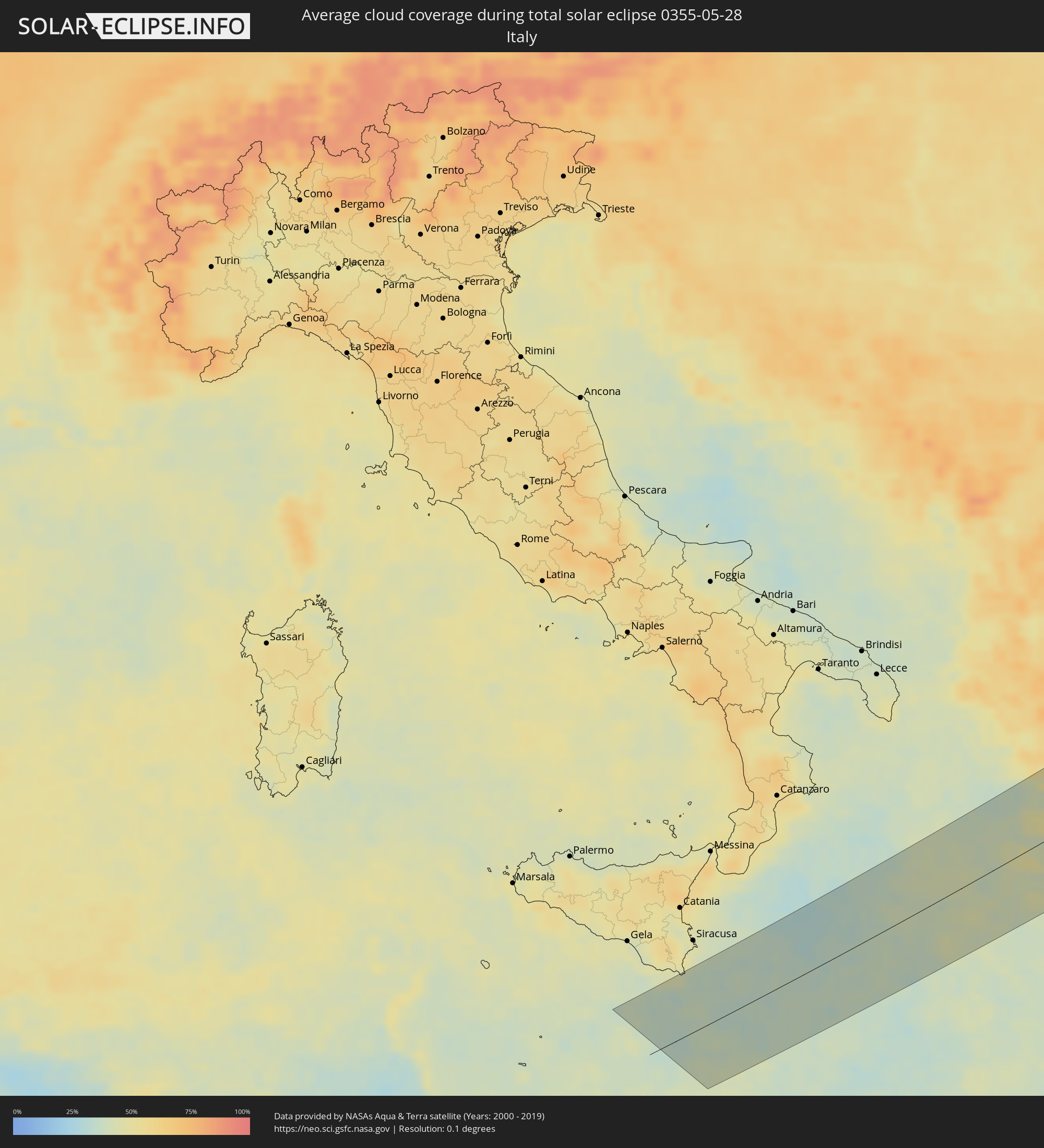 Italien
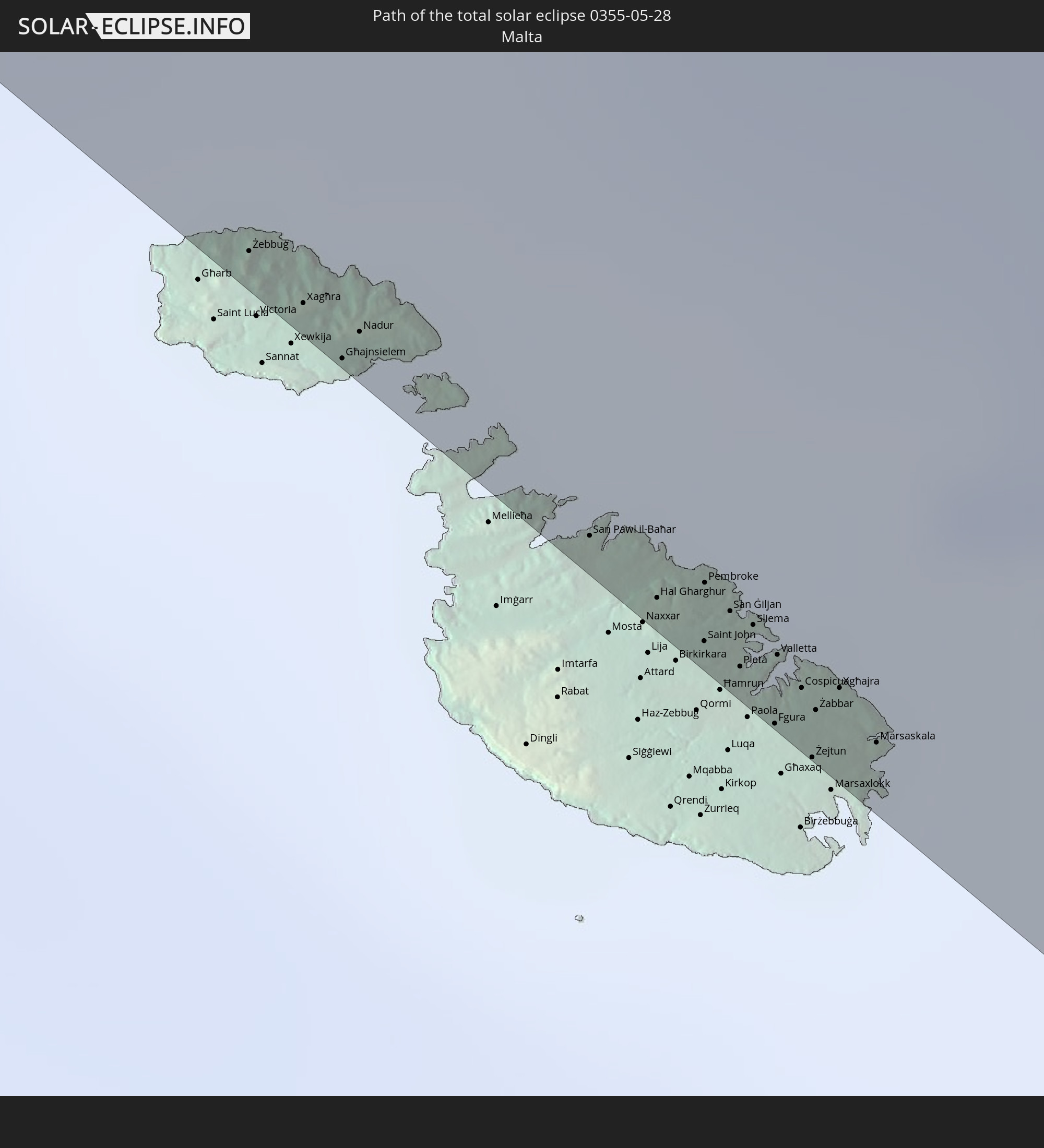
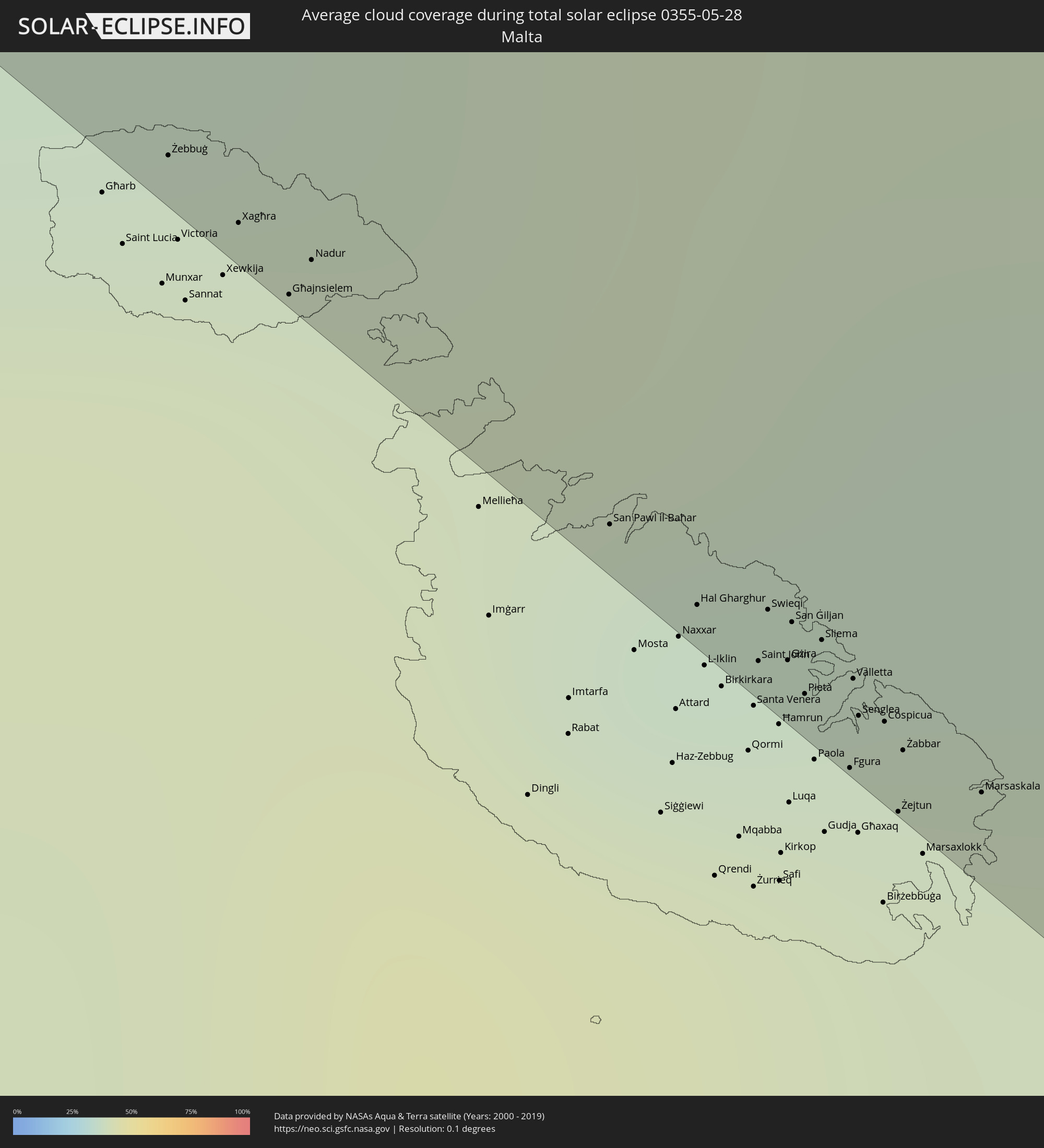 Malta
Malta
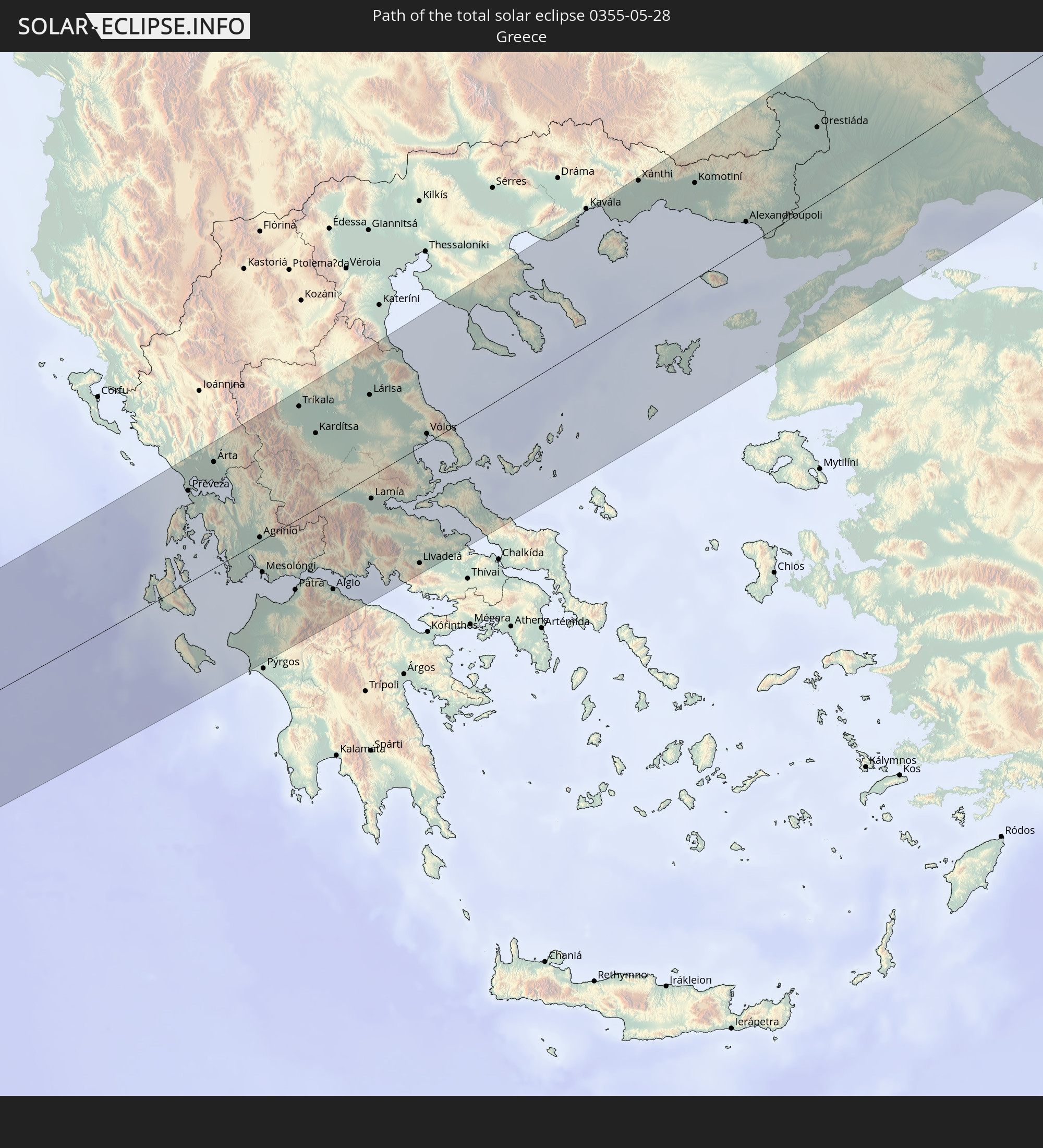
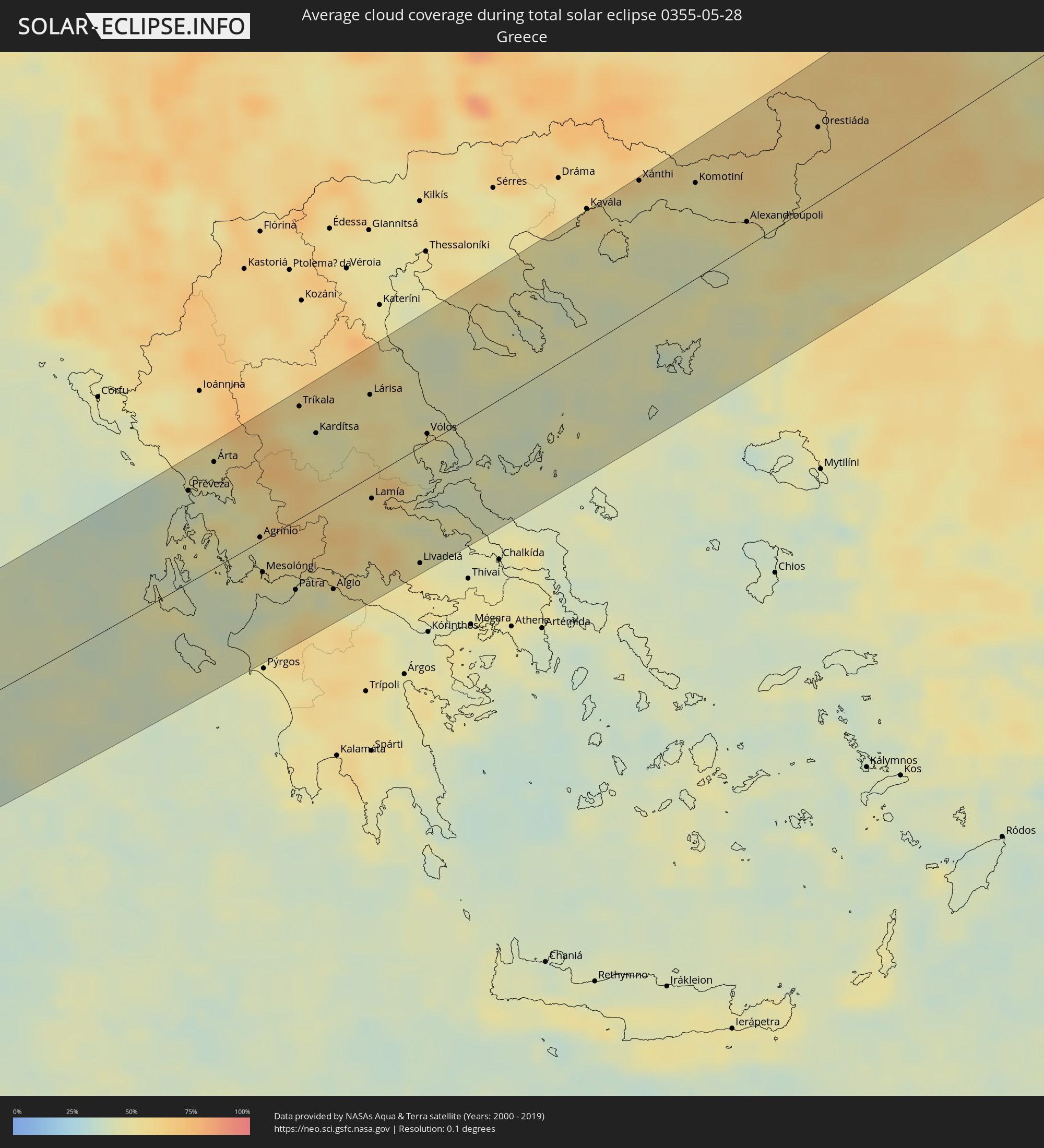 Griechenland
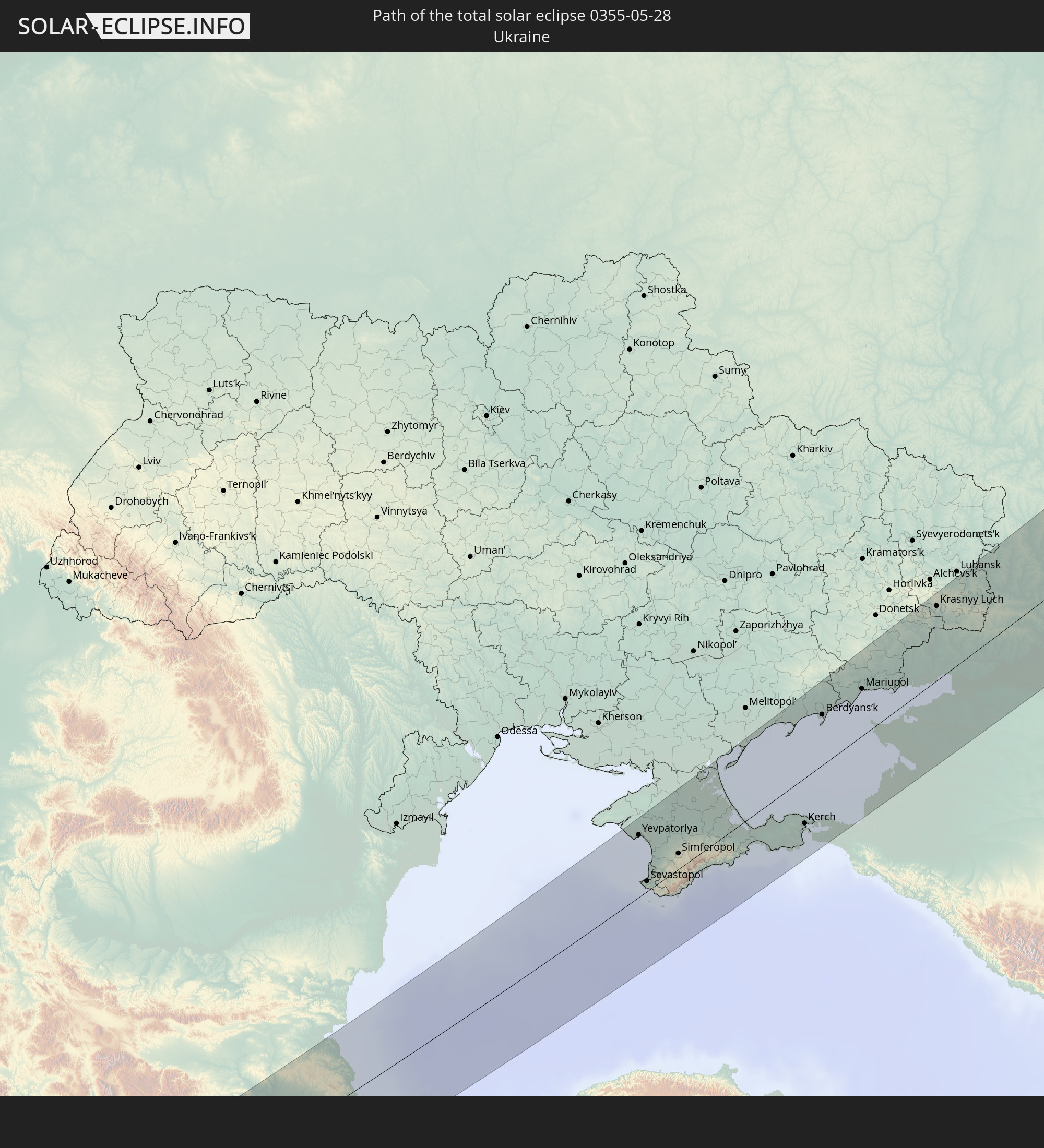
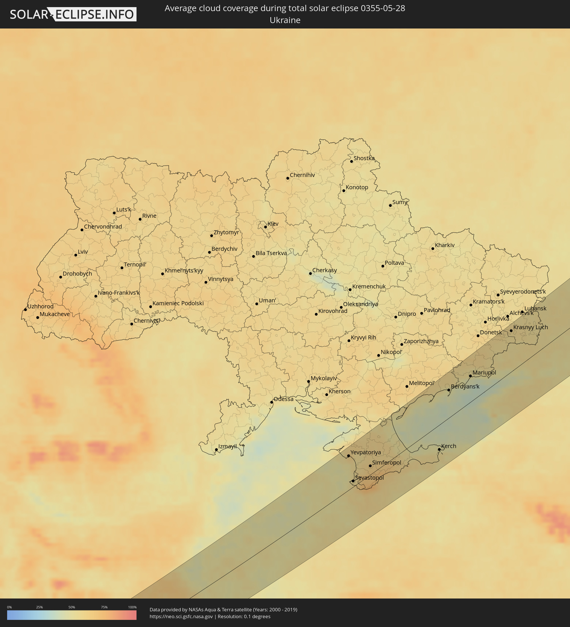 Ukraine
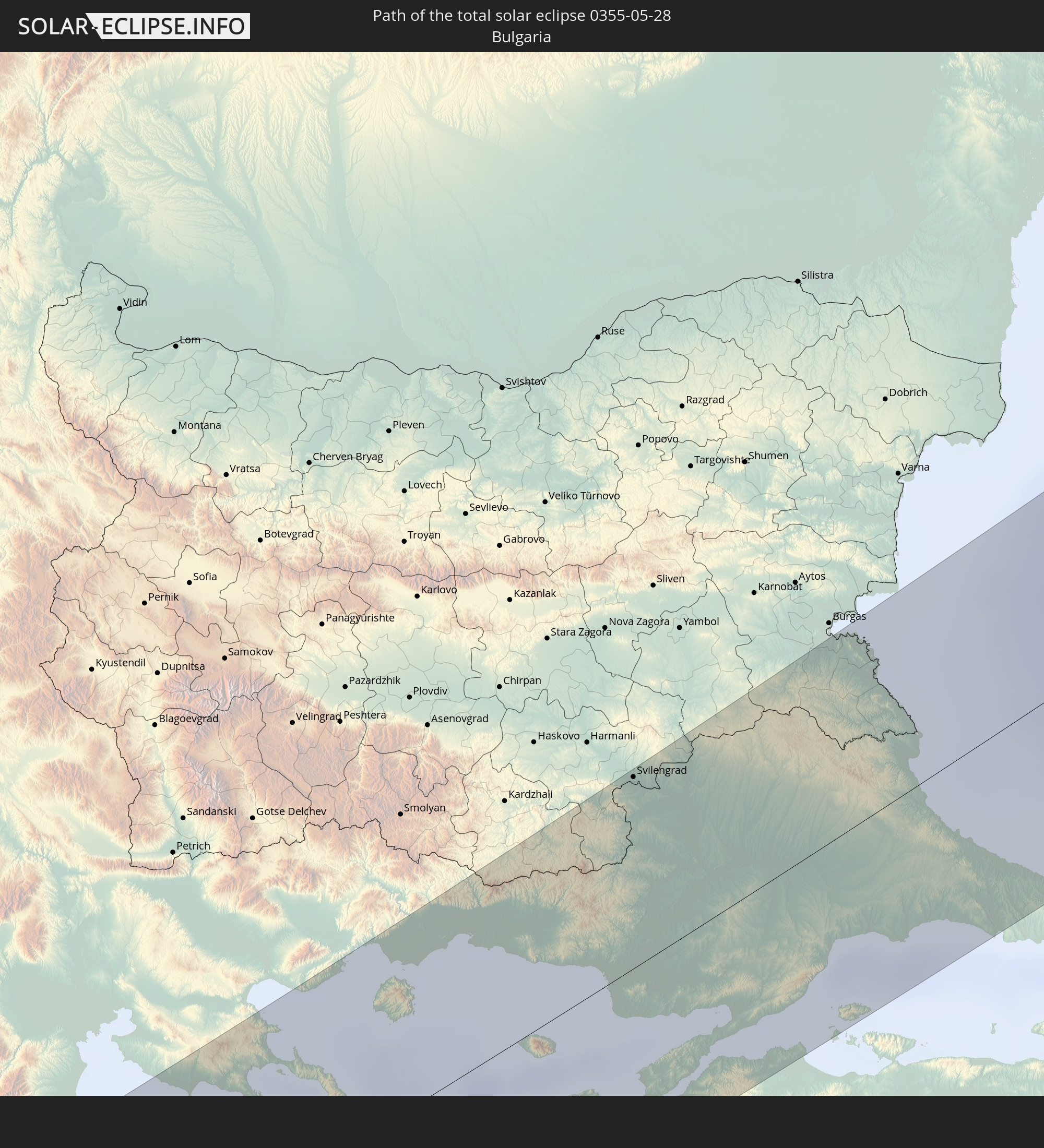
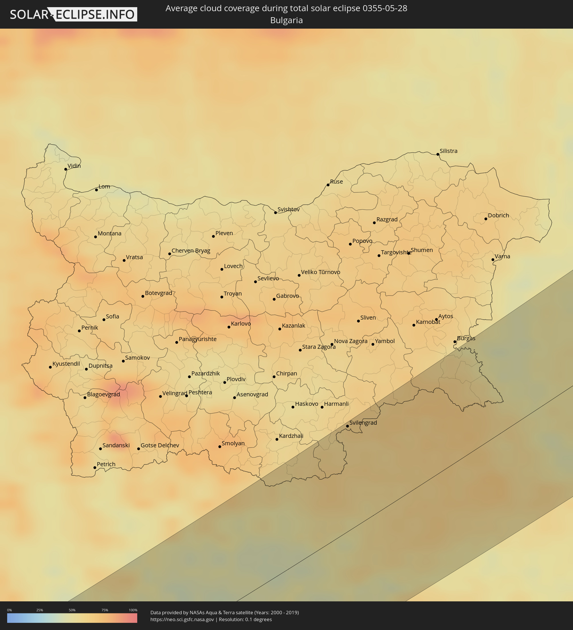 Bulgarien
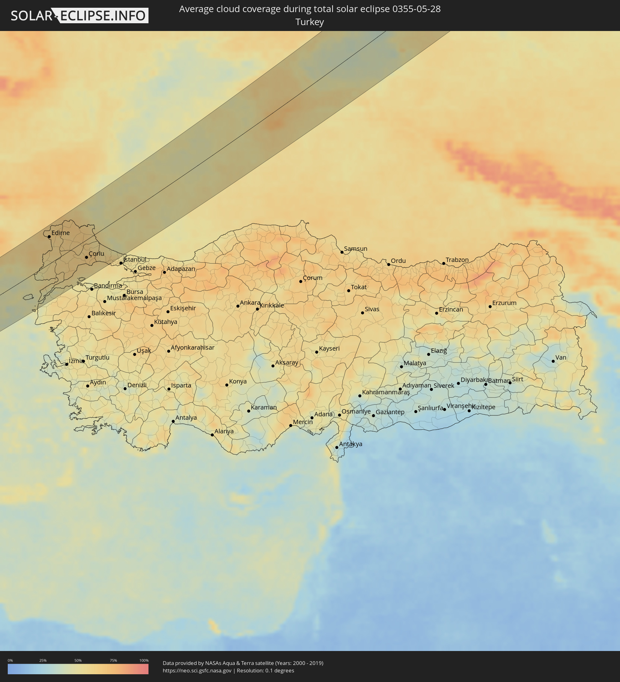 Türkei
 Kasachstan
Orte im Finsternispfad
Die nachfolgene Tabelle zeigt Städte und Orte mit mehr als 5.000 Einwohnern, die sich im Finsternispfad befinden. Städte mit mehr als 100.000 Einwohnern sind dick gekennzeichnet. Mit einem Klick auf den Ort öffnet sich eine Detailkarte die die Lage des jeweiligen Ortes zusammen mit dem Verlauf der zentralen Finsternis präsentiert.
| Ort | Typ | Dauer der Verfinsterung | Ortszeit bei maximaler Verfinsterung | Entfernung zur Zentrallinie | Ø Bewölkung |
|
Żebbuġ, Iż-Żebbuġ
|
total | - | 04:50:31 UTC+01:00 | 58 km | 41% |
|
Xagħra, Ix-Xagħra
|
total | - | 04:50:28 UTC+01:00 | 55 km | 39% |
|
Għajnsielem, Għajnsielem
|
total | - | 04:50:26 UTC+01:00 | 52 km | 41% |
|
Nadur, In-Nadur
|
total | - | 04:50:27 UTC+01:00 | 52 km | 41% |
|
San Pawl il-Baħar, Saint Paul’s Bay
|
total | - | 04:50:17 UTC+01:00 | 38 km | 36% |
|
Naxxar, In-Naxxar
|
total | - | 04:50:14 UTC+01:00 | 34 km | 42% |
|
Hal Gharghur, Ħal Għargħur
|
total | - | 04:50:15 UTC+01:00 | 34 km | 39% |
|
Saint John, Saint John
|
total | - | 04:50:13 UTC+01:00 | 31 km | 39% |
|
Pembroke, Pembroke
|
total | - | 04:50:14 UTC+01:00 | 34 km | 39% |
|
Swieqi, Is-Swieqi
|
total | - | 04:50:14 UTC+01:00 | 33 km | 39% |
|
Imsida, L-Imsida
|
total | - | 04:50:12 UTC+01:00 | 30 km | 39% |
|
Gżira, Il-Gżira
|
total | - | 04:50:12 UTC+01:00 | 31 km | 39% |
|
San Ġiljan, Saint Julian
|
total | - | 04:50:13 UTC+01:00 | 32 km | 39% |
|
Ta’ Xbiex, Ta’ Xbiex
|
total | - | 04:50:12 UTC+01:00 | 30 km | 39% |
|
Pietà, Tal-Pietà
|
total | - | 04:50:12 UTC+01:00 | 30 km | 39% |
|
Marsa, Il-Marsa
|
total | - | 04:50:10 UTC+01:00 | 28 km | 39% |
|
Sliema, Tas-Sliema
|
total | - | 04:50:13 UTC+01:00 | 31 km | 39% |
|
Floriana, Il-Furjana
|
total | - | 04:50:11 UTC+01:00 | 29 km | 39% |
|
Fgura, Il-Fgura
|
total | - | 04:50:09 UTC+01:00 | 26 km | 39% |
|
Valletta, Il-Belt Valletta
|
total | - | 04:50:11 UTC+01:00 | 29 km | 39% |
|
Tarxien, Tarxien
|
total | - | 04:50:09 UTC+01:00 | 26 km | 39% |
|
Senglea, L-Isla
|
total | - | 04:50:10 UTC+01:00 | 28 km | 39% |
|
Vittoriosa, Il-Birgu
|
total | - | 04:50:11 UTC+01:00 | 28 km | 39% |
|
Cospicua, Bormla
|
total | - | 04:50:10 UTC+01:00 | 27 km | 39% |
|
Kalkara, Il-Kalkara
|
total | - | 04:50:10 UTC+01:00 | 28 km | 39% |
|
Żejtun, Iż-Żejtun
|
total | - | 04:50:08 UTC+01:00 | 24 km | 39% |
|
Żabbar, Ħaż-Żabbar
|
total | - | 04:50:09 UTC+01:00 | 26 km | 39% |
|
Xgħajra, Ix-Xgħajra
|
total | - | 04:50:09 UTC+01:00 | 27 km | 39% |
|
Marsaskala, Marsaskala
|
total | - | 04:50:07 UTC+01:00 | 23 km | 39% |
|
Argostólion, Ionian Islands
|
total | - | 05:25:24 UTC+01:34 | 1 km | 47% |
|
Lefkáda, Ionian Islands
|
total | - | 05:26:08 UTC+01:34 | 54 km | 45% |
|
Préveza, Epirus
|
total | - | 05:26:17 UTC+01:34 | 65 km | 41% |
|
Zakynthos, Ionian Islands
|
total | - | 05:24:46 UTC+01:34 | 57 km | 45% |
|
Árta, Epirus
|
total | - | 05:26:28 UTC+01:34 | 74 km | 49% |
|
Gastoúni, West Greece
|
total | - | 05:24:44 UTC+01:34 | 66 km | 45% |
|
Amaliáda, West Greece
|
total | - | 05:24:38 UTC+01:34 | 74 km | 48% |
|
Áyios Konstandínos, West Greece
|
total | - | 05:25:40 UTC+01:34 | 9 km | 47% |
|
Agrínio, West Greece
|
total | - | 05:25:39 UTC+01:34 | 8 km | 47% |
|
Mesolóngi, West Greece
|
total | - | 05:25:20 UTC+01:34 | 30 km | 55% |
|
Paralía, West Greece
|
total | - | 05:25:02 UTC+01:34 | 52 km | 45% |
|
Pátra, West Greece
|
total | - | 05:25:05 UTC+01:34 | 48 km | 45% |
|
Tríkala, Thessaly
|
total | - | 05:26:44 UTC+01:34 | 76 km | 54% |
|
Karpenísi, Central Greece
|
total | - | 05:25:54 UTC+01:34 | 14 km | 64% |
|
Náfpaktos, West Greece
|
total | - | 05:25:14 UTC+01:34 | 39 km | 48% |
|
Kardítsa, Thessaly
|
total | - | 05:26:27 UTC+01:34 | 52 km | 47% |
|
Aígio, West Greece
|
total | - | 05:24:59 UTC+01:34 | 66 km | 51% |
|
Týrnavos, Thessaly
|
total | - | 05:26:50 UTC+01:34 | 74 km | 53% |
|
Ámfissa, Central Greece
|
total | - | 05:25:15 UTC+01:34 | 49 km | 49% |
|
Fársala, Thessaly
|
total | - | 05:26:14 UTC+01:34 | 25 km | 54% |
|
Giánnouli, Thessaly
|
total | - | 05:26:42 UTC+01:34 | 59 km | 52% |
|
Lárisa, Thessaly
|
total | - | 05:26:40 UTC+01:34 | 56 km | 51% |
|
Lamía, Central Greece
|
total | - | 05:25:42 UTC+01:34 | 22 km | 52% |
|
Almyrós, Thessaly
|
total | - | 05:25:59 UTC+01:34 | 25 km | 45% |
|
Livadeiá, Central Greece
|
total | - | 05:24:59 UTC+01:34 | 80 km | 54% |
|
Vólos, Thessaly
|
total | - | 05:26:09 UTC+01:34 | 6 km | 49% |
|
Néa Moudhaniá, Central Macedonia
|
total | - | 05:27:14 UTC+01:34 | 79 km | 46% |
|
Polýgyros, Central Macedonia
|
total | - | 05:27:22 UTC+01:34 | 81 km | 58% |
|
Chrysoúpolis, East Macedonia and Thrace
|
total | - | 05:27:53 UTC+01:34 | 85 km | 50% |
|
Xánthi, East Macedonia and Thrace
|
total | - | 05:28:03 UTC+01:34 | 88 km | 54% |
|
Komotiní, East Macedonia and Thrace
|
total | - | 05:27:55 UTC+01:34 | 66 km | 48% |
|
Krumovgrad, Kŭrdzhali
|
total | - | 05:53:29 UTC+02:00 | 86 km | 59% |
|
Alexandroúpoli, East Macedonia and Thrace
|
total | - | 05:27:27 UTC+01:34 | 16 km | 52% |
|
Gökçeada, Çanakkale Province
|
total | - | 05:48:38 UTC+01:56 | 48 km | 43% |
|
Svilengrad, Khaskovo
|
total | - | 05:53:48 UTC+02:00 | 90 km | 62% |
|
Eceabat, Çanakkale Province
|
total | - | 05:48:31 UTC+01:56 | 69 km | 46% |
|
İpsala, Edirne
|
total | - | 05:49:31 UTC+01:56 | 12 km | 56% |
|
Çanakkale, Çanakkale Province
|
total | - | 05:48:28 UTC+01:56 | 74 km | 46% |
|
Didymóteicho, East Macedonia and Thrace
|
total | - | 05:28:02 UTC+01:34 | 41 km | 58% |
|
Orestiáda, East Macedonia and Thrace
|
total | - | 05:28:14 UTC+01:34 | 50 km | 60% |
|
Edirne, Edirne
|
total | - | 05:50:32 UTC+01:56 | 63 km | 61% |
|
Keşan, Edirne
|
total | - | 05:49:23 UTC+01:56 | 18 km | 58% |
|
Gelibolu, Çanakkale Province
|
total | - | 05:48:46 UTC+01:56 | 65 km | 44% |
|
Lapseki, Çanakkale Province
|
total | - | 05:48:40 UTC+01:56 | 72 km | 51% |
|
Uzunköprü, Edirne
|
total | - | 05:49:57 UTC+01:56 | 27 km | 59% |
|
Havsa, Edirne
|
total | - | 05:50:19 UTC+01:56 | 40 km | 60% |
|
Malkara, Tekirdağ
|
total | - | 05:49:23 UTC+01:56 | 35 km | 60% |
|
Babaeski, Kırklareli
|
total | - | 05:50:06 UTC+01:56 | 25 km | 61% |
|
Hayrabolu, Tekirdağ
|
total | - | 05:49:48 UTC+01:56 | 9 km | 62% |
|
Kırklareli, Kırklareli
|
total | - | 05:50:31 UTC+01:56 | 38 km | 64% |
|
Lüleburgaz, Kırklareli
|
total | - | 05:50:01 UTC+01:56 | 13 km | 62% |
|
Tekirdağ, Tekirdağ
|
total | - | 05:49:24 UTC+01:56 | 50 km | 59% |
|
Pınarhisar, Kırklareli
|
total | - | 05:50:18 UTC+01:56 | 18 km | 62% |
|
Marmaracık, Tekirdağ
|
total | - | 05:49:41 UTC+01:56 | 36 km | 64% |
|
Vize, Kırklareli
|
total | - | 05:50:12 UTC+01:56 | 2 km | 63% |
|
Çorlu, Tekirdağ
|
total | - | 05:49:37 UTC+01:56 | 42 km | 64% |
|
Tsarevo, Burgas
|
total | - | 05:54:06 UTC+02:00 | 50 km | 56% |
|
Velimeşe, Tekirdağ
|
total | - | 05:49:44 UTC+01:56 | 39 km | 65% |
|
Marmara Ereğlisi, Tekirdağ
|
total | - | 05:49:19 UTC+01:56 | 67 km | 55% |
|
Çerkezköy, Tekirdağ
|
total | - | 05:49:45 UTC+01:56 | 46 km | 66% |
|
Çanta, Istanbul
|
total | - | 05:49:27 UTC+01:56 | 65 km | 58% |
|
Silivri, Istanbul
|
total | - | 05:49:25 UTC+01:56 | 70 km | 56% |
|
Kavaklı, Istanbul
|
total | - | 05:49:26 UTC+01:56 | 72 km | 57% |
|
Selimpaşa, Istanbul
|
total | - | 05:49:23 UTC+01:56 | 78 km | 56% |
|
Celâliye, Istanbul
|
total | - | 05:49:22 UTC+01:56 | 80 km | 56% |
|
Çatalca, Istanbul
|
total | - | 05:49:29 UTC+01:56 | 74 km | 58% |
|
Kumburgaz, Istanbul
|
total | - | 05:49:19 UTC+01:56 | 86 km | 58% |
|
Tepecik, Istanbul
|
total | - | 05:49:19 UTC+01:56 | 88 km | 58% |
|
Mimarsinan, Istanbul
|
total | - | 05:49:18 UTC+01:56 | 90 km | 57% |
|
Büyükçekmece, Istanbul
|
total | - | 05:49:18 UTC+01:56 | 91 km | 57% |
|
Boyalık, Istanbul
|
total | - | 05:49:38 UTC+01:56 | 70 km | 60% |
|
Yevpatoriya, Republic of Crimea
|
total | - | 06:14:12 UTC+02:16 | 75 km | 57% |
|
Sevastopol, Gorod Sevastopol
|
total | - | 06:13:16 UTC+02:16 | 16 km | 56% |
|
Saki, Republic of Crimea
|
total | - | 06:14:06 UTC+02:16 | 58 km | 55% |
|
Inkerman, Gorod Sevastopol
|
total | - | 06:13:18 UTC+02:16 | 21 km | 59% |
|
Bakhchisaray, Republic of Crimea
|
total | - | 06:13:31 UTC+02:16 | 13 km | 66% |
|
Gvardeyskoye, Republic of Crimea
|
total | - | 06:14:05 UTC+02:16 | 42 km | 60% |
|
Gresovskiy, Republic of Crimea
|
total | - | 06:13:55 UTC+02:16 | 35 km | 63% |
|
Gaspra, Republic of Crimea
|
total | - | 06:13:02 UTC+02:16 | 30 km | 60% |
|
Simferopol, Republic of Crimea
|
total | - | 06:13:50 UTC+02:16 | 31 km | 64% |
|
Oktyabr’skoye, Republic of Crimea
|
total | - | 06:14:21 UTC+02:16 | 48 km | 59% |
|
Yalta, Republic of Crimea
|
total | - | 06:13:08 UTC+02:16 | 25 km | 66% |
|
Krasnogvardeyskoye, Republic of Crimea
|
total | - | 06:14:41 UTC+02:16 | 64 km | 58% |
|
Dzhankoy, Republic of Crimea
|
total | - | 06:15:01 UTC+02:16 | 74 km | 60% |
|
Alushta, Republic of Crimea
|
total | - | 06:13:25 UTC+02:16 | 31 km | 64% |
|
Belogorsk, Republic of Crimea
|
total | - | 06:14:00 UTC+02:16 | 14 km | 64% |
|
Sovetskiy, Republic of Crimea
|
total | - | 06:14:28 UTC+02:16 | 17 km | 59% |
|
Sudak, Republic of Crimea
|
total | - | 06:13:42 UTC+02:16 | 39 km | 56% |
|
Feodosiya, Republic of Crimea
|
total | - | 06:14:00 UTC+02:16 | 35 km | 57% |
|
Shchyolkino, Republic of Crimea
|
total | - | 06:14:39 UTC+02:16 | 25 km | 47% |
|
Prymors’k, Zaporizhia
|
total | - | 06:02:49 UTC+02:02 | 76 km | 51% |
|
Kerch, Republic of Crimea
|
total | - | 06:14:34 UTC+02:16 | 54 km | 53% |
|
Berdyans’k, Zaporizhia
|
total | - | 06:02:55 UTC+02:02 | 63 km | 46% |
|
Mariupol, Donetsk
|
total | - | 06:03:31 UTC+02:02 | 54 km | 44% |
|
Sartana, Donetsk
|
total | - | 06:03:40 UTC+02:02 | 55 km | 47% |
|
Novyy Svit, Donetsk
|
total | - | 06:04:44 UTC+02:02 | 97 km | 58% |
|
Novoazovs'k, Donetsk
|
total | - | 06:03:37 UTC+02:02 | 35 km | 44% |
|
Ilovays’k, Donetsk
|
total | - | 06:04:57 UTC+02:02 | 98 km | 58% |
|
Yeysk, Krasnodarskiy
|
total | - | 06:31:12 UTC+02:30 | 21 km | 50% |
|
Amvrosiyivka, Donetsk
|
total | - | 06:04:46 UTC+02:02 | 74 km | 54% |
|
Torez, Donetsk
|
total | - | 06:05:12 UTC+02:02 | 91 km | 56% |
|
Taganrog, Rostov Oblast
|
total | - | 06:32:09 UTC+02:30 | 8 km | 45% |
|
Krasnyy Luch, Luhansk
|
total | - | 06:05:25 UTC+02:02 | 84 km | 55% |
|
Lutuhyne, Luhansk
|
total | - | 06:05:54 UTC+02:02 | 94 km | 56% |
|
Roven’ky, Luhansk
|
total | - | 06:05:23 UTC+02:02 | 60 km | 56% |
|
Azov, Rostov Oblast
|
total | - | 06:32:01 UTC+02:30 | 34 km | 51% |
|
Sverdlovs’k, Luhansk
|
total | - | 06:05:27 UTC+02:02 | 47 km | 55% |
|
Rostov-na-Donu, Rostov Oblast
|
total | - | 06:32:16 UTC+02:30 | 33 km | 53% |
|
Krasnodon, Luhansk
|
total | - | 06:05:48 UTC+02:02 | 65 km | 54% |
|
Novoshakhtinsk, Rostov Oblast
|
total | - | 06:33:10 UTC+02:30 | 6 km | 55% |
|
Gukovo, Rostov Oblast
|
total | - | 06:33:40 UTC+02:30 | 36 km | 54% |
|
Novocherkassk, Rostov Oblast
|
total | - | 06:32:38 UTC+02:30 | 36 km | 51% |
|
Shakhty, Rostov Oblast
|
total | - | 06:33:08 UTC+02:30 | 16 km | 55% |
|
Kamensk-Shakhtinskiy, Rostov Oblast
|
total | - | 06:34:09 UTC+02:30 | 41 km | 55% |
|
Mikhaylovka, Volgograd
|
total | - | 06:37:46 UTC+02:30 | 65 km | 55% |
|
Kamyshin, Volgograd
|
total | - | 06:38:28 UTC+02:30 | 33 km | 48% |
|
Saratov, Saratov
|
total | - | 07:31:12 UTC+03:20 | 73 km | 54% |
|
Vol’sk, Saratov
|
total | - | 07:32:34 UTC+03:20 | 58 km | 55% |
|
Balakovo, Saratov
|
total | - | 07:32:42 UTC+03:20 | 39 km | 55% |
|
Chapayevsk, Samara
|
total | - | 07:35:08 UTC+03:20 | 44 km | 61% |
|
Novokuybyshevsk, Samara
|
total | - | 07:35:26 UTC+03:20 | 45 km | 61% |
|
Samara, Samara
|
total | - | 07:35:43 UTC+03:20 | 45 km | 60% |
|
Buzuluk, Orenburg
|
total | - | 08:18:12 UTC+04:02 | 77 km | 55% |
|
Leninogorsk, Tatarstan
|
total | - | 06:49:12 UTC+02:30 | 79 km | 65% |
|
Bugul’ma, Tatarstan
|
total | - | 06:49:15 UTC+02:30 | 60 km | 65% |
|
Oktyabr’skiy, Bashkortostan
|
total | - | 08:21:46 UTC+04:02 | 33 km | 65% |
|
Tuymazy, Bashkortostan
|
total | - | 08:22:07 UTC+04:02 | 29 km | 63% |
|
Belebey, Bashkortostan
|
total | - | 08:21:29 UTC+04:02 | 33 km | 62% |
|
Ufa, Bashkortostan
|
total | - | 08:23:37 UTC+04:02 | 45 km | 63% |
|
Pervoural’sk, Sverdlovsk
|
total | - | 08:29:46 UTC+04:02 | 9 km | 68% |
|
Nizhniy Tagil, Sverdlovsk
|
total | - | 08:31:29 UTC+04:02 | 101 km | 70% |
|
Novoural’sk, Sverdlovsk
|
total | - | 08:30:26 UTC+04:02 | 36 km | 67% |
|
Polevskoy, Sverdlovsk
|
total | - | 08:29:10 UTC+04:02 | 45 km | 66% |
|
Yekaterinburg, Sverdlovsk
|
total | - | 08:30:08 UTC+04:02 | 20 km | 69% |
|
Asbest, Sverdlovsk
|
total | - | 08:30:58 UTC+04:02 | 35 km | 67% |
|
Nefteyugansk, Khanty-Mansiyskiy Avtonomnyy Okrug
|
total | - | 08:45:55 UTC+04:02 | 28 km | 75% |
|
Surgut, Khanty-Mansiyskiy Avtonomnyy Okrug
|
total | - | 08:46:49 UTC+04:02 | 22 km | 73% |
|
Nizhnevartovsk, Khanty-Mansiyskiy Avtonomnyy Okrug
|
total | - | 08:49:12 UTC+04:02 | 86 km | 77% |
|
Magadan, Magadan
|
total | - | 16:15:39 UTC+10:14 | 64 km | 76% |