Totale Sonnenfinsternis vom 15.03.0378
| Wochentag: | Mittwoch |
| Maximale Dauer der Verfinsterung: | 05m21s |
| Maximale Breite des Finsternispfades: | 205 km |
| Saroszyklus: | 84 |
| Bedeckungsgrad: | 100% |
| Magnitude: | 1.0606 |
| Gamma: | -0.2483 |
Wo kann man die Sonnenfinsternis vom 15.03.0378 sehen?
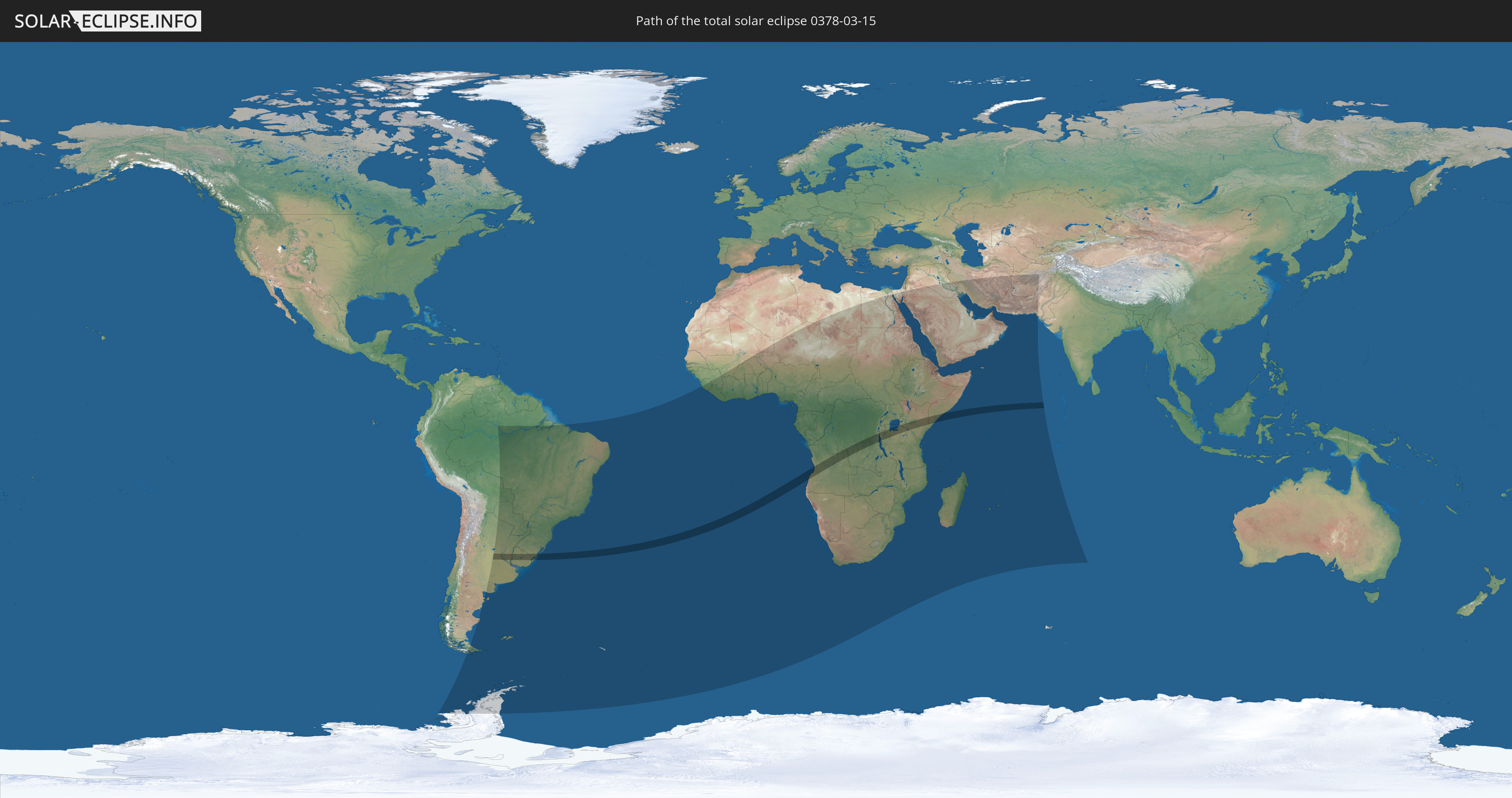
Die Sonnenfinsternis am 15.03.0378 kann man in 72 Ländern als partielle Sonnenfinsternis beobachten.
Der Finsternispfad verläuft durch 9 Länder. Nur in diesen Ländern ist sie als totale Sonnenfinsternis zu sehen.
In den folgenden Ländern ist die Sonnenfinsternis total zu sehen
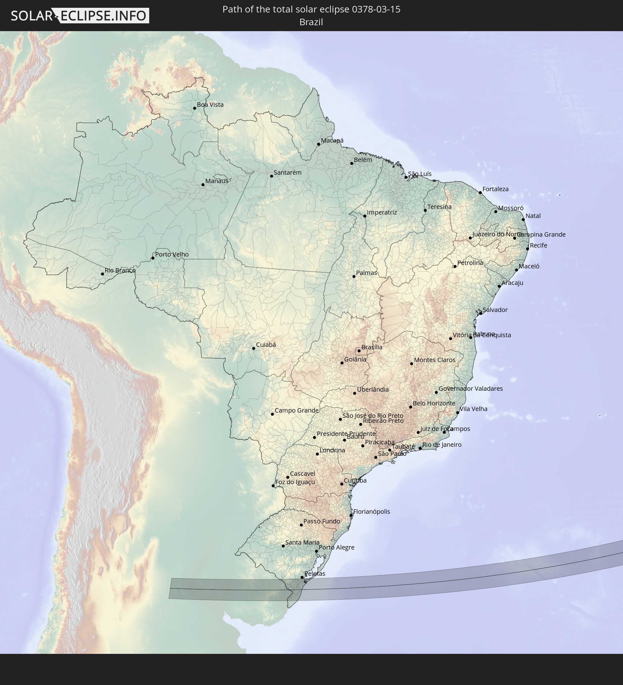 Brasilien
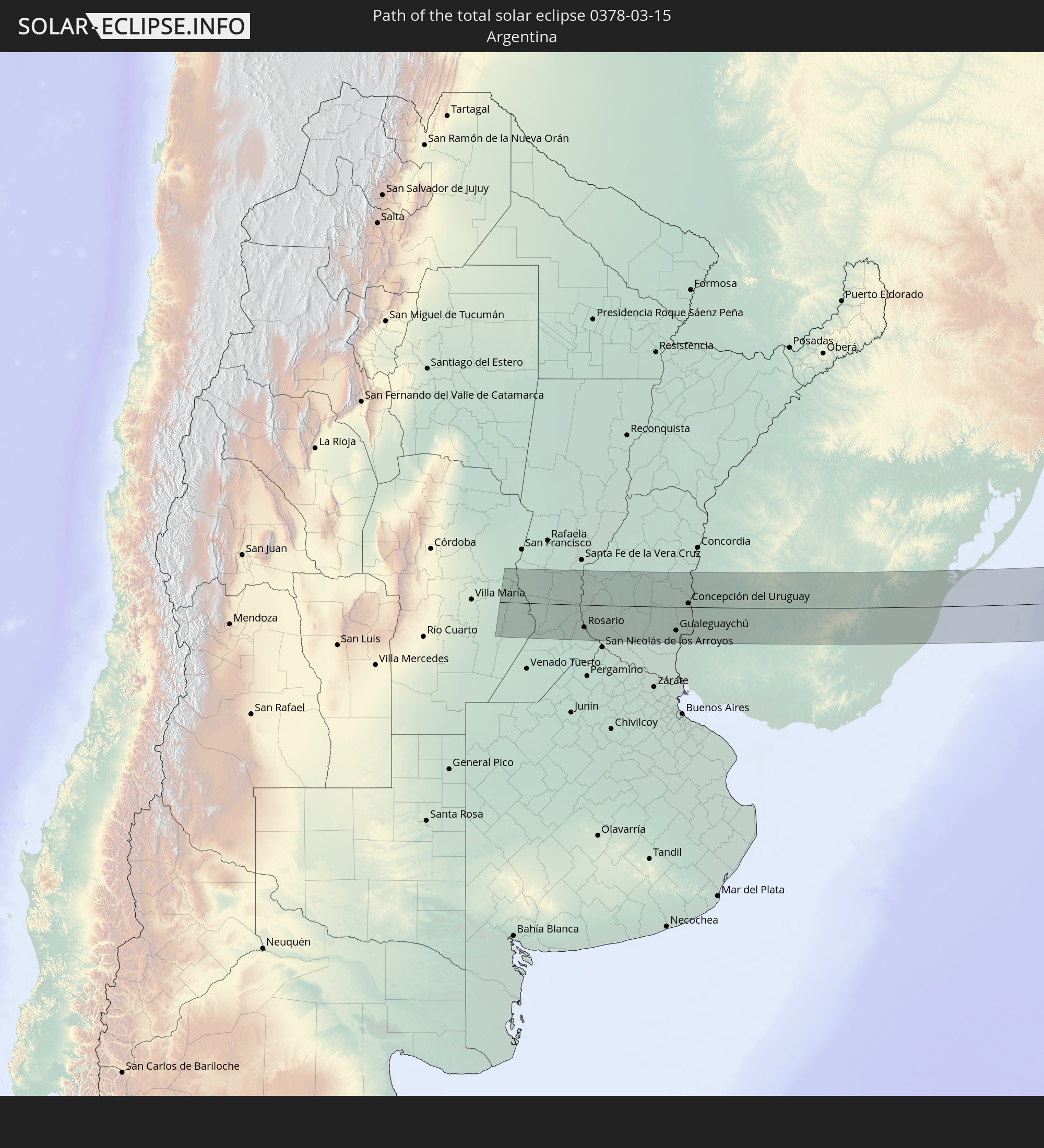 Argentinien
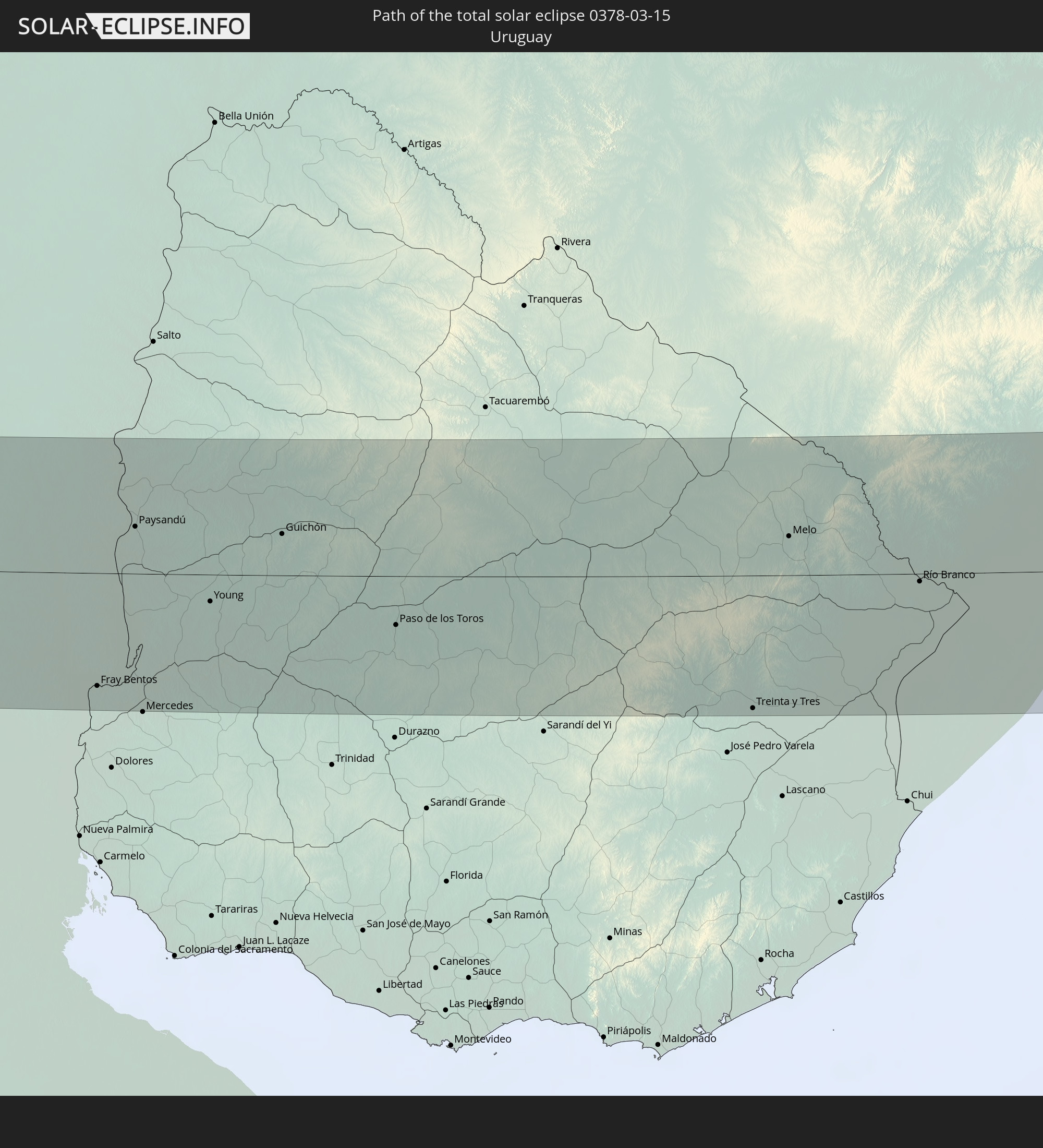 Uruguay
 Angola
 Demokratische Republik Kongo
 Burundi
 Tansania
 Kenia
Kenia
 Somalia
In den folgenden Ländern ist die Sonnenfinsternis partiell zu sehen
 Antarktika
 Chile
Chile
 Brasilien
 Argentinien
 Bolivien
 Paraguay
 Falklandinseln
 Uruguay
 Südgeorgien und die Südlichen Sandwichinseln
 Guinea
 St. Helena
 Sierra Leone
 Mali
Mali
 Liberia
 Elfenbeinküste
 Burkina Faso
 Ghana
Ghana
 Togo
Togo
 Niger
Niger
 Benin
Benin
 Nigeria
 Bouvetinsel
 Äquatorialguinea
 São Tomé und Príncipe
 Kamerun
 Gabun
Gabun
 Libyen
 Republik Kongo
 Angola
 Namibia
 Demokratische Republik Kongo
 Tschad
 Zentralafrikanische Republik
 Südafrika
 Botswana
 Sudan
Sudan
 Sambia
 Ägypten
 Simbabwe
 Lesotho
 Ruanda
 Burundi
 Tansania
 Uganda
 Mosambik
 Swasiland
 Malawi
 Äthiopien
 Kenia
Kenia
 Israel
 Saudi-Arabien
 Jordanien
 Eritrea
 Irak
Irak
 Französische Süd- und Antarktisgebiete
 Somalia
 Dschibuti
 Jemen
Jemen
 Madagaskar
 Komoren
 Iran
Iran
 Mayotte
 Seychellen
 Kuwait
 Bahrain
 Katar
Katar
 Vereinigte Arabische Emirate
 Oman
Oman
 Réunion
 Mauritius
 Afghanistan
 Pakistan
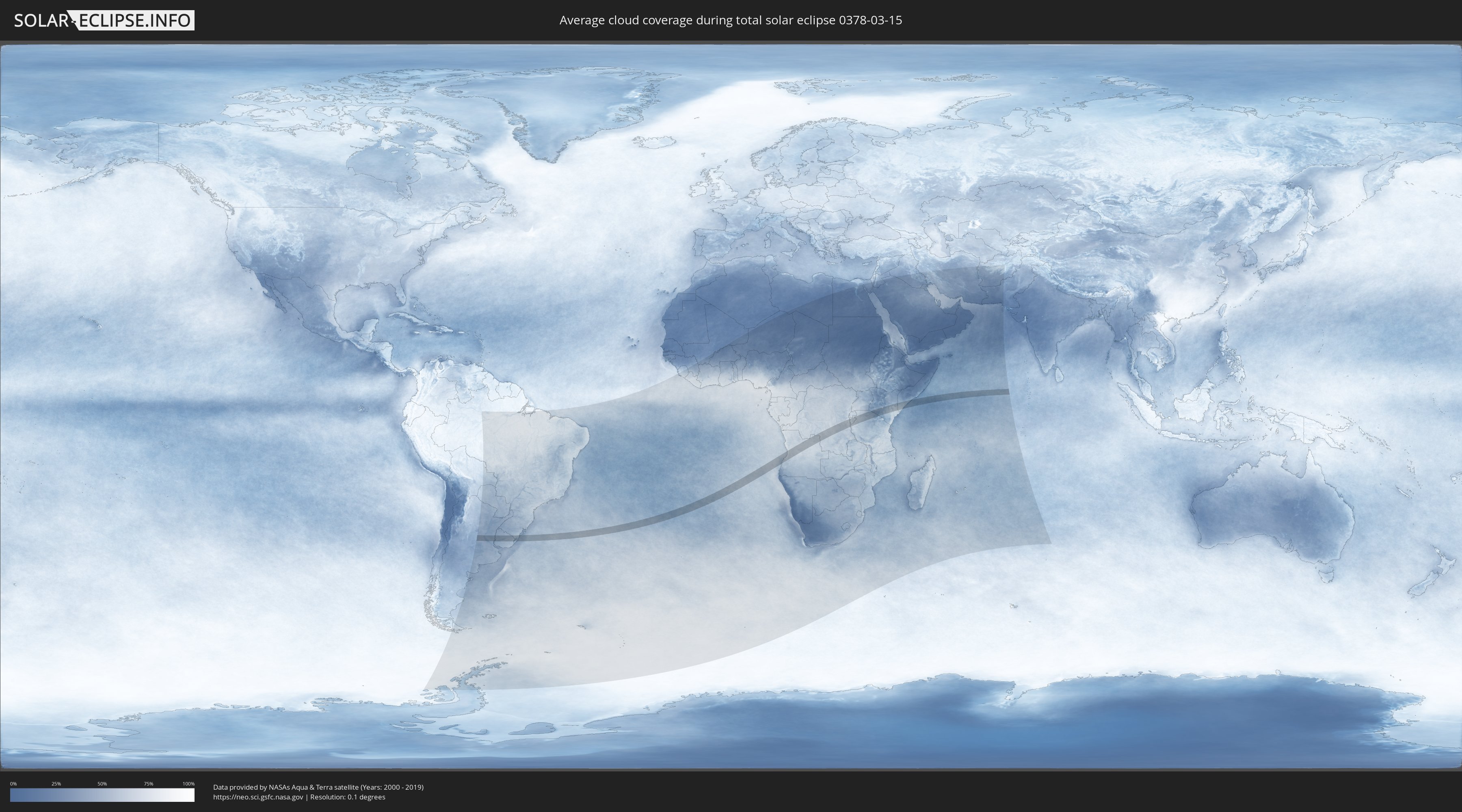
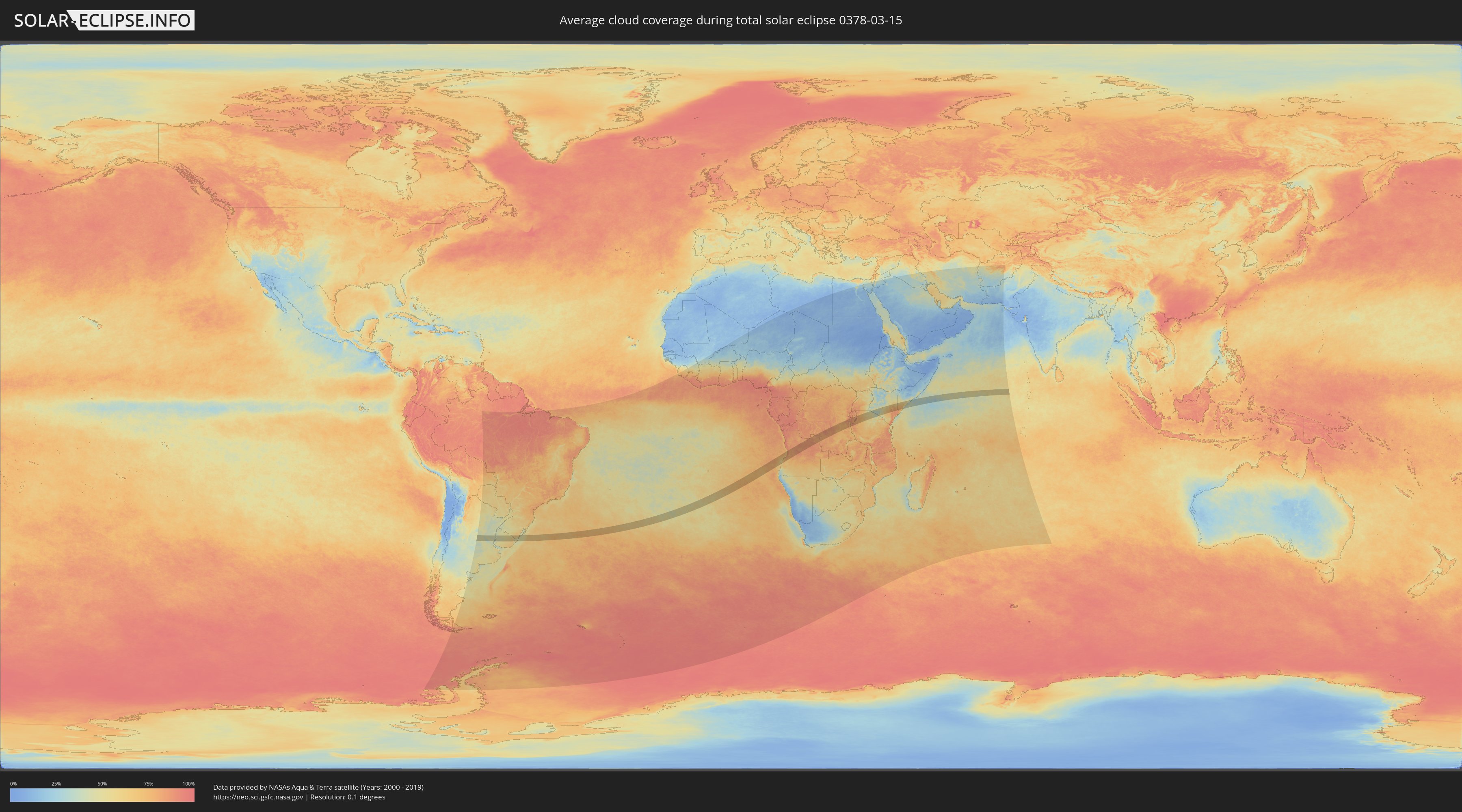
Wie wird das Wetter während der totalen Sonnenfinsternis am 15.03.0378?
Wo ist der beste Ort, um die totale Sonnenfinsternis vom 15.03.0378 zu beobachten?
Die folgenden Karten zeigen die durchschnittliche Bewölkung für den Tag, an dem die totale Sonnenfinsternis
stattfindet. Mit Hilfe der Karten lässt sich der Ort entlang des Finsternispfades eingrenzen,
der die besten Aussichen auf einen klaren wolkenfreien Himmel bietet.
Trotzdem muss man immer lokale Gegenenheiten beachten und sollte sich genau über das Wetter an seinem
gewählten Beobachtungsort informieren.
Die Daten stammen von den beiden NASA-Satelliten
AQUA und TERRA
und wurden über einen Zeitraum von 19 Jahren (2000 - 2019) gemittelt.
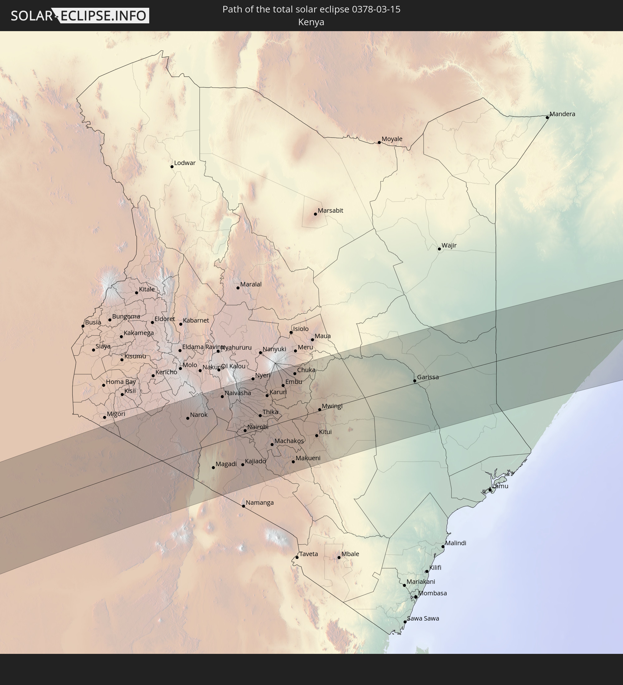
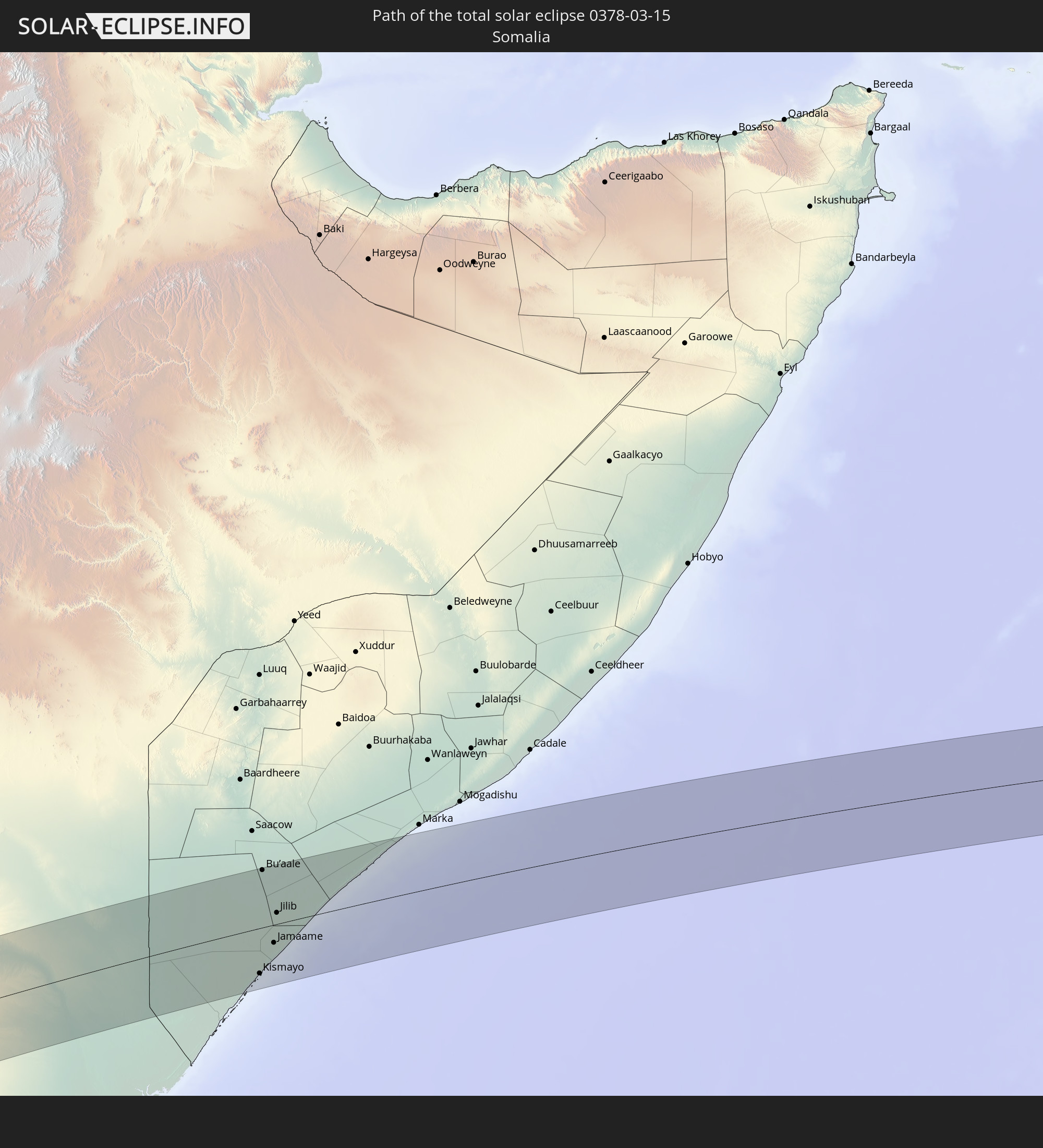
Detaillierte Länderkarten
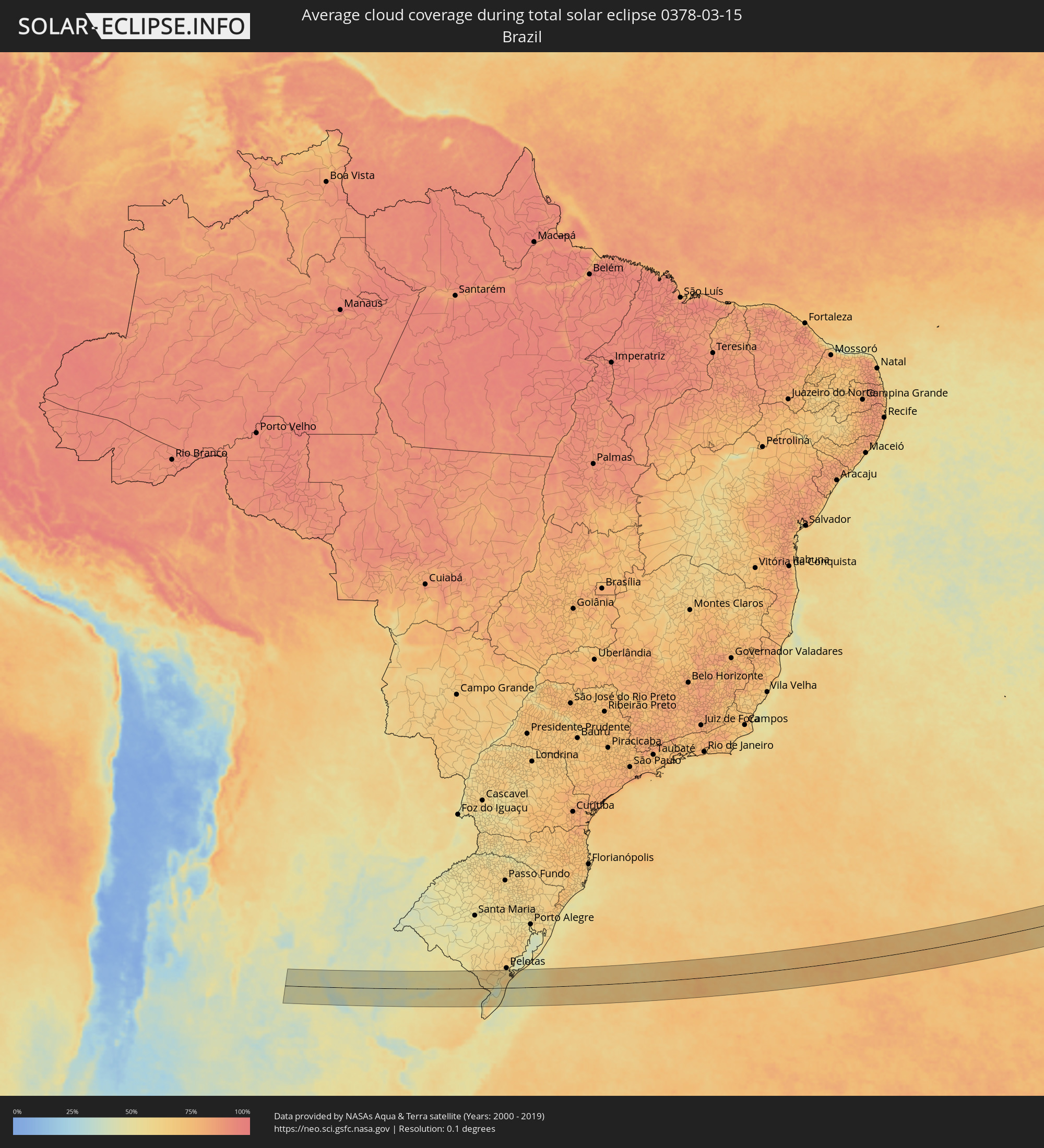 Brasilien
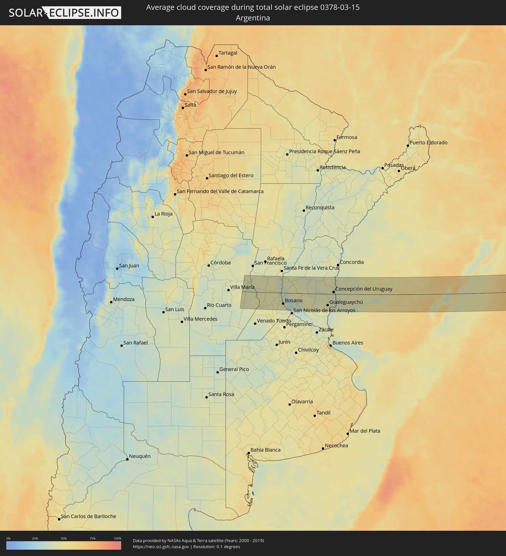 Argentinien
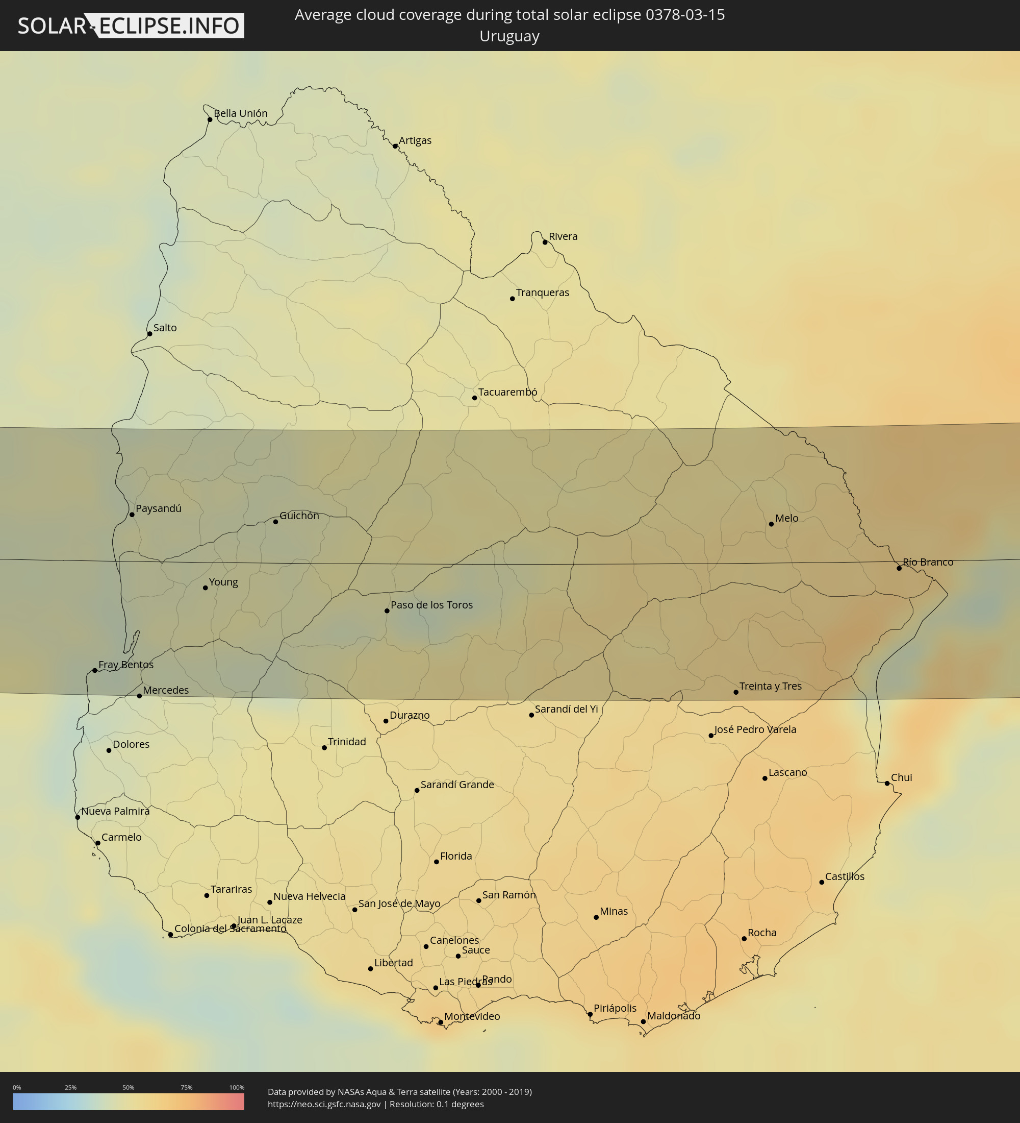 Uruguay
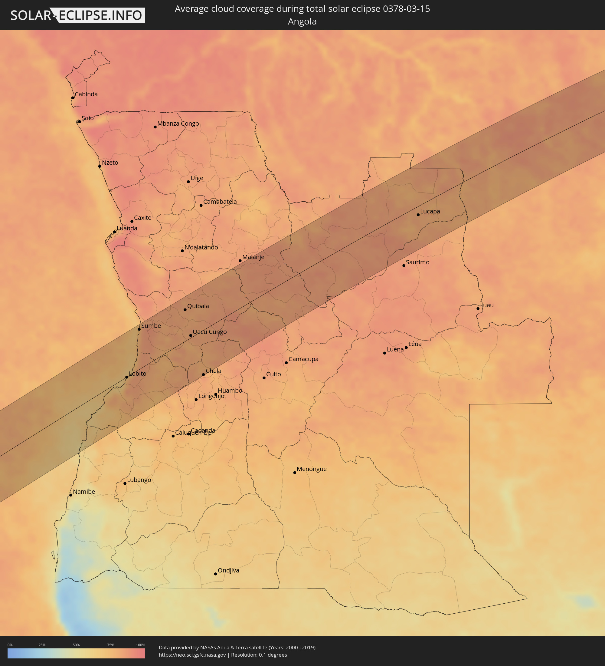 Angola
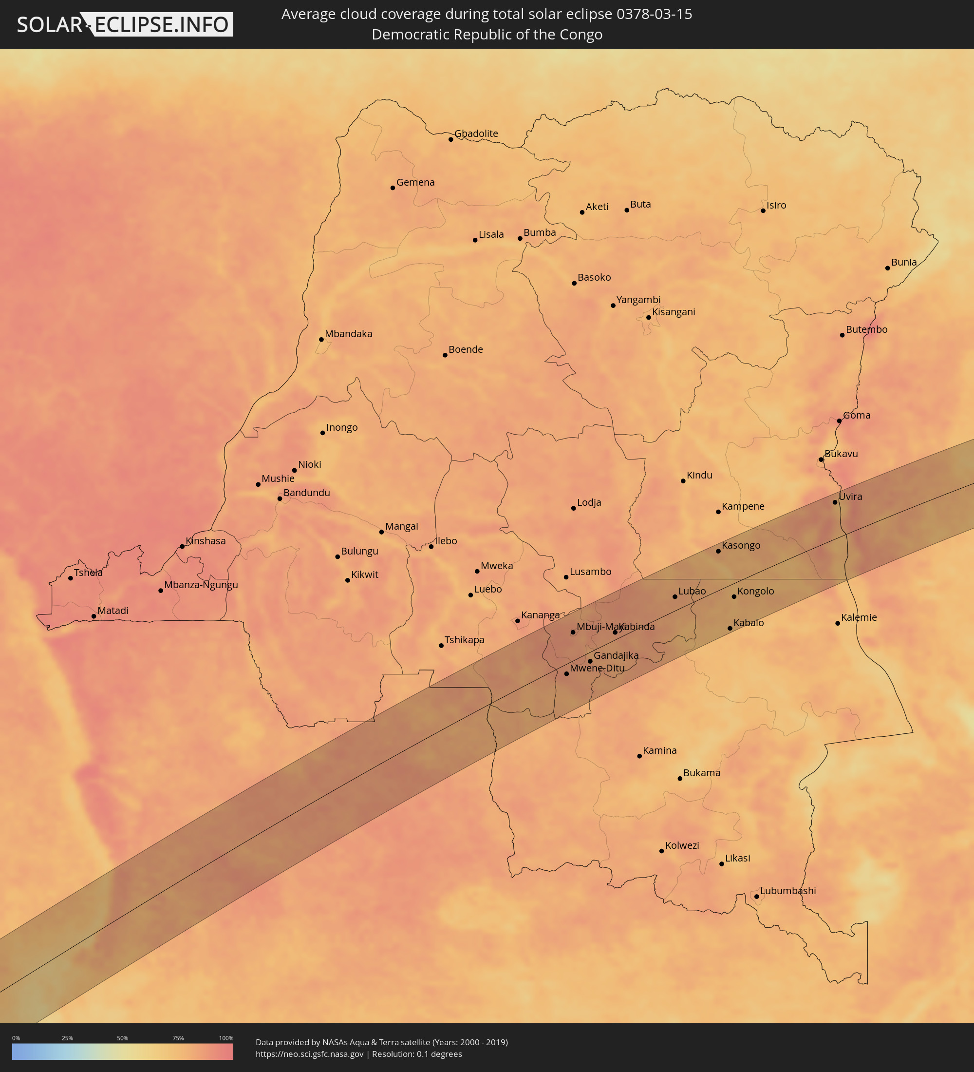 Demokratische Republik Kongo
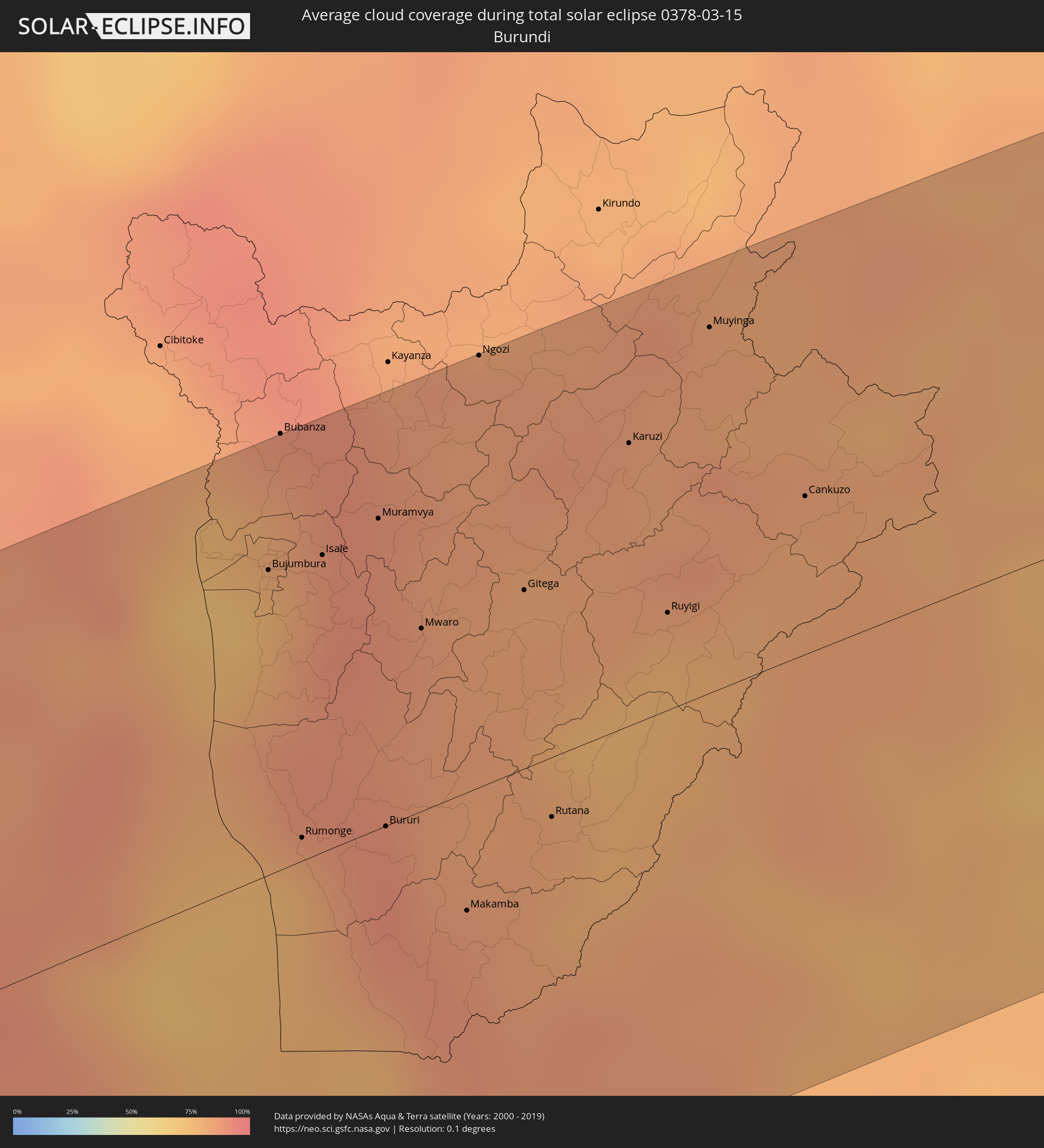 Burundi
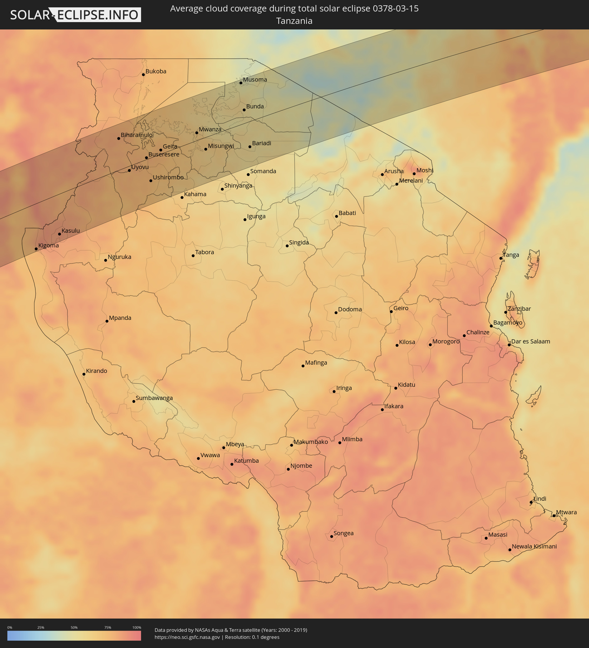 Tansania
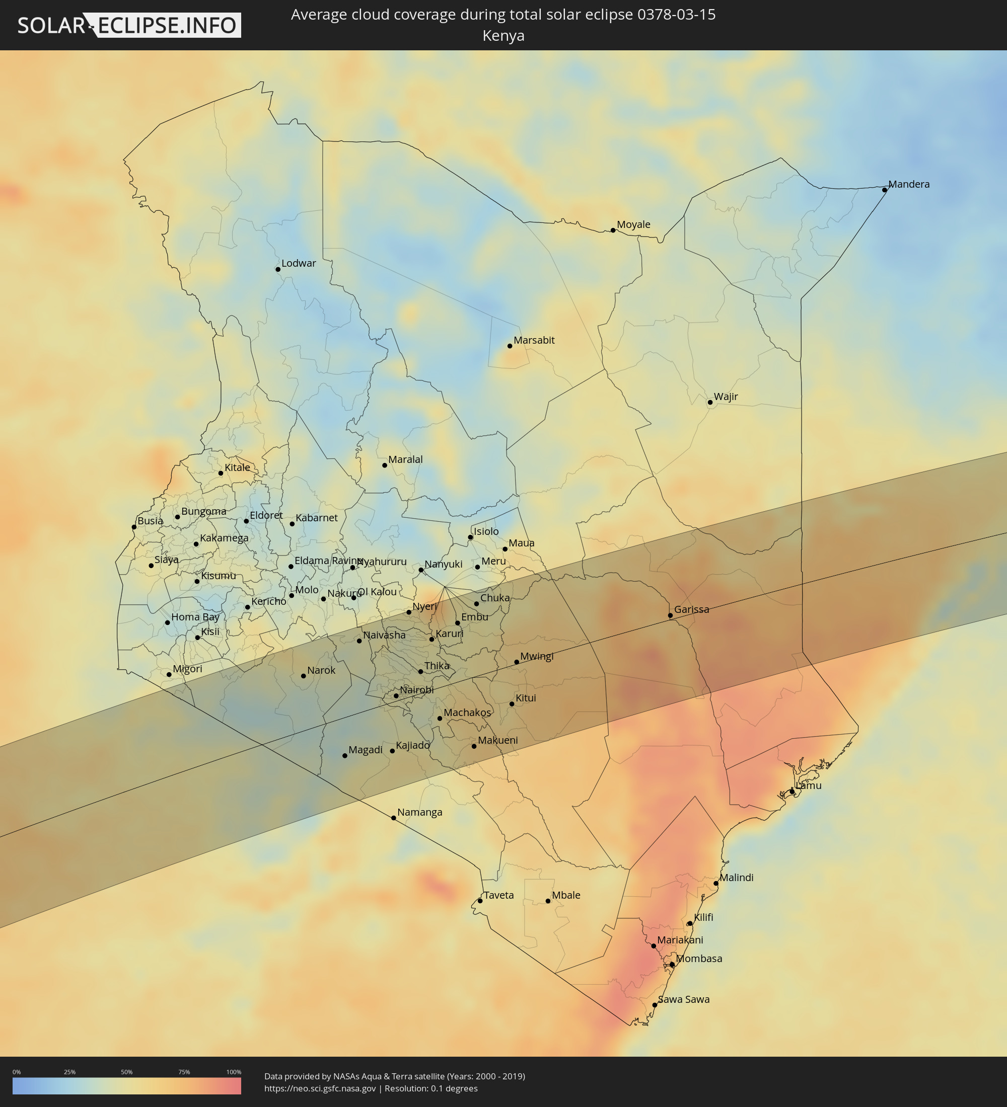 Kenia
Kenia
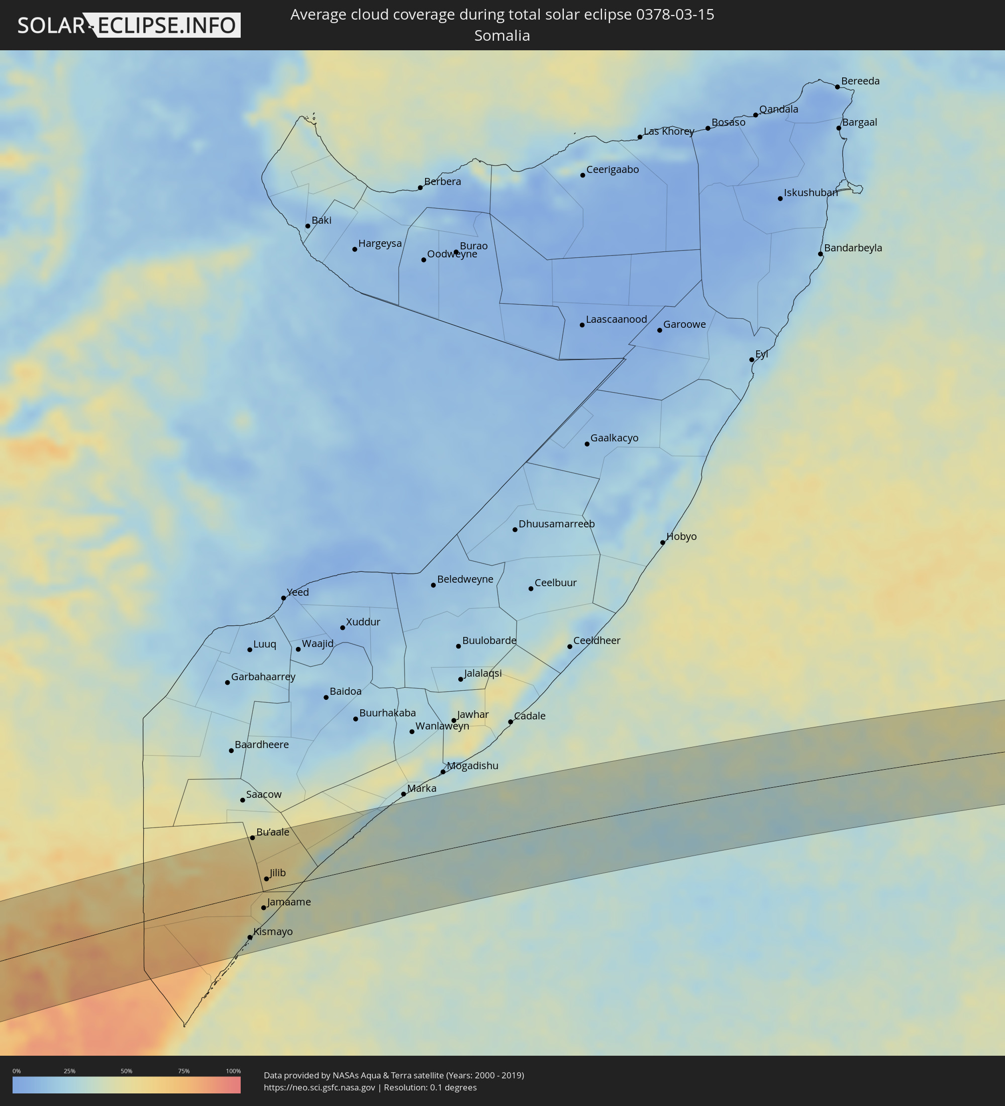 Somalia
Orte im Finsternispfad
Die nachfolgene Tabelle zeigt Städte und Orte mit mehr als 5.000 Einwohnern, die sich im Finsternispfad befinden. Städte mit mehr als 100.000 Einwohnern sind dick gekennzeichnet. Mit einem Klick auf den Ort öffnet sich eine Detailkarte die die Lage des jeweiligen Ortes zusammen mit dem Verlauf der zentralen Finsternis präsentiert.
| Ort | Typ | Dauer der Verfinsterung | Ortszeit bei maximaler Verfinsterung | Entfernung zur Zentrallinie | Ø Bewölkung |
|
Marcos Juárez, Cordoba Province
|
total | - | 05:58:33 UTC-04:16 | 25 km | 44% |
|
San Jorge, Santa Fe Province
|
total | - | 05:58:11 UTC-04:16 | 65 km | 47% |
|
Las Rosas, Santa Fe Province
|
total | - | 05:58:27 UTC-04:16 | 1 km | 44% |
|
Las Parejas, Santa Fe Province
|
total | - | 05:58:33 UTC-04:16 | 22 km | 43% |
|
Cañada de Gómez, Santa Fe Province
|
total | - | 05:58:37 UTC-04:16 | 36 km | 46% |
|
Gálvez, Santa Fe Province
|
total | - | 05:58:15 UTC-04:16 | 52 km | 47% |
|
Casilda, Santa Fe Province
|
total | - | 05:58:44 UTC-04:16 | 61 km | 48% |
|
Carcarañá, Santa Fe Province
|
total | - | 05:58:39 UTC-04:16 | 40 km | 46% |
|
Coronda, Santa Fe Province
|
total | - | 05:58:14 UTC-04:16 | 59 km | 38% |
|
Roldán, Santa Fe Province
|
total | - | 05:58:40 UTC-04:16 | 44 km | 46% |
|
Funes, Santa Fe Province
|
total | - | 05:58:41 UTC-04:16 | 45 km | 47% |
|
Fray Luis A. Beltrán, Santa Fe Province
|
total | - | 05:58:37 UTC-04:16 | 31 km | 45% |
|
Capitán Bermúdez, Santa Fe Province
|
total | - | 05:58:38 UTC-04:16 | 35 km | 45% |
|
Rosario, Santa Fe Province
|
total | - | 05:58:42 UTC-04:16 | 48 km | 43% |
|
Diamante, Entre Ríos Province
|
total | - | 05:58:17 UTC-04:16 | 50 km | 42% |
|
Arroyo Seco, Santa Fe Province
|
total | - | 05:58:48 UTC-04:16 | 71 km | 45% |
|
Crespo, Entre Ríos Province
|
total | - | 05:58:17 UTC-04:16 | 55 km | 45% |
|
Victoria, Entre Ríos Province
|
total | - | 05:58:34 UTC-04:16 | 11 km | 41% |
|
Gualeguay, Entre Ríos Province
|
total | - | 05:58:52 UTC-04:16 | 67 km | 46% |
|
Rosario del Tala, Entre Ríos Province
|
total | - | 05:58:28 UTC-04:16 | 27 km | 41% |
|
Villaguay, Entre Ríos Province
|
total | - | 05:58:17 UTC-04:16 | 76 km | 42% |
|
Gualeguaychú, Entre Ríos Province
|
total | - | 05:58:52 UTC-04:16 | 51 km | 43% |
|
Fray Bentos, Río Negro
|
total | - | 06:30:53 UTC-03:44 | 63 km | 39% |
|
Concepción del Uruguay, Entre Ríos Province
|
total | - | 05:58:38 UTC-04:16 | 8 km | 40% |
|
Paysandú, Paysandú
|
total | - | 06:30:32 UTC-03:44 | 26 km | 44% |
|
Young, Río Negro
|
total | - | 06:30:45 UTC-03:44 | 15 km | 46% |
|
Guichón, Paysandú
|
total | - | 06:30:39 UTC-03:44 | 23 km | 43% |
|
Paso de los Toros, Tacuarembó
|
total | - | 06:30:57 UTC-03:44 | 27 km | 47% |
|
Treinta y Tres, Treinta y Tres
|
total | - | 06:31:32 UTC-03:44 | 74 km | 60% |
|
Melo, Cerro Largo
|
total | - | 06:31:10 UTC-03:44 | 22 km | 56% |
|
Herval, Rio Grande do Sul
|
total | - | 07:09:34 UTC-03:06 | 60 km | 64% |
|
Río Branco, Cerro Largo
|
total | - | 06:31:27 UTC-03:44 | 4 km | 62% |
|
Jaguarão, Rio Grande do Sul
|
total | - | 07:09:49 UTC-03:06 | 1 km | 62% |
|
Arroio Grande, Rio Grande do Sul
|
total | - | 07:09:45 UTC-03:06 | 35 km | 62% |
|
Rio Grande, Rio Grande do Sul
|
total | - | 07:09:55 UTC-03:06 | 56 km | 56% |
|
Benguela, Benguela Province
|
total | - | 12:26:34 UTC+00:13 | 14 km | 76% |
|
Lobito, Benguela Province
|
total | - | 12:27:13 UTC+00:13 | 1 km | 78% |
|
Catumbela, Benguela Province
|
total | - | 12:27:08 UTC+00:13 | 8 km | 78% |
|
Sumbe, Kwanza Sul
|
total | - | 12:29:49 UTC+00:13 | 91 km | 76% |
|
Quibala, Kwanza Sul
|
total | - | 12:33:16 UTC+00:13 | 72 km | 81% |
|
Uacu Cungo, Kwanza Sul
|
total | - | 12:32:36 UTC+00:13 | 4 km | 80% |
|
Chela, Huambo
|
total | - | 12:31:49 UTC+00:13 | 103 km | 85% |
|
Lucapa, Luanda Norte
|
total | - | 12:49:55 UTC+00:13 | 22 km | 82% |
|
Mwene-Ditu, Kasaï-Oriental
|
total | - | 14:54:26 UTC+02:10 | 22 km | 85% |
|
Mbuji-Mayi, Kasaï-Oriental
|
total | - | 14:55:59 UTC+02:10 | 58 km | 85% |
|
Gandajika, Kasaï-Oriental
|
total | - | 14:55:49 UTC+02:10 | 21 km | 84% |
|
Kabinda, Kasaï-Oriental
|
total | - | 14:57:45 UTC+02:10 | 14 km | 84% |
|
Lubao, Kasaï-Oriental
|
total | - | 15:01:14 UTC+02:10 | 28 km | 82% |
|
Kasongo, Maniema
|
total | - | 15:04:16 UTC+02:10 | 82 km | 79% |
|
Kabalo, Katanga
|
total | - | 15:02:29 UTC+02:10 | 94 km | 75% |
|
Kongolo, Katanga
|
total | - | 15:03:34 UTC+02:10 | 30 km | 75% |
|
Uvira, South Kivu
|
total | - | 15:09:59 UTC+02:10 | 78 km | 78% |
|
Bujumbura, Bujumbura Mairie
|
total | - | 15:10:23 UTC+02:10 | 69 km | 83% |
|
Rumonge, Rumonge
|
total | - | 15:09:45 UTC+02:10 | 5 km | 77% |
|
Isale, Bujumbura Rural
|
total | - | 15:10:37 UTC+02:10 | 68 km | 90% |
|
Muramvya, Muramvya
|
total | - | 15:10:56 UTC+02:10 | 71 km | 88% |
|
Bururi, Bururi
|
total | - | 15:10:06 UTC+02:10 | 0 km | 91% |
|
Kigoma, Kigoma
|
total | - | 15:25:50 UTC+02:27 | 96 km | 76% |
|
Mwaro, Mwaro
|
total | - | 15:10:47 UTC+02:10 | 42 km | 84% |
|
Makamba, Makamba
|
total | - | 15:10:09 UTC+02:10 | 27 km | 86% |
|
Ngozi, Ngozi
|
total | - | 15:11:45 UTC+02:10 | 98 km | 83% |
|
Gitega, Gitega
|
total | - | 15:11:16 UTC+02:10 | 41 km | 82% |
|
Rutana, Rutana
|
total | - | 15:10:44 UTC+02:10 | 14 km | 80% |
|
Kasulu, Kigoma
|
total | - | 15:27:01 UTC+02:27 | 85 km | 83% |
|
Karuzi, Karuzi
|
total | - | 15:12:04 UTC+02:10 | 64 km | 82% |
|
Ruyigi, Ruyigi
|
total | - | 15:11:44 UTC+02:10 | 22 km | 76% |
|
Muyinga, Muyinga
|
total | - | 15:12:40 UTC+02:10 | 83 km | 83% |
|
Bugarama, Kagera
|
total | - | 15:29:53 UTC+02:27 | 73 km | 80% |
|
Cankuzo, Cankuzo
|
total | - | 15:12:33 UTC+02:10 | 36 km | 81% |
|
Kibondo, Kigoma
|
total | - | 15:29:18 UTC+02:27 | 9 km | 79% |
|
Kakonko, Kigoma
|
total | - | 15:30:04 UTC+02:27 | 13 km | 77% |
|
Biharamulo, Kagera
|
total | - | 15:31:25 UTC+02:27 | 66 km | 79% |
|
Uyovu, Geita
|
total | - | 15:30:58 UTC+02:27 | 10 km | 79% |
|
Chato, Geita
|
total | - | 15:32:08 UTC+02:27 | 47 km | 73% |
|
Buseresere, Geita
|
total | - | 15:31:50 UTC+02:27 | 3 km | 77% |
|
Ushirombo, Geita
|
total | - | 15:31:24 UTC+02:27 | 49 km | 72% |
|
Geita, Geita
|
total | - | 15:32:28 UTC+02:27 | 8 km | 75% |
|
Masumbwe, Geita
|
total | - | 15:31:34 UTC+02:27 | 73 km | 69% |
|
Kasamwa, Geita
|
total | - | 15:32:54 UTC+02:27 | 1 km | 71% |
|
Mwanza, Mwanza
|
total | - | 15:34:00 UTC+02:27 | 16 km | 67% |
|
Misungwi, Mwanza
|
total | - | 15:33:53 UTC+02:27 | 26 km | 61% |
|
Ngudu, Mwanza
|
total | - | 15:34:07 UTC+02:27 | 48 km | 62% |
|
Nyalikungu, Simiyu
|
total | - | 15:34:32 UTC+02:27 | 88 km | 58% |
|
Musoma, Mara
|
total | - | 15:36:29 UTC+02:27 | 88 km | 48% |
|
Bunda, Mara
|
total | - | 15:35:58 UTC+02:27 | 28 km | 53% |
|
Bariadi, Simiyu
|
total | - | 15:35:16 UTC+02:27 | 55 km | 56% |
|
Kisesa, Simiyu
|
total | - | 15:35:11 UTC+02:27 | 91 km | 58% |
|
Tarime, Mara
|
total | - | 15:37:28 UTC+02:27 | 83 km | 47% |
|
Sirari, Mara
|
total | - | 15:37:43 UTC+02:27 | 89 km | 49% |
|
Kihancha, Migori
|
total | - | 15:38:00 UTC+02:27 | 91 km | 43% |
|
Narok, Narok
|
total | - | 15:39:48 UTC+02:27 | 59 km | 37% |
|
Magadi, Kajiado
|
total | - | 15:39:29 UTC+02:27 | 43 km | 42% |
|
Naivasha, Nakuru
|
total | - | 15:40:56 UTC+02:27 | 78 km | 42% |
|
Ngong, Kajiado
|
total | - | 15:40:33 UTC+02:27 | 2 km | 43% |
|
Kajiado, Kajiado
|
total | - | 15:40:11 UTC+02:27 | 54 km | 54% |
|
Nairobi, Nairobi Area
|
total | - | 15:40:50 UTC+02:27 | 5 km | 47% |
|
Kiambu, Kiambu
|
total | - | 15:40:59 UTC+02:27 | 17 km | 47% |
|
Pumwani, Nairobi Area
|
total | - | 15:40:53 UTC+02:27 | 4 km | 43% |
|
Nyeri, Nyeri
|
total | - | 15:41:54 UTC+02:27 | 92 km | 46% |
|
Athi River, Machakos
|
total | - | 15:40:52 UTC+02:27 | 19 km | 46% |
|
Thika, Nairobi Area
|
total | - | 15:41:25 UTC+02:27 | 23 km | 48% |
|
Murang’a, Murang'A
|
total | - | 15:41:51 UTC+02:27 | 54 km | 48% |
|
Karuri, Murang'A
|
total | - | 15:41:55 UTC+02:27 | 55 km | 48% |
|
Machakos, Machakos
|
total | - | 15:41:10 UTC+02:27 | 35 km | 48% |
|
Keruguya, Kirinyaga
|
total | - | 15:42:14 UTC+02:27 | 73 km | 53% |
|
Kangundo, Machakos
|
total | - | 15:41:30 UTC+02:27 | 14 km | 50% |
|
Embu, Embu
|
total | - | 15:42:25 UTC+02:27 | 64 km | 47% |
|
Makueni, Makueni
|
total | - | 15:41:19 UTC+02:27 | 77 km | 60% |
|
Chuka, Tharaka - Nithi
|
total | - | 15:42:52 UTC+02:27 | 79 km | 48% |
|
Kitui, Kitui
|
total | - | 15:42:15 UTC+02:27 | 43 km | 56% |
|
Mwingi, Kitui
|
total | - | 15:42:46 UTC+02:27 | 1 km | 61% |
|
Garissa, Garissa
|
total | - | 15:45:07 UTC+02:27 | 4 km | 63% |
|
Kismayo, Lower Juba
|
total | - | 15:48:19 UTC+02:27 | 68 km | 49% |
|
Bu’aale, Middle Juba
|
total | - | 15:49:38 UTC+02:27 | 87 km | 52% |
|
Jamaame, Lower Juba
|
total | - | 15:48:54 UTC+02:27 | 27 km | 49% |
|
Jilib, Middle Juba
|
total | - | 15:49:19 UTC+02:27 | 17 km | 58% |