Totale Sonnenfinsternis vom 19.08.0407
| Wochentag: | Sonntag |
| Maximale Dauer der Verfinsterung: | 03m24s |
| Maximale Breite des Finsternispfades: | 127 km |
| Saroszyklus: | 90 |
| Bedeckungsgrad: | 100% |
| Magnitude: | 1.0371 |
| Gamma: | -0.2024 |
Wo kann man die Sonnenfinsternis vom 19.08.0407 sehen?
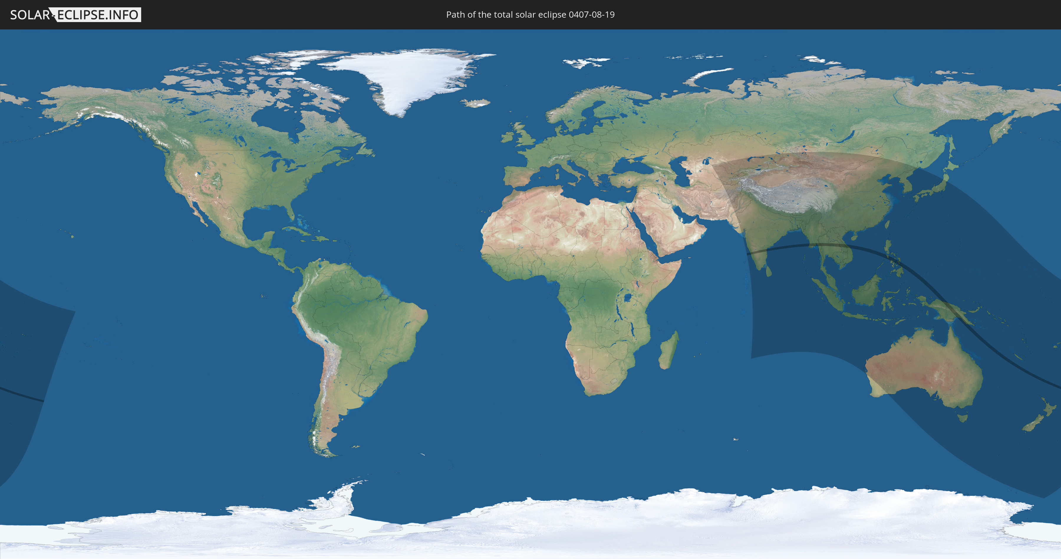
Die Sonnenfinsternis am 19.08.0407 kann man in 58 Ländern als partielle Sonnenfinsternis beobachten.
Der Finsternispfad verläuft durch 10 Länder. Nur in diesen Ländern ist sie als totale Sonnenfinsternis zu sehen.
In den folgenden Ländern ist die Sonnenfinsternis total zu sehen
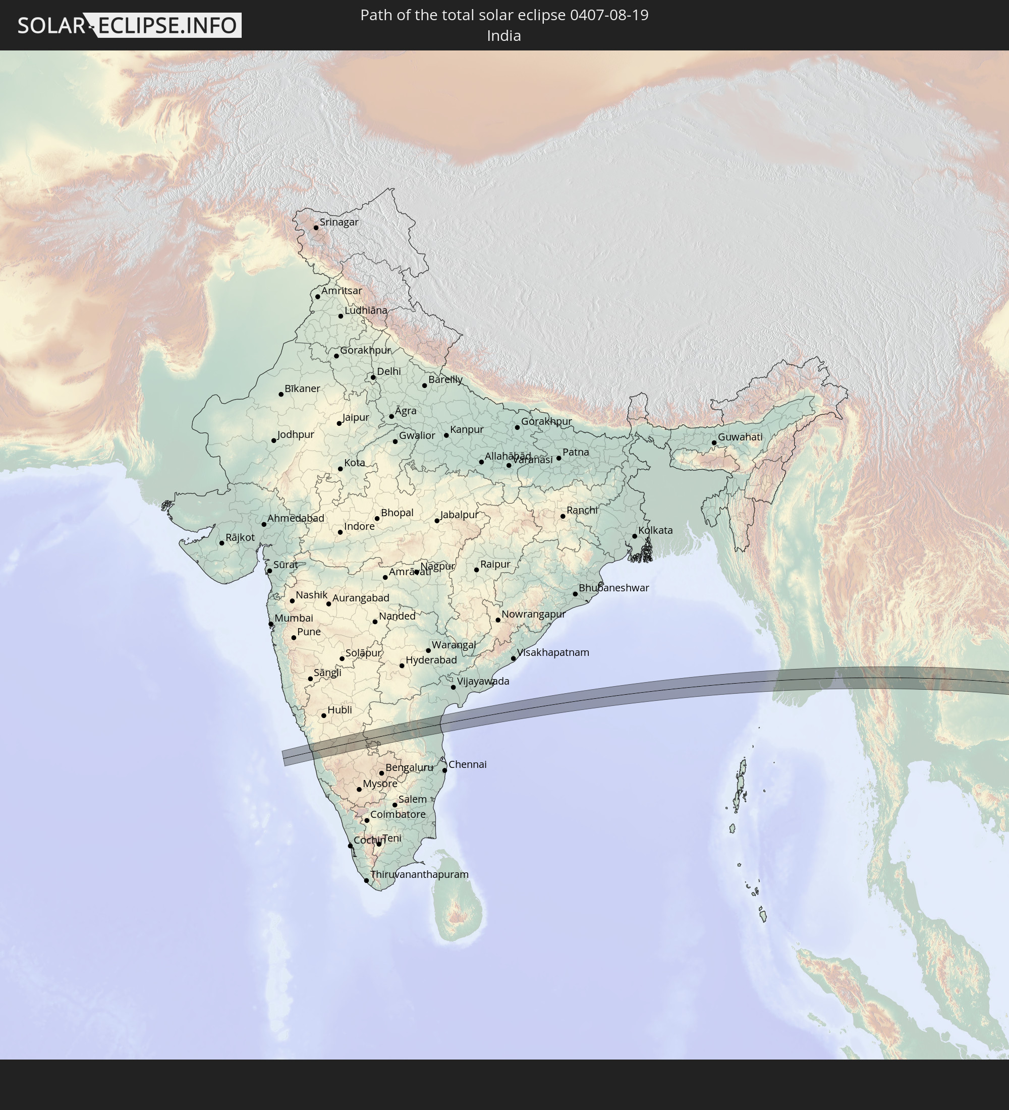 Indien
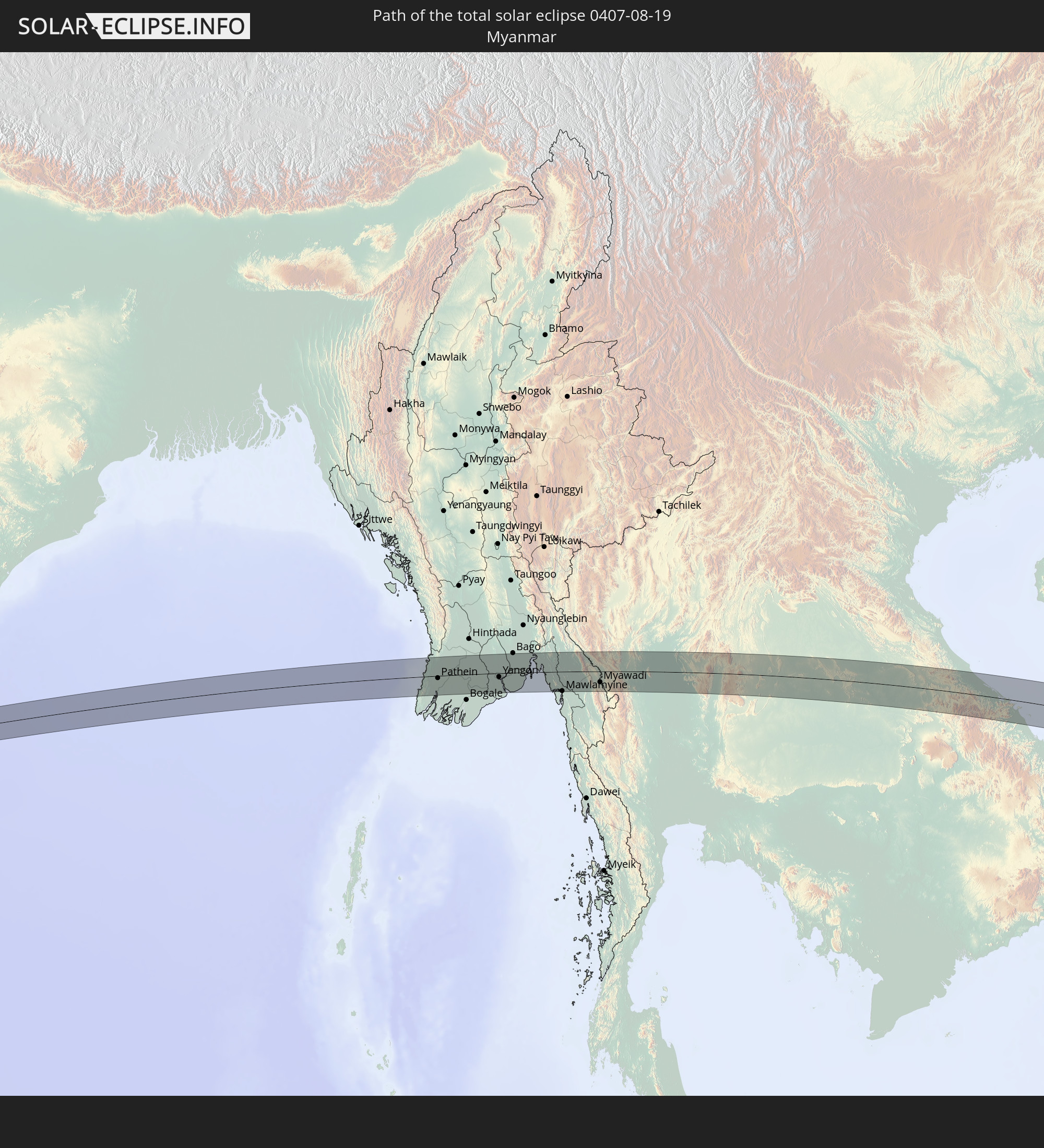 Myanmar
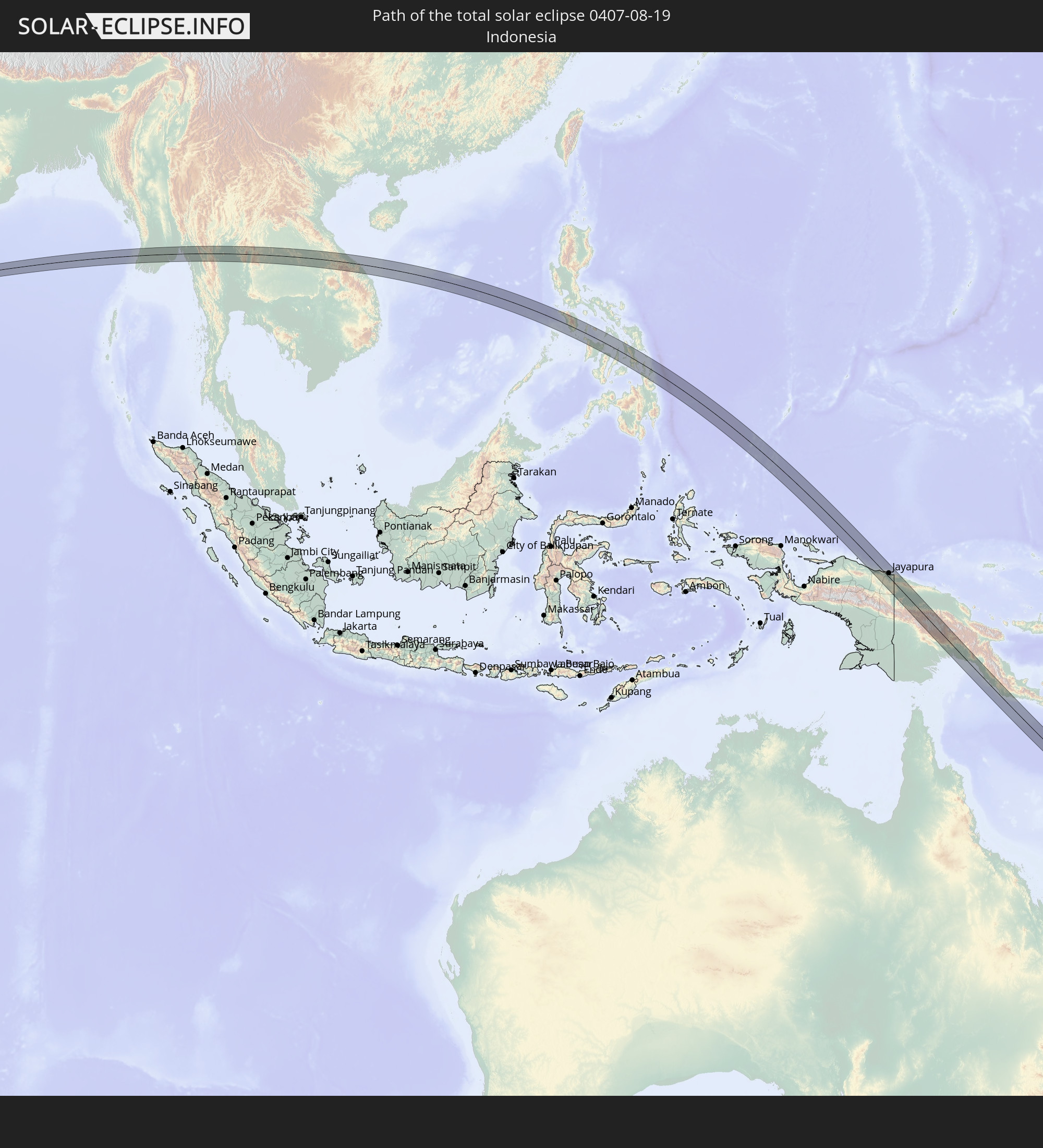 Indonesien
 Thailand
 Laos
Laos
 Vietnam
 Philippinen
 Palau
Palau
 Papua-Neuguinea
 Neukaledonien
In den folgenden Ländern ist die Sonnenfinsternis partiell zu sehen
 Russland
 Fidschi
 Neuseeland
 United States Minor Outlying Islands
 Wallis und Futuna
 Tonga
Tonga
 Kiribati
 Samoa
Samoa
 Tokelau
 Amerikanisch-Samoa
 Niue
Niue
 Cookinseln
 Kasachstan
 Turkmenistan
 Usbekistan
 Afghanistan
 Pakistan
 Tadschikistan
 Indien
 Kirgisistan
 Volksrepublik China
 Sri Lanka
 Nepal
Nepal
 Mongolei
 Bangladesch
 Bhutan
 Myanmar
 Indonesien
 Kokosinseln
 Thailand
 Malaysia
 Laos
Laos
 Vietnam
 Kambodscha
 Singapur
 Weihnachtsinsel
 Australien
 Macau
Macau
 Hongkong
 Brunei
 Taiwan
 Philippinen
 Japan
Japan
 Osttimor
 Nordkorea
 Südkorea
 Palau
Palau
 Föderierte Staaten von Mikronesien
 Papua-Neuguinea
 Guam
Guam
 Nördliche Marianen
 Salomonen
 Neukaledonien
 Marshallinseln
 Vanuatu
 Nauru
Nauru
 Norfolkinsel
 Tuvalu
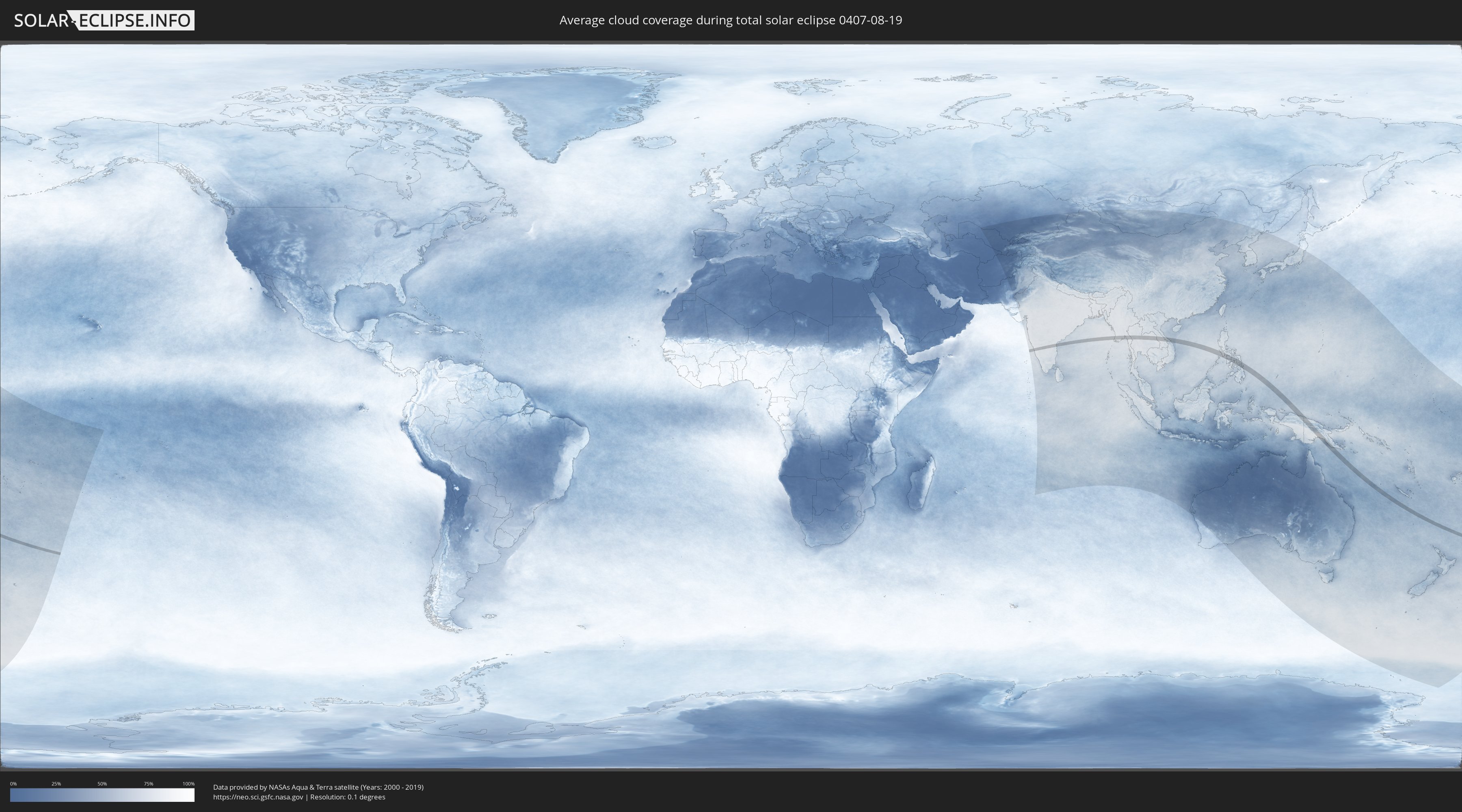
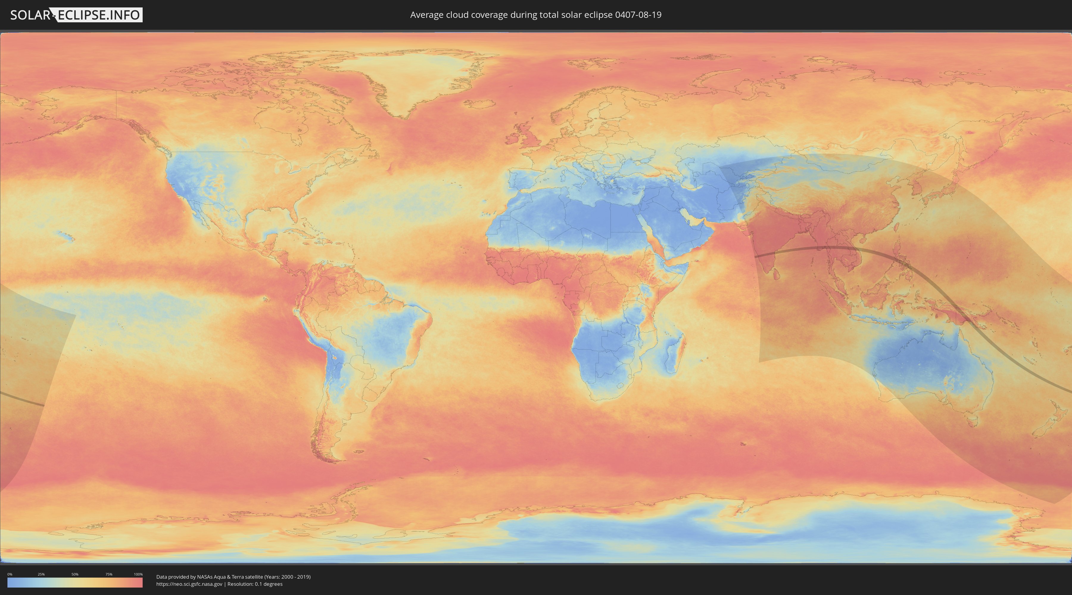
Wie wird das Wetter während der totalen Sonnenfinsternis am 19.08.0407?
Wo ist der beste Ort, um die totale Sonnenfinsternis vom 19.08.0407 zu beobachten?
Die folgenden Karten zeigen die durchschnittliche Bewölkung für den Tag, an dem die totale Sonnenfinsternis
stattfindet. Mit Hilfe der Karten lässt sich der Ort entlang des Finsternispfades eingrenzen,
der die besten Aussichen auf einen klaren wolkenfreien Himmel bietet.
Trotzdem muss man immer lokale Gegenenheiten beachten und sollte sich genau über das Wetter an seinem
gewählten Beobachtungsort informieren.
Die Daten stammen von den beiden NASA-Satelliten
AQUA und TERRA
und wurden über einen Zeitraum von 19 Jahren (2000 - 2019) gemittelt.
Detaillierte Länderkarten
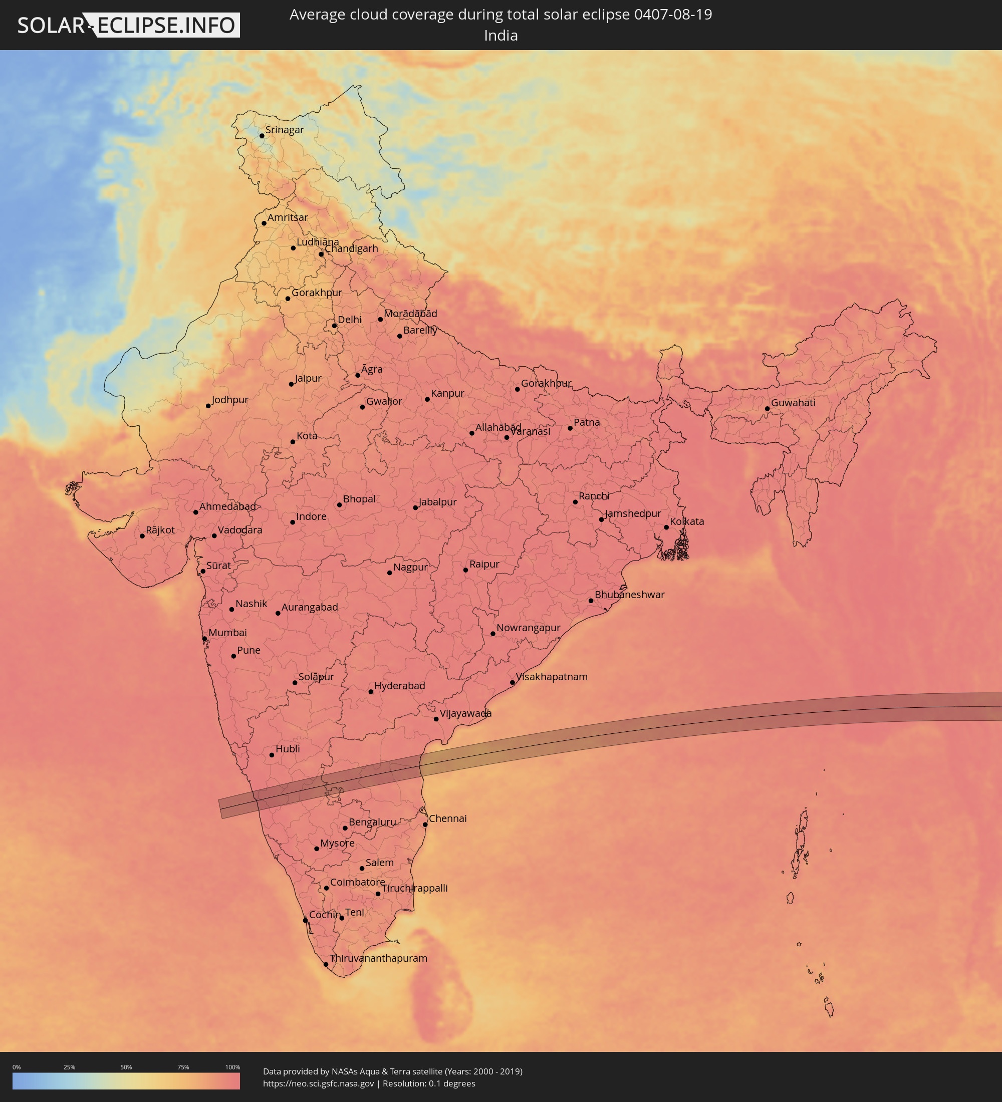 Indien
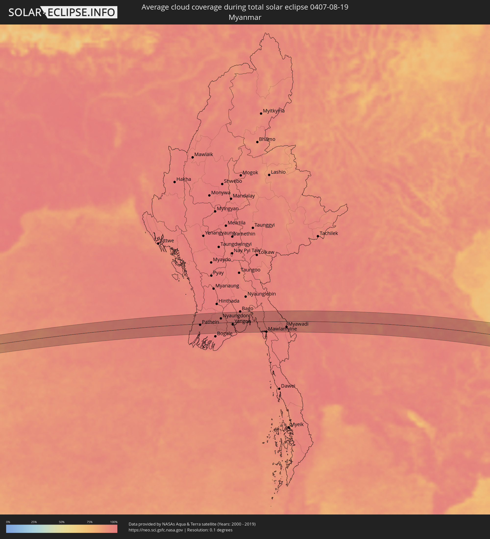 Myanmar
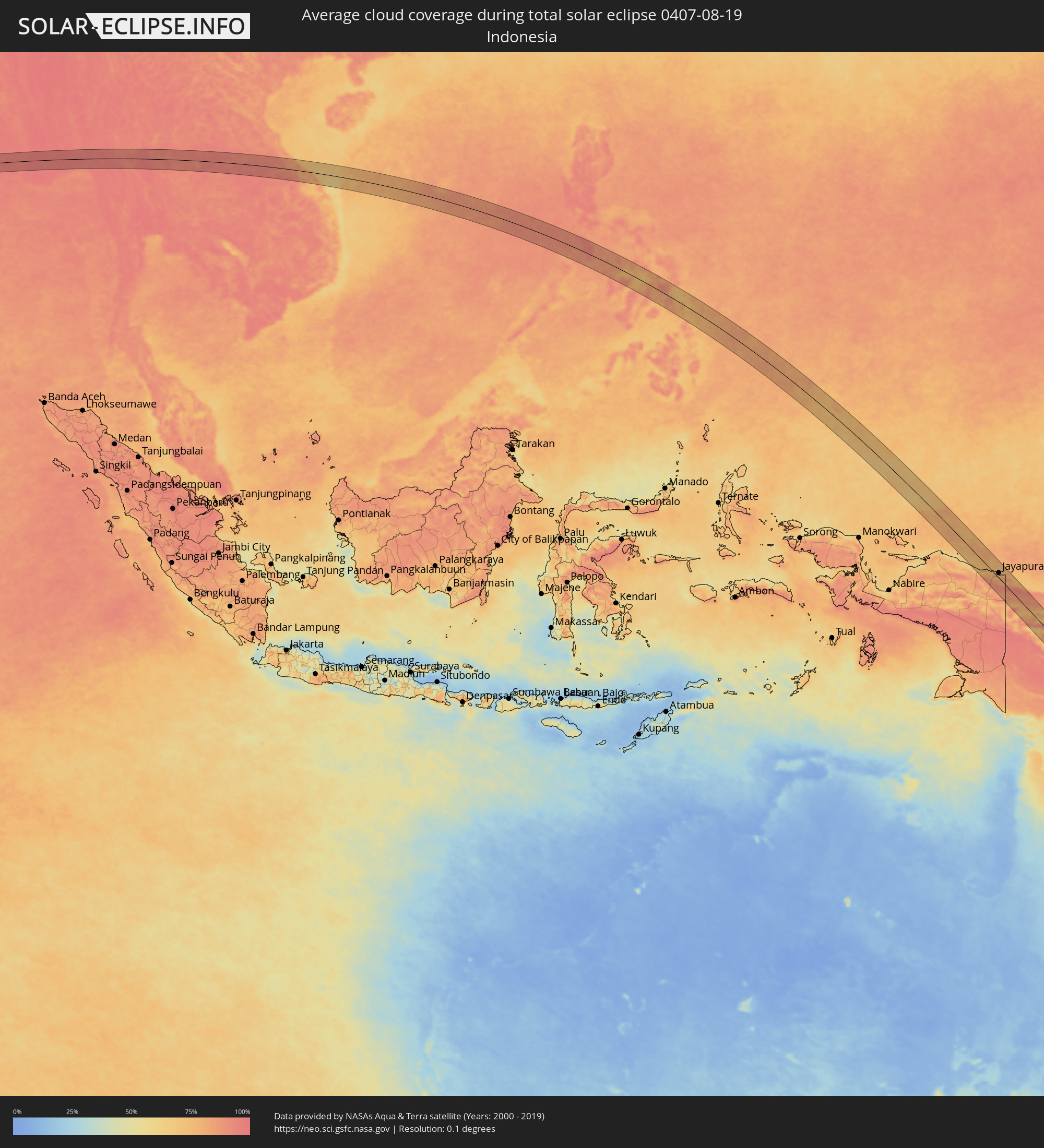 Indonesien
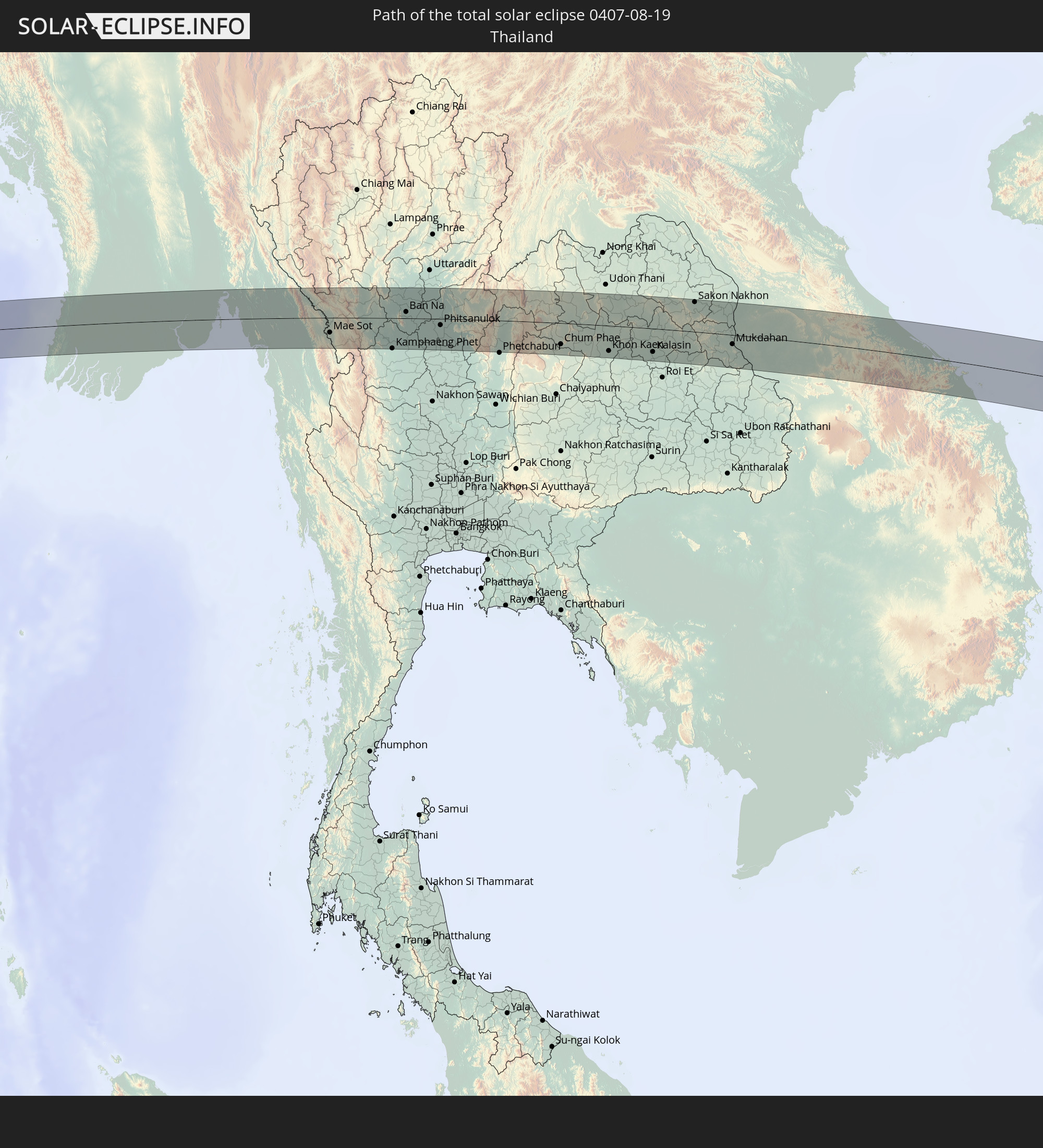
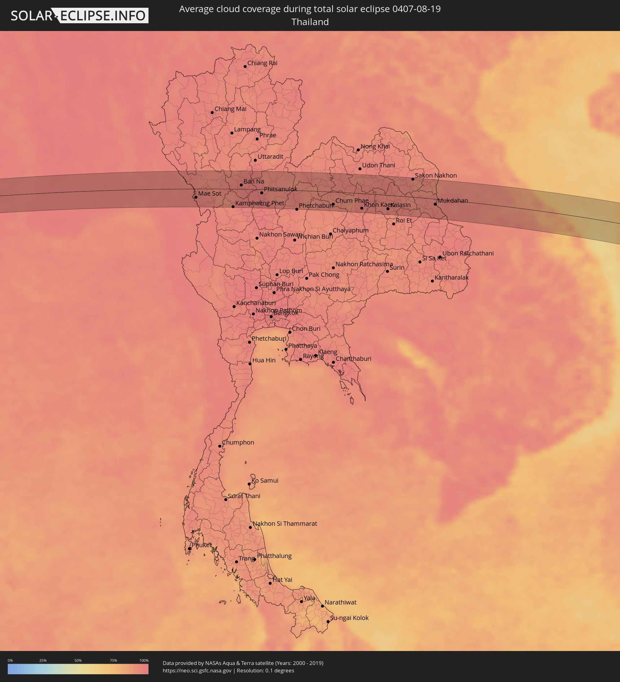 Thailand
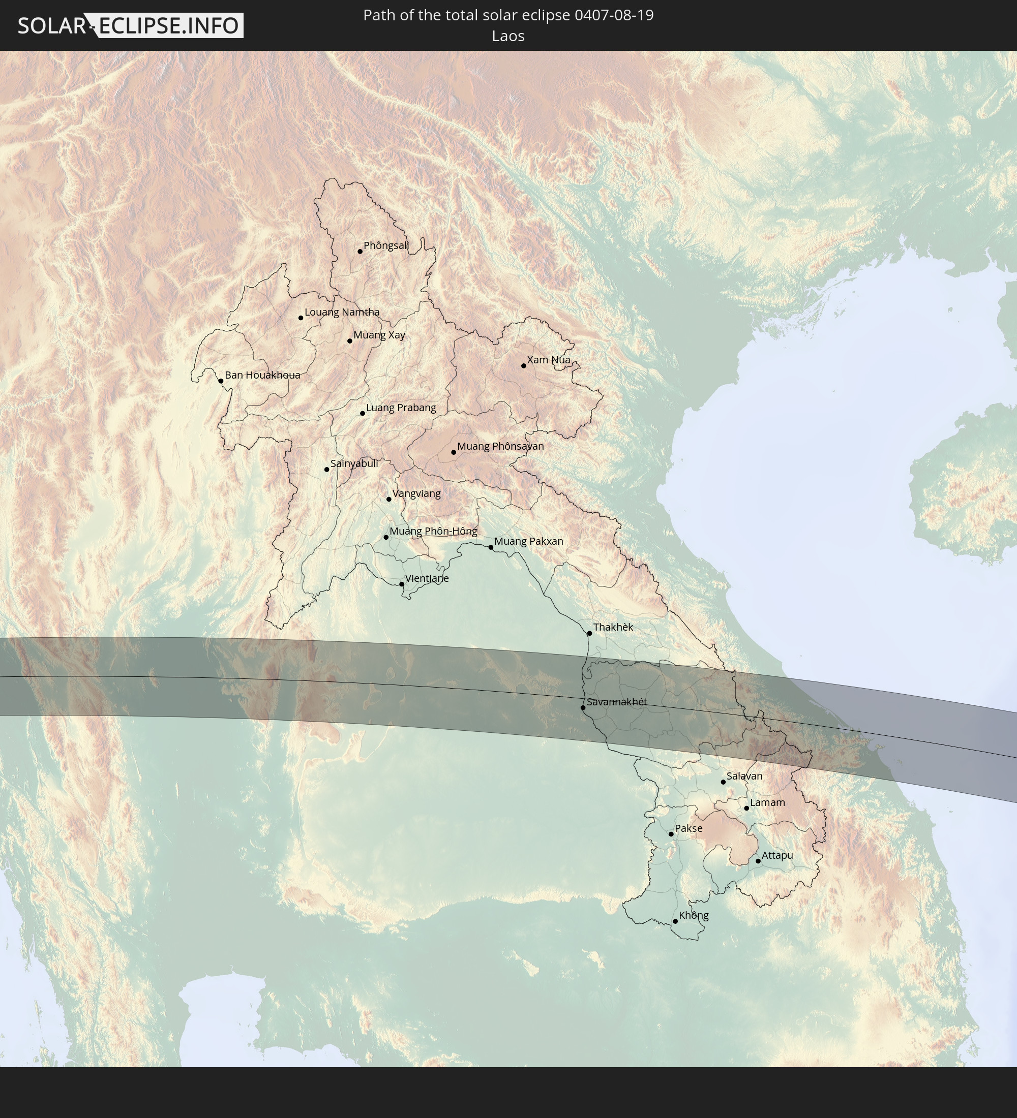
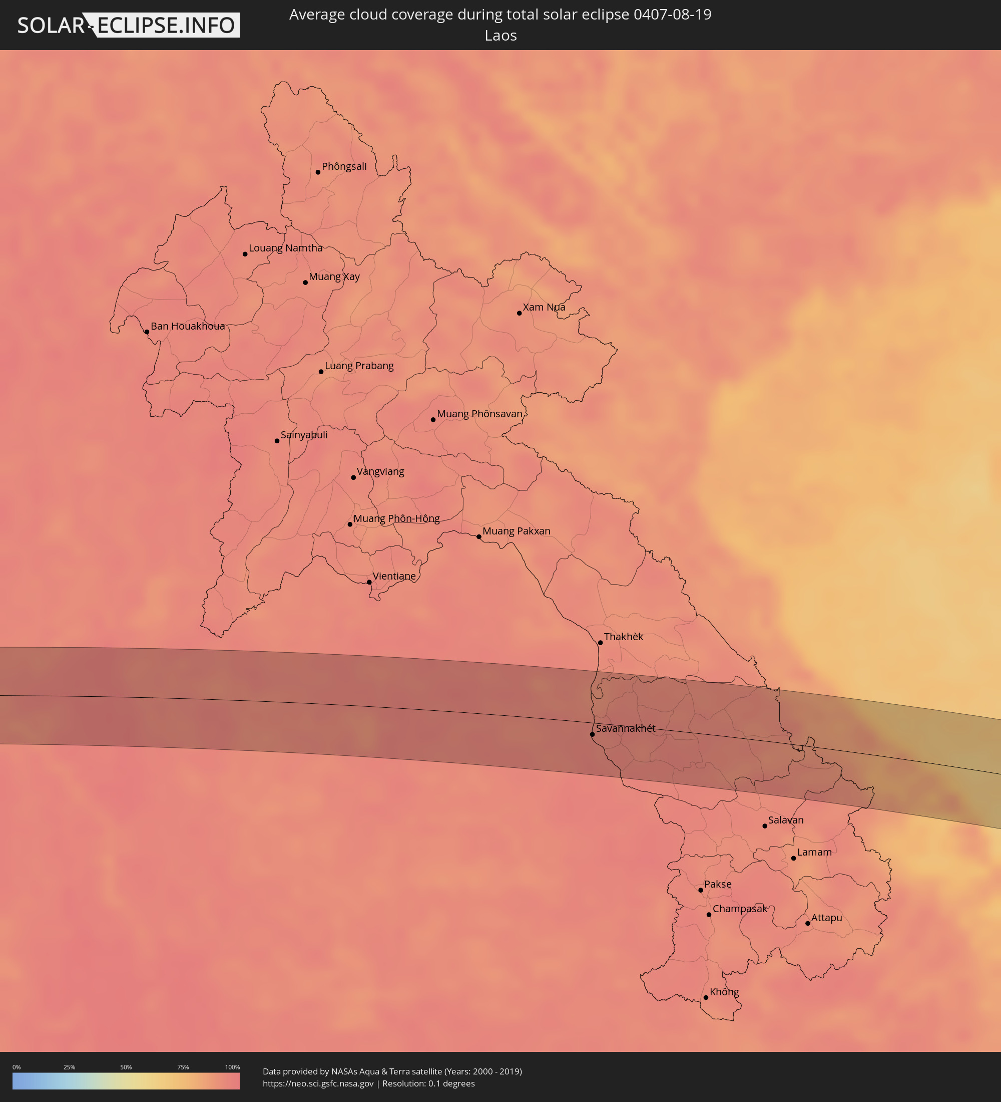 Laos
Laos
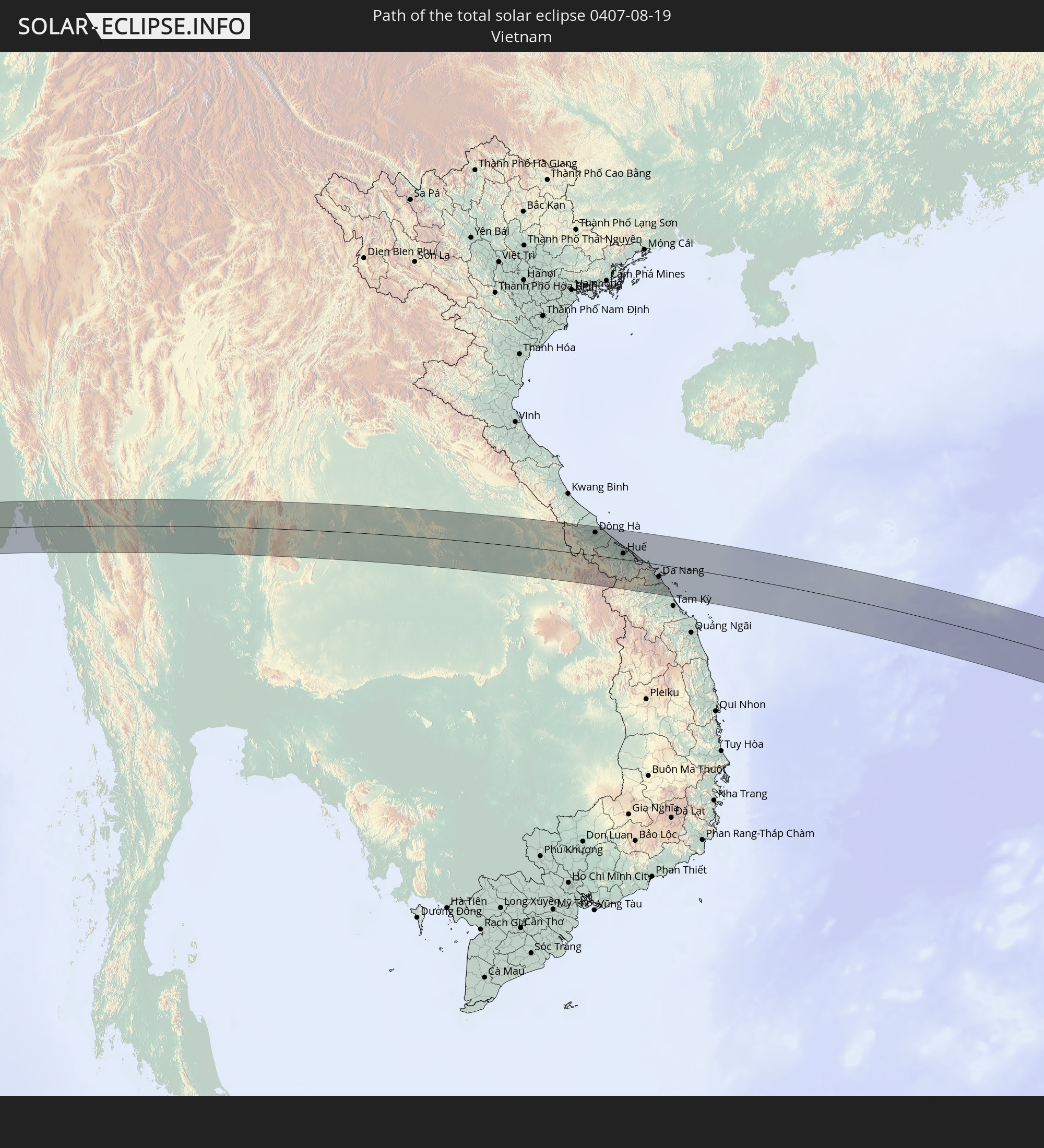
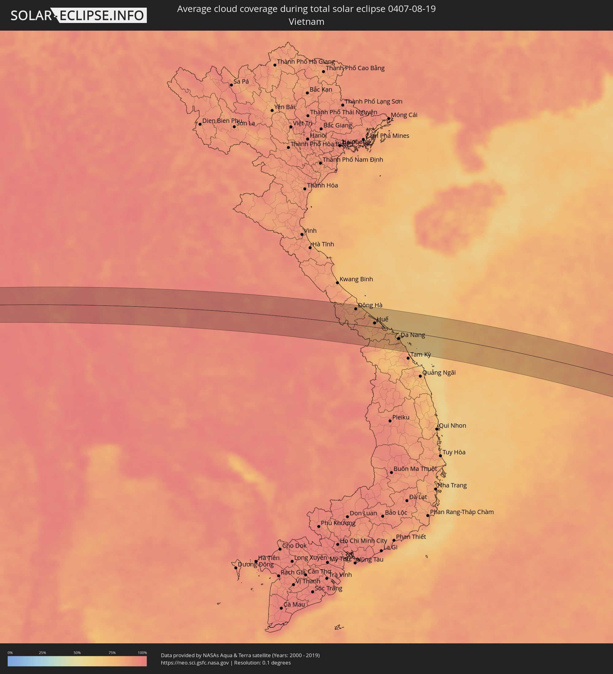 Vietnam
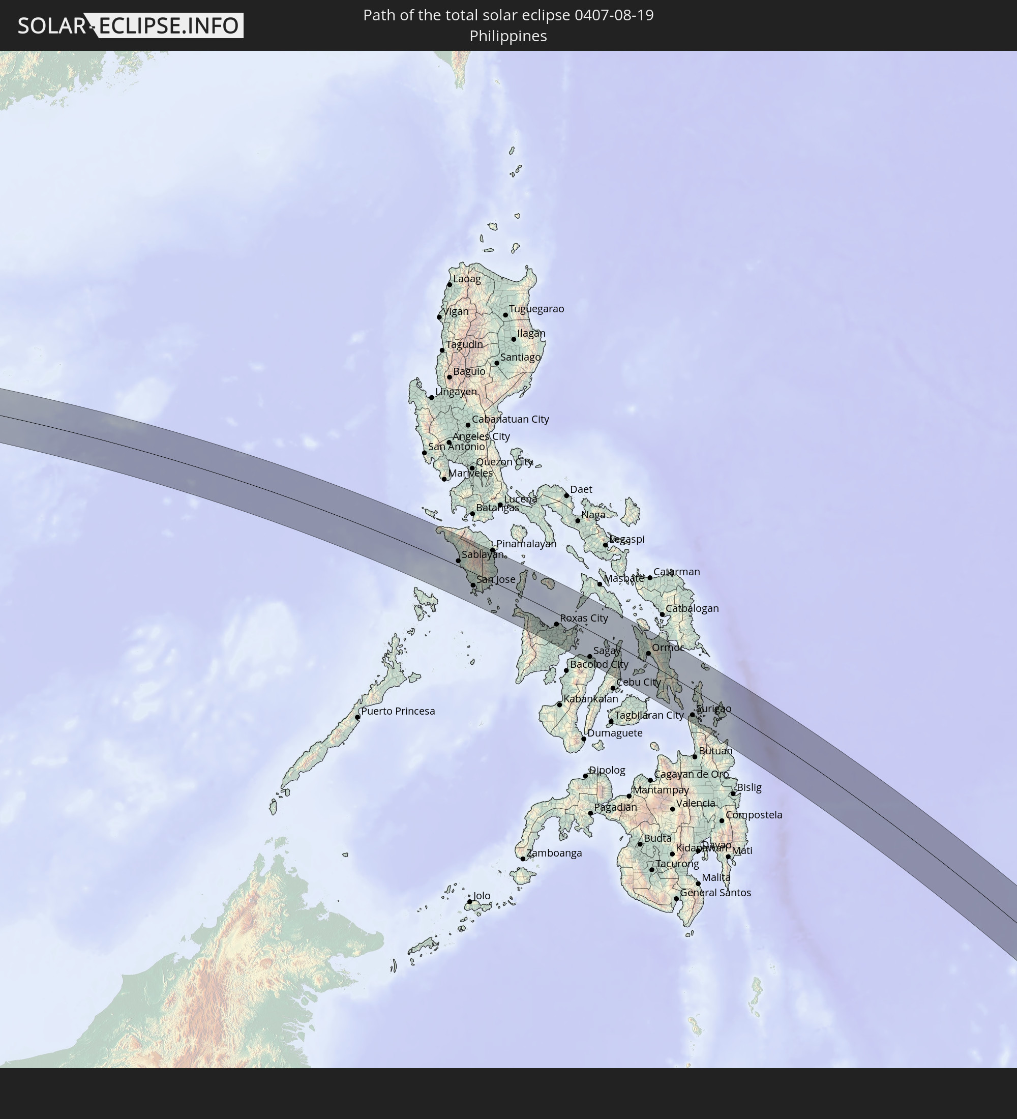
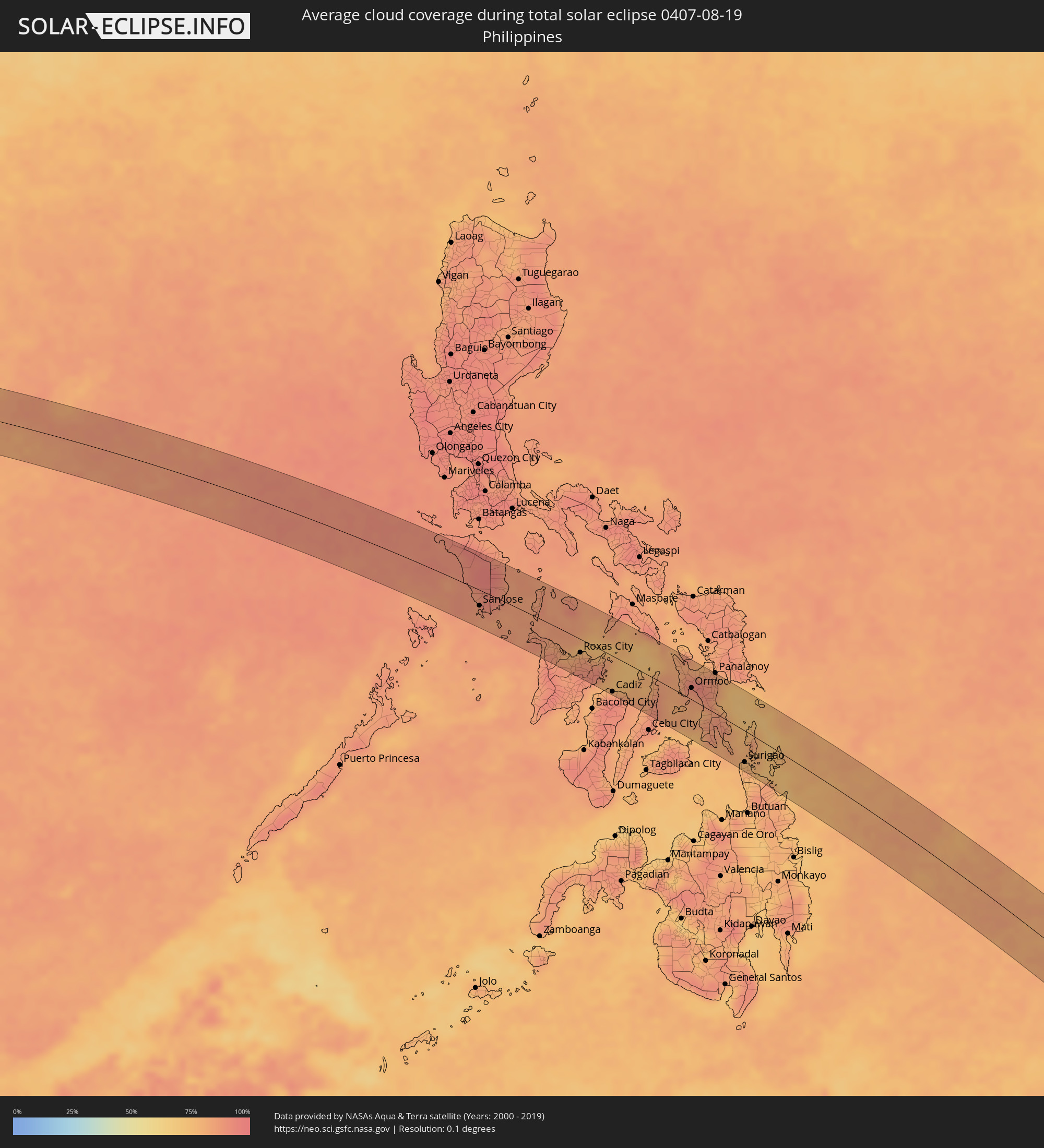 Philippinen
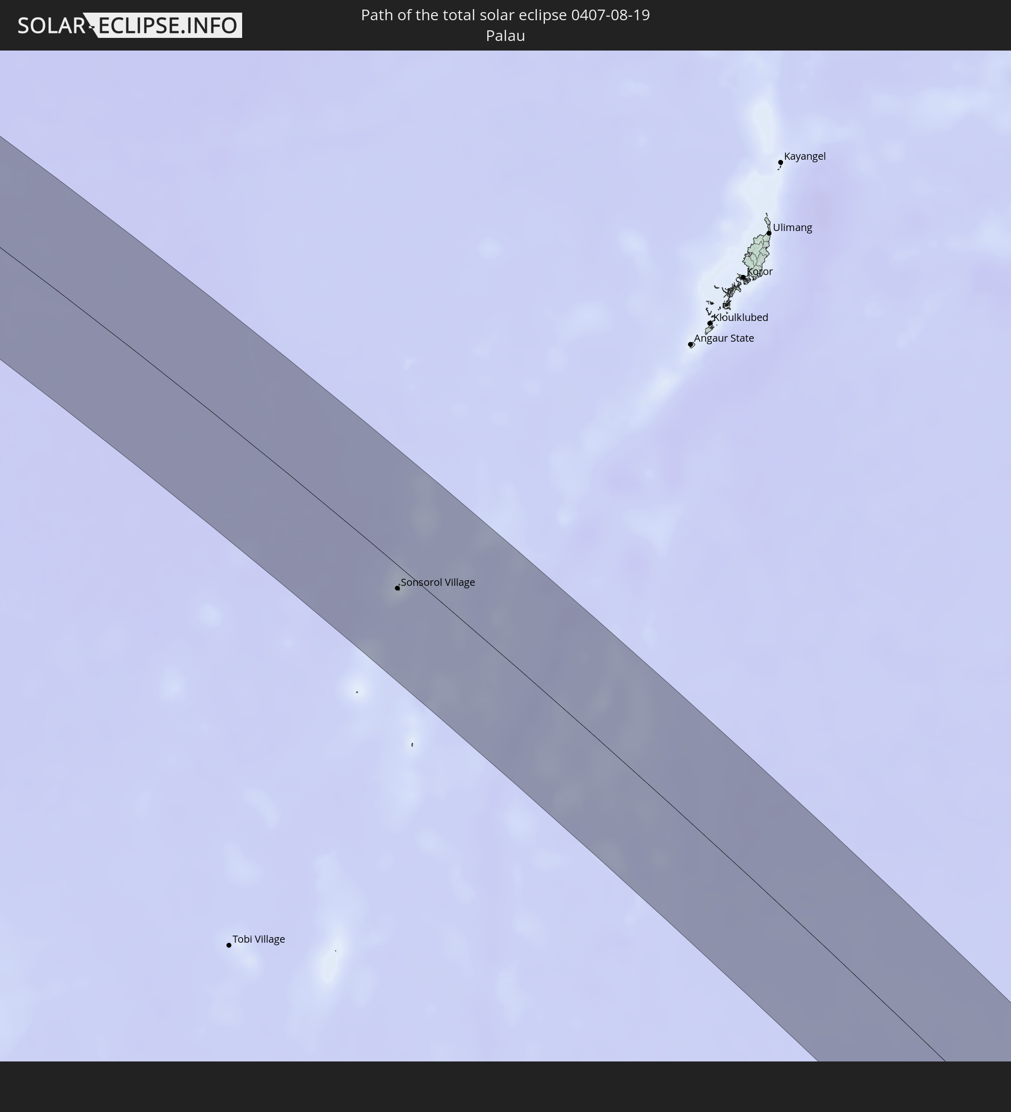
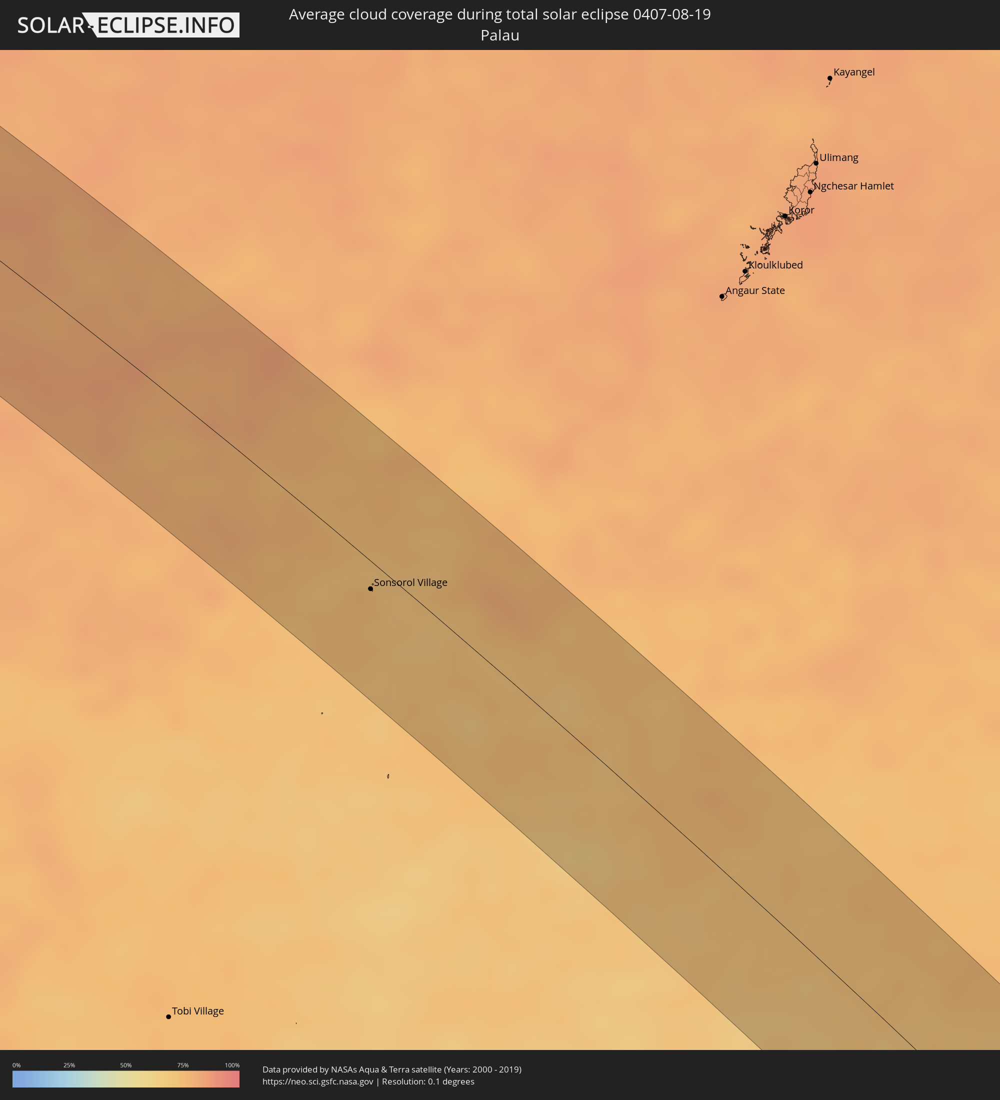 Palau
Palau
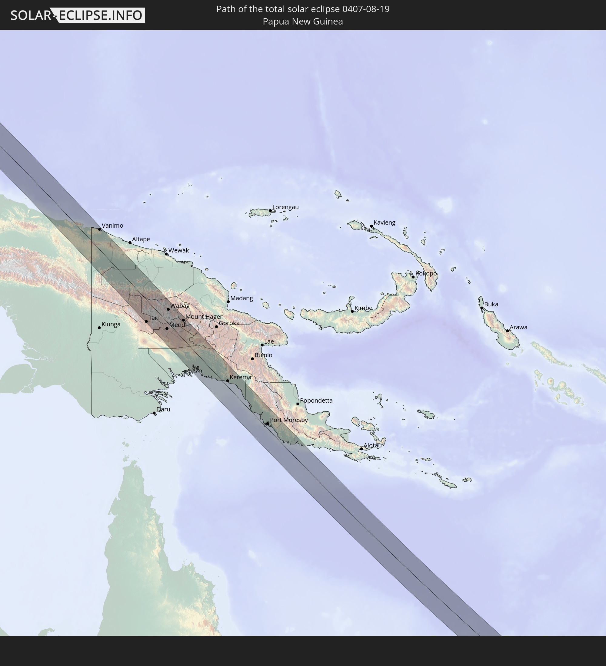
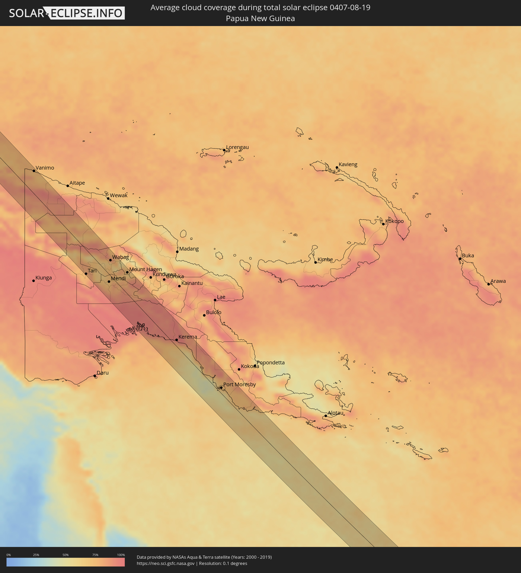 Papua-Neuguinea
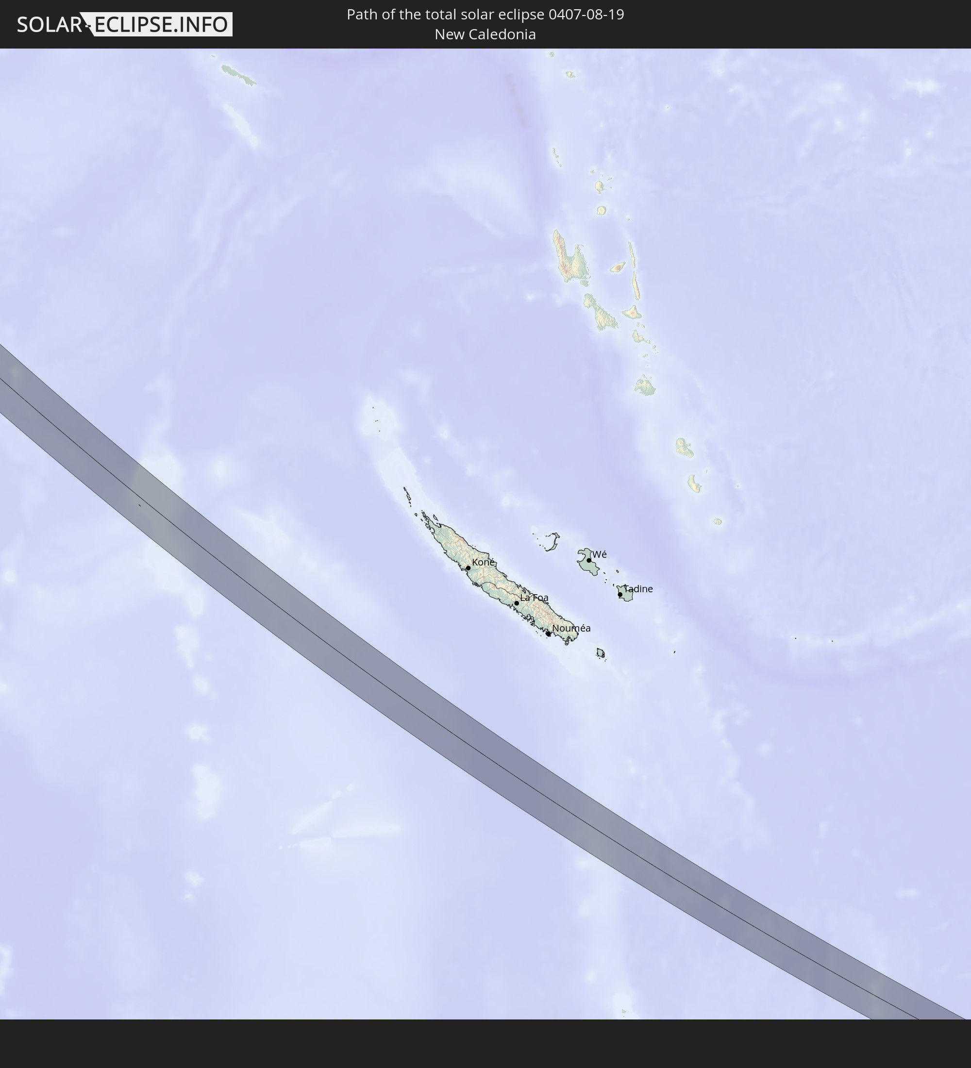
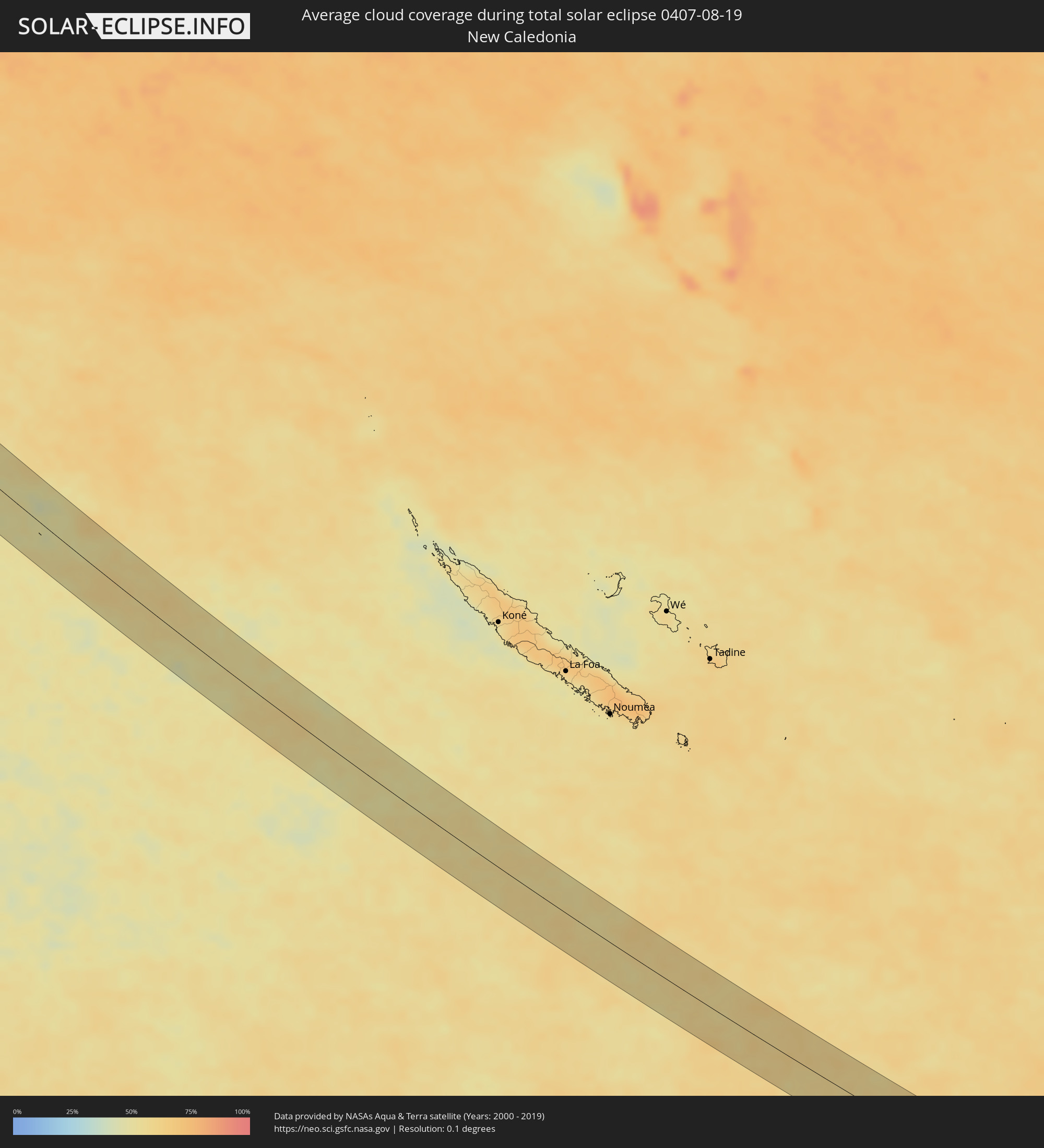 Neukaledonien
Orte im Finsternispfad
Die nachfolgene Tabelle zeigt Städte und Orte mit mehr als 5.000 Einwohnern, die sich im Finsternispfad befinden. Städte mit mehr als 100.000 Einwohnern sind dick gekennzeichnet. Mit einem Klick auf den Ort öffnet sich eine Detailkarte die die Lage des jeweiligen Ortes zusammen mit dem Verlauf der zentralen Finsternis präsentiert.
| Ort | Typ | Dauer der Verfinsterung | Ortszeit bei maximaler Verfinsterung | Entfernung zur Zentrallinie | Ø Bewölkung |
|
Murudeshwara, Karnataka
|
total | - | 06:16:40 UTC+05:21 | 25 km | 94% |
|
Bhatkal, Karnataka
|
total | - | 06:16:42 UTC+05:21 | 11 km | 96% |
|
Byndoor, Karnataka
|
total | - | 06:16:43 UTC+05:21 | 4 km | 94% |
|
Coondapoor, Karnataka
|
total | - | 06:16:46 UTC+05:21 | 31 km | 93% |
|
Sāgar, Karnataka
|
total | - | 06:16:42 UTC+05:21 | 19 km | 97% |
|
Shikārpur, Karnataka
|
total | - | 06:16:43 UTC+05:21 | 23 km | 96% |
|
Shimoga, Karnataka
|
total | - | 06:16:48 UTC+05:21 | 19 km | 95% |
|
Bhadrāvati, Karnataka
|
total | - | 06:16:50 UTC+05:21 | 32 km | 95% |
|
Channagiri, Karnataka
|
total | - | 06:16:50 UTC+05:21 | 18 km | 94% |
|
Chitradurga, Karnataka
|
total | - | 06:16:51 UTC+05:21 | 7 km | 94% |
|
Challakere, Karnataka
|
total | - | 06:16:53 UTC+05:21 | 3 km | 91% |
|
Rāyadrug, Andhra Pradesh
|
total | - | 06:16:50 UTC+05:21 | 34 km | 92% |
|
Kalyandurg, Andhra Pradesh
|
total | - | 06:16:54 UTC+05:21 | 12 km | 92% |
|
Anantapur, Andhra Pradesh
|
total | - | 06:16:58 UTC+05:21 | 15 km | 95% |
|
Dharmavaram, Andhra Pradesh
|
total | - | 06:17:02 UTC+05:21 | 16 km | 95% |
|
Tādpatri, Andhra Pradesh
|
total | - | 06:17:00 UTC+05:21 | 31 km | 95% |
|
Pulivendla, Andhra Pradesh
|
total | - | 06:17:08 UTC+05:21 | 27 km | 93% |
|
Jammalamadugu, Andhra Pradesh
|
total | - | 06:17:05 UTC+05:21 | 16 km | 93% |
|
Erraguntla, Andhra Pradesh
|
total | - | 06:17:10 UTC+05:21 | 10 km | 91% |
|
Proddatūr, Andhra Pradesh
|
total | - | 06:17:08 UTC+05:21 | 2 km | 94% |
|
Cuddapah, Andhra Pradesh
|
total | - | 06:17:15 UTC+05:21 | 34 km | 94% |
|
Kandukūr, Andhra Pradesh
|
total | - | 06:17:23 UTC+05:21 | 24 km | 93% |
|
Kāvali, Andhra Pradesh
|
total | - | 06:17:27 UTC+05:21 | 10 km | 94% |
|
Pathein, Ayeyarwady
|
total | - | 07:28:51 UTC+06:24 | 6 km | 95% |
|
Wakema, Ayeyarwady
|
total | - | 07:29:19 UTC+06:24 | 28 km | 96% |
|
Nyaungdon, Ayeyarwady
|
total | - | 07:29:34 UTC+06:24 | 19 km | 97% |
|
Maubin, Ayeyarwady
|
total | - | 07:29:42 UTC+06:24 | 16 km | 96% |
|
Kyaiklat, Ayeyarwady
|
total | - | 07:29:52 UTC+06:24 | 48 km | 97% |
|
Twante, Yangon
|
total | - | 07:29:57 UTC+06:24 | 19 km | 96% |
|
Kanbe, Yangon
|
total | - | 07:30:01 UTC+06:24 | 20 km | 98% |
|
Yangon, Yangon
|
total | - | 07:30:08 UTC+06:24 | 9 km | 97% |
|
Syriam, Yangon
|
total | - | 07:30:14 UTC+06:24 | 14 km | 97% |
|
Thanatpin, Bago
|
total | - | 07:30:08 UTC+06:24 | 35 km | 97% |
|
Thongwa, Yangon
|
total | - | 07:30:30 UTC+06:24 | 16 km | 97% |
|
Kayan, Yangon
|
total | - | 07:30:29 UTC+06:24 | 1 km | 96% |
|
Thanatpin, Bago
|
total | - | 07:30:21 UTC+06:24 | 43 km | 96% |
|
Kyaikto, Mon
|
total | - | 07:30:46 UTC+06:24 | 44 km | 95% |
|
Thaton, Mon
|
total | - | 07:31:16 UTC+06:24 | 0 km | 96% |
|
Martaban, Mon
|
total | - | 07:31:40 UTC+06:24 | 44 km | 96% |
|
Mawlamyine, Mon
|
total | - | 07:31:42 UTC+06:24 | 48 km | 96% |
|
Hpa-an, Kayin
|
total | - | 07:31:32 UTC+06:24 | 4 km | 95% |
|
Myawadi, Kayin
|
total | - | 07:32:31 UTC+06:24 | 27 km | 96% |
|
Mae Ramat, Tak
|
total | - | 07:49:42 UTC+06:42 | 6 km | 95% |
|
Mae Sot, Tak
|
total | - | 07:49:51 UTC+06:42 | 24 km | 96% |
|
Ban Tak, Tak
|
total | - | 07:50:16 UTC+06:42 | 13 km | 91% |
|
Tak, Tak
|
total | - | 07:50:24 UTC+06:42 | 7 km | 92% |
|
Kamphaeng Phet, Kamphaeng Phet
|
total | - | 07:51:00 UTC+06:42 | 49 km | 93% |
|
Ban Na, Sukhothai
|
total | - | 07:50:59 UTC+06:42 | 10 km | 95% |
|
Sawankhalok, Sukhothai
|
total | - | 07:50:58 UTC+06:42 | 44 km | 96% |
|
Bang Rakam, Phitsanulok
|
total | - | 07:51:32 UTC+06:42 | 18 km | 97% |
|
Phitsanulok, Phitsanulok
|
total | - | 07:51:40 UTC+06:42 | 10 km | 97% |
|
Bang Krathum, Phitsanulok
|
total | - | 07:51:50 UTC+06:42 | 37 km | 97% |
|
Lom Sak, Phetchabun
|
total | - | 07:52:50 UTC+06:42 | 12 km | 96% |
|
Wang Saphung, Loei
|
total | - | 07:53:12 UTC+06:42 | 48 km | 93% |
|
Phu Kradueng, Loei
|
total | - | 07:53:33 UTC+06:42 | 2 km | 93% |
|
Chum Phae, Khon Kaen
|
total | - | 07:53:59 UTC+06:42 | 34 km | 92% |
|
Na Klang, Changwat Nong Bua Lamphu
|
total | - | 07:53:43 UTC+06:42 | 51 km | 93% |
|
Nong Bua Lamphu, Changwat Nong Bua Lamphu
|
total | - | 07:54:04 UTC+06:42 | 41 km | 95% |
|
Khon Kaen, Khon Kaen
|
total | - | 07:54:58 UTC+06:42 | 41 km | 94% |
|
Ban Phan Don, Changwat Udon Thani
|
total | - | 07:54:46 UTC+06:42 | 37 km | 94% |
|
Nong Kung Si, Kalasin
|
total | - | 07:55:27 UTC+06:42 | 15 km | 94% |
|
Kalasin, Kalasin
|
total | - | 07:55:50 UTC+06:42 | 38 km | 92% |
|
Kuchinarai, Kalasin
|
total | - | 07:56:29 UTC+06:42 | 22 km | 95% |
|
Sakon Nakhon, Sakon Nakhon
|
total | - | 07:56:16 UTC+06:42 | 48 km | 93% |
|
Mukdahan, Mukdahan
|
total | - | 07:57:24 UTC+06:42 | 15 km | 95% |
|
Savannakhét, Savannahkhét
|
total | - | 07:57:25 UTC+06:42 | 12 km | 93% |
|
Ðông Hà, Quảng Trị
|
total | - | 08:25:11 UTC+07:06 | 43 km | 82% |
|
Huế, Thừa Thiên-Huế
|
total | - | 08:26:10 UTC+07:06 | 11 km | 80% |
|
Da Nang, Đà Nẵng
|
total | - | 08:27:24 UTC+07:06 | 23 km | 84% |
|
Hội An, Quảng Nam
|
total | - | 08:27:43 UTC+07:06 | 42 km | 78% |
|
Mamburao, Mimaropa
|
total | - | 09:46:32 UTC+08:00 | 41 km | 90% |
|
Sablayan, Mimaropa
|
total | - | 09:47:26 UTC+08:00 | 10 km | 89% |
|
San Jose, Mimaropa
|
total | - | 09:48:44 UTC+08:00 | 26 km | 87% |
|
Mansalay, Mimaropa
|
total | - | 09:49:17 UTC+08:00 | 8 km | 89% |
|
Bansud, Mimaropa
|
total | - | 09:48:50 UTC+08:00 | 44 km | 86% |
|
Pandan, Western Visayas
|
total | - | 09:51:50 UTC+08:00 | 38 km | 84% |
|
Romblon, Mimaropa
|
total | - | 09:51:00 UTC+08:00 | 53 km | 86% |
|
Kalibo (poblacion), Western Visayas
|
total | - | 09:52:28 UTC+08:00 | 29 km | 83% |
|
Roxas City, Western Visayas
|
total | - | 09:53:30 UTC+08:00 | 22 km | 85% |
|
Cadiz, Western Visayas
|
total | - | 09:55:40 UTC+08:00 | 57 km | 94% |
|
Escalante, Western Visayas
|
total | - | 09:56:18 UTC+08:00 | 57 km | 87% |
|
Bantayan, Central Visayas
|
total | - | 09:56:17 UTC+08:00 | 13 km | 79% |
|
Bogo, Central Visayas
|
total | - | 09:57:05 UTC+08:00 | 10 km | 84% |
|
Daanbantayan, Central Visayas
|
total | - | 09:56:48 UTC+08:00 | 10 km | 83% |
|
Danao, Central Visayas
|
total | - | 09:57:59 UTC+08:00 | 60 km | 84% |
|
Ormoc, Eastern Visayas
|
total | - | 09:58:30 UTC+08:00 | 18 km | 86% |
|
Carigara, Eastern Visayas
|
total | - | 09:58:11 UTC+08:00 | 50 km | 85% |
|
Baybay, Eastern Visayas
|
total | - | 09:59:28 UTC+08:00 | 3 km | 79% |
|
Maasin, Eastern Visayas
|
total | - | 10:00:27 UTC+08:00 | 53 km | 76% |
|
Burauen, Eastern Visayas
|
total | - | 09:59:11 UTC+08:00 | 31 km | 89% |
|
Palo, Eastern Visayas
|
total | - | 09:59:06 UTC+08:00 | 54 km | 86% |
|
Abuyog, Eastern Visayas
|
total | - | 09:59:49 UTC+08:00 | 15 km | 85% |
|
Surigao, Caraga
|
total | - | 10:02:30 UTC+08:00 | 49 km | 77% |
|
Sonsorol Village, Sonsorol
|
total | - | 11:26:11 UTC+09:00 | 13 km | 74% |
|
Abepura, Papua
|
total | - | 12:23:27 UTC+09:22 | 7 km | 74% |
|
Jayapura, Papua
|
total | - | 12:23:30 UTC+09:22 | 18 km | 76% |
|
Vanimo, Sandaun
|
total | - | 13:02:04 UTC+10:00 | 53 km | 78% |
|
Vanimo, Sandaun
|
total | - | 13:02:11 UTC+10:00 | 54 km | 78% |
|
Tari, Hela
|
total | - | 13:11:41 UTC+10:00 | 58 km | 77% |
|
Mendi, Southern Highlands
|
total | - | 13:13:32 UTC+10:00 | 18 km | 75% |
|
Wabag, Enga
|
total | - | 13:12:21 UTC+10:00 | 37 km | 73% |
|
Ialibu, Southern Highlands
|
total | - | 13:14:26 UTC+10:00 | 1 km | 84% |
|
Mount Hagen, Western Highlands
|
total | - | 13:14:04 UTC+10:00 | 51 km | 77% |
|
Kerema, Gulf
|
total | - | 13:20:49 UTC+10:00 | 15 km | 74% |
|
Port Moresby, National Capital
|
total | - | 13:25:54 UTC+10:00 | 14 km | 63% |