Total solar eclipse of 08/19/0407
| Day of week: | Sunday |
| Maximum duration of eclipse: | 03m24s |
| Maximum width of eclipse path: | 127 km |
| Saros cycle: | 90 |
| Coverage: | 100% |
| Magnitude: | 1.0371 |
| Gamma: | -0.2024 |
Wo kann man die Sonnenfinsternis vom 08/19/0407 sehen?
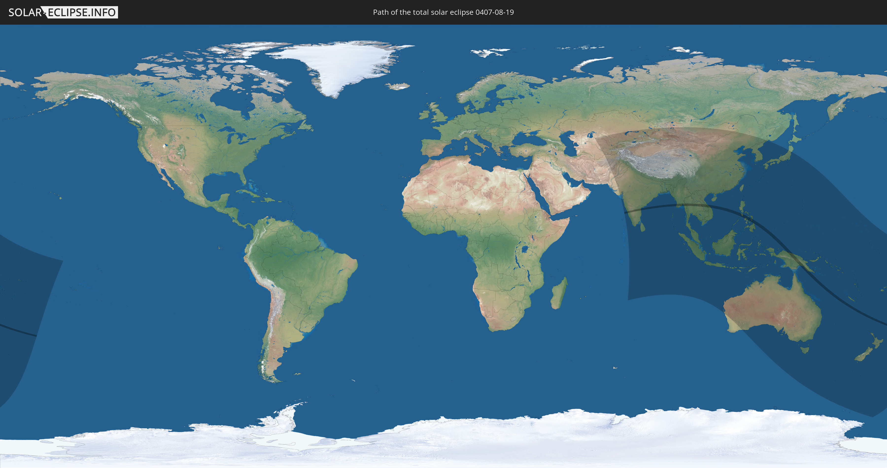
Die Sonnenfinsternis am 08/19/0407 kann man in 58 Ländern als partielle Sonnenfinsternis beobachten.
Der Finsternispfad verläuft durch 10 Länder. Nur in diesen Ländern ist sie als total Sonnenfinsternis zu sehen.
In den folgenden Ländern ist die Sonnenfinsternis total zu sehen
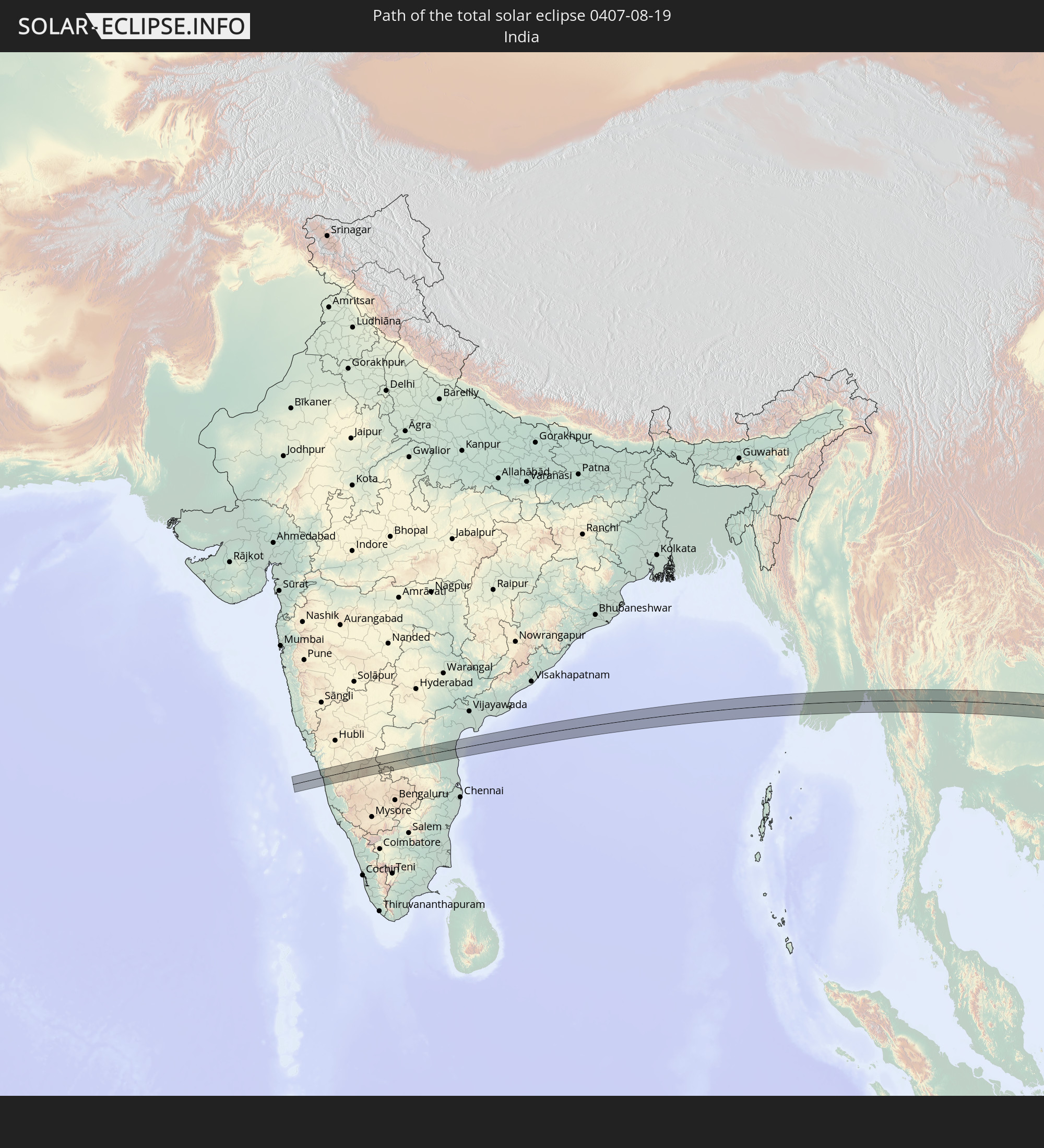 India
India
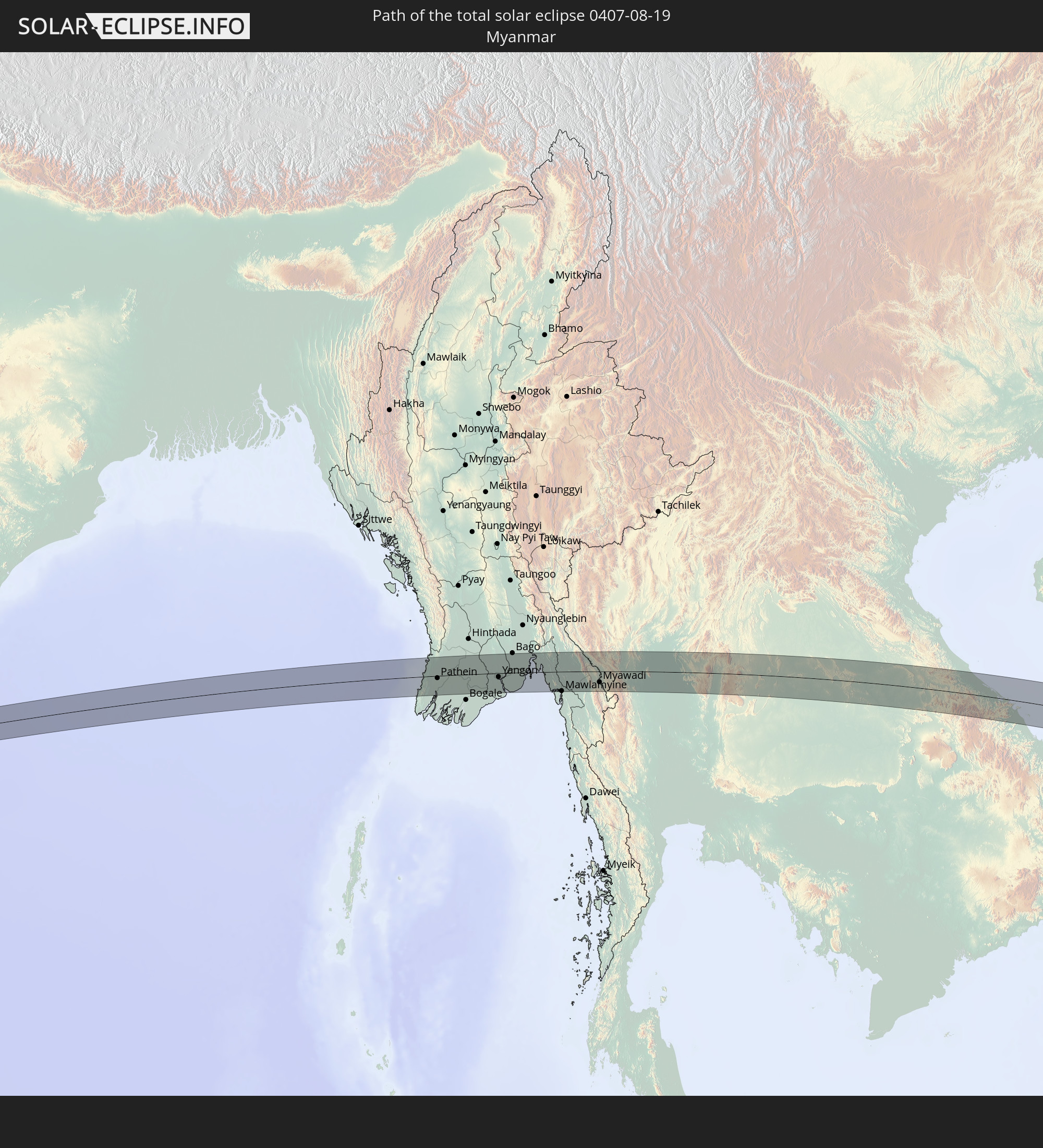 Myanmar
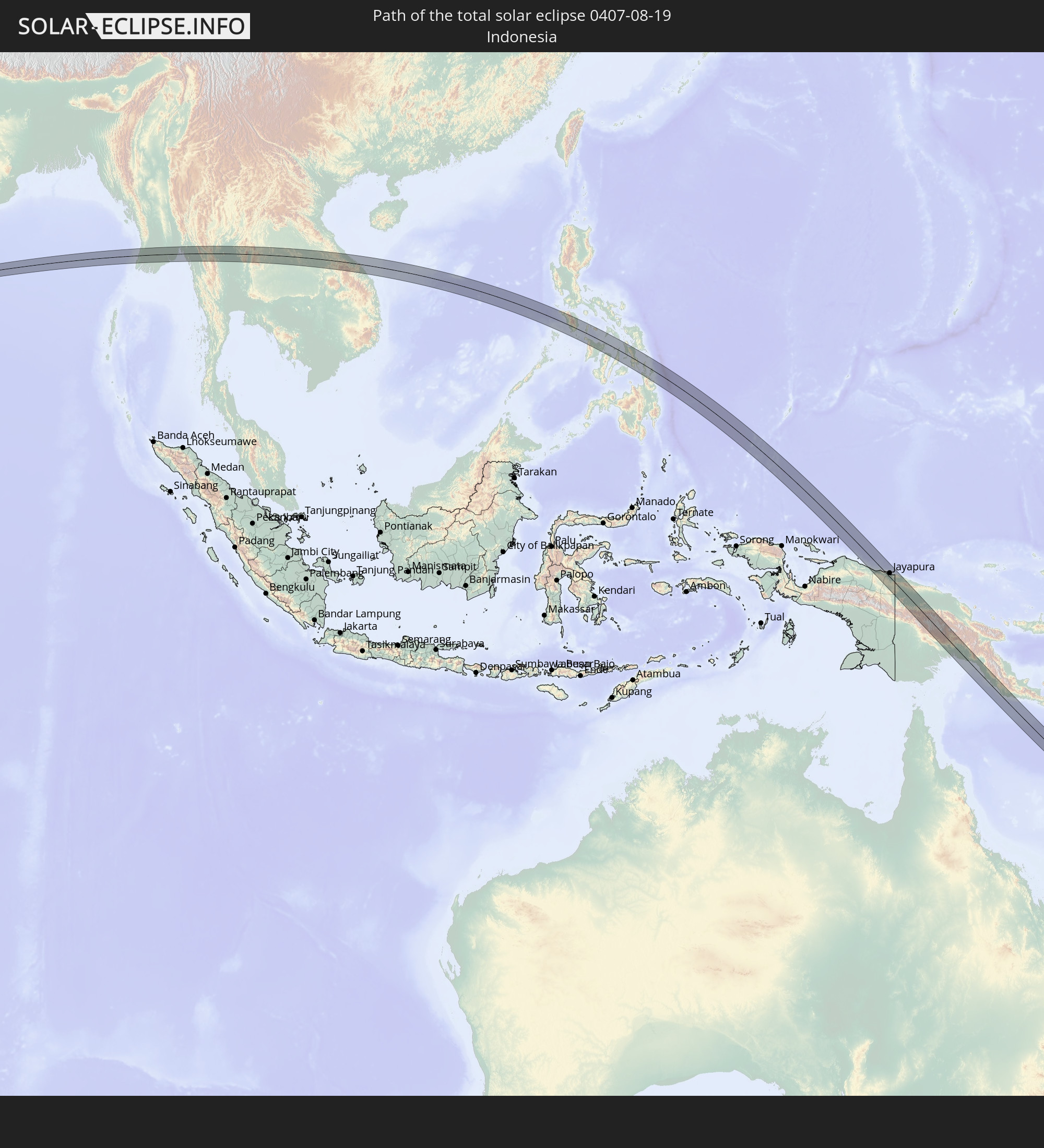 Indonesia
 Thailand
 Laos
Laos
 Vietnam
 Philippines
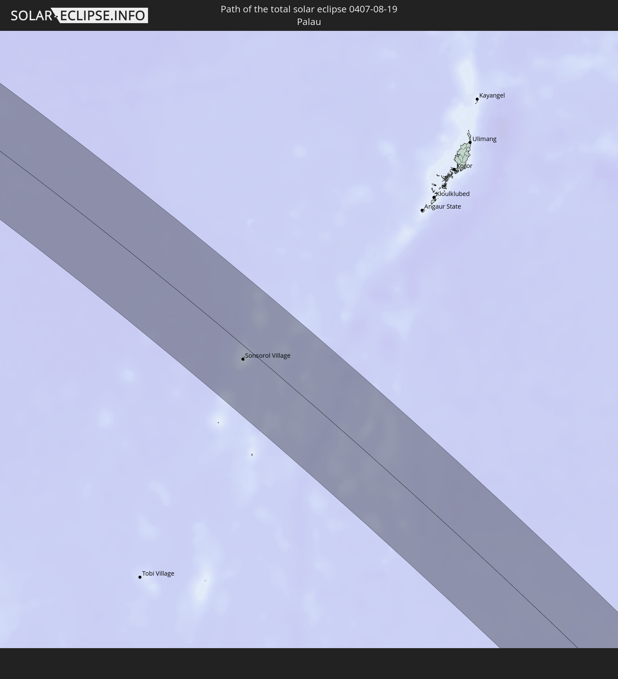 Palau
Palau
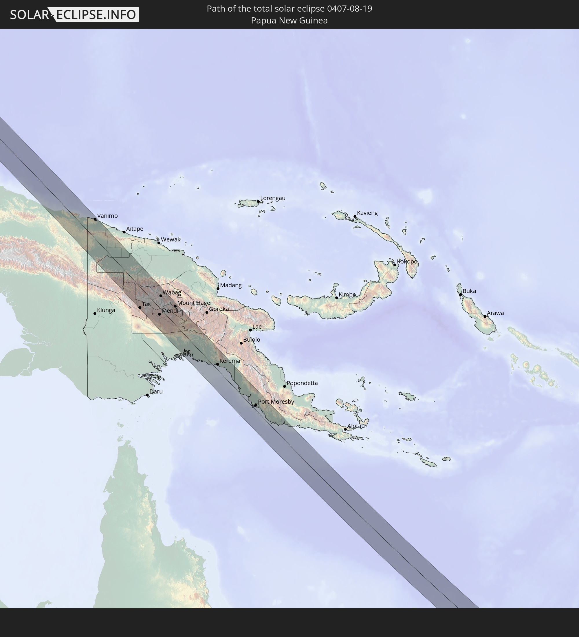 Papua New Guinea
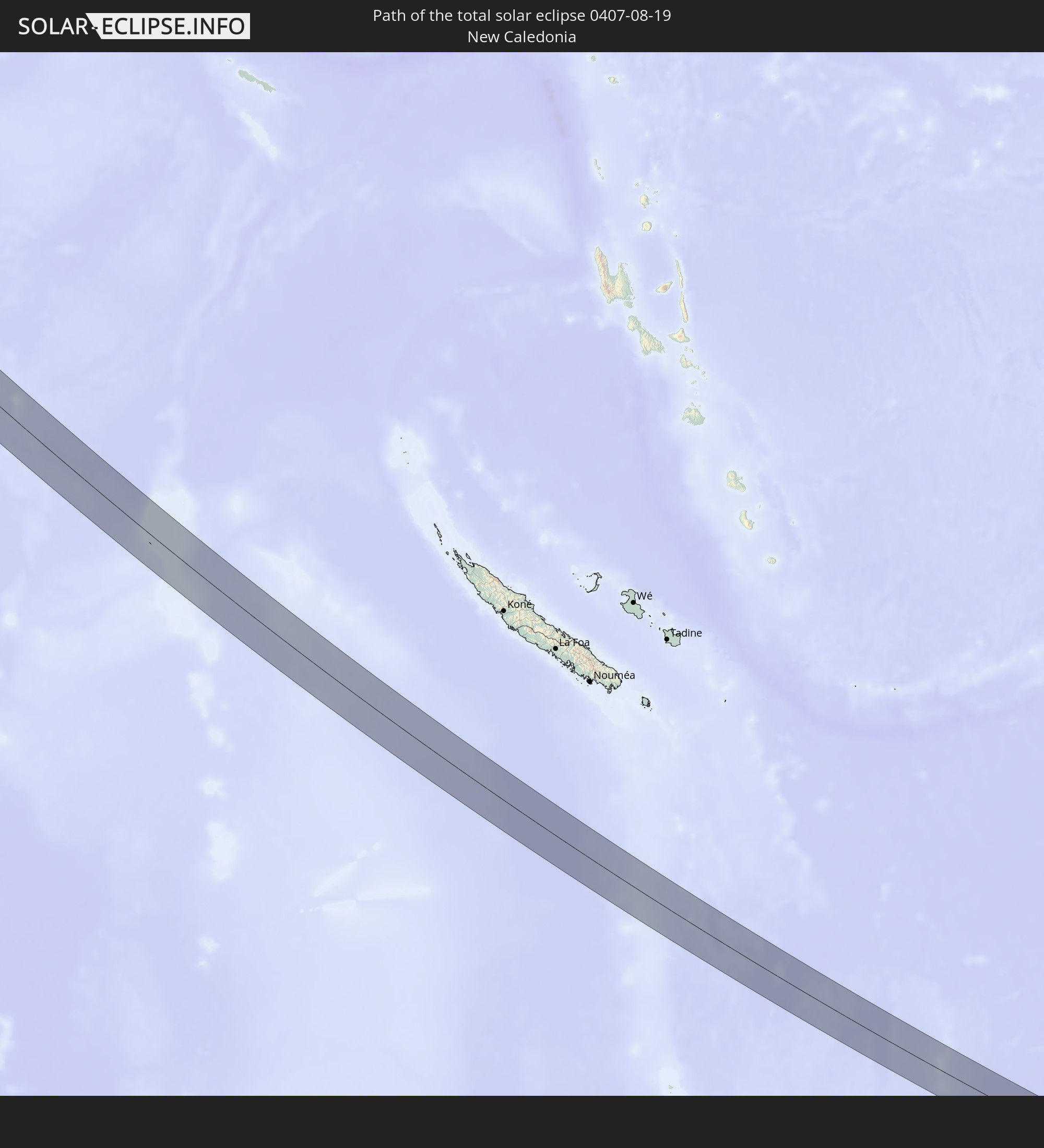 New Caledonia
In den folgenden Ländern ist die Sonnenfinsternis partiell zu sehen
 Fiji
Fiji
 Russia
 New Zealand
 United States Minor Outlying Islands
 Wallis and Futuna
 Tonga
Tonga
 Kiribati
 Samoa
Samoa
 Tokelau
 American Samoa
 Niue
Niue
 Cook Islands
 Kazakhstan
 Turkmenistan
 Uzbekistan
 Afghanistan
 Pakistan
 Tajikistan
 India
India
 Kyrgyzstan
 China
China
 Sri Lanka
 Nepal
Nepal
 Mongolia
 Bangladesh
 Bhutan
 Myanmar
 Indonesia
 Cocos Islands
 Thailand
 Malaysia
 Laos
Laos
 Vietnam
 Cambodia
 Singapore
 Christmas Island
 Australia
 Macau
Macau
 Hong Kong
 Brunei
 Taiwan
 Philippines
 Japan
Japan
 East Timor
 North Korea
 South Korea
 Palau
Palau
 Federated States of Micronesia
 Papua New Guinea
 Guam
Guam
 Northern Mariana Islands
 Solomon Islands
 New Caledonia
 Marshall Islands
 Vanuatu
 Nauru
Nauru
 Norfolk Island
 Tuvalu
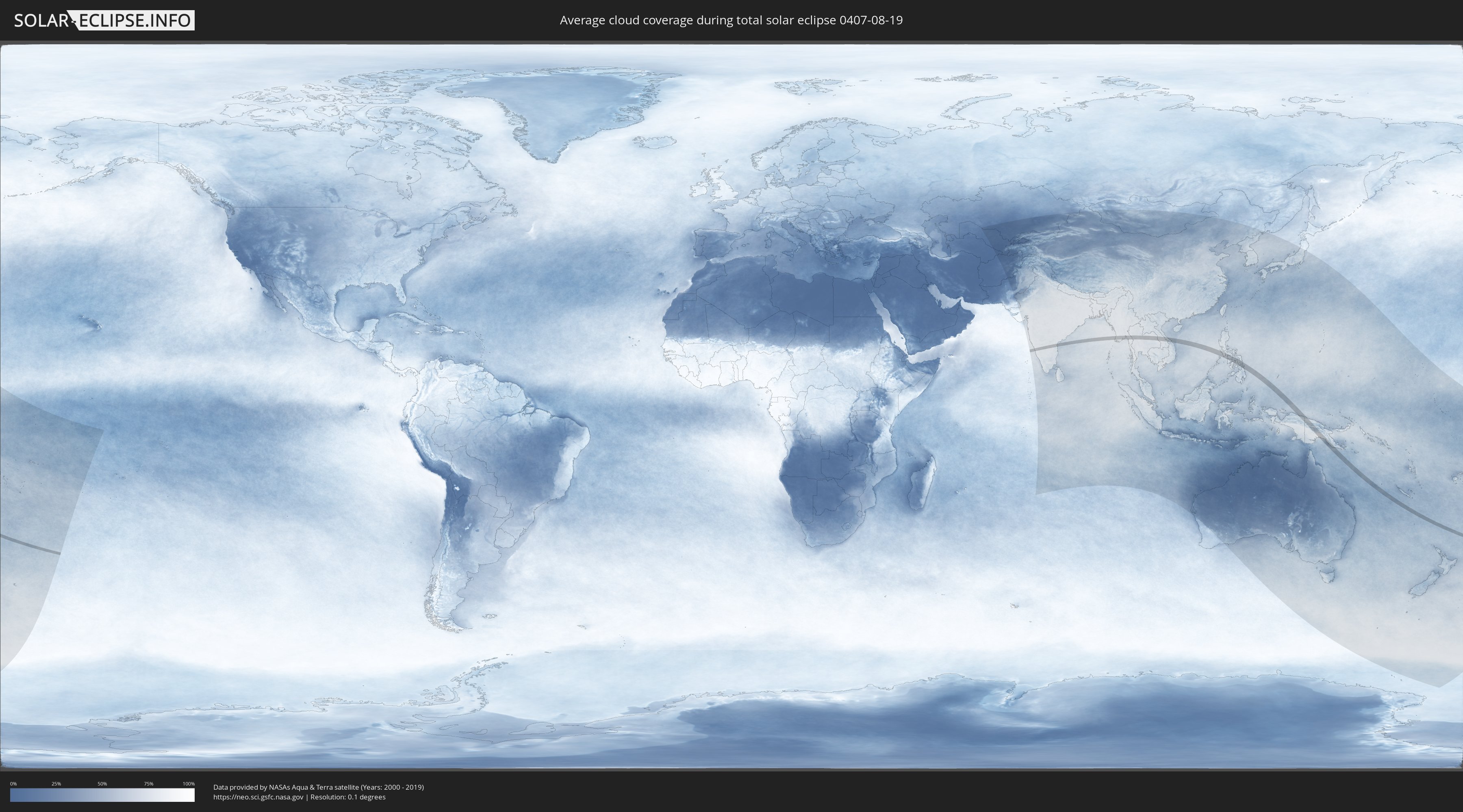
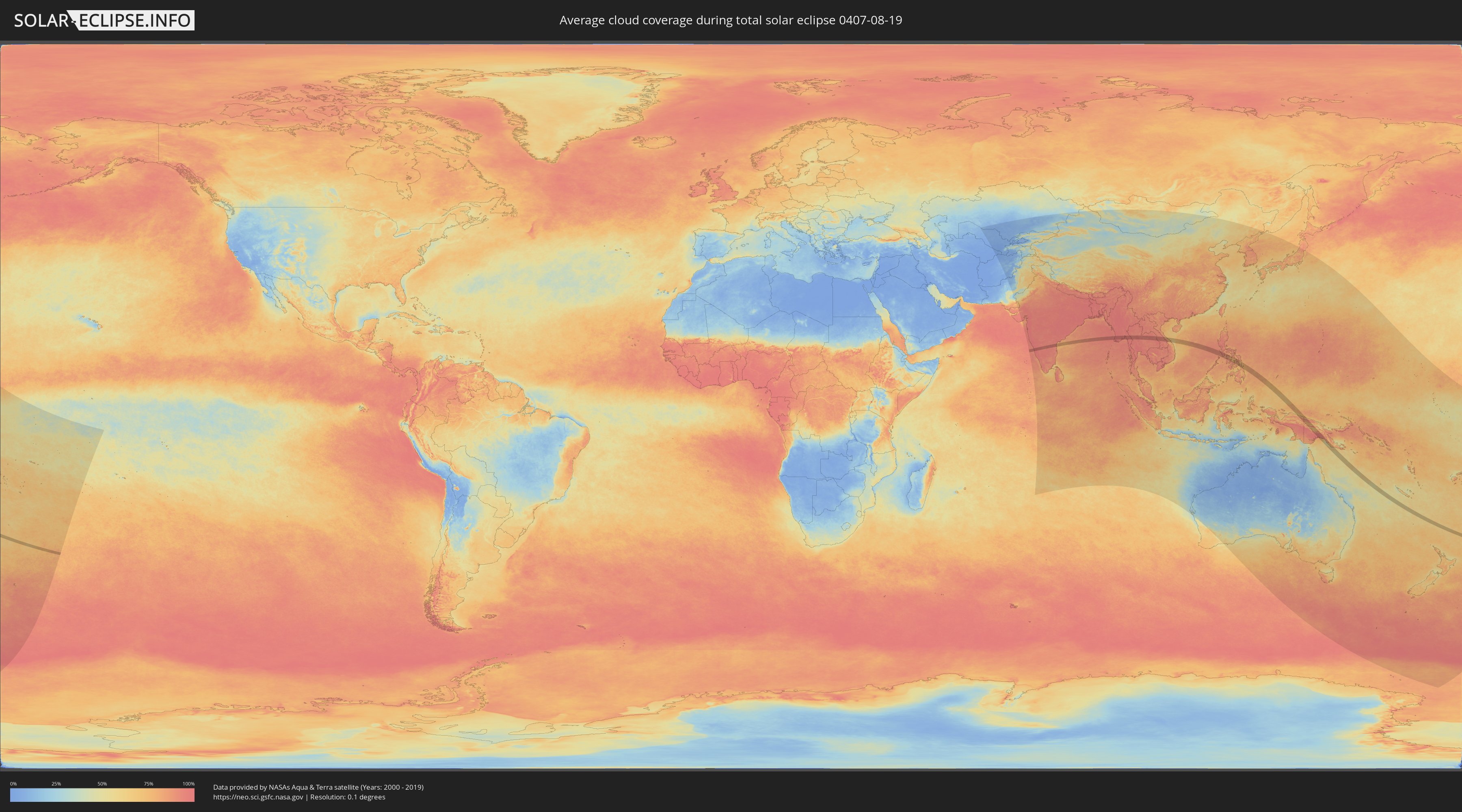
How will be the weather during the total solar eclipse on 08/19/0407?
Where is the best place to see the total solar eclipse of 08/19/0407?
The following maps show the average cloud coverage for the day of the total solar eclipse.
With the help of these maps, it is possible to find the place along the eclipse path, which has the best
chance of a cloudless sky.
Nevertheless, you should consider local circumstances and inform about the weather of your chosen
observation site.
The data is provided by NASAs satellites
AQUA and TERRA.
The cloud maps are averaged over a period of 19 years (2000 - 2019).
Detailed country maps
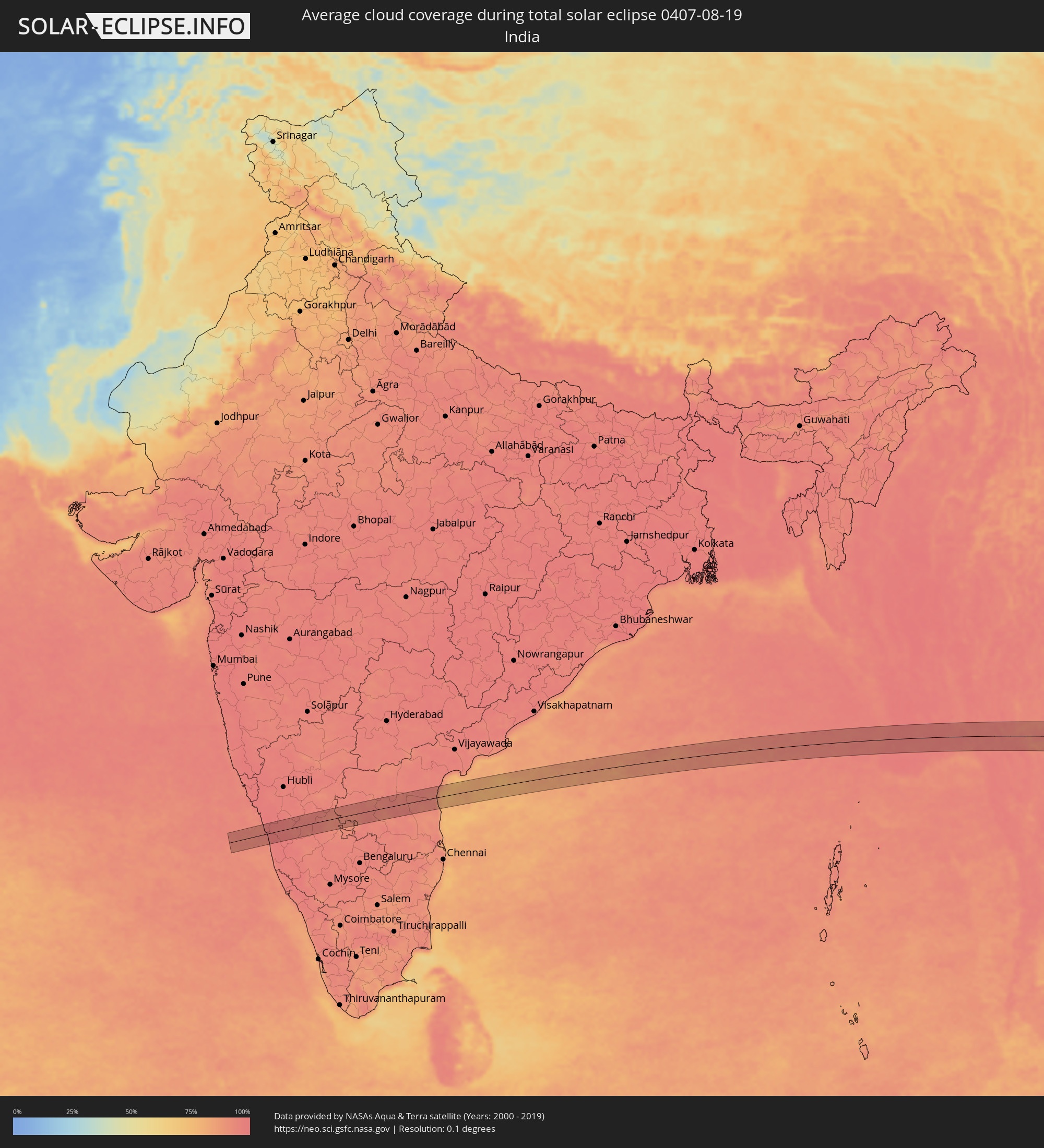 India
India
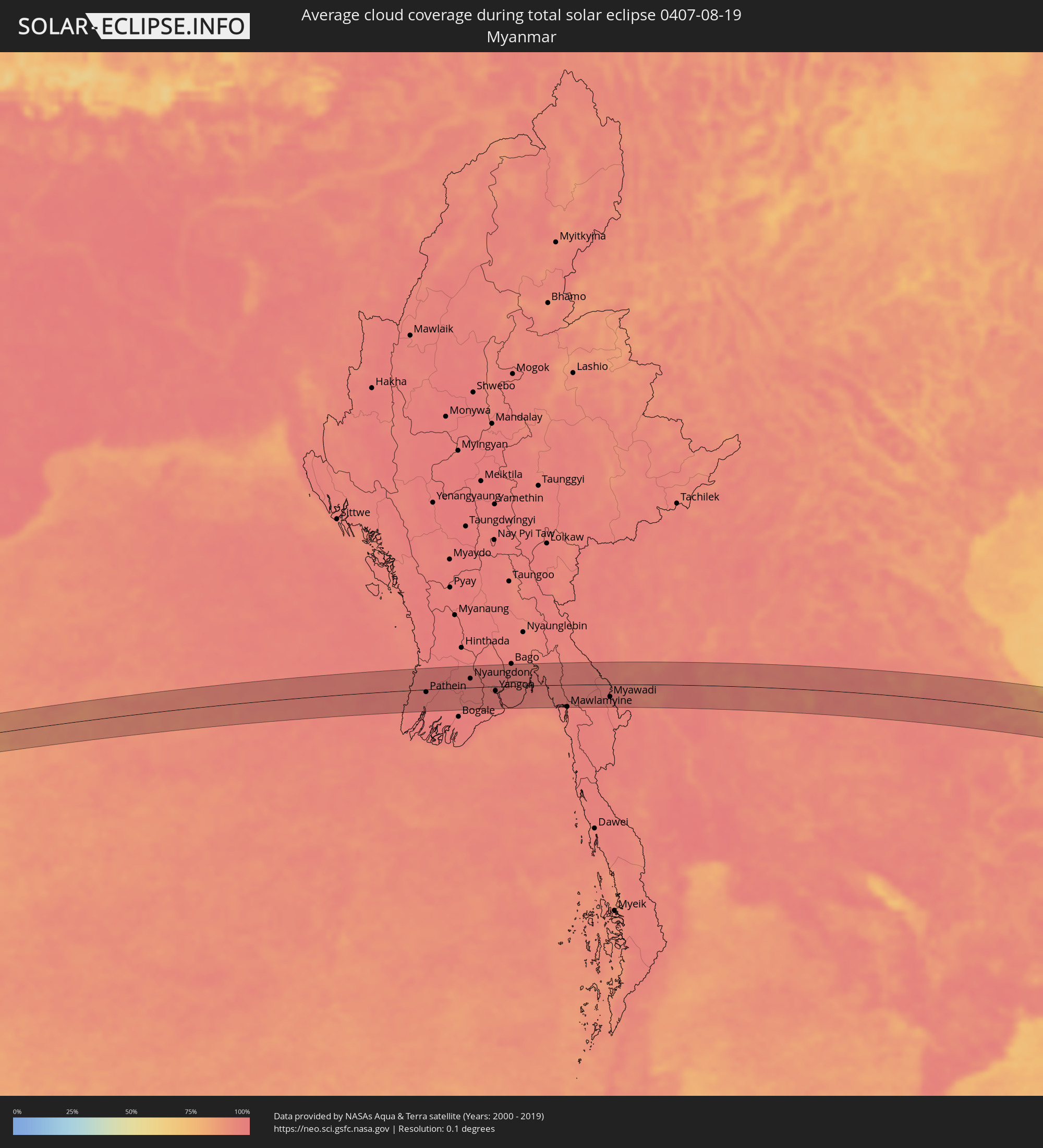 Myanmar
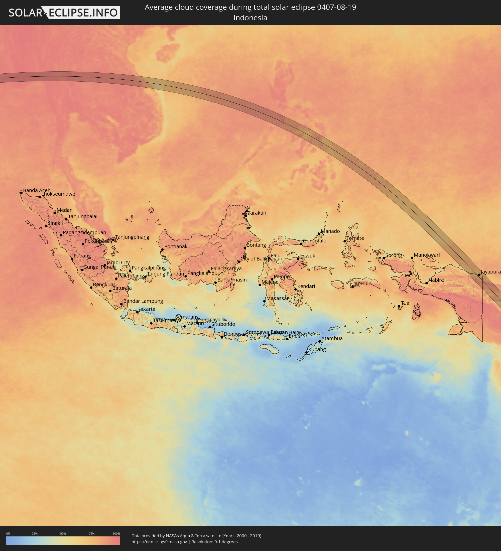 Indonesia
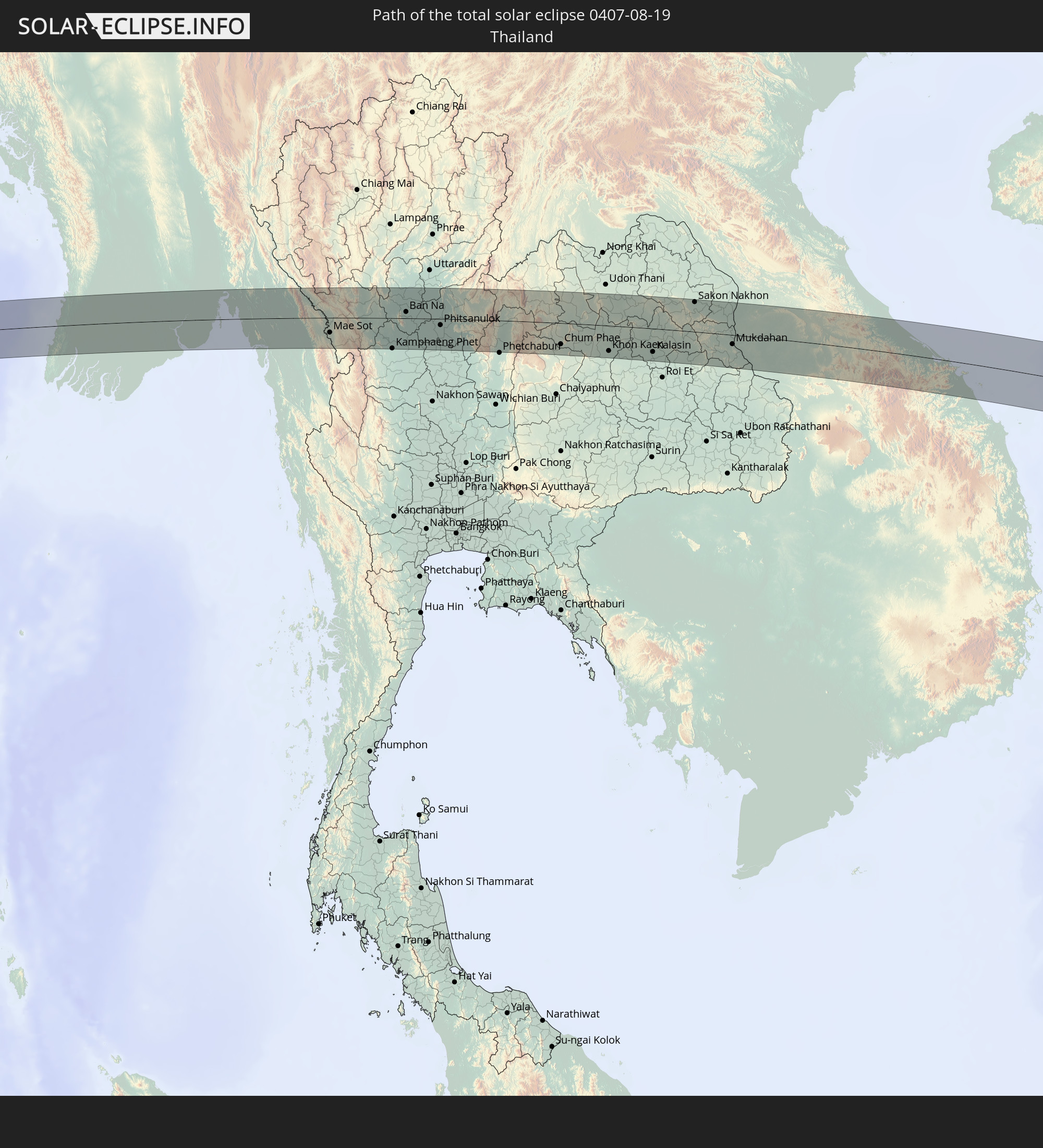
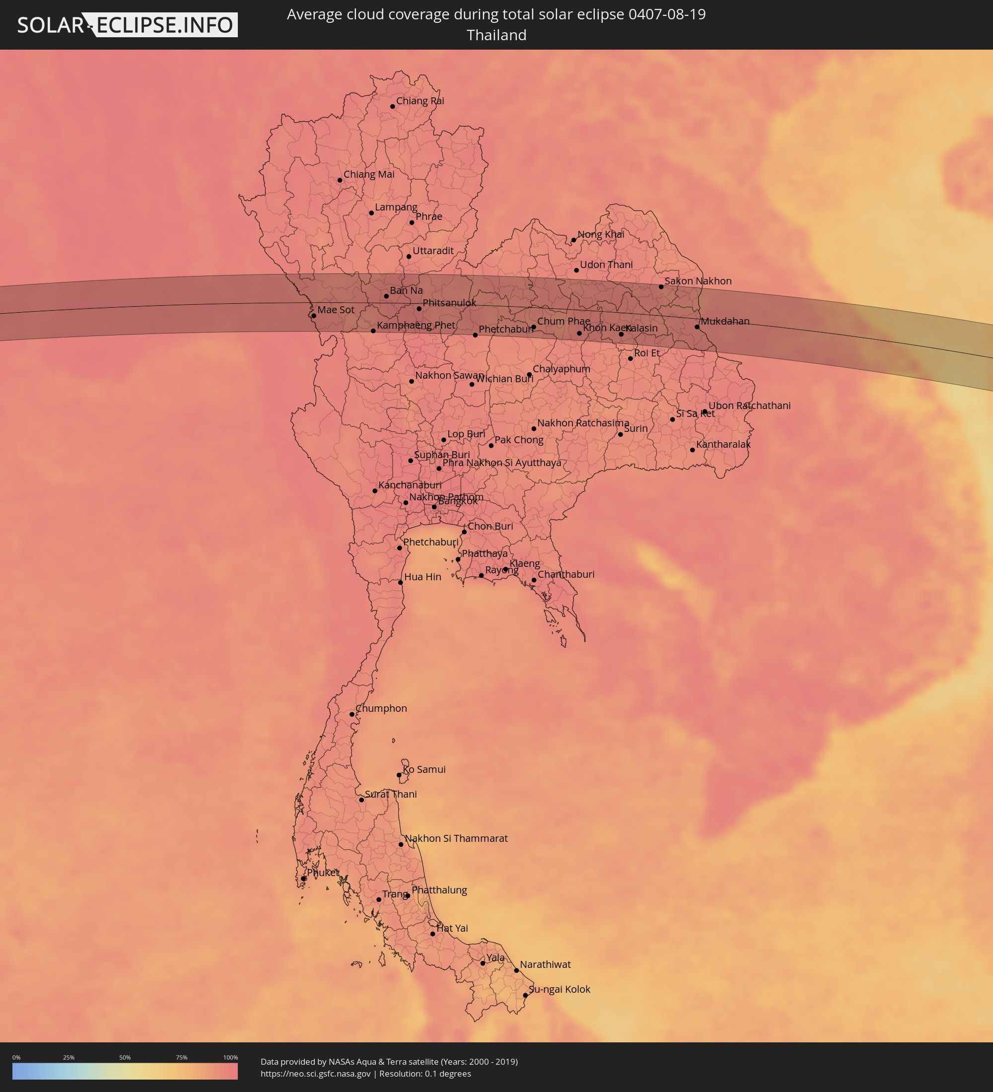 Thailand
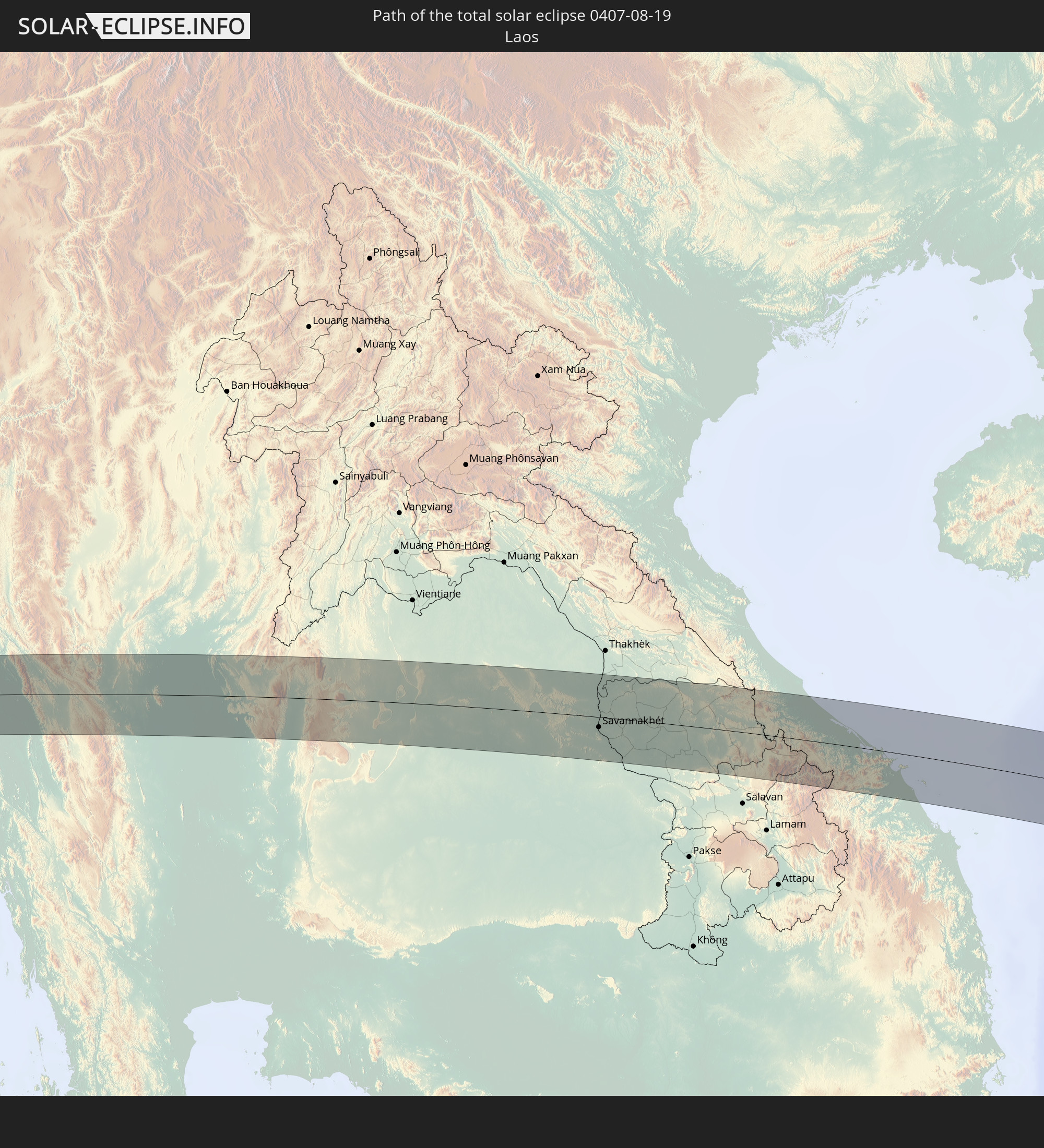
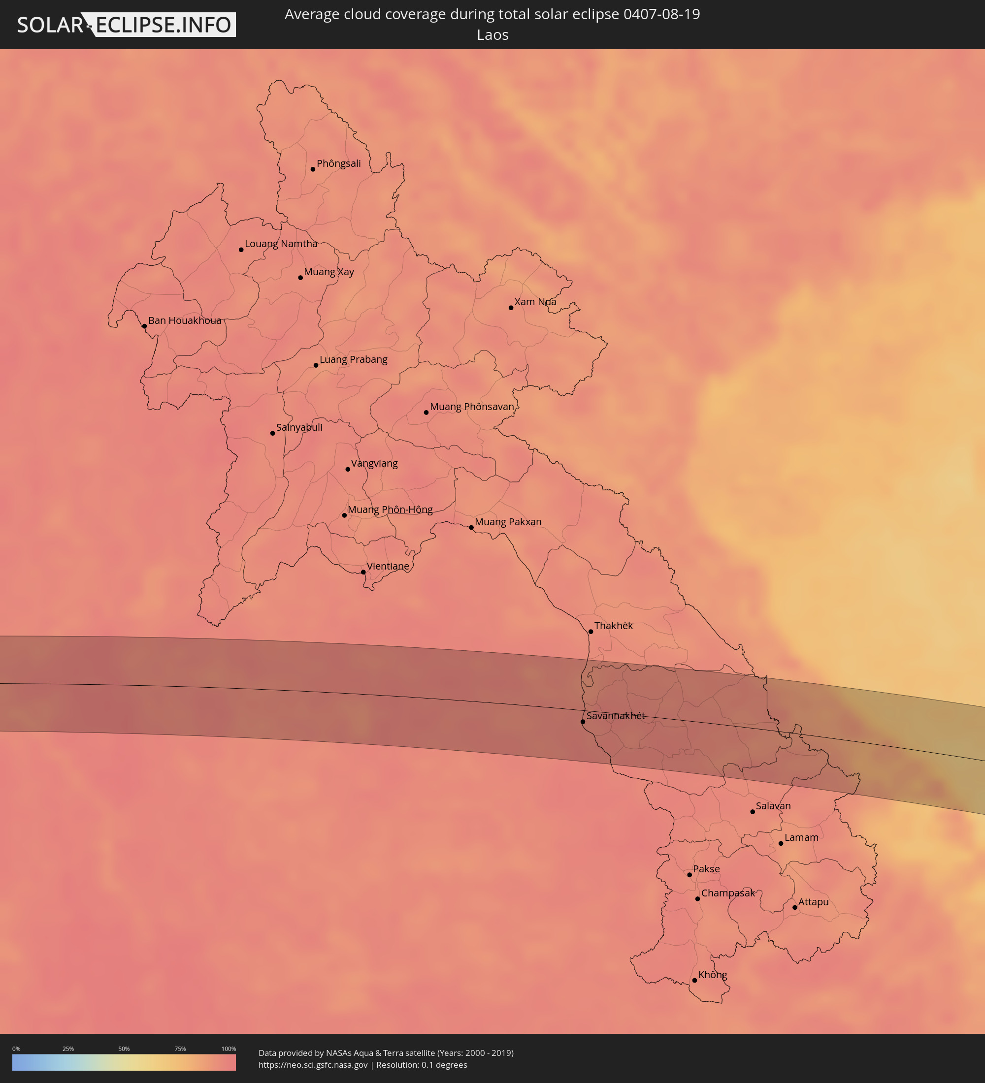 Laos
Laos
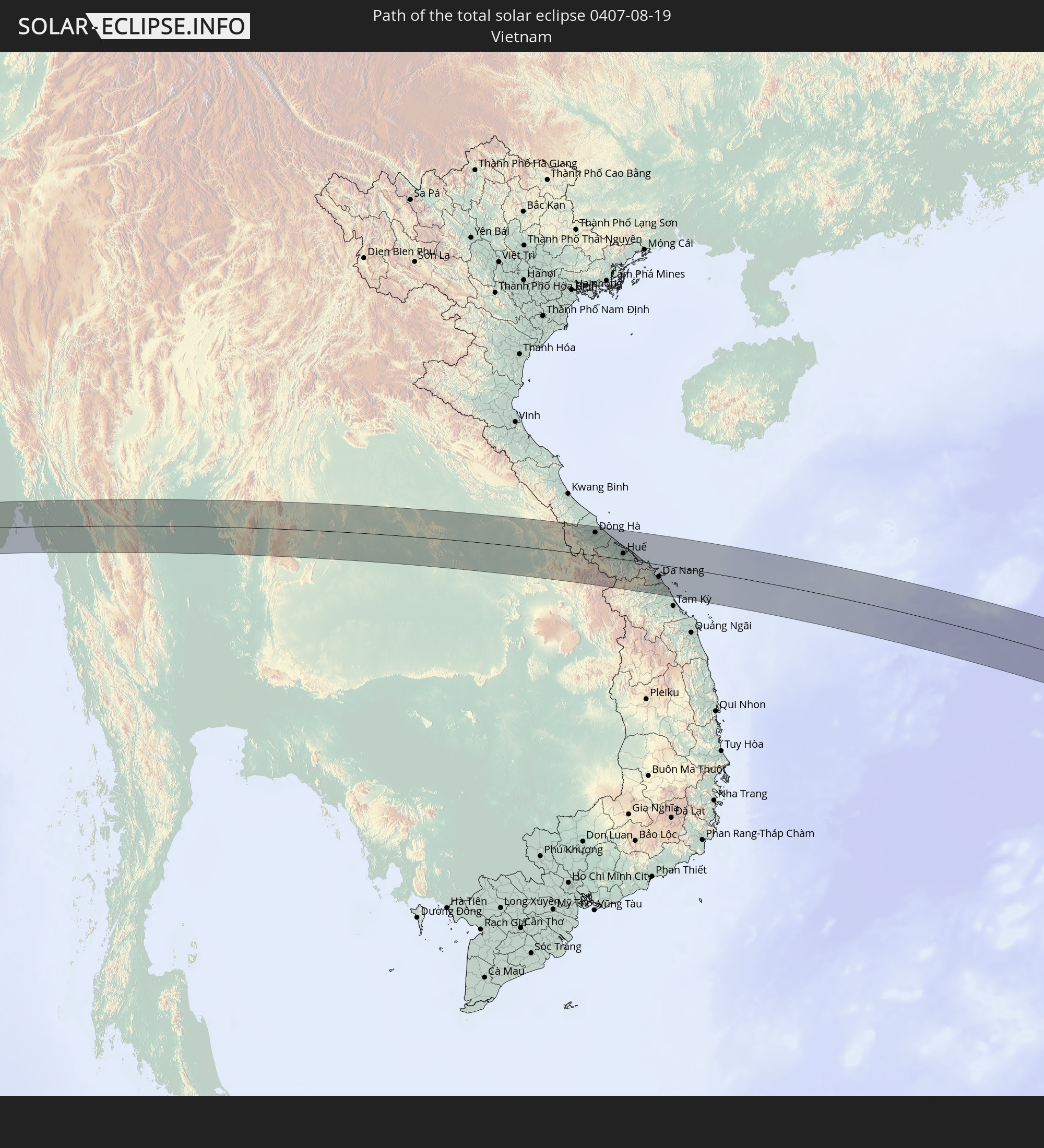
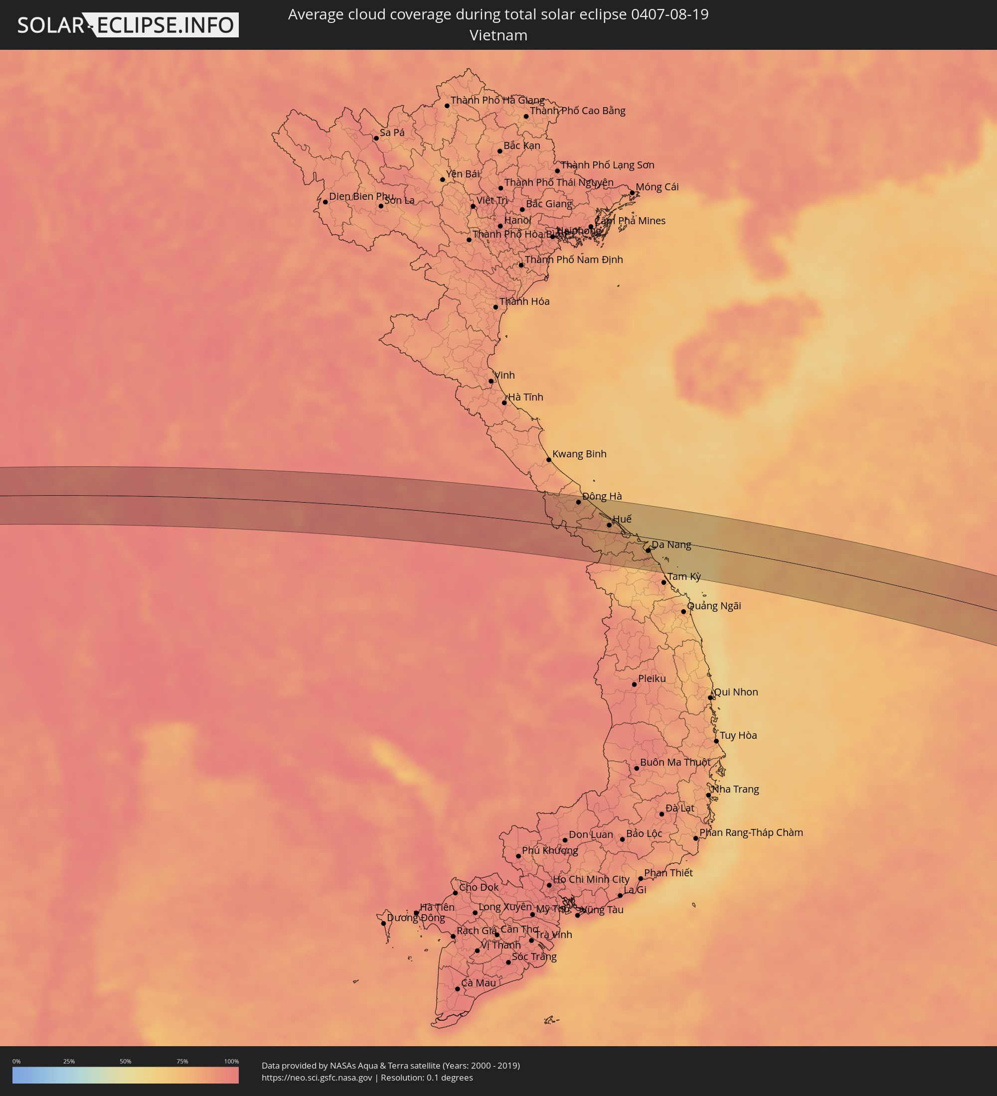 Vietnam
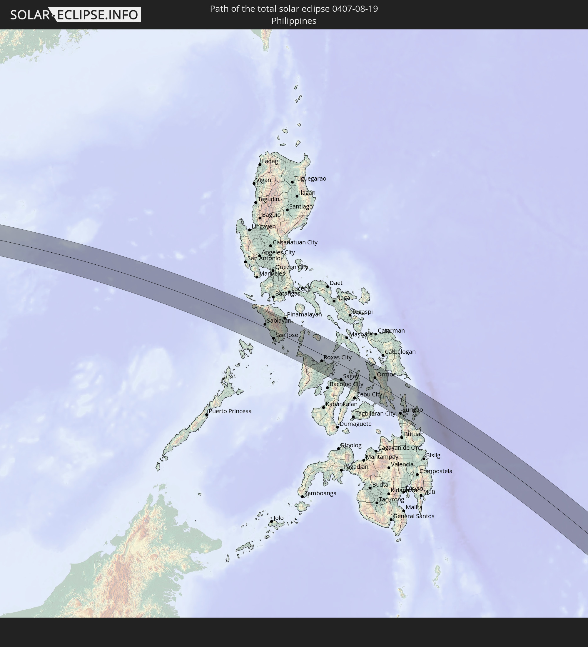
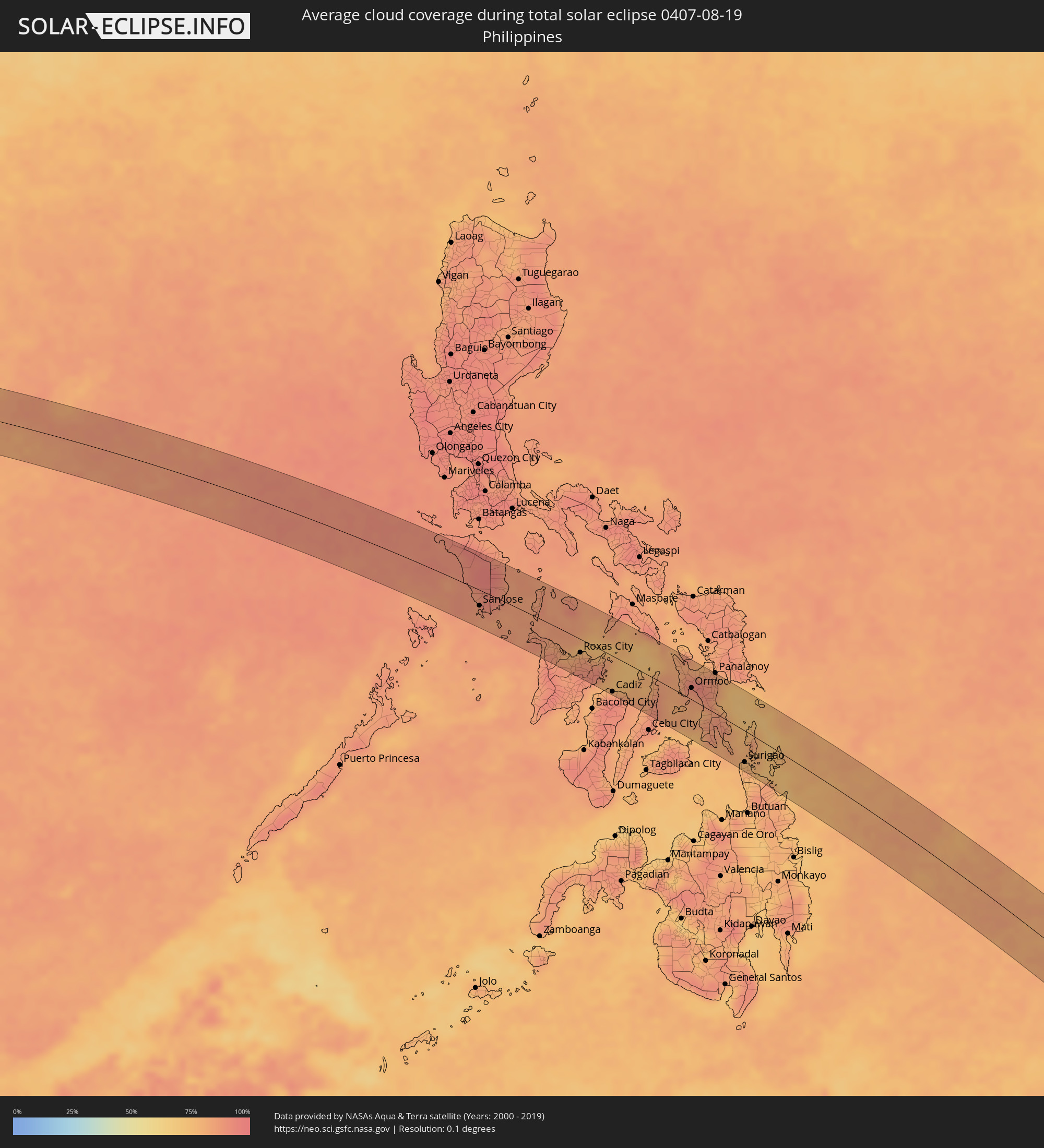 Philippines
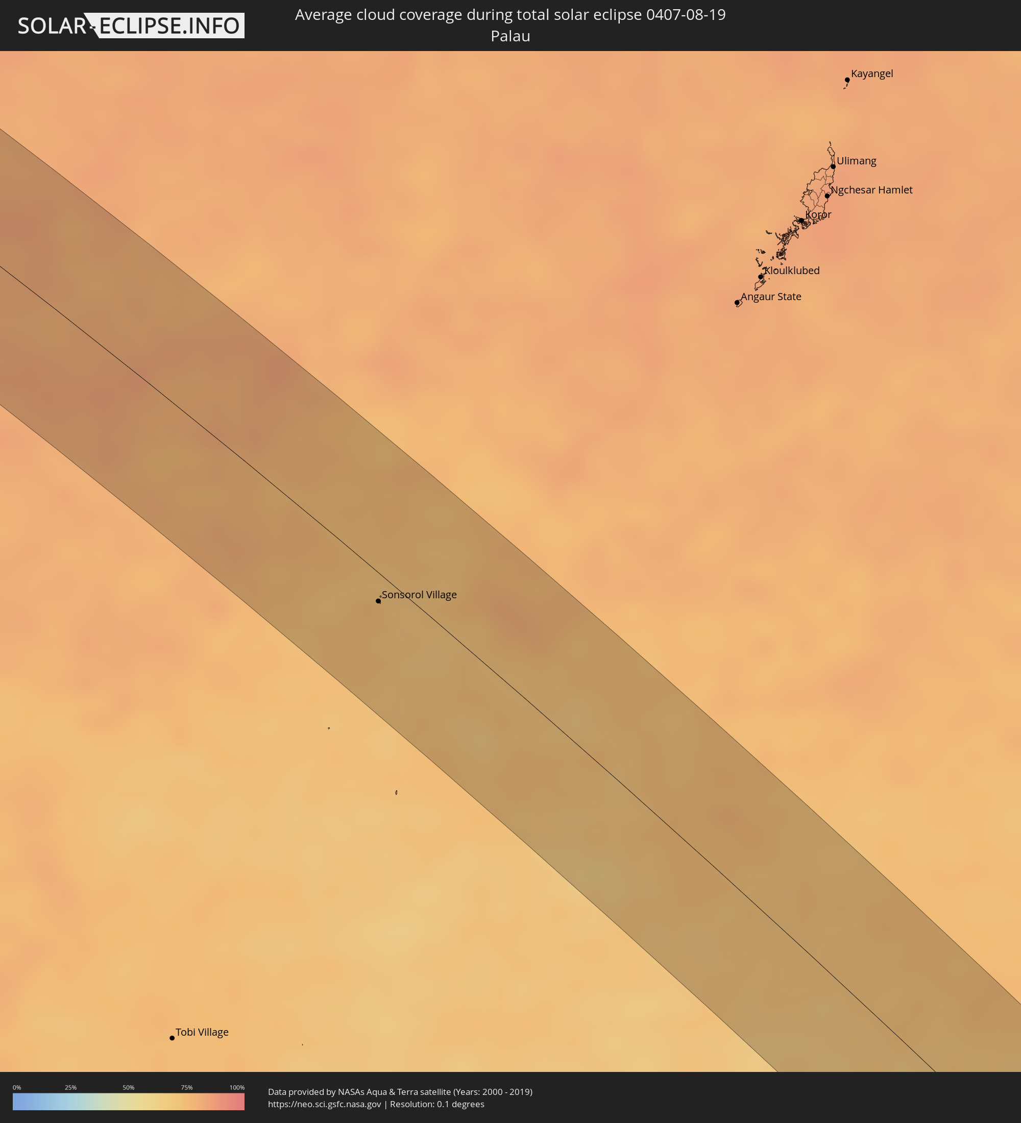 Palau
Palau
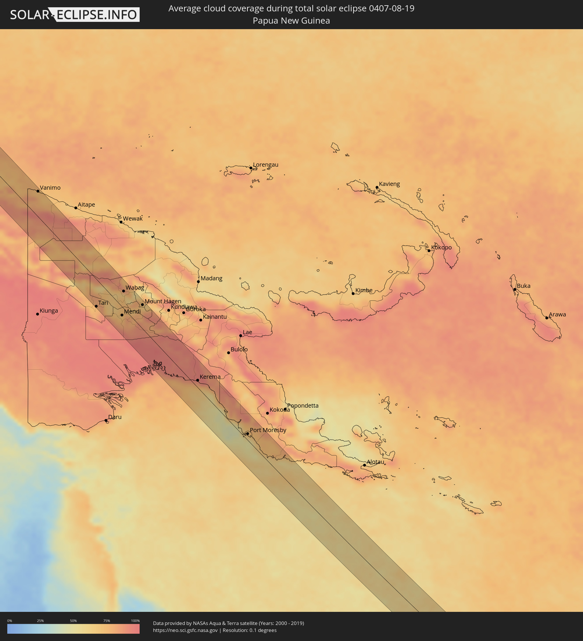 Papua New Guinea
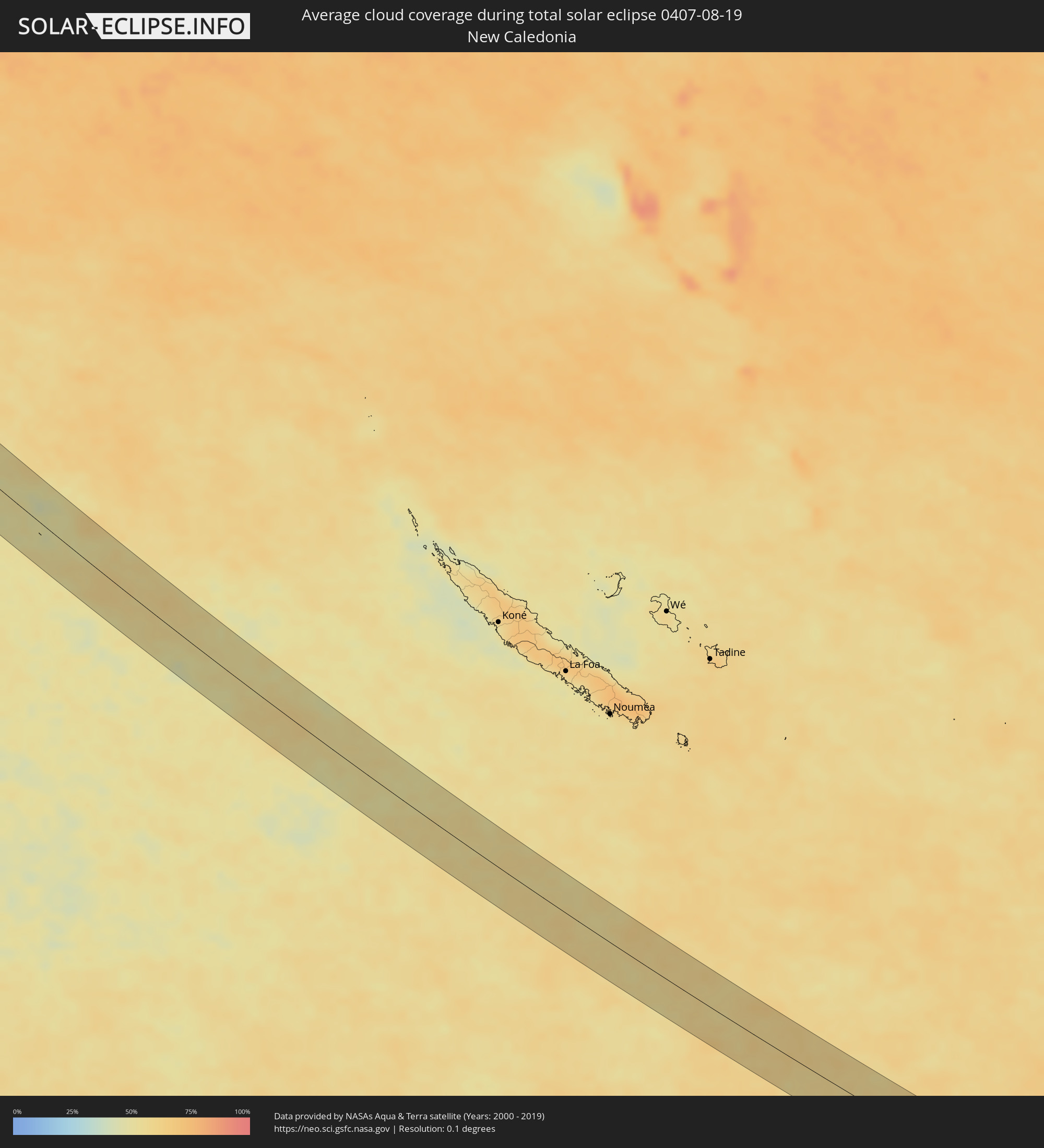 New Caledonia
Cities inside the path of the eclipse
The following table shows all locations with a population of more than 5,000 inside the eclipse path. Cities which have more than 100,000 inhabitants are marked bold. A click at the locations opens a detailed map.
| City | Type | Eclipse duration | Local time of max. eclipse | Distance to central line | Ø Cloud coverage |
|
Murudeshwara, Karnataka
|
total | - | 06:16:40 UTC+05:21 | 25 km | 94% |
|
Bhatkal, Karnataka
|
total | - | 06:16:42 UTC+05:21 | 11 km | 96% |
|
Byndoor, Karnataka
|
total | - | 06:16:43 UTC+05:21 | 4 km | 94% |
|
Coondapoor, Karnataka
|
total | - | 06:16:46 UTC+05:21 | 31 km | 93% |
|
Sāgar, Karnataka
|
total | - | 06:16:42 UTC+05:21 | 19 km | 97% |
|
Shikārpur, Karnataka
|
total | - | 06:16:43 UTC+05:21 | 23 km | 96% |
|
Shimoga, Karnataka
|
total | - | 06:16:48 UTC+05:21 | 19 km | 95% |
|
Bhadrāvati, Karnataka
|
total | - | 06:16:50 UTC+05:21 | 32 km | 95% |
|
Channagiri, Karnataka
|
total | - | 06:16:50 UTC+05:21 | 18 km | 94% |
|
Chitradurga, Karnataka
|
total | - | 06:16:51 UTC+05:21 | 7 km | 94% |
|
Challakere, Karnataka
|
total | - | 06:16:53 UTC+05:21 | 3 km | 91% |
|
Rāyadrug, Andhra Pradesh
|
total | - | 06:16:50 UTC+05:21 | 34 km | 92% |
|
Kalyandurg, Andhra Pradesh
|
total | - | 06:16:54 UTC+05:21 | 12 km | 92% |
|
Anantapur, Andhra Pradesh
|
total | - | 06:16:58 UTC+05:21 | 15 km | 95% |
|
Dharmavaram, Andhra Pradesh
|
total | - | 06:17:02 UTC+05:21 | 16 km | 95% |
|
Tādpatri, Andhra Pradesh
|
total | - | 06:17:00 UTC+05:21 | 31 km | 95% |
|
Pulivendla, Andhra Pradesh
|
total | - | 06:17:08 UTC+05:21 | 27 km | 93% |
|
Jammalamadugu, Andhra Pradesh
|
total | - | 06:17:05 UTC+05:21 | 16 km | 93% |
|
Erraguntla, Andhra Pradesh
|
total | - | 06:17:10 UTC+05:21 | 10 km | 91% |
|
Proddatūr, Andhra Pradesh
|
total | - | 06:17:08 UTC+05:21 | 2 km | 94% |
|
Cuddapah, Andhra Pradesh
|
total | - | 06:17:15 UTC+05:21 | 34 km | 94% |
|
Kandukūr, Andhra Pradesh
|
total | - | 06:17:23 UTC+05:21 | 24 km | 93% |
|
Kāvali, Andhra Pradesh
|
total | - | 06:17:27 UTC+05:21 | 10 km | 94% |
|
Pathein, Ayeyarwady
|
total | - | 07:28:51 UTC+06:24 | 6 km | 95% |
|
Wakema, Ayeyarwady
|
total | - | 07:29:19 UTC+06:24 | 28 km | 96% |
|
Nyaungdon, Ayeyarwady
|
total | - | 07:29:34 UTC+06:24 | 19 km | 97% |
|
Maubin, Ayeyarwady
|
total | - | 07:29:42 UTC+06:24 | 16 km | 96% |
|
Kyaiklat, Ayeyarwady
|
total | - | 07:29:52 UTC+06:24 | 48 km | 97% |
|
Twante, Yangon
|
total | - | 07:29:57 UTC+06:24 | 19 km | 96% |
|
Kanbe, Yangon
|
total | - | 07:30:01 UTC+06:24 | 20 km | 98% |
|
Yangon, Yangon
|
total | - | 07:30:08 UTC+06:24 | 9 km | 97% |
|
Syriam, Yangon
|
total | - | 07:30:14 UTC+06:24 | 14 km | 97% |
|
Thanatpin, Bago
|
total | - | 07:30:08 UTC+06:24 | 35 km | 97% |
|
Thongwa, Yangon
|
total | - | 07:30:30 UTC+06:24 | 16 km | 97% |
|
Kayan, Yangon
|
total | - | 07:30:29 UTC+06:24 | 1 km | 96% |
|
Thanatpin, Bago
|
total | - | 07:30:21 UTC+06:24 | 43 km | 96% |
|
Kyaikto, Mon
|
total | - | 07:30:46 UTC+06:24 | 44 km | 95% |
|
Thaton, Mon
|
total | - | 07:31:16 UTC+06:24 | 0 km | 96% |
|
Martaban, Mon
|
total | - | 07:31:40 UTC+06:24 | 44 km | 96% |
|
Mawlamyine, Mon
|
total | - | 07:31:42 UTC+06:24 | 48 km | 96% |
|
Hpa-an, Kayin
|
total | - | 07:31:32 UTC+06:24 | 4 km | 95% |
|
Myawadi, Kayin
|
total | - | 07:32:31 UTC+06:24 | 27 km | 96% |
|
Mae Ramat, Tak
|
total | - | 07:49:42 UTC+06:42 | 6 km | 95% |
|
Mae Sot, Tak
|
total | - | 07:49:51 UTC+06:42 | 24 km | 96% |
|
Ban Tak, Tak
|
total | - | 07:50:16 UTC+06:42 | 13 km | 91% |
|
Tak, Tak
|
total | - | 07:50:24 UTC+06:42 | 7 km | 92% |
|
Kamphaeng Phet, Kamphaeng Phet
|
total | - | 07:51:00 UTC+06:42 | 49 km | 93% |
|
Ban Na, Sukhothai
|
total | - | 07:50:59 UTC+06:42 | 10 km | 95% |
|
Sawankhalok, Sukhothai
|
total | - | 07:50:58 UTC+06:42 | 44 km | 96% |
|
Bang Rakam, Phitsanulok
|
total | - | 07:51:32 UTC+06:42 | 18 km | 97% |
|
Phitsanulok, Phitsanulok
|
total | - | 07:51:40 UTC+06:42 | 10 km | 97% |
|
Bang Krathum, Phitsanulok
|
total | - | 07:51:50 UTC+06:42 | 37 km | 97% |
|
Lom Sak, Phetchabun
|
total | - | 07:52:50 UTC+06:42 | 12 km | 96% |
|
Wang Saphung, Loei
|
total | - | 07:53:12 UTC+06:42 | 48 km | 93% |
|
Phu Kradueng, Loei
|
total | - | 07:53:33 UTC+06:42 | 2 km | 93% |
|
Chum Phae, Khon Kaen
|
total | - | 07:53:59 UTC+06:42 | 34 km | 92% |
|
Na Klang, Changwat Nong Bua Lamphu
|
total | - | 07:53:43 UTC+06:42 | 51 km | 93% |
|
Nong Bua Lamphu, Changwat Nong Bua Lamphu
|
total | - | 07:54:04 UTC+06:42 | 41 km | 95% |
|
Khon Kaen, Khon Kaen
|
total | - | 07:54:58 UTC+06:42 | 41 km | 94% |
|
Ban Phan Don, Changwat Udon Thani
|
total | - | 07:54:46 UTC+06:42 | 37 km | 94% |
|
Nong Kung Si, Kalasin
|
total | - | 07:55:27 UTC+06:42 | 15 km | 94% |
|
Kalasin, Kalasin
|
total | - | 07:55:50 UTC+06:42 | 38 km | 92% |
|
Kuchinarai, Kalasin
|
total | - | 07:56:29 UTC+06:42 | 22 km | 95% |
|
Sakon Nakhon, Sakon Nakhon
|
total | - | 07:56:16 UTC+06:42 | 48 km | 93% |
|
Mukdahan, Mukdahan
|
total | - | 07:57:24 UTC+06:42 | 15 km | 95% |
|
Savannakhét, Savannahkhét
|
total | - | 07:57:25 UTC+06:42 | 12 km | 93% |
|
Ðông Hà, Quảng Trị
|
total | - | 08:25:11 UTC+07:06 | 43 km | 82% |
|
Huế, Thừa Thiên-Huế
|
total | - | 08:26:10 UTC+07:06 | 11 km | 80% |
|
Da Nang, Đà Nẵng
|
total | - | 08:27:24 UTC+07:06 | 23 km | 84% |
|
Hội An, Quảng Nam
|
total | - | 08:27:43 UTC+07:06 | 42 km | 78% |
|
Mamburao, Mimaropa
|
total | - | 09:46:32 UTC+08:00 | 41 km | 90% |
|
Sablayan, Mimaropa
|
total | - | 09:47:26 UTC+08:00 | 10 km | 89% |
|
San Jose, Mimaropa
|
total | - | 09:48:44 UTC+08:00 | 26 km | 87% |
|
Mansalay, Mimaropa
|
total | - | 09:49:17 UTC+08:00 | 8 km | 89% |
|
Bansud, Mimaropa
|
total | - | 09:48:50 UTC+08:00 | 44 km | 86% |
|
Pandan, Western Visayas
|
total | - | 09:51:50 UTC+08:00 | 38 km | 84% |
|
Romblon, Mimaropa
|
total | - | 09:51:00 UTC+08:00 | 53 km | 86% |
|
Kalibo (poblacion), Western Visayas
|
total | - | 09:52:28 UTC+08:00 | 29 km | 83% |
|
Roxas City, Western Visayas
|
total | - | 09:53:30 UTC+08:00 | 22 km | 85% |
|
Cadiz, Western Visayas
|
total | - | 09:55:40 UTC+08:00 | 57 km | 94% |
|
Escalante, Western Visayas
|
total | - | 09:56:18 UTC+08:00 | 57 km | 87% |
|
Bantayan, Central Visayas
|
total | - | 09:56:17 UTC+08:00 | 13 km | 79% |
|
Bogo, Central Visayas
|
total | - | 09:57:05 UTC+08:00 | 10 km | 84% |
|
Daanbantayan, Central Visayas
|
total | - | 09:56:48 UTC+08:00 | 10 km | 83% |
|
Danao, Central Visayas
|
total | - | 09:57:59 UTC+08:00 | 60 km | 84% |
|
Ormoc, Eastern Visayas
|
total | - | 09:58:30 UTC+08:00 | 18 km | 86% |
|
Carigara, Eastern Visayas
|
total | - | 09:58:11 UTC+08:00 | 50 km | 85% |
|
Baybay, Eastern Visayas
|
total | - | 09:59:28 UTC+08:00 | 3 km | 79% |
|
Maasin, Eastern Visayas
|
total | - | 10:00:27 UTC+08:00 | 53 km | 76% |
|
Burauen, Eastern Visayas
|
total | - | 09:59:11 UTC+08:00 | 31 km | 89% |
|
Palo, Eastern Visayas
|
total | - | 09:59:06 UTC+08:00 | 54 km | 86% |
|
Abuyog, Eastern Visayas
|
total | - | 09:59:49 UTC+08:00 | 15 km | 85% |
|
Surigao, Caraga
|
total | - | 10:02:30 UTC+08:00 | 49 km | 77% |
|
Sonsorol Village, Sonsorol
|
total | - | 11:26:11 UTC+09:00 | 13 km | 74% |
|
Abepura, Papua
|
total | - | 12:23:27 UTC+09:22 | 7 km | 74% |
|
Jayapura, Papua
|
total | - | 12:23:30 UTC+09:22 | 18 km | 76% |
|
Vanimo, Sandaun
|
total | - | 13:02:04 UTC+10:00 | 53 km | 78% |
|
Vanimo, Sandaun
|
total | - | 13:02:11 UTC+10:00 | 54 km | 78% |
|
Tari, Hela
|
total | - | 13:11:41 UTC+10:00 | 58 km | 77% |
|
Mendi, Southern Highlands
|
total | - | 13:13:32 UTC+10:00 | 18 km | 75% |
|
Wabag, Enga
|
total | - | 13:12:21 UTC+10:00 | 37 km | 73% |
|
Ialibu, Southern Highlands
|
total | - | 13:14:26 UTC+10:00 | 1 km | 84% |
|
Mount Hagen, Western Highlands
|
total | - | 13:14:04 UTC+10:00 | 51 km | 77% |
|
Kerema, Gulf
|
total | - | 13:20:49 UTC+10:00 | 15 km | 74% |
|
Port Moresby, National Capital
|
total | - | 13:25:54 UTC+10:00 | 14 km | 63% |