Totale Sonnenfinsternis vom 16.04.0432
| Wochentag: | Freitag |
| Maximale Dauer der Verfinsterung: | 06m37s |
| Maximale Breite des Finsternispfades: | 239 km |
| Saroszyklus: | 84 |
| Bedeckungsgrad: | 100% |
| Magnitude: | 1.0734 |
| Gamma: | -0.0858 |
Wo kann man die Sonnenfinsternis vom 16.04.0432 sehen?
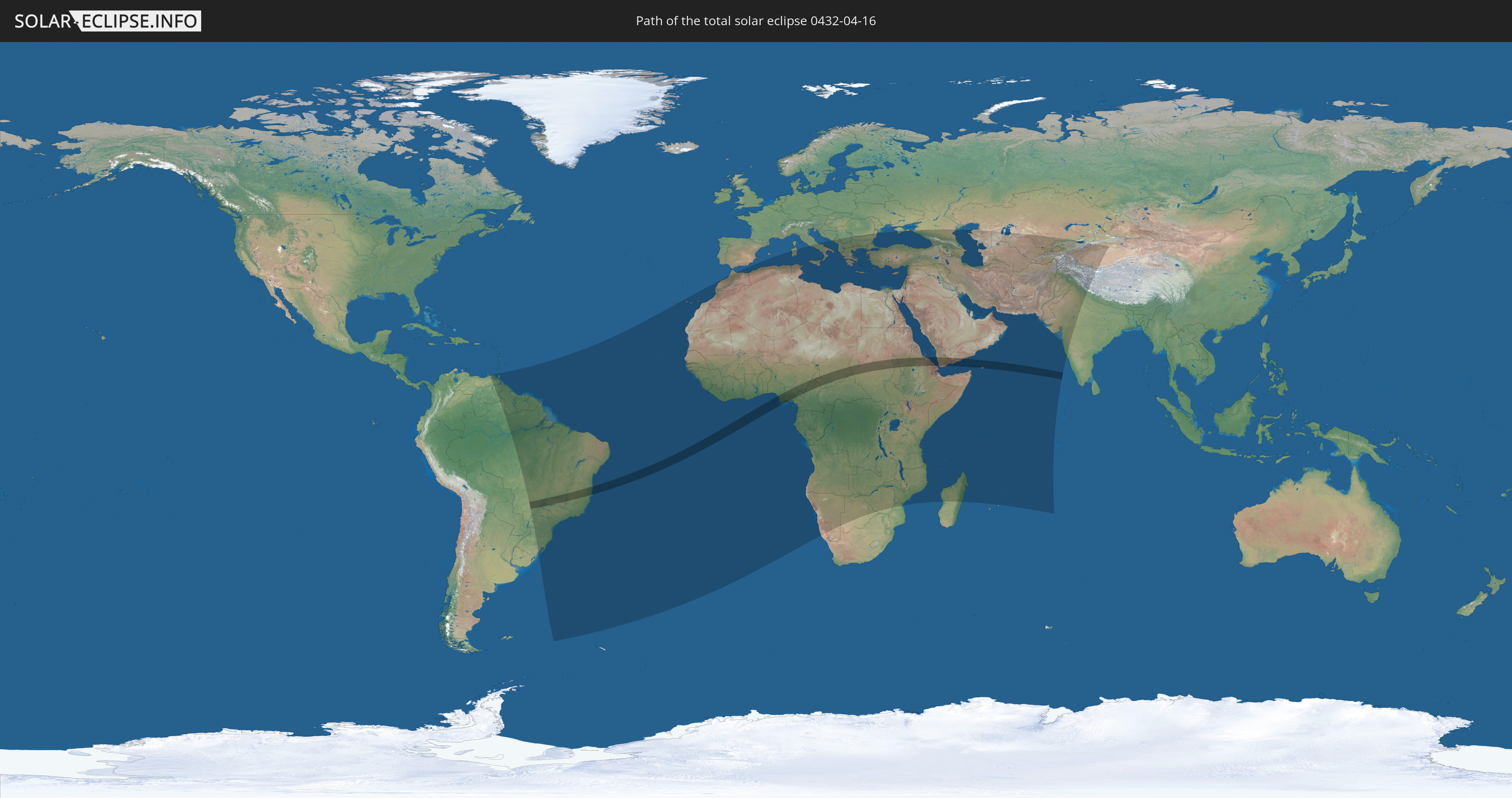
Die Sonnenfinsternis am 16.04.0432 kann man in 102 Ländern als partielle Sonnenfinsternis beobachten.
Der Finsternispfad verläuft durch 10 Länder. Nur in diesen Ländern ist sie als totale Sonnenfinsternis zu sehen.
In den folgenden Ländern ist die Sonnenfinsternis total zu sehen
 Brasilien
 St. Helena
 Nigeria
 Kamerun
 Tschad
 Zentralafrikanische Republik
 Sudan
Sudan
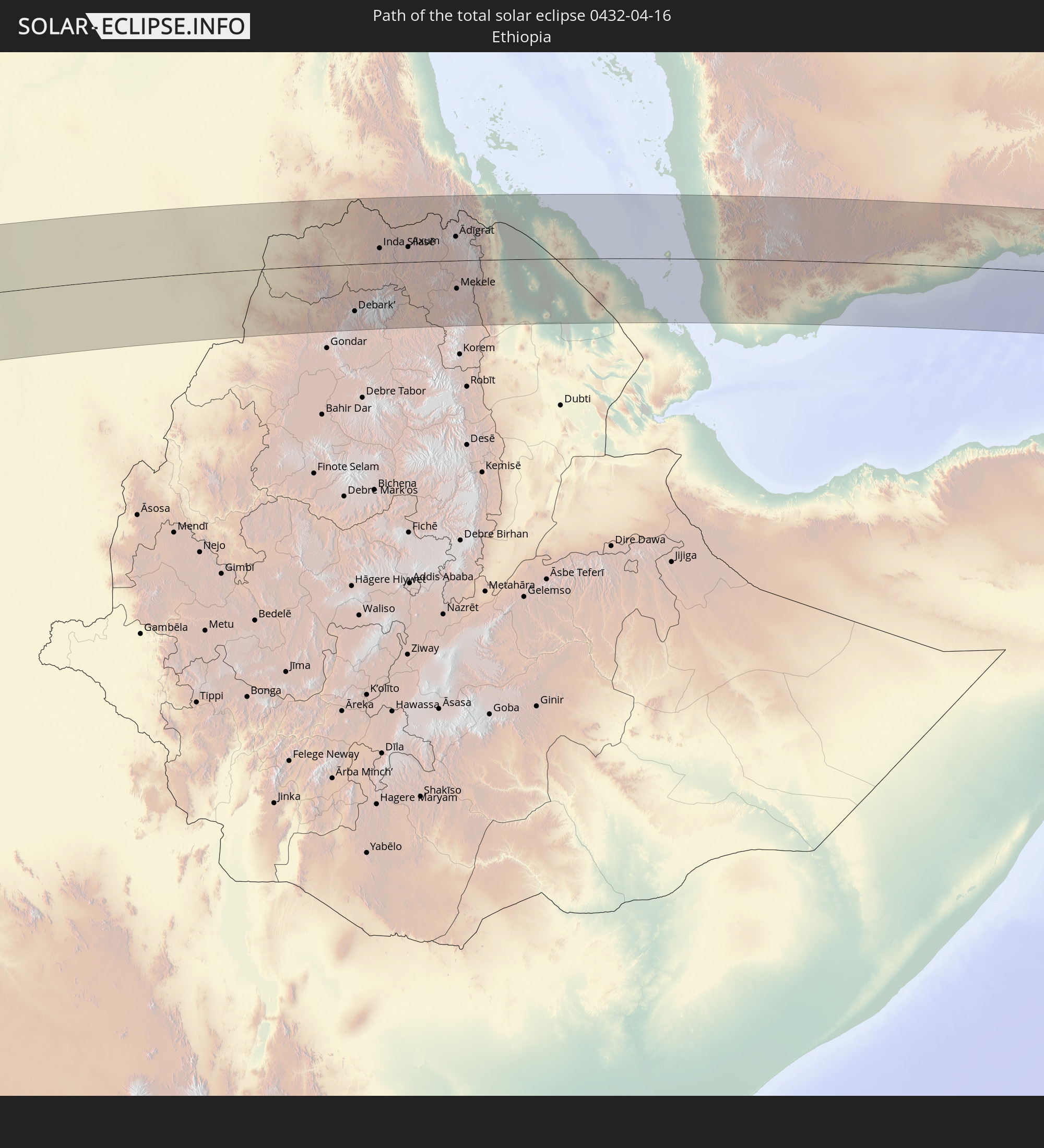 Äthiopien
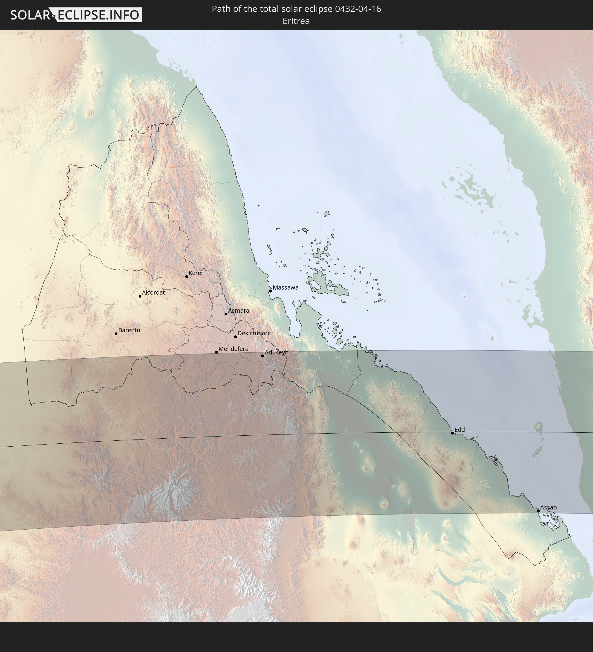 Eritrea
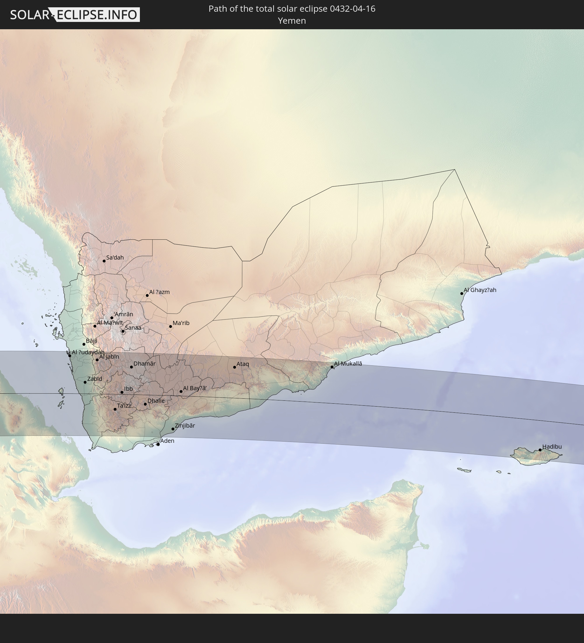 Jemen
Jemen
In den folgenden Ländern ist die Sonnenfinsternis partiell zu sehen
 Russland
 Brasilien
 Venezuela
 Trinidad und Tobago
 Guyana
 Suriname
 Französisch-Guayana
 Kap Verde
 Spanien
 Senegal
 Mauretanien
 Gambia
 Guinea-Bissau
 Guinea
 St. Helena
 Sierra Leone
 Marokko
 Mali
Mali
 Liberia
 Algerien
 Elfenbeinküste
 Burkina Faso
 Ghana
Ghana
 Togo
Togo
 Niger
Niger
 Benin
Benin
 Nigeria
 Äquatorialguinea
 São Tomé und Príncipe
 Italien
 Tunesien
 Kamerun
 Gabun
Gabun
 Libyen
 Republik Kongo
 Angola
 Namibia
 Demokratische Republik Kongo
 Tschad
 Kroatien
 Malta
Malta
 Zentralafrikanische Republik
 Bosnien und Herzegowina
 Südafrika
 Montenegro
 Serbien
 Albanien
 Griechenland
 Botswana
 Rumänien
 Mazedonien
 Sudan
Sudan
 Sambia
 Ukraine
 Bulgarien
 Ägypten
 Simbabwe
 Türkei
 Ruanda
 Burundi
 Tansania
 Uganda
 Mosambik
 Republik Zypern
 Malawi
 Äthiopien
 Kenia
Kenia
 Staat Palästina
 Israel
 Saudi-Arabien
 Jordanien
 Libanon
 Syrien
 Eritrea
 Irak
Irak
 Georgien
 Französische Süd- und Antarktisgebiete
 Somalia
 Dschibuti
 Jemen
Jemen
 Madagaskar
 Komoren
 Armenien
 Iran
Iran
 Aserbaidschan
 Mayotte
 Seychellen
 Kasachstan
 Kuwait
 Bahrain
 Katar
Katar
 Vereinigte Arabische Emirate
 Oman
Oman
 Turkmenistan
 Usbekistan
 Mauritius
 Afghanistan
 Pakistan
 Tadschikistan
 Indien
 Kirgisistan
 Volksrepublik China
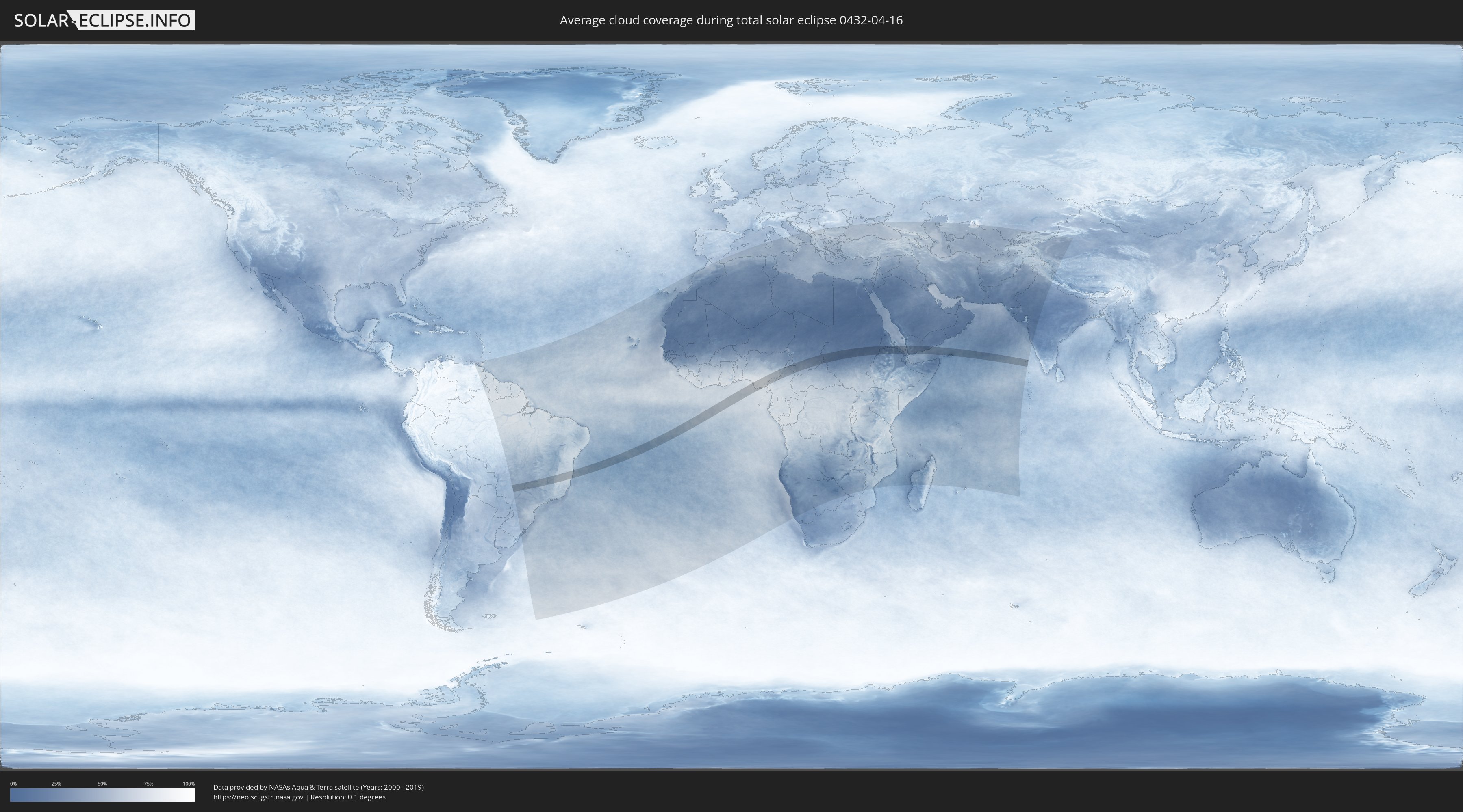
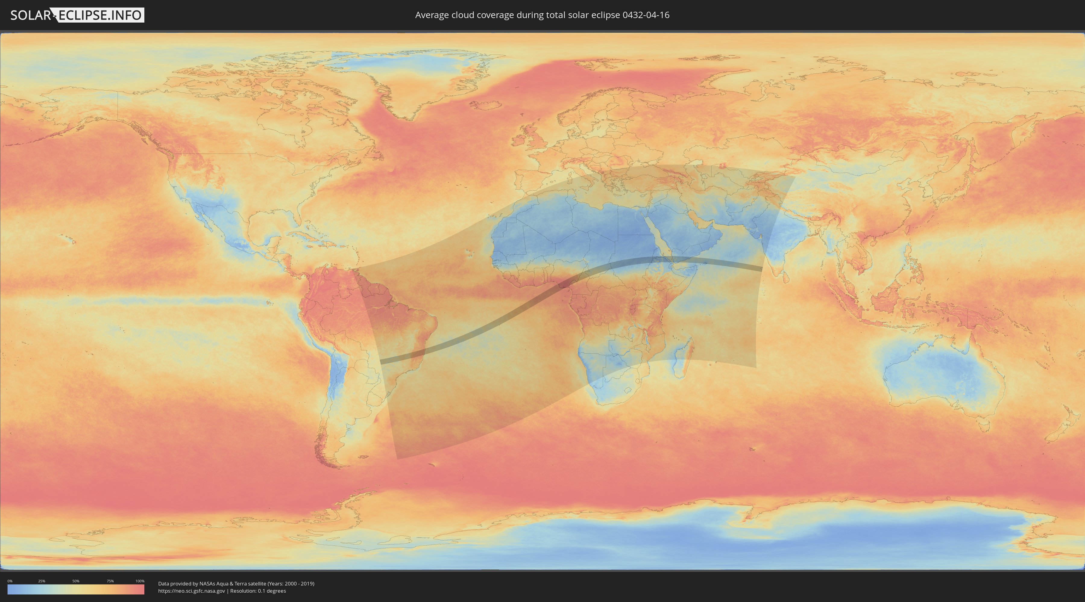
Wie wird das Wetter während der totalen Sonnenfinsternis am 16.04.0432?
Wo ist der beste Ort, um die totale Sonnenfinsternis vom 16.04.0432 zu beobachten?
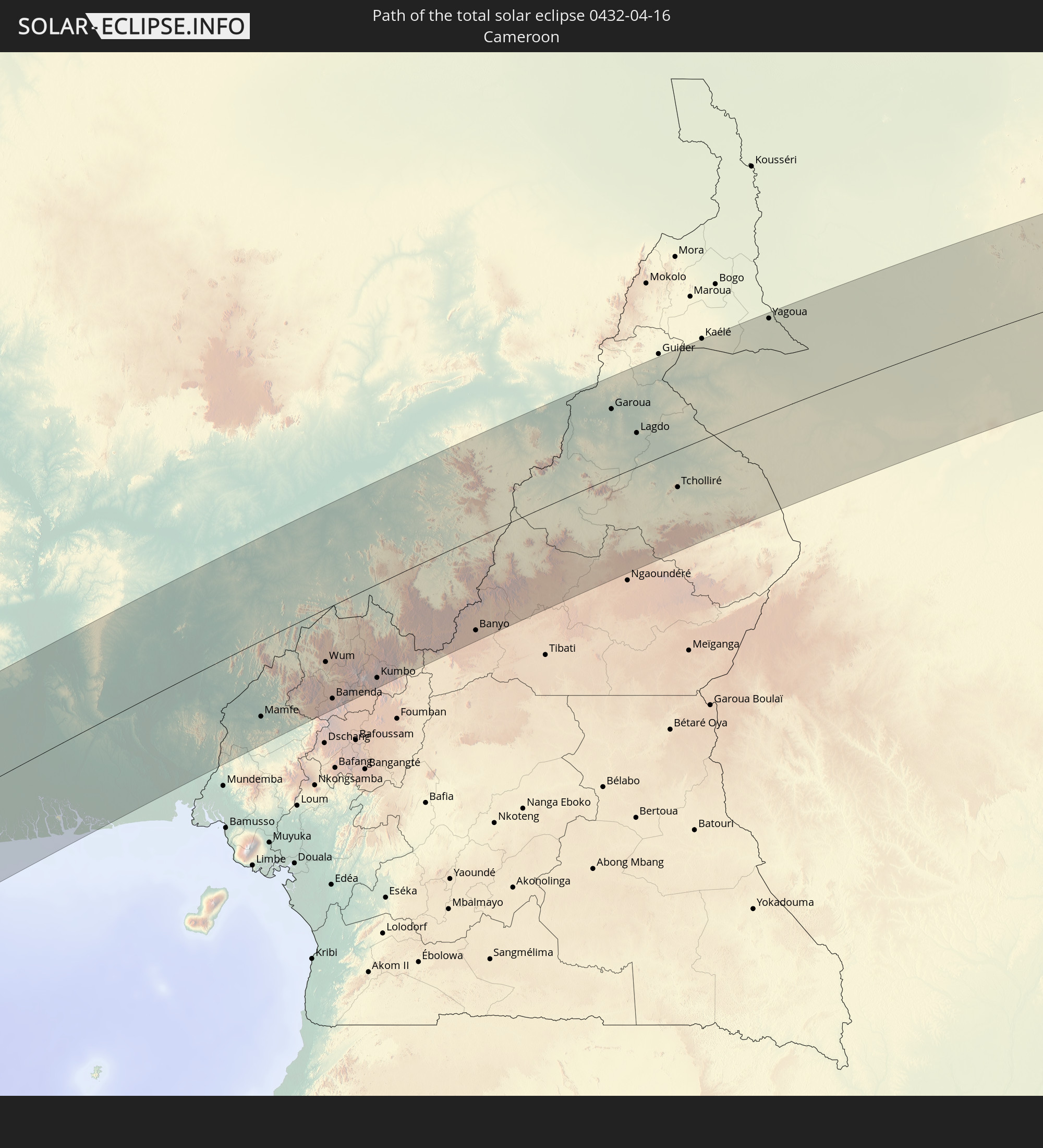
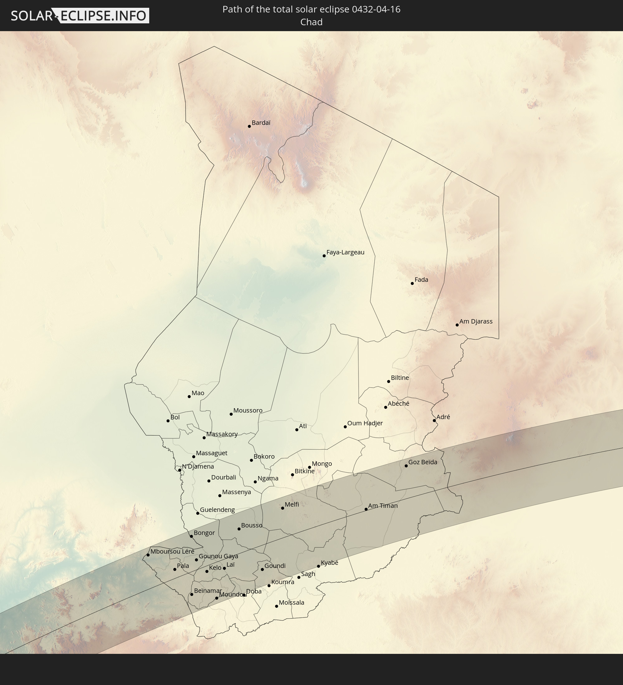
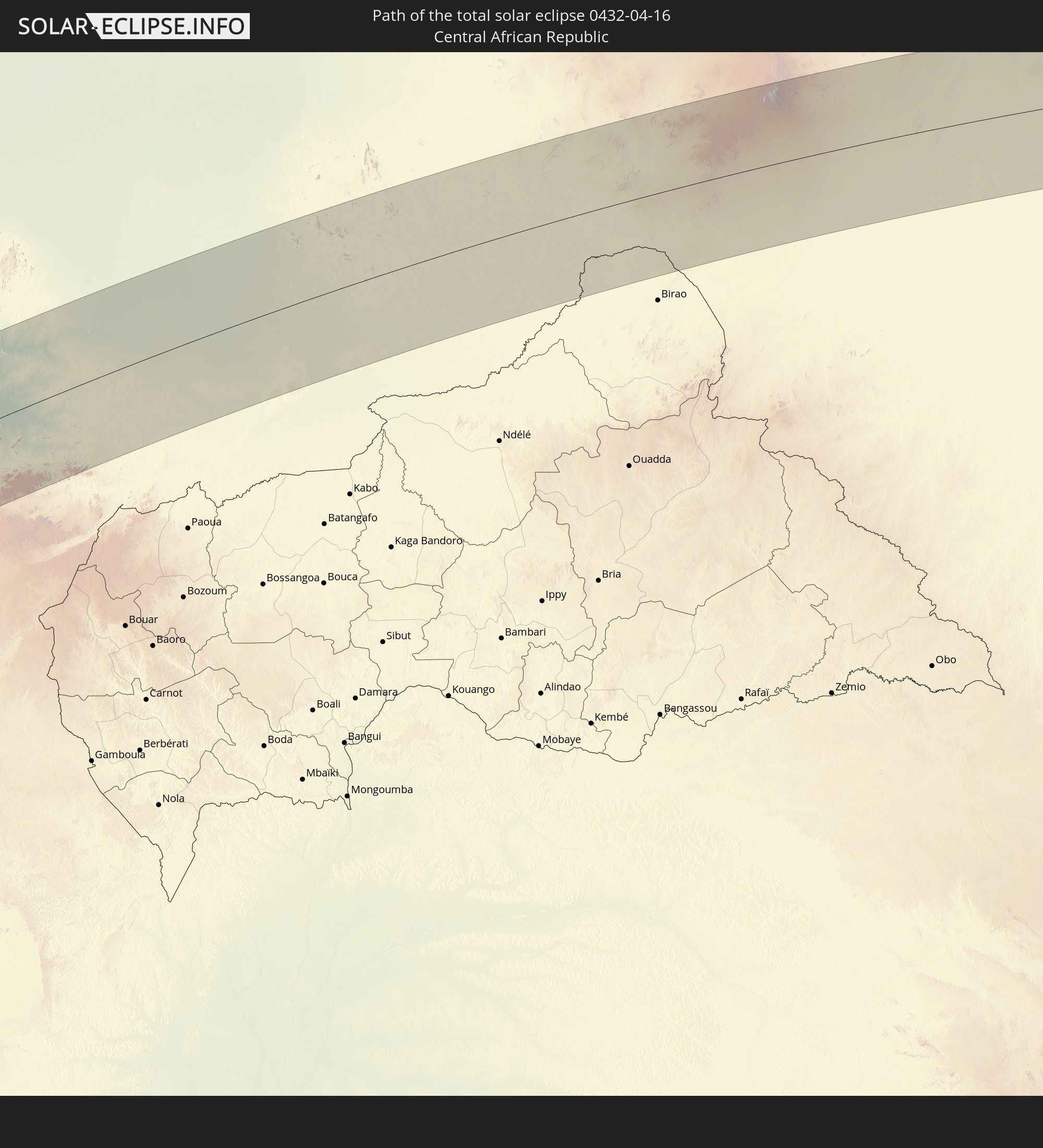
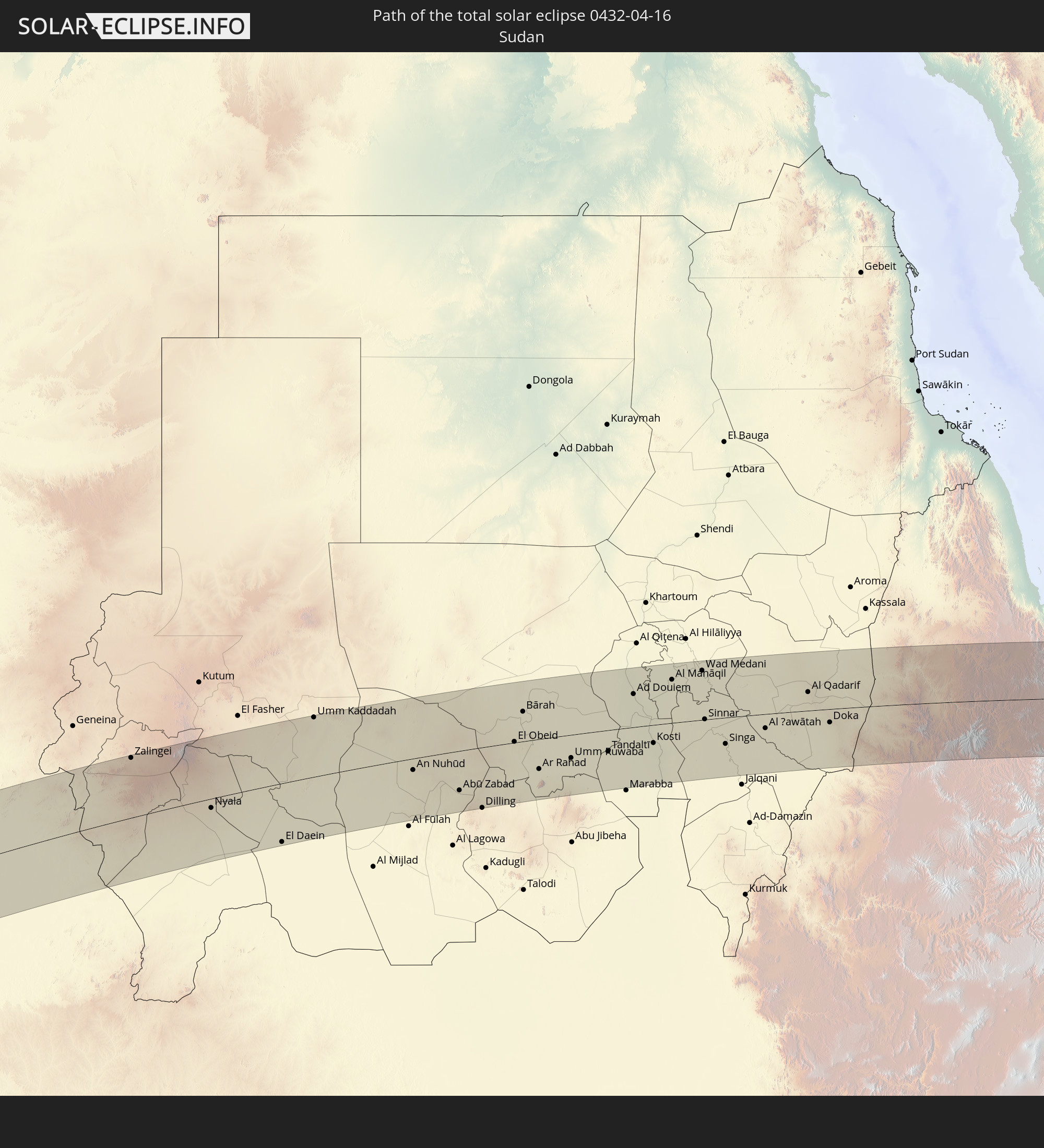
Die folgenden Karten zeigen die durchschnittliche Bewölkung für den Tag, an dem die totale Sonnenfinsternis
stattfindet. Mit Hilfe der Karten lässt sich der Ort entlang des Finsternispfades eingrenzen,
der die besten Aussichen auf einen klaren wolkenfreien Himmel bietet.
Trotzdem muss man immer lokale Gegenenheiten beachten und sollte sich genau über das Wetter an seinem
gewählten Beobachtungsort informieren.
Die Daten stammen von den beiden NASA-Satelliten
AQUA und TERRA
und wurden über einen Zeitraum von 19 Jahren (2000 - 2019) gemittelt.
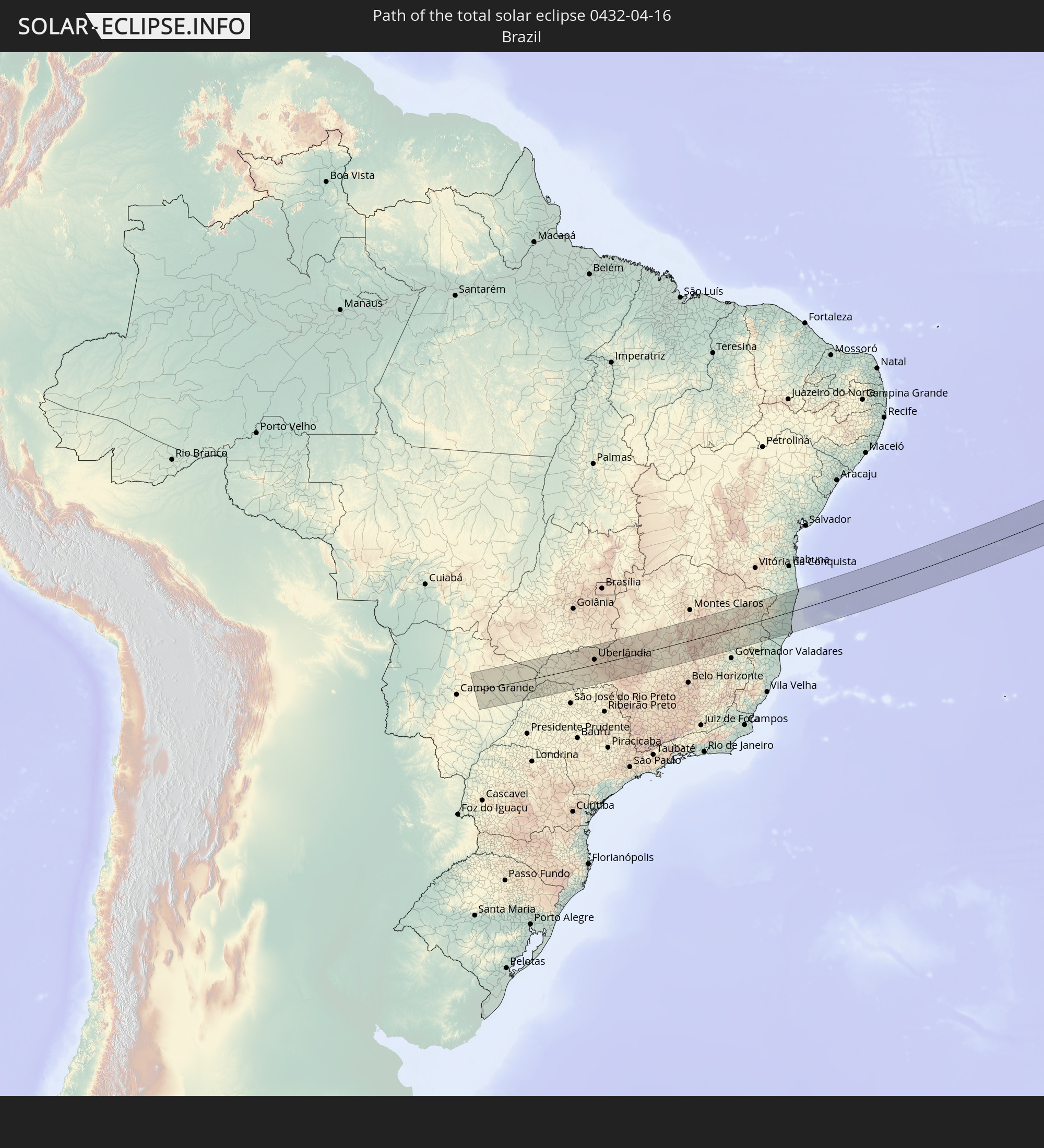
Detaillierte Länderkarten
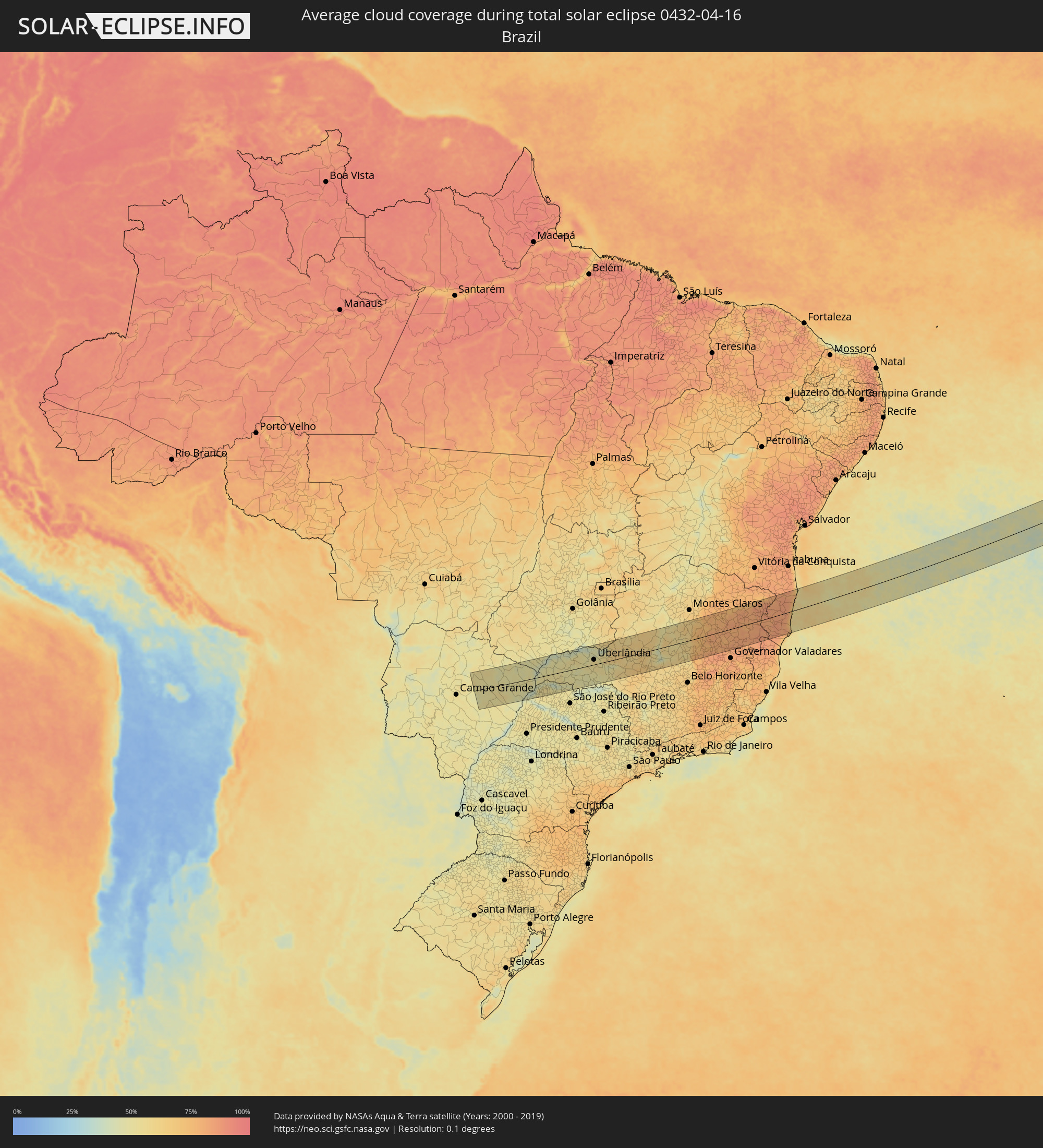 Brasilien
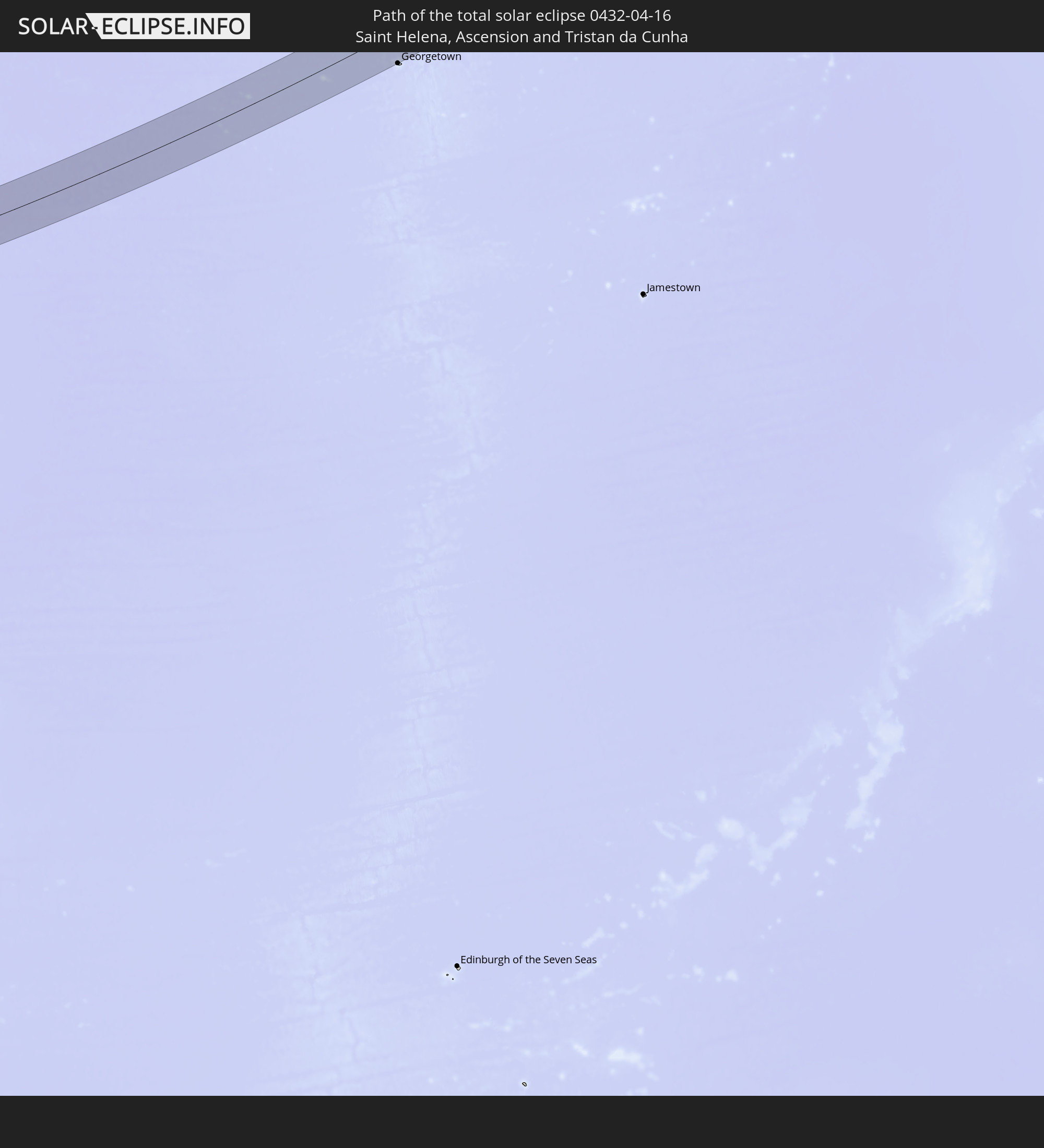
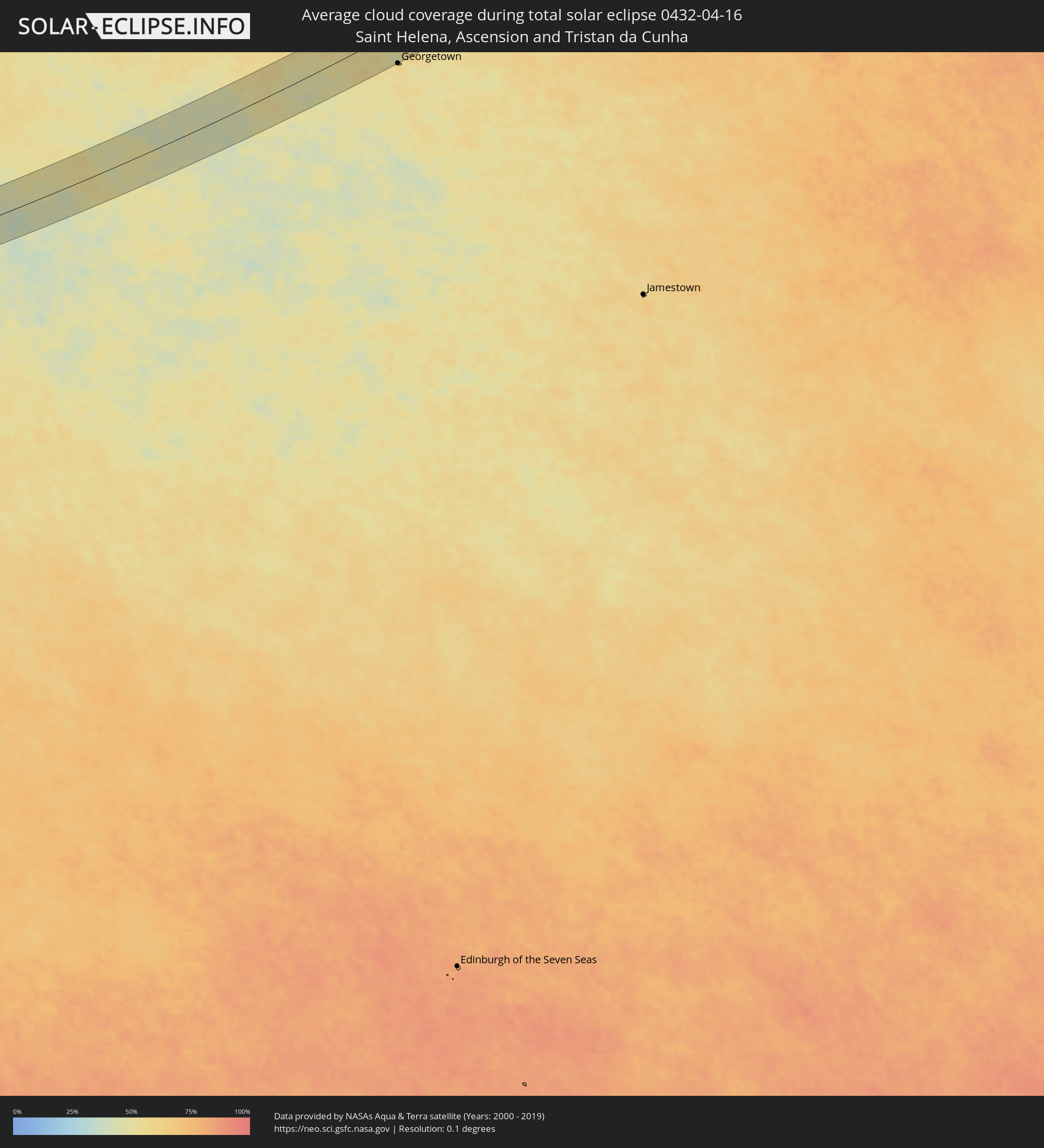 St. Helena
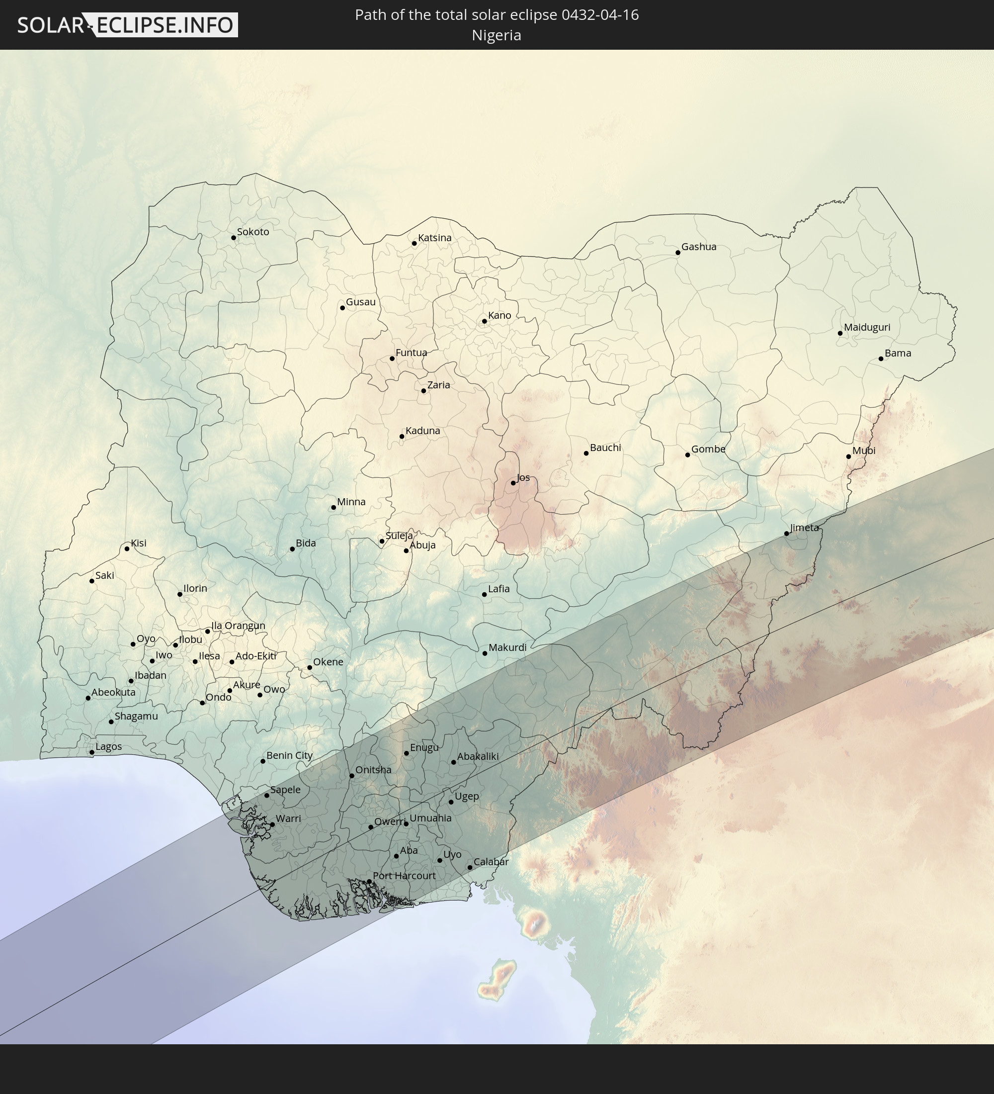
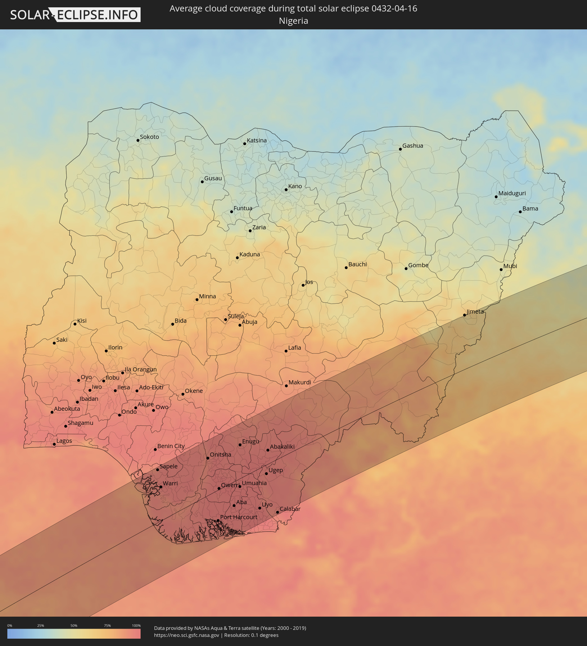 Nigeria
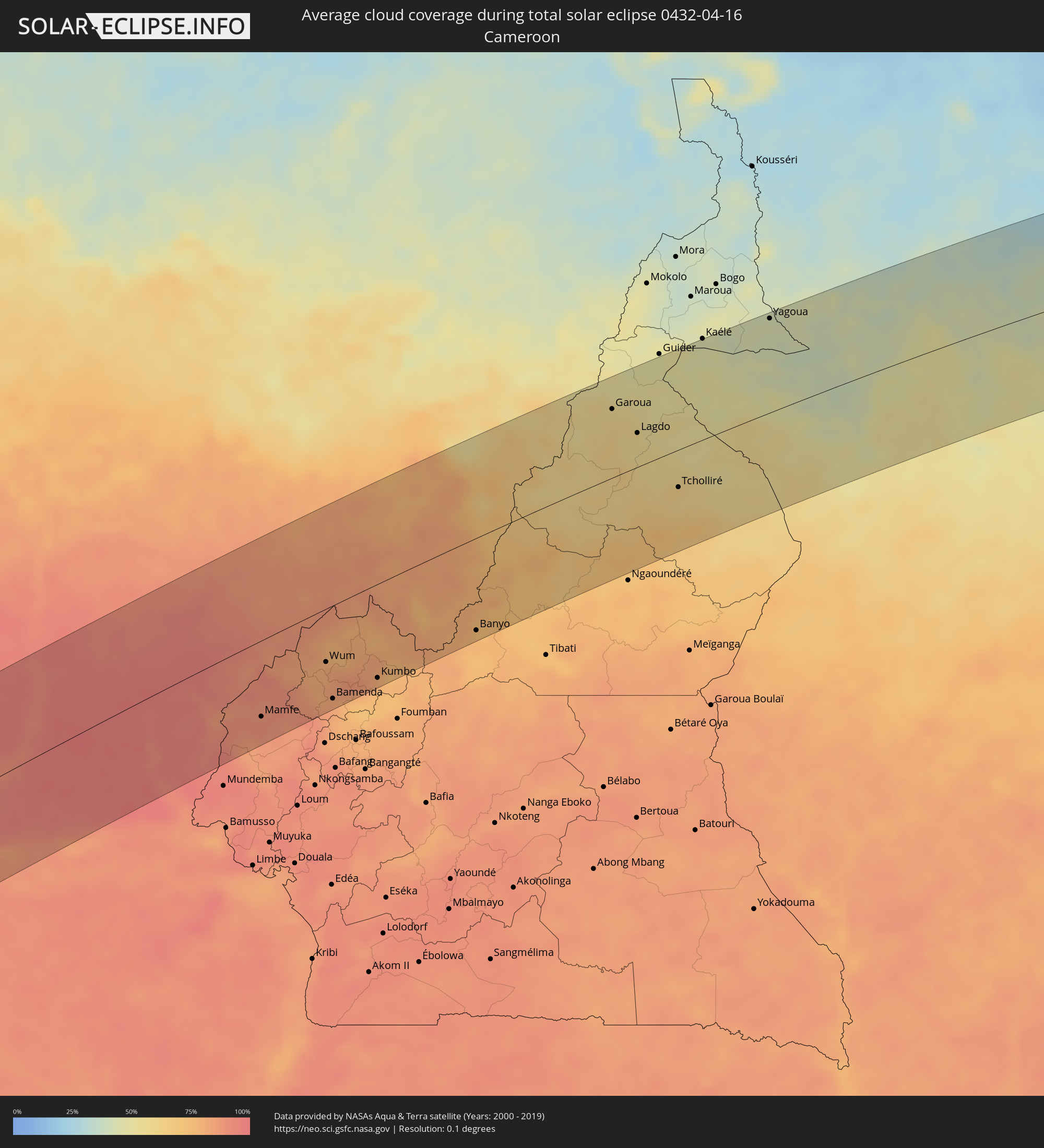 Kamerun
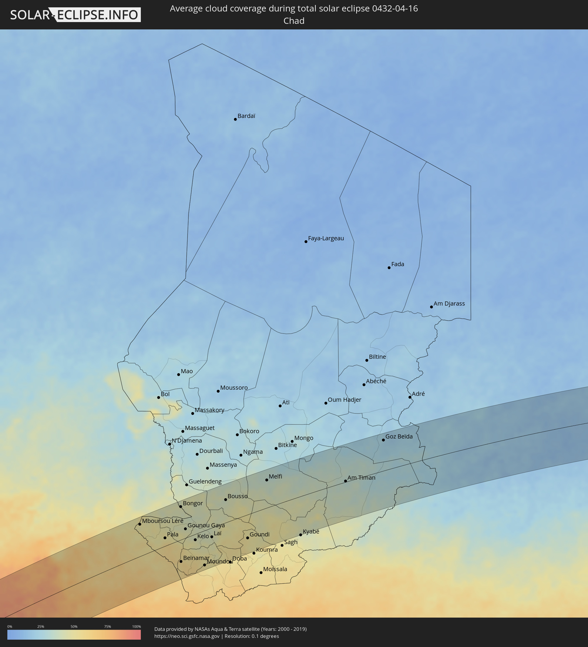 Tschad
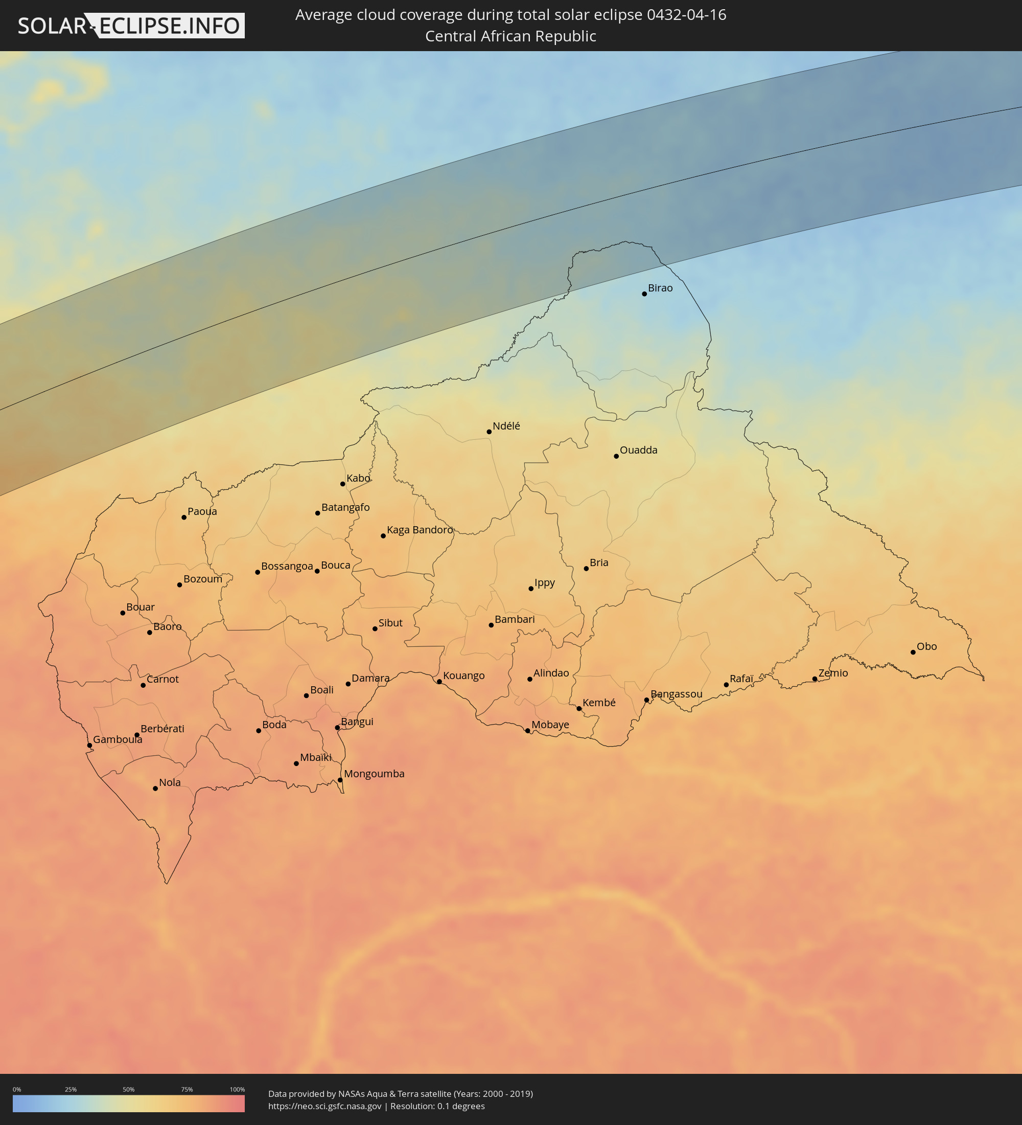 Zentralafrikanische Republik
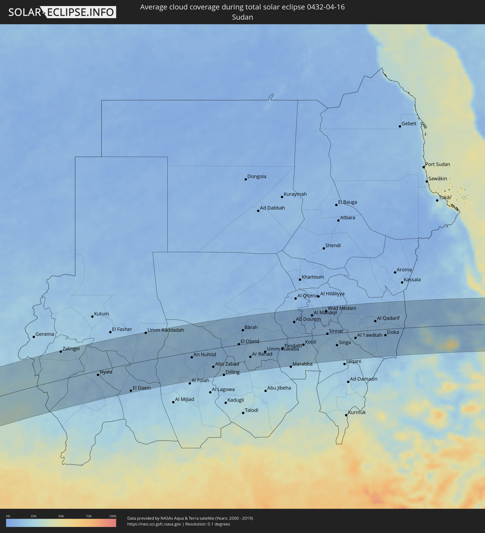 Sudan
Sudan
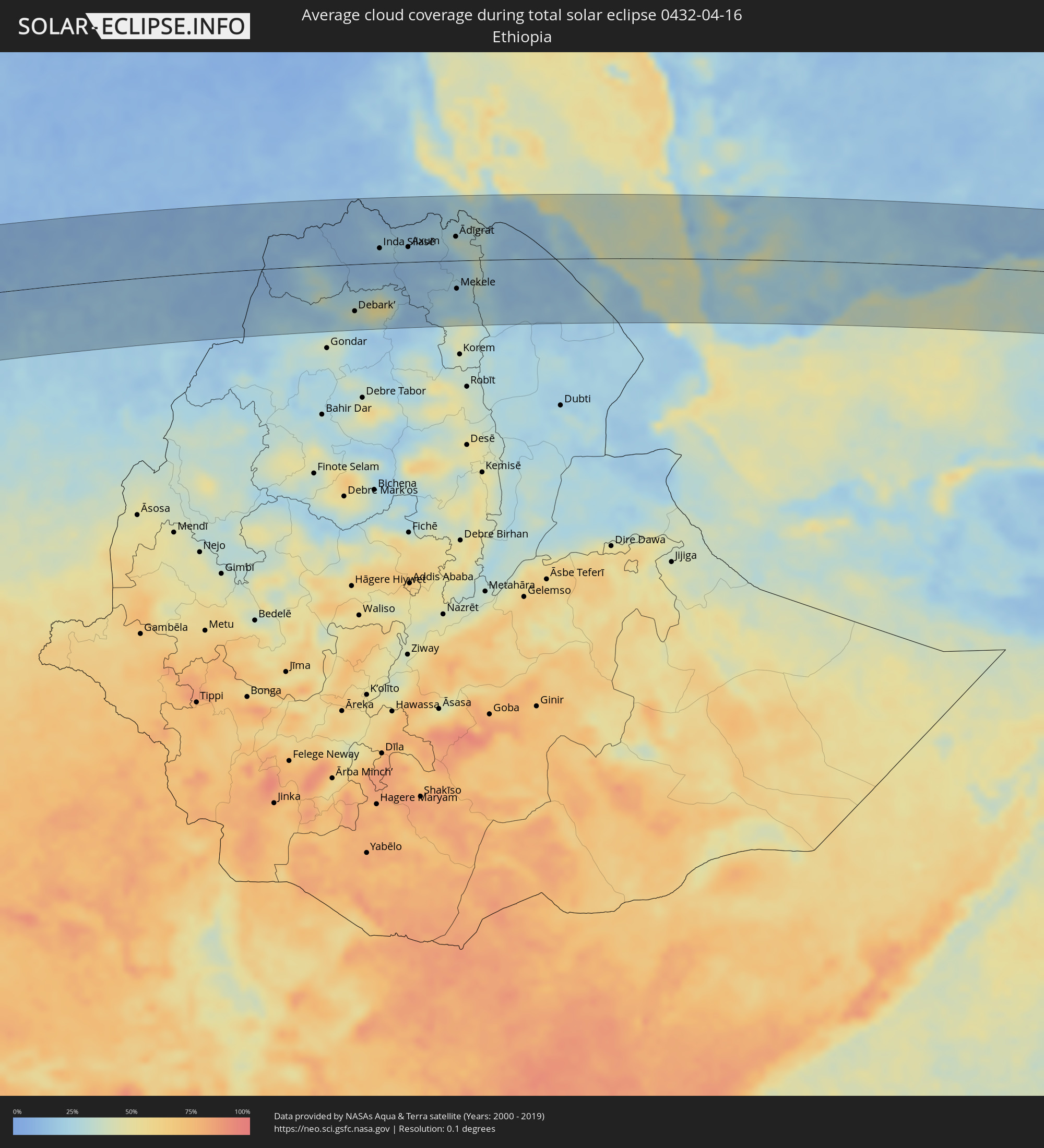 Äthiopien
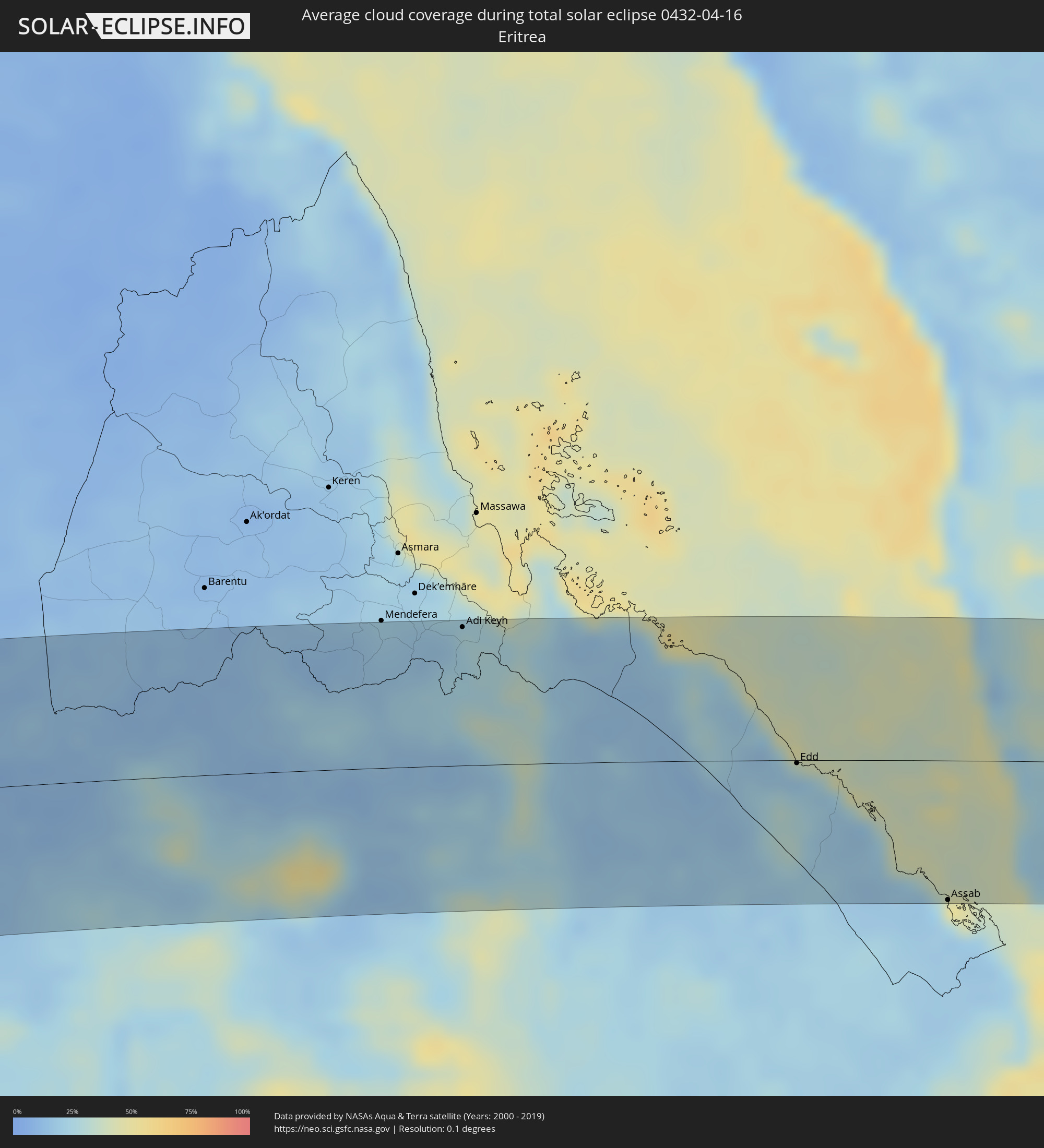 Eritrea
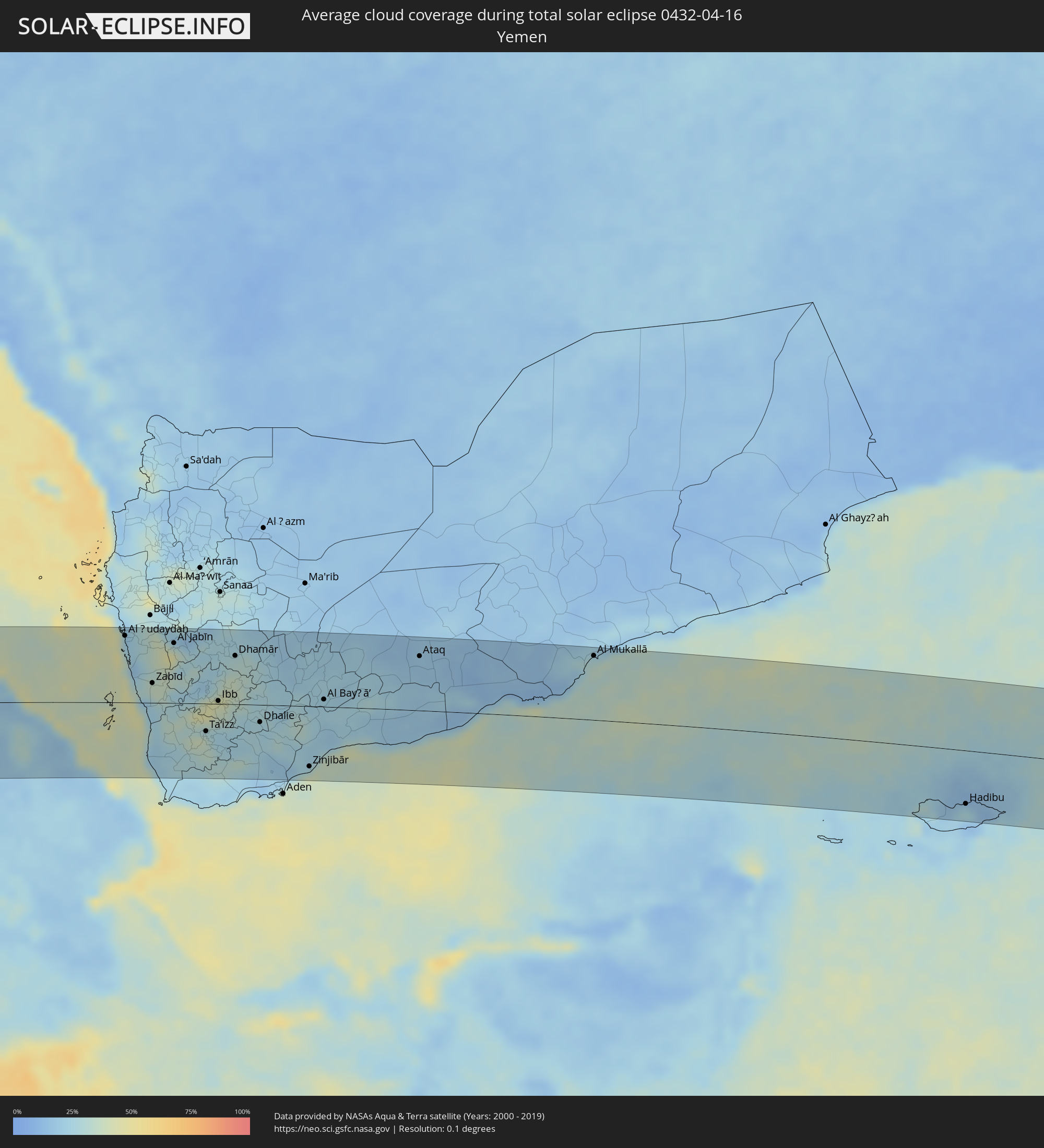 Jemen
Jemen
Orte im Finsternispfad
Die nachfolgene Tabelle zeigt Städte und Orte mit mehr als 5.000 Einwohnern, die sich im Finsternispfad befinden. Städte mit mehr als 100.000 Einwohnern sind dick gekennzeichnet. Mit einem Klick auf den Ort öffnet sich eine Detailkarte die die Lage des jeweiligen Ortes zusammen mit dem Verlauf der zentralen Finsternis präsentiert.
| Ort | Typ | Dauer der Verfinsterung | Ortszeit bei maximaler Verfinsterung | Entfernung zur Zentrallinie | Ø Bewölkung |
|
Paranaíba, Mato Grosso do Sul
|
total | - | 06:11:15 UTC-03:38 | 9 km | 50% |
|
Santa Fé do Sul, São Paulo
|
total | - | 06:43:15 UTC-03:06 | 55 km | 50% |
|
Jales, São Paulo
|
total | - | 06:43:17 UTC-03:06 | 70 km | 54% |
|
Fernandópolis, São Paulo
|
total | - | 06:43:19 UTC-03:06 | 78 km | 52% |
|
Iturama, Minas Gerais
|
total | - | 06:43:20 UTC-03:06 | 19 km | 50% |
|
Ituiutaba, Minas Gerais
|
total | - | 06:43:27 UTC-03:06 | 46 km | 53% |
|
Frutal, Minas Gerais
|
total | - | 06:43:29 UTC-03:06 | 81 km | 49% |
|
Uberlândia, Minas Gerais
|
total | - | 06:43:38 UTC-03:06 | 23 km | 55% |
|
Araguari, Minas Gerais
|
total | - | 06:43:40 UTC-03:06 | 50 km | 44% |
|
Uberaba, Minas Gerais
|
total | - | 06:43:38 UTC-03:06 | 75 km | 51% |
|
Monte Carmelo, Minas Gerais
|
total | - | 06:43:47 UTC-03:06 | 25 km | 62% |
|
Patrocínio, Minas Gerais
|
total | - | 06:43:51 UTC-03:06 | 11 km | 60% |
|
Araxá, Minas Gerais
|
total | - | 06:43:50 UTC-03:06 | 83 km | 57% |
|
Patos de Minas, Minas Gerais
|
total | - | 06:43:59 UTC-03:06 | 16 km | 61% |
|
Carmo do Paranaíba, Minas Gerais
|
total | - | 06:44:00 UTC-03:06 | 35 km | 62% |
|
São Gotardo, Minas Gerais
|
total | - | 06:44:02 UTC-03:06 | 75 km | 64% |
|
Várzea da Palma, Minas Gerais
|
total | - | 06:44:32 UTC-03:06 | 75 km | 54% |
|
Curvelo, Minas Gerais
|
total | - | 06:44:29 UTC-03:06 | 58 km | 61% |
|
Diamantina, Minas Gerais
|
total | - | 06:44:47 UTC-03:06 | 25 km | 75% |
|
Teófilo Otoni, Minas Gerais
|
total | - | 06:45:34 UTC-03:06 | 43 km | 83% |
|
Nanuque, Minas Gerais
|
total | - | 06:46:02 UTC-03:06 | 75 km | 82% |
|
Itamaraju, Bahia
|
total | - | 07:19:00 UTC-02:34 | 15 km | 84% |
|
Porto Seguro, Bahia
|
total | - | 07:19:21 UTC-02:34 | 34 km | 67% |
|
Sapele, Delta
|
total | - | 11:39:48 UTC+00:13 | 113 km | 95% |
|
Warri, Delta
|
total | - | 11:39:28 UTC+00:13 | 72 km | 96% |
|
Onitsha, Anambra
|
total | - | 11:43:09 UTC+00:13 | 80 km | 94% |
|
Ihiala, Anambra
|
total | - | 11:42:56 UTC+00:13 | 47 km | 97% |
|
Buguma, Rivers
|
total | - | 11:41:22 UTC+00:13 | 63 km | 95% |
|
Nnewi, Anambra
|
total | - | 11:43:20 UTC+00:13 | 60 km | 97% |
|
Port Harcourt, Rivers
|
total | - | 11:41:50 UTC+00:13 | 67 km | 96% |
|
Owerri, Imo
|
total | - | 11:42:53 UTC+00:13 | 2 km | 97% |
|
Awka, Anambra
|
total | - | 11:44:01 UTC+00:13 | 71 km | 96% |
|
Okigwe, Imo
|
total | - | 11:44:14 UTC+00:13 | 19 km | 96% |
|
Aba, Abia
|
total | - | 11:43:16 UTC+00:13 | 53 km | 97% |
|
Nsukka, Enugu
|
total | - | 11:45:48 UTC+00:13 | 118 km | 92% |
|
Umuahia, Abia
|
total | - | 11:44:12 UTC+00:13 | 18 km | 97% |
|
Enugu, Enugu
|
total | - | 11:45:30 UTC+00:13 | 72 km | 96% |
|
Ikot Ekpene, Akwa Ibom
|
total | - | 11:44:19 UTC+00:13 | 63 km | 97% |
|
Amaigbo, Abia
|
total | - | 11:45:31 UTC+00:13 | 10 km | 96% |
|
Uyo, Akwa Ibom
|
total | - | 11:44:44 UTC+00:13 | 87 km | 97% |
|
Effium, Ebonyi
|
total | - | 11:47:17 UTC+00:13 | 62 km | 95% |
|
Ugep, Cross River
|
total | - | 11:46:12 UTC+00:13 | 20 km | 96% |
|
Abakaliki, Ebonyi
|
total | - | 11:47:01 UTC+00:13 | 29 km | 96% |
|
Calabar, Cross River
|
total | - | 11:45:42 UTC+00:13 | 117 km | 94% |
|
Mamfe, South-West
|
total | - | 11:49:31 UTC+00:13 | 88 km | 89% |
|
Wukari, Taraba
|
total | - | 11:53:41 UTC+00:13 | 101 km | 82% |
|
Batibo, North-West
|
total | - | 11:51:08 UTC+00:13 | 106 km | 91% |
|
Mbengwi, North-West
|
total | - | 11:51:47 UTC+00:13 | 95 km | 81% |
|
Bali, North-West
|
total | - | 11:51:38 UTC+00:13 | 109 km | 85% |
|
Wum, North-West
|
total | - | 11:52:28 UTC+00:13 | 62 km | 82% |
|
Bamenda, North-West
|
total | - | 11:52:07 UTC+00:13 | 108 km | 82% |
|
Mme-Bafumen, North-West
|
total | - | 11:52:52 UTC+00:13 | 75 km | 84% |
|
Belo, North-West
|
total | - | 11:52:38 UTC+00:13 | 96 km | 83% |
|
Babanki, North-West
|
total | - | 11:52:37 UTC+00:13 | 97 km | 83% |
|
Fundong, North-West
|
total | - | 11:52:50 UTC+00:13 | 85 km | 87% |
|
Njinikom, North-West
|
total | - | 11:52:52 UTC+00:13 | 87 km | 87% |
|
Jakiri, North-West
|
total | - | 11:53:42 UTC+00:13 | 118 km | 75% |
|
Kumbo, North-West
|
total | - | 11:53:53 UTC+00:13 | 109 km | 78% |
|
Banyo, Adamaoua
|
total | - | 11:57:48 UTC+00:13 | 108 km | 75% |
|
Kontcha, Adamaoua
|
total | - | 12:00:32 UTC+00:13 | 4 km | 68% |
|
Jimeta, Adamawa
|
total | - | 12:02:48 UTC+00:13 | 120 km | 56% |
|
Poli, North
|
total | - | 12:03:56 UTC+00:13 | 3 km | 60% |
|
Garoua, North
|
total | - | 12:05:22 UTC+00:13 | 81 km | 59% |
|
Pitoa, North
|
total | - | 12:05:45 UTC+00:13 | 85 km | 56% |
|
Lagdo, North
|
total | - | 12:05:50 UTC+00:13 | 40 km | 57% |
|
Mboursou Léré, Mayo-Kebbi Ouest
|
total | - | 12:54:35 UTC+01:00 | 96 km | 48% |
|
Tcholliré, North
|
total | - | 12:06:23 UTC+00:13 | 44 km | 61% |
|
Rey Bouba, North
|
total | - | 12:06:44 UTC+00:13 | 17 km | 57% |
|
Kaélé, Far North
|
total | - | 12:09:10 UTC+00:13 | 120 km | 46% |
|
Pala, Mayo-Kebbi Ouest
|
total | - | 12:56:08 UTC+01:00 | 24 km | 51% |
|
Yagoua, Far North
|
total | - | 12:11:32 UTC+00:13 | 112 km | 41% |
|
Bongor, Mayo-Kebbi Est
|
total | - | 12:58:27 UTC+01:00 | 100 km | 42% |
|
Beïnamar, Logone Occidental
|
total | - | 12:56:37 UTC+01:00 | 67 km | 59% |
|
Gounou Gaya, Mayo-Kebbi Est
|
total | - | 12:58:05 UTC+01:00 | 27 km | 46% |
|
Kelo, Tandjilé
|
total | - | 12:58:30 UTC+01:00 | 18 km | 47% |
|
Moundou, Logone Occidental
|
total | - | 12:58:24 UTC+01:00 | 106 km | 51% |
|
Béré, Tandjilé
|
total | - | 12:59:27 UTC+01:00 | 31 km | 45% |
|
Laï, Tandjilé
|
total | - | 12:59:56 UTC+01:00 | 28 km | 43% |
|
Benoy, Logone Occidental
|
total | - | 12:59:31 UTC+01:00 | 72 km | 47% |
|
Bébédja, Logone Oriental
|
total | - | 12:59:50 UTC+01:00 | 114 km | 54% |
|
Bousso, Chari-Baguirmi
|
total | - | 13:02:13 UTC+01:00 | 69 km | 40% |
|
Goundi, Mandoul
|
total | - | 13:02:45 UTC+01:00 | 73 km | 50% |
|
Melfi, Guéra
|
total | - | 13:06:02 UTC+01:00 | 85 km | 36% |
|
Am Timan, Salamat
|
total | - | 13:12:01 UTC+01:00 | 2 km | 34% |
|
Goz Beïda, Sila
|
total | - | 13:15:54 UTC+01:00 | 95 km | 23% |
|
Zalingei, Central Darfur
|
total | - | 14:31:20 UTC+02:10 | 111 km | 21% |
|
El Daein, Eastern Darfur
|
total | - | 14:36:27 UTC+02:10 | 110 km | 16% |
|
An Nuhūd, West Kordofan State
|
total | - | 14:42:20 UTC+02:10 | 22 km | 13% |
|
Abū Zabad, West Kordofan State
|
total | - | 14:43:52 UTC+02:10 | 75 km | 18% |
|
Dilling, Southern Kordofan
|
total | - | 14:44:32 UTC+02:10 | 114 km | 20% |
|
El Obeid, North Kordofan
|
total | - | 14:46:18 UTC+02:10 | 2 km | 12% |
|
Bārah, North Kordofan
|
total | - | 14:46:51 UTC+02:10 | 56 km | 13% |
|
Ar Rahad, North Kordofan
|
total | - | 14:46:56 UTC+02:10 | 57 km | 17% |
|
Umm Ruwaba, North Kordofan
|
total | - | 14:48:09 UTC+02:10 | 44 km | 15% |
|
Tandaltī, White Nile
|
total | - | 14:49:29 UTC+02:10 | 41 km | 13% |
|
Ad Douiem, White Nile
|
total | - | 14:50:45 UTC+02:10 | 63 km | 12% |
|
Kosti, White Nile
|
total | - | 14:51:04 UTC+02:10 | 34 km | 15% |
|
Al Manāqil, Al Jazīrah
|
total | - | 14:52:07 UTC+02:10 | 82 km | 11% |
|
Kināna, Sinnār
|
total | - | 14:52:22 UTC+02:10 | 56 km | 12% |
|
Wad Medani, Al Jazīrah
|
total | - | 14:53:08 UTC+02:10 | 93 km | 10% |
|
Sinnar, Sinnār
|
total | - | 14:52:55 UTC+02:10 | 1 km | 16% |
|
Maiurno, Sinnār
|
total | - | 14:53:02 UTC+02:10 | 17 km | 17% |
|
As Sūkī, Sinnār
|
total | - | 14:53:23 UTC+02:10 | 31 km | 18% |
|
Singa, Sinnār
|
total | - | 14:53:24 UTC+02:10 | 50 km | 14% |
|
Ad Dindar, Sinnār
|
total | - | 14:53:51 UTC+02:10 | 47 km | 17% |
|
Al Ḩawātah, Al Qaḑārif
|
total | - | 14:54:46 UTC+02:10 | 27 km | 15% |
|
Al Qadarif, Al Qaḑārif
|
total | - | 14:56:17 UTC+02:10 | 35 km | 12% |
|
Doka, Al Qaḑārif
|
total | - | 14:56:46 UTC+02:10 | 25 km | 12% |
|
Dabat, Amhara
|
total | - | 15:17:02 UTC+02:27 | 97 km | 25% |
|
Debark’, Amhara
|
total | - | 15:17:17 UTC+02:27 | 79 km | 39% |
|
Inda Silasē, Tigray
|
total | - | 15:18:08 UTC+02:27 | 25 km | 17% |
|
Axum, Tigray
|
total | - | 15:18:49 UTC+02:27 | 25 km | 18% |
|
Adi Keyh, Debub
|
total | - | 15:19:56 UTC+02:27 | 103 km | 25% |
|
Ādīgrat, Tigray
|
total | - | 15:19:57 UTC+02:27 | 40 km | 36% |
|
Mekele, Tigray
|
total | - | 15:19:48 UTC+02:27 | 47 km | 21% |
|
Edd, Southern Red Sea
|
total | - | 15:23:02 UTC+02:27 | 2 km | 18% |
|
Assab, Southern Red Sea
|
total | - | 15:24:15 UTC+02:27 | 105 km | 24% |
|
Al Ḩudaydah, Muḩāfaz̧at al Ḩudaydah
|
total | - | 16:04:24 UTC+03:06 | 95 km | 24% |
|
Zabīd, Muḩāfaz̧at al Ḩudaydah
|
total | - | 16:04:47 UTC+03:06 | 28 km | 31% |
|
Bayt al Faqīh, Muḩāfaz̧at al Ḩudaydah
|
total | - | 16:04:50 UTC+03:06 | 64 km | 29% |
|
Al Jabīn, Raymah
|
total | - | 16:05:12 UTC+03:06 | 85 km | 47% |
|
Ta‘izz, Ta‘izz
|
total | - | 16:05:34 UTC+03:06 | 39 km | 38% |
|
Dhī as Sufāl, Ibb
|
total | - | 16:05:43 UTC+03:06 | 11 km | 34% |
|
Ibb, Ibb
|
total | - | 16:05:49 UTC+03:06 | 4 km | 40% |
|
Yarīm, Ibb
|
total | - | 16:06:06 UTC+03:06 | 41 km | 37% |
|
Dhamār, Dhamār
|
total | - | 16:06:09 UTC+03:06 | 69 km | 31% |
|
Dhalie, Aḑ Ḑāli‘
|
total | - | 16:06:27 UTC+03:06 | 25 km | 27% |
|
Laḩij, Laḩij
|
total | - | 16:06:32 UTC+03:06 | 95 km | 22% |
|
Zinjibār, Abyan
|
total | - | 16:07:08 UTC+03:06 | 86 km | 40% |
|
Al Bayḑā’, Al Bayḑāʼ
|
total | - | 16:07:27 UTC+03:06 | 10 km | 24% |
|
Jawf al Maqbābah, Abyan
|
total | - | 16:07:44 UTC+03:06 | 5 km | 23% |
|
Ataq, Shabwah
|
total | - | 16:08:53 UTC+03:06 | 77 km | 17% |
|
Al Mukallā, Muḩāfaz̧at Ḩaḑramawt
|
total | - | 16:11:11 UTC+03:06 | 91 km | 32% |
|
Hadibu, Soqatra Governorate
|
total | - | 16:15:12 UTC+03:06 | 76 km | 26% |
|
Kavaratti, Laccadives
|
total | - | 18:35:52 UTC+05:21 | 2 km | 67% |