Totale Sonnenfinsternis vom 29.07.0436
| Wochentag: | Dienstag |
| Maximale Dauer der Verfinsterung: | 03m37s |
| Maximale Breite des Finsternispfades: | 143 km |
| Saroszyklus: | 91 |
| Bedeckungsgrad: | 100% |
| Magnitude: | 1.0409 |
| Gamma: | 0.2842 |
Wo kann man die Sonnenfinsternis vom 29.07.0436 sehen?
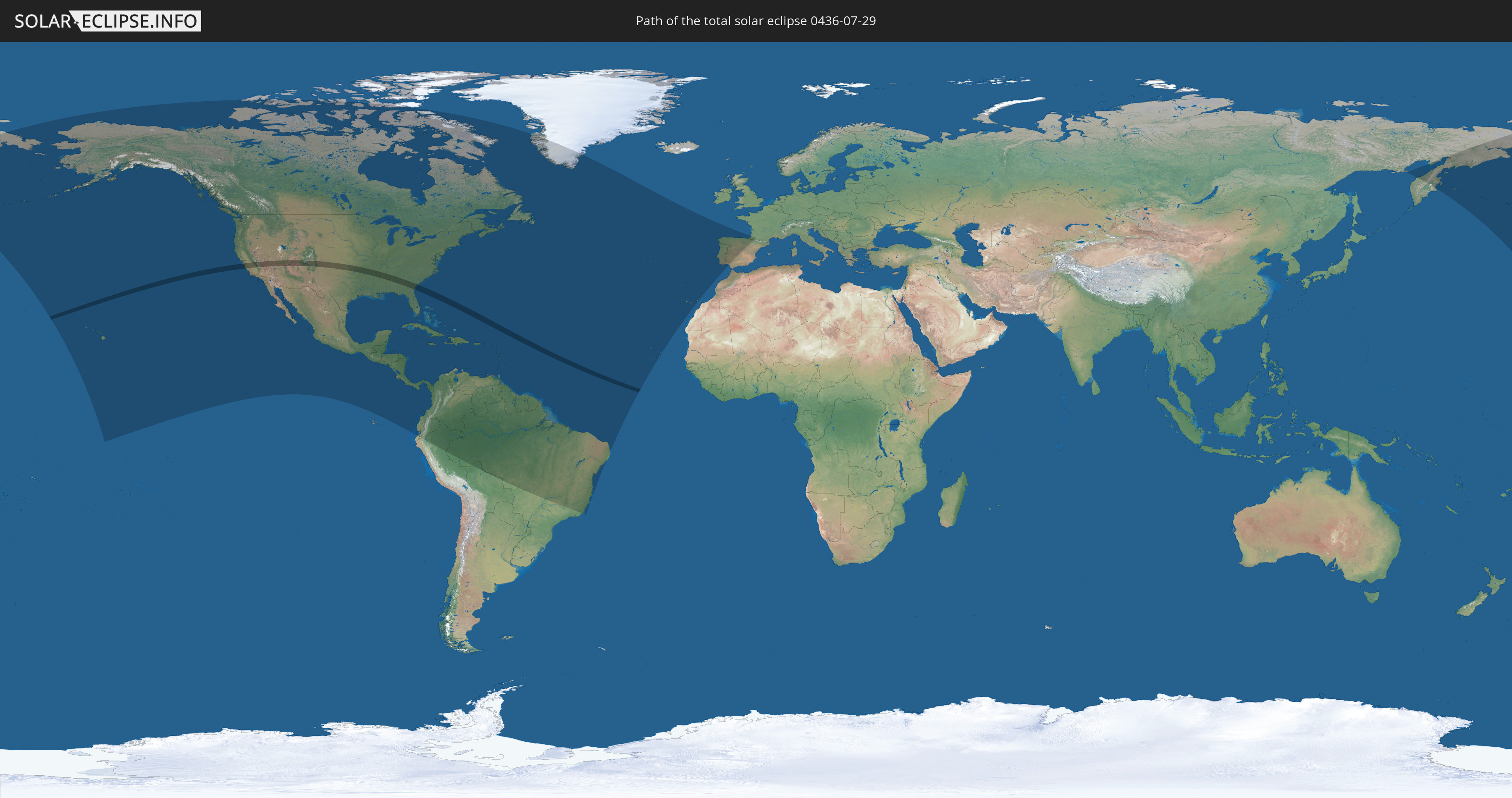
Die Sonnenfinsternis am 29.07.0436 kann man in 54 Ländern als partielle Sonnenfinsternis beobachten.
Der Finsternispfad verläuft durch ein Land. Nur in diesem Land ist sie als totale Sonnenfinsternis zu sehen.
In den folgenden Ländern ist die Sonnenfinsternis total zu sehen
 Vereinigte Staaten
In den folgenden Ländern ist die Sonnenfinsternis partiell zu sehen
 Russland
 Vereinigte Staaten
 United States Minor Outlying Islands
 Kiribati
 Kanada
 Mexiko
 Grönland
 Guatemala
 Ecuador
 El Salvador
 Honduras
 Belize
 Nicaragua
 Costa Rica
 Kuba
Kuba
 Panama
 Kolumbien
 Kaimaninseln
 Peru
Peru
 Bahamas
 Jamaika
 Haiti
Haiti
 Brasilien
 Venezuela
 Turks- und Caicosinseln
 Dominikanische Republik
 Aruba
Aruba
 Bolivien
 Puerto Rico
 Amerikanische Jungferninseln
 Bermuda
 Britische Jungferninseln
 Anguilla
 Saint-Martin
 Saint-Barthélemy
 St. Kitts und Nevis
 Antigua und Barbuda
 Montserrat
 Trinidad und Tobago
 Guadeloupe
 Grenada
 Dominica
 St. Vincent und die Grenadinen
 Guyana
 Martinique
 St. Lucia
 Barbados
 Suriname
 Saint-Pierre und Miquelon
 Französisch-Guayana
 Portugal
 Kap Verde
 Spanien
 Frankreich
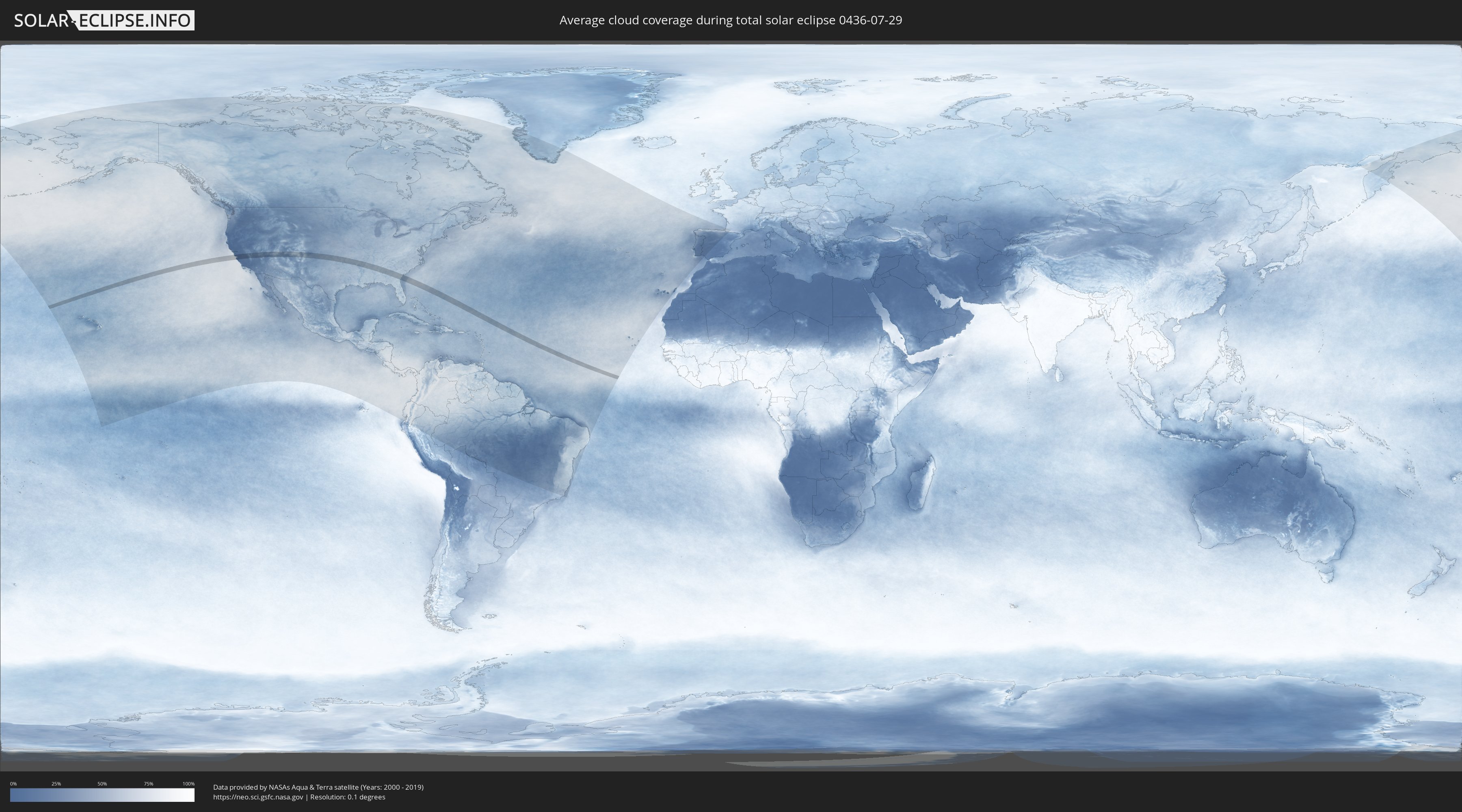
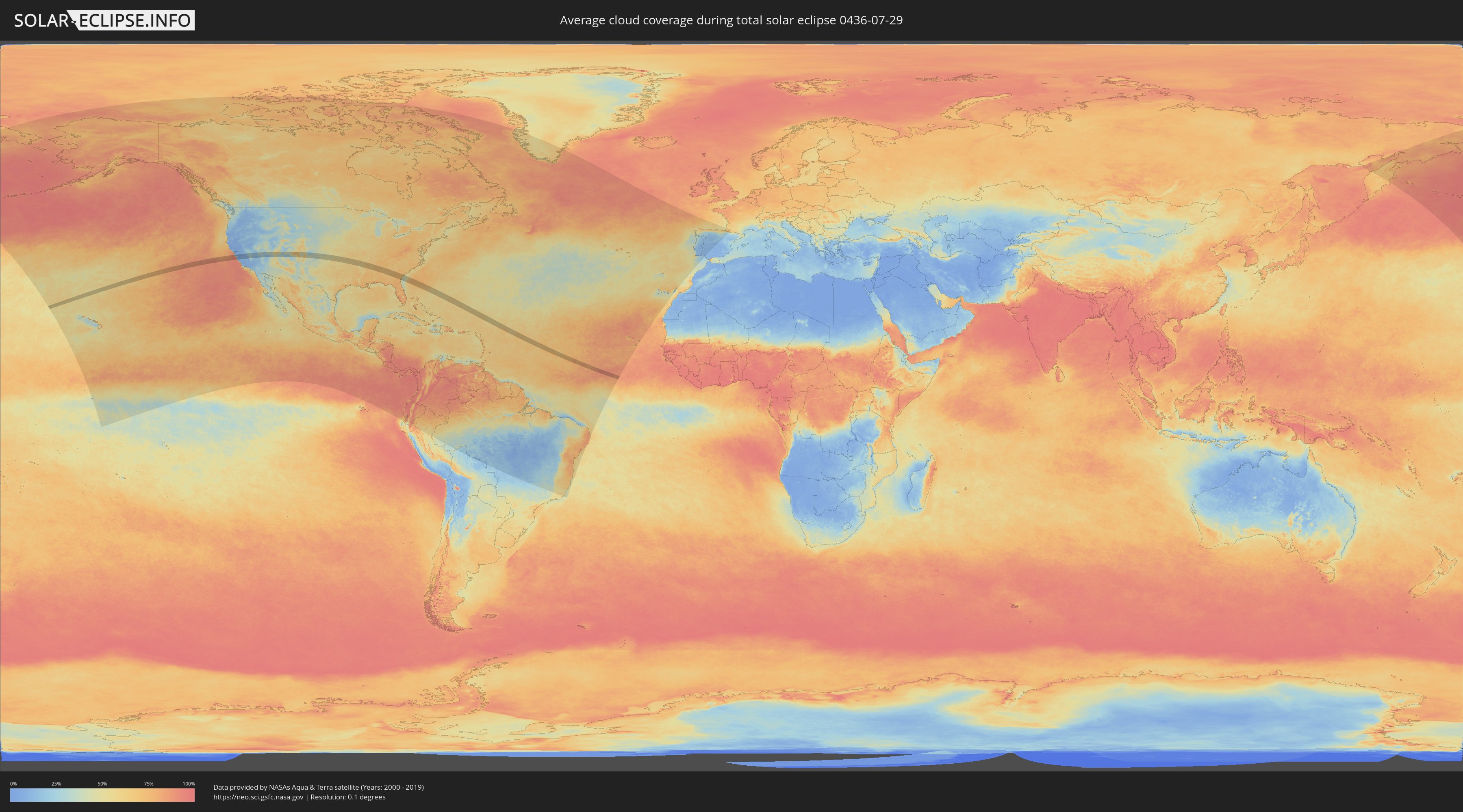
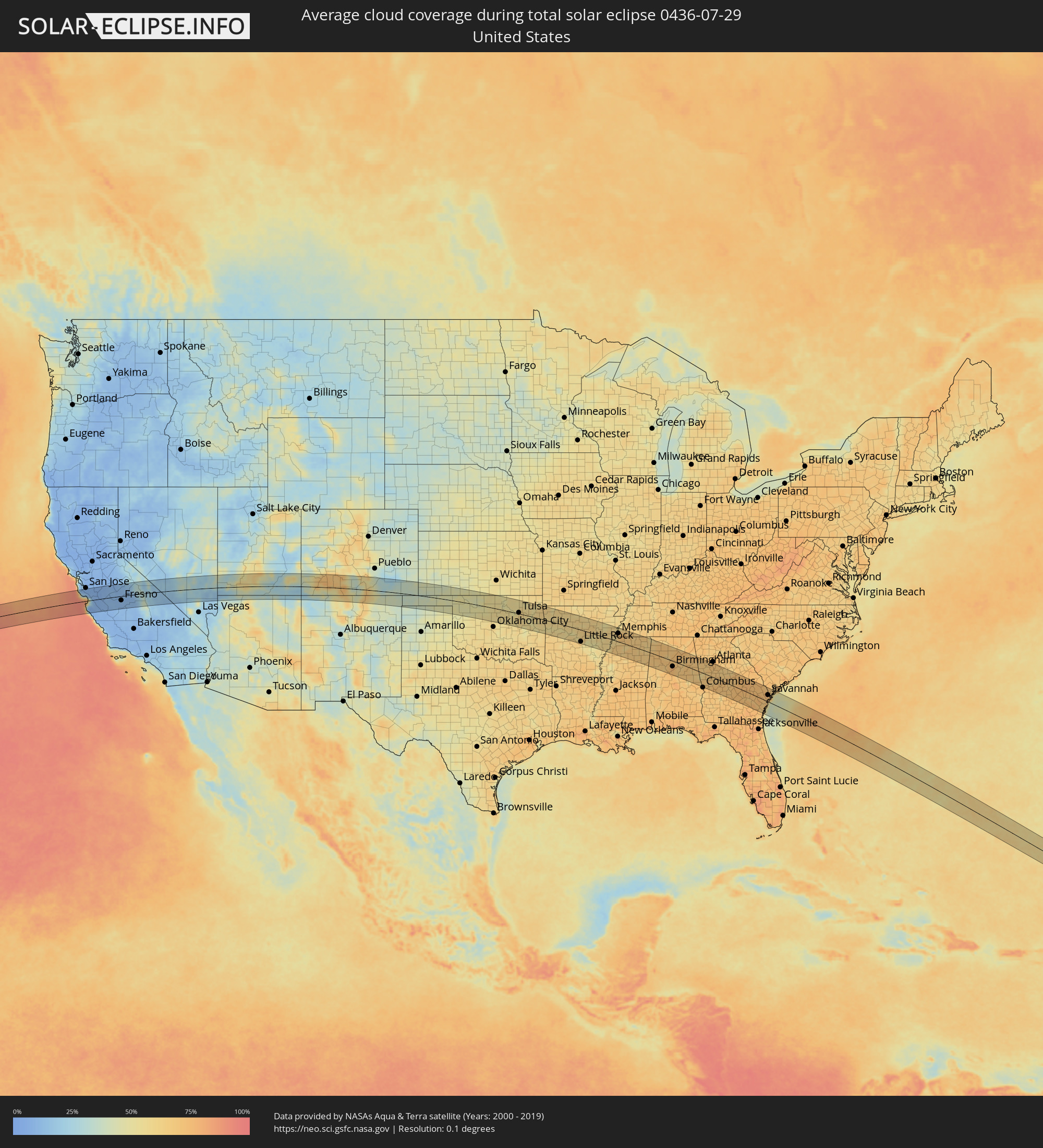
Wie wird das Wetter während der totalen Sonnenfinsternis am 29.07.0436?
Wo ist der beste Ort, um die totale Sonnenfinsternis vom 29.07.0436 zu beobachten?
Die folgenden Karten zeigen die durchschnittliche Bewölkung für den Tag, an dem die totale Sonnenfinsternis
stattfindet. Mit Hilfe der Karten lässt sich der Ort entlang des Finsternispfades eingrenzen,
der die besten Aussichen auf einen klaren wolkenfreien Himmel bietet.
Trotzdem muss man immer lokale Gegenenheiten beachten und sollte sich genau über das Wetter an seinem
gewählten Beobachtungsort informieren.
Die Daten stammen von den beiden NASA-Satelliten
AQUA und TERRA
und wurden über einen Zeitraum von 19 Jahren (2000 - 2019) gemittelt.
Detaillierte Länderkarten
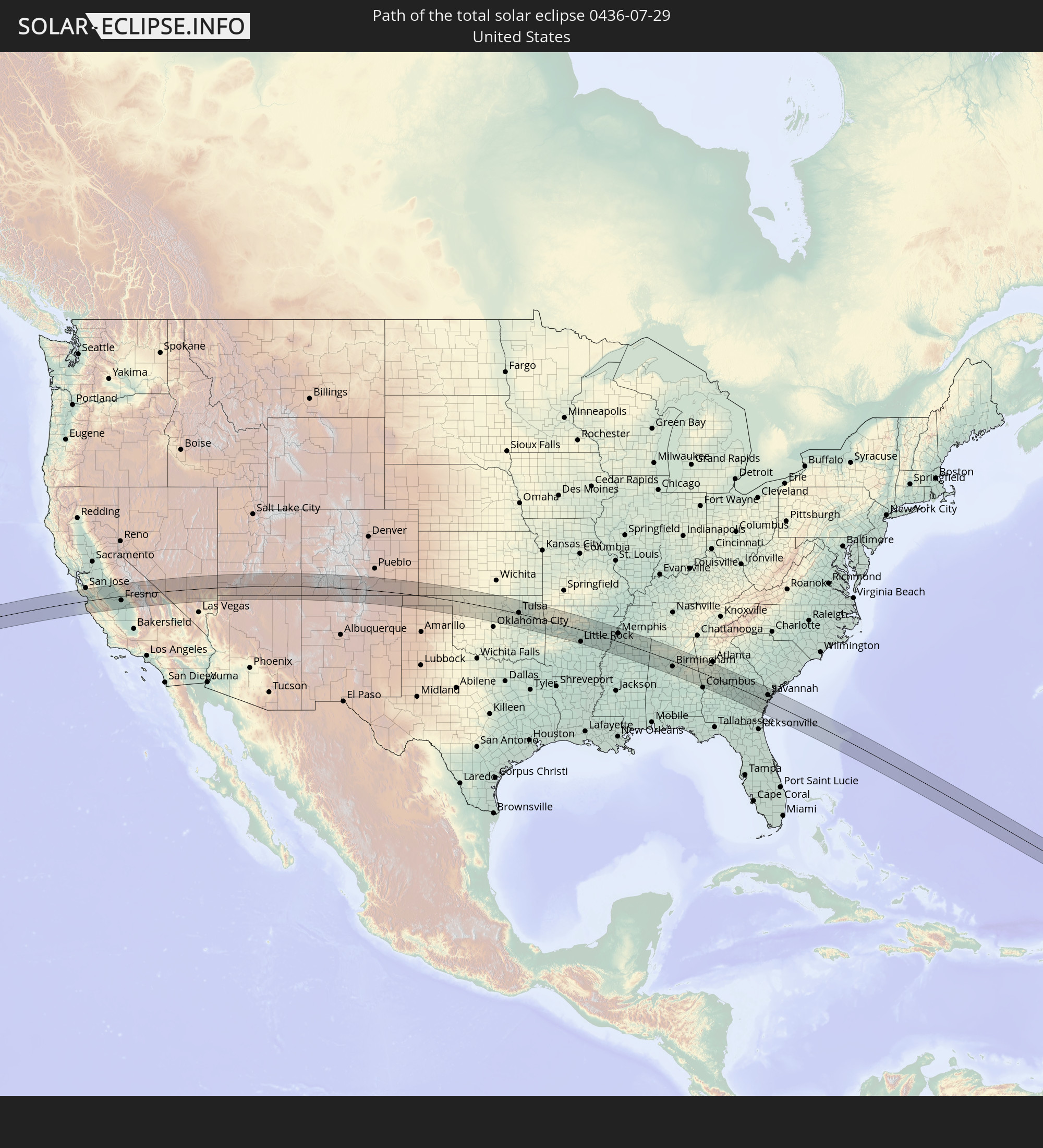
 Vereinigte Staaten
Orte im Finsternispfad
Die nachfolgene Tabelle zeigt Städte und Orte mit mehr als 5.000 Einwohnern, die sich im Finsternispfad befinden. Städte mit mehr als 100.000 Einwohnern sind dick gekennzeichnet. Mit einem Klick auf den Ort öffnet sich eine Detailkarte die die Lage des jeweiligen Ortes zusammen mit dem Verlauf der zentralen Finsternis präsentiert.
| Ort | Typ | Dauer der Verfinsterung | Ortszeit bei maximaler Verfinsterung | Entfernung zur Zentrallinie | Ø Bewölkung |
|
Santa Cruz, California
|
total | - | 09:18:29 UTC-08:00 | 30 km | 54% |
|
Scotts Valley, California
|
total | - | 09:18:34 UTC-08:00 | 38 km | 16% |
|
Live Oak, California
|
total | - | 09:18:34 UTC-08:00 | 30 km | 54% |
|
Soquel, California
|
total | - | 09:18:37 UTC-08:00 | 30 km | 54% |
|
Capitola, California
|
total | - | 09:18:36 UTC-08:00 | 29 km | 54% |
|
Campbell, California
|
total | - | 09:18:52 UTC-08:00 | 63 km | 7% |
|
Pacific Grove, California
|
total | - | 09:18:23 UTC-08:00 | 11 km | 57% |
|
Rio Del Mar, California
|
total | - | 09:18:41 UTC-08:00 | 28 km | 53% |
|
Seaside, California
|
total | - | 09:18:28 UTC-08:00 | 12 km | 57% |
|
Marina, California
|
total | - | 09:18:36 UTC-08:00 | 5 km | 56% |
|
Watsonville, California
|
total | - | 09:18:51 UTC-08:00 | 19 km | 66% |
|
Interlaken, California
|
total | - | 09:18:56 UTC-08:00 | 23 km | 23% |
|
Prunedale, California
|
total | - | 09:18:53 UTC-08:00 | 3 km | 50% |
|
Salinas, California
|
total | - | 09:18:50 UTC-08:00 | 8 km | 34% |
|
Morgan Hill, California
|
total | - | 09:19:11 UTC-08:00 | 42 km | 8% |
|
Gilroy, California
|
total | - | 09:19:14 UTC-08:00 | 27 km | 13% |
|
Gonzales, California
|
total | - | 09:19:02 UTC-08:00 | 29 km | 9% |
|
Hollister, California
|
total | - | 09:19:22 UTC-08:00 | 8 km | 7% |
|
Soledad, California
|
total | - | 09:19:09 UTC-08:00 | 40 km | 8% |
|
Greenfield, California
|
total | - | 09:19:12 UTC-08:00 | 52 km | 7% |
|
Newman, California
|
total | - | 09:20:19 UTC-08:00 | 54 km | 7% |
|
Los Banos, California
|
total | - | 09:20:24 UTC-08:00 | 24 km | 8% |
|
Delhi, California
|
total | - | 09:20:48 UTC-08:00 | 65 km | 7% |
|
Livingston, California
|
total | - | 09:20:51 UTC-08:00 | 59 km | 7% |
|
Winton, California
|
total | - | 09:21:01 UTC-08:00 | 58 km | 8% |
|
Merced, California
|
total | - | 09:21:10 UTC-08:00 | 47 km | 9% |
|
Firebaugh, California
|
total | - | 09:20:52 UTC-08:00 | 3 km | 9% |
|
Mendota, California
|
total | - | 09:20:55 UTC-08:00 | 15 km | 10% |
|
Chowchilla, California
|
total | - | 09:21:23 UTC-08:00 | 24 km | 10% |
|
Madera Acres, California
|
total | - | 09:21:37 UTC-08:00 | 11 km | 9% |
|
Madera, California
|
total | - | 09:21:35 UTC-08:00 | 4 km | 9% |
|
Kerman, California
|
total | - | 09:21:25 UTC-08:00 | 22 km | 10% |
|
Bonadelle Ranchos-Madera Ranchos, California
|
total | - | 09:21:54 UTC-08:00 | 5 km | 10% |
|
Fresno, California
|
total | - | 09:21:54 UTC-08:00 | 23 km | 10% |
|
Sanger, California
|
total | - | 09:22:14 UTC-08:00 | 29 km | 9% |
|
Kingsburg, California
|
total | - | 09:22:06 UTC-08:00 | 51 km | 11% |
|
Parlier, California
|
total | - | 09:22:12 UTC-08:00 | 40 km | 10% |
|
Reedley, California
|
total | - | 09:22:19 UTC-08:00 | 43 km | 10% |
|
Orange Cove, California
|
total | - | 09:22:34 UTC-08:00 | 41 km | 10% |
|
Orosi, California
|
total | - | 09:22:34 UTC-08:00 | 50 km | 10% |
|
Mesquite, Nevada
|
total | - | 09:32:03 UTC-08:00 | 61 km | 22% |
|
Saint George, Utah
|
total | - | 10:33:07 UTC-07:00 | 30 km | 21% |
|
Washington, Utah
|
total | - | 10:33:17 UTC-07:00 | 27 km | 22% |
|
Hurricane, Utah
|
total | - | 10:33:43 UTC-07:00 | 23 km | 24% |
|
Cedar City, Utah
|
total | - | 10:34:23 UTC-07:00 | 32 km | 40% |
|
Cortez, Colorado
|
total | - | 10:43:10 UTC-07:00 | 6 km | 41% |
|
Durango, Colorado
|
total | - | 10:44:37 UTC-07:00 | 12 km | 50% |
|
Alamosa, Colorado
|
total | - | 10:48:54 UTC-07:00 | 19 km | 38% |
|
Trinidad, Colorado
|
total | - | 10:51:51 UTC-07:00 | 4 km | 42% |
|
Guymon, Oklahoma
|
total | - | 11:58:37 UTC-06:00 | 27 km | 41% |
|
Liberal, Kansas
|
total | - | 11:59:49 UTC-06:00 | 20 km | 44% |
|
Perryton, Texas
|
total | - | 12:00:14 UTC-06:00 | 49 km | 45% |
|
Woodward, Oklahoma
|
total | - | 12:03:28 UTC-06:00 | 25 km | 47% |
|
Enid, Oklahoma
|
total | - | 12:06:57 UTC-06:00 | 4 km | 51% |
|
Guthrie, Oklahoma
|
total | - | 12:08:14 UTC-06:00 | 53 km | 54% |
|
Ponca City, Oklahoma
|
total | - | 12:08:38 UTC-06:00 | 44 km | 53% |
|
Stillwater, Oklahoma
|
total | - | 12:08:58 UTC-06:00 | 20 km | 56% |
|
Cushing, Oklahoma
|
total | - | 12:09:43 UTC-06:00 | 29 km | 56% |
|
Sapulpa, Oklahoma
|
total | - | 12:11:13 UTC-06:00 | 14 km | 58% |
|
Sand Springs, Oklahoma
|
total | - | 12:11:10 UTC-06:00 | 1 km | 59% |
|
Glenpool, Oklahoma
|
total | - | 12:11:29 UTC-06:00 | 17 km | 58% |
|
Skiatook, Oklahoma
|
total | - | 12:11:17 UTC-06:00 | 28 km | 56% |
|
Tulsa, Oklahoma
|
total | - | 12:11:25 UTC-06:00 | 5 km | 58% |
|
Bartlesville, Oklahoma
|
total | - | 12:11:08 UTC-06:00 | 69 km | 53% |
|
Jenks, Oklahoma
|
total | - | 12:11:33 UTC-06:00 | 9 km | 58% |
|
Okmulgee, Oklahoma
|
total | - | 12:11:47 UTC-06:00 | 52 km | 58% |
|
Bixby, Oklahoma
|
total | - | 12:11:47 UTC-06:00 | 16 km | 58% |
|
Owasso, Oklahoma
|
total | - | 12:11:40 UTC-06:00 | 20 km | 60% |
|
Broken Arrow, Oklahoma
|
total | - | 12:11:57 UTC-06:00 | 2 km | 61% |
|
Coweta, Oklahoma
|
total | - | 12:12:19 UTC-06:00 | 10 km | 57% |
|
Claremore, Oklahoma
|
total | - | 12:12:12 UTC-06:00 | 30 km | 56% |
|
Muskogee, Oklahoma
|
total | - | 12:13:06 UTC-06:00 | 26 km | 55% |
|
Wagoner, Oklahoma
|
total | - | 12:12:58 UTC-06:00 | 3 km | 54% |
|
Pryor, Oklahoma
|
total | - | 12:12:53 UTC-06:00 | 36 km | 57% |
|
Tahlequah, Oklahoma
|
total | - | 12:13:55 UTC-06:00 | 1 km | 59% |
|
Sallisaw, Oklahoma
|
total | - | 12:14:38 UTC-06:00 | 45 km | 55% |
|
Siloam Springs, Arkansas
|
total | - | 12:14:45 UTC-06:00 | 39 km | 60% |
|
Fort Smith, Arkansas
|
total | - | 12:15:36 UTC-06:00 | 44 km | 57% |
|
Centerton, Arkansas
|
total | - | 12:15:13 UTC-06:00 | 64 km | 63% |
|
Greenwood, Arkansas
|
total | - | 12:16:02 UTC-06:00 | 59 km | 62% |
|
Fayetteville, Arkansas
|
total | - | 12:15:42 UTC-06:00 | 35 km | 61% |
|
Lowell, Arkansas
|
total | - | 12:15:39 UTC-06:00 | 56 km | 57% |
|
Rogers, Arkansas
|
total | - | 12:15:37 UTC-06:00 | 64 km | 57% |
|
Clarksville, Arkansas
|
total | - | 12:17:43 UTC-06:00 | 13 km | 52% |
|
Russellville, Arkansas
|
total | - | 12:18:37 UTC-06:00 | 26 km | 56% |
|
Conway, Arkansas
|
total | - | 12:20:23 UTC-06:00 | 29 km | 59% |
|
Maumelle, Arkansas
|
total | - | 12:20:38 UTC-06:00 | 51 km | 61% |
|
Little Rock, Arkansas
|
total | - | 12:21:00 UTC-06:00 | 61 km | 65% |
|
Jacksonville, Arkansas
|
total | - | 12:21:20 UTC-06:00 | 44 km | 61% |
|
Searcy, Arkansas
|
total | - | 12:21:53 UTC-06:00 | 7 km | 64% |
|
Batesville, Arkansas
|
total | - | 12:21:41 UTC-06:00 | 65 km | 60% |
|
Stuttgart, Arkansas
|
total | - | 12:22:56 UTC-06:00 | 68 km | 50% |
|
Newport, Arkansas
|
total | - | 12:22:38 UTC-06:00 | 57 km | 57% |
|
Forrest City, Arkansas
|
total | - | 12:24:16 UTC-06:00 | 7 km | 59% |
|
Wynne, Arkansas
|
total | - | 12:24:05 UTC-06:00 | 30 km | 60% |
|
West Helena, Arkansas
|
total | - | 12:25:01 UTC-06:00 | 38 km | 57% |
|
Helena-West Helena, Arkansas
|
total | - | 12:25:09 UTC-06:00 | 38 km | 53% |
|
Marion, Arkansas
|
total | - | 12:25:27 UTC-06:00 | 45 km | 62% |
|
Memphis, Tennessee
|
total | - | 12:25:50 UTC-06:00 | 43 km | 73% |
|
Southaven, Mississippi
|
total | - | 12:26:04 UTC-06:00 | 27 km | 71% |
|
Hernando, Mississippi
|
total | - | 12:26:16 UTC-06:00 | 10 km | 61% |
|
Senatobia, Mississippi
|
total | - | 12:26:30 UTC-06:00 | 11 km | 67% |
|
Batesville, Mississippi
|
total | - | 12:26:51 UTC-06:00 | 43 km | 64% |
|
Millington, Tennessee
|
total | - | 12:26:00 UTC-06:00 | 67 km | 67% |
|
Bartlett, Tennessee
|
total | - | 12:26:11 UTC-06:00 | 53 km | 73% |
|
Olive Branch, Mississippi
|
total | - | 12:26:31 UTC-06:00 | 29 km | 71% |
|
Lakeland, Tennessee
|
total | - | 12:26:28 UTC-06:00 | 60 km | 70% |
|
Collierville, Tennessee
|
total | - | 12:26:49 UTC-06:00 | 42 km | 69% |
|
Arlington, Tennessee
|
total | - | 12:26:35 UTC-06:00 | 69 km | 67% |
|
Oxford, Mississippi
|
total | - | 12:27:47 UTC-06:00 | 25 km | 70% |
|
Holly Springs, Mississippi
|
total | - | 12:27:33 UTC-06:00 | 20 km | 68% |
|
New Albany, Mississippi
|
total | - | 12:28:49 UTC-06:00 | 4 km | 66% |
|
Tupelo, Mississippi
|
total | - | 12:29:45 UTC-06:00 | 12 km | 67% |
|
Booneville, Mississippi
|
total | - | 12:29:40 UTC-06:00 | 35 km | 66% |
|
Corinth, Mississippi
|
total | - | 12:29:29 UTC-06:00 | 65 km | 64% |
|
Amory, Mississippi
|
total | - | 12:30:31 UTC-06:00 | 34 km | 66% |
|
Russellville, Alabama
|
total | - | 12:31:42 UTC-06:00 | 45 km | 71% |
|
Tuscumbia, Alabama
|
total | - | 12:31:32 UTC-06:00 | 69 km | 68% |
|
Muscle Shoals, Alabama
|
total | - | 12:31:36 UTC-06:00 | 72 km | 68% |
|
Jasper, Alabama
|
total | - | 12:33:26 UTC-06:00 | 11 km | 70% |
|
Hueytown, Alabama
|
total | - | 12:34:29 UTC-06:00 | 42 km | 73% |
|
Pleasant Grove, Alabama
|
total | - | 12:34:30 UTC-06:00 | 37 km | 73% |
|
Bessemer, Alabama
|
total | - | 12:34:38 UTC-06:00 | 45 km | 73% |
|
Hartselle, Alabama
|
total | - | 12:33:32 UTC-06:00 | 64 km | 68% |
|
Fairfield, Alabama
|
total | - | 12:34:38 UTC-06:00 | 35 km | 76% |
|
Forestdale, Alabama
|
total | - | 12:34:34 UTC-06:00 | 26 km | 76% |
|
Cullman, Alabama
|
total | - | 12:34:02 UTC-06:00 | 39 km | 72% |
|
Helena, Alabama
|
total | - | 12:35:00 UTC-06:00 | 53 km | 74% |
|
Alabaster, Alabama
|
total | - | 12:35:07 UTC-06:00 | 57 km | 74% |
|
Gardendale, Alabama
|
total | - | 12:34:40 UTC-06:00 | 14 km | 73% |
|
Birmingham, Alabama
|
total | - | 12:34:50 UTC-06:00 | 28 km | 77% |
|
Fultondale, Alabama
|
total | - | 12:34:46 UTC-06:00 | 19 km | 79% |
|
Calera, Alabama
|
total | - | 12:35:25 UTC-06:00 | 70 km | 73% |
|
Mountain Brook, Alabama
|
total | - | 12:34:58 UTC-06:00 | 28 km | 77% |
|
Irondale, Alabama
|
total | - | 12:35:02 UTC-06:00 | 23 km | 73% |
|
Meadowbrook, Alabama
|
total | - | 12:35:13 UTC-06:00 | 37 km | 71% |
|
Center Point, Alabama
|
total | - | 12:34:58 UTC-06:00 | 11 km | 76% |
|
Lake Purdy, Alabama
|
total | - | 12:35:13 UTC-06:00 | 33 km | 71% |
|
Dixiana, Alabama
|
total | - | 12:34:56 UTC-06:00 | 0 km | 71% |
|
Chelsea, Alabama
|
total | - | 12:35:26 UTC-06:00 | 41 km | 70% |
|
Trussville, Alabama
|
total | - | 12:35:10 UTC-06:00 | 11 km | 70% |
|
Clay, Alabama
|
total | - | 12:35:06 UTC-06:00 | 2 km | 71% |
|
Leeds, Alabama
|
total | - | 12:35:23 UTC-06:00 | 16 km | 66% |
|
Arab, Alabama
|
total | - | 12:34:39 UTC-06:00 | 65 km | 73% |
|
Moody, Alabama
|
total | - | 12:35:28 UTC-06:00 | 10 km | 67% |
|
Pell City, Alabama
|
total | - | 12:35:55 UTC-06:00 | 4 km | 66% |
|
Sylacauga, Alabama
|
total | - | 12:36:28 UTC-06:00 | 45 km | 70% |
|
Albertville, Alabama
|
total | - | 12:35:20 UTC-06:00 | 69 km | 76% |
|
Boaz, Alabama
|
total | - | 12:35:30 UTC-06:00 | 64 km | 74% |
|
Talladega, Alabama
|
total | - | 12:36:30 UTC-06:00 | 13 km | 69% |
|
Rainbow City, Alabama
|
total | - | 12:36:03 UTC-06:00 | 43 km | 67% |
|
Southside, Alabama
|
total | - | 12:36:08 UTC-06:00 | 40 km | 65% |
|
Gadsden, Alabama
|
total | - | 12:36:04 UTC-06:00 | 50 km | 67% |
|
Alexander City, Alabama
|
total | - | 12:37:24 UTC-06:00 | 59 km | 64% |
|
Saks, Alabama
|
total | - | 12:36:47 UTC-06:00 | 23 km | 72% |
|
Anniston, Alabama
|
total | - | 12:36:51 UTC-06:00 | 19 km | 72% |
|
Jacksonville, Alabama
|
total | - | 12:36:50 UTC-06:00 | 38 km | 68% |
|
Opelika, Alabama
|
total | - | 12:39:02 UTC-06:00 | 70 km | 72% |
|
Valley, Alabama
|
total | - | 12:39:17 UTC-06:00 | 45 km | 66% |
|
Carrollton, Georgia
|
total | - | 13:38:36 UTC-05:00 | 37 km | 67% |
|
La Grange, Georgia
|
total | - | 13:39:21 UTC-05:00 | 17 km | 68% |
|
Villa Rica, Georgia
|
total | - | 13:38:46 UTC-05:00 | 58 km | 68% |
|
Newnan, Georgia
|
total | - | 13:39:27 UTC-05:00 | 27 km | 70% |
|
Douglasville, Georgia
|
total | - | 13:39:07 UTC-05:00 | 66 km | 69% |
|
Peachtree City, Georgia
|
total | - | 13:39:52 UTC-05:00 | 35 km | 71% |
|
Fairburn, Georgia
|
total | - | 13:39:42 UTC-05:00 | 53 km | 69% |
|
Union City, Georgia
|
total | - | 13:39:46 UTC-05:00 | 57 km | 72% |
|
Fayetteville, Georgia
|
total | - | 13:40:07 UTC-05:00 | 46 km | 70% |
|
College Park, Georgia
|
total | - | 13:39:53 UTC-05:00 | 67 km | 72% |
|
East Point, Georgia
|
total | - | 13:39:52 UTC-05:00 | 70 km | 72% |
|
Riverdale, Georgia
|
total | - | 13:40:03 UTC-05:00 | 60 km | 72% |
|
Forest Park, Georgia
|
total | - | 13:40:06 UTC-05:00 | 67 km | 72% |
|
Irondale, Georgia
|
total | - | 13:40:17 UTC-05:00 | 53 km | 69% |
|
Thomaston, Georgia
|
total | - | 13:41:04 UTC-05:00 | 7 km | 68% |
|
Griffin, Georgia
|
total | - | 13:40:46 UTC-05:00 | 32 km | 67% |
|
Stockbridge, Georgia
|
total | - | 13:40:29 UTC-05:00 | 64 km | 70% |
|
Fort Valley, Georgia
|
total | - | 13:42:27 UTC-05:00 | 25 km | 71% |
|
Perry, Georgia
|
total | - | 13:42:54 UTC-05:00 | 29 km | 70% |
|
Macon, Georgia
|
total | - | 13:42:38 UTC-05:00 | 14 km | 66% |
|
Warner Robins, Georgia
|
total | - | 13:42:56 UTC-05:00 | 9 km | 70% |
|
Milledgeville, Georgia
|
total | - | 13:43:12 UTC-05:00 | 53 km | 72% |
|
Dublin, Georgia
|
total | - | 13:44:35 UTC-05:00 | 10 km | 73% |
|
Vidalia, Georgia
|
total | - | 13:46:03 UTC-05:00 | 4 km | 75% |
|
Jesup, Georgia
|
total | - | 13:47:58 UTC-05:00 | 45 km | 76% |
|
Statesboro, Georgia
|
total | - | 13:47:04 UTC-05:00 | 44 km | 71% |
|
Hinesville, Georgia
|
total | - | 13:48:15 UTC-05:00 | 10 km | 75% |
|
Dock Junction, Georgia
|
total | - | 13:49:17 UTC-05:00 | 72 km | 72% |
|
Country Club Estates, Georgia
|
total | - | 13:49:23 UTC-05:00 | 68 km | 72% |
|
Saint Simon Mills, Georgia
|
total | - | 13:49:34 UTC-05:00 | 70 km | 63% |
|
Saint Simons Island, Georgia
|
total | - | 13:49:40 UTC-05:00 | 71 km | 63% |
|
Richmond Hill, Georgia
|
total | - | 13:48:45 UTC-05:00 | 11 km | 67% |
|
Pooler, Georgia
|
total | - | 13:48:38 UTC-05:00 | 31 km | 78% |
|
Rincon, Georgia
|
total | - | 13:48:25 UTC-05:00 | 50 km | 69% |
|
Georgetown, Georgia
|
total | - | 13:48:51 UTC-05:00 | 19 km | 71% |
|
Garden City, Georgia
|
total | - | 13:48:49 UTC-05:00 | 35 km | 78% |
|
Savannah, Georgia
|
total | - | 13:48:58 UTC-05:00 | 34 km | 75% |
|
Skidaway Island, Georgia
|
total | - | 13:49:17 UTC-05:00 | 21 km | 61% |
|
Wilmington Island, Georgia
|
total | - | 13:49:21 UTC-05:00 | 31 km | 72% |
|
Bluffton, South Carolina
|
total | - | 13:49:16 UTC-05:00 | 59 km | 66% |
|
Hilton Head Island, South Carolina
|
total | - | 13:49:31 UTC-05:00 | 61 km | 58% |