Totale Sonnenfinsternis vom 14.01.0484
| Wochentag: | Freitag |
| Maximale Dauer der Verfinsterung: | 03m04s |
| Maximale Breite des Finsternispfades: | 232 km |
| Saroszyklus: | 97 |
| Bedeckungsgrad: | 100% |
| Magnitude: | 1.0366 |
| Gamma: | 0.8499 |
Wo kann man die Sonnenfinsternis vom 14.01.0484 sehen?
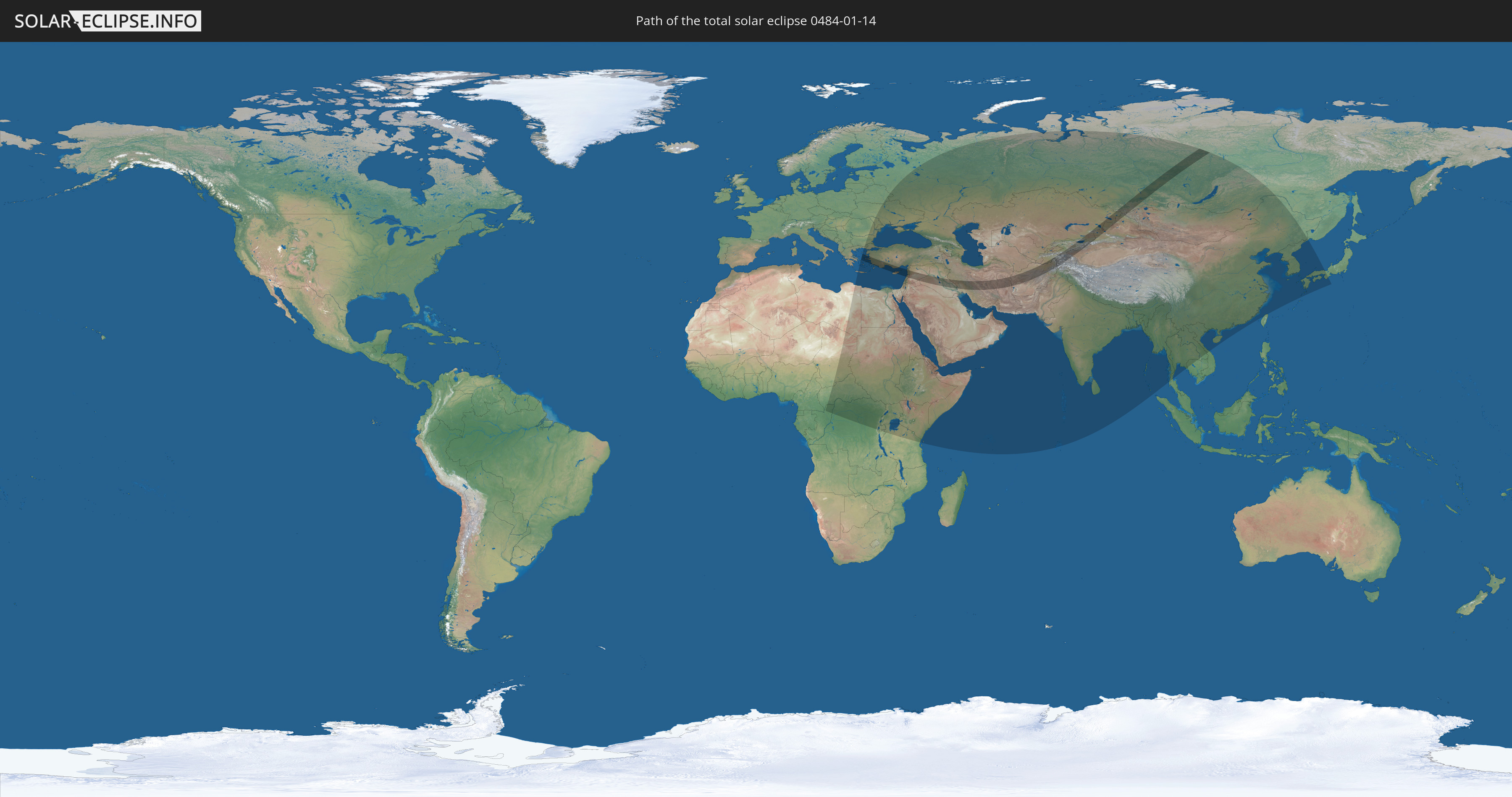
Die Sonnenfinsternis am 14.01.0484 kann man in 70 Ländern als partielle Sonnenfinsternis beobachten.
Der Finsternispfad verläuft durch 15 Länder. Nur in diesen Ländern ist sie als totale Sonnenfinsternis zu sehen.
In den folgenden Ländern ist die Sonnenfinsternis total zu sehen
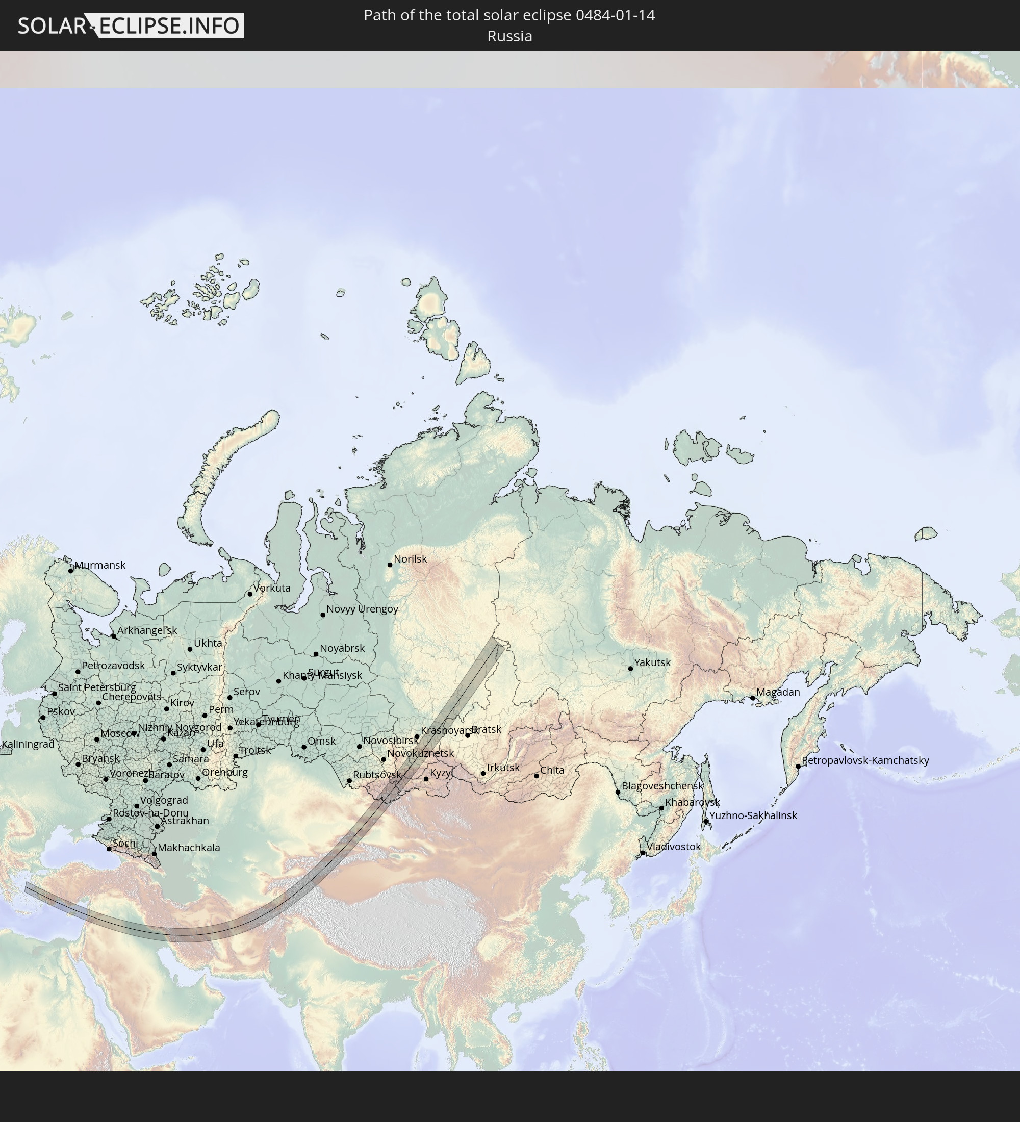 Russland
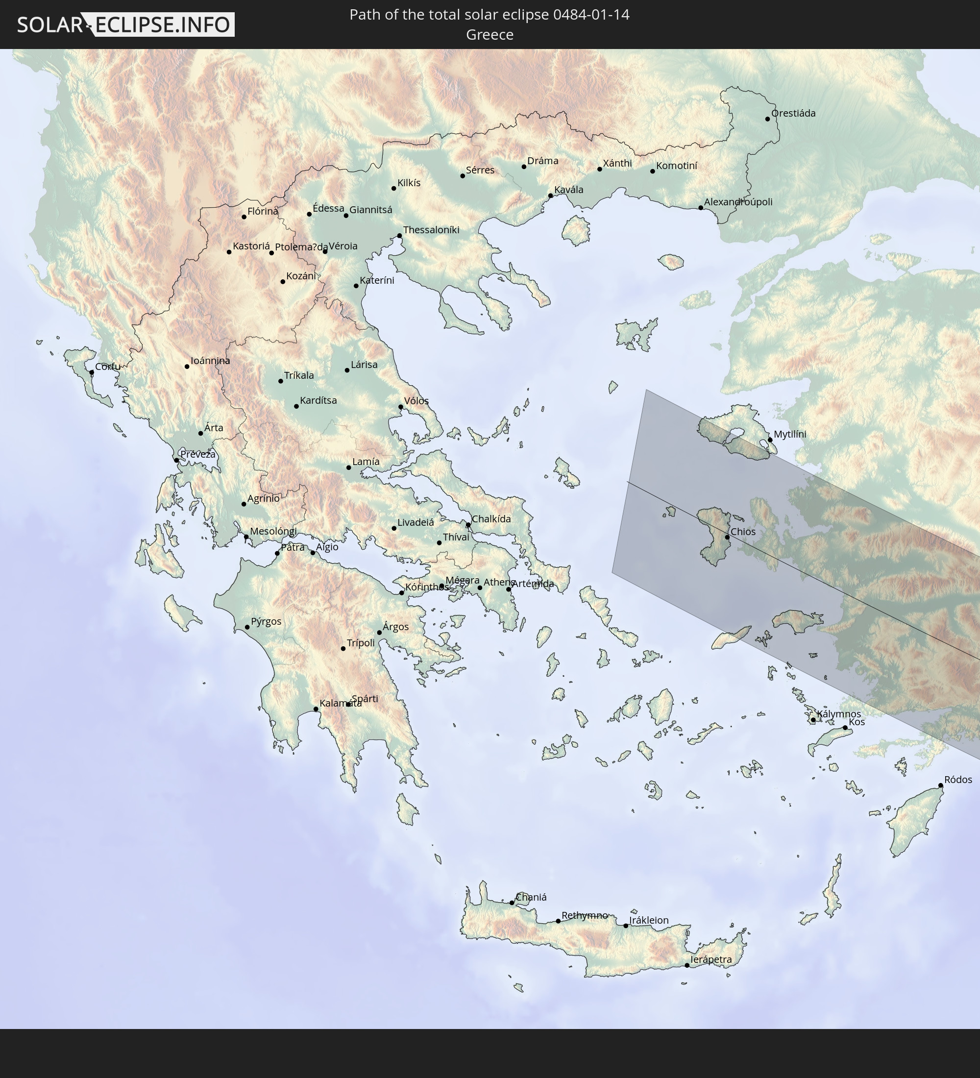 Griechenland
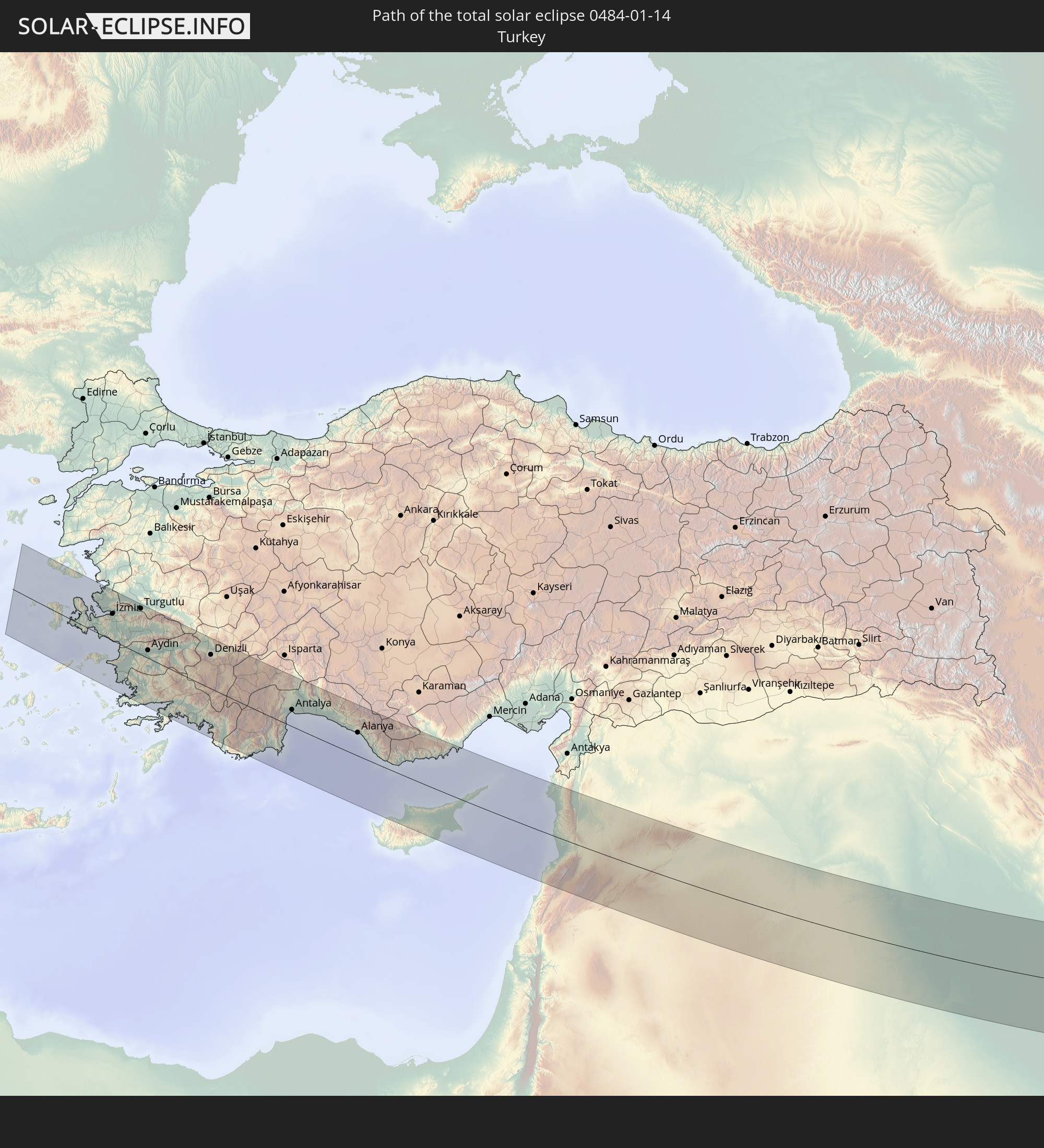 Türkei
 Republik Zypern
 Jordanien
 Libanon
 Syrien
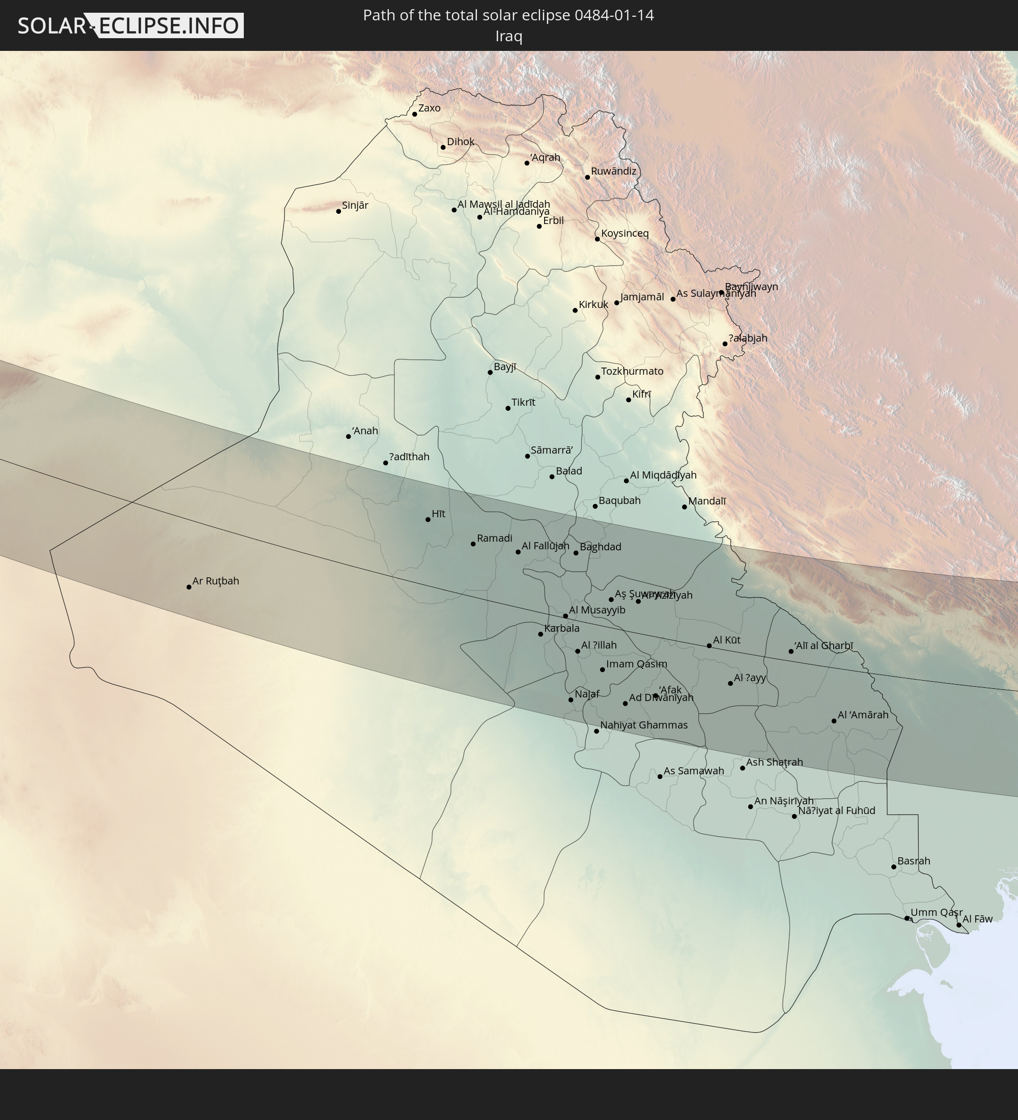 Irak
Irak
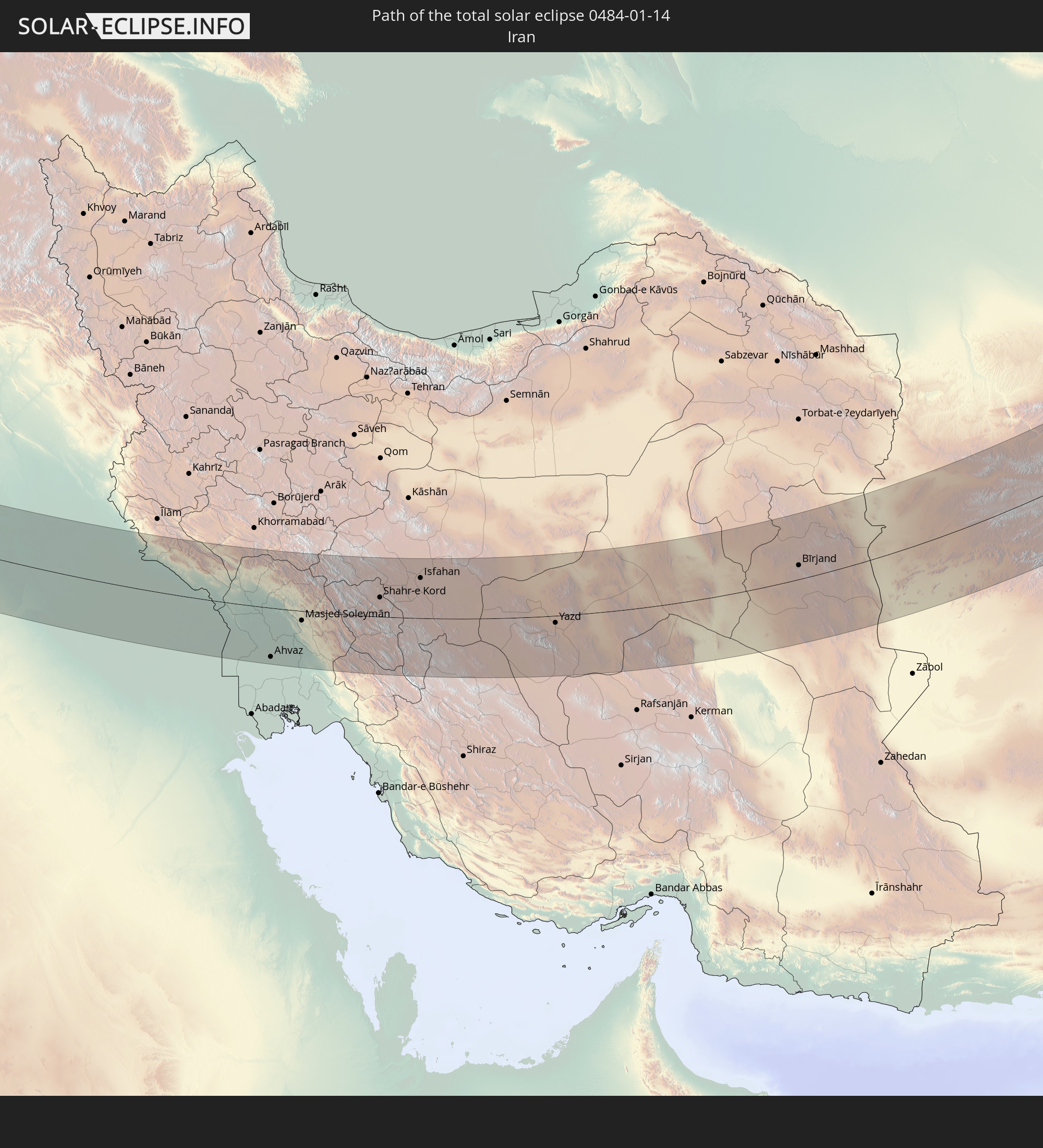 Iran
Iran
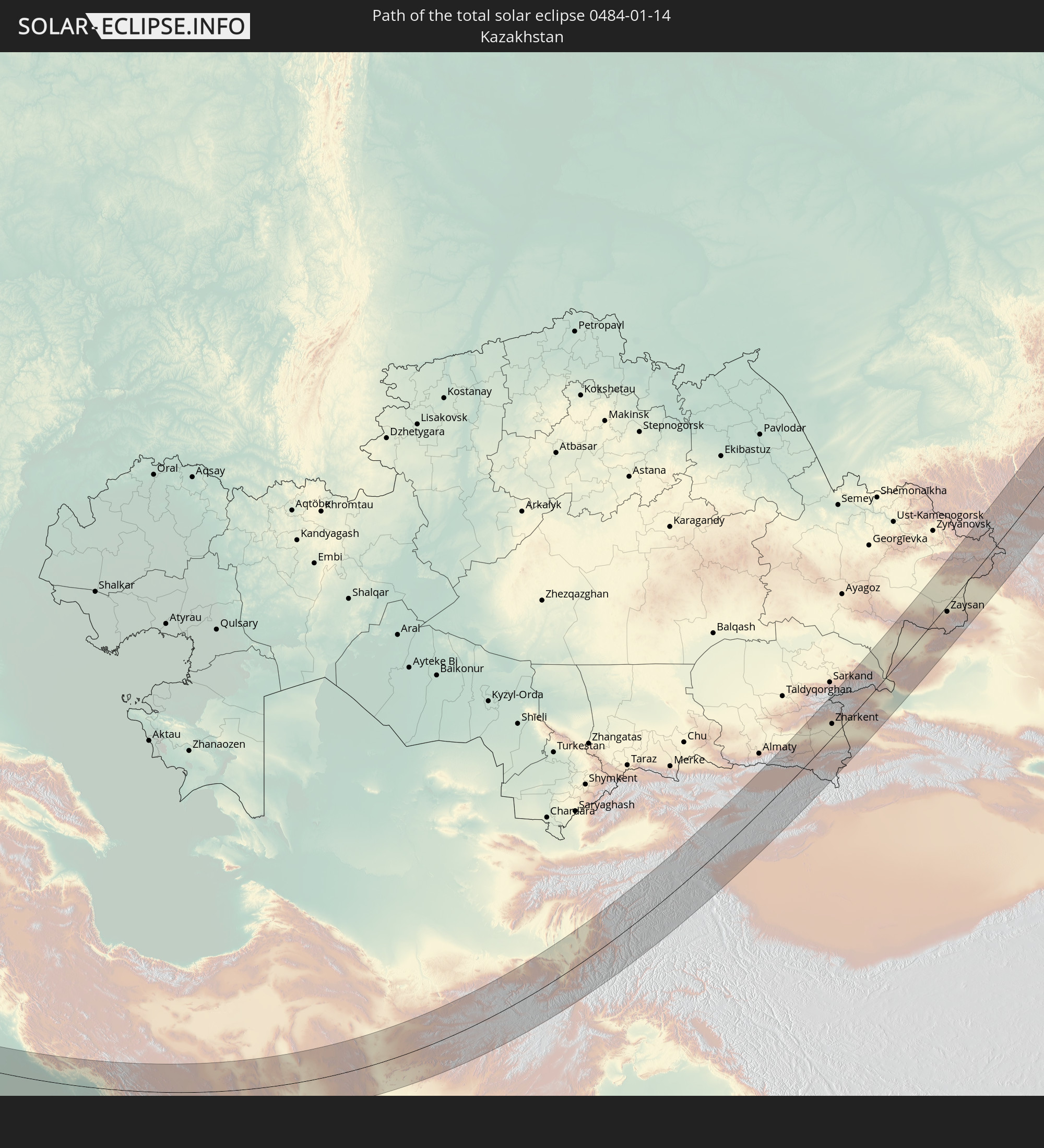 Kasachstan
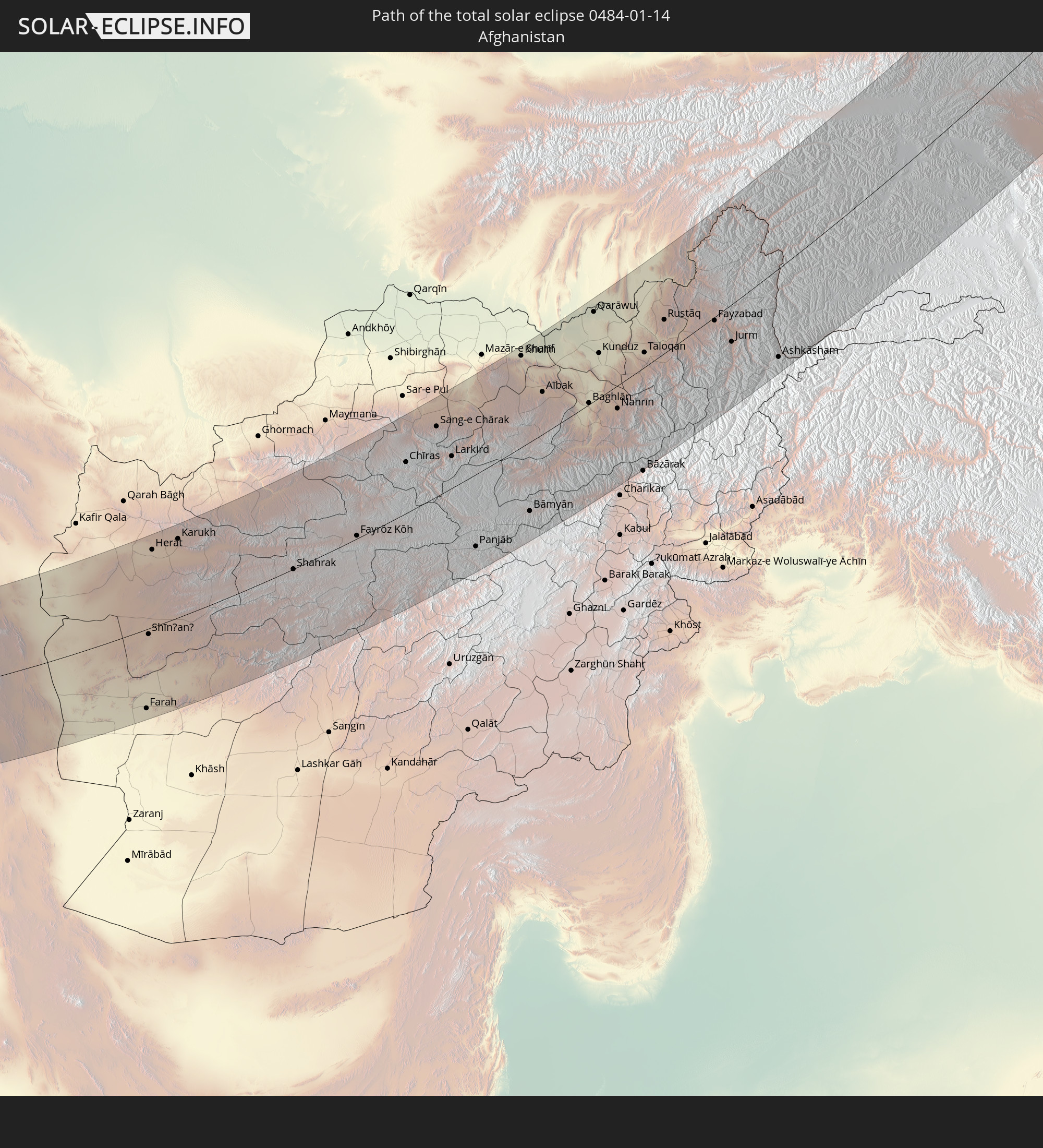 Afghanistan
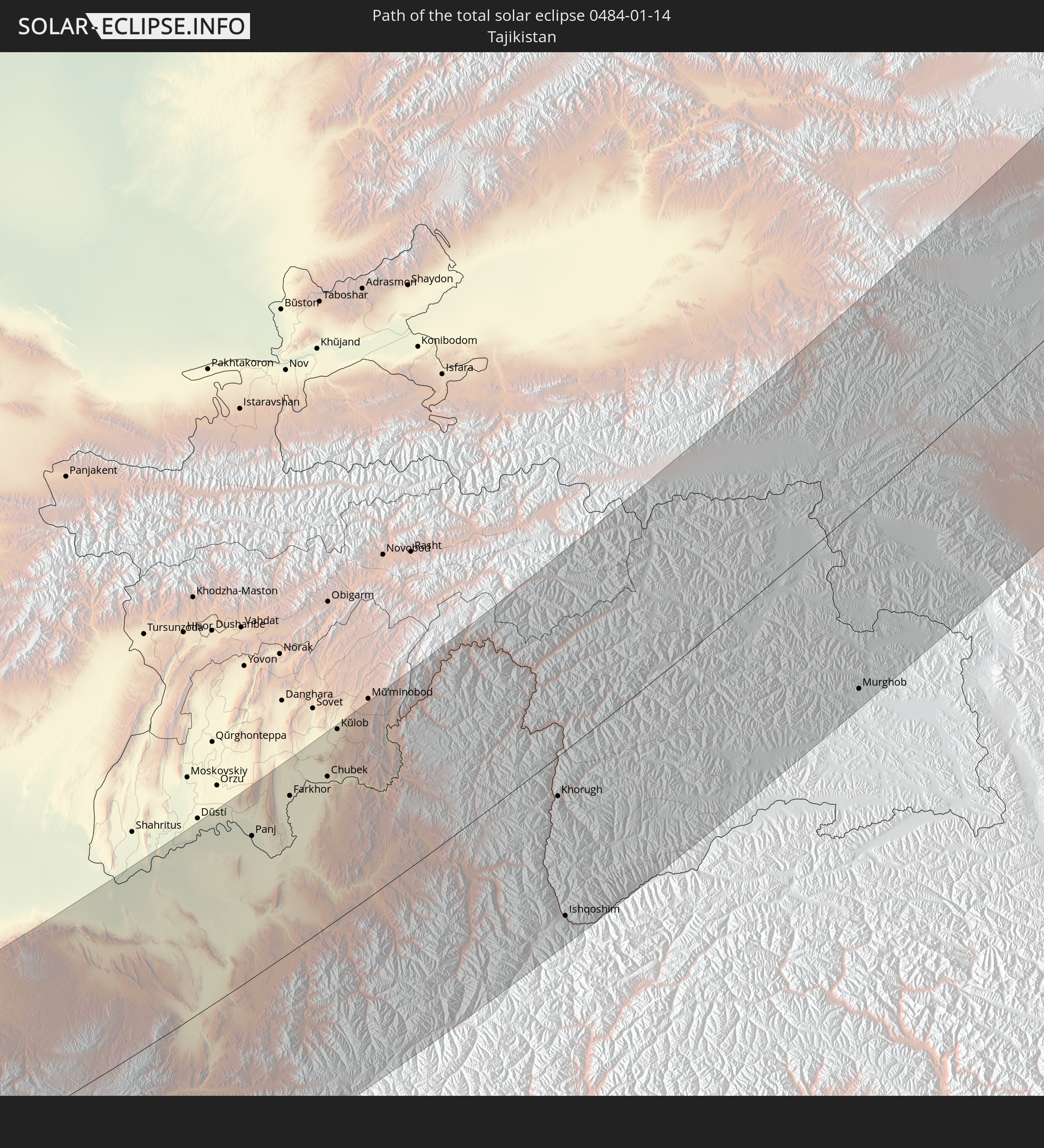 Tadschikistan
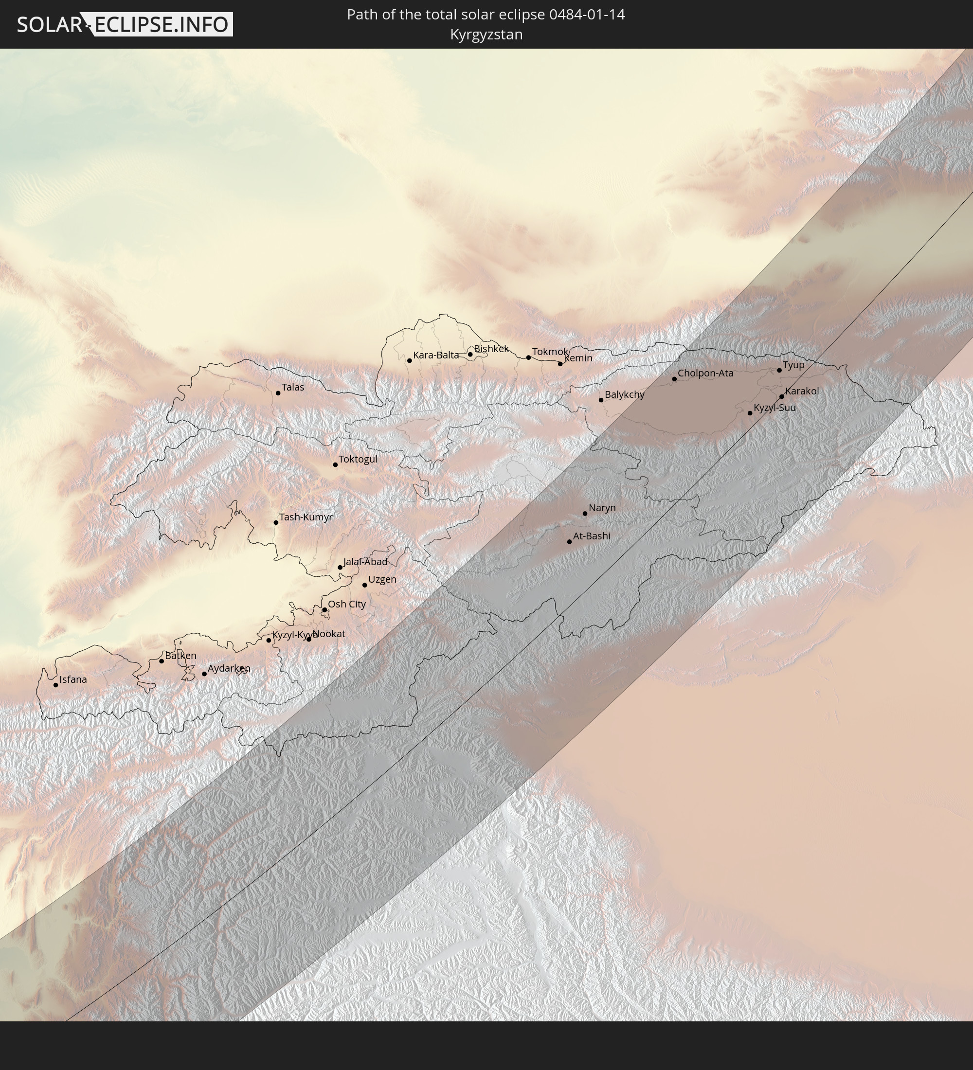 Kirgisistan
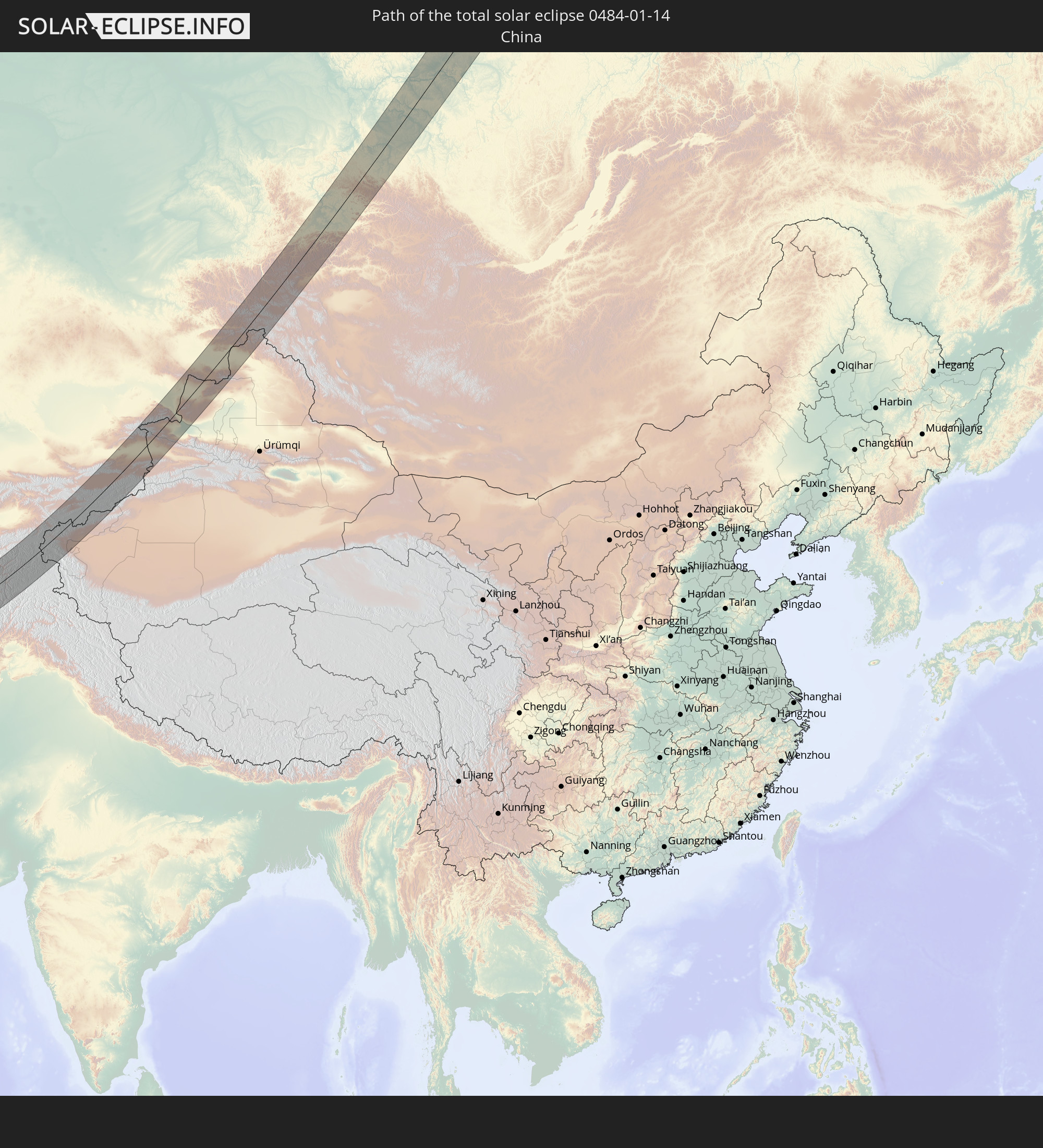 Volksrepublik China
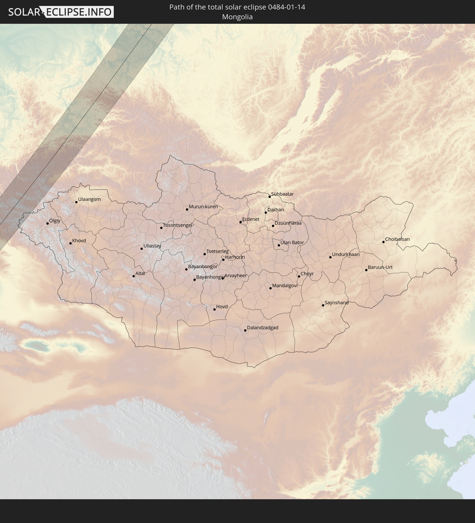 Mongolei
In den folgenden Ländern ist die Sonnenfinsternis partiell zu sehen
 Russland
 Libyen
 Republik Kongo
 Demokratische Republik Kongo
 Tschad
 Zentralafrikanische Republik
 Griechenland
 Rumänien
 Sudan
Sudan
 Ukraine
 Bulgarien
 Weißrussland
 Ägypten
 Türkei
 Moldawien
 Ruanda
 Burundi
 Tansania
 Uganda
 Republik Zypern
 Äthiopien
 Kenia
Kenia
 Staat Palästina
 Israel
 Saudi-Arabien
 Jordanien
 Libanon
 Syrien
 Eritrea
 Irak
Irak
 Georgien
 Somalia
 Dschibuti
 Jemen
Jemen
 Armenien
 Iran
Iran
 Aserbaidschan
 Seychellen
 Kasachstan
 Kuwait
 Bahrain
 Katar
Katar
 Vereinigte Arabische Emirate
 Oman
Oman
 Turkmenistan
 Usbekistan
 Afghanistan
 Pakistan
 Tadschikistan
 Indien
 Kirgisistan
 Britisches Territorium im Indischen Ozean
 Malediven
 Volksrepublik China
 Sri Lanka
 Nepal
Nepal
 Mongolei
 Bangladesch
 Bhutan
 Myanmar
 Thailand
 Laos
Laos
 Vietnam
 Kambodscha
 Macau
Macau
 Hongkong
 Taiwan
 Japan
Japan
 Nordkorea
 Südkorea
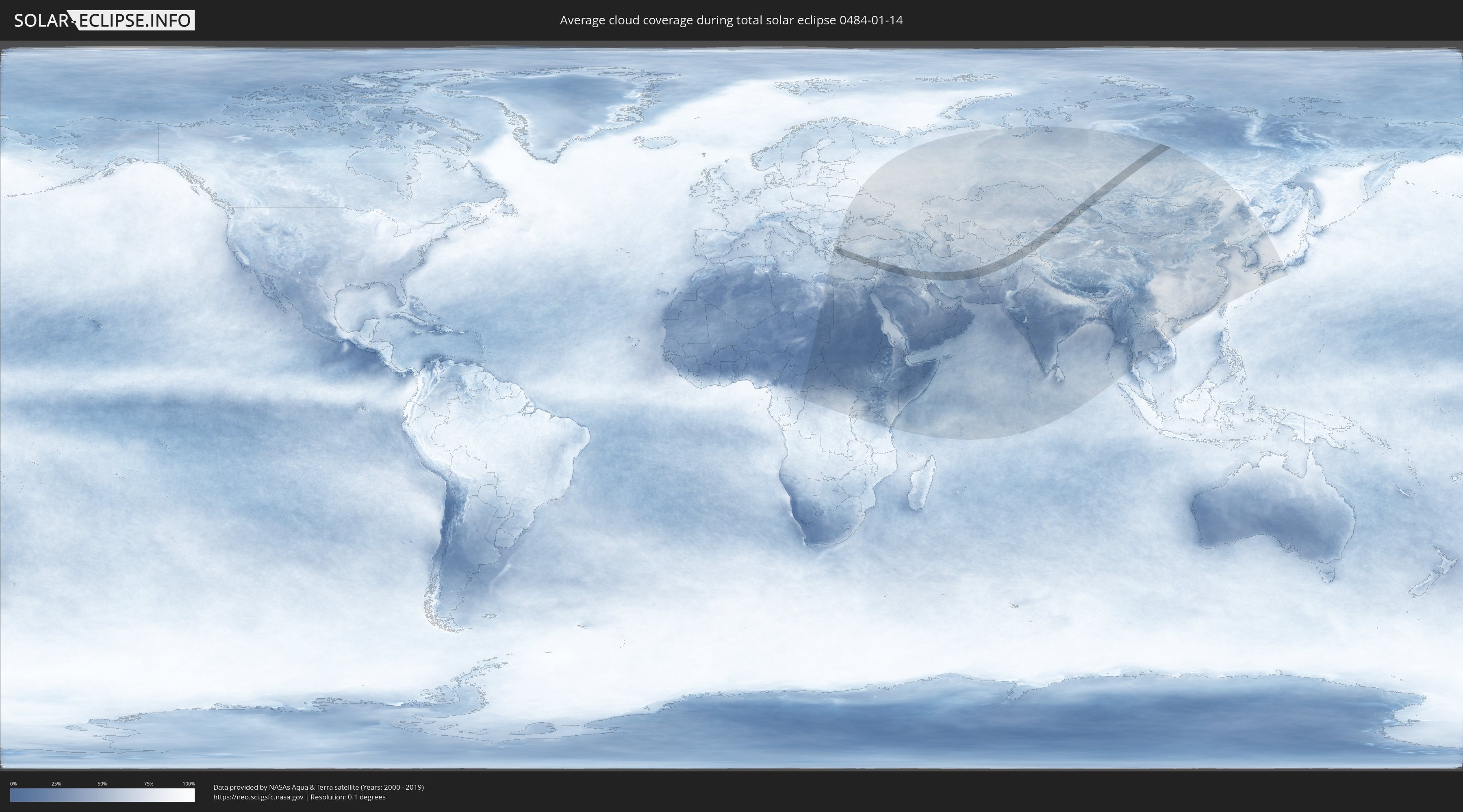
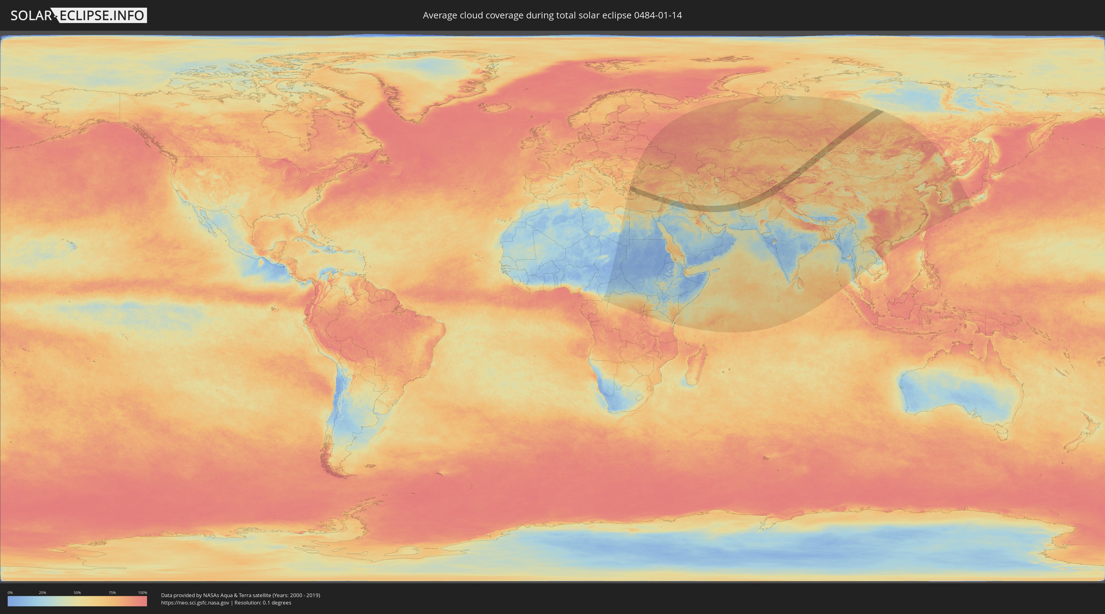
Wie wird das Wetter während der totalen Sonnenfinsternis am 14.01.0484?
Wo ist der beste Ort, um die totale Sonnenfinsternis vom 14.01.0484 zu beobachten?
Die folgenden Karten zeigen die durchschnittliche Bewölkung für den Tag, an dem die totale Sonnenfinsternis
stattfindet. Mit Hilfe der Karten lässt sich der Ort entlang des Finsternispfades eingrenzen,
der die besten Aussichen auf einen klaren wolkenfreien Himmel bietet.
Trotzdem muss man immer lokale Gegenenheiten beachten und sollte sich genau über das Wetter an seinem
gewählten Beobachtungsort informieren.
Die Daten stammen von den beiden NASA-Satelliten
AQUA und TERRA
und wurden über einen Zeitraum von 19 Jahren (2000 - 2019) gemittelt.
Detaillierte Länderkarten
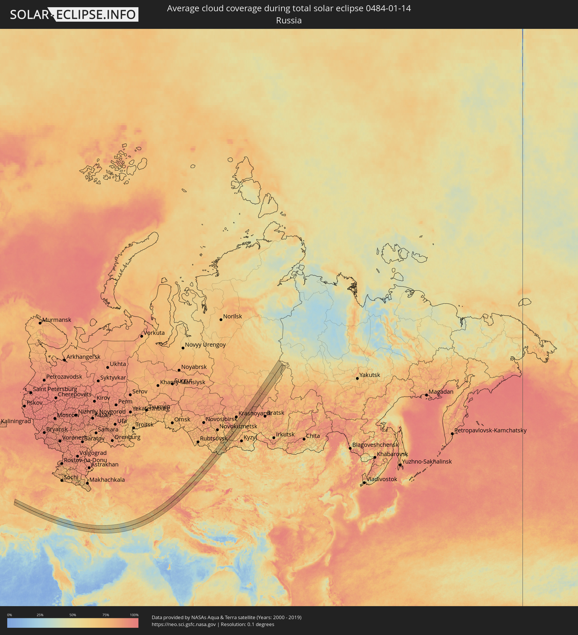 Russland
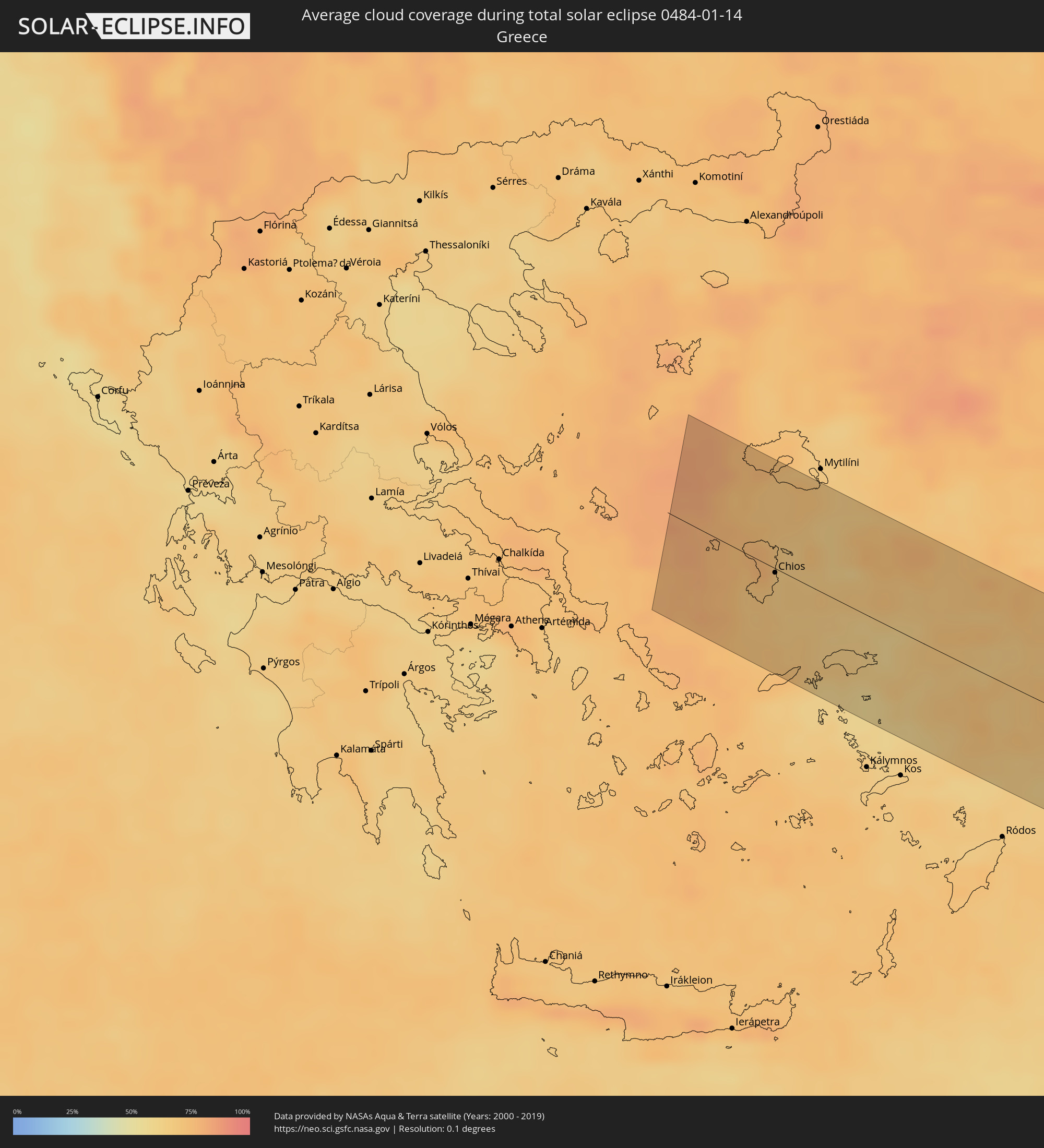 Griechenland
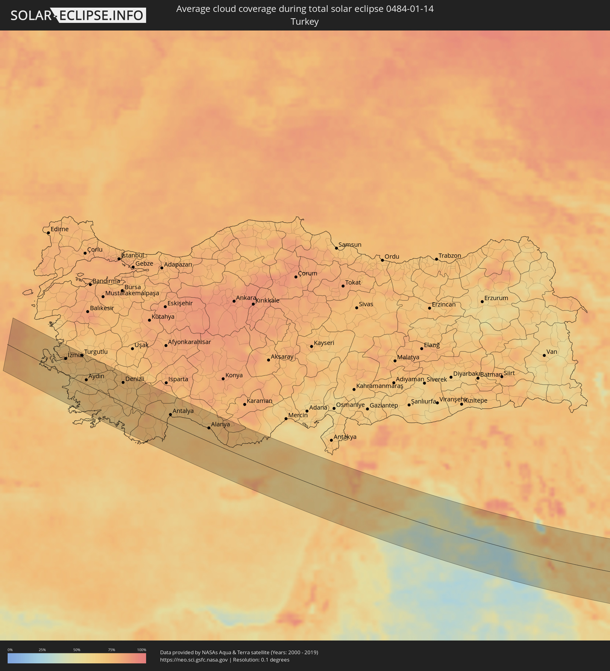 Türkei
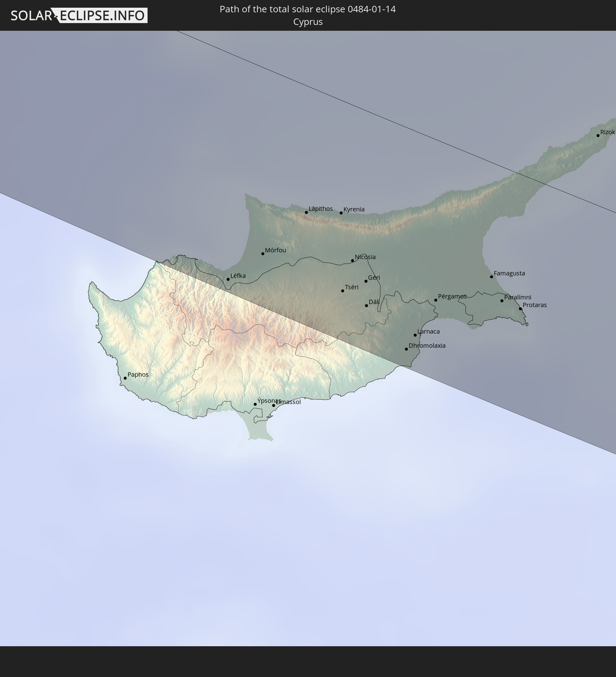
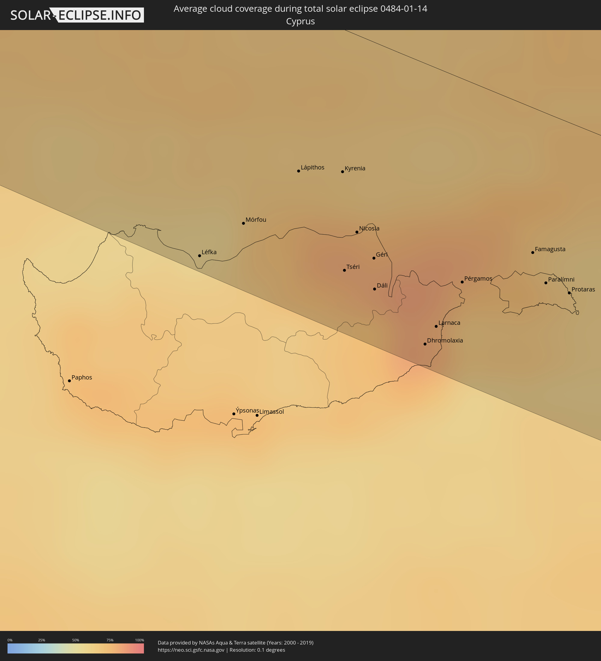 Republik Zypern
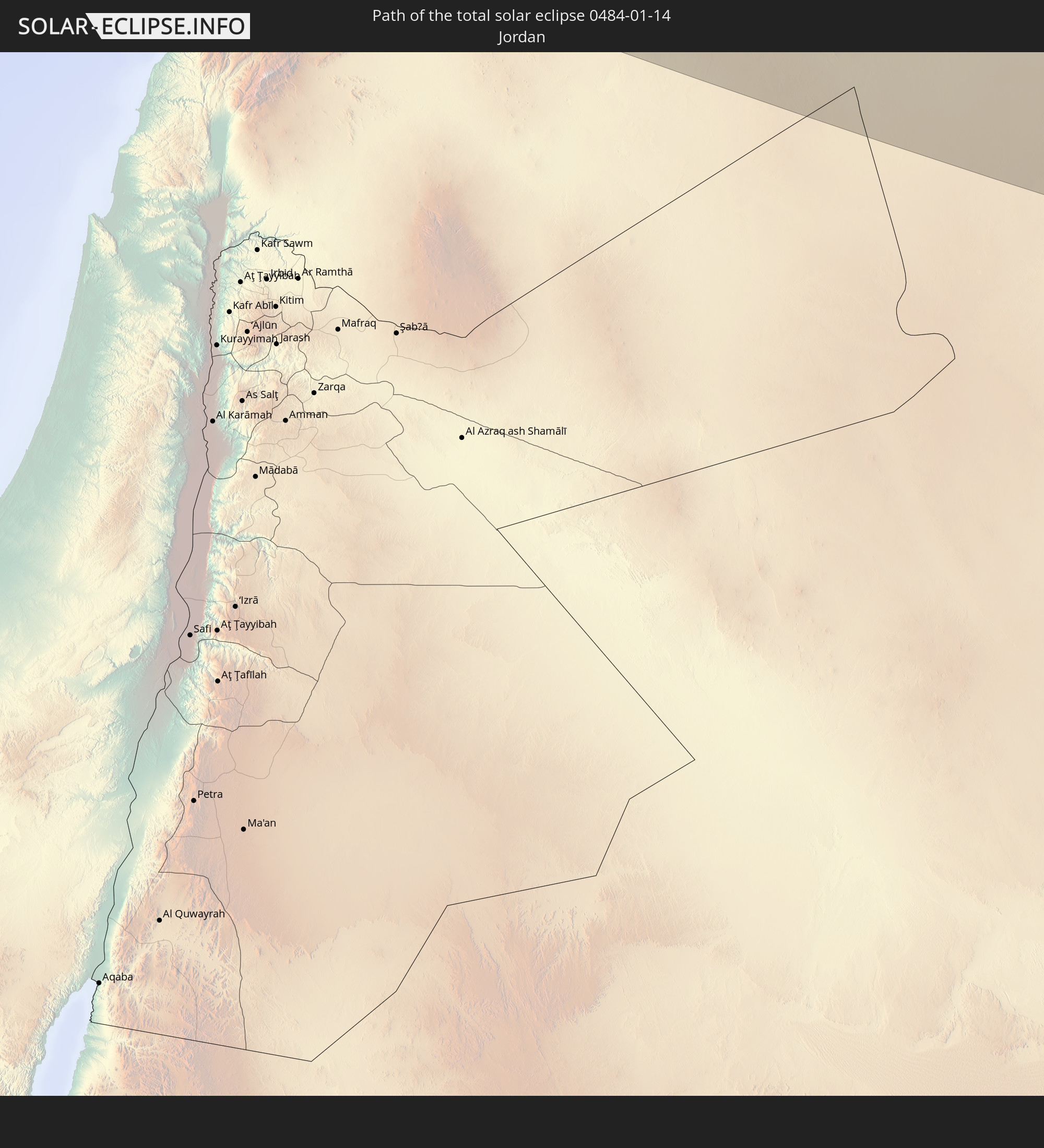
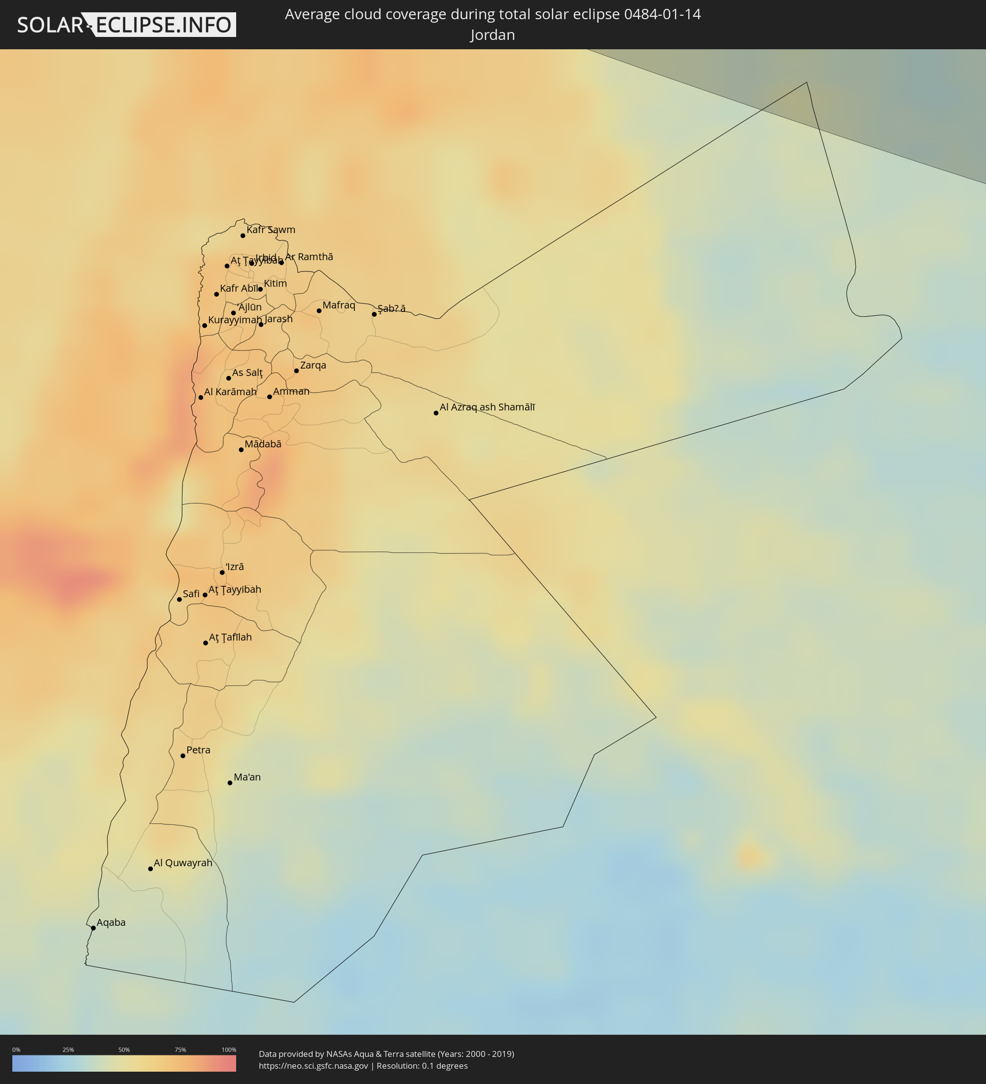 Jordanien
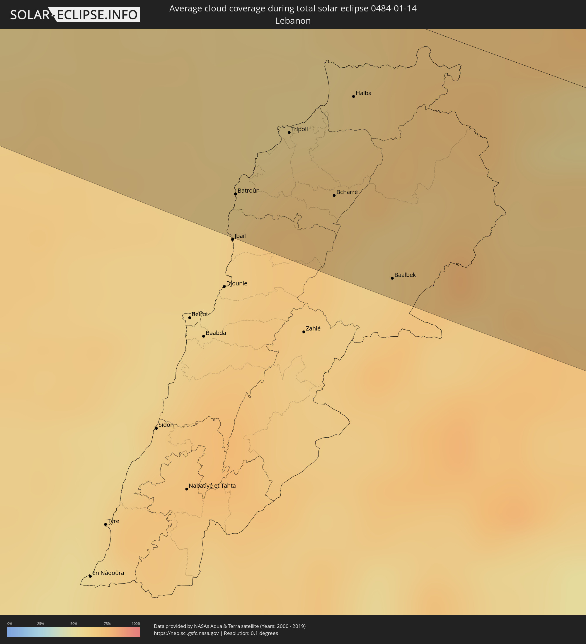 Libanon
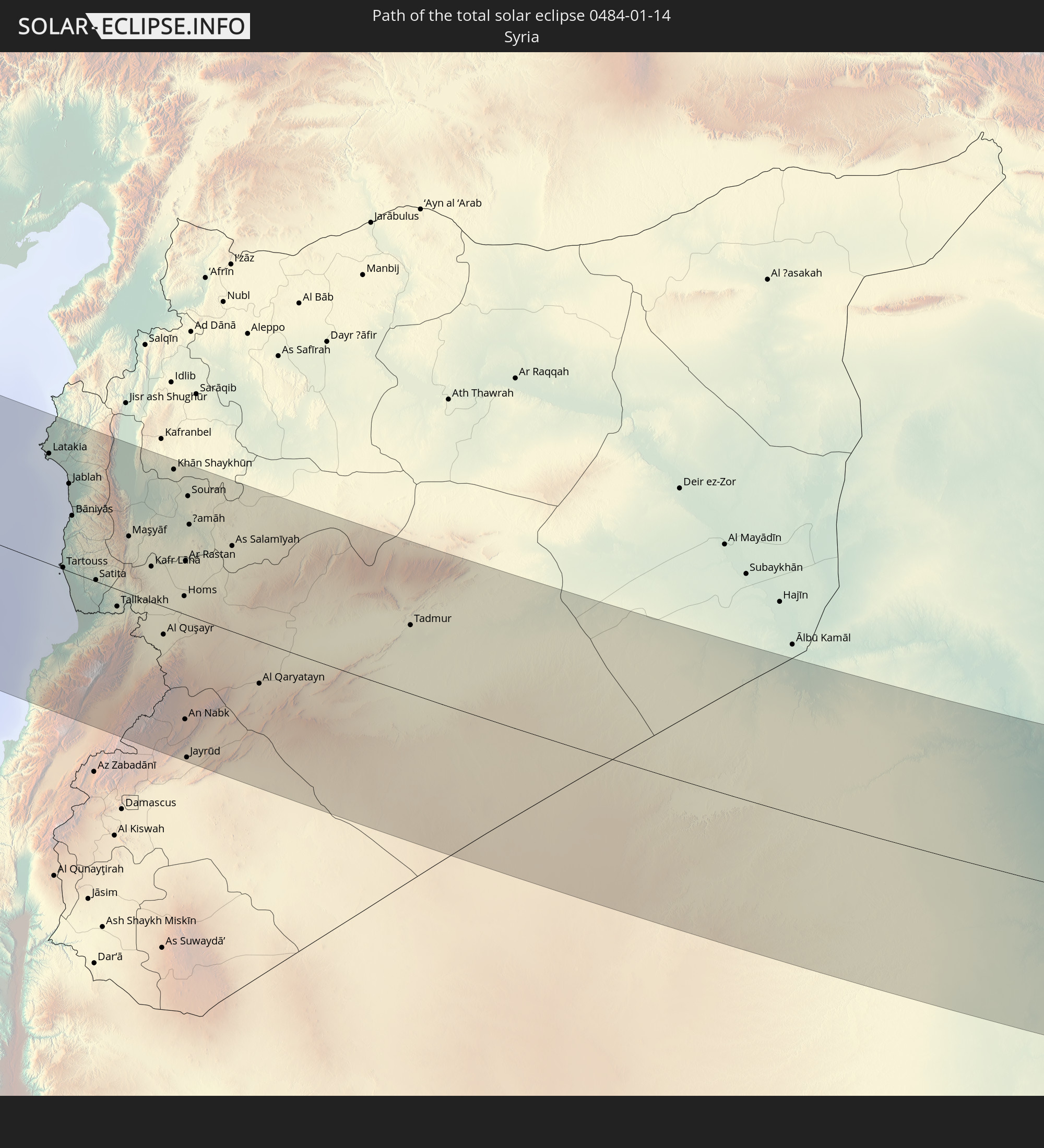
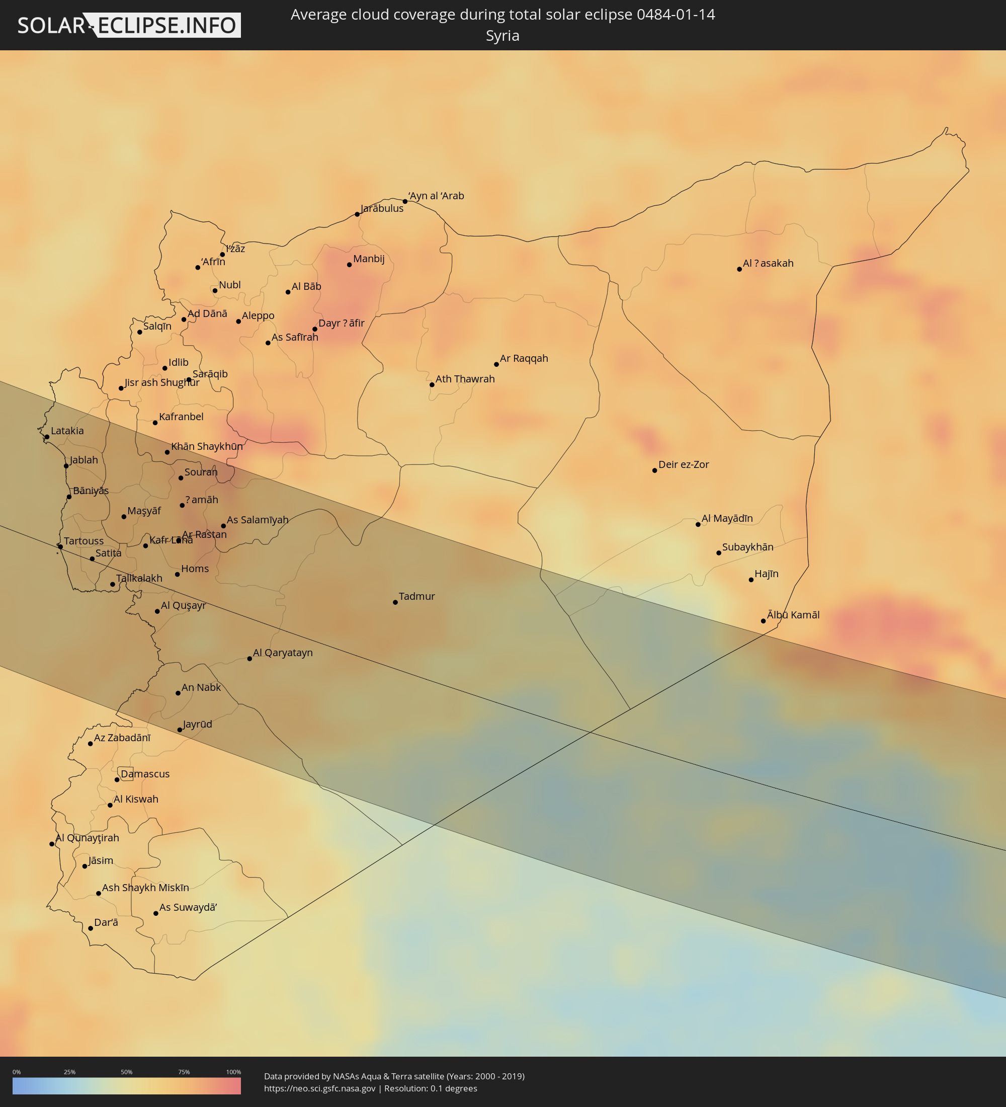 Syrien
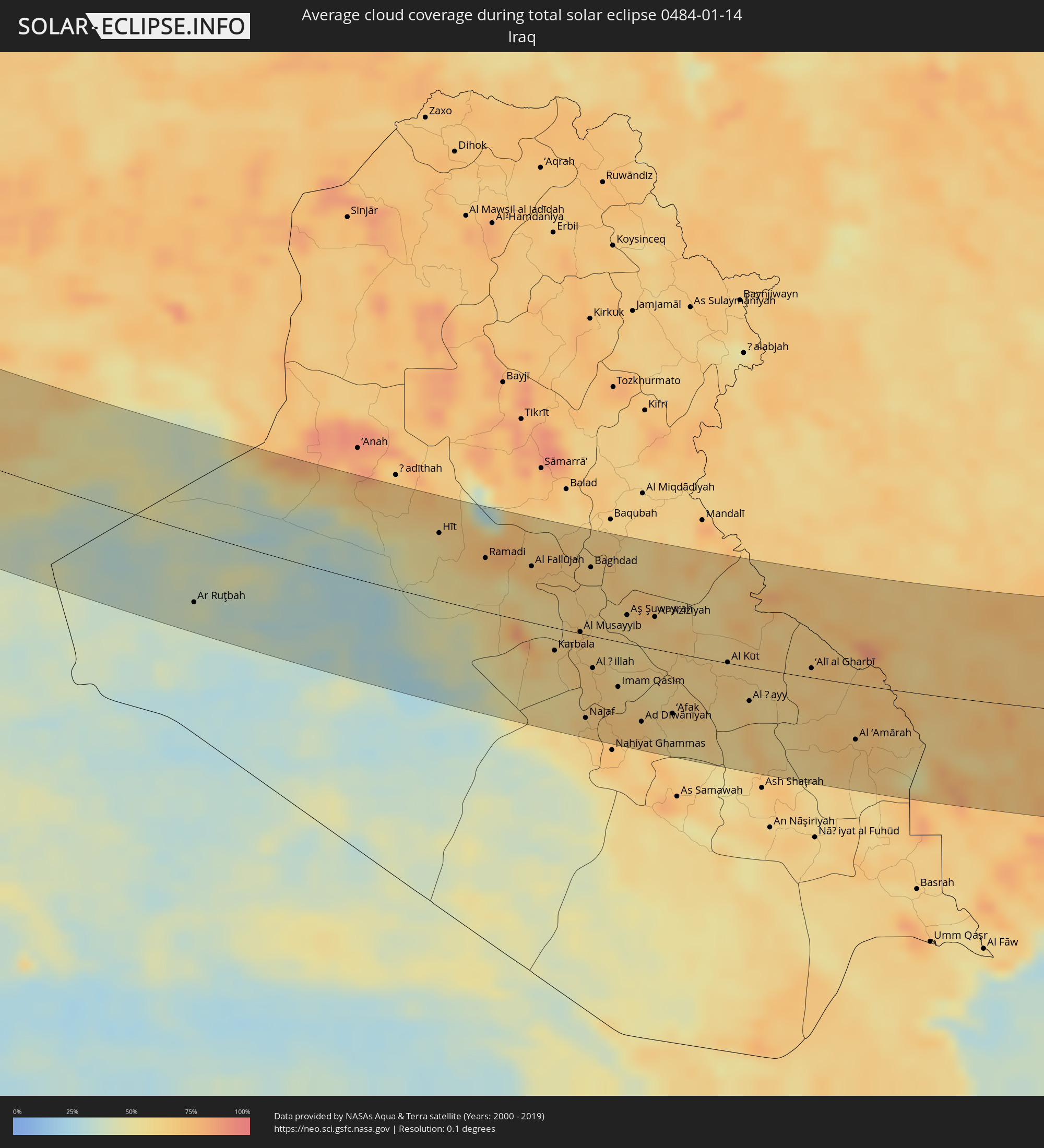 Irak
Irak
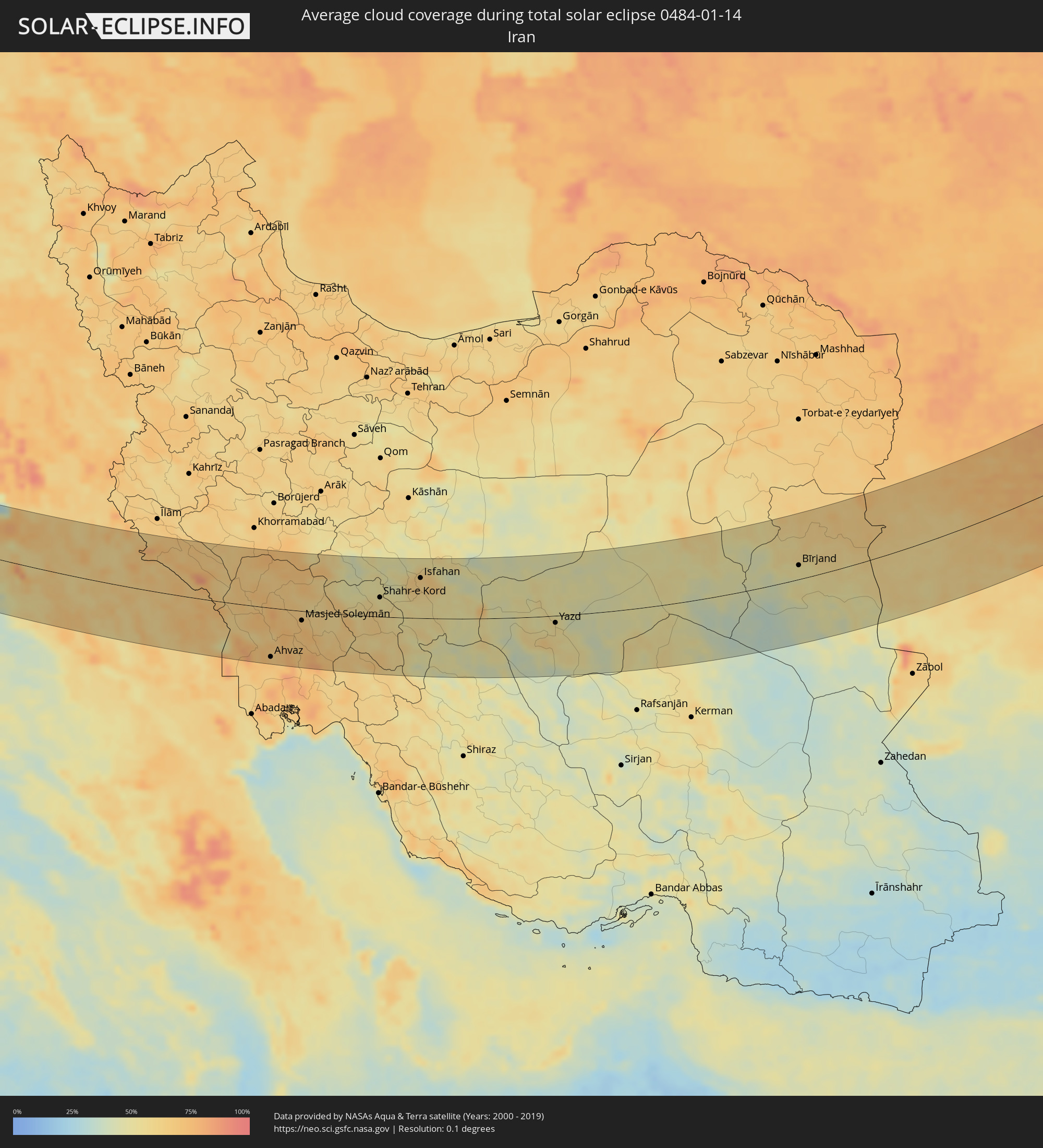 Iran
Iran
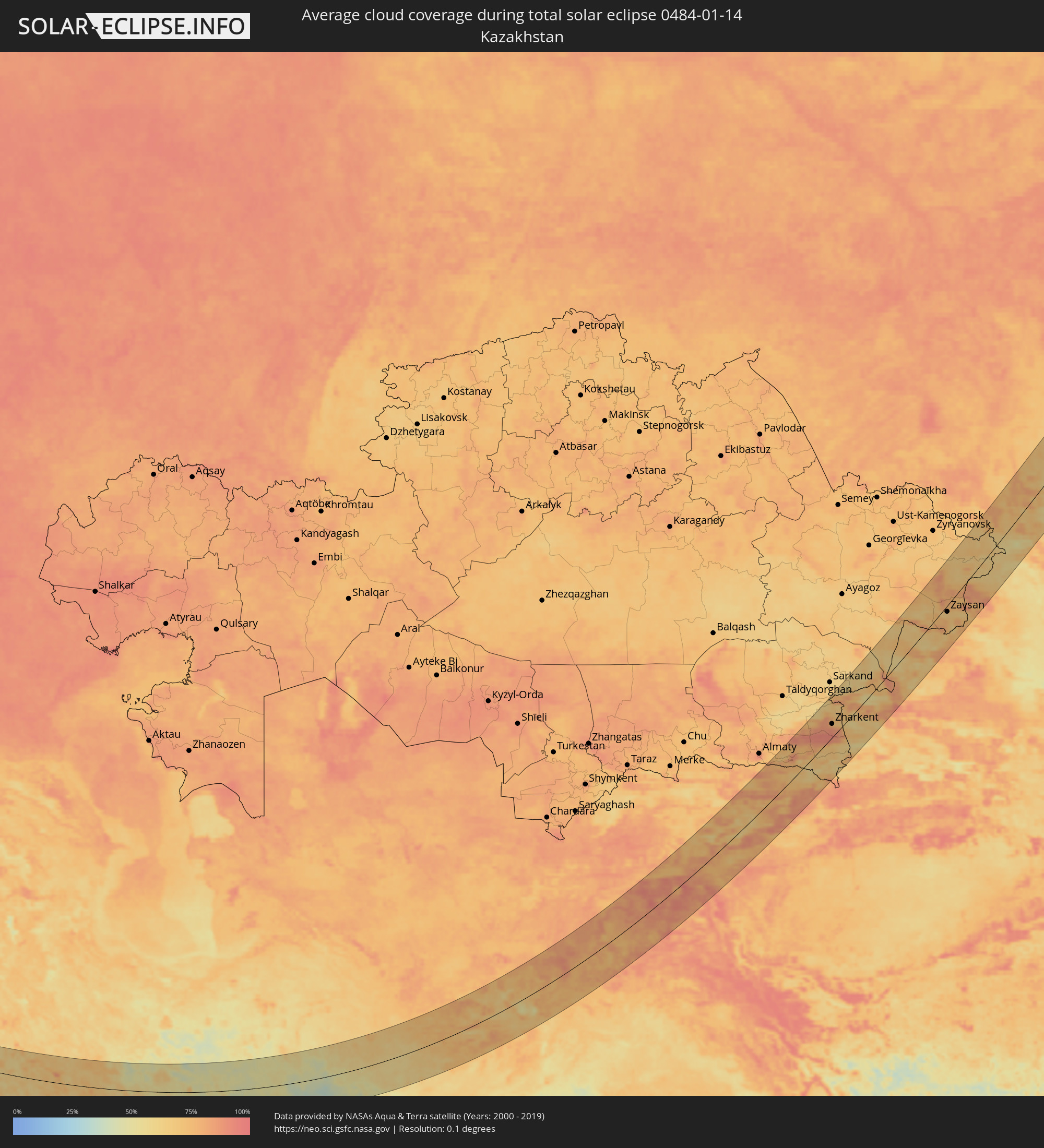 Kasachstan
 Afghanistan
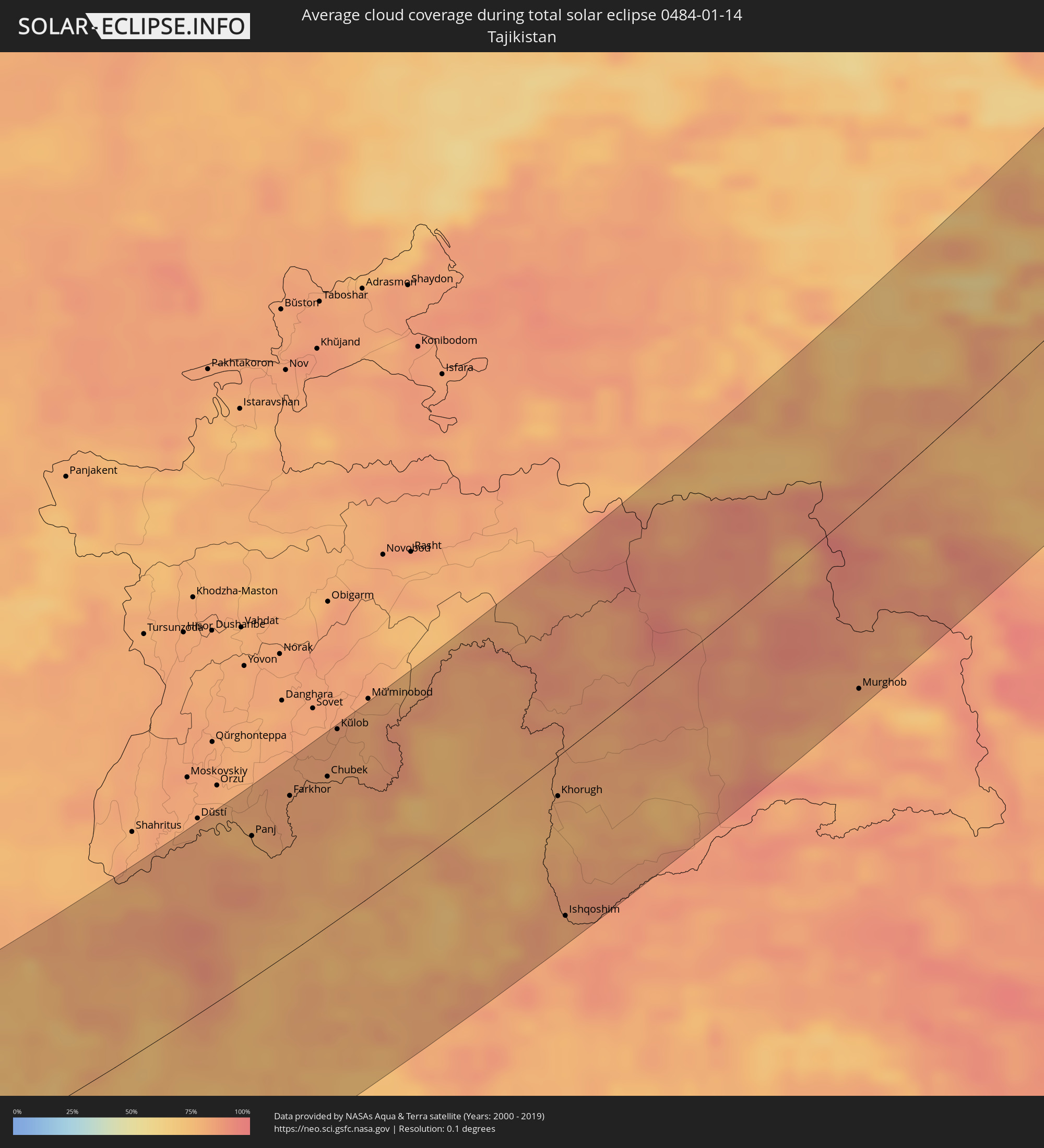 Tadschikistan
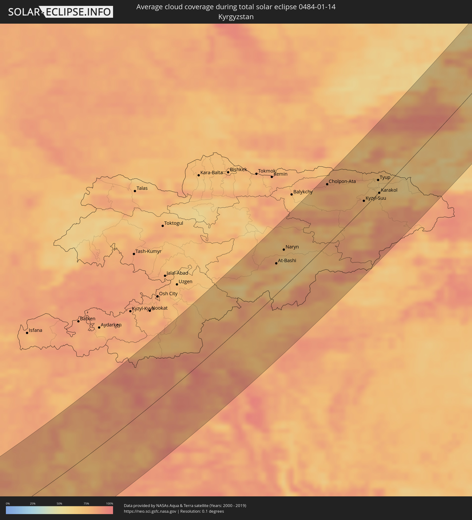 Kirgisistan
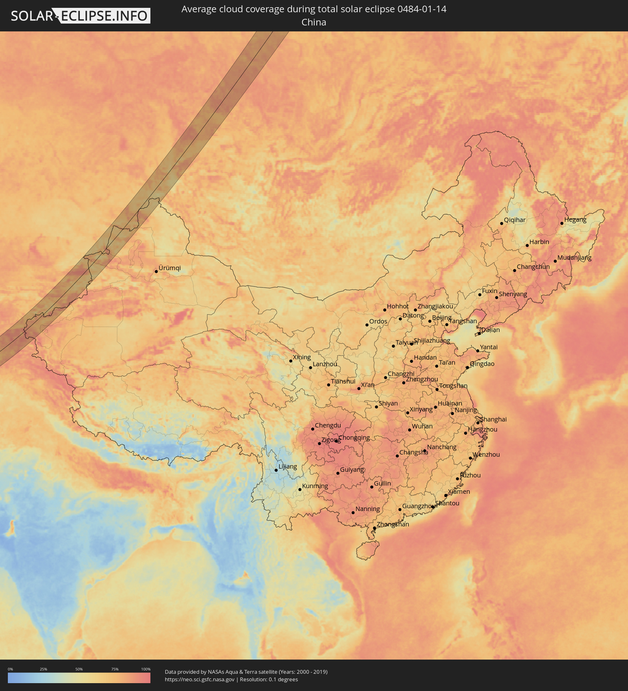 Volksrepublik China
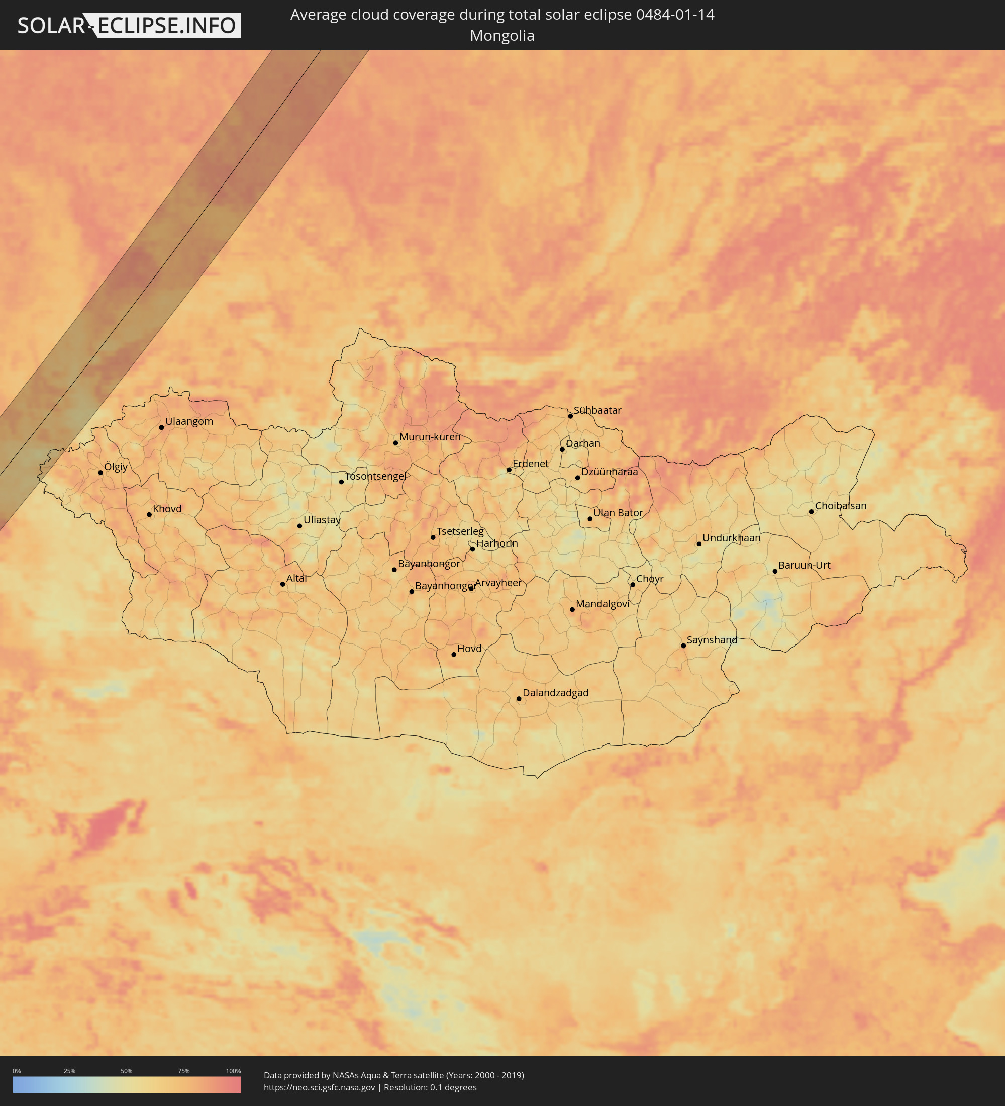 Mongolei
Orte im Finsternispfad
Die nachfolgene Tabelle zeigt Städte und Orte mit mehr als 5.000 Einwohnern, die sich im Finsternispfad befinden. Städte mit mehr als 100.000 Einwohnern sind dick gekennzeichnet. Mit einem Klick auf den Ort öffnet sich eine Detailkarte die die Lage des jeweiligen Ortes zusammen mit dem Verlauf der zentralen Finsternis präsentiert.
| Ort | Typ | Dauer der Verfinsterung | Ortszeit bei maximaler Verfinsterung | Entfernung zur Zentrallinie | Ø Bewölkung |
|
Vrontádos, North Aegean
|
total | - | 07:20:09 UTC+01:34 | 1 km | 73% |
|
Chios, North Aegean
|
total | - | 07:20:06 UTC+01:34 | 3 km | 73% |
|
Néon Karlovásion, North Aegean
|
total | - | 07:19:37 UTC+01:34 | 38 km | 68% |
|
Menemen, İzmir
|
total | - | 07:43:07 UTC+01:56 | 58 km | 74% |
|
İzmir, İzmir
|
total | - | 07:42:53 UTC+01:56 | 41 km | 70% |
|
Kuşadası, Aydın
|
total | - | 07:42:09 UTC+01:56 | 10 km | 63% |
|
Söke, Aydın
|
total | - | 07:42:06 UTC+01:56 | 14 km | 66% |
|
Manisa, Manisa
|
total | - | 07:43:22 UTC+01:56 | 72 km | 76% |
|
Turgutlu, Manisa
|
total | - | 07:43:23 UTC+01:56 | 72 km | 71% |
|
Aydın, Aydın
|
total | - | 07:42:32 UTC+01:56 | 12 km | 67% |
|
Ödemiş, İzmir
|
total | - | 07:43:11 UTC+01:56 | 55 km | 67% |
|
Nazilli, Aydın
|
total | - | 07:42:59 UTC+01:56 | 38 km | 66% |
|
Denizli, Denizli
|
total | - | 07:43:20 UTC+01:56 | 53 km | 72% |
|
Fethiye, Muğla
|
total | - | 07:41:43 UTC+01:56 | 59 km | 65% |
|
Antalya, Antalya
|
total | - | 07:43:20 UTC+01:56 | 27 km | 69% |
|
Belek, Antalya
|
total | - | 07:43:33 UTC+01:56 | 36 km | 68% |
|
Manavgat, Antalya
|
total | - | 07:43:46 UTC+01:56 | 42 km | 69% |
|
Alanya, Antalya
|
total | - | 07:43:53 UTC+01:56 | 38 km | 65% |
|
Anamur, Mersin
|
total | - | 07:43:57 UTC+01:56 | 20 km | 69% |
|
Léfka, Nicosia
|
total | - | 07:59:08 UTC+02:13 | 78 km | 63% |
|
Mórfou, Nicosia
|
total | - | 07:59:23 UTC+02:13 | 65 km | 69% |
|
Lápithos, Keryneia
|
total | - | 07:59:44 UTC+02:13 | 44 km | 77% |
|
Kyrenia, Keryneia
|
total | - | 07:59:52 UTC+02:13 | 39 km | 77% |
|
Tséri, Nicosia
|
total | - | 07:59:30 UTC+02:13 | 66 km | 77% |
|
Nicosia, Nicosia
|
total | - | 07:59:41 UTC+02:13 | 54 km | 79% |
|
Géri, Nicosia
|
total | - | 07:59:38 UTC+02:13 | 59 km | 80% |
|
Dáli, Nicosia
|
total | - | 07:59:31 UTC+02:13 | 68 km | 73% |
|
Dhromolaxia, Larnaka
|
total | - | 07:59:28 UTC+02:13 | 77 km | 69% |
|
Aradíppou, Larnaka
|
total | - | 07:59:35 UTC+02:13 | 69 km | 79% |
|
Larnaca, Larnaka
|
total | - | 07:59:34 UTC+02:13 | 71 km | 69% |
|
Livádia, Larnaka
|
total | - | 07:59:37 UTC+02:13 | 68 km | 79% |
|
Pérgamos, Larnaka
|
total | - | 07:59:49 UTC+02:13 | 56 km | 68% |
|
Famagusta, Ammochostos
|
total | - | 08:00:08 UTC+02:13 | 40 km | 74% |
|
Paralímni, Ammochostos
|
total | - | 08:00:04 UTC+02:13 | 47 km | 65% |
|
Protaras, Ammochostos
|
total | - | 08:00:06 UTC+02:13 | 47 km | 62% |
|
Batroûn, Liban-Nord
|
total | - | 07:47:08 UTC+02:00 | 73 km | 61% |
|
Latakia, Latakia
|
total | - | 08:14:17 UTC+02:25 | 65 km | 60% |
|
Tripoli, Liban-Nord
|
total | - | 07:47:35 UTC+02:00 | 47 km | 62% |
|
Tartouss, Tartus
|
total | - | 08:13:28 UTC+02:25 | 1 km | 62% |
|
Jablah, Latakia
|
total | - | 08:14:10 UTC+02:25 | 51 km | 60% |
|
Bāniyās, Tartus
|
total | - | 08:13:56 UTC+02:25 | 33 km | 61% |
|
Bcharré, Liban-Nord
|
total | - | 07:47:30 UTC+02:00 | 62 km | 67% |
|
Halba, Aakkâr
|
total | - | 07:47:58 UTC+02:00 | 29 km | 64% |
|
Baalbek, Baalbek-Hermel
|
total | - | 07:47:22 UTC+02:00 | 81 km | 64% |
|
Maşyāf, Hama
|
total | - | 08:14:11 UTC+02:25 | 34 km | 74% |
|
Al Quşayr, Homs
|
total | - | 08:13:39 UTC+02:25 | 17 km | 71% |
|
Khān Shaykhūn, Idlib
|
total | - | 08:15:03 UTC+02:25 | 83 km | 75% |
|
Homs, Homs
|
total | - | 08:14:06 UTC+02:25 | 11 km | 69% |
|
An Nabk, Rif-dimashq
|
total | - | 08:13:08 UTC+02:25 | 63 km | 71% |
|
Ar Rastan, Homs
|
total | - | 08:14:24 UTC+02:25 | 32 km | 69% |
|
Jayrūd, Rif-dimashq
|
total | - | 08:12:50 UTC+02:25 | 85 km | 70% |
|
Souran, Hama
|
total | - | 08:14:56 UTC+02:25 | 70 km | 74% |
|
Ḩamāh, Hama
|
total | - | 08:14:43 UTC+02:25 | 54 km | 77% |
|
As Salamīyah, Hama
|
total | - | 08:14:52 UTC+02:25 | 51 km | 73% |
|
Al Qaryatayn, Homs
|
total | - | 08:13:58 UTC+02:25 | 25 km | 62% |
|
Tadmur, Homs
|
total | - | 08:15:36 UTC+02:25 | 41 km | 69% |
|
Ramadi, Anbar
|
total | - | 08:52:42 UTC+02:57 | 50 km | 65% |
|
Al Fallūjah, Anbar
|
total | - | 08:53:15 UTC+02:57 | 53 km | 69% |
|
Karbala, Karbalāʼ
|
total | - | 08:52:35 UTC+02:57 | 22 km | 58% |
|
Abū Ghurayb, Mayorality of Baghdad
|
total | - | 08:53:45 UTC+02:57 | 57 km | 68% |
|
Al Hindīyah, Karbalāʼ
|
total | - | 08:52:47 UTC+02:57 | 25 km | 66% |
|
Al Musayyib, Bābil
|
total | - | 08:53:11 UTC+02:57 | 1 km | 66% |
|
Najaf, An Najaf
|
total | - | 08:52:14 UTC+02:57 | 79 km | 65% |
|
Baghdad, Mayorality of Baghdad
|
total | - | 08:54:07 UTC+02:57 | 65 km | 62% |
|
Al Ḩillah, Bābil
|
total | - | 08:52:56 UTC+02:57 | 30 km | 67% |
|
Kufa, An Najaf
|
total | - | 08:52:25 UTC+02:57 | 75 km | 66% |
|
Ash Shāmīyah, Al Qādisīyah
|
total | - | 08:52:31 UTC+02:57 | 81 km | 70% |
|
Ad Dīwānīyah, Al Qādisīyah
|
total | - | 08:53:02 UTC+02:57 | 72 km | 69% |
|
Al ‘Azīzīyah, Wāsiţ
|
total | - | 08:54:29 UTC+02:57 | 31 km | 64% |
|
Al Kūt, Wāsiţ
|
total | - | 08:55:03 UTC+02:57 | 1 km | 69% |
|
Al Ḩayy, Wāsiţ
|
total | - | 08:54:56 UTC+02:57 | 33 km | 65% |
|
Al ‘Amārah, Maysan
|
total | - | 08:56:10 UTC+02:57 | 53 km | 68% |
|
Dehlorān, Īlām
|
total | - | 09:25:39 UTC+03:25 | 43 km | 86% |
|
Sūsangerd, Khuzestan
|
total | - | 09:25:36 UTC+03:25 | 70 km | 76% |
|
Shūsh, Khuzestan
|
total | - | 09:26:31 UTC+03:25 | 0 km | 67% |
|
Ahvaz, Khuzestan
|
total | - | 09:26:04 UTC+03:25 | 92 km | 70% |
|
Shūshtar, Khuzestan
|
total | - | 09:27:19 UTC+03:25 | 9 km | 70% |
|
Masjed Soleymān, Khuzestan
|
total | - | 09:27:55 UTC+03:25 | 18 km | 73% |
|
Shahr-e Kord, Chahār Maḩāll va Bakhtīārī
|
total | - | 09:31:05 UTC+03:25 | 36 km | 52% |
|
Borūjen, Chahār Maḩāll va Bakhtīārī
|
total | - | 09:31:21 UTC+03:25 | 2 km | 52% |
|
Najafābād, Isfahan
|
total | - | 09:32:22 UTC+03:25 | 72 km | 63% |
|
Falāvarjān, Isfahan
|
total | - | 09:32:31 UTC+03:25 | 64 km | 64% |
|
Isfahan, Isfahan
|
total | - | 09:32:56 UTC+03:25 | 75 km | 65% |
|
Shāhreẕā, Isfahan
|
total | - | 09:32:29 UTC+03:25 | 7 km | 56% |
|
Ābādeh, Fars
|
total | - | 09:32:44 UTC+03:25 | 90 km | 45% |
|
Ardakān, Yazd
|
total | - | 09:36:44 UTC+03:25 | 34 km | 55% |
|
Yazd, Yazd
|
total | - | 09:36:52 UTC+03:25 | 13 km | 55% |
|
Bīrjand, Khorāsān-e Jonūbī
|
total | - | 09:47:36 UTC+03:25 | 25 km | 52% |
|
Farah, Farah
|
total | - | 10:27:18 UTC+04:00 | 104 km | 61% |
|
Shīnḏanḏ, Herat
|
total | - | 10:28:26 UTC+04:00 | 7 km | 59% |
|
Herāt, Herat
|
total | - | 10:29:44 UTC+04:00 | 100 km | 71% |
|
Khulm, Balkh
|
total | - | 10:43:35 UTC+04:00 | 104 km | 79% |
|
Bāmyān, Bamyan
|
total | - | 10:42:04 UTC+04:00 | 80 km | 72% |
|
Aībak, Samangan
|
total | - | 10:43:50 UTC+04:00 | 48 km | 78% |
|
Baghlān, Baghlan
|
total | - | 10:45:09 UTC+04:00 | 2 km | 83% |
|
Pul-e Khumrī, Baghlan
|
total | - | 10:45:00 UTC+04:00 | 16 km | 78% |
|
Qarāwul, Kunduz
|
total | - | 10:46:17 UTC+04:00 | 98 km | 81% |
|
Kunduz, Kunduz
|
total | - | 10:46:00 UTC+04:00 | 50 km | 81% |
|
Panj, Khatlon
|
total | - | 11:22:09 UTC+04:35 | 84 km | 77% |
|
Khanabad, Kunduz
|
total | - | 10:46:30 UTC+04:00 | 32 km | 79% |
|
Nahrīn, Baghlan
|
total | - | 10:45:58 UTC+04:00 | 26 km | 73% |
|
Farkhor, Khatlon
|
total | - | 11:23:00 UTC+04:35 | 91 km | 82% |
|
Ārt Khwājah, Takhar
|
total | - | 10:47:36 UTC+04:00 | 51 km | 80% |
|
Taloqan, Takhar
|
total | - | 10:47:24 UTC+04:00 | 16 km | 75% |
|
Vose’, Khatlon
|
total | - | 11:23:45 UTC+04:35 | 107 km | 83% |
|
Chubek, Khatlon
|
total | - | 11:23:43 UTC+04:35 | 87 km | 81% |
|
Kŭlob, Khatlon
|
total | - | 11:24:08 UTC+04:35 | 109 km | 82% |
|
Rustāq, Takhar
|
total | - | 10:48:21 UTC+04:00 | 36 km | 76% |
|
Fayzabad, Badakhshan
|
total | - | 10:49:52 UTC+04:00 | 4 km | 82% |
|
Khorugh, Gorno-Badakhshan
|
total | - | 11:27:21 UTC+04:35 | 22 km | 80% |
|
Ishqoshim, Gorno-Badakhshan
|
total | - | 11:26:52 UTC+04:35 | 93 km | 80% |
|
Murghob, Gorno-Badakhshan
|
total | - | 11:32:41 UTC+04:35 | 96 km | 78% |
|
At-Bashi, Naryn
|
total | - | 12:01:16 UTC+04:58 | 47 km | 69% |
|
Kashgar, Xinjiang Uyghur Autonomous Region
|
total | - | 15:02:15 UTC+08:00 | 102 km | 85% |
|
Naryn, Naryn
|
total | - | 12:01:45 UTC+04:58 | 56 km | 70% |
|
Cholpon-Ata, Issyk-Kul Region
|
total | - | 12:04:19 UTC+04:58 | 88 km | 77% |
|
Kyzyl-Suu, Issyk-Kul Region
|
total | - | 12:05:49 UTC+04:58 | 10 km | 77% |
|
Tyup, Issyk-Kul Region
|
total | - | 12:06:37 UTC+04:58 | 19 km | 65% |
|
Karakol, Issyk-Kul Region
|
total | - | 12:06:34 UTC+04:58 | 1 km | 71% |
|
Ak-Suu, Issyk-Kul Region
|
total | - | 12:06:48 UTC+04:58 | 9 km | 69% |
|
Kegen, Almaty Oblysy
|
total | - | 11:31:41 UTC+04:21 | 9 km | 66% |
|
Zharkent, Almaty Oblysy
|
total | - | 11:33:24 UTC+04:21 | 31 km | 84% |
|
Tūghyl, East Kazakhstan
|
total | - | 11:40:37 UTC+04:21 | 44 km | 68% |
|
Zaysan, East Kazakhstan
|
total | - | 11:41:34 UTC+04:21 | 13 km | 66% |
|
Abaza, Khakasiya
|
total | - | 13:37:25 UTC+06:11 | 53 km | 80% |
|
Ak-Dovurak, Tyva
|
total | - | 13:38:24 UTC+06:11 | 75 km | 78% |
|
Chernogorsk, Khakasiya
|
total | - | 13:38:27 UTC+06:11 | 67 km | 91% |
|
Sayanogorsk, Khakasiya
|
total | - | 13:38:49 UTC+06:11 | 12 km | 83% |
|
Abakan, Khakasiya
|
total | - | 13:38:39 UTC+06:11 | 52 km | 89% |
|
Minusinsk, Krasnoyarskiy
|
total | - | 13:38:56 UTC+06:11 | 38 km | 84% |
|
Shushenskoye, Krasnoyarskiy
|
total | - | 13:39:21 UTC+06:11 | 1 km | 84% |
|
Kuragino, Krasnoyarskiy
|
total | - | 13:39:58 UTC+06:11 | 3 km | 79% |
|
Uyar, Krasnoyarskiy
|
total | - | 13:40:54 UTC+06:11 | 39 km | 83% |
|
Zelenogorsk, Krasnoyarskiy
|
total | - | 13:41:02 UTC+06:11 | 45 km | 87% |
|
Borodino, Krasnoyarskiy
|
total | - | 13:41:26 UTC+06:11 | 16 km | 83% |
|
Kansk, Krasnoyarskiy
|
total | - | 13:42:05 UTC+06:11 | 5 km | 86% |
|
Ilanskiy, Krasnoyarskiy
|
total | - | 13:42:24 UTC+06:11 | 21 km | 86% |
|
Aban, Krasnoyarskiy
|
total | - | 13:42:10 UTC+06:11 | 8 km | 83% |
|
Boguchany, Krasnoyarskiy
|
total | - | 13:42:29 UTC+06:11 | 50 km | 80% |
|
Kodinsk, Krasnoyarskiy
|
total | - | 13:43:47 UTC+06:11 | 12 km | 80% |