Totale Sonnenfinsternis vom 19.05.0486
| Wochentag: | Sonntag |
| Maximale Dauer der Verfinsterung: | 06m54s |
| Maximale Breite des Finsternispfades: | 262 km |
| Saroszyklus: | 84 |
| Bedeckungsgrad: | 100% |
| Magnitude: | 1.0806 |
| Gamma: | 0.1193 |
Wo kann man die Sonnenfinsternis vom 19.05.0486 sehen?
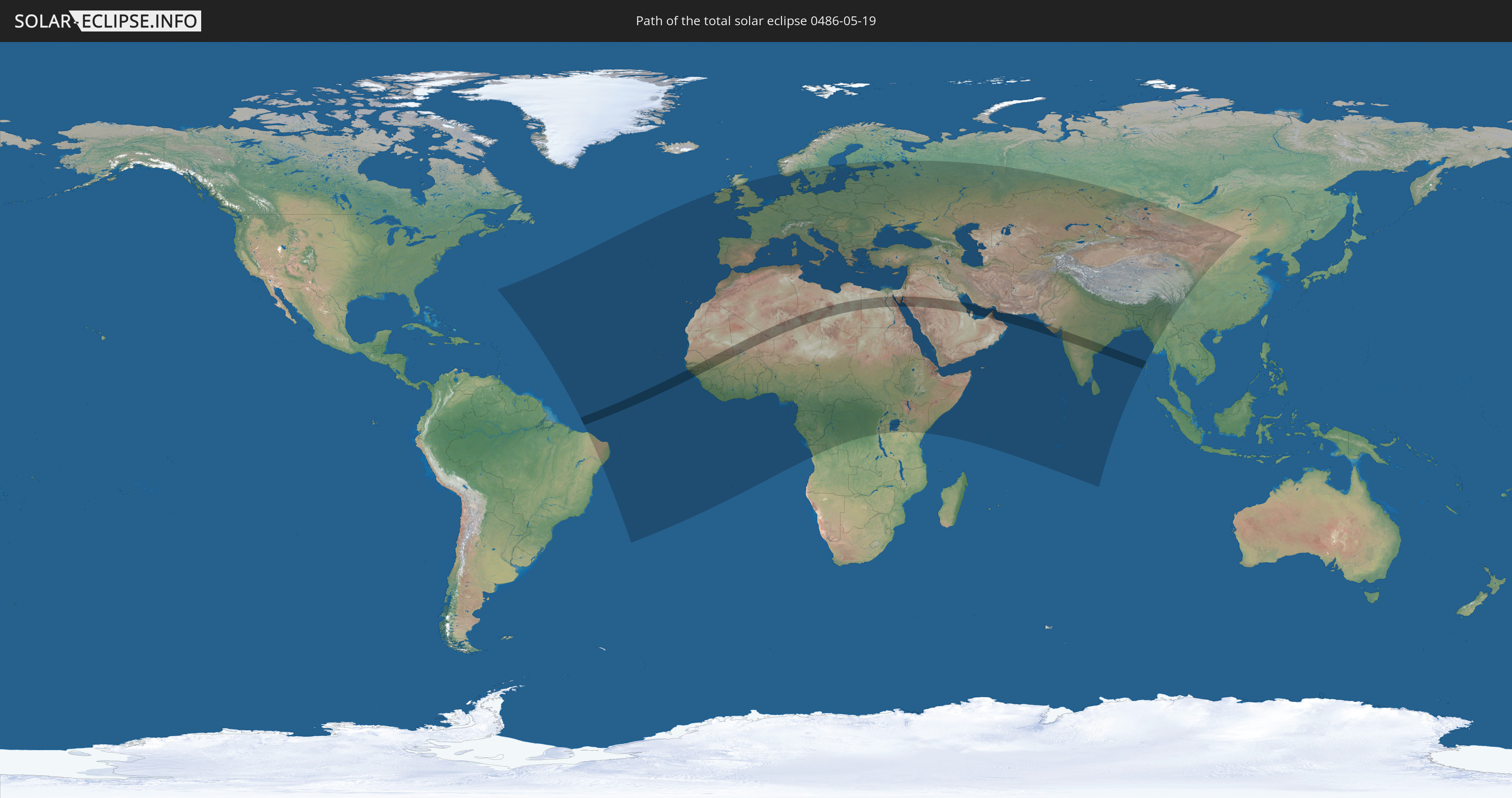
Die Sonnenfinsternis am 19.05.0486 kann man in 127 Ländern als partielle Sonnenfinsternis beobachten.
Der Finsternispfad verläuft durch 17 Länder. Nur in diesen Ländern ist sie als totale Sonnenfinsternis zu sehen.
In den folgenden Ländern ist die Sonnenfinsternis total zu sehen
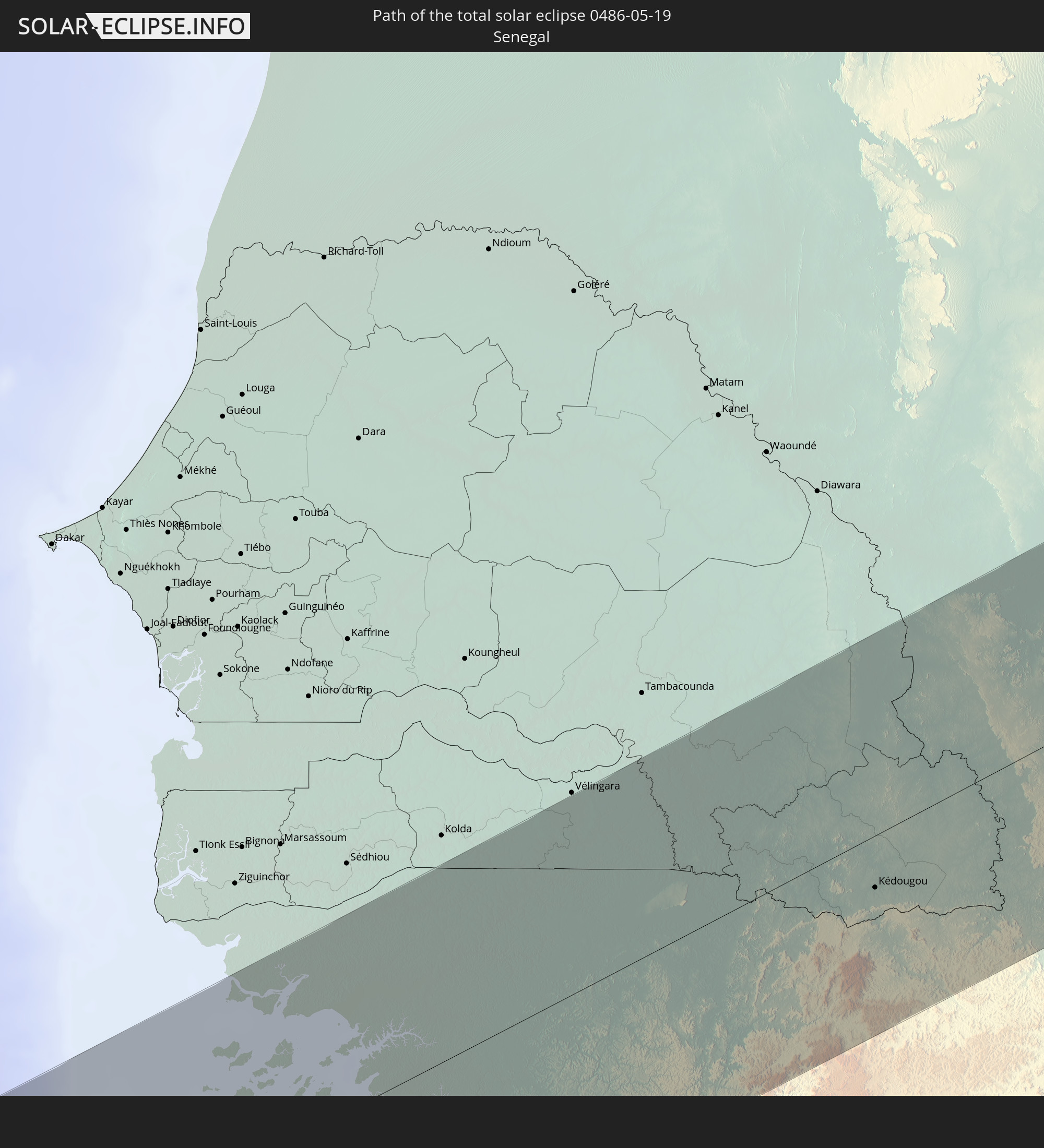 Senegal
 Mauretanien
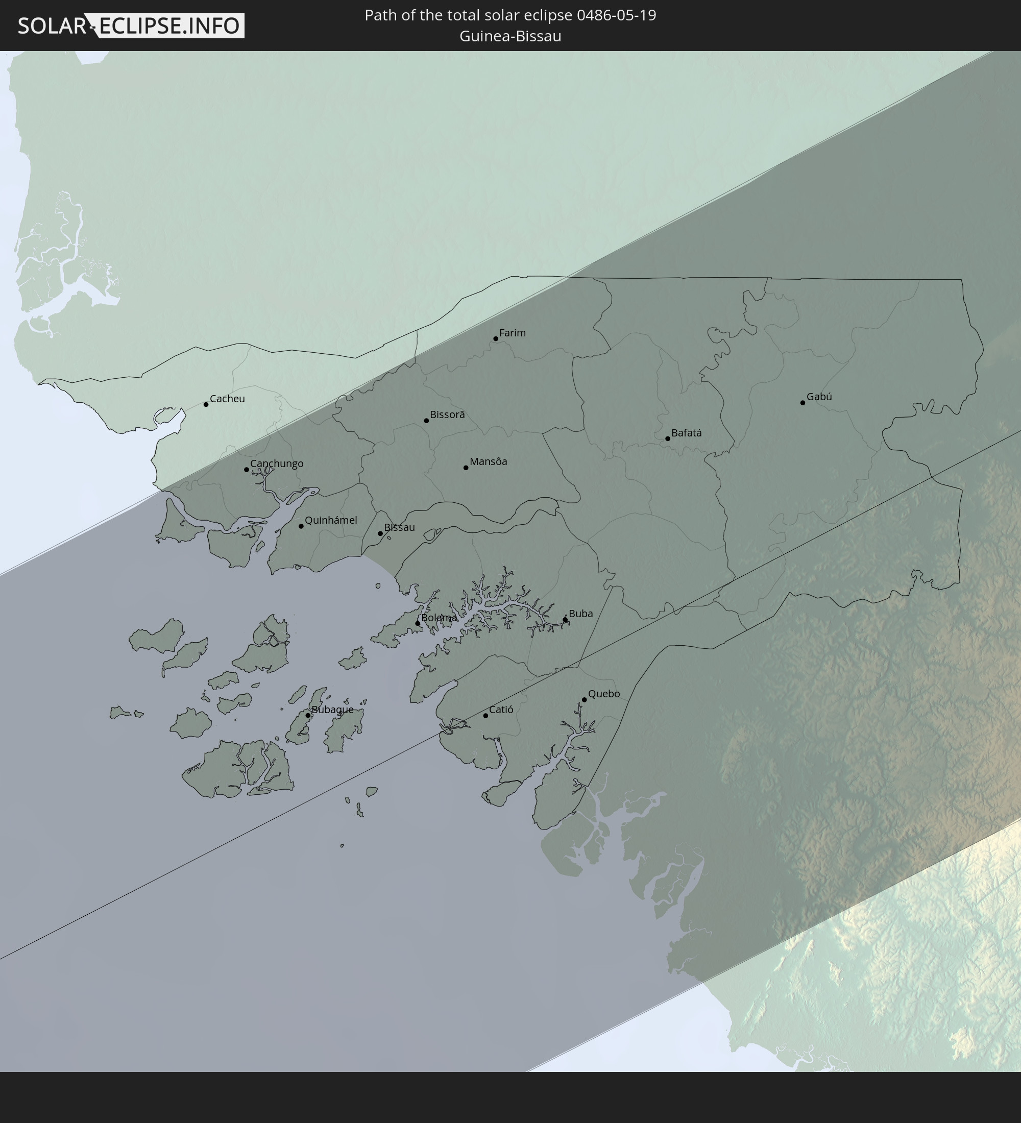 Guinea-Bissau
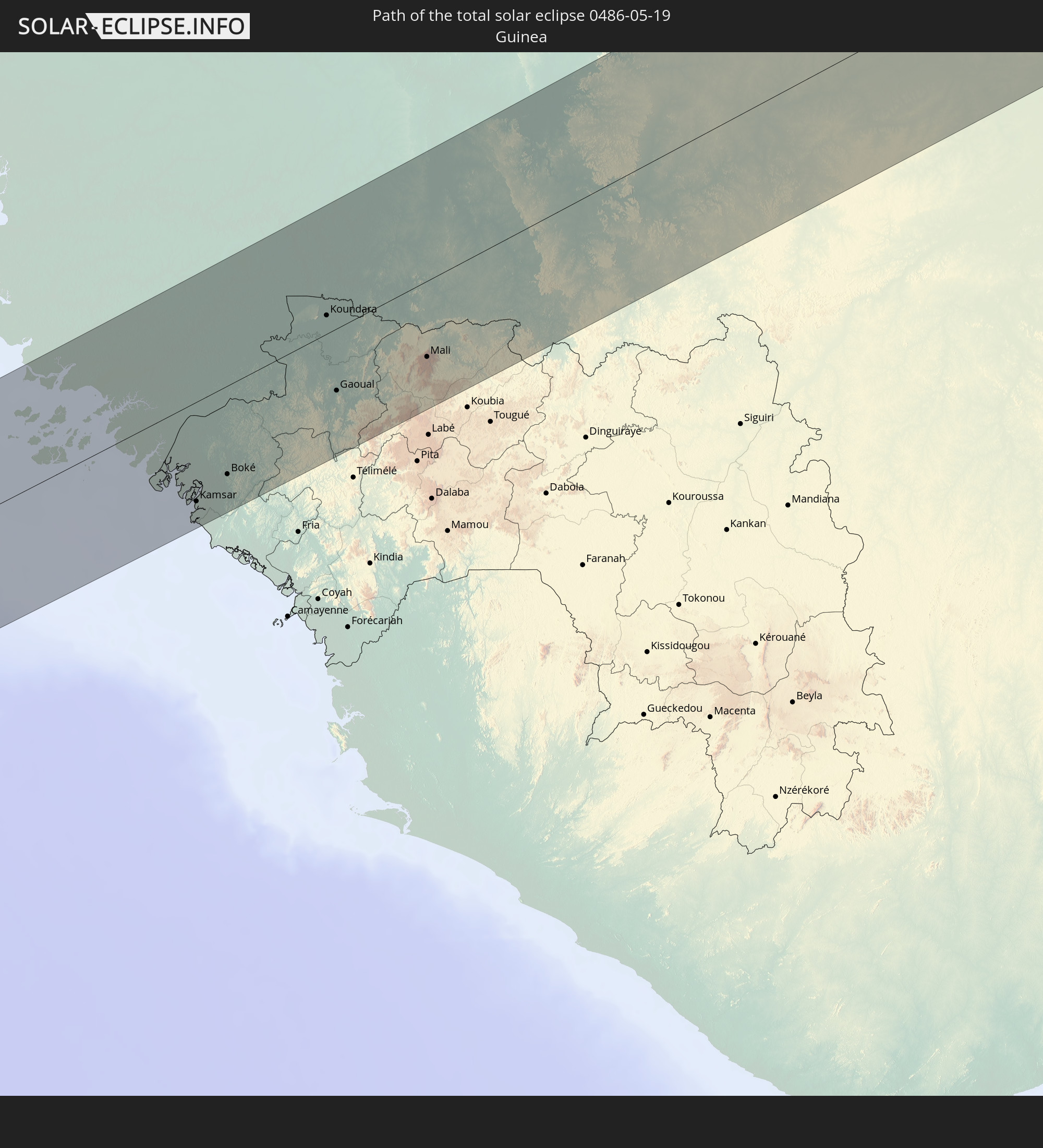 Guinea
 Mali
Mali
 Algerien
 Niger
Niger
 Libyen
 Ägypten
 Saudi-Arabien
 Jordanien
 Iran
Iran
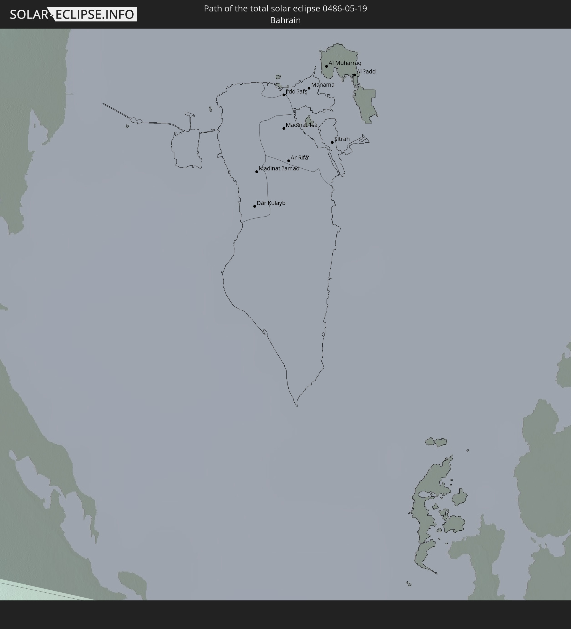 Bahrain
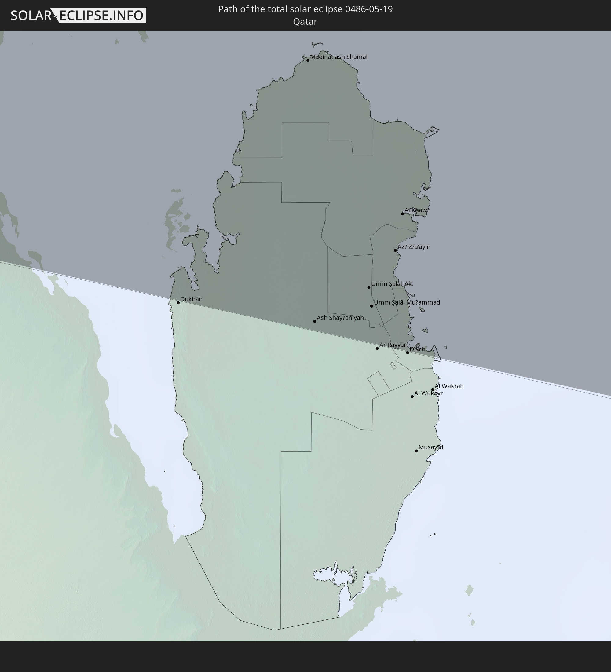 Katar
Katar
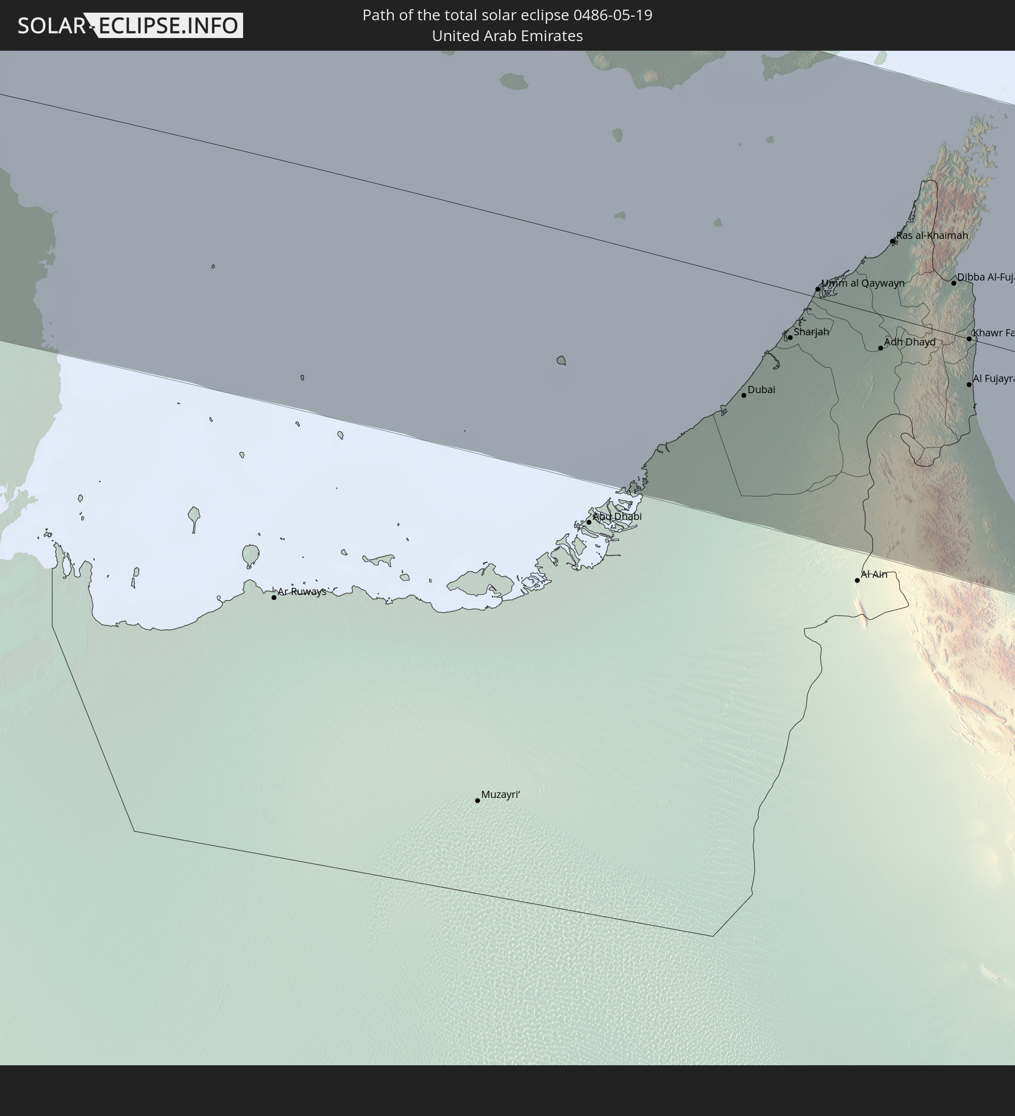 Vereinigte Arabische Emirate
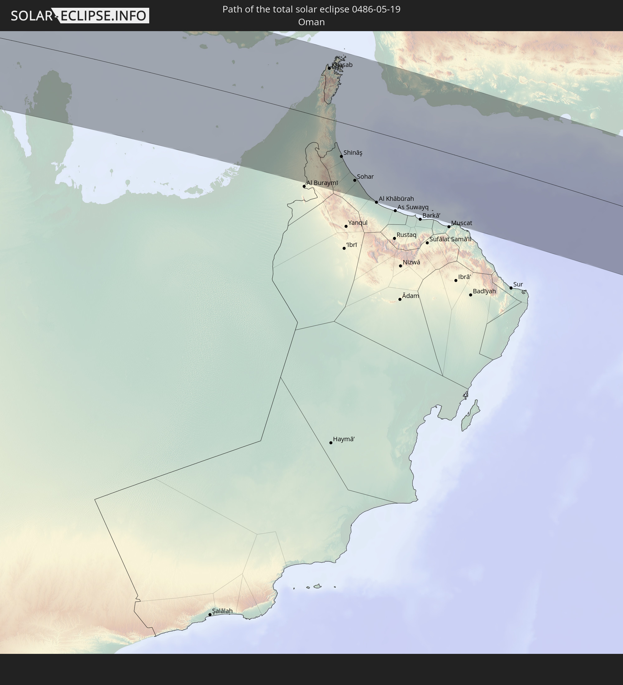 Oman
Oman
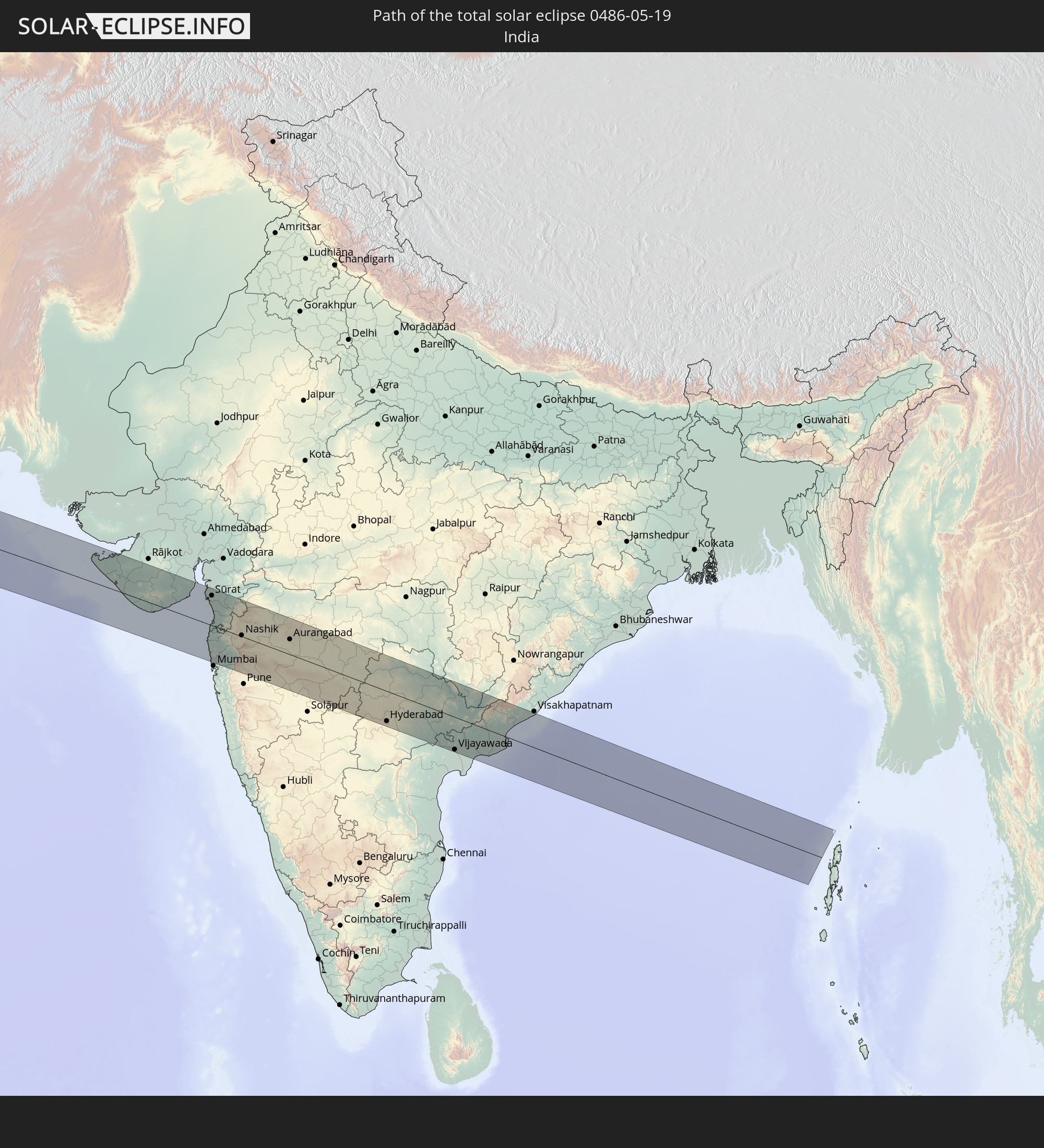 Indien
In den folgenden Ländern ist die Sonnenfinsternis partiell zu sehen
 Russland
 Brasilien
 Portugal
 Kap Verde
 Spanien
 Senegal
 Mauretanien
 Gambia
 Guinea-Bissau
 Guinea
 St. Helena
 Sierra Leone
 Marokko
 Mali
Mali
 Liberia
 Irland
 Algerien
 Vereinigtes Königreich
 Elfenbeinküste
 Burkina Faso
 Gibraltar
 Frankreich
 Isle of Man
 Ghana
Ghana
 Guernsey
 Jersey
 Togo
Togo
 Niger
Niger
 Benin
Benin
 Andorra
 Belgien
 Nigeria
 Niederlande
 Norwegen
 Äquatorialguinea
 Luxemburg
 Deutschland
 Schweiz
 São Tomé und Príncipe
 Italien
 Monaco
 Tunesien
 Dänemark
 Kamerun
 Gabun
Gabun
 Libyen
 Liechtenstein
 Österreich
 Schweden
 Republik Kongo
 Angola
 Tschechien
 Demokratische Republik Kongo
 San Marino
 Vatikanstadt
 Slowenien
 Tschad
 Kroatien
 Polen
Polen
 Malta
Malta
 Zentralafrikanische Republik
 Bosnien und Herzegowina
 Ungarn
 Slowakei
 Montenegro
 Serbien
 Albanien
 Åland Islands
 Griechenland
 Rumänien
 Mazedonien
 Finnland
 Litauen
 Lettland
 Estland
 Sudan
Sudan
 Ukraine
 Bulgarien
 Weißrussland
 Ägypten
 Türkei
 Moldawien
 Ruanda
 Burundi
 Tansania
 Uganda
 Republik Zypern
 Äthiopien
 Kenia
Kenia
 Staat Palästina
 Israel
 Saudi-Arabien
 Jordanien
 Libanon
 Syrien
 Eritrea
 Irak
Irak
 Georgien
 Somalia
 Dschibuti
 Jemen
Jemen
 Armenien
 Iran
Iran
 Aserbaidschan
 Seychellen
 Kasachstan
 Kuwait
 Bahrain
 Katar
Katar
 Vereinigte Arabische Emirate
 Oman
Oman
 Turkmenistan
 Usbekistan
 Afghanistan
 Pakistan
 Tadschikistan
 Indien
 Kirgisistan
 Britisches Territorium im Indischen Ozean
 Malediven
 Volksrepublik China
 Sri Lanka
 Nepal
Nepal
 Mongolei
 Bangladesch
 Bhutan
 Myanmar
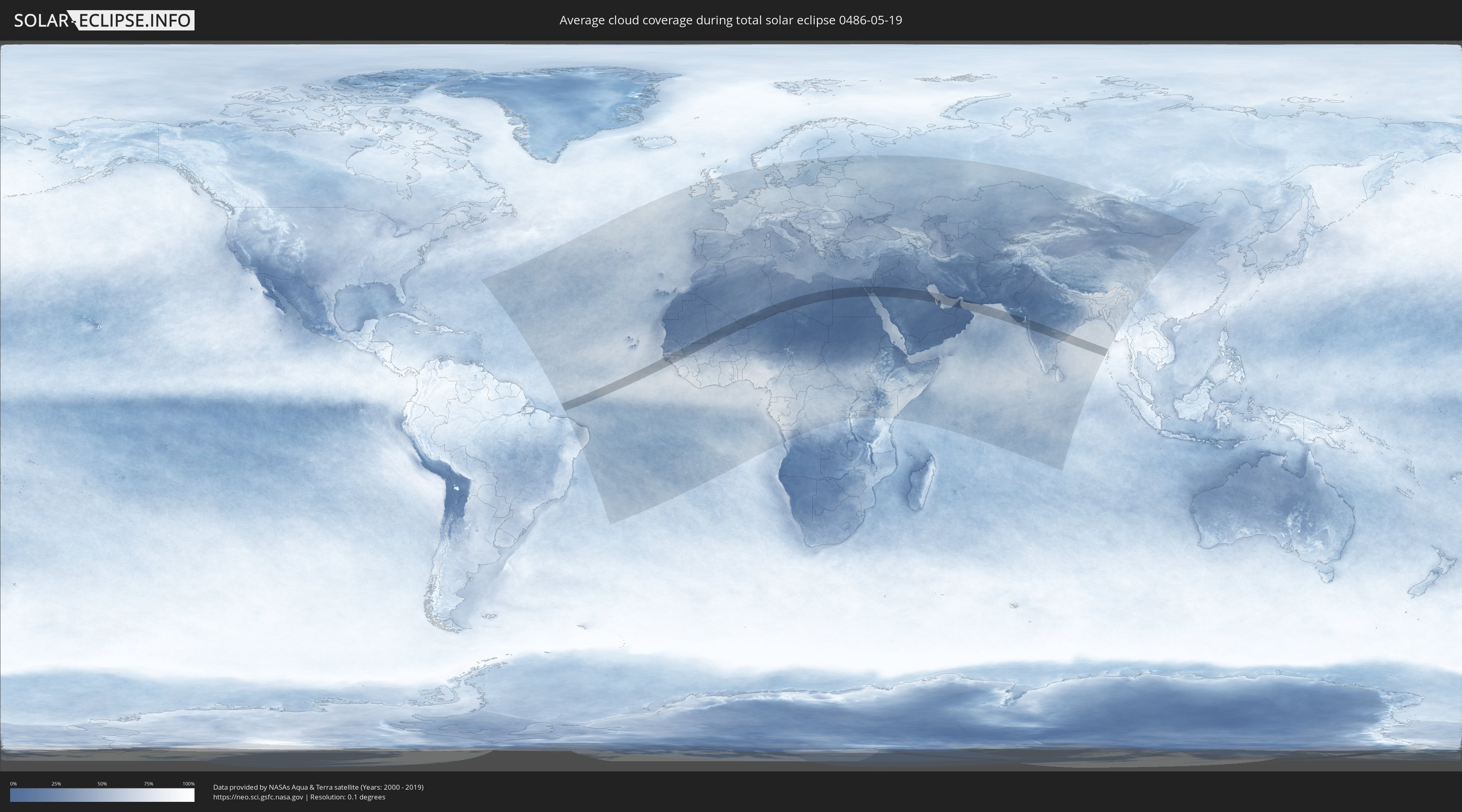
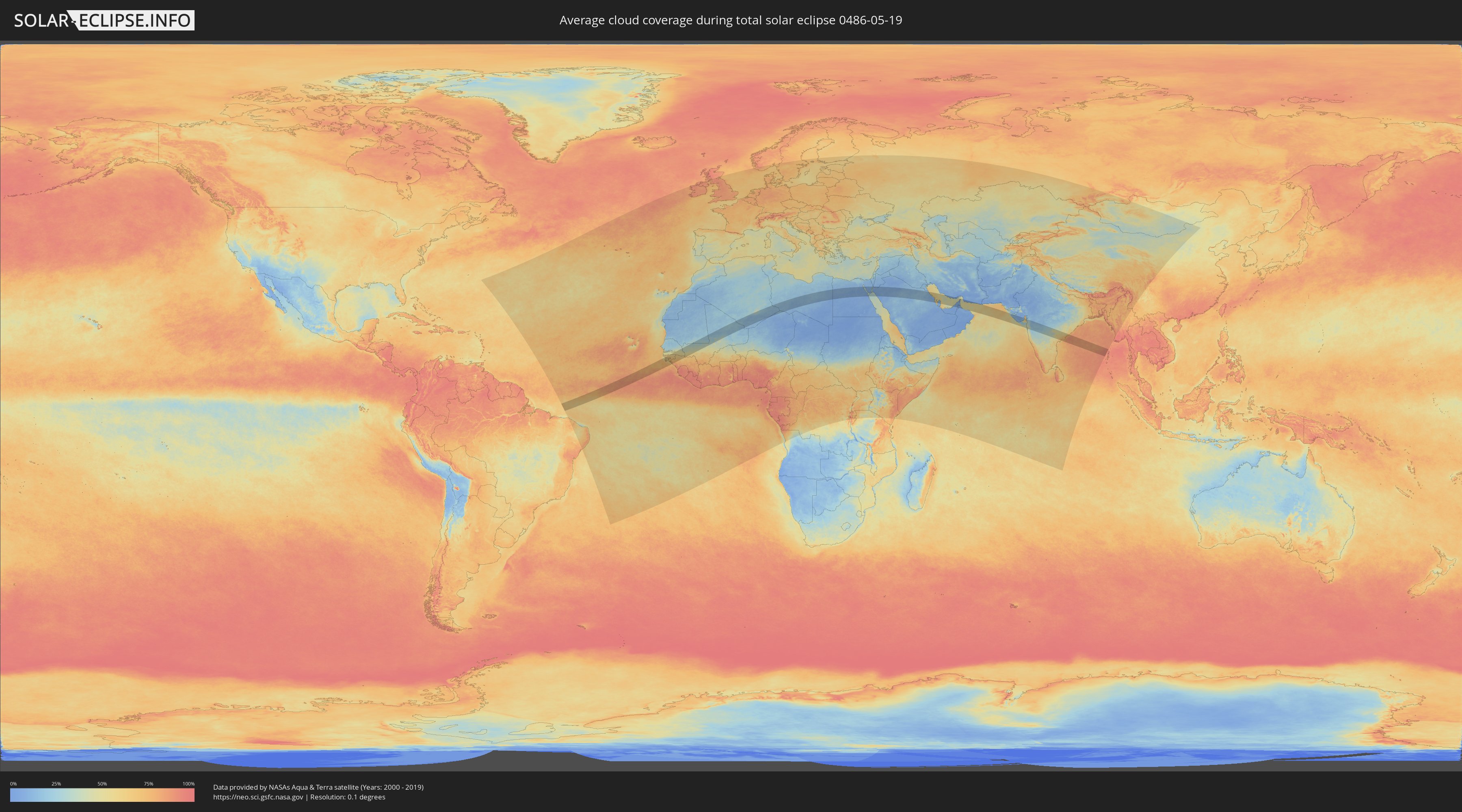
Wie wird das Wetter während der totalen Sonnenfinsternis am 19.05.0486?
Wo ist der beste Ort, um die totale Sonnenfinsternis vom 19.05.0486 zu beobachten?
Die folgenden Karten zeigen die durchschnittliche Bewölkung für den Tag, an dem die totale Sonnenfinsternis
stattfindet. Mit Hilfe der Karten lässt sich der Ort entlang des Finsternispfades eingrenzen,
der die besten Aussichen auf einen klaren wolkenfreien Himmel bietet.
Trotzdem muss man immer lokale Gegenenheiten beachten und sollte sich genau über das Wetter an seinem
gewählten Beobachtungsort informieren.
Die Daten stammen von den beiden NASA-Satelliten
AQUA und TERRA
und wurden über einen Zeitraum von 19 Jahren (2000 - 2019) gemittelt.
Detaillierte Länderkarten
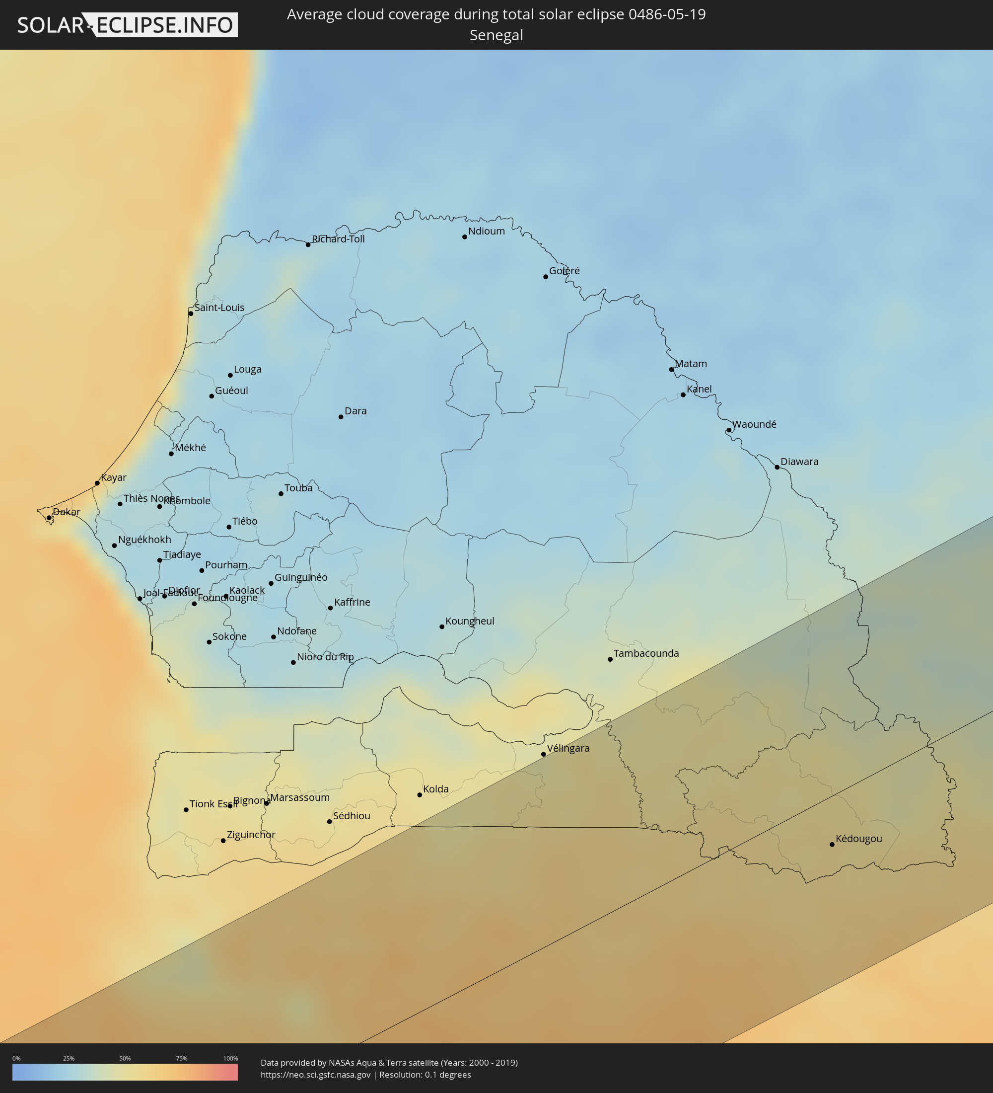 Senegal
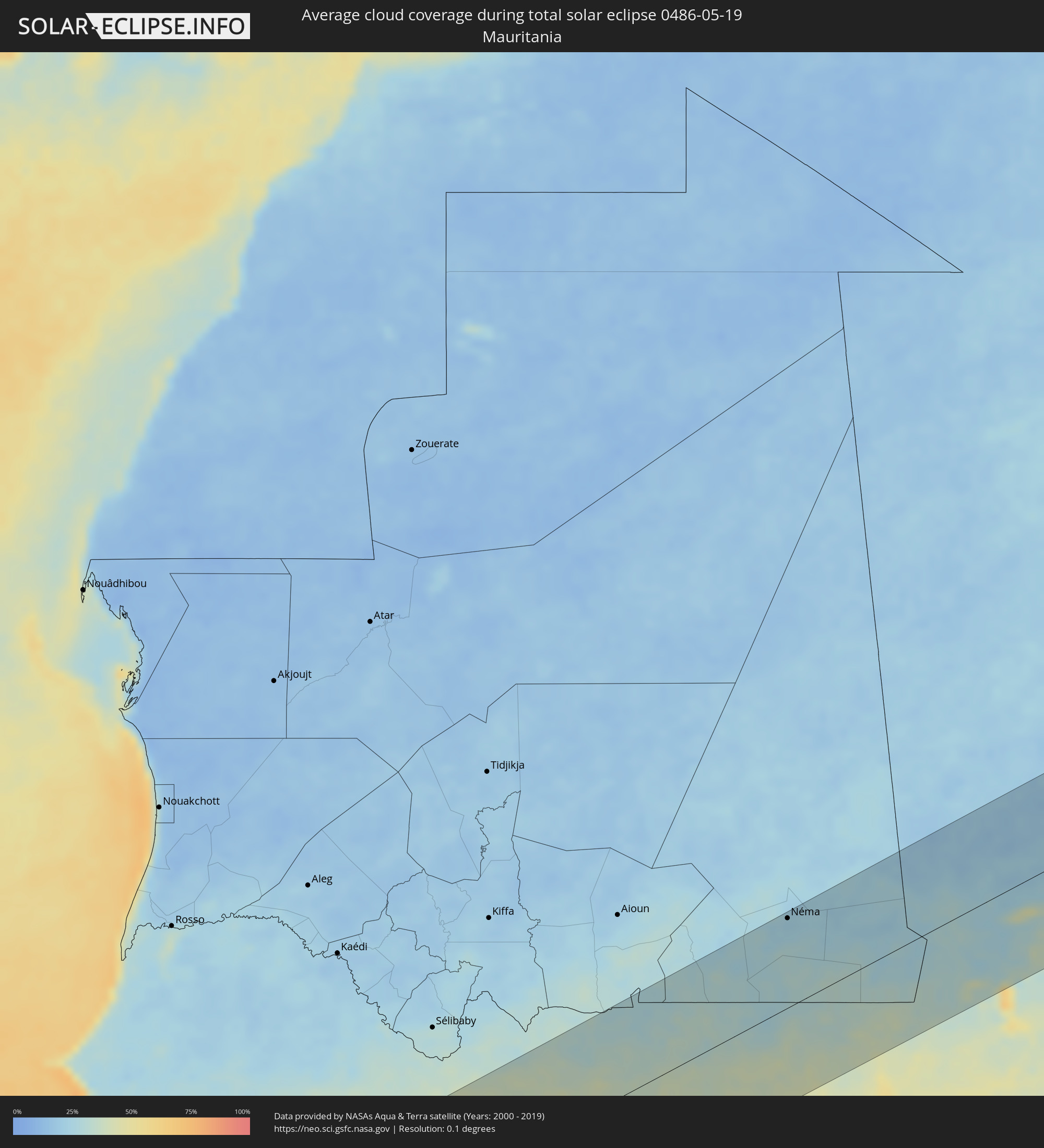 Mauretanien
 Guinea-Bissau
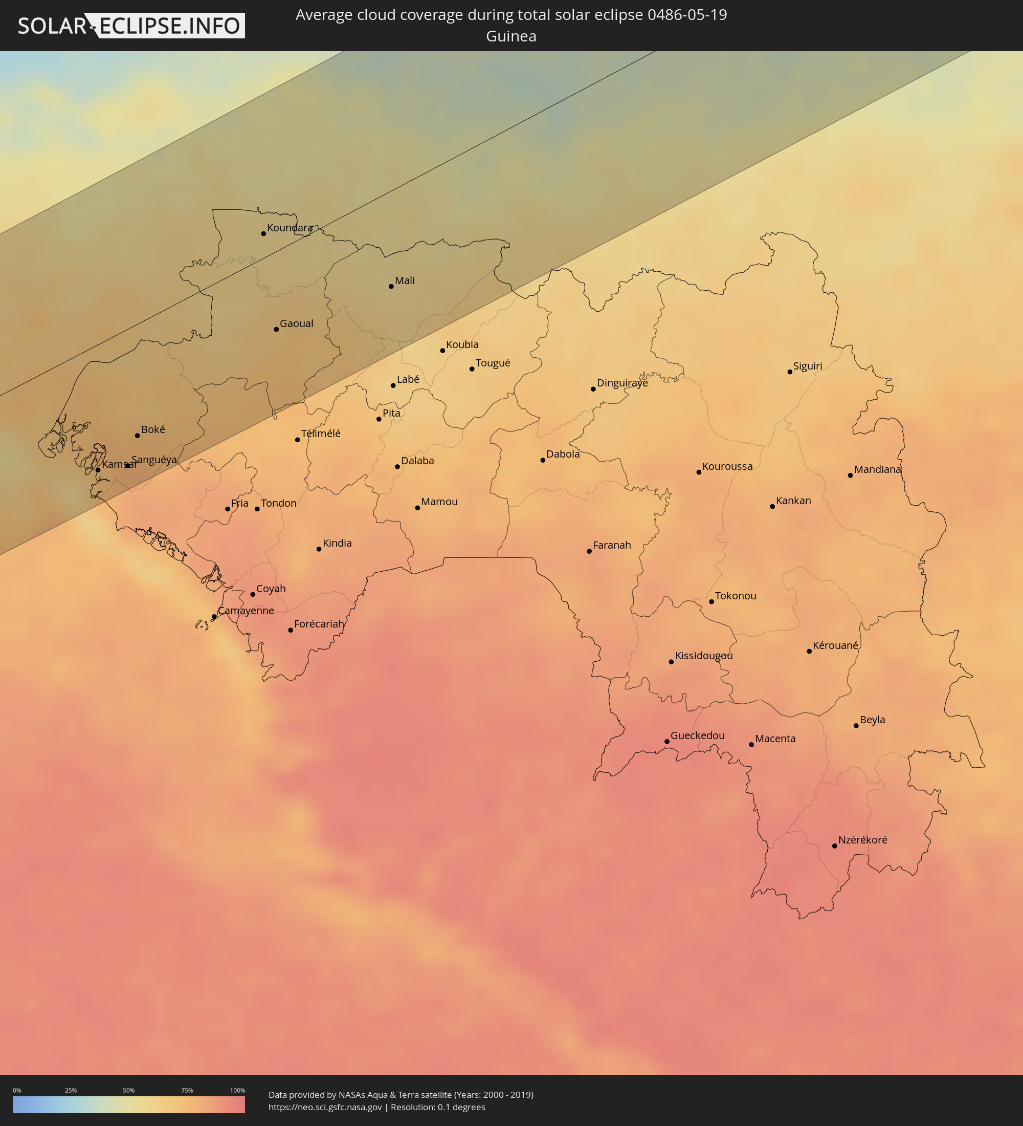 Guinea
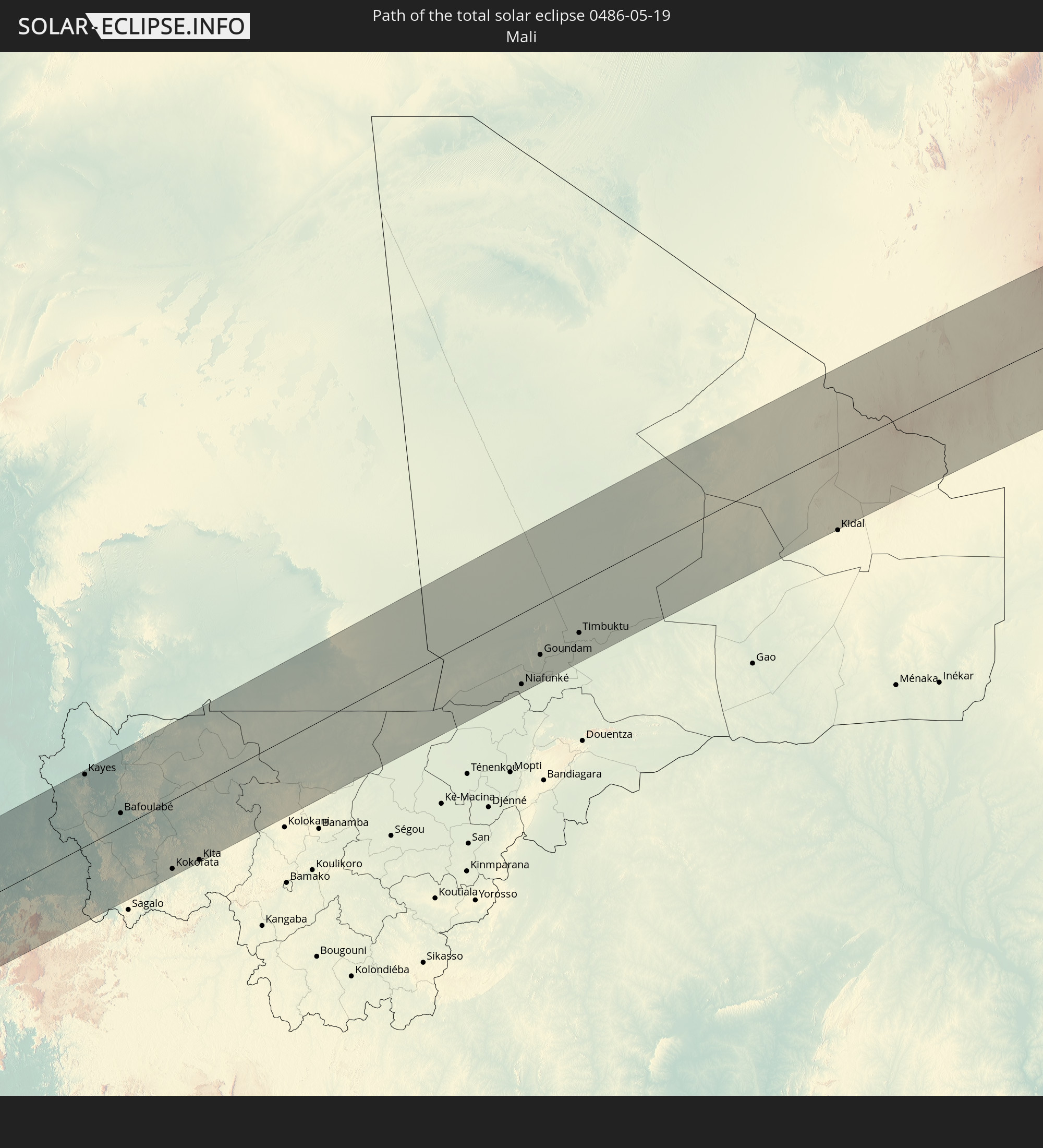
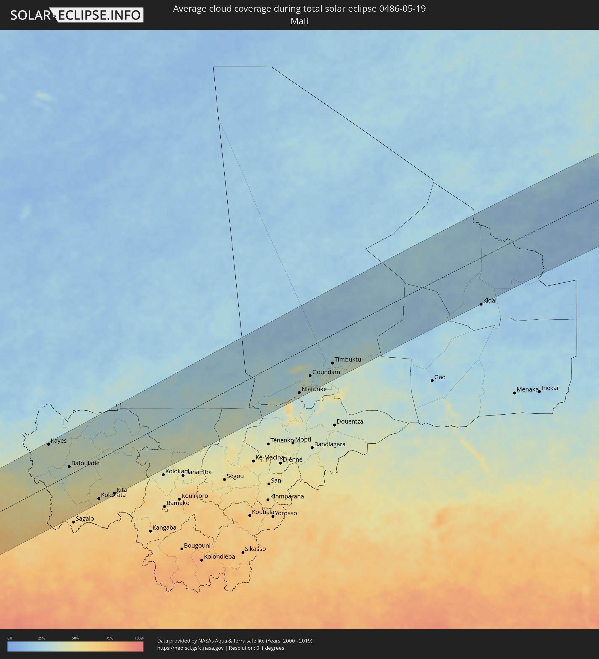 Mali
Mali
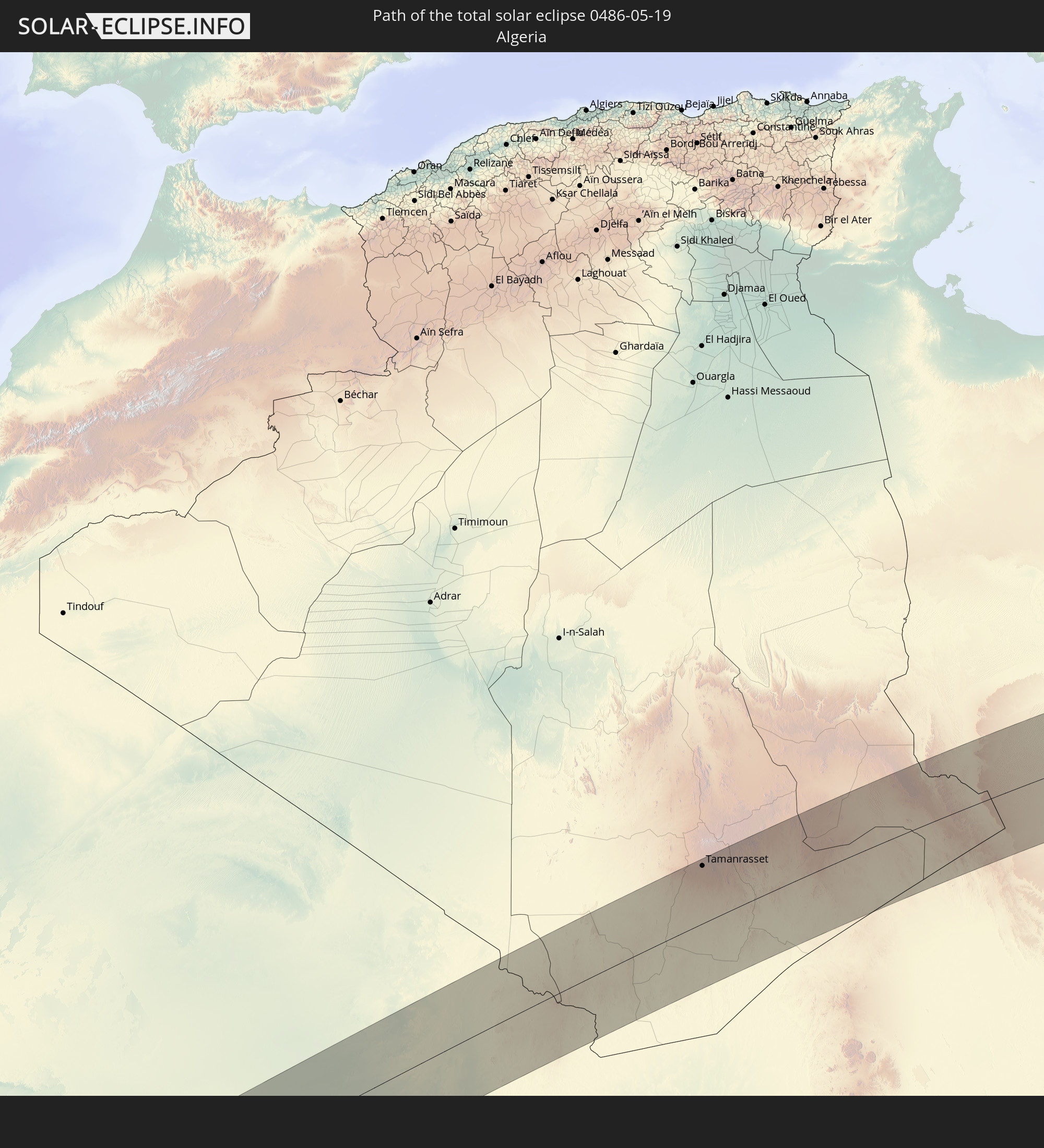
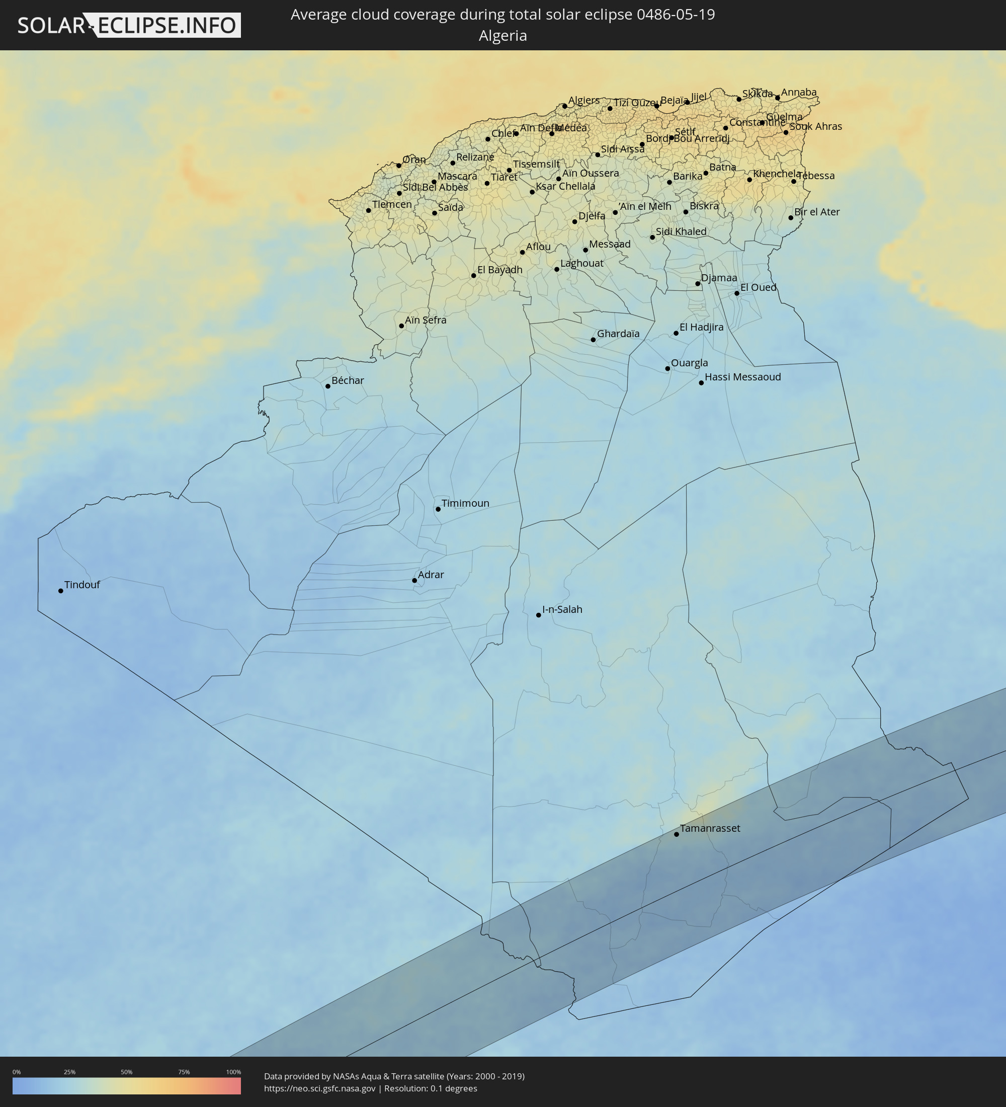 Algerien
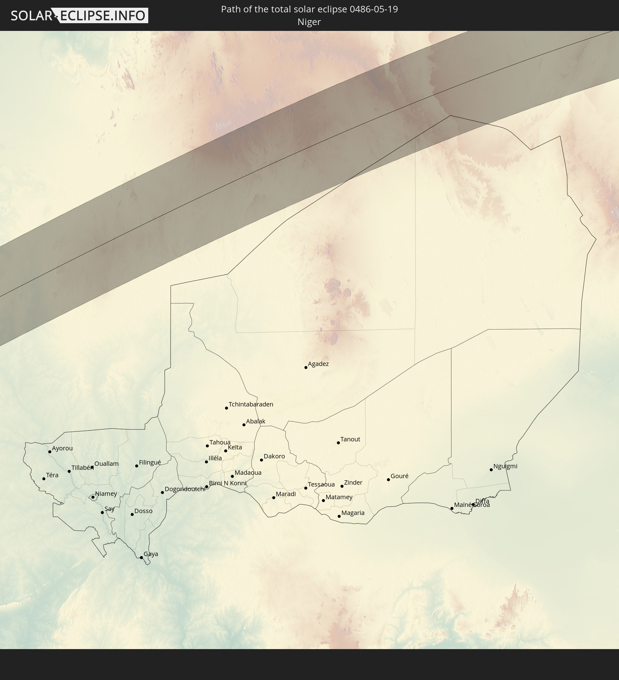
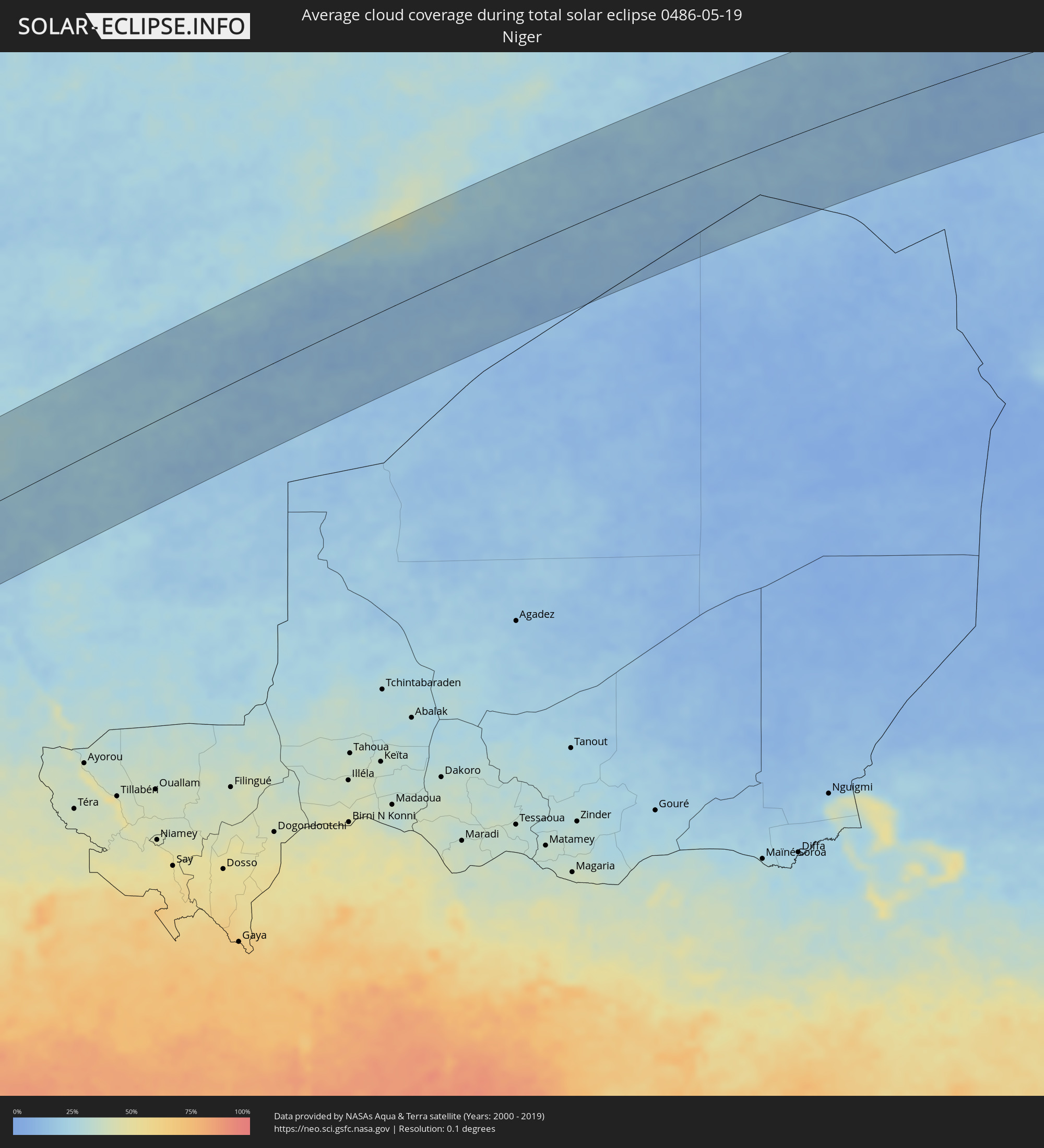 Niger
Niger
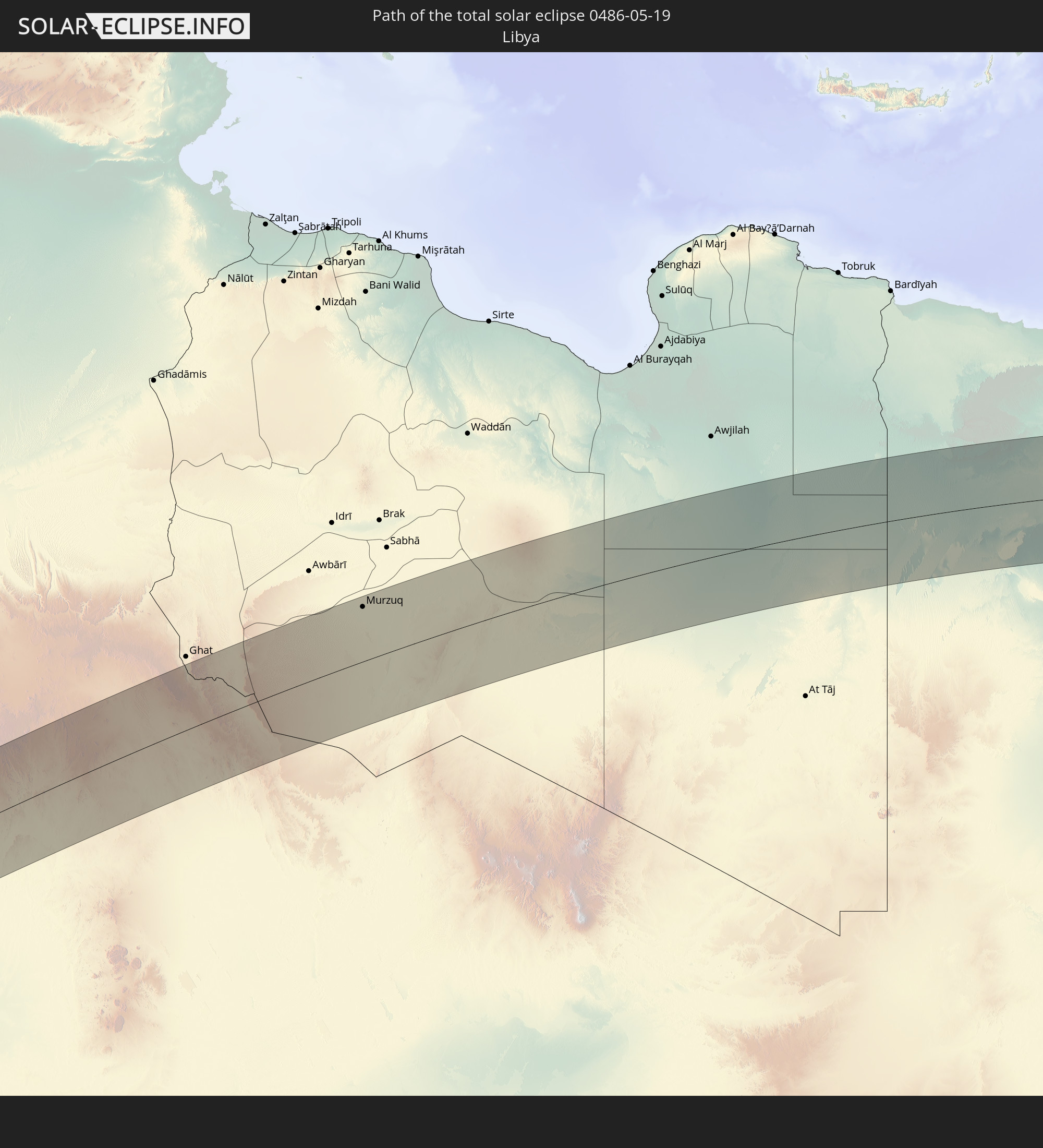
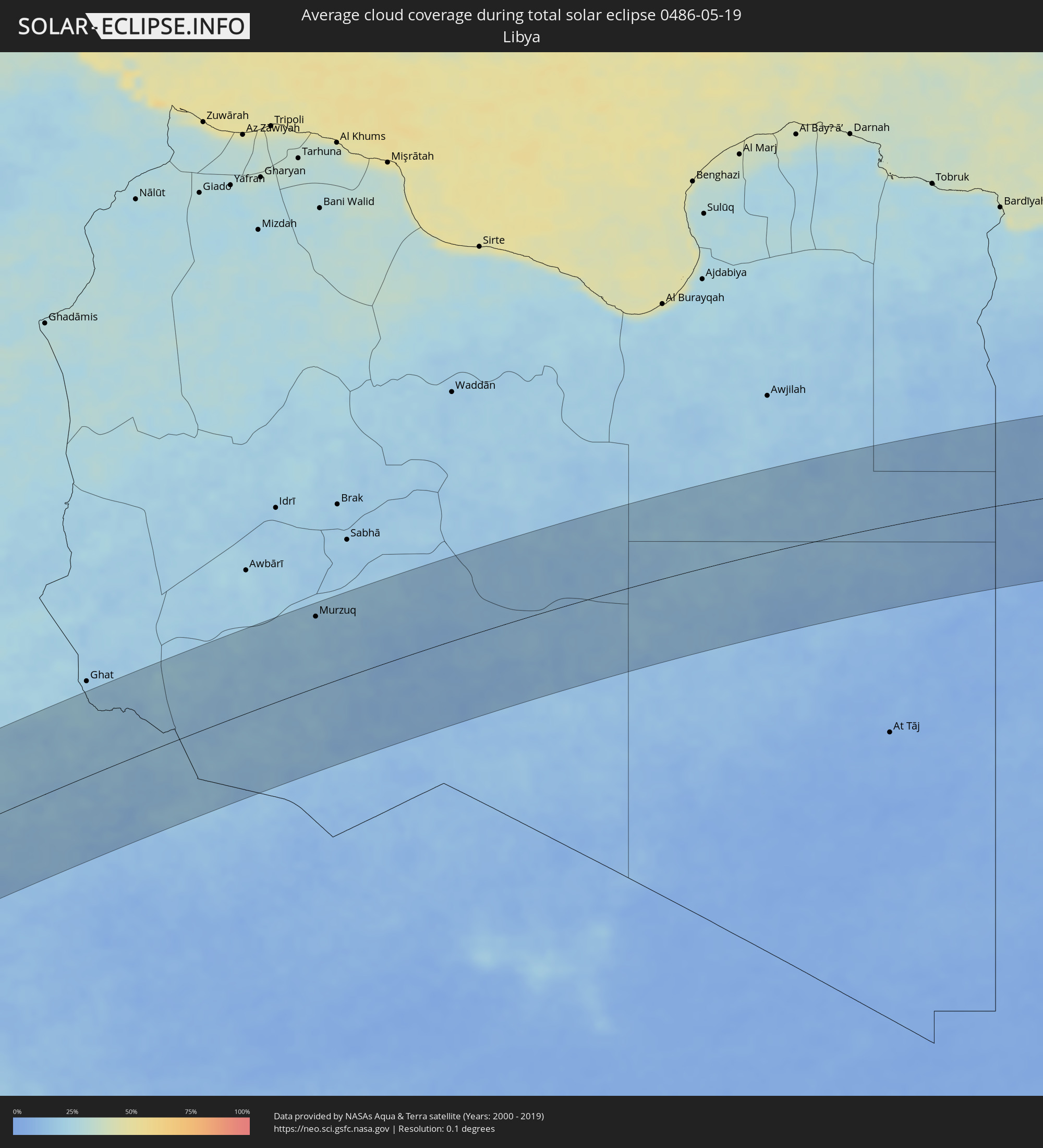 Libyen
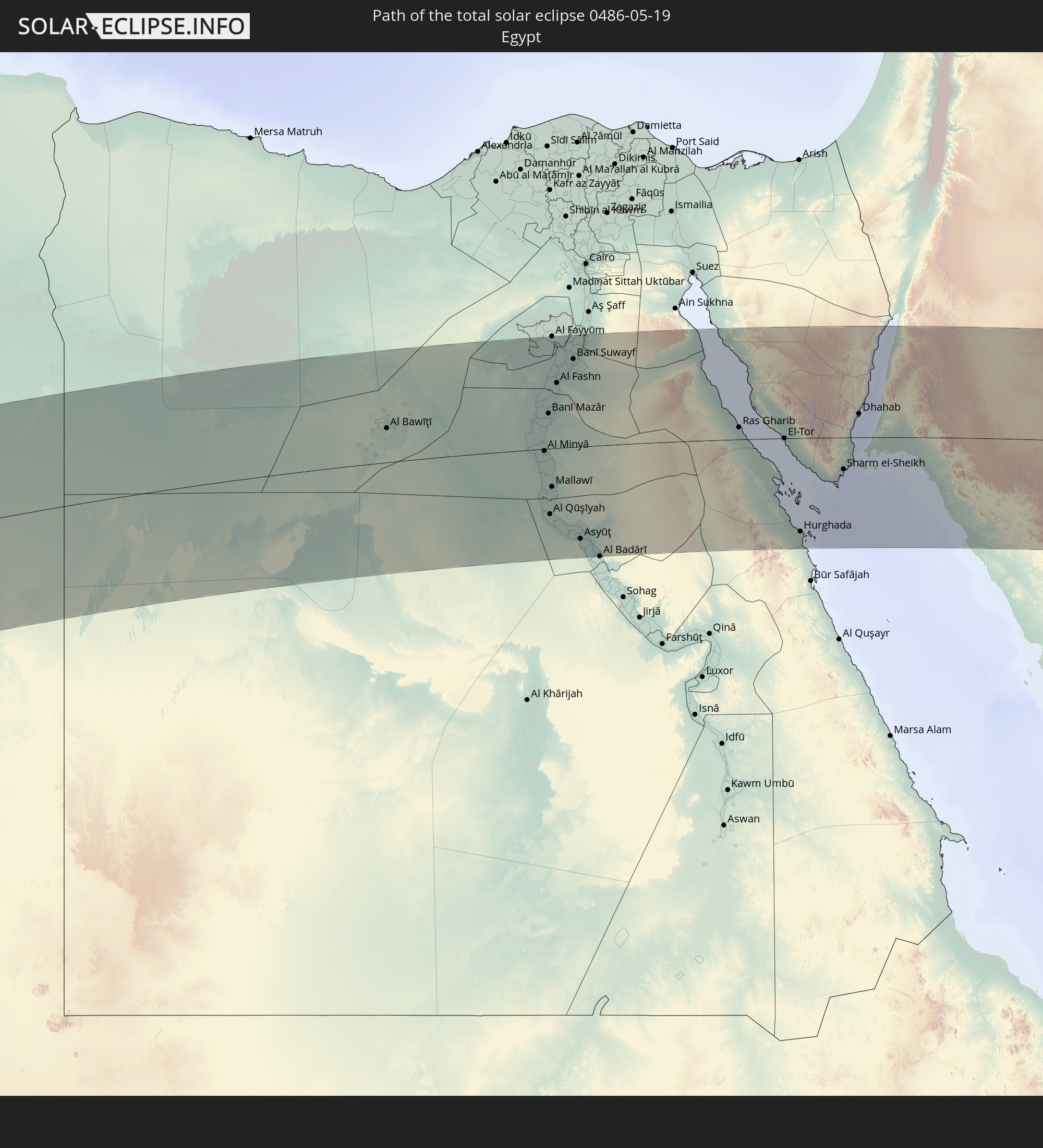
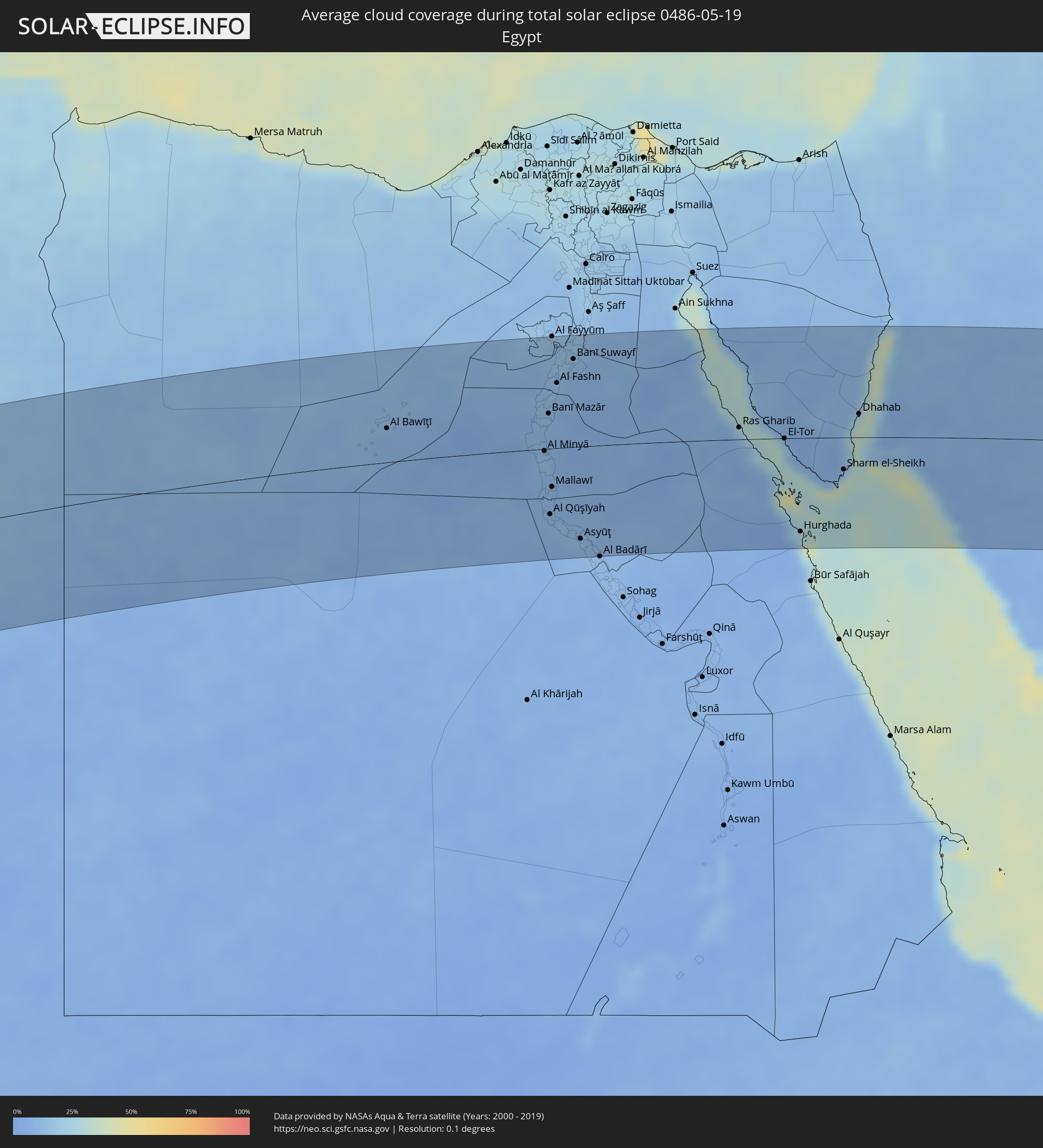 Ägypten
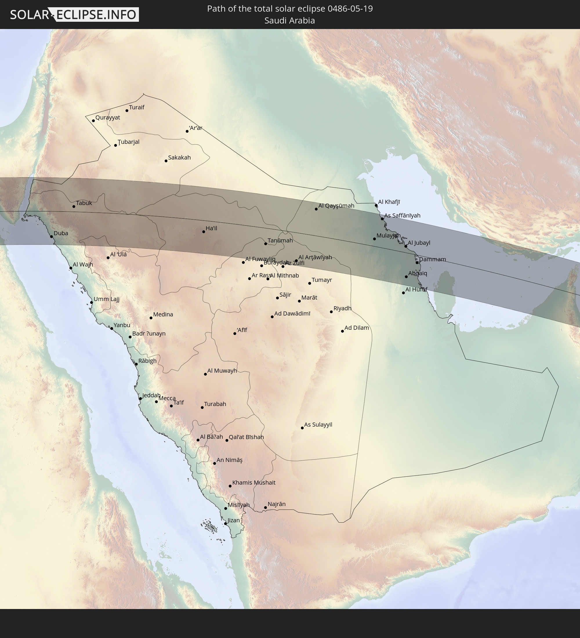
 Saudi-Arabien
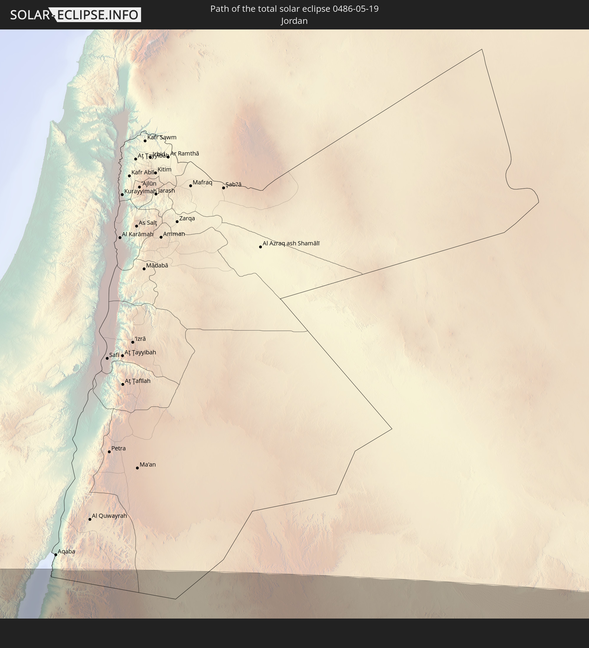
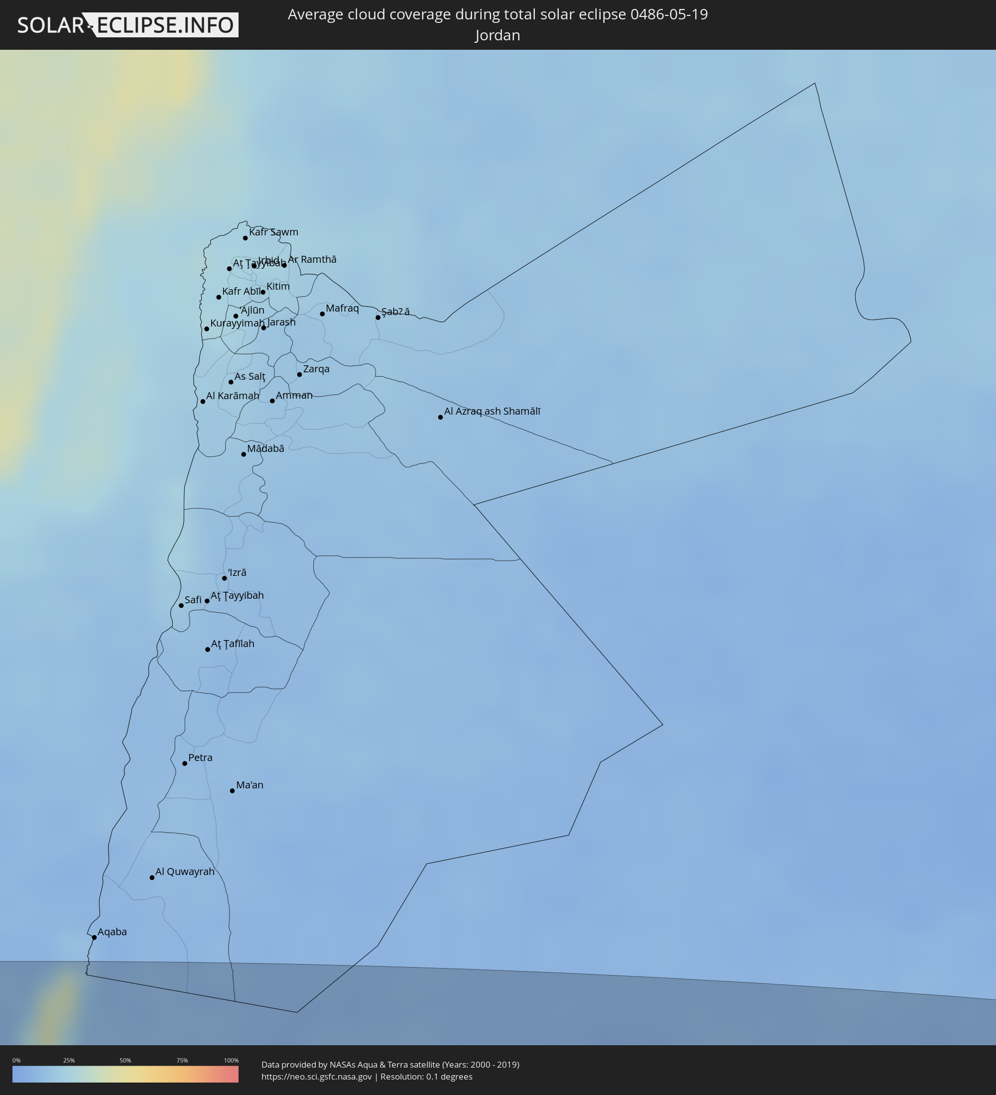 Jordanien
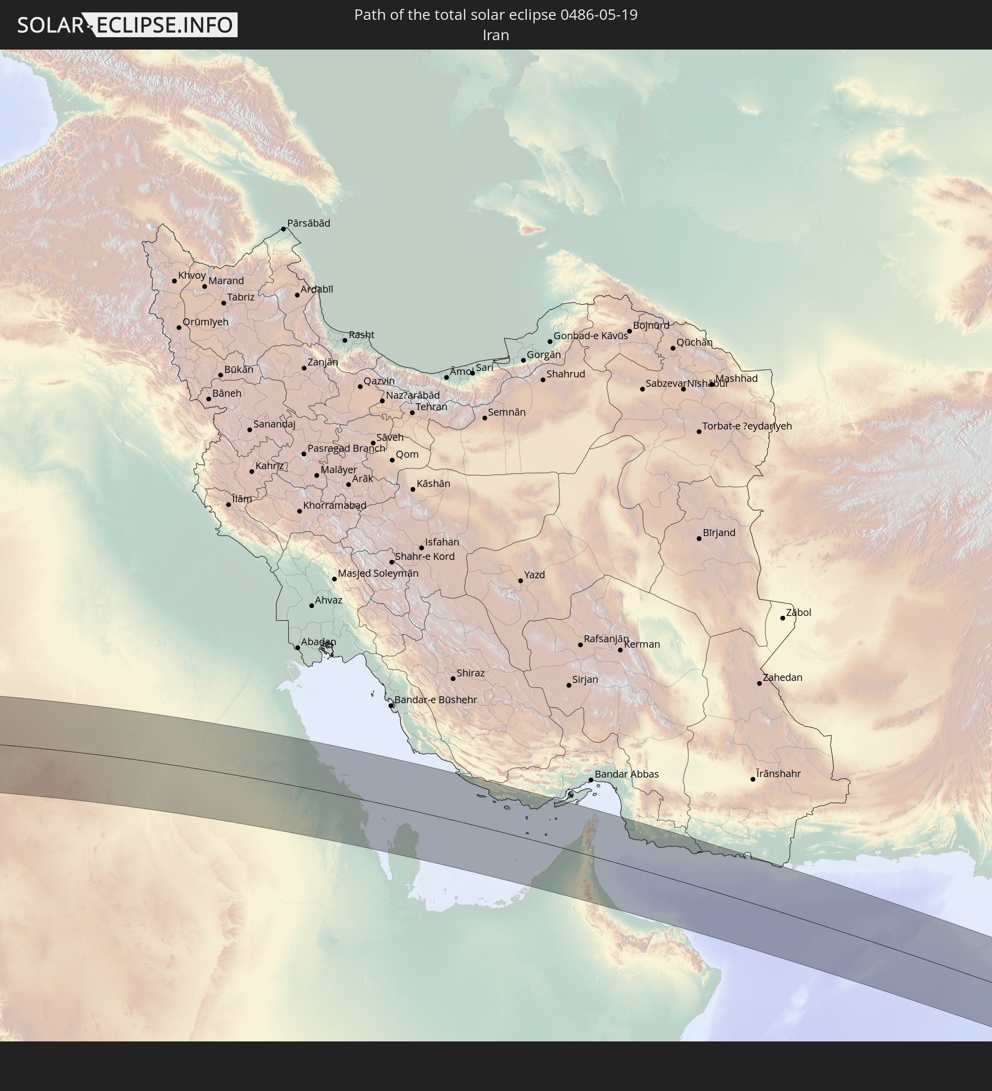
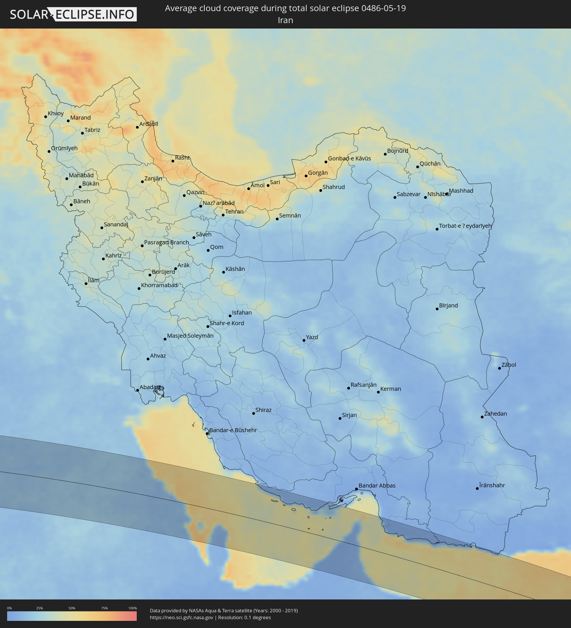 Iran
Iran
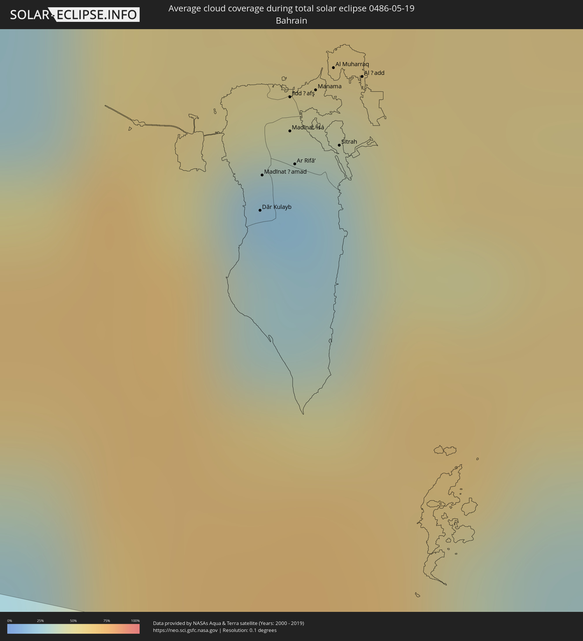 Bahrain
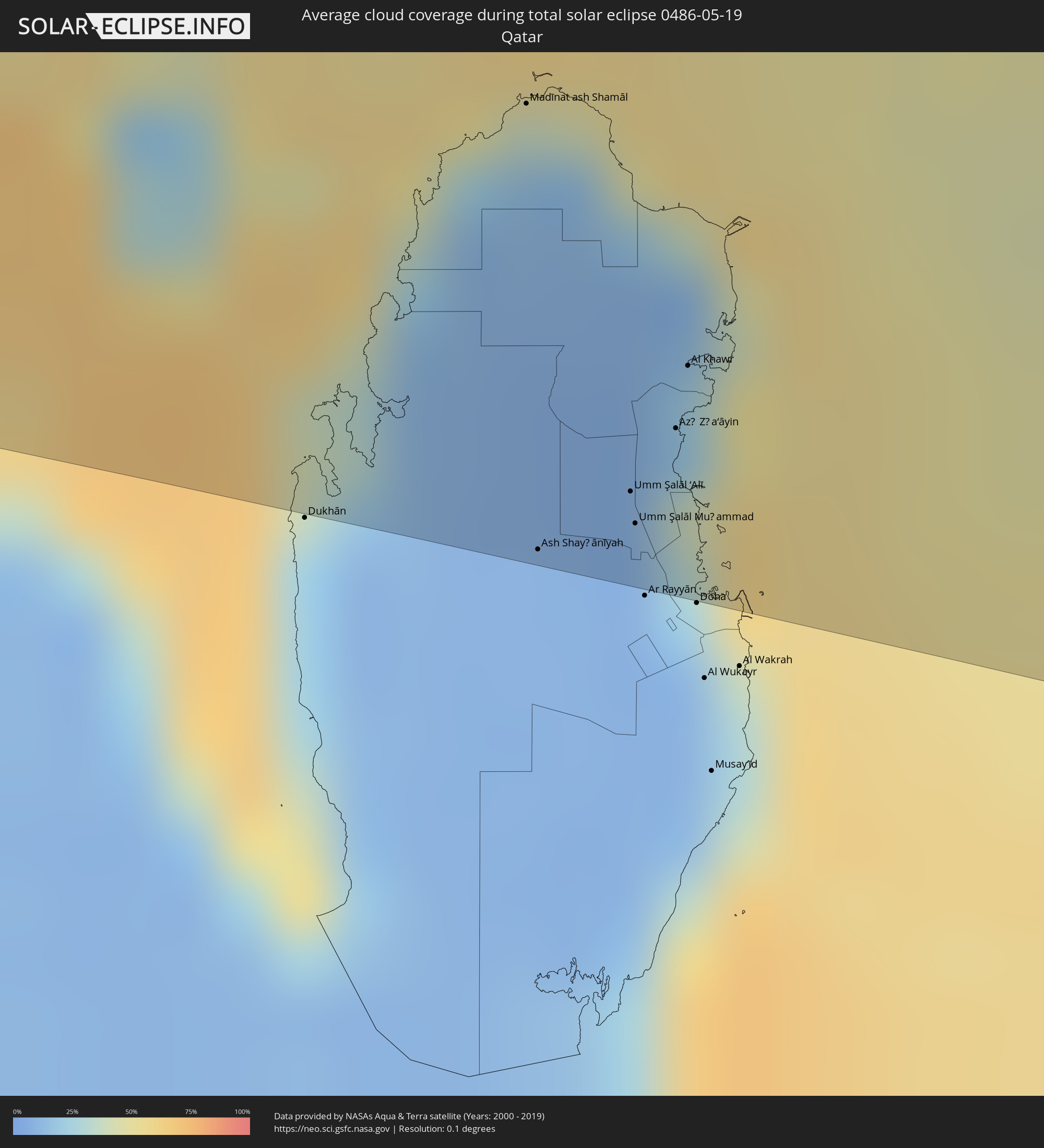 Katar
Katar
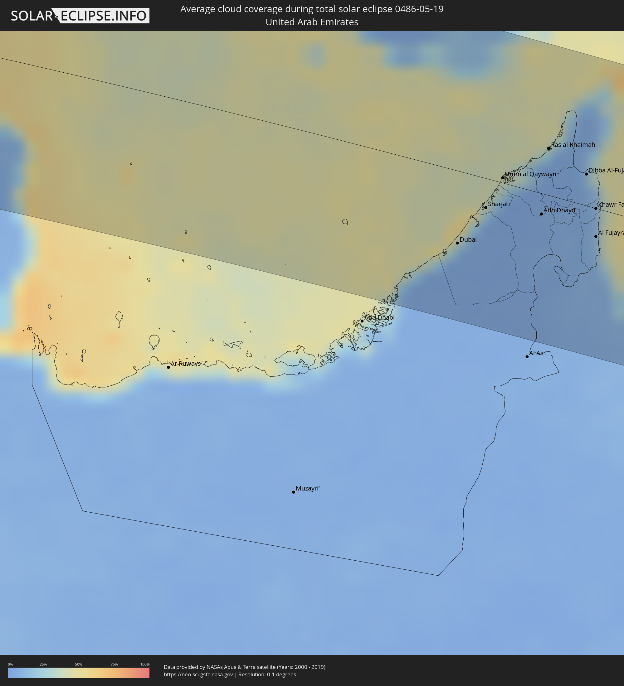 Vereinigte Arabische Emirate
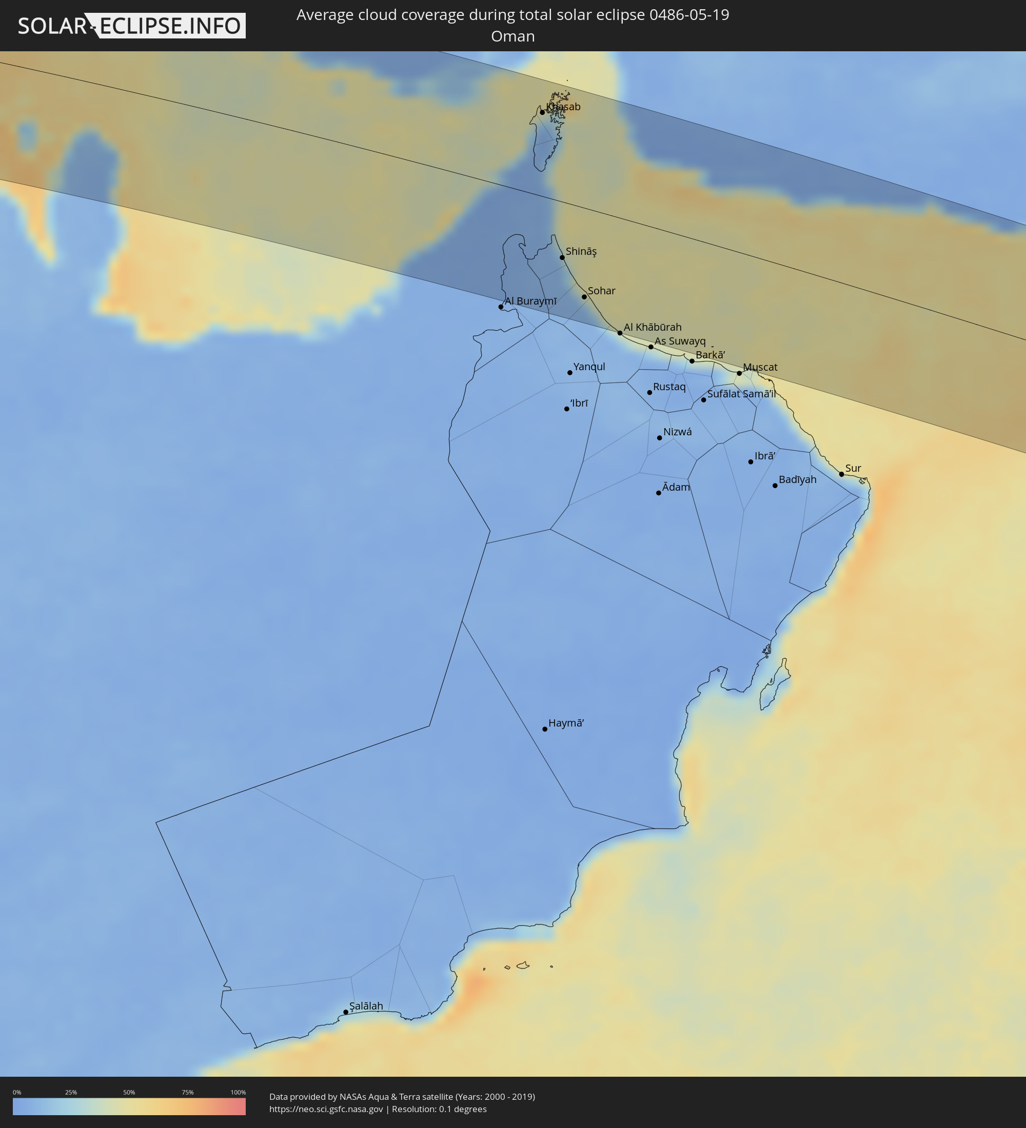 Oman
Oman
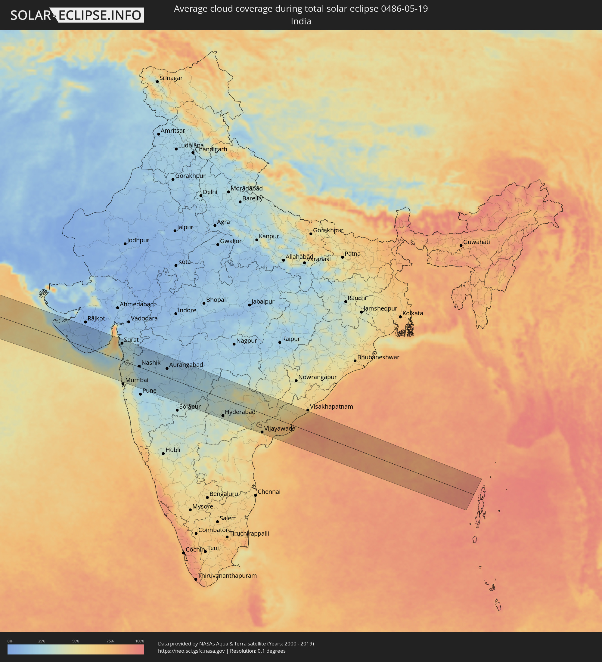 Indien
Orte im Finsternispfad
Die nachfolgene Tabelle zeigt Städte und Orte mit mehr als 5.000 Einwohnern, die sich im Finsternispfad befinden. Städte mit mehr als 100.000 Einwohnern sind dick gekennzeichnet. Mit einem Klick auf den Ort öffnet sich eine Detailkarte die die Lage des jeweiligen Ortes zusammen mit dem Verlauf der zentralen Finsternis präsentiert.
| Ort | Typ | Dauer der Verfinsterung | Ortszeit bei maximaler Verfinsterung | Entfernung zur Zentrallinie | Ø Bewölkung |
|
Canchungo, Cacheu
|
total | - | 07:53:04 UTC-01:02 | 114 km | 61% |
|
Quinhámel, Biombo
|
total | - | 07:53:01 UTC-01:02 | 88 km | 61% |
|
Bubaque, Bolama and Bijagos
|
total | - | 07:52:26 UTC-01:02 | 27 km | 64% |
|
Bissau, Bissau
|
total | - | 07:53:13 UTC-01:02 | 72 km | 63% |
|
Bolama, Bolama and Bijagos
|
total | - | 07:53:01 UTC-01:02 | 38 km | 64% |
|
Bissorã, Oio
|
total | - | 07:53:42 UTC-01:02 | 100 km | 61% |
|
Mansôa, Oio
|
total | - | 07:53:39 UTC-01:02 | 79 km | 61% |
|
Catió, Tombali
|
total | - | 07:52:54 UTC-01:02 | 2 km | 71% |
|
Farim, Oio
|
total | - | 07:54:10 UTC-01:02 | 115 km | 61% |
|
Buba, Quinara
|
total | - | 07:53:26 UTC-01:02 | 15 km | 70% |
|
Quebo, Tombali
|
total | - | 07:53:13 UTC-01:02 | 13 km | 72% |
|
Bafatá, Bafatá
|
total | - | 07:54:19 UTC-01:02 | 55 km | 61% |
|
Kamsar, Boke
|
total | - | 08:39:02 UTC-00:16 | 96 km | 72% |
|
Sanguéya, Boke
|
total | - | 08:39:16 UTC-00:16 | 105 km | 78% |
|
Boké, Boke
|
total | - | 08:39:34 UTC-00:16 | 85 km | 77% |
|
Gabú, Gabú
|
total | - | 07:54:49 UTC-01:02 | 44 km | 61% |
|
Koundara, Boke
|
total | - | 08:42:04 UTC-00:16 | 18 km | 58% |
|
Gaoual, Boke
|
total | - | 08:41:23 UTC-00:16 | 60 km | 67% |
|
Youkounkoun, Boke
|
total | - | 08:42:17 UTC-00:16 | 13 km | 59% |
|
Mali, Labe
|
total | - | 08:42:36 UTC-00:16 | 73 km | 60% |
|
Kédougou, Kédougou
|
total | - | 08:43:14 UTC-00:16 | 32 km | 55% |
|
Kayes, Kayes
|
total | - | 08:46:03 UTC-00:16 | 117 km | 40% |
|
Diré
|
total | - | 08:44:10 UTC-00:16 | 120 km | 62% |
|
Bafoulabé, Kayes
|
total | - | 08:45:59 UTC-00:16 | 23 km | 39% |
|
Kokofata
|
total | - | 08:45:55 UTC-00:16 | 113 km | 55% |
|
Kita, Kayes
|
total | - | 08:46:35 UTC-00:16 | 121 km | 56% |
|
Néma, Hodh ech Chargui
|
total | - | 08:53:26 UTC-00:16 | 117 km | 23% |
|
Niafunké, Tombouctou
|
total | - | 08:57:03 UTC-00:16 | 114 km | 36% |
|
Goundam, Tombouctou
|
total | - | 08:58:06 UTC-00:16 | 83 km | 38% |
|
Timbuktu, Tombouctou
|
total | - | 08:59:32 UTC-00:16 | 80 km | 30% |
|
Tamanrasset, Tamanrasset
|
total | - | 09:47:38 UTC+00:09 | 115 km | 26% |
|
Murzuq, Murzuq
|
total | - | 10:53:01 UTC+00:52 | 110 km | 18% |
|
Samālūţ, Minya
|
total | - | 12:44:07 UTC+02:00 | 20 km | 10% |
|
Al Minyā, Minya
|
total | - | 12:44:11 UTC+02:00 | 2 km | 11% |
|
Iţsā, Faiyum
|
total | - | 12:44:24 UTC+02:00 | 123 km | 13% |
|
Banī Mazār, Minya
|
total | - | 12:44:22 UTC+02:00 | 41 km | 10% |
|
Al Qūşīyah, Asyut
|
total | - | 12:44:17 UTC+02:00 | 77 km | 9% |
|
Abū Qurqāş, Minya
|
total | - | 12:44:23 UTC+02:00 | 23 km | 10% |
|
Mallawī, Minya
|
total | - | 12:44:22 UTC+02:00 | 45 km | 10% |
|
Al Fayyūm, Faiyum
|
total | - | 12:44:33 UTC+02:00 | 130 km | 13% |
|
Al Fashn, Beni Suweif
|
total | - | 12:44:38 UTC+02:00 | 76 km | 12% |
|
Manfalūţ, Asyut
|
total | - | 12:44:39 UTC+02:00 | 93 km | 9% |
|
Banī Suwayf, Beni Suweif
|
total | - | 12:45:09 UTC+02:00 | 103 km | 14% |
|
Asyūţ, Asyut
|
total | - | 12:45:11 UTC+02:00 | 108 km | 9% |
|
Abū Tīj, Asyut
|
total | - | 12:45:31 UTC+02:00 | 124 km | 9% |
|
Hurghada, Red Sea
|
total | - | 12:51:48 UTC+02:00 | 110 km | 17% |
|
Duba, Tabuk
|
total | - | 14:03:15 UTC+03:06 | 100 km | 21% |
|
Tabuk, Tabuk
|
total | - | 14:05:09 UTC+03:06 | 19 km | 8% |
|
Ha'il, Ḩāʼil
|
total | - | 14:16:51 UTC+03:06 | 45 km | 18% |
|
Tanūmah, Al-Qassim
|
total | - | 14:22:06 UTC+03:06 | 62 km | 16% |
|
Al Qayşūmah, Eastern Province
|
total | - | 14:25:18 UTC+03:06 | 101 km | 15% |
|
Al Jubayl, Eastern Province
|
total | - | 14:32:26 UTC+03:06 | 23 km | 31% |
|
Abqaiq, Eastern Province
|
total | - | 14:33:11 UTC+03:06 | 94 km | 12% |
|
Umm as Sāhik, Eastern Province
|
total | - | 14:33:06 UTC+03:06 | 11 km | 14% |
|
Şafwá, Eastern Province
|
total | - | 14:33:10 UTC+03:06 | 10 km | 23% |
|
Tārūt, Eastern Province
|
total | - | 14:33:22 UTC+03:06 | 17 km | 23% |
|
Sayhāt, Eastern Province
|
total | - | 14:33:26 UTC+03:06 | 26 km | 15% |
|
Raḩīmah, Eastern Province
|
total | - | 14:33:19 UTC+03:06 | 2 km | 55% |
|
Dammam, Eastern Province
|
total | - | 14:33:34 UTC+03:06 | 31 km | 14% |
|
Khobar, Eastern Province
|
total | - | 14:33:51 UTC+03:06 | 45 km | 31% |
|
Dār Kulayb, Southern Governorate
|
total | - | 14:53:46 UTC+03:26 | 62 km | 30% |
|
Madīnat Ḩamad, Central Governorate
|
total | - | 14:53:44 UTC+03:26 | 57 km | 30% |
|
Madīnat ‘Īsá, Southern Governorate
|
total | - | 14:53:46 UTC+03:26 | 50 km | 22% |
|
Jidd Ḩafş, Manama
|
total | - | 14:53:44 UTC+03:26 | 45 km | 22% |
|
Ar Rifā‘, Southern Governorate
|
total | - | 14:53:48 UTC+03:26 | 54 km | 27% |
|
Manama, Manama
|
total | - | 14:53:47 UTC+03:26 | 43 km | 26% |
|
Al Muharraq, Muharraq
|
total | - | 14:53:49 UTC+03:26 | 39 km | 42% |
|
Sitrah, Manama
|
total | - | 14:53:54 UTC+03:26 | 50 km | 26% |
|
Al Ḩadd, Muharraq
|
total | - | 14:53:53 UTC+03:26 | 39 km | 51% |
|
Madīnat ash Shamāl, Madīnat ash Shamāl
|
total | - | 14:54:52 UTC+03:26 | 40 km | 16% |
|
Ash Shayḩānīyah, Baladīyat ar Rayyān
|
total | - | 14:55:26 UTC+03:26 | 122 km | 8% |
|
Umm Şalāl ‘Alī, Baladīyat Umm Şalāl
|
total | - | 14:55:39 UTC+03:26 | 107 km | 8% |
|
Umm Şalāl Muḩammad, Baladīyat Umm Şalāl
|
total | - | 14:55:42 UTC+03:26 | 113 km | 8% |
|
Az̧ Z̧a‘āyin, Baladīyat az̧ Z̧a‘āyin
|
total | - | 14:55:43 UTC+03:26 | 94 km | 38% |
|
Al Khawr, Al Khawr
|
total | - | 14:55:41 UTC+03:26 | 82 km | 22% |
|
Kīsh, Hormozgan
|
total | - | 14:58:31 UTC+03:25 | 72 km | 36% |
|
Bandar-e Lengeh, Hormozgan
|
total | - | 14:59:45 UTC+03:25 | 93 km | 25% |
|
Dubai, Dubai
|
total | - | 15:16:46 UTC+03:41 | 60 km | 10% |
|
Sharjah, Ash Shāriqah
|
total | - | 15:16:54 UTC+03:41 | 24 km | 7% |
|
Ajman, Ajman
|
total | - | 15:16:53 UTC+03:41 | 16 km | 21% |
|
Umm al Qaywayn, Umm al Qaywayn
|
total | - | 15:16:56 UTC+03:41 | 4 km | 17% |
|
Adh Dhayd, Ash Shāriqah
|
total | - | 15:17:35 UTC+03:41 | 17 km | 6% |
|
Ras al-Khaimah, Raʼs al Khaymah
|
total | - | 15:17:17 UTC+03:41 | 38 km | 24% |
|
Khasab, Musandam
|
total | - | 15:17:24 UTC+03:41 | 88 km | 16% |
|
Dibba Al-Fujairah, Al Fujayrah
|
total | - | 15:17:52 UTC+03:41 | 26 km | 15% |
|
Dibba Al-Hisn, Al Fujayrah
|
total | - | 15:17:52 UTC+03:41 | 29 km | 15% |
|
Al Fujayrah, Al Fujayrah
|
total | - | 15:18:21 UTC+03:41 | 23 km | 13% |
|
Khawr Fakkān, Ash Shāriqah
|
total | - | 15:18:11 UTC+03:41 | 0 km | 12% |
|
Shināş, Al Batinah North Governorate
|
total | - | 15:18:48 UTC+03:41 | 60 km | 22% |
|
Al Liwā’, Al Batinah North Governorate
|
total | - | 15:19:05 UTC+03:41 | 79 km | 14% |
|
Sohar, Al Batinah North Governorate
|
total | - | 15:19:25 UTC+03:41 | 96 km | 15% |
|
Şaḩam, Al Batinah North Governorate
|
total | - | 15:19:48 UTC+03:41 | 110 km | 24% |
|
Chabahar, Sistan and Baluchestan
|
total | - | 15:08:02 UTC+03:25 | 118 km | 54% |
|
Sūrat, Gujarat
|
total | - | 17:16:39 UTC+05:21 | 94 km | 26% |
|
Bhayandar, Maharashtra
|
total | - | 17:18:00 UTC+05:21 | 103 km | 43% |
|
Bilimora, Gujarat
|
total | - | 17:17:02 UTC+05:21 | 54 km | 31% |
|
Thāne, Maharashtra
|
total | - | 17:18:08 UTC+05:21 | 110 km | 42% |
|
Kalyān, Maharashtra
|
total | - | 17:18:12 UTC+05:21 | 99 km | 42% |
|
Nashik, Maharashtra
|
total | - | 17:18:00 UTC+05:21 | 3 km | 20% |
|
Mālegaon, Maharashtra
|
total | - | 17:17:58 UTC+05:21 | 88 km | 16% |
|
Ahmadnagar, Maharashtra
|
total | - | 17:19:05 UTC+05:21 | 56 km | 17% |
|
Aurangabad, Maharashtra
|
total | - | 17:18:49 UTC+05:21 | 48 km | 20% |
|
Nanded, Maharashtra
|
total | - | 17:20:04 UTC+05:21 | 46 km | 27% |
|
Hyderabad, Telangana
|
total | - | 17:21:35 UTC+05:21 | 96 km | 38% |
|
Rāmgundam, Telangana
|
total | - | 17:20:59 UTC+05:21 | 89 km | 40% |
|
Warangal, Telangana
|
total | - | 17:21:31 UTC+05:21 | 11 km | 37% |
|
Vijayawada, Andhra Pradesh
|
total | - | 17:22:41 UTC+05:21 | 104 km | 62% |