Totale Sonnenfinsternis vom 10.03.0601
| Wochentag: | Dienstag |
| Maximale Dauer der Verfinsterung: | 02m47s |
| Maximale Breite des Finsternispfades: | 144 km |
| Saroszyklus: | 78 |
| Bedeckungsgrad: | 100% |
| Magnitude: | 1.0327 |
| Gamma: | 0.6483 |
Wo kann man die Sonnenfinsternis vom 10.03.0601 sehen?
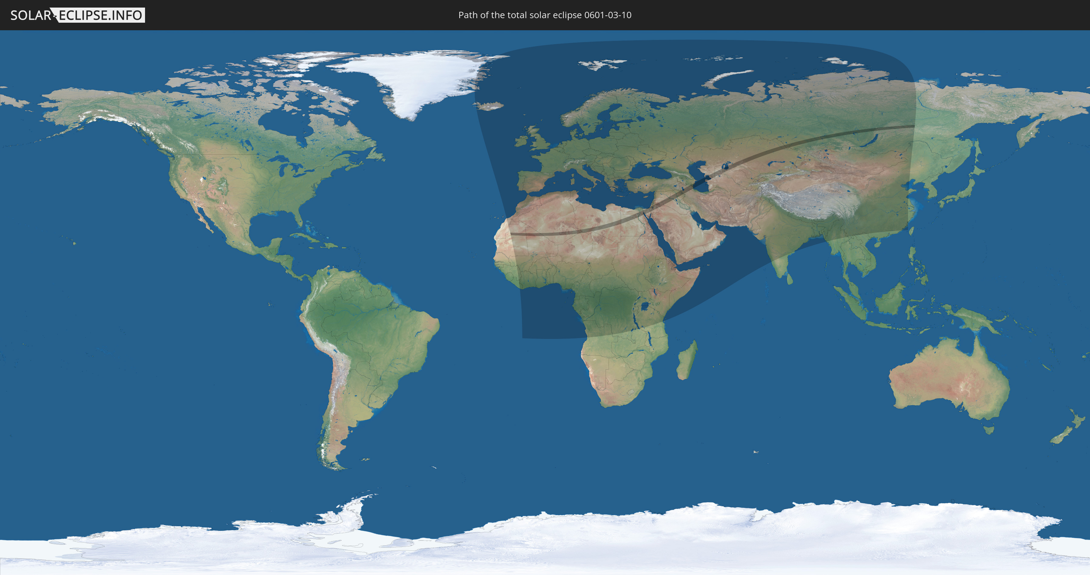
Die Sonnenfinsternis am 10.03.0601 kann man in 124 Ländern als partielle Sonnenfinsternis beobachten.
Der Finsternispfad verläuft durch 18 Länder. Nur in diesen Ländern ist sie als totale Sonnenfinsternis zu sehen.
In den folgenden Ländern ist die Sonnenfinsternis total zu sehen
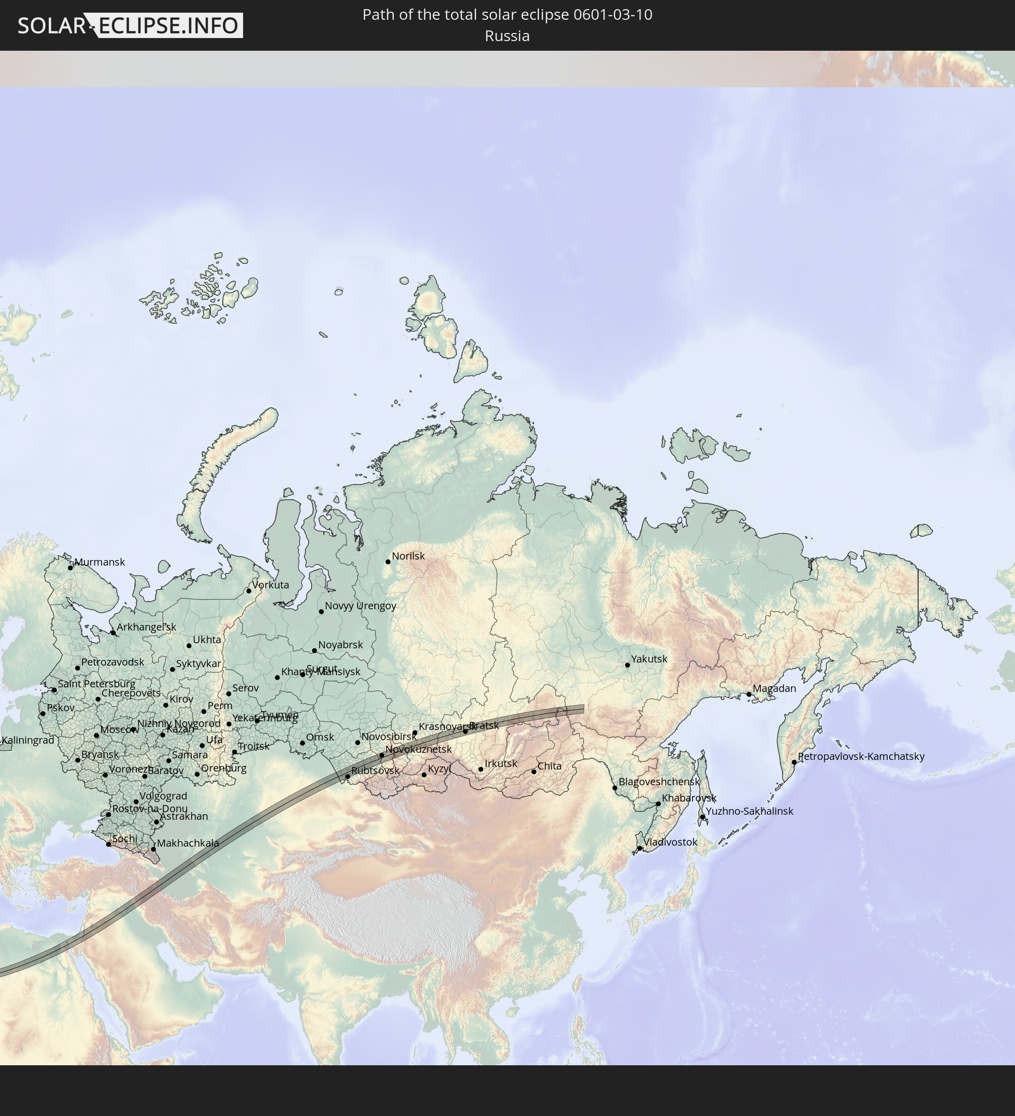 Russland
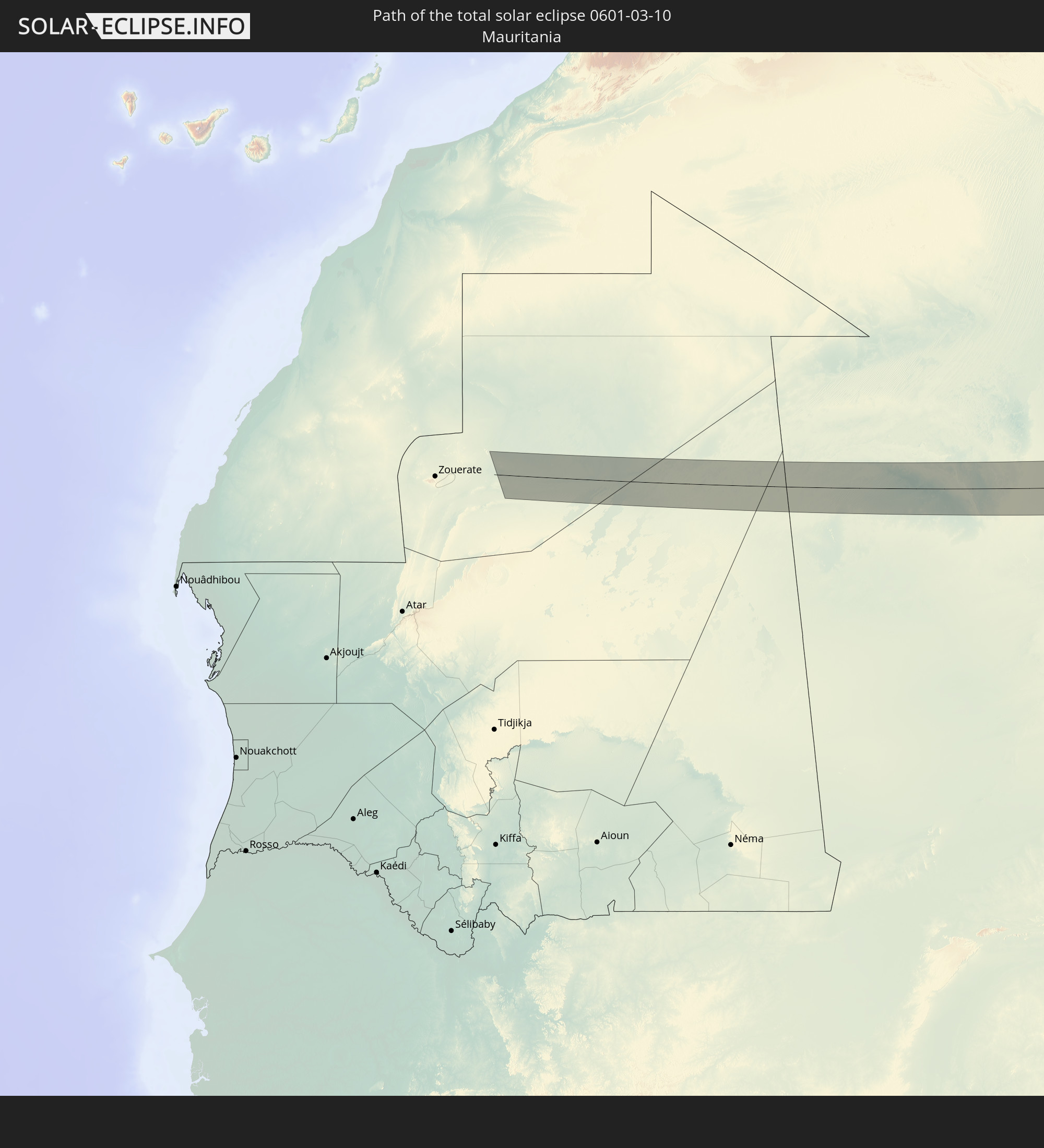 Mauretanien
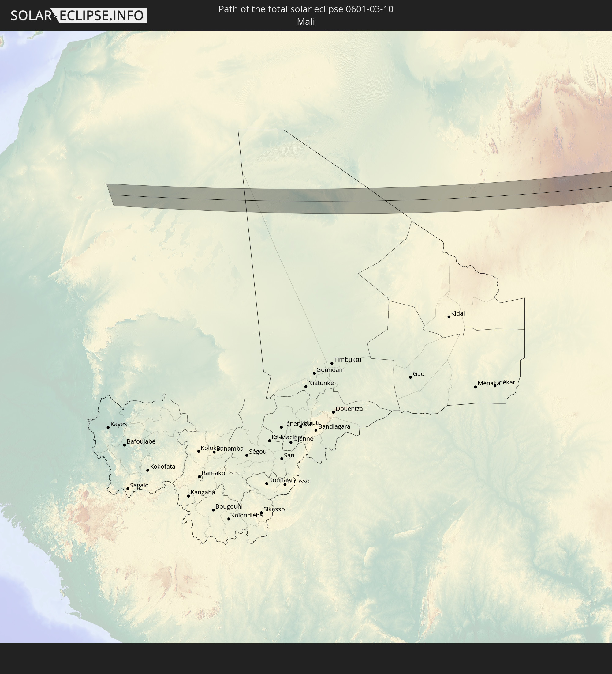 Mali
Mali
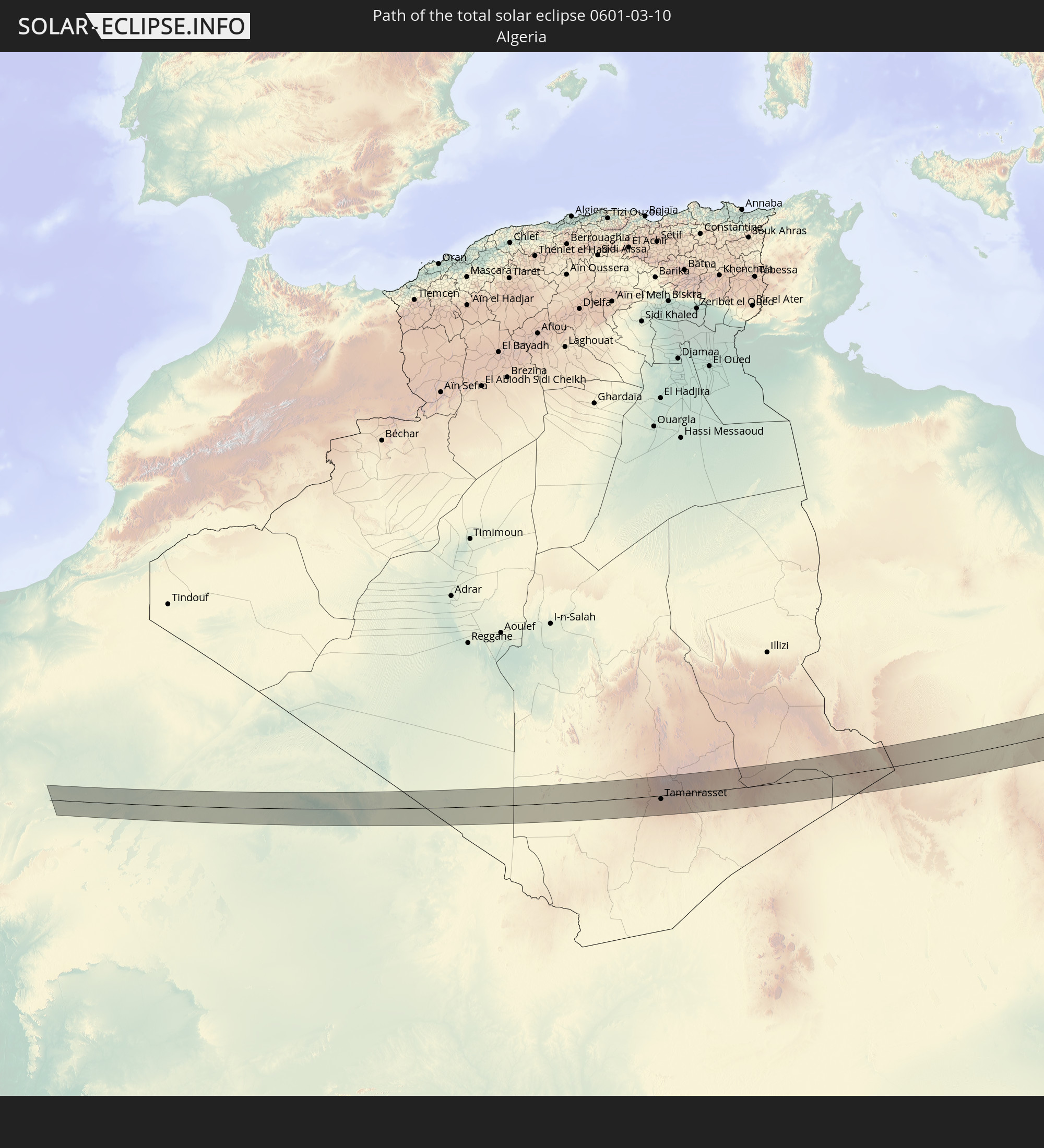 Algerien
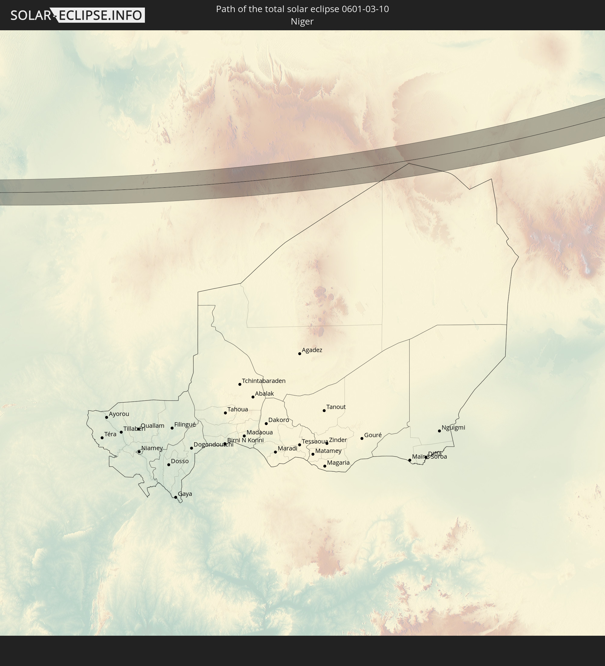 Niger
Niger
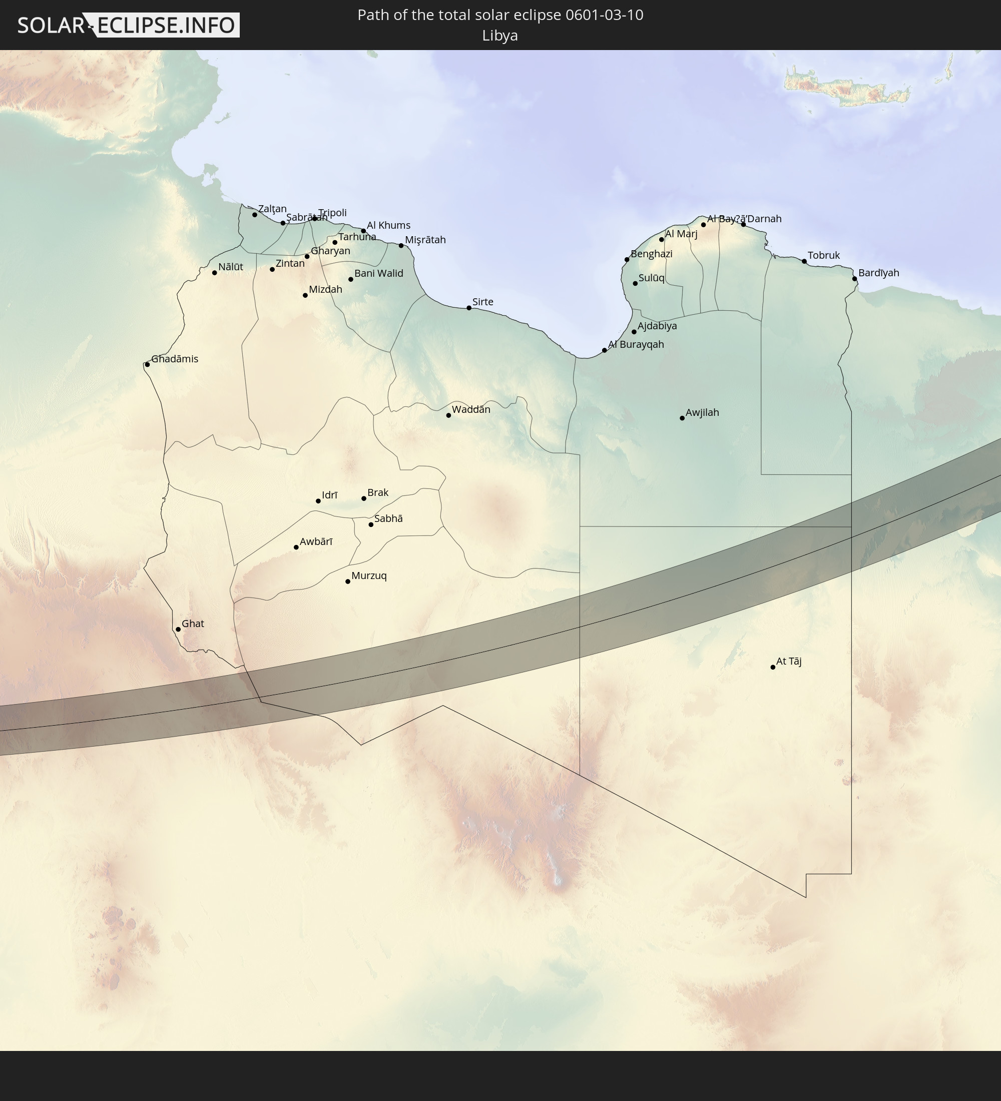 Libyen
 Ägypten
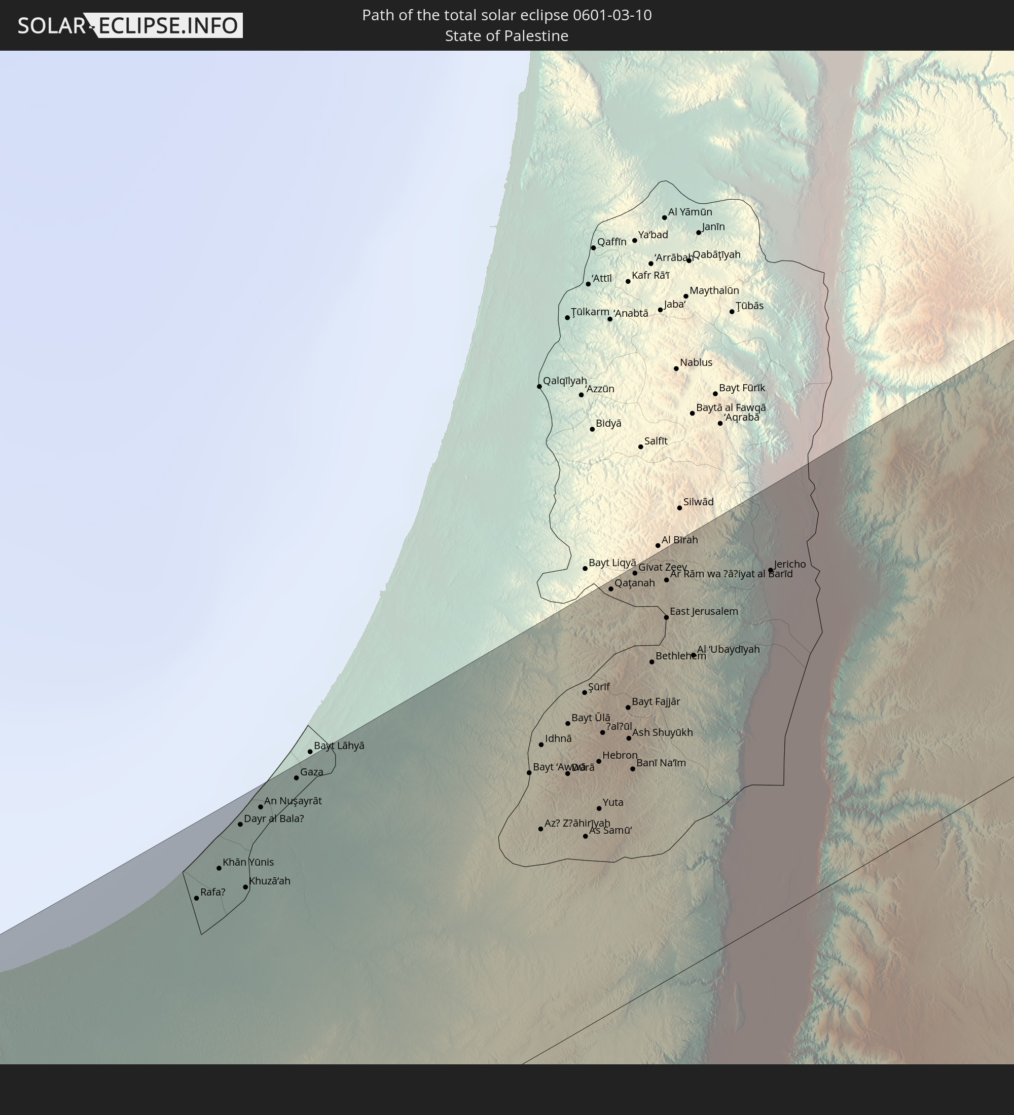 Staat Palästina
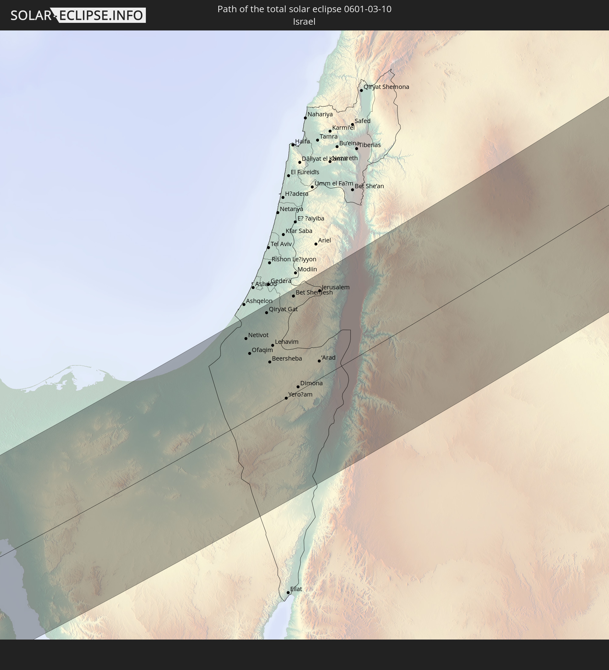 Israel
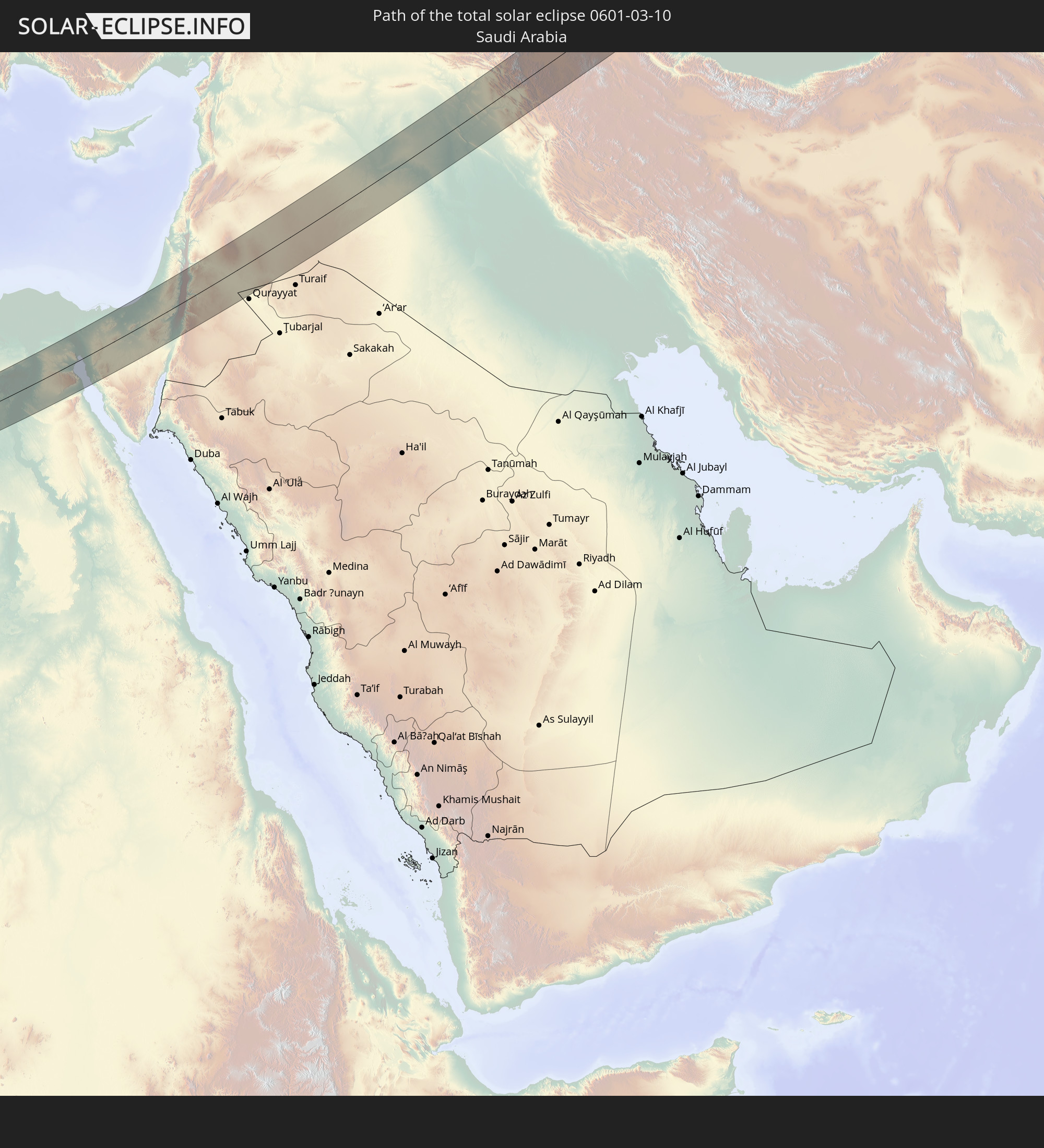 Saudi-Arabien
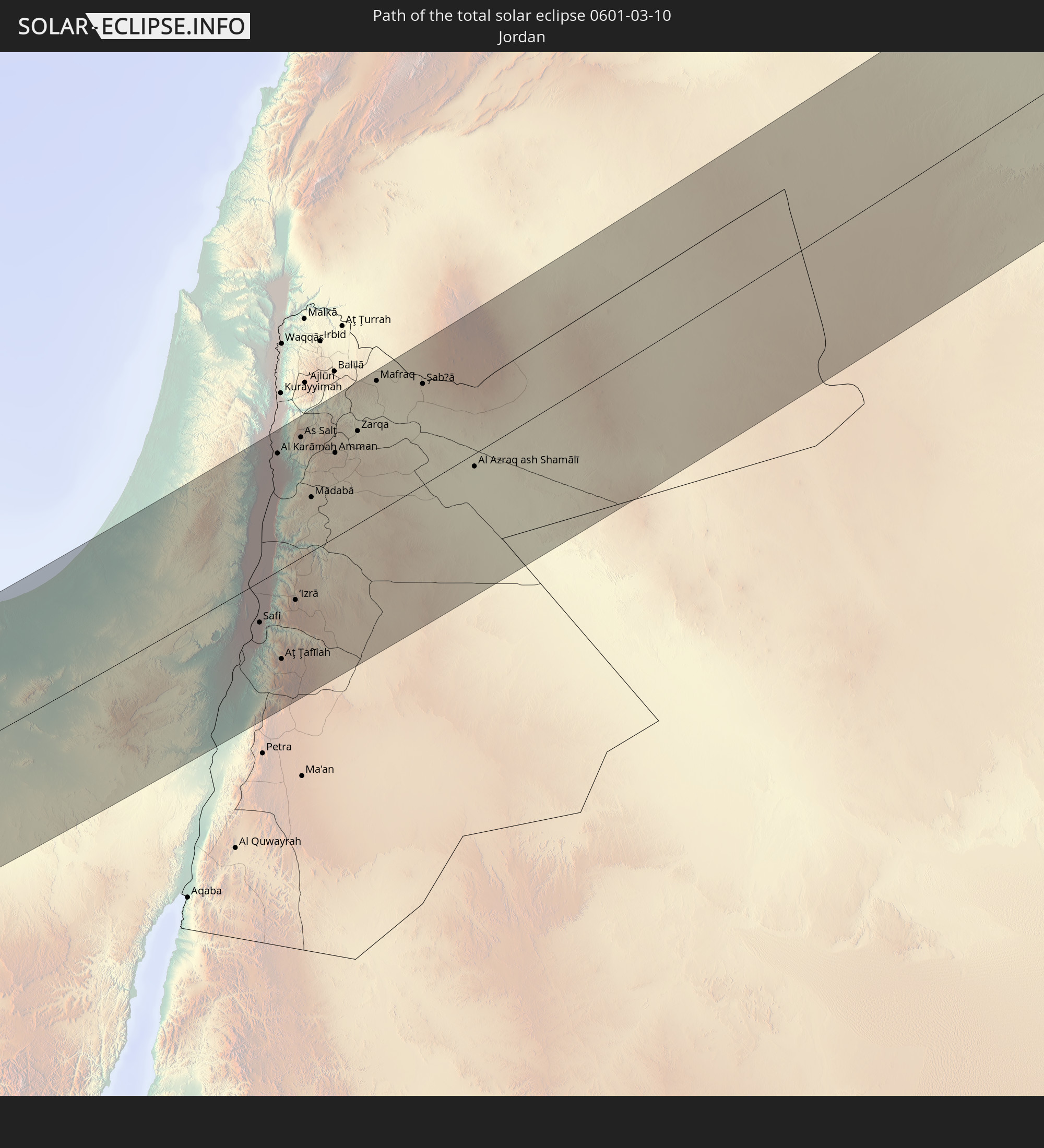 Jordanien
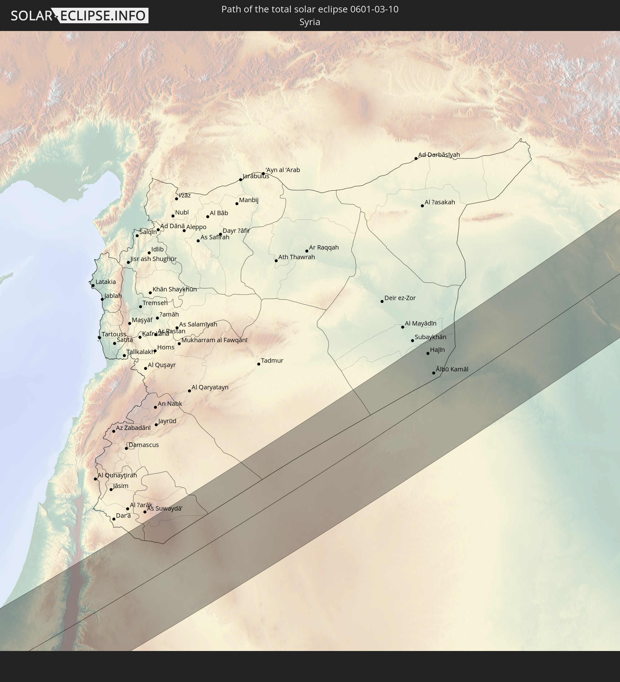 Syrien
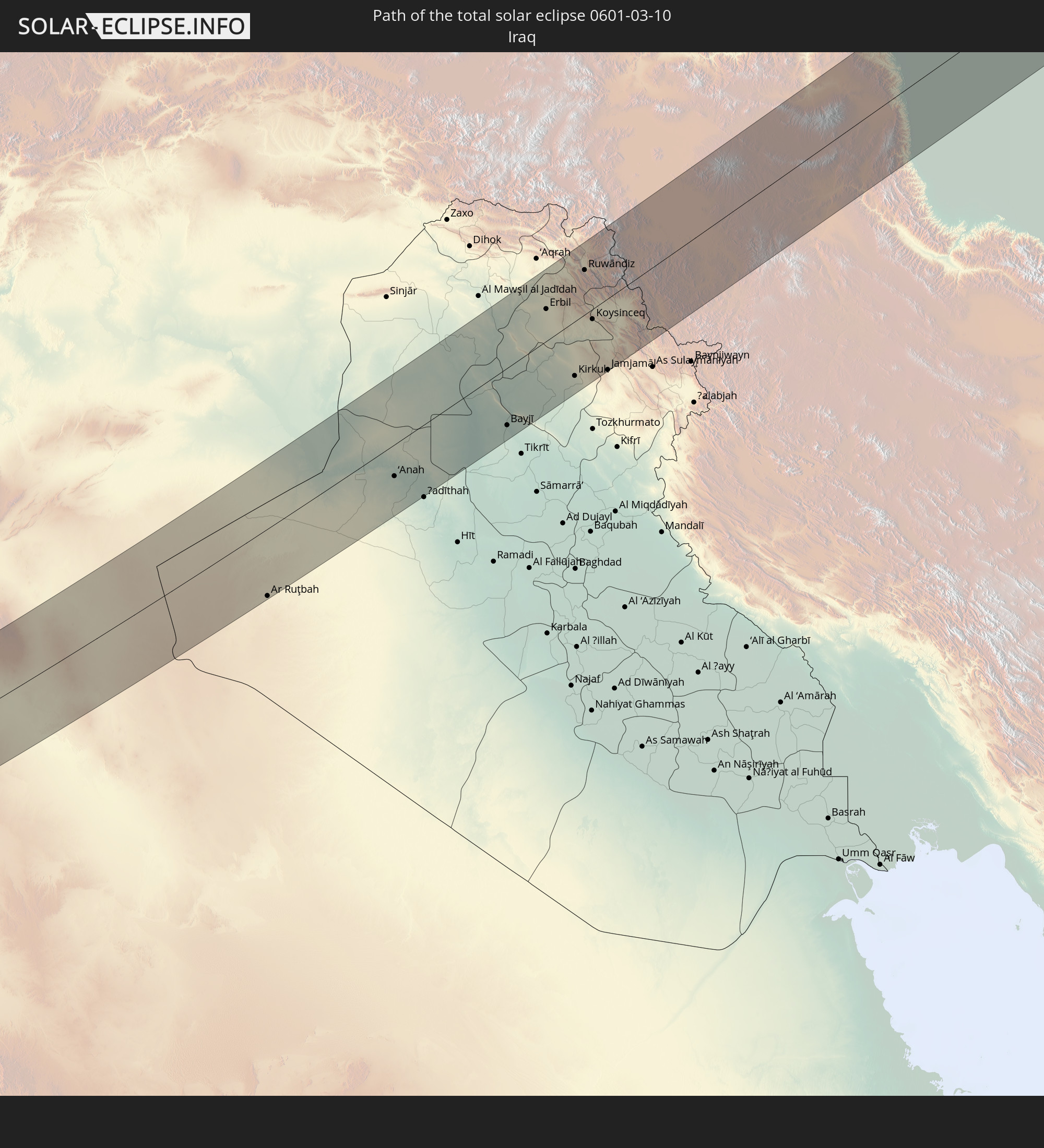 Irak
Irak
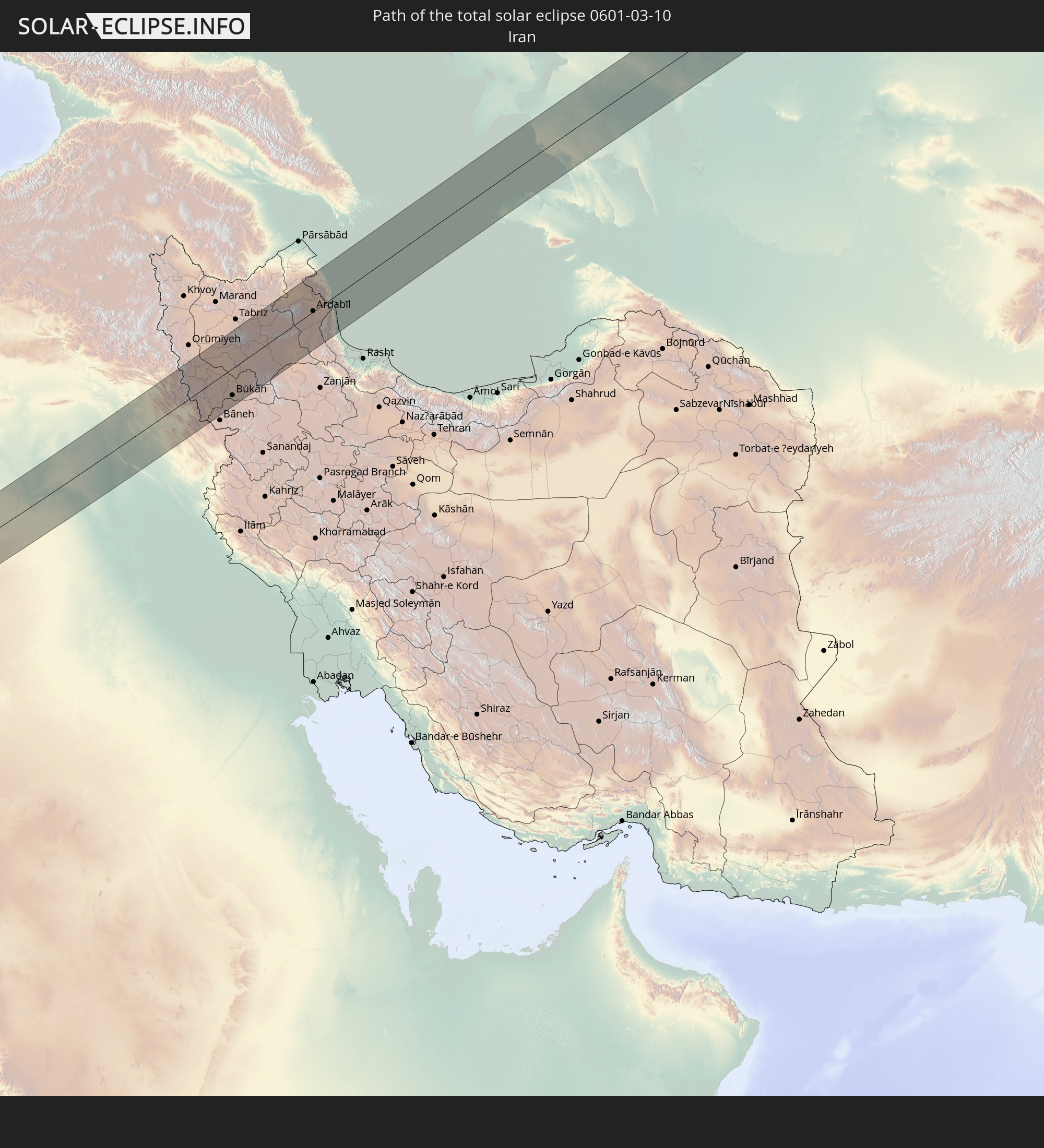 Iran
Iran
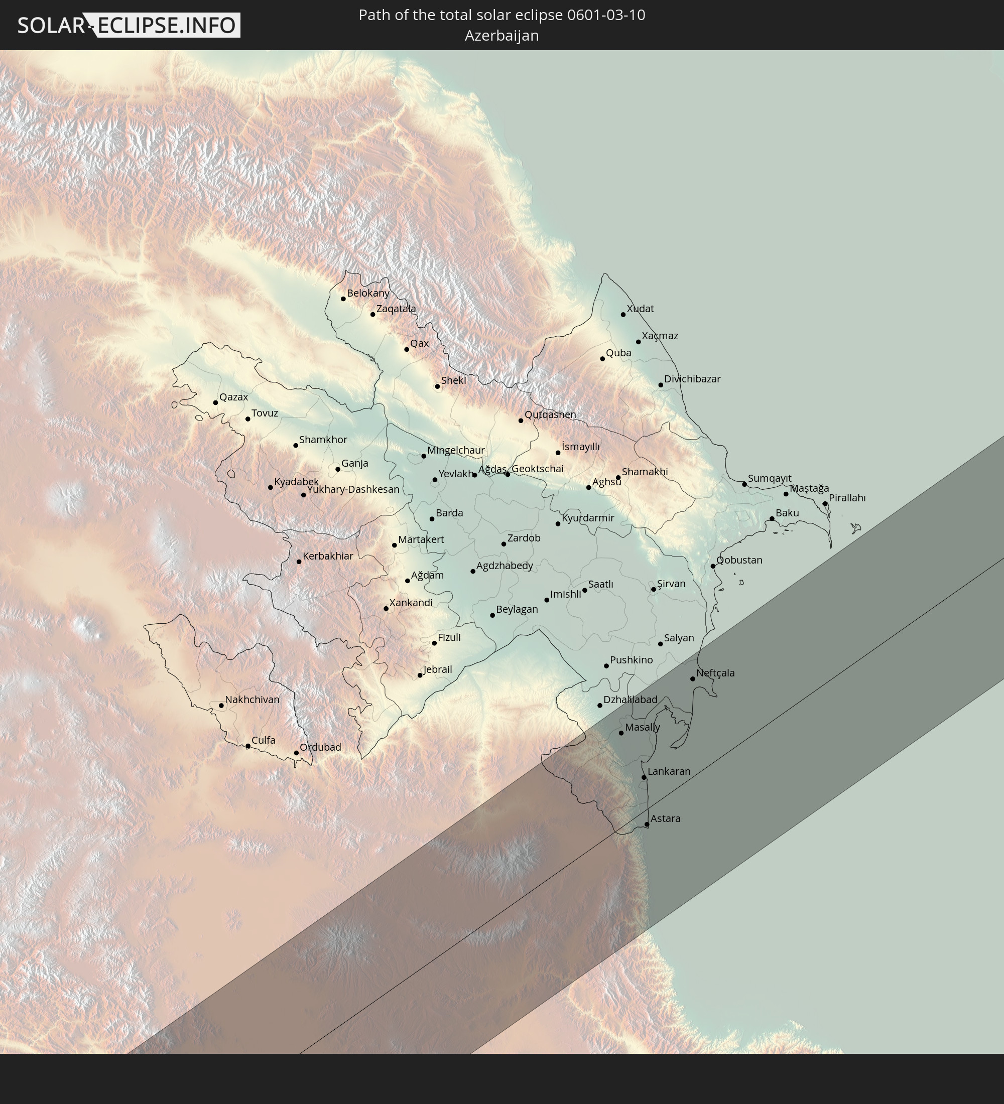 Aserbaidschan
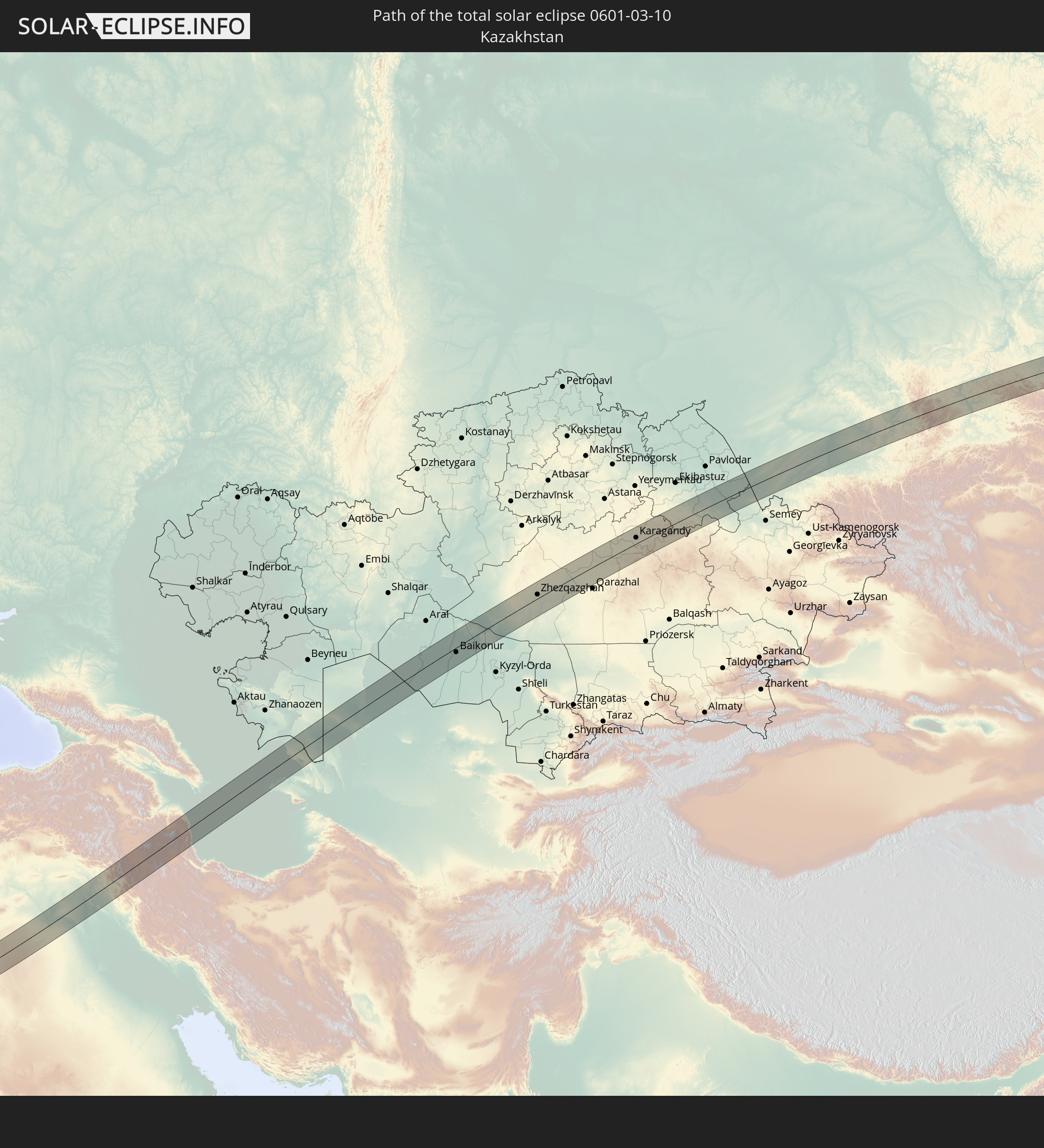 Kasachstan
 Turkmenistan
 Usbekistan
In den folgenden Ländern ist die Sonnenfinsternis partiell zu sehen
 Russland
 Grönland
 Portugal
 Island
 Spanien
 Mauretanien
 Guinea
 Marokko
 Mali
Mali
 Liberia
 Irland
 Spitzbergen
 Algerien
 Vereinigtes Königreich
 Elfenbeinküste
 Färöer
 Burkina Faso
 Gibraltar
 Frankreich
 Isle of Man
 Ghana
Ghana
 Guernsey
 Jersey
 Togo
Togo
 Niger
Niger
 Benin
Benin
 Andorra
 Belgien
 Nigeria
 Niederlande
 Norwegen
 Äquatorialguinea
 Luxemburg
 Deutschland
 Schweiz
 São Tomé und Príncipe
 Italien
 Monaco
 Tunesien
 Dänemark
 Kamerun
 Gabun
Gabun
 Libyen
 Liechtenstein
 Österreich
 Schweden
 Republik Kongo
 Angola
 Tschechien
 Demokratische Republik Kongo
 San Marino
 Vatikanstadt
 Slowenien
 Tschad
 Kroatien
 Polen
Polen
 Malta
Malta
 Zentralafrikanische Republik
 Bosnien und Herzegowina
 Ungarn
 Slowakei
 Montenegro
 Serbien
 Albanien
 Åland Islands
 Griechenland
 Rumänien
 Mazedonien
 Finnland
 Litauen
 Lettland
 Estland
 Sudan
Sudan
 Sambia
 Ukraine
 Bulgarien
 Weißrussland
 Ägypten
 Türkei
 Moldawien
 Ruanda
 Burundi
 Tansania
 Uganda
 Republik Zypern
 Äthiopien
 Kenia
Kenia
 Staat Palästina
 Israel
 Saudi-Arabien
 Jordanien
 Libanon
 Syrien
 Eritrea
 Irak
Irak
 Georgien
 Somalia
 Dschibuti
 Jemen
Jemen
 Armenien
 Iran
Iran
 Aserbaidschan
 Kasachstan
 Kuwait
 Bahrain
 Katar
Katar
 Vereinigte Arabische Emirate
 Oman
Oman
 Turkmenistan
 Usbekistan
 Afghanistan
 Pakistan
 Tadschikistan
 Indien
 Kirgisistan
 Volksrepublik China
 Nepal
Nepal
 Mongolei
 Bangladesch
 Bhutan
 Myanmar
 Laos
Laos
 Vietnam
 Taiwan
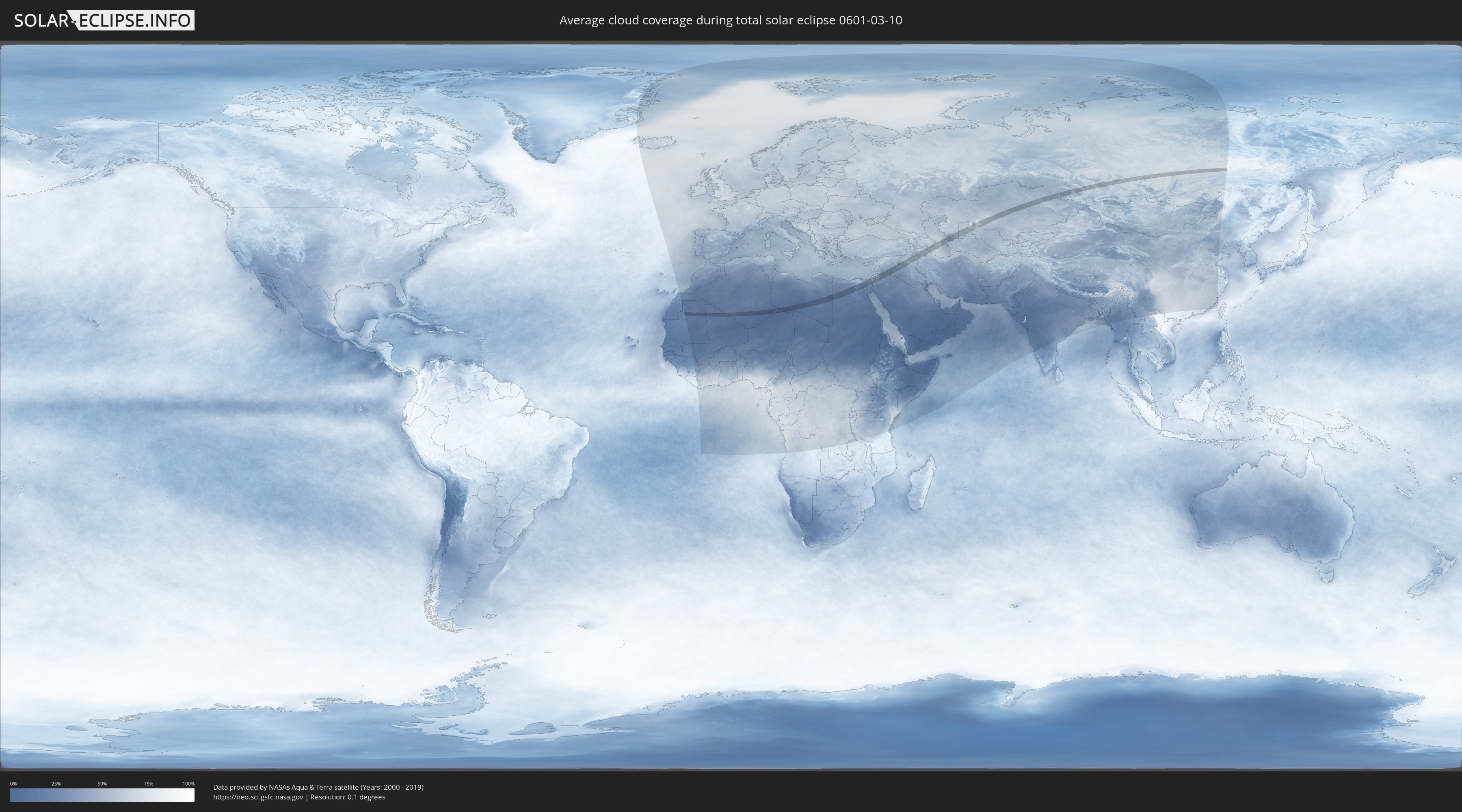
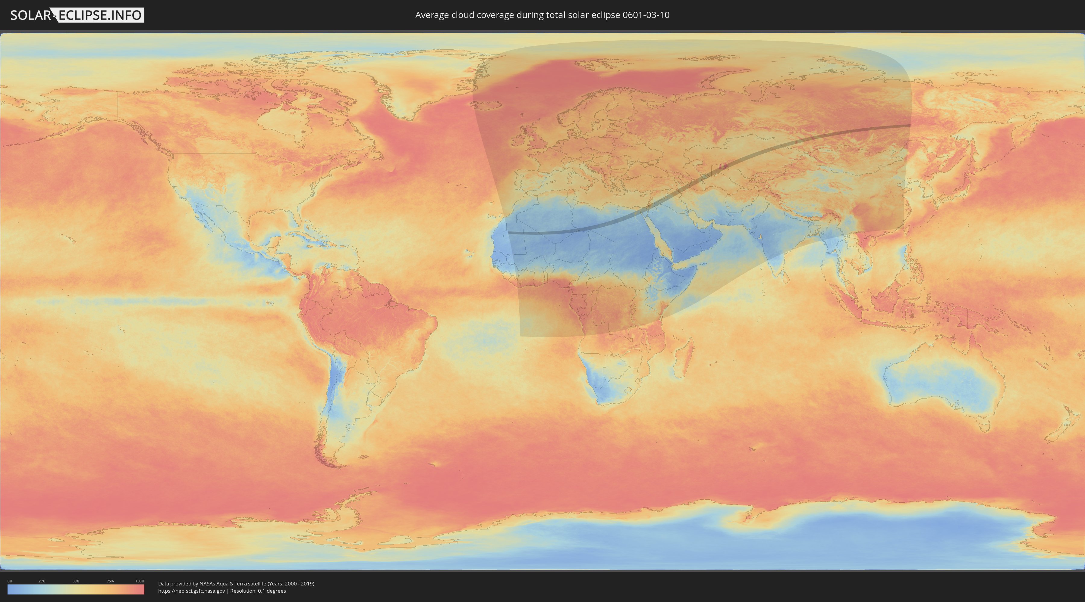
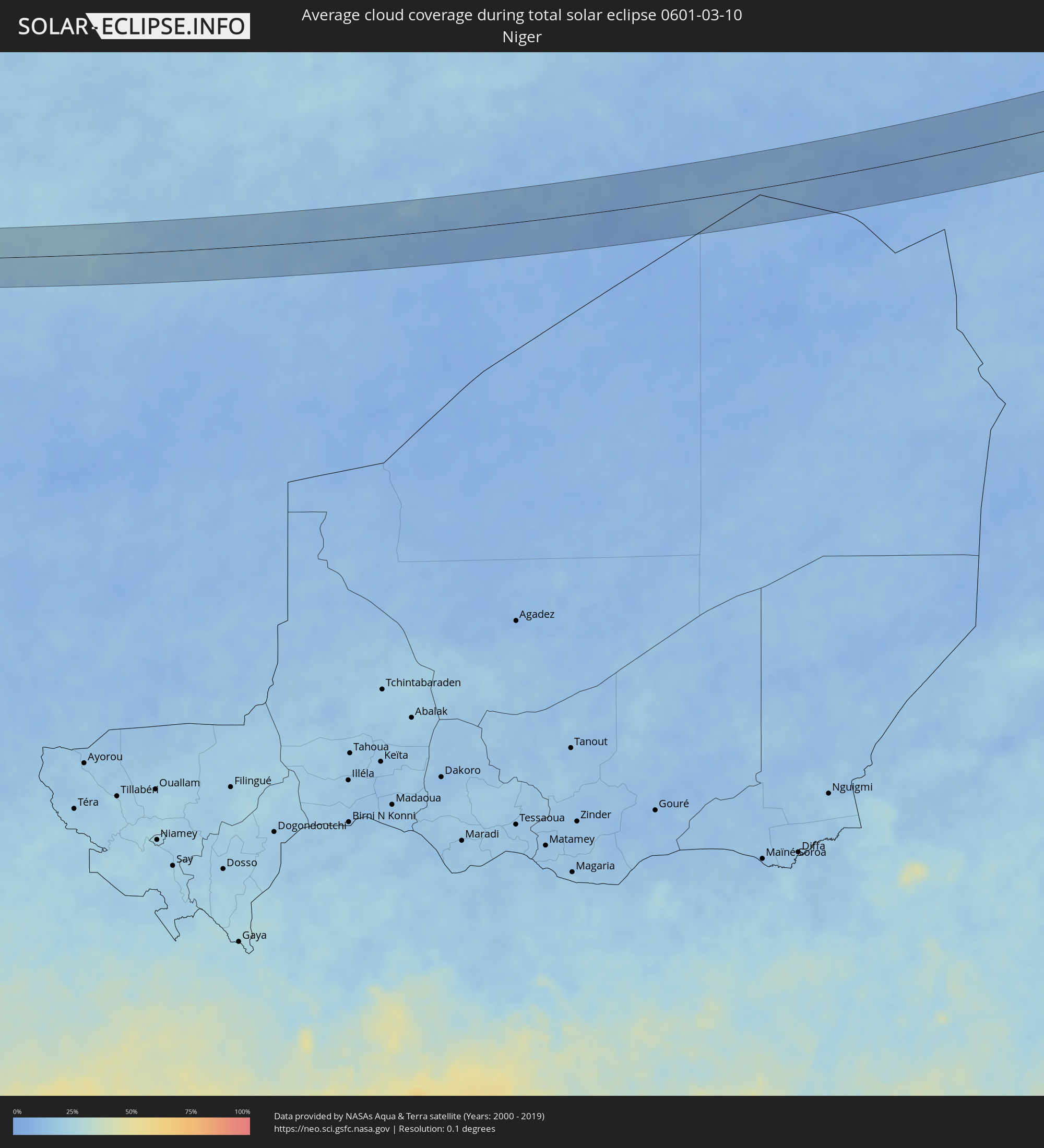
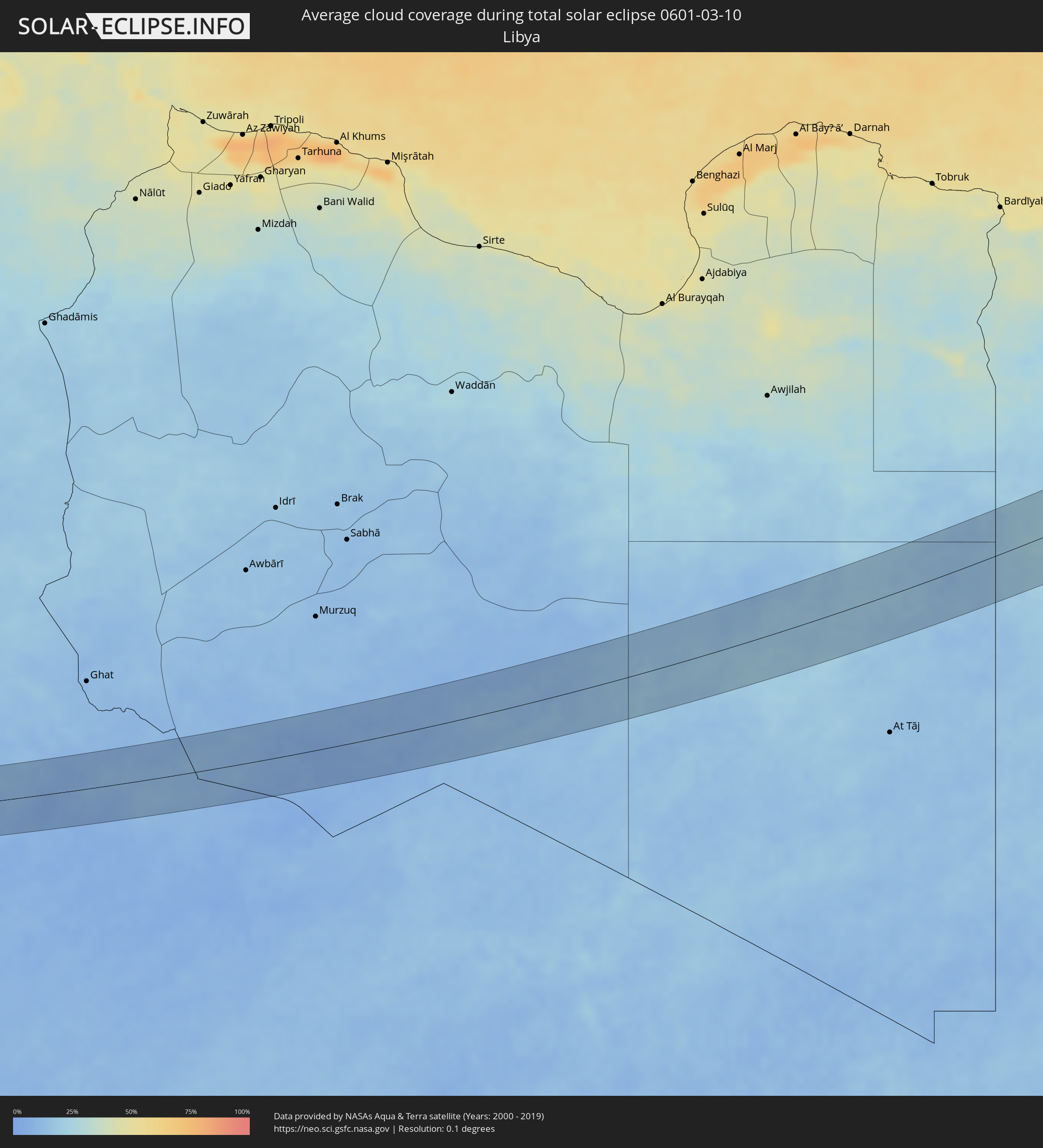
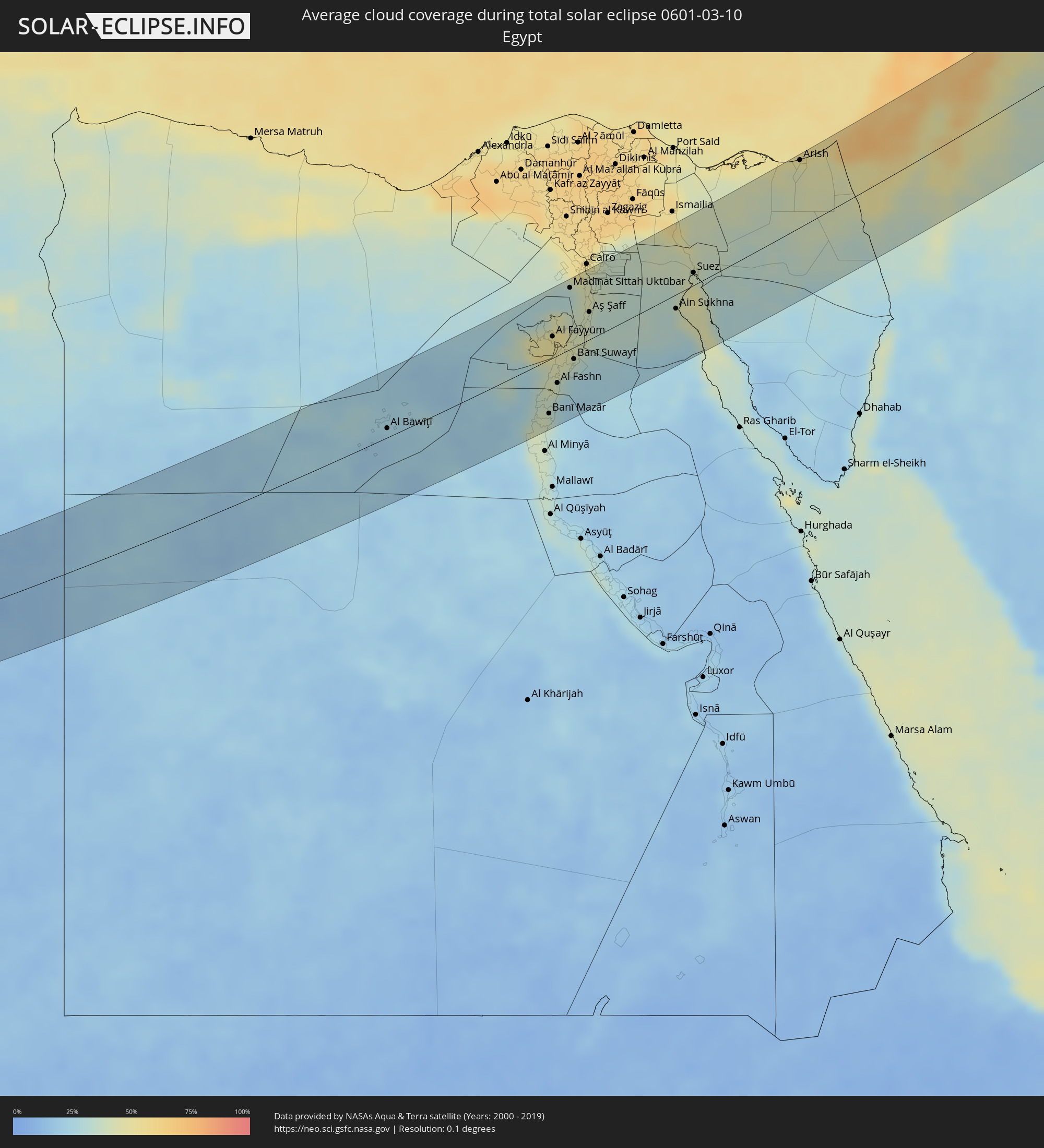
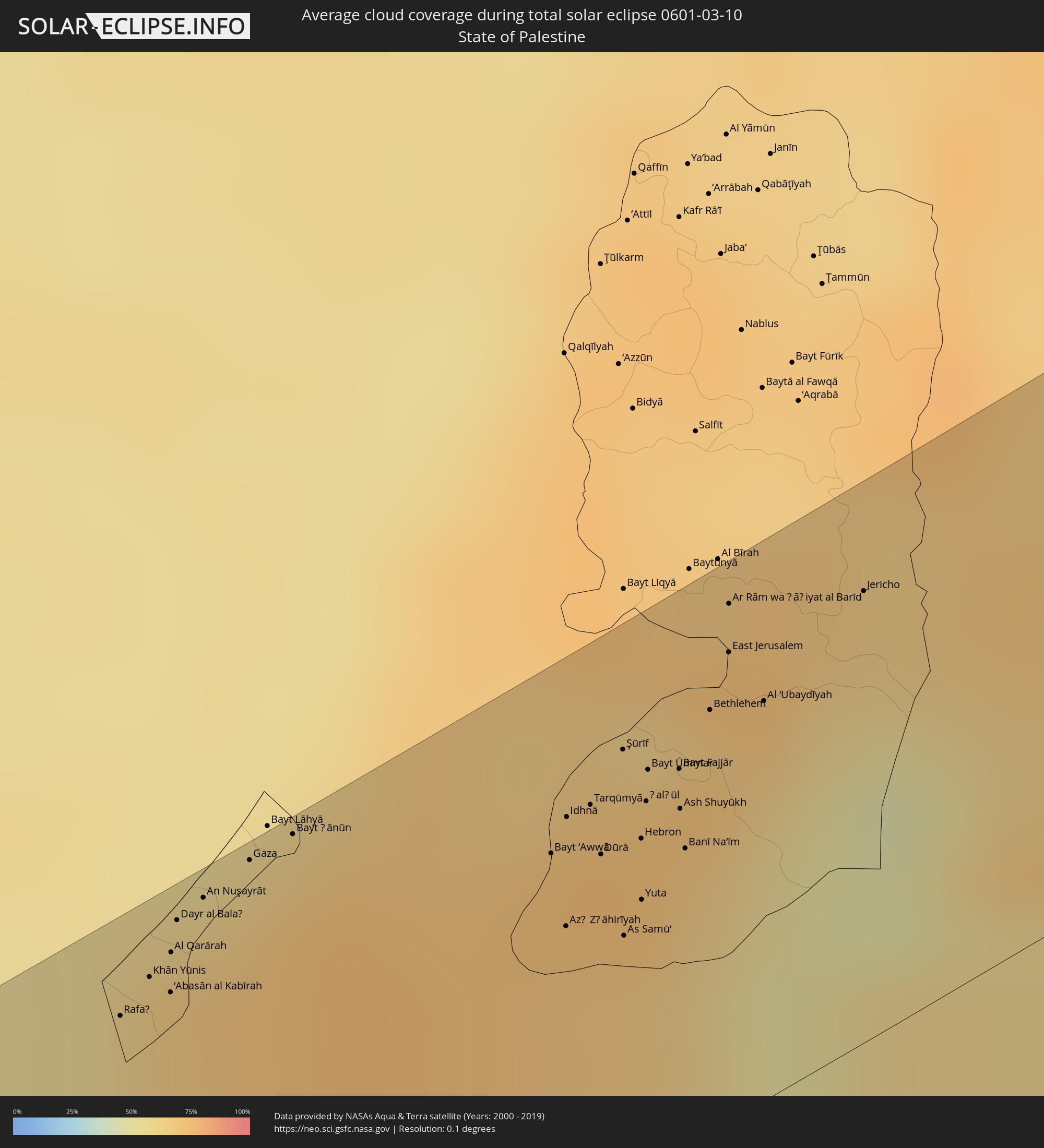
Wie wird das Wetter während der totalen Sonnenfinsternis am 10.03.0601?
Wo ist der beste Ort, um die totale Sonnenfinsternis vom 10.03.0601 zu beobachten?
Die folgenden Karten zeigen die durchschnittliche Bewölkung für den Tag, an dem die totale Sonnenfinsternis
stattfindet. Mit Hilfe der Karten lässt sich der Ort entlang des Finsternispfades eingrenzen,
der die besten Aussichen auf einen klaren wolkenfreien Himmel bietet.
Trotzdem muss man immer lokale Gegenenheiten beachten und sollte sich genau über das Wetter an seinem
gewählten Beobachtungsort informieren.
Die Daten stammen von den beiden NASA-Satelliten
AQUA und TERRA
und wurden über einen Zeitraum von 19 Jahren (2000 - 2019) gemittelt.
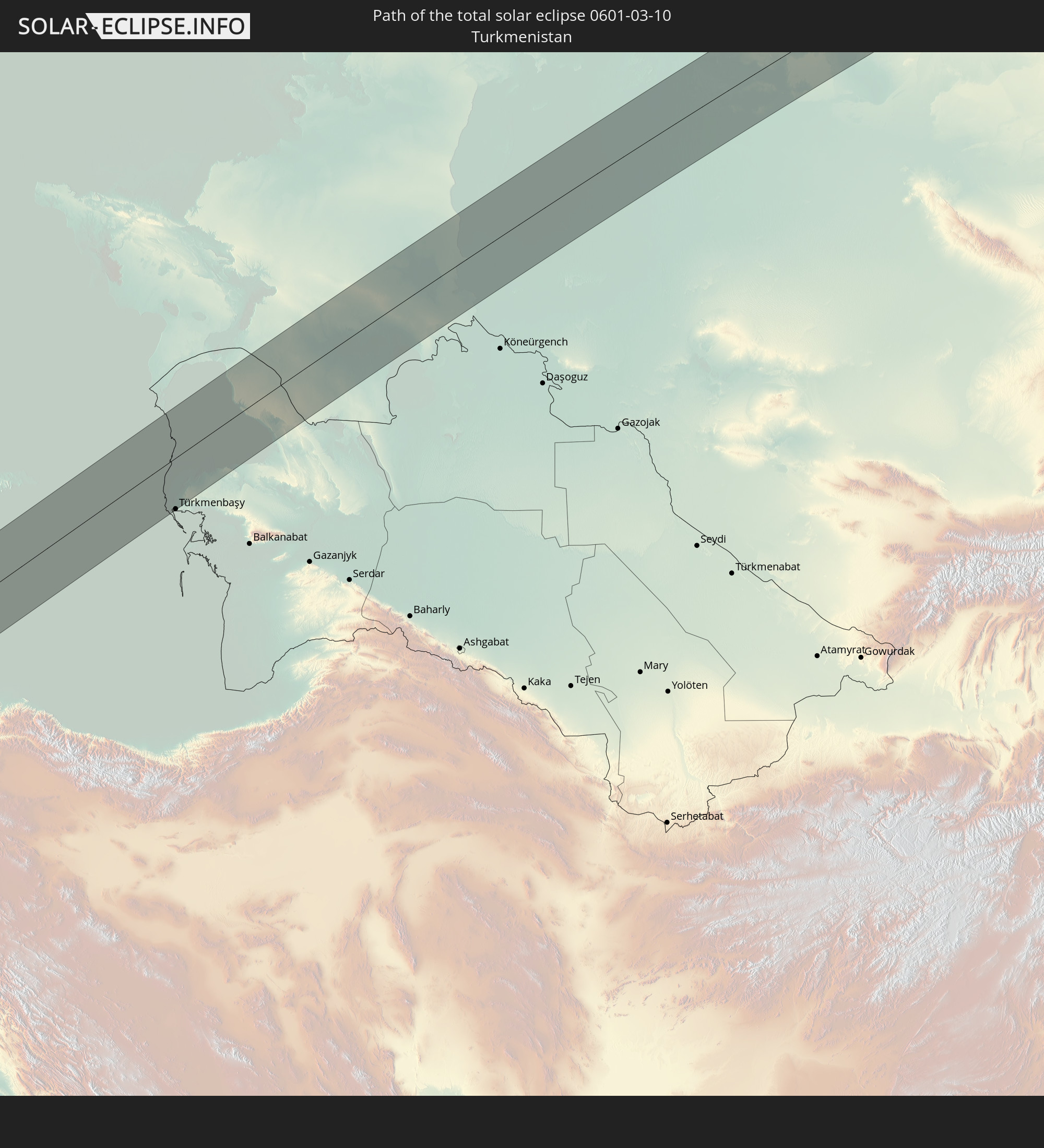
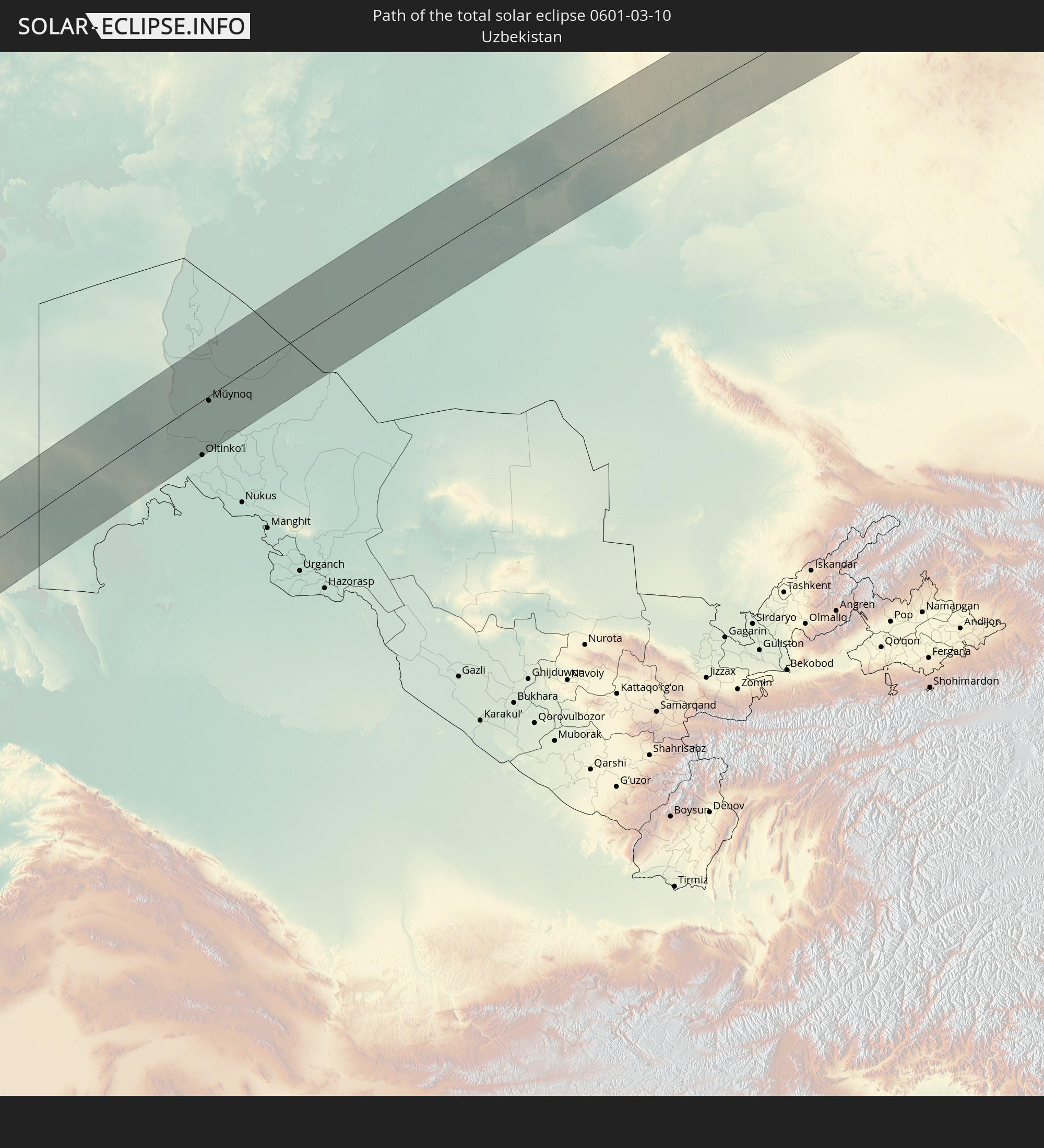
Detaillierte Länderkarten
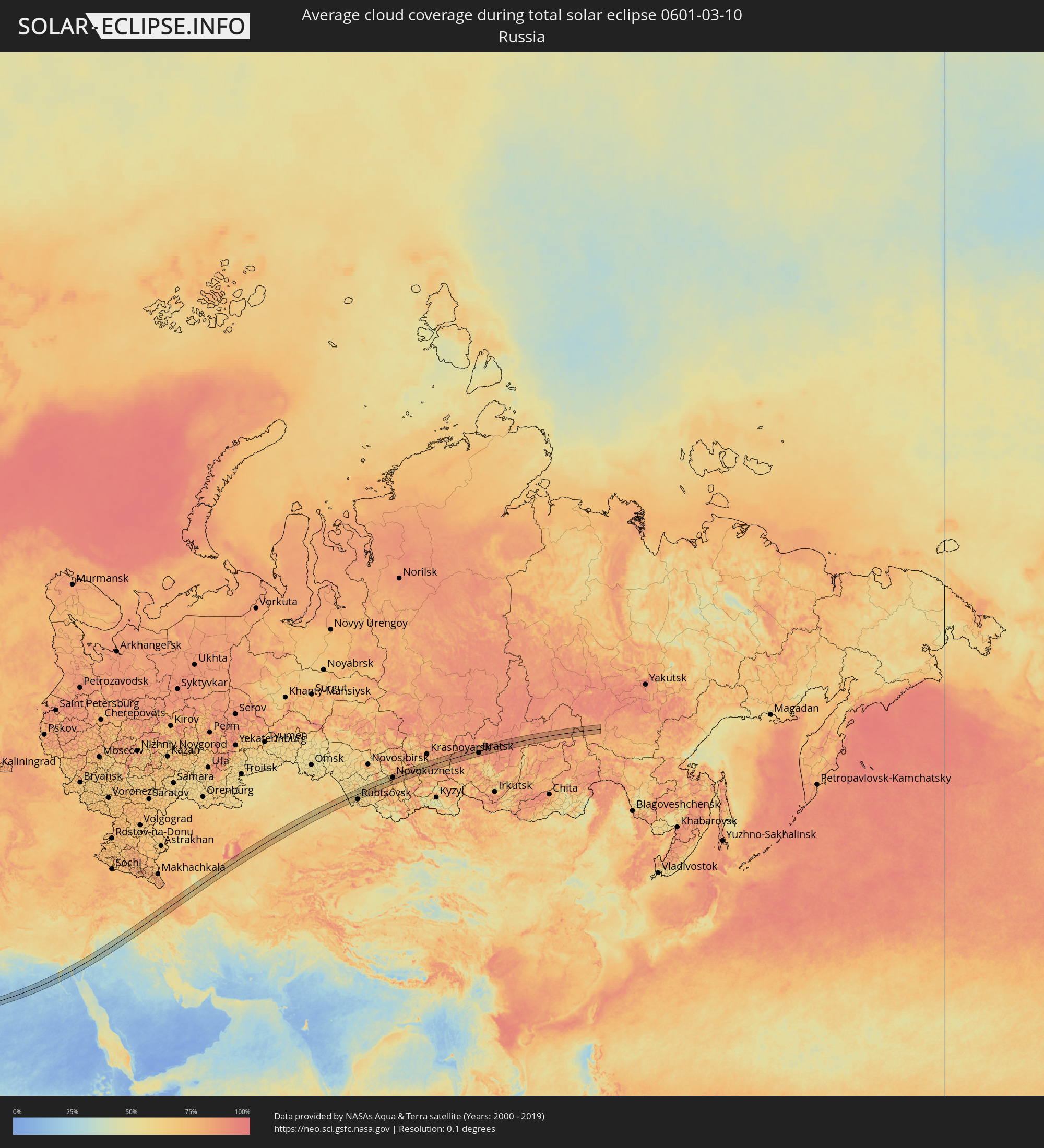 Russland
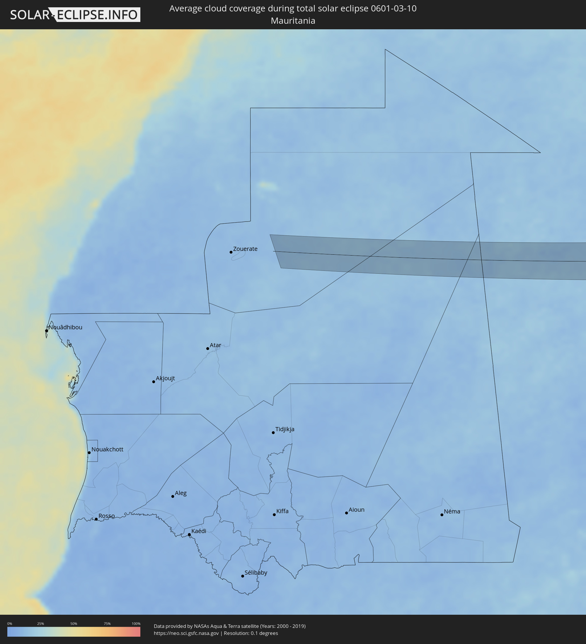 Mauretanien
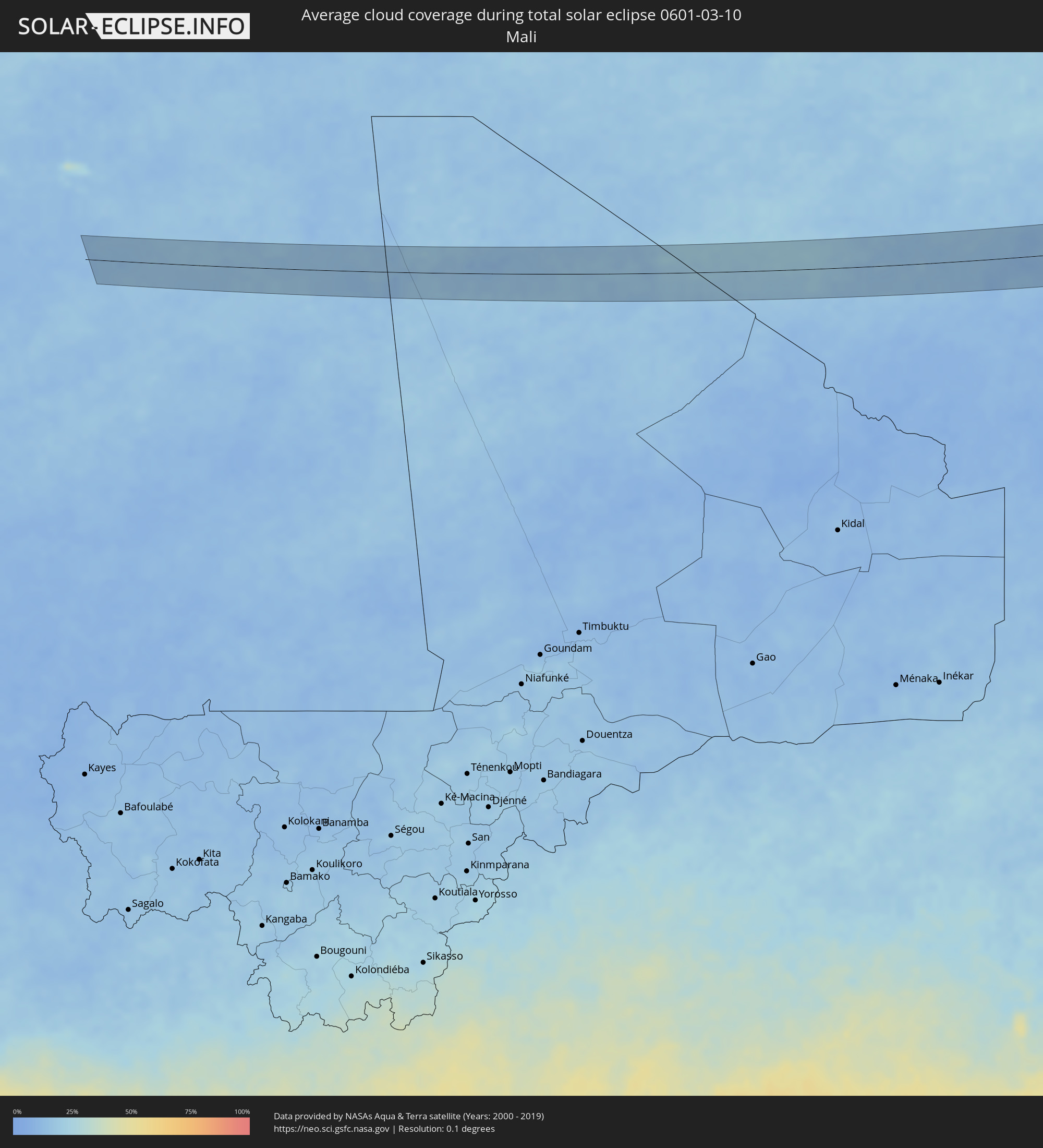 Mali
Mali
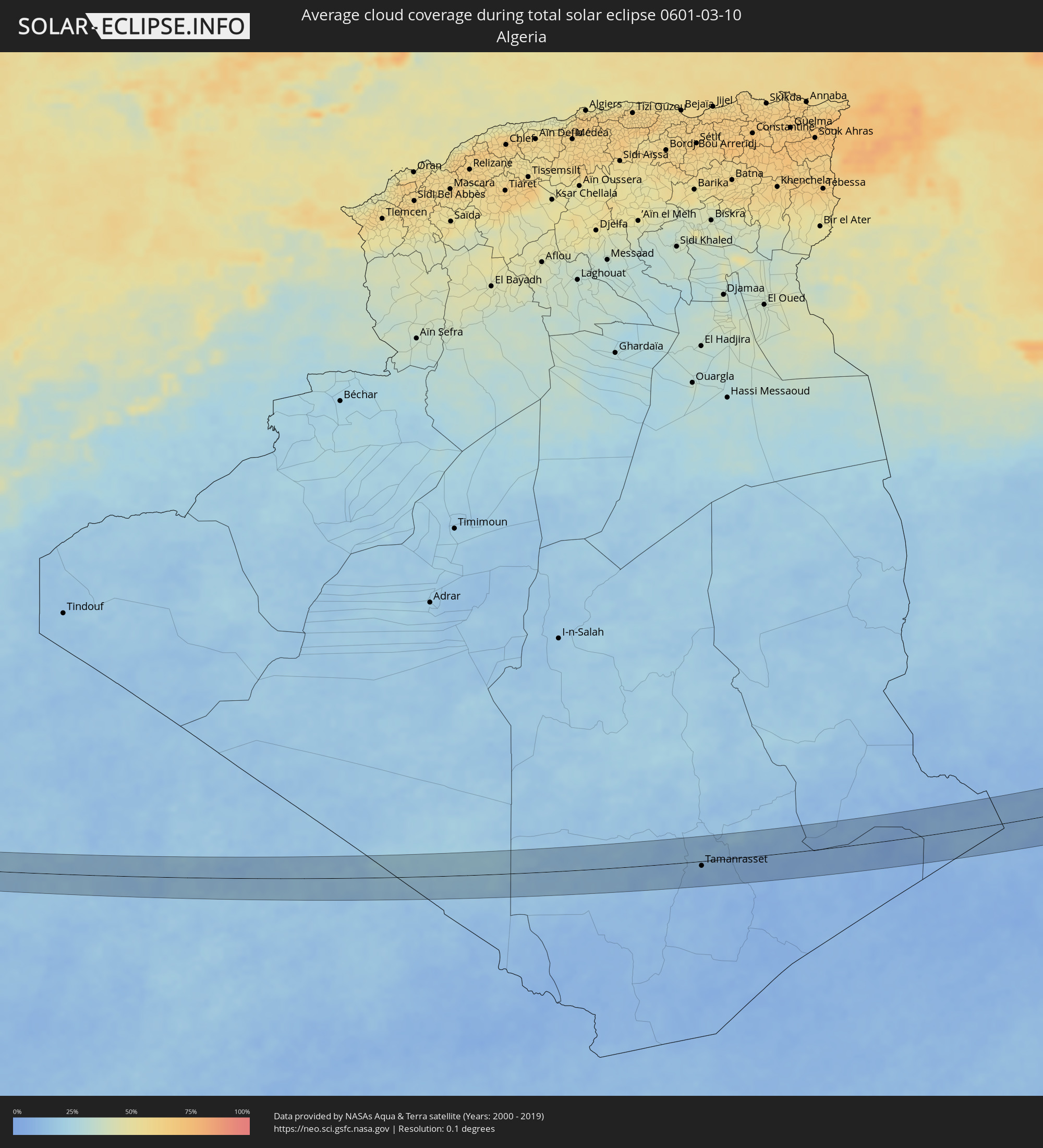 Algerien
 Niger
Niger
 Libyen
 Ägypten
 Staat Palästina
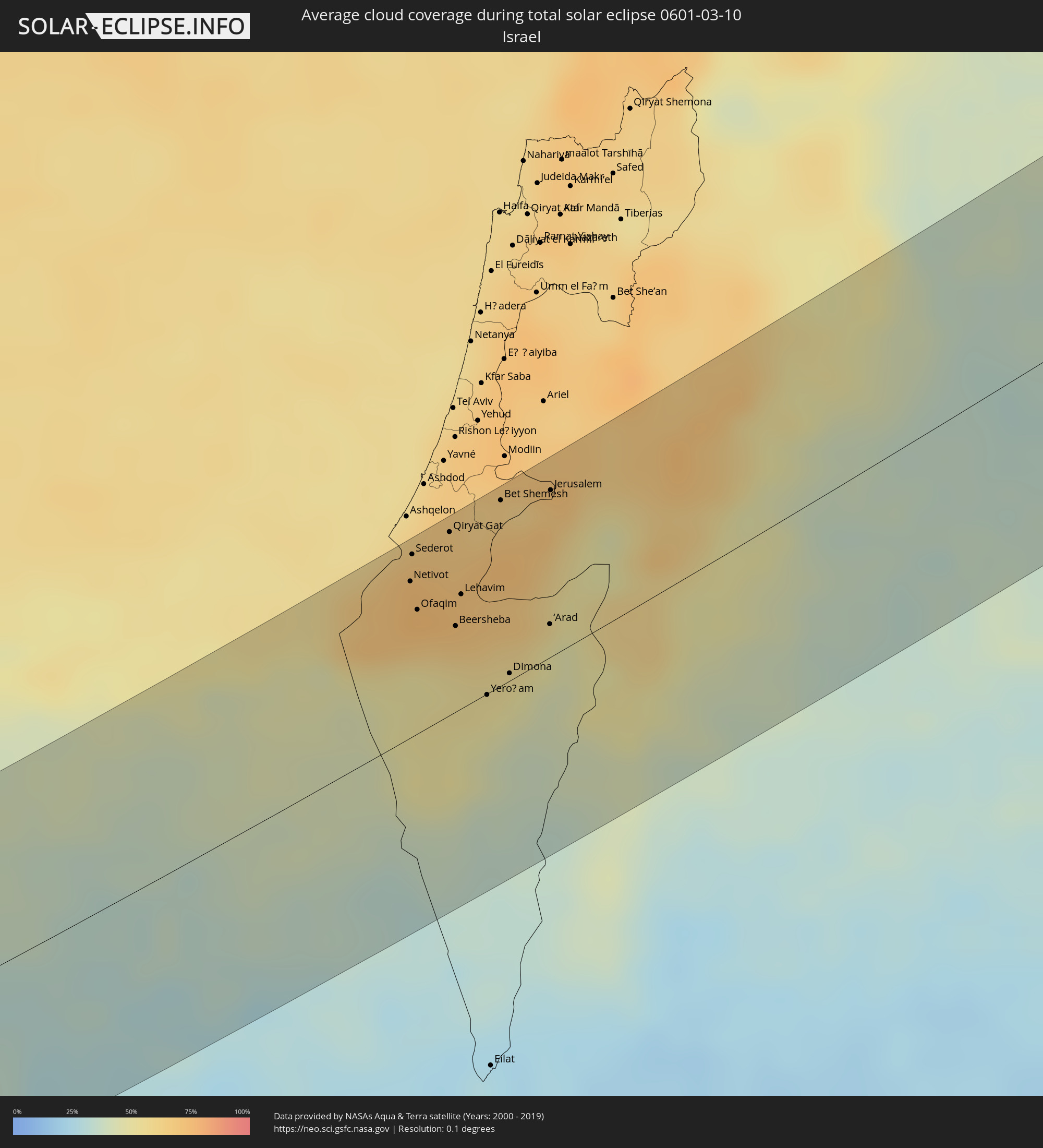 Israel
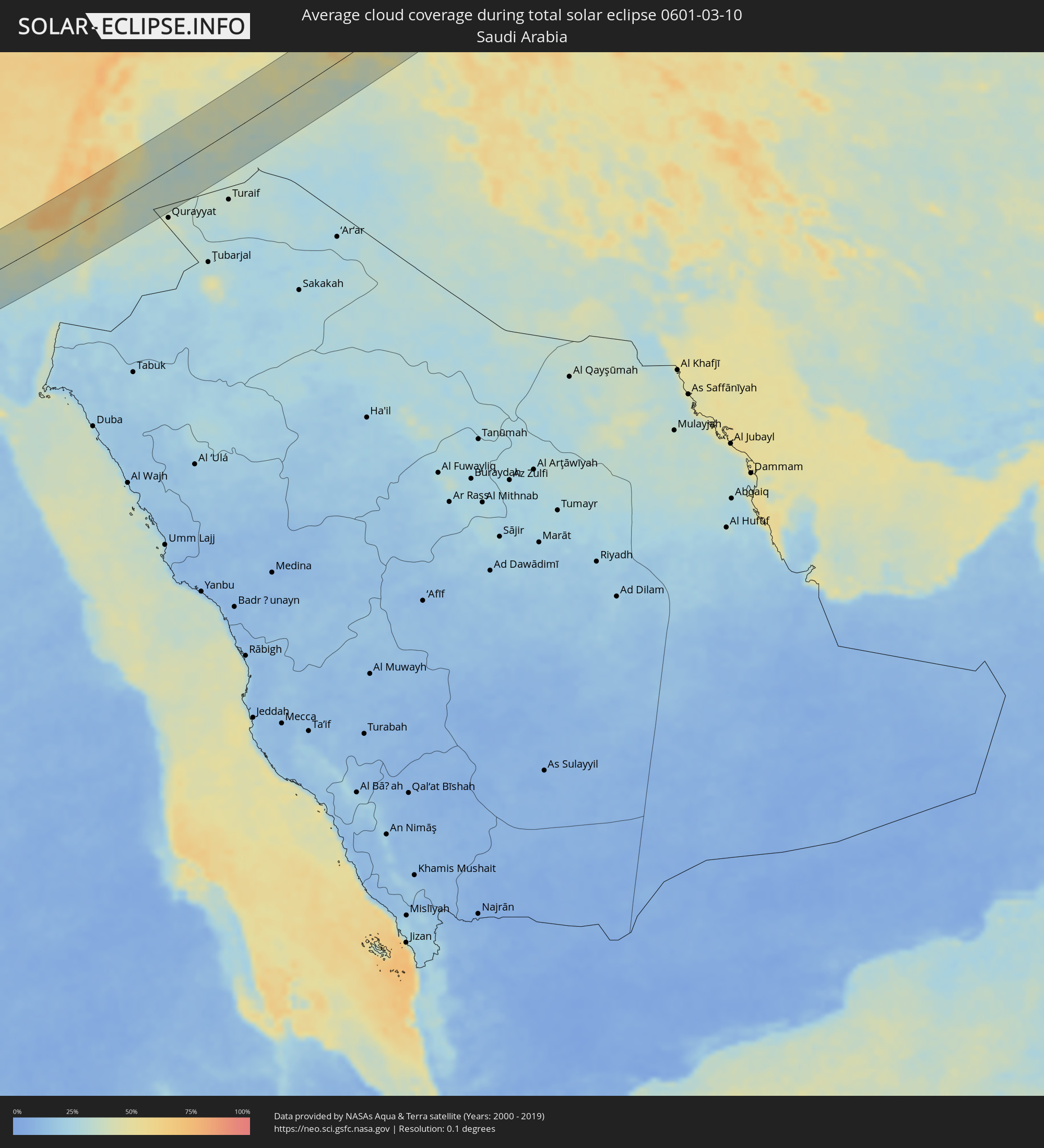 Saudi-Arabien
 Jordanien
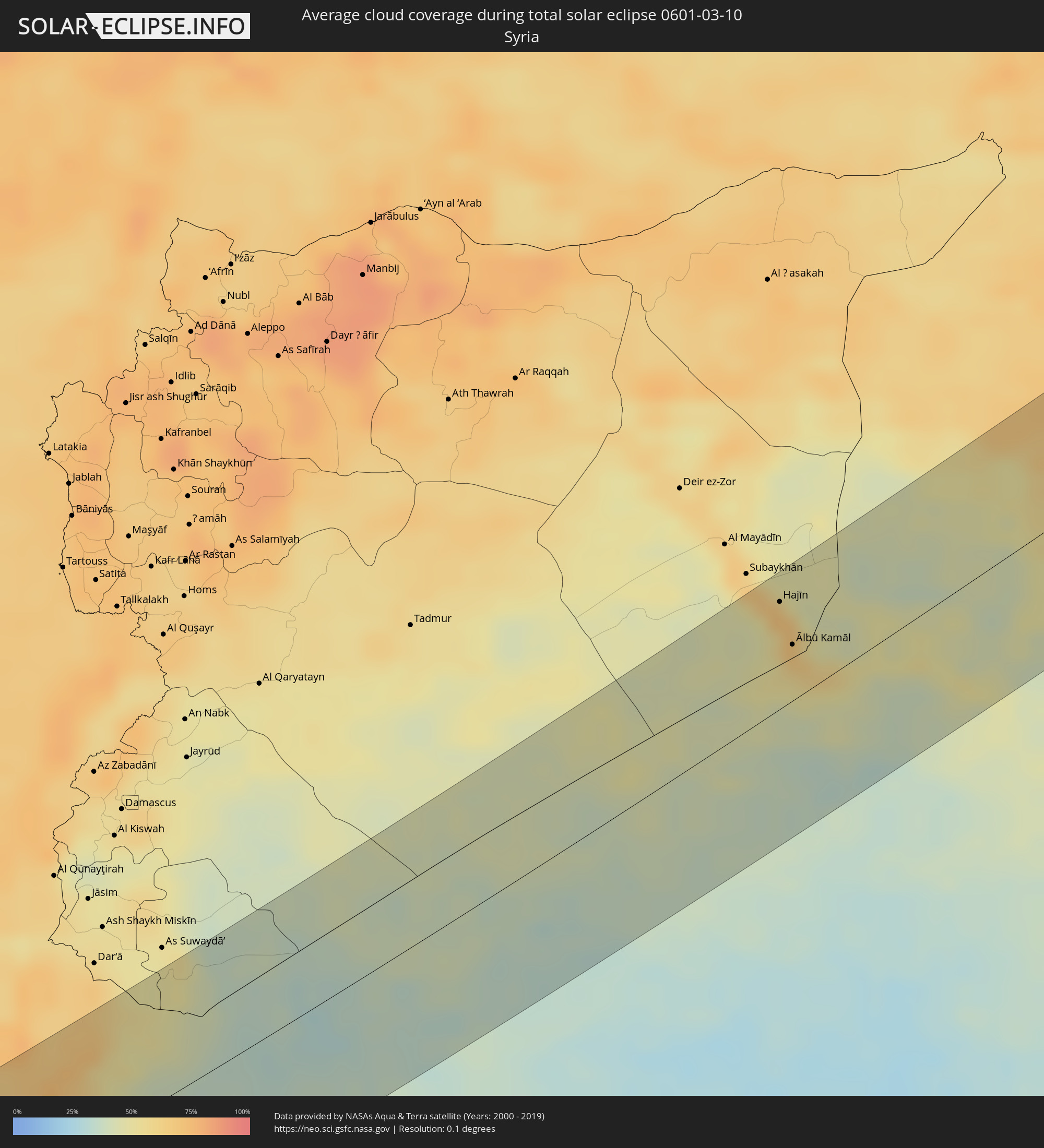 Syrien
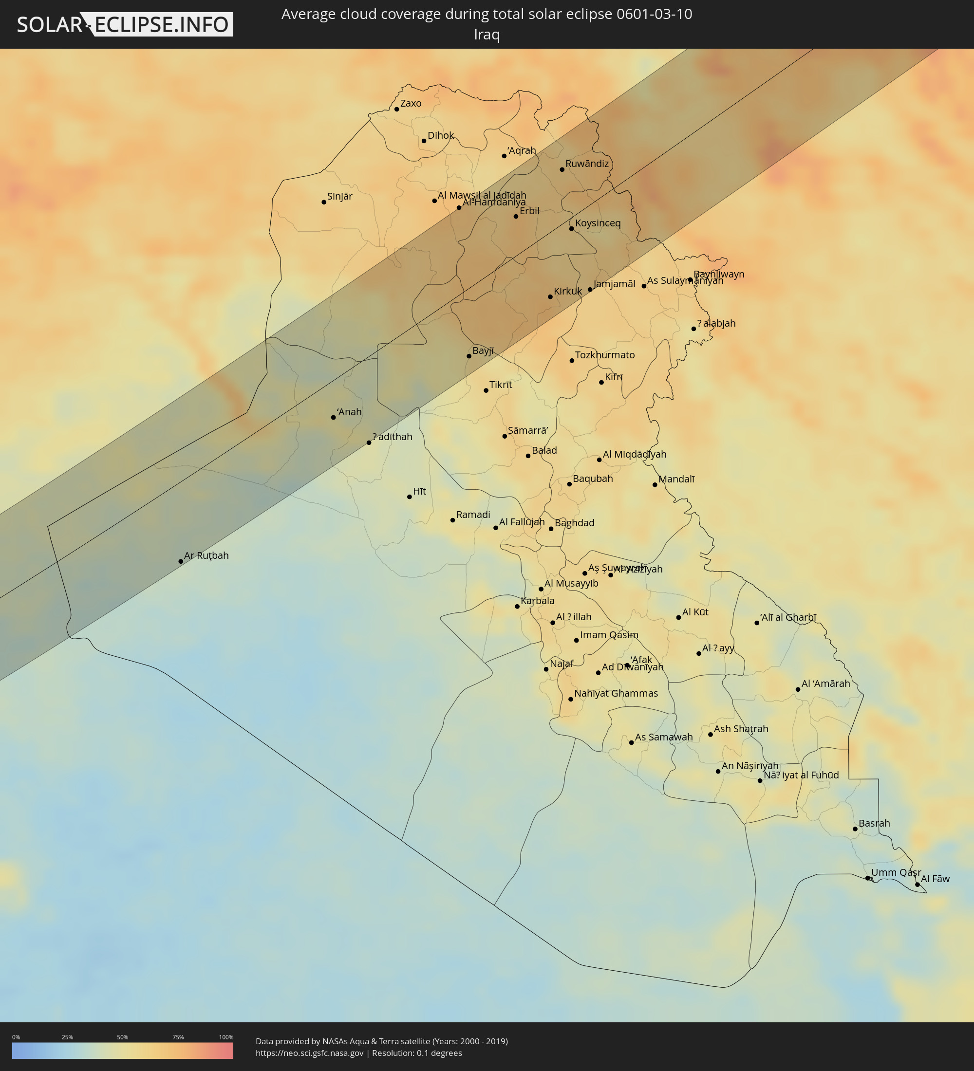 Irak
Irak
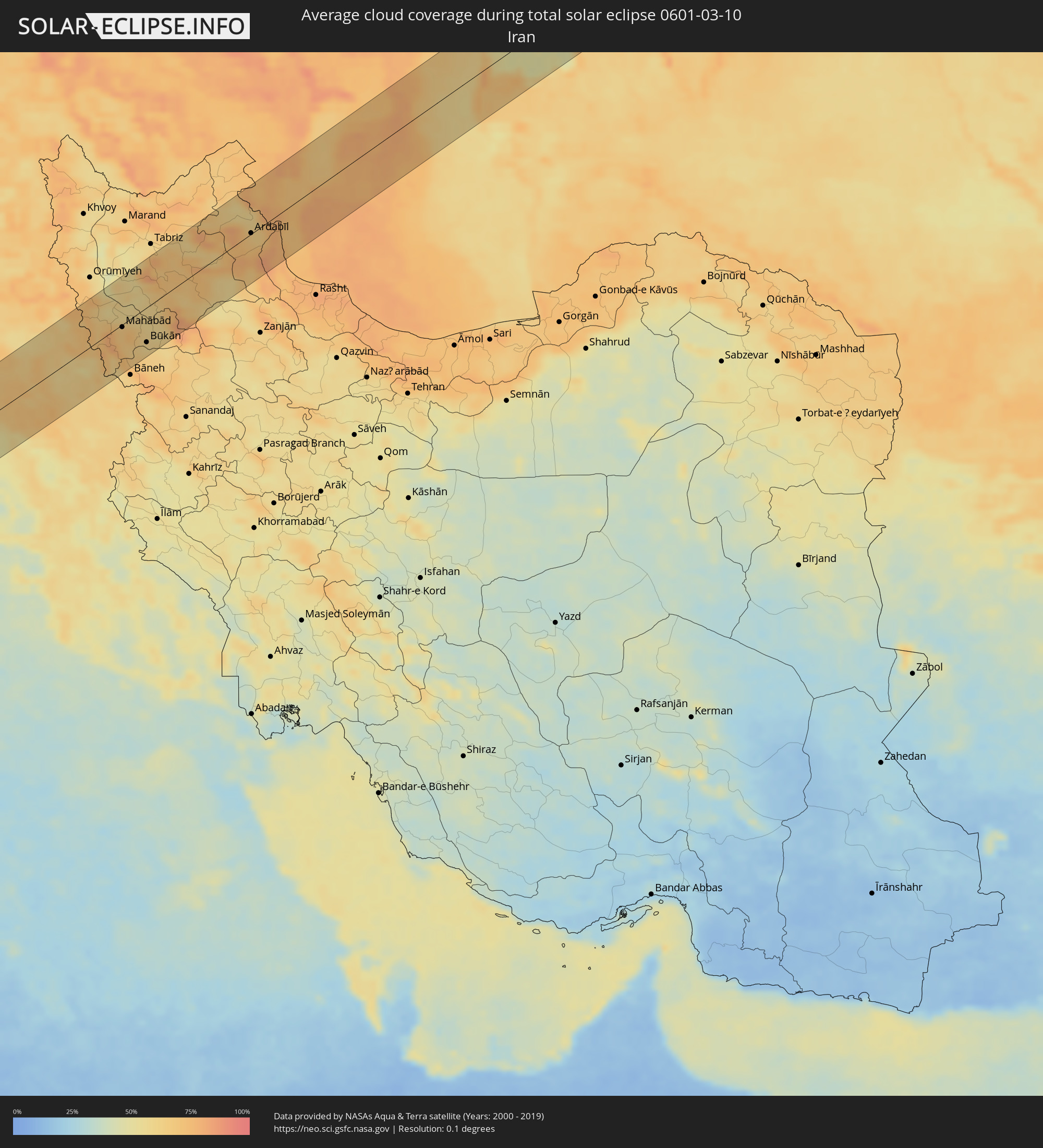 Iran
Iran
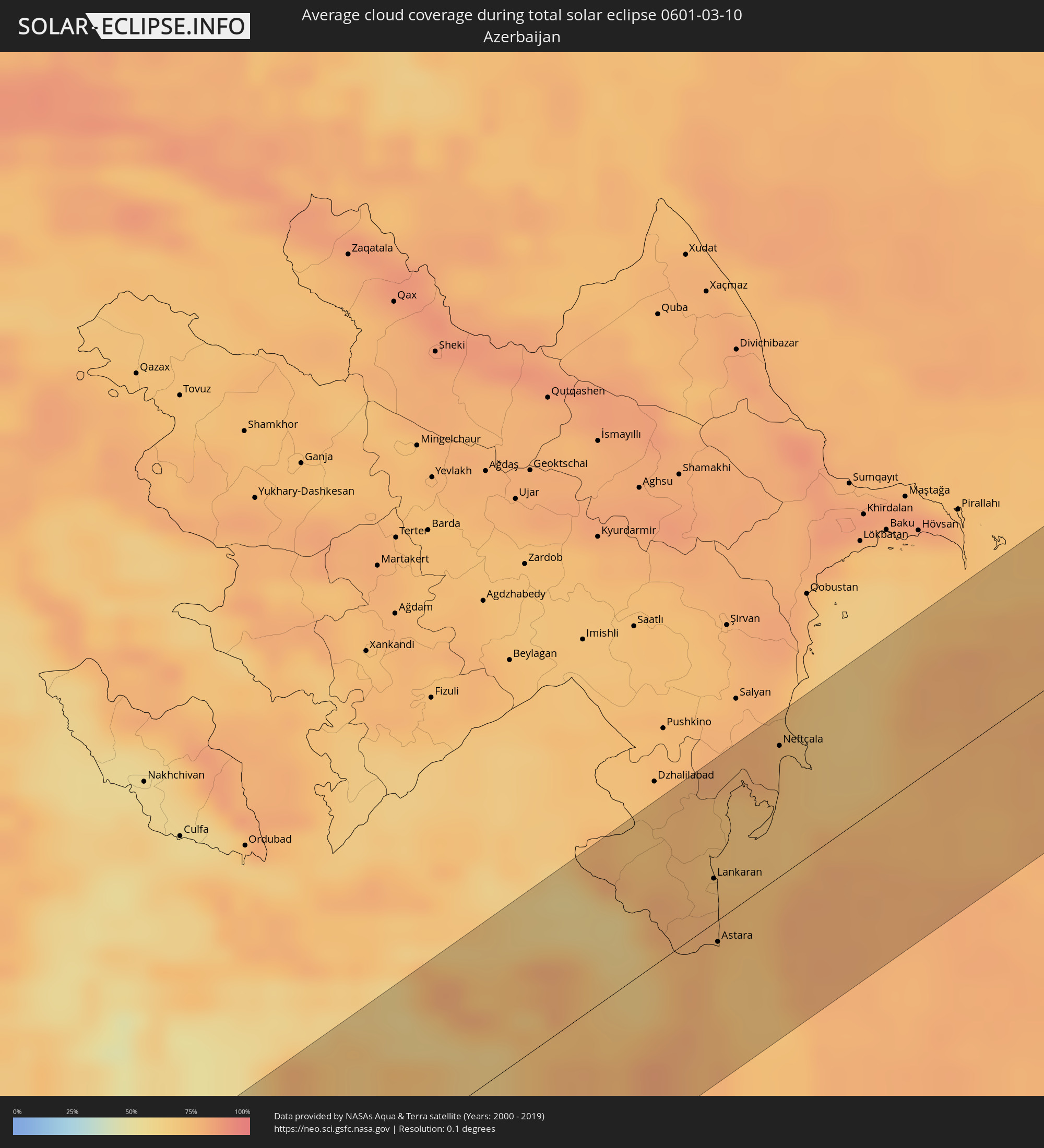 Aserbaidschan
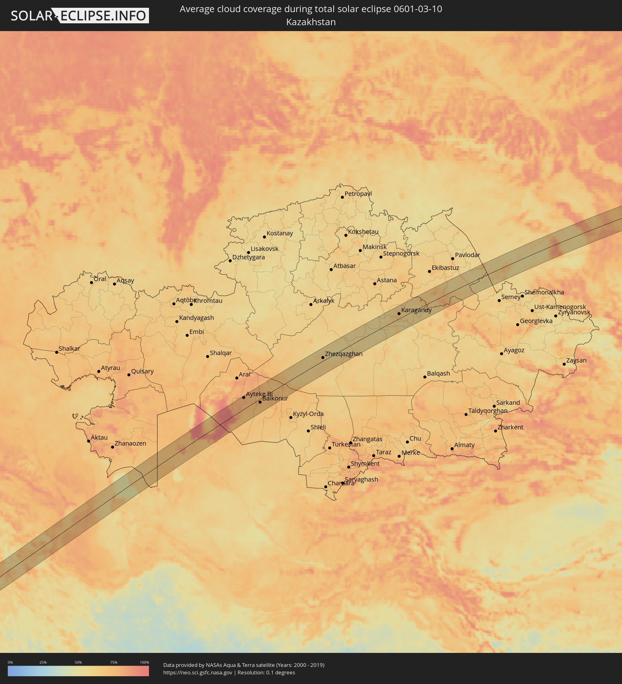 Kasachstan
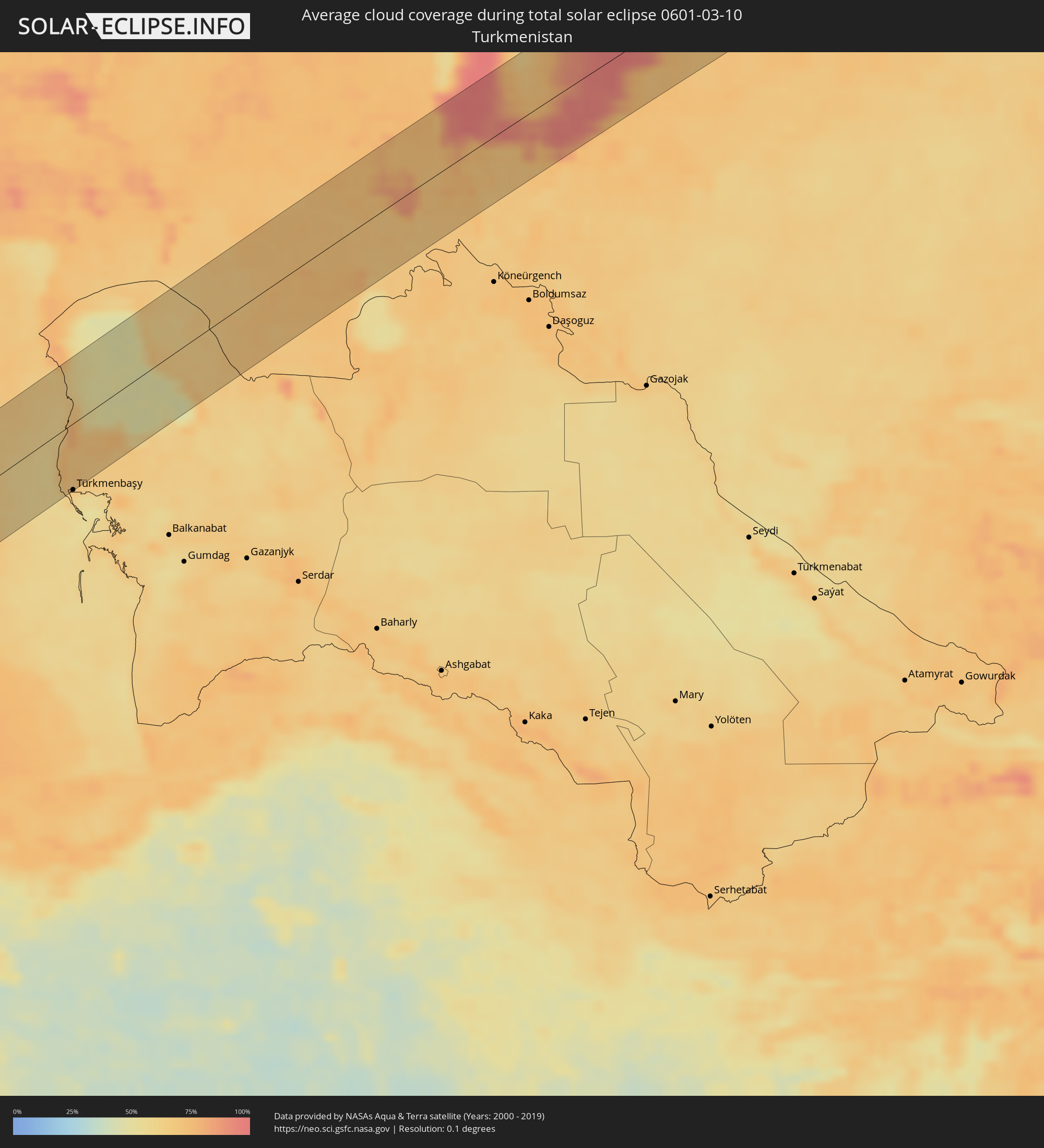 Turkmenistan
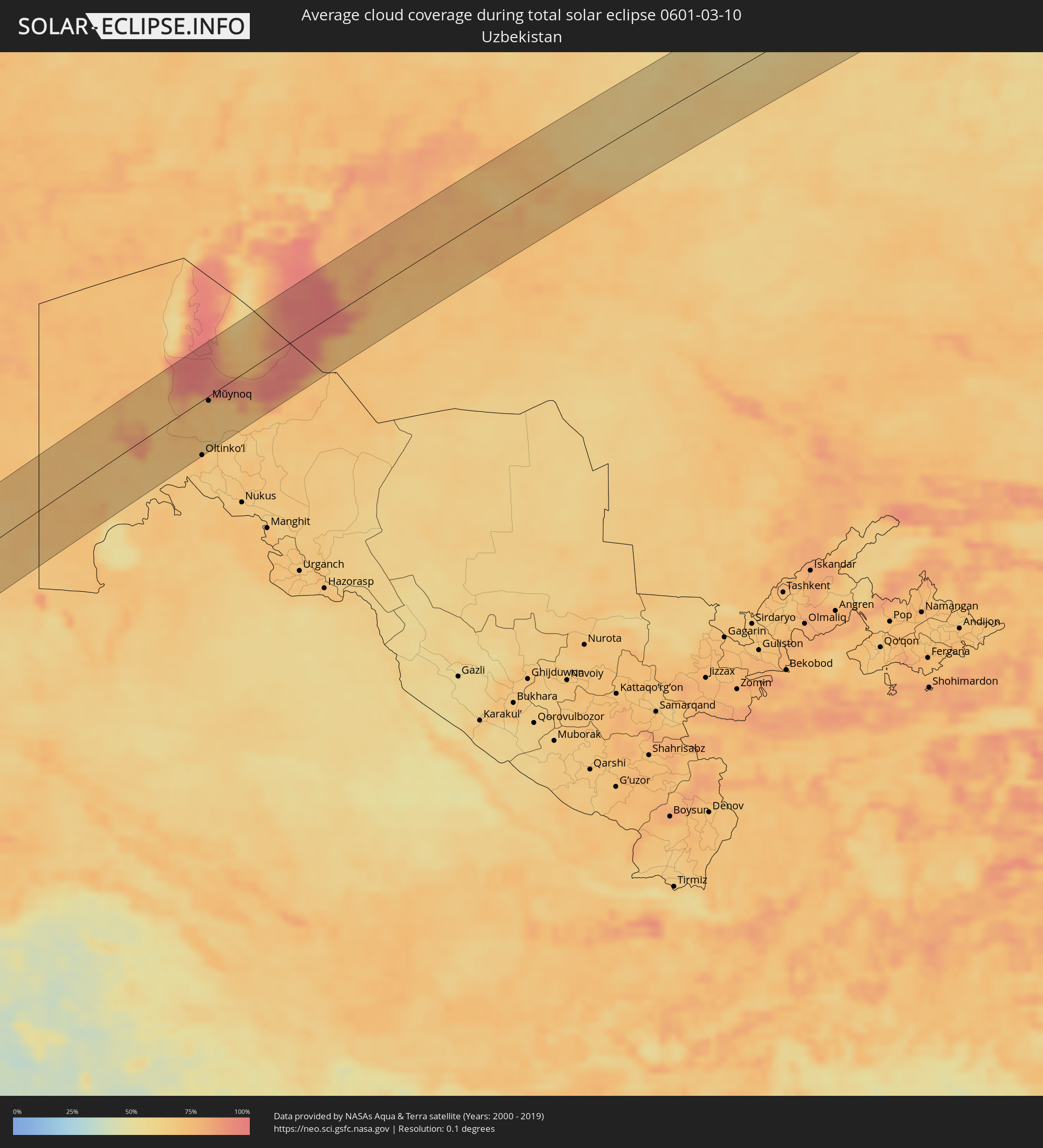 Usbekistan
Orte im Finsternispfad
Die nachfolgene Tabelle zeigt Städte und Orte mit mehr als 5.000 Einwohnern, die sich im Finsternispfad befinden. Städte mit mehr als 100.000 Einwohnern sind dick gekennzeichnet. Mit einem Klick auf den Ort öffnet sich eine Detailkarte die die Lage des jeweiligen Ortes zusammen mit dem Verlauf der zentralen Finsternis präsentiert.
| Ort | Typ | Dauer der Verfinsterung | Ortszeit bei maximaler Verfinsterung | Entfernung zur Zentrallinie | Ø Bewölkung |
|
Tamanrasset, Tamanrasset
|
total | - | 07:17:02 UTC+00:09 | 10 km | 12% |
|
Ibshawāy, Faiyum
|
total | - | 09:49:11 UTC+02:00 | 34 km | 49% |
|
Samālūţ, Minya
|
total | - | 09:47:31 UTC+02:00 | 71 km | 39% |
|
Maţāy, Minya
|
total | - | 09:47:49 UTC+02:00 | 64 km | 35% |
|
Iţsā, Faiyum
|
total | - | 09:49:11 UTC+02:00 | 17 km | 51% |
|
Banī Mazār, Minya
|
total | - | 09:47:59 UTC+02:00 | 56 km | 39% |
|
Al Fayyūm, Faiyum
|
total | - | 09:49:23 UTC+02:00 | 22 km | 50% |
|
Al Fashn, Beni Suweif
|
total | - | 09:48:42 UTC+02:00 | 29 km | 33% |
|
Ţāmiyah, Faiyum
|
total | - | 09:49:52 UTC+02:00 | 34 km | 51% |
|
Madīnat Sittah Uktūbar, Giza
|
total | - | 09:50:36 UTC+02:00 | 63 km | 32% |
|
Banī Suwayf, Beni Suweif
|
total | - | 09:49:28 UTC+02:00 | 12 km | 38% |
|
Būsh, Beni Suweif
|
total | - | 09:49:38 UTC+02:00 | 6 km | 38% |
|
Aş Şaff, Giza
|
total | - | 09:50:36 UTC+02:00 | 28 km | 39% |
|
Ḩalwān, Cairo
|
total | - | 09:51:05 UTC+02:00 | 55 km | 43% |
|
Ain Sukhna, Suez
|
total | - | 09:52:32 UTC+02:00 | 14 km | 32% |
|
Suez, Suez
|
total | - | 09:53:31 UTC+02:00 | 13 km | 42% |
|
Arish, North Sinai
|
total | - | 09:57:45 UTC+02:00 | 67 km | 43% |
|
An Naşr, Gaza Strip
|
total | - | 09:58:56 UTC+02:00 | 58 km | 65% |
|
Khān Yūnis, Gaza Strip
|
total | - | 09:59:02 UTC+02:00 | 63 km | 65% |
|
‘Abasān al Jadīdah
|
total | - | 09:59:07 UTC+02:00 | 61 km | 65% |
|
Al Mughrāqah
|
total | - | 09:59:26 UTC+02:00 | 70 km | 62% |
|
Gaza, Gaza Strip
|
total | - | 09:59:36 UTC+02:00 | 71 km | 68% |
|
Netivot, Southern District
|
total | - | 10:20:22 UTC+02:20 | 58 km | 74% |
|
Sederot, Southern District
|
total | - | 10:20:33 UTC+02:20 | 67 km | 72% |
|
Ofaqim, Southern District
|
total | - | 10:20:15 UTC+02:20 | 46 km | 66% |
|
Qiryat Gat, Southern District
|
total | - | 10:21:00 UTC+02:20 | 67 km | 67% |
|
Beersheba, Southern District
|
total | - | 10:20:29 UTC+02:20 | 32 km | 65% |
|
Lehavim, Southern District
|
total | - | 10:20:43 UTC+02:20 | 42 km | 71% |
|
Yeroẖam, Southern District
|
total | - | 10:20:20 UTC+02:20 | 0 km | 52% |
|
Az̧ Z̧āhirīyah, West Bank
|
total | - | 10:00:25 UTC+02:00 | 38 km | 67% |
|
Dayr Sāmit
|
total | - | 10:00:35 UTC+02:00 | 49 km | 72% |
|
Bet Shemesh, Jerusalem
|
total | - | 10:21:37 UTC+02:20 | 68 km | 68% |
|
Dimona, Southern District
|
total | - | 10:20:39 UTC+02:20 | 3 km | 53% |
|
Khārās, West Bank
|
total | - | 10:00:52 UTC+02:00 | 55 km | 72% |
|
Hebron, West Bank
|
total | - | 10:00:50 UTC+02:00 | 44 km | 71% |
|
Mevo Betar, Jerusalem
|
total | - | 10:21:50 UTC+02:20 | 62 km | 69% |
|
Abū Ghaush, Jerusalem
|
total | - | 10:21:58 UTC+02:20 | 70 km | 62% |
|
Qaţanah, West Bank
|
total | - | 10:01:22 UTC+02:00 | 72 km | 62% |
|
Naḩḩālīn, West Bank
|
total | - | 10:01:08 UTC+02:00 | 58 km | 69% |
|
Biddū, West Bank
|
total | - | 10:01:25 UTC+02:00 | 71 km | 62% |
|
‘Arad, Southern District
|
total | - | 10:21:18 UTC+02:20 | 12 km | 52% |
|
Jerusalem, Jerusalem
|
total | - | 10:22:06 UTC+02:20 | 61 km | 67% |
|
West Jerusalem, Jerusalem
|
total | - | 10:22:08 UTC+02:20 | 62 km | 67% |
|
East Jerusalem, West Bank
|
total | - | 10:22:10 UTC+02:20 | 62 km | 67% |
|
Za‘tarah, West Bank
|
total | - | 10:01:22 UTC+02:00 | 50 km | 61% |
|
Dayr Dibwān, West Bank
|
total | - | 10:01:46 UTC+02:00 | 72 km | 71% |
|
Jericho, West Bank
|
total | - | 10:02:02 UTC+02:00 | 59 km | 61% |
|
Safi, Karak
|
total | - | 10:24:29 UTC+02:23 | 21 km | 50% |
|
Al Karāmah, Balqa
|
total | - | 10:26:09 UTC+02:23 | 61 km | 67% |
|
Aţ Ţafīlah, Tafielah
|
total | - | 10:24:26 UTC+02:23 | 47 km | 43% |
|
‘Ayy, Karak
|
total | - | 10:24:59 UTC+02:23 | 21 km | 51% |
|
‘Izrā, Karak
|
total | - | 10:25:07 UTC+02:23 | 20 km | 55% |
|
Al Mazār al Janūbī, Karak
|
total | - | 10:24:59 UTC+02:23 | 29 km | 48% |
|
Qīr Moāv, Ma’an
|
total | - | 10:25:10 UTC+02:23 | 19 km | 55% |
|
As Salţ, Balqa
|
total | - | 10:26:34 UTC+02:23 | 62 km | 68% |
|
Karak City, Karak
|
total | - | 10:25:16 UTC+02:23 | 23 km | 48% |
|
Mādabā, Madaba
|
total | - | 10:26:12 UTC+02:23 | 28 km | 64% |
|
Umm as Summāq, Amman
|
total | - | 10:26:35 UTC+02:23 | 41 km | 66% |
|
Jāwā, Amman
|
total | - | 10:26:41 UTC+02:23 | 34 km | 66% |
|
Amman, Amman
|
total | - | 10:26:52 UTC+02:23 | 44 km | 69% |
|
Zarqa, Zarqa
|
total | - | 10:27:19 UTC+02:23 | 48 km | 57% |
|
Mafraq, Mafraq
|
total | - | 10:27:58 UTC+02:23 | 68 km | 60% |
|
Al Azraq ash Shamālī, Zarqa
|
total | - | 10:28:27 UTC+02:23 | 7 km | 37% |
|
Ar Ruţbah, Anbar
|
total | - | 11:10:53 UTC+02:57 | 70 km | 34% |
|
Hajīn, Deir ez-Zor
|
total | - | 10:41:58 UTC+02:25 | 57 km | 68% |
|
Ālbū Kamāl, Deir ez-Zor
|
total | - | 10:41:48 UTC+02:25 | 30 km | 62% |
|
Rāwah, Anbar
|
total | - | 11:16:14 UTC+02:57 | 19 km | 49% |
|
‘Anat al Qadīmah, Anbar
|
total | - | 11:16:15 UTC+02:57 | 21 km | 49% |
|
‘Anah, Anbar
|
total | - | 11:16:11 UTC+02:57 | 32 km | 50% |
|
Al-Hamdaniya, Nīnawá
|
total | - | 11:21:32 UTC+02:57 | 71 km | 69% |
|
Bayjī, Salah ad Din Governorate
|
total | - | 11:19:59 UTC+02:57 | 58 km | 58% |
|
Erbil, Arbīl
|
total | - | 11:22:41 UTC+02:57 | 32 km | 72% |
|
Kirkuk, At Taʼmīm
|
total | - | 11:22:30 UTC+02:57 | 54 km | 70% |
|
Ruwāndiz, Arbīl
|
total | - | 11:24:14 UTC+02:57 | 44 km | 66% |
|
Koysinceq, Arbīl
|
total | - | 11:23:46 UTC+02:57 | 10 km | 61% |
|
Jamjamāl, As Sulaymānīyah
|
total | - | 11:23:28 UTC+02:57 | 71 km | 61% |
|
Oshnavīyeh, Āz̄ārbāyjān-e Gharbī
|
total | - | 11:54:02 UTC+03:25 | 53 km | 67% |
|
Piranshahr, Āz̄ārbāyjān-e Gharbī
|
total | - | 11:53:42 UTC+03:25 | 20 km | 73% |
|
Naqadeh, Āz̄ārbāyjān-e Gharbī
|
total | - | 11:54:30 UTC+03:25 | 31 km | 62% |
|
Mahābād, Āz̄ārbāyjān-e Gharbī
|
total | - | 11:54:55 UTC+03:25 | 4 km | 67% |
|
‘Ajab Shīr, East Azerbaijan
|
total | - | 11:56:08 UTC+03:25 | 53 km | 56% |
|
Bonāb, East Azerbaijan
|
total | - | 11:56:17 UTC+03:25 | 32 km | 57% |
|
Mīāndoāb, Āz̄ārbāyjān-e Gharbī
|
total | - | 11:55:56 UTC+03:25 | 5 km | 60% |
|
Būkān, Āz̄ārbāyjān-e Gharbī
|
total | - | 11:55:35 UTC+03:25 | 51 km | 58% |
|
Shāhīn Dezh, Āz̄ārbāyjān-e Gharbī
|
total | - | 11:56:29 UTC+03:25 | 54 km | 61% |
|
Hashtrūd, East Azerbaijan
|
total | - | 11:58:23 UTC+03:25 | 6 km | 71% |
|
Yardımlı, Yardımlı
|
total | - | 11:55:58 UTC+03:19 | 64 km | 78% |
|
Ardabīl, Ardabīl
|
total | - | 12:01:41 UTC+03:25 | 1 km | 68% |
|
Lerik, Lerik
|
total | - | 11:56:09 UTC+03:19 | 43 km | 75% |
|
Khalkhāl, Ardabīl
|
total | - | 12:01:27 UTC+03:25 | 68 km | 77% |
|
Prishibinskoye, Jalilabad
|
total | - | 11:56:52 UTC+03:19 | 65 km | 75% |
|
Masally, Masally
|
total | - | 11:56:55 UTC+03:19 | 54 km | 76% |
|
Boradigah, Masally
|
total | - | 11:56:53 UTC+03:19 | 42 km | 75% |
|
Lankaran, Lənkəran
|
total | - | 11:56:58 UTC+03:19 | 19 km | 72% |
|
Āstārā, Gīlān
|
total | - | 12:03:00 UTC+03:25 | 12 km | 73% |
|
Astara, Astara
|
total | - | 11:56:42 UTC+03:19 | 9 km | 74% |
|
Neftçala, Neftçala
|
total | - | 11:58:22 UTC+03:19 | 56 km | 77% |
|
Severo-Vostotchnyi Bank, Neftçala
|
total | - | 11:58:25 UTC+03:19 | 59 km | 77% |
|
Türkmenbaşy, Balkan
|
total | - | 12:40:07 UTC+03:53 | 68 km | 58% |
|
Oltinko’l, Karakalpakstan
|
total | - | 13:27:13 UTC+04:27 | 65 km | 73% |
|
Mŭynoq, Karakalpakstan
|
total | - | 13:27:46 UTC+04:27 | 6 km | 74% |
|
Qazaly, Qyzylorda
|
total | - | 13:27:30 UTC+04:21 | 48 km | 78% |
|
Ayteke Bi, Qyzylorda
|
total | - | 13:27:35 UTC+04:21 | 53 km | 79% |
|
Tyuratam, Baikonur
|
total | - | 13:29:20 UTC+04:21 | 13 km | 75% |
|
Baikonur, Baikonur
|
total | - | 13:29:20 UTC+04:21 | 16 km | 73% |
|
Zhosaly, Qyzylorda
|
total | - | 13:30:28 UTC+04:21 | 60 km | 74% |
|
Zhezqazghan, Qaraghandy
|
total | - | 13:36:06 UTC+04:21 | 14 km | 64% |
|
Atasū, Qaraghandy
|
total | - | 13:41:10 UTC+04:21 | 39 km | 60% |
|
Shakhan, Qaraghandy
|
total | - | 13:42:12 UTC+04:21 | 37 km | 64% |
|
Novodolīnskīy, Qaraghandy
|
total | - | 13:42:17 UTC+04:21 | 24 km | 64% |
|
Sorang, Qaraghandy
|
total | - | 13:42:26 UTC+04:21 | 28 km | 66% |
|
Abay, Qaraghandy
|
total | - | 13:42:30 UTC+04:21 | 12 km | 64% |
|
Aqtas, Qaraghandy
|
total | - | 13:42:35 UTC+04:21 | 23 km | 65% |
|
Temirtau, Qaraghandy
|
total | - | 13:42:31 UTC+04:21 | 50 km | 73% |
|
Karagandy, Qaraghandy
|
total | - | 13:42:49 UTC+04:21 | 21 km | 64% |
|
Bayanaul, Pavlodar
|
total | - | 13:45:28 UTC+04:21 | 33 km | 68% |
|
Pospelikha, Altai Krai
|
total | - | 15:40:48 UTC+06:11 | 31 km | 56% |
|
Aleysk, Altai Krai
|
total | - | 15:41:26 UTC+06:11 | 4 km | 58% |
|
Yuzhnyy, Altai Krai
|
total | - | 15:41:46 UTC+06:11 | 50 km | 67% |
|
Prokop’yevsk, Kemerovo
|
total | - | 15:43:52 UTC+06:11 | 41 km | 72% |
|
Novokuznetsk, Kemerovo
|
total | - | 15:44:18 UTC+06:11 | 16 km | 75% |
|
Osinniki, Kemerovo
|
total | - | 15:44:36 UTC+06:11 | 4 km | 78% |
|
Myski, Kemerovo
|
total | - | 15:44:53 UTC+06:11 | 6 km | 77% |
|
Mezhdurechensk, Kemerovo
|
total | - | 15:45:06 UTC+06:11 | 13 km | 76% |
|
Sorsk, Khakasiya
|
total | - | 15:46:30 UTC+06:11 | 31 km | 83% |
|
Tayshet, Irkutsk
|
total | - | 16:35:14 UTC+06:57 | 18 km | 81% |
|
Chunskiy, Irkutsk
|
total | - | 16:35:56 UTC+06:57 | 5 km | 79% |
|
Vikhorevka, Irkutsk
|
total | - | 16:36:37 UTC+06:57 | 16 km | 88% |
|
Bratsk, Irkutsk
|
total | - | 16:36:49 UTC+06:57 | 21 km | 86% |
|
Zheleznogorsk-Ilimskiy, Irkutsk
|
total | - | 16:37:25 UTC+06:57 | 11 km | 85% |
|
Ust’-Kut, Irkutsk
|
total | - | 16:37:48 UTC+06:57 | 11 km | 90% |
|
Bodaybo, Irkutsk
|
total | - | 16:38:58 UTC+06:57 | 7 km | 87% |