Totale Sonnenfinsternis vom 30.03.0610
| Wochentag: | Freitag |
| Maximale Dauer der Verfinsterung: | 03m34s |
| Maximale Breite des Finsternispfades: | 208 km |
| Saroszyklus: | 97 |
| Bedeckungsgrad: | 100% |
| Magnitude: | 1.0485 |
| Gamma: | 0.6469 |
Wo kann man die Sonnenfinsternis vom 30.03.0610 sehen?
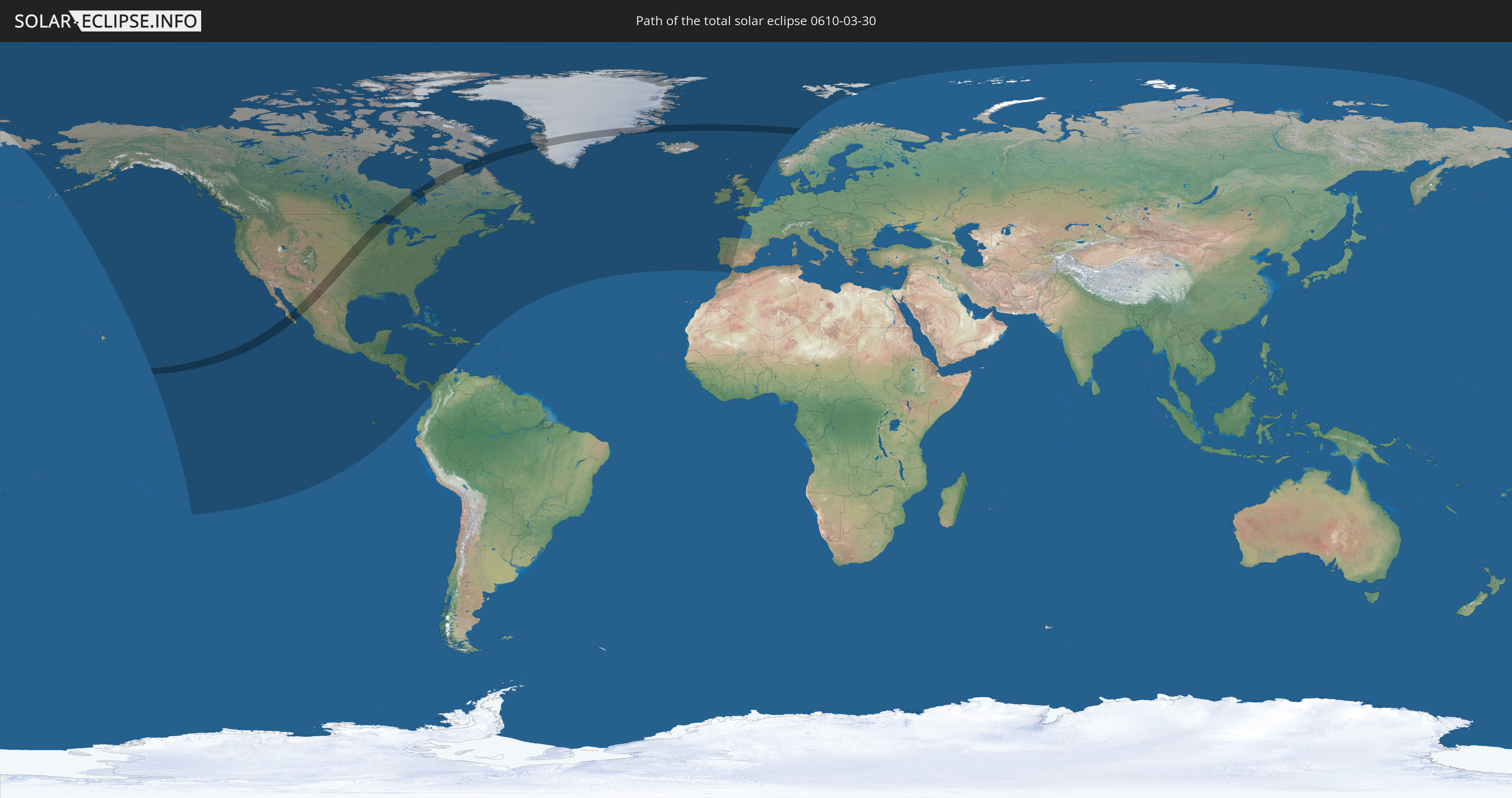
Die Sonnenfinsternis am 30.03.0610 kann man in 37 Ländern als partielle Sonnenfinsternis beobachten.
Der Finsternispfad verläuft durch 4 Länder. Nur in diesen Ländern ist sie als totale Sonnenfinsternis zu sehen.
In den folgenden Ländern ist die Sonnenfinsternis total zu sehen
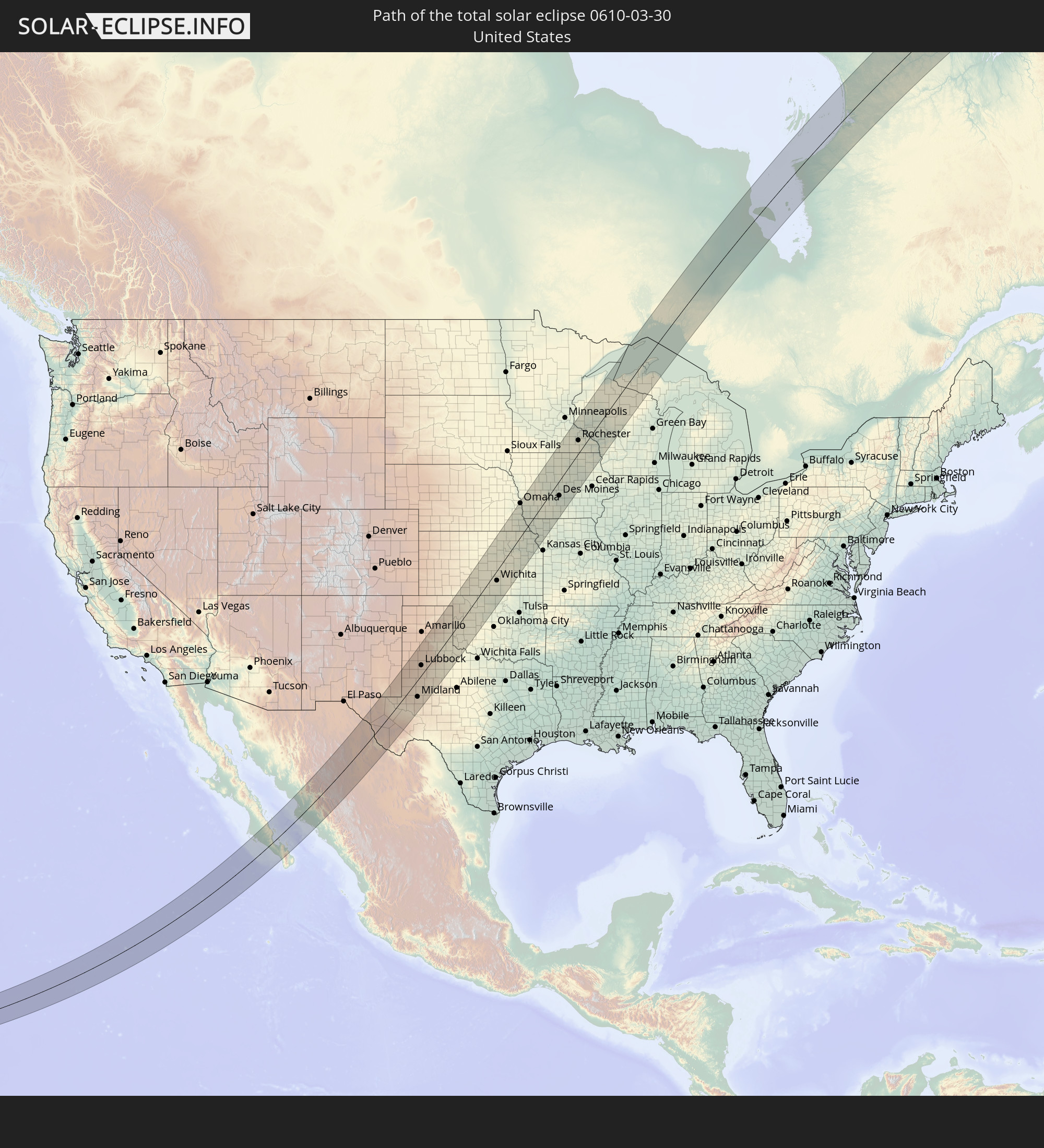 Vereinigte Staaten
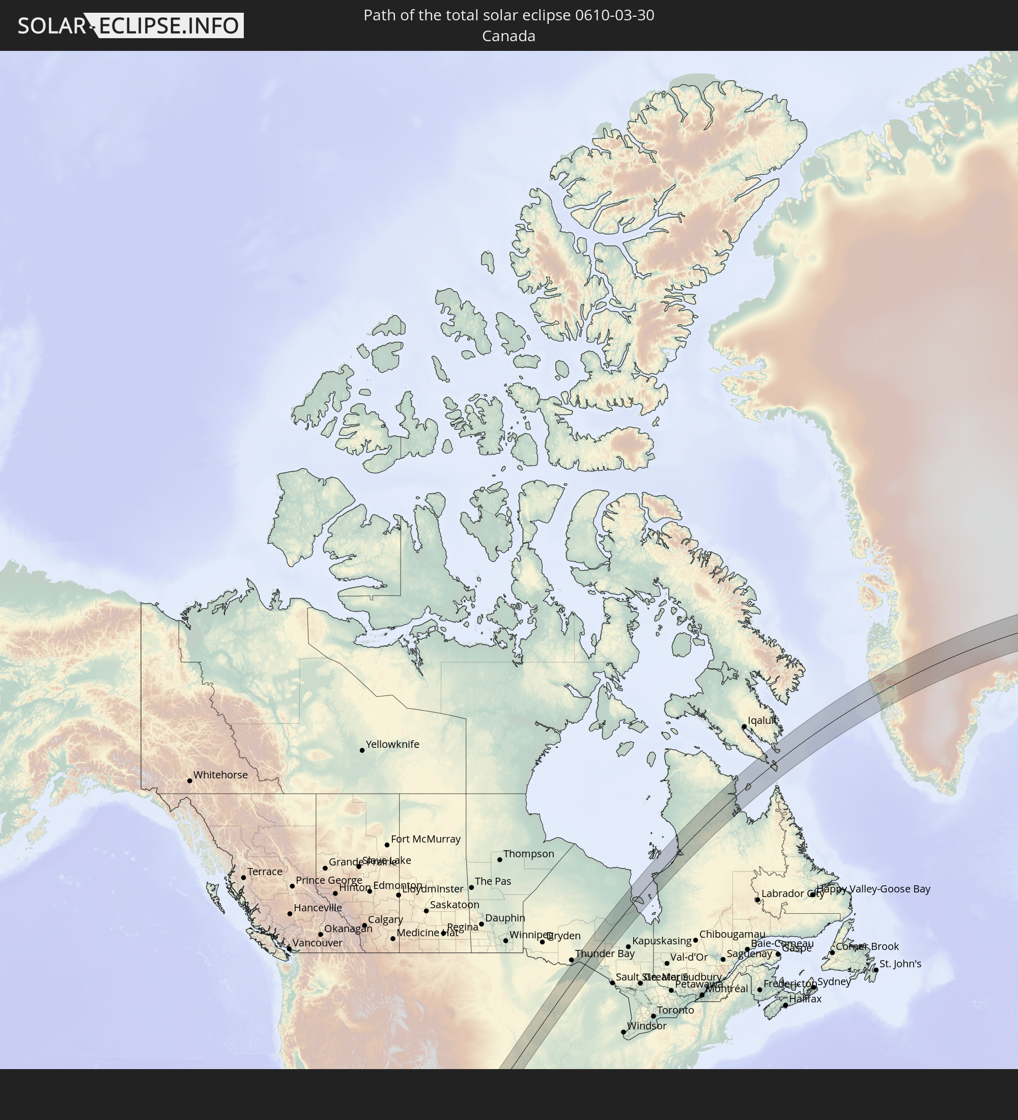 Kanada
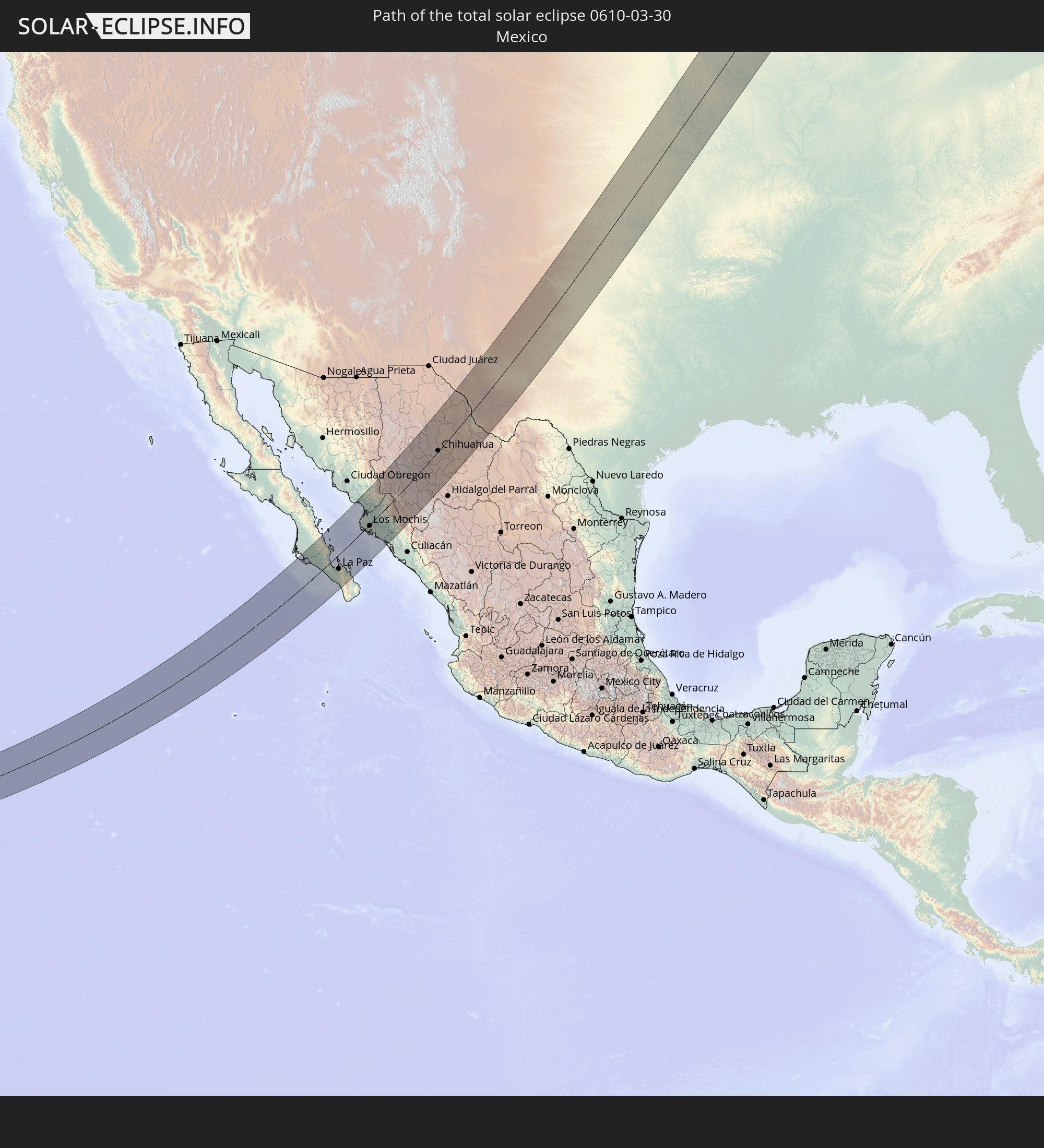 Mexiko
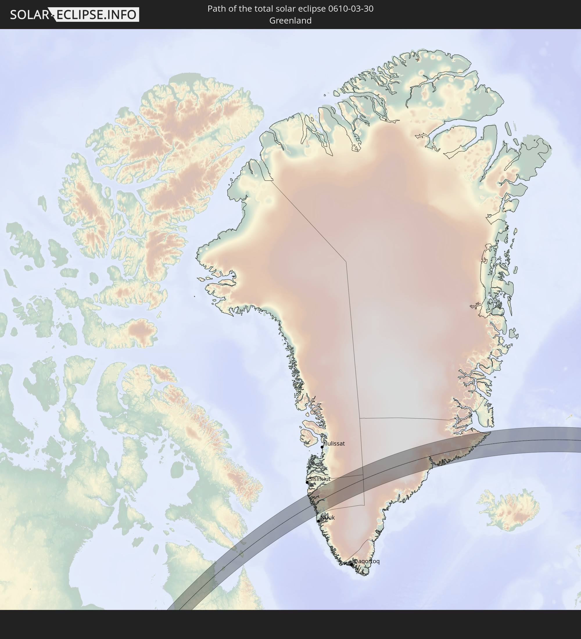 Grönland
In den folgenden Ländern ist die Sonnenfinsternis partiell zu sehen
 Russland
 Vereinigte Staaten
 United States Minor Outlying Islands
 Kanada
 Mexiko
 Grönland
 Guatemala
 Ecuador
 El Salvador
 Honduras
 Belize
 Nicaragua
 Costa Rica
 Kuba
Kuba
 Panama
 Kolumbien
 Kaimaninseln
 Bahamas
 Jamaika
 Haiti
Haiti
 Turks- und Caicosinseln
 Dominikanische Republik
 Puerto Rico
 Bermuda
 Saint-Pierre und Miquelon
 Portugal
 Island
 Spanien
 Marokko
 Irland
 Spitzbergen
 Vereinigtes Königreich
 Färöer
 Frankreich
 Isle of Man
 Guernsey
 Jersey
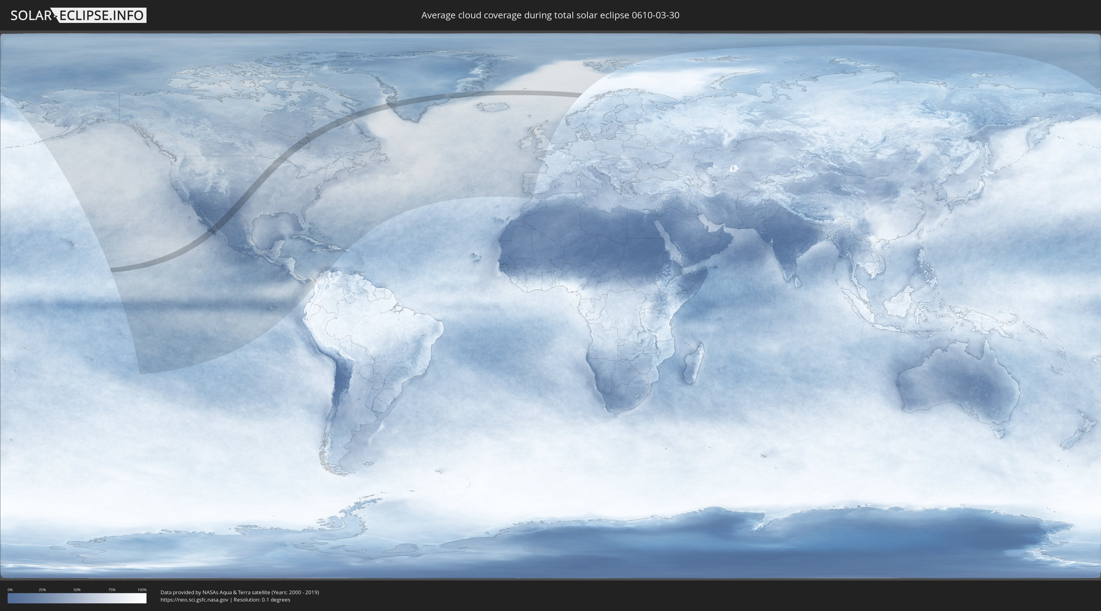
Wie wird das Wetter während der totalen Sonnenfinsternis am 30.03.0610?
Wo ist der beste Ort, um die totale Sonnenfinsternis vom 30.03.0610 zu beobachten?
Die folgenden Karten zeigen die durchschnittliche Bewölkung für den Tag, an dem die totale Sonnenfinsternis
stattfindet. Mit Hilfe der Karten lässt sich der Ort entlang des Finsternispfades eingrenzen,
der die besten Aussichen auf einen klaren wolkenfreien Himmel bietet.
Trotzdem muss man immer lokale Gegenenheiten beachten und sollte sich genau über das Wetter an seinem
gewählten Beobachtungsort informieren.
Die Daten stammen von den beiden NASA-Satelliten
AQUA und TERRA
und wurden über einen Zeitraum von 19 Jahren (2000 - 2019) gemittelt.

Detaillierte Länderkarten
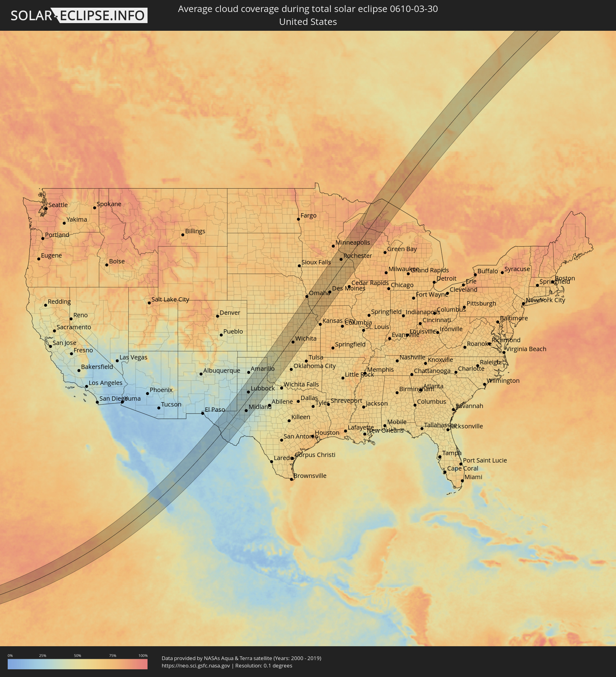 Vereinigte Staaten
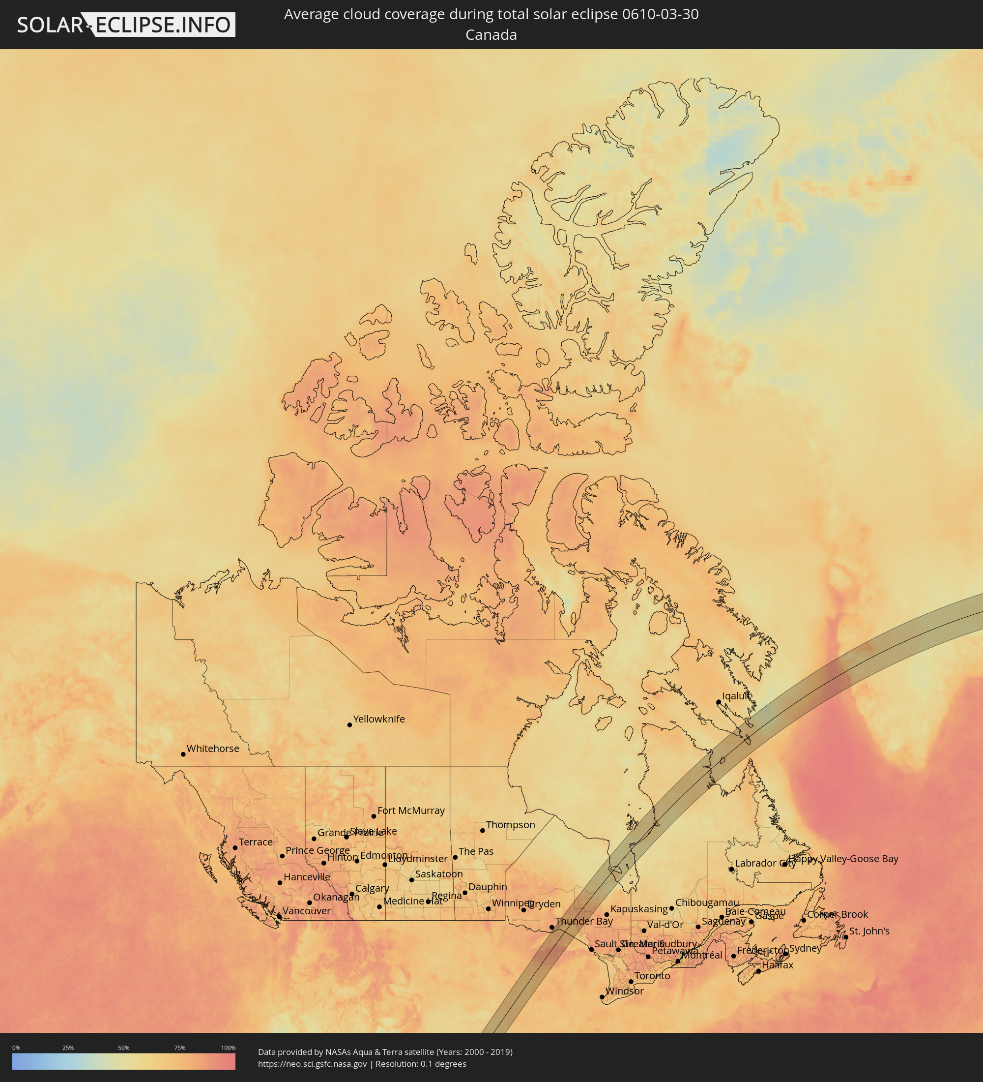 Kanada
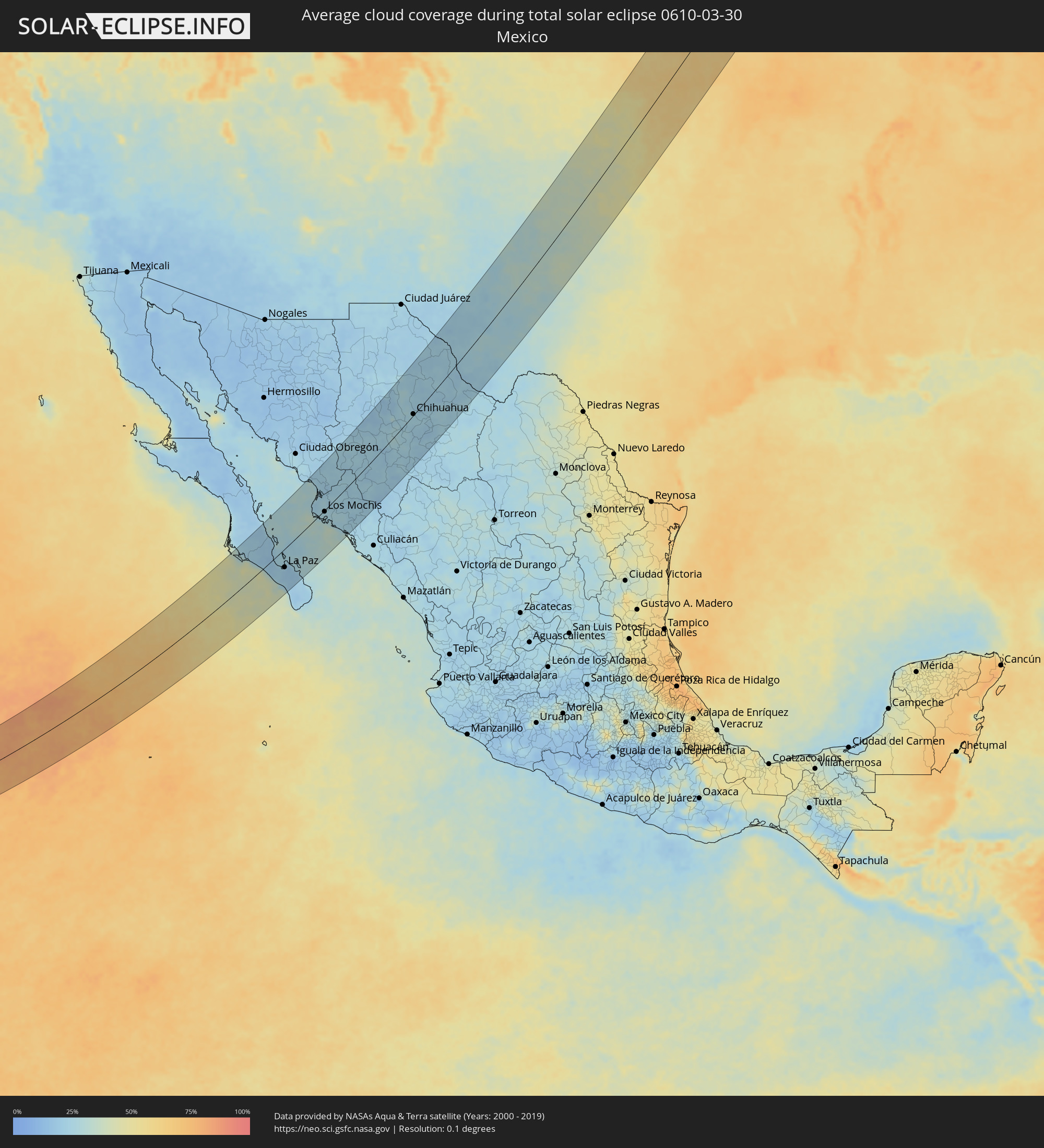 Mexiko
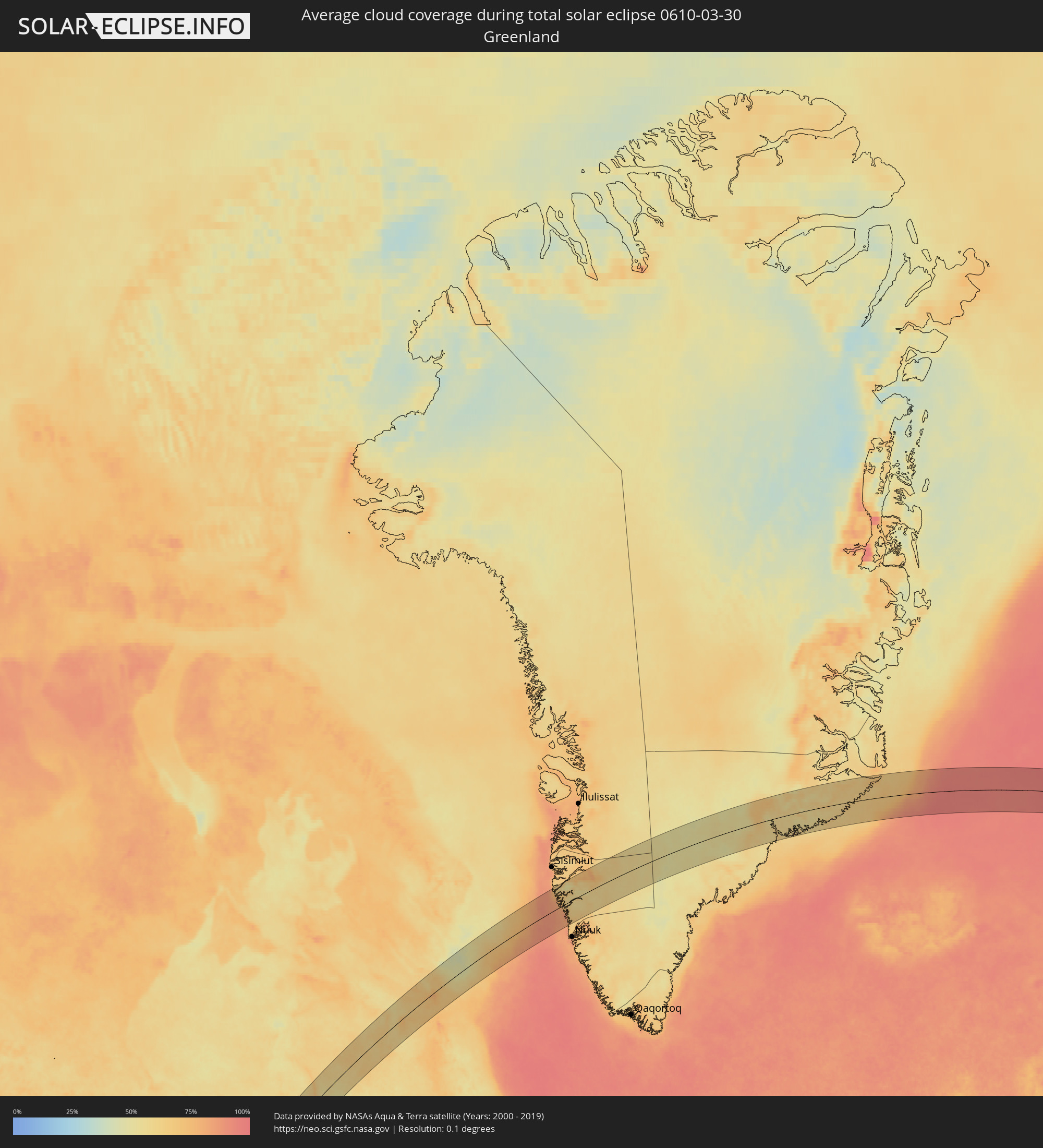 Grönland
Orte im Finsternispfad
Die nachfolgene Tabelle zeigt Städte und Orte mit mehr als 5.000 Einwohnern, die sich im Finsternispfad befinden. Städte mit mehr als 100.000 Einwohnern sind dick gekennzeichnet. Mit einem Klick auf den Ort öffnet sich eine Detailkarte die die Lage des jeweiligen Ortes zusammen mit dem Verlauf der zentralen Finsternis präsentiert.
| Ort | Typ | Dauer der Verfinsterung | Ortszeit bei maximaler Verfinsterung | Entfernung zur Zentrallinie | Ø Bewölkung |
|
La Paz, Baja California Sur
|
total | - | 09:03:53 UTC-07:05 | 45 km | 18% |
|
Higuera de Zaragoza, Sinaloa
|
total | - | 09:08:25 UTC-07:05 | 32 km | 21% |
|
Ahome, Sinaloa
|
total | - | 09:08:27 UTC-07:05 | 19 km | 24% |
|
Topolobampo, Sinaloa
|
total | - | 09:07:57 UTC-07:05 | 15 km | 30% |
|
San Miguel Zapotitlan, Sinaloa
|
total | - | 09:08:38 UTC-07:05 | 12 km | 24% |
|
Los Mochis, Sinaloa
|
total | - | 09:08:24 UTC-07:05 | 4 km | 25% |
|
Alamos, Sonora
|
total | - | 08:52:39 UTC-07:23 | 88 km | 23% |
|
Juan Jose Rios, Sinaloa
|
total | - | 09:08:29 UTC-07:05 | 19 km | 25% |
|
San Blas, Sinaloa
|
total | - | 09:09:11 UTC-07:05 | 2 km | 21% |
|
Adolfo Ruíz Cortínes, Sinaloa
|
total | - | 09:08:33 UTC-07:05 | 24 km | 25% |
|
Leyva Solano, Sinaloa
|
total | - | 09:08:30 UTC-07:05 | 39 km | 26% |
|
El Fuerte de Montes Claros, Sinaloa
|
total | - | 09:10:00 UTC-07:05 | 18 km | 23% |
|
Guasave, Sinaloa
|
total | - | 09:08:29 UTC-07:05 | 59 km | 24% |
|
Choix, Sinaloa
|
total | - | 09:10:52 UTC-07:05 | 20 km | 25% |
|
Guamúchil, Sinaloa
|
total | - | 09:08:41 UTC-07:05 | 95 km | 23% |
|
Mocorito, Sinaloa
|
total | - | 09:08:53 UTC-07:05 | 105 km | 23% |
|
Creel, Chihuahua
|
total | - | 09:13:39 UTC-07:05 | 49 km | 23% |
|
Adolfo López Mateos, Chihuahua
|
total | - | 09:15:26 UTC-07:05 | 79 km | 18% |
|
Cuauhtémoc, Chihuahua
|
total | - | 09:15:48 UTC-07:05 | 42 km | 21% |
|
Anáhuac, Chihuahua
|
total | - | 09:16:04 UTC-07:05 | 39 km | 23% |
|
Valentín Gómez Farías, Chihuahua
|
total | - | 09:15:43 UTC-07:05 | 8 km | 26% |
|
Chihuahua, Chihuahua
|
total | - | 09:17:06 UTC-07:05 | 2 km | 24% |
|
Ampliación Colonia Lázaro Cárdenas, Chihuahua
|
total | - | 09:17:07 UTC-07:05 | 51 km | 20% |
|
Rosales, Chihuahua
|
total | - | 09:16:48 UTC-07:05 | 70 km | 19% |
|
Naica, Chihuahua
|
total | - | 09:16:13 UTC-07:05 | 99 km | 21% |
|
Pedro Meoqui, Chihuahua
|
total | - | 09:17:04 UTC-07:05 | 68 km | 21% |
|
Ciudad Delicias, Chihuahua
|
total | - | 09:16:54 UTC-07:05 | 76 km | 20% |
|
Jiménez, Chihuahua
|
total | - | 09:17:16 UTC-07:05 | 71 km | 22% |
|
Saucillo, Chihuahua
|
total | - | 09:16:47 UTC-07:05 | 101 km | 23% |
|
Ojinaga, Chihuahua
|
total | - | 09:20:41 UTC-07:05 | 44 km | 24% |
|
Manuel Ojinaga, Chihuahua
|
total | - | 09:20:50 UTC-07:05 | 54 km | 23% |
|
Pecos, Texas
|
total | - | 10:31:15 UTC-06:00 | 9 km | 25% |
|
Lovington, New Mexico
|
total | - | 09:34:26 UTC-07:00 | 102 km | 25% |
|
Hobbs, New Mexico
|
total | - | 09:34:12 UTC-07:00 | 69 km | 30% |
|
Fort Stockton, Texas
|
total | - | 10:30:56 UTC-06:00 | 74 km | 25% |
|
Andrews, Texas
|
total | - | 10:34:09 UTC-06:00 | 0 km | 31% |
|
Levelland, Texas
|
total | - | 10:36:50 UTC-06:00 | 72 km | 31% |
|
Odessa, Texas
|
total | - | 10:33:26 UTC-06:00 | 46 km | 28% |
|
Brownfield, Texas
|
total | - | 10:36:10 UTC-06:00 | 38 km | 30% |
|
Midland, Texas
|
total | - | 10:34:05 UTC-06:00 | 57 km | 31% |
|
Lamesa, Texas
|
total | - | 10:35:41 UTC-06:00 | 16 km | 33% |
|
Lubbock, Texas
|
total | - | 10:37:27 UTC-06:00 | 33 km | 34% |
|
Plainview, Texas
|
total | - | 10:38:49 UTC-06:00 | 62 km | 35% |
|
Big Spring, Texas
|
total | - | 10:35:18 UTC-06:00 | 85 km | 33% |
|
Pampa, Texas
|
total | - | 10:42:20 UTC-06:00 | 95 km | 38% |
|
Snyder, Texas
|
total | - | 10:36:54 UTC-06:00 | 95 km | 37% |
|
Elk City, Oklahoma
|
total | - | 10:44:01 UTC-06:00 | 27 km | 43% |
|
Woodward, Oklahoma
|
total | - | 10:45:59 UTC-06:00 | 38 km | 48% |
|
Altus, Oklahoma
|
total | - | 10:42:37 UTC-06:00 | 83 km | 48% |
|
Clinton, Oklahoma
|
total | - | 10:44:45 UTC-06:00 | 53 km | 48% |
|
Weatherford, Oklahoma
|
total | - | 10:45:06 UTC-06:00 | 71 km | 52% |
|
Hutchinson, Kansas
|
total | - | 10:50:51 UTC-06:00 | 36 km | 61% |
|
Enid, Oklahoma
|
total | - | 10:47:48 UTC-06:00 | 75 km | 60% |
|
McPherson, Kansas
|
total | - | 10:51:45 UTC-06:00 | 37 km | 60% |
|
Salina, Kansas
|
total | - | 10:52:41 UTC-06:00 | 63 km | 62% |
|
Wellington, Kansas
|
total | - | 10:50:05 UTC-06:00 | 55 km | 62% |
|
Haysville, Kansas
|
total | - | 10:50:39 UTC-06:00 | 37 km | 64% |
|
Newton, Kansas
|
total | - | 10:51:34 UTC-06:00 | 7 km | 62% |
|
Wichita, Kansas
|
total | - | 10:50:55 UTC-06:00 | 30 km | 65% |
|
Park City, Kansas
|
total | - | 10:51:08 UTC-06:00 | 25 km | 65% |
|
Blackwell, Oklahoma
|
total | - | 10:49:20 UTC-06:00 | 91 km | 63% |
|
Derby, Kansas
|
total | - | 10:50:44 UTC-06:00 | 45 km | 63% |
|
Andover, Kansas
|
total | - | 10:51:13 UTC-06:00 | 43 km | 64% |
|
Arkansas City, Kansas
|
total | - | 10:50:07 UTC-06:00 | 92 km | 58% |
|
Winfield, Kansas
|
total | - | 10:50:30 UTC-06:00 | 84 km | 59% |
|
Augusta, Kansas
|
total | - | 10:51:22 UTC-06:00 | 56 km | 63% |
|
El Dorado, Kansas
|
total | - | 10:51:45 UTC-06:00 | 56 km | 63% |
|
Junction City, Kansas
|
total | - | 10:54:01 UTC-06:00 | 19 km | 63% |
|
Fort Riley North, Kansas
|
total | - | 10:54:11 UTC-06:00 | 23 km | 62% |
|
Beatrice, Nebraska
|
total | - | 10:56:21 UTC-06:00 | 91 km | 60% |
|
Manhattan, Kansas
|
total | - | 10:54:37 UTC-06:00 | 10 km | 61% |
|
Emporia, Kansas
|
total | - | 10:53:42 UTC-06:00 | 67 km | 61% |
|
La Vista, Nebraska
|
total | - | 10:58:51 UTC-06:00 | 98 km | 68% |
|
Omaha, Nebraska
|
total | - | 10:59:06 UTC-06:00 | 96 km | 68% |
|
Nebraska City, Nebraska
|
total | - | 10:58:11 UTC-06:00 | 54 km | 64% |
|
Topeka, Kansas
|
total | - | 10:55:31 UTC-06:00 | 62 km | 64% |
|
Lawrence, Kansas
|
total | - | 10:55:56 UTC-06:00 | 98 km | 63% |
|
Atchison, Kansas
|
total | - | 10:57:09 UTC-06:00 | 68 km | 67% |
|
Atlantic, Iowa
|
total | - | 11:00:31 UTC-06:00 | 42 km | 69% |
|
Leavenworth, Kansas
|
total | - | 10:56:57 UTC-06:00 | 98 km | 64% |
|
Maryville, Missouri
|
total | - | 10:58:51 UTC-06:00 | 35 km | 67% |
|
Carroll, Iowa
|
total | - | 11:01:50 UTC-06:00 | 73 km | 67% |
|
Saint Joseph, Missouri
|
total | - | 10:57:52 UTC-06:00 | 74 km | 67% |
|
Creston, Iowa
|
total | - | 11:00:45 UTC-06:00 | 25 km | 71% |
|
Fort Dodge, Iowa
|
total | - | 11:03:26 UTC-06:00 | 53 km | 65% |
|
Perry, Iowa
|
total | - | 11:02:24 UTC-06:00 | 7 km | 67% |
|
Waukee, Iowa
|
total | - | 11:02:18 UTC-06:00 | 23 km | 68% |
|
Boone, Iowa
|
total | - | 11:03:04 UTC-06:00 | 6 km | 66% |
|
Webster City, Iowa
|
total | - | 11:03:50 UTC-06:00 | 27 km | 68% |
|
Grimes, Iowa
|
total | - | 11:02:33 UTC-06:00 | 24 km | 68% |
|
Clive, Iowa
|
total | - | 11:02:29 UTC-06:00 | 34 km | 69% |
|
Norwalk, Iowa
|
total | - | 11:02:20 UTC-06:00 | 45 km | 69% |
|
Ames, Iowa
|
total | - | 11:03:21 UTC-06:00 | 14 km | 65% |
|
Des Moines, Iowa
|
total | - | 11:02:38 UTC-06:00 | 42 km | 67% |
|
Indianola, Iowa
|
total | - | 11:02:17 UTC-06:00 | 61 km | 69% |
|
Pleasant Hill, Iowa
|
total | - | 11:02:43 UTC-06:00 | 49 km | 69% |
|
Altoona, Iowa
|
total | - | 11:02:53 UTC-06:00 | 49 km | 69% |
|
Clear Lake, Iowa
|
total | - | 11:05:30 UTC-06:00 | 40 km | 65% |
|
Albert Lea, Minnesota
|
total | - | 11:06:21 UTC-06:00 | 71 km | 68% |
|
Owatonna, Minnesota
|
total | - | 11:07:14 UTC-06:00 | 89 km | 67% |
|
Mason City, Iowa
|
total | - | 11:05:45 UTC-06:00 | 29 km | 65% |
|
Knoxville, Iowa
|
total | - | 11:02:48 UTC-06:00 | 94 km | 71% |
|
Newton, Iowa
|
total | - | 11:03:31 UTC-06:00 | 74 km | 70% |
|
Austin, Minnesota
|
total | - | 11:06:52 UTC-06:00 | 46 km | 68% |
|
Pella, Iowa
|
total | - | 11:03:12 UTC-06:00 | 102 km | 70% |
|
Marshalltown, Iowa
|
total | - | 11:04:17 UTC-06:00 | 61 km | 69% |
|
Grinnell, Iowa
|
total | - | 11:04:01 UTC-06:00 | 93 km | 72% |
|
Charles City, Iowa
|
total | - | 11:06:16 UTC-06:00 | 12 km | 65% |
|
River Falls, Wisconsin
|
total | - | 11:09:13 UTC-06:00 | 99 km | 74% |
|
Red Wing, Minnesota
|
total | - | 11:08:51 UTC-06:00 | 74 km | 73% |
|
Waverly, Iowa
|
total | - | 11:05:58 UTC-06:00 | 47 km | 65% |
|
Rochester, Minnesota
|
total | - | 11:08:04 UTC-06:00 | 36 km | 68% |
|
Waterloo, Iowa
|
total | - | 11:05:45 UTC-06:00 | 71 km | 67% |
|
Menomonie, Wisconsin
|
total | - | 11:10:06 UTC-06:00 | 54 km | 73% |
|
Decorah, Iowa
|
total | - | 11:07:47 UTC-06:00 | 55 km | 70% |
|
Rice Lake, Wisconsin
|
total | - | 11:11:18 UTC-06:00 | 83 km | 76% |
|
Winona, Minnesota
|
total | - | 11:09:10 UTC-06:00 | 17 km | 69% |
|
Eau Claire, Wisconsin
|
total | - | 11:10:32 UTC-06:00 | 23 km | 74% |
|
Chippewa Falls, Wisconsin
|
total | - | 11:10:51 UTC-06:00 | 24 km | 73% |
|
Holmen, Wisconsin
|
total | - | 11:09:30 UTC-06:00 | 47 km | 69% |
|
La Crosse, Wisconsin
|
total | - | 11:09:16 UTC-06:00 | 59 km | 70% |
|
Ashland, Wisconsin
|
total | - | 11:13:59 UTC-06:00 | 98 km | 82% |
|
Sparta, Wisconsin
|
total | - | 11:10:02 UTC-06:00 | 78 km | 72% |
|
Tomah, Wisconsin
|
total | - | 11:10:29 UTC-06:00 | 95 km | 73% |
|
Marshfield, Wisconsin
|
total | - | 11:11:59 UTC-06:00 | 72 km | 71% |
|
Merrill, Wisconsin
|
total | - | 11:13:22 UTC-06:00 | 69 km | 78% |
|
Wausau, Wisconsin
|
total | - | 11:13:06 UTC-06:00 | 87 km | 76% |
|
Kronenwetter, Wisconsin
|
total | - | 11:12:57 UTC-06:00 | 99 km | 70% |
|
Weston, Wisconsin
|
total | - | 11:13:06 UTC-06:00 | 97 km | 72% |
|
Rhinelander, Wisconsin
|
total | - | 11:14:24 UTC-06:00 | 57 km | 84% |
|
Houghton, Michigan
|
total | - | 12:17:35 UTC-05:00 | 11 km | 82% |