Totale Sonnenfinsternis vom 01.05.0645
| Wochentag: | Donnerstag |
| Maximale Dauer der Verfinsterung: | 06m38s |
| Maximale Breite des Finsternispfades: | 257 km |
| Saroszyklus: | 87 |
| Bedeckungsgrad: | 100% |
| Magnitude: | 1.0779 |
| Gamma: | -0.2115 |
Wo kann man die Sonnenfinsternis vom 01.05.0645 sehen?
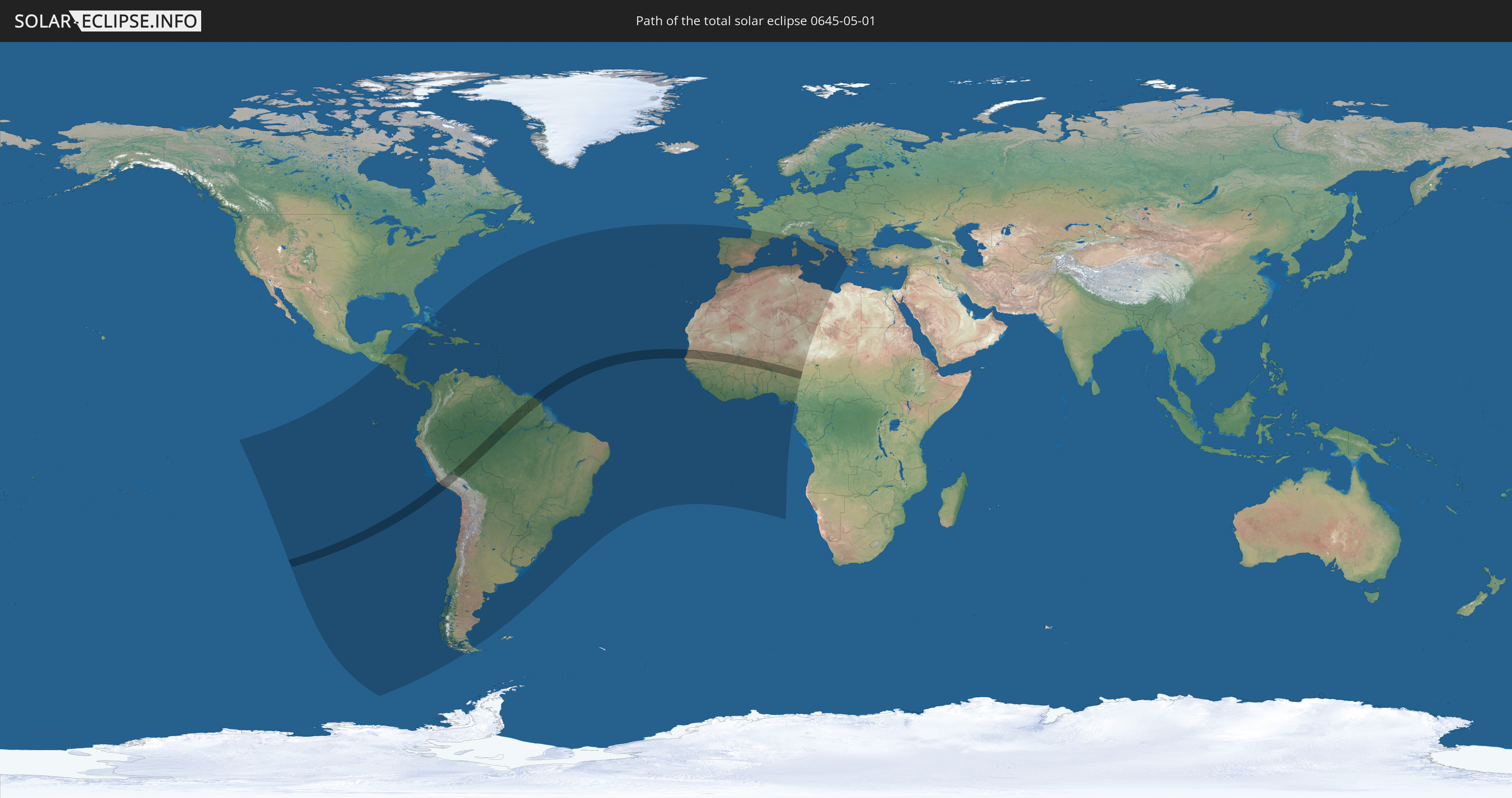
Die Sonnenfinsternis am 01.05.0645 kann man in 80 Ländern als partielle Sonnenfinsternis beobachten.
Der Finsternispfad verläuft durch 14 Länder. Nur in diesen Ländern ist sie als totale Sonnenfinsternis zu sehen.
In den folgenden Ländern ist die Sonnenfinsternis total zu sehen
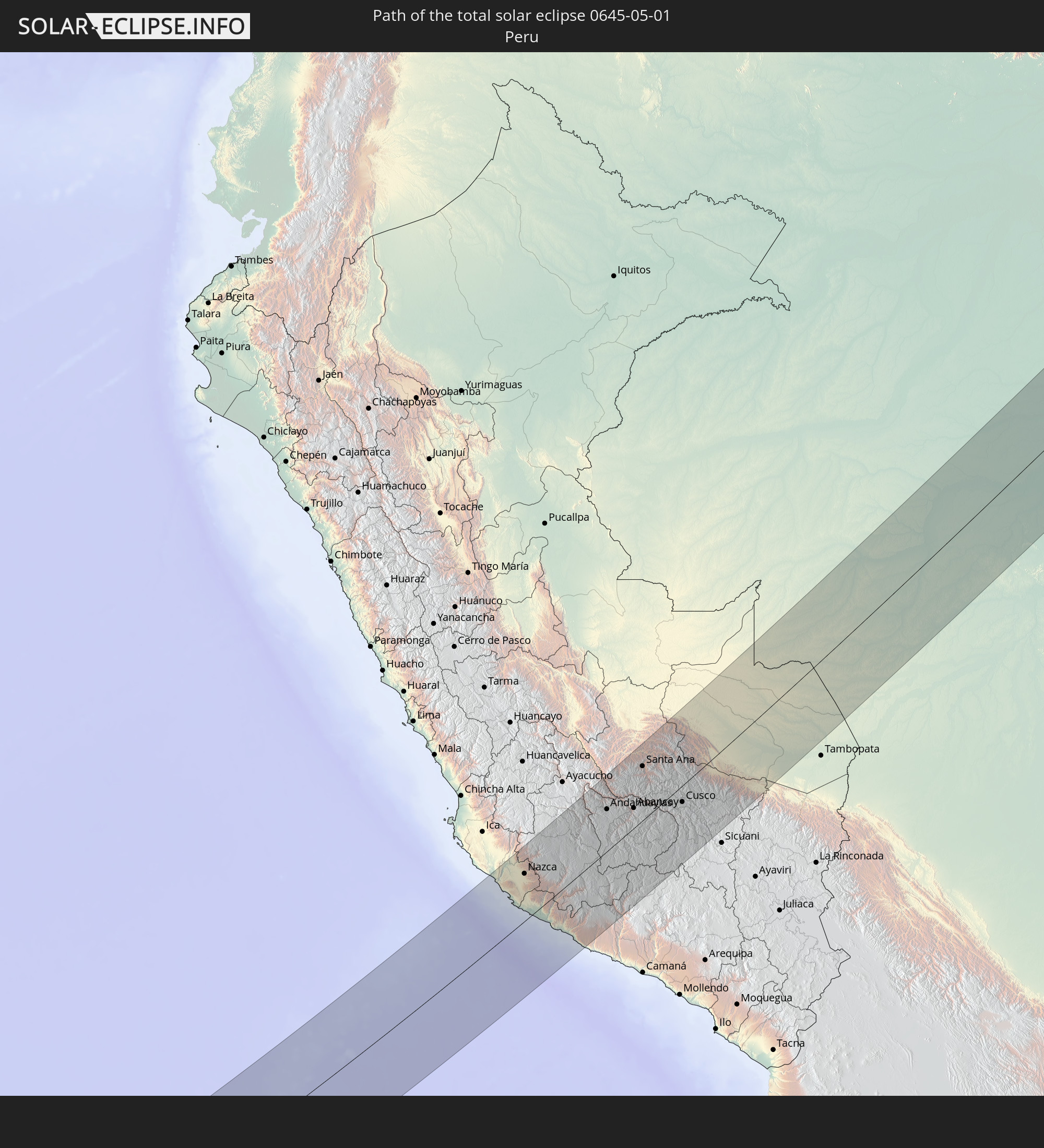 Peru
Peru
 Brasilien
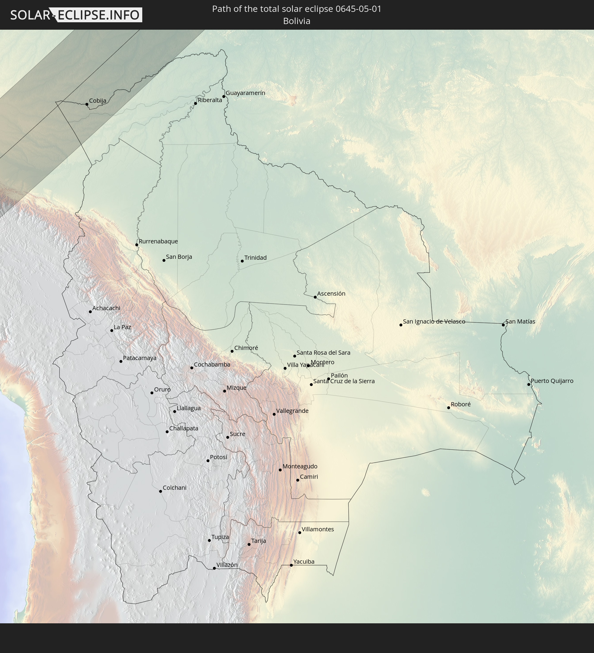 Bolivien
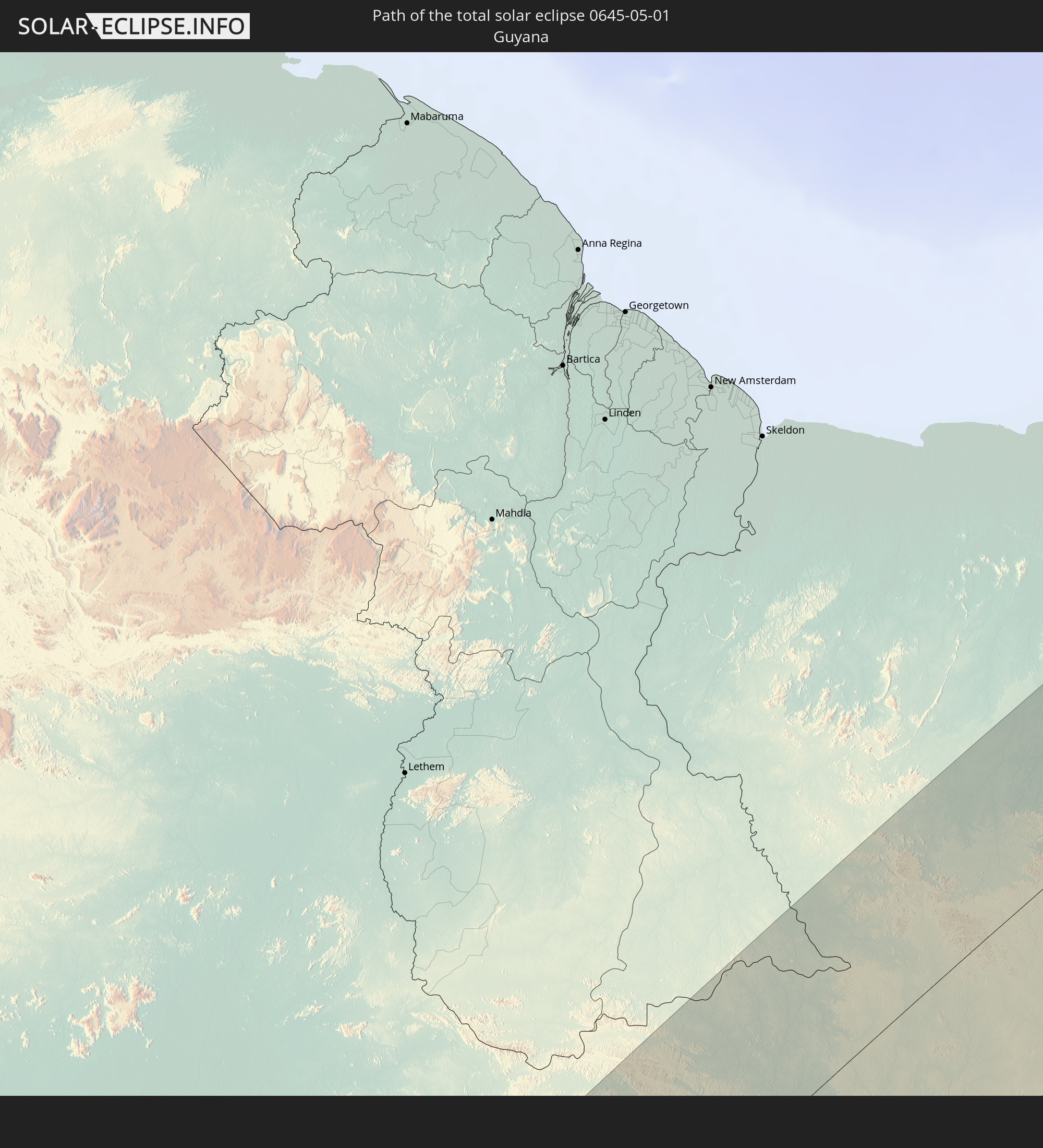 Guyana
 Suriname
 Französisch-Guayana
 Kap Verde
 Senegal
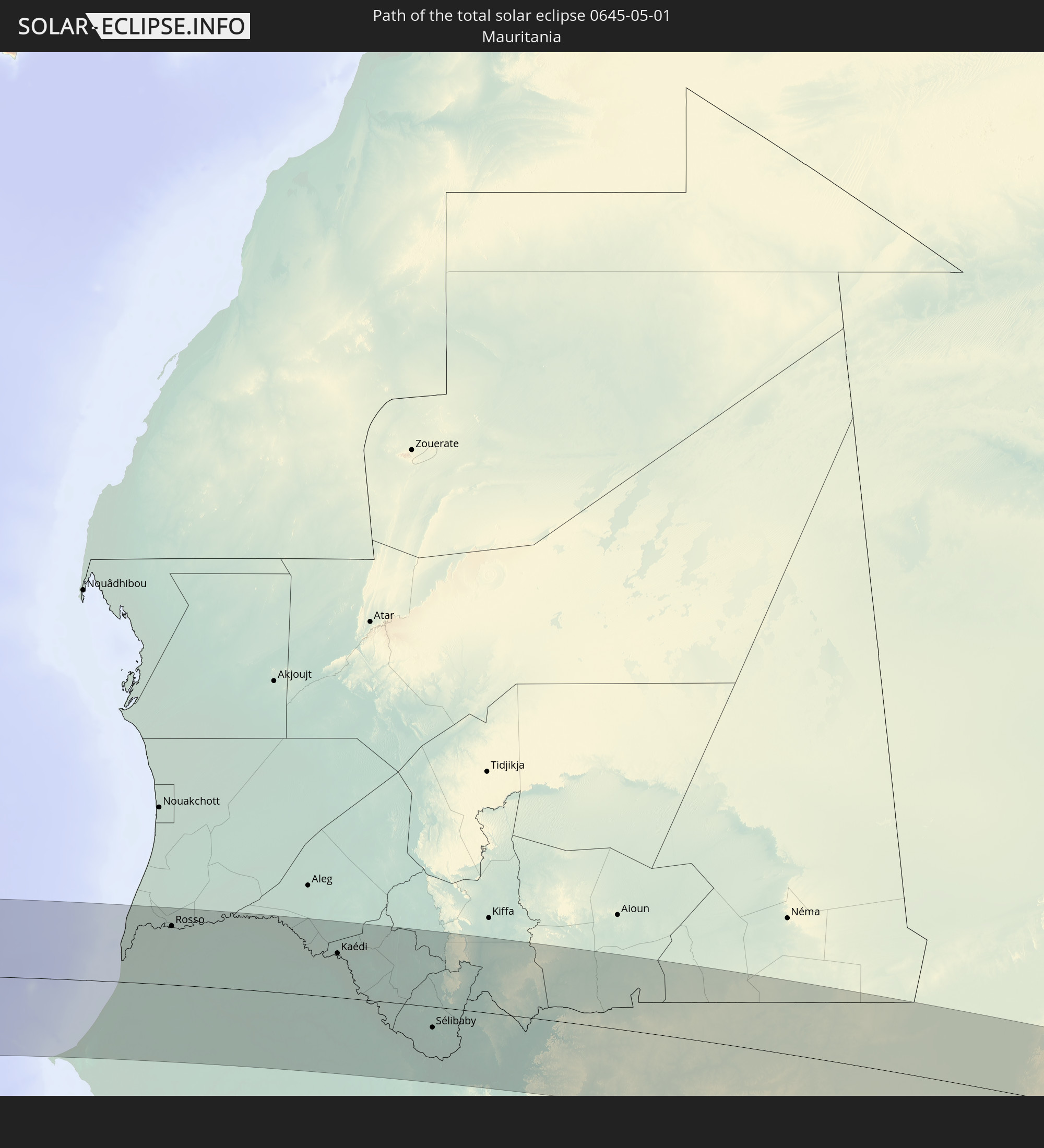 Mauretanien
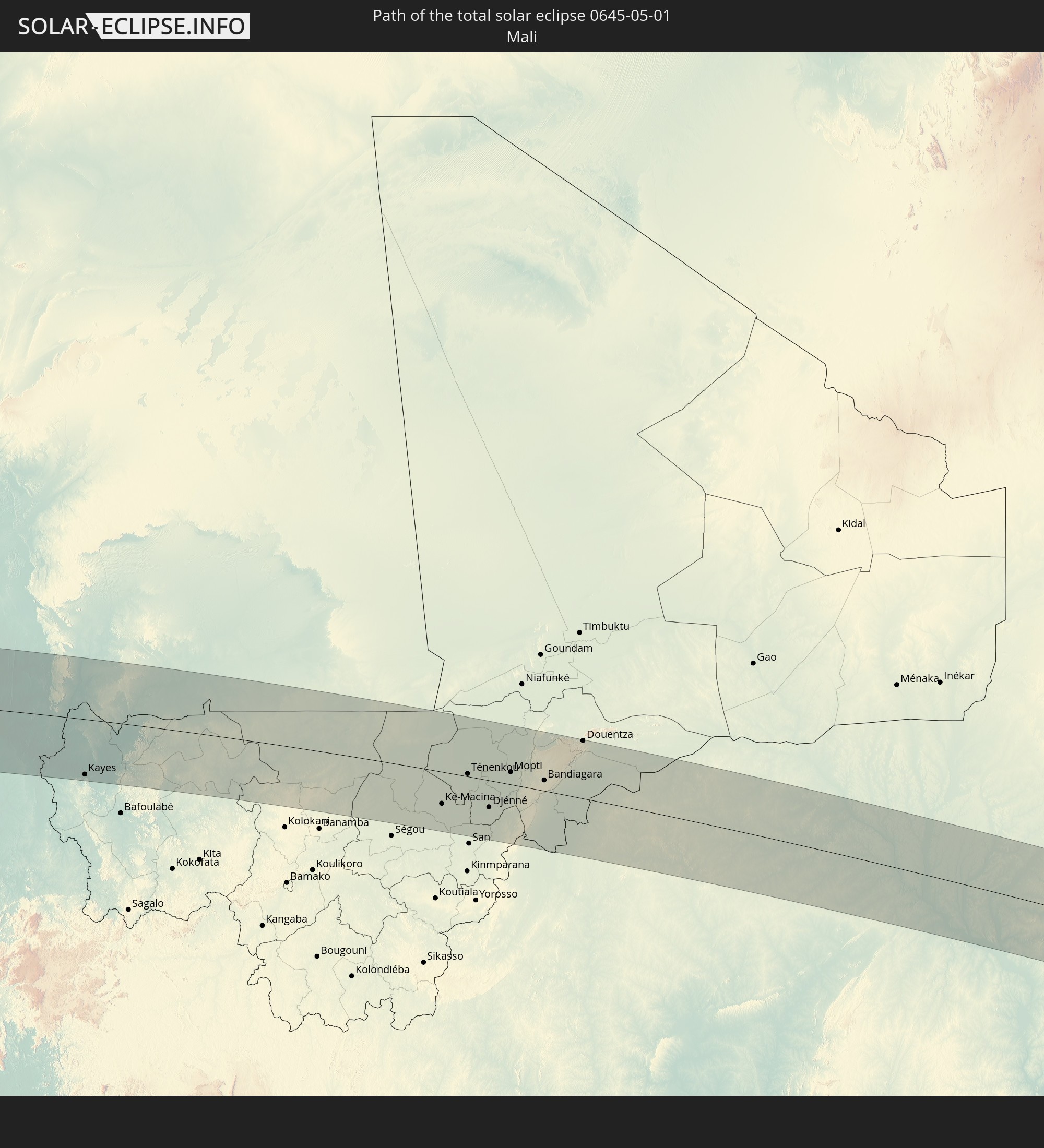 Mali
Mali
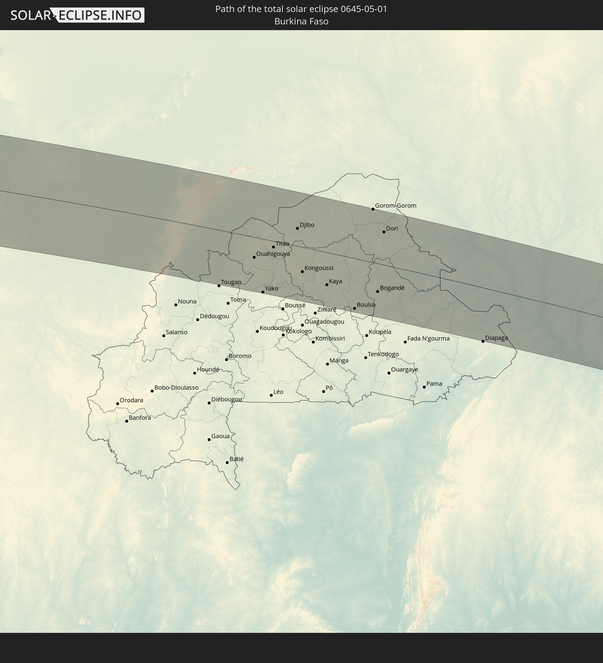 Burkina Faso
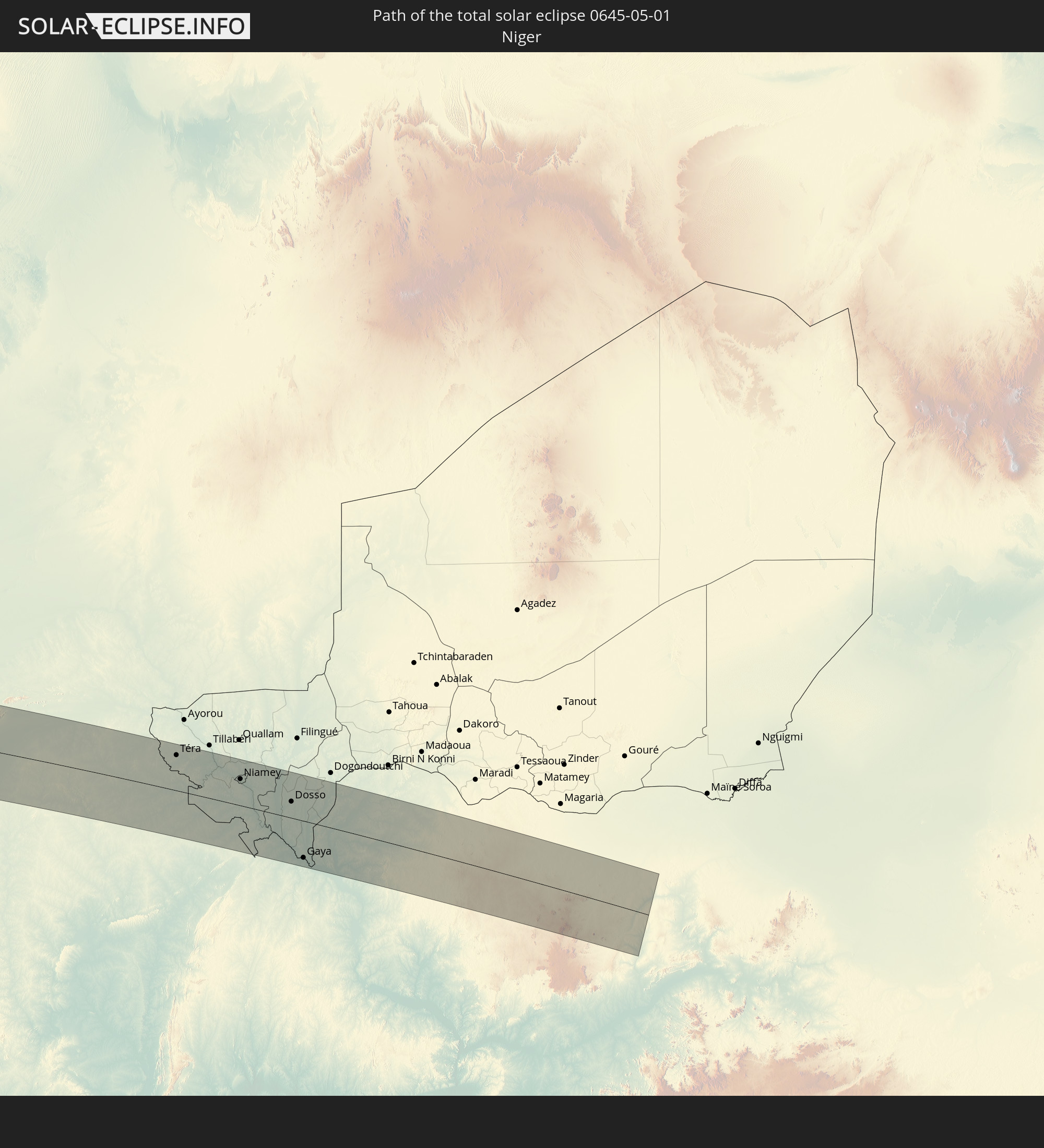 Niger
Niger
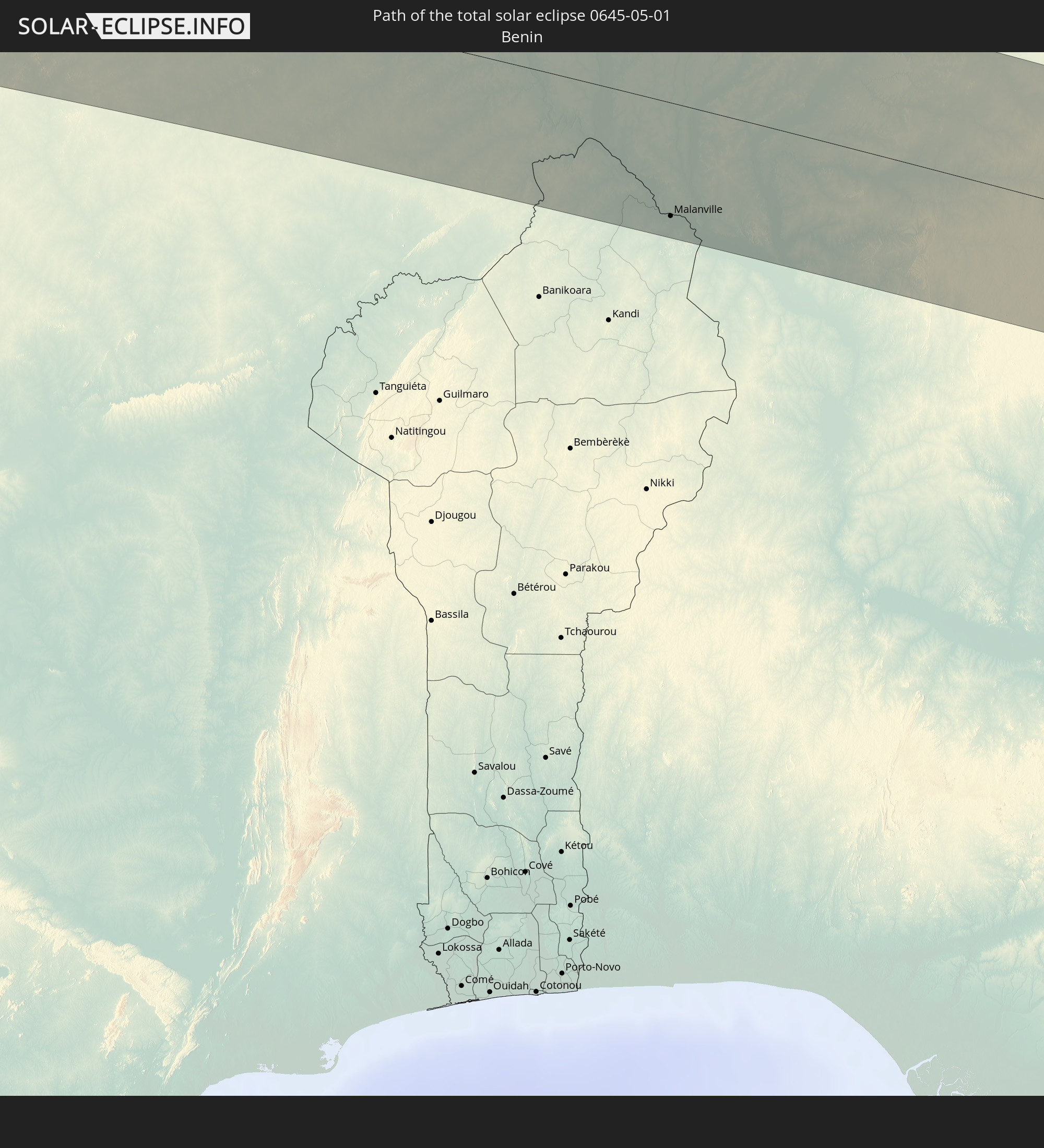 Benin
Benin
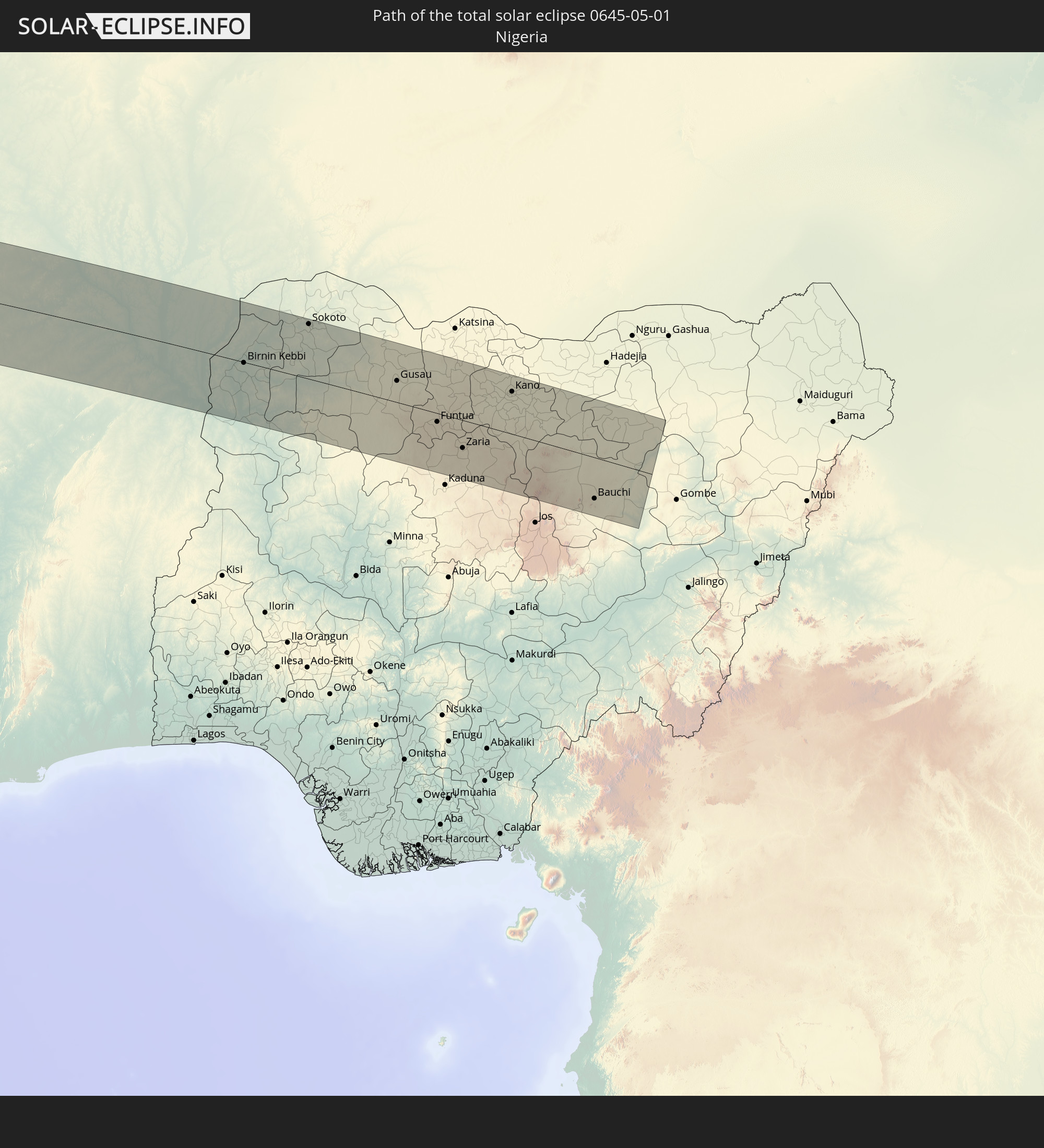 Nigeria
In den folgenden Ländern ist die Sonnenfinsternis partiell zu sehen
 United States Minor Outlying Islands
 Chile
Chile
 Ecuador
 El Salvador
 Honduras
 Nicaragua
 Costa Rica
 Kuba
Kuba
 Panama
 Kolumbien
 Kaimaninseln
 Peru
Peru
 Bahamas
 Jamaika
 Haiti
Haiti
 Brasilien
 Argentinien
 Venezuela
 Turks- und Caicosinseln
 Dominikanische Republik
 Aruba
Aruba
 Bolivien
 Puerto Rico
 Amerikanische Jungferninseln
 Bermuda
 Britische Jungferninseln
 Anguilla
 Saint-Martin
 Saint-Barthélemy
 St. Kitts und Nevis
 Paraguay
 Antigua und Barbuda
 Montserrat
 Trinidad und Tobago
 Guadeloupe
 Grenada
 Dominica
 St. Vincent und die Grenadinen
 Guyana
 Martinique
 St. Lucia
 Barbados
 Uruguay
 Suriname
 Französisch-Guayana
 Portugal
 Kap Verde
 Spanien
 Senegal
 Mauretanien
 Gambia
 Guinea-Bissau
 Guinea
 St. Helena
 Sierra Leone
 Marokko
 Mali
Mali
 Liberia
 Algerien
 Elfenbeinküste
 Burkina Faso
 Gibraltar
 Frankreich
 Ghana
Ghana
 Togo
Togo
 Niger
Niger
 Benin
Benin
 Andorra
 Nigeria
 Äquatorialguinea
 São Tomé und Príncipe
 Italien
 Monaco
 Tunesien
 Kamerun
 Libyen
 Vatikanstadt
 Malta
Malta
 Albanien
 Griechenland
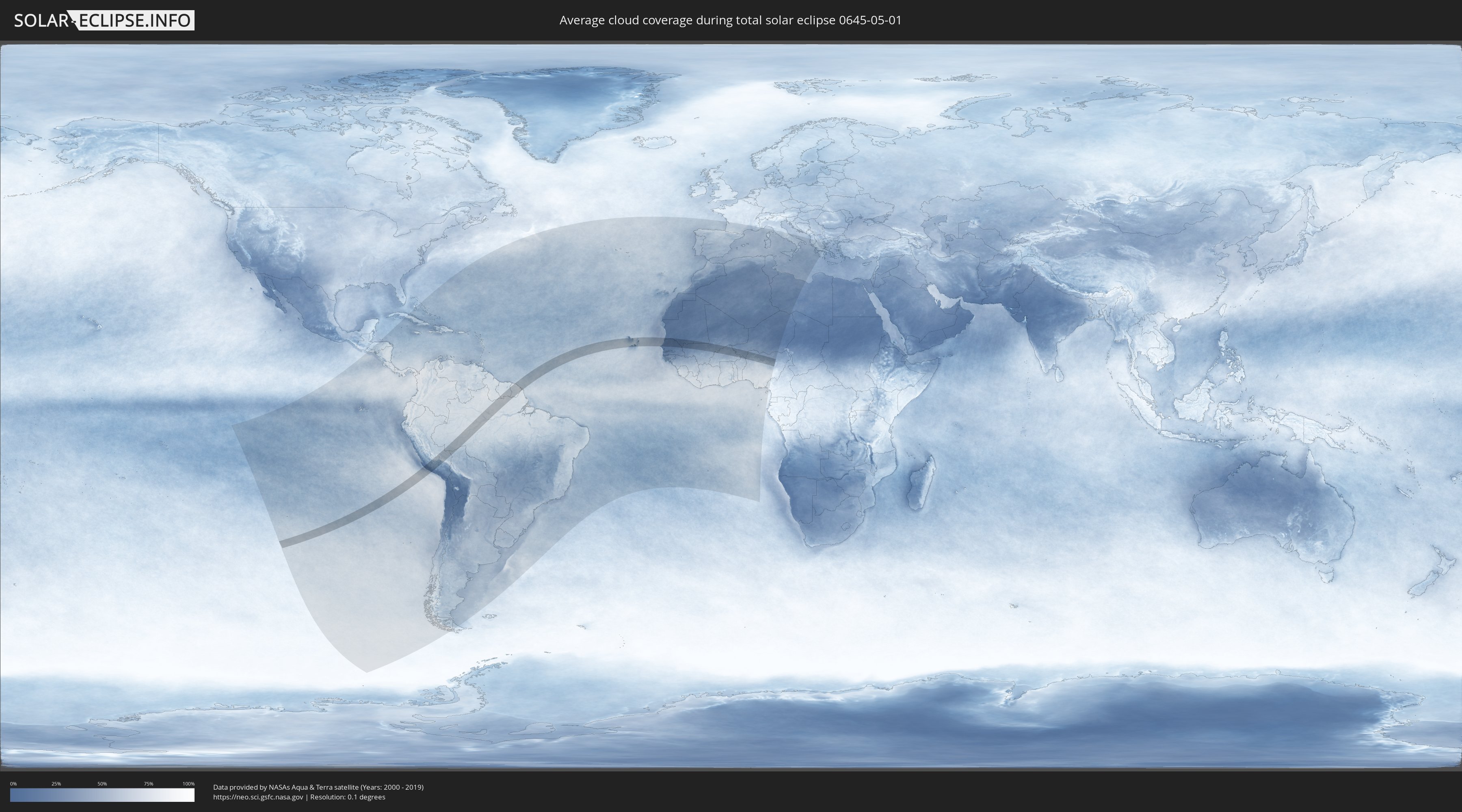
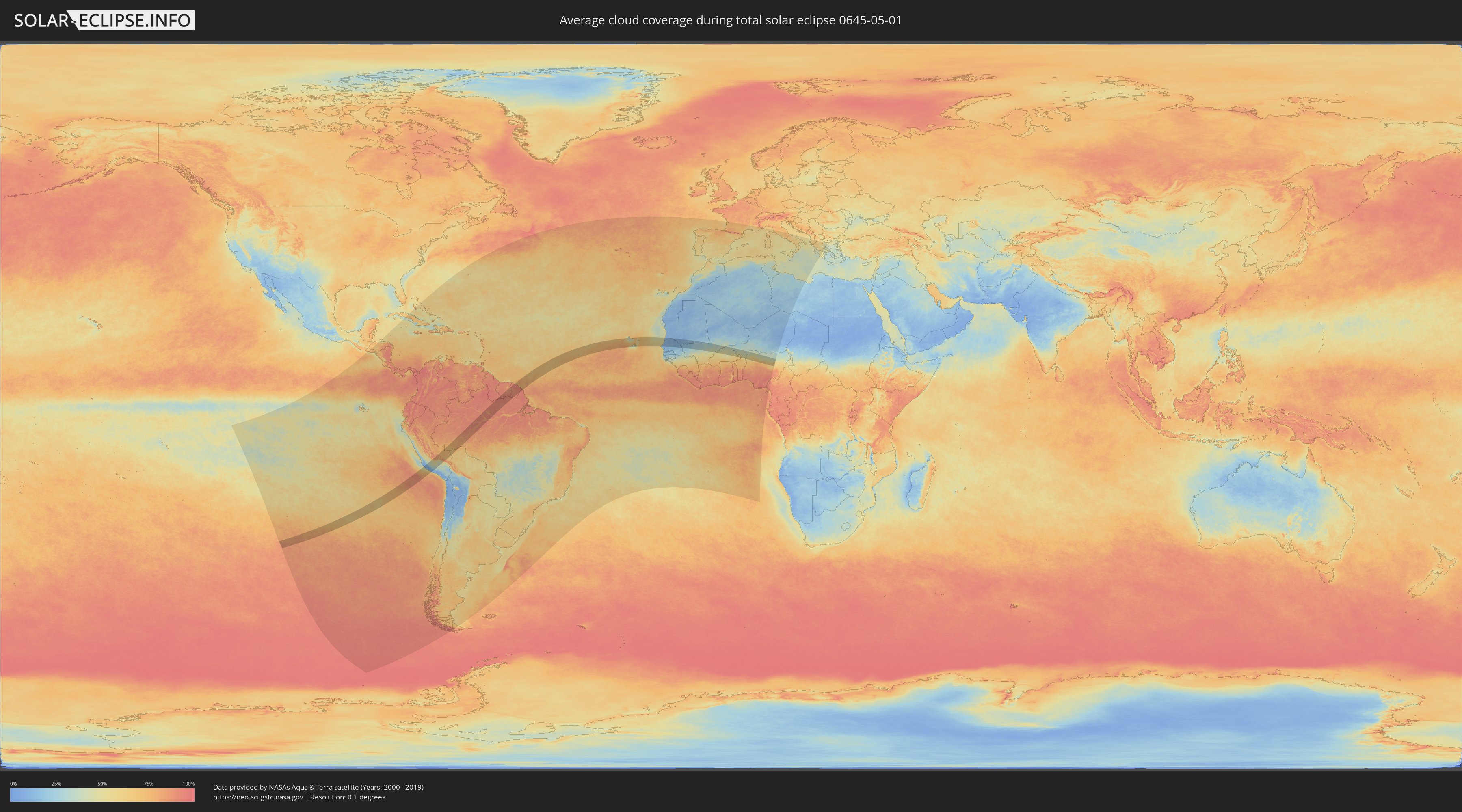
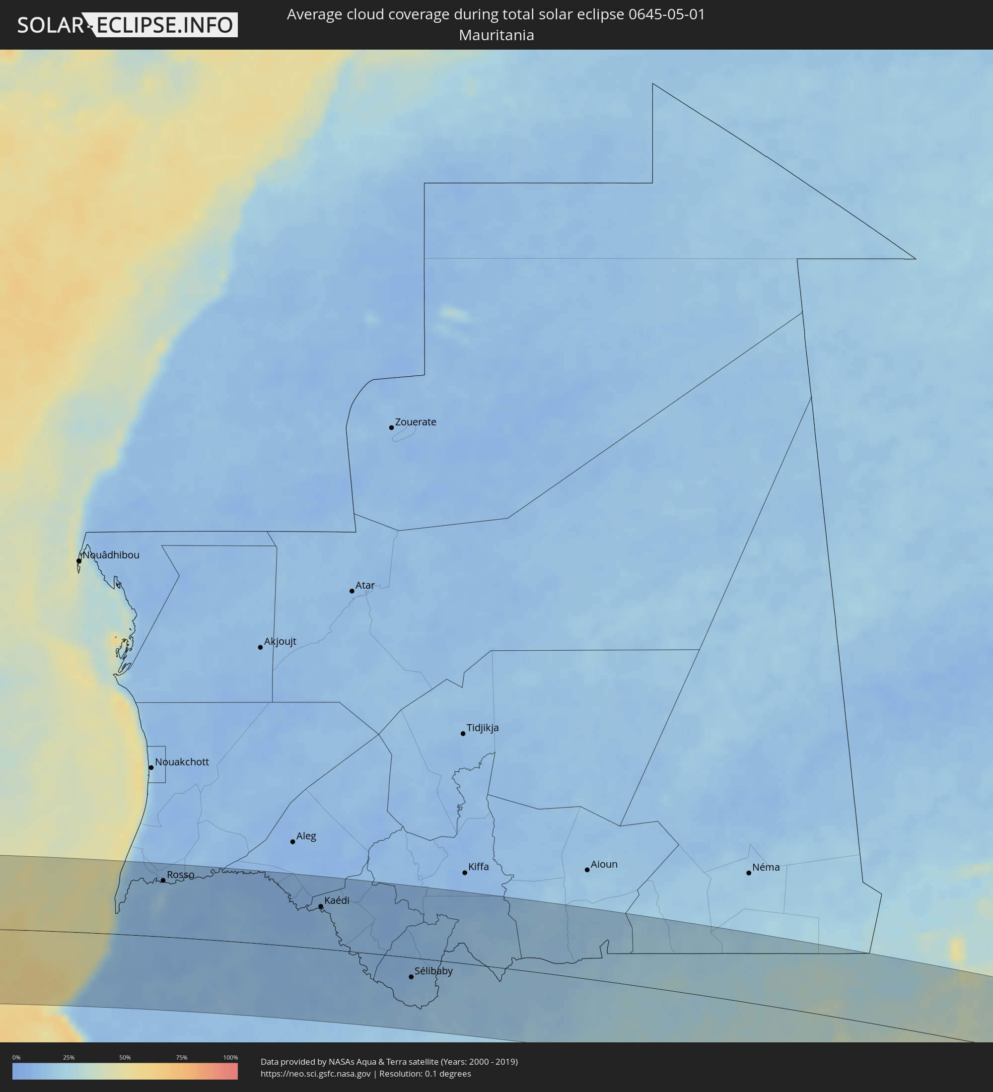
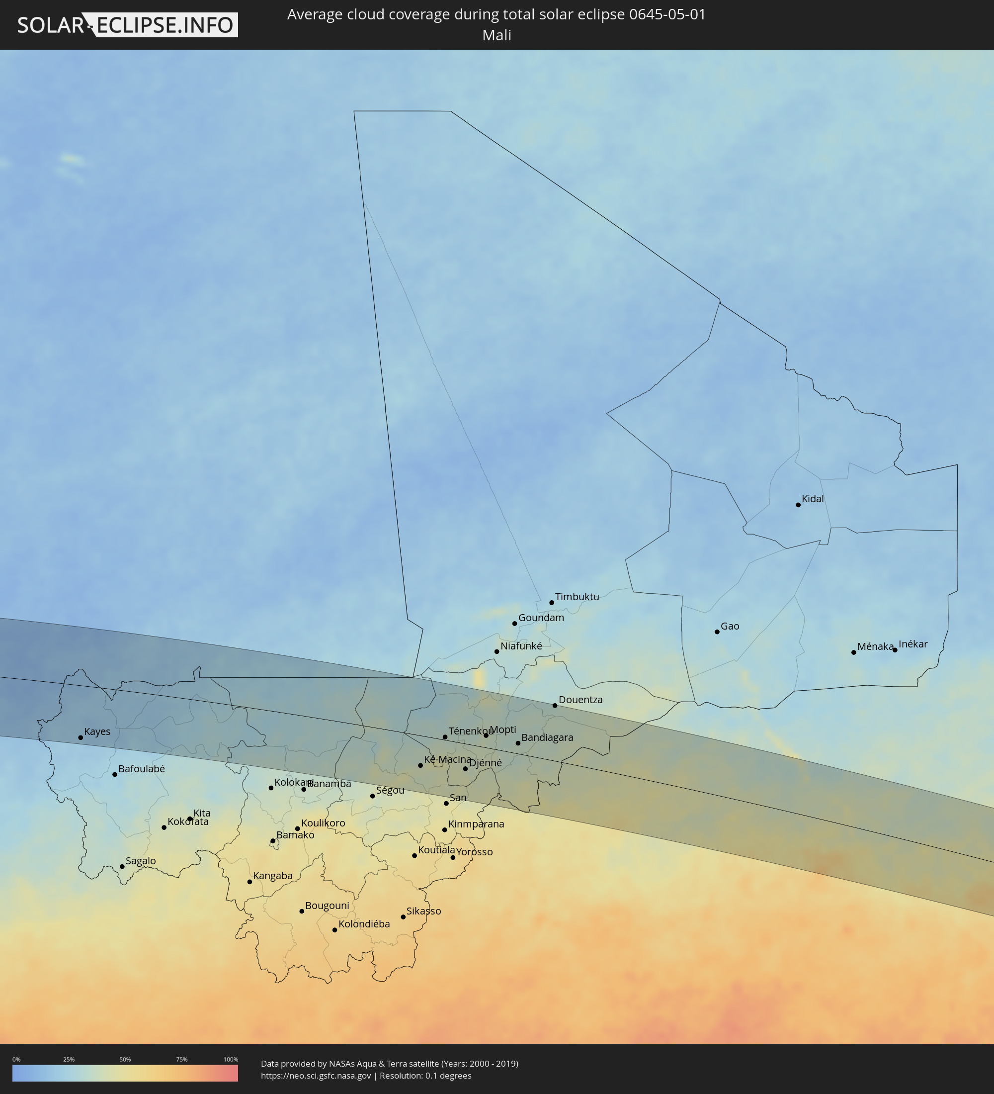
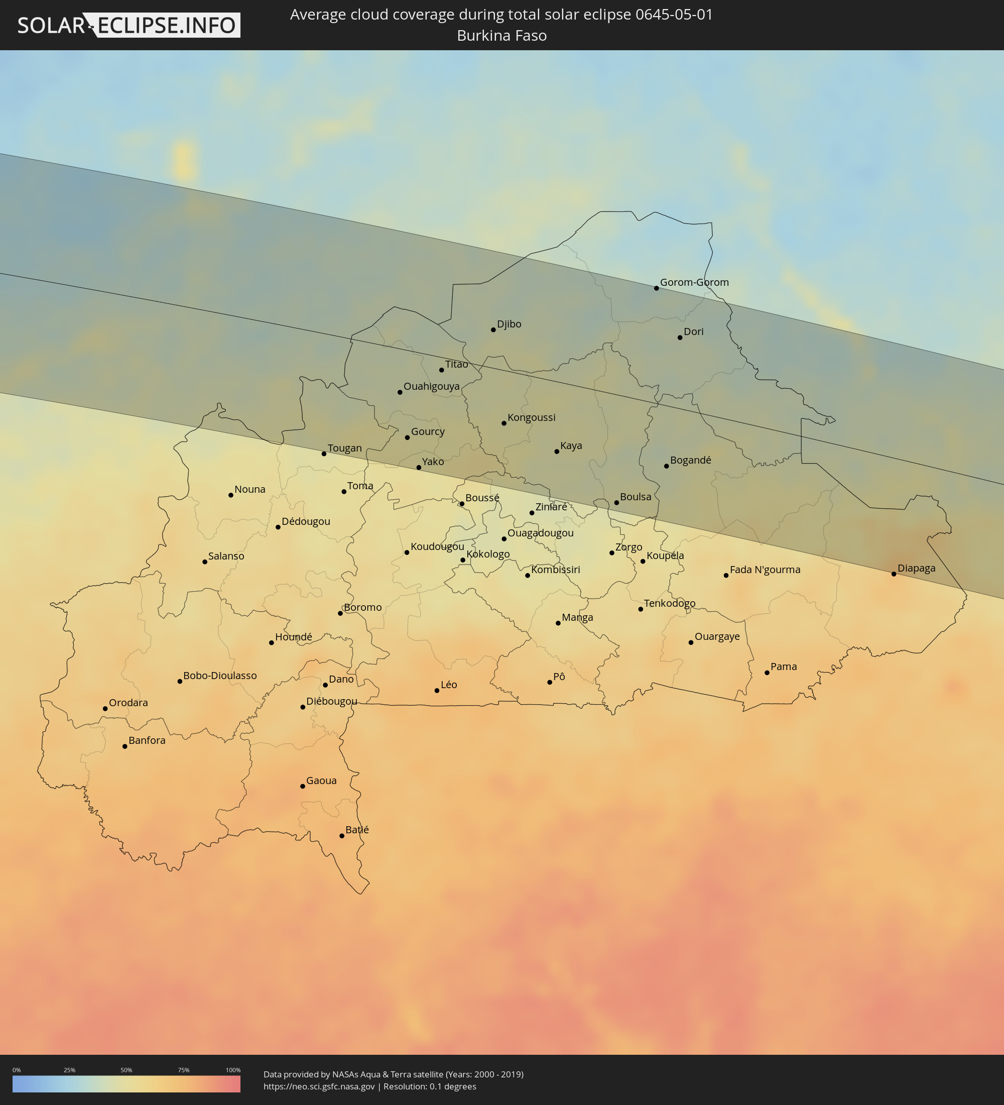
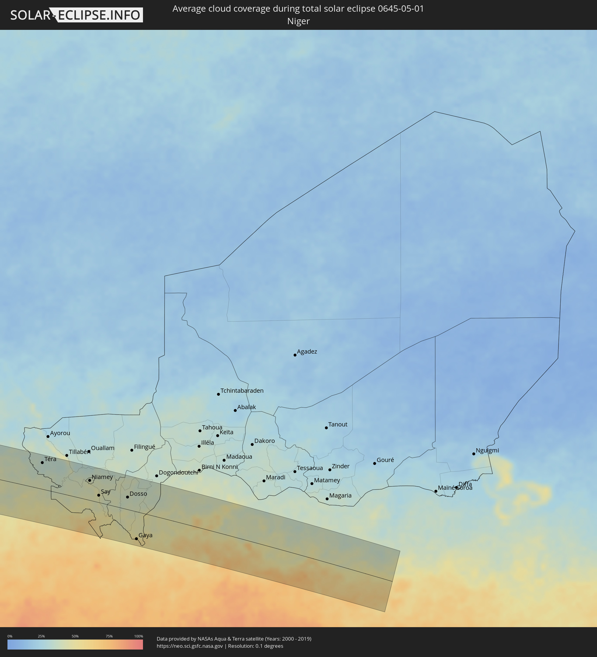
Wie wird das Wetter während der totalen Sonnenfinsternis am 01.05.0645?
Wo ist der beste Ort, um die totale Sonnenfinsternis vom 01.05.0645 zu beobachten?
Die folgenden Karten zeigen die durchschnittliche Bewölkung für den Tag, an dem die totale Sonnenfinsternis
stattfindet. Mit Hilfe der Karten lässt sich der Ort entlang des Finsternispfades eingrenzen,
der die besten Aussichen auf einen klaren wolkenfreien Himmel bietet.
Trotzdem muss man immer lokale Gegenenheiten beachten und sollte sich genau über das Wetter an seinem
gewählten Beobachtungsort informieren.
Die Daten stammen von den beiden NASA-Satelliten
AQUA und TERRA
und wurden über einen Zeitraum von 19 Jahren (2000 - 2019) gemittelt.
Detaillierte Länderkarten
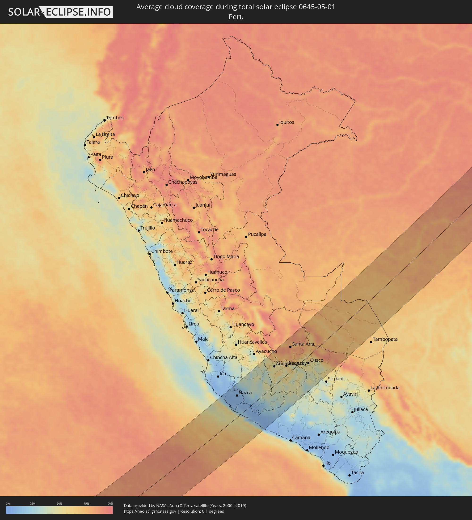 Peru
Peru
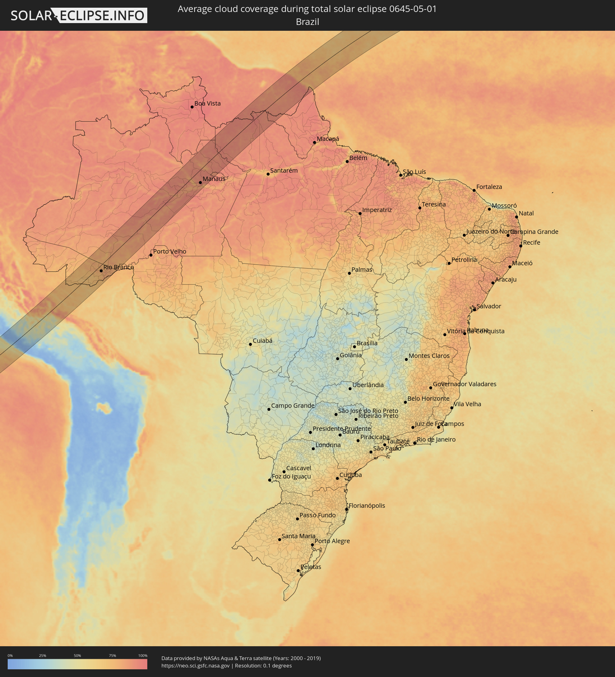 Brasilien
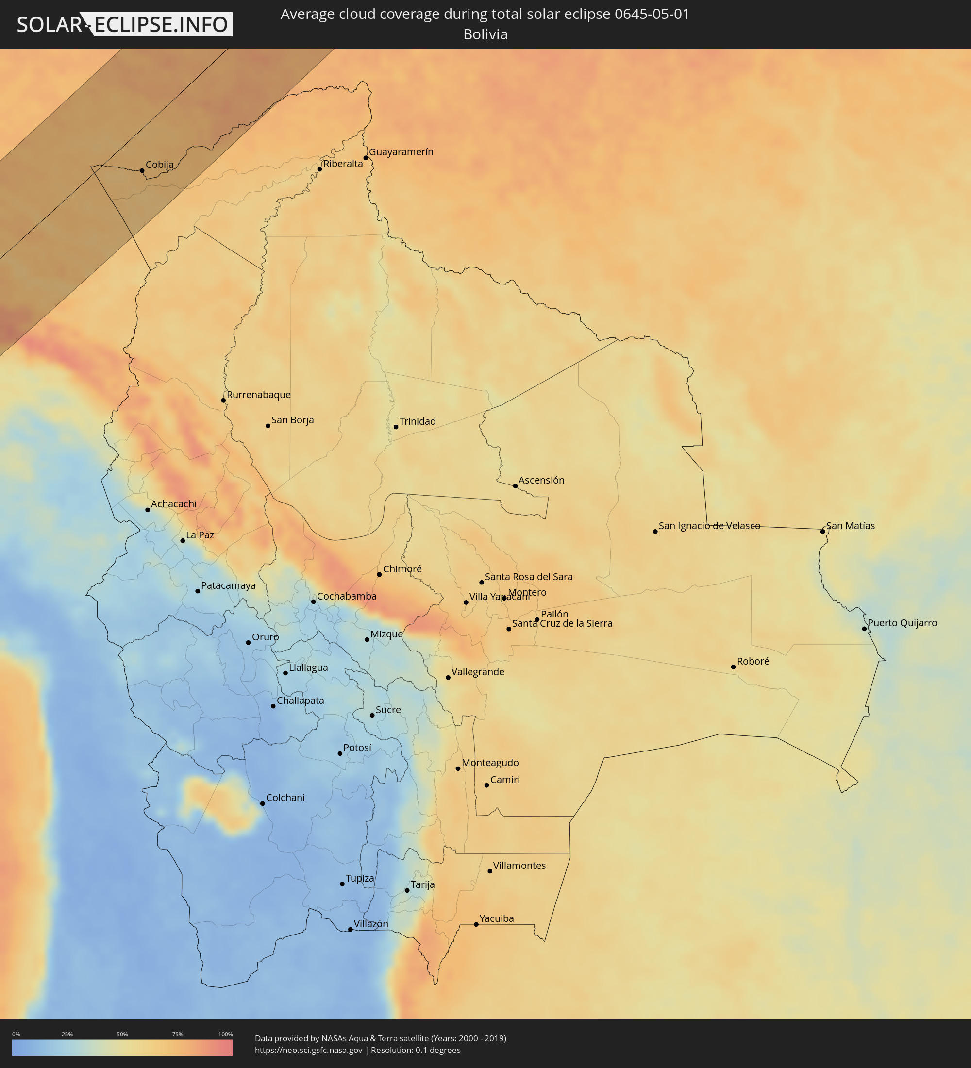 Bolivien
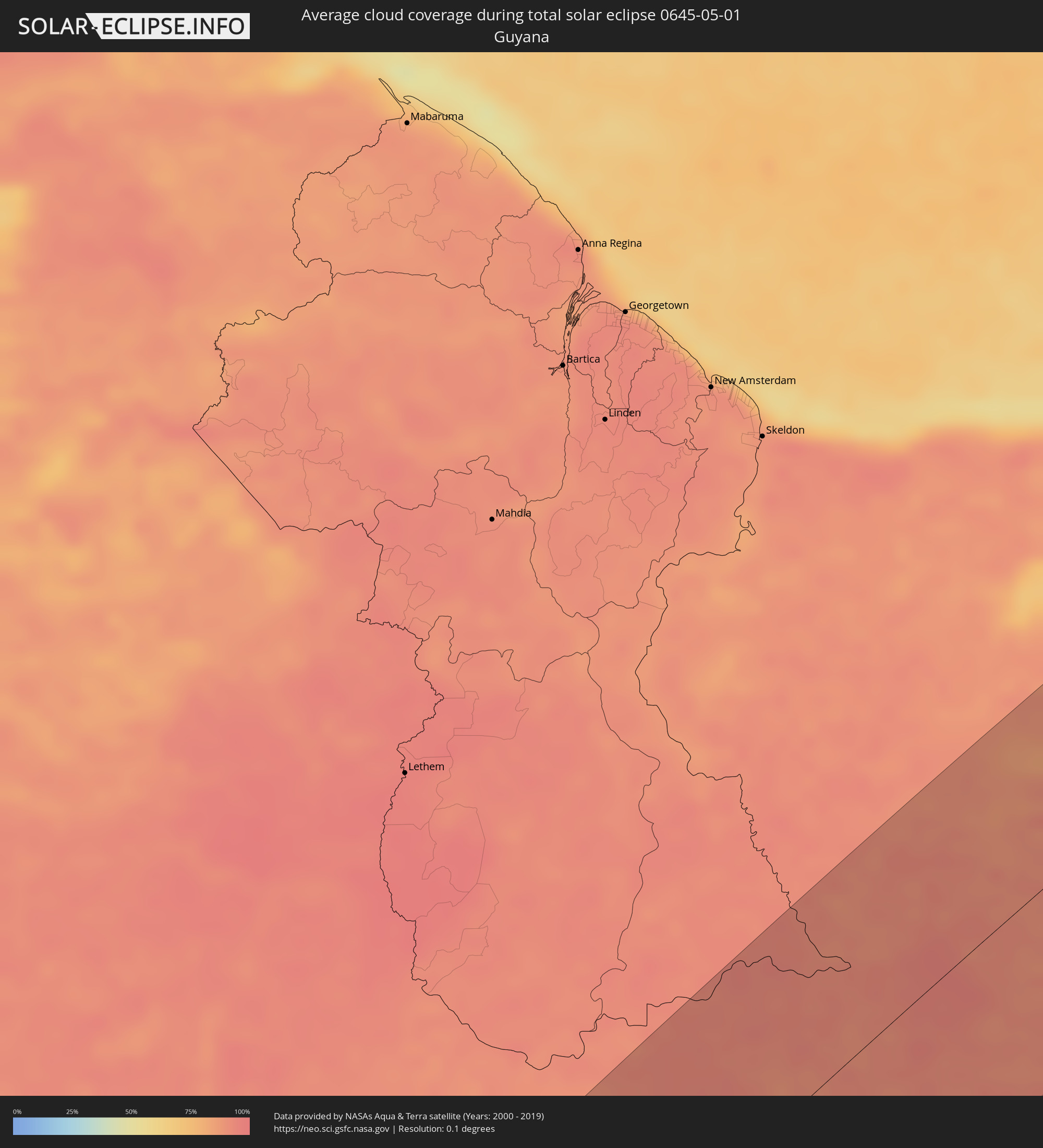 Guyana
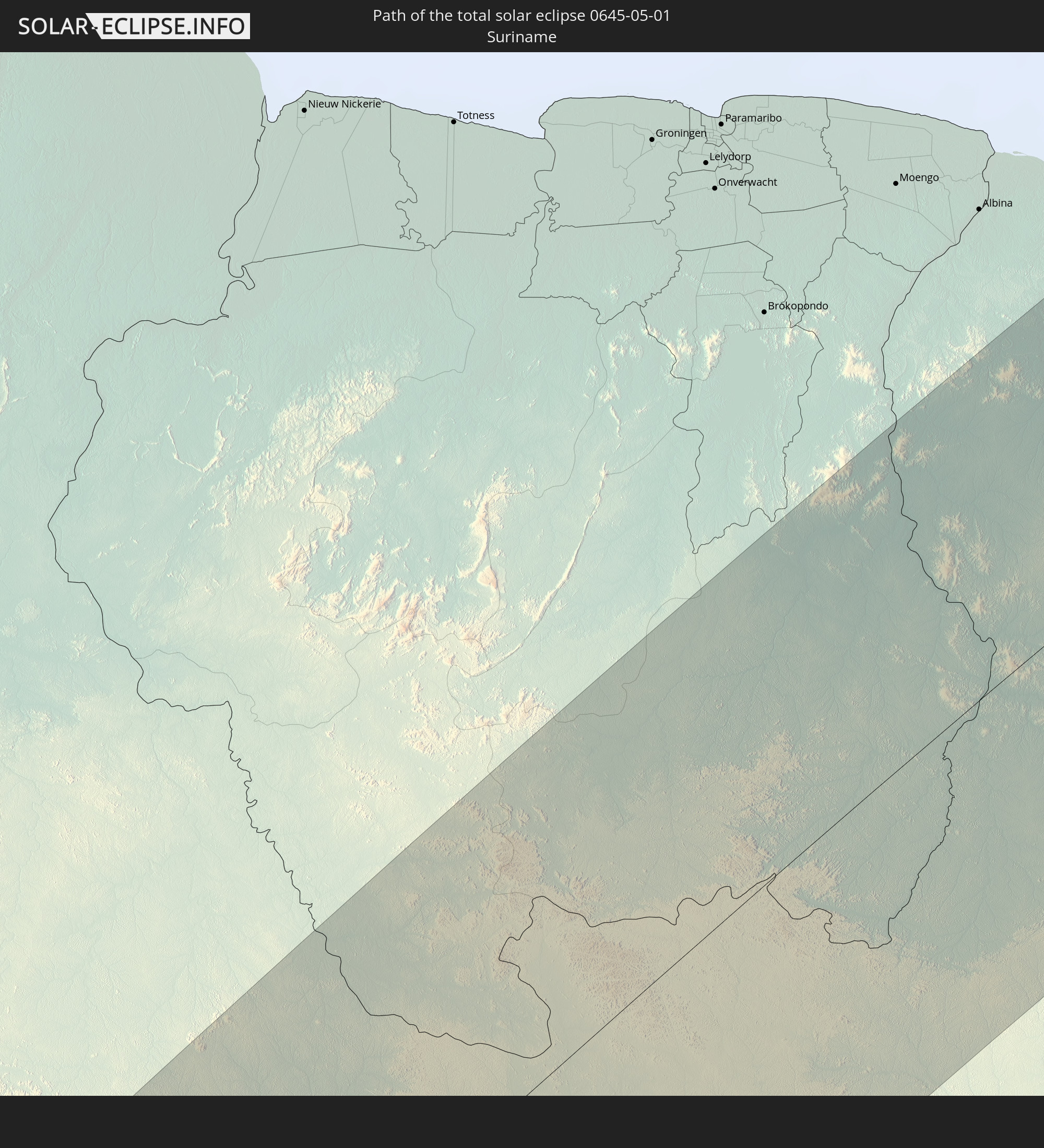
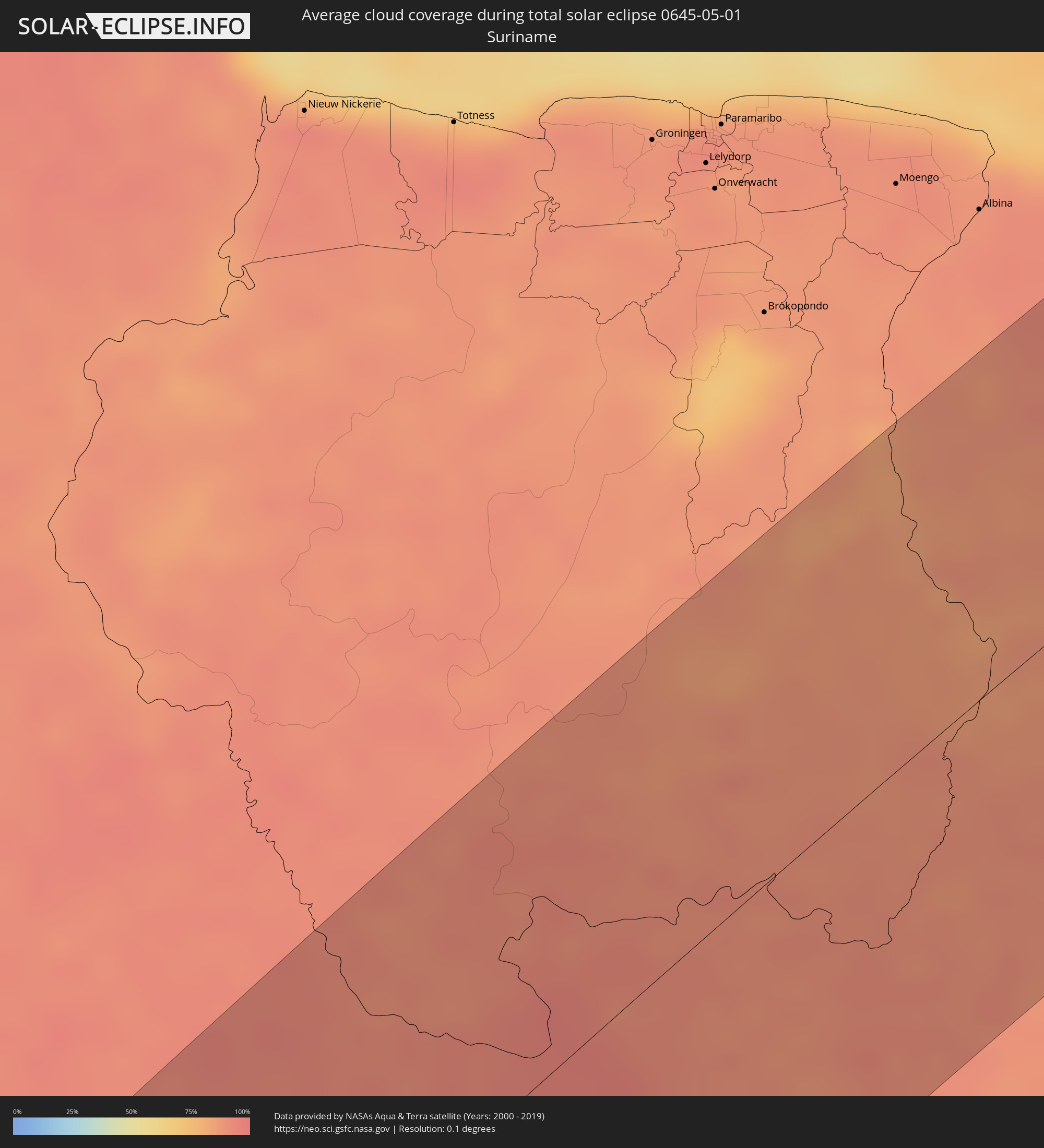 Suriname
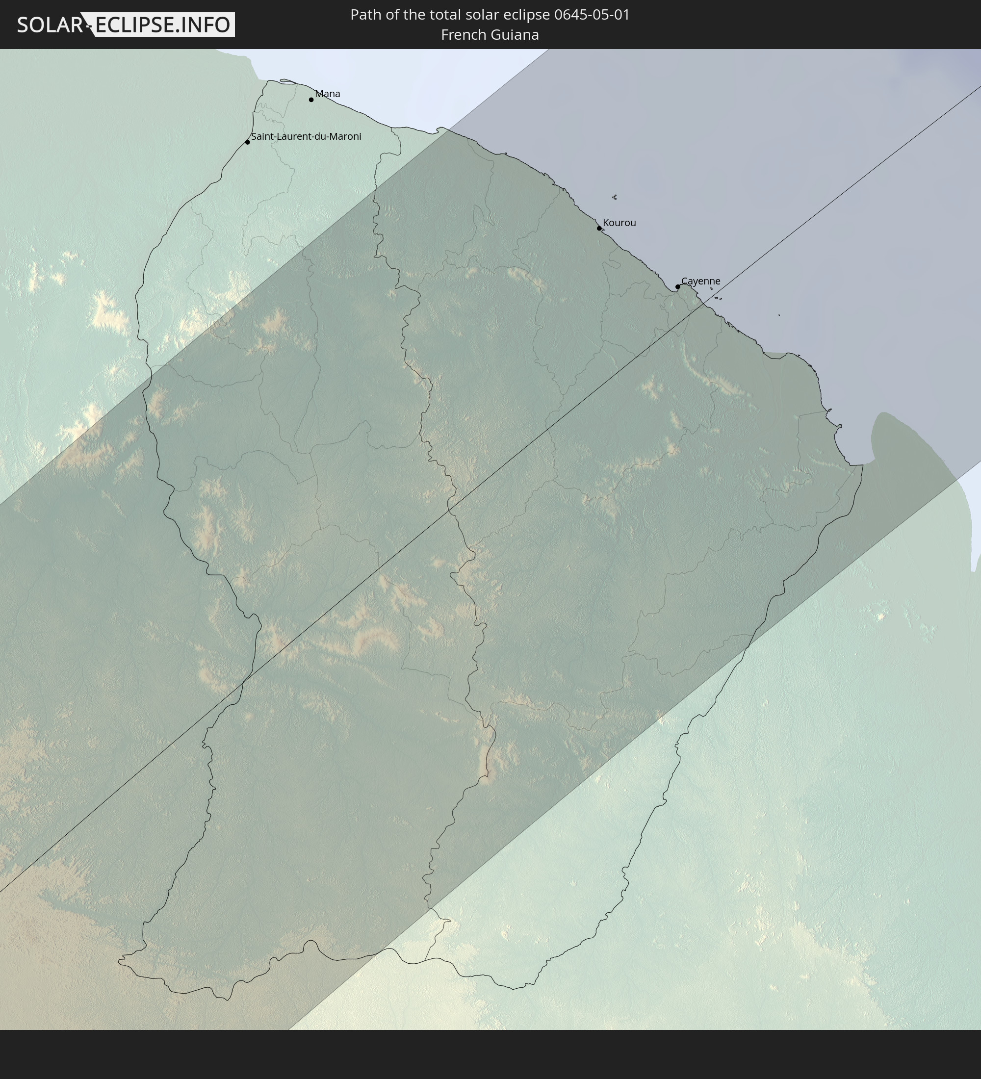
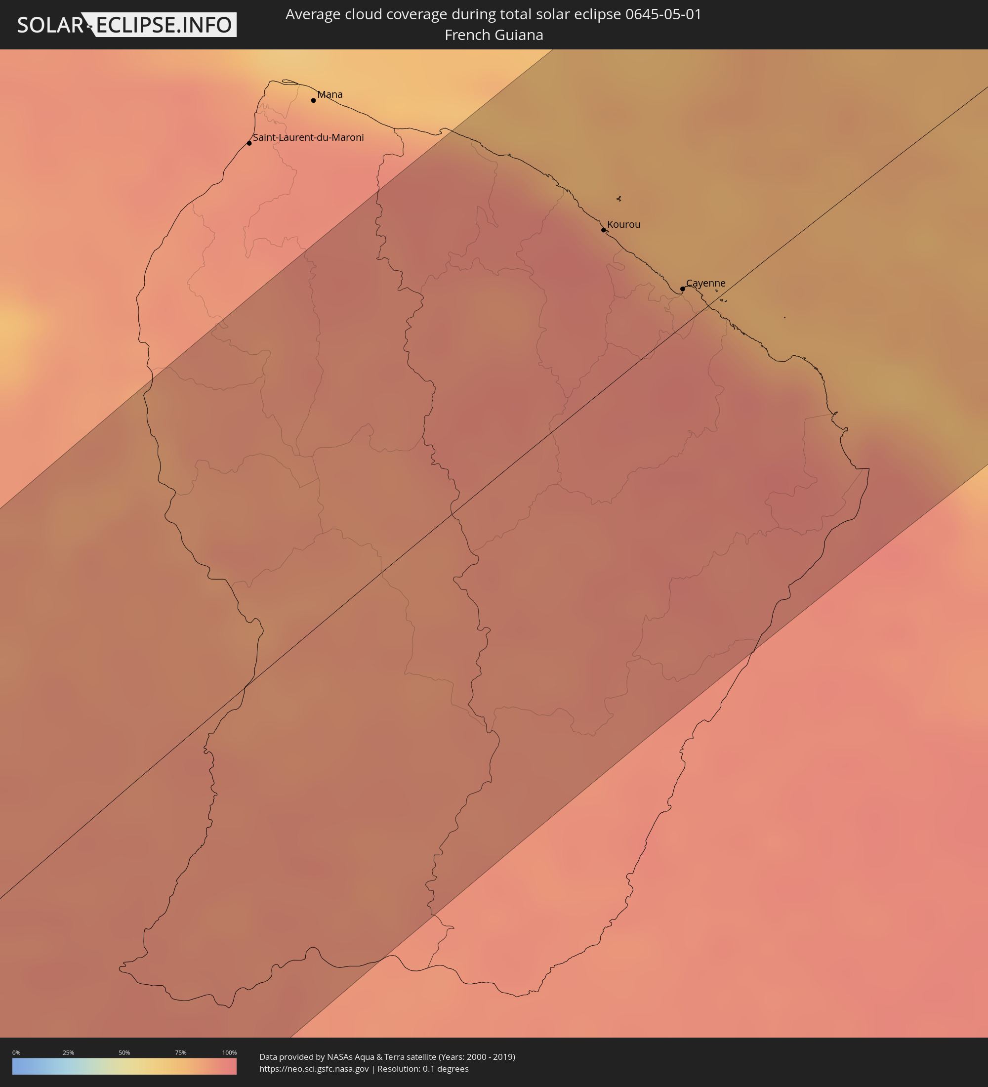 Französisch-Guayana
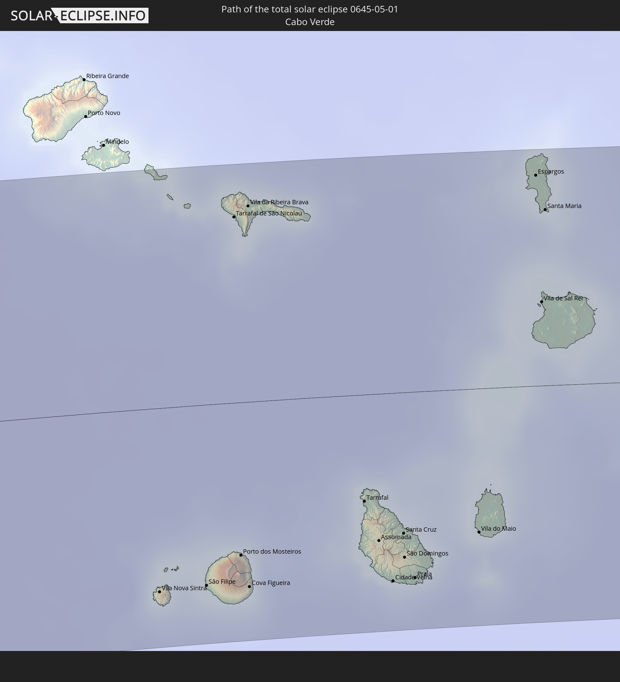
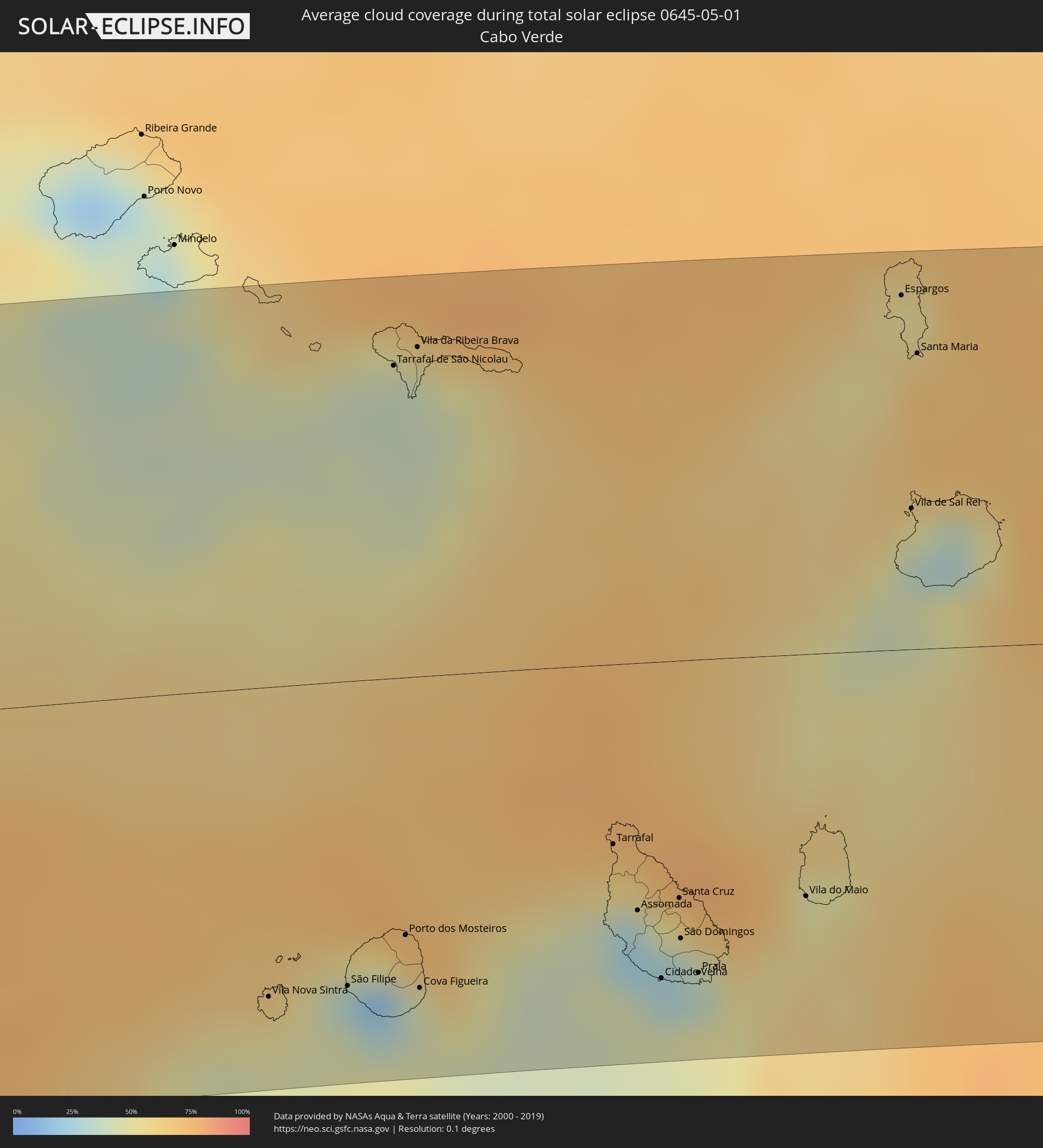 Kap Verde
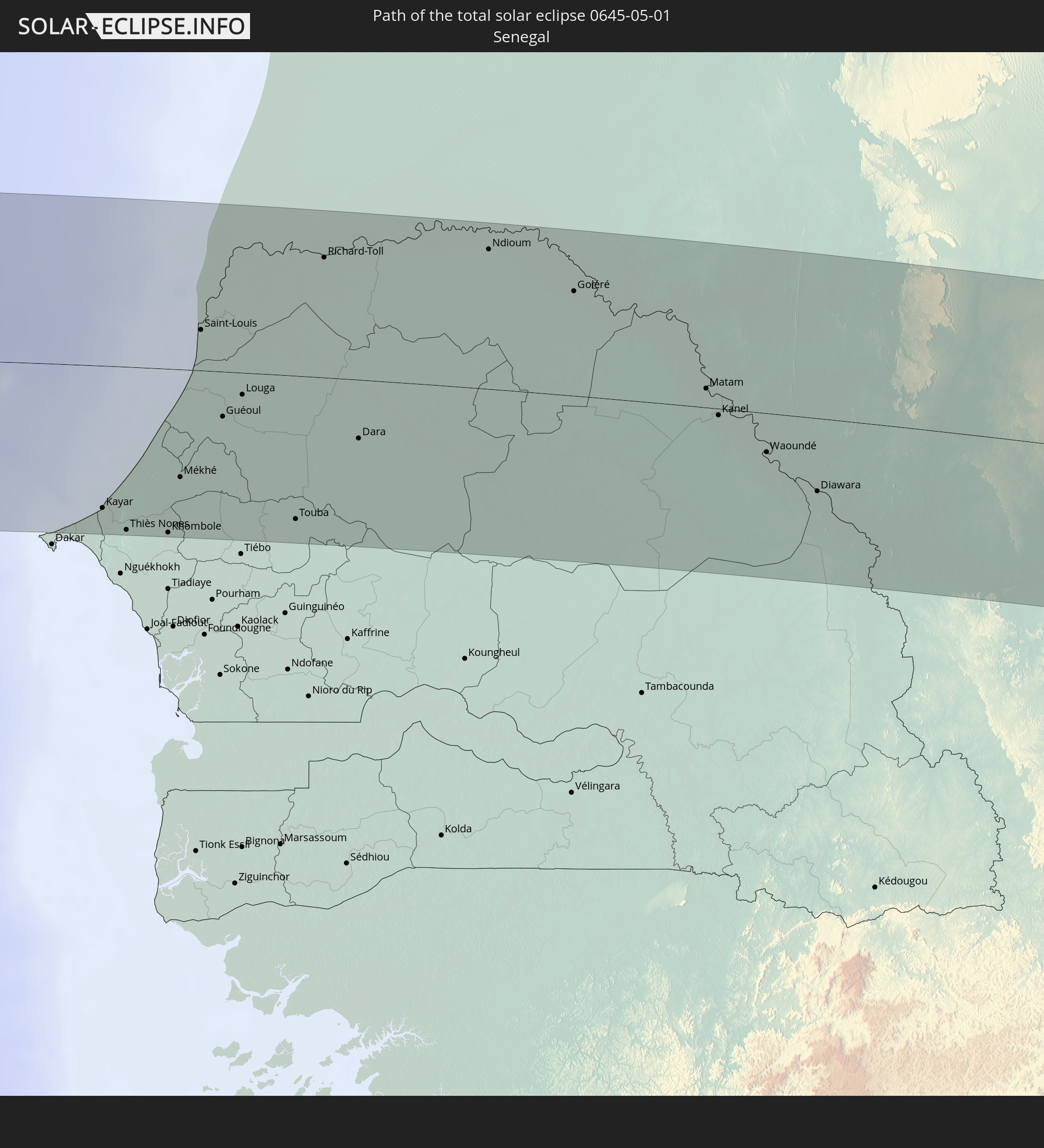
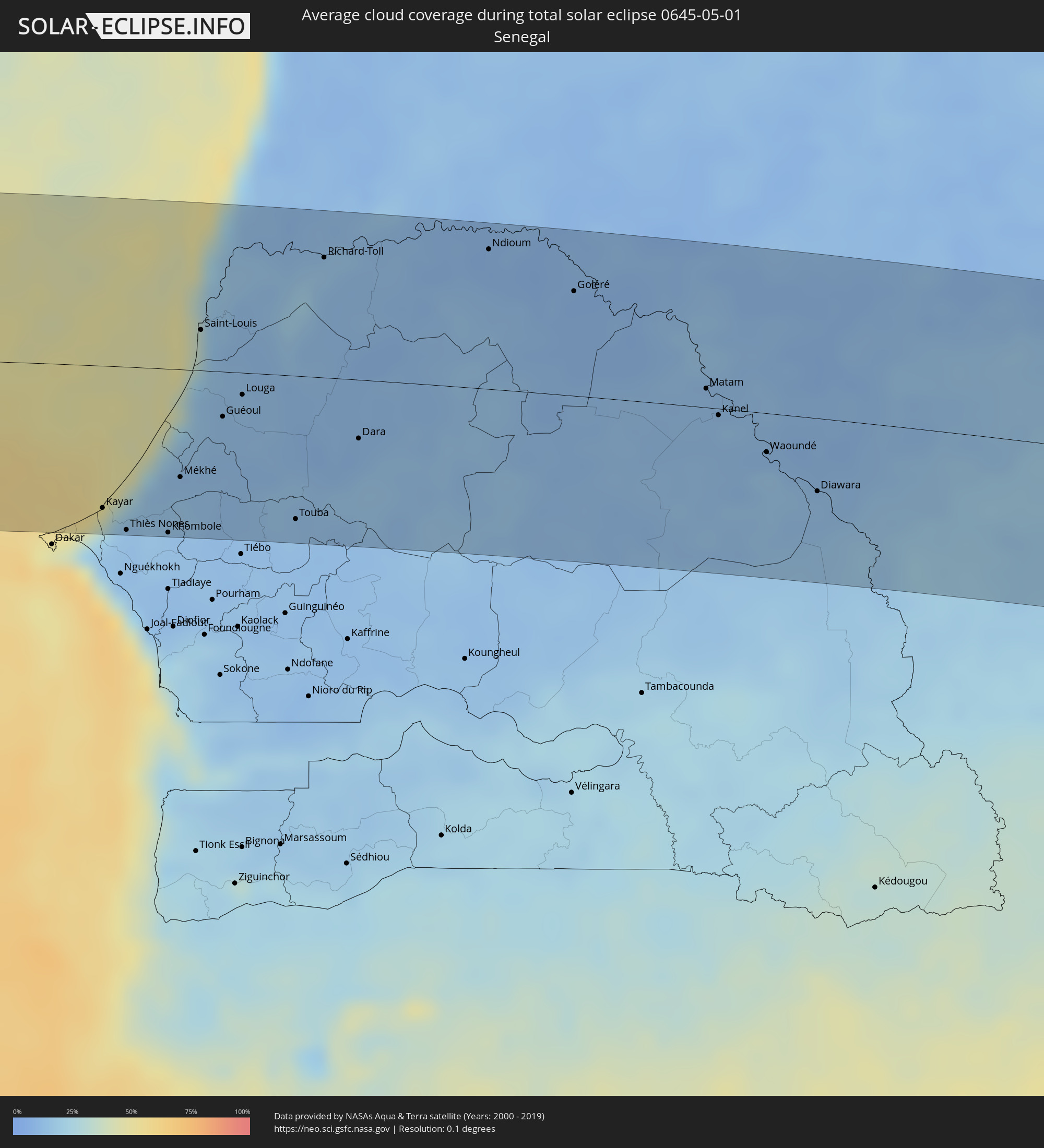 Senegal
 Mauretanien
 Mali
Mali
 Burkina Faso
 Niger
Niger
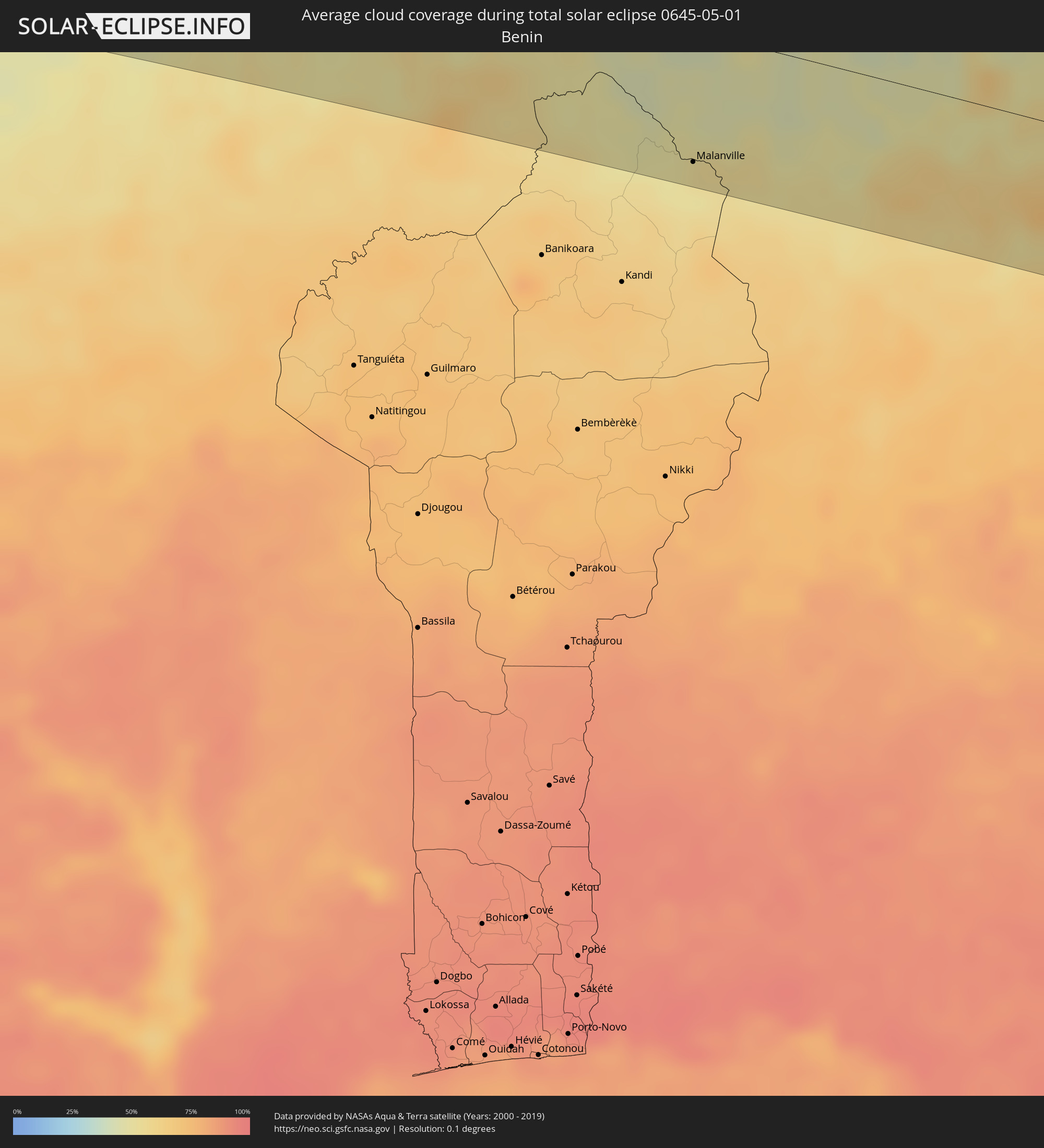 Benin
Benin
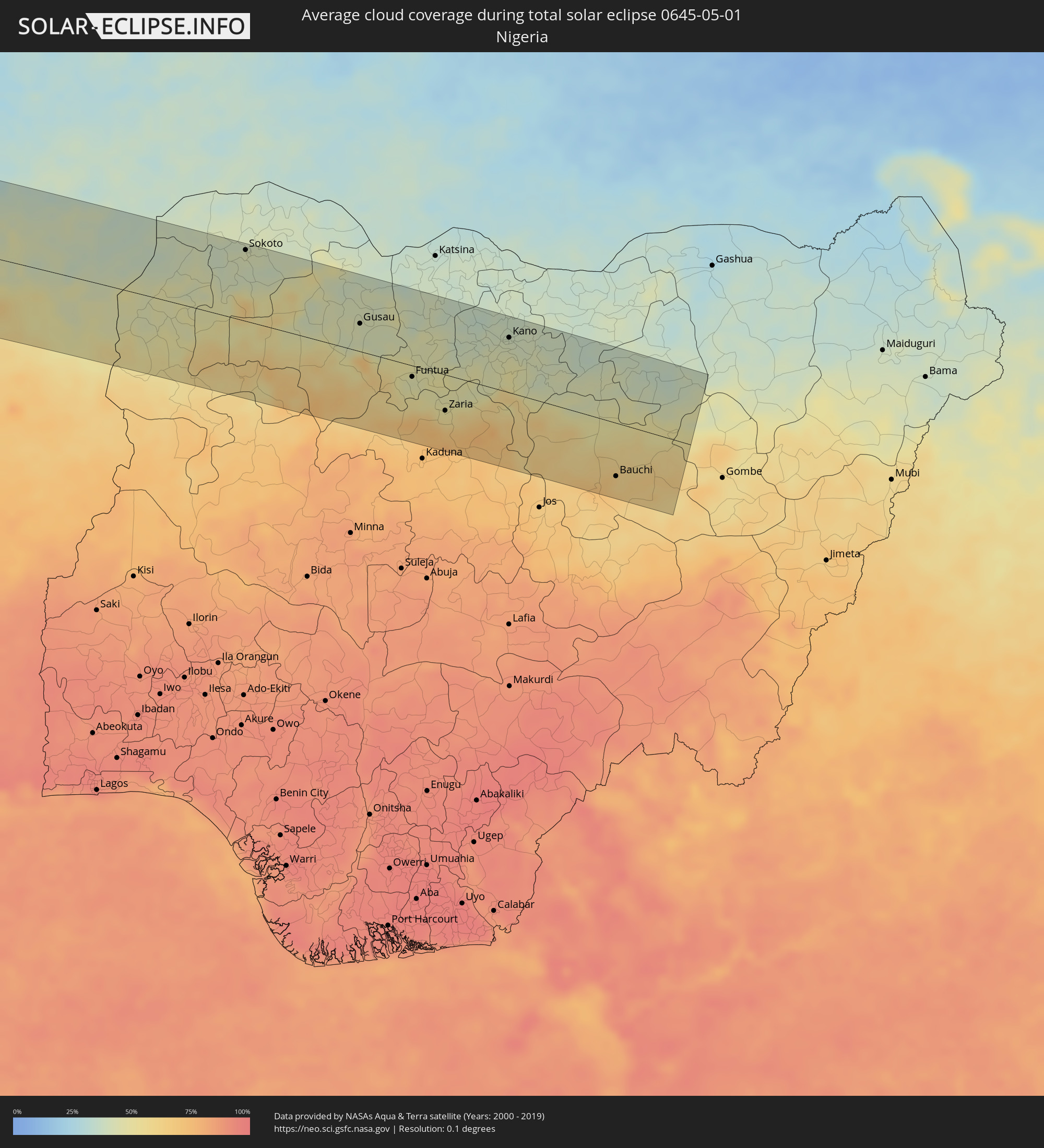 Nigeria
Orte im Finsternispfad
Die nachfolgene Tabelle zeigt Städte und Orte mit mehr als 5.000 Einwohnern, die sich im Finsternispfad befinden. Städte mit mehr als 100.000 Einwohnern sind dick gekennzeichnet. Mit einem Klick auf den Ort öffnet sich eine Detailkarte die die Lage des jeweiligen Ortes zusammen mit dem Verlauf der zentralen Finsternis präsentiert.
| Ort | Typ | Dauer der Verfinsterung | Ortszeit bei maximaler Verfinsterung | Entfernung zur Zentrallinie | Ø Bewölkung |
|
Palpa, Ica
|
total | - | 09:23:53 UTC-05:08 | 116 km | 11% |
|
Minas de Marcona, Ica
|
total | - | 09:23:15 UTC-05:08 | 53 km | 13% |
|
Nazca, Ica
|
total | - | 09:23:52 UTC-05:08 | 74 km | 9% |
|
Puquio, Ayacucho
|
total | - | 09:25:02 UTC-05:08 | 29 km | 25% |
|
Tambo, Ayacucho
|
total | - | 09:25:11 UTC-05:08 | 6 km | 36% |
|
Coracora, Ayacucho
|
total | - | 09:25:07 UTC-05:08 | 24 km | 22% |
|
Talavera, Apurímac
|
total | - | 09:27:07 UTC-05:08 | 68 km | 49% |
|
Andahuaylas, Apurímac
|
total | - | 09:27:10 UTC-05:08 | 65 km | 49% |
|
San Jerónimo, Apurímac
|
total | - | 09:27:12 UTC-05:08 | 63 km | 49% |
|
Abancay, Apurímac
|
total | - | 09:27:52 UTC-05:08 | 31 km | 50% |
|
Santa Ana, Cusco
|
total | - | 09:29:00 UTC-05:08 | 83 km | 80% |
|
Anta, Cusco
|
total | - | 09:29:03 UTC-05:08 | 8 km | 54% |
|
Urubamba, Cusco
|
total | - | 09:29:18 UTC-05:08 | 4 km | 47% |
|
Cusco, Cusco
|
total | - | 09:29:15 UTC-05:08 | 25 km | 51% |
|
Calca, Cusco
|
total | - | 09:29:30 UTC-05:08 | 11 km | 55% |
|
Urcos, Cusco
|
total | - | 09:29:32 UTC-05:08 | 63 km | 41% |
|
Cobija, Pando
|
total | - | 10:13:03 UTC-04:32 | 53 km | 72% |
|
Brasiléia, Acre
|
total | - | 10:13:06 UTC-04:32 | 53 km | 73% |
|
Sena Madureira, Acre
|
total | - | 10:17:19 UTC-04:31 | 100 km | 80% |
|
Rio Branco, Acre
|
total | - | 10:17:24 UTC-04:31 | 38 km | 79% |
|
Senador Guiomard, Acre
|
total | - | 10:17:16 UTC-04:31 | 58 km | 78% |
|
Boca do Acre, Amazonas
|
total | - | 10:48:20 UTC-04:02 | 30 km | 76% |
|
Plácido de Castro, Acre
|
total | - | 10:16:29 UTC-04:32 | 115 km | 77% |
|
Pauini, Amazonas
|
total | - | 10:50:33 UTC-04:02 | 81 km | 80% |
|
Canutama, Amazonas
|
total | - | 10:56:50 UTC-04:02 | 22 km | 80% |
|
Coari, Amazonas
|
total | - | 11:03:03 UTC-04:02 | 78 km | 86% |
|
Codajás, Amazonas
|
total | - | 11:05:31 UTC-04:02 | 14 km | 86% |
|
Anori, Amazonas
|
total | - | 11:06:25 UTC-04:02 | 13 km | 88% |
|
Manacapuru, Amazonas
|
total | - | 11:09:13 UTC-04:02 | 54 km | 79% |
|
Manaquiri, Amazonas
|
total | - | 11:09:43 UTC-04:02 | 76 km | 79% |
|
Iranduba, Amazonas
|
total | - | 11:10:06 UTC-04:02 | 86 km | 81% |
|
Manaus, Amazonas
|
total | - | 11:10:44 UTC-04:02 | 84 km | 89% |
|
Careiro da Várzea, Amazonas
|
total | - | 11:10:58 UTC-04:02 | 107 km | 80% |
|
Rio Preto da Eva, Amazonas
|
total | - | 11:12:05 UTC-04:02 | 76 km | 90% |
|
Kourou, Guyane
|
total | - | 12:14:50 UTC-03:29 | 54 km | 82% |
|
Macouria, Guyane
|
total | - | 12:15:00 UTC-03:29 | 13 km | 88% |
|
Cayenne, Guyane
|
total | - | 12:15:08 UTC-03:29 | 12 km | 87% |
|
Matoury, Guyane
|
total | - | 12:15:00 UTC-03:29 | 4 km | 92% |
|
Rémire-Montjoly, Guyane
|
total | - | 12:15:16 UTC-03:29 | 6 km | 87% |
|
São Filipe, São Filipe
|
total | - | 15:24:13 UTC-01:34 | 91 km | 42% |
|
Tarrafal de São Nicolau, Tarrafal de São Nicolau
|
total | - | 15:25:19 UTC-01:34 | 93 km | 40% |
|
Vila da Ribeira Brava, Ribeira Brava
|
total | - | 15:25:27 UTC-01:34 | 98 km | 40% |
|
Cova Figueira, Santa Catarina do Fogo
|
total | - | 15:24:32 UTC-01:34 | 93 km | 40% |
|
Tarrafal, Tarrafal
|
total | - | 15:25:36 UTC-01:34 | 54 km | 57% |
|
Assomada, Santa Catarina
|
total | - | 15:25:37 UTC-01:34 | 74 km | 25% |
|
Picos, São Salvador do Mundo
|
total | - | 15:25:41 UTC-01:34 | 76 km | 29% |
|
Cidade Velha, Ribeira Grande de Santiago
|
total | - | 15:25:37 UTC-01:34 | 95 km | 44% |
|
Calheta, São Miguel
|
total | - | 15:25:48 UTC-01:34 | 65 km | 49% |
|
Santa Cruz, Santa Cruz
|
total | - | 15:25:48 UTC-01:34 | 71 km | 29% |
|
São Domingos, São Domingos
|
total | - | 15:25:45 UTC-01:34 | 83 km | 30% |
|
Pedra Badejo, Santa Cruz
|
total | - | 15:25:52 UTC-01:34 | 71 km | 42% |
|
Praia, Praia
|
total | - | 15:25:47 UTC-01:34 | 94 km | 47% |
|
Vila do Maio, Maio
|
total | - | 15:26:21 UTC-01:34 | 73 km | 56% |
|
Espargos, Sal
|
total | - | 15:27:33 UTC-01:34 | 106 km | 54% |
|
Vila de Sal Rei, Boa Vista
|
total | - | 15:27:19 UTC-01:34 | 42 km | 48% |
|
Santa Maria, Sal
|
total | - | 15:27:33 UTC-01:34 | 88 km | 69% |
|
N’diareme limamoulaye, Dakar
|
total | - | 16:52:12 UTC-00:16 | 114 km | 45% |
|
Kayar, Thiès
|
total | - | 16:52:35 UTC-00:16 | 98 km | 22% |
|
Pout, Thiès
|
total | - | 16:52:36 UTC-00:16 | 114 km | 16% |
|
Thiès Nones, Thiès
|
total | - | 16:52:43 UTC-00:16 | 112 km | 13% |
|
Khombole, Thiès
|
total | - | 16:53:02 UTC-00:16 | 112 km | 13% |
|
Mékhé, Thiès
|
total | - | 16:53:15 UTC-00:16 | 74 km | 15% |
|
Saint-Louis, Saint-Louis
|
total | - | 16:53:42 UTC-00:16 | 28 km | 37% |
|
Guéoul, Louga
|
total | - | 16:53:42 UTC-00:16 | 31 km | 12% |
|
Louga, Louga
|
total | - | 16:53:53 UTC-00:16 | 15 km | 12% |
|
Touba, Diourbel
|
total | - | 16:54:02 UTC-00:16 | 98 km | 13% |
|
Rosso, Trarza
|
total | - | 16:54:37 UTC-00:16 | 87 km | 16% |
|
Richard-Toll, Saint-Louis
|
total | - | 16:54:43 UTC-00:16 | 82 km | 16% |
|
Dara, Louga
|
total | - | 16:54:39 UTC-00:16 | 40 km | 12% |
|
Ndibène Dahra, Louga
|
total | - | 16:54:39 UTC-00:16 | 42 km | 12% |
|
Tékane, Trarza
|
total | - | 16:55:01 UTC-00:16 | 97 km | 14% |
|
Ndioum, Saint-Louis
|
total | - | 16:55:53 UTC-00:16 | 95 km | 8% |
|
Kaédi, Gorgol
|
total | - | 16:56:58 UTC-00:16 | 65 km | 12% |
|
Ouro Sogui, Matam
|
total | - | 16:57:01 UTC-00:16 | 7 km | 12% |
|
Matam, Matam
|
total | - | 16:57:06 UTC-00:16 | 13 km | 12% |
|
Kanel, Matam
|
total | - | 16:57:08 UTC-00:16 | 5 km | 11% |
|
Sélibaby, Guidimaka
|
total | - | 16:58:02 UTC-00:16 | 31 km | 13% |
|
Kayes, Kayes
|
total | - | 16:58:33 UTC-00:16 | 101 km | 20% |
|
Markala, Ségou
|
total | - | 17:02:45 UTC-00:16 | 100 km | 43% |
|
Ké-Macina, Ségou
|
total | - | 17:03:16 UTC-00:16 | 58 km | 41% |
|
Ténenkou, Mopti
|
total | - | 17:03:38 UTC-00:16 | 5 km | 36% |
|
Djénné, Mopti
|
total | - | 17:03:46 UTC-00:16 | 49 km | 42% |
|
Mopti, Mopti
|
total | - | 17:04:05 UTC-00:16 | 22 km | 40% |
|
Bandiagara, Mopti
|
total | - | 17:04:24 UTC-00:16 | 19 km | 36% |
|
Douentza, Mopti
|
total | - | 17:04:51 UTC-00:16 | 104 km | 35% |
|
Ouahigouya, Nord
|
total | - | 17:04:56 UTC-00:16 | 40 km | 45% |
|
Gourcy, Nord
|
total | - | 17:04:54 UTC-00:16 | 79 km | 50% |
|
Yako, Nord
|
total | - | 17:04:54 UTC-00:16 | 104 km | 51% |
|
Titao, Nord
|
total | - | 17:05:08 UTC-00:16 | 12 km | 43% |
|
Djibo, Sahel
|
total | - | 17:05:24 UTC-00:16 | 34 km | 46% |
|
Kongoussi, Centre-Nord
|
total | - | 17:05:20 UTC-00:16 | 48 km | 48% |
|
Kaya, Centre-Nord
|
total | - | 17:05:31 UTC-00:16 | 64 km | 45% |
|
Boulsa, Centre-Nord
|
total | - | 17:05:41 UTC-00:16 | 98 km | 44% |
|
Gorom-Gorom, Sahel
|
total | - | 17:06:05 UTC-00:16 | 103 km | 36% |
|
Bogandé, Est
|
total | - | 17:05:55 UTC-00:16 | 55 km | 43% |
|
Dori, Sahel
|
total | - | 17:06:07 UTC-00:16 | 63 km | 40% |
|
Téra, Tillabéri
|
total | - | 17:36:09 UTC+00:13 | 79 km | 34% |
|
Niamey, Niamey
|
total | - | 17:36:35 UTC+00:13 | 59 km | 44% |
|
Kollo, Tillabéri
|
total | - | 17:36:38 UTC+00:13 | 42 km | 46% |
|
Say, Tillabéri
|
total | - | 17:36:37 UTC+00:13 | 21 km | 44% |
|
Dosso, Dosso
|
total | - | 17:36:53 UTC+00:13 | 37 km | 39% |
|
Malanville, Atakora
|
total | - | 17:36:46 UTC+00:13 | 86 km | 53% |
|
Gaya, Dosso
|
total | - | 17:36:47 UTC+00:13 | 83 km | 53% |
|
Kamba, Kebbi
|
total | - | 17:36:50 UTC+00:13 | 81 km | 54% |
|
Birnin Kebbi, Kebbi
|
total | - | 17:37:05 UTC+00:13 | 1 km | 46% |
|
Jega, Kebbi
|
total | - | 17:37:06 UTC+00:13 | 21 km | 47% |
|
Argungu, Kebbi
|
total | - | 17:37:12 UTC+00:13 | 39 km | 43% |
|
Gummi, Zamfara
|
total | - | 17:37:16 UTC+00:13 | 10 km | 53% |
|
Zuru, Kebbi
|
total | - | 17:37:11 UTC+00:13 | 83 km | 59% |
|
Sokoto, Sokoto
|
total | - | 17:37:25 UTC+00:13 | 93 km | 43% |
|
Talata Mafara, Zamfara
|
total | - | 17:37:32 UTC+00:13 | 62 km | 46% |
|
Kaura Namoda, Zamfara
|
total | - | 17:37:38 UTC+00:13 | 80 km | 41% |
|
Gusau, Zamfara
|
total | - | 17:37:35 UTC+00:13 | 36 km | 42% |
|
Funtua, Katsina
|
total | - | 17:37:37 UTC+00:13 | 15 km | 48% |
|
Malumfashi, Katsina
|
total | - | 17:37:42 UTC+00:13 | 23 km | 46% |
|
Zaria, Kaduna
|
total | - | 17:37:36 UTC+00:13 | 47 km | 56% |
|
Kano, Kano
|
total | - | 17:37:50 UTC+00:13 | 72 km | 42% |
|
Birnin Kudu, Jigawa
|
total | - | 17:37:52 UTC+00:13 | 42 km | 44% |
|
Bauchi, Bauchi
|
total | - | 17:37:43 UTC+00:13 | 70 km | 62% |
|
Azare, Bauchi
|
total | - | 17:37:56 UTC+00:13 | 87 km | 37% |