Totale Sonnenfinsternis vom 01.06.0653
| Wochentag: | Mittwoch |
| Maximale Dauer der Verfinsterung: | 04m32s |
| Maximale Breite des Finsternispfades: | 152 km |
| Saroszyklus: | 96 |
| Bedeckungsgrad: | 100% |
| Magnitude: | 1.0436 |
| Gamma: | -0.2861 |
Wo kann man die Sonnenfinsternis vom 01.06.0653 sehen?
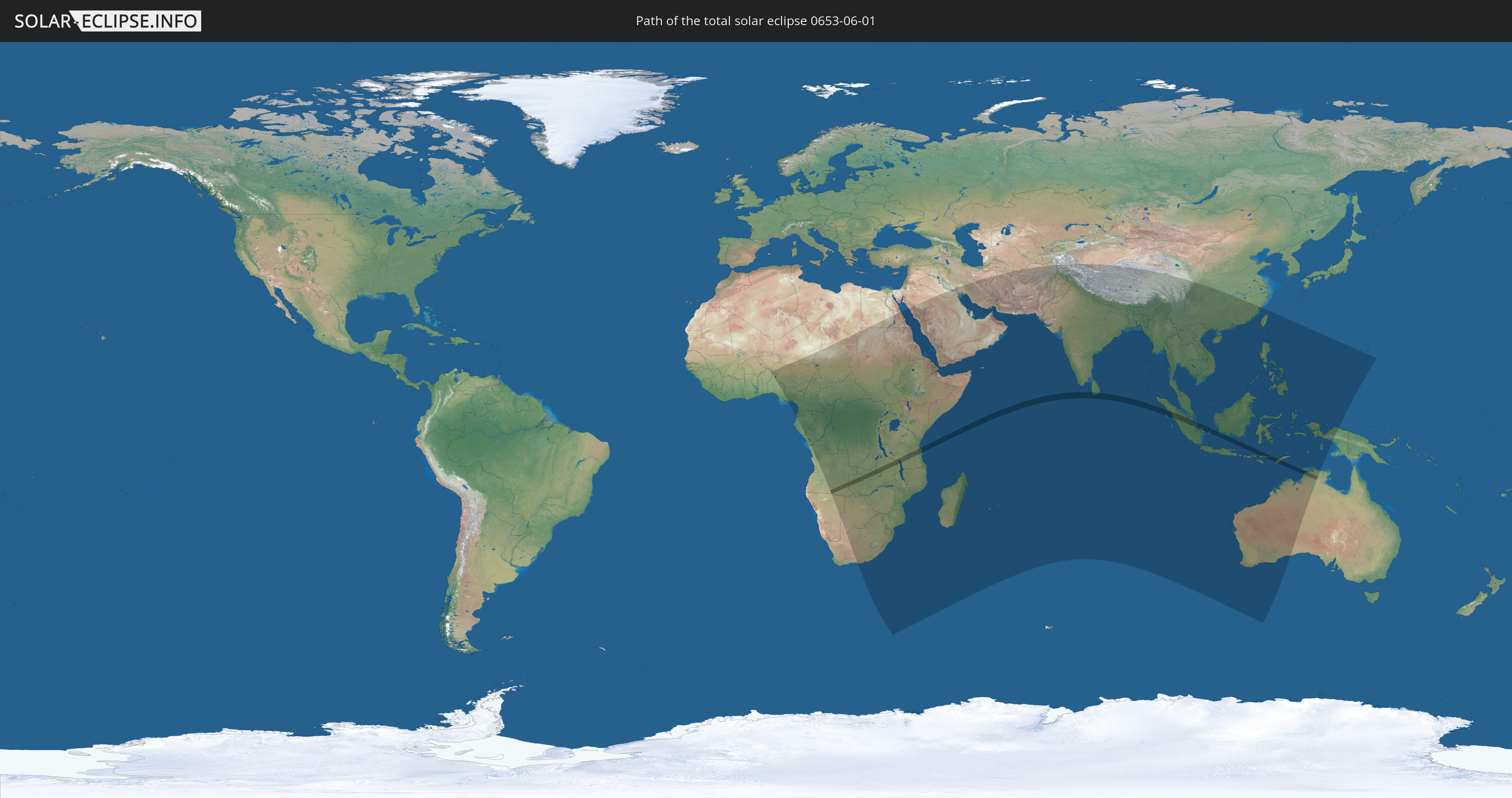
Die Sonnenfinsternis am 01.06.0653 kann man in 81 Ländern als partielle Sonnenfinsternis beobachten.
Der Finsternispfad verläuft durch 11 Länder. Nur in diesen Ländern ist sie als totale Sonnenfinsternis zu sehen.
In den folgenden Ländern ist die Sonnenfinsternis total zu sehen
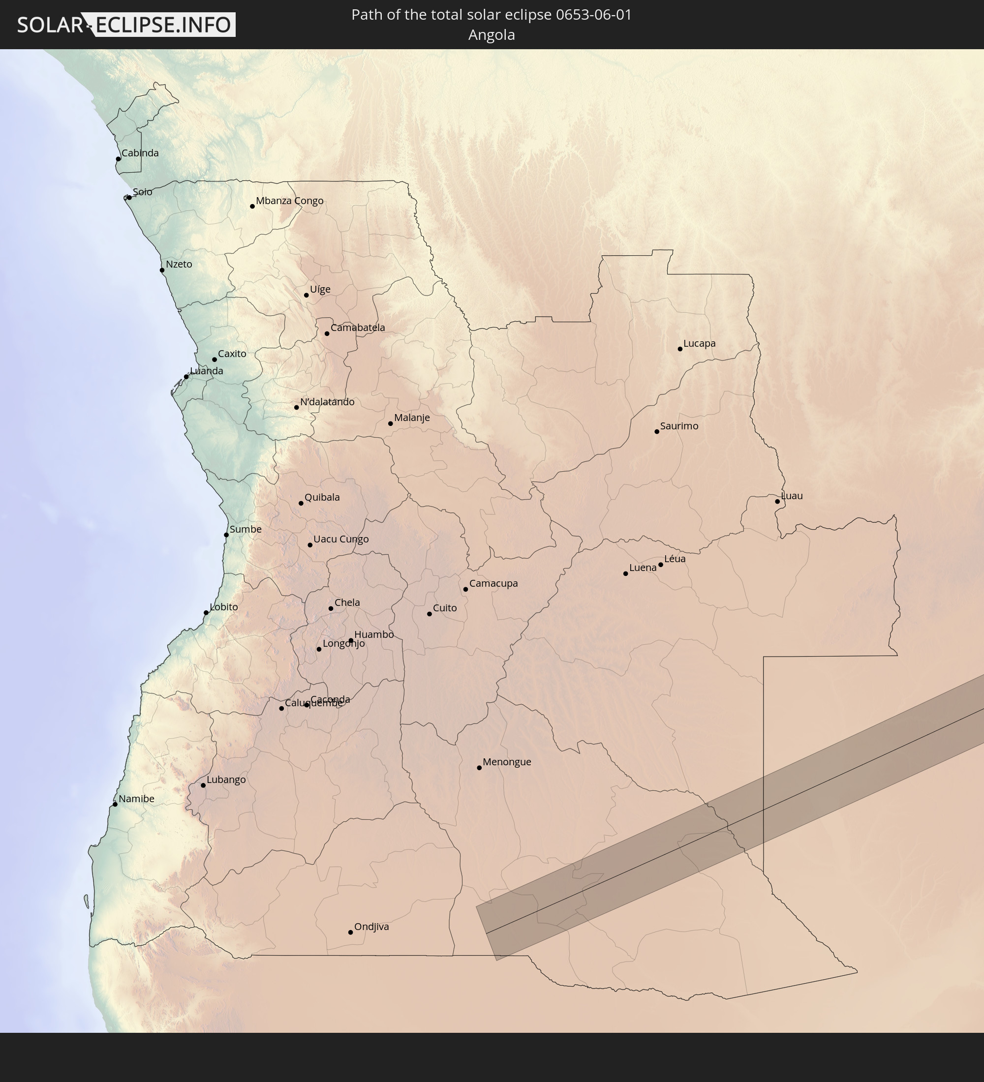 Angola
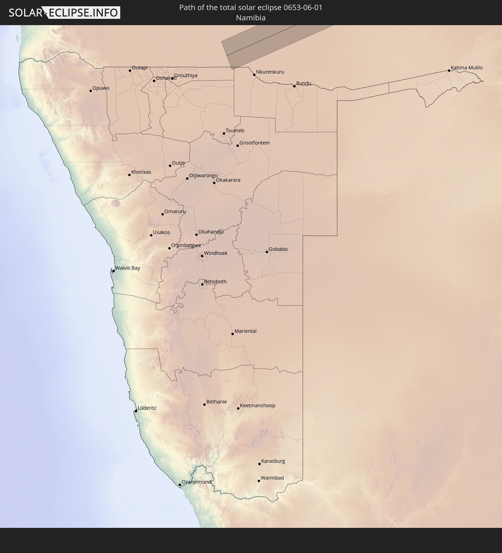 Namibia
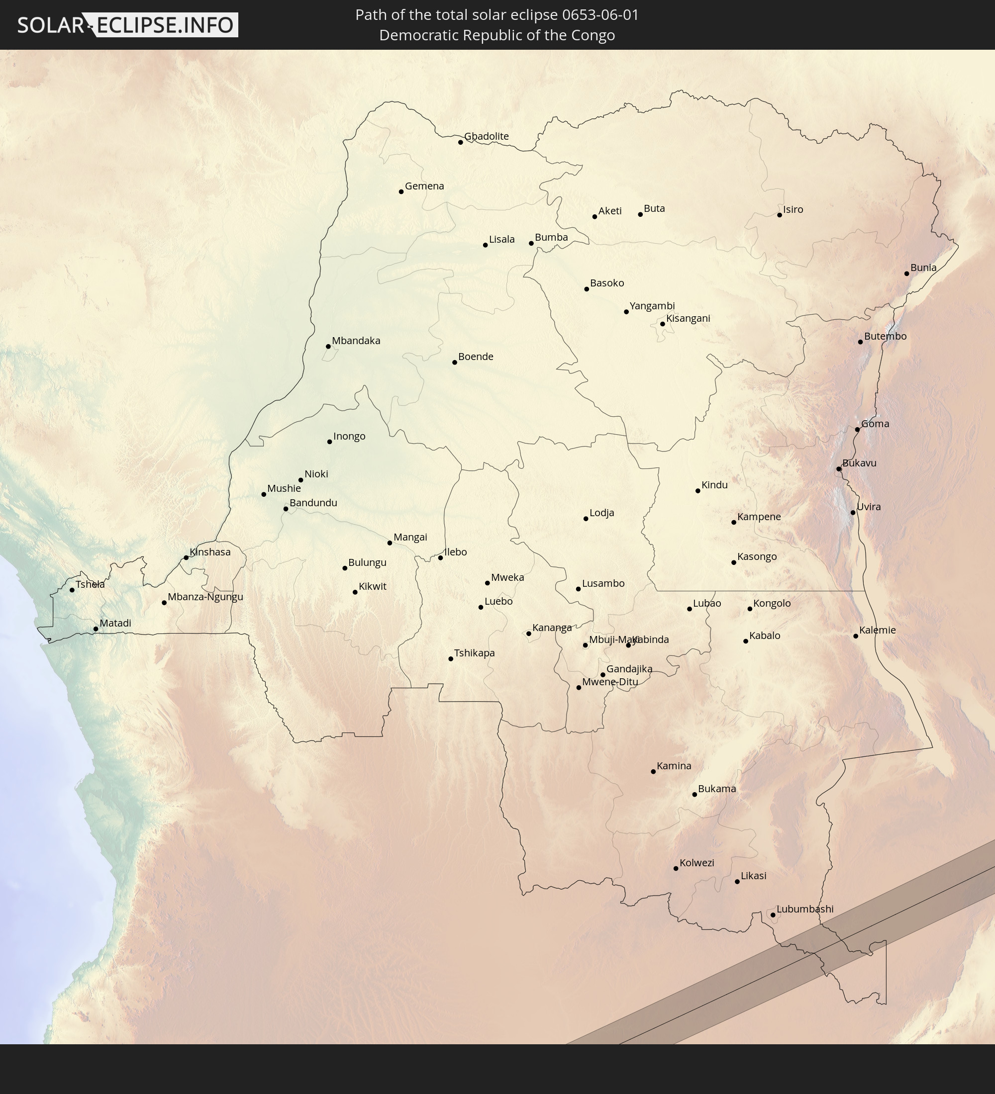 Demokratische Republik Kongo
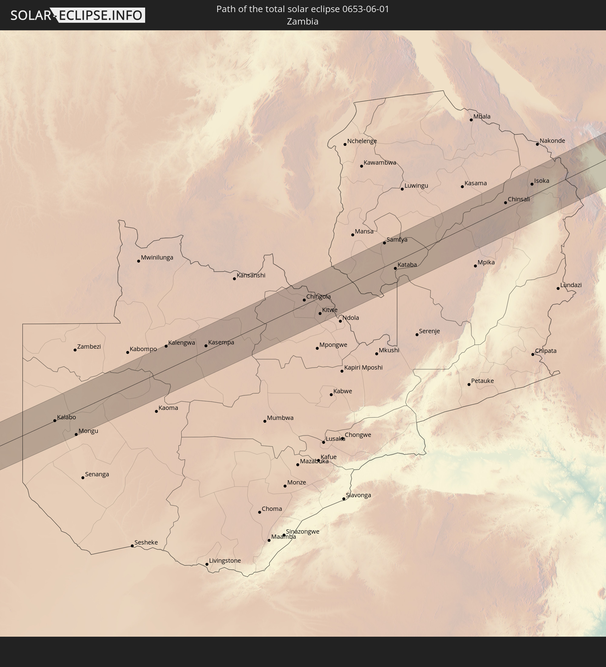 Sambia
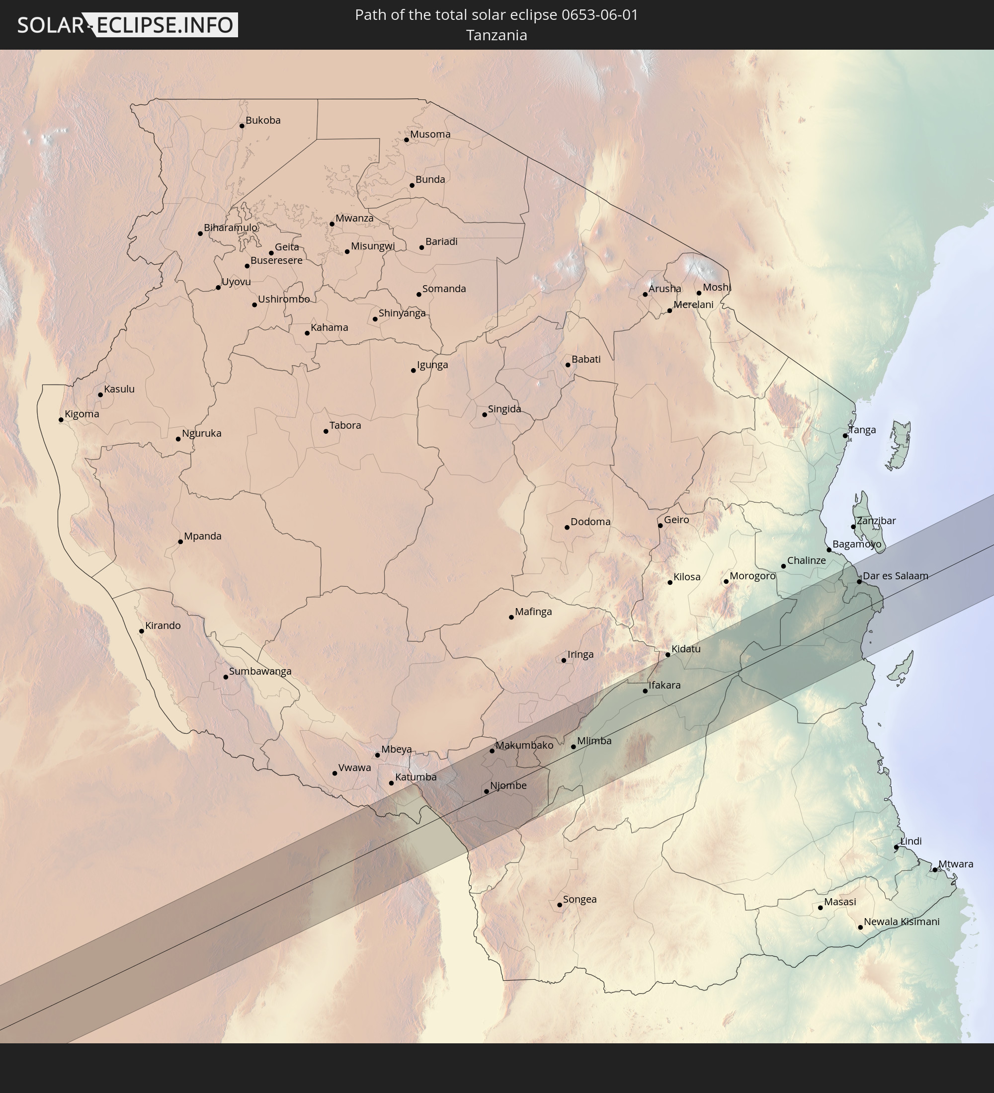 Tansania
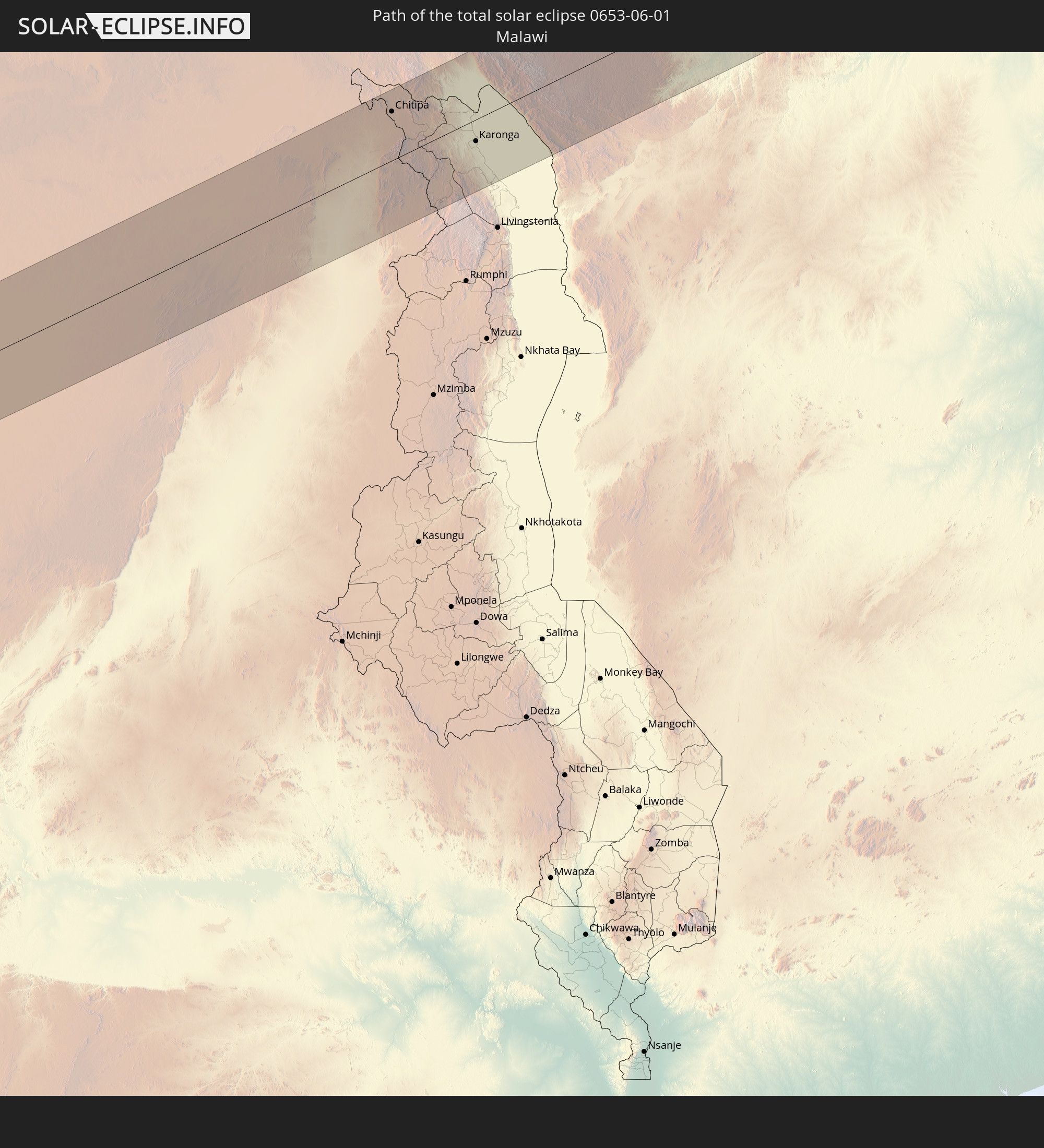 Malawi
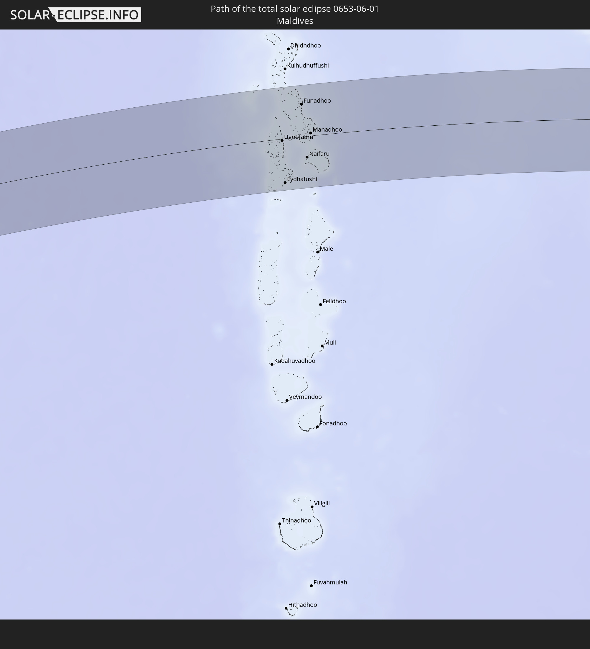 Malediven
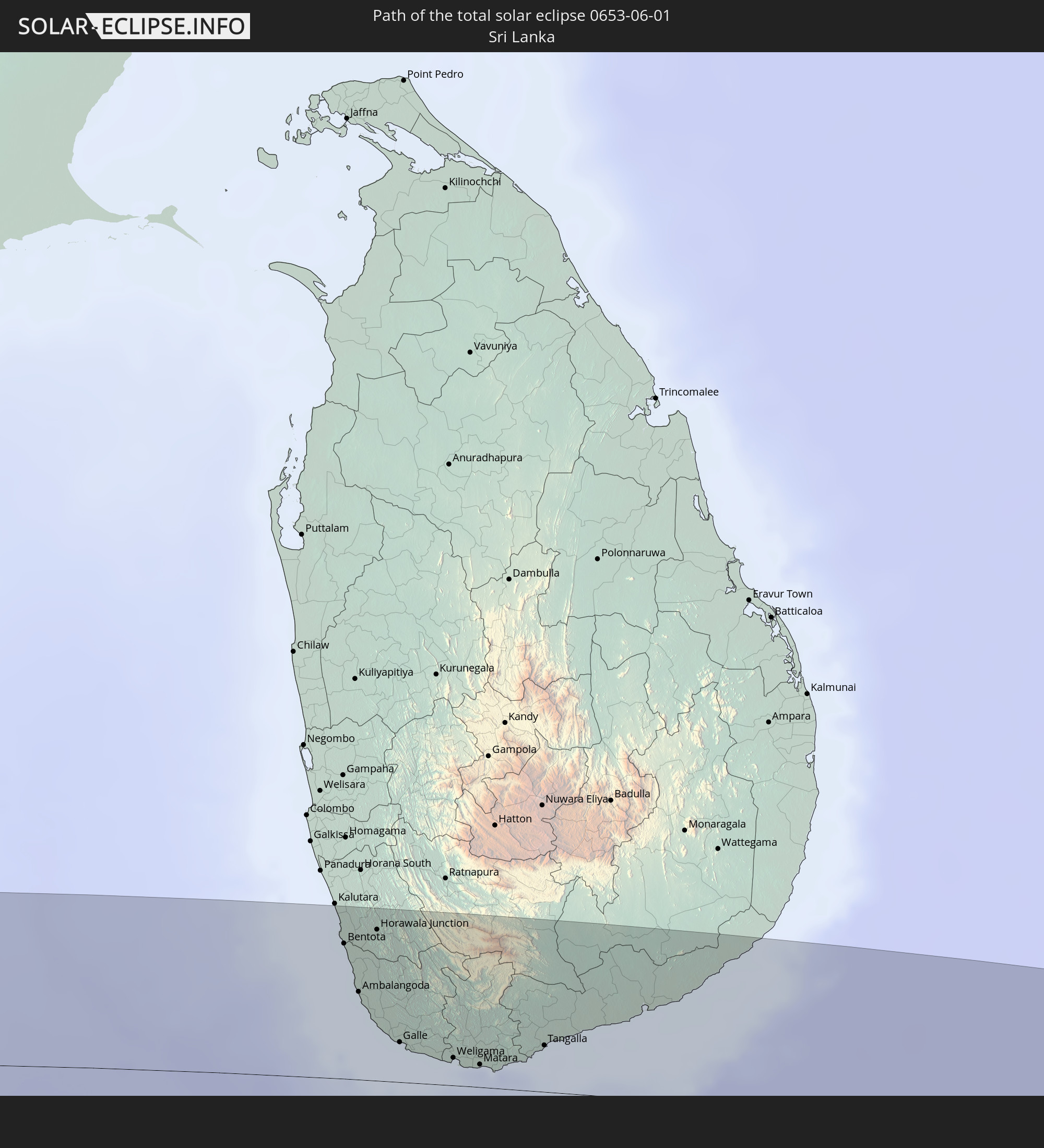 Sri Lanka
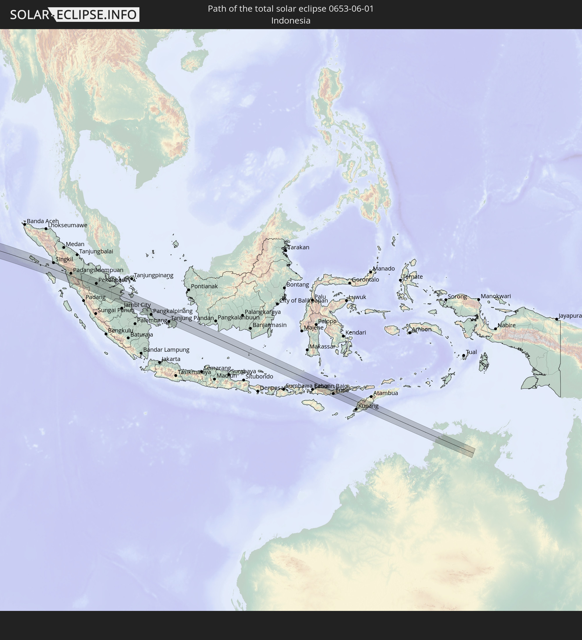 Indonesien
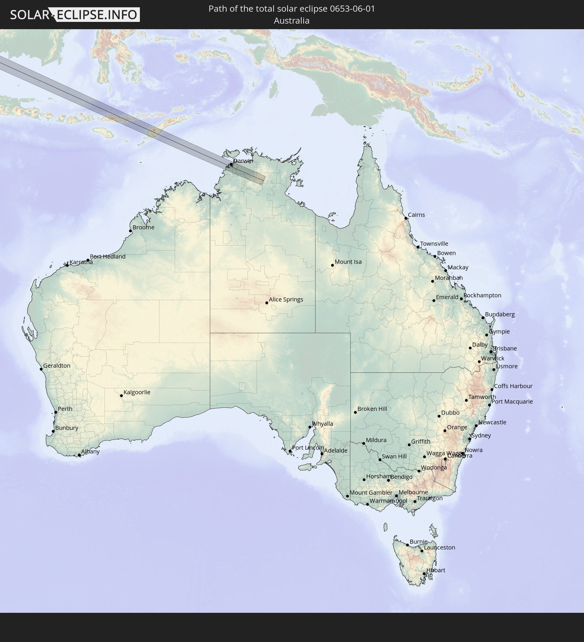 Australien
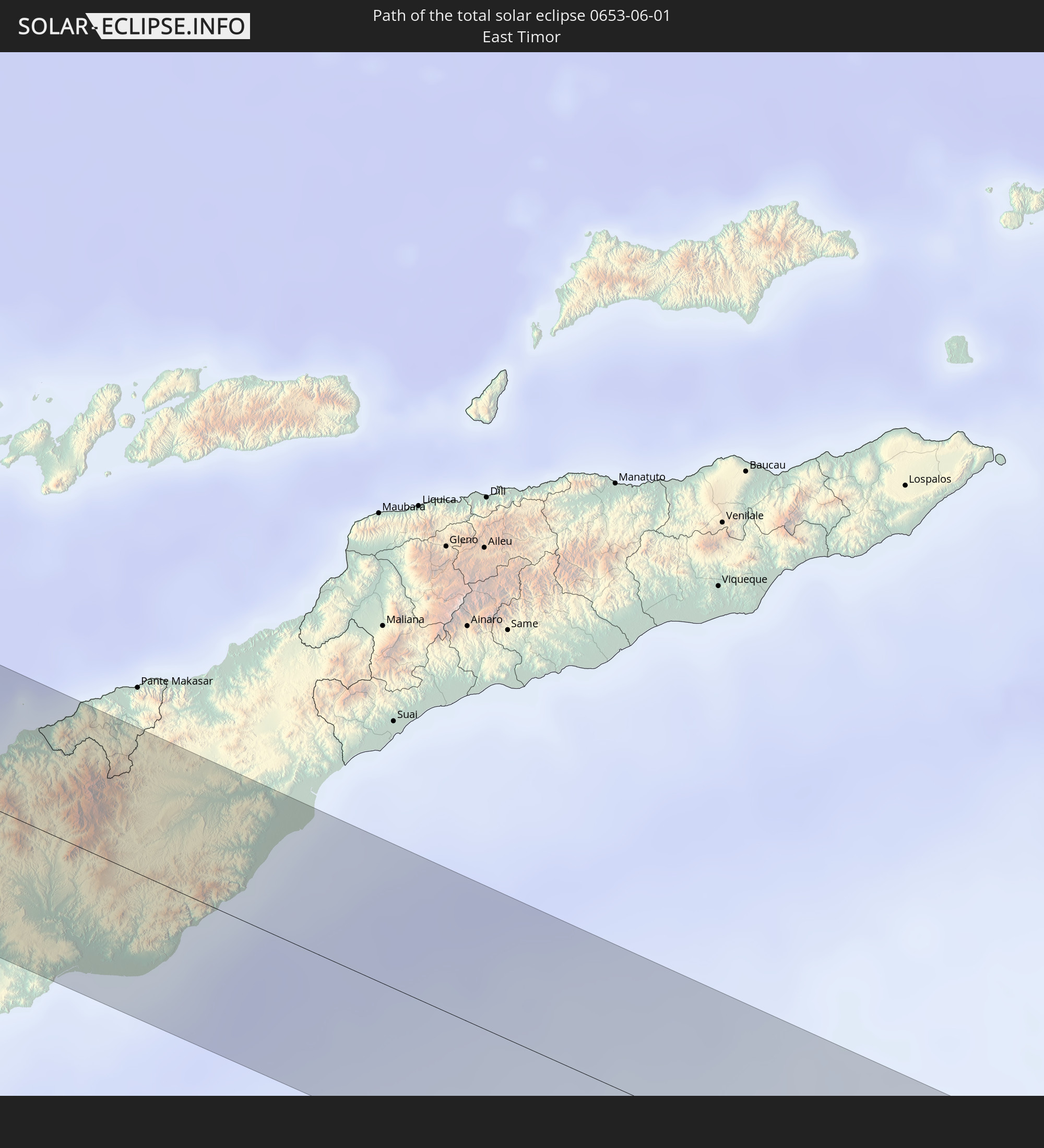 Osttimor
In den folgenden Ländern ist die Sonnenfinsternis partiell zu sehen
 Niger
Niger
 Nigeria
 Äquatorialguinea
 Kamerun
 Gabun
Gabun
 Libyen
 Republik Kongo
 Angola
 Namibia
 Demokratische Republik Kongo
 Tschad
 Zentralafrikanische Republik
 Südafrika
 Botswana
 Sudan
Sudan
 Sambia
 Ägypten
 Simbabwe
 Lesotho
 Ruanda
 Burundi
 Tansania
 Uganda
 Mosambik
 Swasiland
 Malawi
 Äthiopien
 Kenia
Kenia
 Saudi-Arabien
 Eritrea
 Irak
Irak
 Französische Süd- und Antarktisgebiete
 Somalia
 Dschibuti
 Jemen
Jemen
 Madagaskar
 Komoren
 Iran
Iran
 Mayotte
 Seychellen
 Kuwait
 Bahrain
 Katar
Katar
 Vereinigte Arabische Emirate
 Oman
Oman
 Turkmenistan
 Réunion
 Mauritius
 Afghanistan
 Pakistan
 Tadschikistan
 Indien
 Britisches Territorium im Indischen Ozean
 Malediven
 Volksrepublik China
 Sri Lanka
 Nepal
Nepal
 Bangladesch
 Bhutan
 Myanmar
 Indonesien
 Kokosinseln
 Thailand
 Malaysia
 Laos
Laos
 Vietnam
 Kambodscha
 Singapur
 Weihnachtsinsel
 Australien
 Macau
Macau
 Hongkong
 Brunei
 Taiwan
 Philippinen
 Japan
Japan
 Osttimor
 Palau
Palau
 Föderierte Staaten von Mikronesien
 Guam
Guam
 Nördliche Marianen
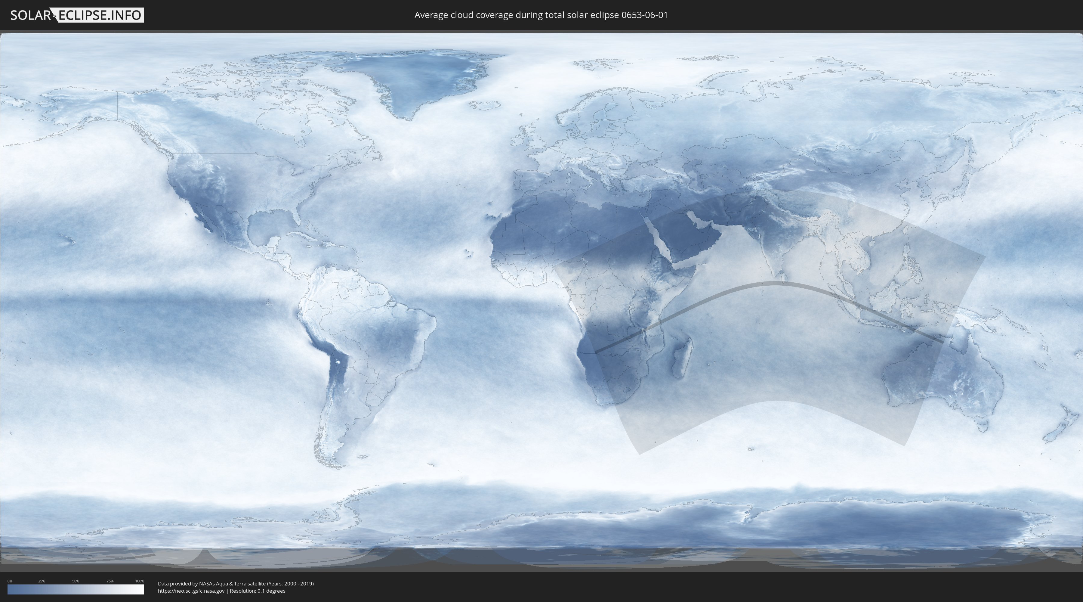
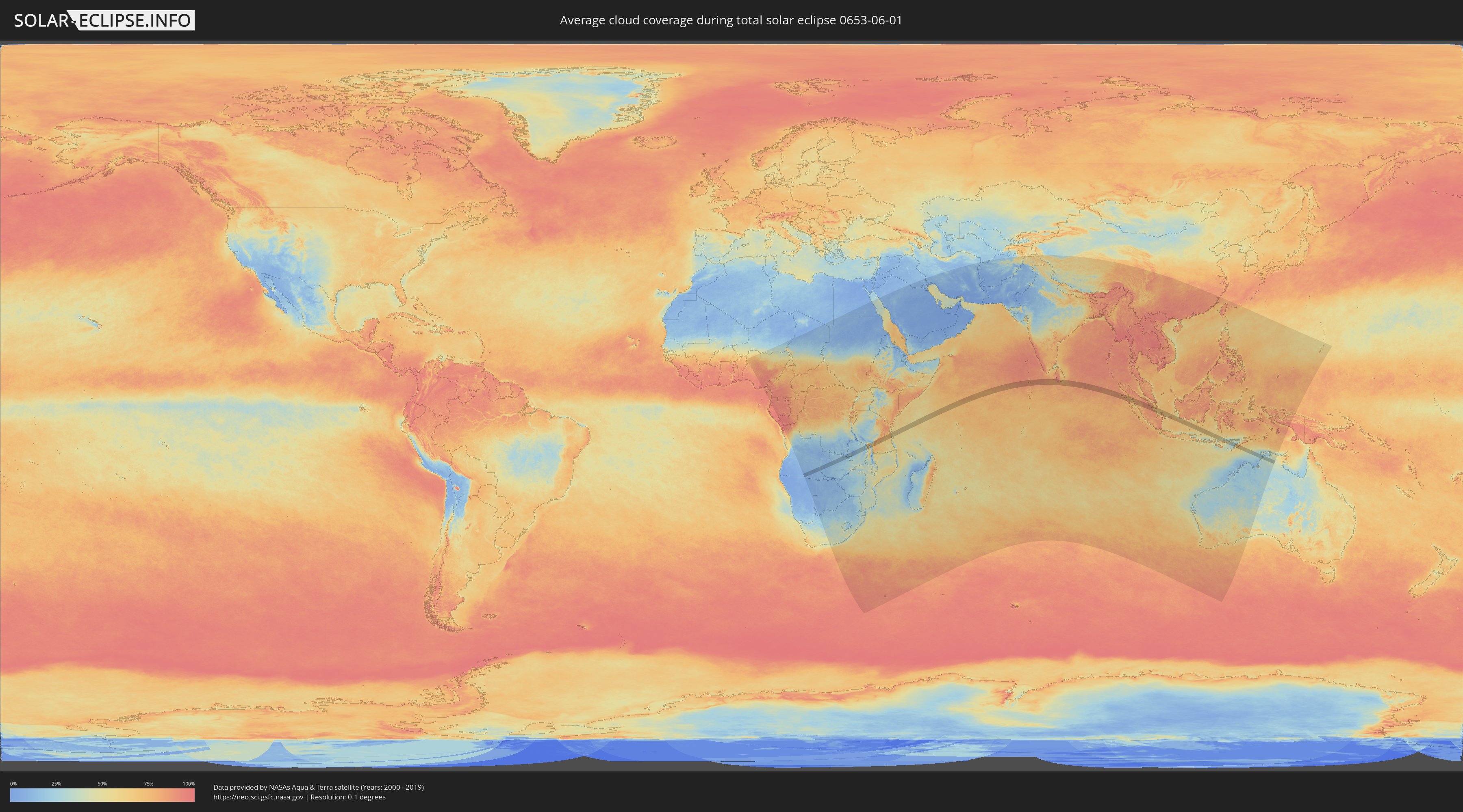
Wie wird das Wetter während der totalen Sonnenfinsternis am 01.06.0653?
Wo ist der beste Ort, um die totale Sonnenfinsternis vom 01.06.0653 zu beobachten?
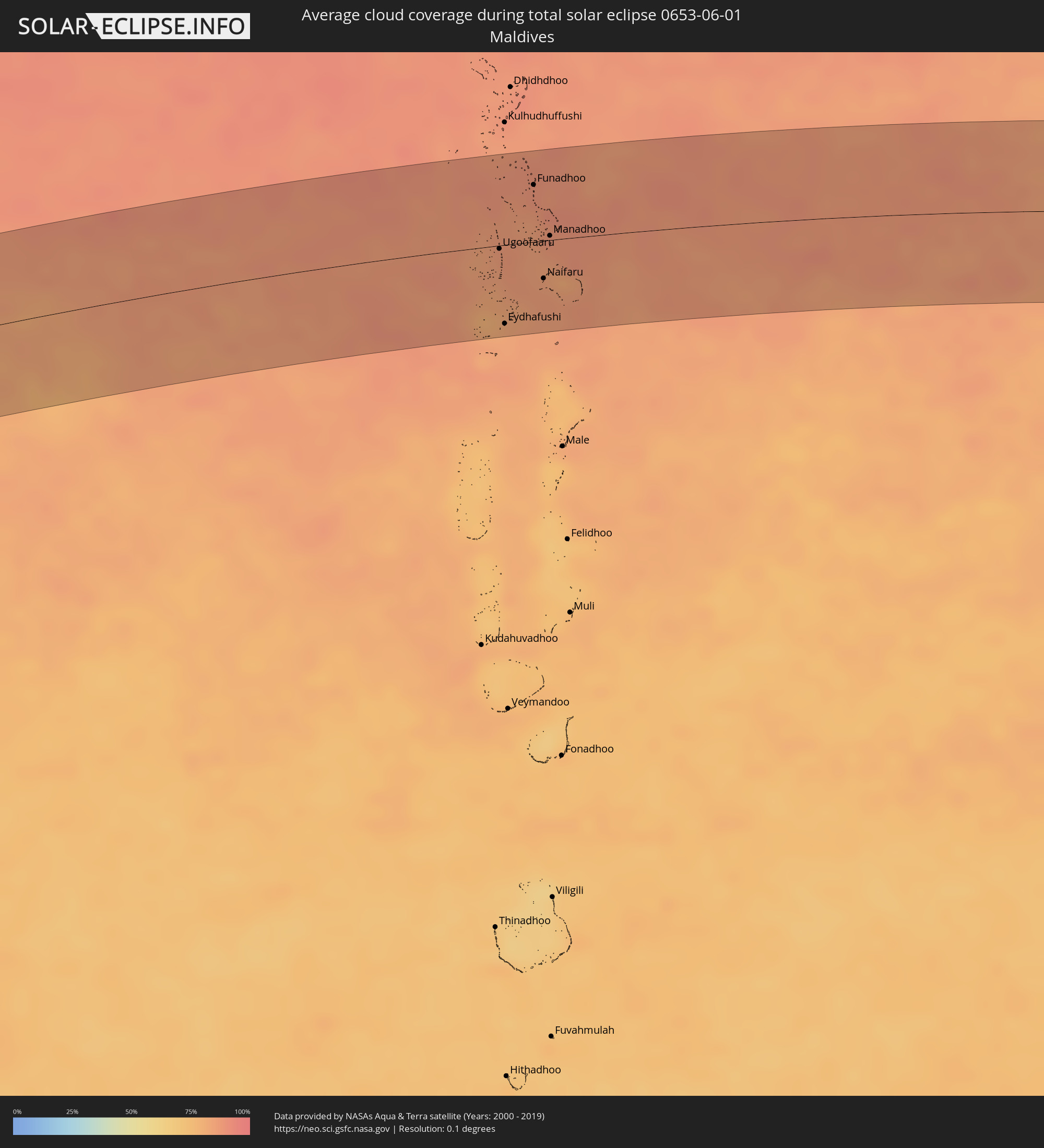
Die folgenden Karten zeigen die durchschnittliche Bewölkung für den Tag, an dem die totale Sonnenfinsternis
stattfindet. Mit Hilfe der Karten lässt sich der Ort entlang des Finsternispfades eingrenzen,
der die besten Aussichen auf einen klaren wolkenfreien Himmel bietet.
Trotzdem muss man immer lokale Gegenenheiten beachten und sollte sich genau über das Wetter an seinem
gewählten Beobachtungsort informieren.
Die Daten stammen von den beiden NASA-Satelliten
AQUA und TERRA
und wurden über einen Zeitraum von 19 Jahren (2000 - 2019) gemittelt.
Detaillierte Länderkarten
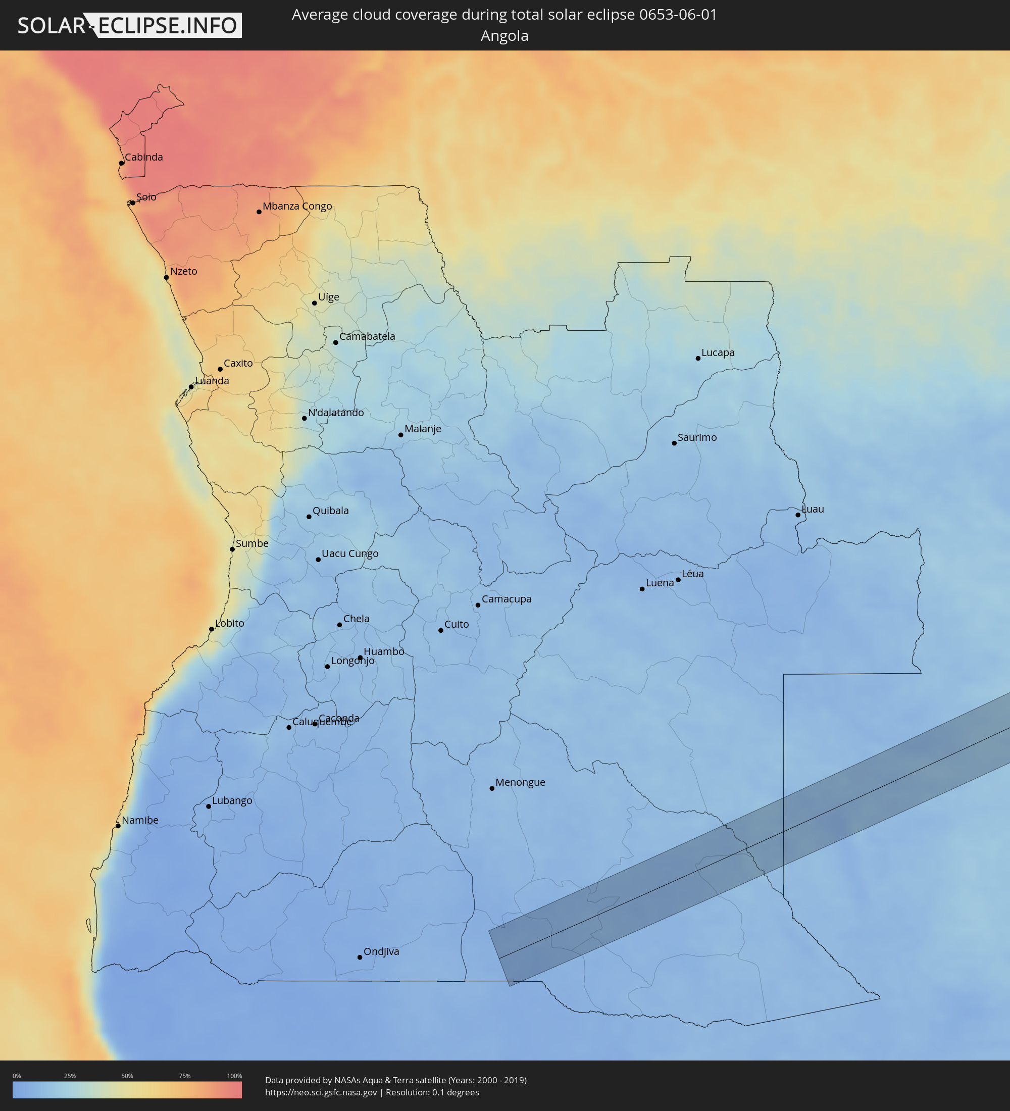 Angola
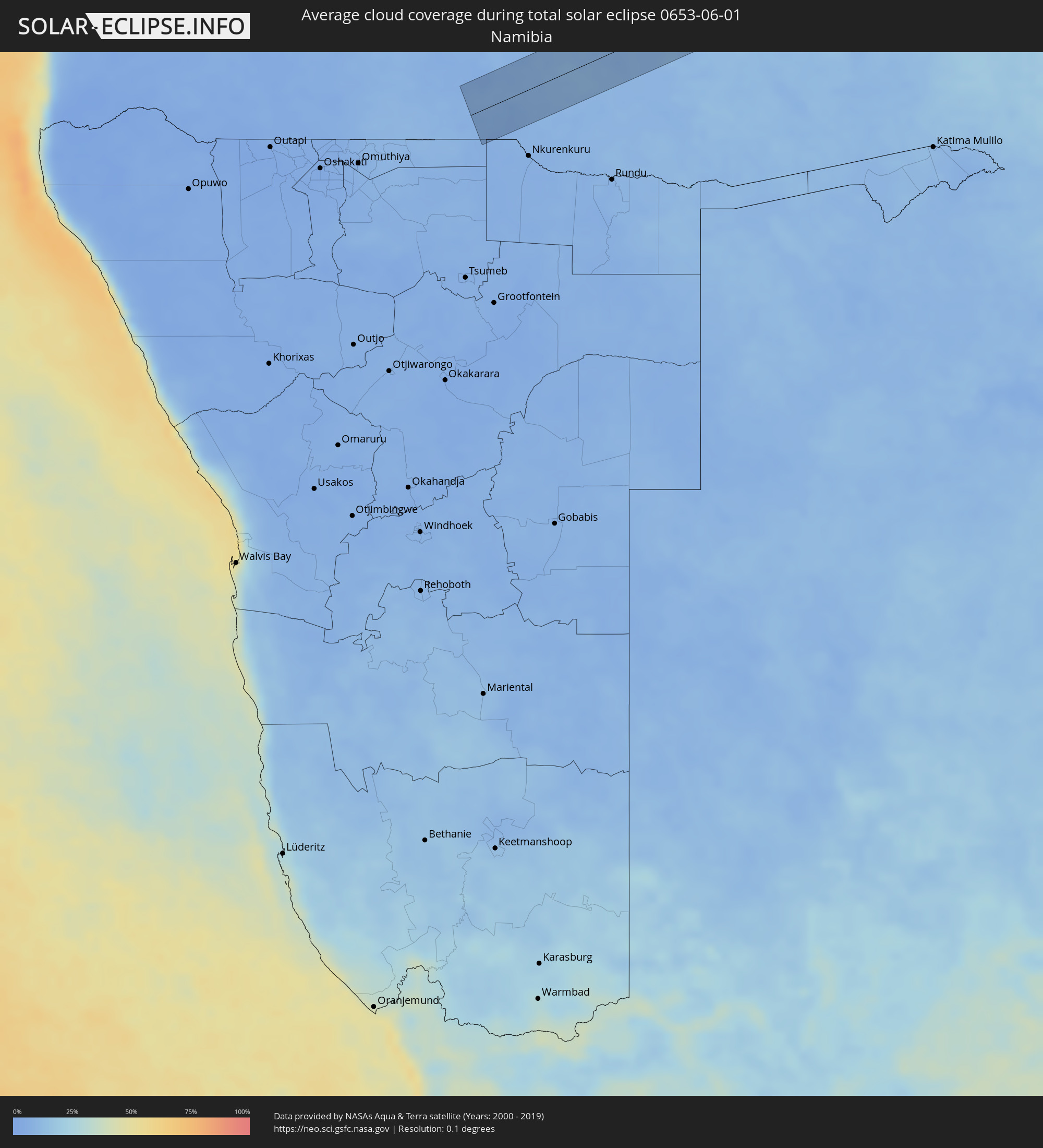 Namibia
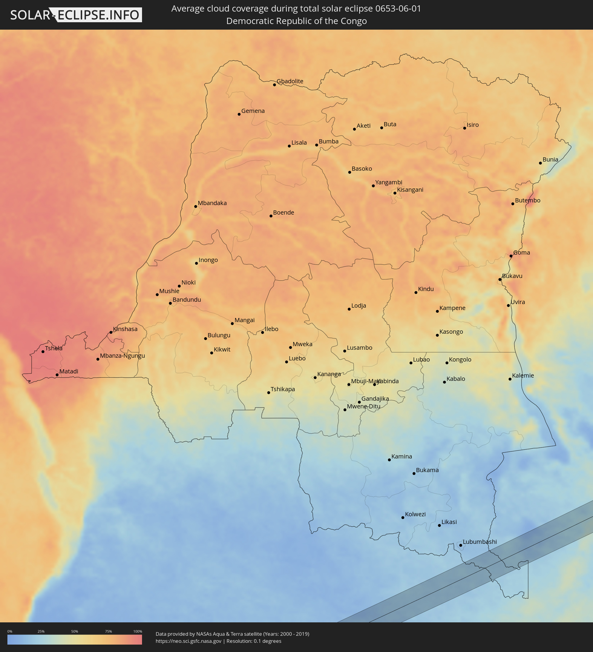 Demokratische Republik Kongo
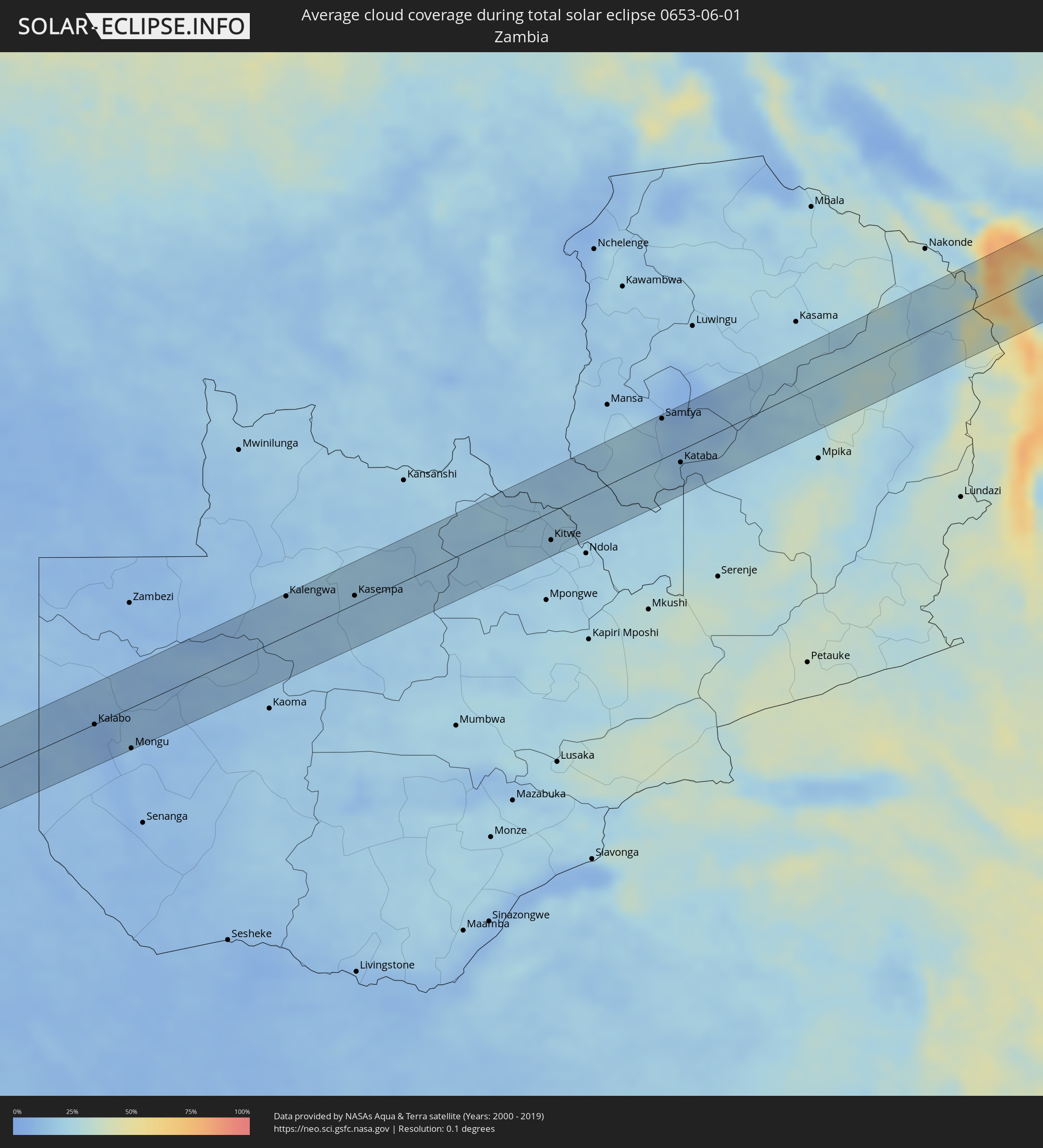 Sambia
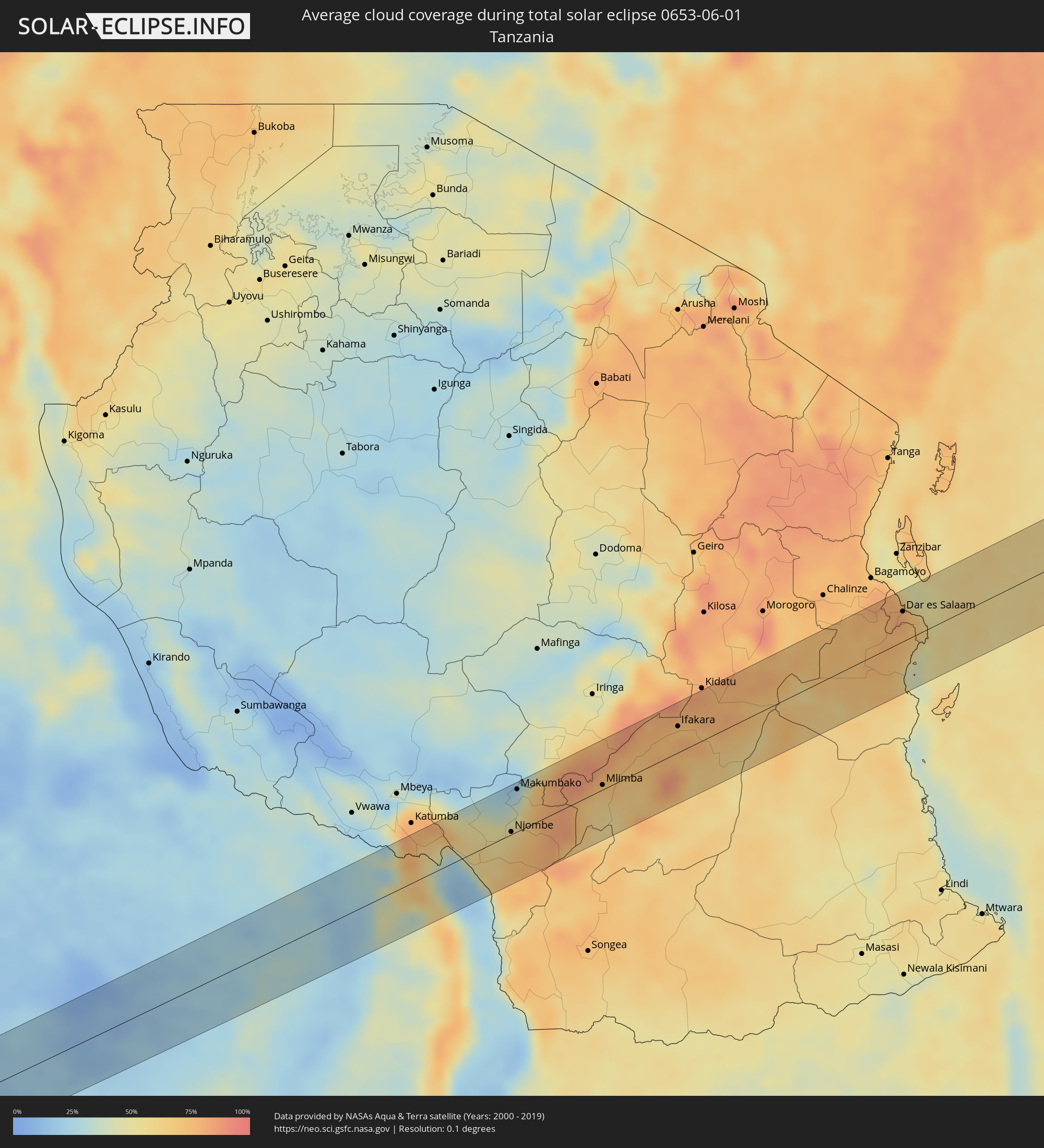 Tansania
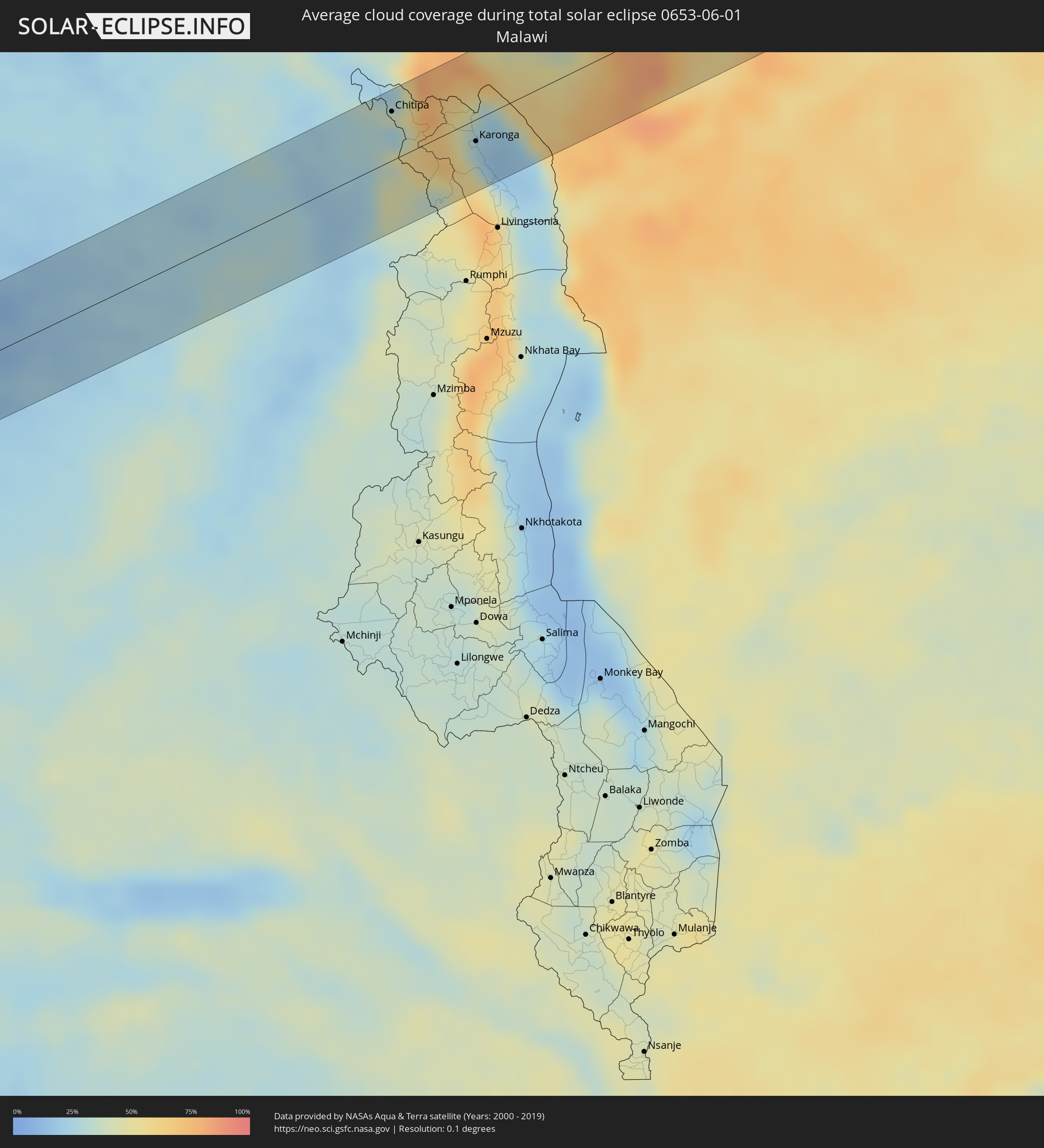 Malawi
 Malediven
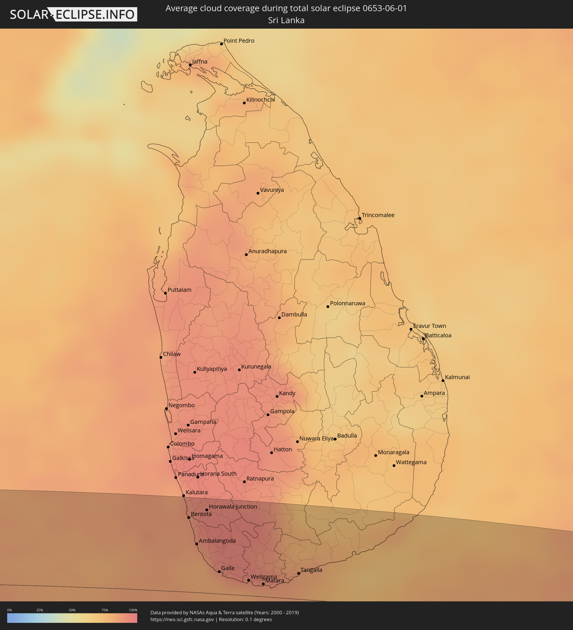 Sri Lanka
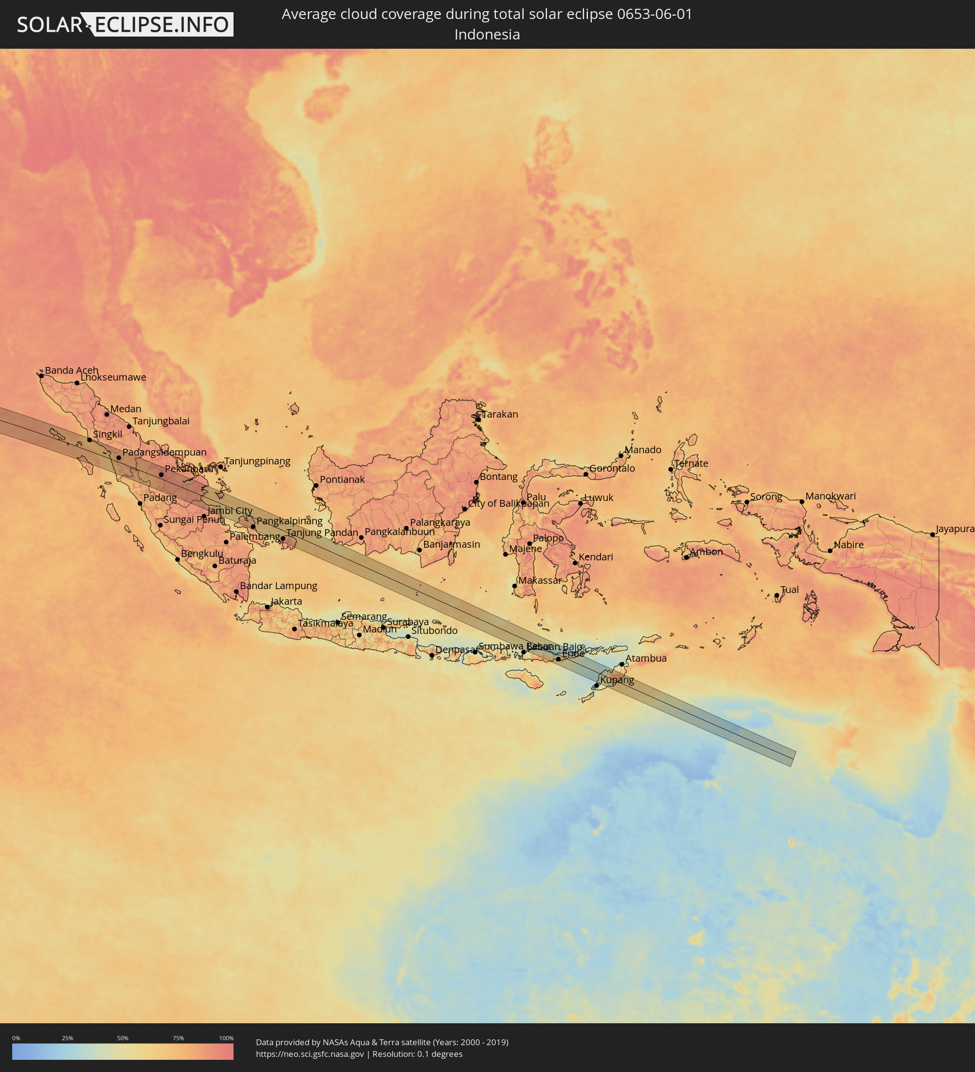 Indonesien
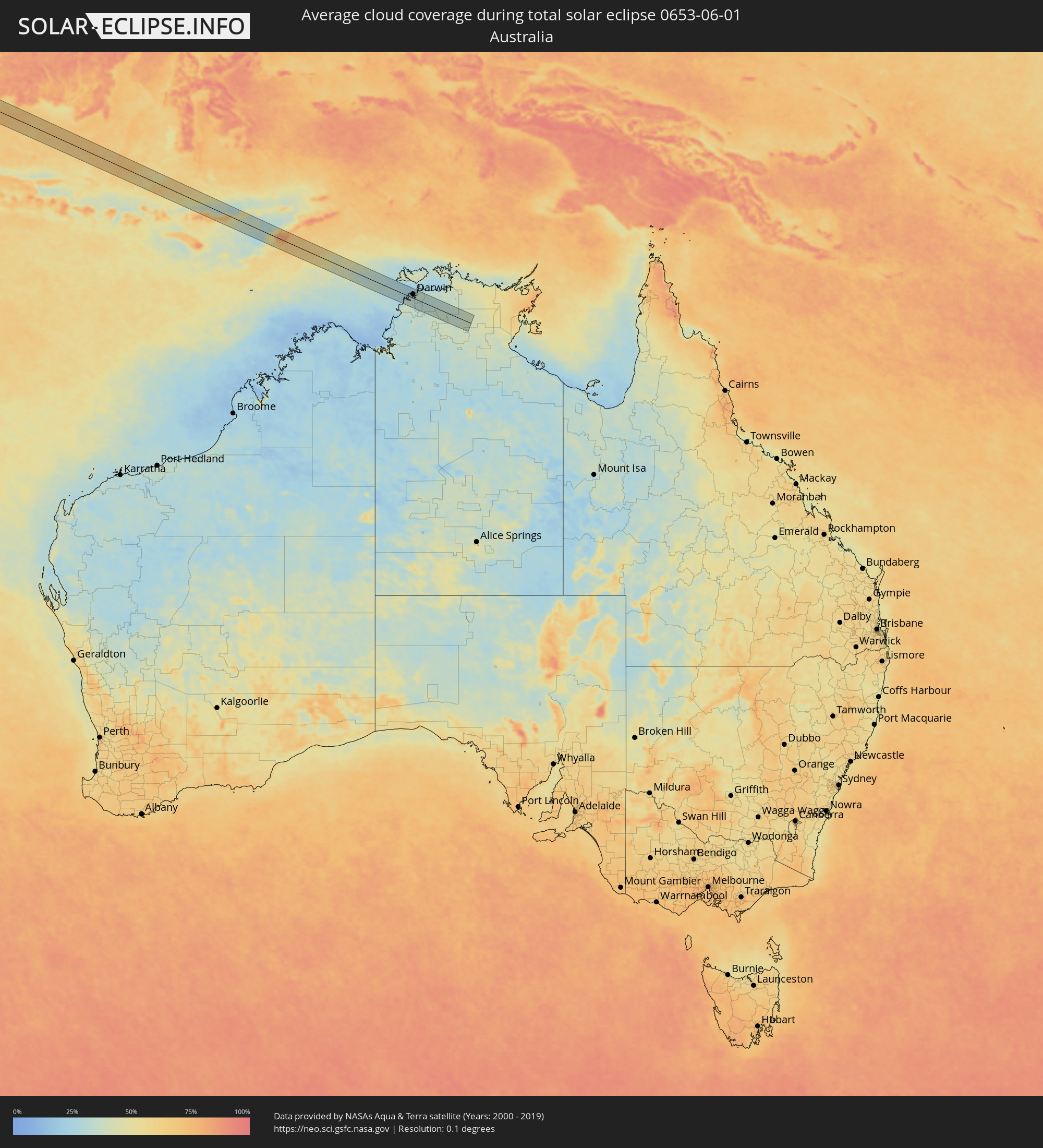 Australien
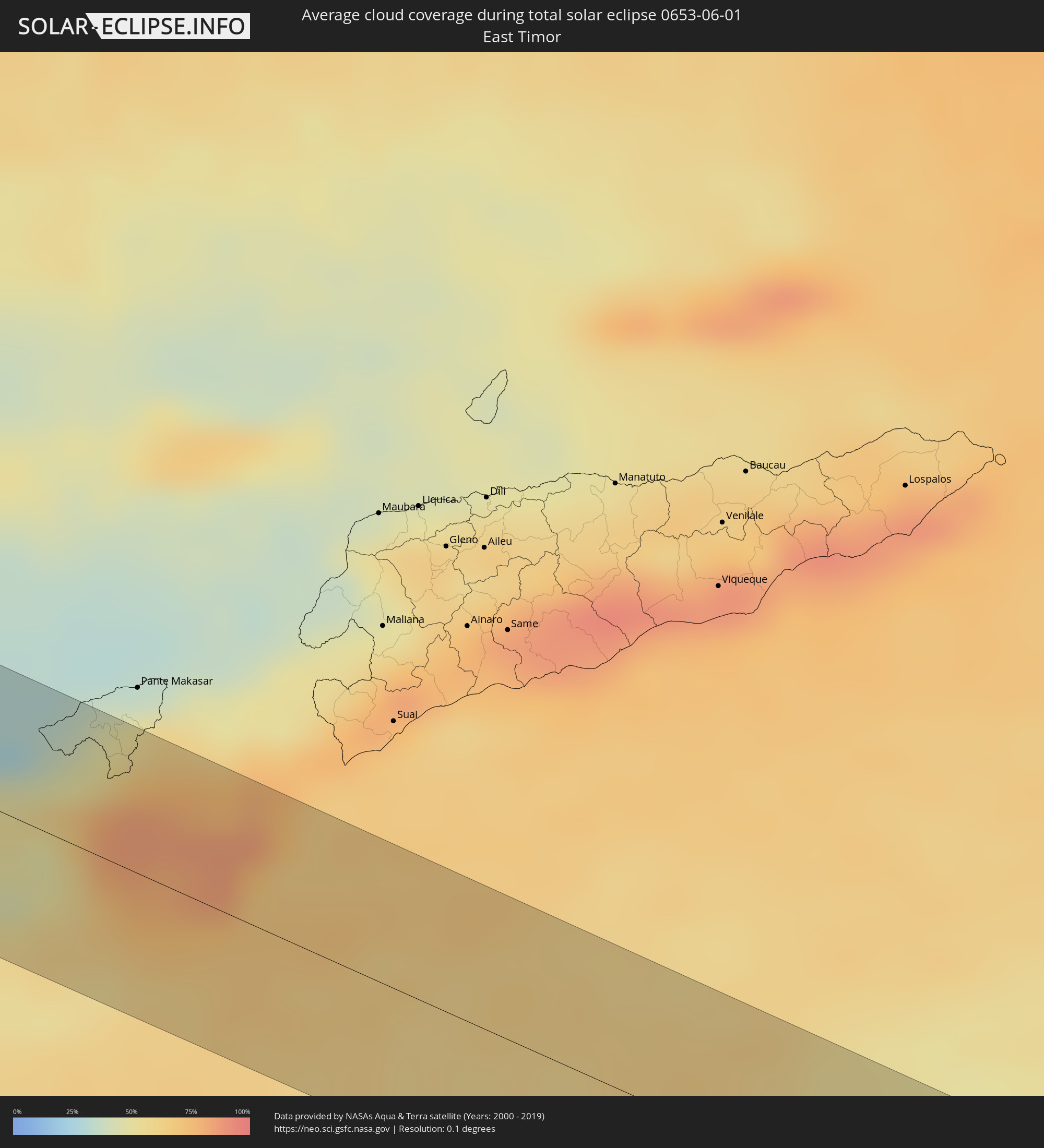 Osttimor
Orte im Finsternispfad
Die nachfolgene Tabelle zeigt Städte und Orte mit mehr als 5.000 Einwohnern, die sich im Finsternispfad befinden. Städte mit mehr als 100.000 Einwohnern sind dick gekennzeichnet. Mit einem Klick auf den Ort öffnet sich eine Detailkarte die die Lage des jeweiligen Ortes zusammen mit dem Verlauf der zentralen Finsternis präsentiert.
| Ort | Typ | Dauer der Verfinsterung | Ortszeit bei maximaler Verfinsterung | Entfernung zur Zentrallinie | Ø Bewölkung |
|
Kalabo, Western
|
total | - | 07:24:04 UTC+02:10 | 0 km | 8% |
|
Mongu, Western
|
total | - | 07:24:13 UTC+02:10 | 48 km | 14% |
|
Limulunga, Western
|
total | - | 07:24:12 UTC+02:10 | 34 km | 15% |
|
Mufumbwe, North-Western
|
total | - | 07:24:34 UTC+02:10 | 34 km | 16% |
|
Kalengwa, North-Western
|
total | - | 07:24:37 UTC+02:10 | 47 km | 15% |
|
Kasempa, North-Western
|
total | - | 07:24:55 UTC+02:10 | 10 km | 18% |
|
Kalulushi, Copperbelt
|
total | - | 07:25:49 UTC+02:10 | 32 km | 18% |
|
Kitwe, Copperbelt
|
total | - | 07:25:53 UTC+02:10 | 34 km | 18% |
|
Mufulira, Copperbelt
|
total | - | 07:25:53 UTC+02:10 | 10 km | 18% |
|
Samfya, Luapula
|
total | - | 07:26:33 UTC+02:10 | 48 km | 13% |
|
Kataba, Copperbelt
|
total | - | 07:26:39 UTC+02:10 | 15 km | 13% |
|
Chitipa, Northern Region
|
total | - | 07:28:57 UTC+02:10 | 38 km | 27% |
|
Masoko, Mbeya
|
total | - | 07:46:16 UTC+02:27 | 52 km | 72% |
|
Kyela, Mbeya
|
total | - | 07:46:19 UTC+02:27 | 22 km | 40% |
|
Ipinda, Mbeya
|
total | - | 07:46:22 UTC+02:27 | 30 km | 48% |
|
Karonga, Northern Region
|
total | - | 07:29:24 UTC+02:10 | 17 km | 32% |
|
Mwaya, Mbeya
|
total | - | 07:46:23 UTC+02:27 | 21 km | 27% |
|
Mlangali, Njombe
|
total | - | 07:46:47 UTC+02:27 | 30 km | 62% |
|
Ilembula, Njombe
|
total | - | 07:46:57 UTC+02:27 | 55 km | 28% |
|
Njombe, Njombe
|
total | - | 07:47:02 UTC+02:27 | 3 km | 62% |
|
Mtwango, Njombe
|
total | - | 07:47:06 UTC+02:27 | 33 km | 44% |
|
Makumbako, Njombe
|
total | - | 07:47:09 UTC+02:27 | 48 km | 35% |
|
Makungu, Iringa
|
total | - | 07:47:32 UTC+02:27 | 38 km | 84% |
|
Mlimba, Morogoro
|
total | - | 07:47:57 UTC+02:27 | 5 km | 69% |
|
Malinyi, Morogoro
|
total | - | 07:48:12 UTC+02:27 | 23 km | 65% |
|
Mtimbira, Morogoro
|
total | - | 07:48:24 UTC+02:27 | 19 km | 78% |
|
Lupiro, Morogoro
|
total | - | 07:48:45 UTC+02:27 | 6 km | 73% |
|
Ifakara, Morogoro
|
total | - | 07:48:49 UTC+02:27 | 30 km | 72% |
|
Mahenge, Morogoro
|
total | - | 07:48:44 UTC+02:27 | 27 km | 74% |
|
Kisanga, Morogoro
|
total | - | 07:49:53 UTC+02:27 | 50 km | 76% |
|
Utete, Pwani
|
total | - | 07:50:47 UTC+02:27 | 57 km | 65% |
|
Maneromango, Pwani
|
total | - | 07:50:59 UTC+02:27 | 20 km | 72% |
|
Kibaha, Pwani
|
total | - | 07:51:14 UTC+02:27 | 57 km | 76% |
|
Kibiti, Pwani
|
total | - | 07:51:01 UTC+02:27 | 39 km | 73% |
|
Bungu, Pwani
|
total | - | 07:51:09 UTC+02:27 | 36 km | 70% |
|
Kisarawe, Pwani
|
total | - | 07:51:21 UTC+02:27 | 36 km | 78% |
|
Mkuranga, Pwani
|
total | - | 07:51:26 UTC+02:27 | 8 km | 74% |
|
Magomeni, Dar es Salaam
|
total | - | 07:51:33 UTC+02:27 | 37 km | 74% |
|
Dar es Salaam, Dar es Salaam
|
total | - | 07:51:34 UTC+02:27 | 34 km | 74% |
|
Vikindu, Pwani
|
total | - | 07:51:33 UTC+02:27 | 14 km | 72% |
|
Sokoni, Zanzibar Central/South
|
total | - | 07:51:58 UTC+02:27 | 59 km | 51% |
|
Ugoofaaru, Raa Atoll
|
total | - | 11:40:58 UTC+04:54 | 3 km | 85% |
|
Eydhafushi, Baa Atholhu
|
total | - | 11:40:57 UTC+04:54 | 66 km | 83% |
|
Funadhoo, Shaviyani Atholhu
|
total | - | 11:41:59 UTC+04:54 | 48 km | 89% |
|
Naifaru, Lhaviyani Atholhu
|
total | - | 11:42:03 UTC+04:54 | 31 km | 85% |
|
Manadhoo, Noonu Atoll
|
total | - | 11:42:18 UTC+04:54 | 4 km | 88% |
|
Beruwala, Western
|
total | - | 12:30:20 UTC+05:19 | 65 km | 86% |
|
Bentota, Southern
|
total | - | 12:30:23 UTC+05:19 | 59 km | 85% |
|
Ambalangoda, Southern
|
total | - | 12:30:35 UTC+05:19 | 39 km | 80% |
|
Horawala Junction, Western
|
total | - | 12:30:49 UTC+05:19 | 66 km | 94% |
|
Galle, Southern
|
total | - | 12:31:08 UTC+05:19 | 18 km | 80% |
|
Weligama, Southern
|
total | - | 12:31:51 UTC+05:19 | 12 km | 81% |
|
Matara, Southern
|
total | - | 12:32:13 UTC+05:19 | 10 km | 82% |
|
Tangalla, Southern
|
total | - | 12:33:04 UTC+05:19 | 20 km | 81% |
|
Sinabang, Aceh
|
total | - | 15:06:12 UTC+07:07 | 24 km | 79% |
|
Singkil, Aceh
|
total | - | 15:09:20 UTC+07:07 | 57 km | 73% |
|
Sibolga, North Sumatra
|
total | - | 15:11:37 UTC+07:07 | 39 km | 75% |
|
Padangsidempuan, North Sumatra
|
total | - | 15:12:44 UTC+07:07 | 21 km | 78% |
|
Pekanbaru, Riau
|
total | - | 15:17:11 UTC+07:07 | 20 km | 92% |
|
Kuala Tungkal, Jambi
|
total | - | 15:21:09 UTC+07:07 | 31 km | 85% |
|
Mendaha, Jambi
|
total | - | 15:21:26 UTC+07:07 | 46 km | 90% |
|
Simpang, Jambi
|
total | - | 15:22:20 UTC+07:07 | 50 km | 85% |
|
Pangkalpinang, Bangka–Belitung Islands
|
total | - | 15:25:41 UTC+07:07 | 50 km | 82% |
|
Sungailiat, Bangka–Belitung Islands
|
total | - | 15:25:37 UTC+07:07 | 21 km | 82% |
|
Tanjung Pandan, Bangka–Belitung Islands
|
total | - | 15:27:58 UTC+07:07 | 44 km | 80% |
|
Manggar, Bangka–Belitung Islands
|
total | - | 15:28:51 UTC+07:07 | 31 km | 71% |
|
Ende, East Nusa Tenggara
|
total | - | 16:32:03 UTC+07:57 | 24 km | 69% |
|
Maumere, East Nusa Tenggara
|
total | - | 16:32:20 UTC+07:57 | 24 km | 48% |
|
Soe, East Nusa Tenggara
|
total | - | 16:33:18 UTC+07:57 | 8 km | 66% |
|
Kefamenanu, East Nusa Tenggara
|
total | - | 16:33:24 UTC+07:57 | 43 km | 75% |
|
Darwin, Northern Territory
|
total | - | 18:07:23 UTC+09:30 | 18 km | 30% |
|
Palmerston, Northern Territory
|
total | - | 18:07:25 UTC+09:30 | 22 km | 31% |
|
McMinns Lagoon, Northern Territory
|
total | - | 18:07:25 UTC+09:30 | 20 km | 34% |