Totale Sonnenfinsternis vom 12.04.0655
| Wochentag: | Donnerstag |
| Maximale Dauer der Verfinsterung: | 02m05s |
| Maximale Breite des Finsternispfades: | 169 km |
| Saroszyklus: | 78 |
| Bedeckungsgrad: | 100% |
| Magnitude: | 1.0296 |
| Gamma: | 0.8065 |
Wo kann man die Sonnenfinsternis vom 12.04.0655 sehen?
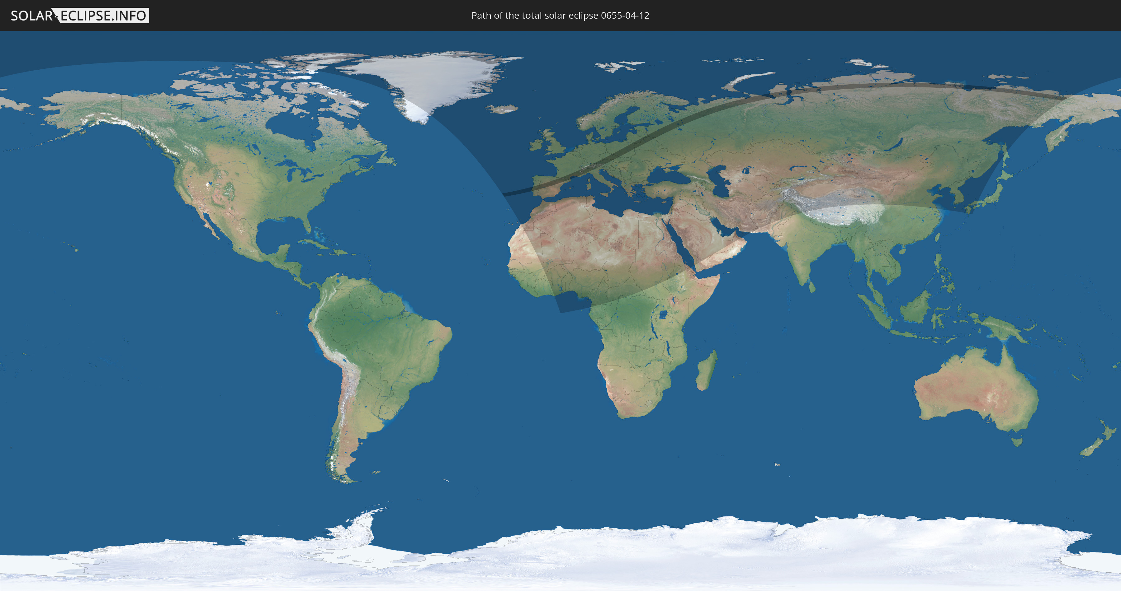
Die Sonnenfinsternis am 12.04.0655 kann man in 110 Ländern als partielle Sonnenfinsternis beobachten.
Der Finsternispfad verläuft durch 15 Länder. Nur in diesen Ländern ist sie als totale Sonnenfinsternis zu sehen.
In den folgenden Ländern ist die Sonnenfinsternis total zu sehen
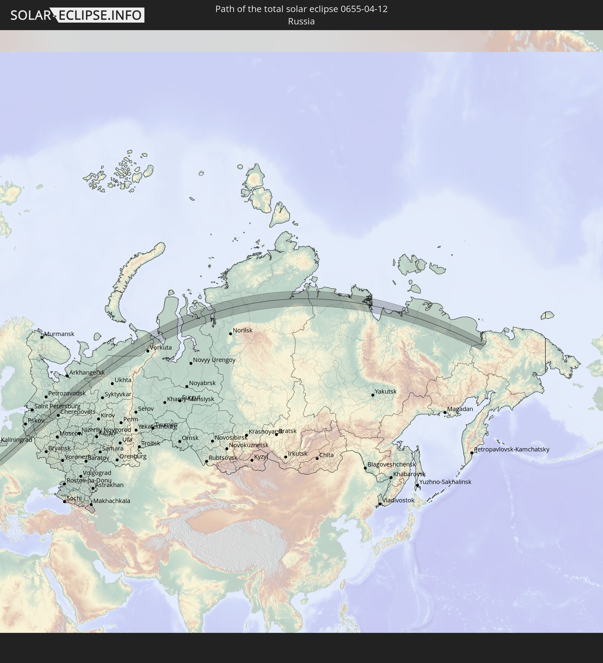 Russland
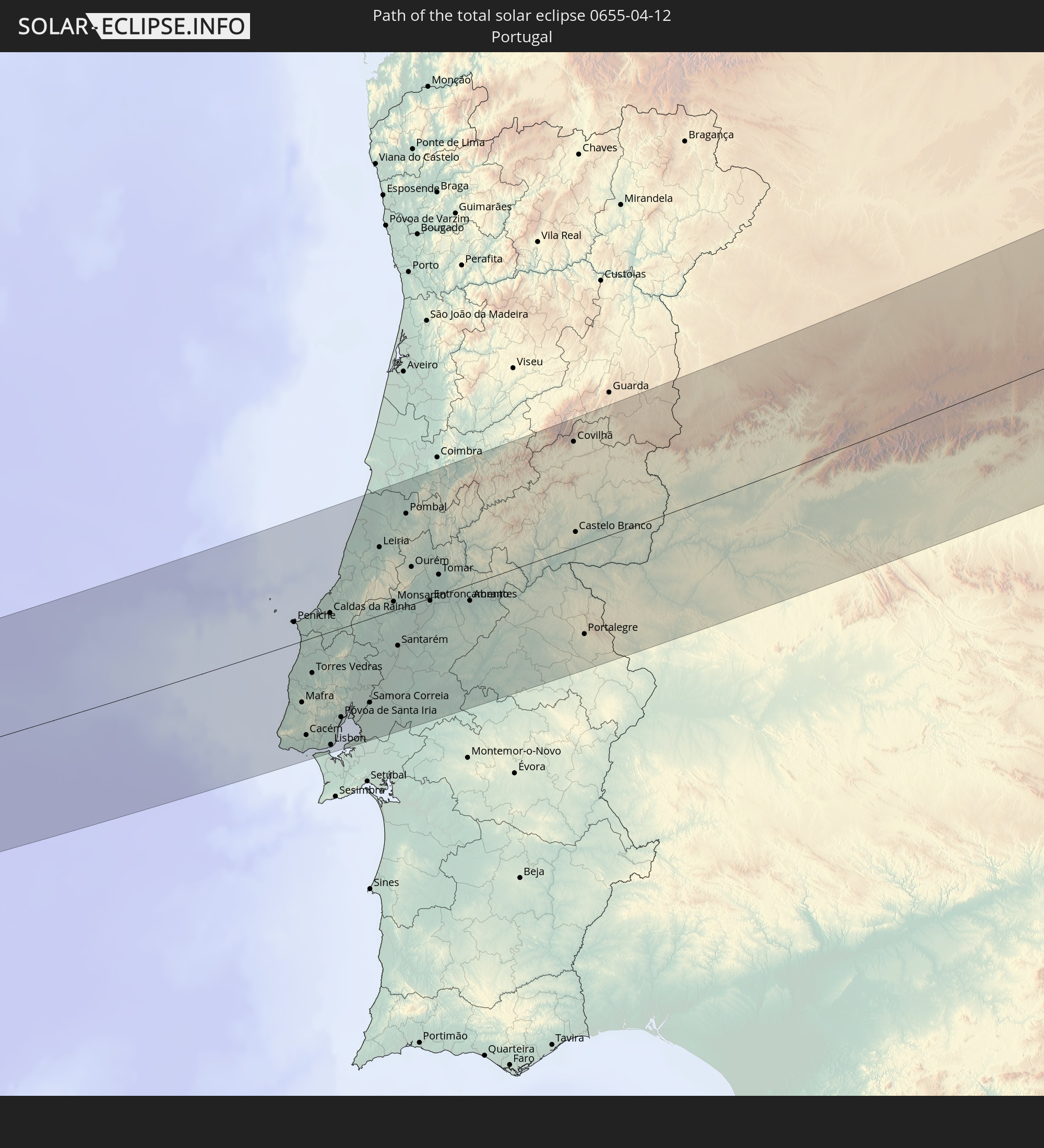 Portugal
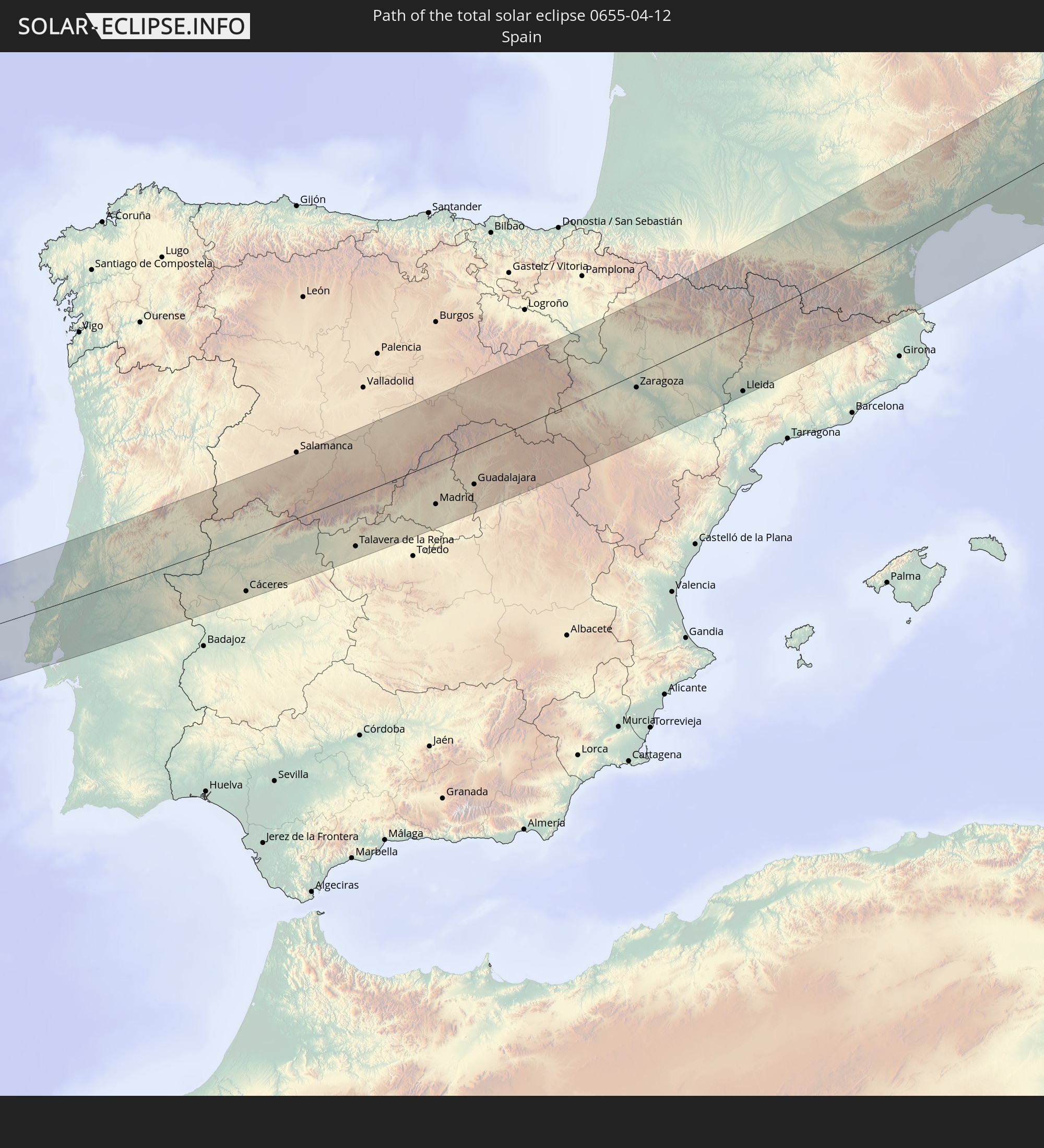 Spanien
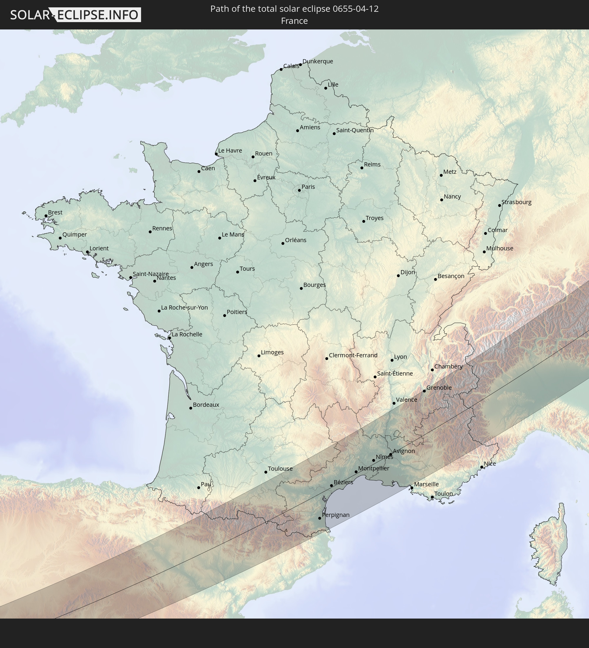 Frankreich
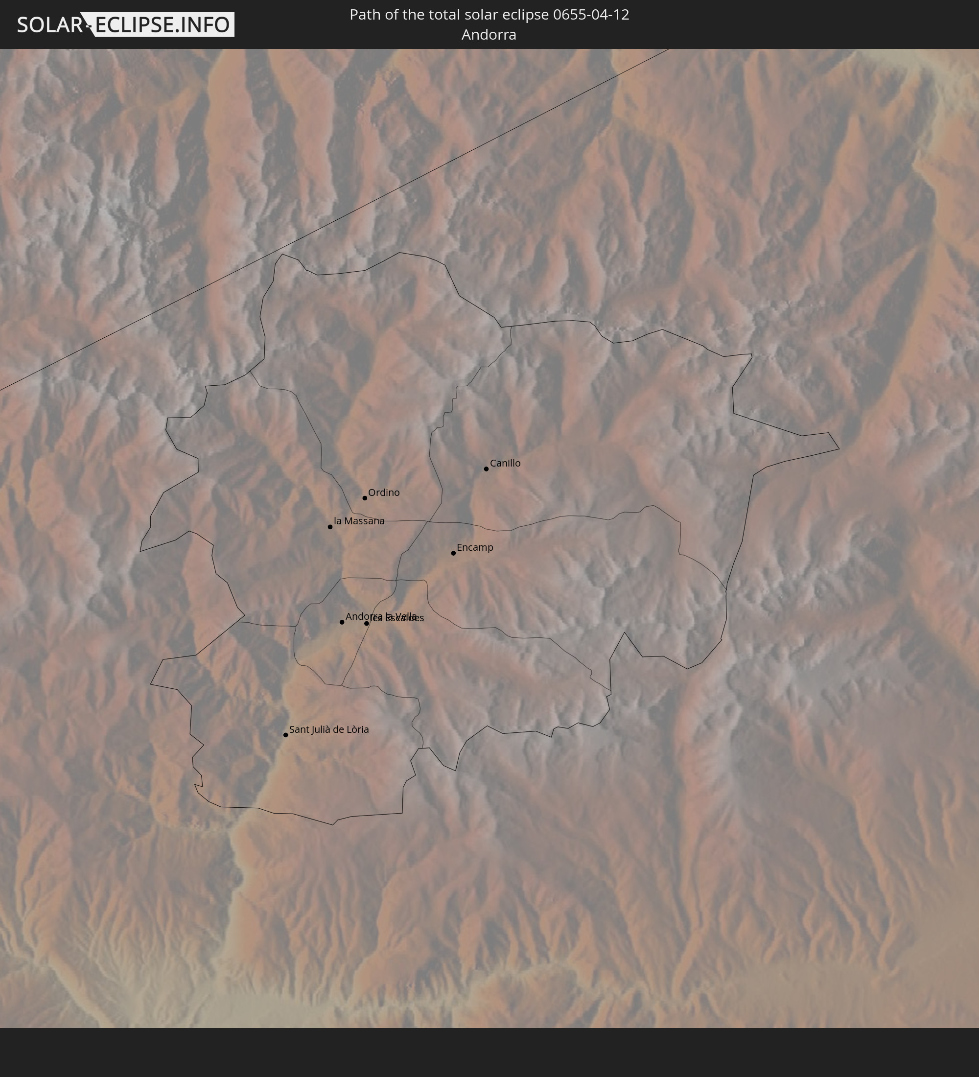 Andorra
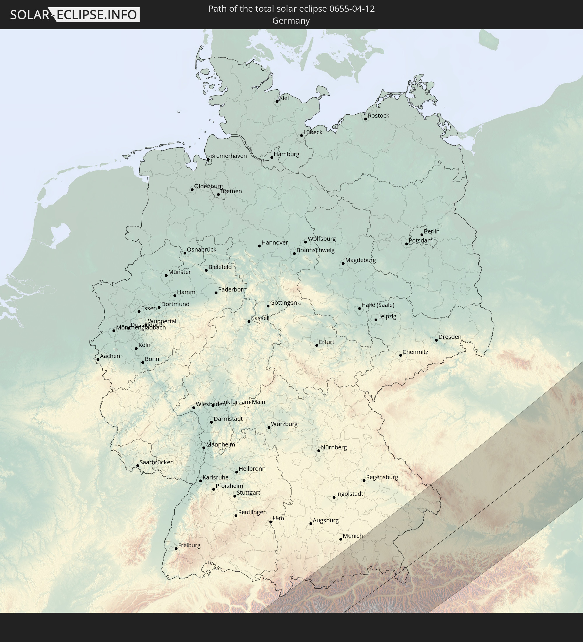 Deutschland
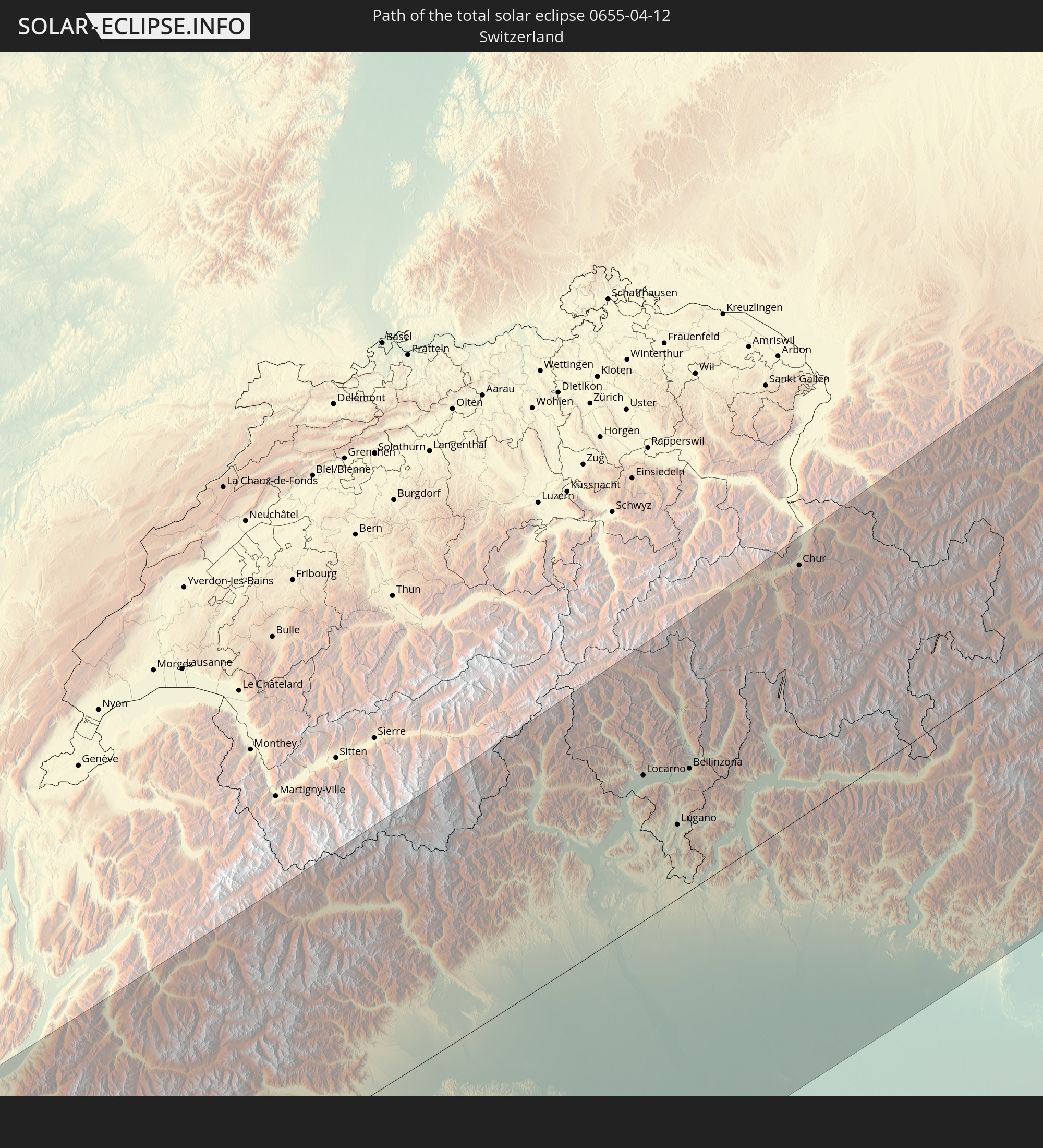 Schweiz
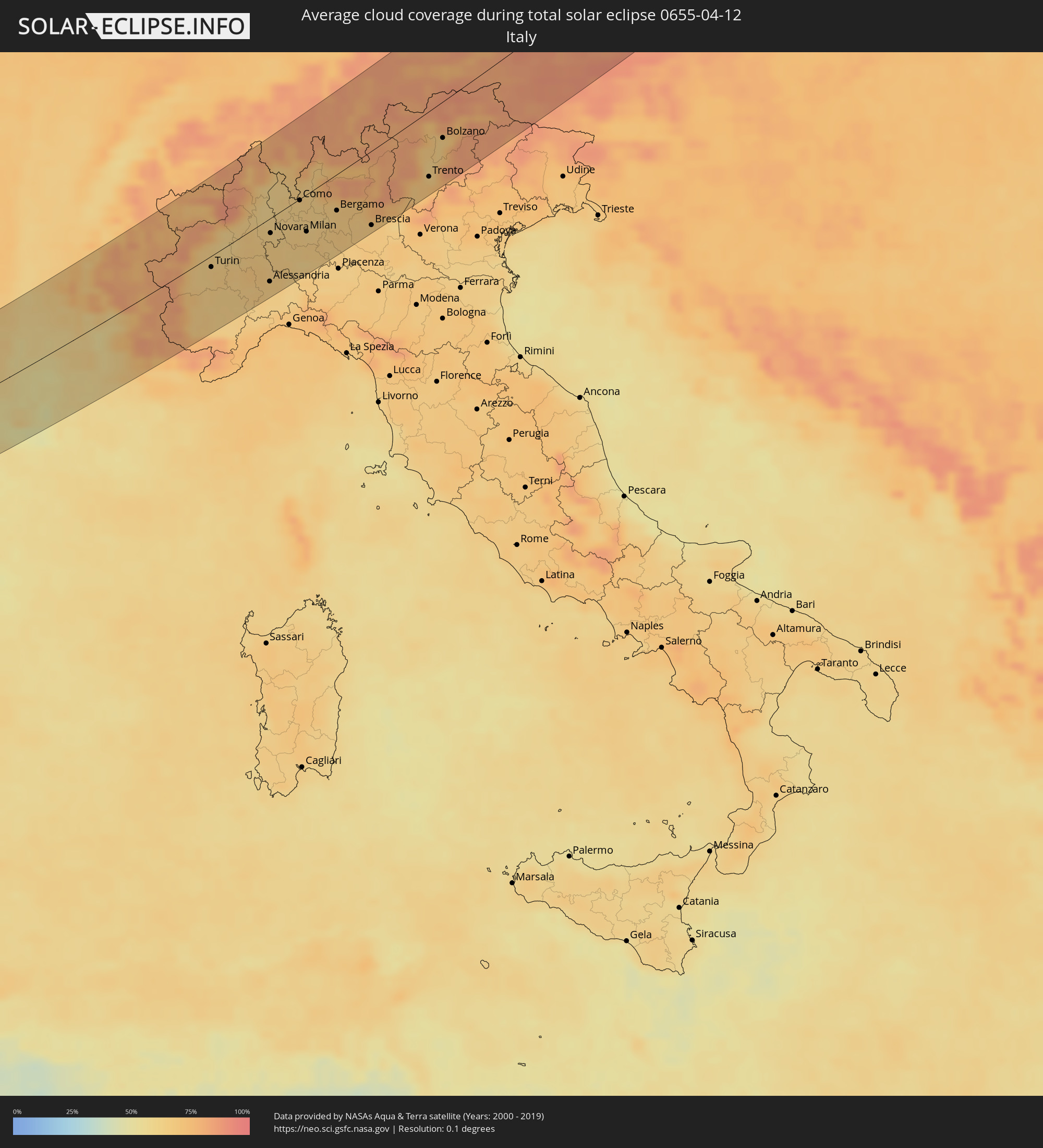
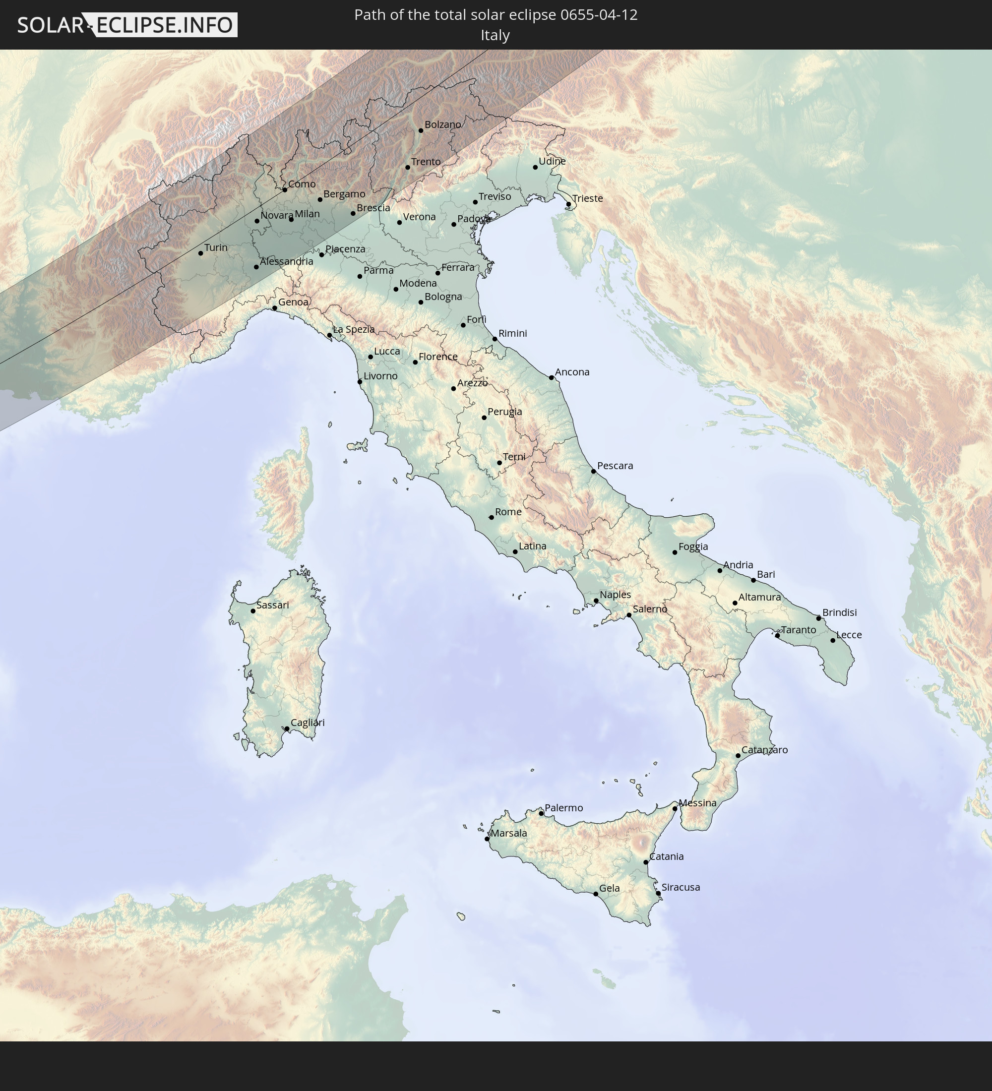 Italien
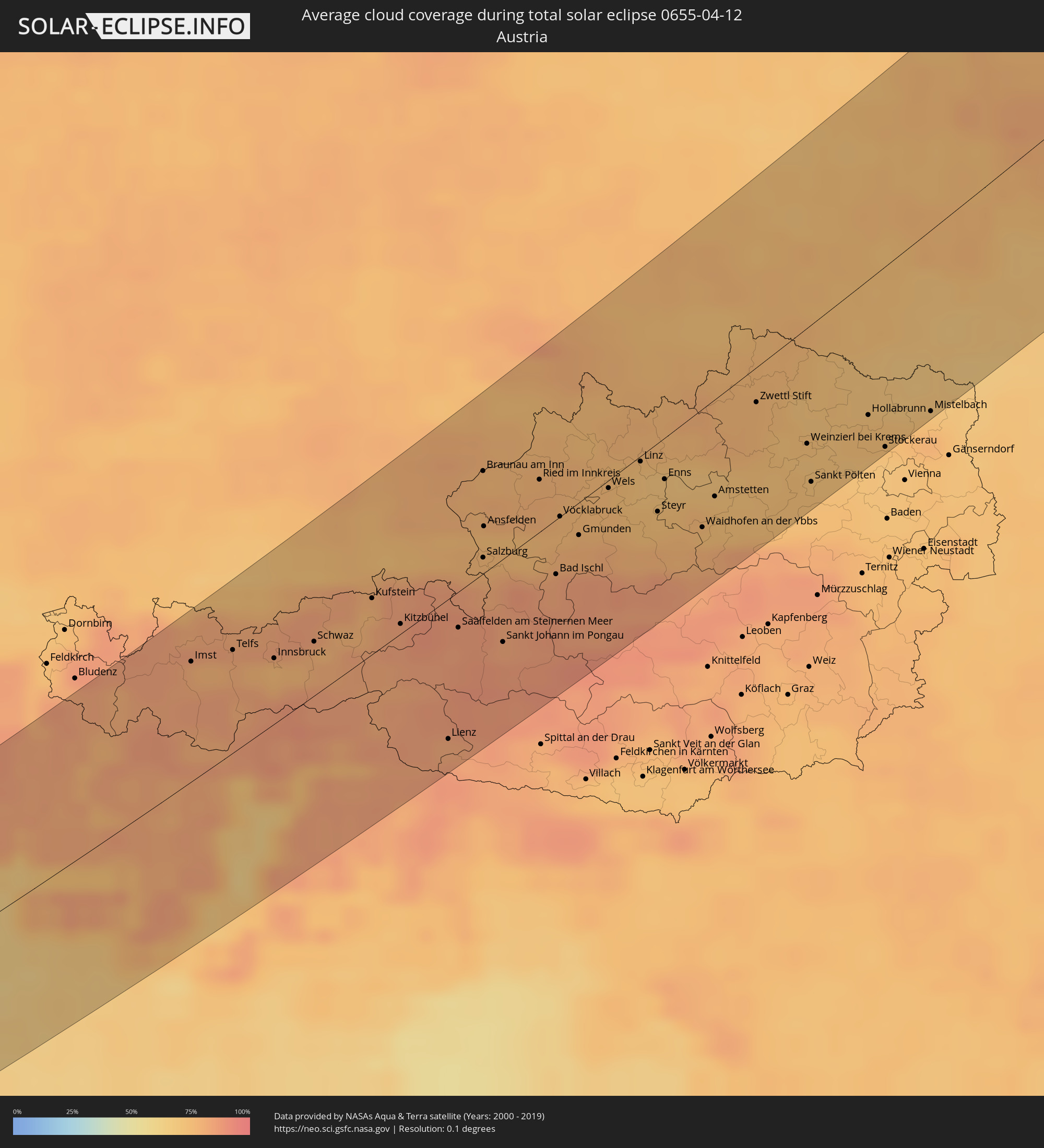
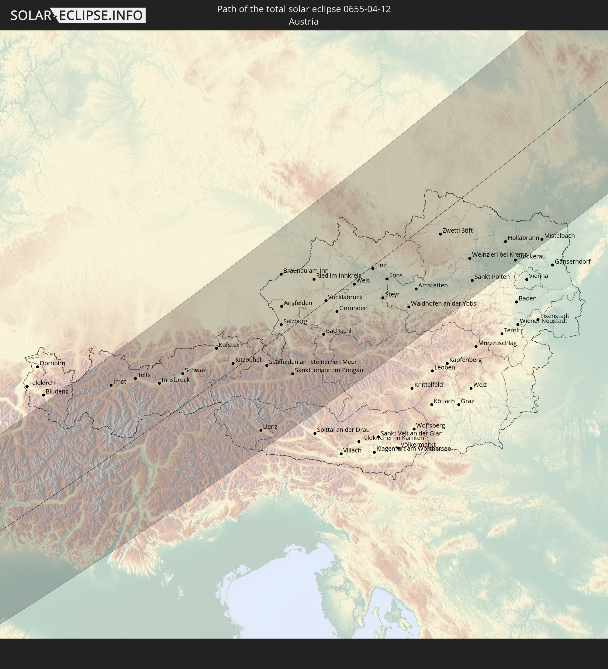 Österreich
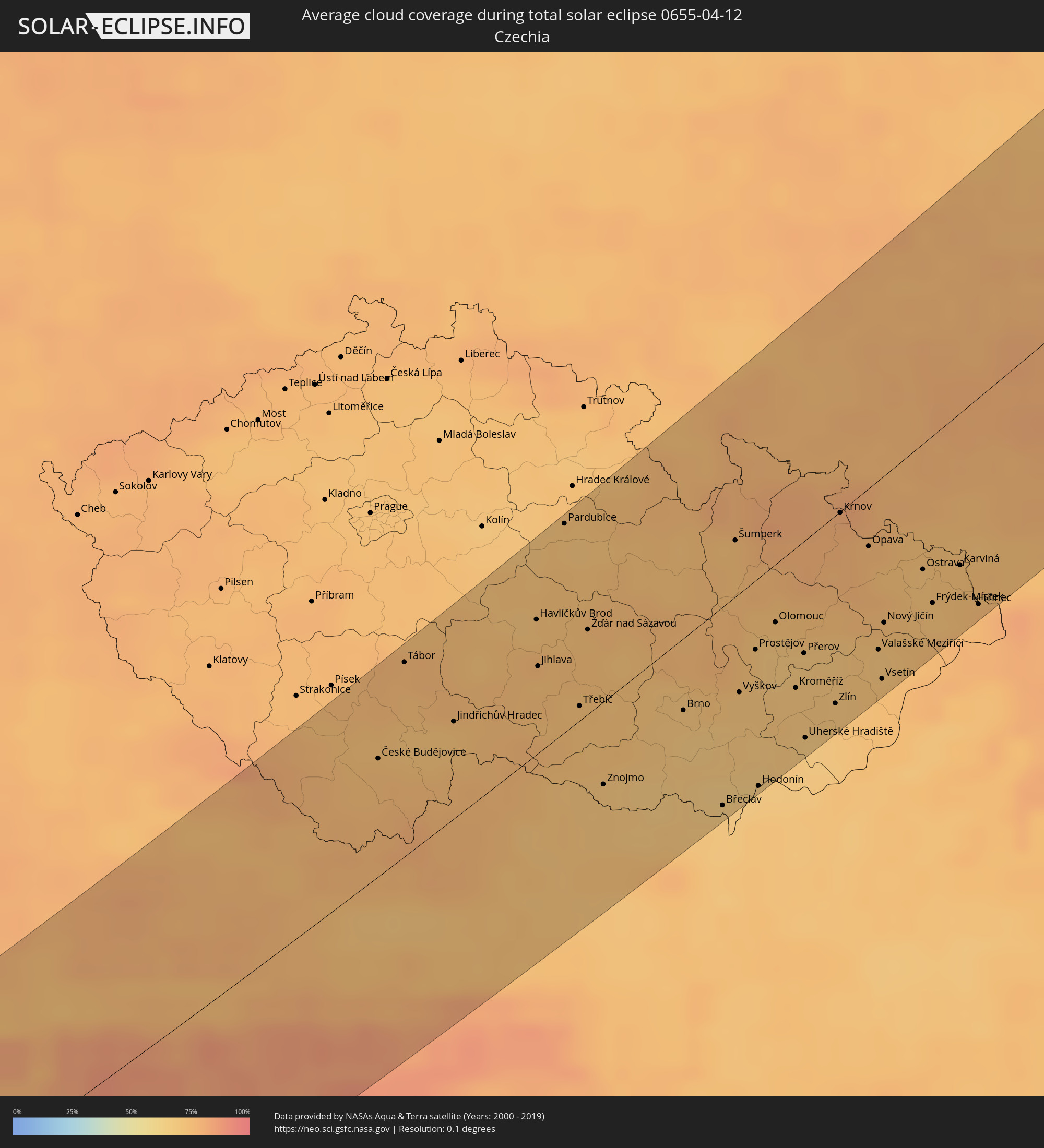
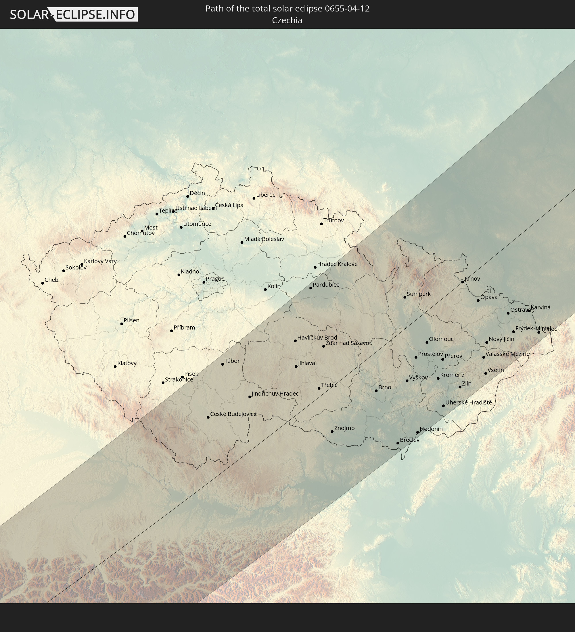 Tschechien
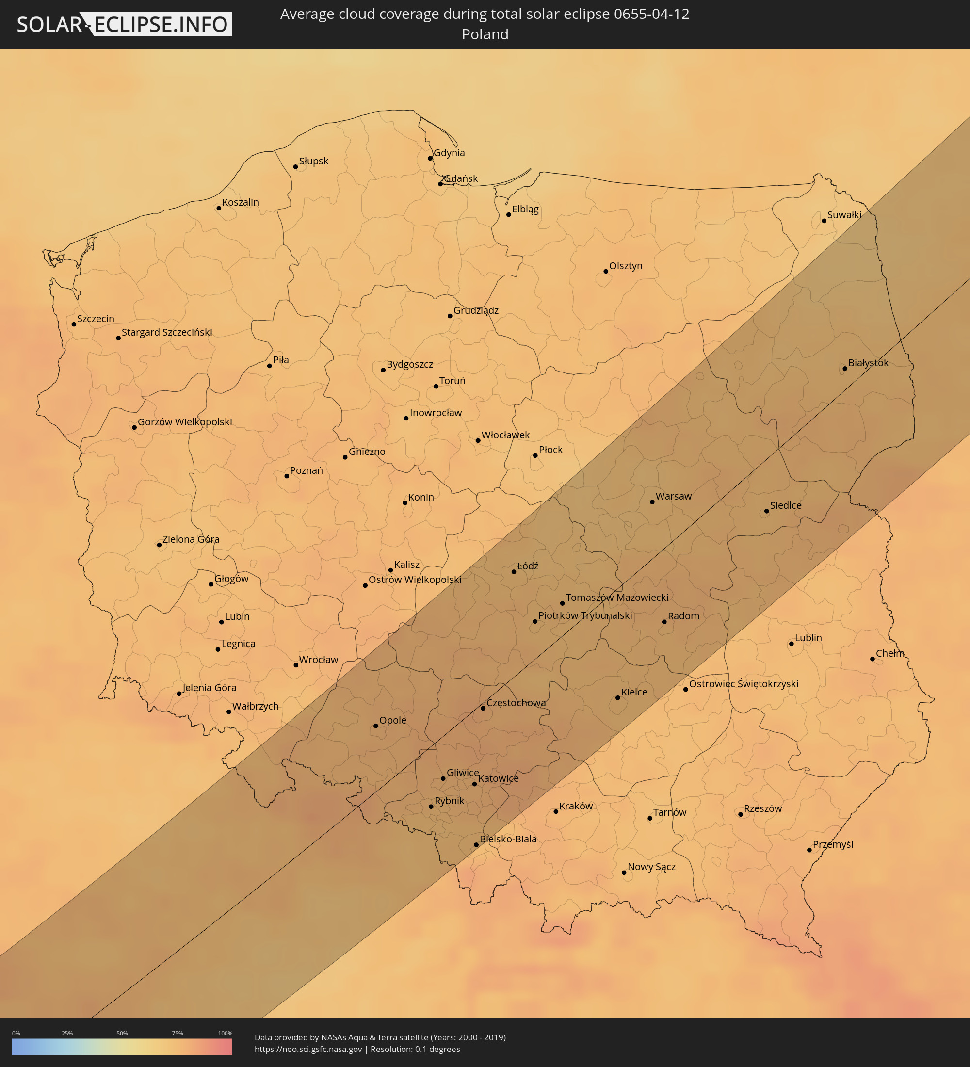
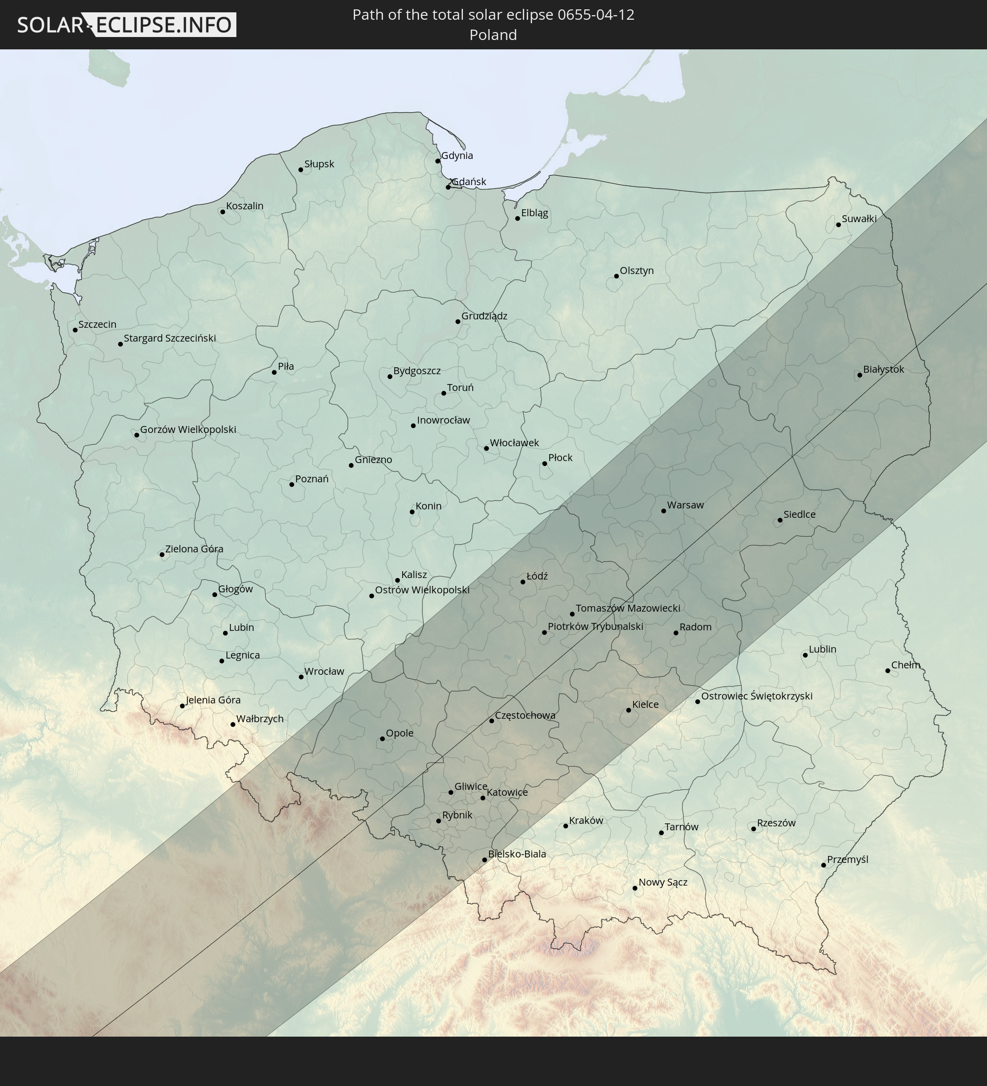 Polen
Polen
 Slowakei
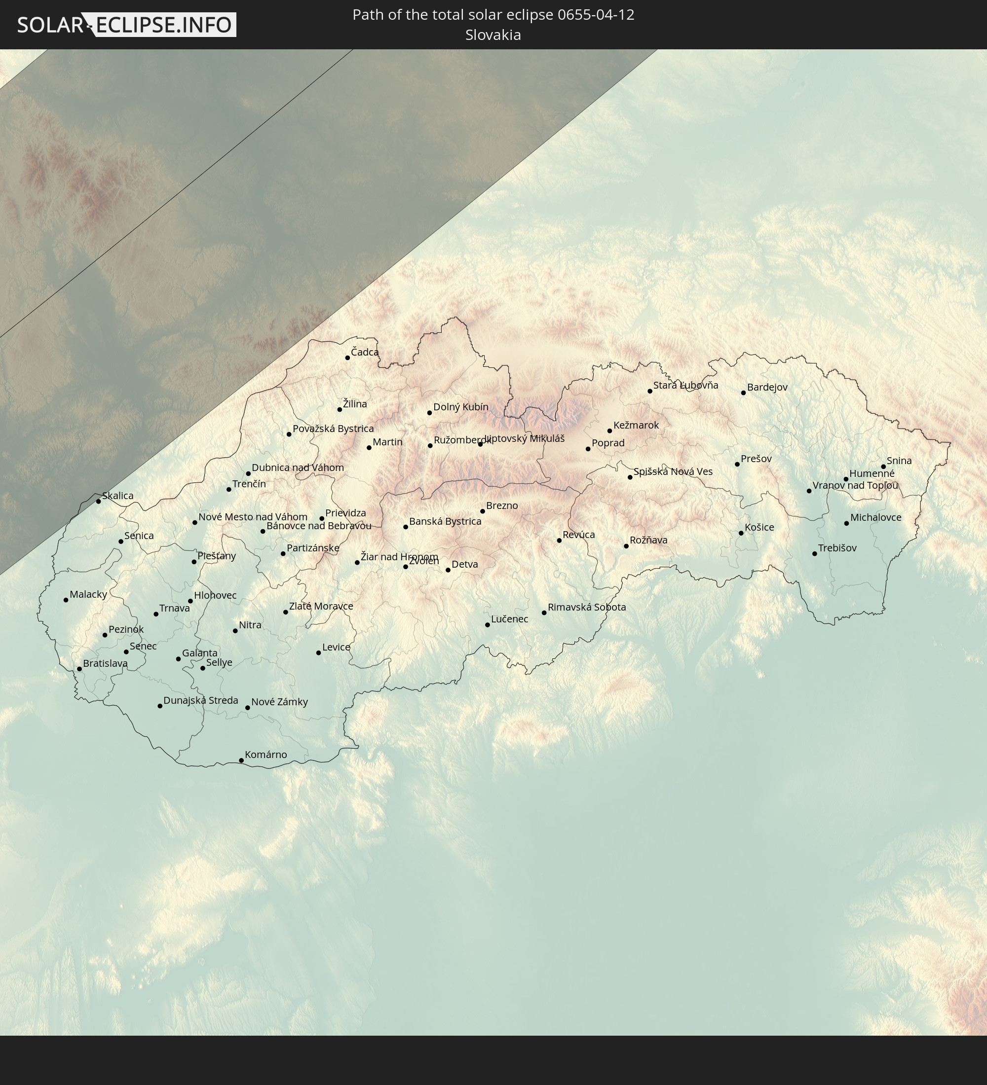
 Litauen
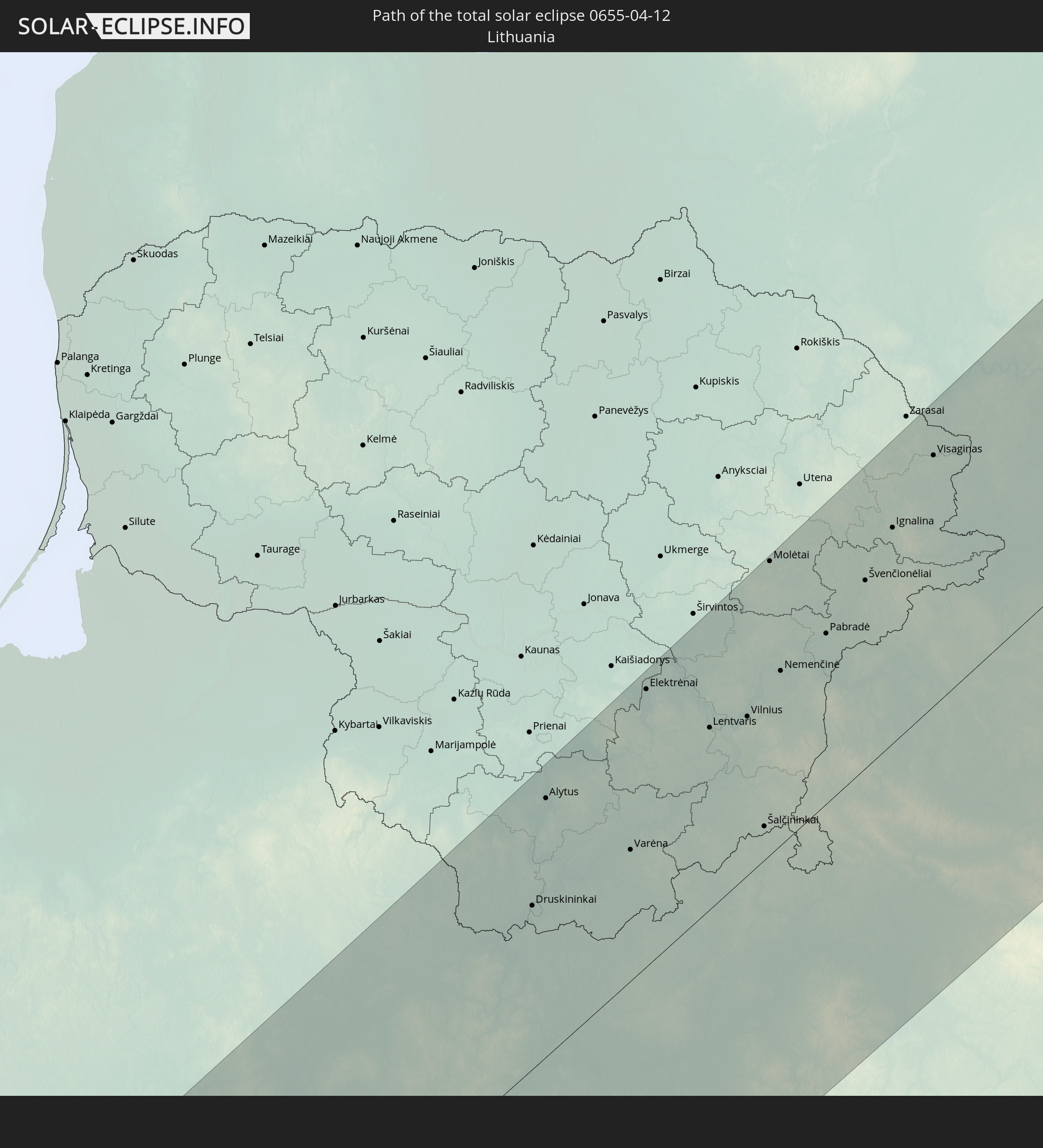
 Lettland
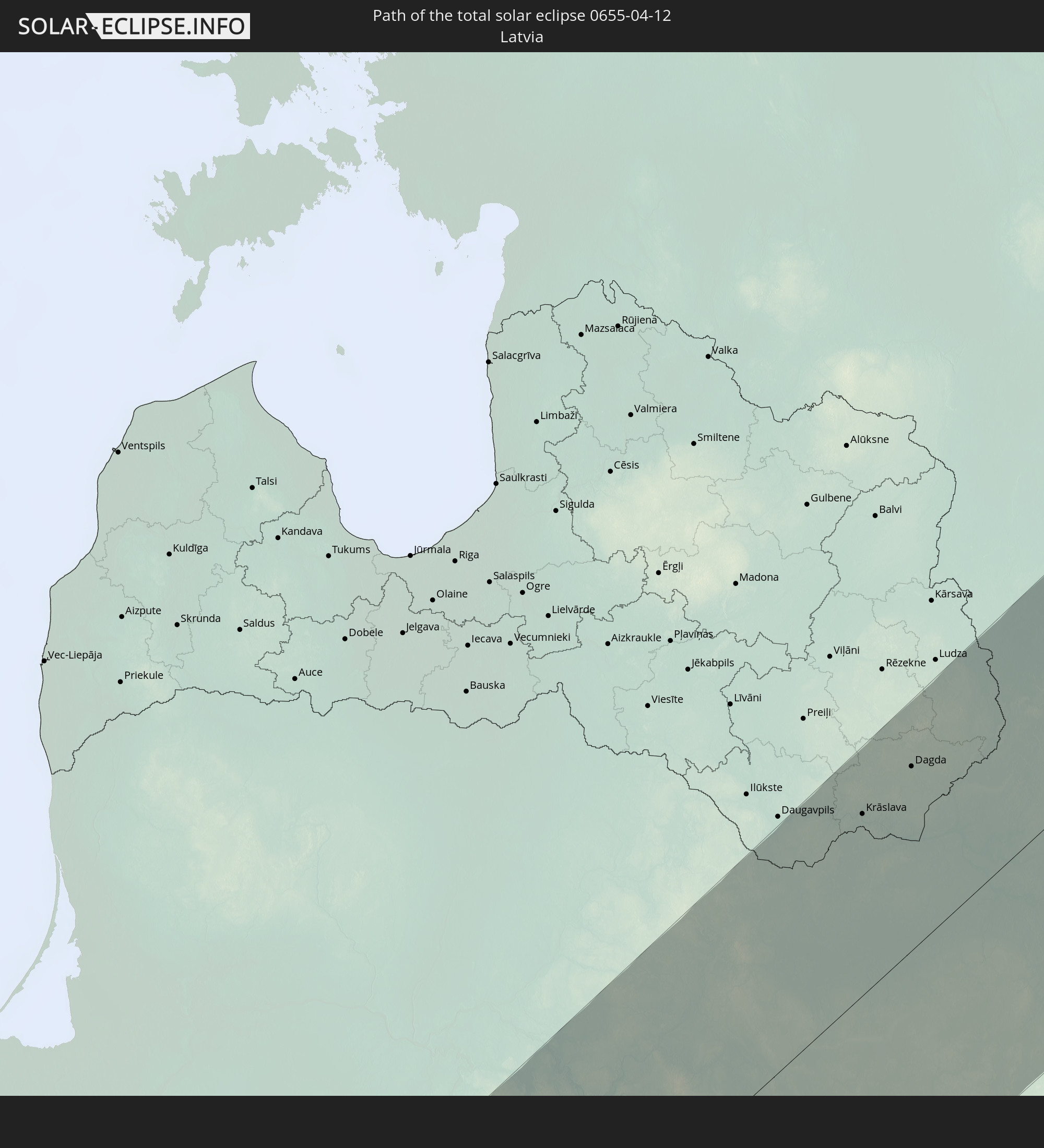
 Weißrussland
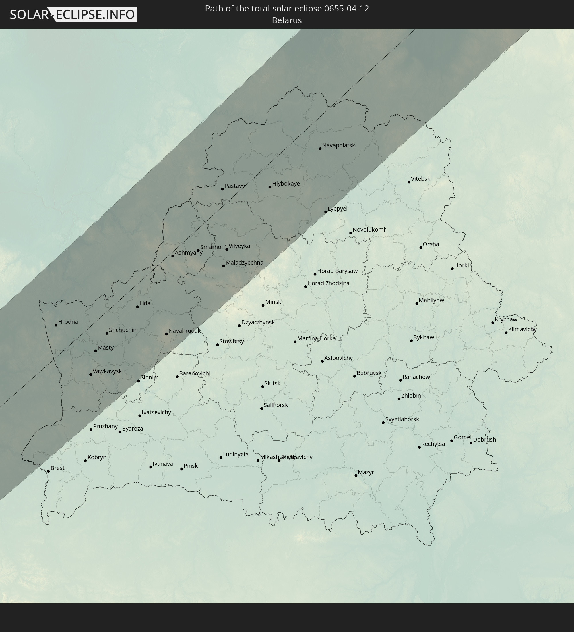
In den folgenden Ländern ist die Sonnenfinsternis partiell zu sehen
 Russland
 Kanada
 Grönland
 Portugal
 Island
 Spanien
 Mauretanien
 Marokko
 Mali
Mali
 Irland
 Spitzbergen
 Algerien
 Vereinigtes Königreich
 Elfenbeinküste
 Färöer
 Burkina Faso
 Gibraltar
 Frankreich
 Isle of Man
 Ghana
Ghana
 Guernsey
 Jersey
 Togo
Togo
 Niger
Niger
 Benin
Benin
 Andorra
 Belgien
 Nigeria
 Niederlande
 Norwegen
 Äquatorialguinea
 Luxemburg
 Deutschland
 Schweiz
 São Tomé und Príncipe
 Italien
 Monaco
 Tunesien
 Dänemark
 Kamerun
 Gabun
Gabun
 Libyen
 Liechtenstein
 Österreich
 Schweden
 Republik Kongo
 Tschechien
 Demokratische Republik Kongo
 San Marino
 Vatikanstadt
 Slowenien
 Tschad
 Kroatien
 Polen
Polen
 Malta
Malta
 Zentralafrikanische Republik
 Bosnien und Herzegowina
 Ungarn
 Slowakei
 Montenegro
 Serbien
 Albanien
 Åland Islands
 Griechenland
 Rumänien
 Mazedonien
 Finnland
 Litauen
 Lettland
 Estland
 Sudan
Sudan
 Ukraine
 Bulgarien
 Weißrussland
 Ägypten
 Türkei
 Moldawien
 Republik Zypern
 Äthiopien
 Staat Palästina
 Israel
 Saudi-Arabien
 Jordanien
 Libanon
 Syrien
 Eritrea
 Irak
Irak
 Georgien
 Jemen
Jemen
 Armenien
 Iran
Iran
 Aserbaidschan
 Kasachstan
 Kuwait
 Bahrain
 Katar
Katar
 Vereinigte Arabische Emirate
 Oman
Oman
 Turkmenistan
 Usbekistan
 Afghanistan
 Pakistan
 Tadschikistan
 Indien
 Kirgisistan
 Volksrepublik China
 Mongolei
 Japan
Japan
 Nordkorea
 Südkorea
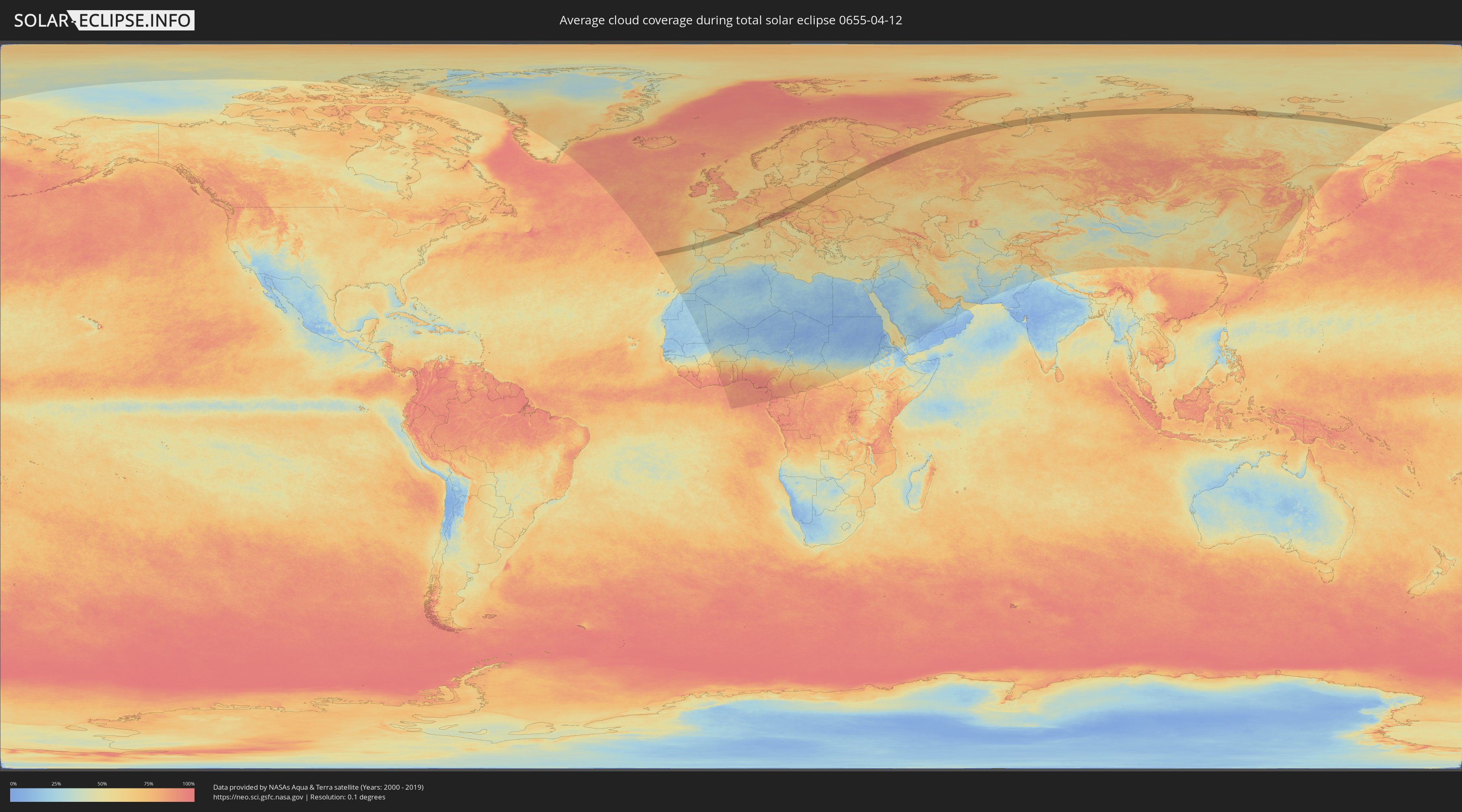
Wie wird das Wetter während der totalen Sonnenfinsternis am 12.04.0655?
Wo ist der beste Ort, um die totale Sonnenfinsternis vom 12.04.0655 zu beobachten?
Die folgenden Karten zeigen die durchschnittliche Bewölkung für den Tag, an dem die totale Sonnenfinsternis
stattfindet. Mit Hilfe der Karten lässt sich der Ort entlang des Finsternispfades eingrenzen,
der die besten Aussichen auf einen klaren wolkenfreien Himmel bietet.
Trotzdem muss man immer lokale Gegenenheiten beachten und sollte sich genau über das Wetter an seinem
gewählten Beobachtungsort informieren.
Die Daten stammen von den beiden NASA-Satelliten
AQUA und TERRA
und wurden über einen Zeitraum von 19 Jahren (2000 - 2019) gemittelt.

Detaillierte Länderkarten
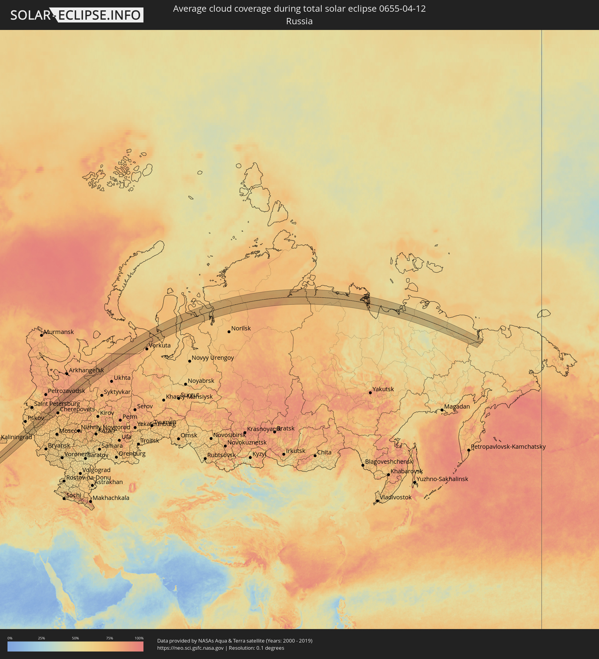 Russland
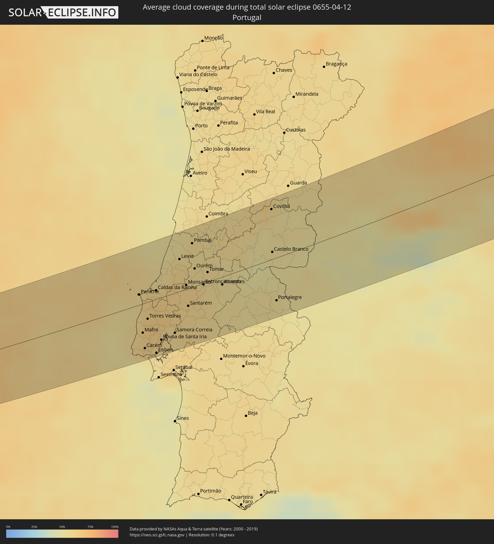 Portugal
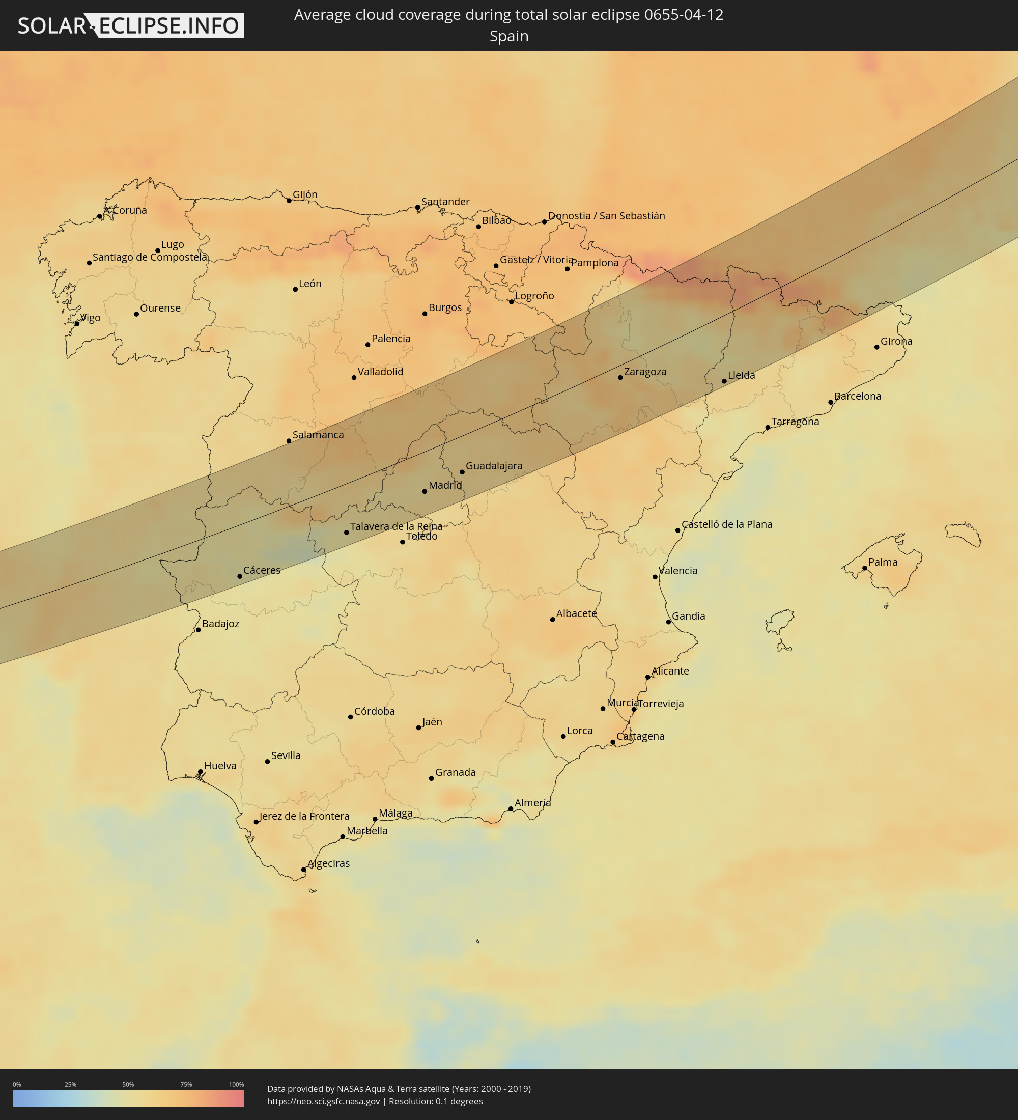 Spanien
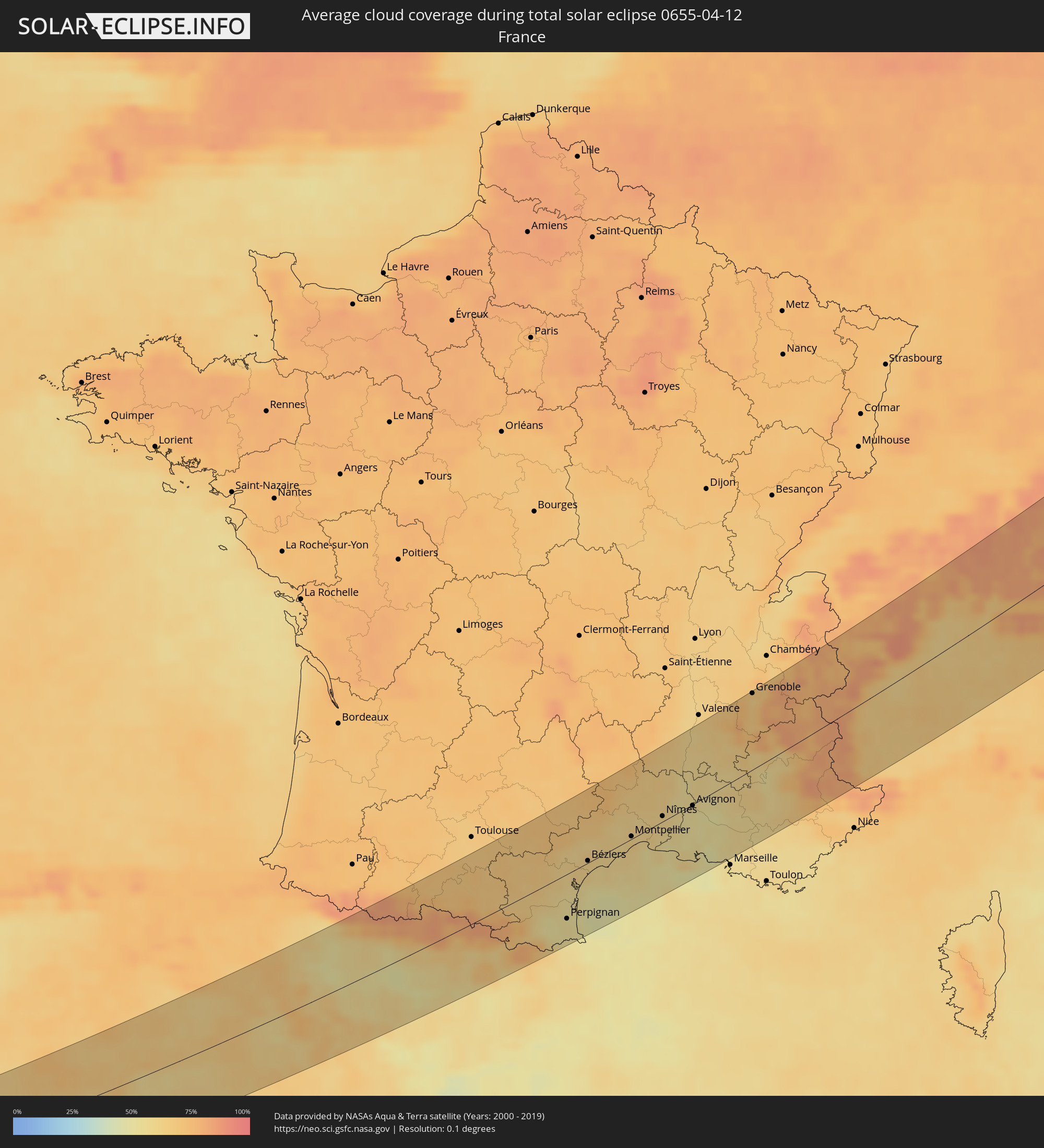 Frankreich
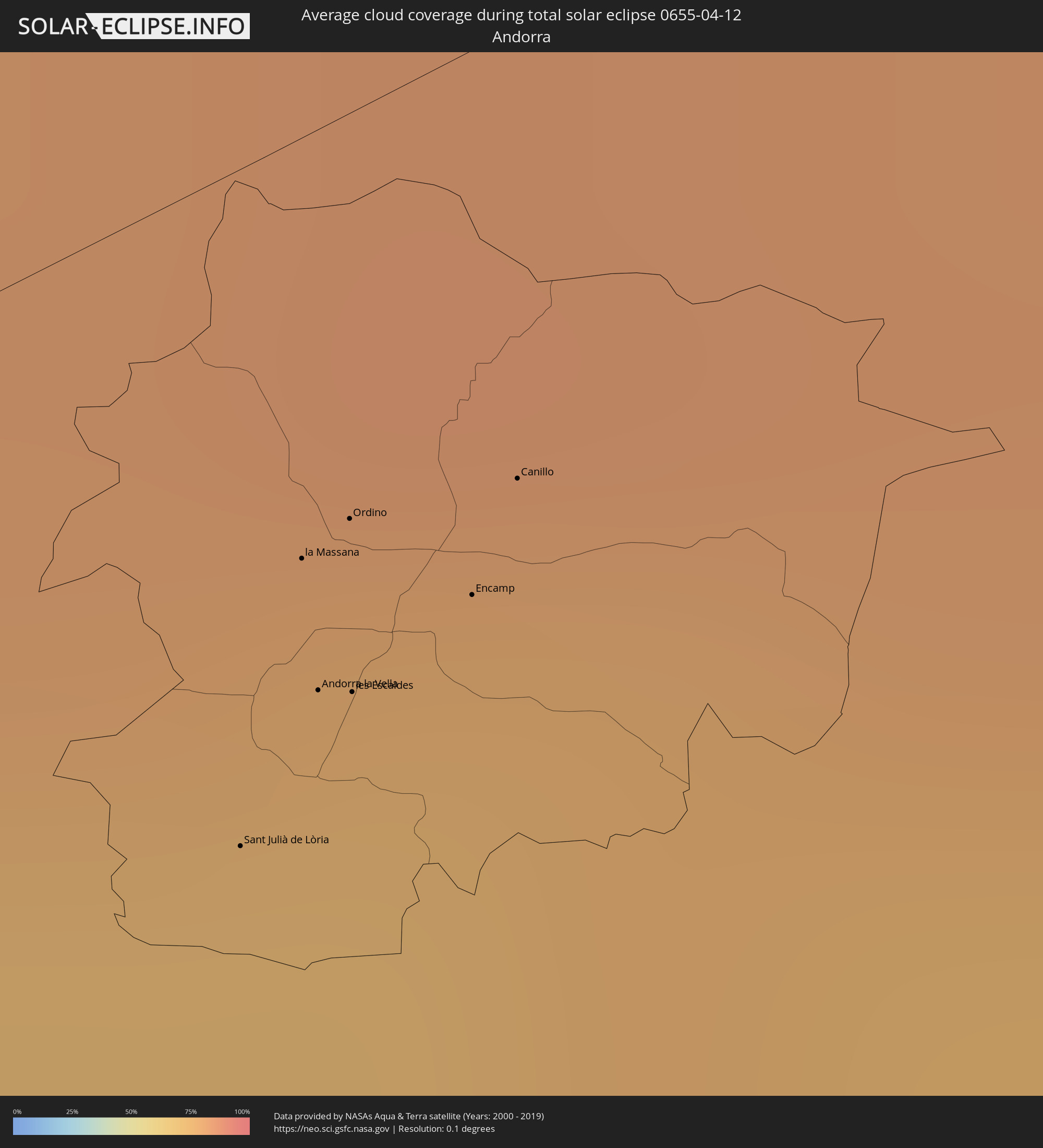 Andorra
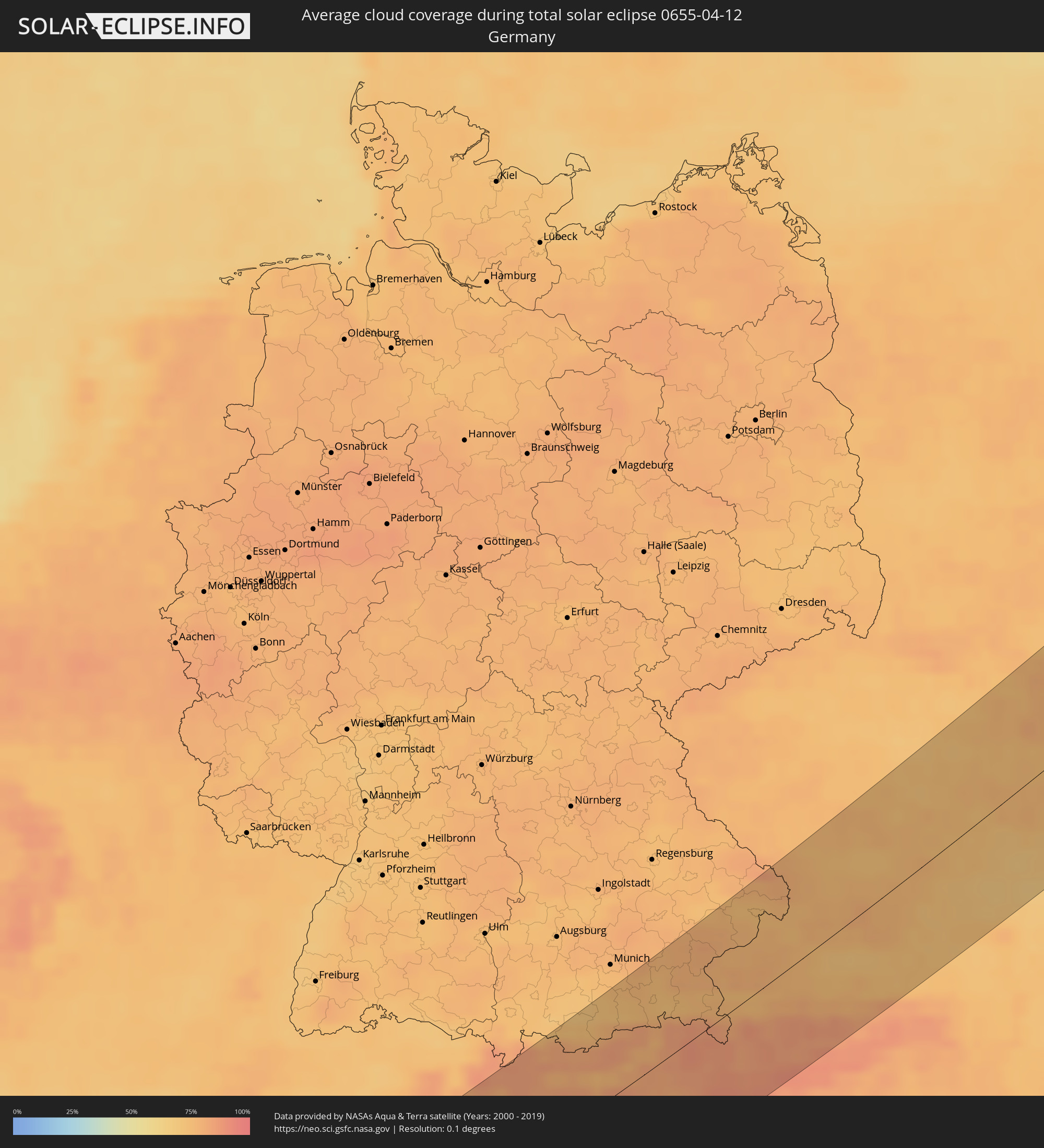 Deutschland
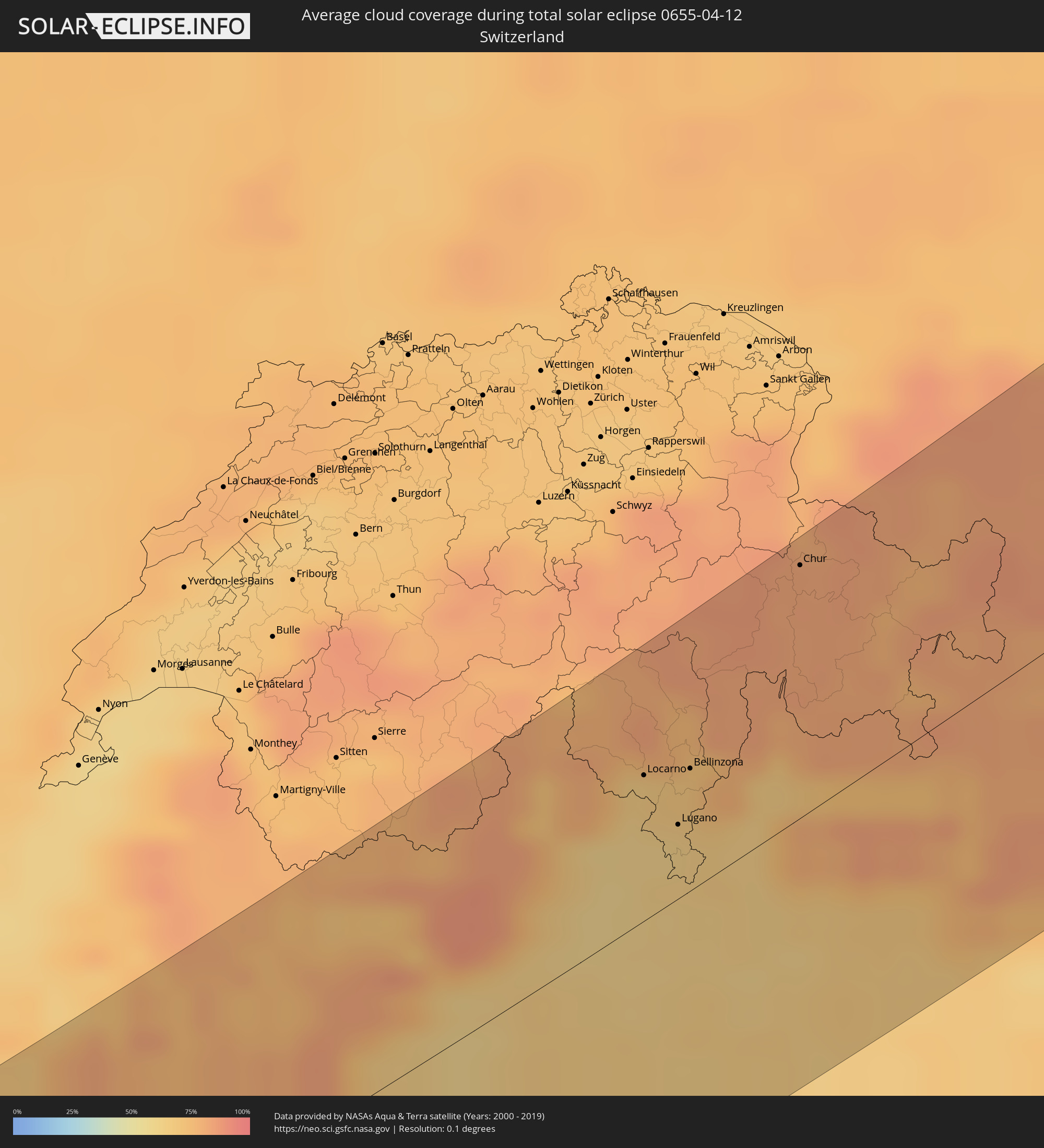 Schweiz
 Italien
 Österreich
 Tschechien
 Polen
Polen
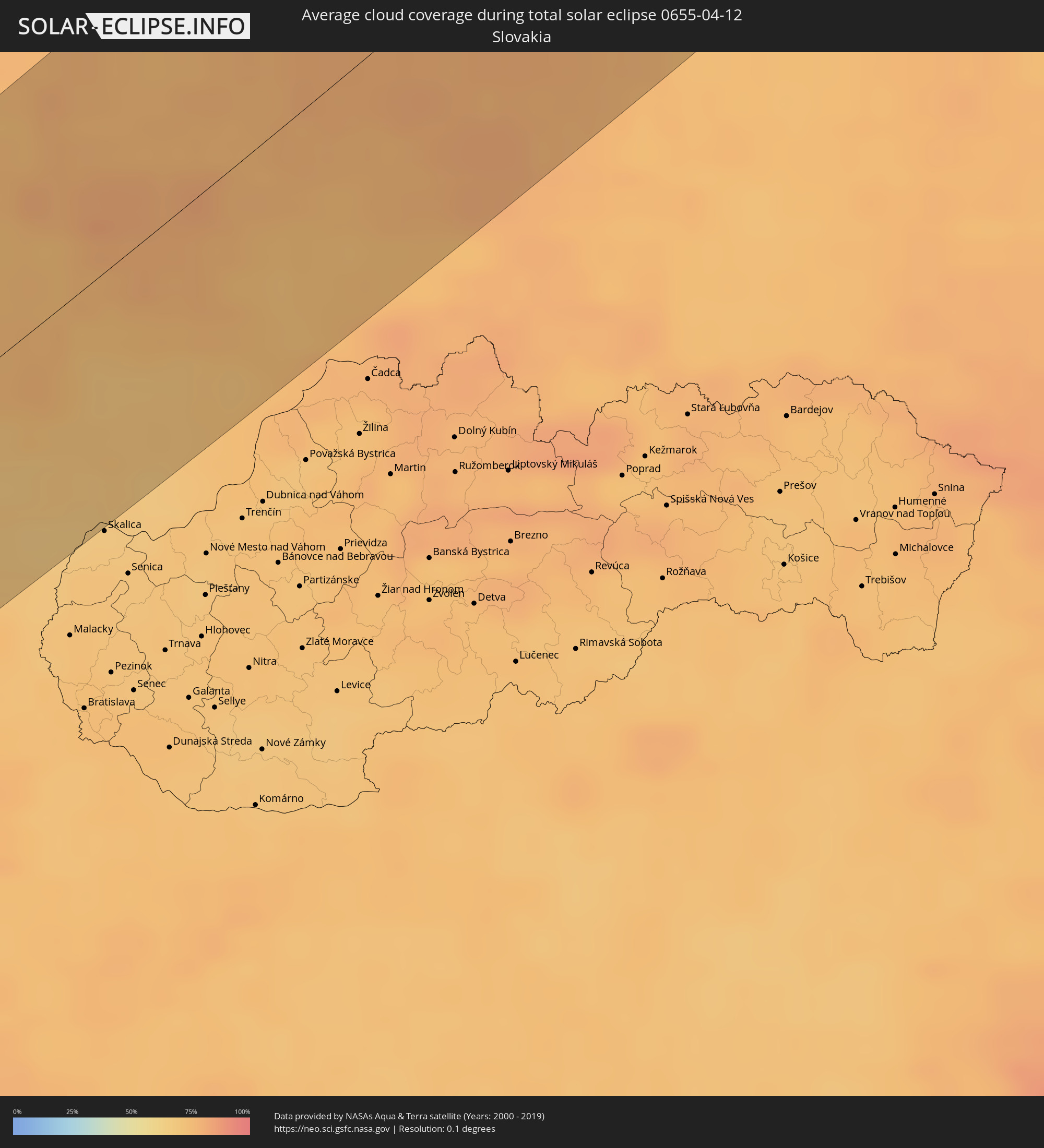 Slowakei
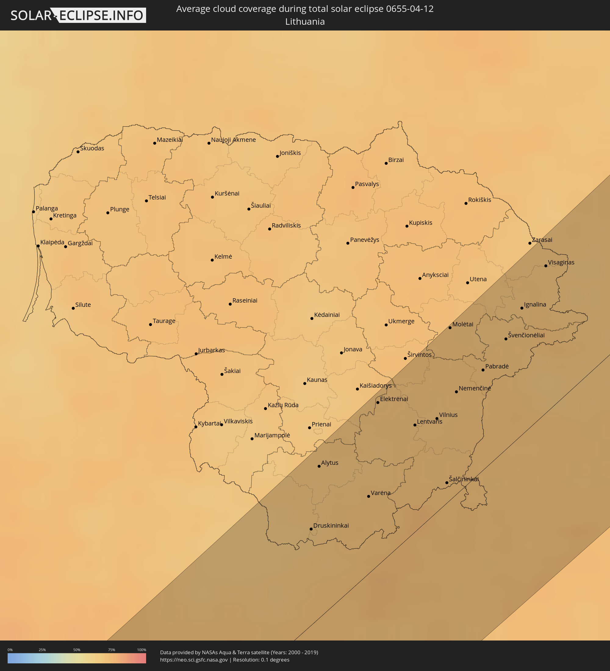 Litauen
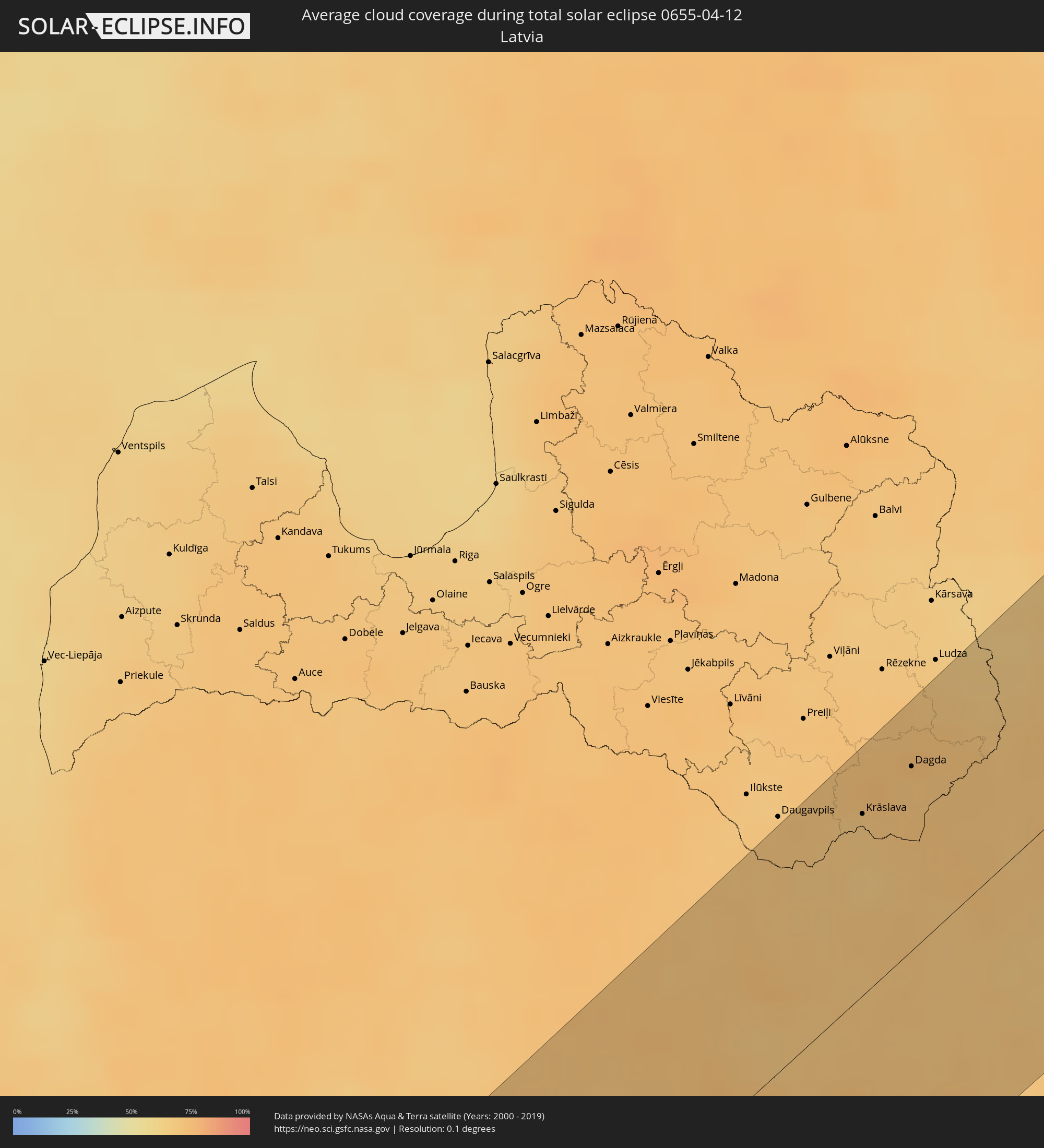 Lettland
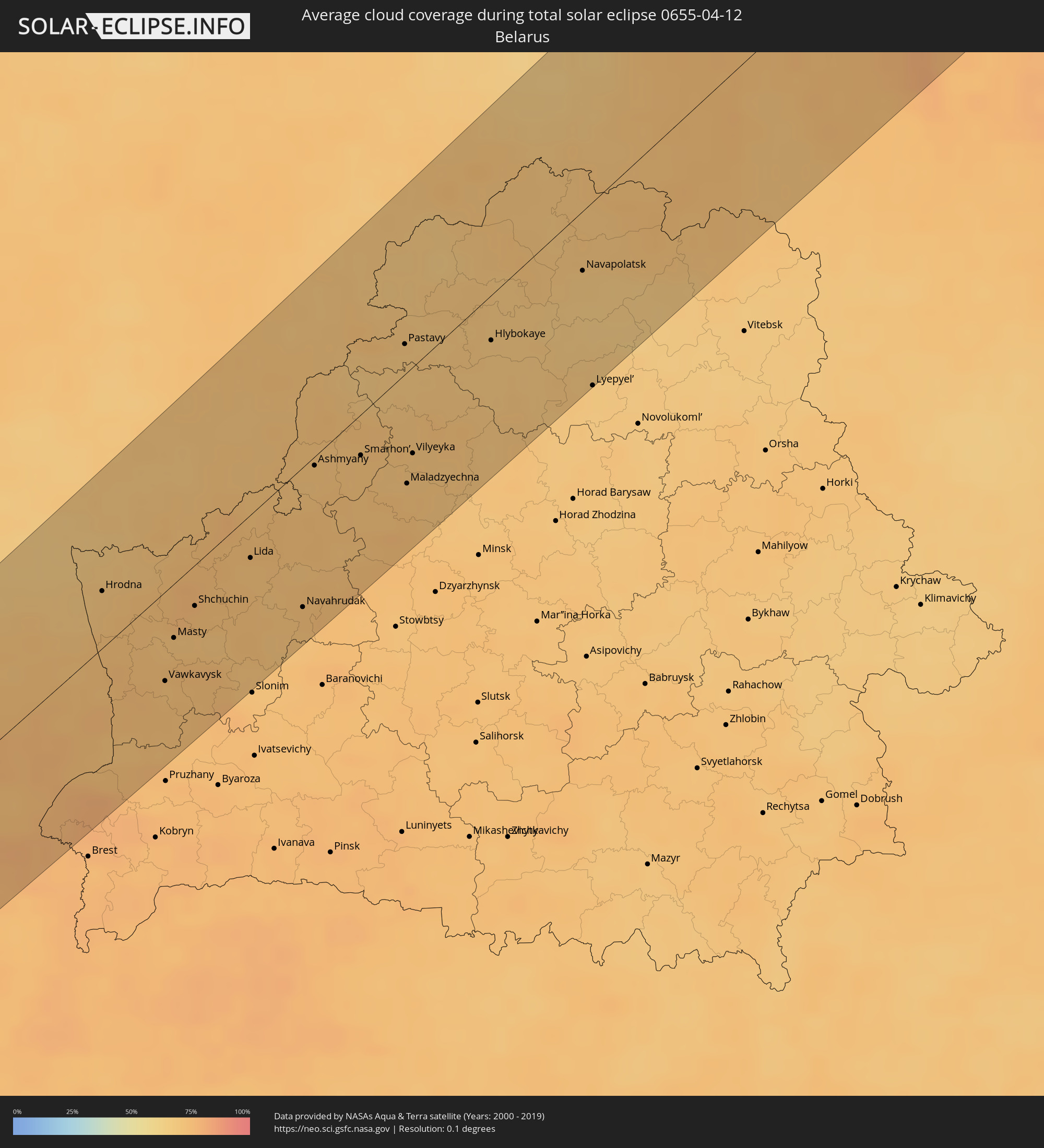 Weißrussland
Orte im Finsternispfad
Die nachfolgene Tabelle zeigt Städte und Orte mit mehr als 5.000 Einwohnern, die sich im Finsternispfad befinden. Städte mit mehr als 100.000 Einwohnern sind dick gekennzeichnet. Mit einem Klick auf den Ort öffnet sich eine Detailkarte die die Lage des jeweiligen Ortes zusammen mit dem Verlauf der zentralen Finsternis präsentiert.
| Ort | Typ | Dauer der Verfinsterung | Ortszeit bei maximaler Verfinsterung | Entfernung zur Zentrallinie | Ø Bewölkung |
|
Peniche, Leiria
|
total | - | 06:09:12 UTC-00:36 | 19 km | 56% |
|
Cacém, Lisbon
|
total | - | 06:08:16 UTC-00:36 | 53 km | 61% |
|
Torres Vedras, Lisbon
|
total | - | 06:08:47 UTC-00:36 | 25 km | 62% |
|
Caldas da Rainha, Leiria
|
total | - | 06:09:16 UTC-00:36 | 14 km | 62% |
|
Lisbon, Lisbon
|
total | - | 06:08:11 UTC-00:36 | 64 km | 54% |
|
Póvoa de Santa Iria, Lisbon
|
total | - | 06:08:25 UTC-00:36 | 54 km | 61% |
|
Leiria, Leiria
|
total | - | 06:09:48 UTC-00:36 | 40 km | 61% |
|
Monsanto, Santarém
|
total | - | 06:09:21 UTC-00:36 | 18 km | 60% |
|
Santarém, Santarém
|
total | - | 06:09:00 UTC-00:36 | 30 km | 59% |
|
Pombal, Leiria
|
total | - | 06:10:05 UTC-00:36 | 51 km | 56% |
|
Entroncamento, Santarém
|
total | - | 06:09:22 UTC-00:36 | 3 km | 61% |
|
Tomar, Santarém
|
total | - | 06:09:35 UTC-00:36 | 16 km | 57% |
|
Covilhã, Castelo Branco
|
total | - | 06:10:41 UTC-00:36 | 57 km | 57% |
|
Castelo Branco, Castelo Branco
|
total | - | 06:09:56 UTC-00:36 | 8 km | 51% |
|
Portalegre, Portalegre
|
total | - | 06:09:06 UTC-00:36 | 49 km | 54% |
|
Cáceres, Extremadura
|
total | - | 06:46:10 UTC+00:00 | 62 km | 50% |
|
Talavera de la Reina, Castille-La Mancha
|
total | - | 06:47:04 UTC+00:00 | 57 km | 50% |
|
Ávila, Castille and León
|
total | - | 06:48:13 UTC+00:00 | 18 km | 61% |
|
Segovia, Castille and León
|
total | - | 06:48:46 UTC+00:00 | 22 km | 66% |
|
Collado-Villalba, Madrid
|
total | - | 06:48:15 UTC+00:00 | 15 km | 54% |
|
Las Rozas de Madrid, Madrid
|
total | - | 06:48:02 UTC+00:00 | 32 km | 55% |
|
Móstoles, Madrid
|
total | - | 06:47:45 UTC+00:00 | 51 km | 57% |
|
Madrid, Madrid
|
total | - | 06:47:55 UTC+00:00 | 47 km | 58% |
|
Valdemoro, Madrid
|
total | - | 06:47:33 UTC+00:00 | 70 km | 58% |
|
Alcobendas, Madrid
|
total | - | 06:48:09 UTC+00:00 | 39 km | 57% |
|
Rivas-Vaciamadrid, Madrid
|
total | - | 06:47:48 UTC+00:00 | 64 km | 55% |
|
Alcalá de Henares, Madrid
|
total | - | 06:48:05 UTC+00:00 | 51 km | 58% |
|
Guadalajara, Castille-La Mancha
|
total | - | 06:48:21 UTC+00:00 | 44 km | 58% |
|
Zaragoza, Aragon
|
total | - | 06:50:28 UTC+00:00 | 15 km | 65% |
|
Lleida, Catalonia
|
total | - | 06:50:43 UTC+00:00 | 75 km | 58% |
|
Sant Julià de Lòria, Sant Julià de Loria
|
total | - | 06:52:25 UTC+00:00 | 22 km | 71% |
|
la Massana, La Massana
|
total | - | 06:52:34 UTC+00:00 | 13 km | 71% |
|
Andorra la Vella, Andorra la Vella
|
total | - | 06:52:30 UTC+00:00 | 17 km | 71% |
|
Ordino, Ordino
|
total | - | 06:52:35 UTC+00:00 | 12 km | 76% |
|
les Escaldes, Escaldes-Engordany
|
total | - | 06:52:30 UTC+00:00 | 17 km | 71% |
|
Encamp, Encamp
|
total | - | 06:52:34 UTC+00:00 | 15 km | 75% |
|
Canillo, Canillo
|
total | - | 06:52:38 UTC+00:00 | 13 km | 77% |
|
Castres, Occitania
|
total | - | 07:03:59 UTC+00:09 | 66 km | 67% |
|
Carcassonne, Occitania
|
total | - | 07:03:20 UTC+00:09 | 23 km | 65% |
|
Perpignan, Occitania
|
total | - | 07:02:35 UTC+00:09 | 50 km | 54% |
|
Narbonne, Occitania
|
total | - | 07:03:28 UTC+00:09 | 6 km | 57% |
|
Béziers, Occitania
|
total | - | 07:03:49 UTC+00:09 | 21 km | 60% |
|
Montpellier, Occitania
|
total | - | 07:04:31 UTC+00:09 | 10 km | 63% |
|
Alès, Occitania
|
total | - | 07:05:30 UTC+00:09 | 47 km | 63% |
|
Nîmes, Occitania
|
total | - | 07:05:04 UTC+00:09 | 12 km | 58% |
|
Arles, Provence-Alpes-Côte d'Azur
|
total | - | 07:04:53 UTC+00:09 | 20 km | 54% |
|
Avignon, Provence-Alpes-Côte d'Azur
|
total | - | 07:05:26 UTC+00:09 | 18 km | 53% |
|
Martigues, Provence-Alpes-Côte d'Azur
|
total | - | 07:04:34 UTC+00:09 | 65 km | 51% |
|
Marseille 15, Provence-Alpes-Côte d'Azur
|
total | - | 07:04:36 UTC+00:09 | 80 km | 55% |
|
Aix-en-Provence, Provence-Alpes-Côte d'Azur
|
total | - | 07:04:55 UTC+00:09 | 68 km | 55% |
|
Grenoble, Auvergne-Rhône-Alpes
|
total | - | 07:07:59 UTC+00:09 | 82 km | 64% |
|
Gap, Provence-Alpes-Côte d'Azur
|
total | - | 07:07:02 UTC+00:09 | 14 km | 60% |
|
Turin, Piedmont
|
total | - | 07:59:17 UTC+01:00 | 15 km | 65% |
|
Zermatt, Valais
|
total | - | 08:01:03 UTC+01:00 | 78 km | 78% |
|
Asti, Piedmont
|
total | - | 07:59:13 UTC+01:00 | 51 km | 66% |
|
Alessandria, Piedmont
|
total | - | 07:59:25 UTC+01:00 | 67 km | 65% |
|
Novara, Piedmont
|
total | - | 08:00:24 UTC+01:00 | 16 km | 65% |
|
Losone, Ticino
|
total | - | 08:01:47 UTC+01:00 | 46 km | 67% |
|
Locarno, Ticino
|
total | - | 08:01:49 UTC+01:00 | 46 km | 67% |
|
Minusio, Ticino
|
total | - | 08:01:50 UTC+01:00 | 46 km | 67% |
|
Varese, Lombardy
|
total | - | 08:01:11 UTC+01:00 | 14 km | 63% |
|
Busto Arsizio, Lombardy
|
total | - | 08:00:49 UTC+01:00 | 23 km | 62% |
|
Vigevano, Lombardy
|
total | - | 08:00:16 UTC+01:00 | 39 km | 64% |
|
Lugano, Ticino
|
total | - | 08:01:36 UTC+01:00 | 25 km | 65% |
|
Viganello, Ticino
|
total | - | 08:01:36 UTC+01:00 | 25 km | 65% |
|
Pregassona, Ticino
|
total | - | 08:01:37 UTC+01:00 | 26 km | 65% |
|
Mendrisio, Ticino
|
total | - | 08:01:21 UTC+01:00 | 9 km | 65% |
|
Giubiasco, Ticino
|
total | - | 08:01:55 UTC+01:00 | 42 km | 70% |
|
Bellinzona, Ticino
|
total | - | 08:01:57 UTC+01:00 | 42 km | 70% |
|
Chiasso, Ticino
|
total | - | 08:01:18 UTC+01:00 | 6 km | 63% |
|
Como, Lombardy
|
total | - | 08:01:17 UTC+01:00 | 7 km | 64% |
|
Pavia, Lombardy
|
total | - | 08:00:11 UTC+01:00 | 66 km | 61% |
|
Milan, Lombardy
|
total | - | 08:00:42 UTC+01:00 | 39 km | 63% |
|
Lecco, Lombardy
|
total | - | 08:01:31 UTC+01:00 | 20 km | 68% |
|
Domat, Grisons
|
total | - | 08:03:21 UTC+01:00 | 78 km | 83% |
|
Chur, Grisons
|
total | - | 08:03:25 UTC+01:00 | 76 km | 83% |
|
Igis, Grisons
|
total | - | 08:03:37 UTC+01:00 | 84 km | 82% |
|
Bergamo, Lombardy
|
total | - | 08:01:22 UTC+01:00 | 38 km | 67% |
|
Davos, Grisons
|
total | - | 08:03:30 UTC+01:00 | 62 km | 82% |
|
Brescia, Lombardy
|
total | - | 08:01:21 UTC+01:00 | 77 km | 67% |
|
Telfs, Tyrol
|
total | - | 08:05:04 UTC+01:00 | 51 km | 80% |
|
Garmisch-Partenkirchen, Bavaria
|
total | - | 08:05:26 UTC+01:00 | 67 km | 81% |
|
Trento, Trentino-Alto Adige
|
total | - | 08:02:48 UTC+01:00 | 67 km | 67% |
|
Bolzano, Trentino-Alto Adige
|
total | - | 08:03:42 UTC+01:00 | 37 km | 64% |
|
Innsbruck, Tyrol
|
total | - | 08:05:10 UTC+01:00 | 35 km | 76% |
|
Geretsried, Bavaria
|
total | - | 08:06:19 UTC+01:00 | 83 km | 72% |
|
Holzkirchen, Bavaria
|
total | - | 08:06:28 UTC+01:00 | 77 km | 73% |
|
Bruckmühl, Bavaria
|
total | - | 08:06:36 UTC+01:00 | 65 km | 74% |
|
Grafing bei München, Bavaria
|
total | - | 08:06:56 UTC+01:00 | 78 km | 76% |
|
Rosenheim, Bavaria
|
total | - | 08:06:40 UTC+01:00 | 54 km | 74% |
|
Kufstein, Tyrol
|
total | - | 08:06:11 UTC+01:00 | 29 km | 78% |
|
Waldkraiburg, Bavaria
|
total | - | 08:07:29 UTC+01:00 | 73 km | 78% |
|
Traunreut, Bavaria
|
total | - | 08:07:08 UTC+01:00 | 43 km | 75% |
|
Eggenfelden, Bavaria
|
total | - | 08:08:03 UTC+01:00 | 76 km | 81% |
|
Burghausen, Bavaria
|
total | - | 08:07:40 UTC+01:00 | 55 km | 78% |
|
Saalfelden am Steinernen Meer, Salzburg
|
total | - | 08:06:18 UTC+01:00 | 26 km | 84% |
|
Bad Reichenhall, Bavaria
|
total | - | 08:06:52 UTC+01:00 | 10 km | 84% |
|
Braunau am Inn, Upper Austria
|
total | - | 08:07:57 UTC+01:00 | 49 km | 77% |
|
Salzburg, Salzburg
|
total | - | 08:07:06 UTC+01:00 | 12 km | 78% |
|
Ansfelden, Salzburg
|
total | - | 08:07:25 UTC+01:00 | 31 km | 74% |
|
Vilshofen, Bavaria
|
total | - | 08:08:44 UTC+01:00 | 77 km | 76% |
|
Pocking, Bavaria
|
total | - | 08:08:23 UTC+01:00 | 53 km | 77% |
|
Passau, Bavaria
|
total | - | 08:08:45 UTC+01:00 | 59 km | 74% |
|
Bad Ischl, Upper Austria
|
total | - | 08:07:17 UTC+01:00 | 27 km | 83% |
|
Hauzenberg, Bavaria
|
total | - | 08:09:02 UTC+01:00 | 58 km | 74% |
|
Wels, Upper Austria
|
total | - | 08:08:23 UTC+01:00 | 4 km | 75% |
|
Linz, Upper Austria
|
total | - | 08:08:48 UTC+01:00 | 22 km | 71% |
|
Steyr, Upper Austria
|
total | - | 08:08:24 UTC+01:00 | 35 km | 75% |
|
České Budějovice, Jihočeský
|
total | - | 08:10:10 UTC+01:00 | 49 km | 74% |
|
Tábor, Jihočeský
|
total | - | 08:11:06 UTC+01:00 | 80 km | 76% |
|
Amstetten, Lower Austria
|
total | - | 08:08:50 UTC+01:00 | 45 km | 73% |
|
Jihlava, Vysočina
|
total | - | 08:11:40 UTC+01:00 | 36 km | 73% |
|
Weinzierl bei Krems, Lower Austria
|
total | - | 08:09:49 UTC+01:00 | 55 km | 71% |
|
Sankt Pölten, Lower Austria
|
total | - | 08:09:28 UTC+01:00 | 72 km | 73% |
|
Pardubice, Pardubický
|
total | - | 08:12:59 UTC+01:00 | 82 km | 72% |
|
Třebíč, Vysočina
|
total | - | 08:11:31 UTC+01:00 | 9 km | 73% |
|
Stockerau, Lower Austria
|
total | - | 08:10:12 UTC+01:00 | 82 km | 70% |
|
Brno, South Moravian
|
total | - | 08:11:58 UTC+01:00 | 31 km | 70% |
|
Prostějov, Olomoucký
|
total | - | 08:12:50 UTC+01:00 | 30 km | 72% |
|
Olomouc, Olomoucký
|
total | - | 08:13:09 UTC+01:00 | 23 km | 71% |
|
Přerov, Olomoucký
|
total | - | 08:13:02 UTC+01:00 | 44 km | 69% |
|
Zlín, Zlín
|
total | - | 08:12:46 UTC+01:00 | 74 km | 70% |
|
Opava, Moravskoslezský
|
total | - | 08:14:15 UTC+01:00 | 29 km | 76% |
|
Opole, Opole Voivodeship
|
total | - | 08:39:37 UTC+01:24 | 44 km | 76% |
|
Ostrava, Moravskoslezský
|
total | - | 08:14:20 UTC+01:00 | 50 km | 72% |
|
Frýdek-Místek, Moravskoslezský
|
total | - | 08:14:06 UTC+01:00 | 68 km | 72% |
|
Karviná, Moravskoslezský
|
total | - | 08:14:33 UTC+01:00 | 59 km | 73% |
|
Rybnik, Silesian Voivodeship
|
total | - | 08:39:00 UTC+01:24 | 42 km | 74% |
|
Jastrzębie Zdrój, Silesian Voivodeship
|
total | - | 08:38:46 UTC+01:24 | 53 km | 73% |
|
Třinec, Moravskoslezský
|
total | - | 08:14:20 UTC+01:00 | 80 km | 75% |
|
Gliwice, Silesian Voivodeship
|
total | - | 08:39:28 UTC+01:24 | 27 km | 76% |
|
Katowice, Silesian Voivodeship
|
total | - | 08:39:40 UTC+01:24 | 47 km | 76% |
|
Bielsko-Biala, Silesian Voivodeship
|
total | - | 08:38:52 UTC+01:24 | 86 km | 77% |
|
Częstochowa, Silesian Voivodeship
|
total | - | 08:40:43 UTC+01:24 | 9 km | 79% |
|
Dąbrowa Górnicza, Silesian Voivodeship
|
total | - | 08:39:56 UTC+01:24 | 54 km | 77% |
|
Łódź, Łódź Voivodeship
|
total | - | 08:42:43 UTC+01:24 | 61 km | 73% |
|
Piotrków Trybunalski, Łódź Voivodeship
|
total | - | 08:42:16 UTC+01:24 | 23 km | 73% |
|
Kielce, Świętokrzyskie
|
total | - | 08:42:00 UTC+01:24 | 66 km | 74% |
|
Warsaw, Masovian Voivodeship
|
total | - | 08:44:46 UTC+01:24 | 36 km | 73% |
|
Radom, Masovian Voivodeship
|
total | - | 08:43:22 UTC+01:24 | 49 km | 74% |
|
Siedlce, Masovian Voivodeship
|
total | - | 08:45:40 UTC+01:24 | 30 km | 73% |
|
Białystok, Podlasie
|
total | - | 08:48:06 UTC+01:24 | 23 km | 74% |
|
Hrodna, Grodnenskaya
|
total | - | 09:15:37 UTC+01:50 | 30 km | 70% |
|
Druskininkai, Alytus County
|
total | - | 08:50:19 UTC+01:24 | 49 km | 69% |
|
Alytus, Alytus County
|
total | - | 08:51:03 UTC+01:24 | 78 km | 69% |
|
Vawkavysk, Grodnenskaya
|
total | - | 09:15:12 UTC+01:50 | 44 km | 72% |
|
Masty, Grodnenskaya
|
total | - | 09:15:44 UTC+01:50 | 26 km | 72% |
|
Varėna, Alytus County
|
total | - | 08:51:10 UTC+01:24 | 39 km | 71% |
|
Elektrėnai, Vilnius County
|
total | - | 08:52:14 UTC+01:24 | 81 km | 71% |
|
Shchuchin, Grodnenskaya
|
total | - | 09:16:14 UTC+01:50 | 20 km | 75% |
|
Lentvaris, Vilnius County
|
total | - | 08:52:19 UTC+01:24 | 54 km | 70% |
|
Grigiškės
|
total | - | 08:52:24 UTC+01:24 | 56 km | 70% |
|
Vilnius, Vilnius County
|
total | - | 08:52:35 UTC+01:24 | 46 km | 70% |
|
Lida, Grodnenskaya
|
total | - | 09:17:12 UTC+01:50 | 22 km | 72% |
|
Rasos, Vilnius County
|
total | - | 08:52:35 UTC+01:24 | 44 km | 70% |
|
Šalčininkai
|
total | - | 08:52:00 UTC+01:24 | 10 km | 72% |
|
Molėtai, Utena County
|
total | - | 08:53:38 UTC+01:24 | 86 km | 72% |
|
Nemenčinė, Vilnius County
|
total | - | 08:53:02 UTC+01:24 | 51 km | 71% |
|
Pabradė, Vilnius County
|
total | - | 08:53:29 UTC+01:24 | 53 km | 72% |
|
Navahrudak, Grodnenskaya
|
total | - | 09:17:09 UTC+01:50 | 69 km | 72% |
|
Ashmyany, Grodnenskaya
|
total | - | 09:18:41 UTC+01:50 | 4 km | 70% |
|
Švenčionėliai
|
total | - | 08:54:00 UTC+01:24 | 54 km | 71% |
|
Ignalina
|
total | - | 08:54:28 UTC+01:24 | 62 km | 70% |
|
Smarhon’, Grodnenskaya
|
total | - | 09:19:11 UTC+01:50 | 19 km | 72% |
|
Visaginas, Utena County
|
total | - | 08:55:06 UTC+01:24 | 71 km | 69% |
|
Pastavy, Vitebsk
|
total | - | 09:20:38 UTC+01:50 | 14 km | 69% |
|
Maladzyechna, Minsk
|
total | - | 09:19:18 UTC+01:50 | 55 km | 72% |
|
Vilyeyka, Minsk
|
total | - | 09:19:39 UTC+01:50 | 41 km | 71% |
|
Braslaw, Vitebsk
|
total | - | 09:21:42 UTC+01:50 | 48 km | 68% |
|
Krāslava, Krāslavas Rajons
|
total | - | 09:08:48 UTC+01:36 | 64 km | 69% |
|
Dagda, Dagda
|
total | - | 09:09:28 UTC+01:36 | 67 km | 71% |
|
Hlybokaye, Vitebsk
|
total | - | 09:21:26 UTC+01:50 | 21 km | 69% |
|
Cibla, Cibla
|
total | - | 09:10:31 UTC+01:36 | 87 km | 67% |
|
Zilupe, Zilupes
|
total | - | 09:10:27 UTC+01:36 | 65 km | 67% |
|
Navapolatsk, Vitebsk
|
total | - | 09:22:54 UTC+01:50 | 27 km | 68% |
|
Opochka, Pskov
|
total | - | 10:05:10 UTC+02:30 | 66 km | 67% |
|
Lyepyel’, Vitebsk
|
total | - | 09:21:55 UTC+01:50 | 87 km | 68% |
|
Nevel’, Pskov
|
total | - | 10:05:11 UTC+02:30 | 43 km | 72% |
|
Velikiye Luki, Pskov
|
total | - | 10:06:16 UTC+02:30 | 43 km | 70% |
|
Staraya Russa, Novgorod
|
total | - | 10:09:36 UTC+02:30 | 59 km | 69% |
|
Toropets, Tverskaya
|
total | - | 10:07:32 UTC+02:30 | 76 km | 73% |
|
Ostashkov, Tverskaya
|
total | - | 10:09:56 UTC+02:30 | 83 km | 74% |
|
Valday, Novgorod
|
total | - | 10:11:19 UTC+02:30 | 19 km | 76% |
|
Okulovka, Novgorod
|
total | - | 10:11:59 UTC+02:30 | 15 km | 78% |
|
Boksitogorsk, Leningradskaya Oblast'
|
total | - | 10:14:04 UTC+02:30 | 82 km | 78% |
|
Borovichi, Novgorod
|
total | - | 10:12:33 UTC+02:30 | 20 km | 76% |
|
Bologoye, Tverskaya
|
total | - | 10:11:59 UTC+02:30 | 61 km | 76% |
|
Pikalëvo, Leningradskaya Oblast'
|
total | - | 10:14:25 UTC+02:30 | 72 km | 83% |
|
Pestovo, Novgorod
|
total | - | 10:14:38 UTC+02:30 | 67 km | 78% |
|
Nyandoma, Arkhangelskaya
|
total | - | 10:22:48 UTC+02:30 | 27 km | 86% |
|
Konosha, Arkhangelskaya
|
total | - | 10:22:01 UTC+02:30 | 33 km | 84% |