Totale Sonnenfinsternis vom 01.05.0664
| Wochentag: | Sonntag |
| Maximale Dauer der Verfinsterung: | 03m50s |
| Maximale Breite des Finsternispfades: | 187 km |
| Saroszyklus: | 97 |
| Bedeckungsgrad: | 100% |
| Magnitude: | 1.0501 |
| Gamma: | 0.4658 |
Wo kann man die Sonnenfinsternis vom 01.05.0664 sehen?
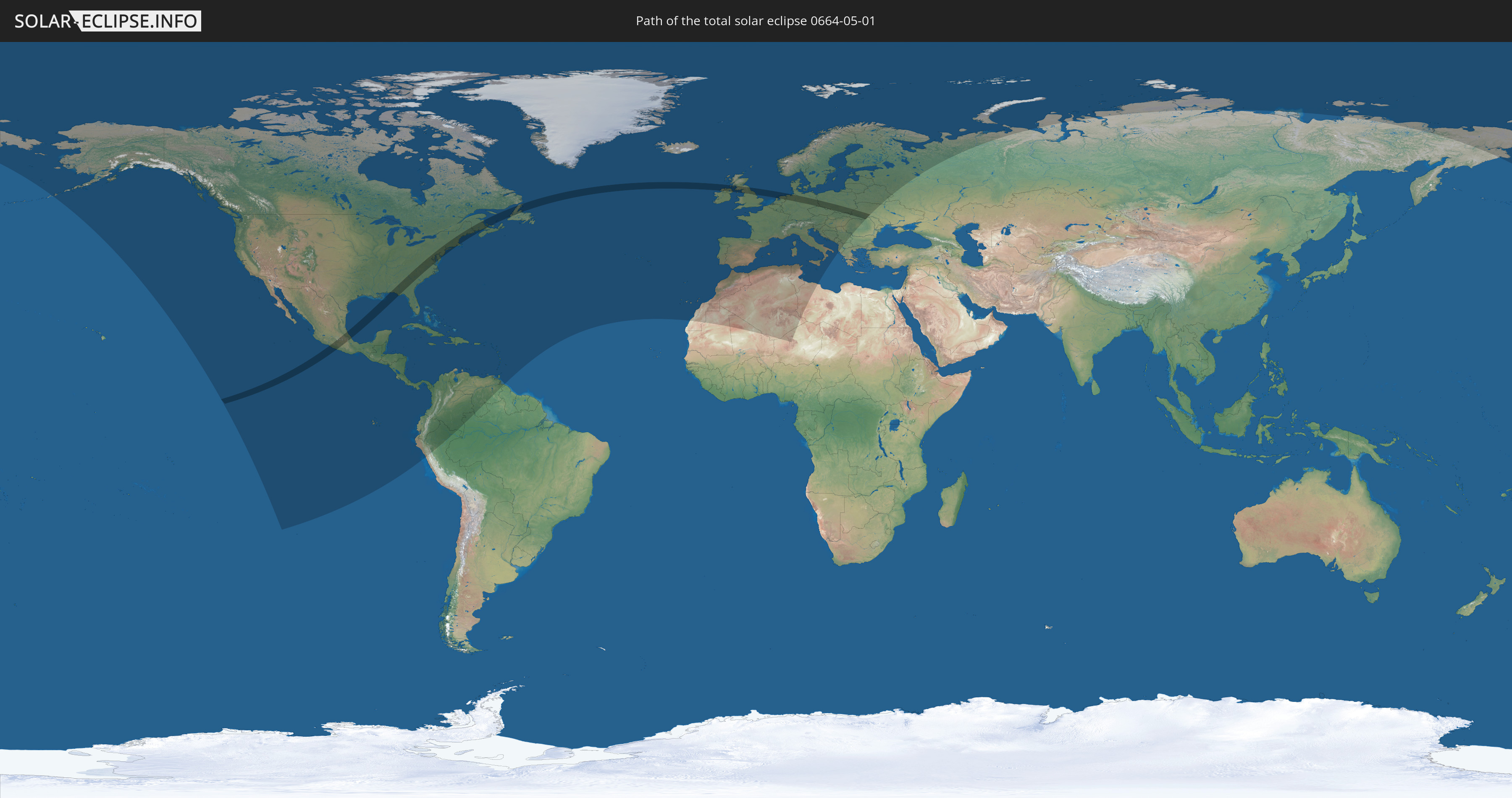
Die Sonnenfinsternis am 01.05.0664 kann man in 101 Ländern als partielle Sonnenfinsternis beobachten.
Der Finsternispfad verläuft durch 13 Länder. Nur in diesen Ländern ist sie als totale Sonnenfinsternis zu sehen.
In den folgenden Ländern ist die Sonnenfinsternis total zu sehen
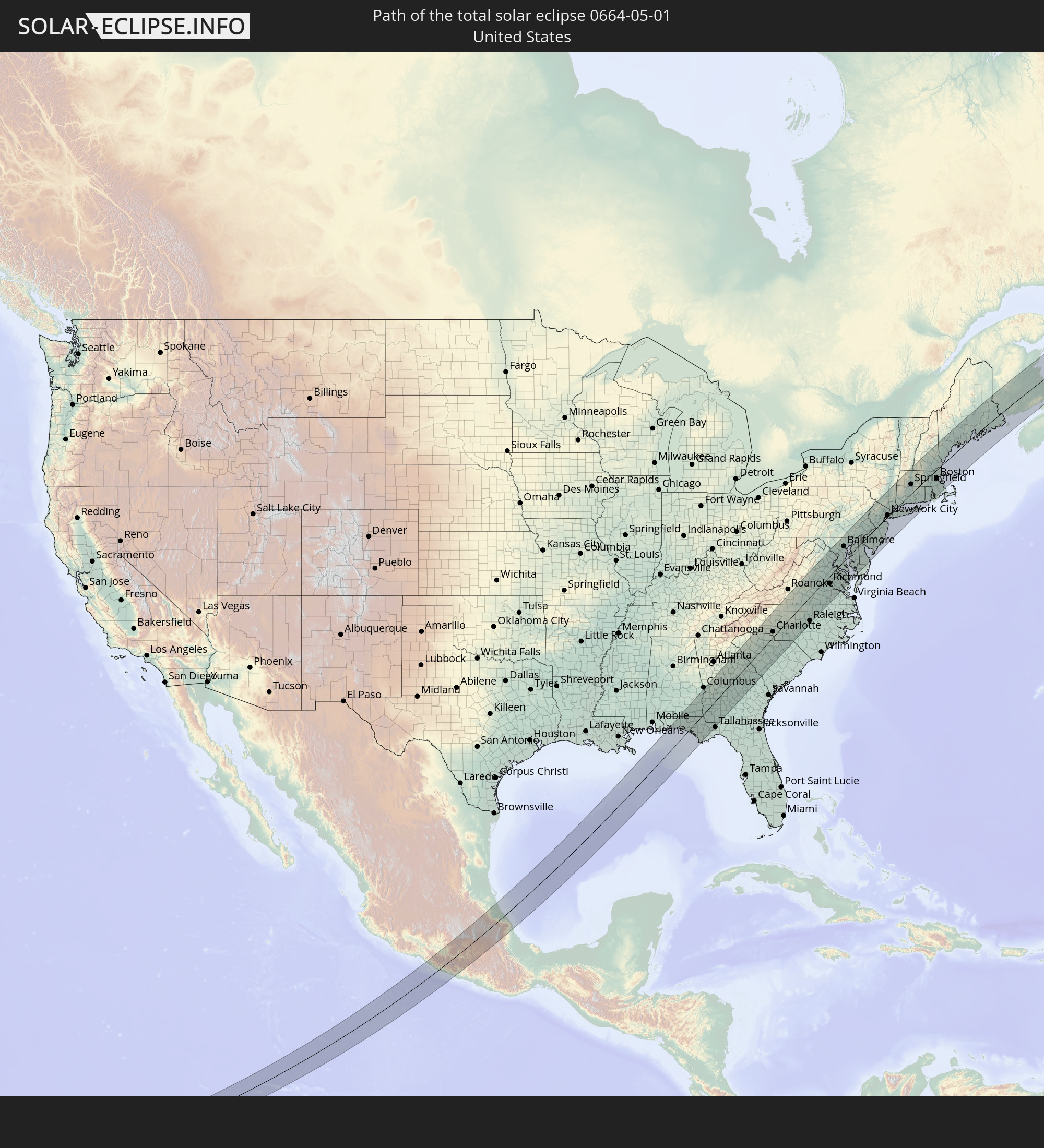 Vereinigte Staaten
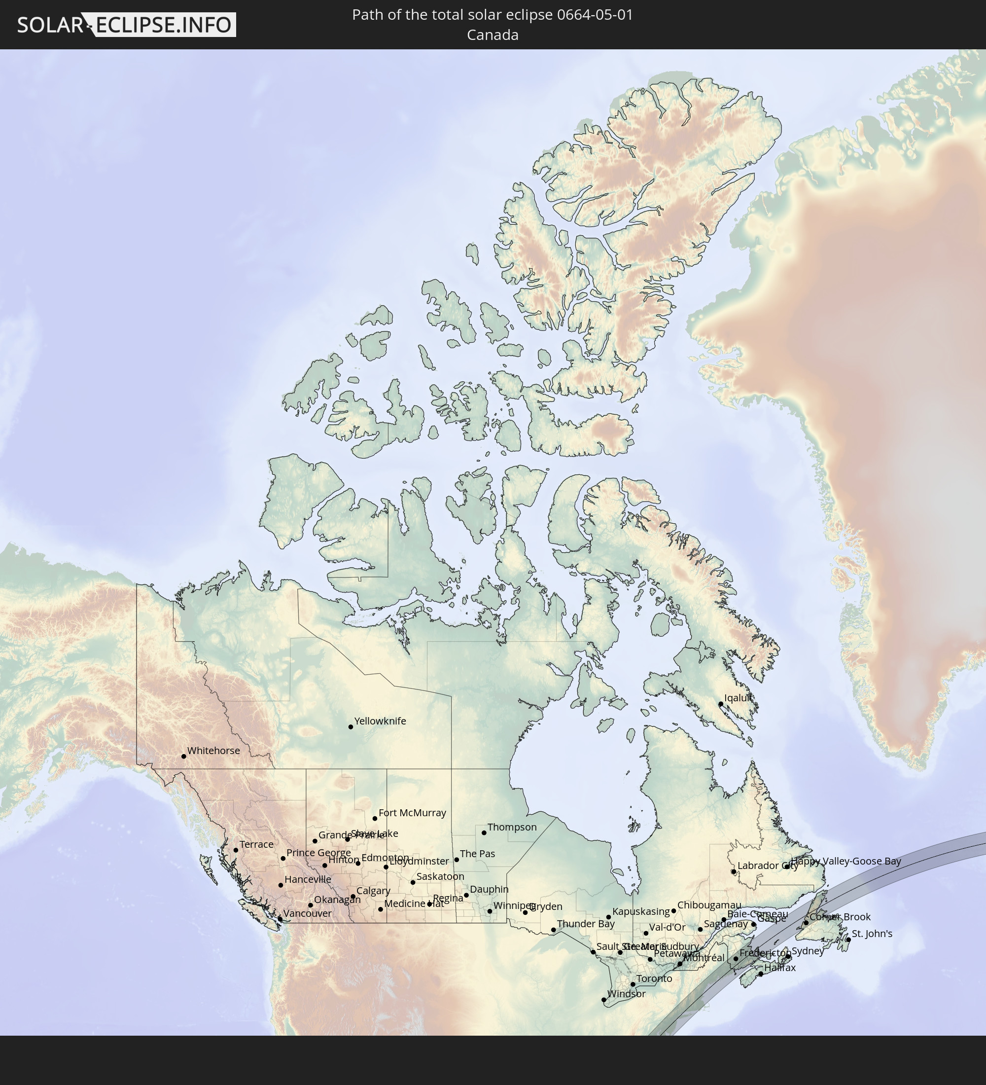 Kanada
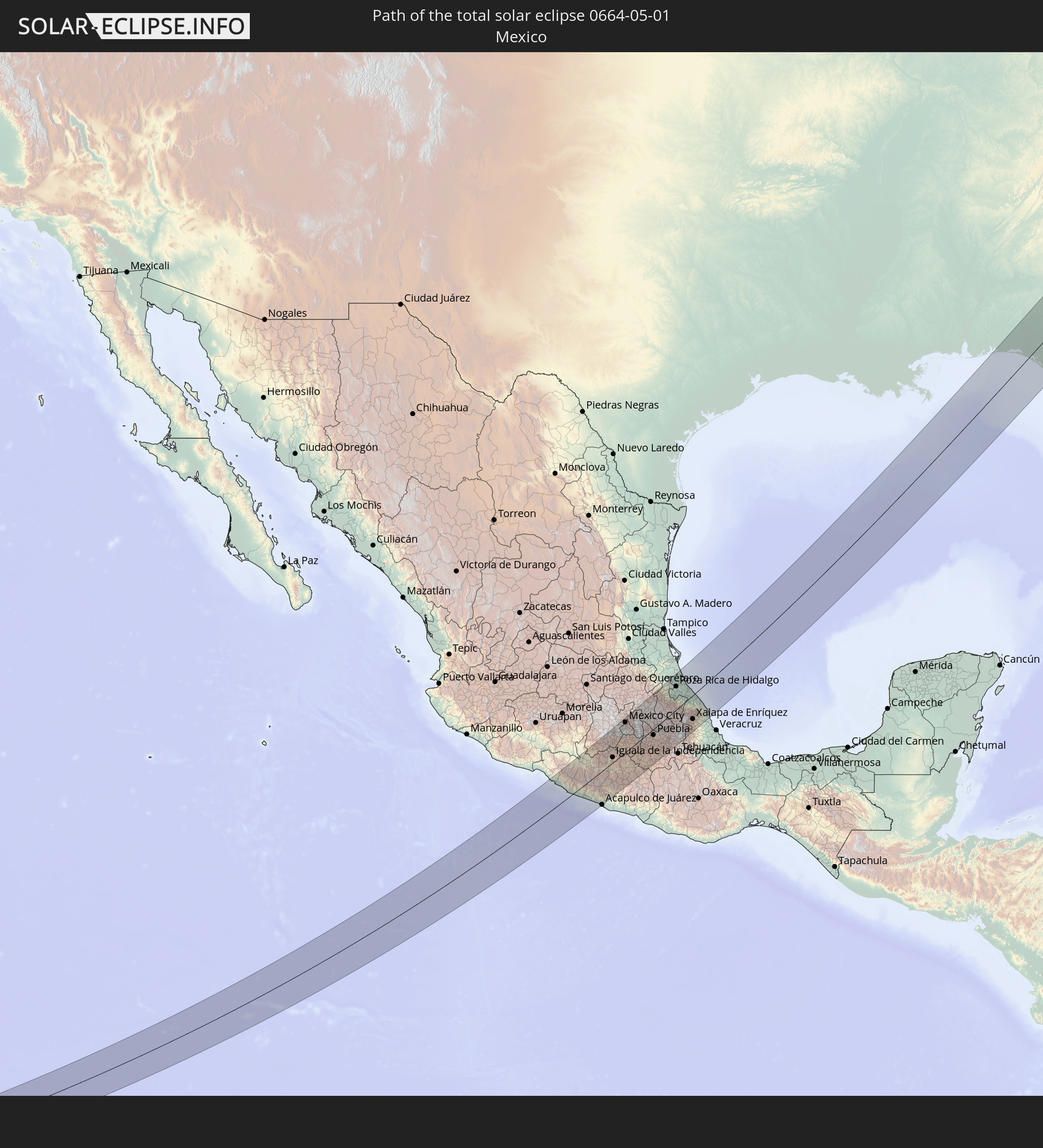 Mexiko
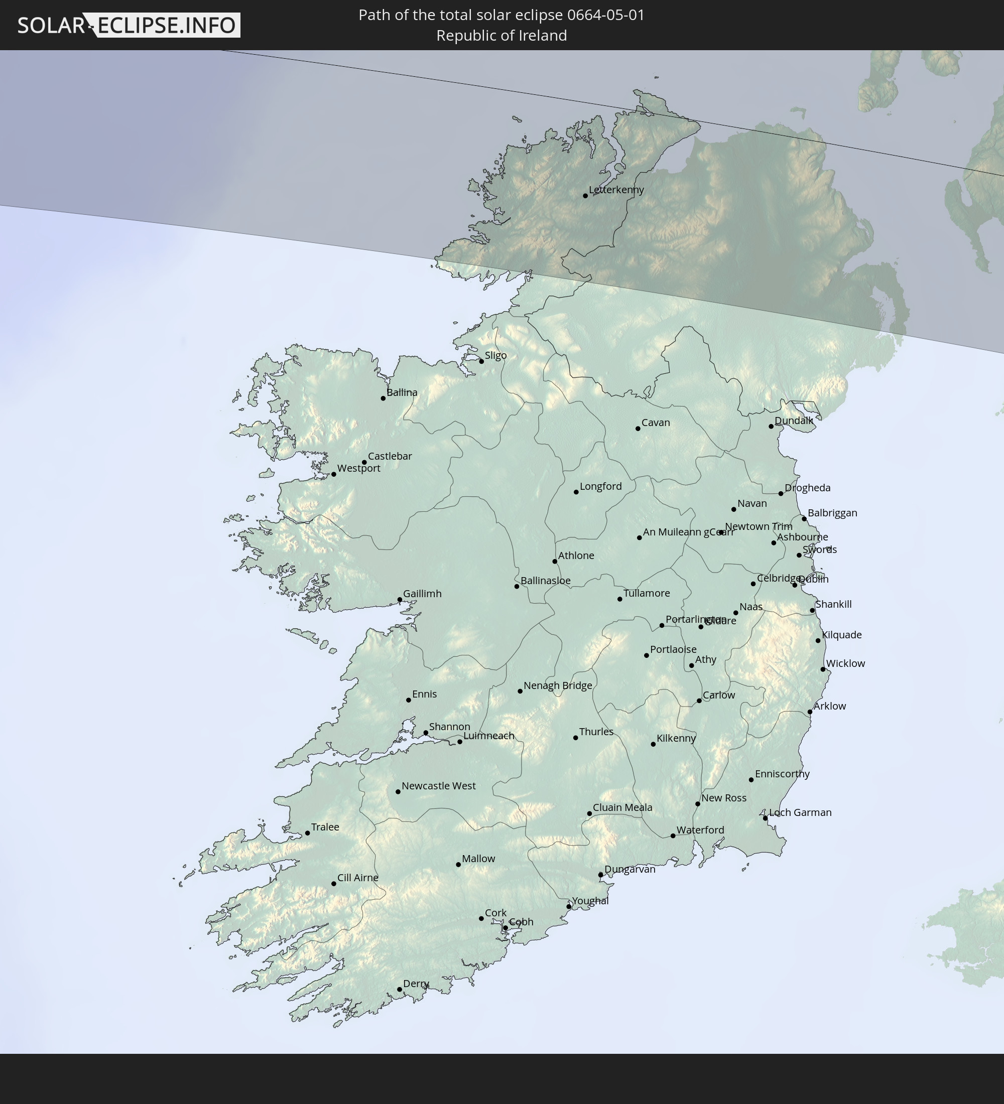 Irland
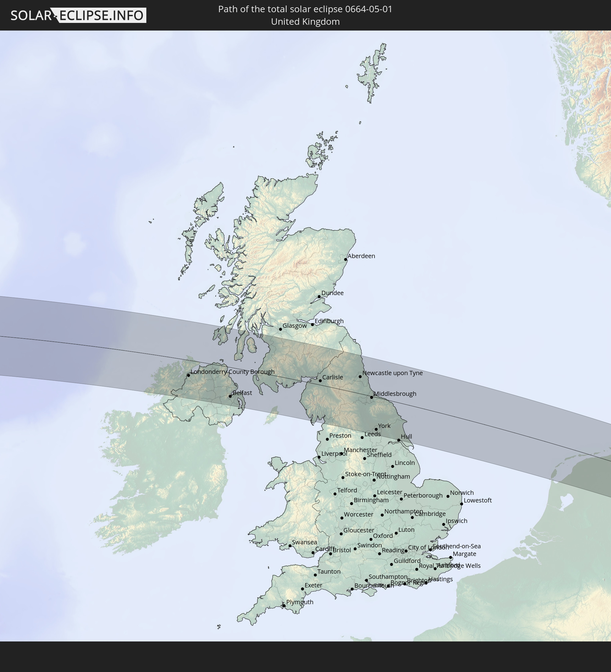 Vereinigtes Königreich
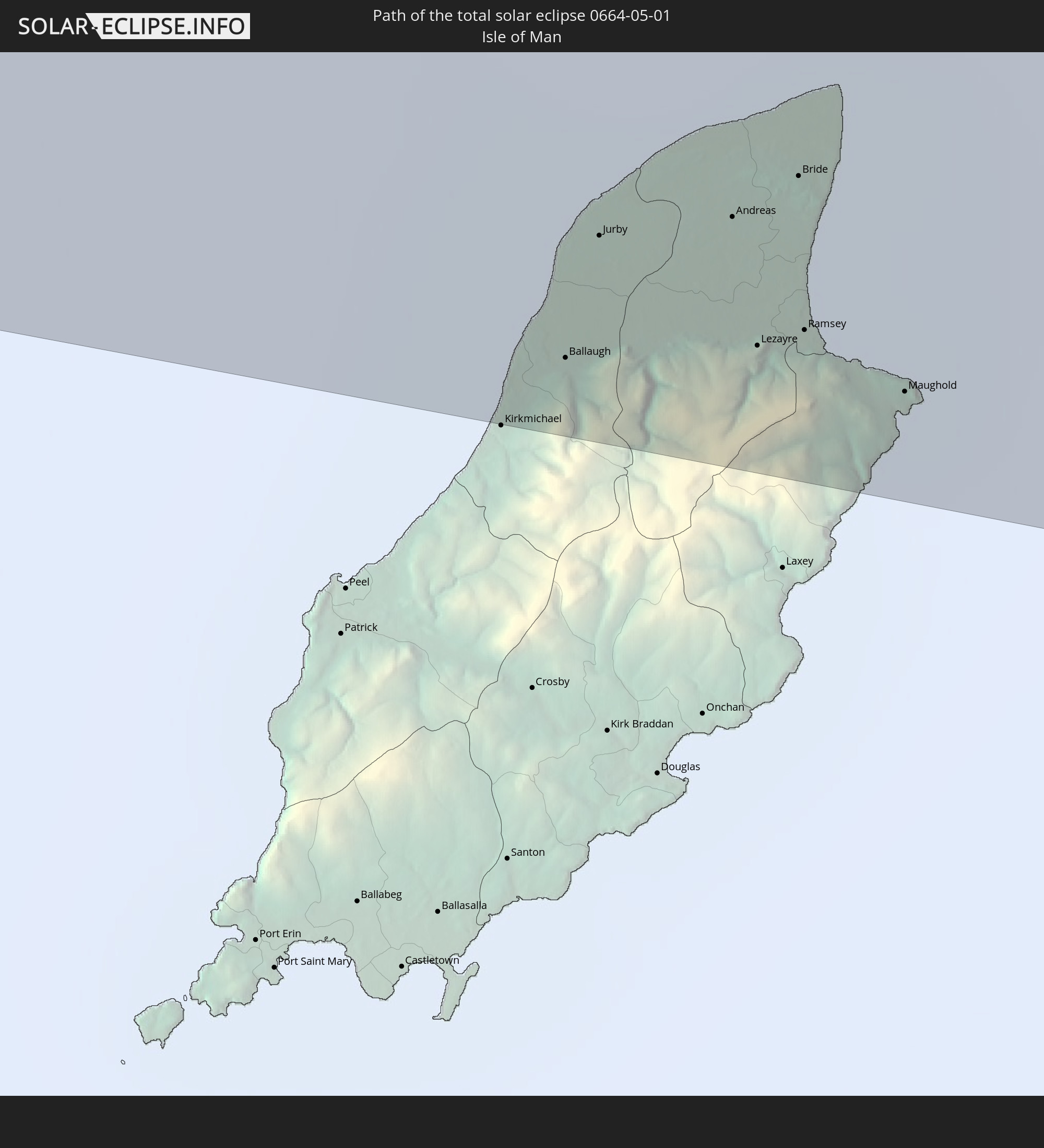 Isle of Man
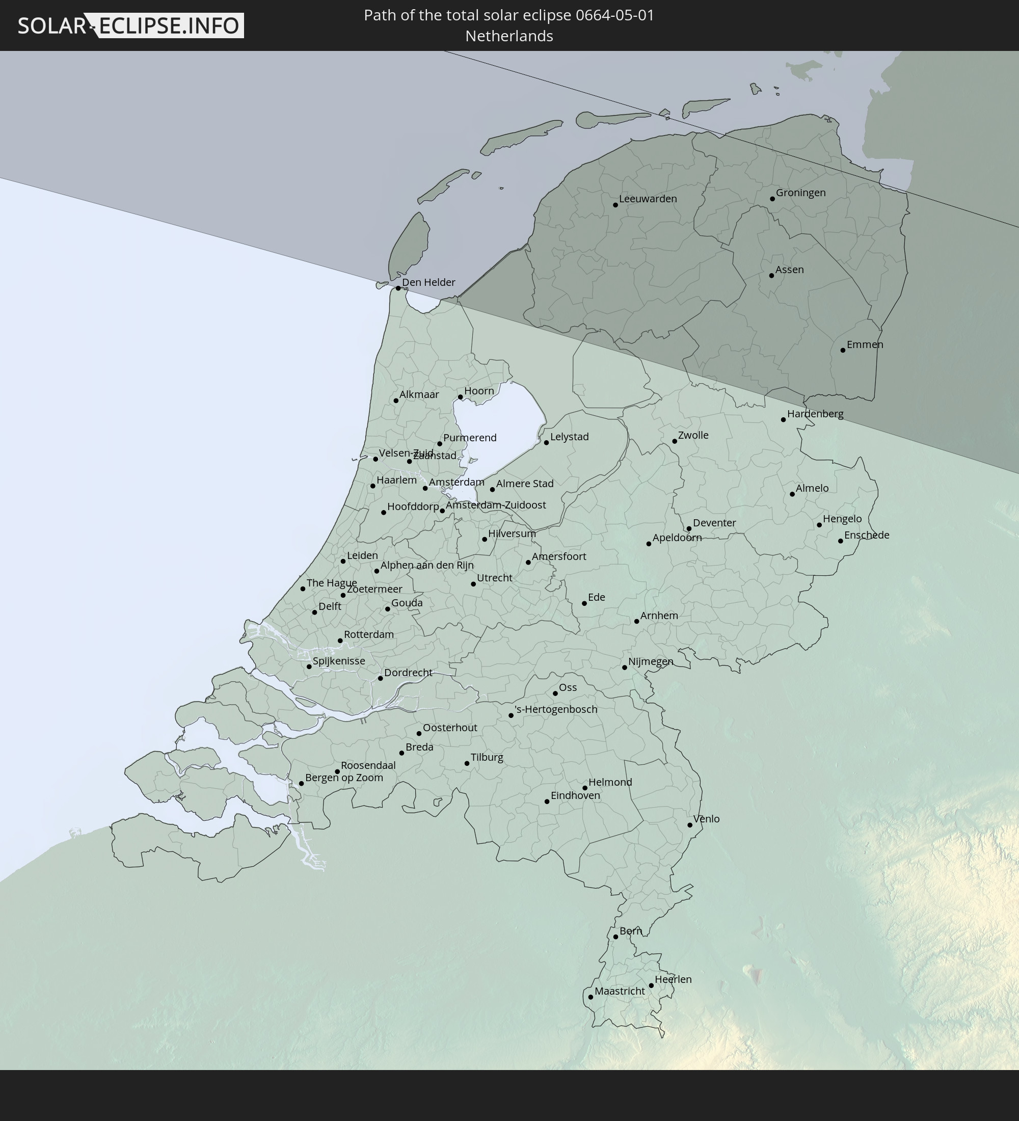 Niederlande
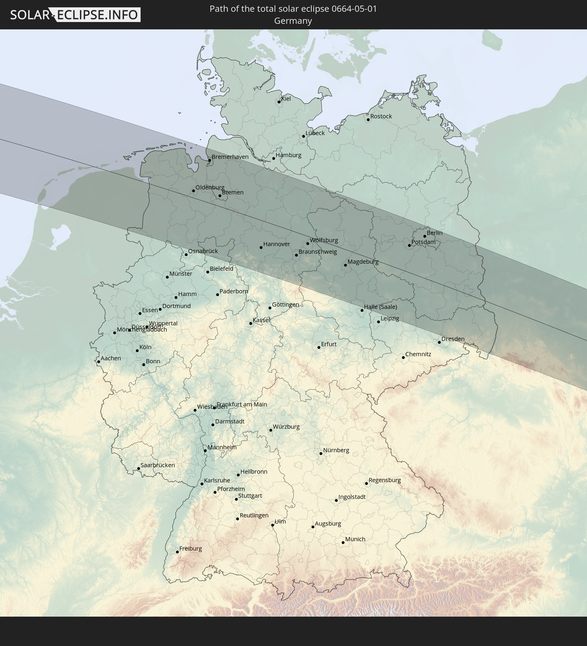 Deutschland
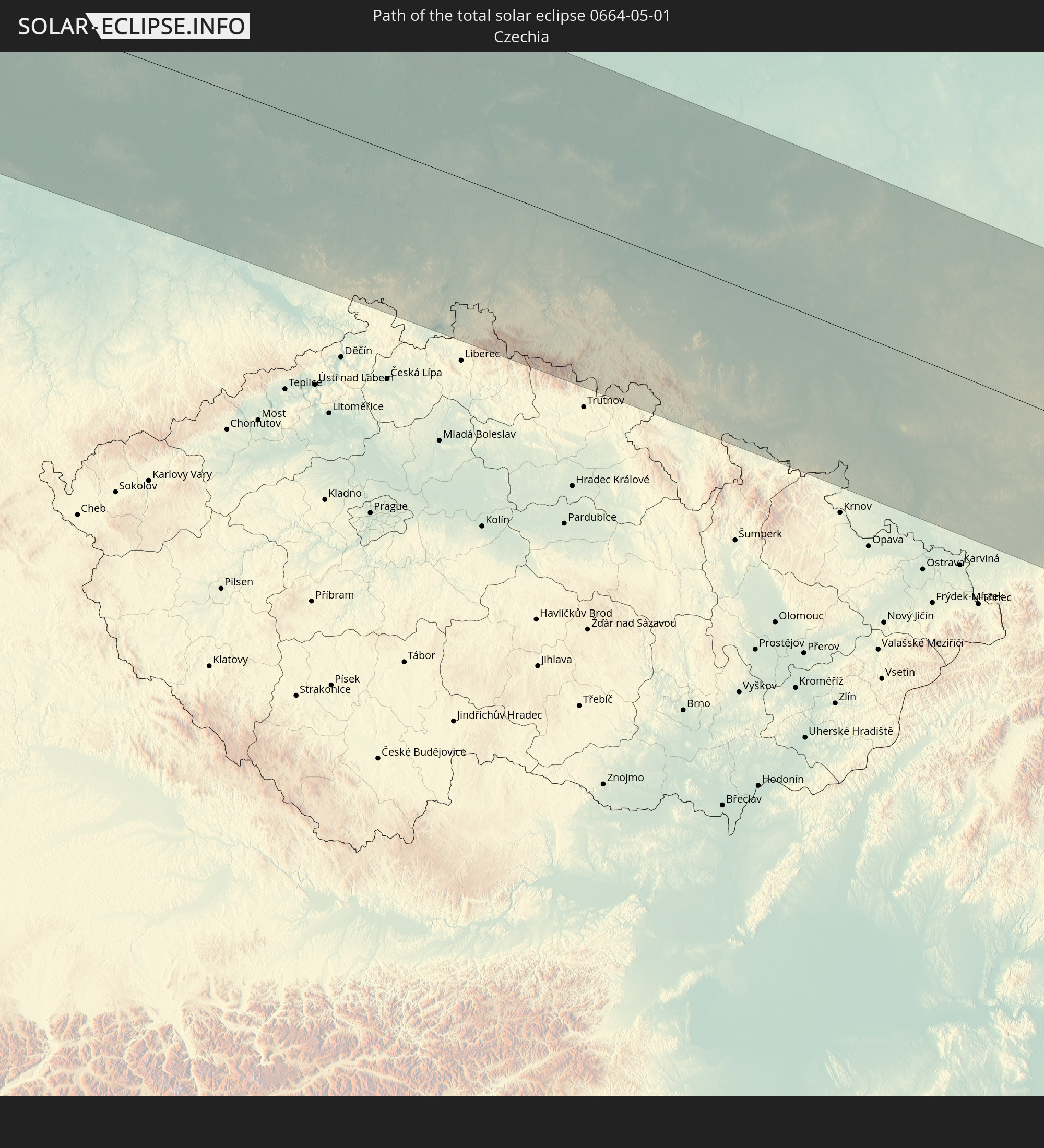 Tschechien
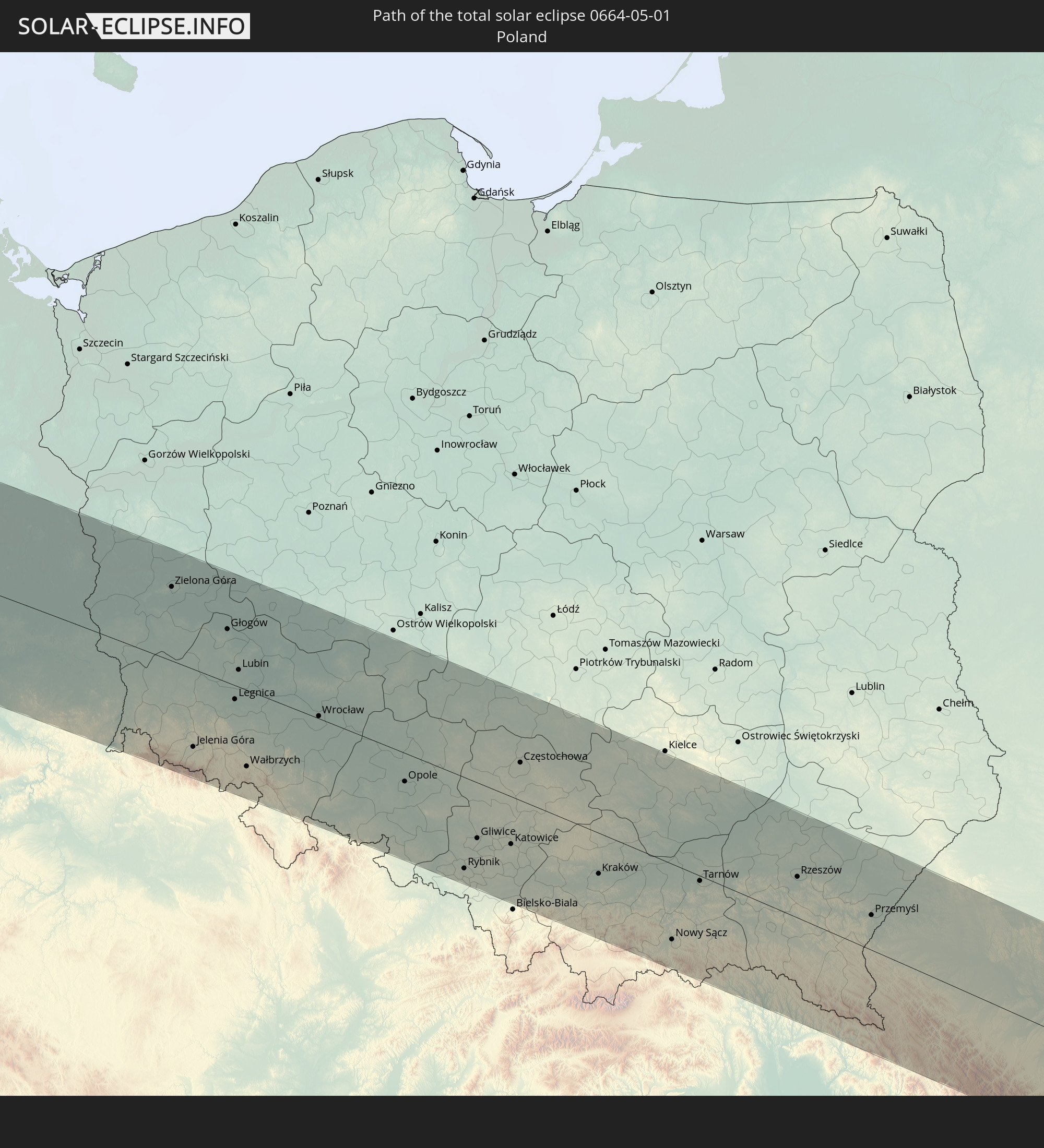 Polen
Polen
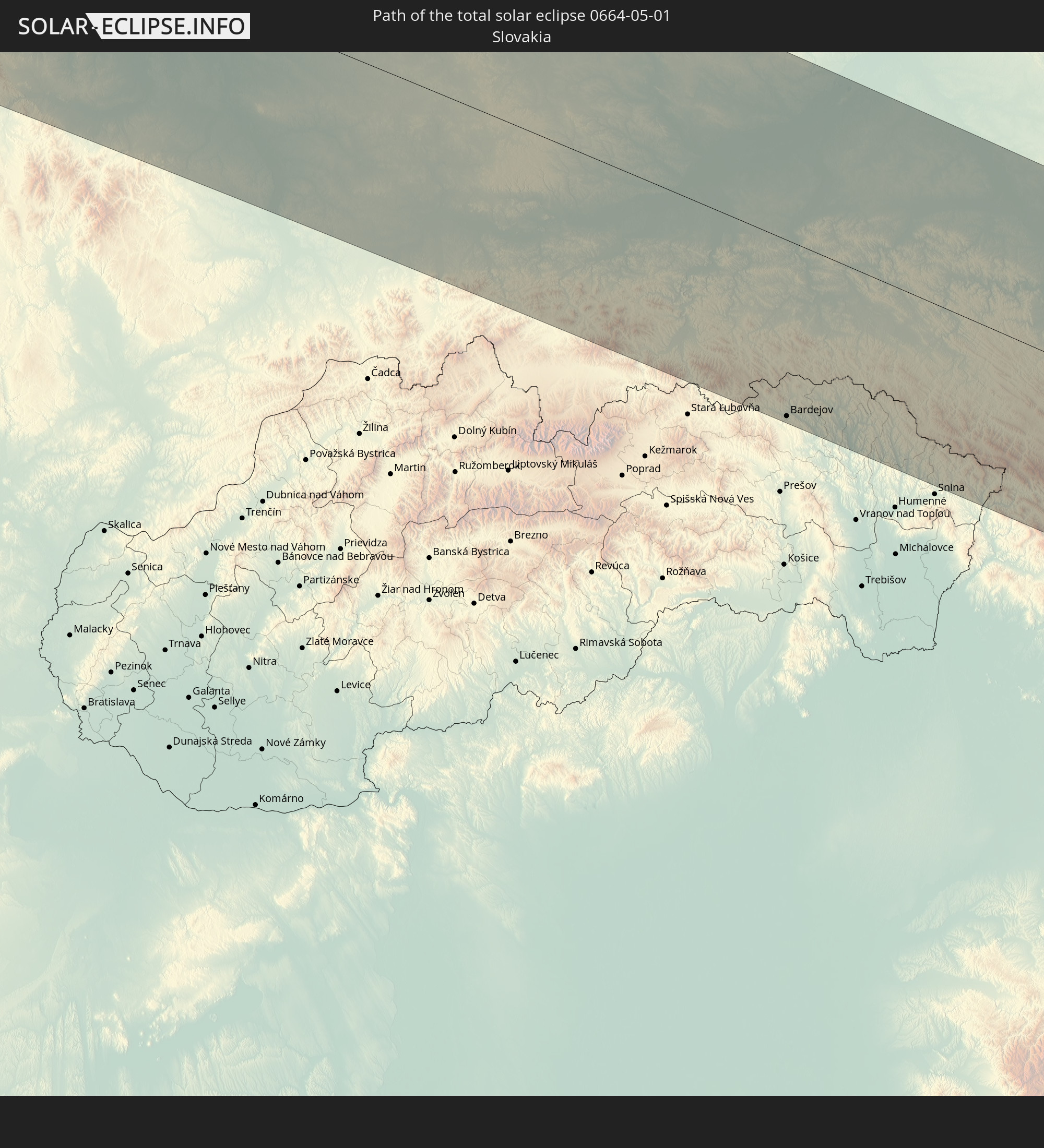 Slowakei
 Rumänien
 Ukraine
In den folgenden Ländern ist die Sonnenfinsternis partiell zu sehen
 Russland
 Vereinigte Staaten
 United States Minor Outlying Islands
 Kanada
 Mexiko
 Grönland
 Guatemala
 Ecuador
 El Salvador
 Honduras
 Belize
 Nicaragua
 Costa Rica
 Kuba
Kuba
 Panama
 Kolumbien
 Kaimaninseln
 Peru
Peru
 Bahamas
 Jamaika
 Haiti
Haiti
 Brasilien
 Venezuela
 Turks- und Caicosinseln
 Dominikanische Republik
 Aruba
Aruba
 Puerto Rico
 Amerikanische Jungferninseln
 Bermuda
 Britische Jungferninseln
 Anguilla
 Saint-Martin
 Saint-Barthélemy
 St. Kitts und Nevis
 Antigua und Barbuda
 Montserrat
 Trinidad und Tobago
 Guadeloupe
 Grenada
 Dominica
 St. Vincent und die Grenadinen
 Martinique
 St. Lucia
 Barbados
 Saint-Pierre und Miquelon
 Portugal
 Island
 Spanien
 Mauretanien
 Marokko
 Mali
Mali
 Irland
 Spitzbergen
 Algerien
 Vereinigtes Königreich
 Färöer
 Gibraltar
 Frankreich
 Isle of Man
 Guernsey
 Jersey
 Niger
Niger
 Andorra
 Belgien
 Niederlande
 Norwegen
 Luxemburg
 Deutschland
 Schweiz
 Italien
 Monaco
 Tunesien
 Dänemark
 Libyen
 Liechtenstein
 Österreich
 Schweden
 Tschechien
 San Marino
 Vatikanstadt
 Slowenien
 Kroatien
 Polen
Polen
 Malta
Malta
 Bosnien und Herzegowina
 Ungarn
 Slowakei
 Montenegro
 Serbien
 Albanien
 Åland Islands
 Griechenland
 Rumänien
 Mazedonien
 Finnland
 Litauen
 Lettland
 Estland
 Ukraine
 Bulgarien
 Weißrussland
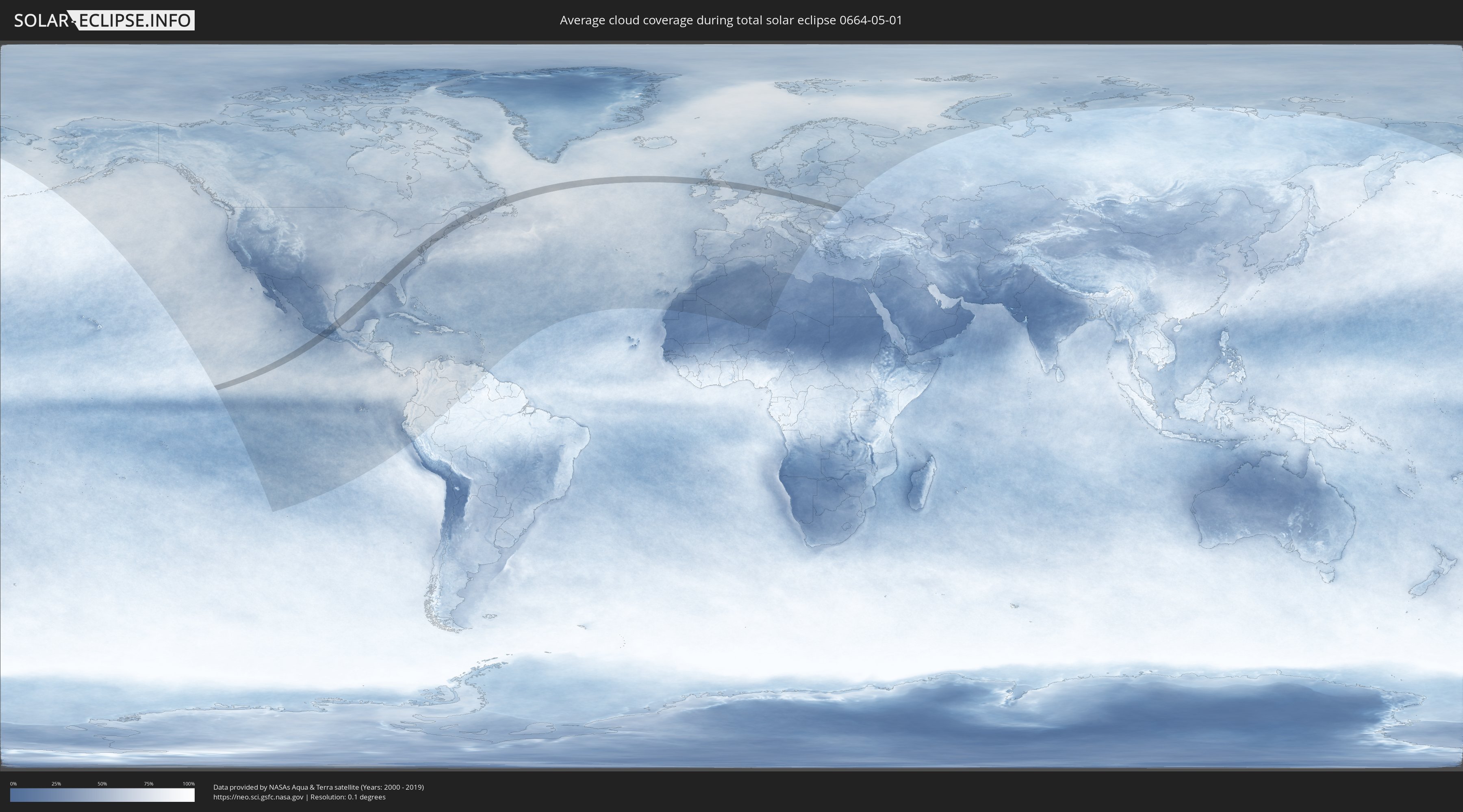
Wie wird das Wetter während der totalen Sonnenfinsternis am 01.05.0664?
Wo ist der beste Ort, um die totale Sonnenfinsternis vom 01.05.0664 zu beobachten?
Die folgenden Karten zeigen die durchschnittliche Bewölkung für den Tag, an dem die totale Sonnenfinsternis
stattfindet. Mit Hilfe der Karten lässt sich der Ort entlang des Finsternispfades eingrenzen,
der die besten Aussichen auf einen klaren wolkenfreien Himmel bietet.
Trotzdem muss man immer lokale Gegenenheiten beachten und sollte sich genau über das Wetter an seinem
gewählten Beobachtungsort informieren.
Die Daten stammen von den beiden NASA-Satelliten
AQUA und TERRA
und wurden über einen Zeitraum von 19 Jahren (2000 - 2019) gemittelt.

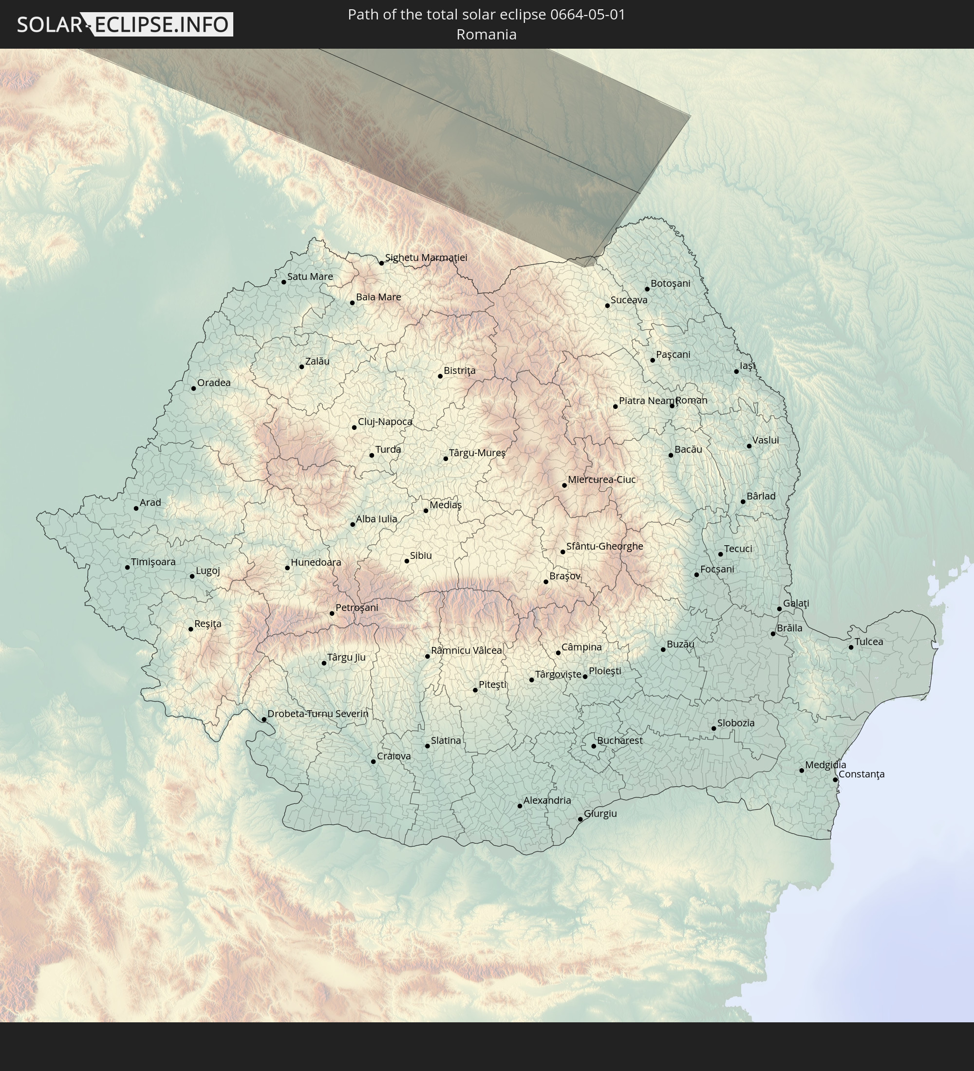
Detaillierte Länderkarten
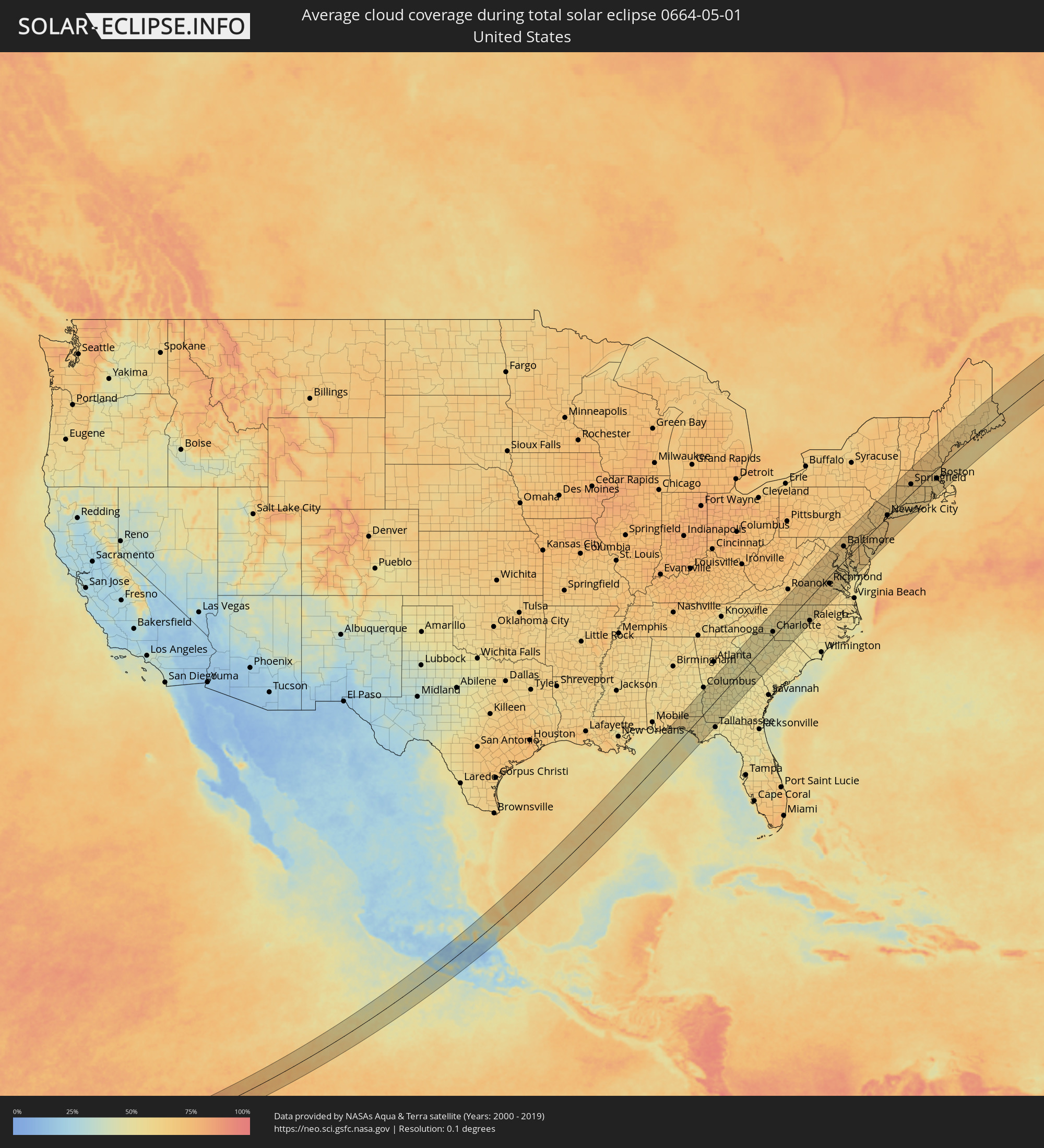 Vereinigte Staaten
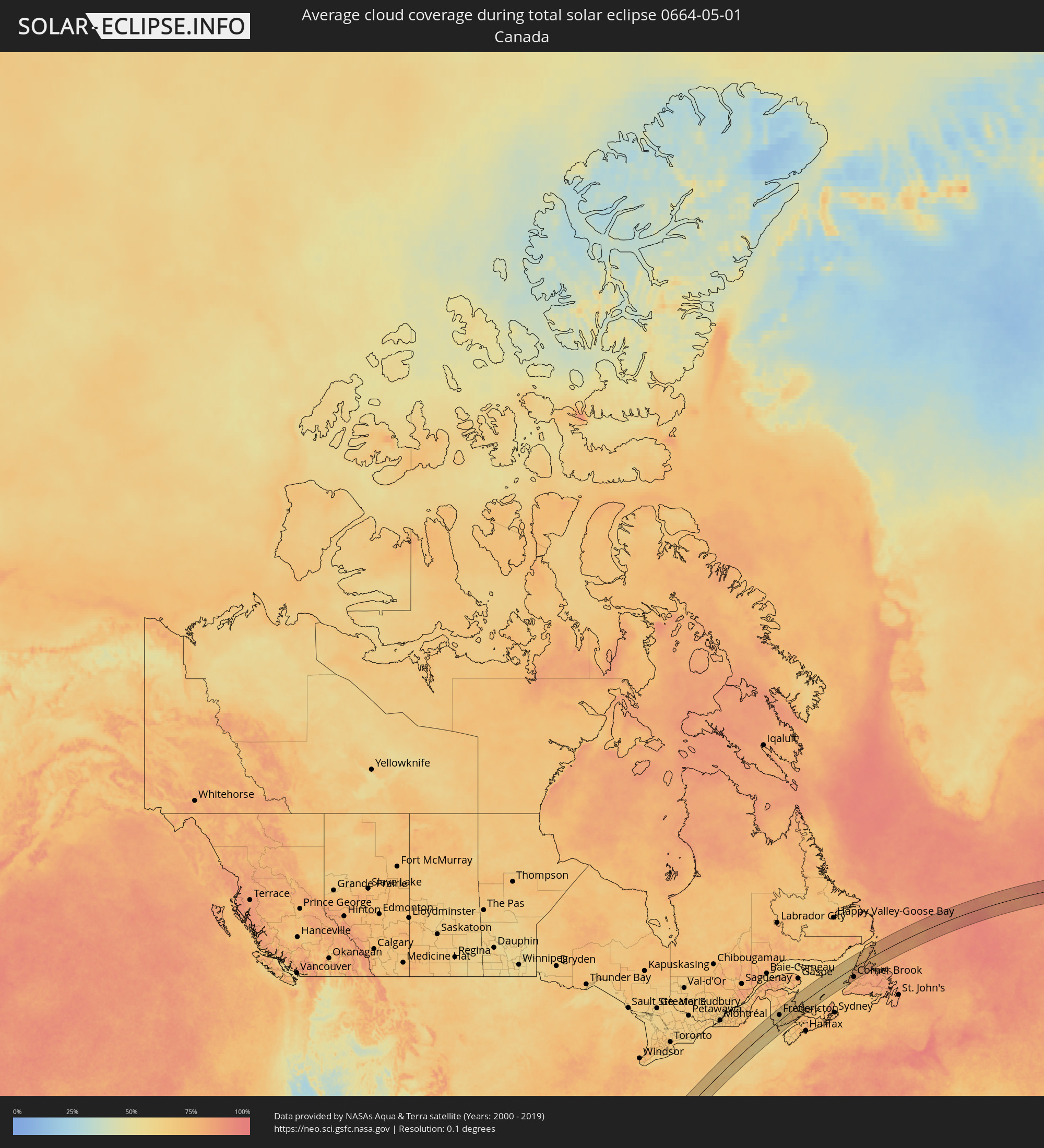 Kanada
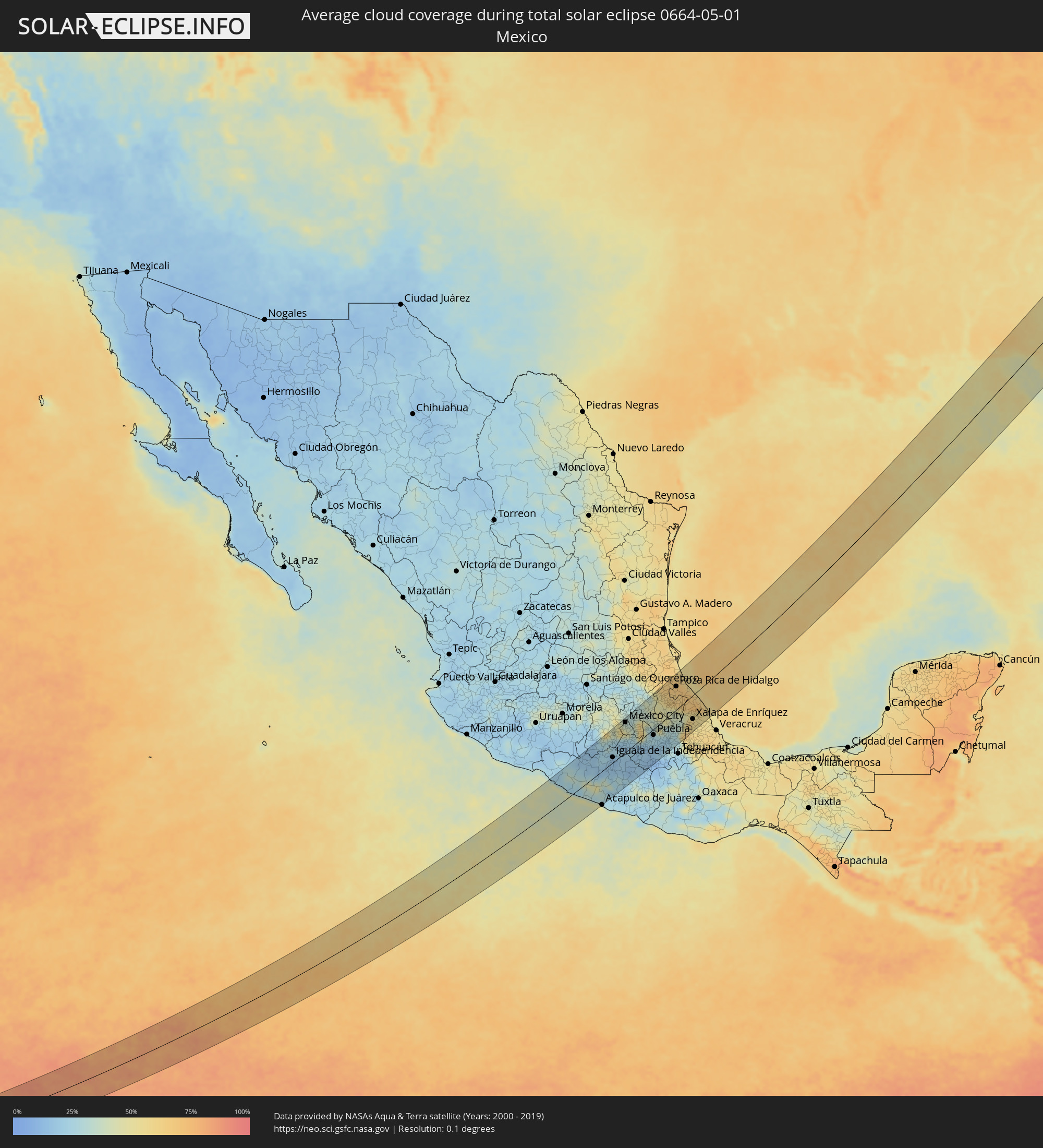 Mexiko
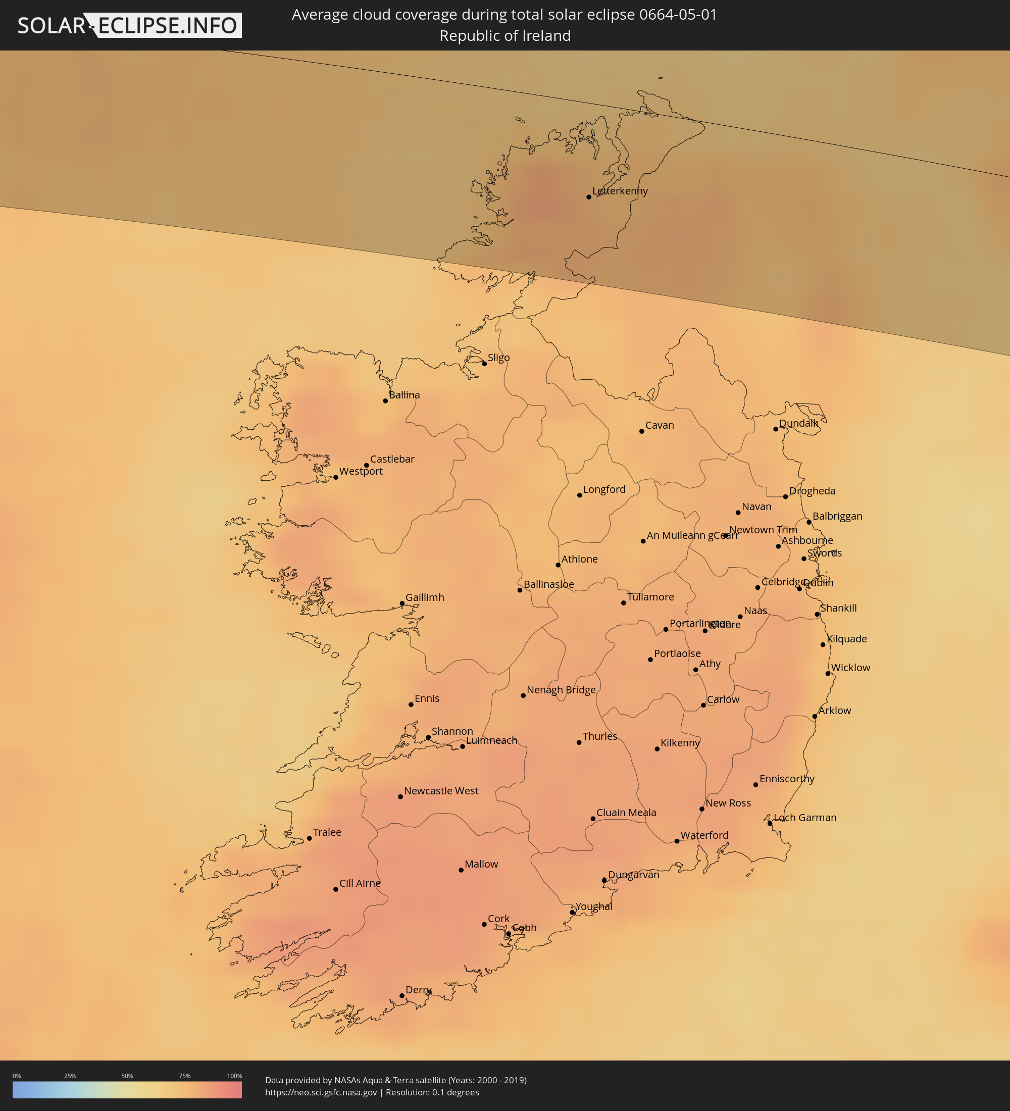 Irland
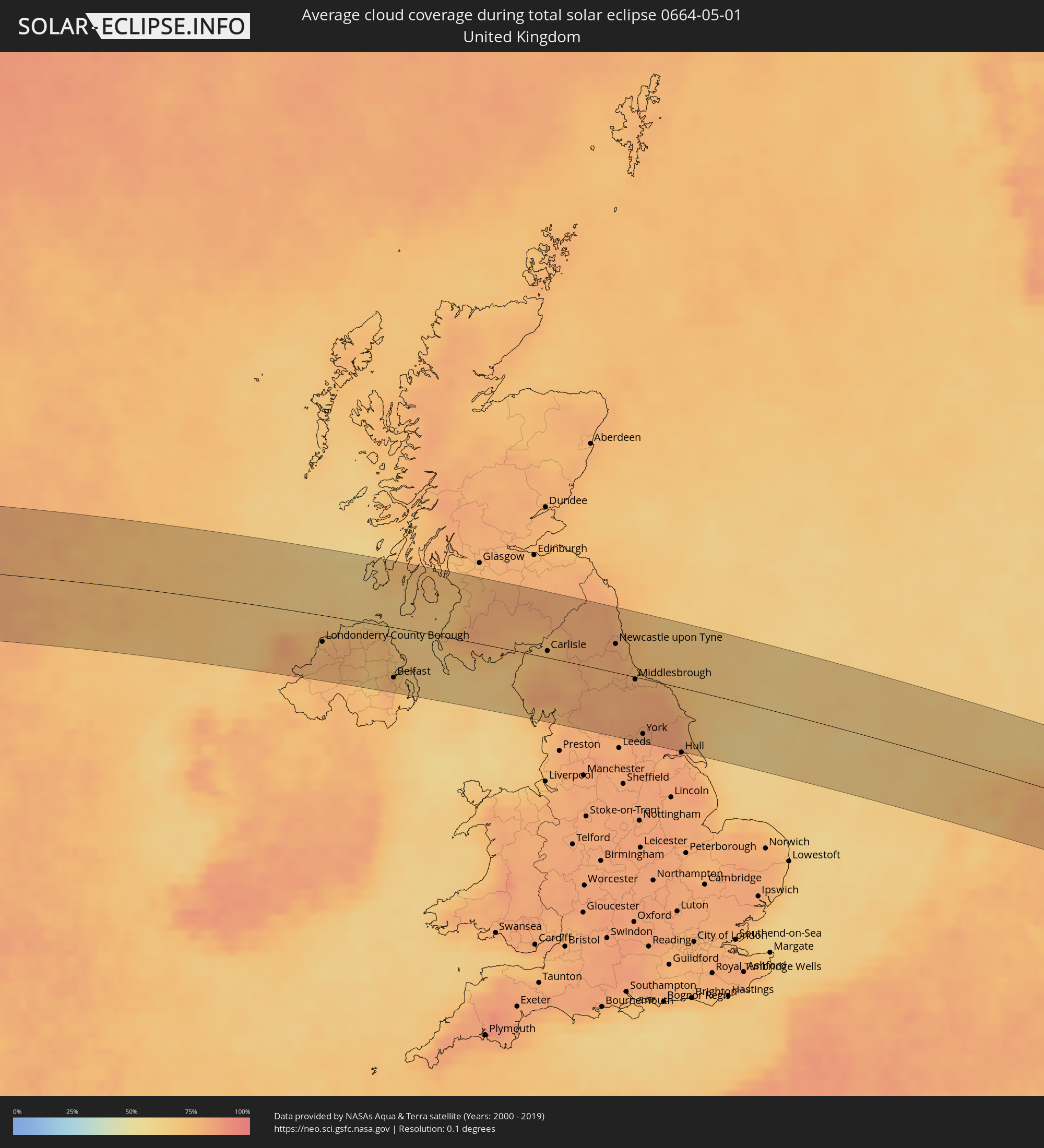 Vereinigtes Königreich
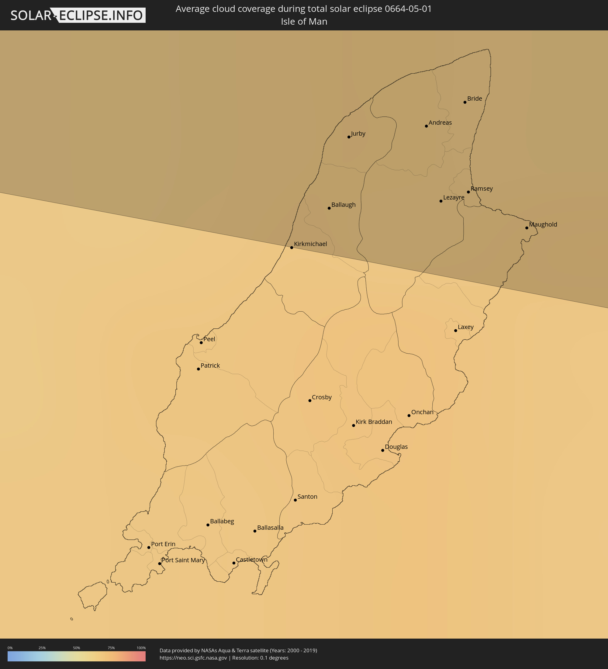 Isle of Man
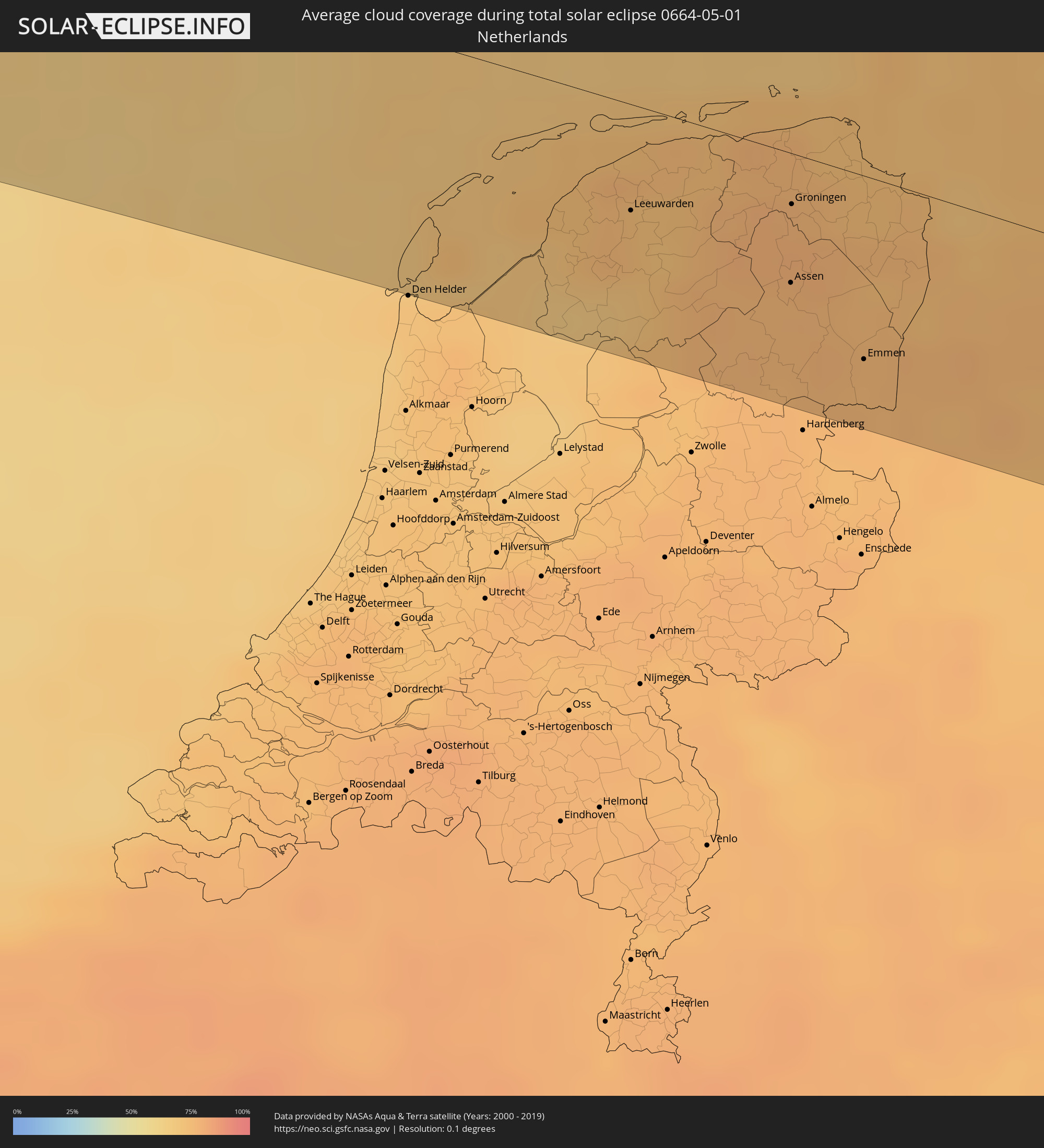 Niederlande
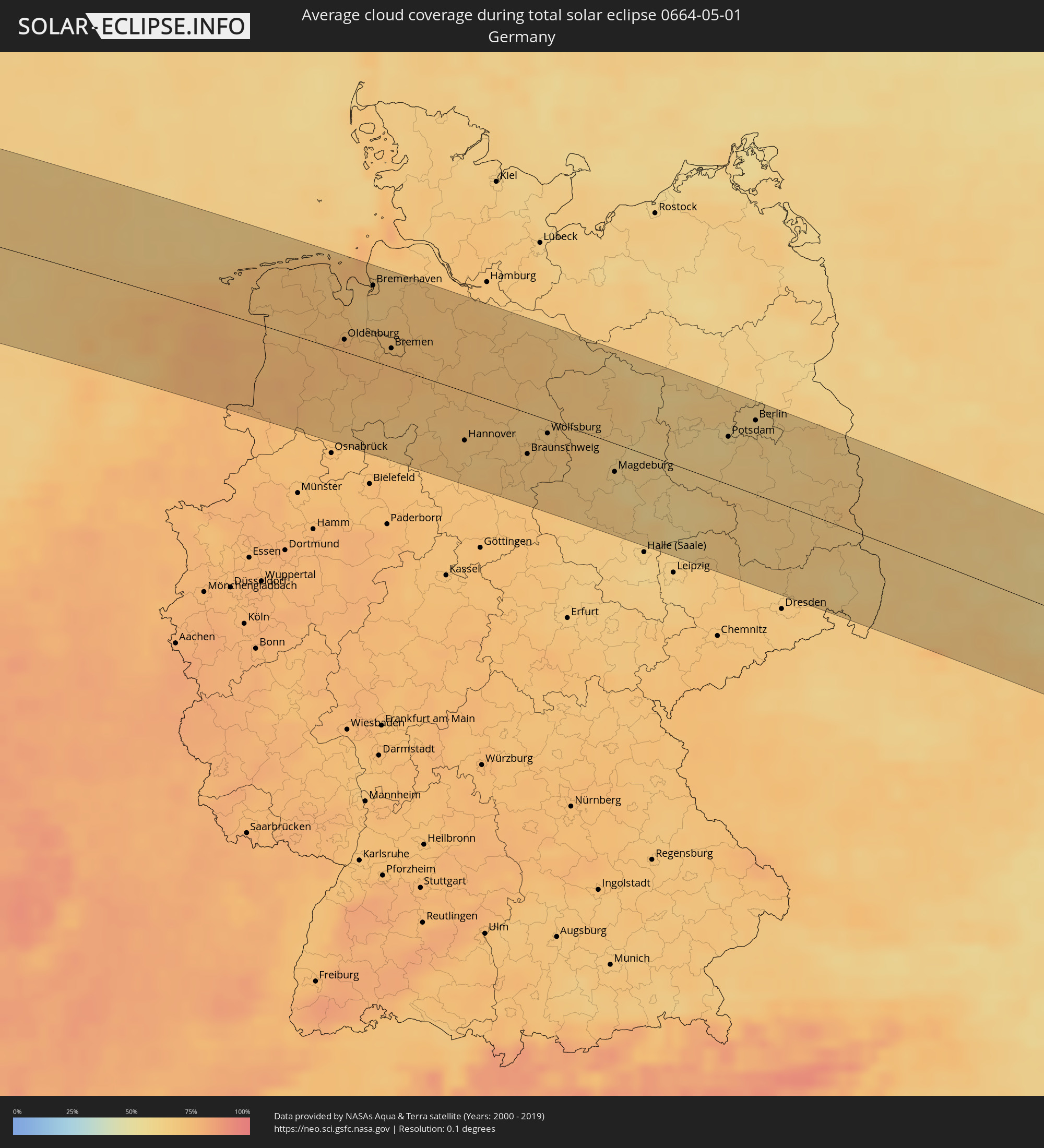 Deutschland
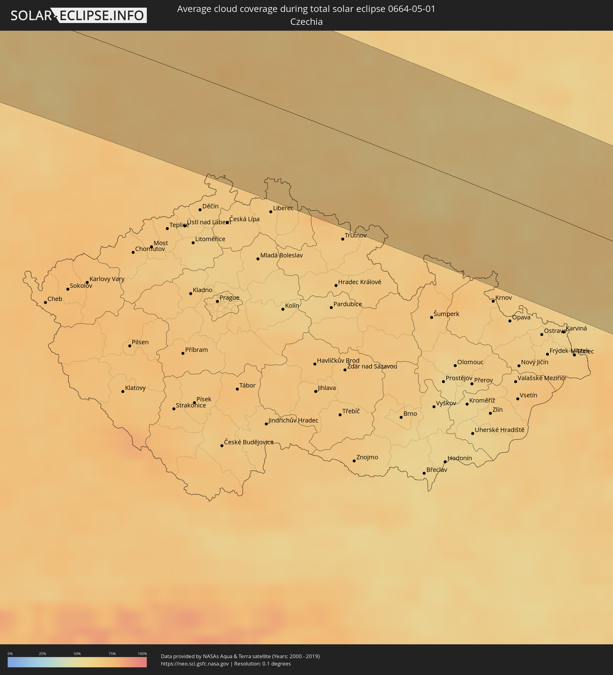 Tschechien
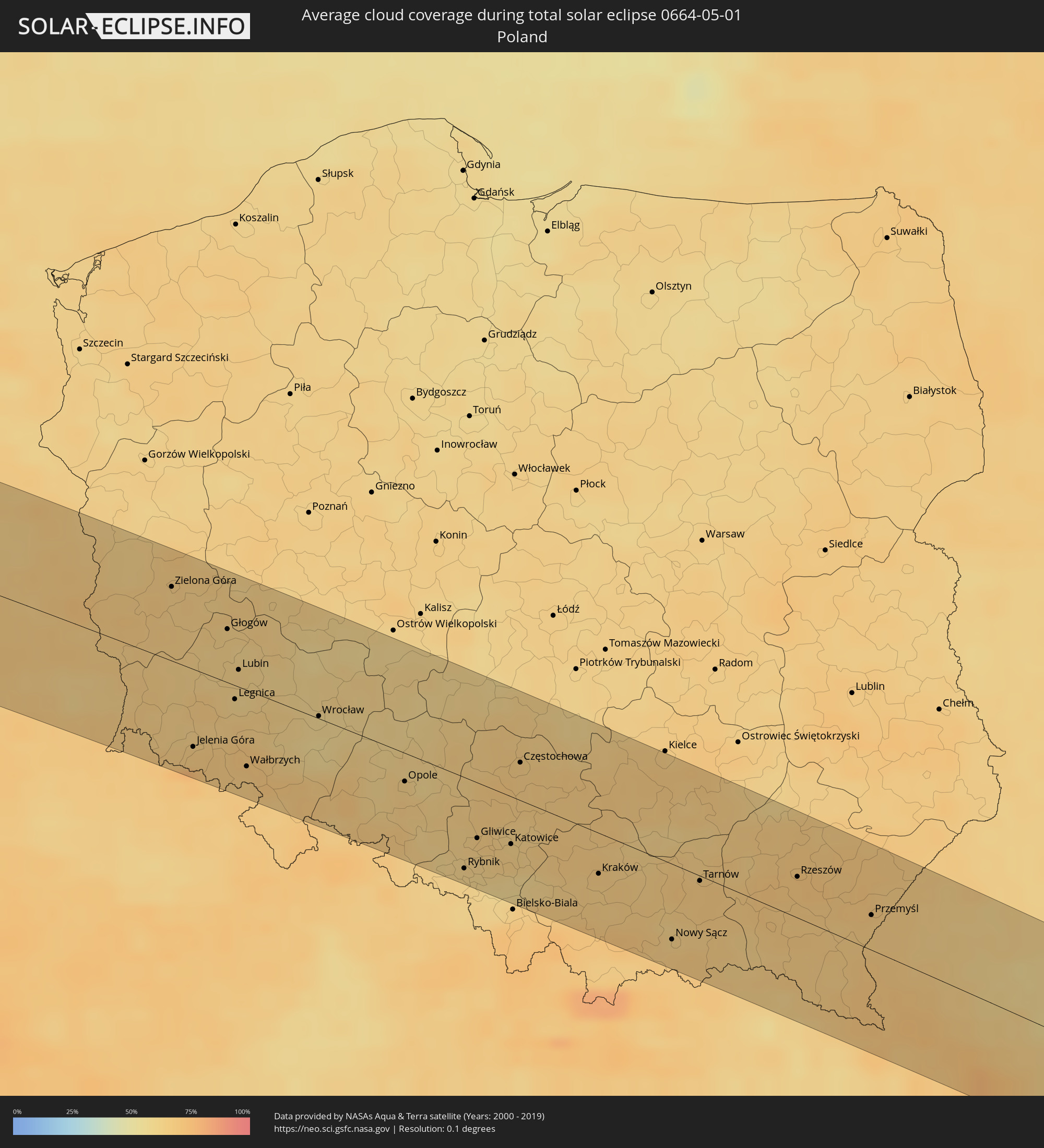 Polen
Polen
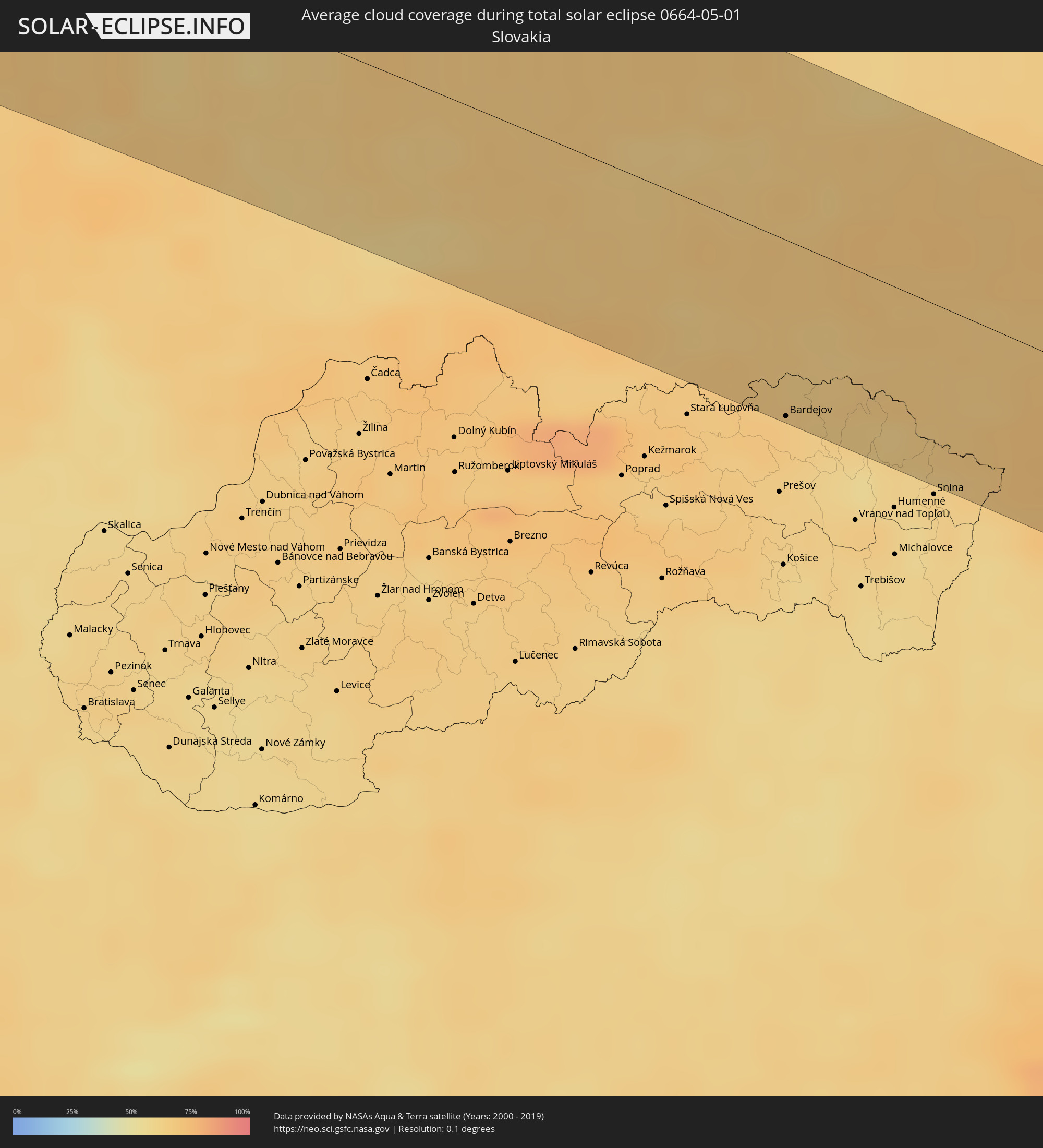 Slowakei
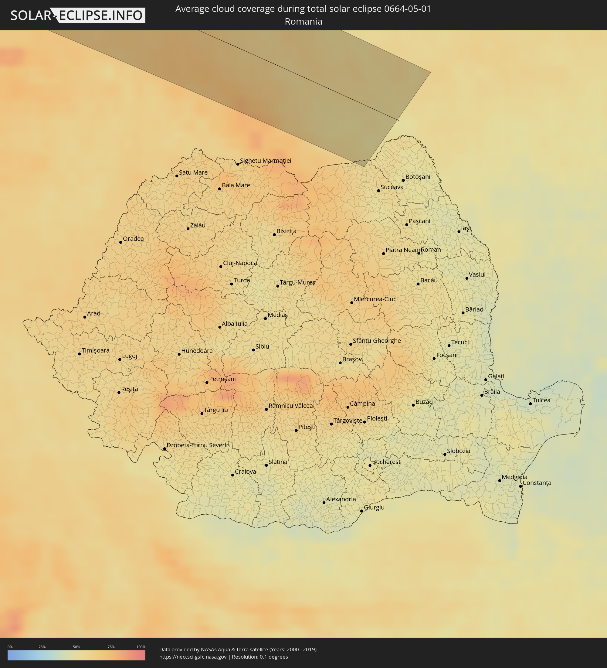 Rumänien
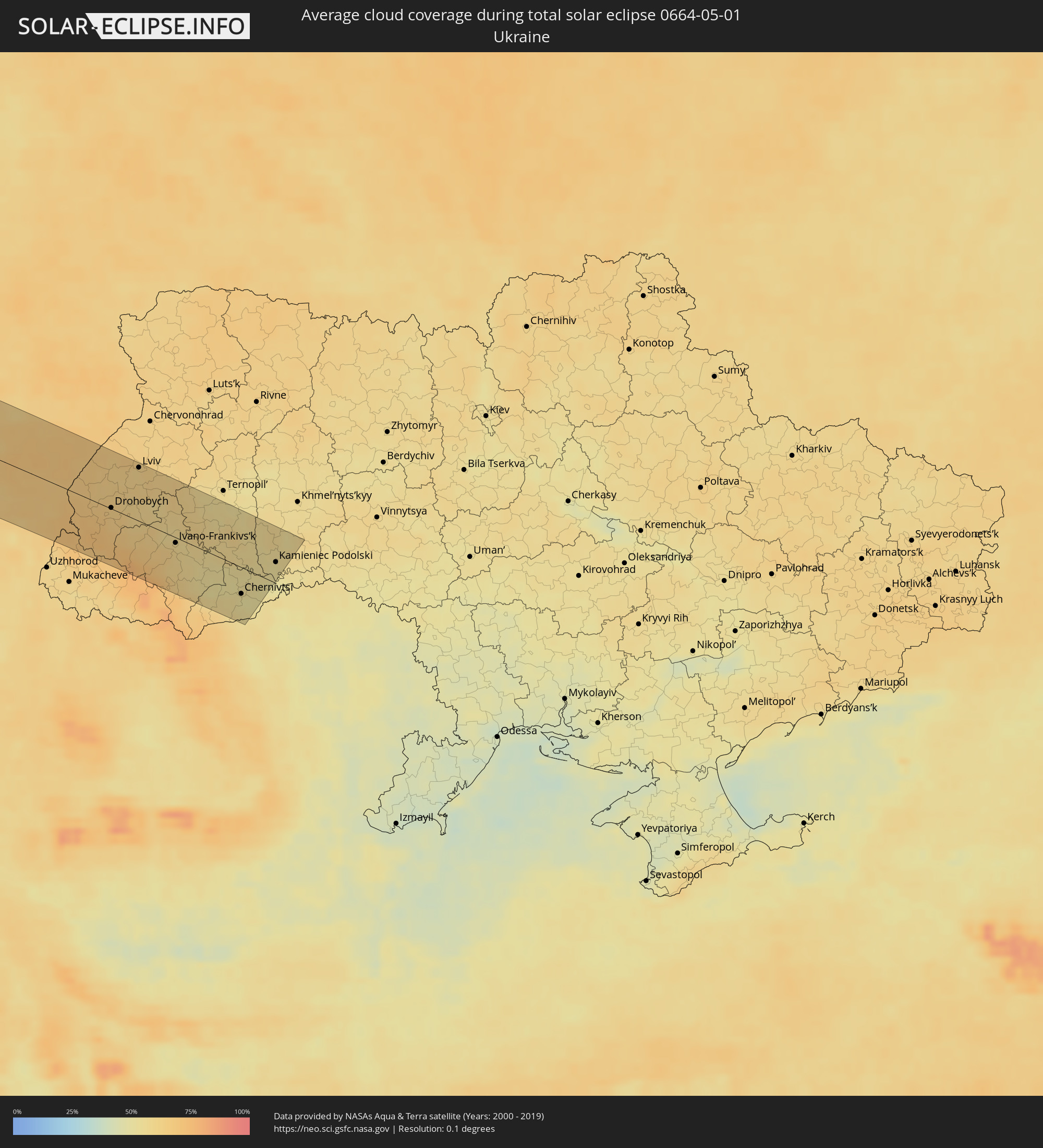 Ukraine
Orte im Finsternispfad
Die nachfolgene Tabelle zeigt Städte und Orte mit mehr als 5.000 Einwohnern, die sich im Finsternispfad befinden. Städte mit mehr als 100.000 Einwohnern sind dick gekennzeichnet. Mit einem Klick auf den Ort öffnet sich eine Detailkarte die die Lage des jeweiligen Ortes zusammen mit dem Verlauf der zentralen Finsternis präsentiert.
| Ort | Typ | Dauer der Verfinsterung | Ortszeit bei maximaler Verfinsterung | Entfernung zur Zentrallinie | Ø Bewölkung |
|
Iguala de la Independencia, Guerrero
|
total | - | 08:03:12 UTC-06:36 | 14 km | 14% |
|
Chilpancingo, Guerrero
|
total | - | 08:01:54 UTC-06:36 | 57 km | 25% |
|
Huixquilucan, México
|
total | - | 08:05:02 UTC-06:36 | 89 km | 47% |
|
Cuernavaca, Morelos
|
total | - | 08:04:22 UTC-06:36 | 44 km | 21% |
|
Tlalpan, Mexico City
|
total | - | 08:05:02 UTC-06:36 | 71 km | 46% |
|
Mexico City, Mexico City
|
total | - | 08:05:17 UTC-06:36 | 80 km | 37% |
|
Ecatepec, México
|
total | - | 08:05:39 UTC-06:36 | 92 km | 33% |
|
Santa María Chimalhuacán, México
|
total | - | 08:05:23 UTC-06:36 | 67 km | 35% |
|
Cuautla Morelos, Morelos
|
total | - | 08:04:20 UTC-06:36 | 14 km | 21% |
|
San Miguel Xico Viejo, México
|
total | - | 08:05:08 UTC-06:36 | 53 km | 35% |
|
Atlixco, Puebla
|
total | - | 08:04:50 UTC-06:36 | 11 km | 26% |
|
Tulancingo, Hidalgo
|
total | - | 08:06:54 UTC-06:36 | 84 km | 38% |
|
Puebla, Puebla
|
total | - | 08:05:12 UTC-06:36 | 16 km | 26% |
|
Poza Rica de Hidalgo, Veracruz
|
total | - | 08:08:17 UTC-06:36 | 60 km | 65% |
|
Tuxpan de Rodríguez Cano, Veracruz
|
total | - | 08:09:04 UTC-06:36 | 92 km | 59% |
|
Martínez de la Torre, Veracruz
|
total | - | 08:07:45 UTC-06:36 | 6 km | 65% |
|
Xalapa de Enríquez, Veracruz
|
total | - | 08:06:55 UTC-06:36 | 62 km | 57% |
|
Charlotte, North Carolina
|
total | - | 10:29:45 UTC-05:00 | 20 km | 54% |
|
Winston-Salem, North Carolina
|
total | - | 10:32:12 UTC-05:00 | 45 km | 57% |
|
Greensboro, North Carolina
|
total | - | 10:32:45 UTC-05:00 | 13 km | 59% |
|
Durham, North Carolina
|
total | - | 10:33:48 UTC-05:00 | 52 km | 58% |
|
Raleigh, North Carolina
|
total | - | 10:33:44 UTC-05:00 | 86 km | 59% |
|
Richmond, Virginia
|
total | - | 10:38:42 UTC-05:00 | 27 km | 63% |
|
Washington, D.C., Washington, D.C.
|
total | - | 10:41:45 UTC-05:00 | 49 km | 63% |
|
Baltimore, Maryland
|
total | - | 10:43:03 UTC-05:00 | 53 km | 66% |
|
Philadelphia, Pennsylvania
|
total | - | 10:46:15 UTC-05:00 | 15 km | 67% |
|
Staten Island, New York
|
total | - | 10:48:46 UTC-05:00 | 1 km | 67% |
|
New York City, New York
|
total | - | 10:49:14 UTC-05:00 | 5 km | 68% |
|
The Bronx, New York
|
total | - | 10:49:39 UTC-05:00 | 8 km | 66% |
|
Jamaica, New York
|
total | - | 10:49:29 UTC-05:00 | 8 km | 66% |
|
Springfield, Massachusetts
|
total | - | 10:53:35 UTC-05:00 | 34 km | 66% |
|
Worcester, Massachusetts
|
total | - | 10:54:59 UTC-05:00 | 2 km | 65% |
|
Providence, Rhode Island
|
total | - | 10:54:51 UTC-05:00 | 56 km | 63% |
|
Boston, Massachusetts
|
total | - | 10:56:14 UTC-05:00 | 32 km | 61% |
|
Fredericton, New Brunswick
|
total | - | 11:53:31 UTC-04:14 | 39 km | 62% |
|
Oromocto, New Brunswick
|
total | - | 11:53:39 UTC-04:14 | 20 km | 62% |
|
Saint John, New Brunswick
|
total | - | 11:53:31 UTC-04:14 | 48 km | 65% |
|
Miramichi, New Brunswick
|
total | - | 11:56:35 UTC-04:14 | 78 km | 67% |
|
Lutes Mountain, New Brunswick
|
total | - | 11:56:21 UTC-04:14 | 29 km | 69% |
|
Moncton, New Brunswick
|
total | - | 11:56:27 UTC-04:14 | 38 km | 69% |
|
Dieppe, New Brunswick
|
total | - | 11:56:36 UTC-04:14 | 44 km | 70% |
|
Sackville, New Brunswick
|
total | - | 11:56:51 UTC-04:14 | 73 km | 74% |
|
Amherst, Nova Scotia
|
total | - | 11:57:02 UTC-04:14 | 89 km | 75% |
|
Summerside, Prince Edward Island
|
total | - | 11:58:19 UTC-04:14 | 58 km | 74% |
|
Stephenville, Newfoundland and Labrador
|
total | - | 12:51:47 UTC-03:30 | 82 km | 70% |
|
Corner Brook, Newfoundland and Labrador
|
total | - | 12:53:03 UTC-03:30 | 69 km | 80% |
|
Letterkenny, Ulster
|
total | - | 16:49:33 UTC-00:25 | 42 km | 77% |
|
Buncrana, Ulster
|
total | - | 16:49:30 UTC-00:25 | 19 km | 73% |
|
Londonderry County Borough, Northern Ireland
|
total | - | 17:15:03 UTC+00:00 | 32 km | 76% |
|
Belfast, Northern Ireland
|
total | - | 17:16:03 UTC+00:00 | 61 km | 76% |
|
Bangor, Northern Ireland
|
total | - | 17:16:06 UTC+00:00 | 52 km | 69% |
|
Ayr, Scotland
|
total | - | 17:15:38 UTC+00:00 | 49 km | 72% |
|
Ballaugh, Ballaugh
|
total | - | 17:16:54 UTC+00:00 | 76 km | 69% |
|
Jurby, Jurby
|
total | - | 17:16:51 UTC+00:00 | 71 km | 65% |
|
Kilmarnock, Scotland
|
total | - | 17:15:32 UTC+00:00 | 66 km | 72% |
|
Andreas, Andreas
|
total | - | 17:16:53 UTC+00:00 | 69 km | 65% |
|
Lezayre, Lezayre
|
total | - | 17:16:56 UTC+00:00 | 74 km | 67% |
|
Bride, Bride
|
total | - | 17:16:53 UTC+00:00 | 66 km | 65% |
|
Ramsey, Ramsey
|
total | - | 17:16:57 UTC+00:00 | 73 km | 67% |
|
Maughold, Maughold
|
total | - | 17:17:00 UTC+00:00 | 75 km | 65% |
|
Carlisle, England
|
total | - | 17:16:51 UTC+00:00 | 8 km | 75% |
|
Newcastle upon Tyne, England
|
total | - | 17:17:12 UTC+00:00 | 35 km | 79% |
|
Durham, England
|
total | - | 17:17:26 UTC+00:00 | 14 km | 81% |
|
Darlington, England
|
total | - | 17:17:42 UTC+00:00 | 13 km | 80% |
|
Harrogate, England
|
total | - | 17:18:17 UTC+00:00 | 71 km | 82% |
|
Blyth, England
|
total | - | 17:17:04 UTC+00:00 | 53 km | 77% |
|
Sunderland, England
|
total | - | 17:17:21 UTC+00:00 | 31 km | 77% |
|
Middlesbrough, England
|
total | - | 17:17:45 UTC+00:00 | 3 km | 79% |
|
York, England
|
total | - | 17:18:28 UTC+00:00 | 68 km | 83% |
|
Beverley, England
|
total | - | 17:18:47 UTC+00:00 | 70 km | 83% |
|
Scarborough, England
|
total | - | 17:18:19 UTC+00:00 | 23 km | 78% |
|
Bridlington, England
|
total | - | 17:18:35 UTC+00:00 | 41 km | 77% |
|
Harlingen, Friesland
|
total | - | 17:40:22 UTC+00:19 | 42 km | 70% |
|
Sneek, Friesland
|
total | - | 17:40:33 UTC+00:19 | 53 km | 68% |
|
Leeuwarden, Friesland
|
total | - | 17:40:24 UTC+00:19 | 32 km | 75% |
|
Heerenveen, Friesland
|
total | - | 17:40:41 UTC+00:19 | 56 km | 72% |
|
Dokkum, Friesland
|
total | - | 17:40:18 UTC+00:19 | 15 km | 74% |
|
Drachten, Friesland
|
total | - | 17:40:32 UTC+00:19 | 36 km | 77% |
|
Steenwijk, Overijssel
|
total | - | 17:40:54 UTC+00:19 | 70 km | 74% |
|
Grootegast, Groningen
|
total | - | 17:40:28 UTC+00:19 | 22 km | 78% |
|
Hoogeveen, Drenthe
|
total | - | 17:41:01 UTC+00:19 | 70 km | 77% |
|
Assen, Drenthe
|
total | - | 17:40:44 UTC+00:19 | 39 km | 77% |
|
Groningen, Groningen
|
total | - | 17:40:30 UTC+00:19 | 15 km | 78% |
|
Coevorden, Drenthe
|
total | - | 17:41:07 UTC+00:19 | 71 km | 76% |
|
Borger, Drenthe
|
total | - | 17:40:51 UTC+00:19 | 42 km | 77% |
|
Veendam, Groningen
|
total | - | 17:40:39 UTC+00:19 | 21 km | 75% |
|
Emmen, Drenthe
|
total | - | 17:41:01 UTC+00:19 | 55 km | 75% |
|
Delfzijl, Groningen
|
total | - | 17:40:25 UTC+00:19 | 3 km | 74% |
|
Vlagtwedde, Groningen
|
total | - | 17:40:46 UTC+00:19 | 25 km | 75% |
|
Wilhelmshaven, Lower Saxony
|
total | - | 18:20:49 UTC+01:00 | 49 km | 74% |
|
Oldenburg, Lower Saxony
|
total | - | 18:21:15 UTC+01:00 | 10 km | 76% |
|
Bremerhaven, Bremen
|
total | - | 18:20:51 UTC+01:00 | 60 km | 70% |
|
Bremen, Bremen
|
total | - | 18:21:23 UTC+01:00 | 15 km | 74% |
|
Minden, North Rhine-Westphalia
|
total | - | 18:22:13 UTC+01:00 | 66 km | 69% |
|
Hannover, Lower Saxony
|
total | - | 18:22:12 UTC+01:00 | 40 km | 69% |
|
Hildesheim, Lower Saxony
|
total | - | 18:22:27 UTC+01:00 | 58 km | 69% |
|
Celle, Lower Saxony
|
total | - | 18:21:58 UTC+01:00 | 6 km | 71% |
|
Lüneburg, Lower Saxony
|
total | - | 18:21:19 UTC+01:00 | 68 km | 69% |
|
Braunschweig, Lower Saxony
|
total | - | 18:22:22 UTC+01:00 | 33 km | 69% |
|
Wolfsburg, Lower Saxony
|
total | - | 18:22:13 UTC+01:00 | 11 km | 69% |
|
Magdeburg, Saxony-Anhalt
|
total | - | 18:22:34 UTC+01:00 | 23 km | 63% |
|
Dessau, Saxony-Anhalt
|
total | - | 18:22:53 UTC+01:00 | 39 km | 65% |
|
Brandenburg an der Havel, Brandenburg
|
total | - | 18:22:17 UTC+01:00 | 28 km | 62% |
|
Potsdam, Brandenburg
|
total | - | 18:22:18 UTC+01:00 | 39 km | 62% |
|
Berlin, Berlin
|
total | - | 18:22:11 UTC+01:00 | 60 km | 63% |
|
Cottbus, Brandenburg
|
total | - | 18:22:58 UTC+01:00 | 2 km | 65% |
|
Šluknov, Ústecký
|
total | - | 18:23:44 UTC+01:00 | 74 km | 67% |
|
Frýdlant, Liberecký
|
total | - | 18:23:48 UTC+01:00 | 67 km | 66% |
|
Zielona Góra, Lubusz
|
total | - | 18:46:45 UTC+01:24 | 49 km | 65% |
|
Jelenia Góra, Lower Silesian Voivodeship
|
total | - | 18:47:47 UTC+01:24 | 53 km | 67% |
|
Głogów, Lower Silesian Voivodeship
|
total | - | 18:47:00 UTC+01:24 | 36 km | 63% |
|
Legnica, Lower Silesian Voivodeship
|
total | - | 18:47:27 UTC+01:24 | 9 km | 63% |
|
Lubin, Lower Silesian Voivodeship
|
total | - | 18:47:15 UTC+01:24 | 11 km | 63% |
|
Wałbrzych, Lower Silesian Voivodeship
|
total | - | 18:47:53 UTC+01:24 | 52 km | 68% |
|
Broumov, Královéhradecký
|
total | - | 18:24:04 UTC+01:00 | 70 km | 67% |
|
Wrocław, Lower Silesian Voivodeship
|
total | - | 18:47:30 UTC+01:24 | 2 km | 59% |
|
Opole, Opole Voivodeship
|
total | - | 18:47:51 UTC+01:24 | 19 km | 64% |
|
Rybnik, Silesian Voivodeship
|
total | - | 18:48:21 UTC+01:24 | 62 km | 62% |
|
Gliwice, Silesian Voivodeship
|
total | - | 18:48:08 UTC+01:24 | 38 km | 65% |
|
Katowice, Silesian Voivodeship
|
total | - | 18:48:08 UTC+01:24 | 32 km | 64% |
|
Częstochowa, Silesian Voivodeship
|
total | - | 18:47:36 UTC+01:24 | 26 km | 66% |
|
Dąbrowa Górnicza, Silesian Voivodeship
|
total | - | 18:48:03 UTC+01:24 | 21 km | 65% |
|
Kraków, Lesser Poland Voivodeship
|
total | - | 18:48:13 UTC+01:24 | 28 km | 67% |
|
Nowy Sącz, Lesser Poland Voivodeship
|
total | - | 18:48:31 UTC+01:24 | 52 km | 67% |
|
Tarnów, Lesser Poland Voivodeship
|
total | - | 18:48:06 UTC+01:24 | 3 km | 67% |
|
Bardejov, Prešovský
|
total | - | 18:24:44 UTC+01:00 | 69 km | 66% |
|
Svidník, Prešovský
|
total | - | 18:24:41 UTC+01:00 | 59 km | 64% |
|
Stropkov, Prešovský
|
total | - | 18:24:46 UTC+01:00 | 68 km | 60% |
|
Medzilaborce, Prešovský
|
total | - | 18:24:39 UTC+01:00 | 53 km | 62% |
|
Rzeszów, Subcarpathian Voivodeship
|
total | - | 18:47:55 UTC+01:24 | 28 km | 69% |
|
Sambir, Lviv
|
total | - | 19:26:14 UTC+02:02 | 9 km | 65% |
|
Drohobych, Lviv
|
total | - | 19:26:20 UTC+02:02 | 1 km | 65% |
|
Novoyavorivs'k, Lviv
|
total | - | 19:25:47 UTC+02:02 | 62 km | 63% |
|
Horodok, Lviv
|
total | - | 19:25:54 UTC+02:02 | 50 km | 62% |
|
Stryi, Lviv
|
total | - | 19:26:20 UTC+02:02 | 3 km | 61% |
|
Dolyna, Ivano-Frankivsk
|
total | - | 19:26:34 UTC+02:02 | 22 km | 63% |
|
Lviv, Lviv
|
total | - | 19:25:46 UTC+02:02 | 66 km | 62% |
|
Kalush, Ivano-Frankivsk
|
total | - | 19:26:27 UTC+02:02 | 8 km | 62% |
|
Nadvirna, Ivano-Frankivsk
|
total | - | 19:26:45 UTC+02:02 | 40 km | 64% |
|
Burshtyn, Ivano-Frankivsk
|
total | - | 19:26:10 UTC+02:02 | 25 km | 59% |
|
Ivano-Frankivs’k, Ivano-Frankivsk
|
total | - | 19:26:28 UTC+02:02 | 7 km | 60% |
|
Бережани, Ternopil
|
total | - | 19:25:56 UTC+02:02 | 54 km | 61% |
|
Kolomyya, Ivano-Frankivsk
|
total | - | 19:26:44 UTC+02:02 | 36 km | 57% |
|
Chortkiv, Ternopil
|
total | - | 19:26:07 UTC+02:02 | 36 km | 59% |
|
Chernivtsi, Chernivtsi
|
total | - | 19:26:43 UTC+02:02 | 33 km | 53% |
|
Kamieniec Podolski, Khmelnytskyi
|
total | - | 19:26:12 UTC+02:02 | 27 km | 52% |
|
Dunaivtsi, Khmelnytskyi
|
total | - | 19:25:57 UTC+02:02 | 55 km | 57% |