Totale Sonnenfinsternis vom 25.08.0667
| Wochentag: | Sonntag |
| Maximale Dauer der Verfinsterung: | 01m40s |
| Maximale Breite des Finsternispfades: | 62 km |
| Saroszyklus: | 94 |
| Bedeckungsgrad: | 100% |
| Magnitude: | 1.018 |
| Gamma: | 0.0594 |
Wo kann man die Sonnenfinsternis vom 25.08.0667 sehen?
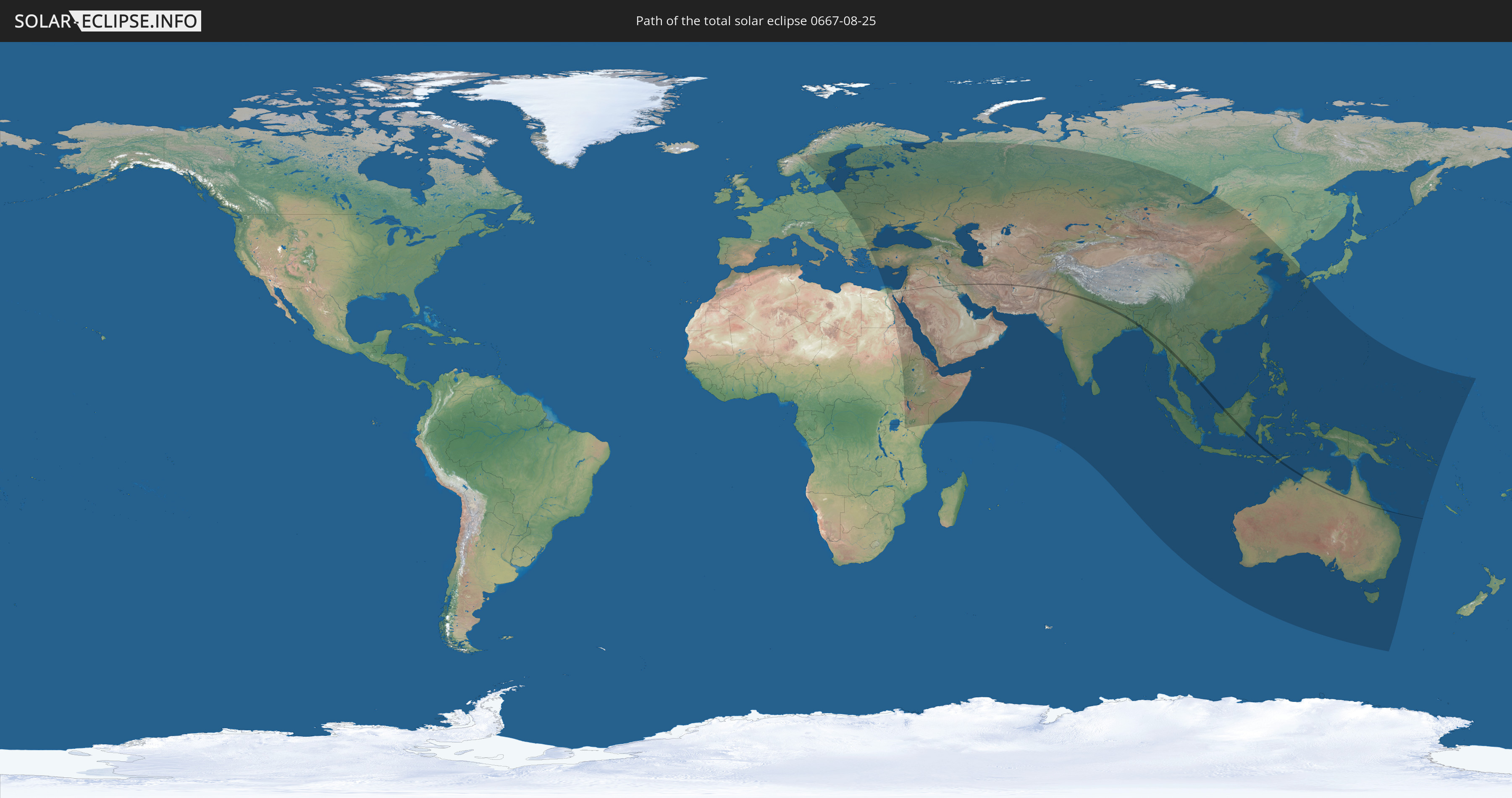
Die Sonnenfinsternis am 25.08.0667 kann man in 85 Ländern als partielle Sonnenfinsternis beobachten.
Der Finsternispfad verläuft durch 18 Länder. Nur in diesen Ländern ist sie als totale Sonnenfinsternis zu sehen.
In den folgenden Ländern ist die Sonnenfinsternis total zu sehen
 Ägypten
 Israel
 Saudi-Arabien
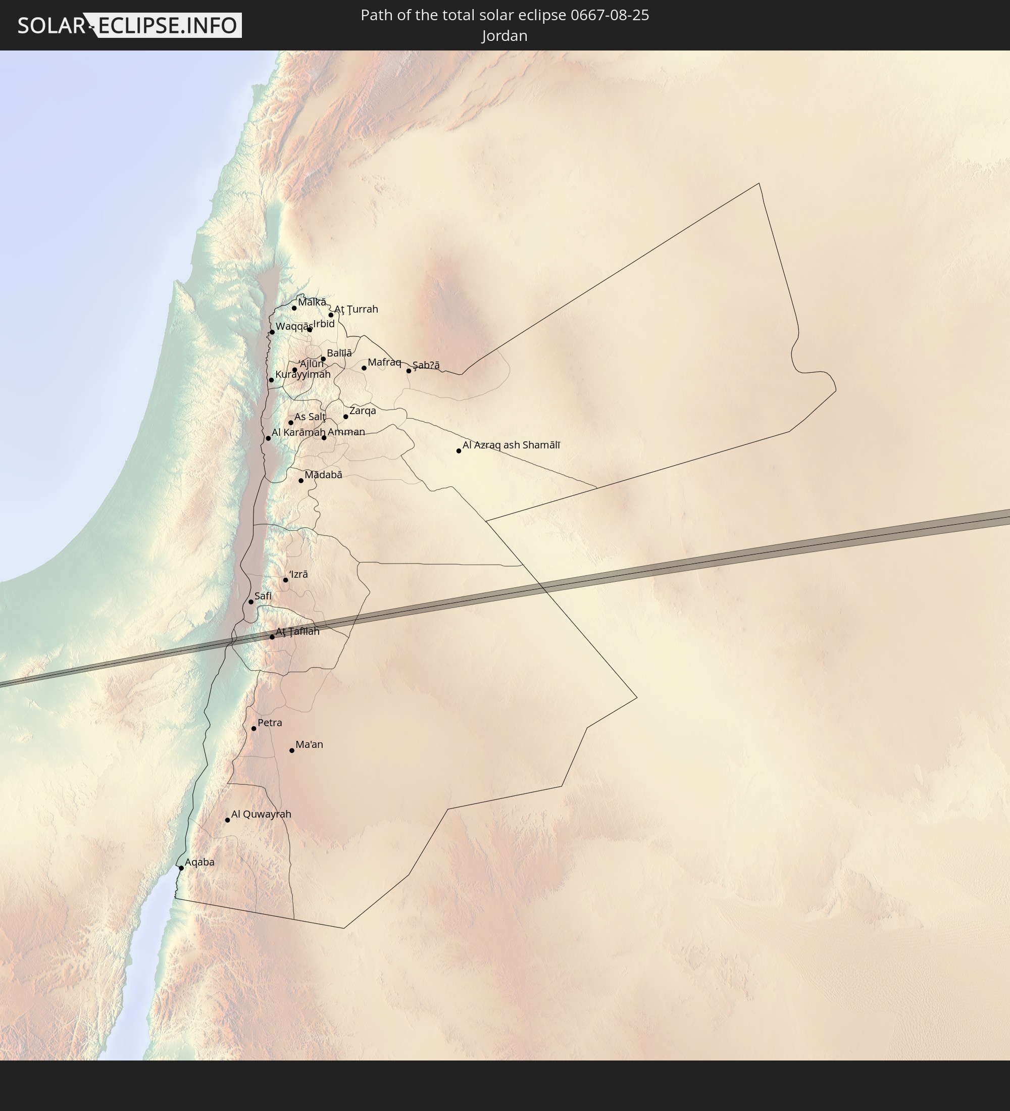 Jordanien
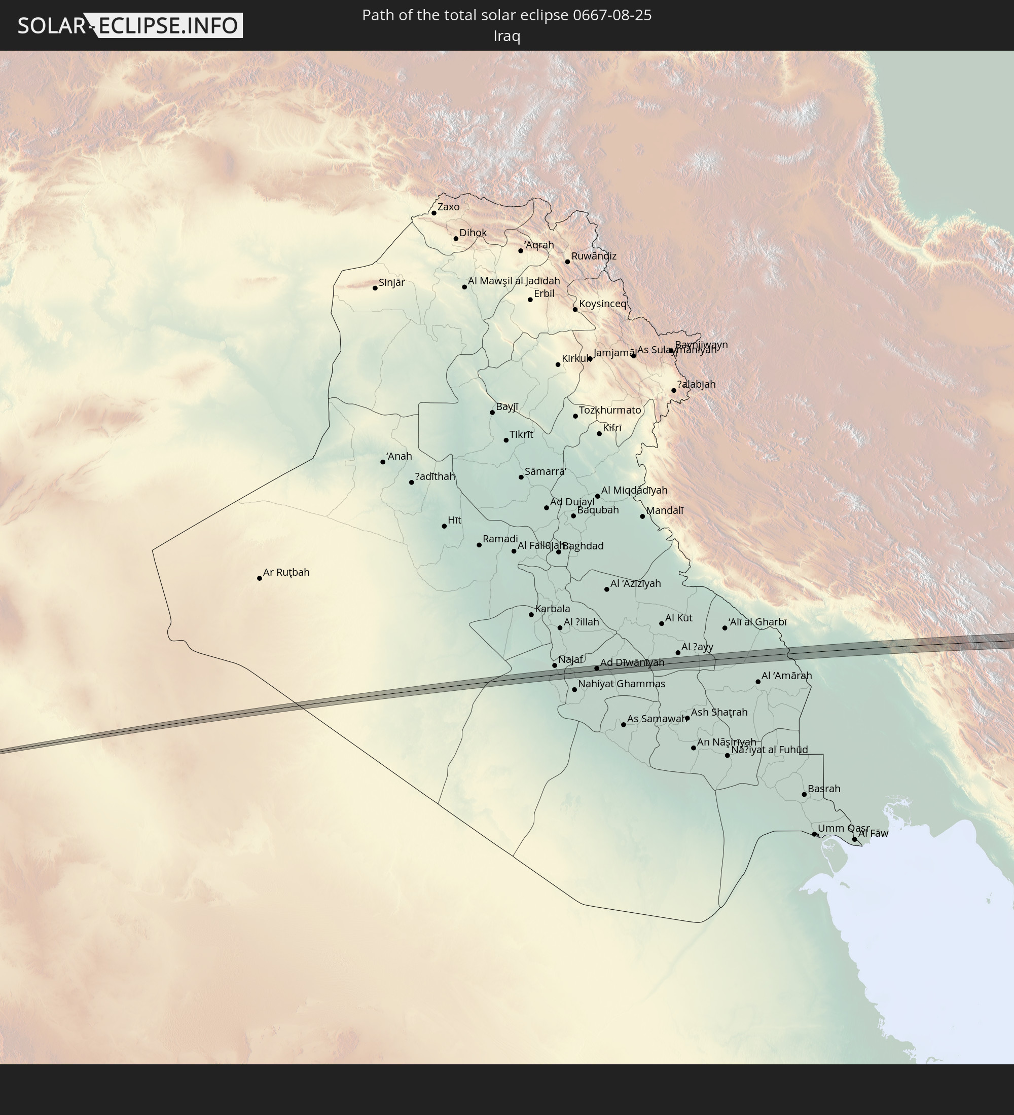 Irak
Irak
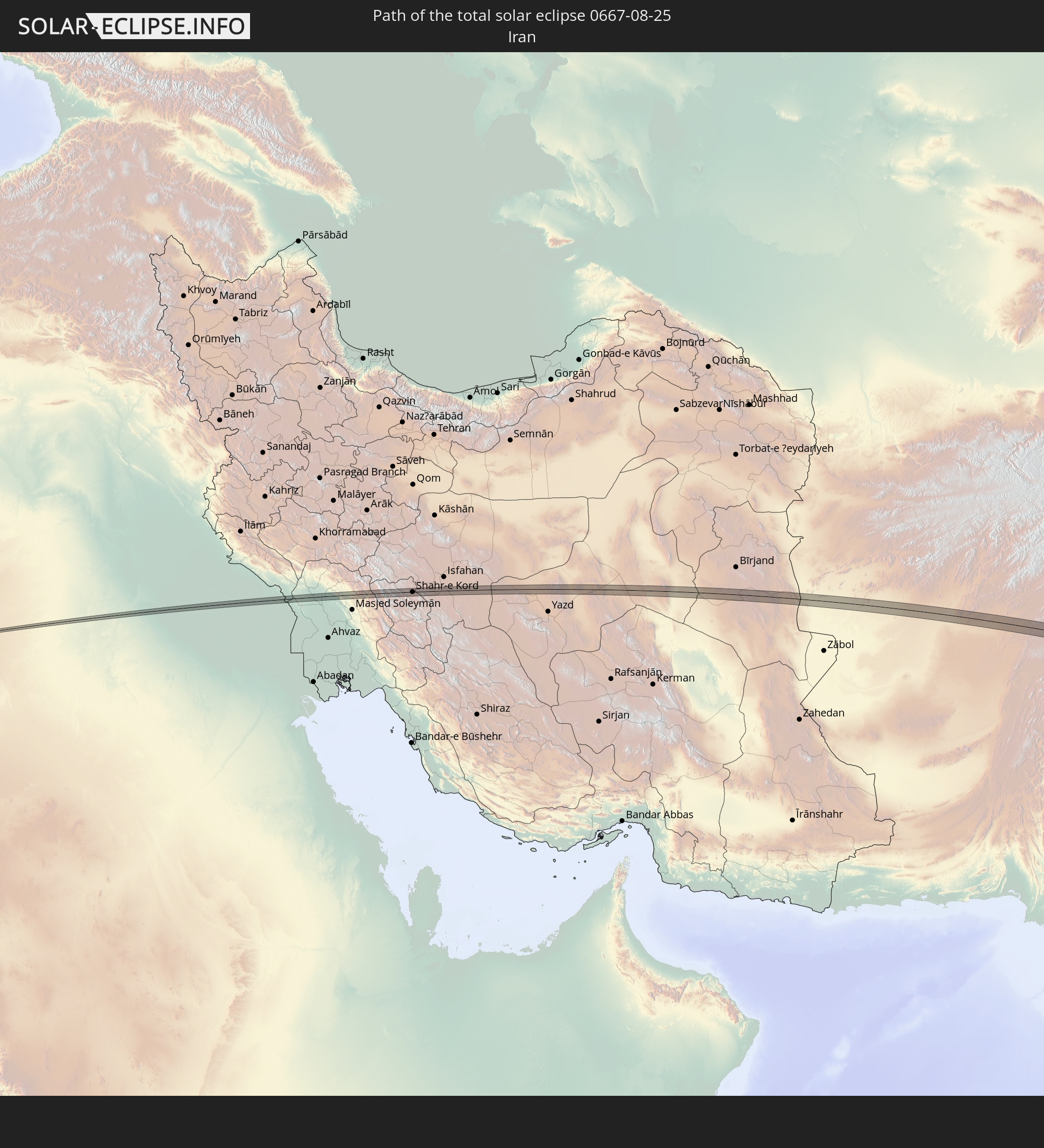 Iran
Iran
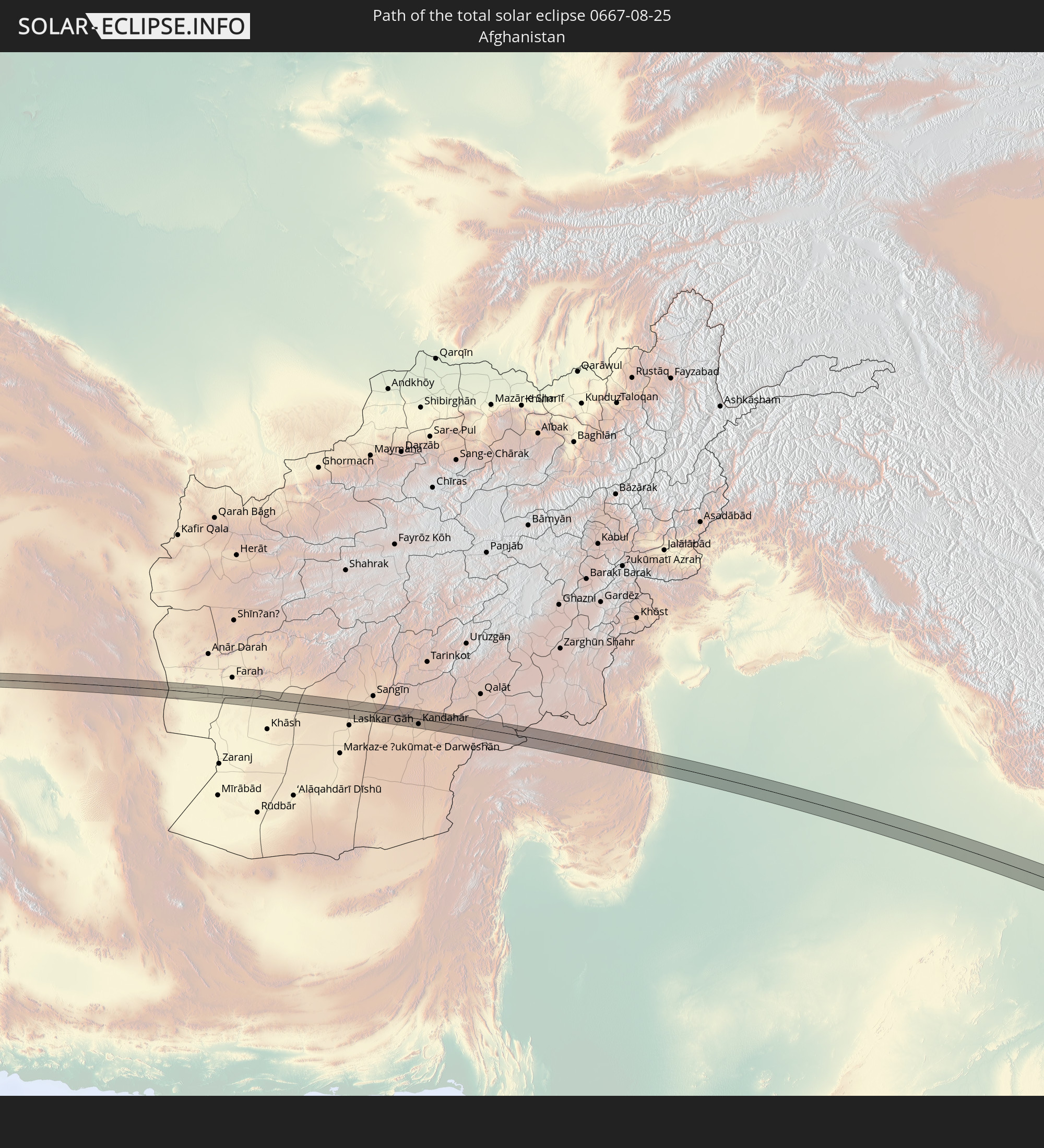 Afghanistan
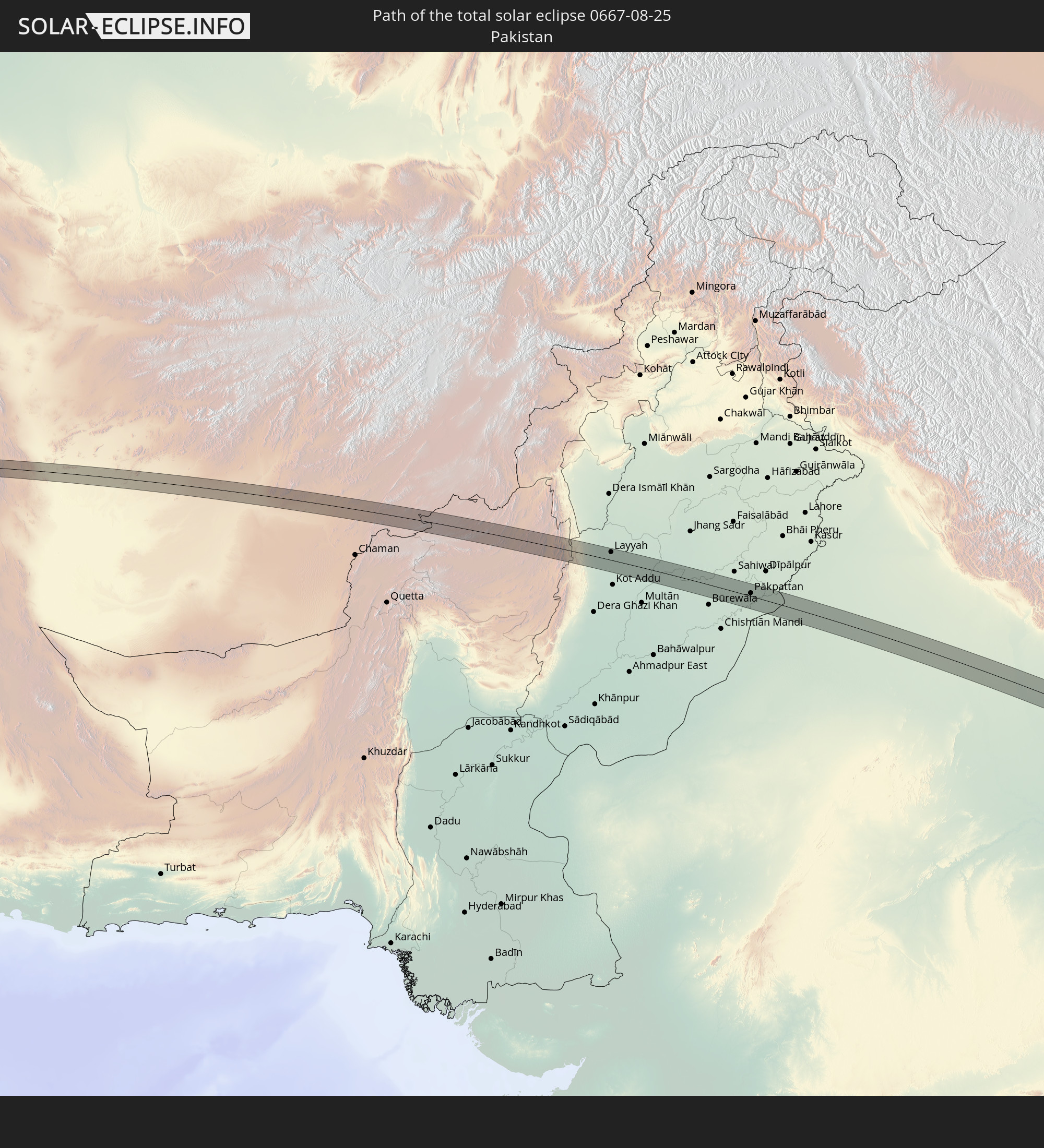 Pakistan
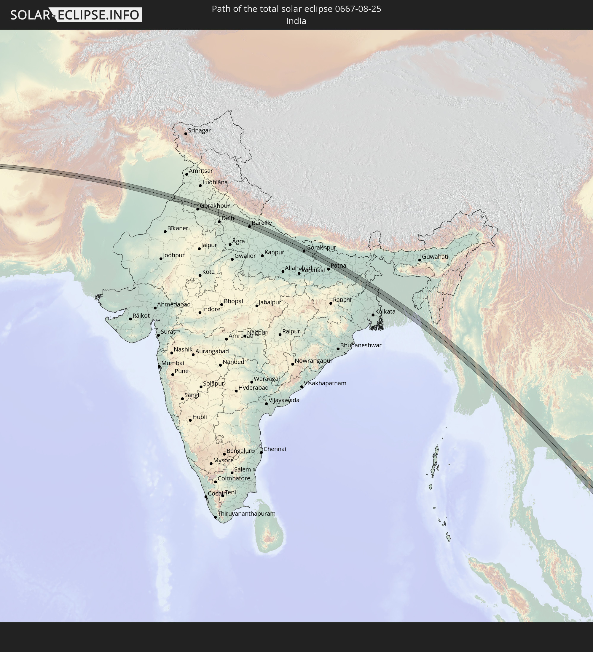 Indien
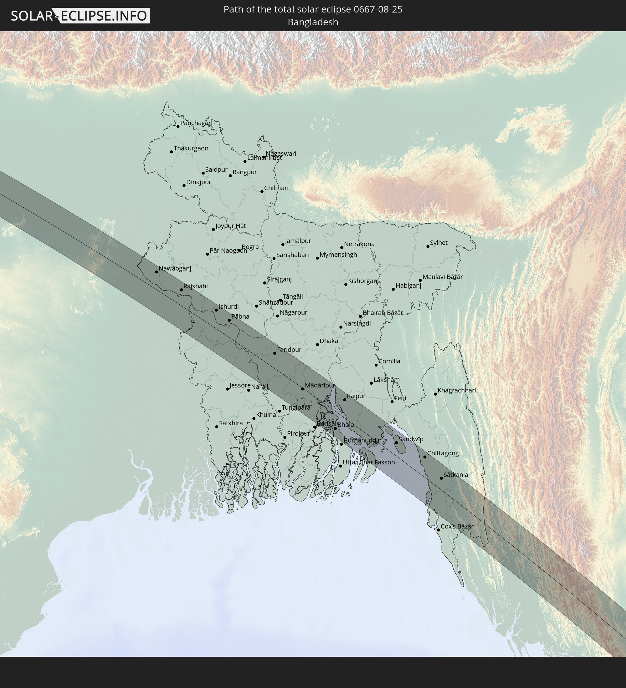 Bangladesch
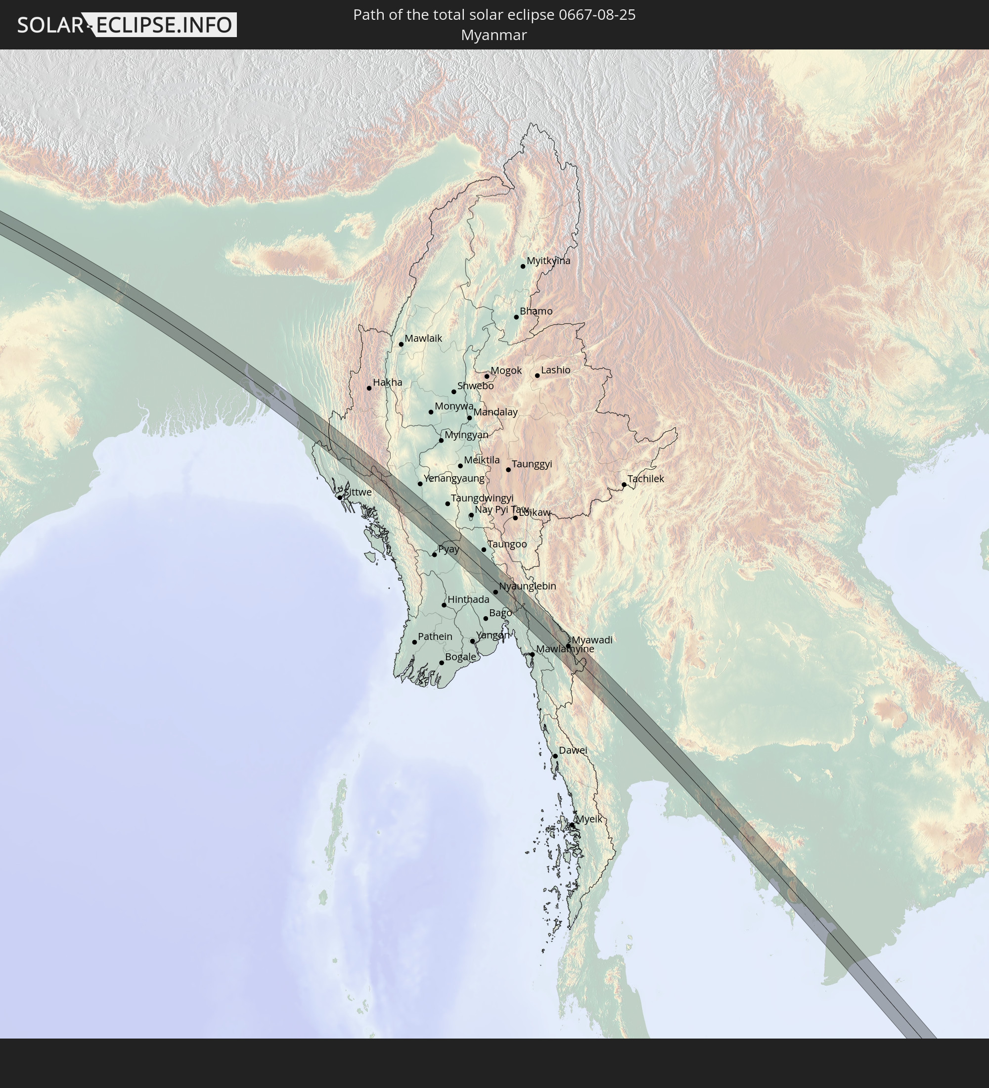 Myanmar
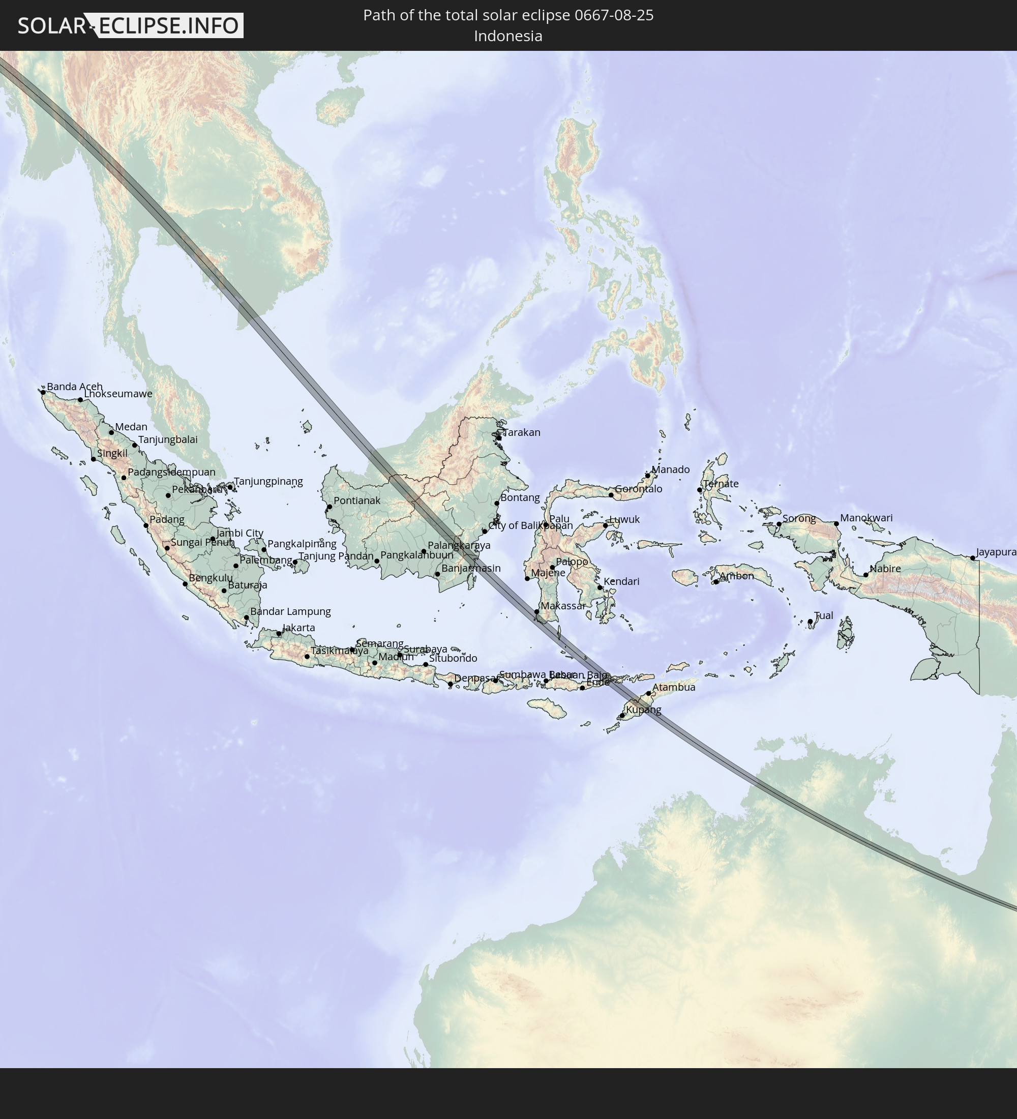 Indonesien
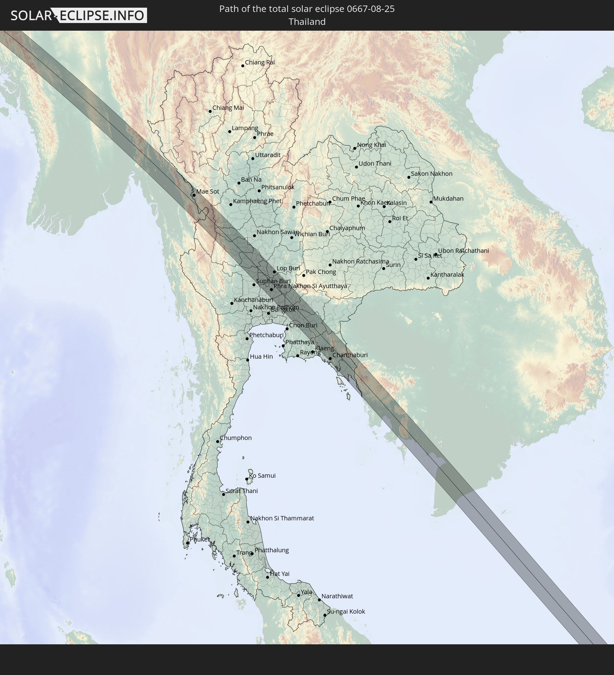 Thailand
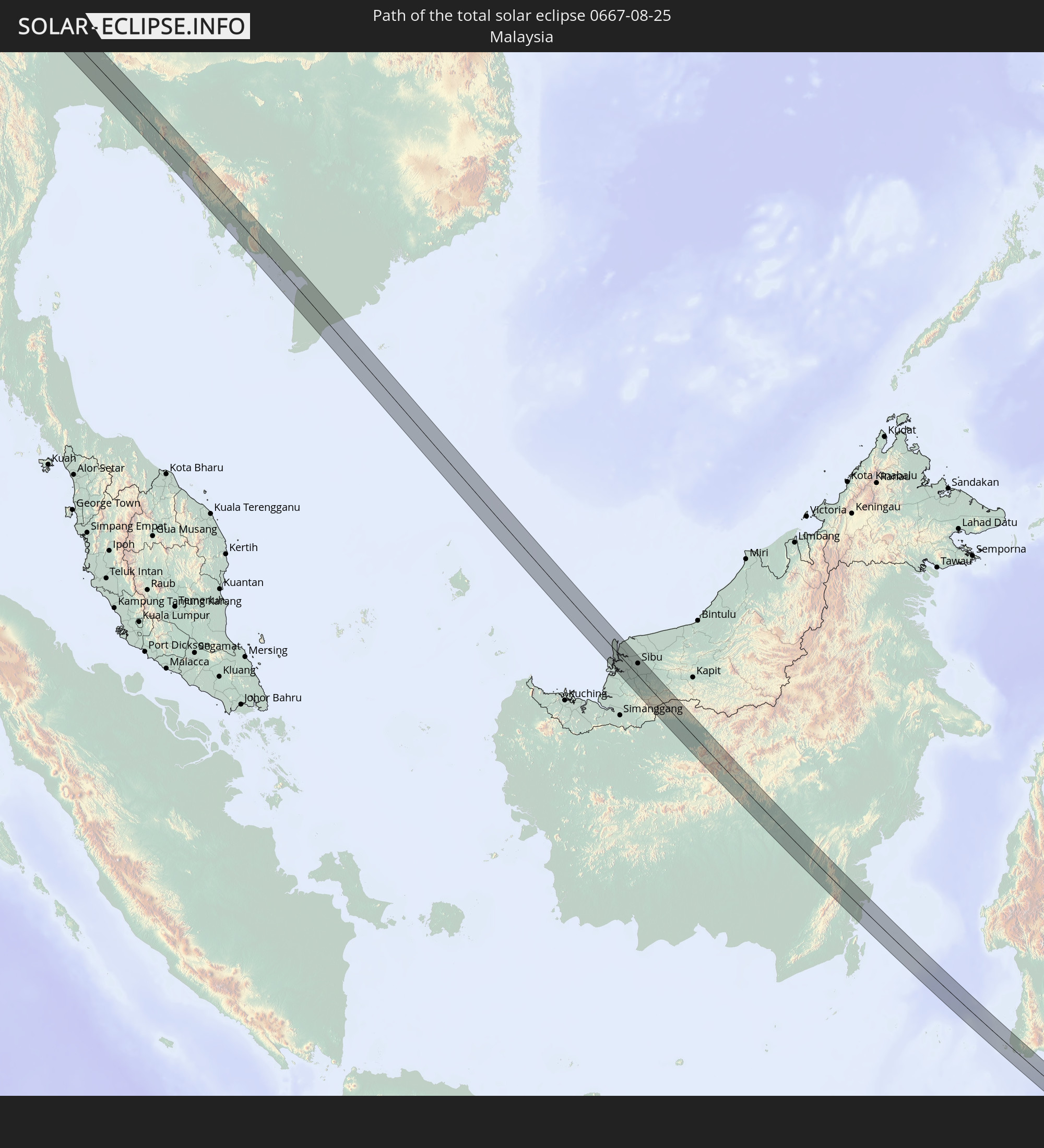 Malaysia
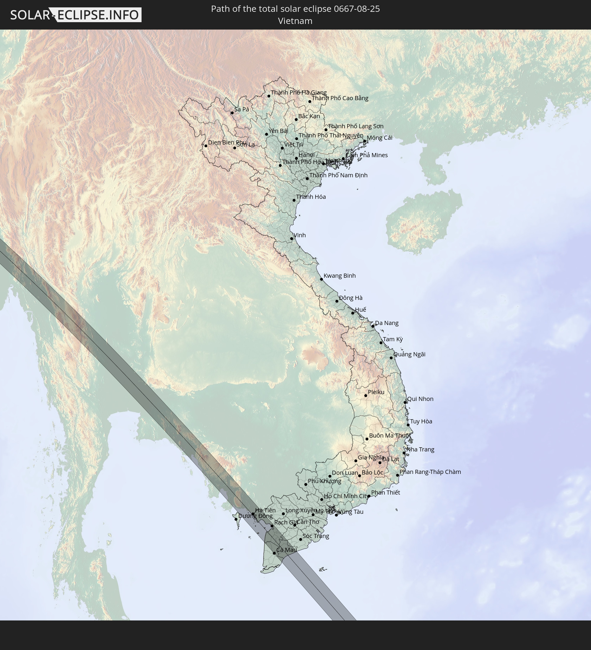 Vietnam
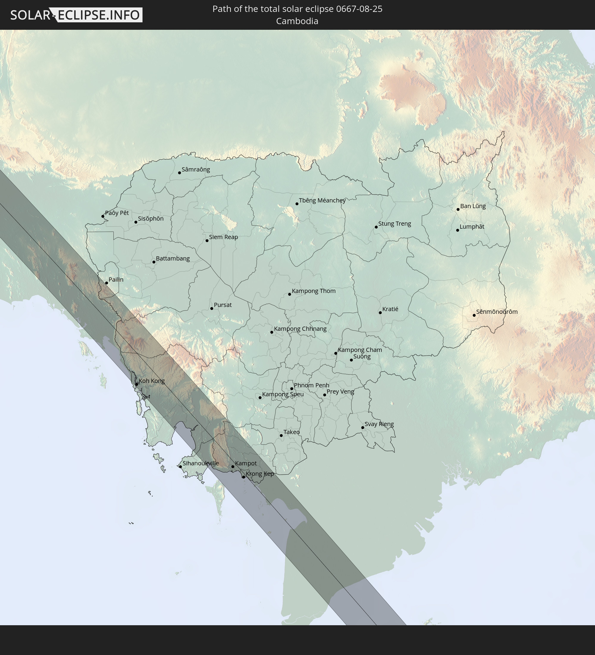 Kambodscha
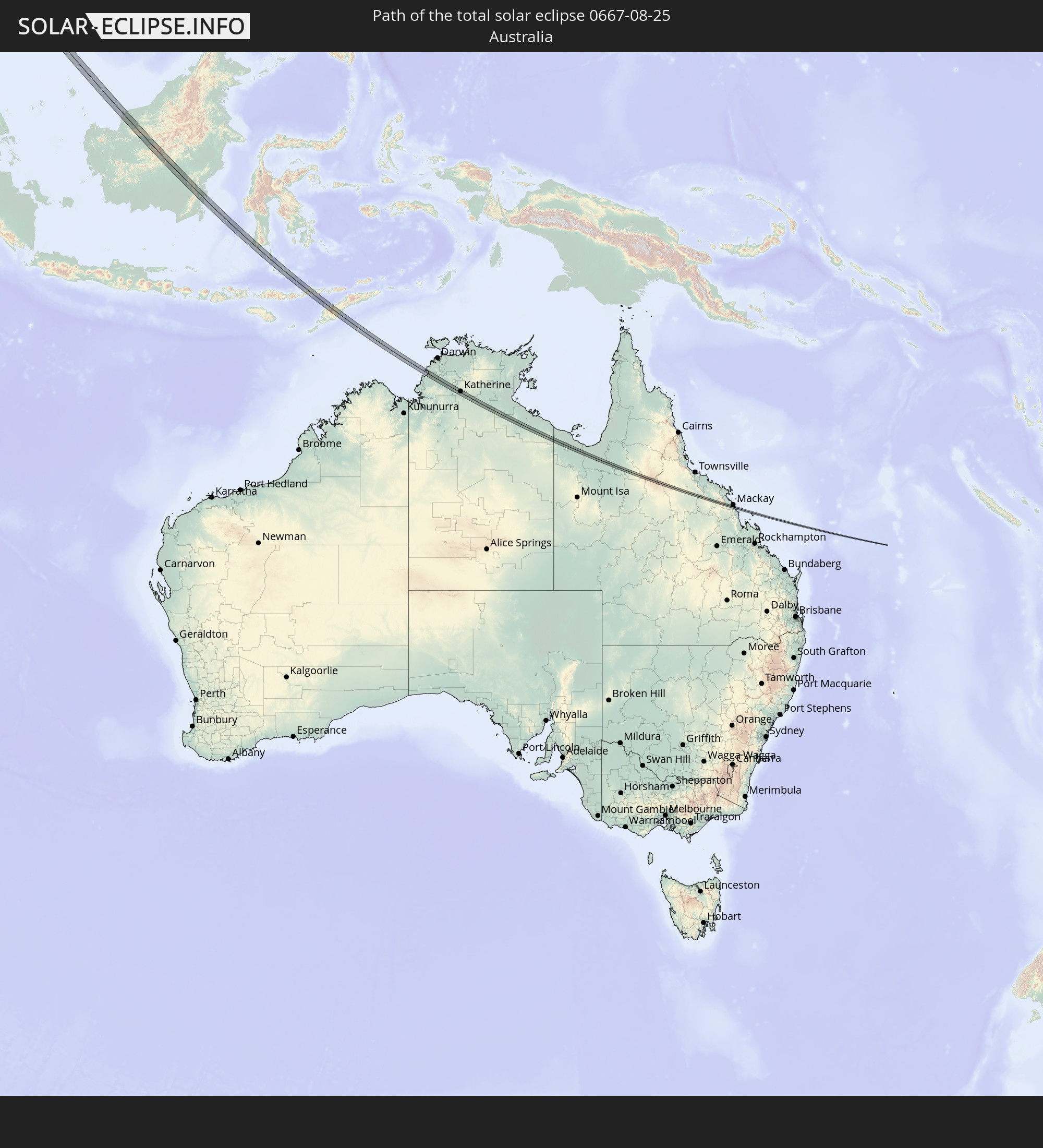 Australien
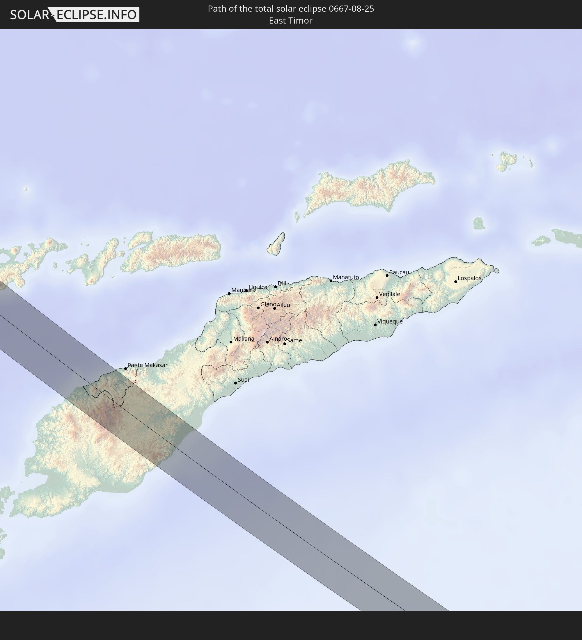 Osttimor
In den folgenden Ländern ist die Sonnenfinsternis partiell zu sehen
 Russland
 Norwegen
 Schweden
 Polen
Polen
 Slowakei
 Åland Islands
 Rumänien
 Finnland
 Litauen
 Lettland
 Estland
 Sudan
Sudan
 Ukraine
 Bulgarien
 Weißrussland
 Ägypten
 Türkei
 Moldawien
 Tansania
 Republik Zypern
 Äthiopien
 Kenia
Kenia
 Staat Palästina
 Israel
 Saudi-Arabien
 Jordanien
 Libanon
 Syrien
 Eritrea
 Irak
Irak
 Georgien
 Somalia
 Dschibuti
 Jemen
Jemen
 Armenien
 Iran
Iran
 Aserbaidschan
 Kasachstan
 Kuwait
 Bahrain
 Katar
Katar
 Vereinigte Arabische Emirate
 Oman
Oman
 Turkmenistan
 Usbekistan
 Afghanistan
 Pakistan
 Tadschikistan
 Indien
 Kirgisistan
 Malediven
 Volksrepublik China
 Sri Lanka
 Nepal
Nepal
 Mongolei
 Bangladesch
 Bhutan
 Myanmar
 Indonesien
 Kokosinseln
 Thailand
 Malaysia
 Laos
Laos
 Vietnam
 Kambodscha
 Singapur
 Weihnachtsinsel
 Australien
 Macau
Macau
 Hongkong
 Brunei
 Taiwan
 Philippinen
 Japan
Japan
 Osttimor
 Nordkorea
 Südkorea
 Palau
Palau
 Föderierte Staaten von Mikronesien
 Papua-Neuguinea
 Guam
Guam
 Nördliche Marianen
 Salomonen
 Neukaledonien
 Marshallinseln
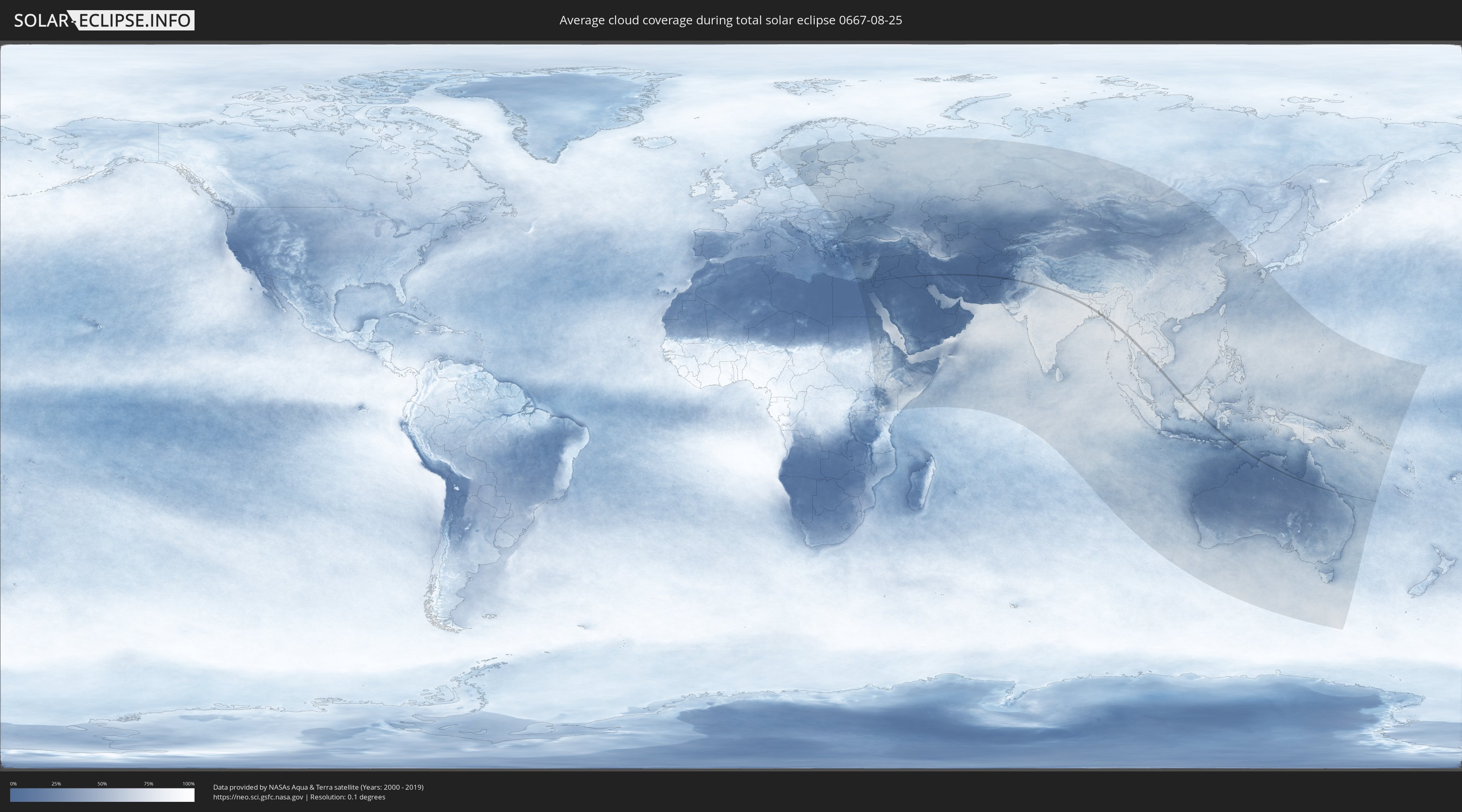
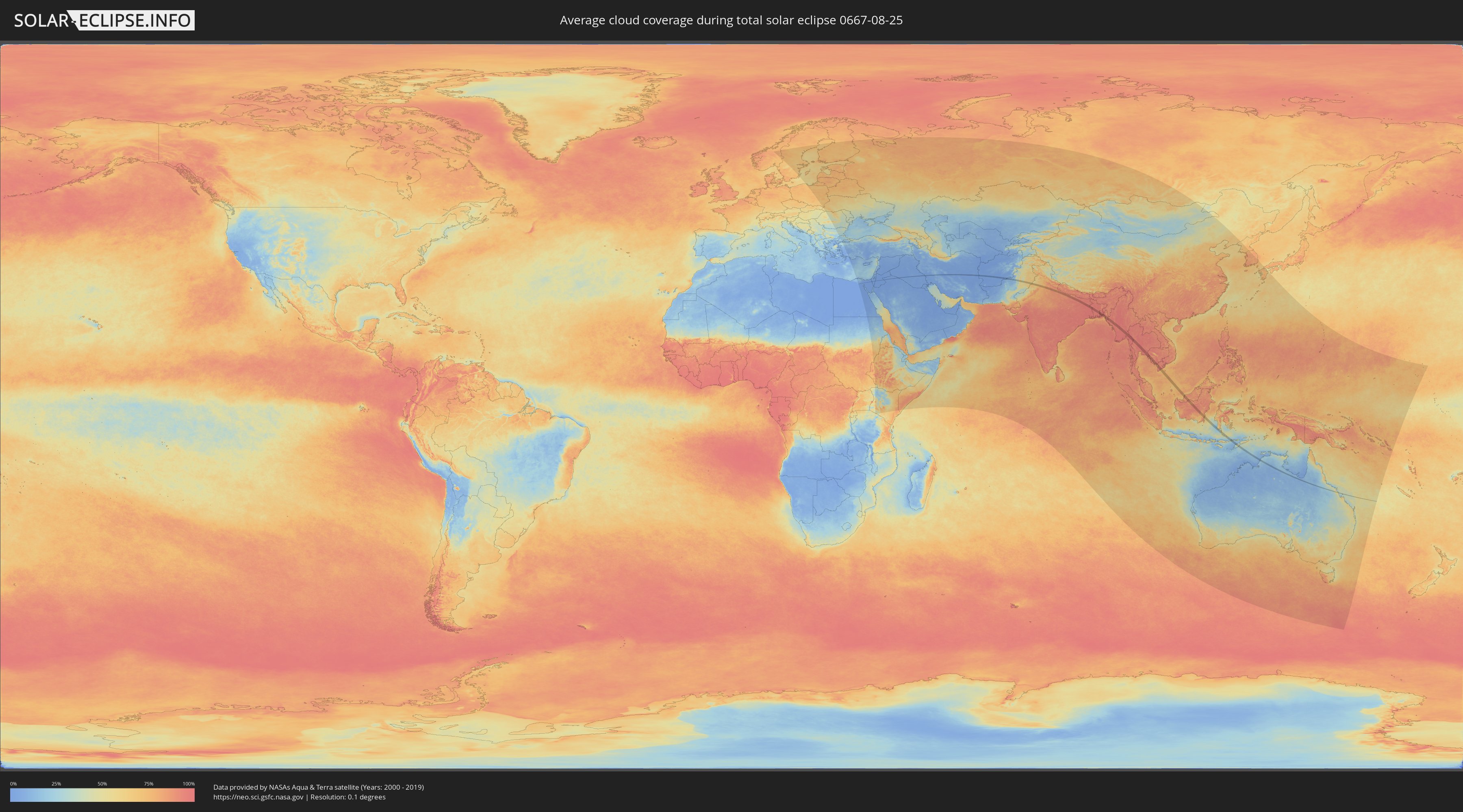
Wie wird das Wetter während der totalen Sonnenfinsternis am 25.08.0667?
Wo ist der beste Ort, um die totale Sonnenfinsternis vom 25.08.0667 zu beobachten?
Die folgenden Karten zeigen die durchschnittliche Bewölkung für den Tag, an dem die totale Sonnenfinsternis
stattfindet. Mit Hilfe der Karten lässt sich der Ort entlang des Finsternispfades eingrenzen,
der die besten Aussichen auf einen klaren wolkenfreien Himmel bietet.
Trotzdem muss man immer lokale Gegenenheiten beachten und sollte sich genau über das Wetter an seinem
gewählten Beobachtungsort informieren.
Die Daten stammen von den beiden NASA-Satelliten
AQUA und TERRA
und wurden über einen Zeitraum von 19 Jahren (2000 - 2019) gemittelt.
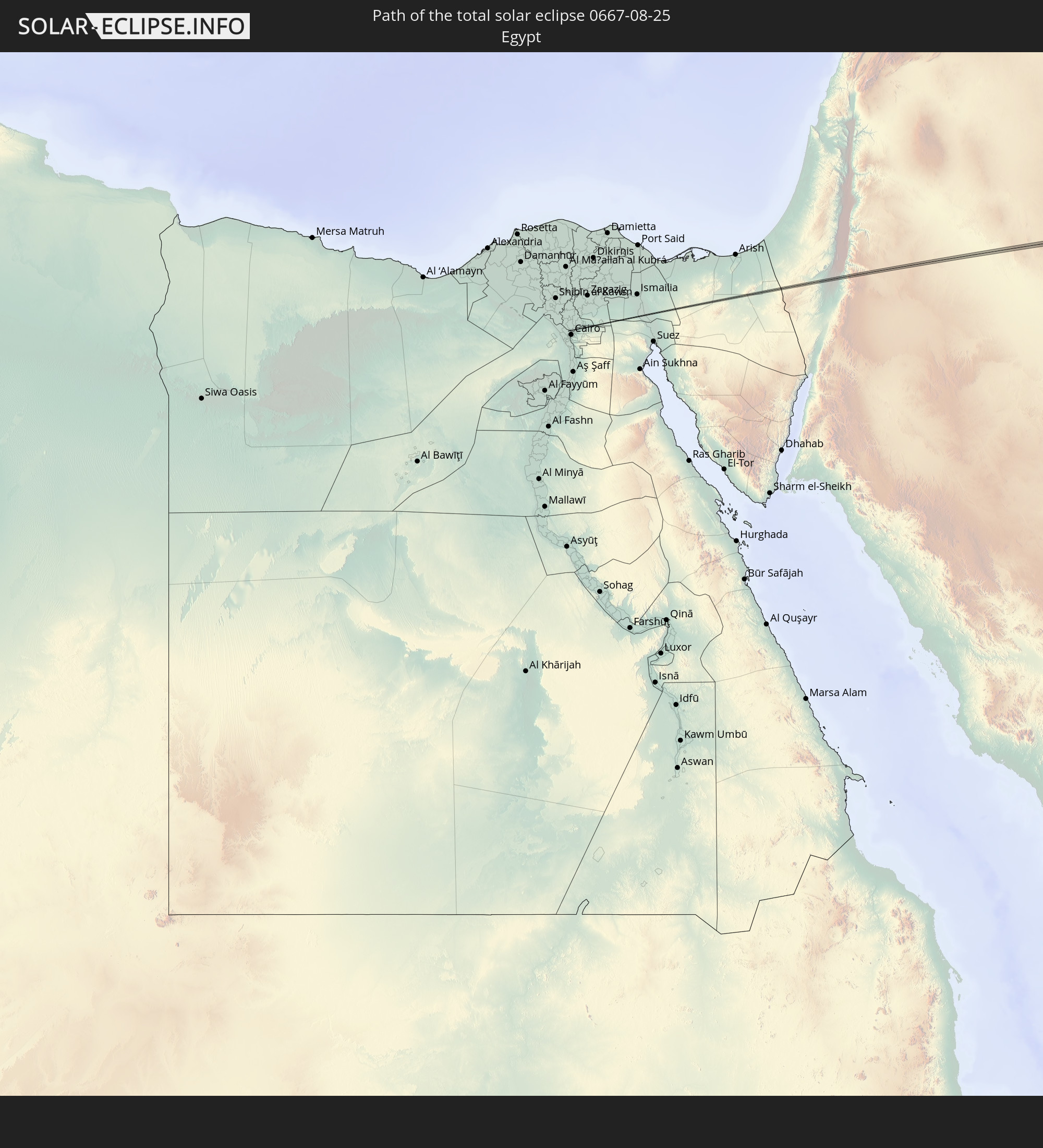
Detaillierte Länderkarten
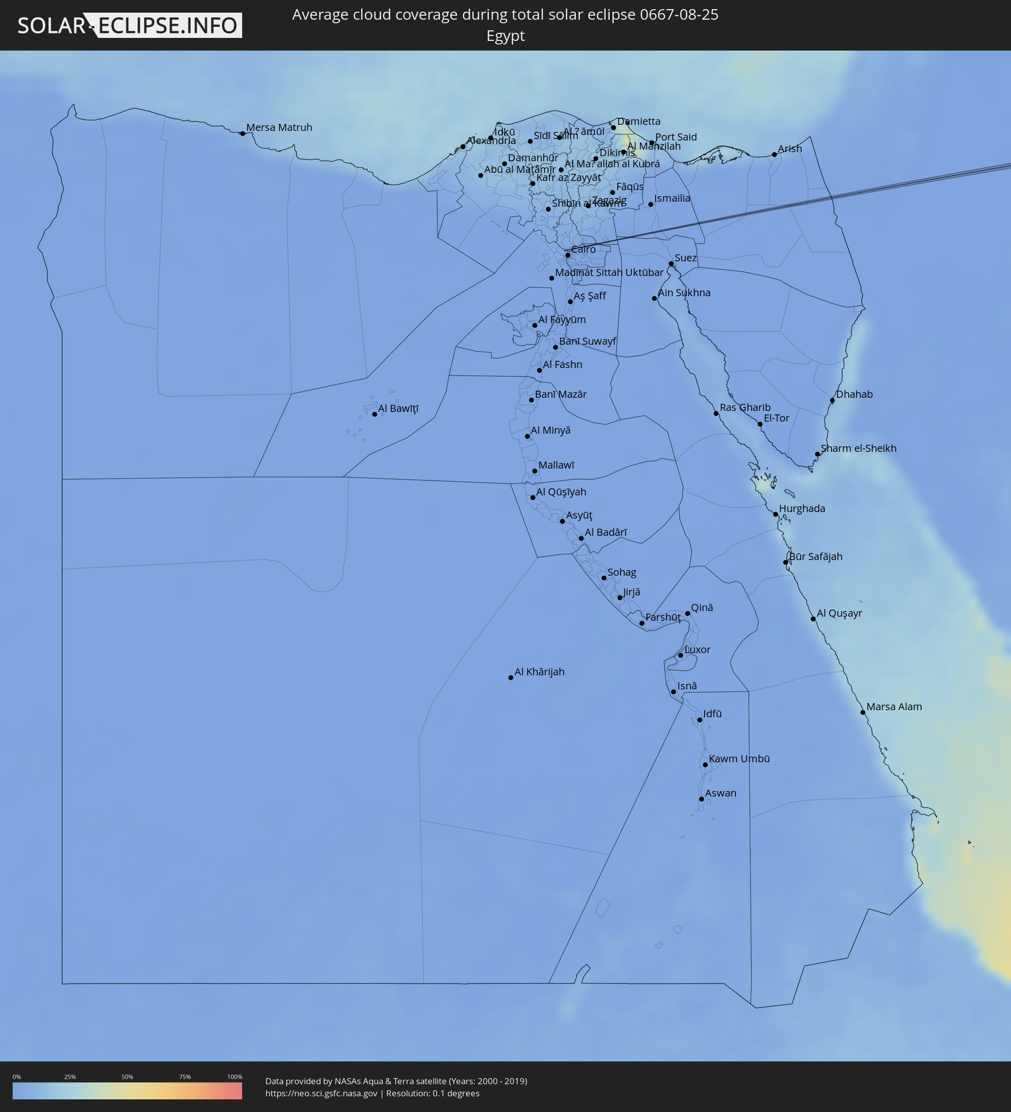 Ägypten
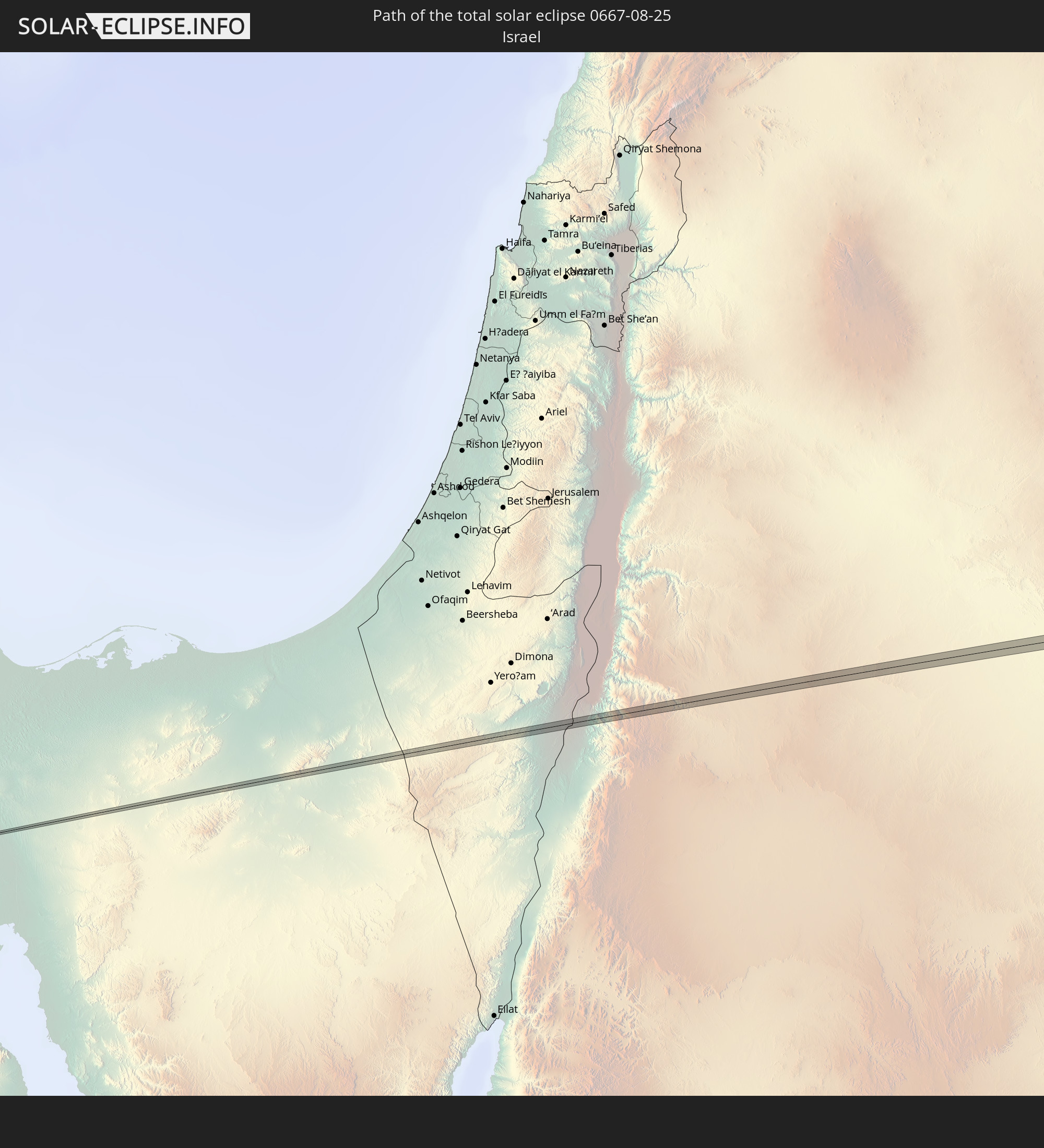
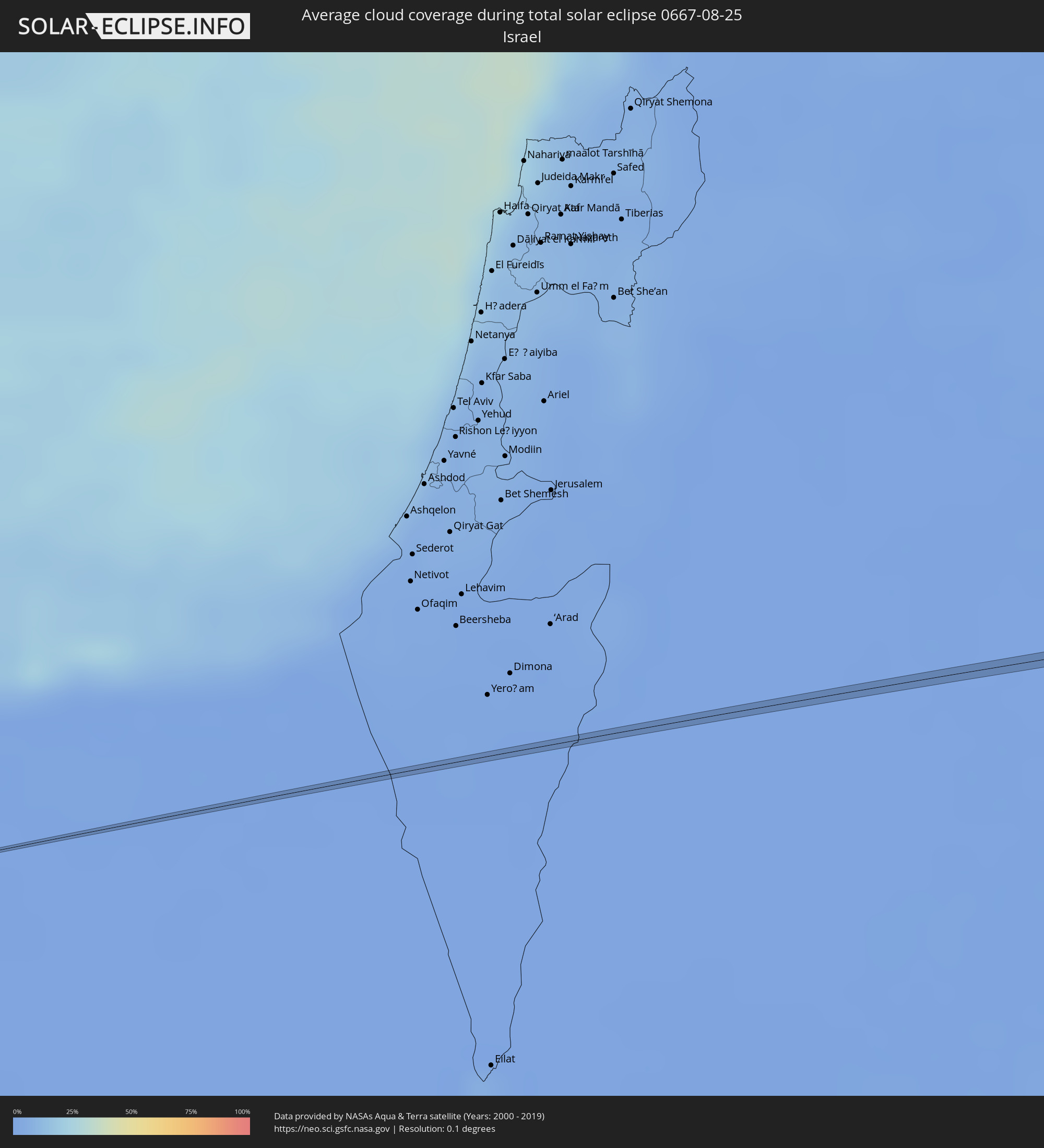 Israel
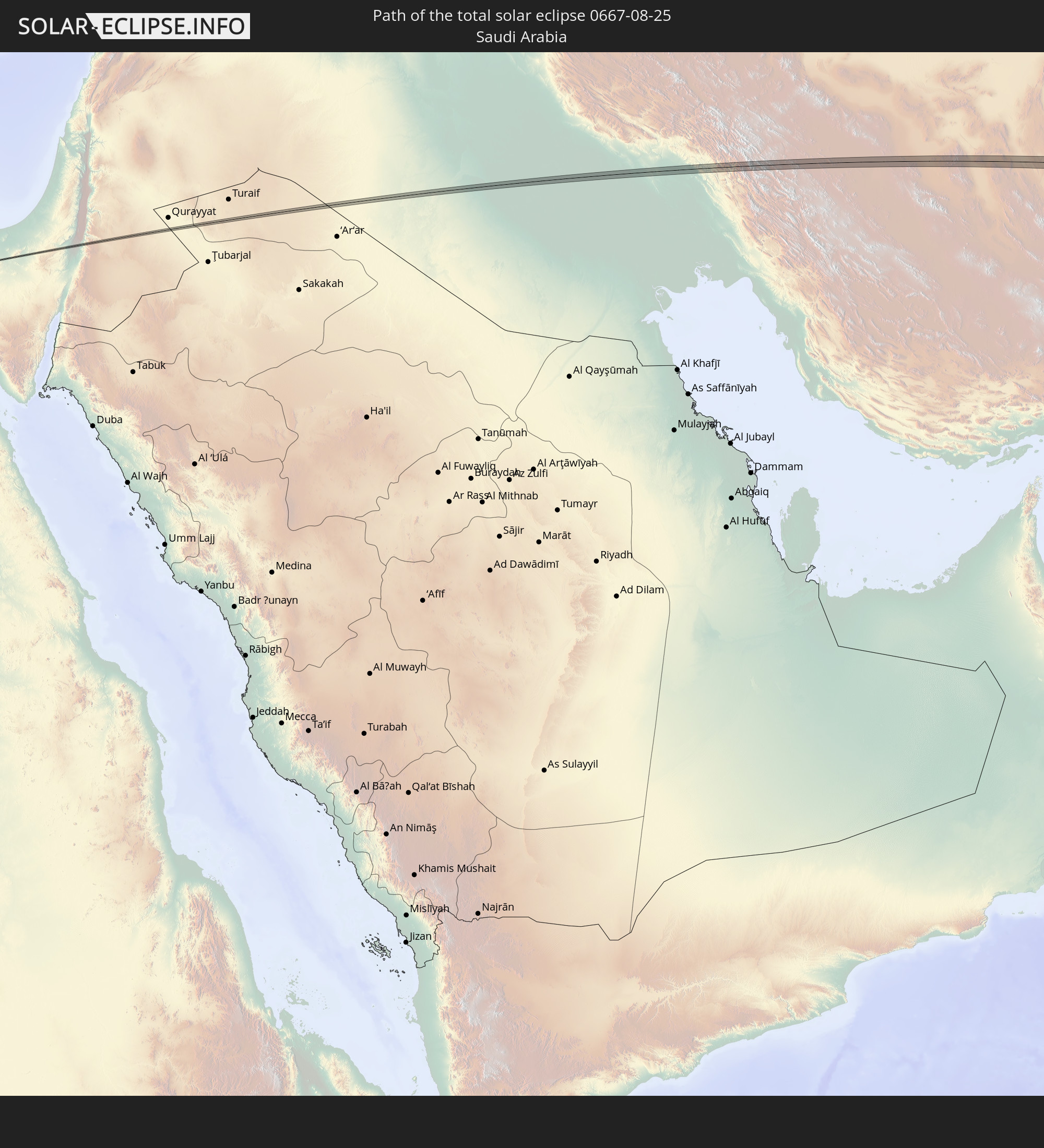
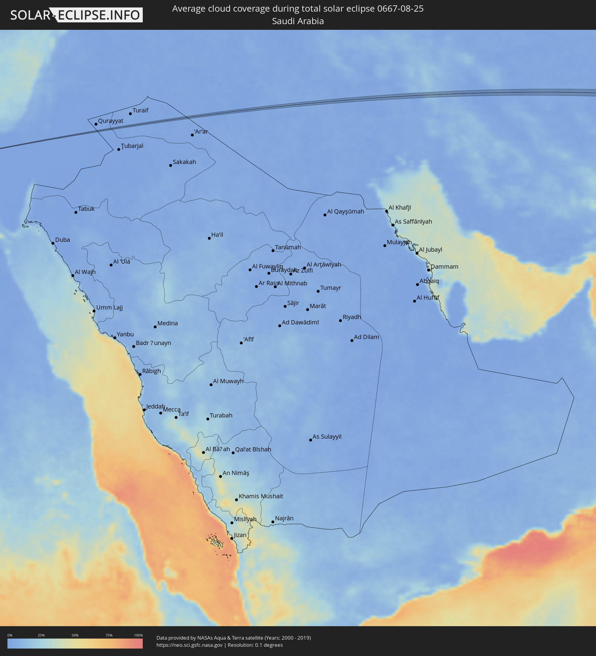 Saudi-Arabien
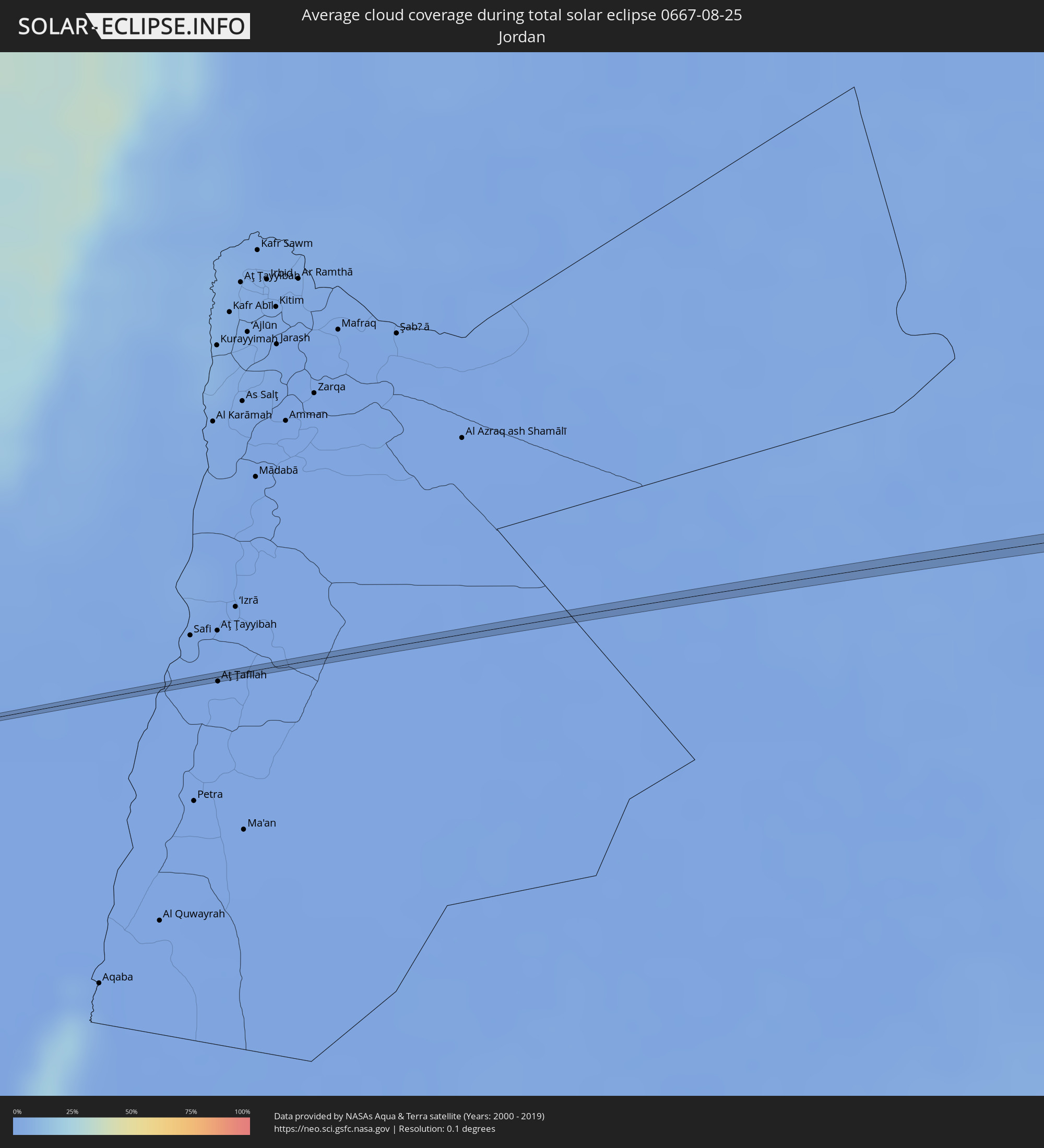 Jordanien
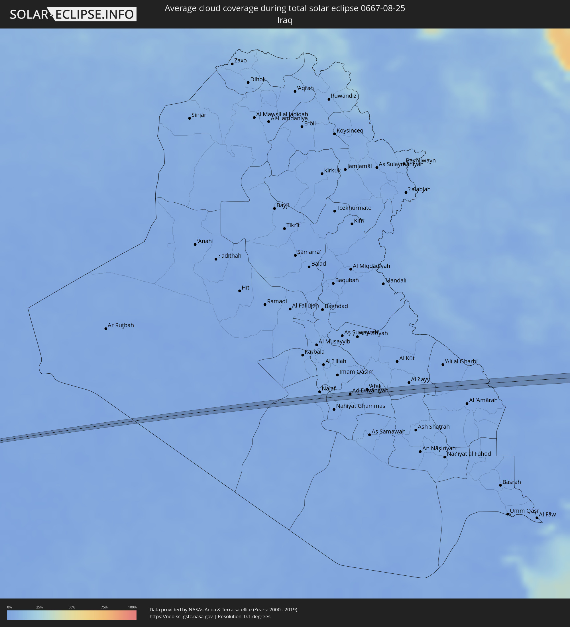 Irak
Irak
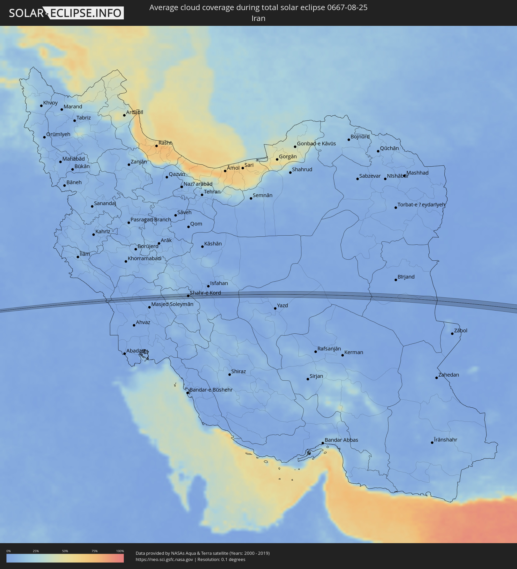 Iran
Iran
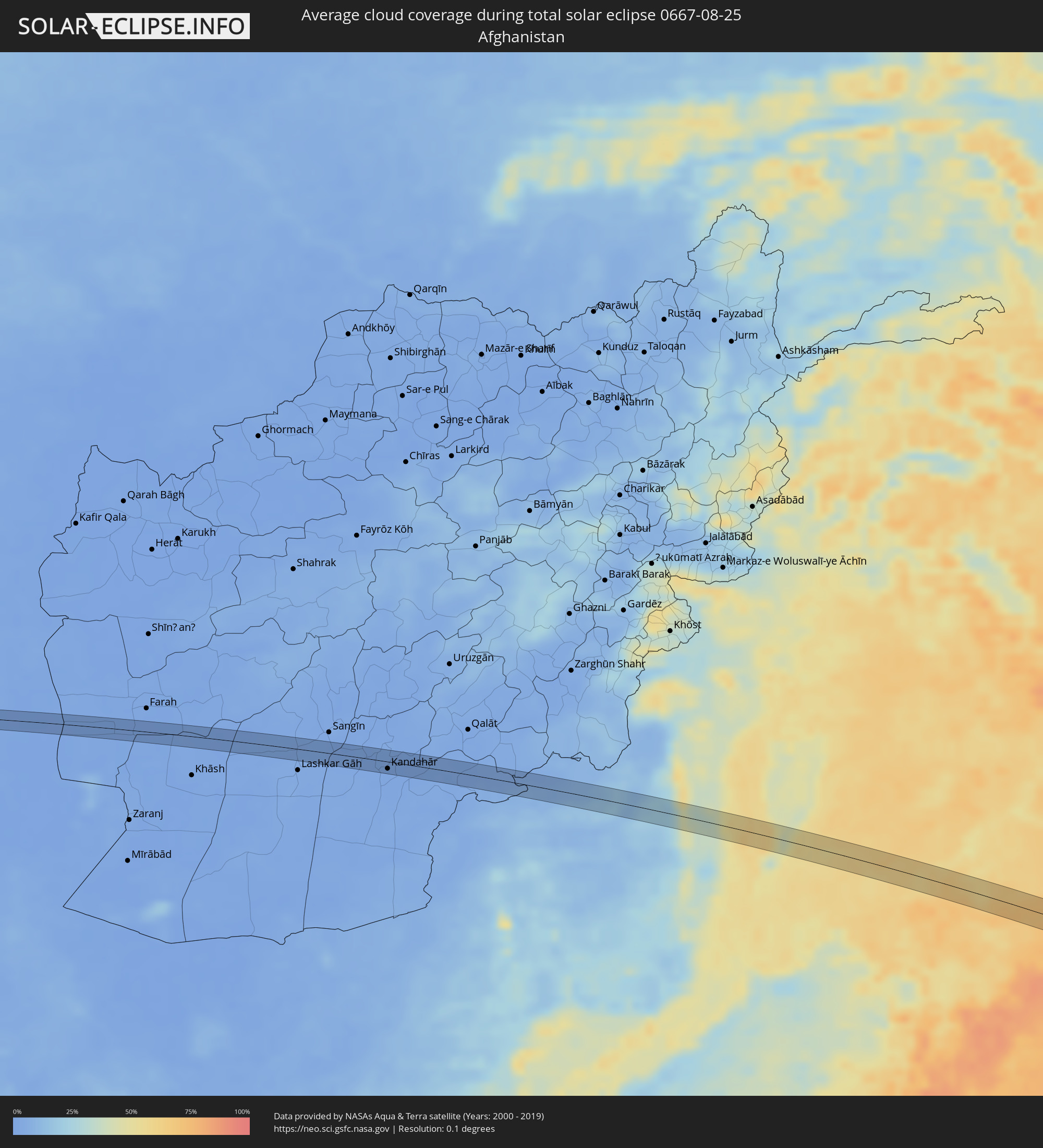 Afghanistan
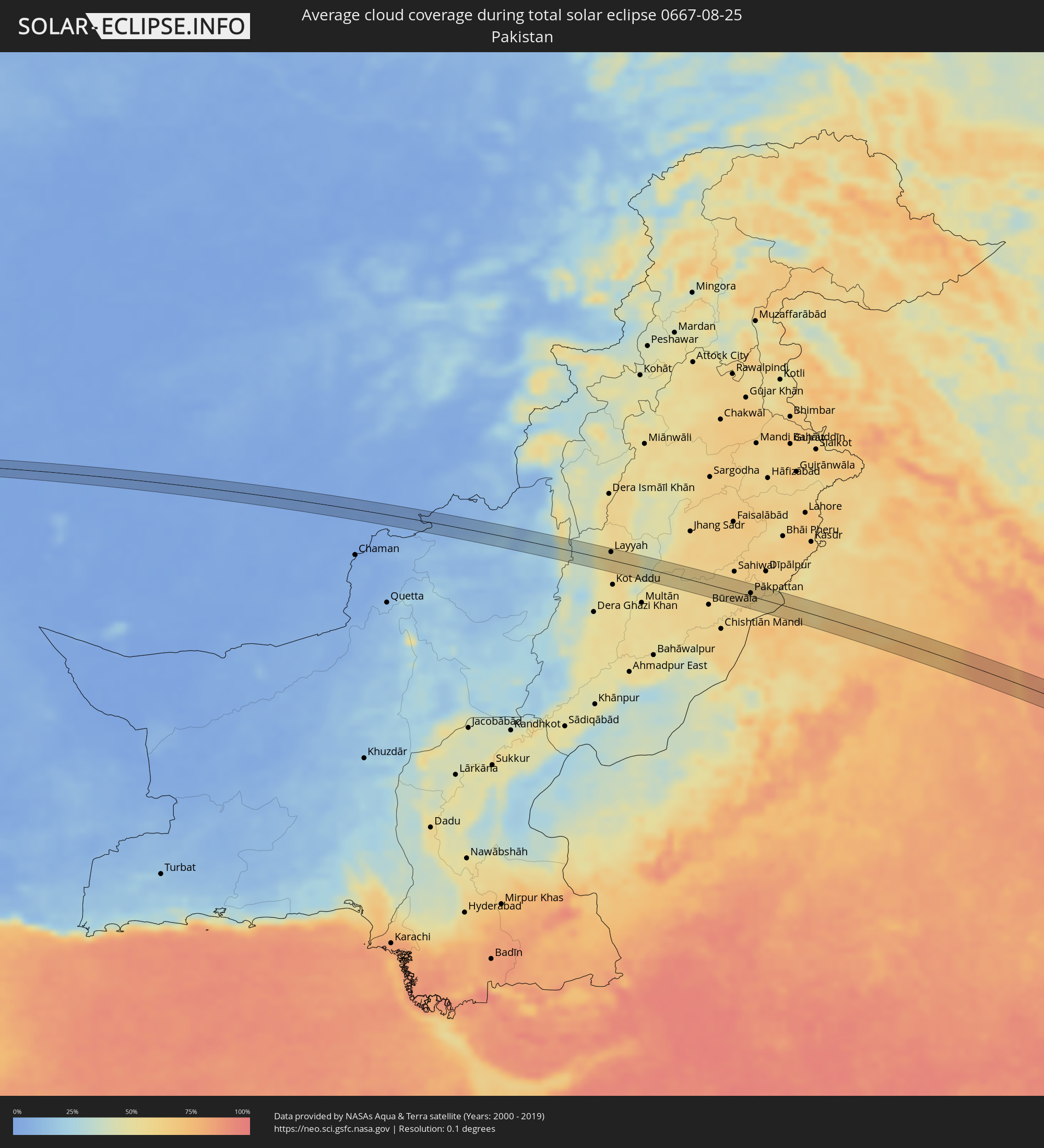 Pakistan
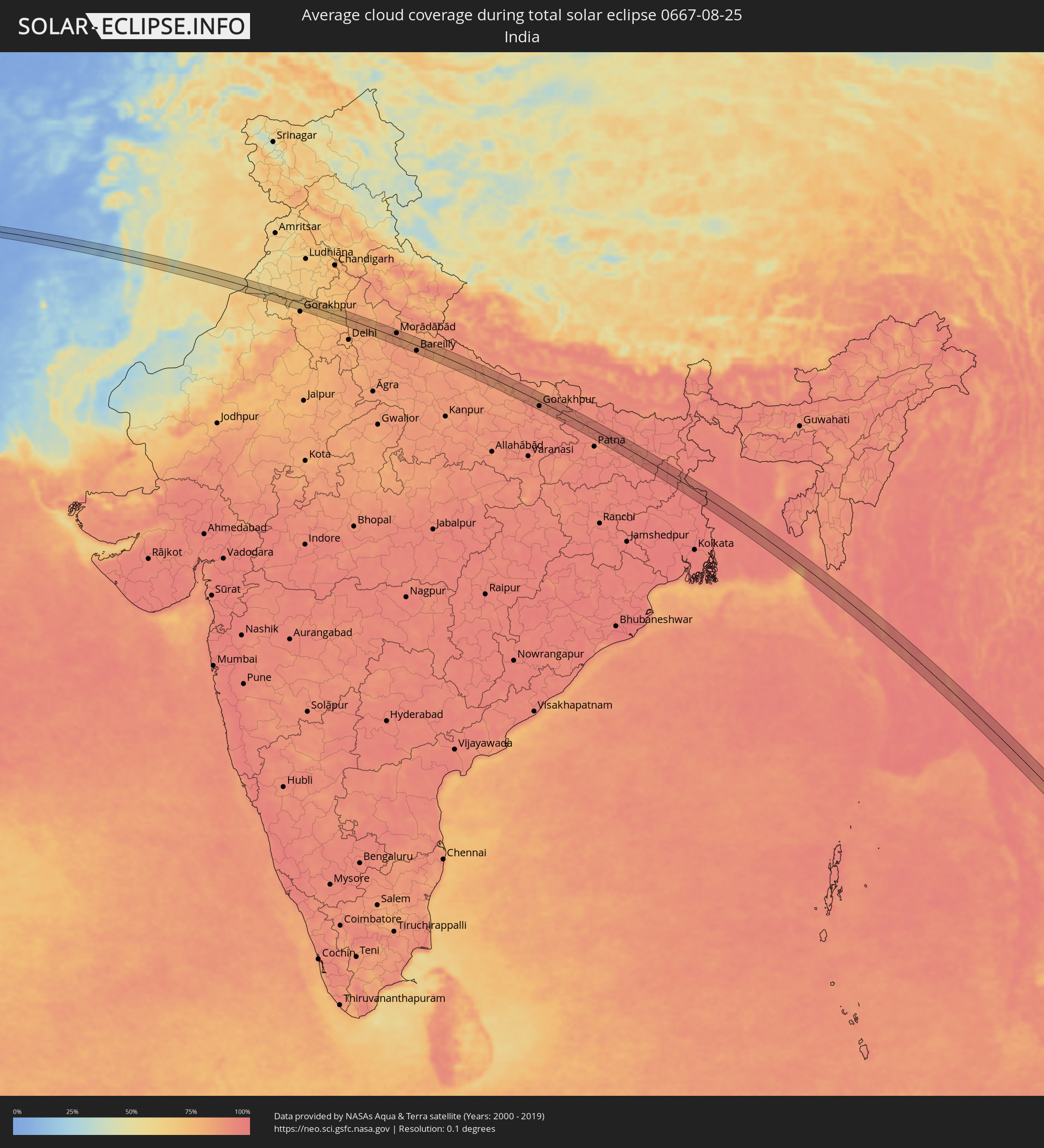 Indien
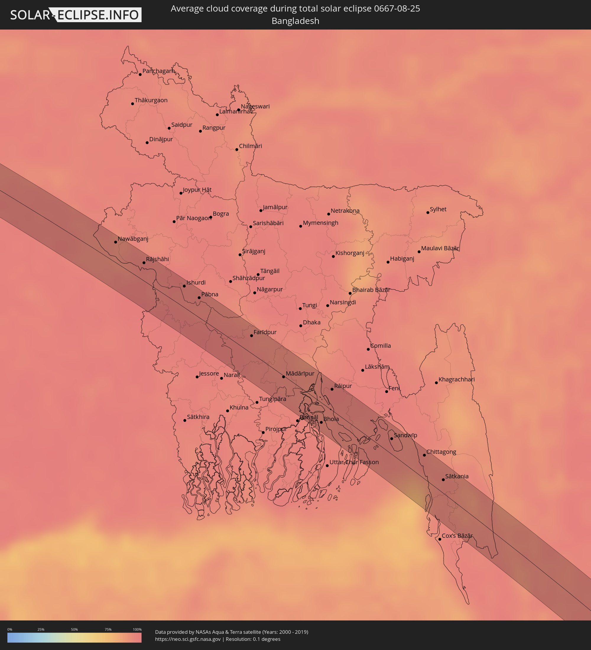 Bangladesch
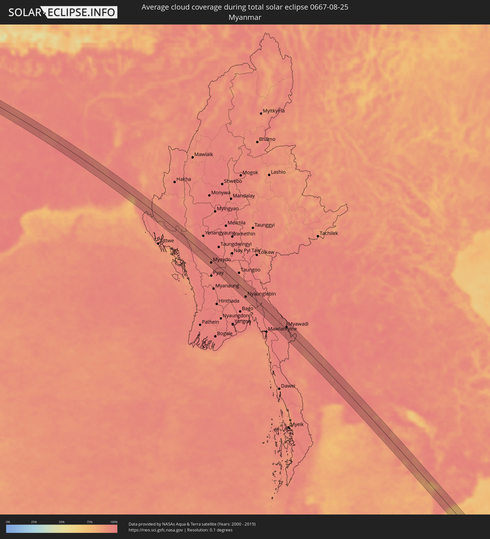 Myanmar
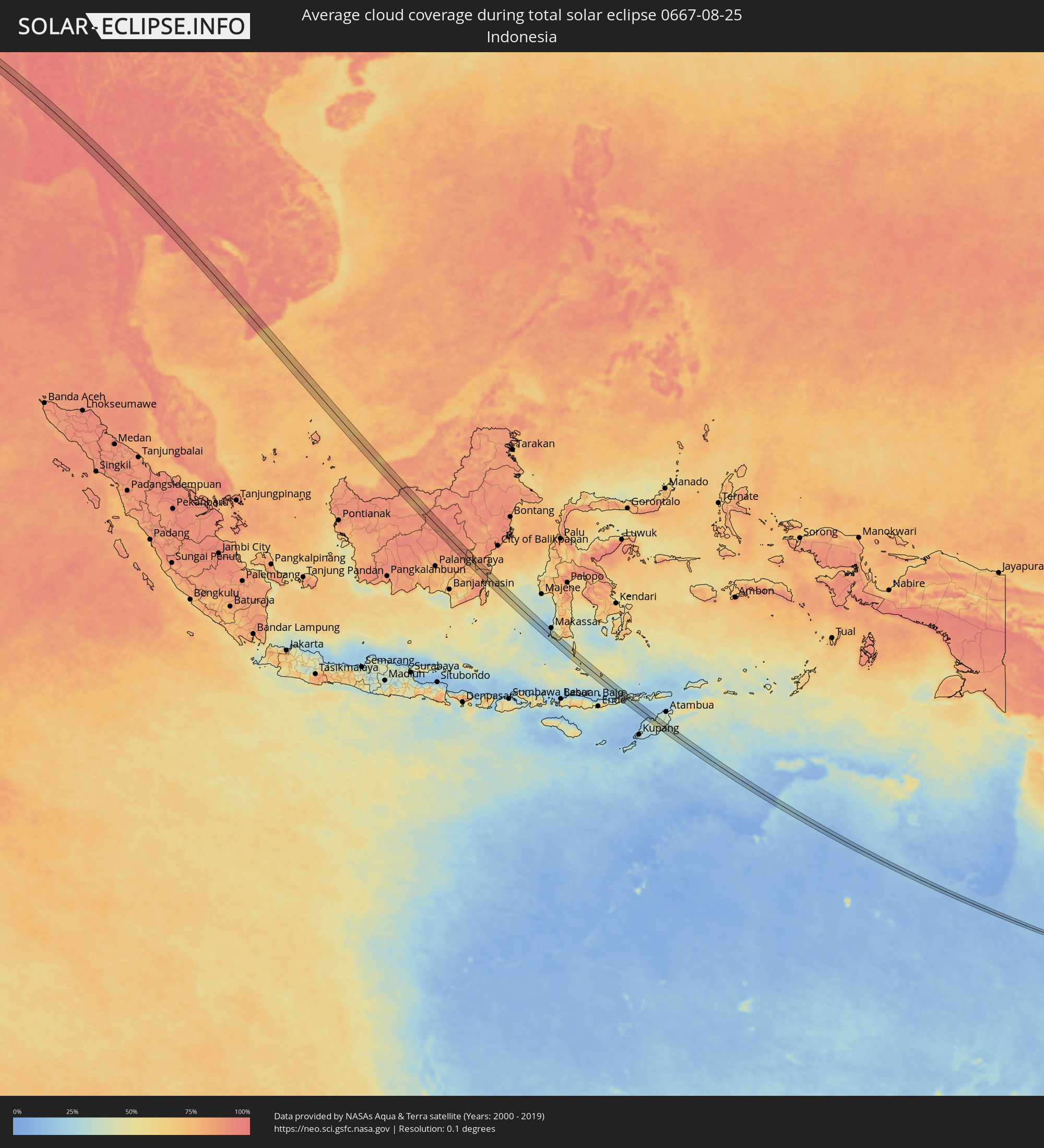 Indonesien
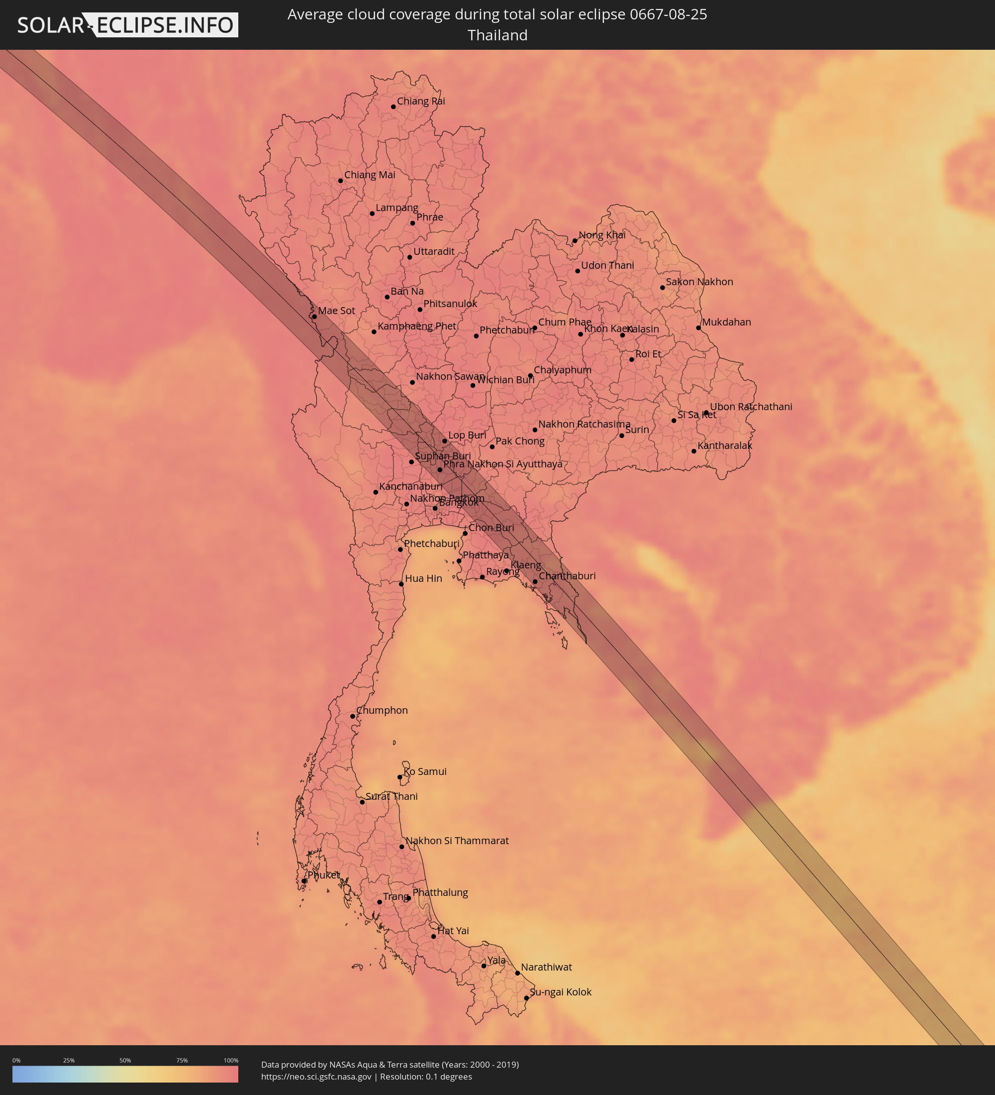 Thailand
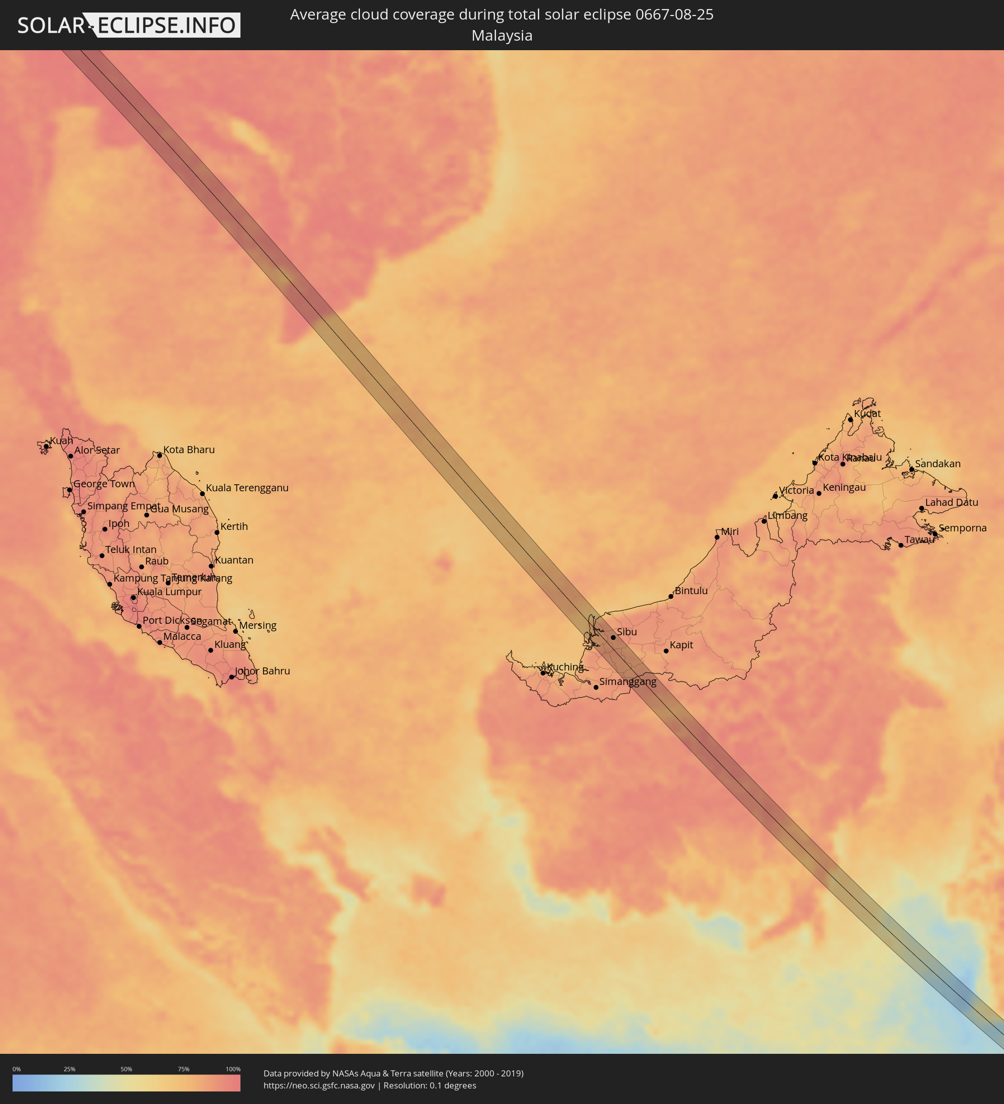 Malaysia
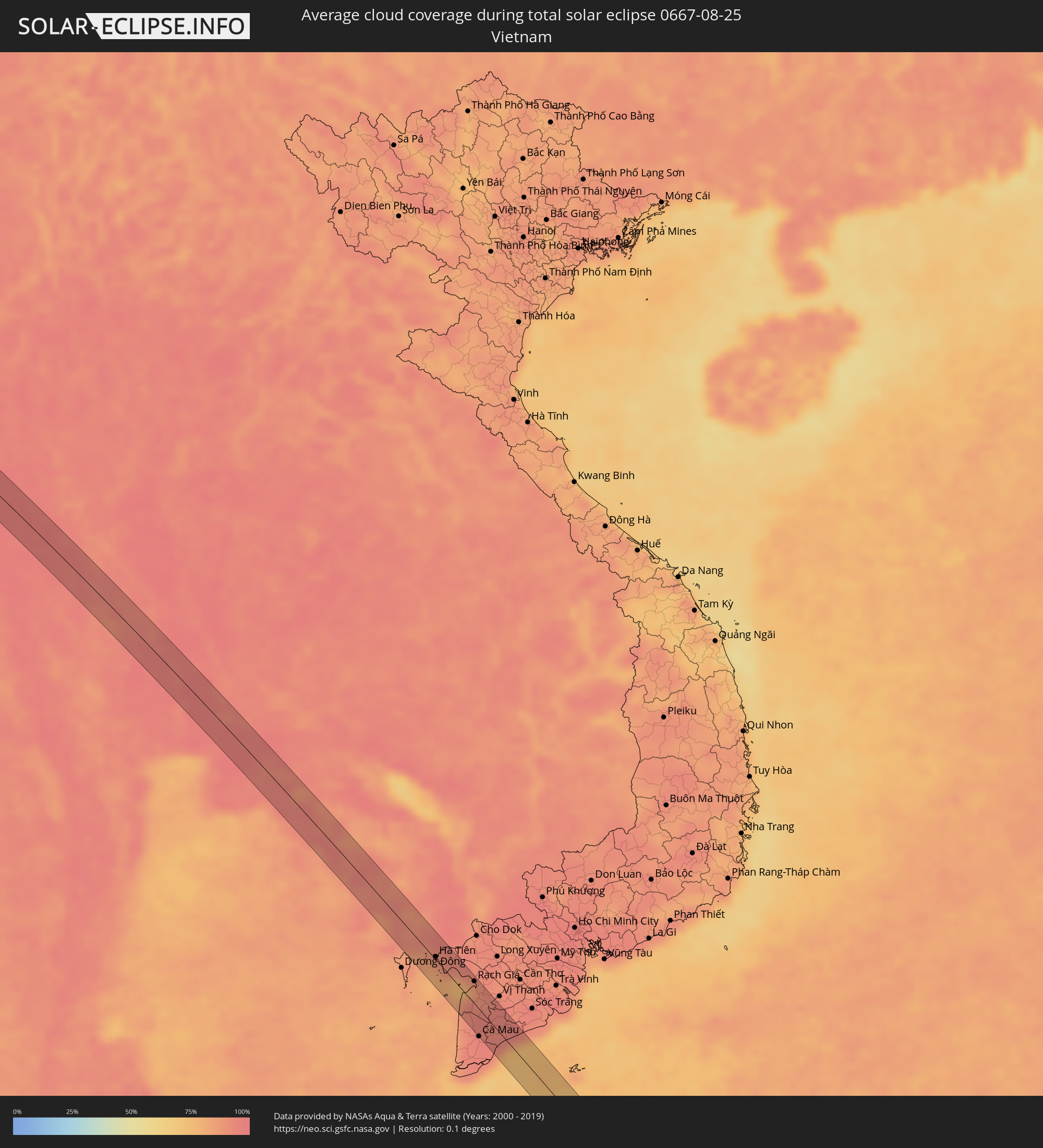 Vietnam
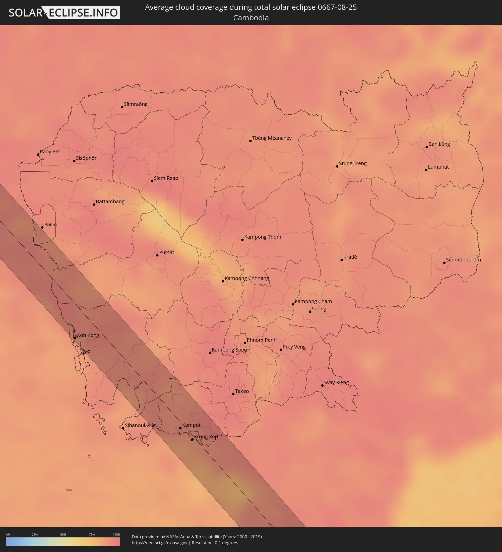 Kambodscha
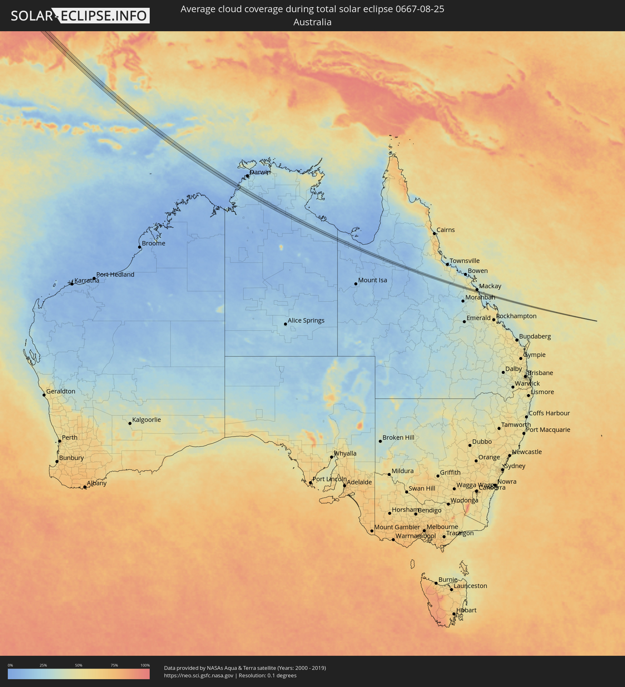 Australien
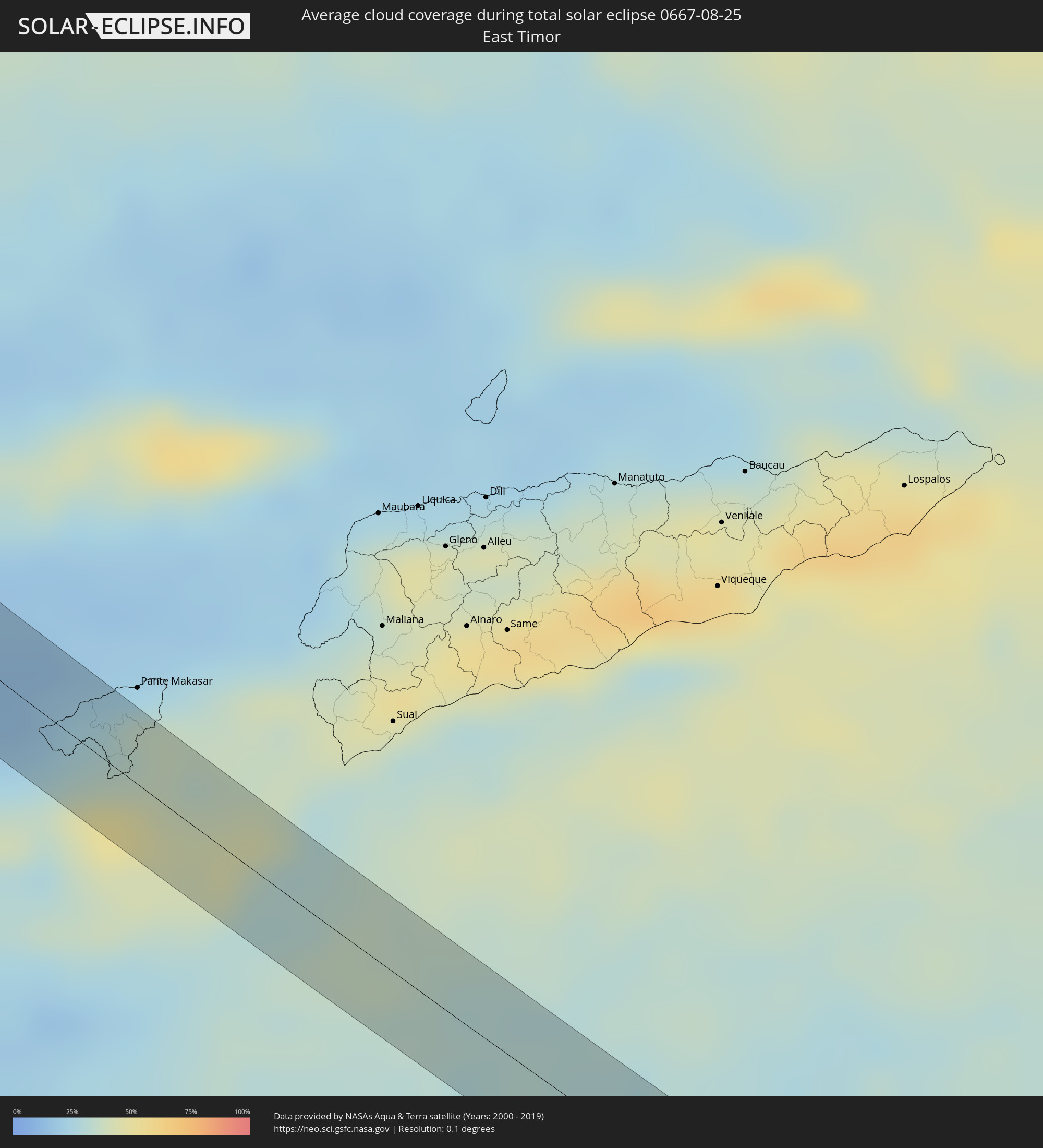 Osttimor
Orte im Finsternispfad
Die nachfolgene Tabelle zeigt Städte und Orte mit mehr als 5.000 Einwohnern, die sich im Finsternispfad befinden. Städte mit mehr als 100.000 Einwohnern sind dick gekennzeichnet. Mit einem Klick auf den Ort öffnet sich eine Detailkarte die die Lage des jeweiligen Ortes zusammen mit dem Verlauf der zentralen Finsternis präsentiert.
| Ort | Typ | Dauer der Verfinsterung | Ortszeit bei maximaler Verfinsterung | Entfernung zur Zentrallinie | Ø Bewölkung |
|
Aţ Ţafīlah, Tafielah
|
total | - | 05:55:28 UTC+02:23 | 2 km | 0% |
|
Ash Shāmīyah, Al Qādisīyah
|
total | - | 06:31:31 UTC+02:57 | 2 km | 3% |
|
Ad Dīwānīyah, Al Qādisīyah
|
total | - | 06:31:39 UTC+02:57 | 2 km | 3% |
|
‘Afak, Al Qādisīyah
|
total | - | 06:31:47 UTC+02:57 | 7 km | 2% |
|
Shūsh, Khuzestan
|
total | - | 07:01:12 UTC+03:25 | 2 km | 2% |
|
Fārsān, Chahār Maḩāll va Bakhtīārī
|
total | - | 07:02:24 UTC+03:25 | 7 km | 8% |
|
Shahr-e Kord, Chahār Maḩāll va Bakhtīārī
|
total | - | 07:02:35 UTC+03:25 | 1 km | 7% |
|
Farrokh Shahr, Chahār Maḩāll va Bakhtīārī
|
total | - | 07:02:38 UTC+03:25 | 7 km | 7% |
|
Ardakān, Yazd
|
total | - | 07:04:32 UTC+03:25 | 9 km | 3% |
|
Gereshk, Helmand
|
total | - | 07:48:03 UTC+04:00 | 2 km | 2% |
|
Kandahār, Kandahar
|
total | - | 07:49:20 UTC+04:00 | 10 km | 1% |
|
Kot Sultan, Punjab
|
total | - | 08:24:13 UTC+04:28 | 8 km | 56% |
|
Layyah, Punjab
|
total | - | 08:24:09 UTC+04:28 | 13 km | 55% |
|
Ahmadpur Siāl, Punjab
|
total | - | 08:25:22 UTC+04:28 | 0 km | 50% |
|
Sarāi Sidhu, Punjab
|
total | - | 08:25:42 UTC+04:28 | 3 km | 54% |
|
Talamba, Punjab
|
total | - | 08:26:06 UTC+04:28 | 4 km | 56% |
|
Miān Channūn, Punjab
|
total | - | 08:26:18 UTC+04:28 | 11 km | 58% |
|
Chīchāwatni, Punjab
|
total | - | 08:26:45 UTC+04:28 | 8 km | 59% |
|
Hasan Abdāl, Punjab
|
total | - | 08:26:48 UTC+04:28 | 3 km | 60% |
|
Kamīr, Punjab
|
total | - | 08:27:17 UTC+04:28 | 6 km | 60% |
|
Ārifwāla, Punjab
|
total | - | 08:27:23 UTC+04:28 | 8 km | 57% |
|
Pākpattan, Punjab
|
total | - | 08:27:49 UTC+04:28 | 5 km | 60% |
|
Minchinābād, Punjab
|
total | - | 08:28:10 UTC+04:28 | 10 km | 57% |
|
Jīnd, Haryana
|
total | - | 09:25:46 UTC+05:21 | 20 km | 75% |
|
Pānīpat, Haryana
|
total | - | 09:26:44 UTC+05:21 | 8 km | 77% |
|
Meerut, Uttar Pradesh
|
total | - | 09:28:12 UTC+05:21 | 10 km | 82% |
|
Amroha, Uttar Pradesh
|
total | - | 09:29:30 UTC+05:21 | 8 km | 86% |
|
Sambhal, Uttar Pradesh
|
total | - | 09:29:55 UTC+05:21 | 22 km | 86% |
|
Morādābād, Uttar Pradesh
|
total | - | 09:30:03 UTC+05:21 | 12 km | 84% |
|
Rāmpur, Uttar Pradesh
|
total | - | 09:30:30 UTC+05:21 | 18 km | 84% |
|
Bareilly, Uttar Pradesh
|
total | - | 09:31:32 UTC+05:21 | 16 km | 85% |
|
Lakhīmpur, Uttar Pradesh
|
total | - | 09:34:12 UTC+05:21 | 4 km | 85% |
|
Bahraigh, Uttar Pradesh
|
total | - | 09:35:58 UTC+05:21 | 9 km | 88% |
|
Gorakhpur, Uttar Pradesh
|
total | - | 09:39:59 UTC+05:21 | 14 km | 90% |
|
Muzaffarpur, Bihar
|
total | - | 09:44:27 UTC+05:21 | 17 km | 95% |
|
Monghyr, Bihar
|
total | - | 09:47:27 UTC+05:21 | 1 km | 93% |
|
Bhāgalpur, Bihar
|
total | - | 09:48:34 UTC+05:21 | 12 km | 96% |
|
Baharampur, West Bengal
|
total | - | 09:52:39 UTC+05:21 | 27 km | 97% |
|
Nawābganj, Rājshāhi
|
total | - | 10:24:09 UTC+05:53 | 20 km | 92% |
|
Rājshāhi, Rājshāhi
|
total | - | 10:25:06 UTC+05:53 | 18 km | 96% |
|
Ishurdi, Rājshāhi
|
total | - | 10:26:22 UTC+05:53 | 21 km | 95% |
|
Kushtia, Khulna
|
total | - | 10:26:49 UTC+05:53 | 3 km | 97% |
|
Pābna, Rājshāhi
|
total | - | 10:26:53 UTC+05:53 | 19 km | 95% |
|
Farīdpur, Dhaka
|
total | - | 10:28:41 UTC+05:53 | 17 km | 96% |
|
Mādārīpur, Dhaka
|
total | - | 10:30:06 UTC+05:53 | 1 km | 93% |
|
Pālang, Dhaka
|
total | - | 10:30:18 UTC+05:53 | 11 km | 94% |
|
Bhola, Barisāl
|
total | - | 10:31:44 UTC+05:53 | 19 km | 94% |
|
Rāipur, Chittagong
|
total | - | 10:31:25 UTC+05:53 | 20 km | 96% |
|
Lakshmīpur, Chittagong
|
total | - | 10:31:42 UTC+05:53 | 15 km | 94% |
|
Sandwīp, Chittagong
|
total | - | 10:33:39 UTC+05:53 | 15 km | 94% |
|
Chittagong, Chittagong
|
total | - | 10:34:42 UTC+05:53 | 22 km | 91% |
|
Patiya, Chittagong
|
total | - | 10:35:04 UTC+05:53 | 28 km | 95% |
|
Sātkania, Chittagong
|
total | - | 10:35:35 UTC+05:53 | 13 km | 94% |
|
Thayetmyo, Magway
|
total | - | 11:18:24 UTC+06:24 | 17 km | 93% |
|
Myaydo, Magway
|
total | - | 11:18:22 UTC+06:24 | 11 km | 94% |
|
Pyu, Bago
|
total | - | 11:22:36 UTC+06:24 | 2 km | 96% |
|
Nyaunglebin, Bago
|
total | - | 11:24:14 UTC+06:24 | 21 km | 95% |
|
Myawadi, Kayin
|
total | - | 11:30:28 UTC+06:24 | 9 km | 97% |
|
Mae Sot, Tak
|
total | - | 11:47:49 UTC+06:42 | 15 km | 97% |
|
Uthai Thani, Uthai Thani
|
total | - | 11:53:35 UTC+06:42 | 22 km | 93% |
|
Phak Hai, Phra Nakhon Si Ayutthaya
|
total | - | 11:56:15 UTC+06:42 | 22 km | 96% |
|
Sing Buri, Sing Buri
|
total | - | 11:55:24 UTC+06:42 | 13 km | 94% |
|
Phra Nakhon Si Ayutthaya, Phra Nakhon Si Ayutthaya
|
total | - | 11:56:54 UTC+06:42 | 14 km | 95% |
|
Khlong Luang, Pathum Thani
|
partiell | - | 11:57:40 UTC+06:42 | 31 km | 94% |
|
Lop Buri, Lop Buri
|
total | - | 11:56:06 UTC+06:42 | 26 km | 96% |
|
Ban Lam Luk Ka, Pathum Thani
|
total | - | 11:58:07 UTC+06:42 | 27 km | 96% |
|
Nong Khae, Sara Buri
|
total | - | 11:57:31 UTC+06:42 | 8 km | 96% |
|
Saraburi, Sara Buri
|
total | - | 11:57:12 UTC+06:42 | 26 km | 97% |
|
Chachoengsao, Chachoengsao
|
total | - | 11:59:20 UTC+06:42 | 26 km | 95% |
|
Nakhon Nayok, Nakhon Nayok
|
total | - | 11:58:30 UTC+06:42 | 24 km | 92% |
|
Prachin Buri, Prachin Buri
|
total | - | 11:59:09 UTC+06:42 | 25 km | 95% |
|
Chanthaburi, Chanthaburi
|
total | - | 12:03:46 UTC+06:42 | 25 km | 93% |
|
Trat, Trat
|
total | - | 12:05:23 UTC+06:42 | 20 km | 89% |
|
Koh Kong, Koh Kong
|
total | - | 12:07:42 UTC+06:42 | 29 km | 85% |
|
Smach Mean Chey, Koh Kong
|
total | - | 12:07:57 UTC+06:42 | 29 km | 85% |
|
Kampot, Kampot
|
total | - | 12:12:16 UTC+06:42 | 5 km | 85% |
|
Krong Kep, Kep
|
total | - | 12:12:48 UTC+06:42 | 3 km | 85% |
|
Hà Tiên, Kiến Giang
|
total | - | 12:37:58 UTC+07:06 | 3 km | 87% |
|
Rạch Giá, Kiến Giang
|
total | - | 12:39:55 UTC+07:06 | 25 km | 87% |
|
Cà Mau, Cà Mau
|
total | - | 12:41:55 UTC+07:06 | 30 km | 95% |
|
Thành phố Bạc Liêu, Bạc Liêu
|
total | - | 12:42:45 UTC+07:06 | 26 km | 92% |
|
Sarikei, Sarawak
|
total | - | 13:23:16 UTC+07:21 | 20 km | 88% |
|
Sibu, Sarawak
|
total | - | 13:23:23 UTC+07:21 | 18 km | 82% |
|
Galesong, South Sulawesi
|
total | - | 14:25:15 UTC+07:57 | 13 km | 37% |
|
Kefamenanu, East Nusa Tenggara
|
total | - | 14:37:43 UTC+07:57 | 13 km | 37% |
|
Katherine, Northern Territory
|
total | - | 16:23:18 UTC+09:30 | 6 km | 11% |