Totale Sonnenfinsternis vom 05.10.0693
| Wochentag: | Donnerstag |
| Maximale Dauer der Verfinsterung: | 04m30s |
| Maximale Breite des Finsternispfades: | 196 km |
| Saroszyklus: | 103 |
| Bedeckungsgrad: | 100% |
| Magnitude: | 1.0517 |
| Gamma: | 0.491 |
Wo kann man die Sonnenfinsternis vom 05.10.0693 sehen?
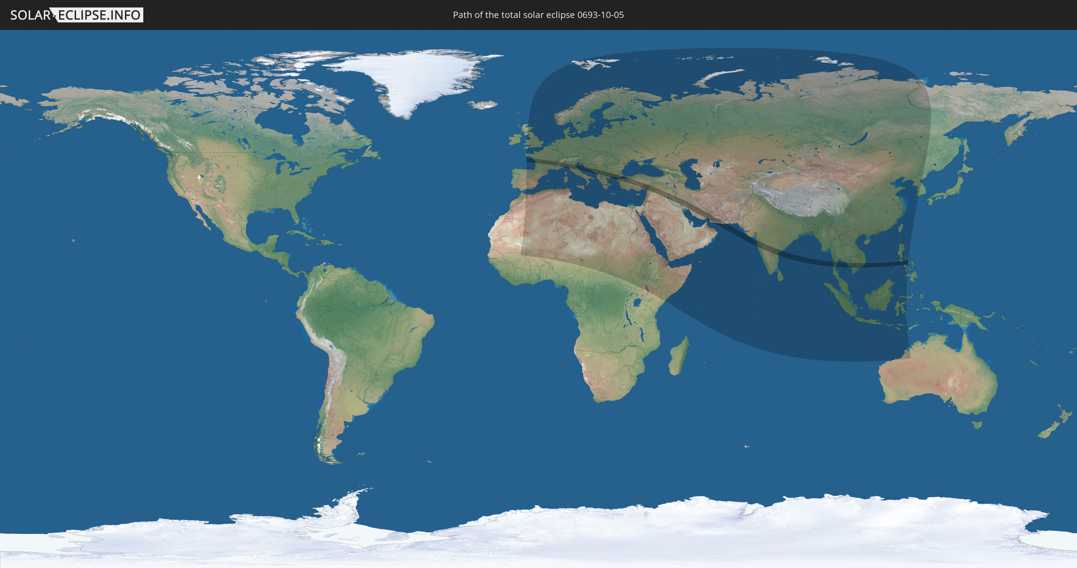
Die Sonnenfinsternis am 05.10.0693 kann man in 120 Ländern als partielle Sonnenfinsternis beobachten.
Der Finsternispfad verläuft durch 22 Länder. Nur in diesen Ländern ist sie als totale Sonnenfinsternis zu sehen.
In den folgenden Ländern ist die Sonnenfinsternis total zu sehen
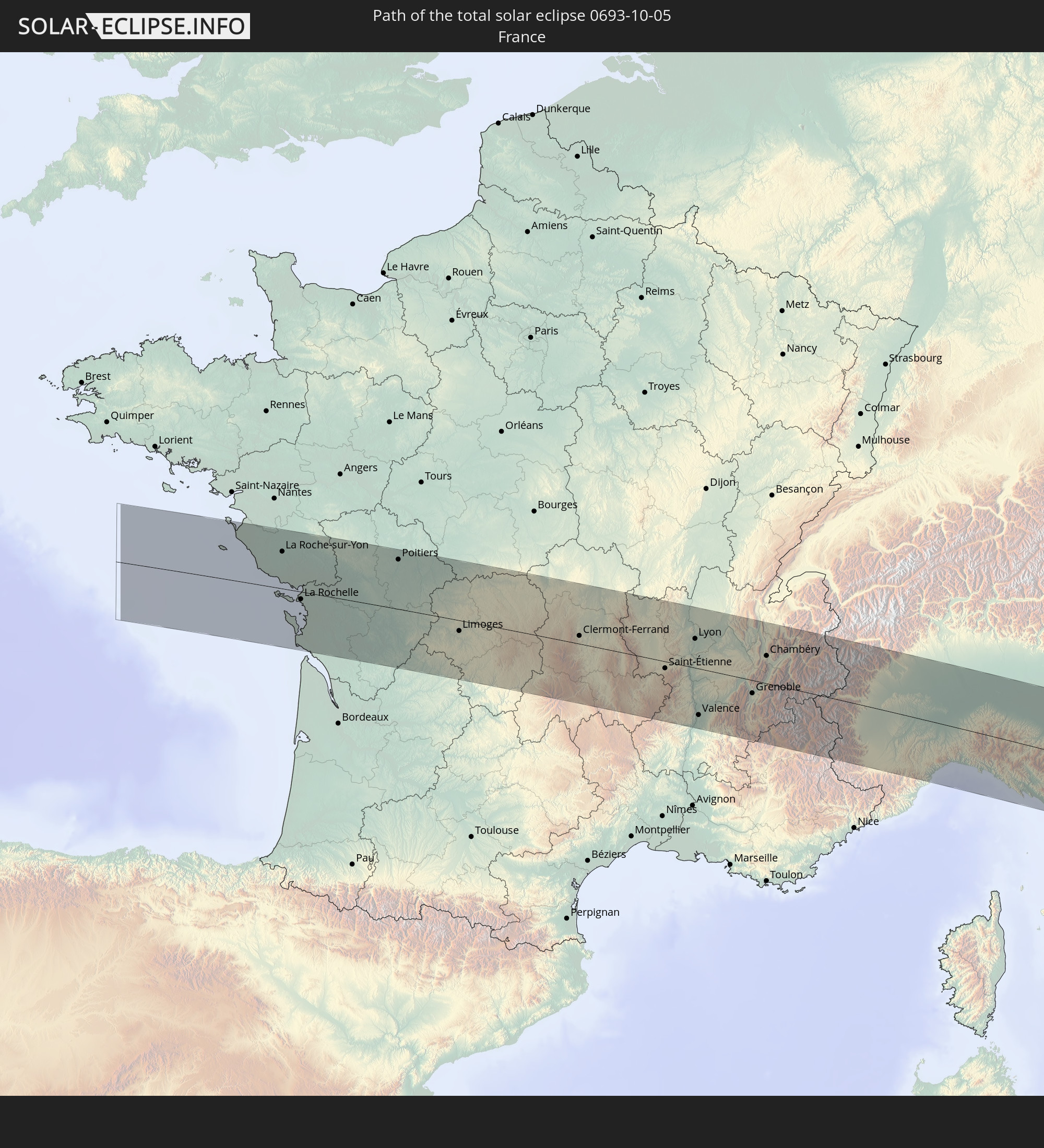 Frankreich
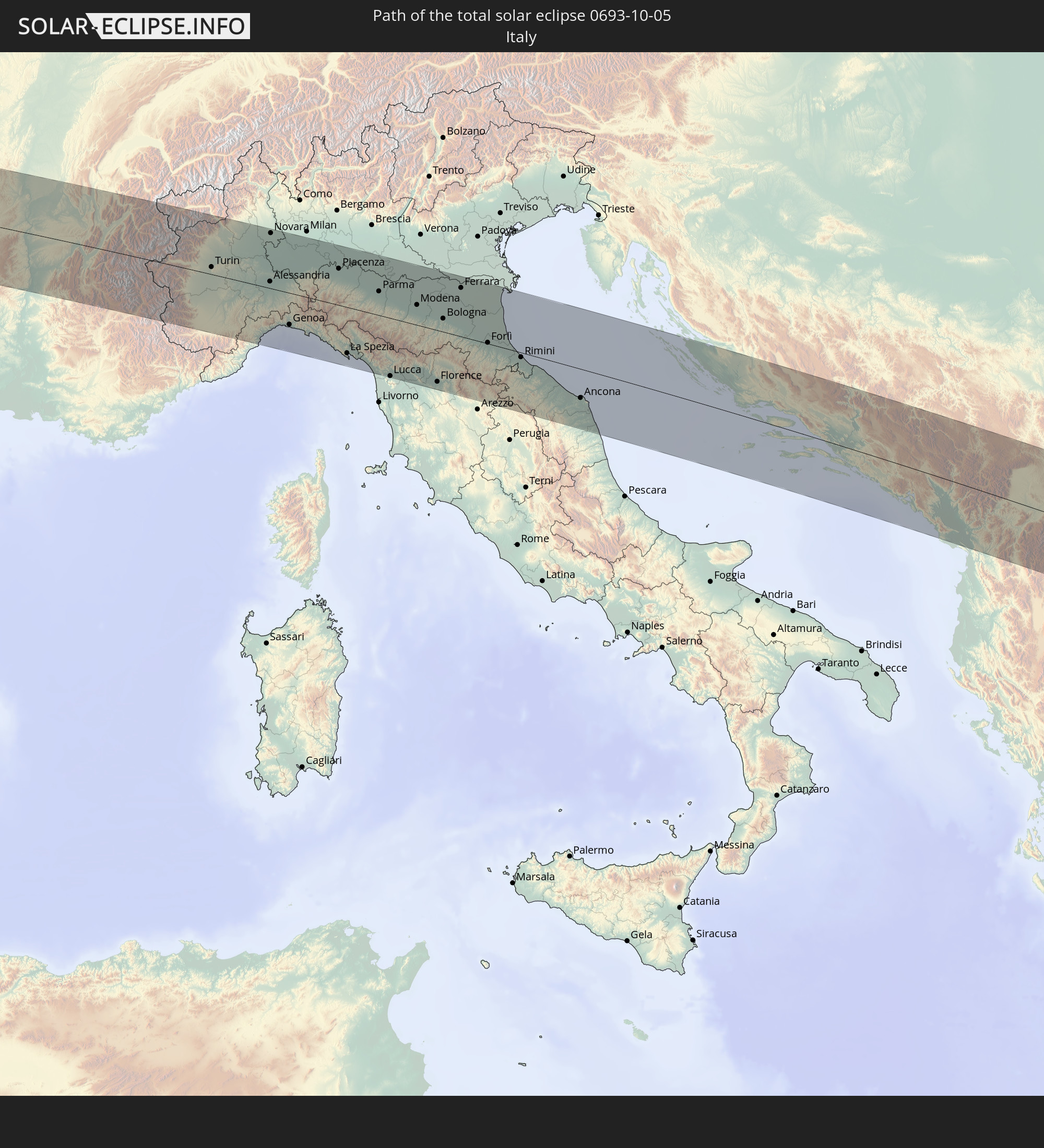 Italien
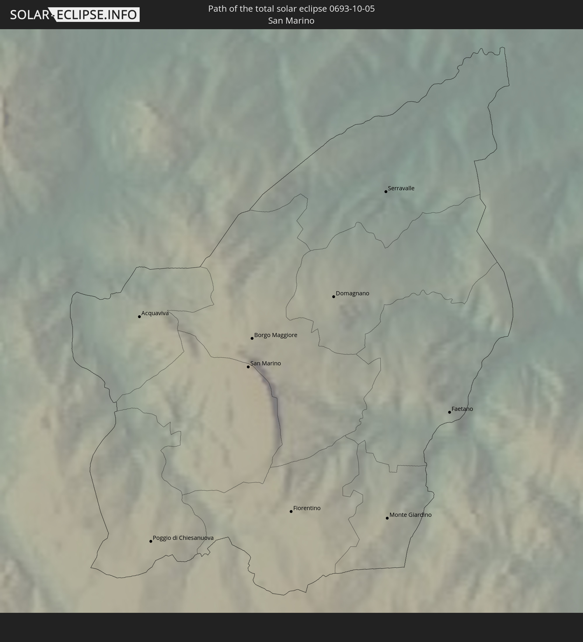 San Marino
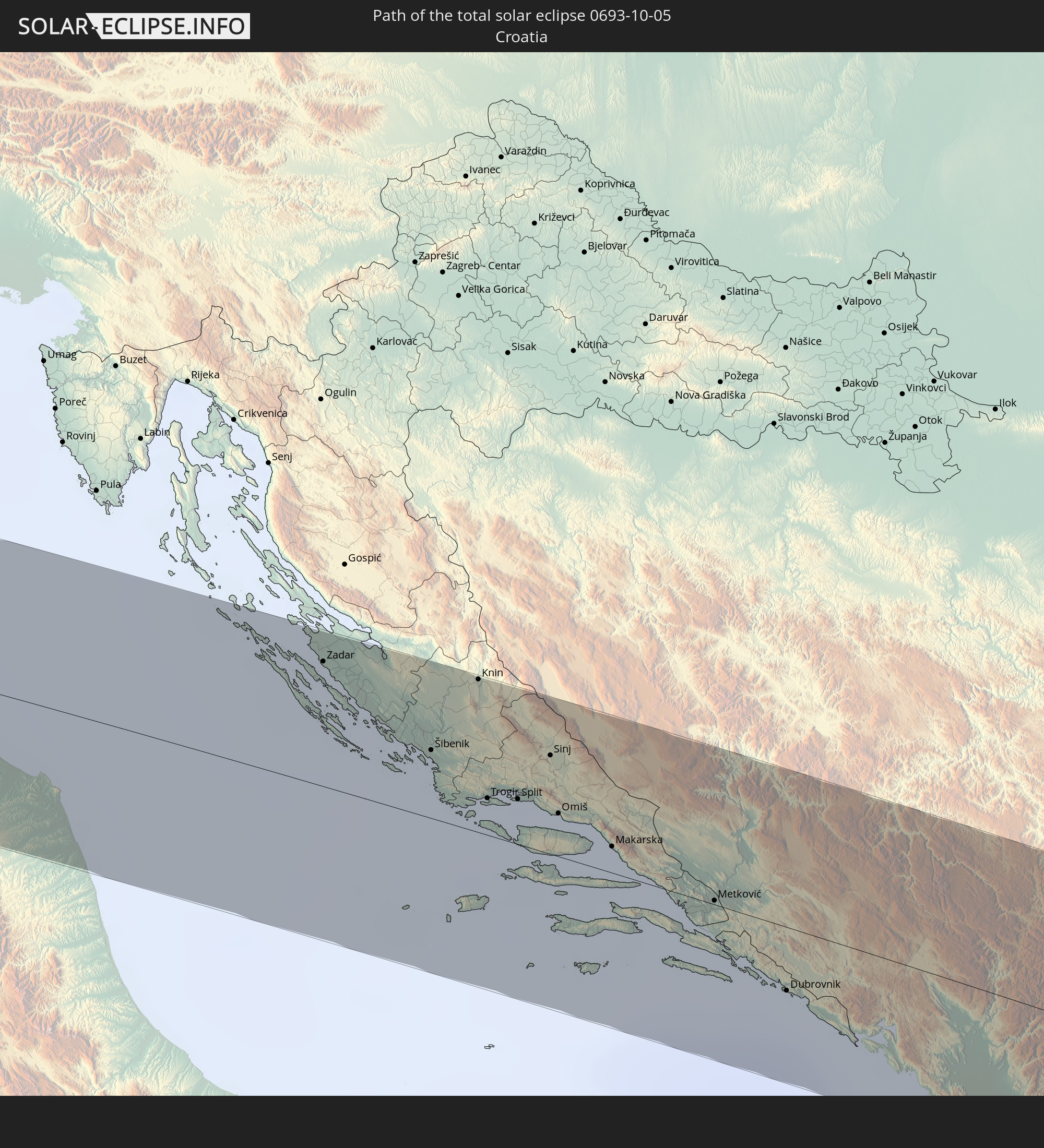 Kroatien
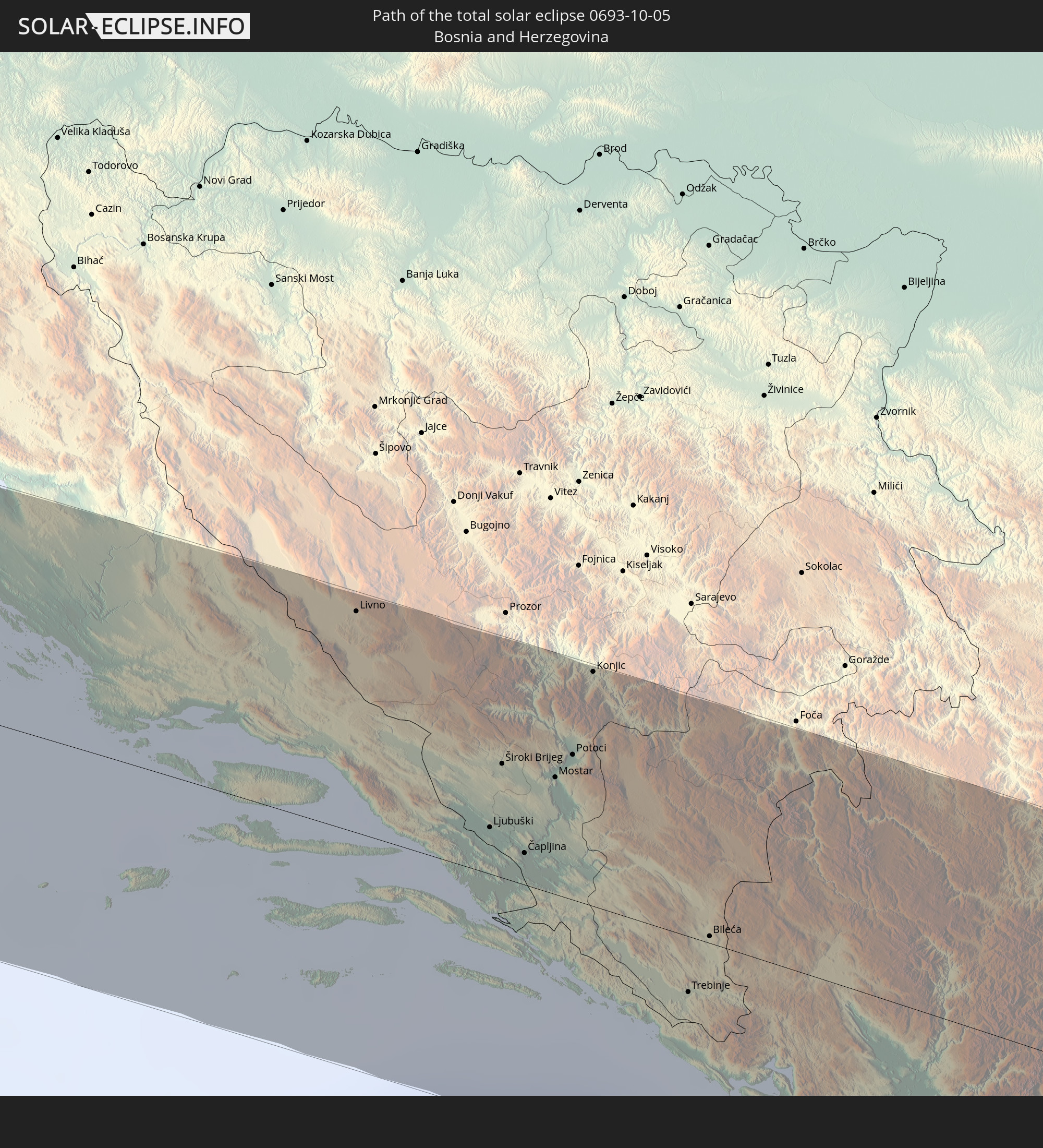 Bosnien und Herzegowina
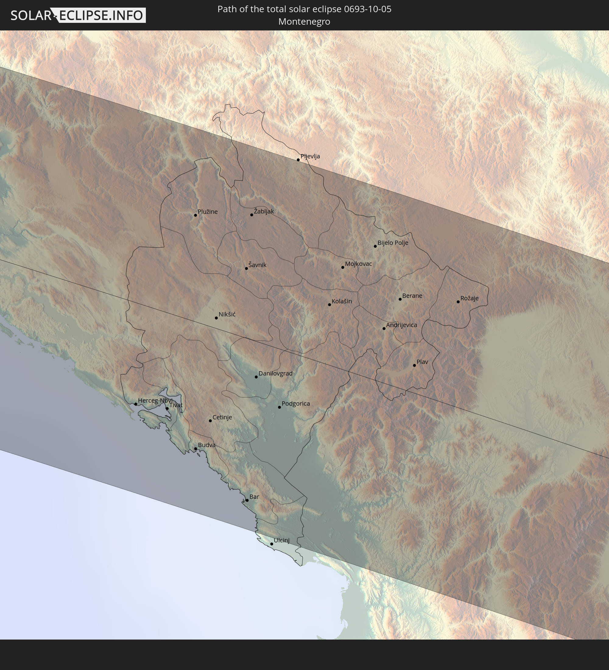 Montenegro
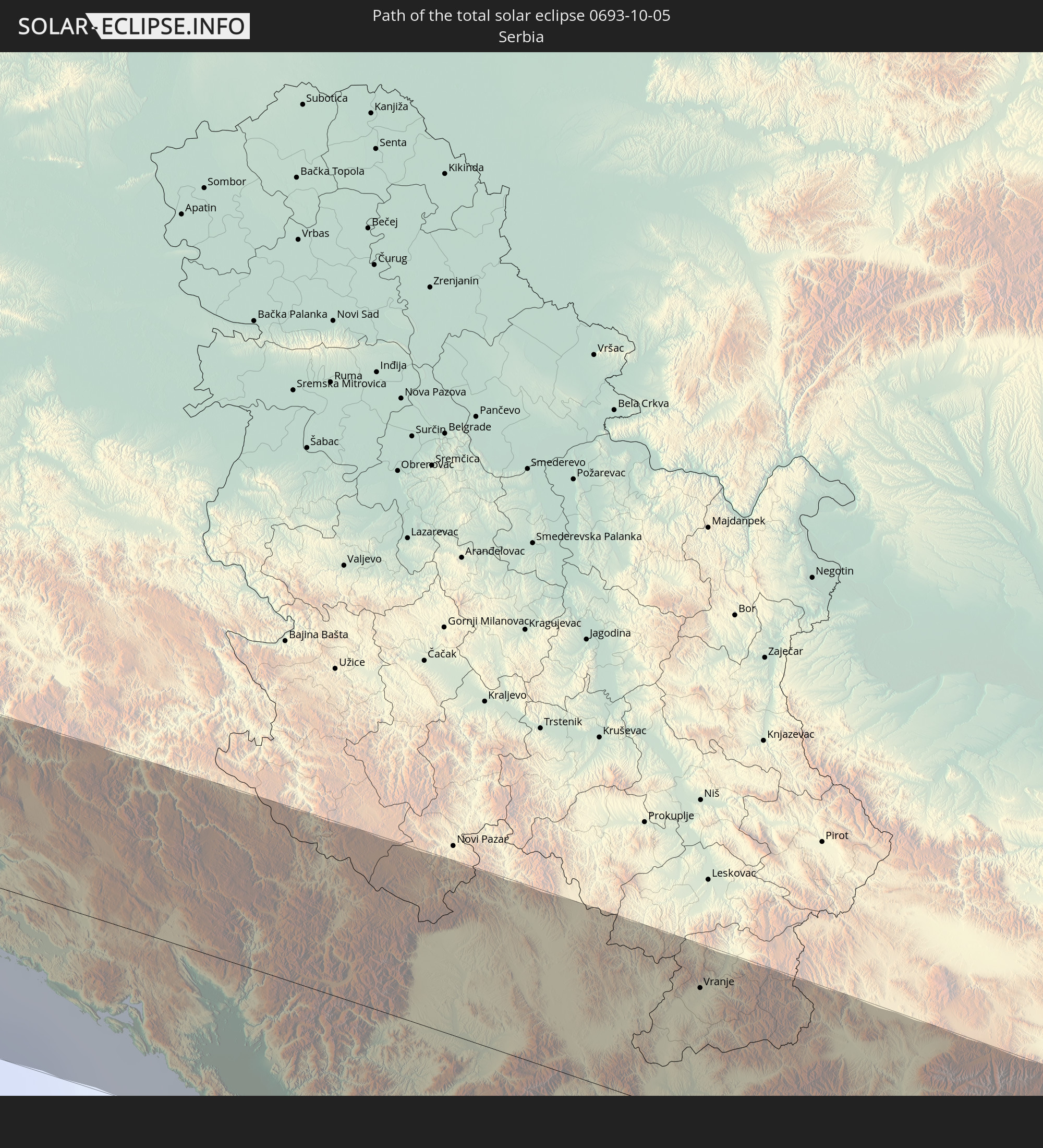 Serbien
 Albanien
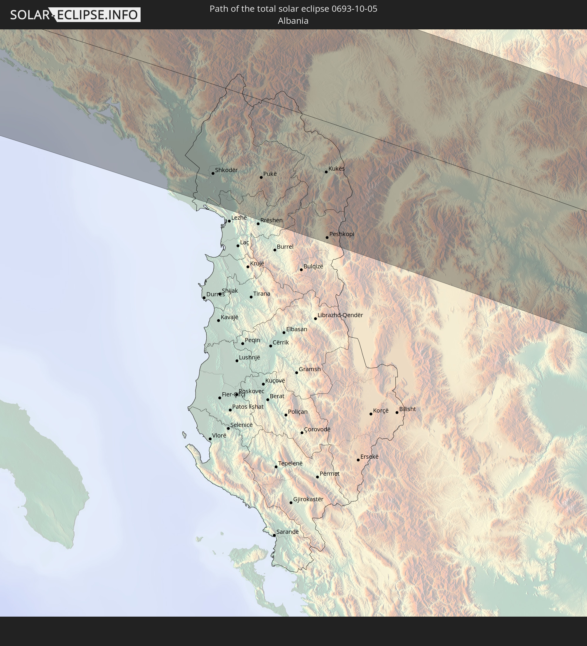
 Griechenland
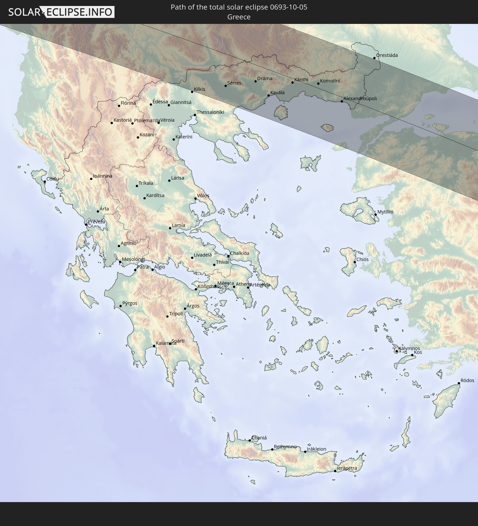
 Mazedonien
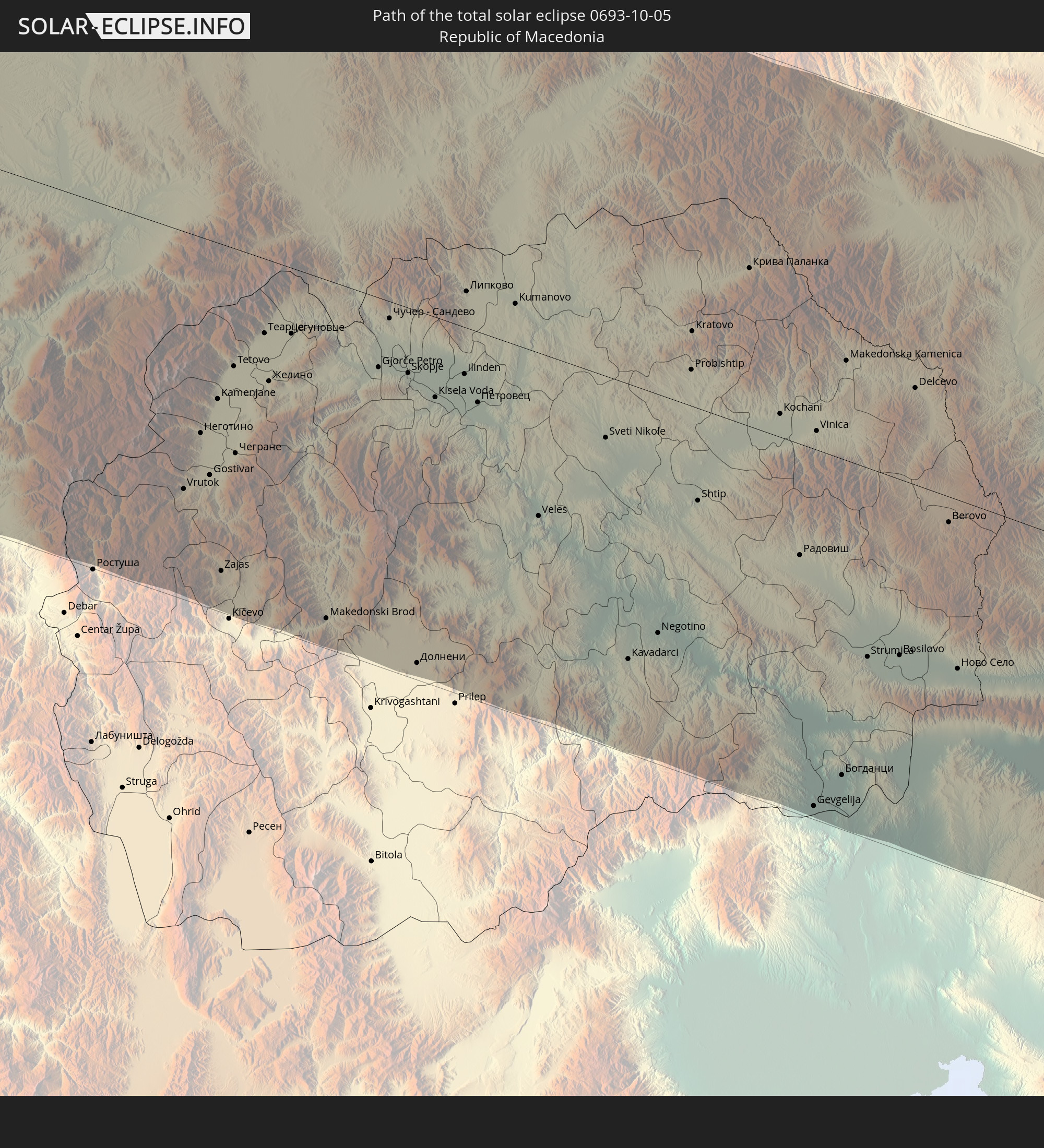
 Bulgarien
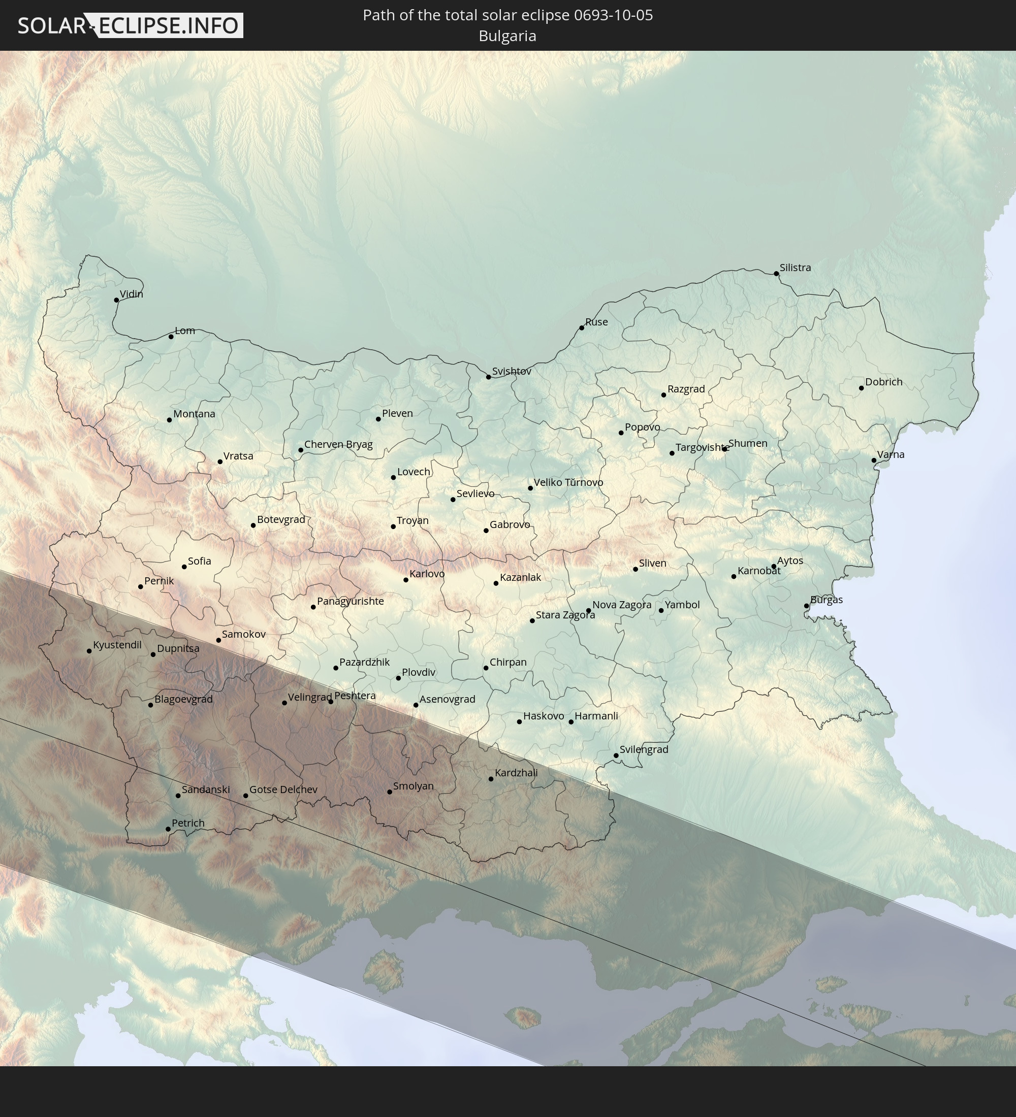
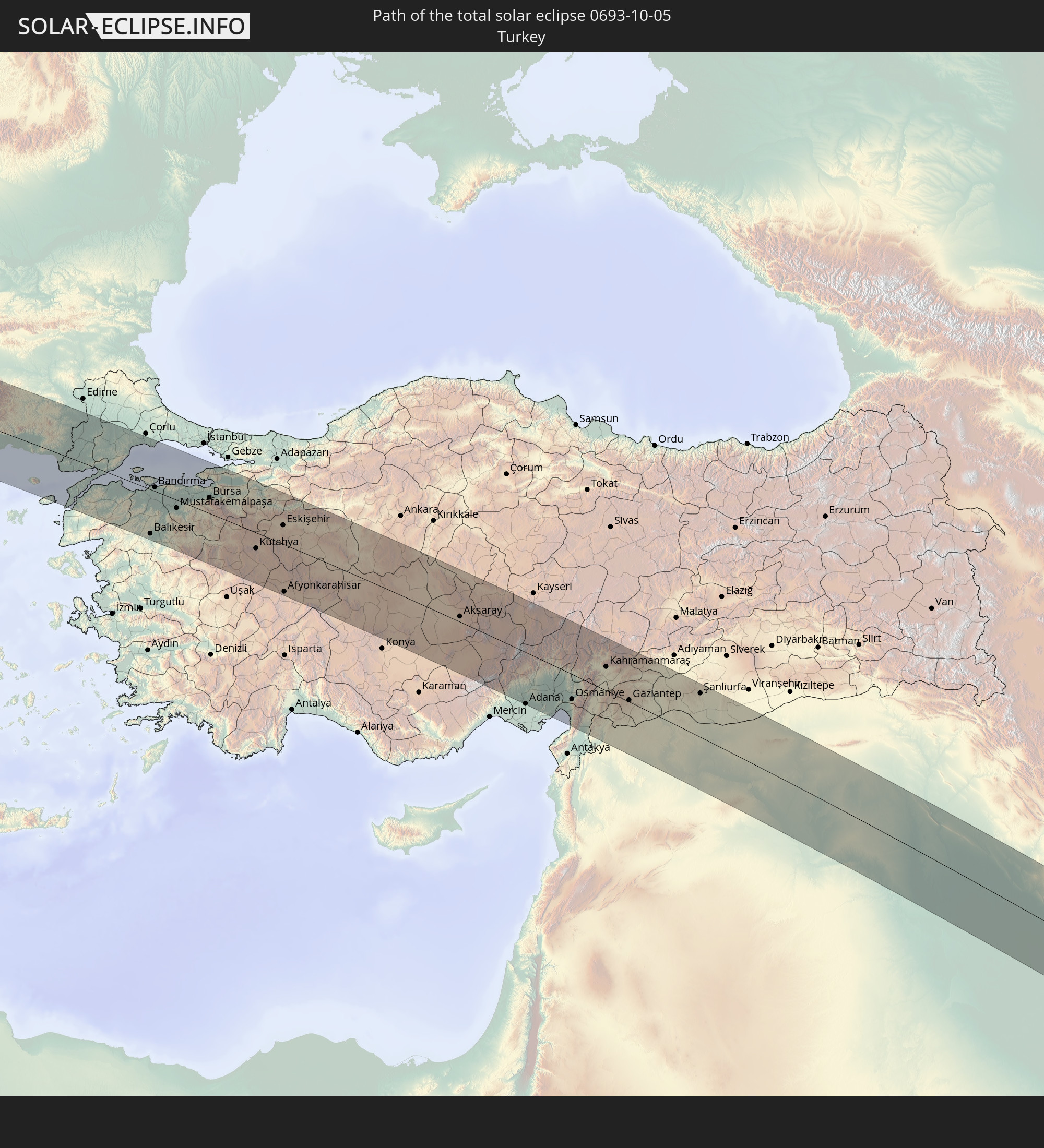 Türkei
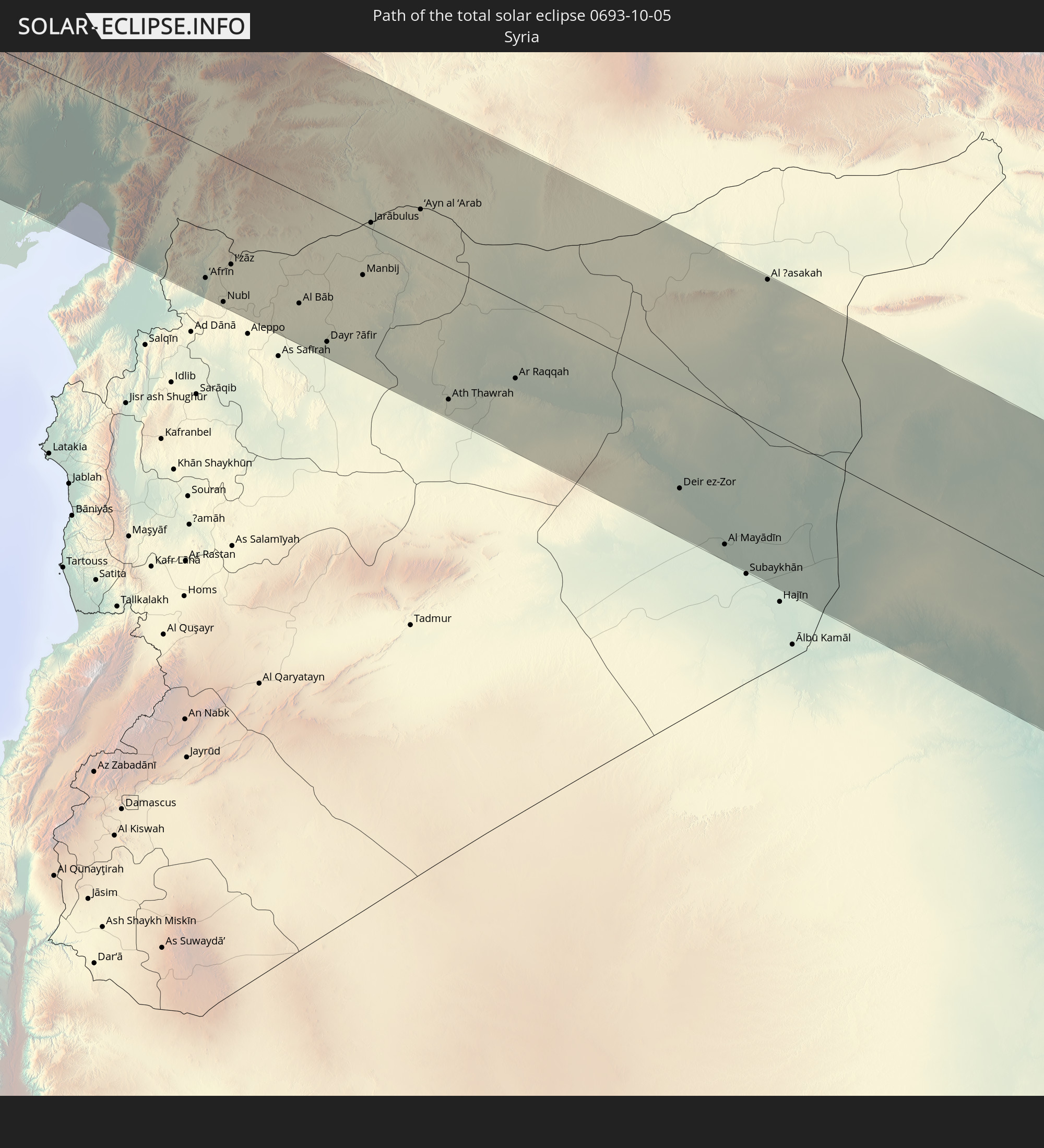 Syrien
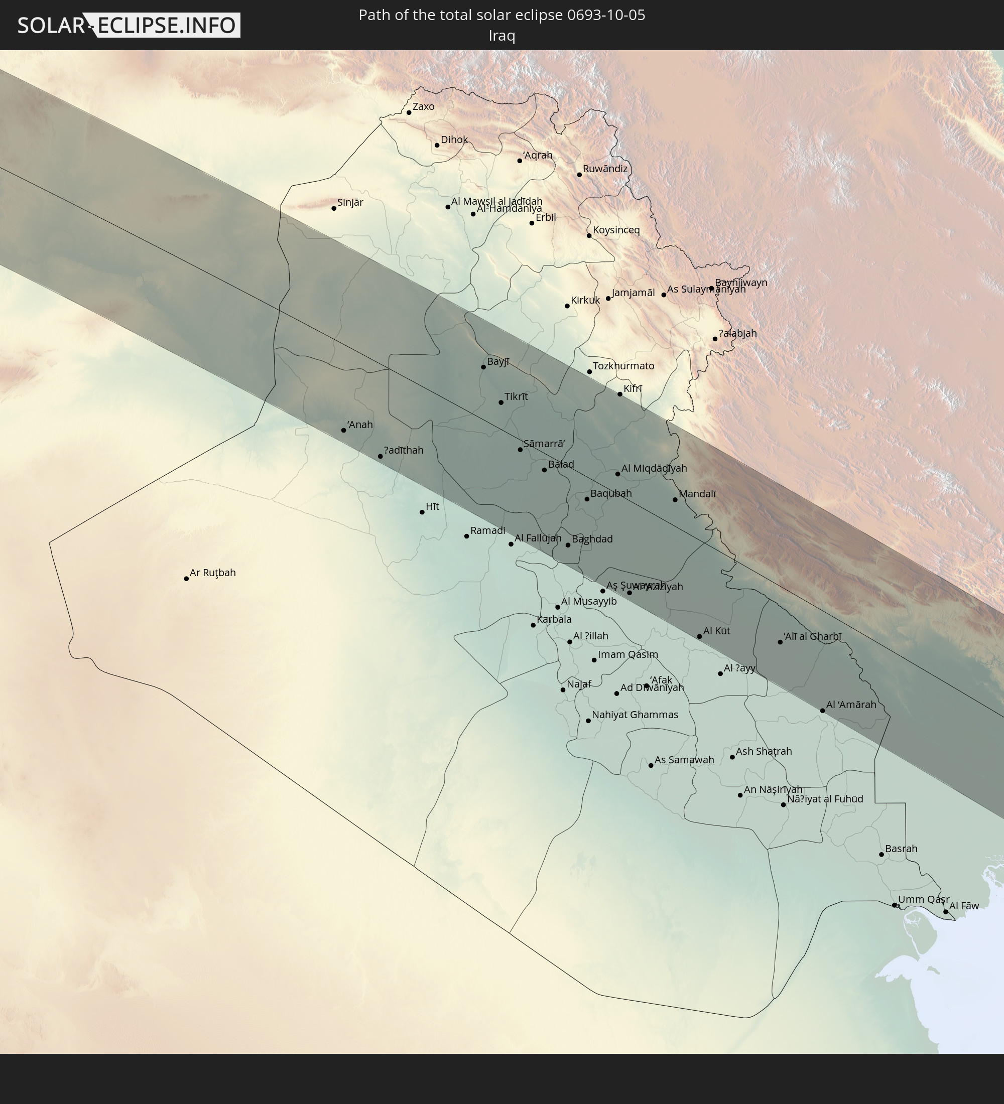 Irak
Irak
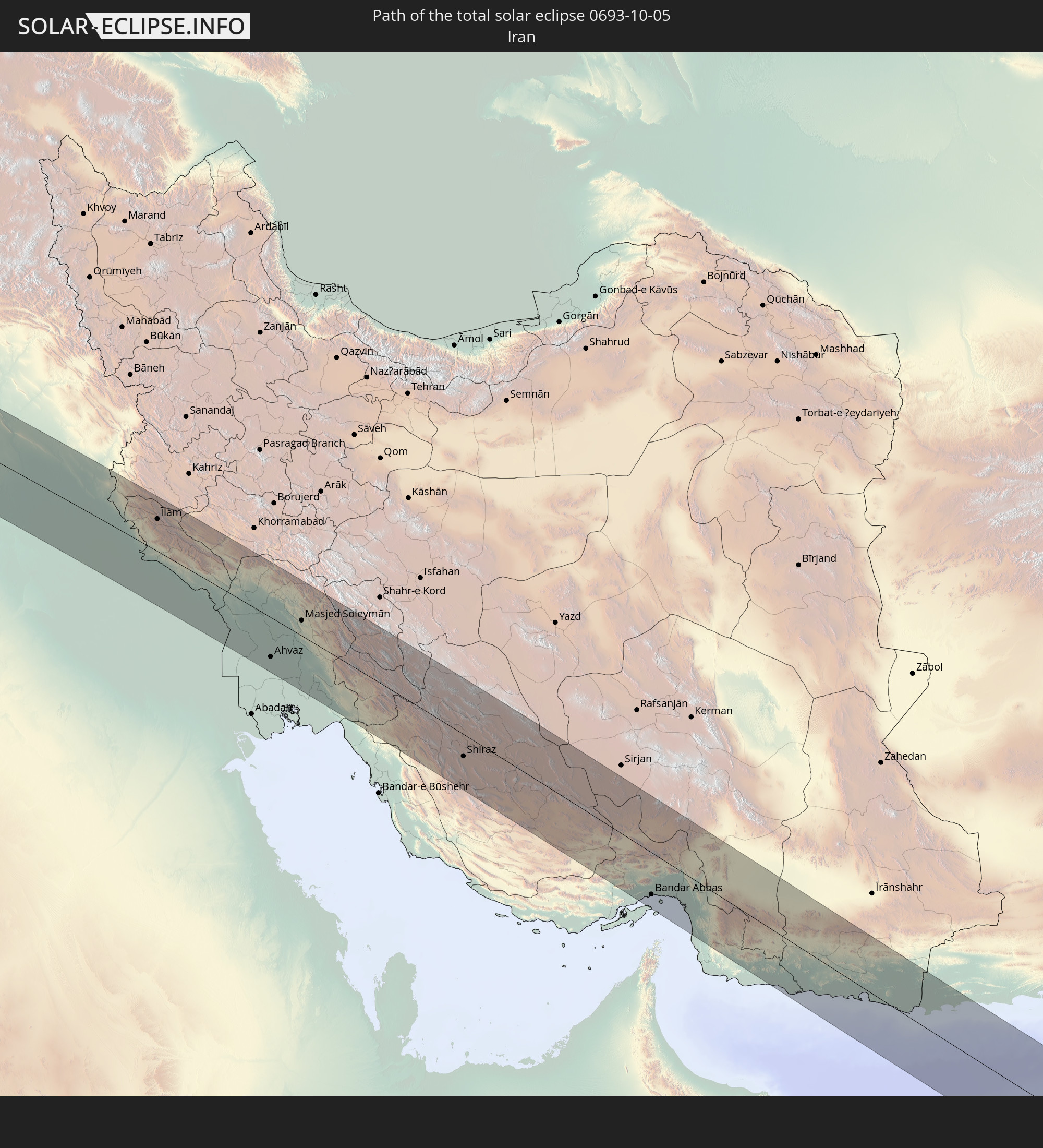 Iran
Iran
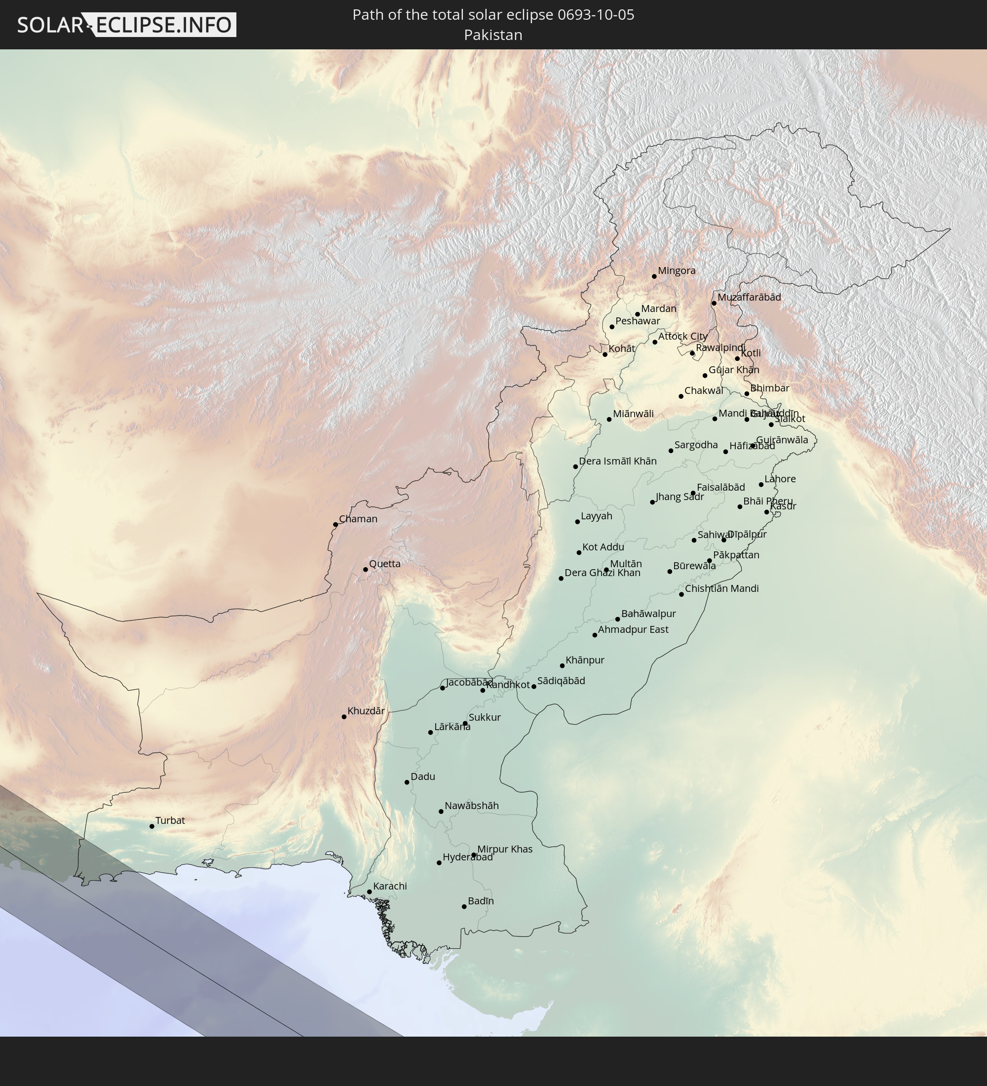 Pakistan
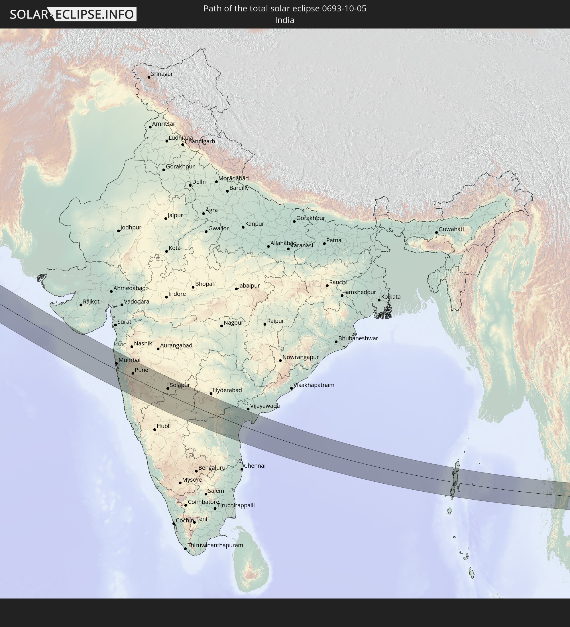 Indien
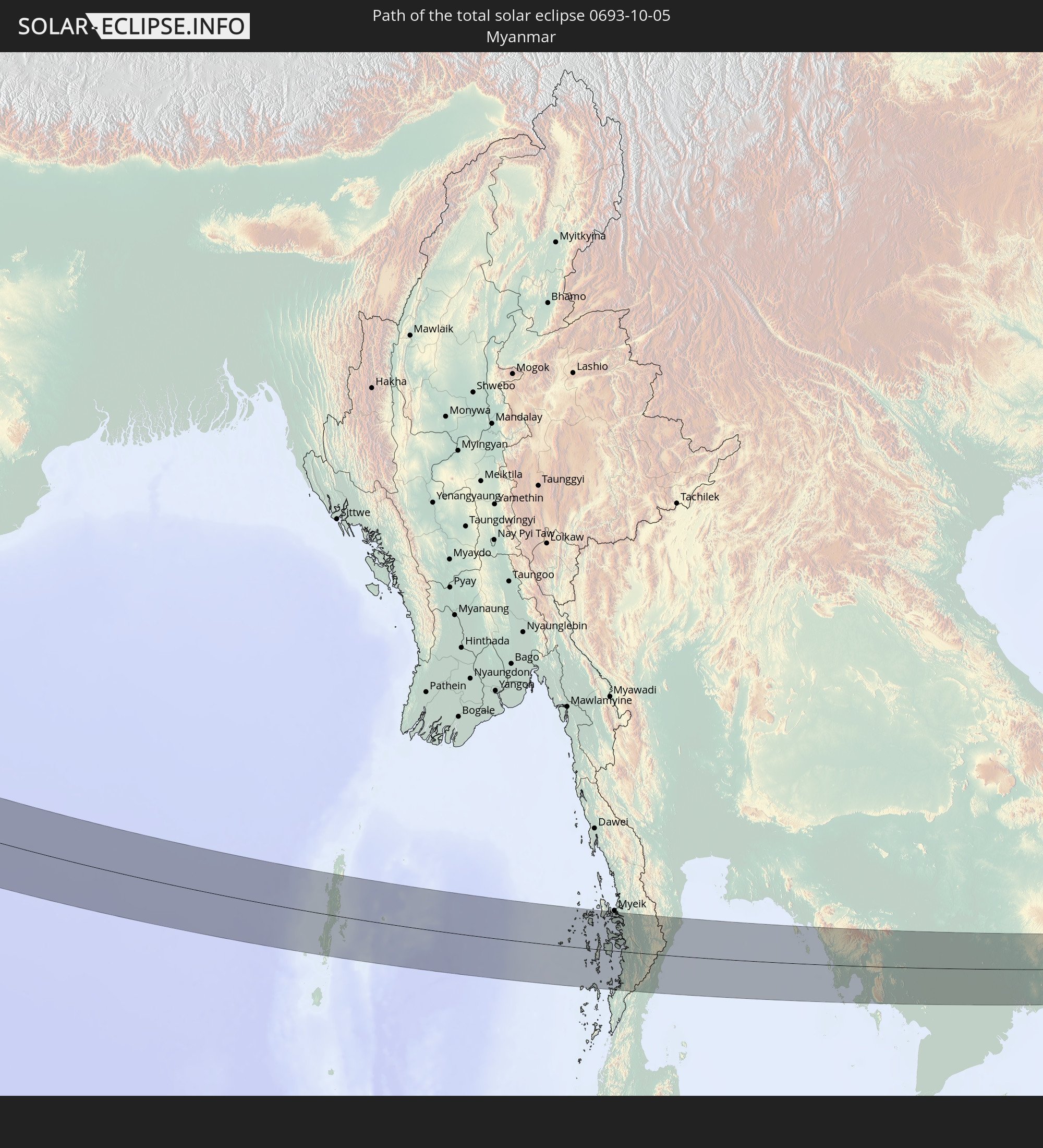 Myanmar
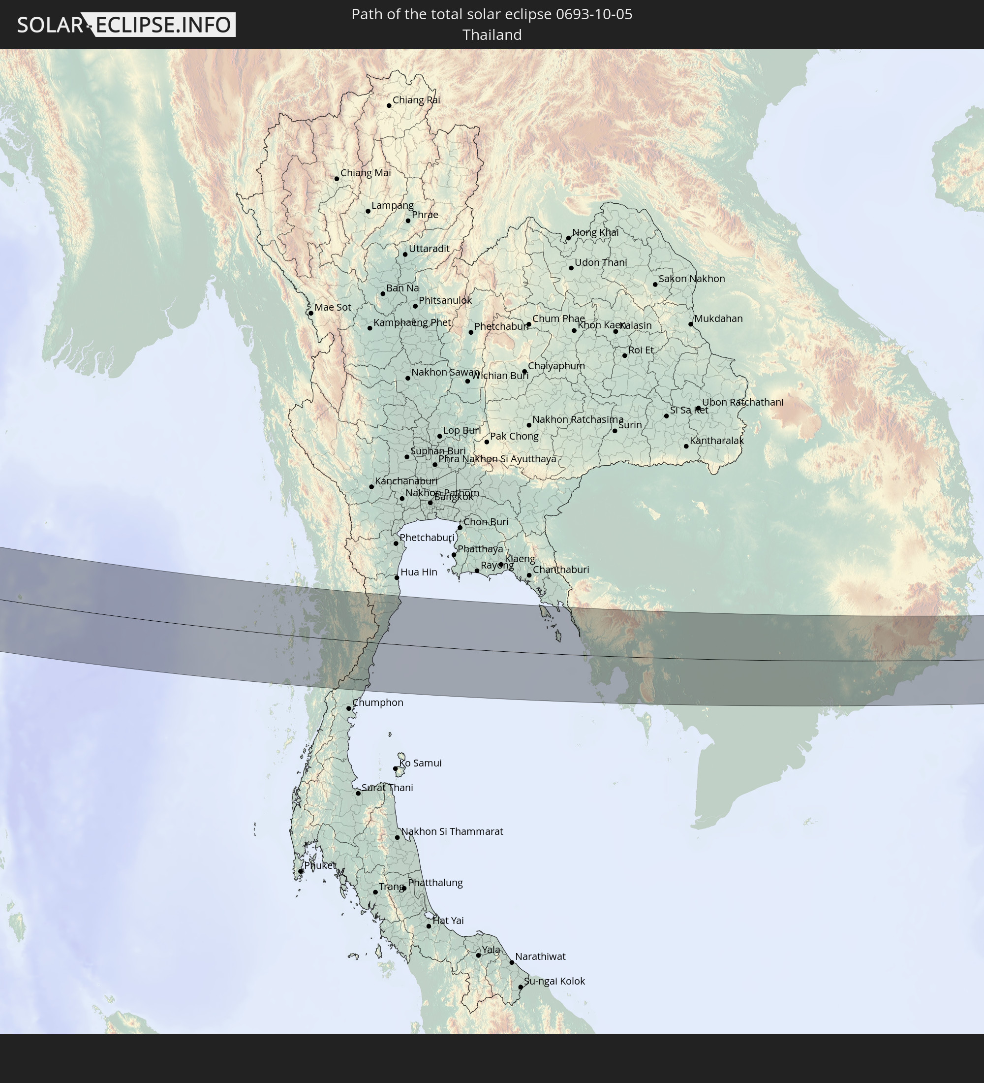 Thailand
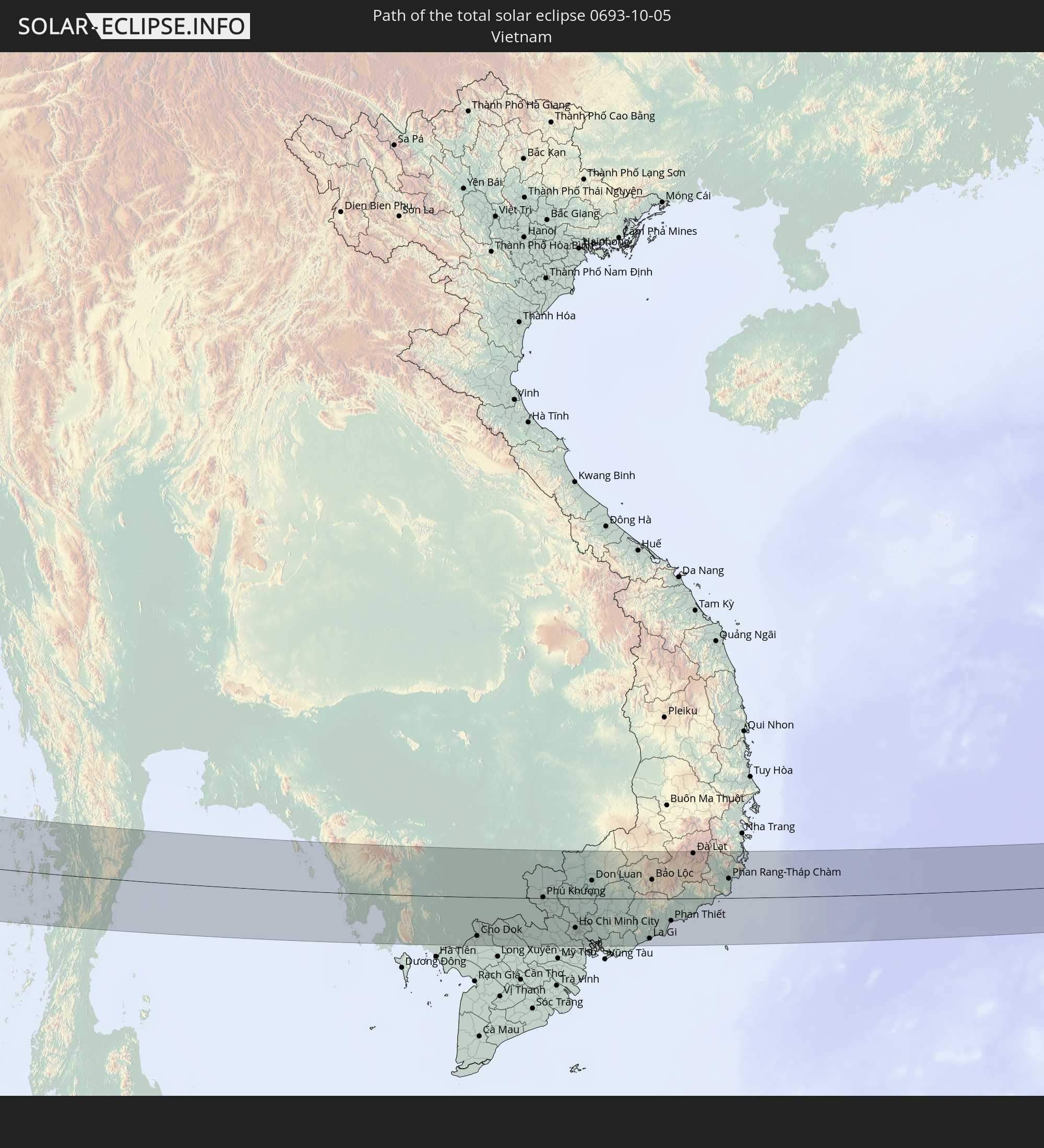 Vietnam
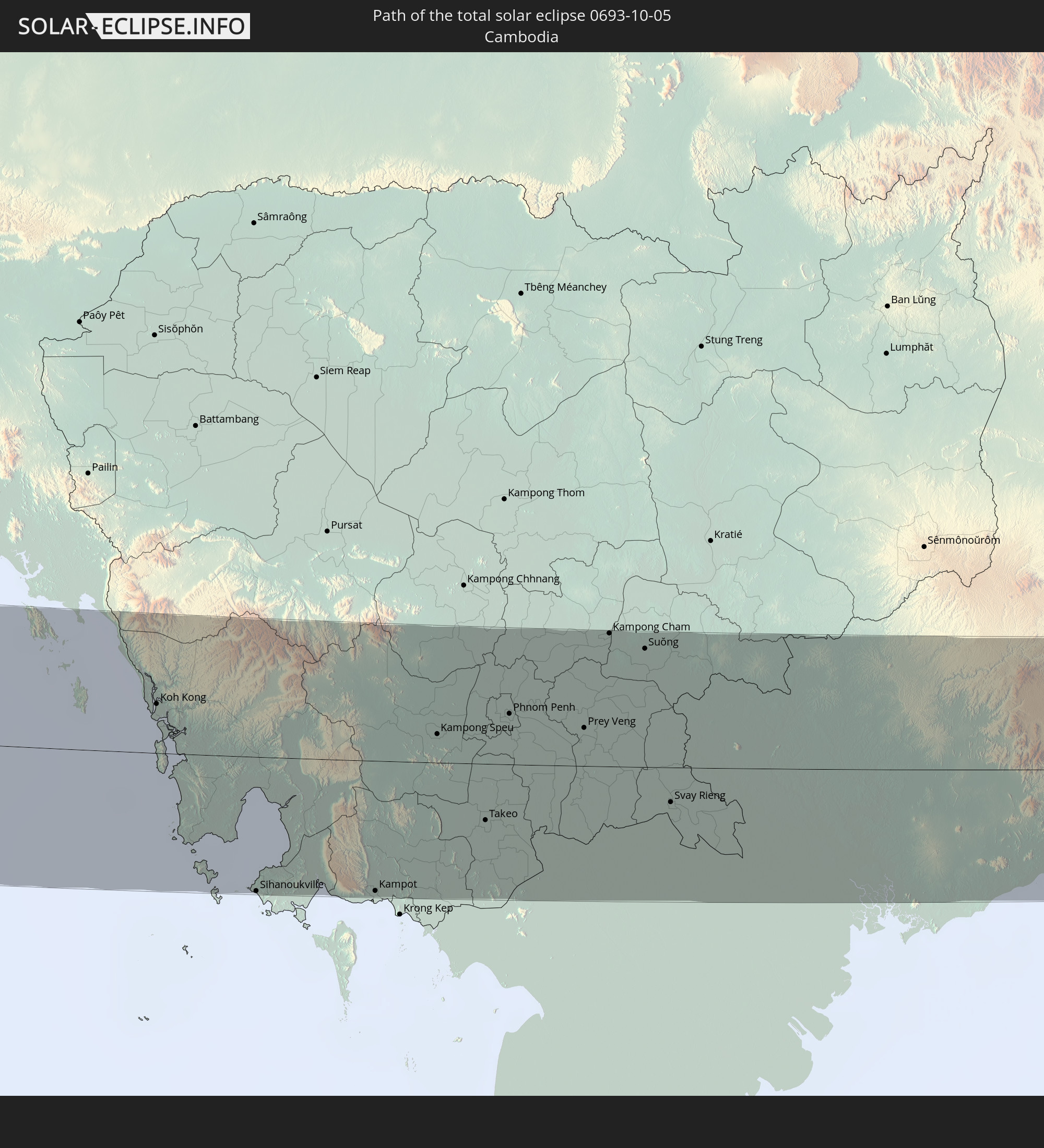 Kambodscha
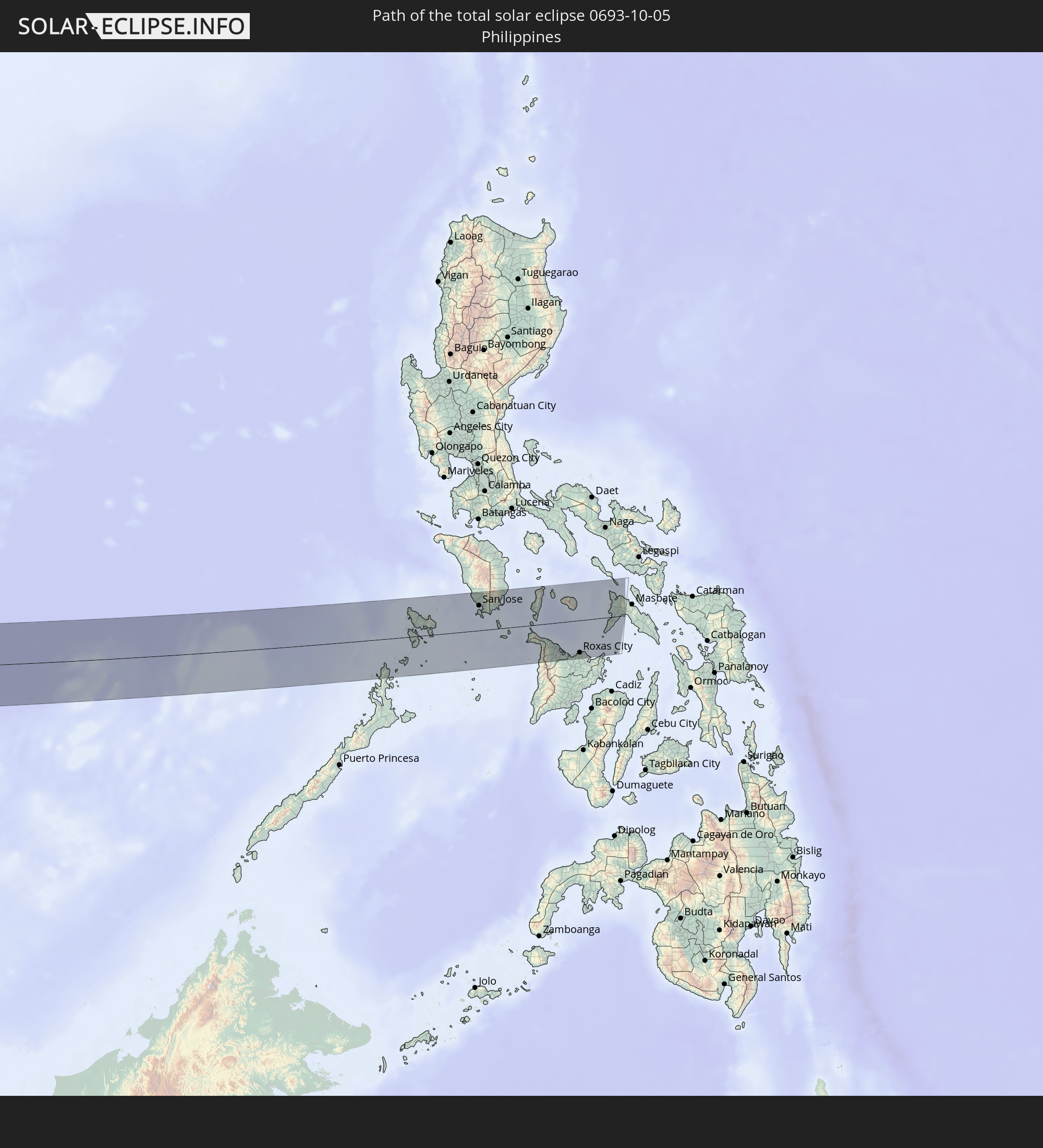 Philippinen
In den folgenden Ländern ist die Sonnenfinsternis partiell zu sehen
 Russland
 Spanien
 Mauretanien
 Marokko
 Mali
Mali
 Spitzbergen
 Algerien
 Vereinigtes Königreich
 Burkina Faso
 Frankreich
 Guernsey
 Jersey
 Niger
Niger
 Andorra
 Belgien
 Nigeria
 Niederlande
 Norwegen
 Luxemburg
 Deutschland
 Schweiz
 Italien
 Monaco
 Tunesien
 Dänemark
 Kamerun
 Libyen
 Liechtenstein
 Österreich
 Schweden
 Tschechien
 San Marino
 Vatikanstadt
 Slowenien
 Tschad
 Kroatien
 Polen
Polen
 Malta
Malta
 Zentralafrikanische Republik
 Bosnien und Herzegowina
 Ungarn
 Slowakei
 Montenegro
 Serbien
 Albanien
 Åland Islands
 Griechenland
 Rumänien
 Mazedonien
 Finnland
 Litauen
 Lettland
 Estland
 Sudan
Sudan
 Ukraine
 Bulgarien
 Weißrussland
 Ägypten
 Türkei
 Moldawien
 Uganda
 Republik Zypern
 Äthiopien
 Kenia
Kenia
 Staat Palästina
 Israel
 Saudi-Arabien
 Jordanien
 Libanon
 Syrien
 Eritrea
 Irak
Irak
 Georgien
 Somalia
 Dschibuti
 Jemen
Jemen
 Armenien
 Iran
Iran
 Aserbaidschan
 Seychellen
 Kasachstan
 Kuwait
 Bahrain
 Katar
Katar
 Vereinigte Arabische Emirate
 Oman
Oman
 Turkmenistan
 Usbekistan
 Afghanistan
 Pakistan
 Tadschikistan
 Indien
 Kirgisistan
 Britisches Territorium im Indischen Ozean
 Malediven
 Volksrepublik China
 Sri Lanka
 Nepal
Nepal
 Mongolei
 Bangladesch
 Bhutan
 Myanmar
 Indonesien
 Kokosinseln
 Thailand
 Malaysia
 Laos
Laos
 Vietnam
 Kambodscha
 Singapur
 Weihnachtsinsel
 Australien
 Macau
Macau
 Hongkong
 Brunei
 Taiwan
 Philippinen
 Japan
Japan
 Nordkorea
 Südkorea
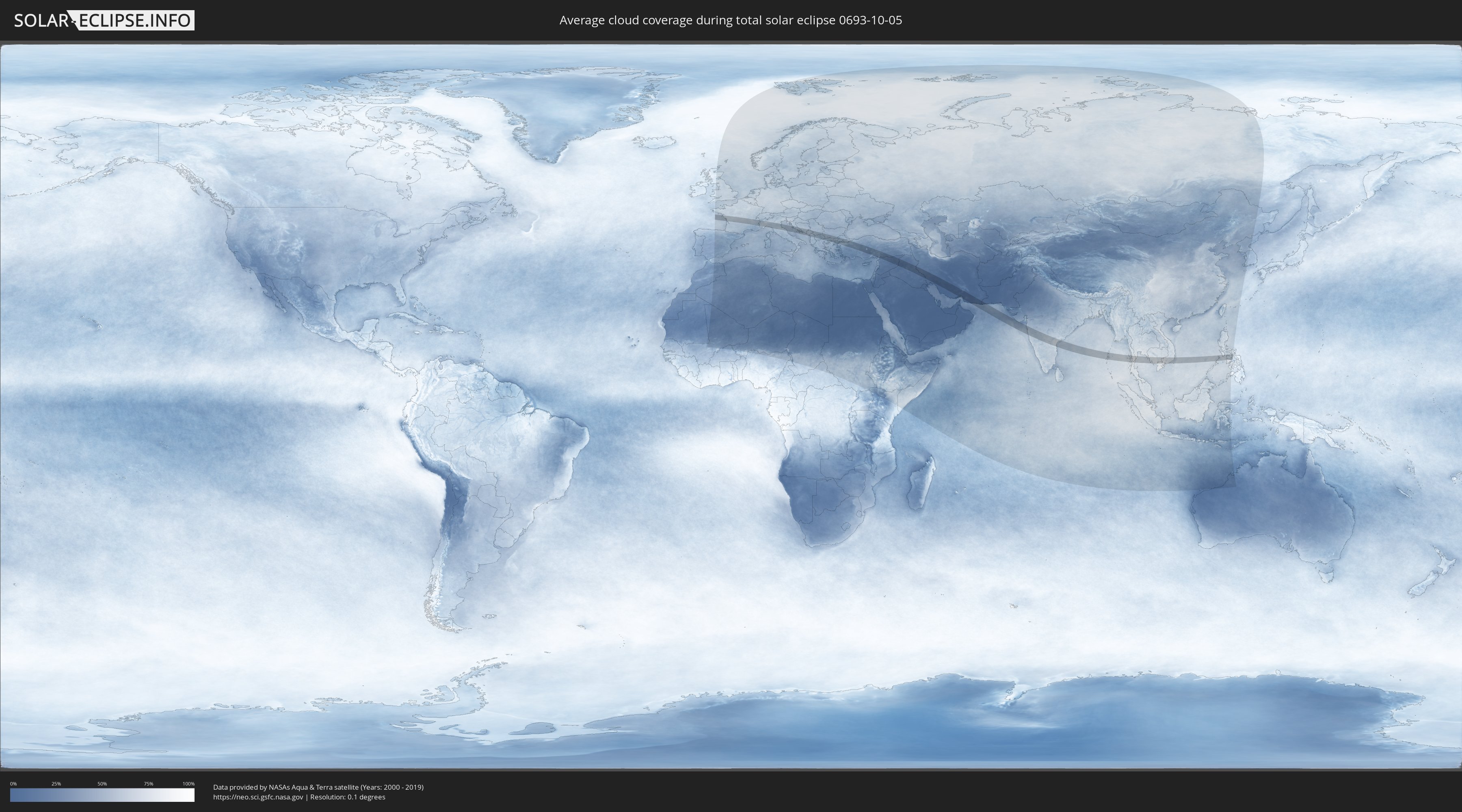
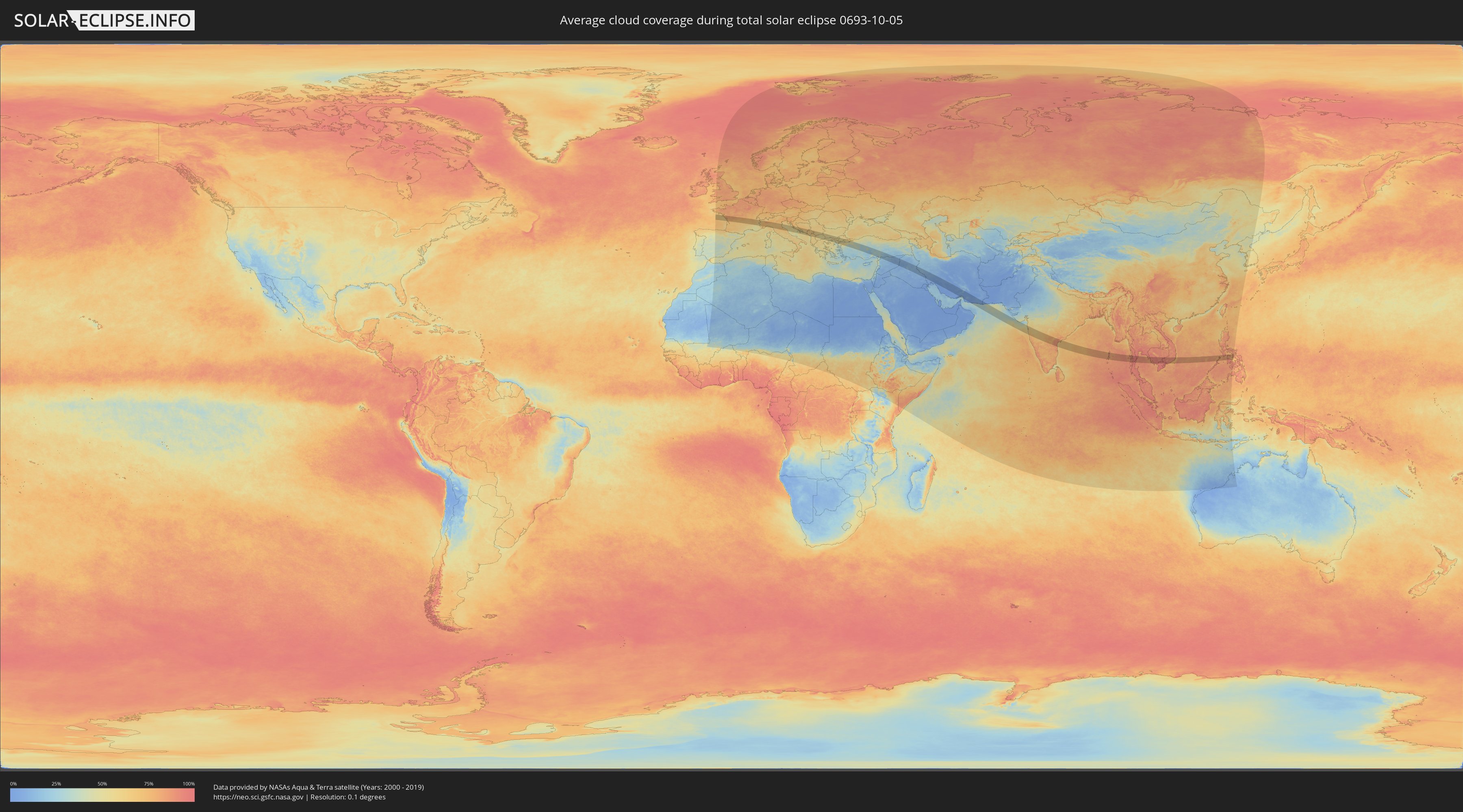
Wie wird das Wetter während der totalen Sonnenfinsternis am 05.10.0693?
Wo ist der beste Ort, um die totale Sonnenfinsternis vom 05.10.0693 zu beobachten?
Die folgenden Karten zeigen die durchschnittliche Bewölkung für den Tag, an dem die totale Sonnenfinsternis
stattfindet. Mit Hilfe der Karten lässt sich der Ort entlang des Finsternispfades eingrenzen,
der die besten Aussichen auf einen klaren wolkenfreien Himmel bietet.
Trotzdem muss man immer lokale Gegenenheiten beachten und sollte sich genau über das Wetter an seinem
gewählten Beobachtungsort informieren.
Die Daten stammen von den beiden NASA-Satelliten
AQUA und TERRA
und wurden über einen Zeitraum von 19 Jahren (2000 - 2019) gemittelt.
Detaillierte Länderkarten
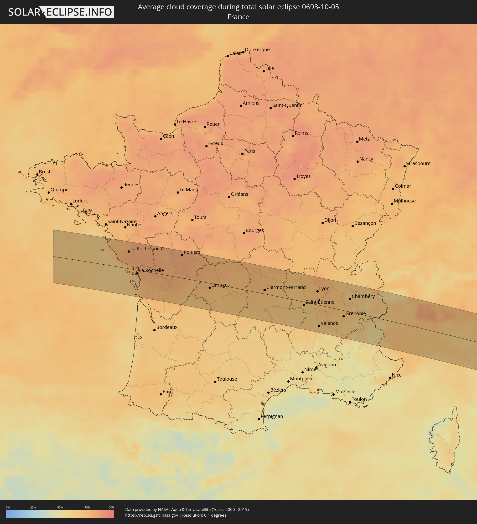 Frankreich
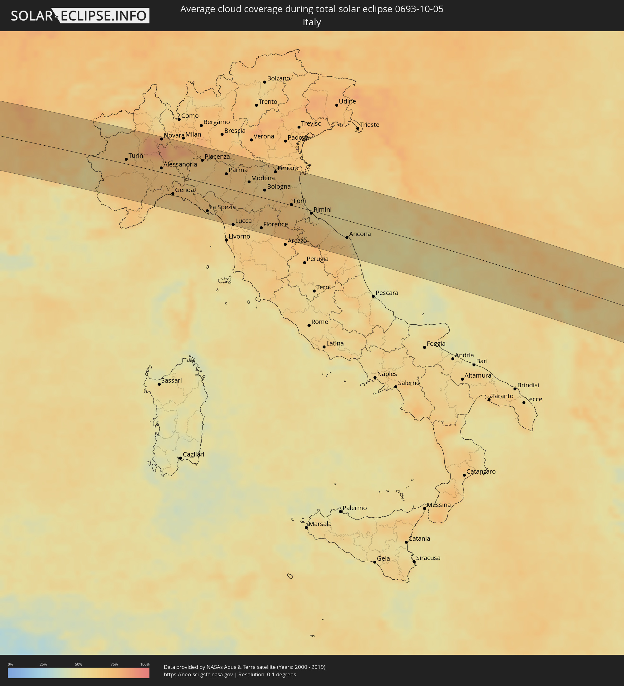 Italien
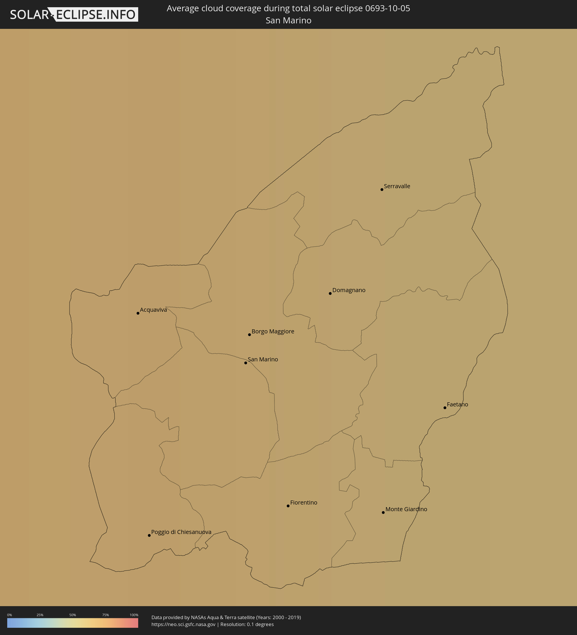 San Marino
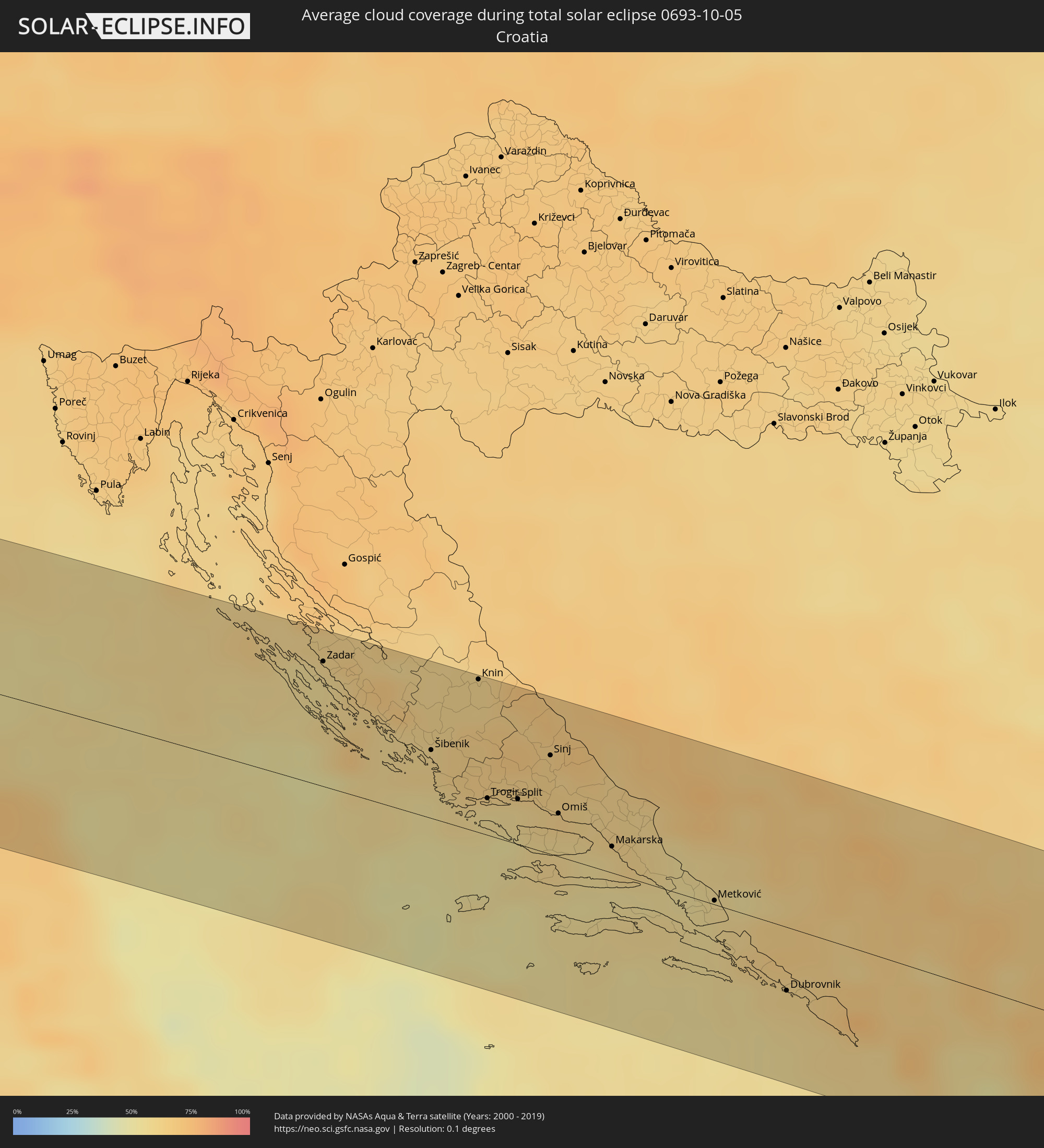 Kroatien
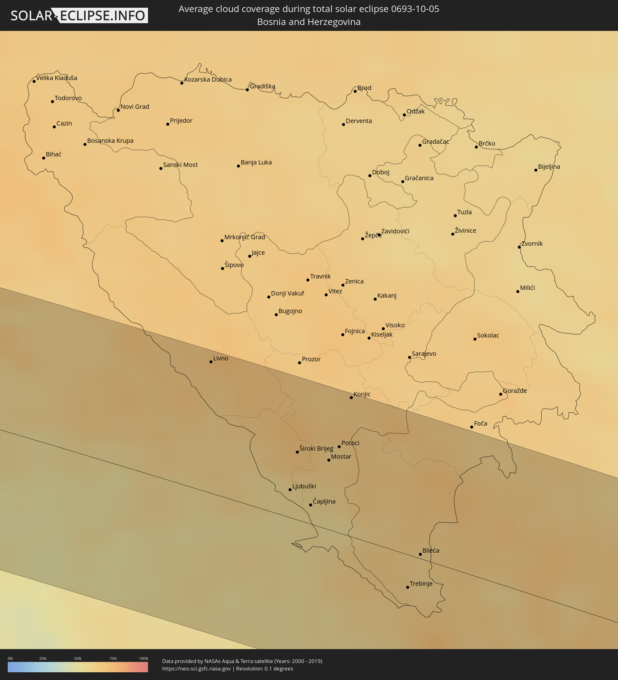 Bosnien und Herzegowina
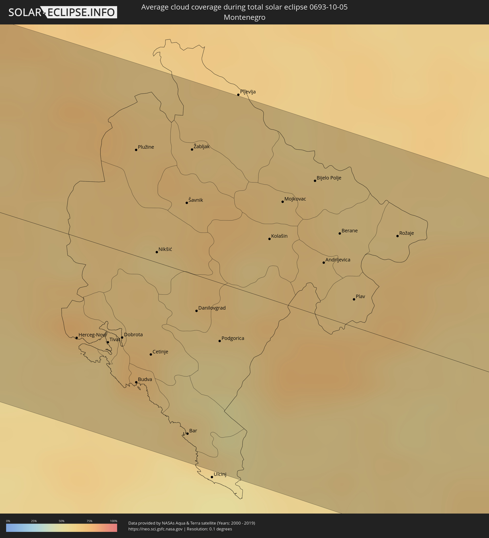 Montenegro
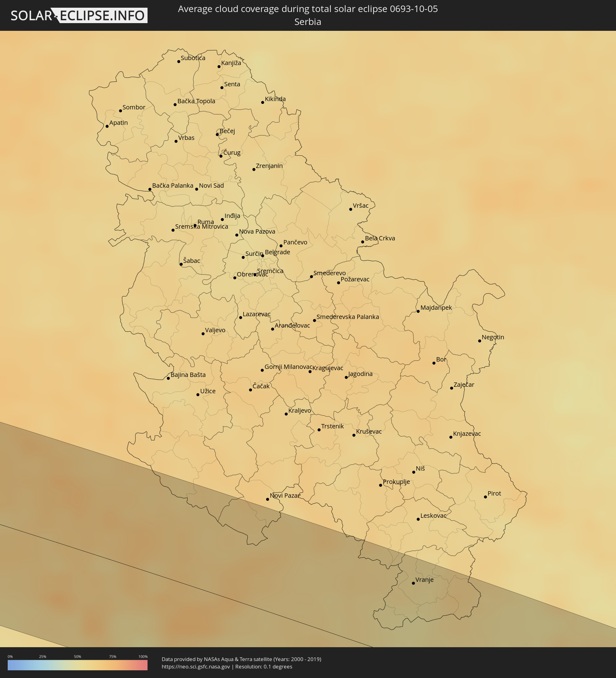 Serbien
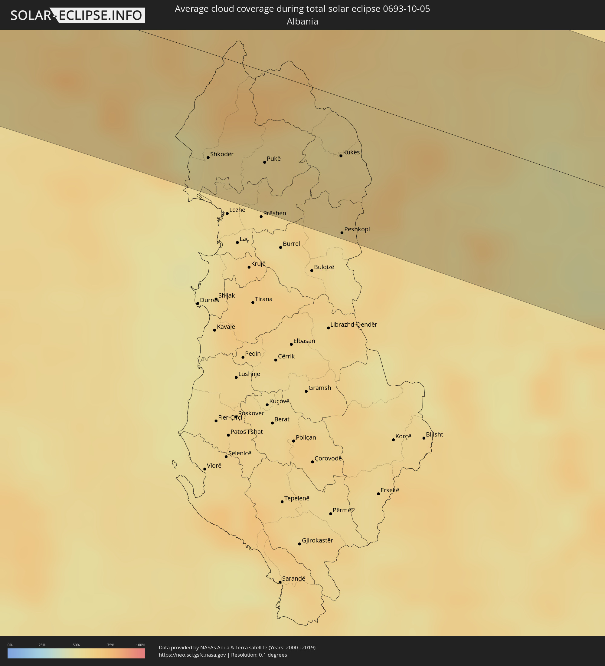 Albanien
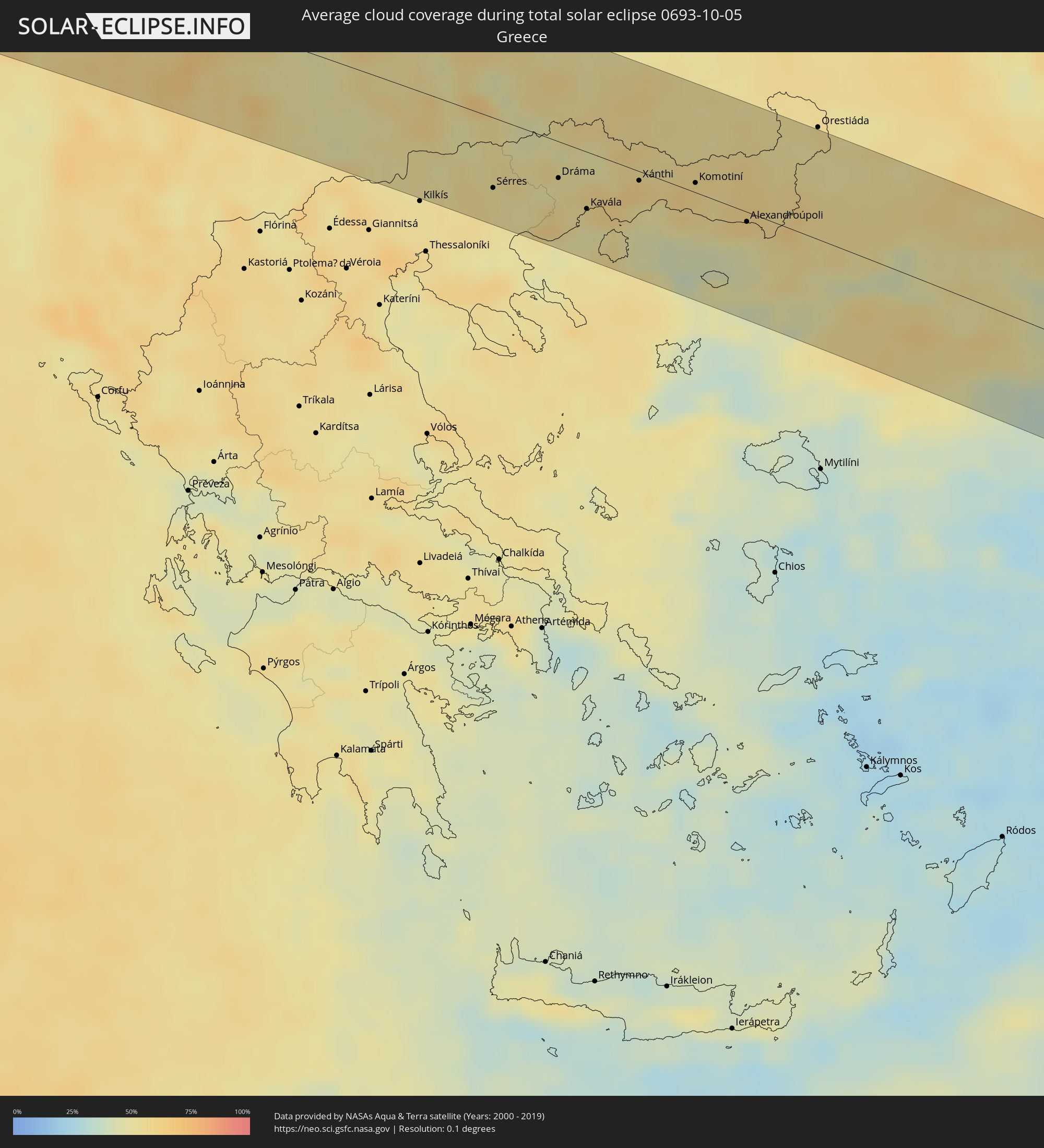 Griechenland
 Mazedonien
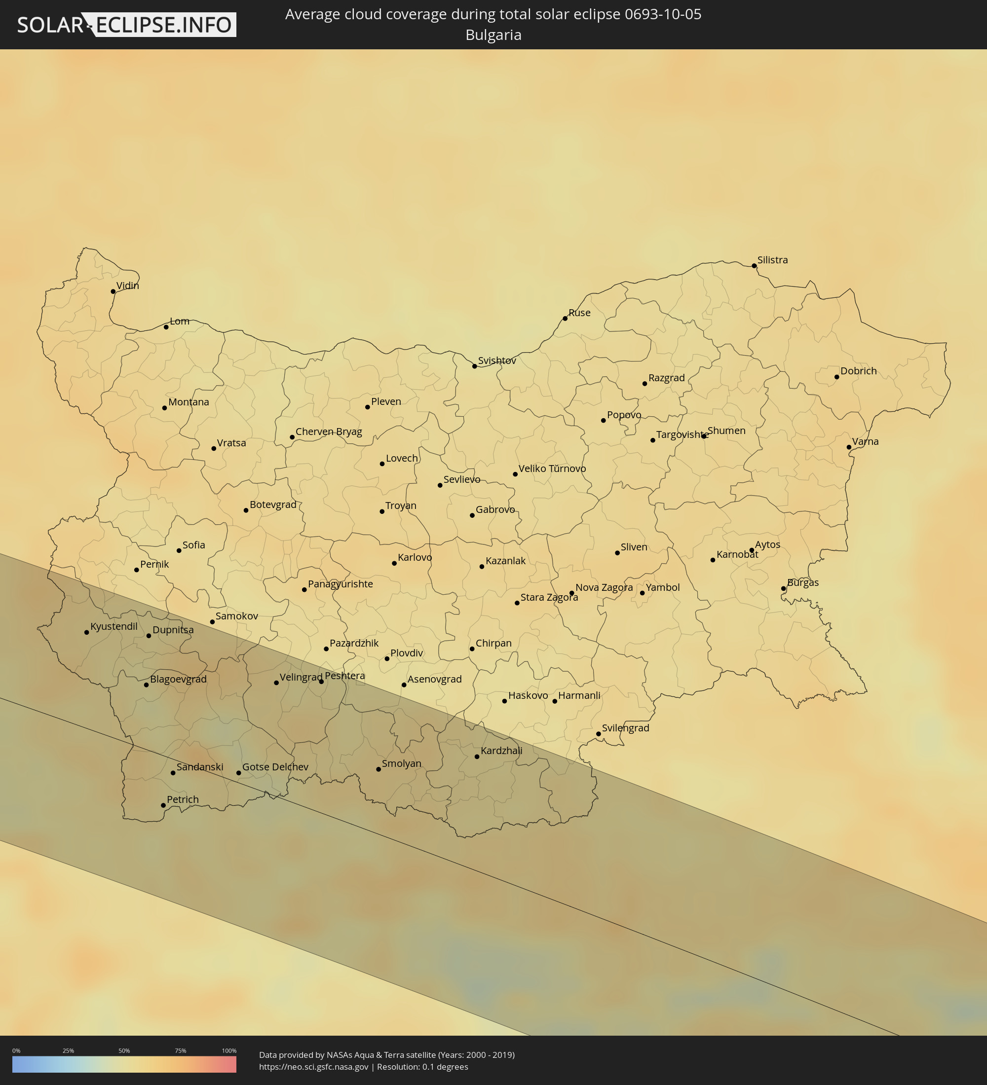 Bulgarien
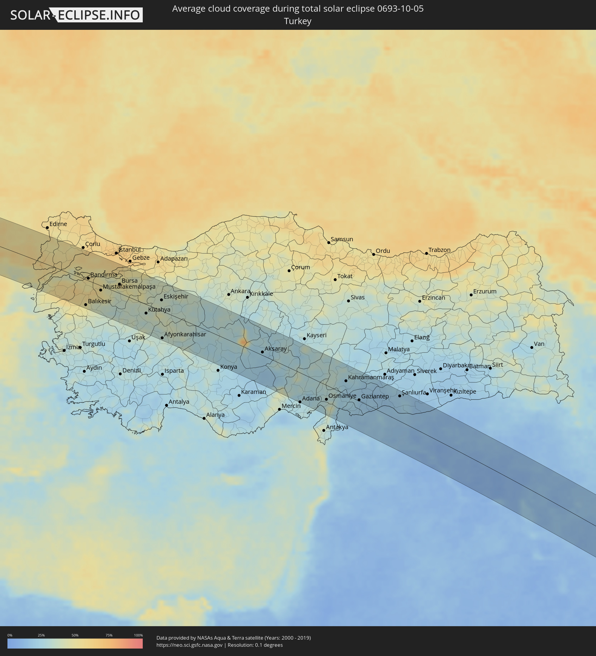 Türkei
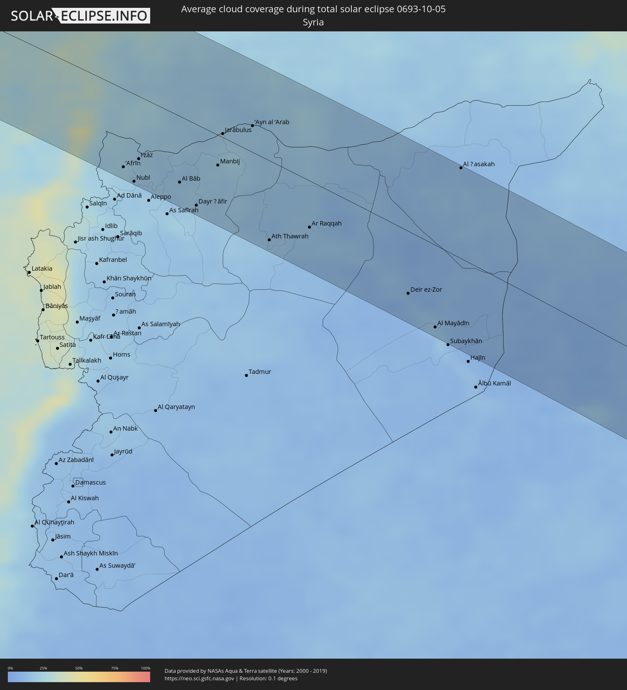 Syrien
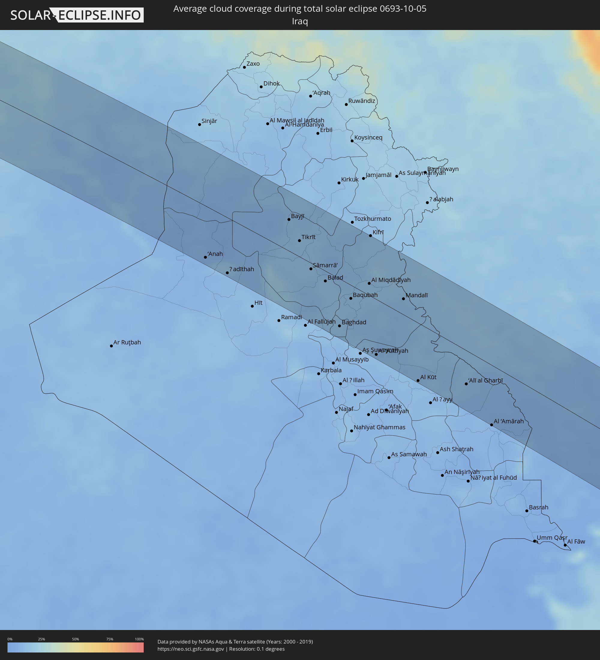 Irak
Irak
 Iran
Iran
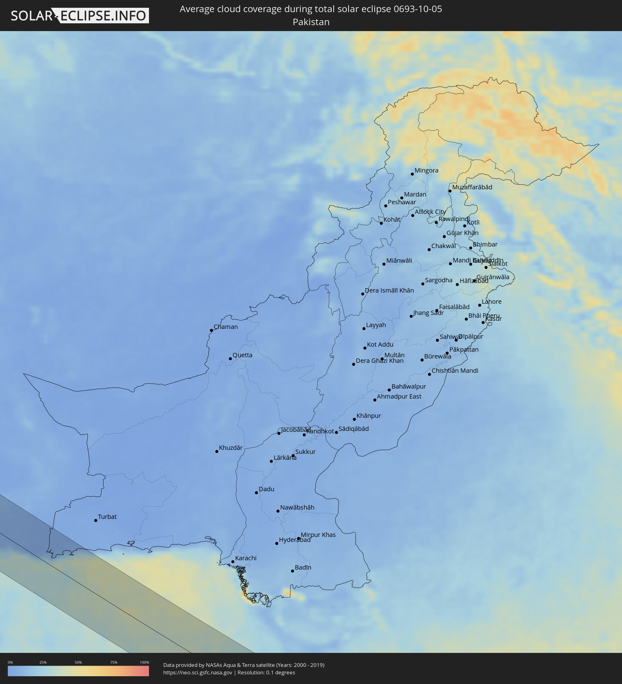 Pakistan
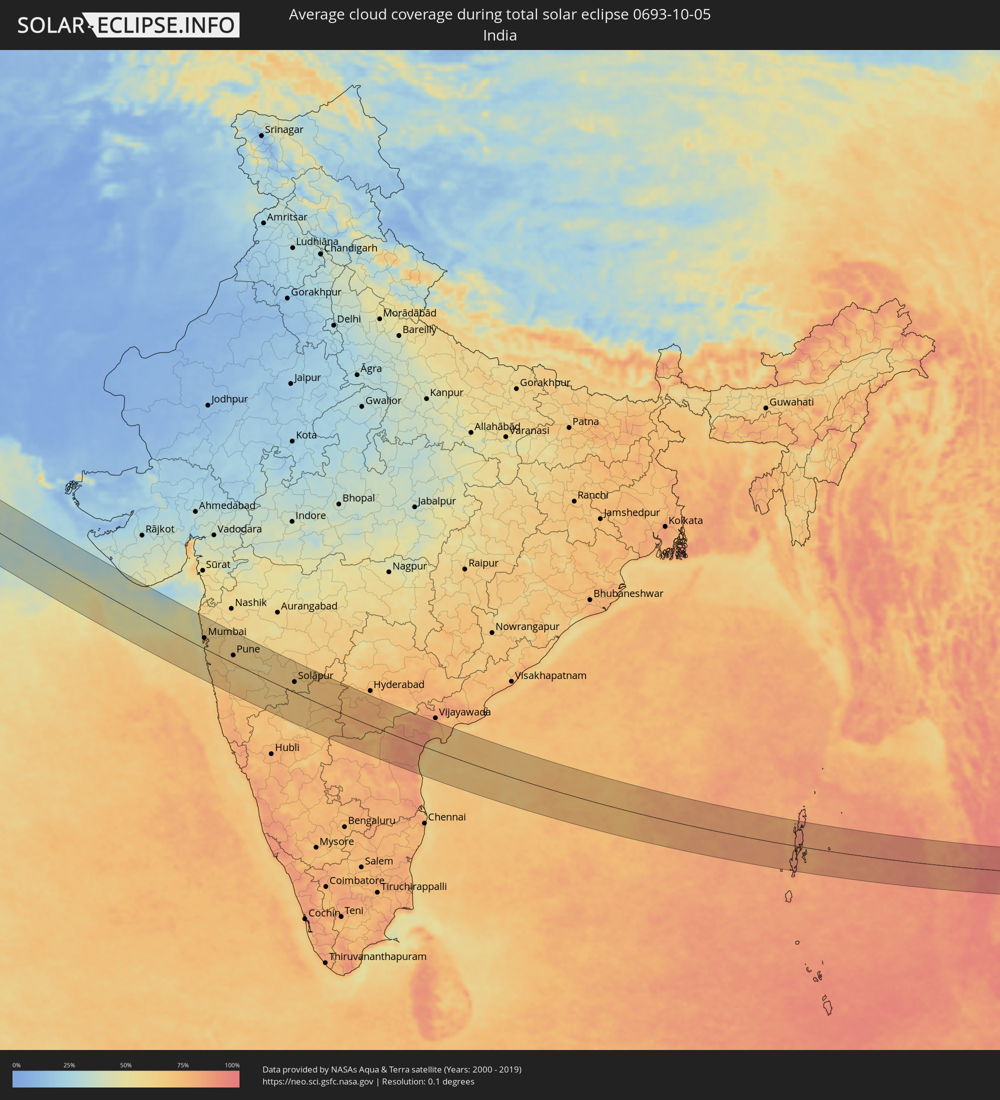 Indien
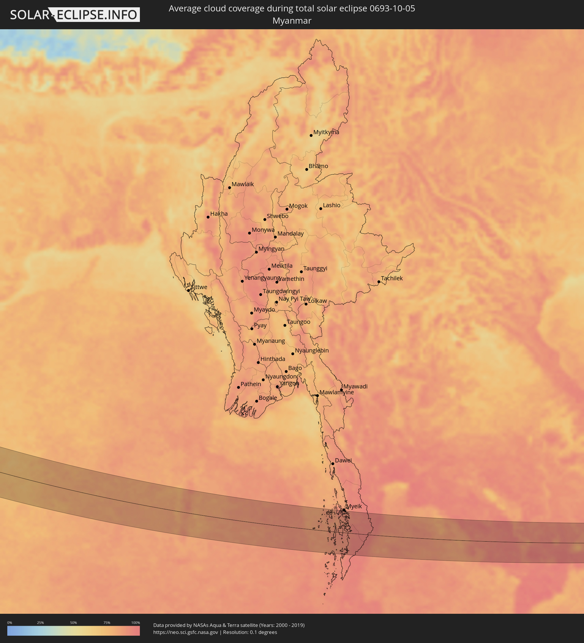 Myanmar
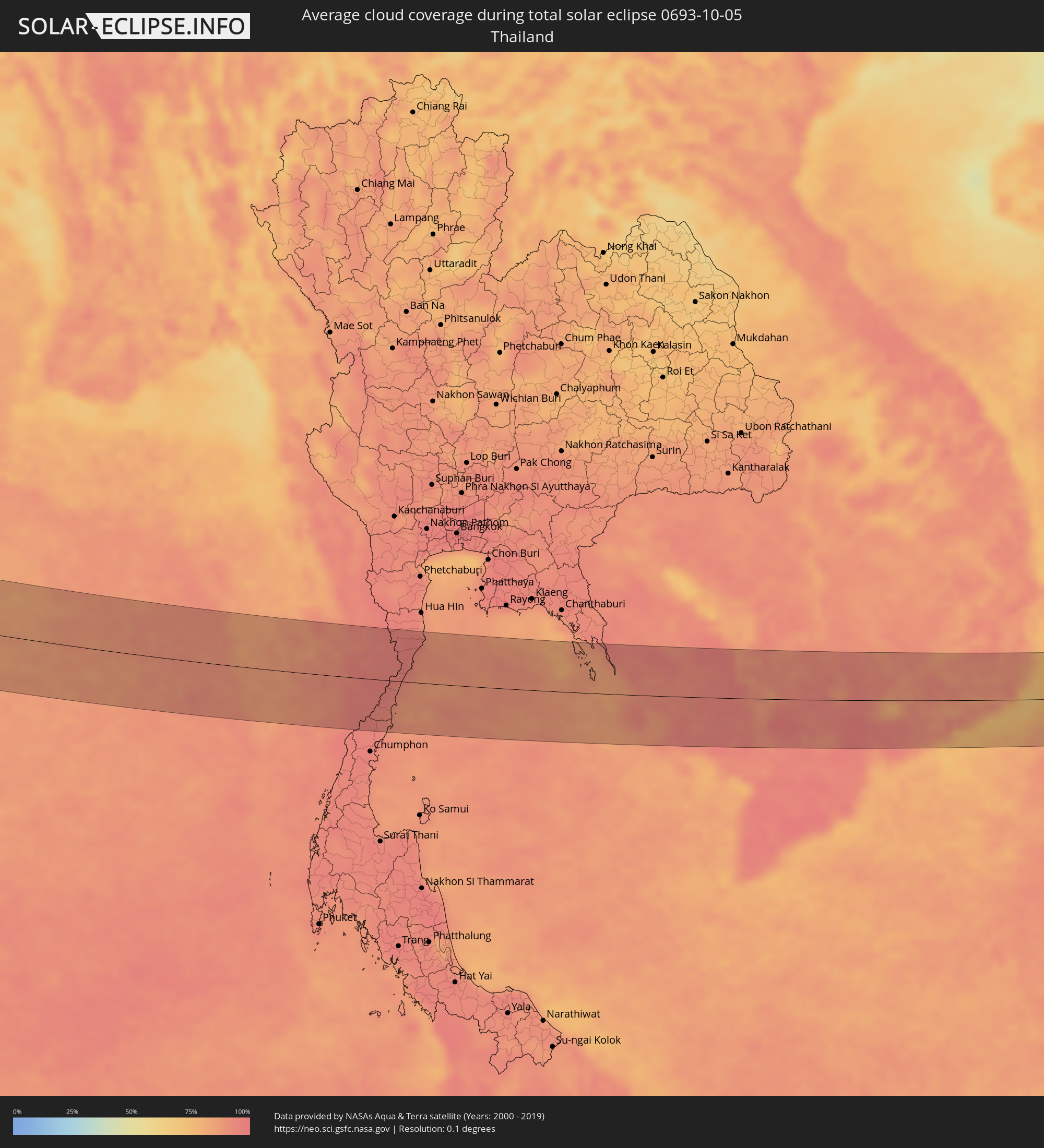 Thailand
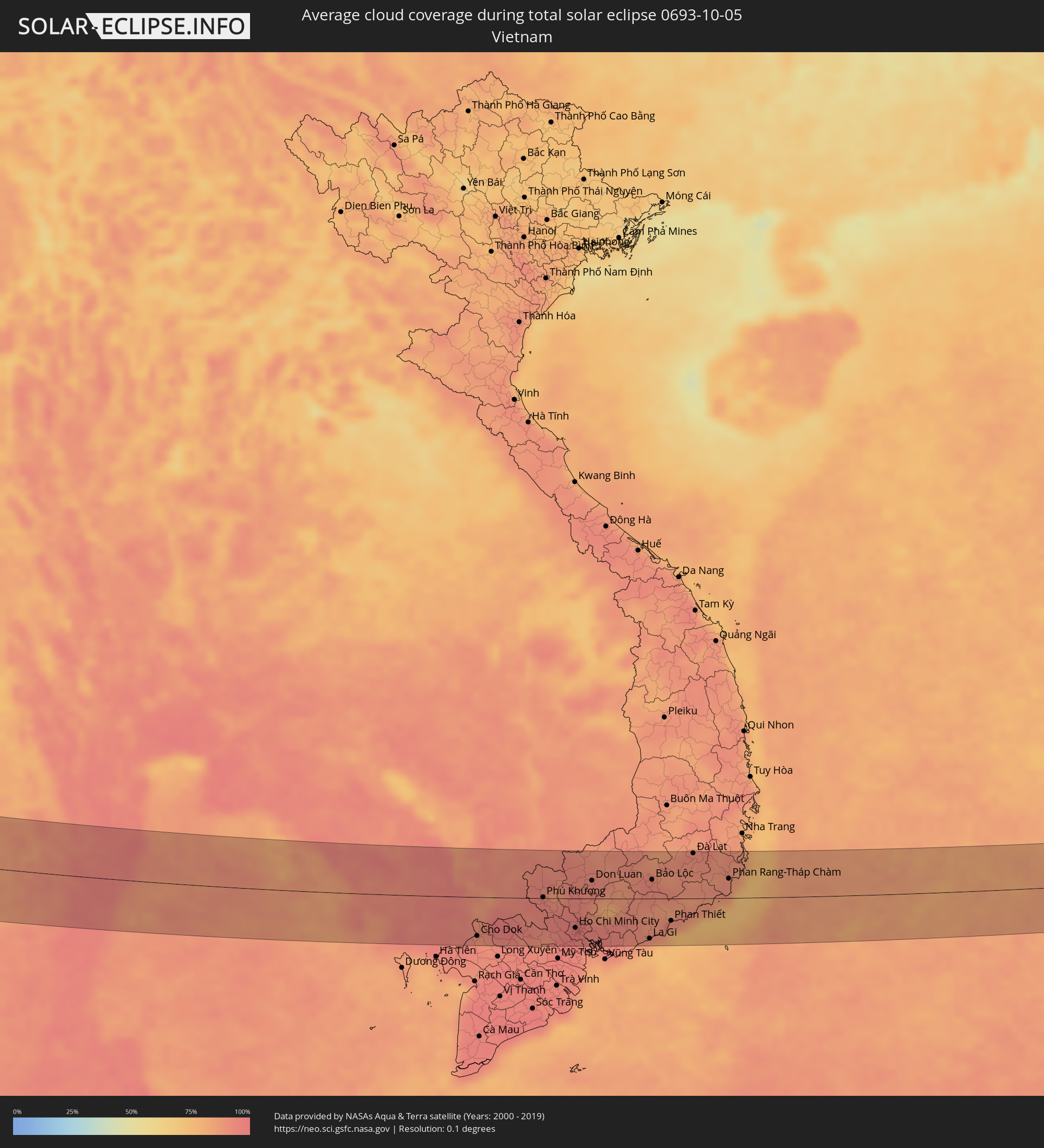 Vietnam
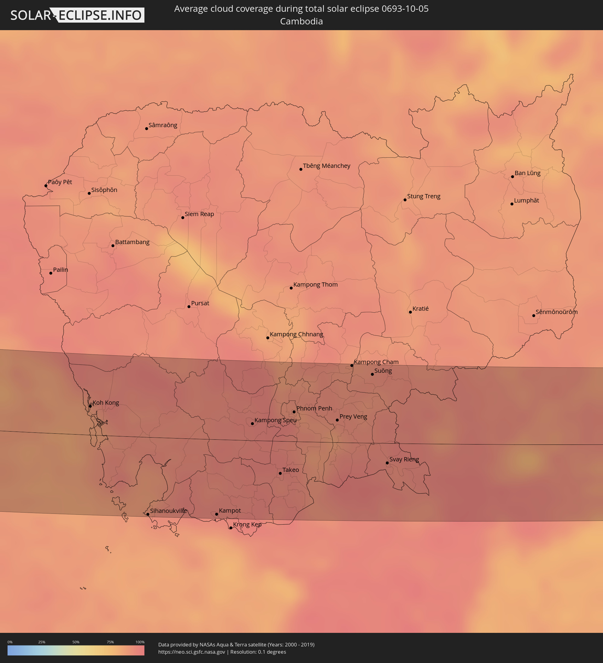 Kambodscha
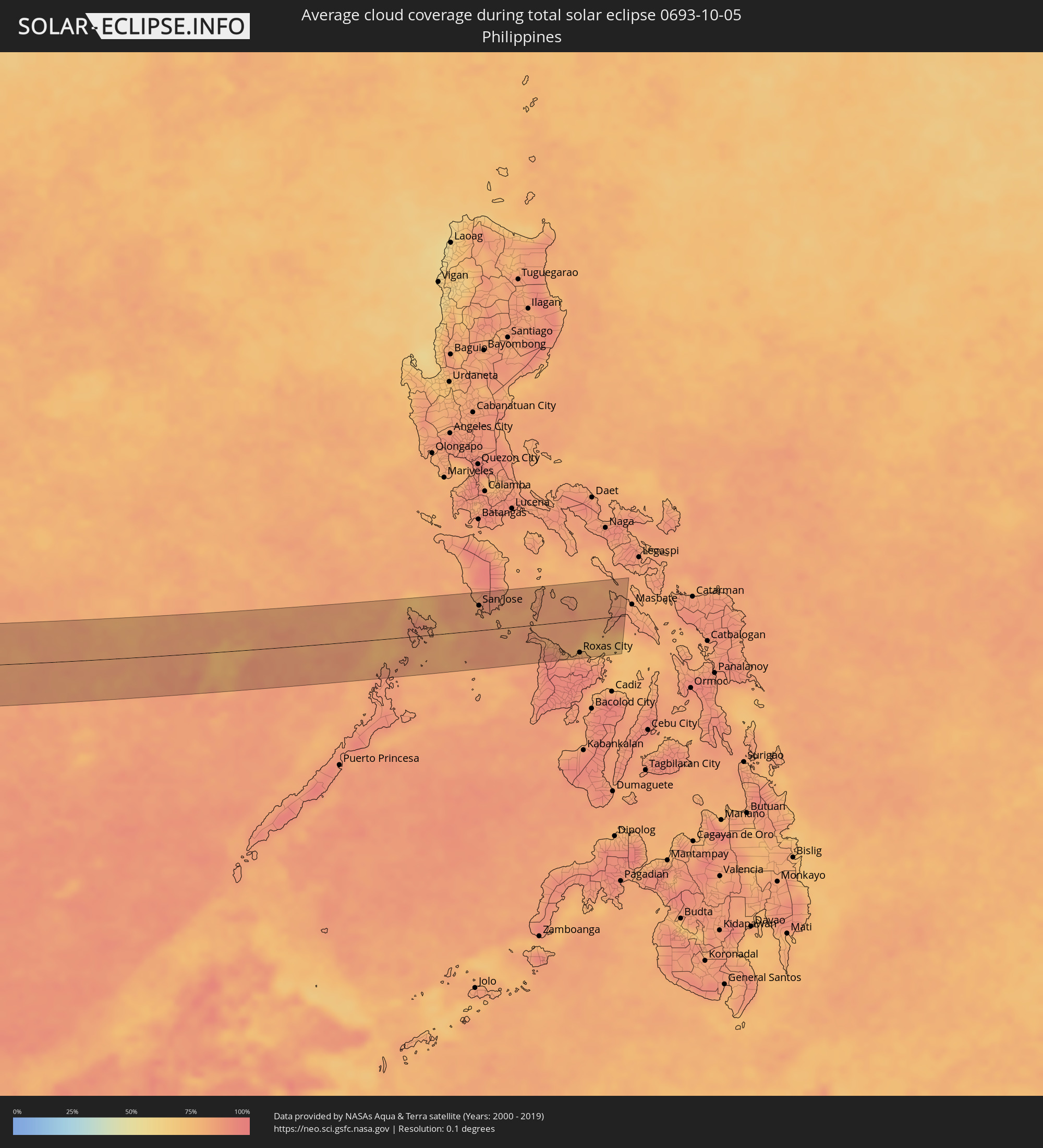 Philippinen
Orte im Finsternispfad
Die nachfolgene Tabelle zeigt Städte und Orte mit mehr als 5.000 Einwohnern, die sich im Finsternispfad befinden. Städte mit mehr als 100.000 Einwohnern sind dick gekennzeichnet. Mit einem Klick auf den Ort öffnet sich eine Detailkarte die die Lage des jeweiligen Ortes zusammen mit dem Verlauf der zentralen Finsternis präsentiert.
| Ort | Typ | Dauer der Verfinsterung | Ortszeit bei maximaler Verfinsterung | Entfernung zur Zentrallinie | Ø Bewölkung |
|
La Roche-sur-Yon, Pays de la Loire
|
total | - | 06:39:06 UTC+00:09 | 43 km | 81% |
|
La Rochelle, Nouvelle-Aquitaine
|
total | - | 06:38:44 UTC+00:09 | 9 km | 71% |
|
Poitiers, Nouvelle-Aquitaine
|
total | - | 06:39:19 UTC+00:09 | 57 km | 79% |
|
Limoges, Nouvelle-Aquitaine
|
total | - | 06:38:53 UTC+00:09 | 12 km | 73% |
|
Clermont-Ferrand, Auvergne-Rhône-Alpes
|
total | - | 06:39:15 UTC+00:09 | 9 km | 73% |
|
Saint-Étienne, Auvergne-Rhône-Alpes
|
total | - | 06:39:19 UTC+00:09 | 8 km | 68% |
|
Lyon, Auvergne-Rhône-Alpes
|
total | - | 06:39:42 UTC+00:09 | 34 km | 73% |
|
Valence, Auvergne-Rhône-Alpes
|
total | - | 06:39:05 UTC+00:09 | 54 km | 67% |
|
Grenoble, Auvergne-Rhône-Alpes
|
total | - | 06:39:30 UTC+00:09 | 15 km | 67% |
|
Chambéry, Auvergne-Rhône-Alpes
|
total | - | 06:39:53 UTC+00:09 | 32 km | 68% |
|
Turin, Piedmont
|
total | - | 07:30:45 UTC+01:00 | 9 km | 69% |
|
Genoa, Liguria
|
total | - | 07:30:44 UTC+01:00 | 38 km | 65% |
|
Parma, Emilia-Romagna
|
total | - | 07:31:35 UTC+01:00 | 29 km | 69% |
|
Reggio nell'Emilia, Emilia-Romagna
|
total | - | 07:31:38 UTC+01:00 | 24 km | 68% |
|
Modena, Emilia-Romagna
|
total | - | 07:31:44 UTC+01:00 | 24 km | 68% |
|
Prato, Tuscany
|
total | - | 07:31:16 UTC+01:00 | 55 km | 66% |
|
Florence, Tuscany
|
total | - | 07:31:16 UTC+01:00 | 63 km | 64% |
|
Bologna, Emilia-Romagna
|
total | - | 07:31:48 UTC+01:00 | 16 km | 66% |
|
Forlì, Emilia-Romagna
|
total | - | 07:31:57 UTC+01:00 | 1 km | 68% |
|
Acquaviva, Acquaviva
|
total | - | 07:31:56 UTC+01:00 | 21 km | 71% |
|
Poggio di Chiesanuova, Chiesanuova
|
total | - | 07:31:54 UTC+01:00 | 25 km | 71% |
|
San Marino, San Marino
|
total | - | 07:31:56 UTC+01:00 | 21 km | 71% |
|
Borgo Maggiore, Borgo Maggiore
|
total | - | 07:31:57 UTC+01:00 | 21 km | 71% |
|
Fiorentino, Fiorentino
|
total | - | 07:31:56 UTC+01:00 | 24 km | 71% |
|
Domagnano, Domagnano
|
total | - | 07:31:58 UTC+01:00 | 19 km | 71% |
|
Serravalle, Serravalle
|
total | - | 07:31:59 UTC+01:00 | 17 km | 68% |
|
Monte Giardino, Montegiardino
|
total | - | 07:31:56 UTC+01:00 | 23 km | 71% |
|
Faetano, Faetano
|
total | - | 07:31:58 UTC+01:00 | 21 km | 71% |
|
Rimini, Emilia-Romagna
|
total | - | 07:32:05 UTC+01:00 | 6 km | 58% |
|
Zadar, Zadarska
|
total | - | 07:33:32 UTC+01:00 | 59 km | 55% |
|
Šibenik, Šibensko-Kniniska
|
total | - | 07:33:39 UTC+01:00 | 32 km | 61% |
|
Knin, Šibensko-Kniniska
|
total | - | 07:34:02 UTC+01:00 | 73 km | 61% |
|
Trogir, Splitsko-Dalmatinska
|
total | - | 07:33:43 UTC+01:00 | 17 km | 56% |
|
Split, Splitsko-Dalmatinska
|
total | - | 07:33:50 UTC+01:00 | 21 km | 57% |
|
Podstrana, Splitsko-Dalmatinska
|
total | - | 07:33:53 UTC+01:00 | 22 km | 61% |
|
Sinj, Splitsko-Dalmatinska
|
total | - | 07:34:05 UTC+01:00 | 47 km | 64% |
|
Livno, Federation of Bosnia and Herzegovina
|
total | - | 07:34:23 UTC+01:00 | 69 km | 64% |
|
Makarska, Splitsko-Dalmatinska
|
total | - | 07:34:03 UTC+01:00 | 13 km | 58% |
|
Tomislavgrad, Federation of Bosnia and Herzegovina
|
total | - | 07:34:27 UTC+01:00 | 62 km | 66% |
|
Ljubuški, Federation of Bosnia and Herzegovina
|
total | - | 07:34:19 UTC+01:00 | 15 km | 54% |
|
Široki Brijeg, Federation of Bosnia and Herzegovina
|
total | - | 07:34:28 UTC+01:00 | 35 km | 62% |
|
Metković, Dubrovačko-Neretvanska
|
total | - | 07:34:18 UTC+01:00 | 2 km | 56% |
|
Čapljina, Federation of Bosnia and Herzegovina
|
total | - | 07:34:22 UTC+01:00 | 10 km | 57% |
|
Mostar, Federation of Bosnia and Herzegovina
|
total | - | 07:34:35 UTC+01:00 | 36 km | 60% |
|
Stolac, Federation of Bosnia and Herzegovina
|
total | - | 07:34:31 UTC+01:00 | 13 km | 59% |
|
Konjic, Federation of Bosnia and Herzegovina
|
total | - | 07:34:52 UTC+01:00 | 73 km | 64% |
|
Dubrovnik, Dubrovačko-Neretvanska
|
total | - | 07:34:21 UTC+01:00 | 30 km | 59% |
|
Trebinje, Republic of Srspka
|
total | - | 07:34:33 UTC+01:00 | 17 km | 64% |
|
Bileća, Republic of Srspka
|
total | - | 07:34:42 UTC+01:00 | 2 km | 61% |
|
Herceg-Novi, Herceg Novi
|
total | - | 07:34:32 UTC+01:00 | 40 km | 66% |
|
Kotor, Kotor
|
total | - | 07:34:40 UTC+01:00 | 38 km | 70% |
|
Dobrota
|
total | - | 07:34:41 UTC+01:00 | 34 km | 68% |
|
Budva, Budva
|
total | - | 07:34:38 UTC+01:00 | 50 km | 61% |
|
Nikšić, Opština Nikšić
|
total | - | 07:34:59 UTC+01:00 | 4 km | 59% |
|
Bar, Bar
|
total | - | 07:34:43 UTC+01:00 | 64 km | 59% |
|
Podgorica, Podgorica
|
total | - | 07:35:01 UTC+01:00 | 23 km | 56% |
|
Shkodër, Shkodër
|
total | - | 07:54:19 UTC+01:19 | 56 km | 55% |
|
Bijelo Polje, Bijelo Polje
|
total | - | 07:35:42 UTC+01:00 | 52 km | 66% |
|
Berane, Berane
|
total | - | 07:35:40 UTC+01:00 | 35 km | 62% |
|
Pukë, Shkodër
|
total | - | 07:54:35 UTC+01:19 | 49 km | 63% |
|
Rožaje, Opština Rožaje
|
total | - | 07:35:52 UTC+01:00 | 41 km | 66% |
|
Kukës, Kukës
|
total | - | 07:54:58 UTC+01:19 | 32 km | 58% |
|
Peshkopi, Dibër
|
total | - | 07:54:46 UTC+01:19 | 73 km | 54% |
|
Gostivar, Gostivar
|
total | - | 07:35:51 UTC+01:00 | 49 km | 56% |
|
Tetovo, Tetovo
|
total | - | 07:36:01 UTC+01:00 | 24 km | 59% |
|
Skopje, Karpoš
|
total | - | 07:36:21 UTC+01:00 | 13 km | 53% |
|
Kumanovo, Kumanovo
|
total | - | 07:36:38 UTC+01:00 | 8 km | 49% |
|
Veles, Veles
|
total | - | 07:36:28 UTC+01:00 | 34 km | 51% |
|
Vranje, Central Serbia
|
total | - | 07:37:00 UTC+01:00 | 58 km | 56% |
|
Kavadarci, Kavadarci
|
total | - | 07:36:31 UTC+01:00 | 57 km | 50% |
|
Shtip, Štip
|
total | - | 07:36:49 UTC+01:00 | 19 km | 50% |
|
Kochani, Kočani
|
total | - | 07:37:04 UTC+01:00 | 5 km | 55% |
|
Радовиш, Radoviš
|
total | - | 07:36:59 UTC+01:00 | 23 km | 50% |
|
Strumica, Strumica
|
total | - | 07:37:01 UTC+01:00 | 39 km | 51% |
|
Kyustendil, Kyustendil
|
total | - | 08:37:29 UTC+02:00 | 51 km | 53% |
|
Blagoevgrad, Blagoevgrad
|
total | - | 08:37:40 UTC+02:00 | 34 km | 47% |
|
Dupnitsa, Kyustendil
|
total | - | 08:37:49 UTC+02:00 | 61 km | 52% |
|
Petrich, Blagoevgrad
|
total | - | 08:37:28 UTC+02:00 | 27 km | 52% |
|
Sandanski, Blagoevgrad
|
total | - | 08:37:36 UTC+02:00 | 8 km | 49% |
|
Sidirókastro, Central Macedonia
|
total | - | 08:12:24 UTC+01:34 | 39 km | 55% |
|
Sérres, Central Macedonia
|
total | - | 08:12:28 UTC+01:34 | 51 km | 54% |
|
Gotse Delchev, Blagoevgrad
|
total | - | 08:37:59 UTC+02:00 | 5 km | 52% |
|
Velingrad, Pazardzhik
|
total | - | 08:38:25 UTC+02:00 | 61 km | 55% |
|
Dráma, East Macedonia and Thrace
|
total | - | 08:13:00 UTC+01:34 | 26 km | 50% |
|
Peshtera, Pazardzhik
|
total | - | 08:38:40 UTC+02:00 | 70 km | 54% |
|
Kavála, East Macedonia and Thrace
|
total | - | 08:13:08 UTC+01:34 | 41 km | 48% |
|
Smolyan, Smolyan
|
total | - | 08:38:48 UTC+02:00 | 35 km | 57% |
|
Chrysoúpolis, East Macedonia and Thrace
|
total | - | 08:13:24 UTC+01:34 | 28 km | 60% |
|
Xánthi, East Macedonia and Thrace
|
total | - | 08:13:38 UTC+01:34 | 7 km | 61% |
|
Kardzhali, Kŭrdzhali
|
total | - | 08:39:25 UTC+02:00 | 61 km | 53% |
|
Komotiní, East Macedonia and Thrace
|
total | - | 08:14:05 UTC+01:34 | 7 km | 60% |
|
Alexandroúpoli, East Macedonia and Thrace
|
total | - | 08:14:24 UTC+01:34 | 7 km | 51% |
|
Féres, East Macedonia and Thrace
|
total | - | 08:14:41 UTC+01:34 | 6 km | 60% |
|
Didymóteicho, East Macedonia and Thrace
|
total | - | 08:15:10 UTC+01:34 | 63 km | 51% |
|
Balıkesir, Balıkesir
|
total | - | 08:37:56 UTC+01:56 | 70 km | 46% |
|
Bursa, Bursa
|
total | - | 08:39:18 UTC+01:56 | 24 km | 47% |
|
Kütahya, Kütahya
|
total | - | 08:40:02 UTC+01:56 | 25 km | 38% |
|
Eskişehir, Eskişehir
|
total | - | 08:40:42 UTC+01:56 | 29 km | 38% |
|
Aksaray, Aksaray
|
total | - | 08:44:25 UTC+01:56 | 9 km | 22% |
|
Adana, Adana
|
total | - | 08:45:55 UTC+01:56 | 82 km | 28% |
|
Osmaniye, Osmaniye
|
total | - | 08:47:07 UTC+01:56 | 40 km | 30% |
|
‘Afrīn, Aleppo
|
total | - | 09:16:12 UTC+02:25 | 72 km | 20% |
|
Kahramanmaraş, Kahramanmaraş
|
total | - | 08:48:02 UTC+01:56 | 38 km | 22% |
|
I‘zāz, Aleppo
|
total | - | 09:16:26 UTC+02:25 | 58 km | 19% |
|
Gaziantep, Gaziantep
|
total | - | 08:48:38 UTC+01:56 | 3 km | 19% |
|
Al Bāb, Aleppo
|
total | - | 09:17:05 UTC+02:25 | 61 km | 18% |
|
Manbij, Aleppo
|
total | - | 09:17:41 UTC+02:25 | 28 km | 17% |
|
‘Ayn al ‘Arab, Aleppo
|
total | - | 09:18:14 UTC+02:25 | 24 km | 18% |
|
Ath Thawrah, Ar-Raqqah
|
total | - | 09:18:33 UTC+02:25 | 73 km | 14% |
|
Şanlıurfa, Şanlıurfa
|
total | - | 08:50:34 UTC+01:56 | 69 km | 20% |
|
Ar Raqqah, Ar-Raqqah
|
total | - | 09:19:12 UTC+02:25 | 43 km | 15% |
|
Deir ez-Zor, Deir ez-Zor
|
total | - | 09:20:55 UTC+02:25 | 58 km | 9% |
|
Al Mayādīn, Deir ez-Zor
|
total | - | 09:21:26 UTC+02:25 | 76 km | 16% |
|
Al Ḩasakah, Al-Hasakah
|
total | - | 09:21:41 UTC+02:25 | 83 km | 12% |
|
Tikrīt, Salah ad Din Governorate
|
total | - | 09:58:58 UTC+02:57 | 23 km | 13% |
|
Sāmarrā’, Salah ad Din Governorate
|
total | - | 09:59:25 UTC+02:57 | 9 km | 13% |
|
Balad, Salah ad Din Governorate
|
total | - | 09:59:54 UTC+02:57 | 15 km | 14% |
|
Abū Ghurayb, Mayorality of Baghdad
|
total | - | 10:00:12 UTC+02:57 | 82 km | 13% |
|
Baghdad, Mayorality of Baghdad
|
total | - | 10:00:33 UTC+02:57 | 69 km | 12% |
|
Baqubah, Diyālá
|
total | - | 10:00:45 UTC+02:57 | 20 km | 13% |
|
Al Miqdādīyah, Diyālá
|
total | - | 10:01:14 UTC+02:57 | 17 km | 14% |
|
Al ‘Azīzīyah, Wāsiţ
|
total | - | 10:01:50 UTC+02:57 | 81 km | 12% |
|
Al Kūt, Wāsiţ
|
total | - | 10:03:18 UTC+02:57 | 85 km | 12% |
|
Īlām, Īlām
|
total | - | 10:32:01 UTC+03:25 | 52 km | 15% |
|
Al ‘Amārah, Maysan
|
total | - | 10:05:58 UTC+02:57 | 88 km | 6% |
|
Ahvaz, Khuzestan
|
total | - | 10:37:12 UTC+03:25 | 64 km | 6% |
|
Masjed Soleymān, Khuzestan
|
total | - | 10:38:00 UTC+03:25 | 25 km | 6% |
|
Dogonbadan, Kohgīlūyeh va Būyer Aḩmad
|
total | - | 10:41:50 UTC+03:25 | 52 km | 1% |
|
Yasuj, Kohgīlūyeh va Būyer Aḩmad
|
total | - | 10:43:10 UTC+03:25 | 17 km | 5% |
|
Kāzerūn, Fars
|
total | - | 10:44:02 UTC+03:25 | 79 km | 1% |
|
Shiraz, Fars
|
total | - | 10:45:49 UTC+03:25 | 36 km | 3% |
|
Akbarābād, Fars
|
total | - | 10:46:36 UTC+03:25 | 58 km | 3% |
|
Fasā, Fars
|
total | - | 10:48:37 UTC+03:25 | 42 km | 2% |
|
Bandar Abbas, Hormozgan
|
total | - | 10:55:47 UTC+03:25 | 70 km | 9% |
|
Jīwani, Balochistān
|
total | - | 12:12:51 UTC+04:28 | 23 km | 26% |
|
Gwadar, Balochistān
|
total | - | 12:14:06 UTC+04:28 | 61 km | 30% |
|
Bhayandar, Maharashtra
|
total | - | 13:39:49 UTC+05:21 | 54 km | 62% |
|
Mumbai, Maharashtra
|
total | - | 13:40:13 UTC+05:21 | 33 km | 64% |
|
Thāne, Maharashtra
|
total | - | 13:40:14 UTC+05:21 | 50 km | 63% |
|
Kalyān, Maharashtra
|
total | - | 13:40:33 UTC+05:21 | 62 km | 61% |
|
Pune, Maharashtra
|
total | - | 13:43:17 UTC+05:21 | 25 km | 62% |
|
Bijapur, Karnataka
|
total | - | 13:50:02 UTC+05:21 | 60 km | 67% |
|
Solāpur, Maharashtra
|
total | - | 13:49:14 UTC+05:21 | 34 km | 67% |
|
Gulbarga, Karnataka
|
total | - | 13:51:48 UTC+05:21 | 41 km | 70% |
|
Rāichūr, Karnataka
|
total | - | 13:54:36 UTC+05:21 | 52 km | 79% |
|
Guntur, Andhra Pradesh
|
total | - | 14:01:06 UTC+05:21 | 81 km | 84% |
|
Bang Saphan, Prachuap Khiri Khan
|
total | - | 15:58:49 UTC+06:42 | 38 km | 92% |
|
Prachuap Khiri Khan, Prachuap Khiri Khan
|
total | - | 15:58:27 UTC+06:42 | 32 km | 93% |
|
Kui Buri, Prachuap Khiri Khan
|
total | - | 15:58:15 UTC+06:42 | 61 km | 93% |
|
Sam Roi Yot, Prachuap Khiri Khan
|
total | - | 15:58:03 UTC+06:42 | 82 km | 96% |
|
Koh Kong, Koh Kong
|
total | - | 16:01:49 UTC+06:42 | 29 km | 85% |
|
Sihanoukville, Preah Sihanouk
|
total | - | 16:03:20 UTC+06:42 | 80 km | 86% |
|
Kampong Speu, Kampong Speu
|
total | - | 16:03:20 UTC+06:42 | 17 km | 94% |
|
Phumĭ Véal Srê, Takeo
|
total | - | 16:04:01 UTC+06:42 | 35 km | 92% |
|
Takeo, Takeo
|
total | - | 16:04:01 UTC+06:42 | 34 km | 92% |
|
Phnom Penh, Phnom Penh
|
total | - | 16:03:32 UTC+06:42 | 30 km | 95% |
|
Ta Khmau, Kandal
|
total | - | 16:03:39 UTC+06:42 | 22 km | 91% |
|
Prey Veng, Prey Veng
|
total | - | 16:03:57 UTC+06:42 | 23 km | 85% |
|
Kampong Cham, Kampong Cham
|
total | - | 16:03:32 UTC+06:42 | 79 km | 90% |
|
Suŏng, Tboung Khmum
|
total | - | 16:03:47 UTC+06:42 | 71 km | 90% |
|
Ho Chi Minh City, Ho Chi Minh City
|
total | - | 16:30:11 UTC+07:06 | 49 km | 97% |
|
Thủ Dầu Một, Bình Dương
|
total | - | 16:30:03 UTC+07:06 | 32 km | 97% |
|
Cần Giuộc, Long An
|
total | - | 16:30:26 UTC+07:06 | 73 km | 94% |
|
Biên Hòa, Đồng Nai
|
total | - | 16:30:13 UTC+07:06 | 36 km | 95% |
|
La Gi, Bình Thuận
|
total | - | 16:31:09 UTC+07:06 | 67 km | 81% |
|
Bảo Lộc, Lâm Đồng
|
total | - | 16:30:19 UTC+07:06 | 32 km | 91% |
|
Phan Thiết, Bình Thuận
|
total | - | 16:31:07 UTC+07:06 | 37 km | 78% |
|
Ðà Lạt, Lâm Đồng
|
total | - | 16:30:21 UTC+07:06 | 76 km | 90% |
|
Phan Rang-Tháp Chàm, Ninh Thuận
|
total | - | 16:31:04 UTC+07:06 | 32 km | 88% |
|
Cam Ranh, Khánh Hòa
|
total | - | 16:30:50 UTC+07:06 | 72 km | 85% |
|
El Nido, Mimaropa
|
total | - | 17:29:05 UTC+08:00 | 68 km | 87% |
|
Coron, Mimaropa
|
total | - | 17:28:33 UTC+08:00 | 14 km | 83% |
|
San Jose, Mimaropa
|
total | - | 17:28:25 UTC+08:00 | 45 km | 83% |
|
Bulalacao, Mimaropa
|
total | - | 17:28:29 UTC+08:00 | 39 km | 80% |
|
Mansalay, Mimaropa
|
total | - | 17:28:20 UTC+08:00 | 60 km | 84% |
|
Pandan, Western Visayas
|
total | - | 17:29:05 UTC+08:00 | 33 km | 89% |
|
Romblon, Mimaropa
|
total | - | 17:28:24 UTC+08:00 | 57 km | 80% |
|
Kalibo (poblacion), Western Visayas
|
total | - | 17:29:09 UTC+08:00 | 41 km | 84% |
|
Roxas City, Western Visayas
|
total | - | 17:29:17 UTC+08:00 | 58 km | 86% |
|
Guinticgan, Western Visayas
|
total | - | 17:29:21 UTC+08:00 | 65 km | 80% |