Totale Sonnenfinsternis vom 23.05.0700
| Wochentag: | Mittwoch |
| Maximale Dauer der Verfinsterung: | 03m56s |
| Maximale Breite des Finsternispfades: | 168 km |
| Saroszyklus: | 97 |
| Bedeckungsgrad: | 100% |
| Magnitude: | 1.048 |
| Gamma: | 0.3233 |
Wo kann man die Sonnenfinsternis vom 23.05.0700 sehen?
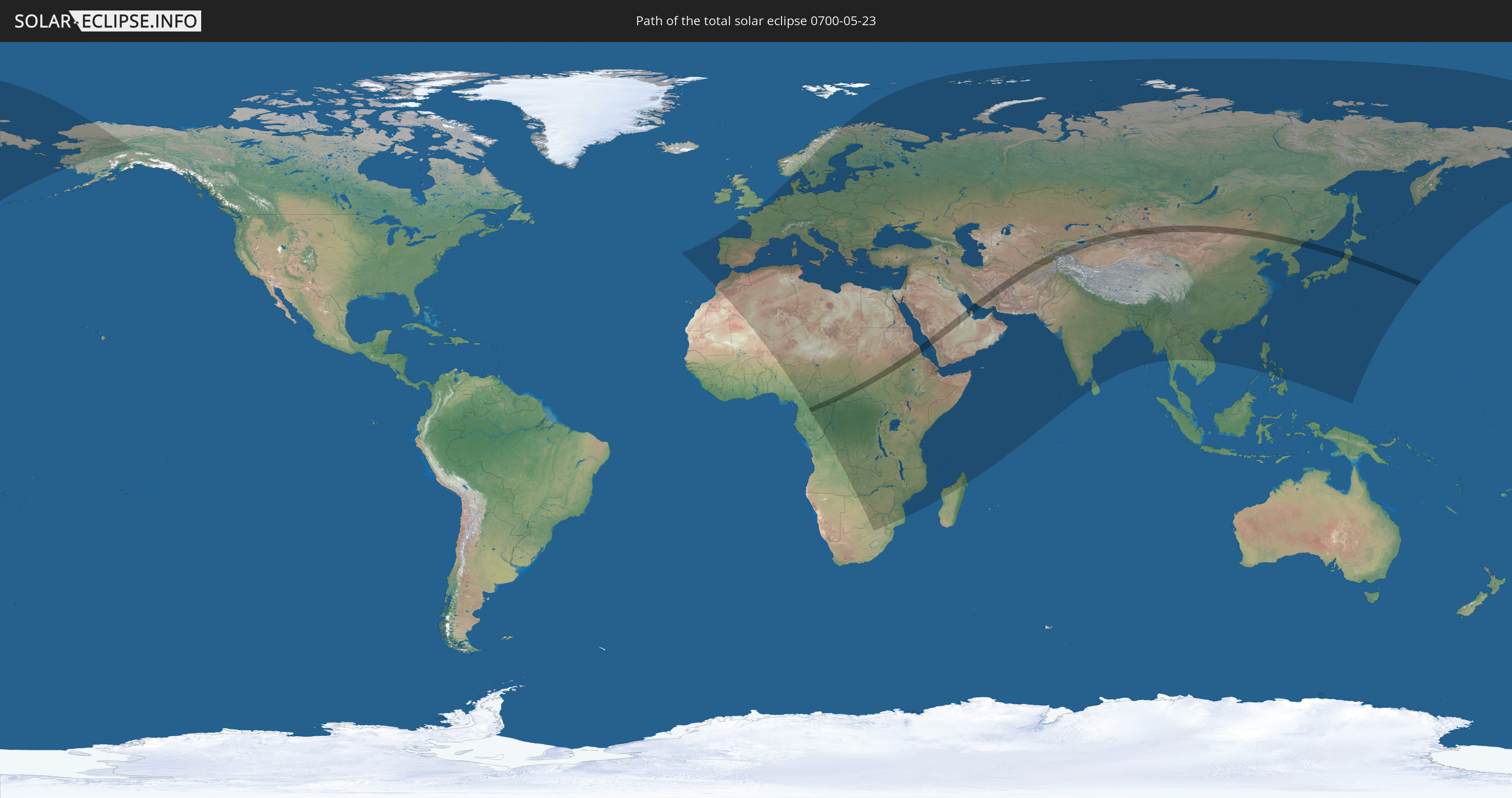
Die Sonnenfinsternis am 23.05.0700 kann man in 133 Ländern als partielle Sonnenfinsternis beobachten.
Der Finsternispfad verläuft durch 24 Länder. Nur in diesen Ländern ist sie als totale Sonnenfinsternis zu sehen.
In den folgenden Ländern ist die Sonnenfinsternis total zu sehen
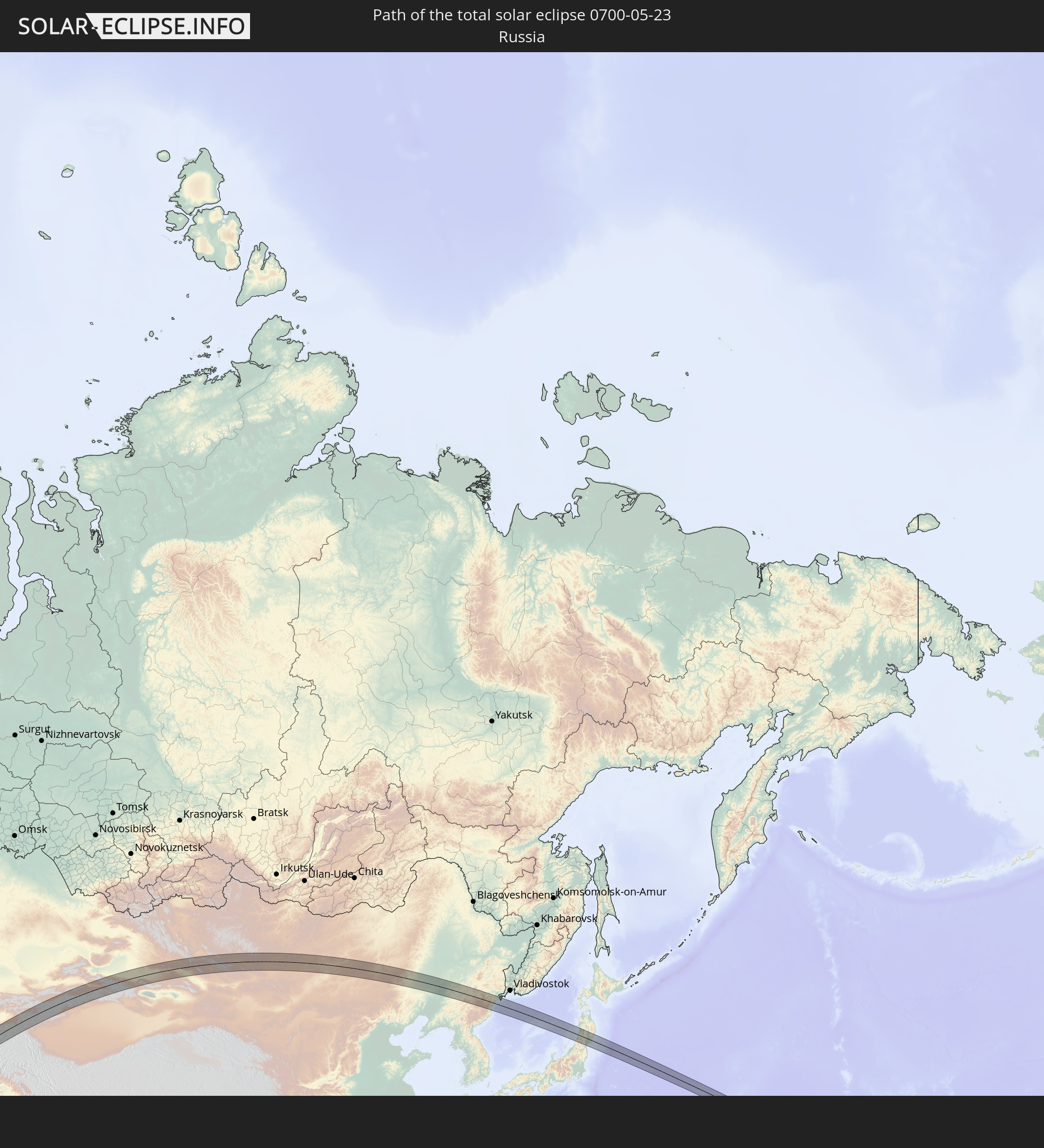 Russland
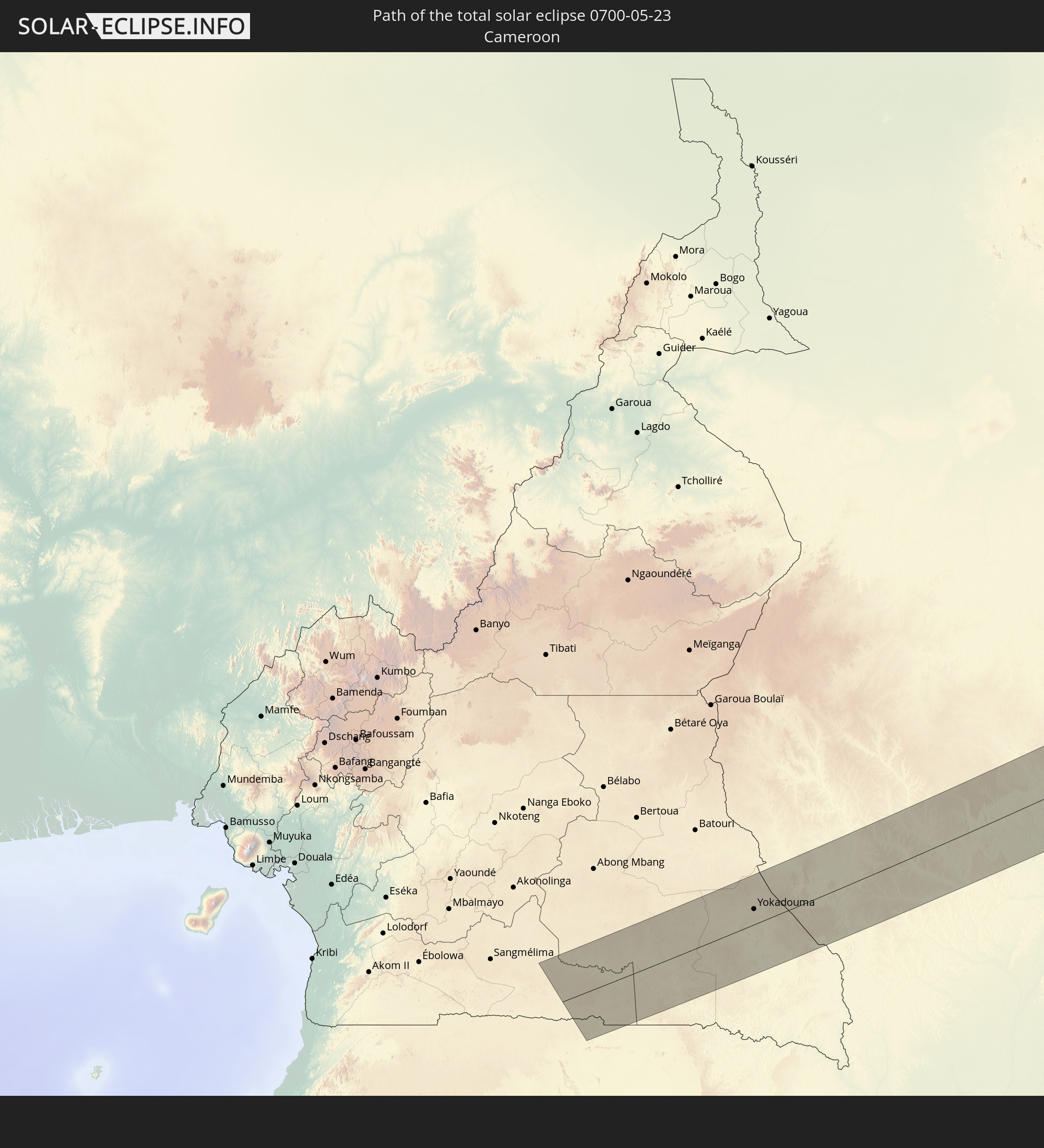 Kamerun
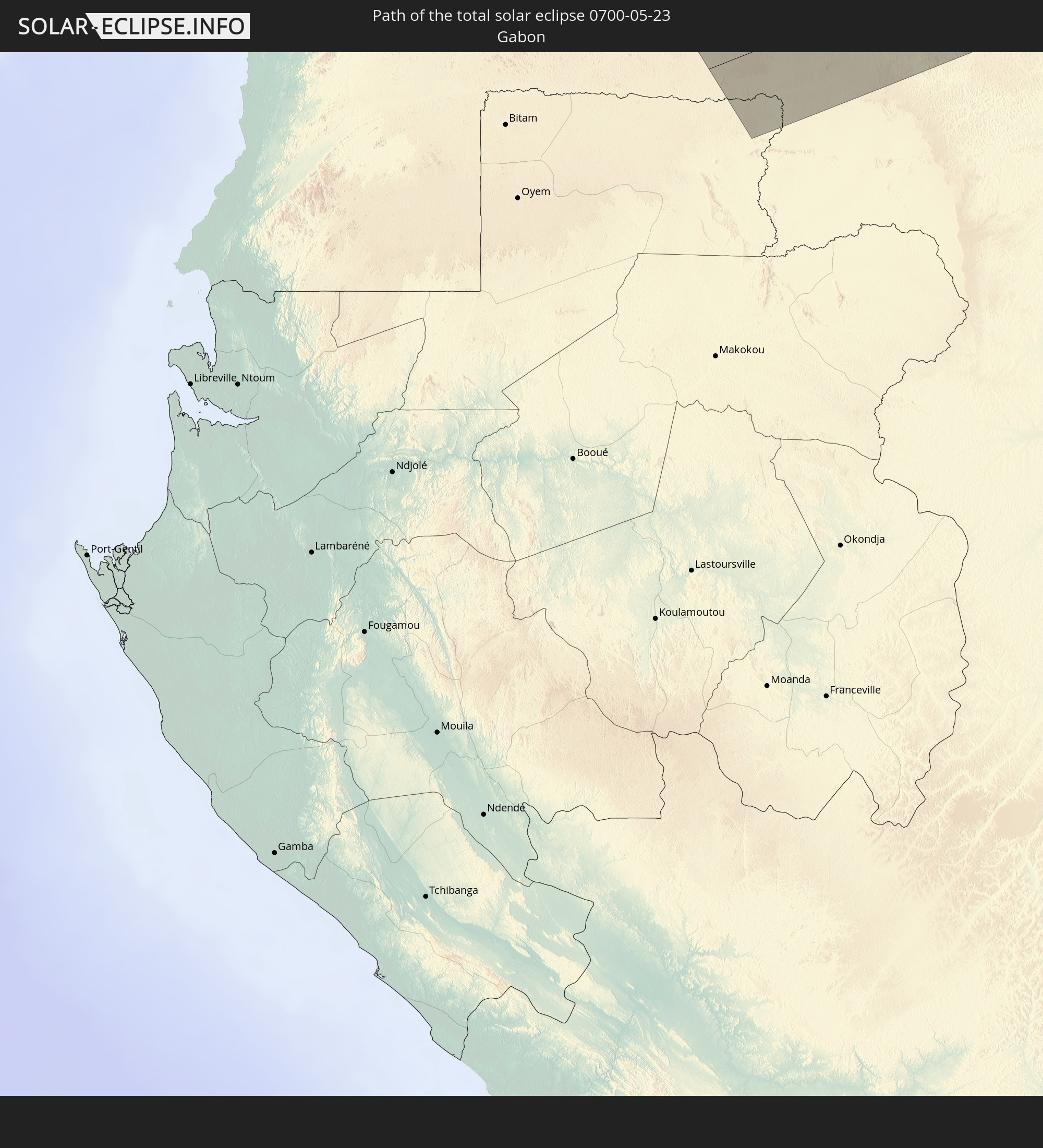 Gabun
Gabun
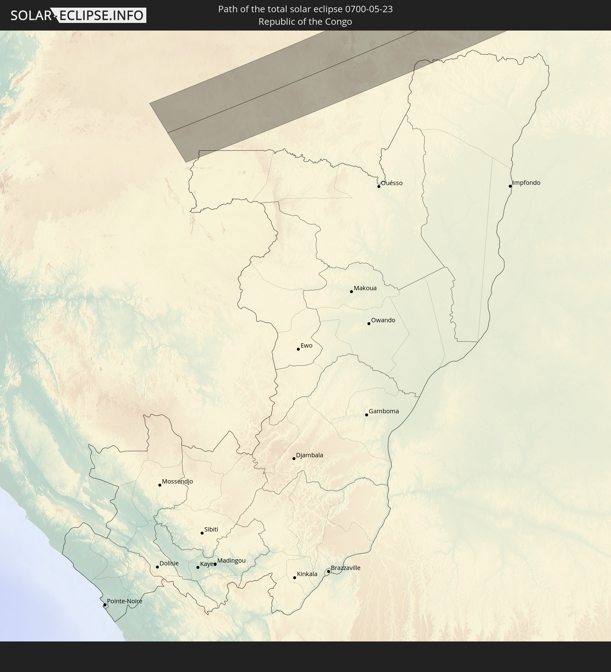 Republik Kongo
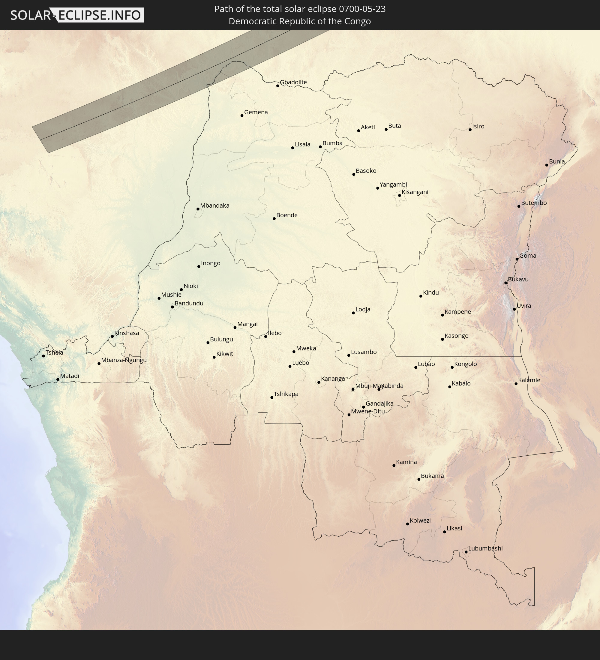 Demokratische Republik Kongo
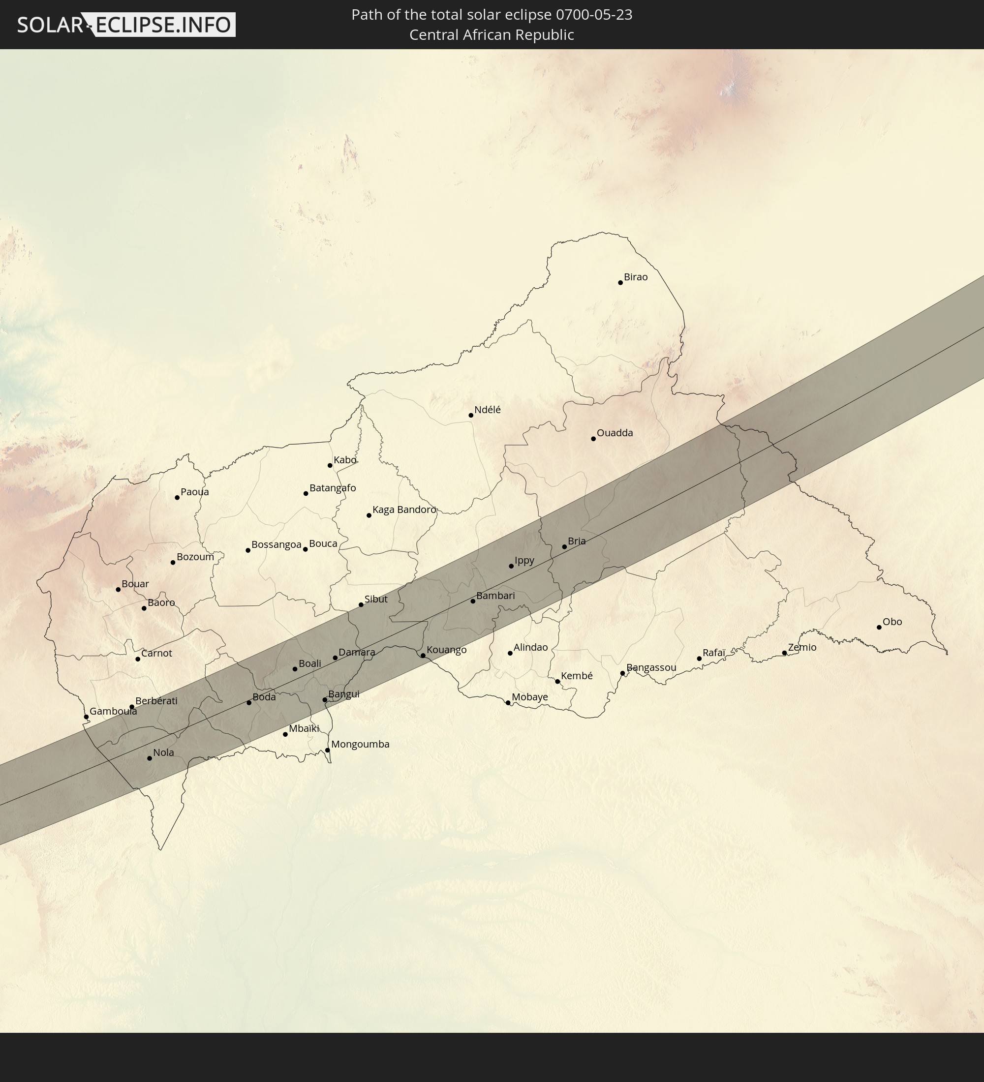 Zentralafrikanische Republik
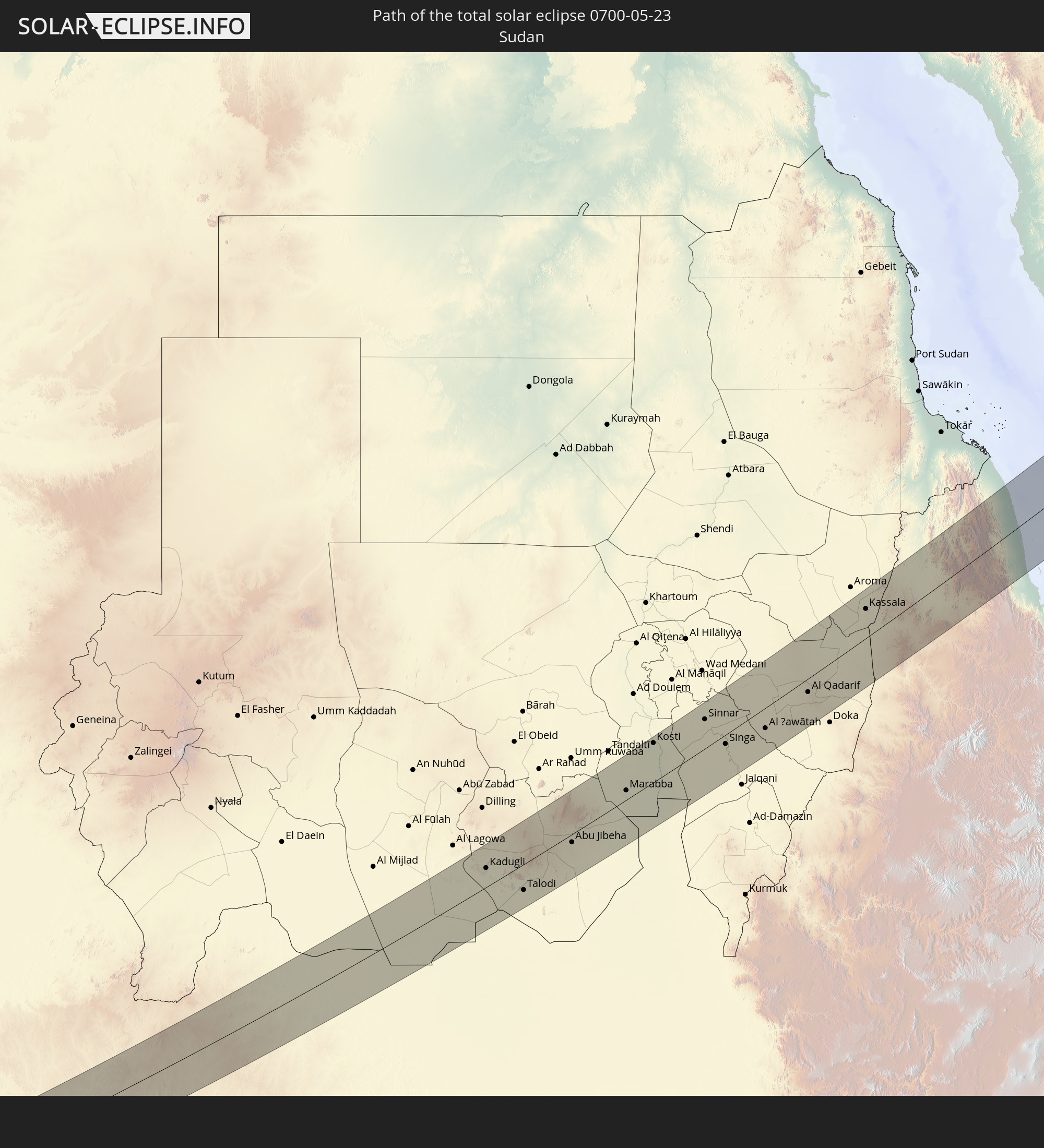 Sudan
Sudan
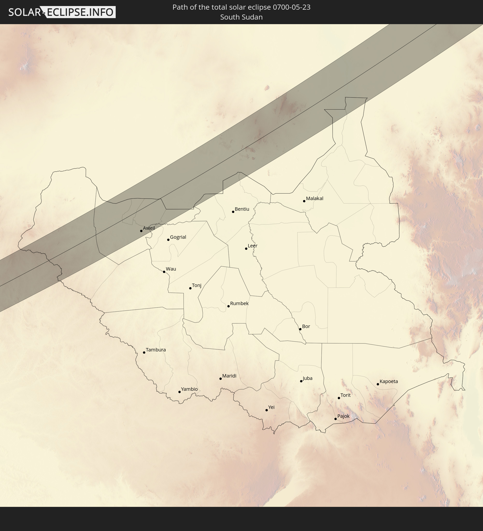 Südsudan
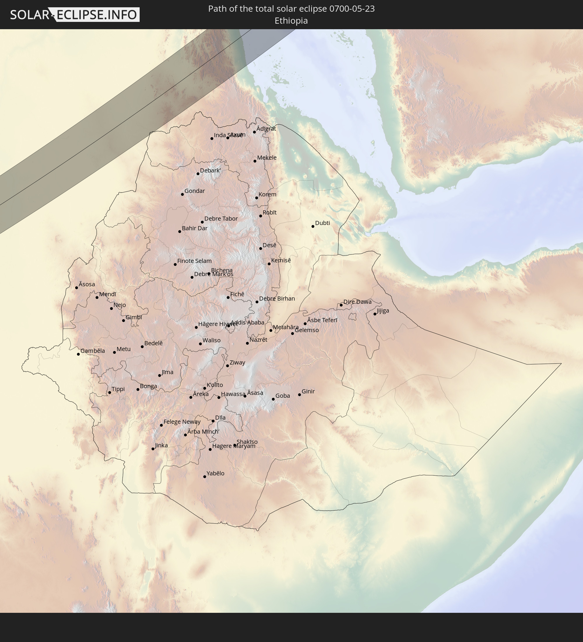 Äthiopien
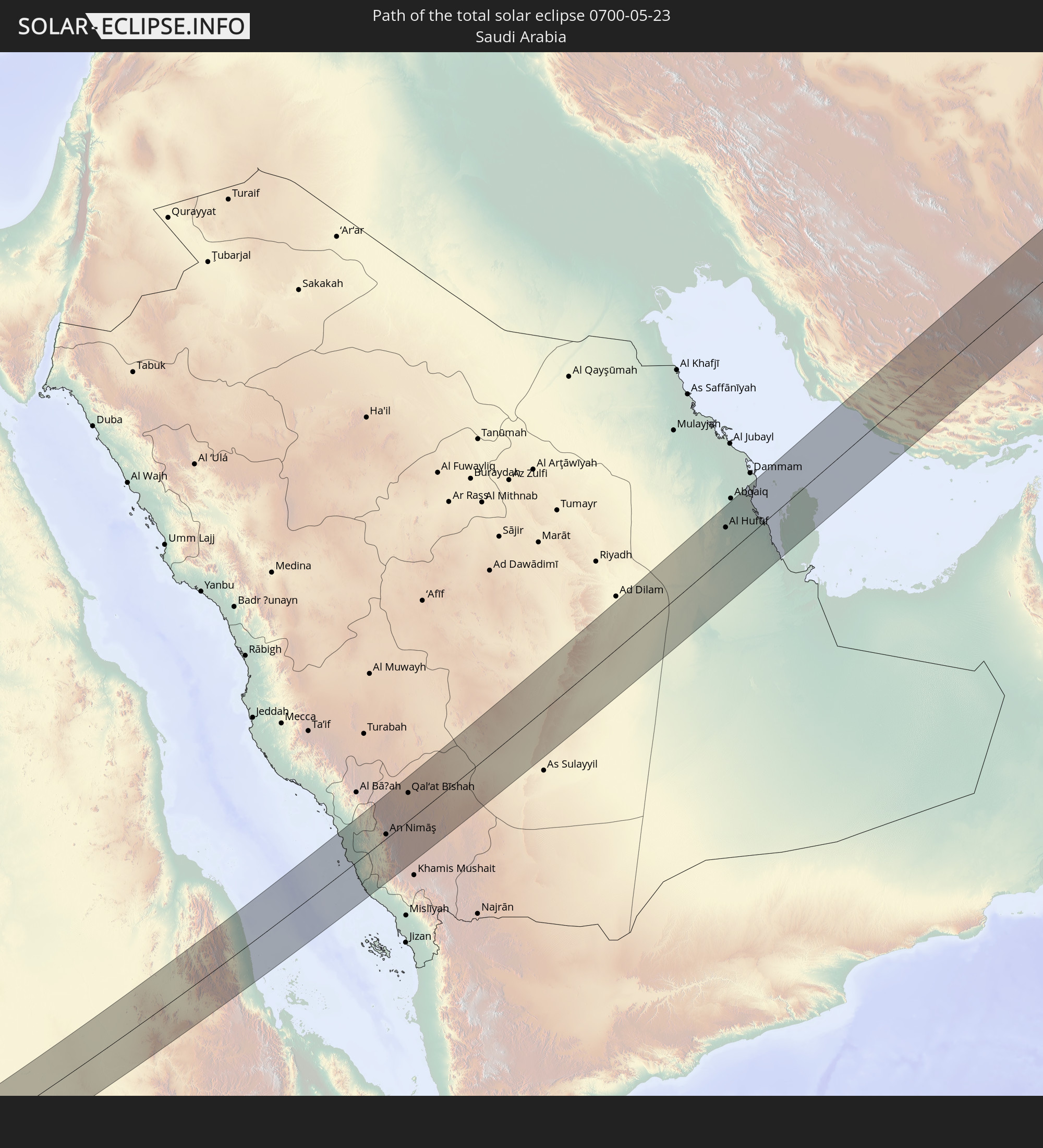 Saudi-Arabien
 Eritrea
 Iran
Iran
 Kasachstan
 Bahrain
 Katar
Katar
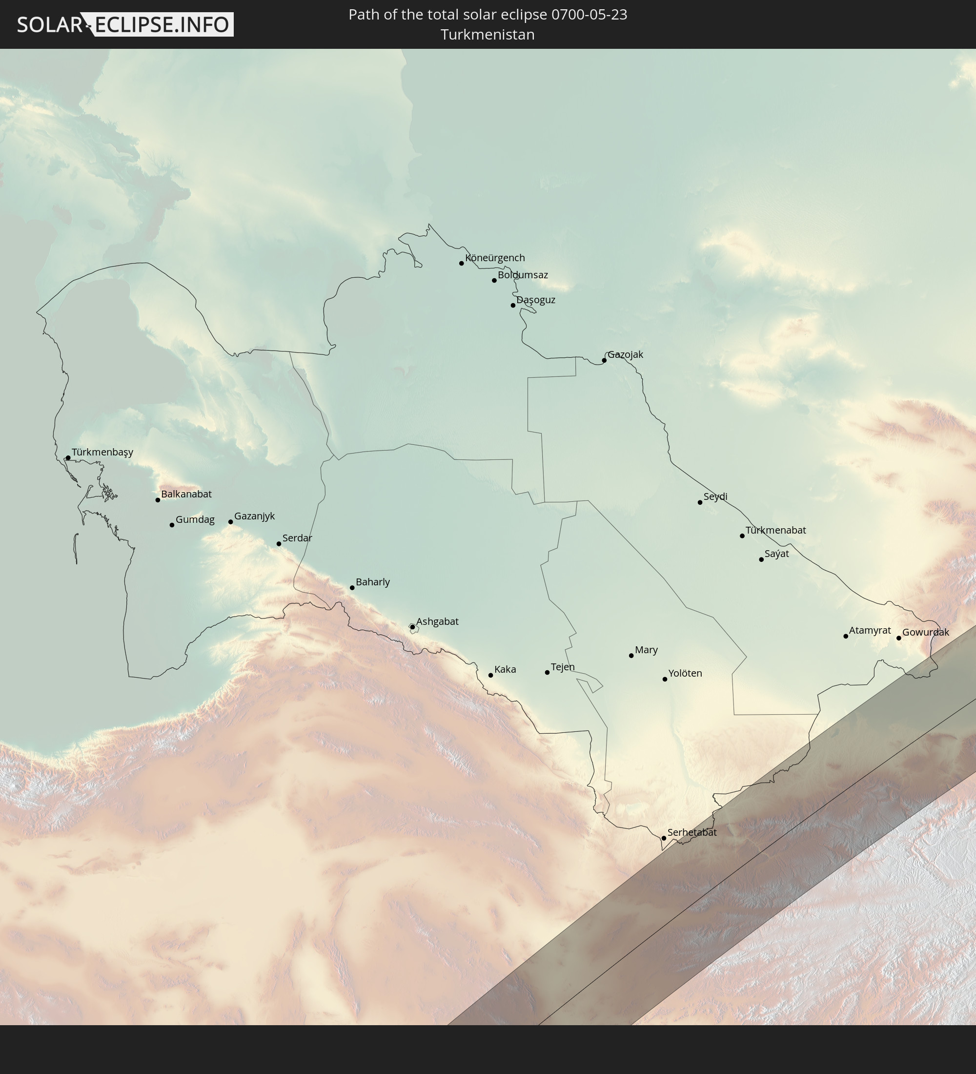 Turkmenistan
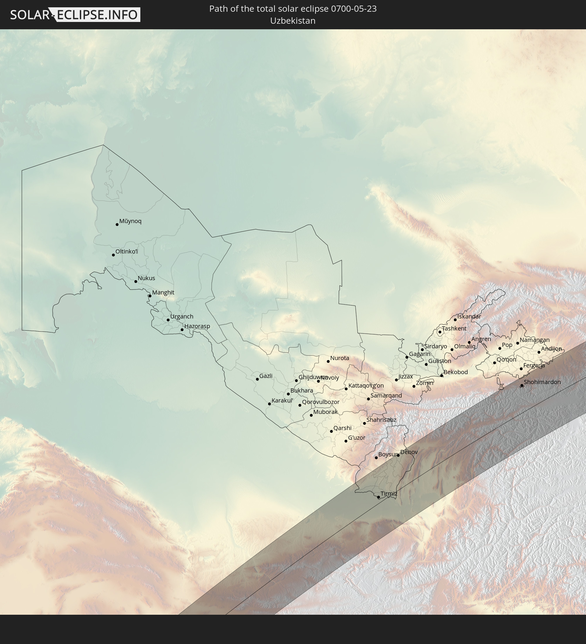 Usbekistan
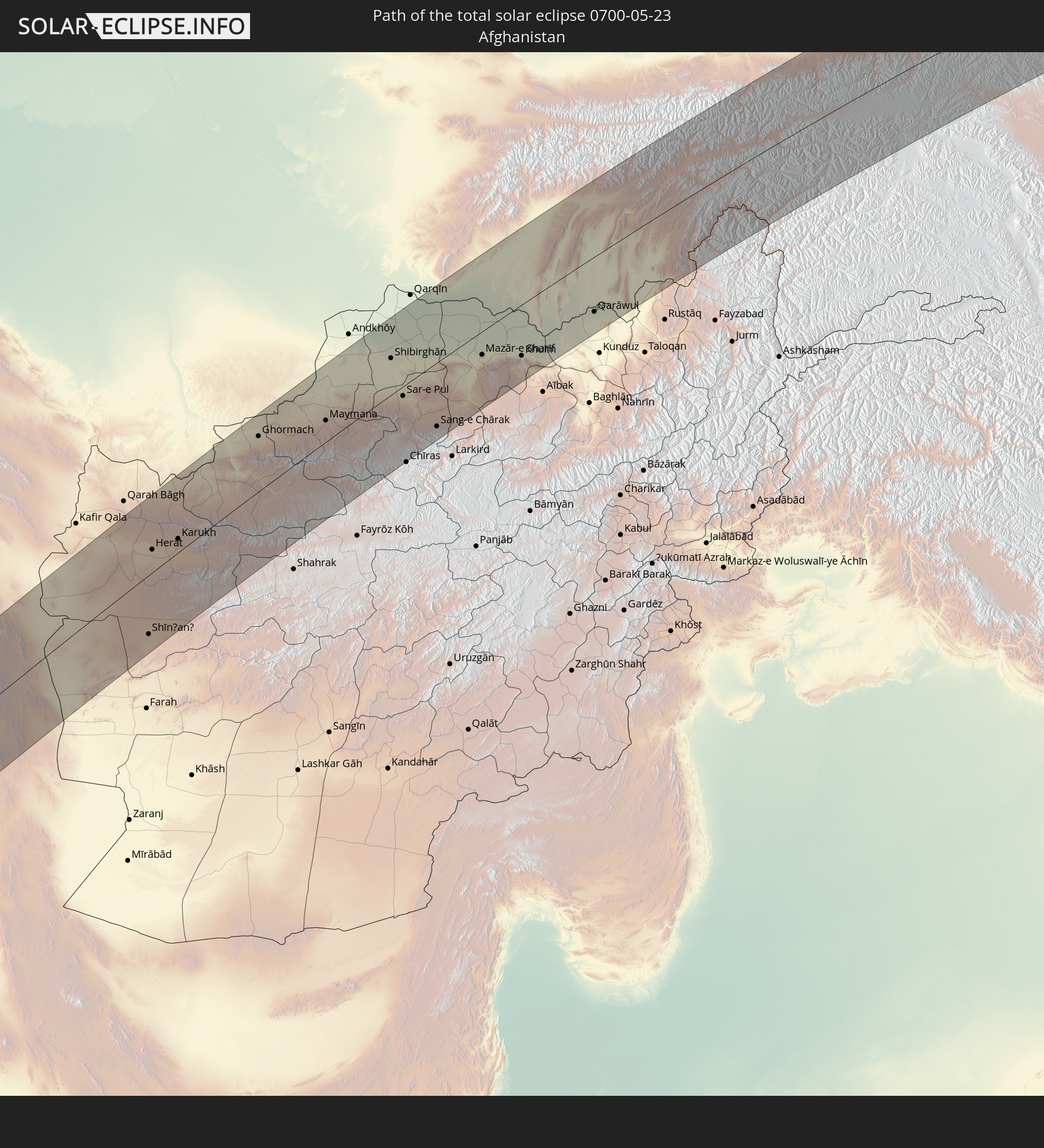 Afghanistan
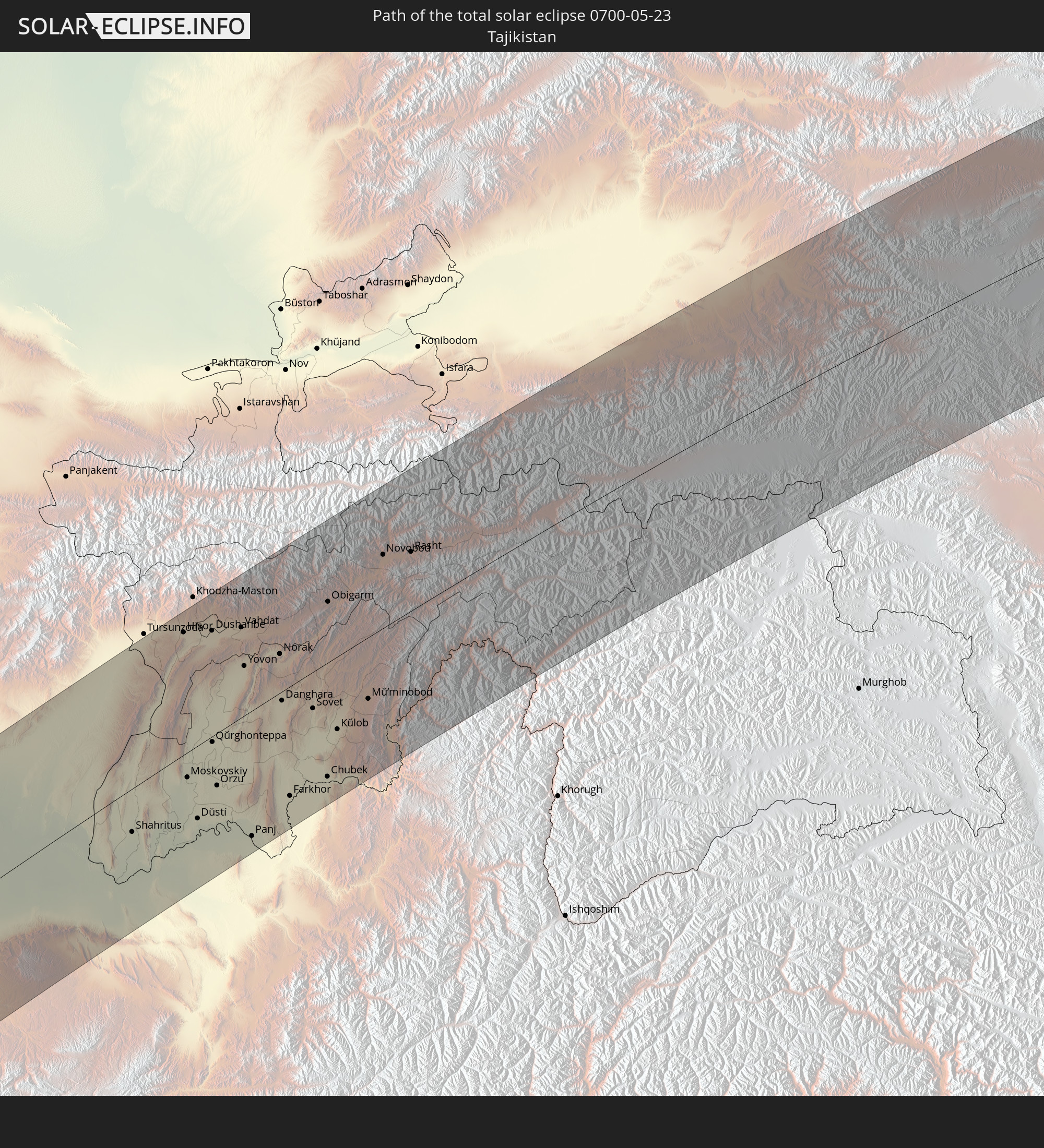 Tadschikistan
 Kirgisistan
 Volksrepublik China
 Mongolei
 Japan
Japan
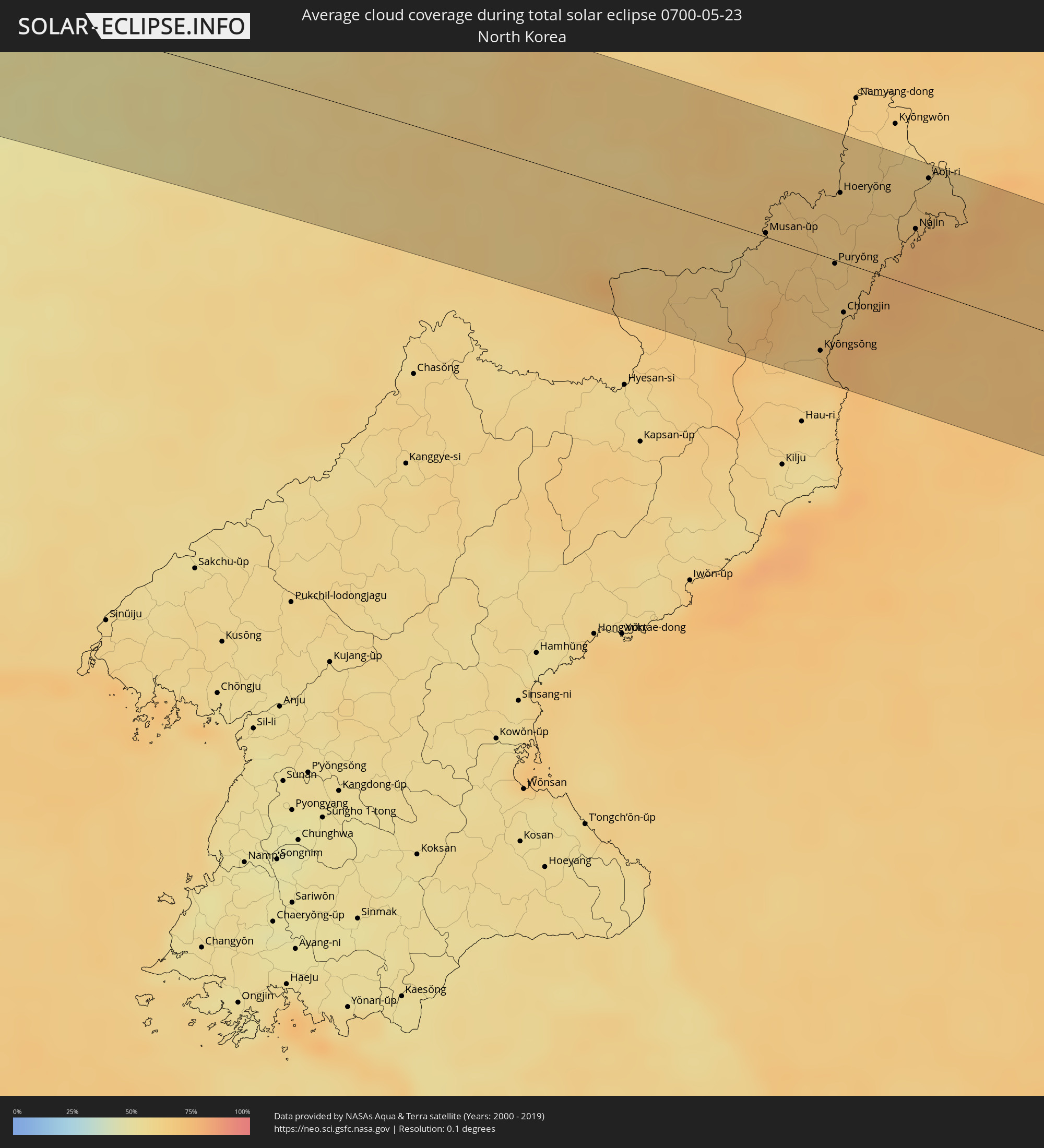
 Nordkorea
In den folgenden Ländern ist die Sonnenfinsternis partiell zu sehen
 Russland
 Vereinigte Staaten
 Portugal
 Spanien
 Marokko
 Mali
Mali
 Algerien
 Vereinigtes Königreich
 Gibraltar
 Frankreich
 Niger
Niger
 Andorra
 Belgien
 Nigeria
 Niederlande
 Norwegen
 Luxemburg
 Deutschland
 Schweiz
 Italien
 Monaco
 Tunesien
 Dänemark
 Kamerun
 Gabun
Gabun
 Libyen
 Liechtenstein
 Österreich
 Schweden
 Republik Kongo
 Angola
 Namibia
 Tschechien
 Demokratische Republik Kongo
 San Marino
 Vatikanstadt
 Slowenien
 Tschad
 Kroatien
 Polen
Polen
 Malta
Malta
 Zentralafrikanische Republik
 Bosnien und Herzegowina
 Ungarn
 Südafrika
 Slowakei
 Montenegro
 Serbien
 Albanien
 Åland Islands
 Griechenland
 Botswana
 Rumänien
 Mazedonien
 Finnland
 Litauen
 Lettland
 Estland
 Sudan
Sudan
 Sambia
 Ukraine
 Bulgarien
 Weißrussland
 Ägypten
 Simbabwe
 Türkei
 Moldawien
 Ruanda
 Burundi
 Tansania
 Uganda
 Mosambik
 Republik Zypern
 Malawi
 Äthiopien
 Kenia
Kenia
 Staat Palästina
 Israel
 Saudi-Arabien
 Jordanien
 Libanon
 Syrien
 Eritrea
 Irak
Irak
 Georgien
 Französische Süd- und Antarktisgebiete
 Somalia
 Dschibuti
 Jemen
Jemen
 Madagaskar
 Komoren
 Armenien
 Iran
Iran
 Aserbaidschan
 Mayotte
 Seychellen
 Kasachstan
 Kuwait
 Bahrain
 Katar
Katar
 Vereinigte Arabische Emirate
 Oman
Oman
 Turkmenistan
 Usbekistan
 Mauritius
 Afghanistan
 Pakistan
 Tadschikistan
 Indien
 Kirgisistan
 Malediven
 Volksrepublik China
 Sri Lanka
 Nepal
Nepal
 Mongolei
 Bangladesch
 Bhutan
 Myanmar
 Thailand
 Laos
Laos
 Vietnam
 Kambodscha
 Macau
Macau
 Hongkong
 Taiwan
 Philippinen
 Japan
Japan
 Nordkorea
 Südkorea
 Palau
Palau
 Föderierte Staaten von Mikronesien
 Guam
Guam
 Nördliche Marianen
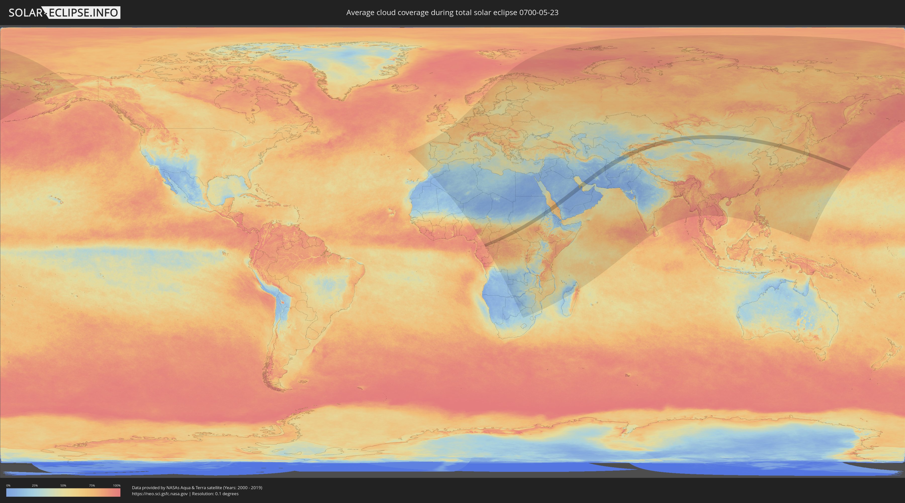
Wie wird das Wetter während der totalen Sonnenfinsternis am 23.05.0700?
Wo ist der beste Ort, um die totale Sonnenfinsternis vom 23.05.0700 zu beobachten?
Die folgenden Karten zeigen die durchschnittliche Bewölkung für den Tag, an dem die totale Sonnenfinsternis
stattfindet. Mit Hilfe der Karten lässt sich der Ort entlang des Finsternispfades eingrenzen,
der die besten Aussichen auf einen klaren wolkenfreien Himmel bietet.
Trotzdem muss man immer lokale Gegenenheiten beachten und sollte sich genau über das Wetter an seinem
gewählten Beobachtungsort informieren.
Die Daten stammen von den beiden NASA-Satelliten
AQUA und TERRA
und wurden über einen Zeitraum von 19 Jahren (2000 - 2019) gemittelt.

Detaillierte Länderkarten
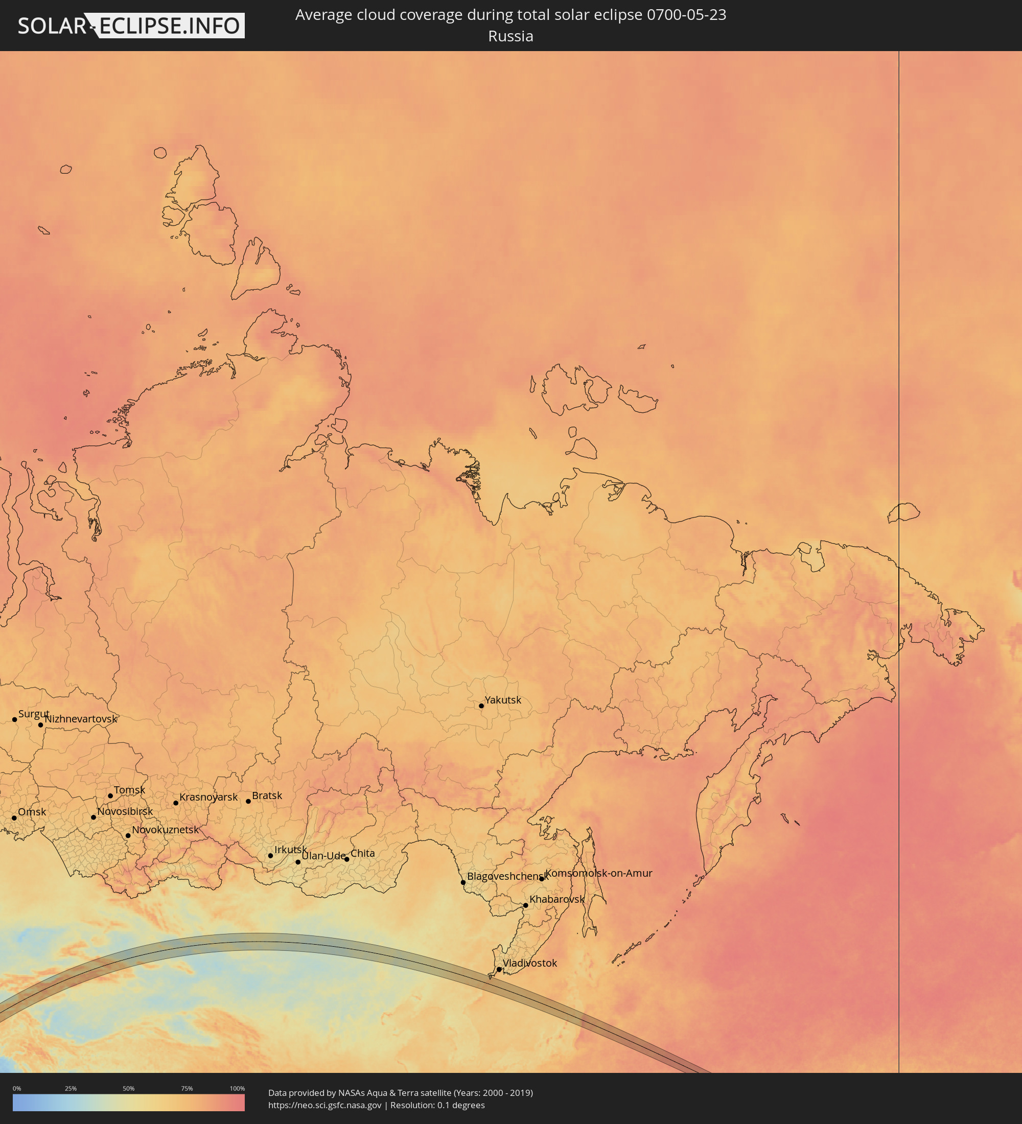 Russland
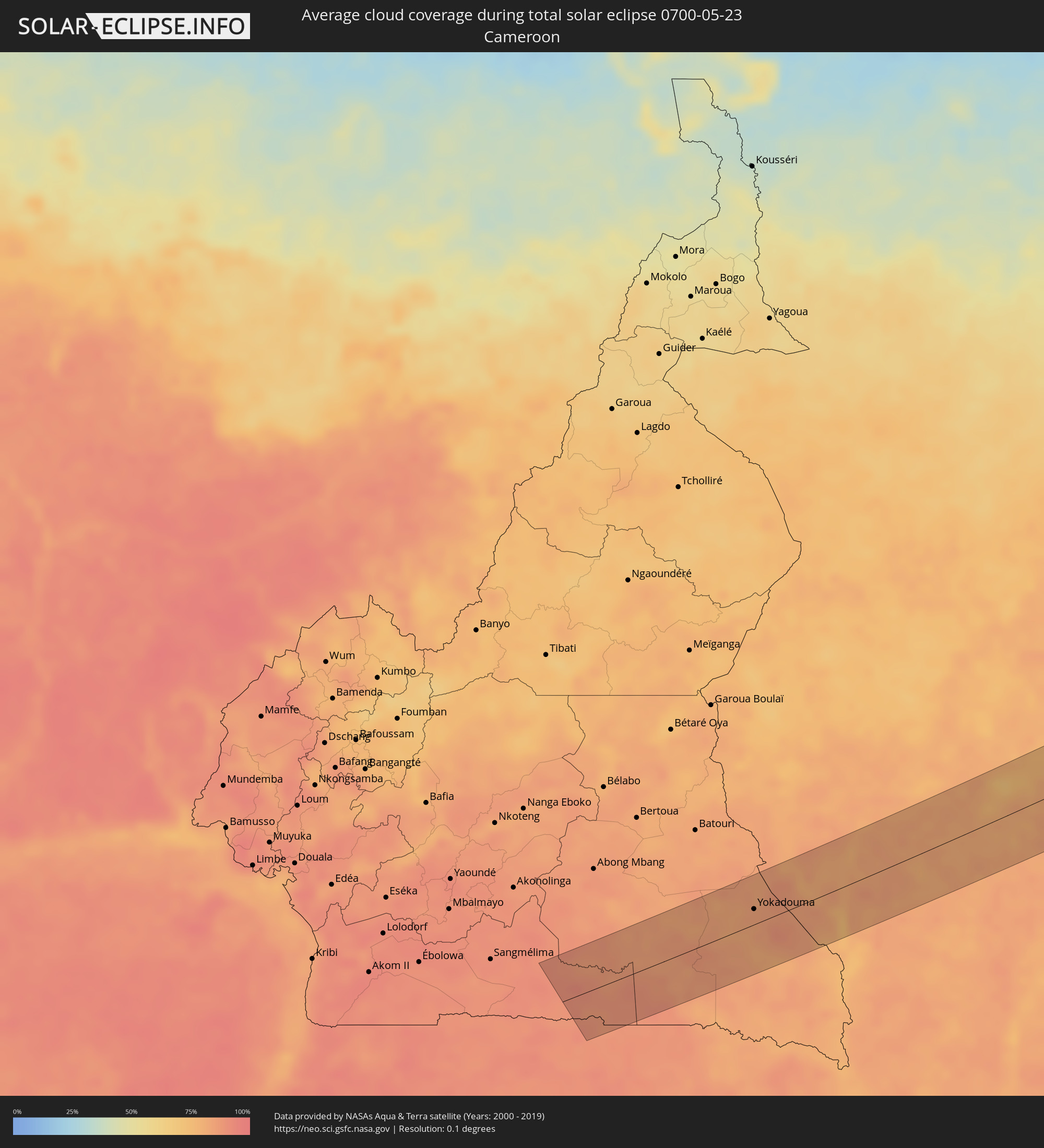 Kamerun
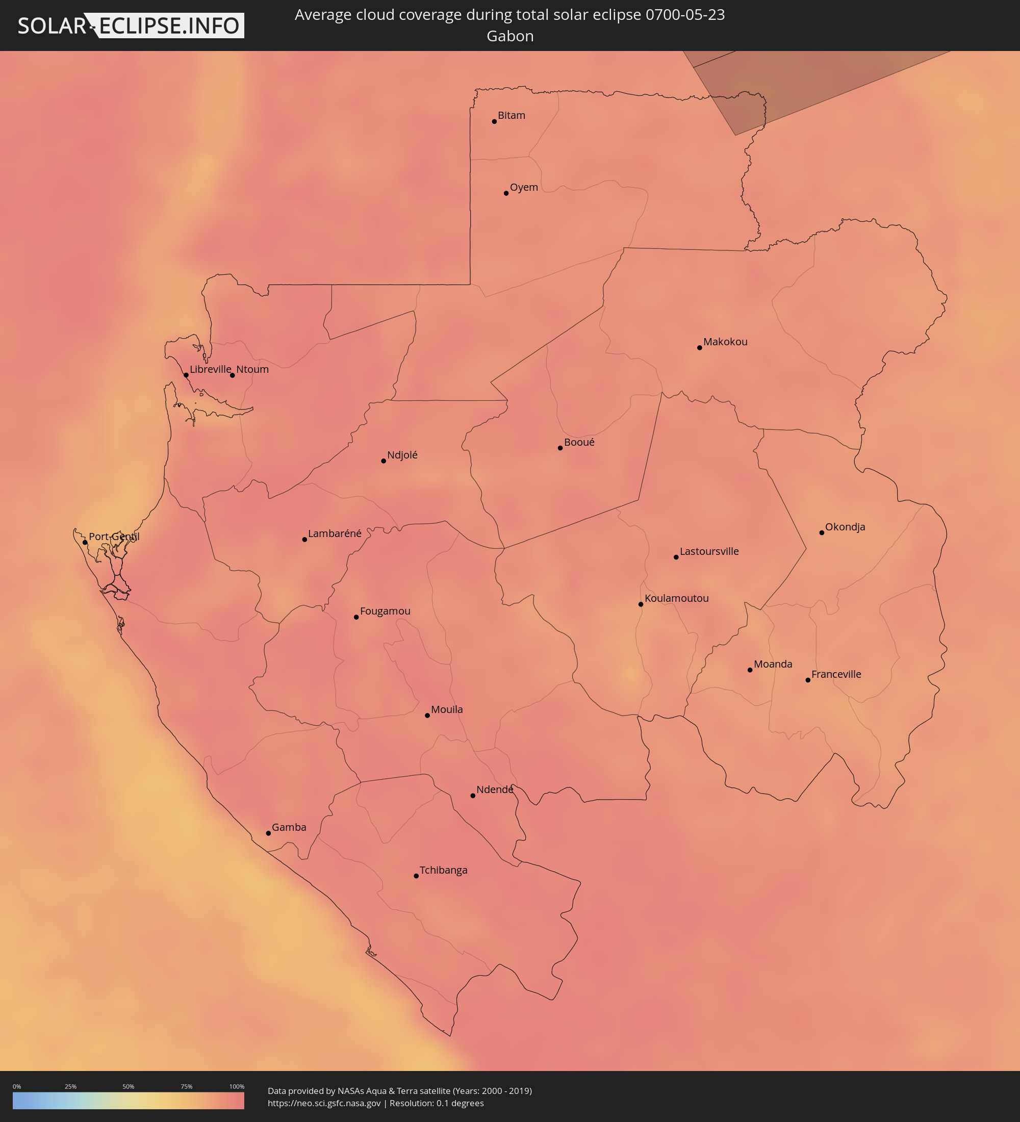 Gabun
Gabun
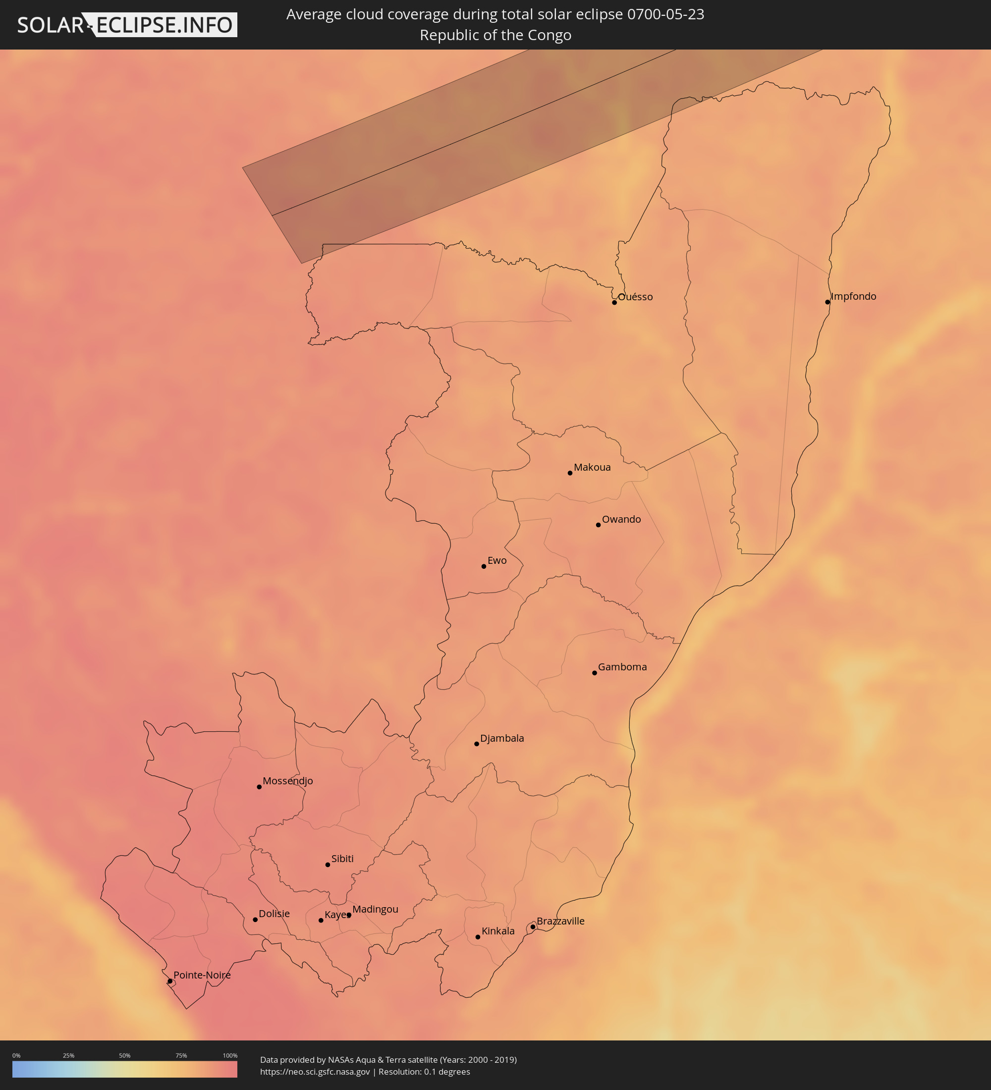 Republik Kongo
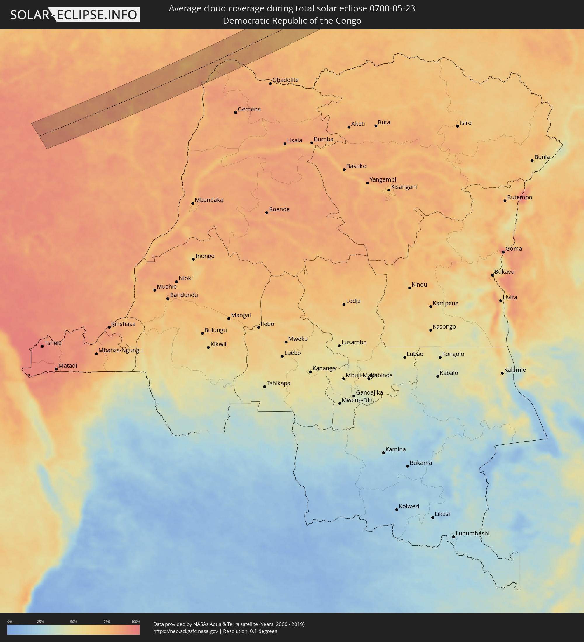 Demokratische Republik Kongo
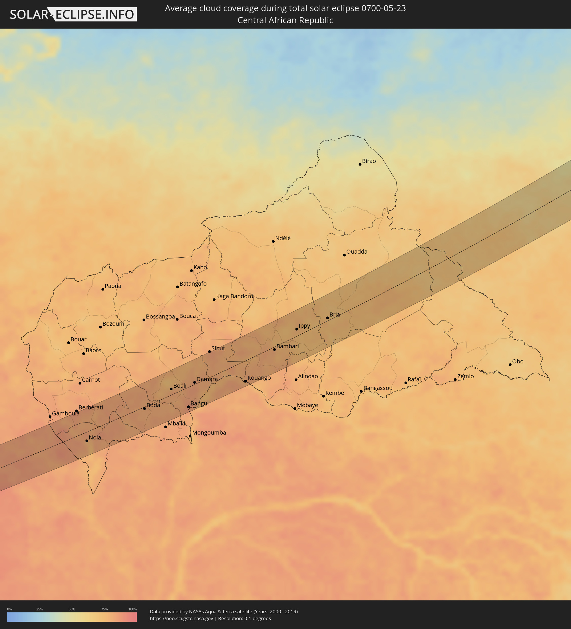 Zentralafrikanische Republik
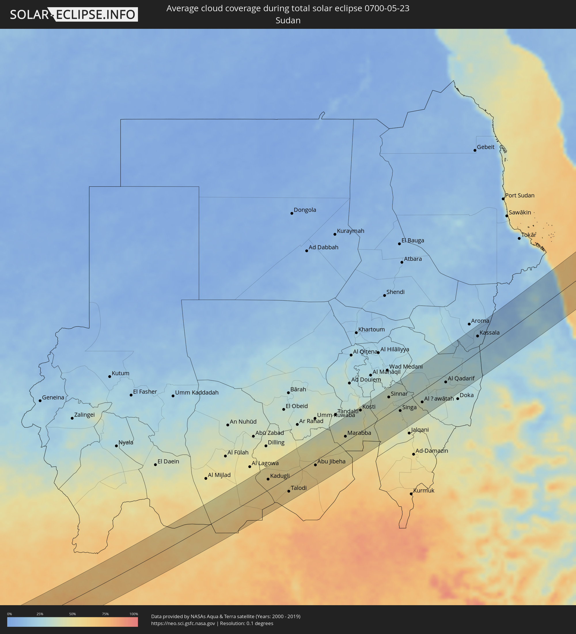 Sudan
Sudan
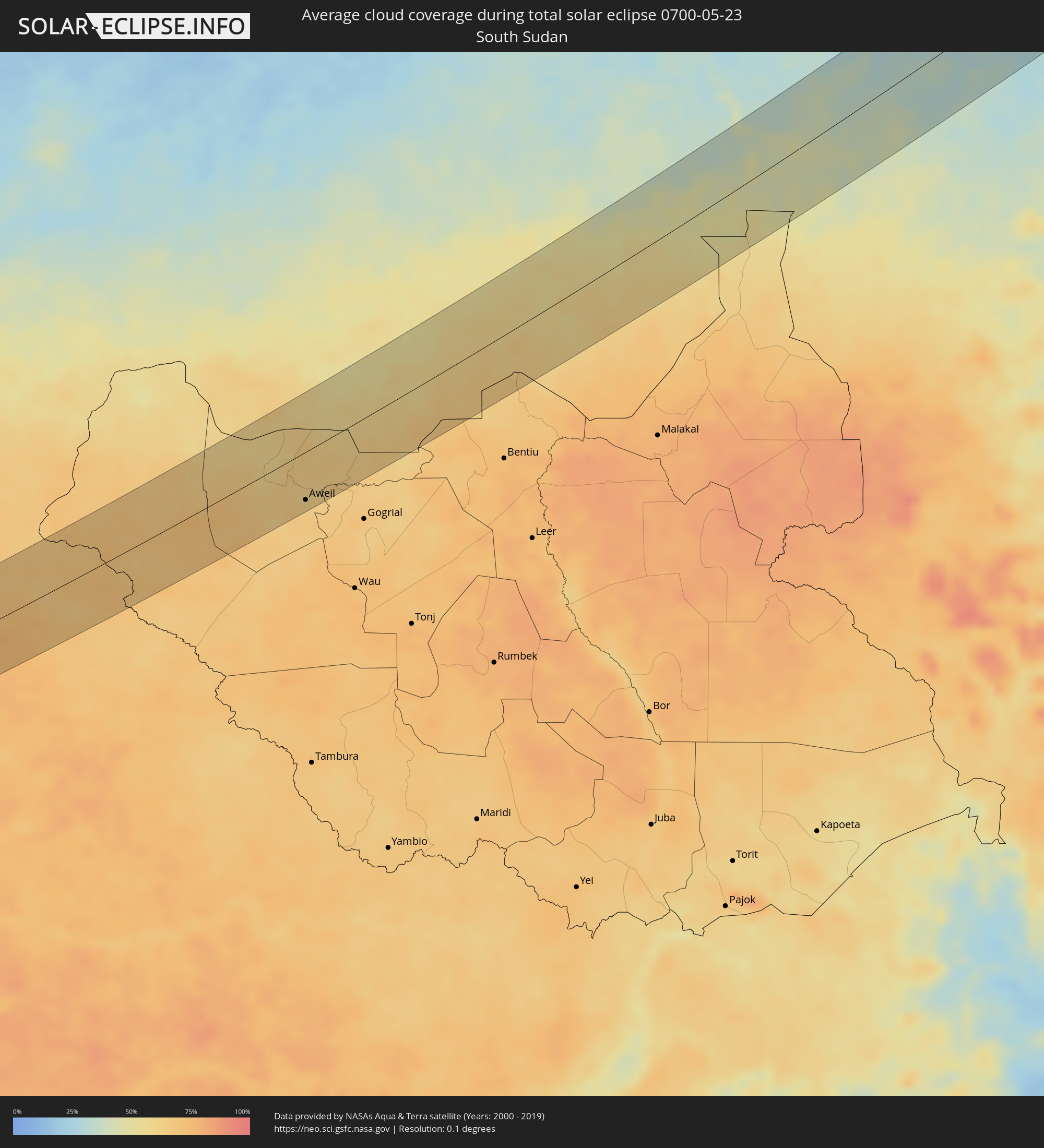 Südsudan
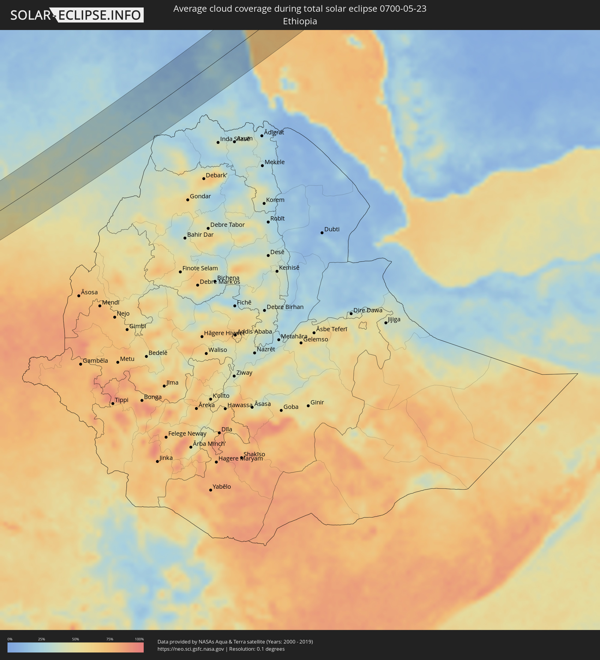 Äthiopien
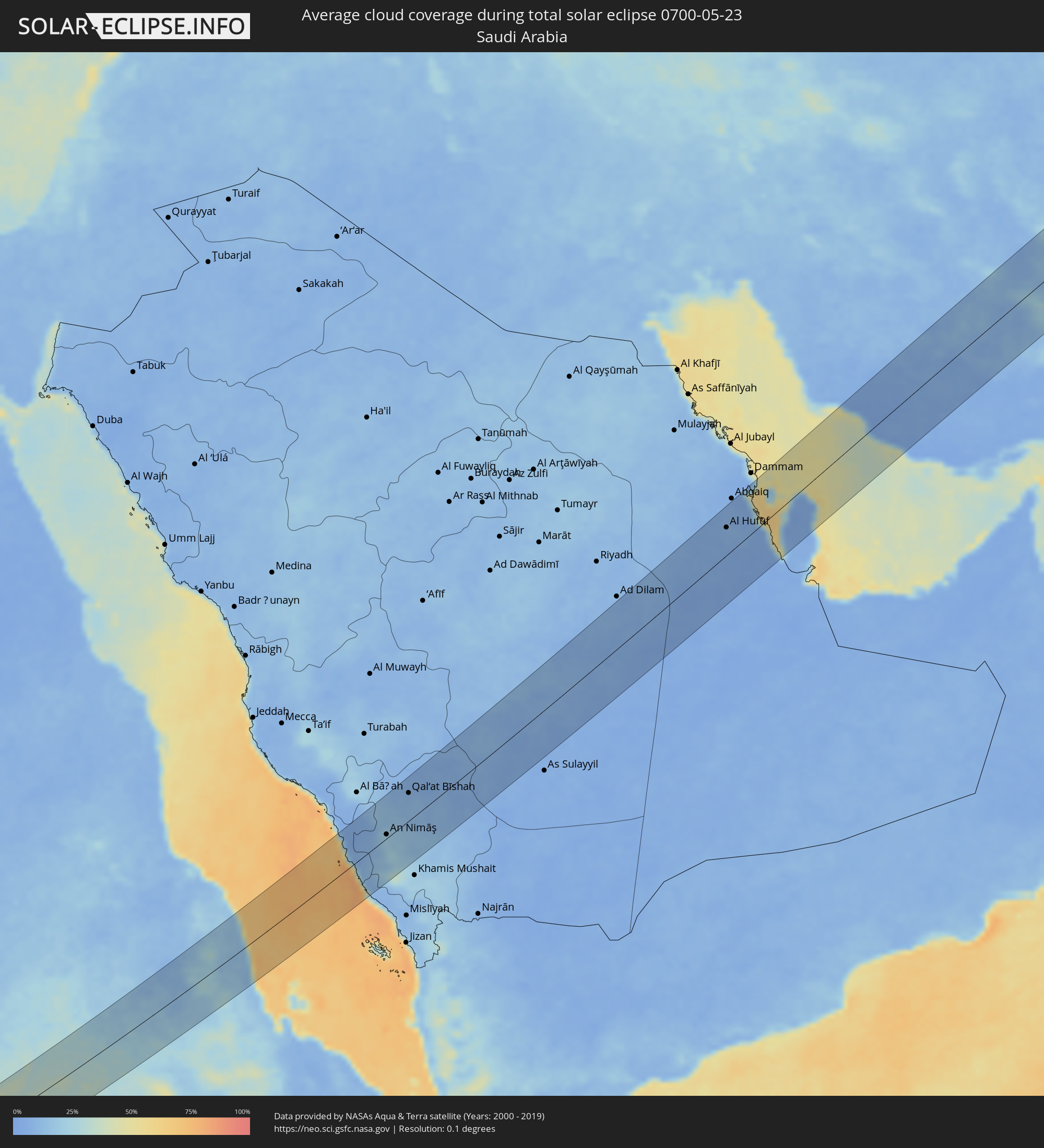 Saudi-Arabien
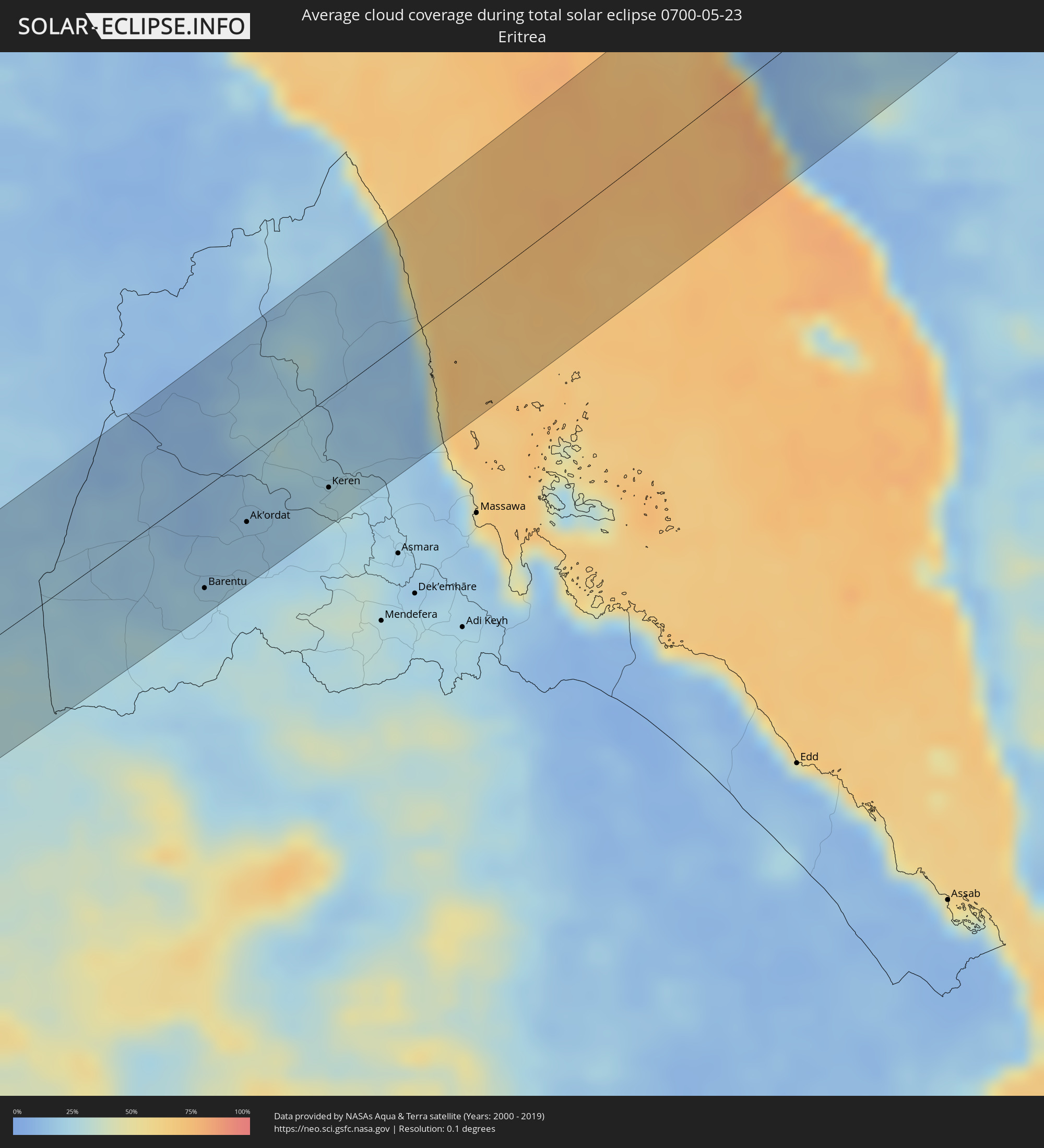 Eritrea
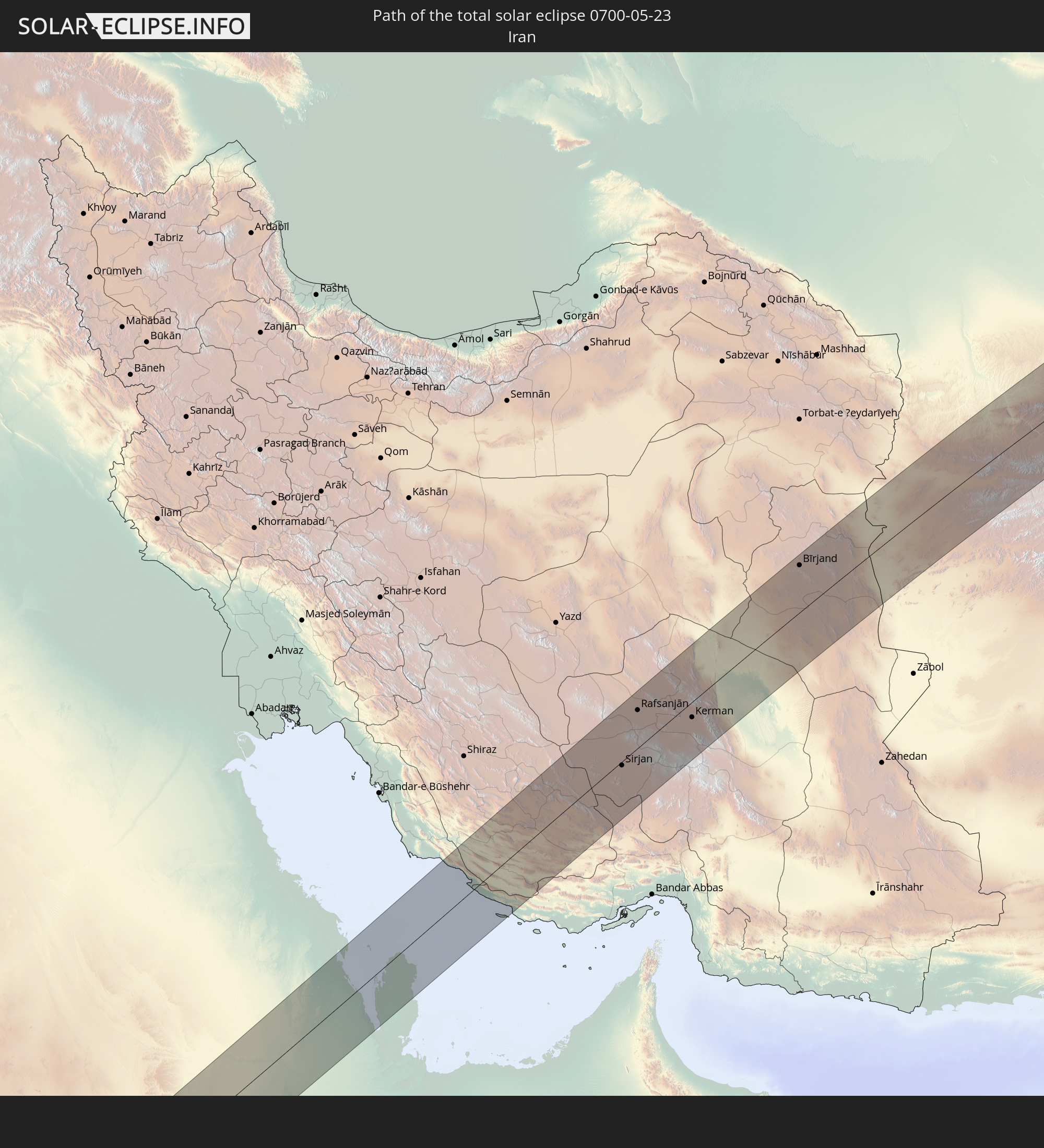
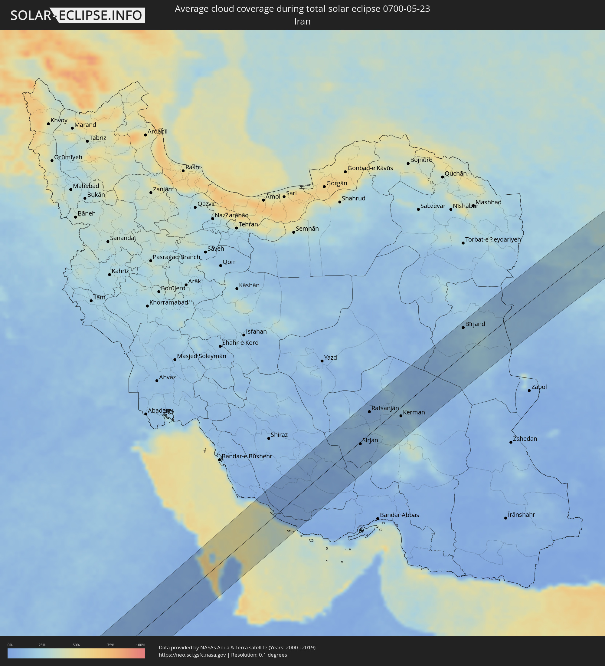 Iran
Iran
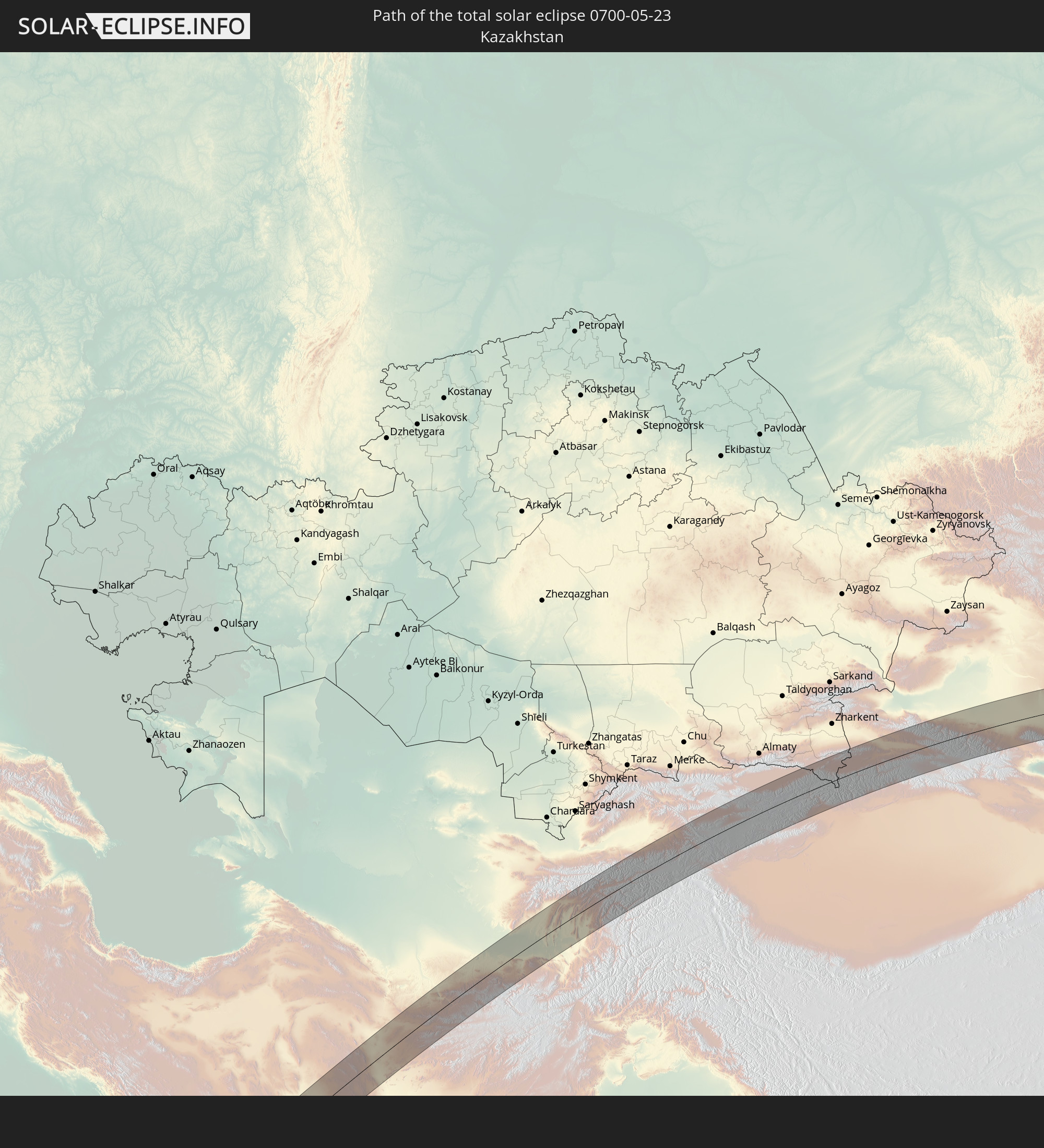
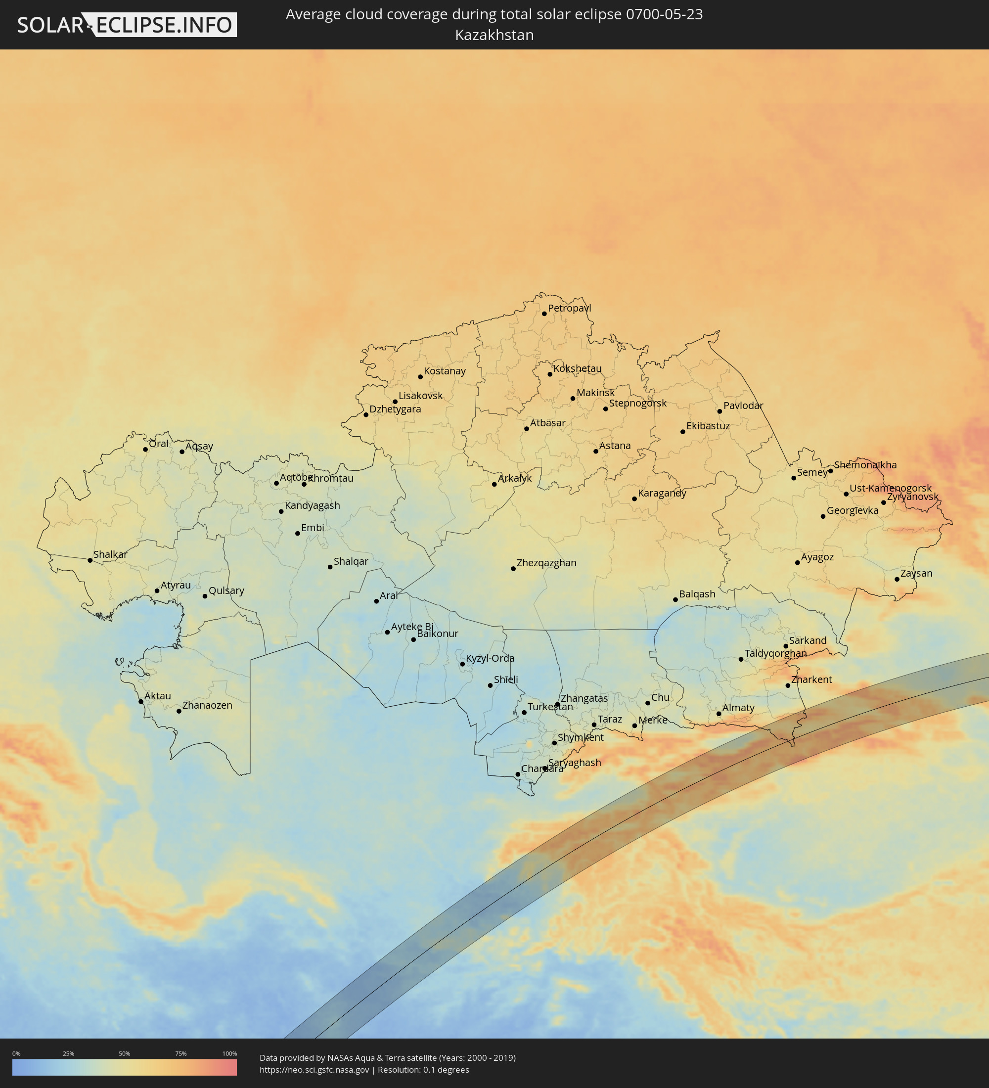 Kasachstan
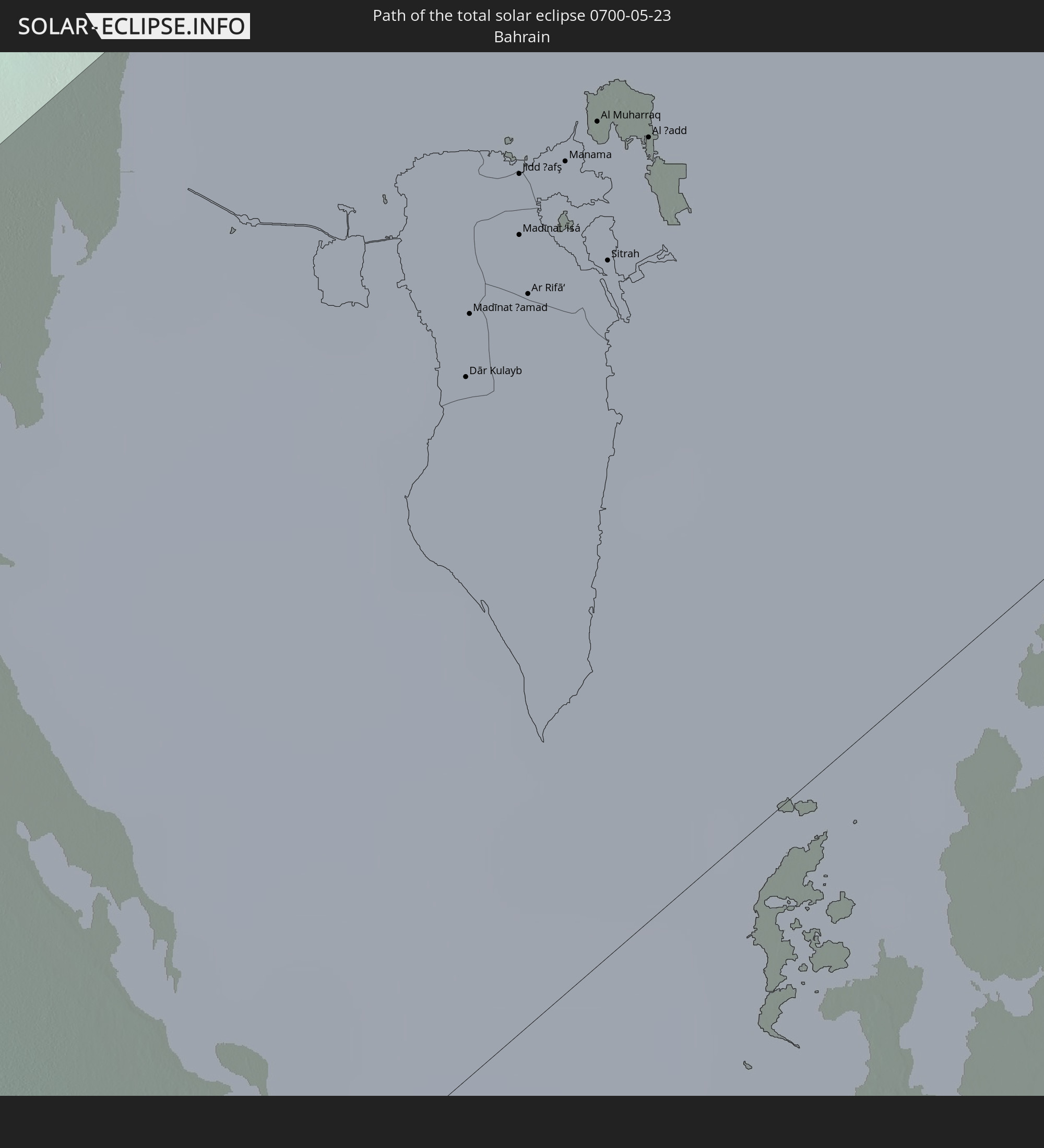
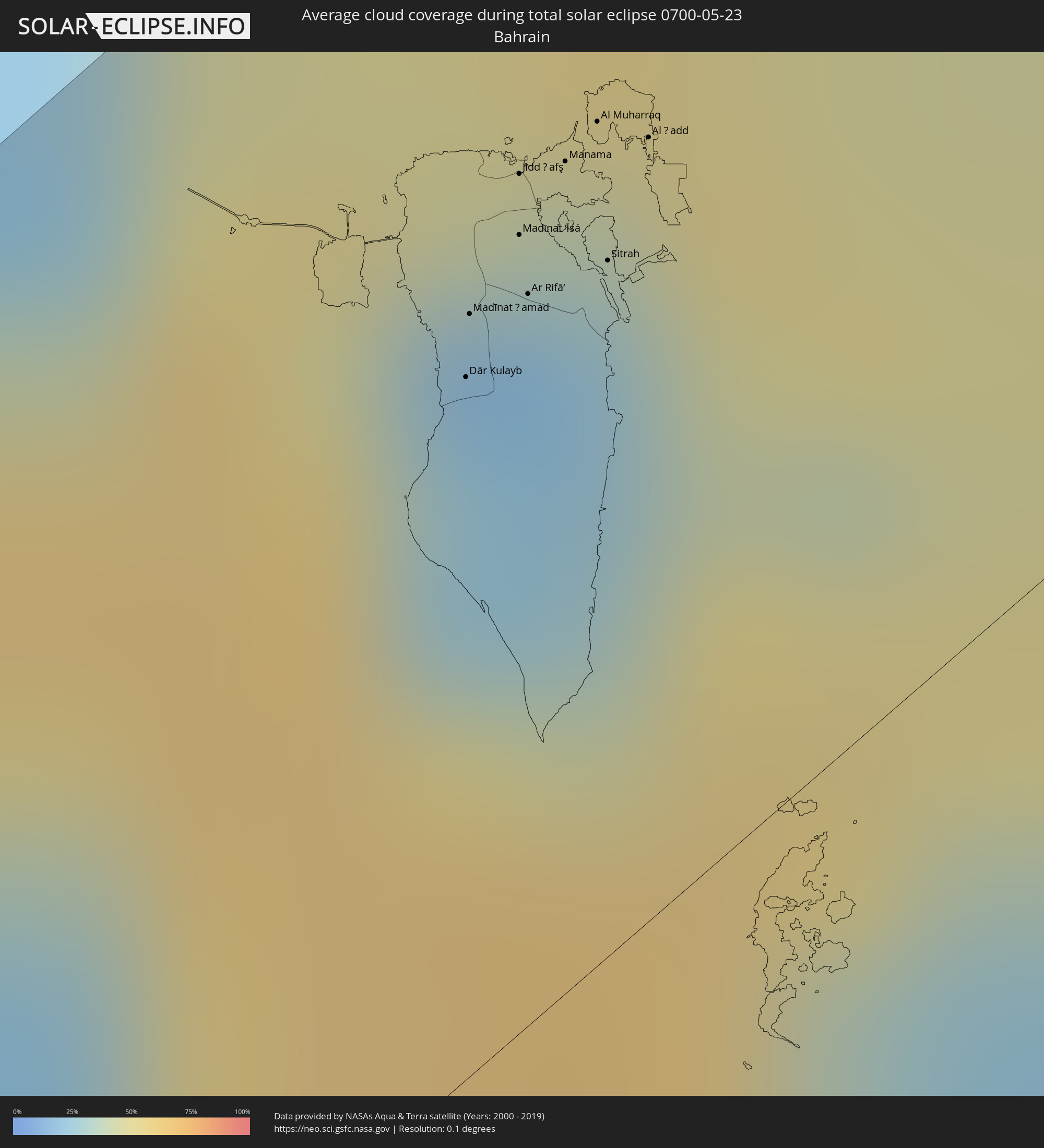 Bahrain
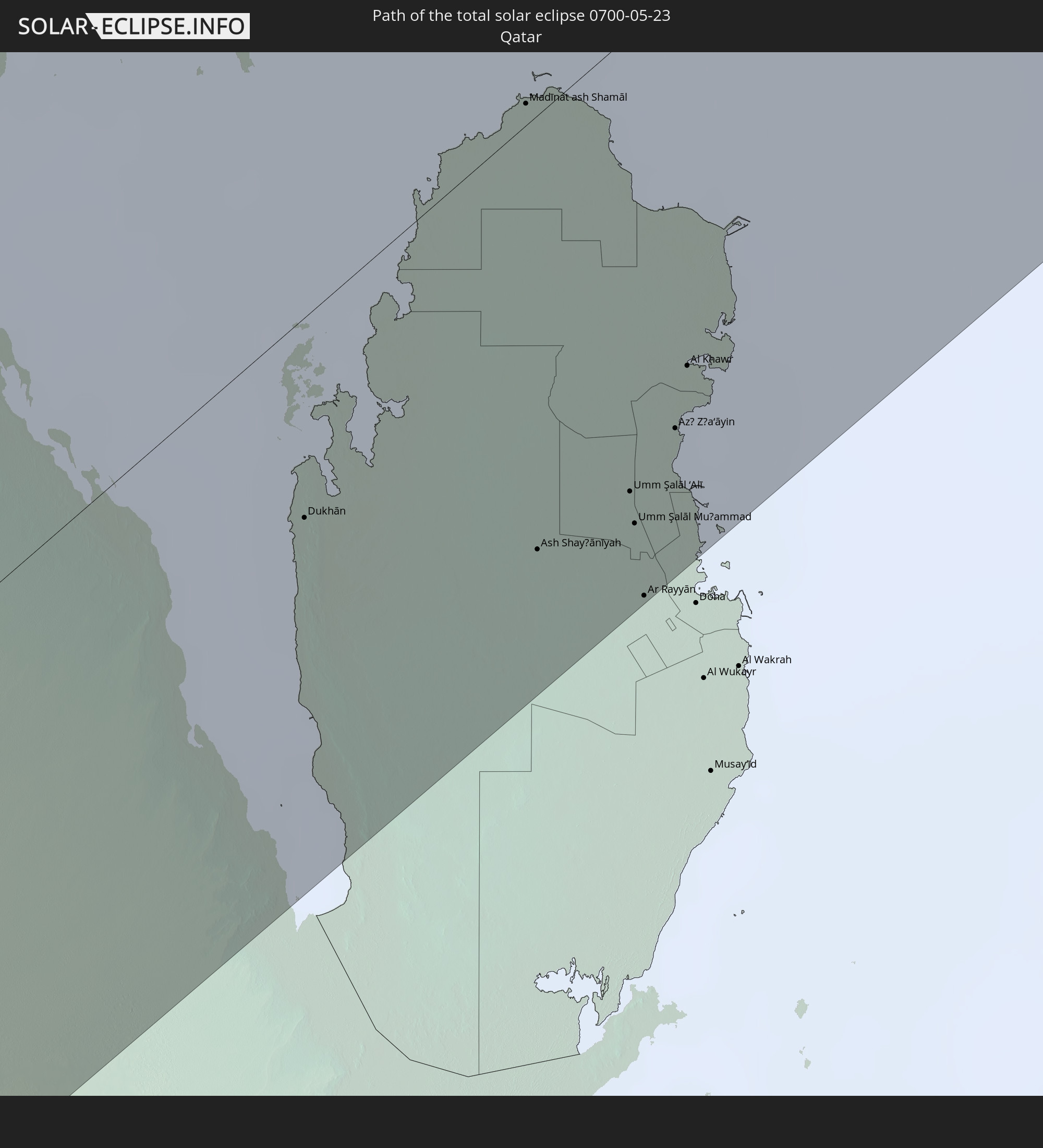
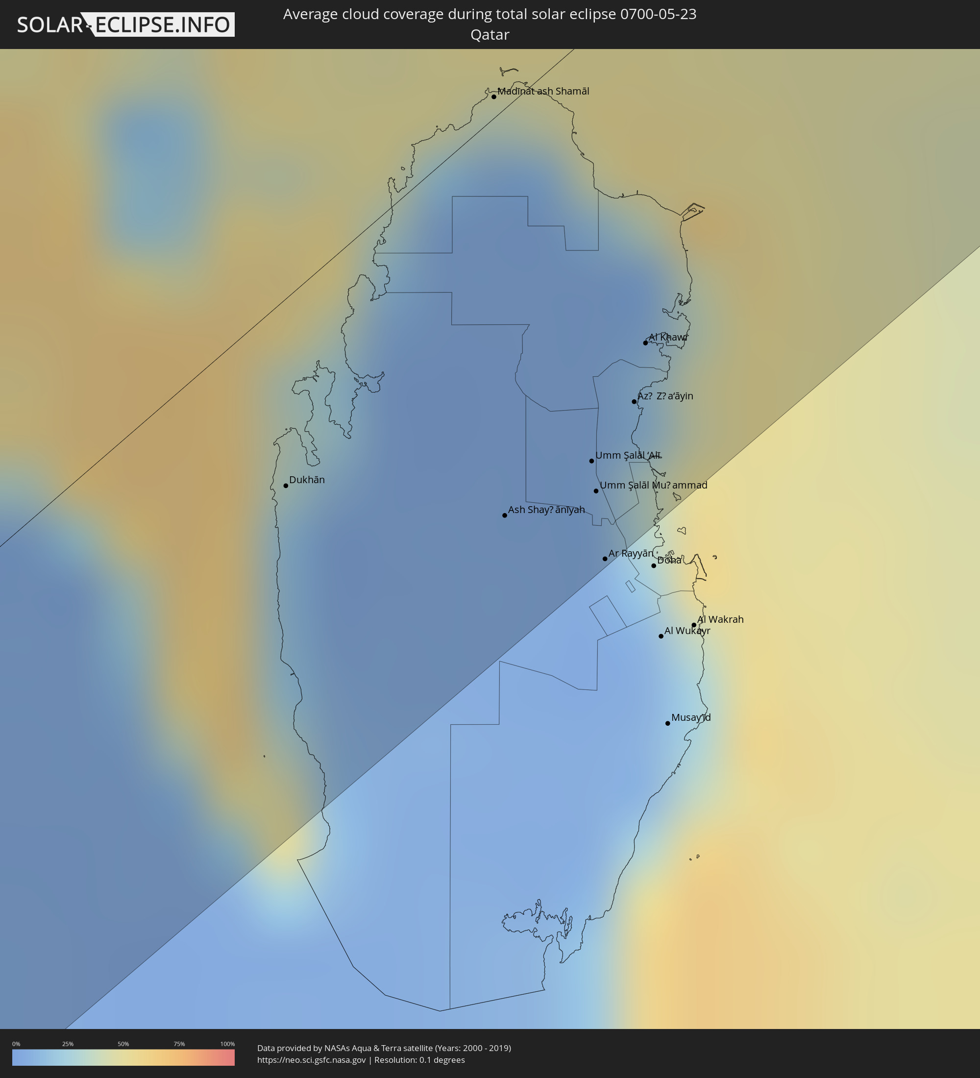 Katar
Katar
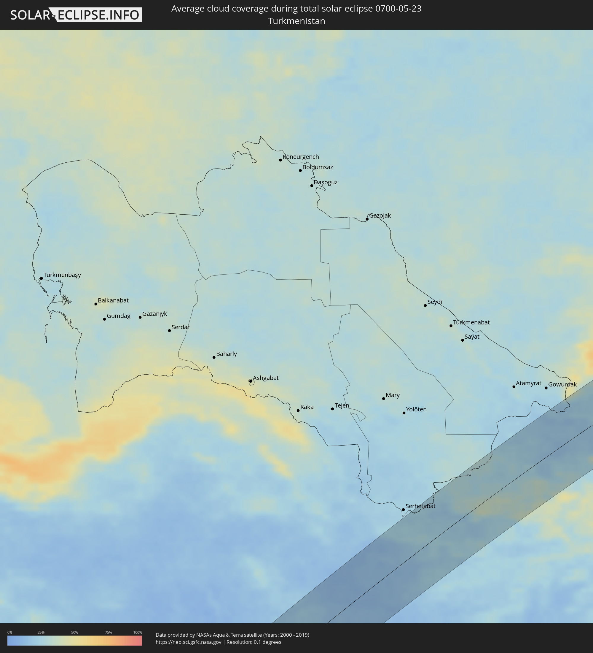 Turkmenistan
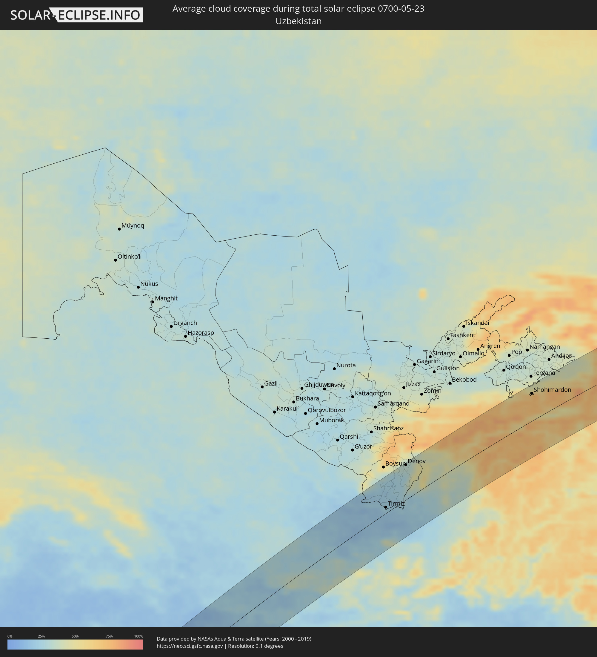 Usbekistan
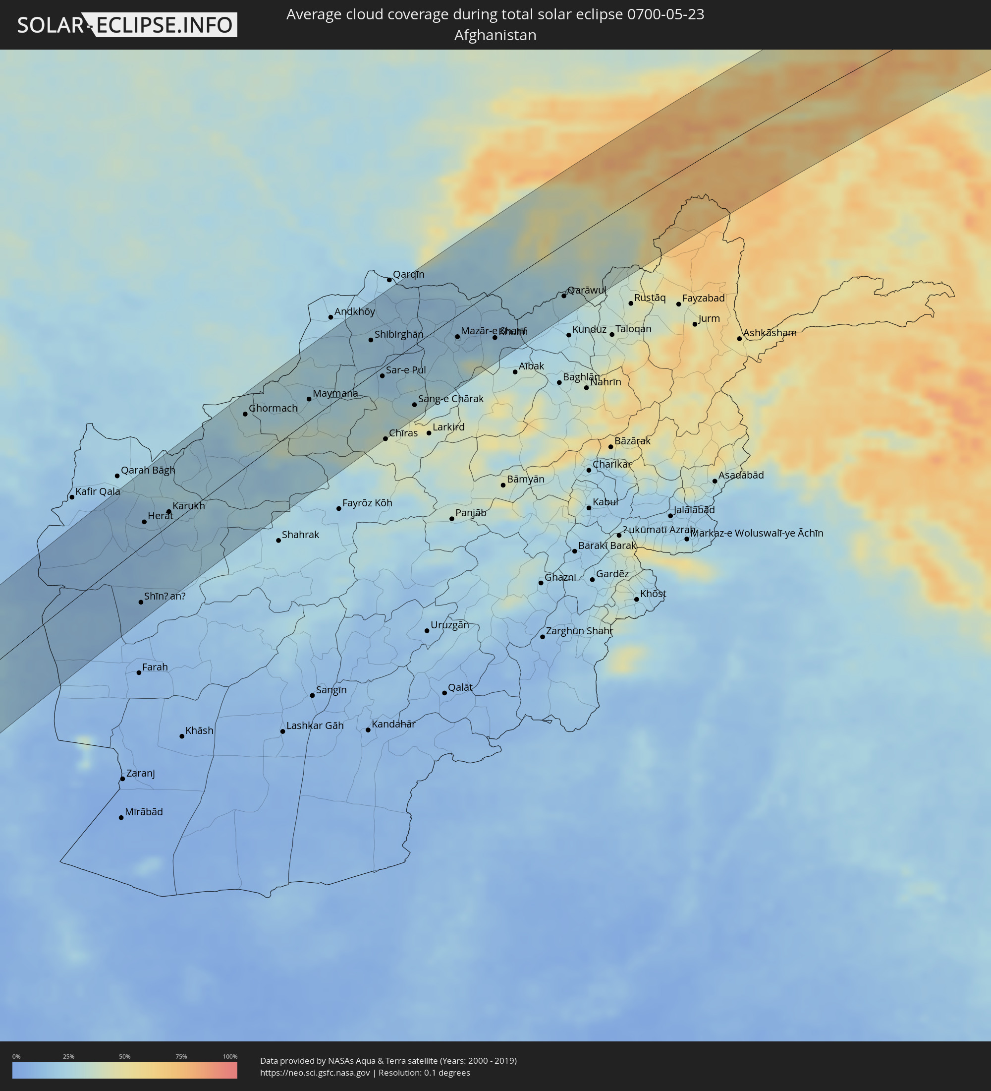 Afghanistan
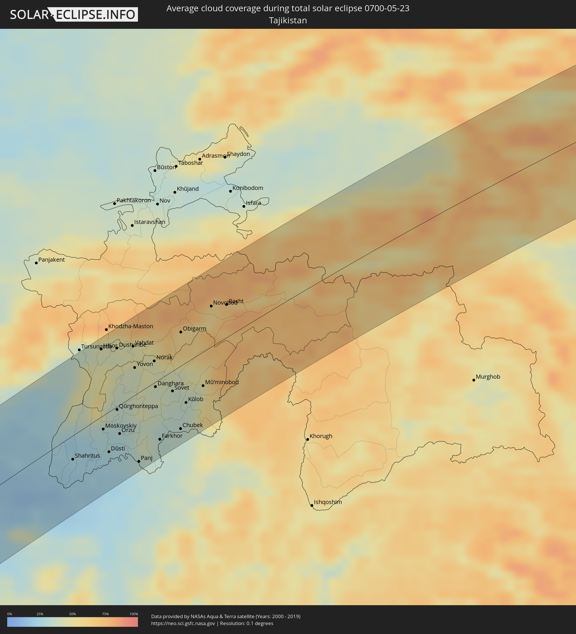 Tadschikistan
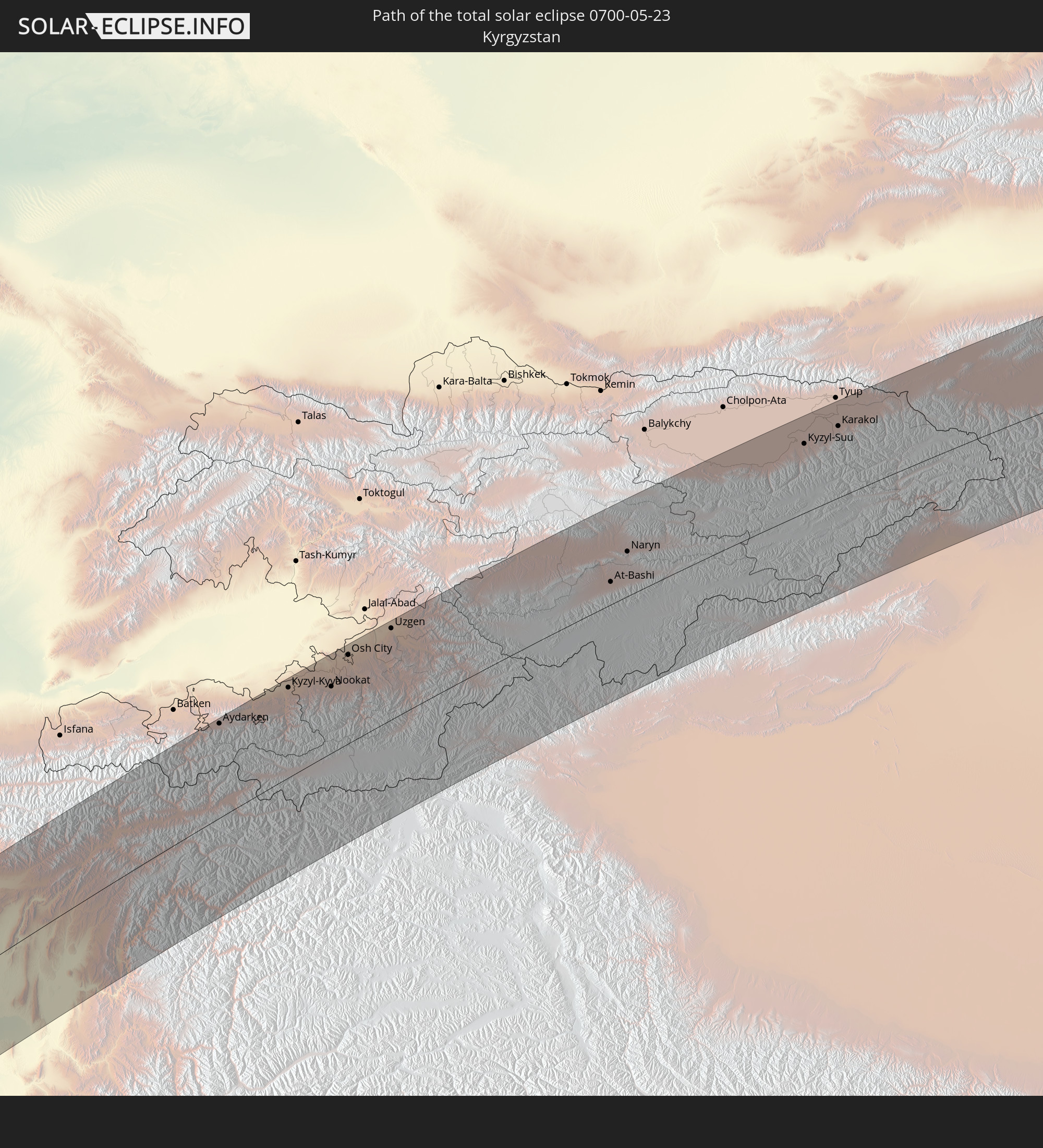
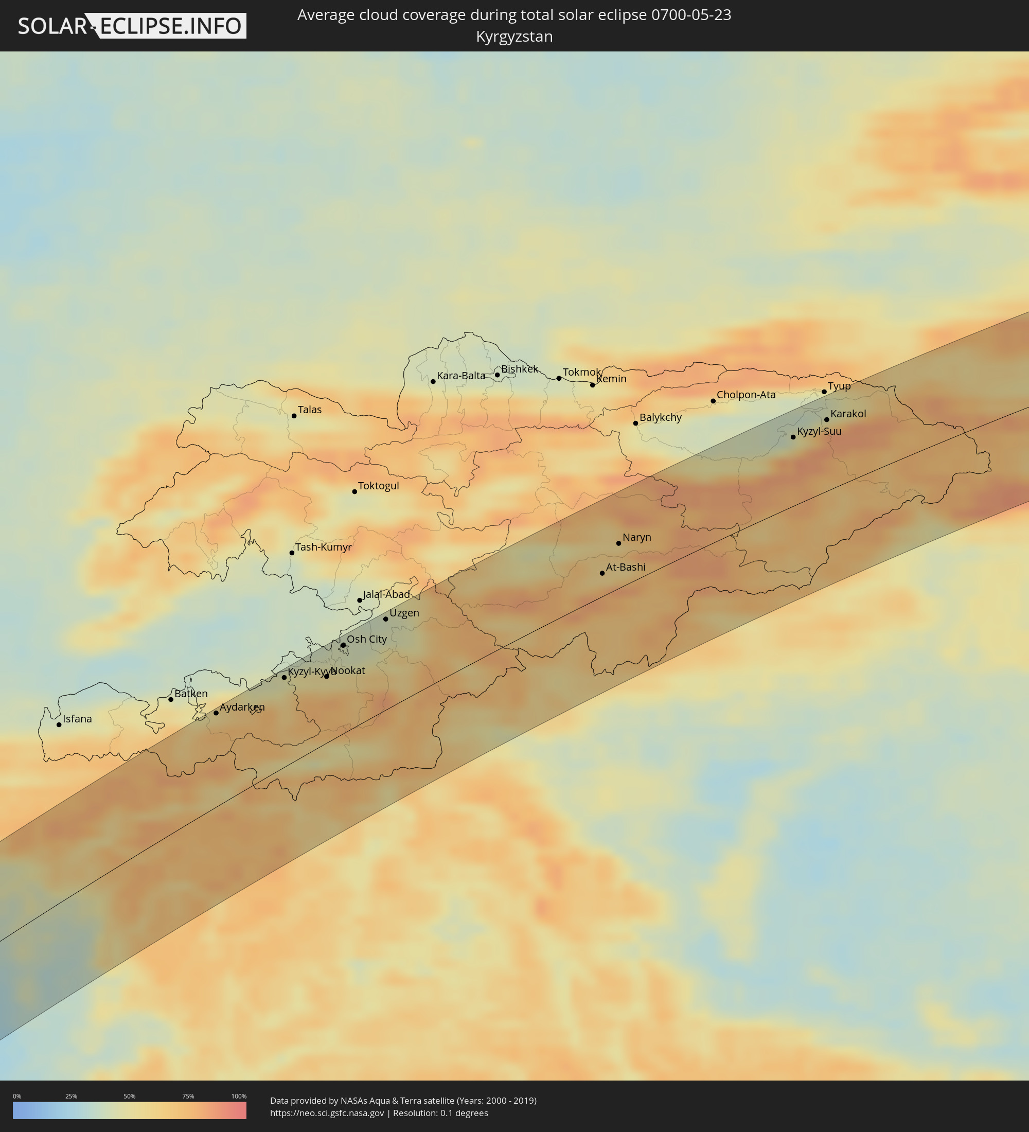 Kirgisistan
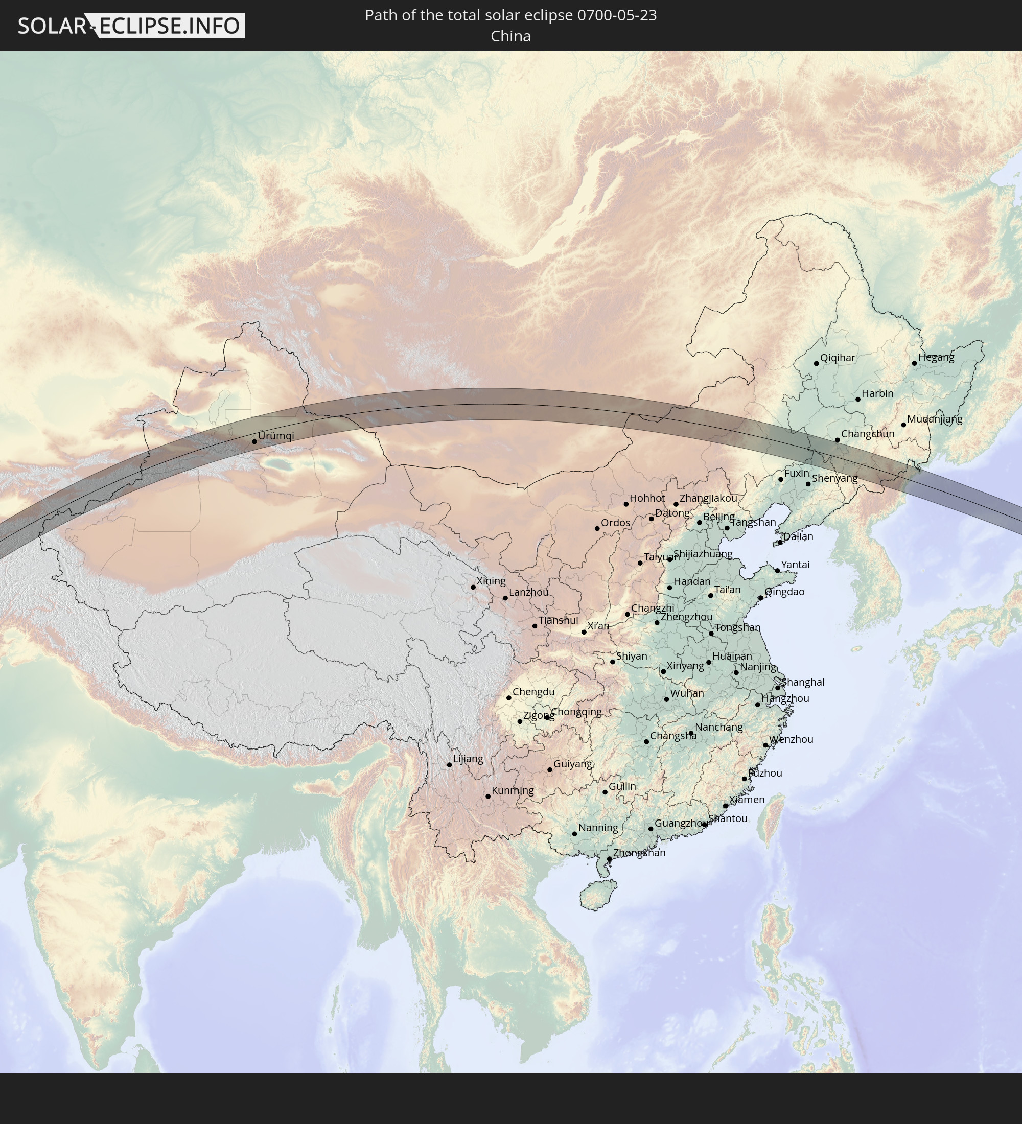
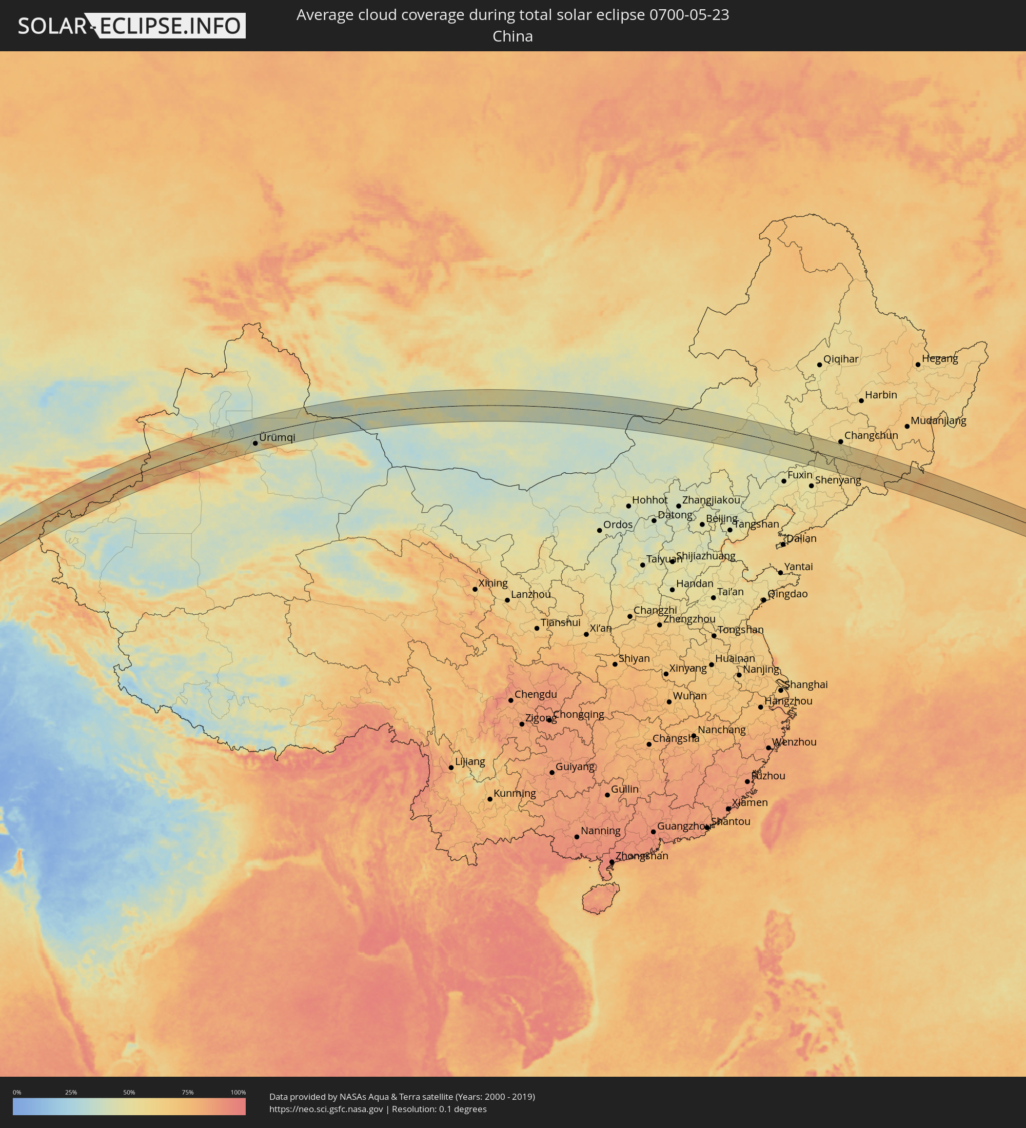 Volksrepublik China
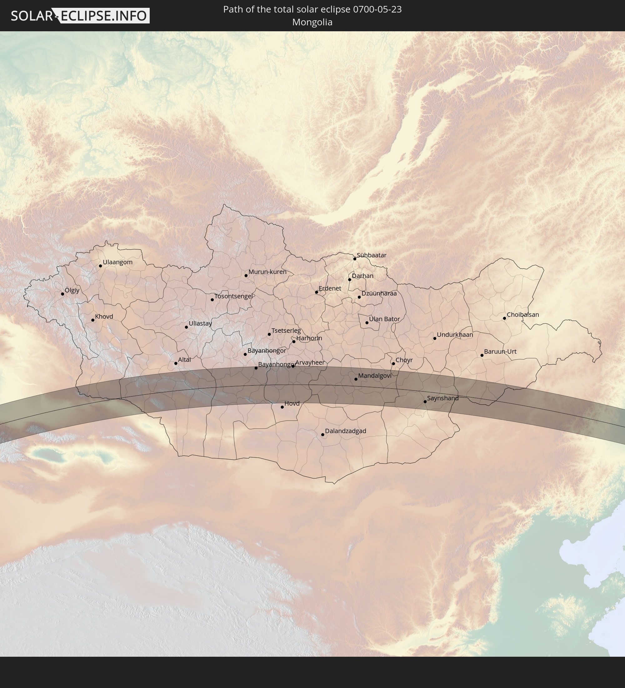
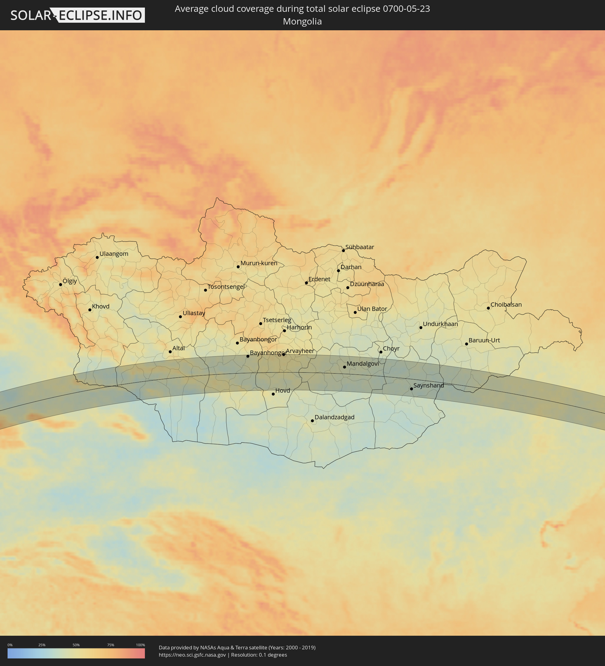 Mongolei
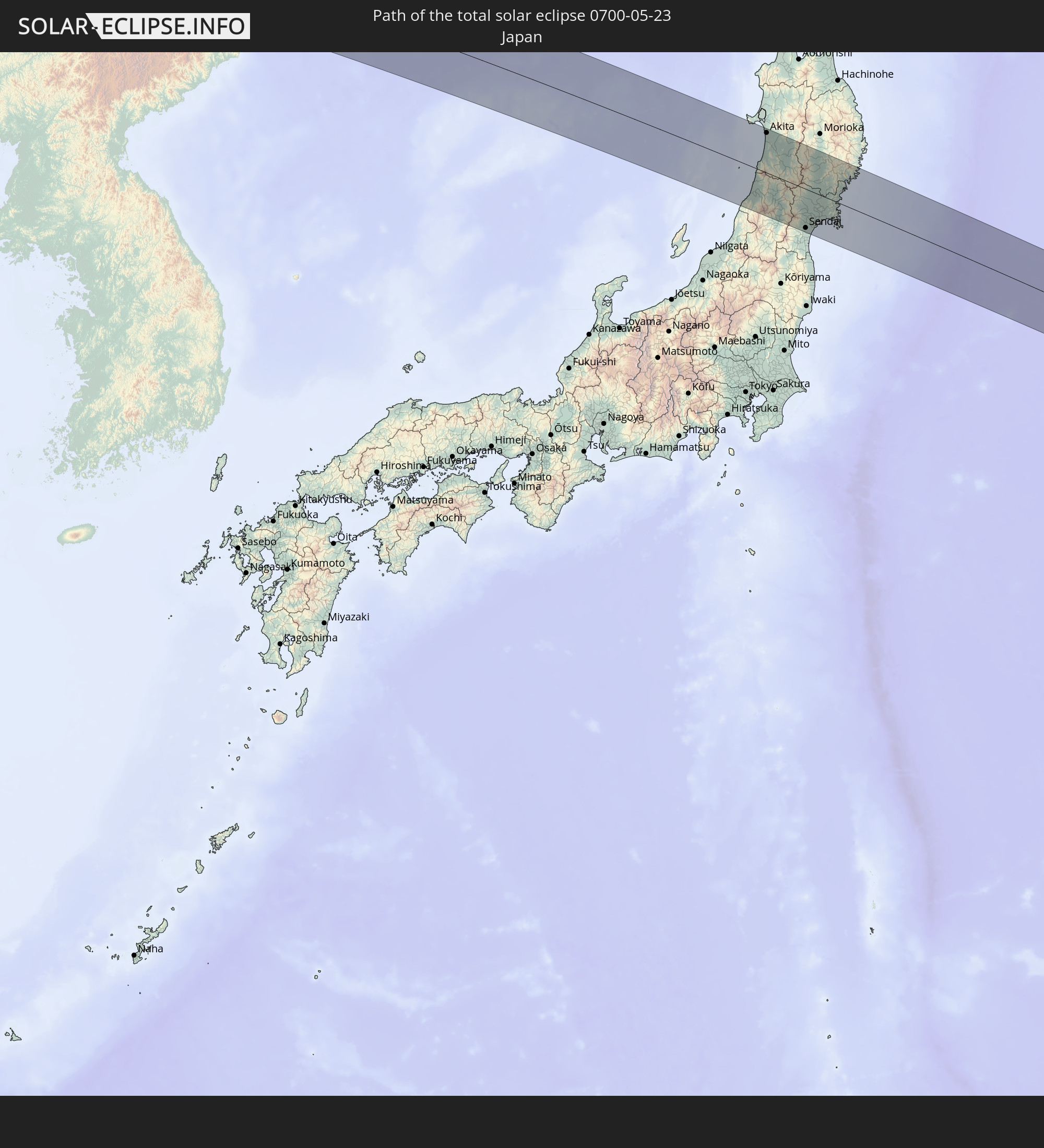
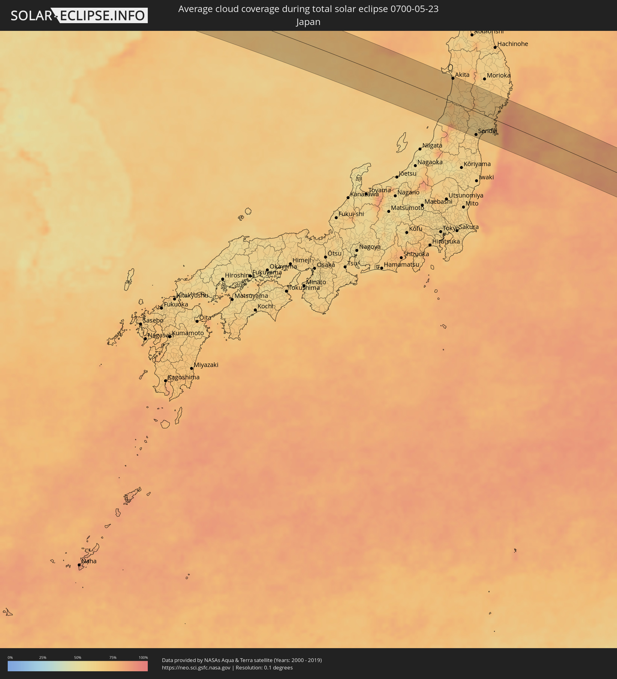 Japan
Japan
 Nordkorea
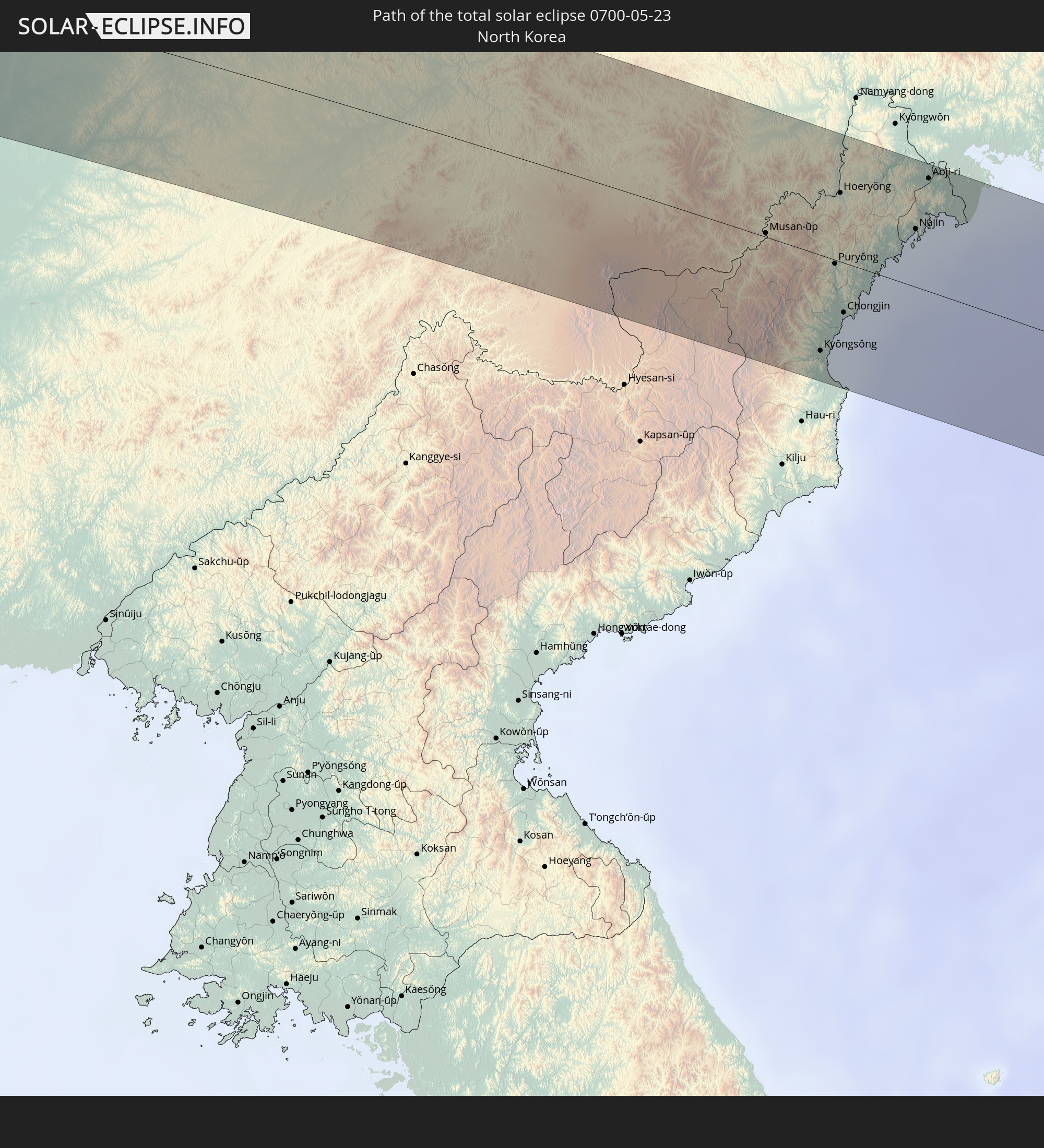
Orte im Finsternispfad
Die nachfolgene Tabelle zeigt Städte und Orte mit mehr als 5.000 Einwohnern, die sich im Finsternispfad befinden. Städte mit mehr als 100.000 Einwohnern sind dick gekennzeichnet. Mit einem Klick auf den Ort öffnet sich eine Detailkarte die die Lage des jeweiligen Ortes zusammen mit dem Verlauf der zentralen Finsternis präsentiert.
| Ort | Typ | Dauer der Verfinsterung | Ortszeit bei maximaler Verfinsterung | Entfernung zur Zentrallinie | Ø Bewölkung |
|
Yokadouma, East
|
total | - | 05:13:09 UTC+00:13 | 18 km | 84% |
|
Nola, Sangha-Mbaéré
|
total | - | 05:12:56 UTC+00:13 | 24 km | 80% |
|
Boda, Lobaye
|
total | - | 05:13:18 UTC+00:13 | 5 km | 80% |
|
Boali, Ombella-M'Poko
|
total | - | 05:13:36 UTC+00:13 | 14 km | 82% |
|
Bimbo, Ombella-M'Poko
|
total | - | 05:13:06 UTC+00:13 | 55 km | 82% |
|
Bangui, Bangui
|
total | - | 05:13:10 UTC+00:13 | 50 km | 81% |
|
Damara, Ombella-M'Poko
|
total | - | 05:13:40 UTC+00:13 | 4 km | 82% |
|
Sibut, Kémo
|
partiell | - | 05:14:17 UTC+00:13 | 63 km | 84% |
|
Kouango, Ouaka
|
total | - | 05:13:32 UTC+00:13 | 52 km | 77% |
|
Bambari, Ouaka
|
total | - | 05:14:10 UTC+00:13 | 8 km | 77% |
|
Ippy, Ouaka
|
total | - | 05:14:35 UTC+00:13 | 16 km | 77% |
|
Bria, Haute-Kotto
|
total | - | 05:14:48 UTC+00:13 | 6 km | 73% |
 Aweil, Northern Bahr al Ghazal
|
total | - | 07:10:09 UTC+02:06 | 56 km | 64% |
|
Kadugli, Southern Kordofan
|
total | - | 07:16:45 UTC+02:10 | 31 km | 59% |
|
Abu Jibeha, Southern Kordofan
|
total | - | 07:17:39 UTC+02:10 | 13 km | 57% |
|
Kosti, White Nile
|
total | - | 07:20:13 UTC+02:10 | 63 km | 39% |
|
Rabak, White Nile
|
total | - | 07:20:16 UTC+02:10 | 60 km | 39% |
|
Sinnar, Sinnār
|
total | - | 07:21:03 UTC+02:10 | 46 km | 41% |
|
Maiurno, Sinnār
|
total | - | 07:20:53 UTC+02:10 | 26 km | 41% |
|
As Sūkī, Sinnār
|
total | - | 07:20:50 UTC+02:10 | 4 km | 39% |
|
Singa, Sinnār
|
total | - | 07:20:38 UTC+02:10 | 15 km | 39% |
|
Ad Dindar, Sinnār
|
total | - | 07:20:47 UTC+02:10 | 24 km | 39% |
|
Al Ḩawātah, Al Qaḑārif
|
total | - | 07:21:15 UTC+02:10 | 32 km | 39% |
|
Al Qadarif, Al Qaḑārif
|
total | - | 07:22:23 UTC+02:10 | 21 km | 31% |
|
Kassala, Kassala
|
total | - | 07:24:48 UTC+02:10 | 45 km | 21% |
|
Barentu, Gash-Barka
|
total | - | 07:42:02 UTC+02:27 | 61 km | 22% |
|
Ak’ordat, Gash-Barka
|
total | - | 07:42:49 UTC+02:27 | 39 km | 18% |
|
Keren, Anseba
|
total | - | 07:43:27 UTC+02:27 | 54 km | 26% |
|
Al Majāridah, 'Asir
|
total | - | 08:30:18 UTC+03:06 | 19 km | 12% |
|
An Nimāş, 'Asir
|
total | - | 08:30:29 UTC+03:06 | 7 km | 21% |
|
Qal‘at Bīshah, 'Asir
|
total | - | 08:32:13 UTC+03:06 | 50 km | 9% |
|
Al Hufūf, Eastern Province
|
total | - | 08:47:46 UTC+03:06 | 46 km | 8% |
|
Al Qurayn, Eastern Province
|
total | - | 08:48:00 UTC+03:06 | 54 km | 8% |
|
Al Baţţālīyah, Eastern Province
|
total | - | 08:47:57 UTC+03:06 | 48 km | 8% |
|
Al Jubayl, Eastern Province
|
total | - | 08:47:55 UTC+03:06 | 44 km | 9% |
|
Al Qārah, Eastern Province
|
total | - | 08:47:58 UTC+03:06 | 44 km | 9% |
|
Al Munayzilah, Eastern Province
|
total | - | 08:47:54 UTC+03:06 | 41 km | 9% |
|
Al Jafr, Eastern Province
|
total | - | 08:47:57 UTC+03:06 | 37 km | 9% |
|
Aţ Ţaraf, Eastern Province
|
total | - | 08:47:56 UTC+03:06 | 36 km | 9% |
|
Khobar, Eastern Province
|
total | - | 08:50:06 UTC+03:06 | 81 km | 25% |
|
Dār Kulayb, Southern Governorate
|
total | - | 09:09:20 UTC+03:26 | 44 km | 25% |
|
Madīnat Ḩamad, Central Governorate
|
total | - | 09:09:25 UTC+03:26 | 47 km | 25% |
|
Madīnat ‘Īsá, Southern Governorate
|
total | - | 09:09:34 UTC+03:26 | 50 km | 19% |
|
Jidd Ḩafş, Manama
|
total | - | 09:09:39 UTC+03:26 | 53 km | 19% |
|
Ar Rifā‘, Southern Governorate
|
total | - | 09:09:30 UTC+03:26 | 46 km | 22% |
|
Manama, Manama
|
total | - | 09:09:42 UTC+03:26 | 52 km | 22% |
|
Al Muharraq, Muharraq
|
total | - | 09:09:47 UTC+03:26 | 52 km | 39% |
|
Sitrah, Manama
|
total | - | 09:09:37 UTC+03:26 | 43 km | 22% |
|
Al Ḩadd, Muharraq
|
total | - | 09:09:49 UTC+03:26 | 49 km | 45% |
|
Dukhān, Baladīyat ar Rayyān
|
total | - | 09:08:29 UTC+03:26 | 29 km | 18% |
|
Madīnat ash Shamāl, Madīnat ash Shamāl
|
total | - | 09:10:14 UTC+03:26 | 3 km | 11% |
|
Ash Shayḩānīyah, Baladīyat ar Rayyān
|
total | - | 09:08:54 UTC+03:26 | 62 km | 6% |
|
Umm Şalāl ‘Alī, Baladīyat Umm Şalāl
|
total | - | 09:09:17 UTC+03:26 | 65 km | 6% |
|
Umm Şalāl Muḩammad, Baladīyat Umm Şalāl
|
total | - | 09:09:12 UTC+03:26 | 71 km | 6% |
|
Ar Rayyān, Baladīyat ar Rayyān
|
total | - | 09:09:00 UTC+03:26 | 82 km | 4% |
|
Az̧ Z̧a‘āyin, Baladīyat az̧ Z̧a‘āyin
|
total | - | 09:09:35 UTC+03:26 | 62 km | 32% |
|
Al Khawr, Al Khawr
|
total | - | 09:09:48 UTC+03:26 | 54 km | 17% |
|
Fasā, Fars
|
total | - | 09:17:57 UTC+03:25 | 80 km | 7% |
|
Gerāsh, Fars
|
total | - | 09:16:15 UTC+03:25 | 58 km | 4% |
|
Neyrīz, Fars
|
total | - | 09:19:19 UTC+03:25 | 59 km | 10% |
|
Dārāb, Fars
|
total | - | 09:18:47 UTC+03:25 | 7 km | 4% |
|
Sirjan, Kerman
|
total | - | 09:21:36 UTC+03:25 | 6 km | 9% |
|
Rafsanjān, Kerman
|
total | - | 09:23:47 UTC+03:25 | 55 km | 8% |
|
Zarand, Kerman
|
total | - | 09:25:19 UTC+03:25 | 54 km | 13% |
|
Bardsīr, Kerman
|
total | - | 09:23:42 UTC+03:25 | 22 km | 18% |
|
Rāvar, Kerman
|
total | - | 09:26:29 UTC+03:25 | 78 km | 13% |
|
Kerman, Kerman
|
total | - | 09:25:05 UTC+03:25 | 23 km | 14% |
|
Bīrjand, Khorāsān-e Jonūbī
|
total | - | 09:32:56 UTC+03:25 | 68 km | 20% |
|
Kushk, Herat
|
total | - | 10:12:17 UTC+04:00 | 54 km | 11% |
|
Shīnḏanḏ, Herat
|
total | - | 10:12:37 UTC+04:00 | 64 km | 12% |
|
Herāt, Herat
|
total | - | 10:14:32 UTC+04:00 | 25 km | 15% |
|
Karukh, Herat
|
total | - | 10:15:24 UTC+04:00 | 15 km | 19% |
|
Ghormach, Badghis
|
total | - | 10:19:31 UTC+04:00 | 60 km | 28% |
|
Maymana, Faryab
|
total | - | 10:21:31 UTC+04:00 | 23 km | 28% |
|
Shibirghān, Jowzjan
|
total | - | 10:24:25 UTC+04:00 | 40 km | 20% |
|
Sar-e Pul, Sar-e Pol
|
total | - | 10:24:00 UTC+04:00 | 10 km | 19% |
|
Balkh, Balkh
|
total | - | 10:26:34 UTC+04:00 | 10 km | 19% |
|
Mazār-e Sharīf, Balkh
|
total | - | 10:26:52 UTC+04:00 | 26 km | 20% |
|
Tirmiz, Surxondaryo
|
total | - | 10:55:51 UTC+04:27 | 13 km | 22% |
|
Khulm, Balkh
|
total | - | 10:27:54 UTC+04:00 | 56 km | 21% |
|
Sho’rchi, Surxondaryo
|
total | - | 10:57:57 UTC+04:27 | 60 km | 25% |
|
Denov, Surxondaryo
|
total | - | 10:58:33 UTC+04:27 | 79 km | 32% |
|
Hisor, Republican Subordination
|
total | - | 11:07:25 UTC+04:35 | 72 km | 41% |
|
Moskovskiy, Khatlon
|
total | - | 11:06:06 UTC+04:35 | 15 km | 29% |
|
Dushanbe, Dushanbe
|
total | - | 11:07:50 UTC+04:35 | 62 km | 42% |
|
Qarāwul, Kunduz
|
total | - | 10:30:41 UTC+04:00 | 61 km | 27% |
|
Qŭrghonteppa, Khatlon
|
total | - | 11:06:48 UTC+04:35 | 3 km | 33% |
|
Vahdat, Republican Subordination
|
total | - | 11:08:17 UTC+04:35 | 53 km | 45% |
|
Yovon, Khatlon
|
total | - | 11:07:58 UTC+04:35 | 29 km | 39% |
|
Norak, Khatlon
|
total | - | 11:08:36 UTC+04:35 | 23 km | 42% |
|
Danghara, Khatlon
|
total | - | 11:08:12 UTC+04:35 | 5 km | 38% |
|
Farkhor, Khatlon
|
total | - | 11:07:26 UTC+04:35 | 65 km | 32% |
|
Vose’, Khatlon
|
total | - | 11:08:20 UTC+04:35 | 47 km | 33% |
|
Chubek, Khatlon
|
total | - | 11:08:10 UTC+04:35 | 68 km | 34% |
|
Kŭlob, Khatlon
|
total | - | 11:08:45 UTC+04:35 | 43 km | 36% |
|
Aydarken, Batken
|
total | - | 11:37:38 UTC+04:58 | 79 km | 68% |
|
Shohimardon, Fergana
|
total | - | 11:08:01 UTC+04:27 | 63 km | 69% |
|
Iradan, Batken
|
total | - | 11:39:27 UTC+04:58 | 78 km | 45% |
|
Kyzyl-Kyya, Batken
|
total | - | 11:39:29 UTC+04:58 | 76 km | 45% |
|
Nookat
|
total | - | 11:40:24 UTC+04:58 | 56 km | 53% |
|
Osh, Osh
|
total | - | 11:41:03 UTC+04:58 | 74 km | 42% |
|
Osh City, Osh City
|
total | - | 11:41:05 UTC+04:58 | 75 km | 42% |
|
Uzgen, Osh
|
total | - | 11:42:17 UTC+04:58 | 77 km | 40% |
|
At-Bashi, Naryn
|
total | - | 11:47:23 UTC+04:58 | 19 km | 60% |
|
Naryn, Naryn
|
total | - | 11:48:02 UTC+04:58 | 38 km | 65% |
|
Kyzyl-Suu, Issyk-Kul Region
|
total | - | 11:52:42 UTC+04:58 | 59 km | 59% |
|
Karakol, Issyk-Kul Region
|
total | - | 11:53:34 UTC+04:58 | 62 km | 58% |
|
Ak-Suu, Issyk-Kul Region
|
total | - | 11:53:49 UTC+04:58 | 58 km | 66% |
|
Shihezi, Xinjiang Uyghur Autonomous Region
|
total | - | 15:10:27 UTC+08:00 | 41 km | 38% |
|
Changji, Xinjiang Uyghur Autonomous Region
|
total | - | 15:12:38 UTC+08:00 | 18 km | 39% |
|
Ürümqi, Xinjiang Uyghur Autonomous Region
|
total | - | 15:13:05 UTC+08:00 | 46 km | 45% |
|
Bayanhongor, Bayanhongor
|
total | - | 14:42:20 UTC+07:07 | 72 km | 43% |
|
Arvayheer, Övörhangay
|
total | - | 14:45:15 UTC+07:07 | 77 km | 53% |
|
Mandalgovi, Middle Govĭ
|
total | - | 14:50:17 UTC+07:07 | 28 km | 42% |
|
Saynshand, East Gobi Aymag
|
total | - | 14:55:46 UTC+07:07 | 46 km | 36% |
|
Tongliao, Inner Mongolia
|
total | - | 16:01:38 UTC+08:00 | 9 km | 46% |
|
Zhengjiatun, Jilin
|
total | - | 16:02:42 UTC+08:00 | 5 km | 51% |
|
Siping, Jilin
|
total | - | 16:03:42 UTC+08:00 | 13 km | 50% |
|
Gongzhuling, Jilin
|
total | - | 16:03:40 UTC+08:00 | 33 km | 51% |
|
Liaoyuan, Jilin
|
total | - | 16:04:30 UTC+08:00 | 24 km | 55% |
|
Meihekou, Jilin
|
total | - | 16:05:15 UTC+08:00 | 52 km | 58% |
|
Huadian, Jilin
|
total | - | 16:05:31 UTC+08:00 | 20 km | 59% |
|
Helong, Jilin
|
total | - | 16:07:19 UTC+08:00 | 30 km | 65% |
|
Musan-ŭp, Hamgyŏng-bukto
|
total | - | 16:30:46 UTC+08:23 | 2 km | 66% |
|
Longjing, Jilin
|
total | - | 16:07:19 UTC+08:00 | 65 km | 62% |
|
Kyŏngsŏng, Hamgyŏng-bukto
|
total | - | 16:31:39 UTC+08:23 | 55 km | 66% |
|
Sŭngam-nodongjagu, Hamgyŏng-bukto
|
total | - | 16:31:36 UTC+08:23 | 45 km | 72% |
|
Hoemul-li, Hamgyŏng-bukto
|
total | - | 16:31:51 UTC+08:23 | 69 km | 62% |
|
Nanam, Hamgyŏng-bukto
|
total | - | 16:31:34 UTC+08:23 | 40 km | 72% |
|
Komusan 1-tong, Hamgyŏng-bukto
|
total | - | 16:31:10 UTC+08:23 | 3 km | 66% |
|
Puryŏng, Hamgyŏng-bukto
|
total | - | 16:31:13 UTC+08:23 | 2 km | 66% |
|
Hoeryŏng, Hamgyŏng-bukto
|
total | - | 16:30:51 UTC+08:23 | 39 km | 66% |
|
Chongjin, Hamgyŏng-bukto
|
total | - | 16:31:32 UTC+08:23 | 28 km | 70% |
|
Najin, Rason
|
total | - | 16:31:20 UTC+08:23 | 33 km | 77% |
|
Aoji-ri, Hamgyŏng-bukto
|
total | - | 16:31:06 UTC+08:23 | 64 km | 66% |
|
Sŏnbong, Rason
|
total | - | 16:31:18 UTC+08:23 | 46 km | 75% |
|
Tsuruoka, Yamagata
|
total | - | 17:15:28 UTC+09:00 | 49 km | 63% |
|
Sakata, Yamagata
|
total | - | 17:15:17 UTC+09:00 | 28 km | 62% |
|
Akita, Akita
|
total | - | 17:14:32 UTC+09:00 | 62 km | 69% |
|
Shinjō, Yamagata
|
total | - | 17:15:32 UTC+09:00 | 30 km | 64% |
|
Higashine, Yamagata
|
total | - | 17:15:51 UTC+09:00 | 59 km | 64% |
|
Sendai, Miyagi
|
total | - | 17:16:07 UTC+09:00 | 61 km | 65% |
|
Furukawa, Miyagi
|
total | - | 17:15:50 UTC+09:00 | 27 km | 62% |
|
Shiogama, Miyagi
|
total | - | 17:16:06 UTC+09:00 | 51 km | 67% |
|
Kitakami, Iwate
|
total | - | 17:15:10 UTC+09:00 | 51 km | 64% |
|
Ichinoseki, Iwate
|
total | - | 17:15:32 UTC+09:00 | 14 km | 65% |
|
Mizusawa, Iwate
|
total | - | 17:15:19 UTC+09:00 | 37 km | 65% |
|
Ishinomaki, Miyagi
|
total | - | 17:16:03 UTC+09:00 | 31 km | 69% |