Totale Sonnenfinsternis vom 04.07.0707
| Wochentag: | Donnerstag |
| Maximale Dauer der Verfinsterung: | 04m57s |
| Maximale Breite des Finsternispfades: | 174 km |
| Saroszyklus: | 96 |
| Bedeckungsgrad: | 100% |
| Magnitude: | 1.0525 |
| Gamma: | -0.0573 |
Wo kann man die Sonnenfinsternis vom 04.07.0707 sehen?
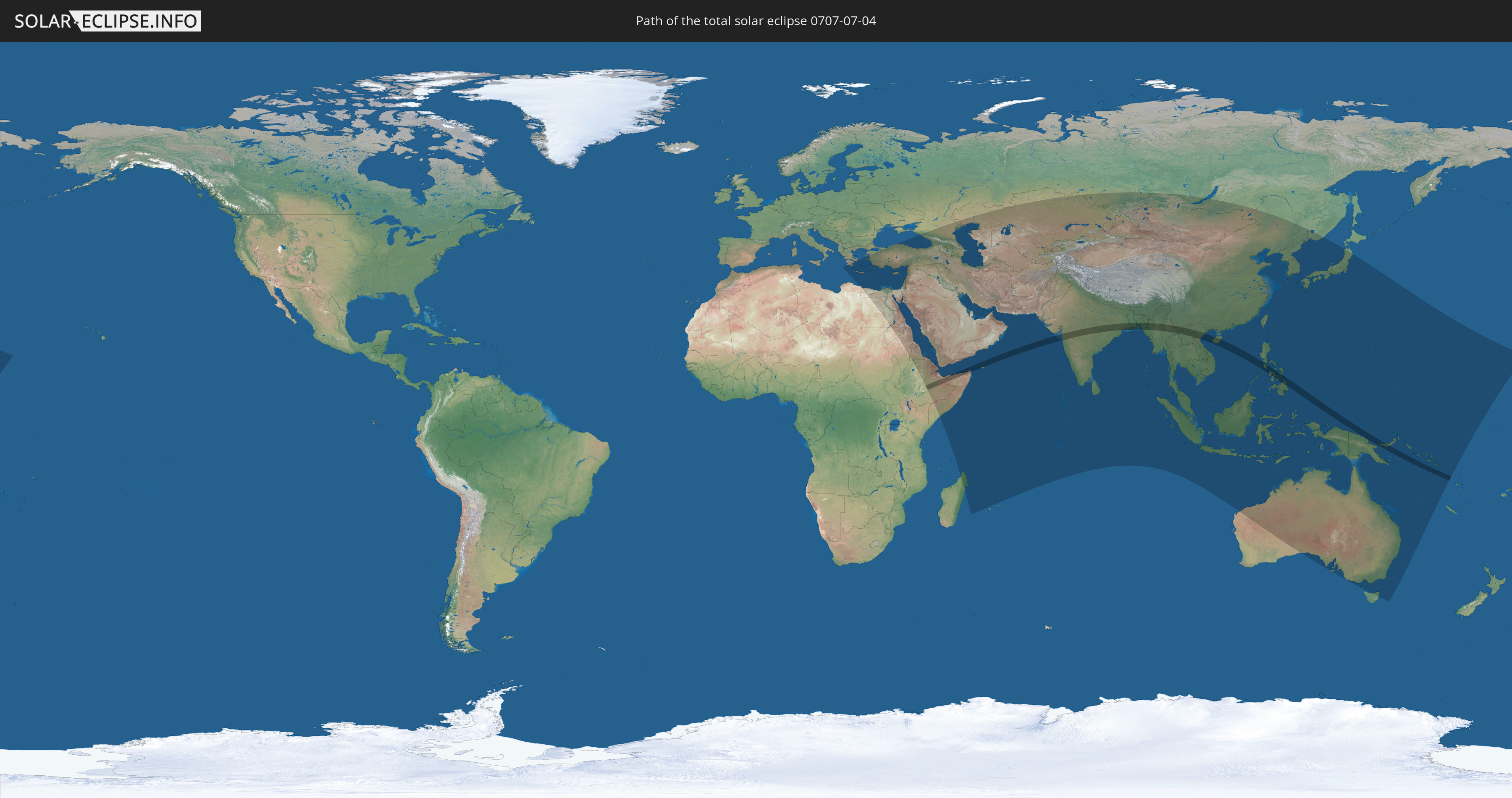
Die Sonnenfinsternis am 04.07.0707 kann man in 79 Ländern als partielle Sonnenfinsternis beobachten.
Der Finsternispfad verläuft durch 13 Länder. Nur in diesen Ländern ist sie als totale Sonnenfinsternis zu sehen.
In den folgenden Ländern ist die Sonnenfinsternis total zu sehen
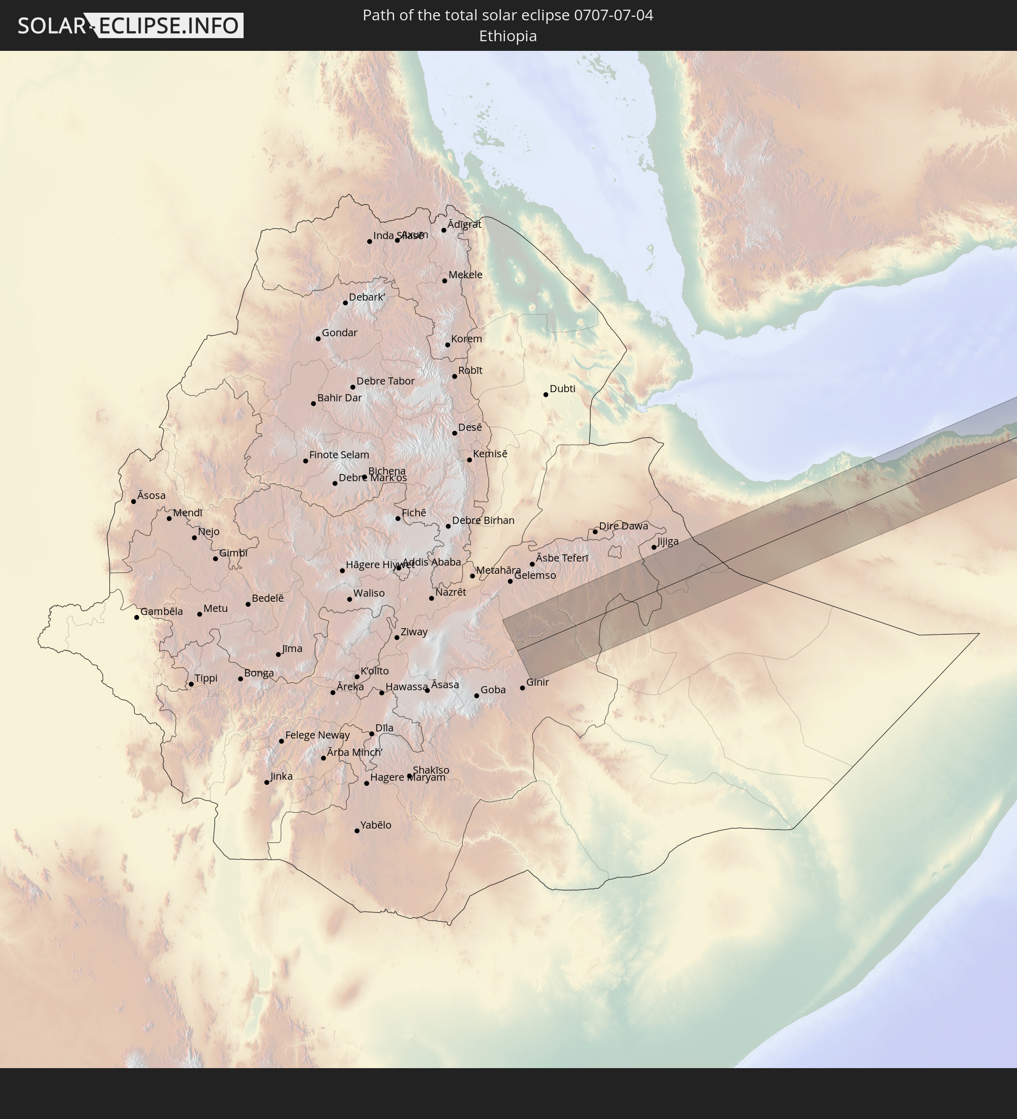 Äthiopien
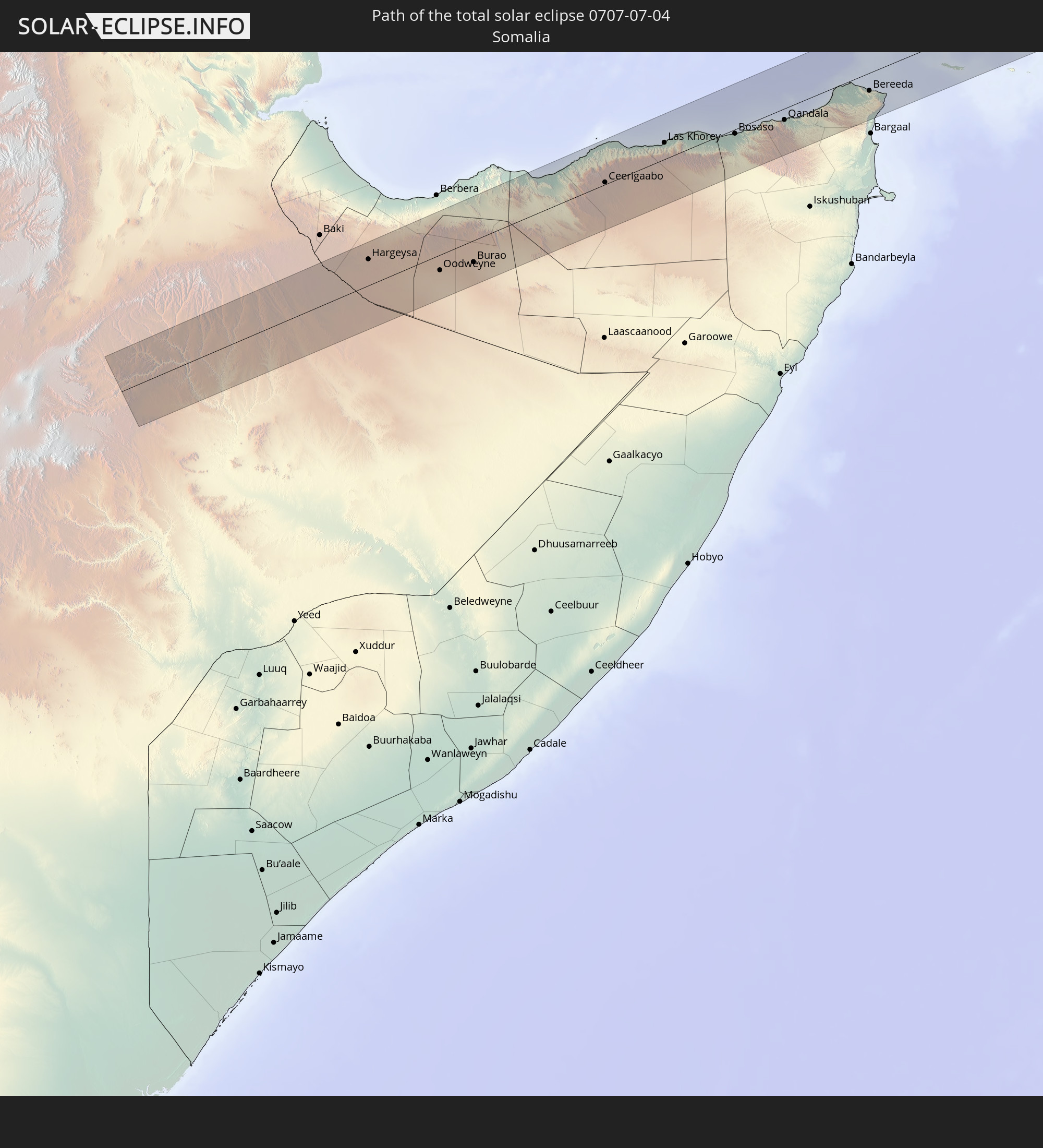 Somalia
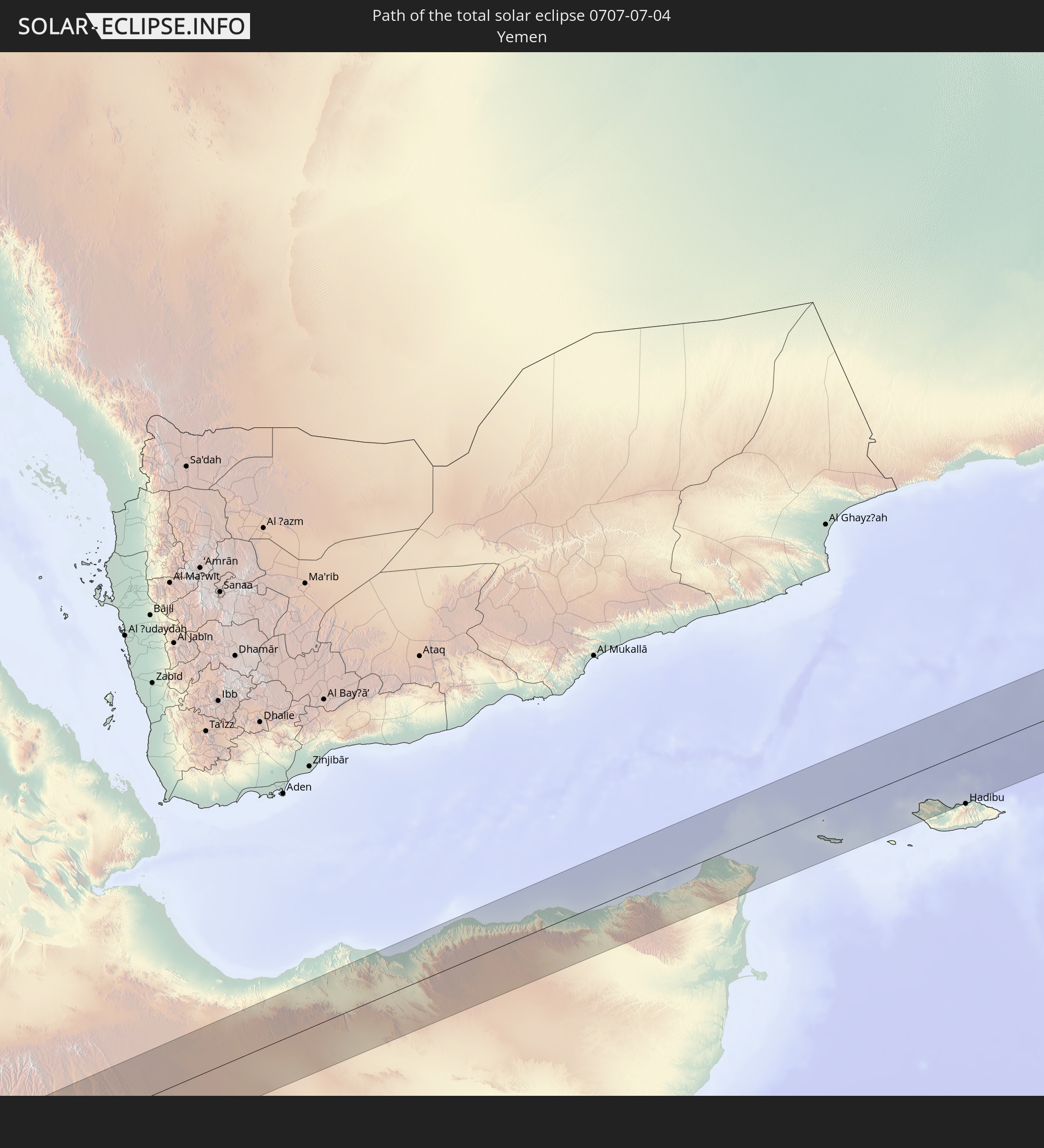 Jemen
Jemen
 Indien
 Volksrepublik China
 Bangladesch
 Myanmar
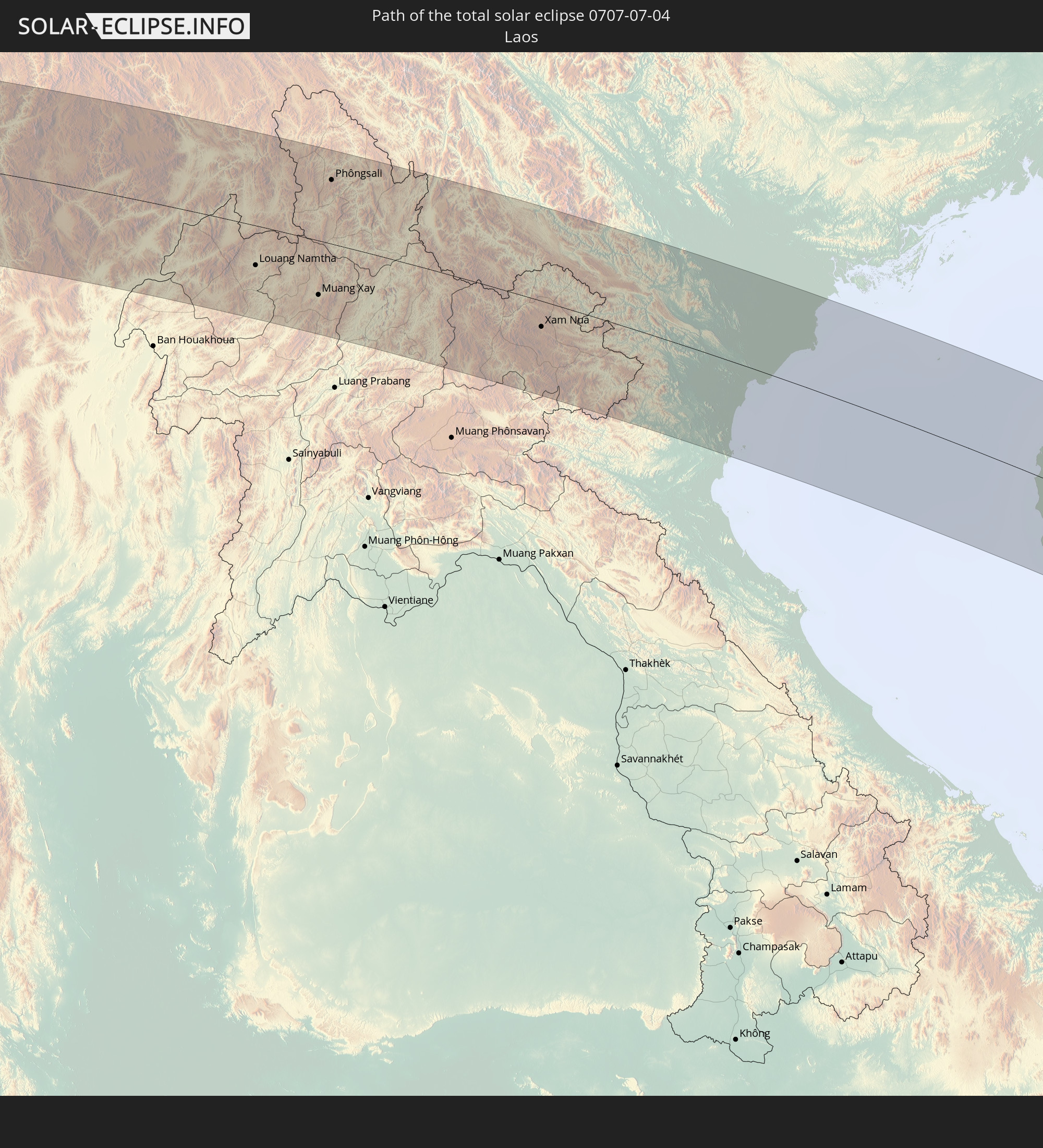 Laos
Laos
 Vietnam
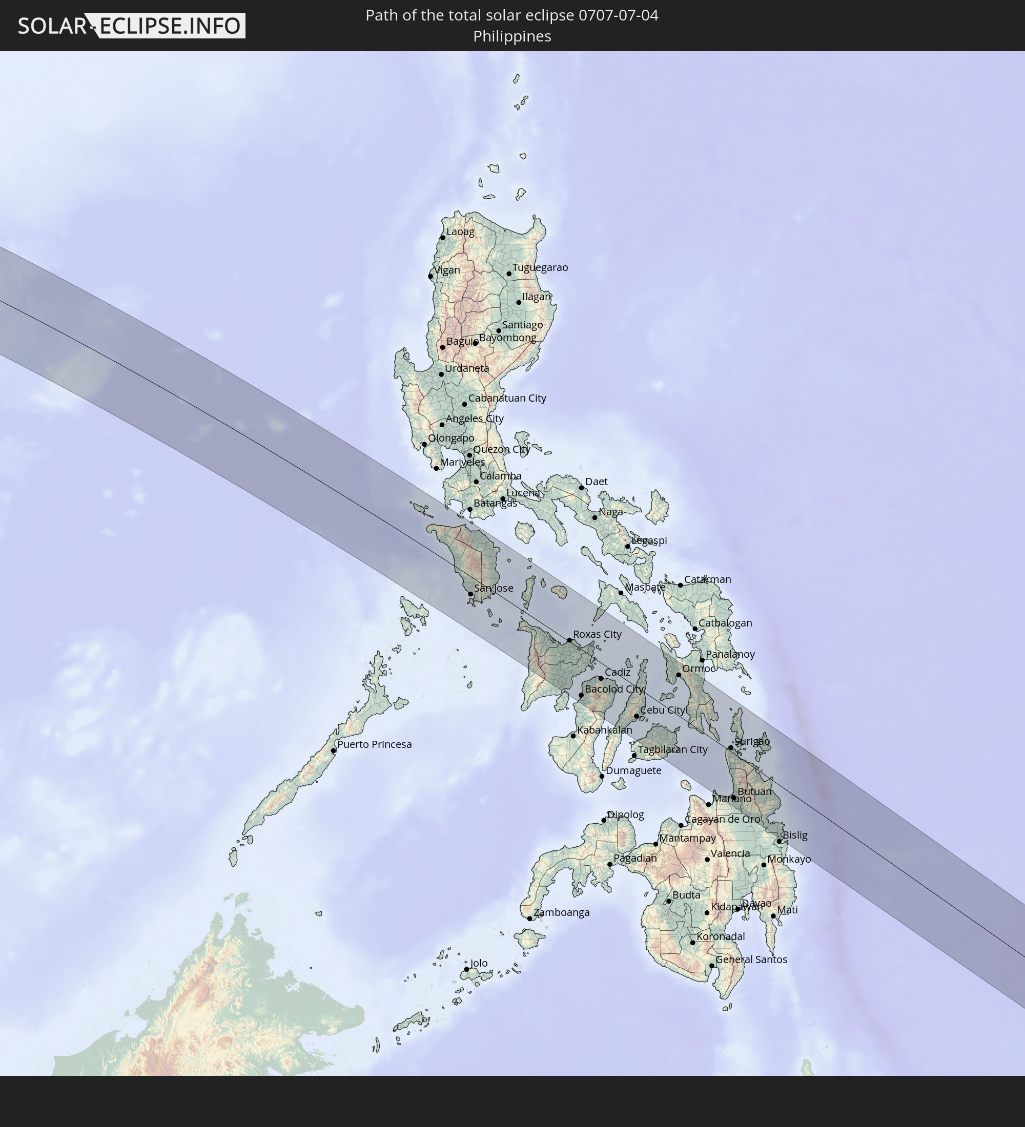 Philippinen
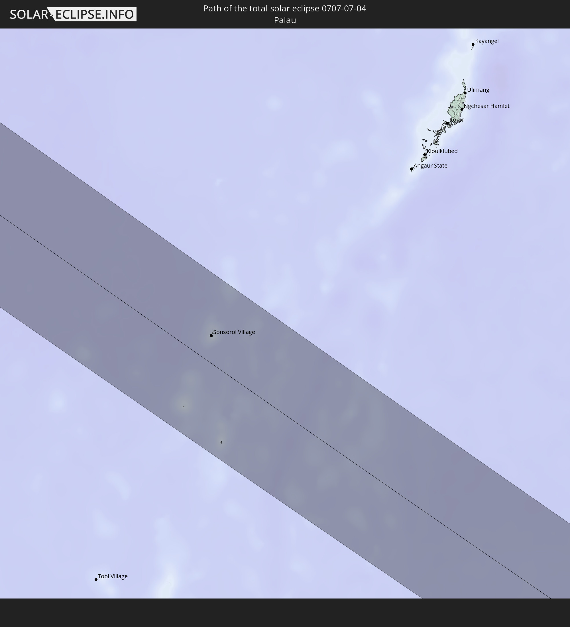 Palau
Palau
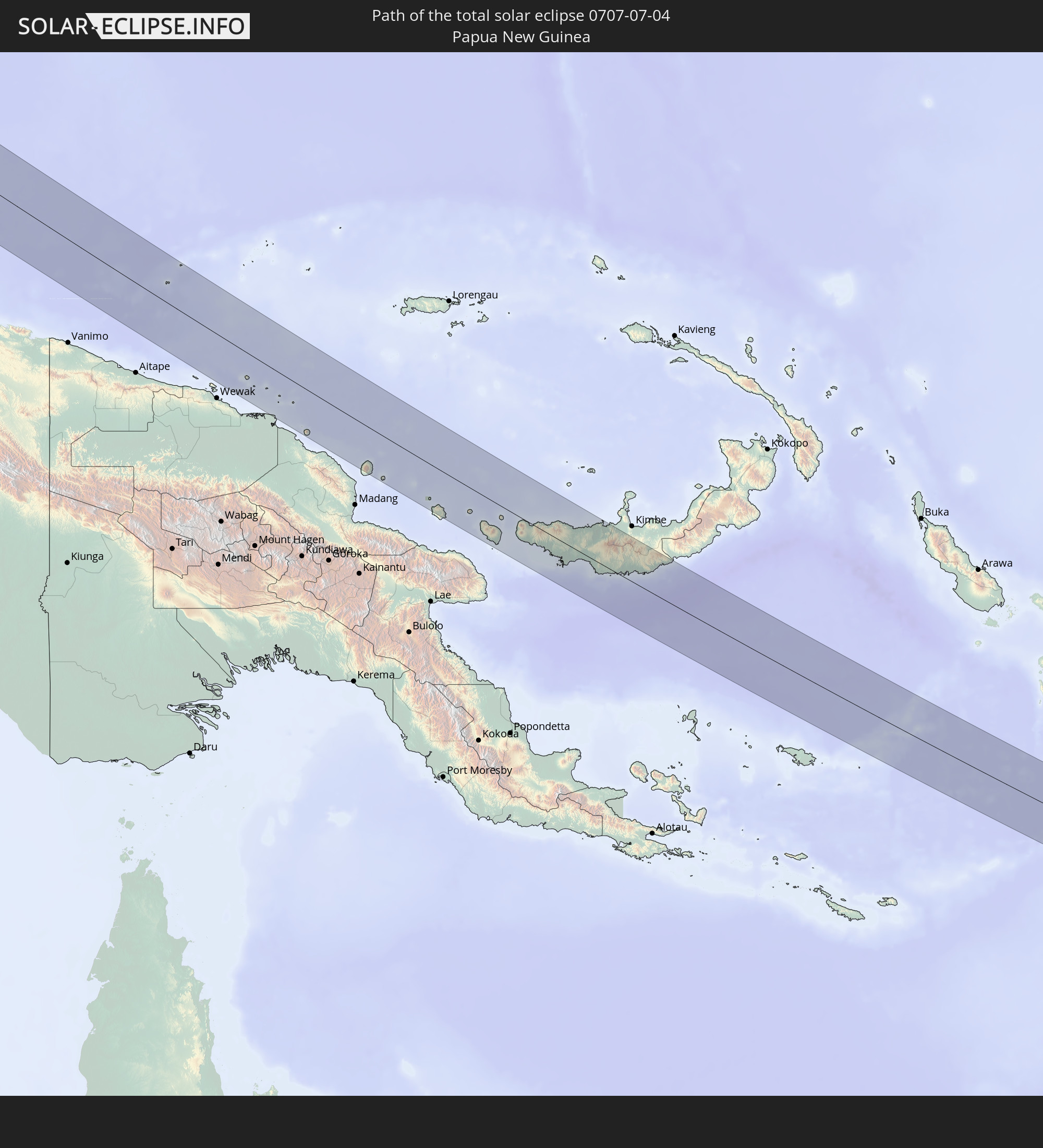 Papua-Neuguinea
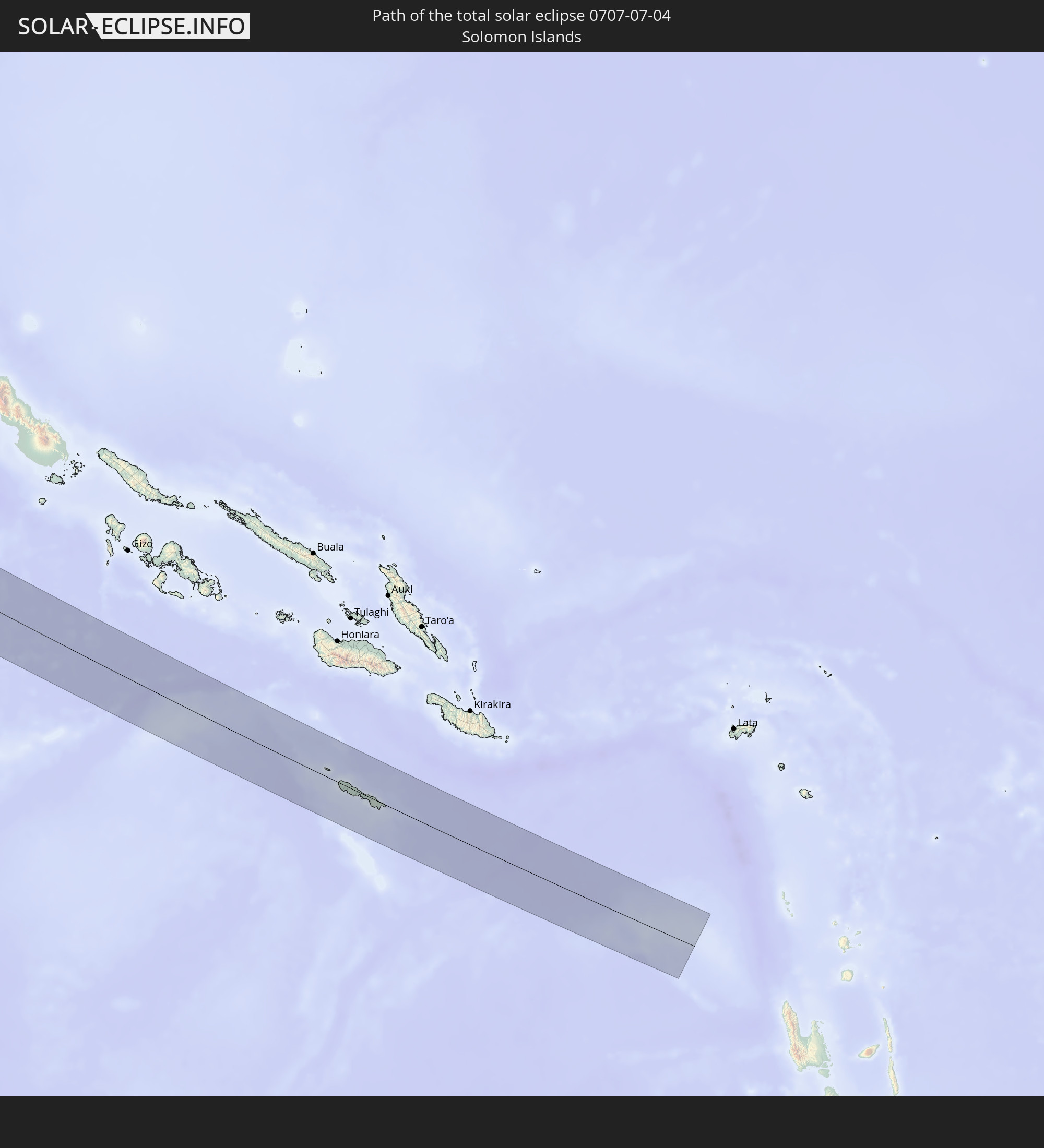 Salomonen
In den folgenden Ländern ist die Sonnenfinsternis partiell zu sehen
 Russland
 United States Minor Outlying Islands
 Kiribati
 Libyen
 Griechenland
 Sudan
Sudan
 Ägypten
 Türkei
 Republik Zypern
 Äthiopien
 Staat Palästina
 Israel
 Saudi-Arabien
 Jordanien
 Libanon
 Syrien
 Eritrea
 Irak
Irak
 Georgien
 Französische Süd- und Antarktisgebiete
 Somalia
 Dschibuti
 Jemen
Jemen
 Madagaskar
 Armenien
 Iran
Iran
 Aserbaidschan
 Seychellen
 Kasachstan
 Kuwait
 Bahrain
 Katar
Katar
 Vereinigte Arabische Emirate
 Oman
Oman
 Turkmenistan
 Usbekistan
 Mauritius
 Afghanistan
 Pakistan
 Tadschikistan
 Indien
 Kirgisistan
 Britisches Territorium im Indischen Ozean
 Malediven
 Volksrepublik China
 Sri Lanka
 Nepal
Nepal
 Mongolei
 Bangladesch
 Bhutan
 Myanmar
 Indonesien
 Kokosinseln
 Thailand
 Malaysia
 Laos
Laos
 Vietnam
 Kambodscha
 Singapur
 Weihnachtsinsel
 Australien
 Macau
Macau
 Hongkong
 Brunei
 Taiwan
 Philippinen
 Japan
Japan
 Osttimor
 Nordkorea
 Südkorea
 Palau
Palau
 Föderierte Staaten von Mikronesien
 Papua-Neuguinea
 Guam
Guam
 Nördliche Marianen
 Salomonen
 Neukaledonien
 Marshallinseln
 Nauru
Nauru
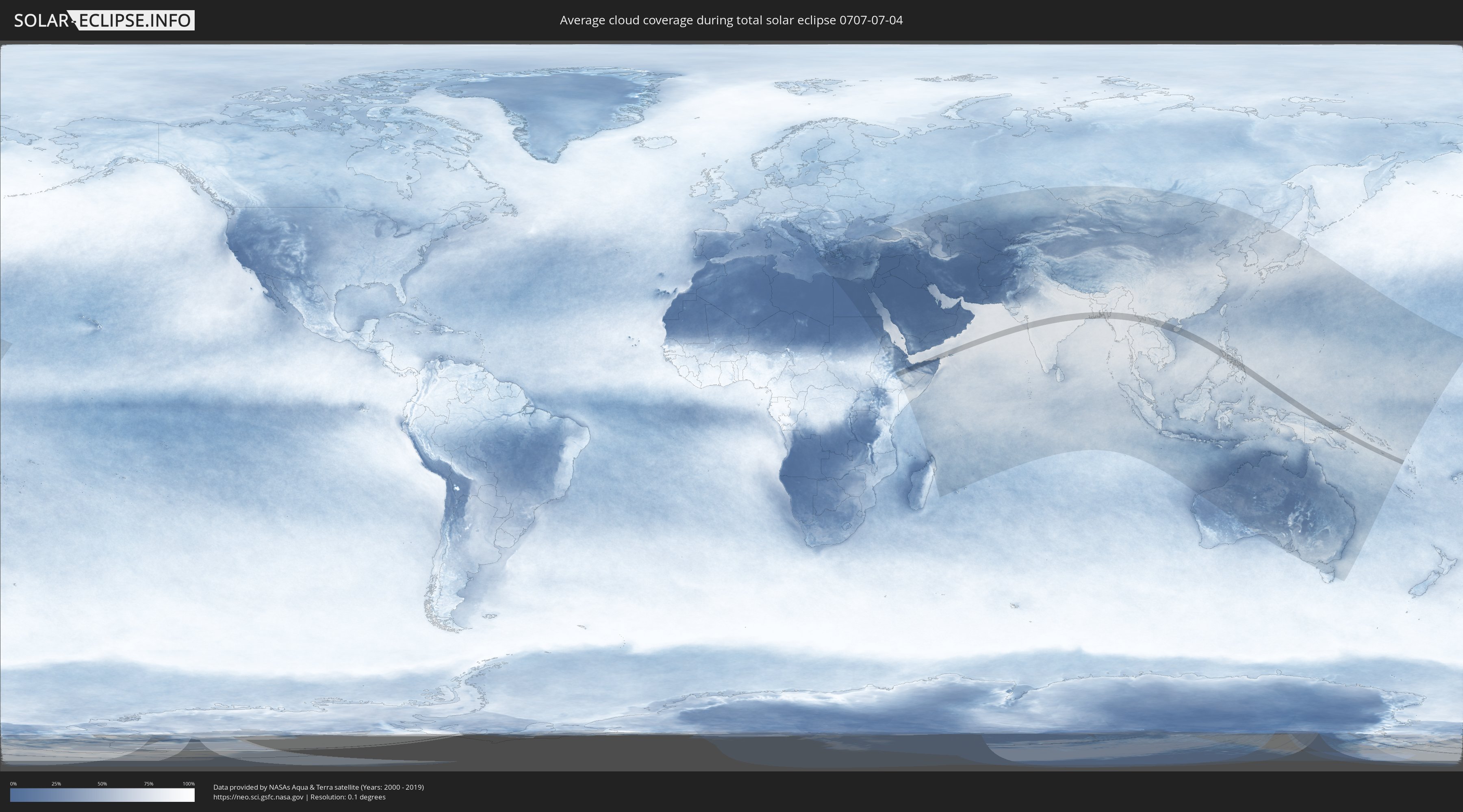
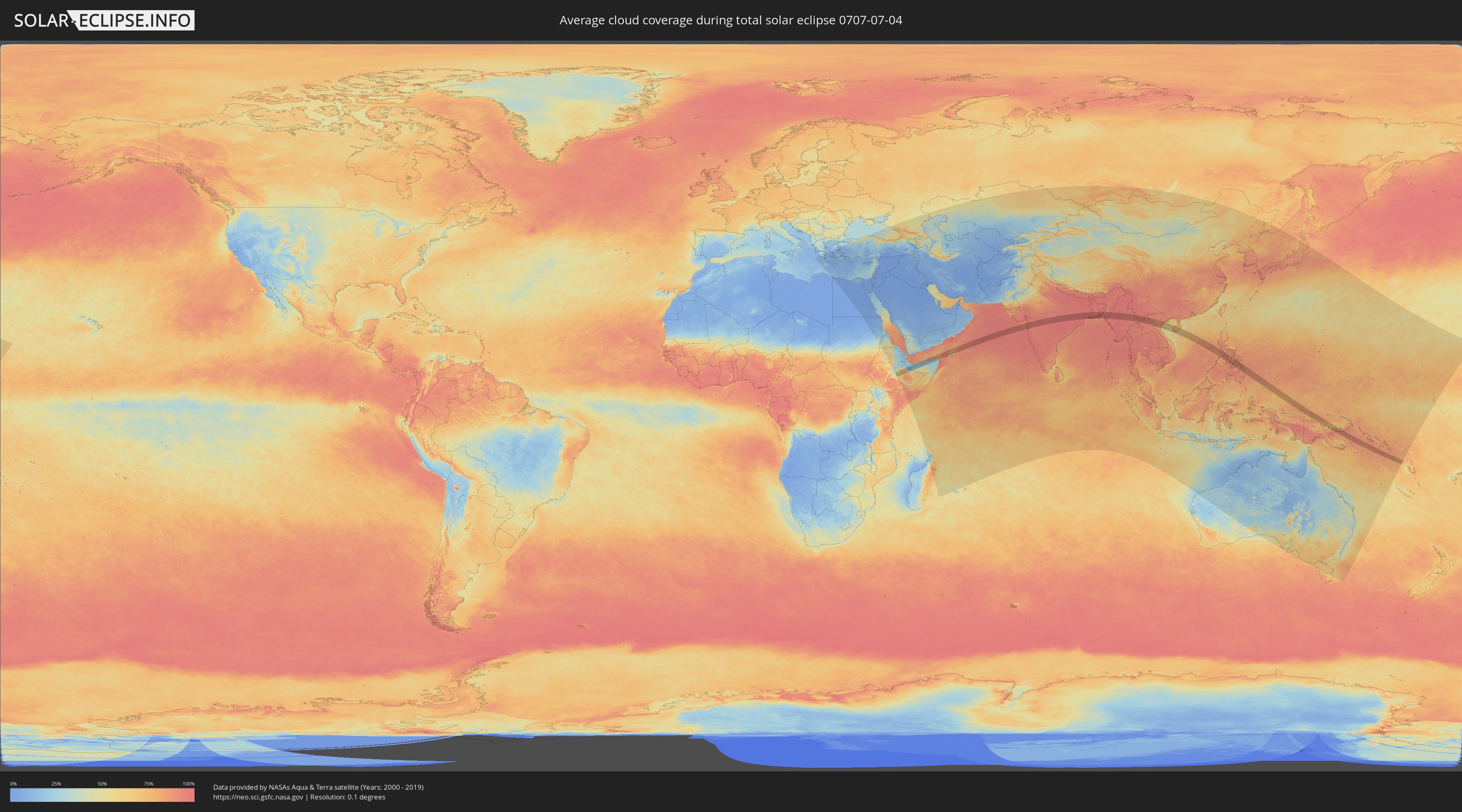
Wie wird das Wetter während der totalen Sonnenfinsternis am 04.07.0707?
Wo ist der beste Ort, um die totale Sonnenfinsternis vom 04.07.0707 zu beobachten?
Die folgenden Karten zeigen die durchschnittliche Bewölkung für den Tag, an dem die totale Sonnenfinsternis
stattfindet. Mit Hilfe der Karten lässt sich der Ort entlang des Finsternispfades eingrenzen,
der die besten Aussichen auf einen klaren wolkenfreien Himmel bietet.
Trotzdem muss man immer lokale Gegenenheiten beachten und sollte sich genau über das Wetter an seinem
gewählten Beobachtungsort informieren.
Die Daten stammen von den beiden NASA-Satelliten
AQUA und TERRA
und wurden über einen Zeitraum von 19 Jahren (2000 - 2019) gemittelt.
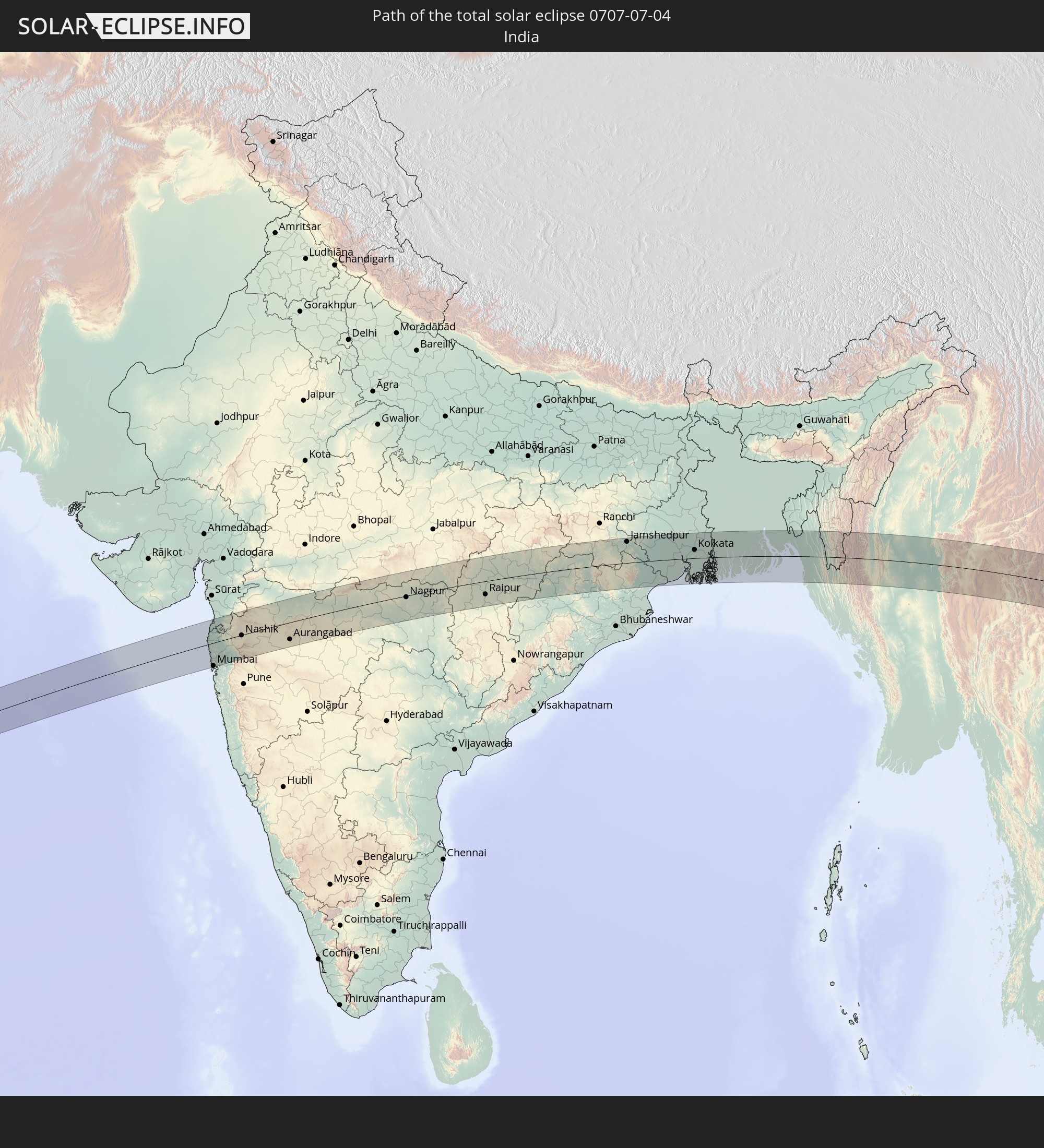
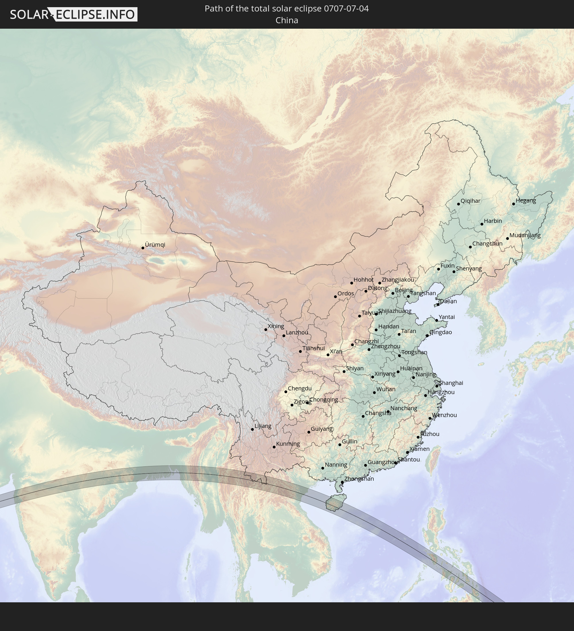
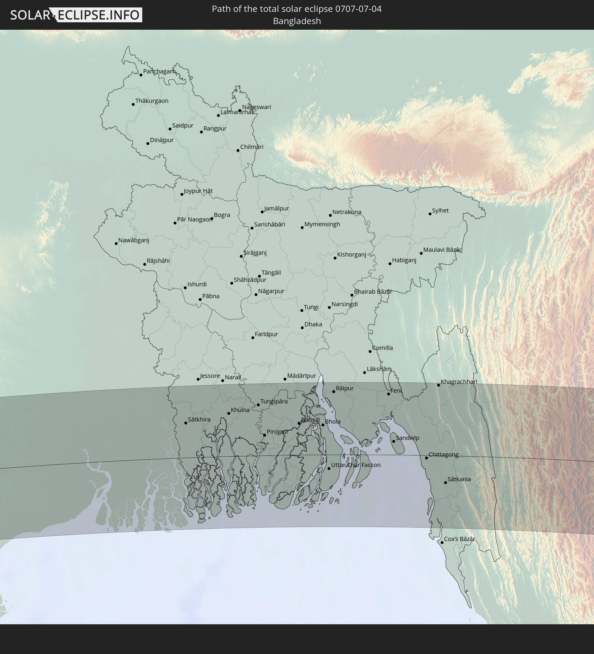
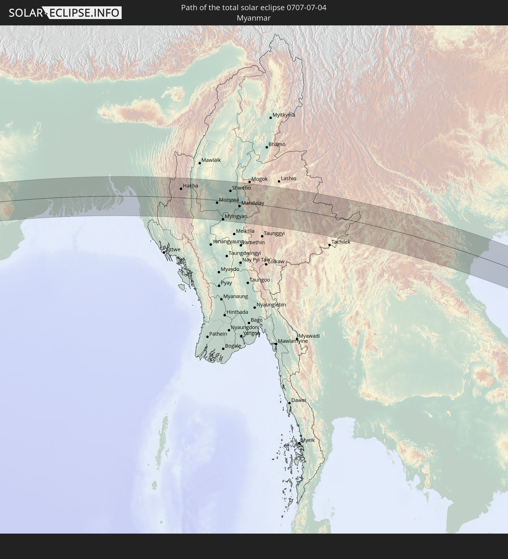
Detaillierte Länderkarten
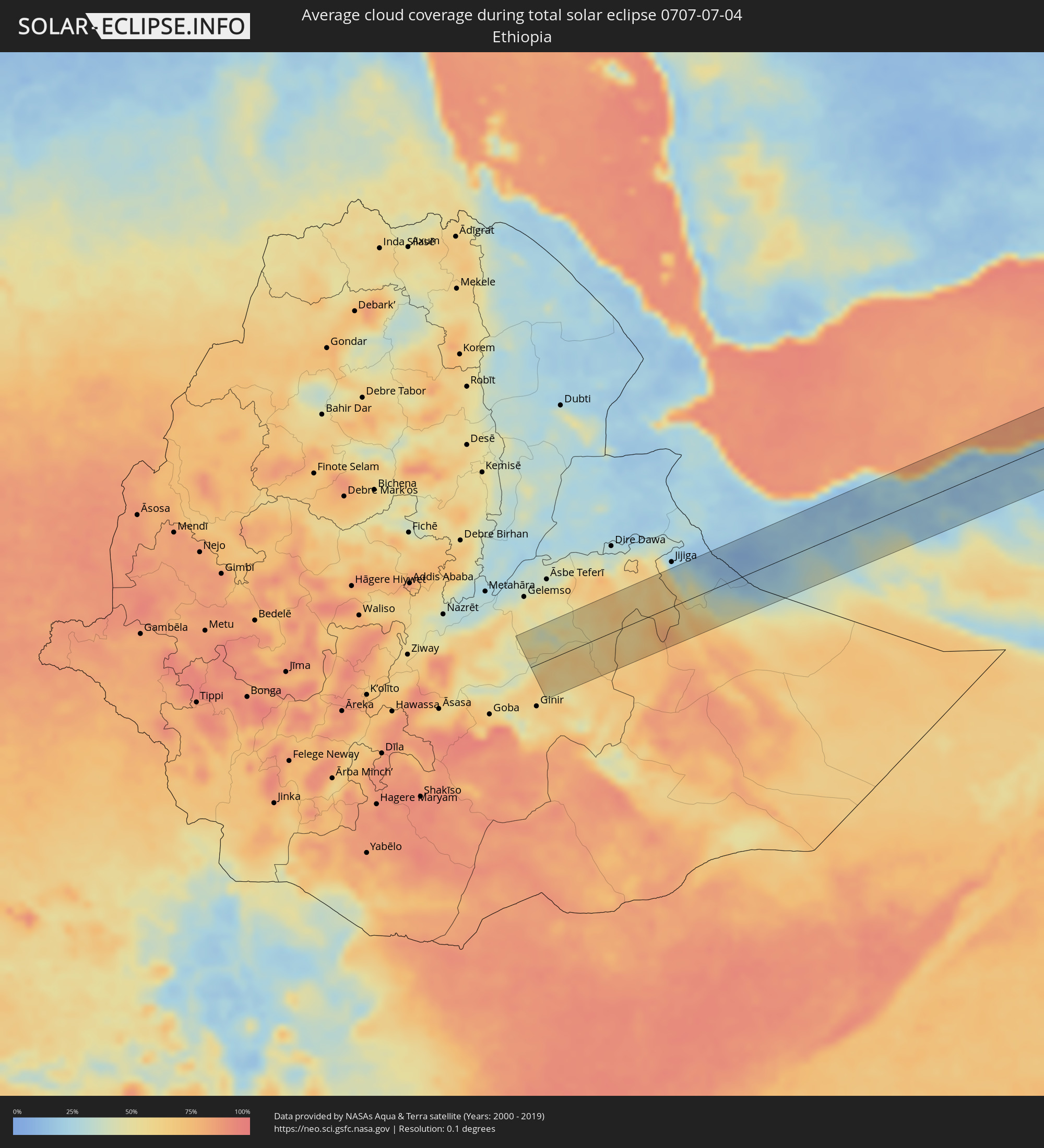 Äthiopien
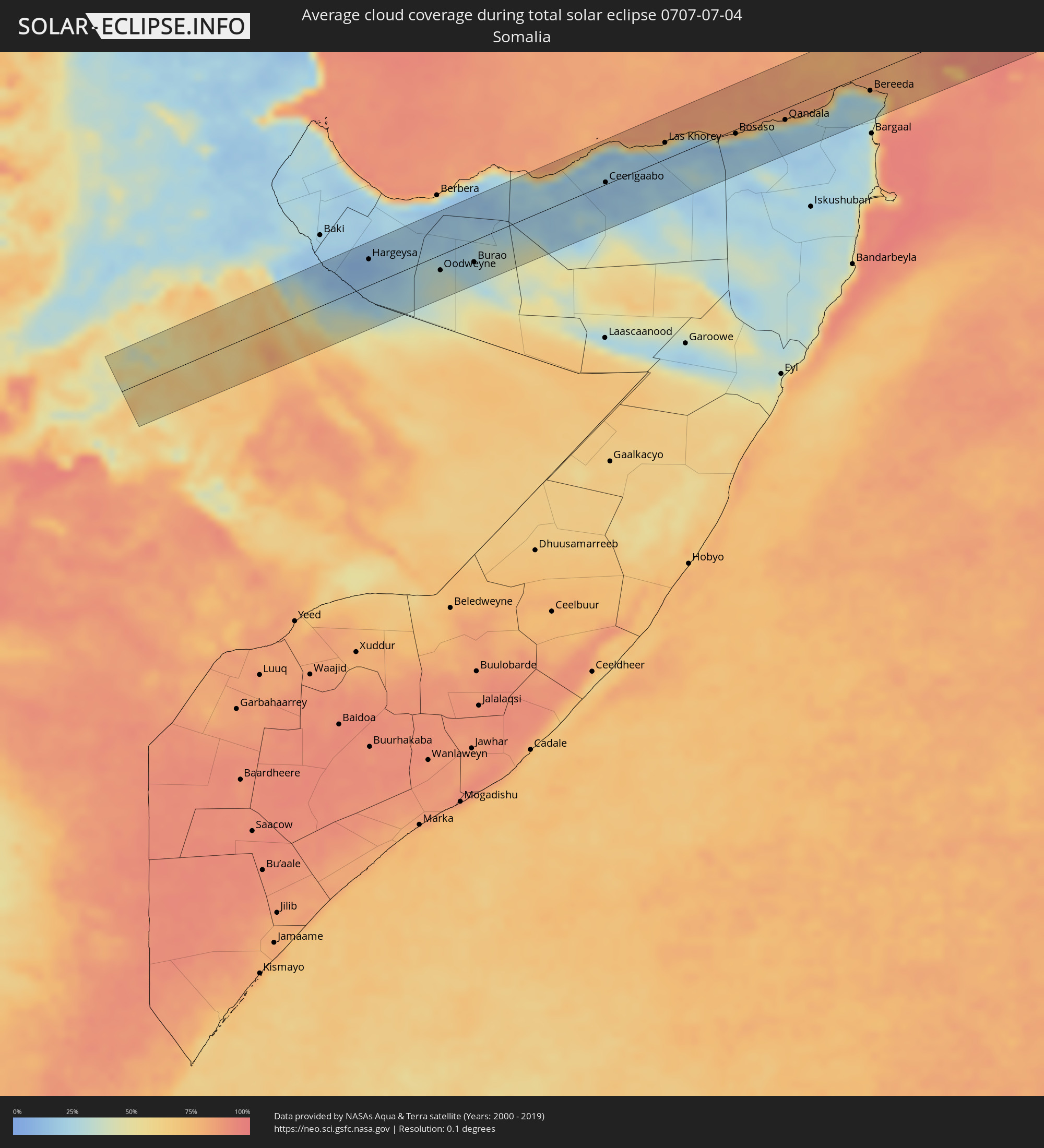 Somalia
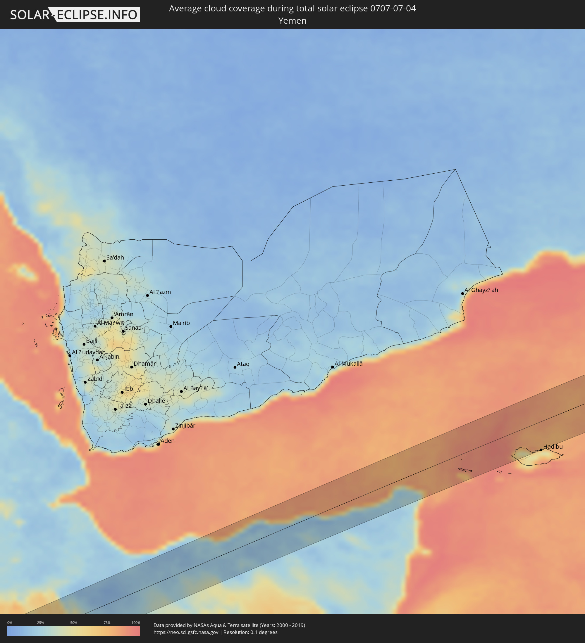 Jemen
Jemen
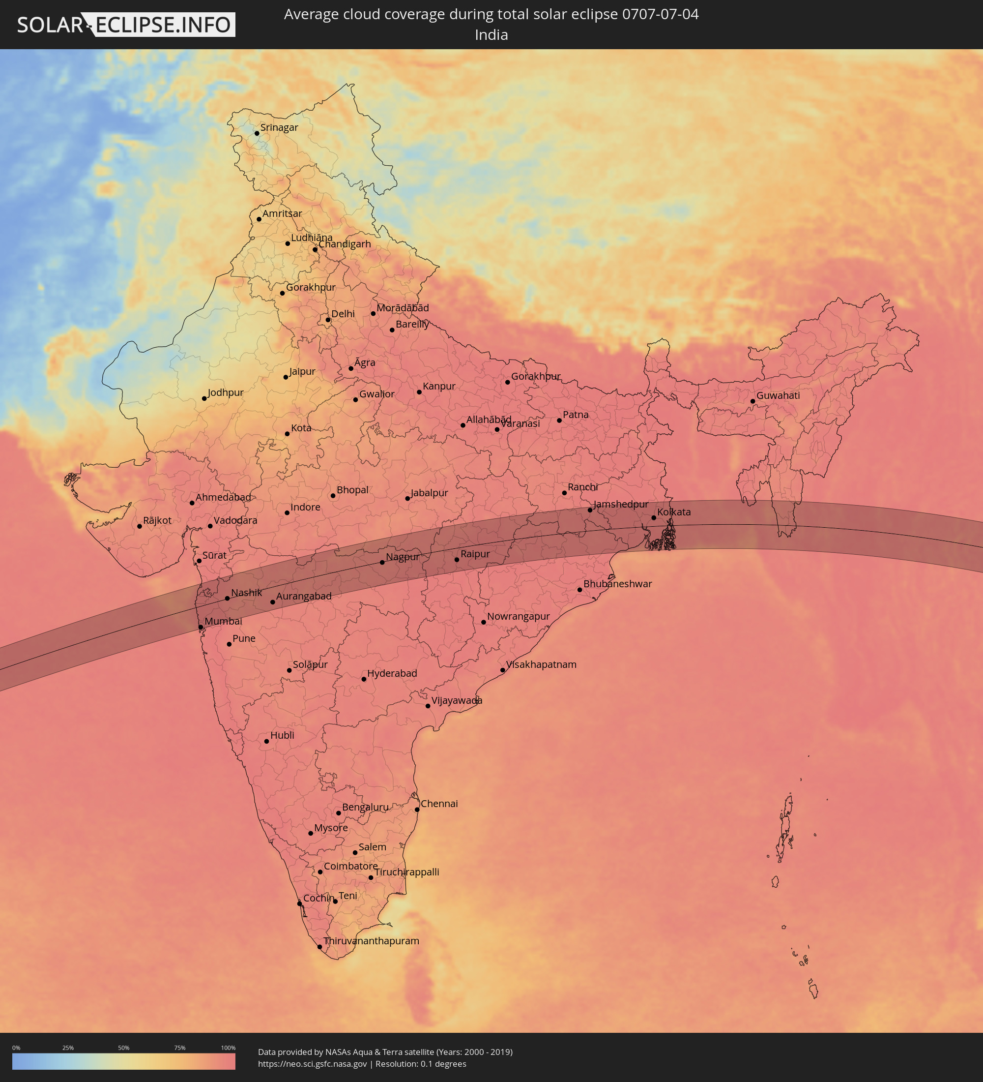 Indien
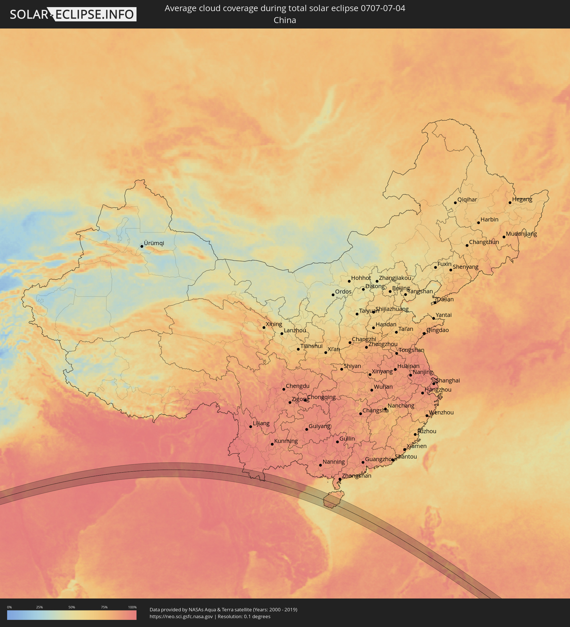 Volksrepublik China
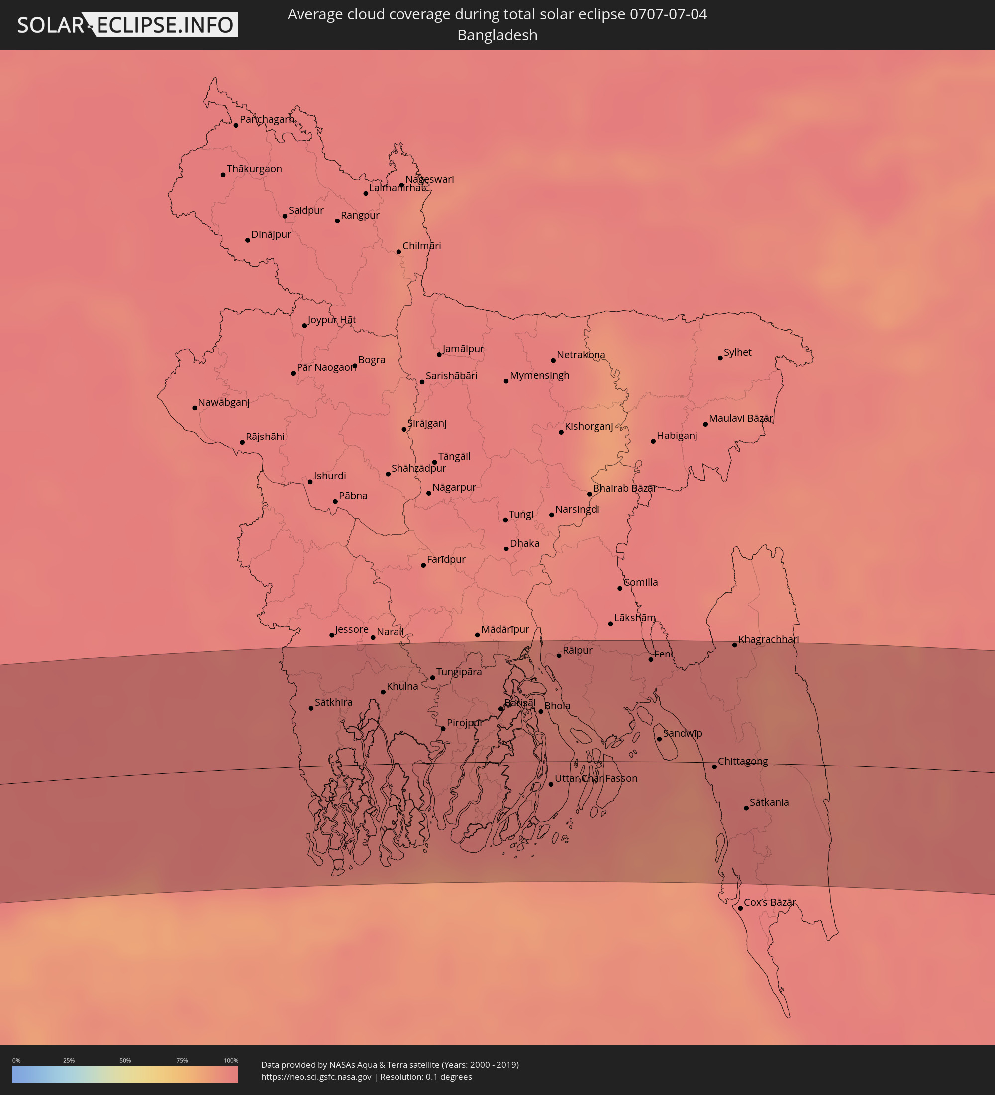 Bangladesch
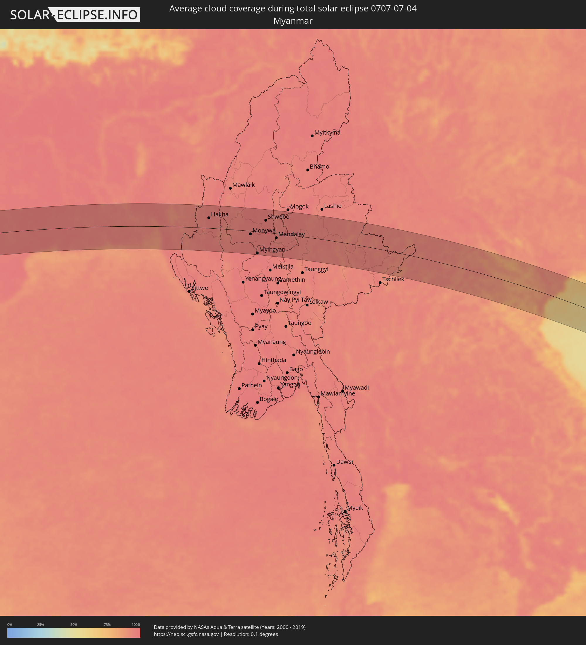 Myanmar
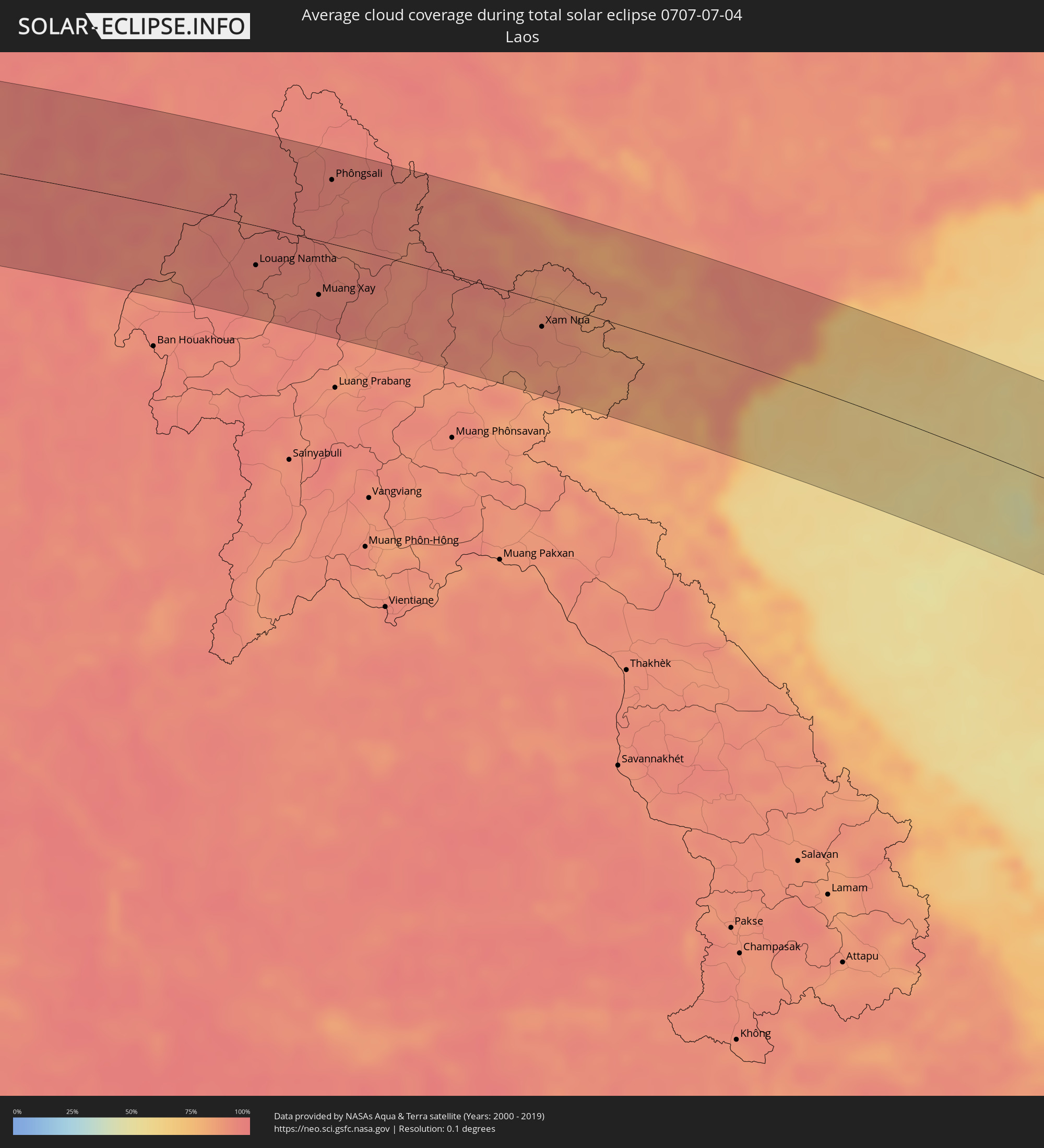 Laos
Laos
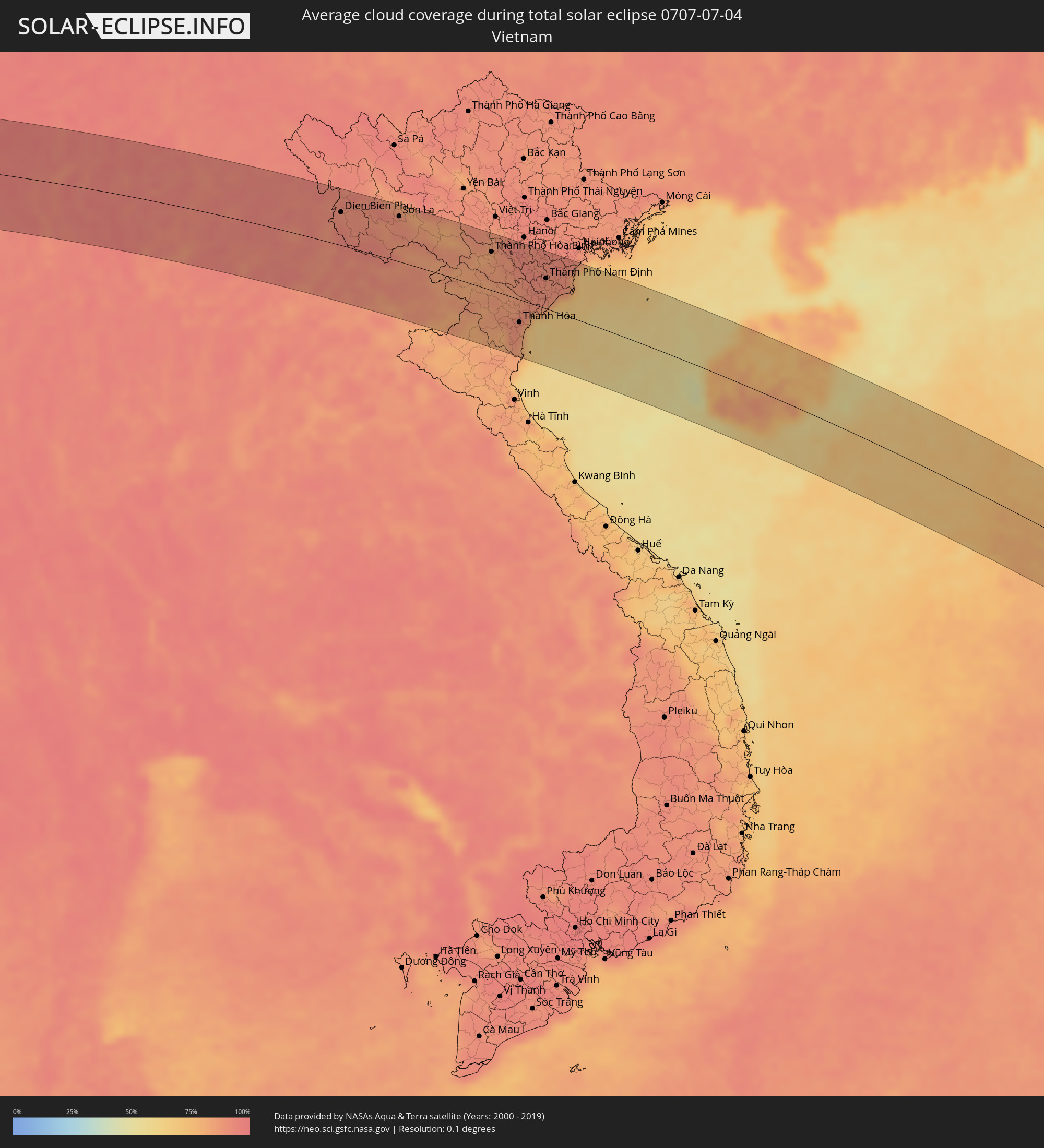 Vietnam
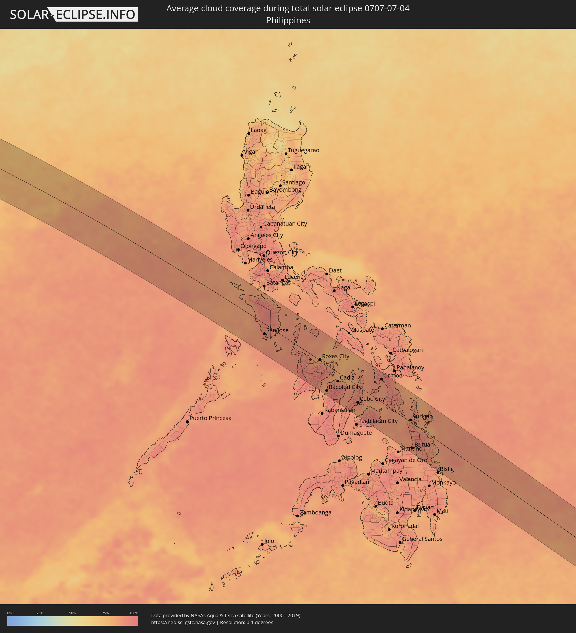 Philippinen
 Palau
Palau
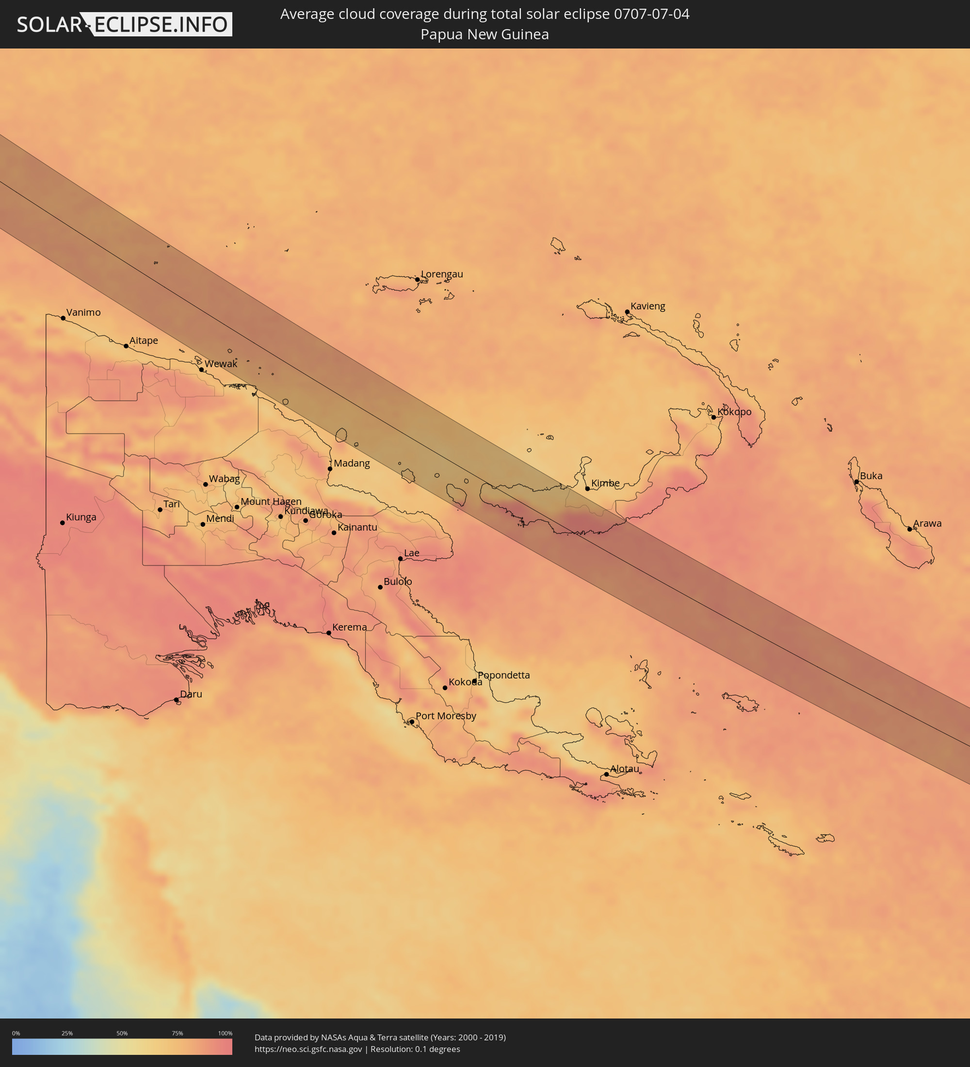 Papua-Neuguinea
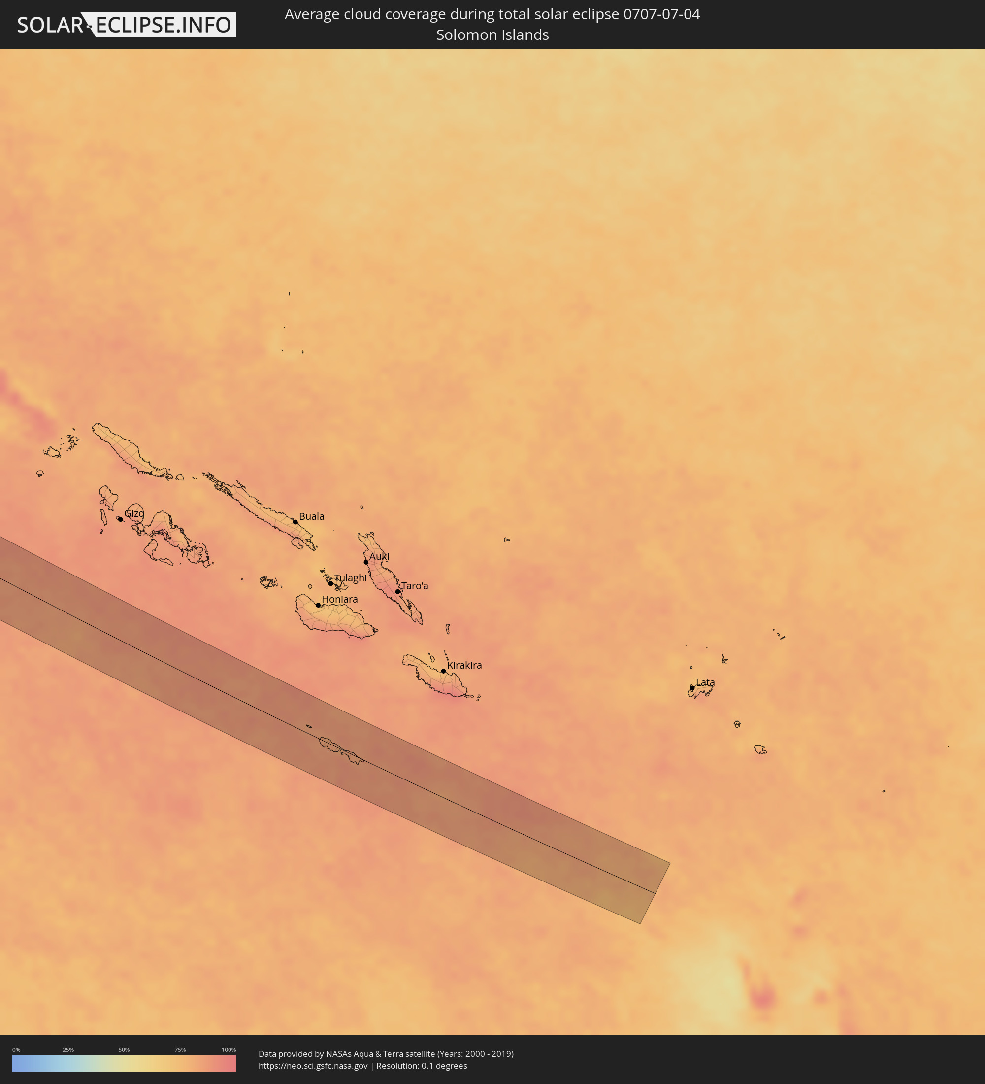 Salomonen
Orte im Finsternispfad
Die nachfolgene Tabelle zeigt Städte und Orte mit mehr als 5.000 Einwohnern, die sich im Finsternispfad befinden. Städte mit mehr als 100.000 Einwohnern sind dick gekennzeichnet. Mit einem Klick auf den Ort öffnet sich eine Detailkarte die die Lage des jeweiligen Ortes zusammen mit dem Verlauf der zentralen Finsternis präsentiert.
| Ort | Typ | Dauer der Verfinsterung | Ortszeit bei maximaler Verfinsterung | Entfernung zur Zentrallinie | Ø Bewölkung |
|
Hargeysa, Woqooyi Galbeed
|
total | - | 05:33:49 UTC+02:27 | 37 km | 12% |
|
Oodweyne, Togdheer
|
total | - | 05:33:49 UTC+02:27 | 22 km | 34% |
|
Burao, Togdheer
|
total | - | 05:33:53 UTC+02:27 | 31 km | 26% |
|
Ceerigaabo, Sanaag
|
total | - | 05:34:24 UTC+02:27 | 3 km | 16% |
|
Las Khorey, Sanaag
|
total | - | 05:34:42 UTC+02:27 | 23 km | 40% |
|
Bosaso, Bari
|
total | - | 05:34:56 UTC+02:27 | 6 km | 28% |
|
Qandala, Bari
|
total | - | 05:35:09 UTC+02:27 | 16 km | 34% |
|
Bereeda, Bari
|
total | - | 05:35:36 UTC+02:27 | 25 km | 39% |
|
Bhayandar, Maharashtra
|
total | - | 08:50:27 UTC+05:21 | 50 km | 97% |
|
Mumbai, Maharashtra
|
total | - | 08:50:23 UTC+05:21 | 75 km | 96% |
|
Thāne, Maharashtra
|
total | - | 08:50:34 UTC+05:21 | 64 km | 97% |
|
Kalyān, Maharashtra
|
total | - | 08:50:50 UTC+05:21 | 64 km | 97% |
|
Nashik, Maharashtra
|
total | - | 08:52:08 UTC+05:21 | 1 km | 94% |
|
Mālegaon, Maharashtra
|
total | - | 08:53:30 UTC+05:21 | 38 km | 92% |
|
Dhūlia, Maharashtra
|
total | - | 08:54:02 UTC+05:21 | 70 km | 93% |
|
Aurangabad, Maharashtra
|
total | - | 08:54:26 UTC+05:21 | 55 km | 95% |
|
Jalgaon, Maharashtra
|
total | - | 08:55:18 UTC+05:21 | 61 km | 94% |
|
Jālna, Maharashtra
|
total | - | 08:55:17 UTC+05:21 | 73 km | 95% |
|
Akola, Maharashtra
|
total | - | 08:57:29 UTC+05:21 | 6 km | 95% |
|
Amrāvati, Maharashtra
|
total | - | 08:58:51 UTC+05:21 | 1 km | 93% |
|
Nagpur, Maharashtra
|
total | - | 09:01:16 UTC+05:21 | 5 km | 94% |
|
Durg, Chhattisgarh
|
total | - | 09:05:24 UTC+05:21 | 42 km | 97% |
|
Bhilai, Chhattisgarh
|
total | - | 09:05:42 UTC+05:21 | 42 km | 97% |
|
Raipur, Chhattisgarh
|
total | - | 09:06:06 UTC+05:21 | 43 km | 97% |
|
Bilāspur, Chhattisgarh
|
total | - | 09:07:24 UTC+05:21 | 41 km | 97% |
|
Korba, Chhattisgarh
|
total | - | 09:08:34 UTC+05:21 | 62 km | 97% |
|
Jamshedpur, Jharkhand
|
total | - | 09:16:02 UTC+05:21 | 70 km | 96% |
|
Nangi, West Bengal
|
total | - | 09:20:37 UTC+05:21 | 22 km | 97% |
|
Kolkata, West Bengal
|
total | - | 09:20:58 UTC+05:21 | 28 km | 97% |
|
Bhātpāra, West Bengal
|
total | - | 09:21:04 UTC+05:21 | 61 km | 97% |
|
Bārāsat, West Bengal
|
total | - | 09:21:15 UTC+05:21 | 45 km | 97% |
|
Sātkhira, Khulna
|
total | - | 09:54:49 UTC+05:53 | 40 km | 96% |
|
Bhātpāra Abhaynagar, Khulna
|
total | - | 09:55:42 UTC+05:53 | 73 km | 96% |
|
Phultala, Khulna
|
total | - | 09:55:52 UTC+05:53 | 40 km | 97% |
|
Khulna, Khulna
|
total | - | 09:55:59 UTC+05:53 | 50 km | 96% |
|
Kālia, Khulna
|
total | - | 09:56:09 UTC+05:53 | 76 km | 95% |
|
Tungipāra, Dhaka
|
total | - | 09:56:48 UTC+05:53 | 59 km | 95% |
|
Pirojpur, Barisāl
|
total | - | 09:56:59 UTC+05:53 | 24 km | 96% |
|
Gaurnadi, Barisāl
|
total | - | 09:57:35 UTC+05:53 | 67 km | 96% |
|
Nālchiti, Barisāl
|
total | - | 09:57:42 UTC+05:53 | 29 km | 94% |
|
Barisāl, Barisāl
|
total | - | 09:57:57 UTC+05:53 | 37 km | 95% |
|
Mehendiganj, Barisāl
|
total | - | 09:58:20 UTC+05:53 | 50 km | 95% |
|
Bhola, Barisāl
|
total | - | 09:58:37 UTC+05:53 | 35 km | 94% |
|
Uttar Char Fasson, Khulna
|
total | - | 09:58:49 UTC+05:53 | 17 km | 97% |
|
Burhānuddin, Barisāl
|
total | - | 09:58:50 UTC+05:53 | 13 km | 95% |
|
Lālmohan, Barisāl
|
total | - | 09:58:52 UTC+05:53 | 4 km | 96% |
|
Rāipur, Chittagong
|
total | - | 09:58:54 UTC+05:53 | 74 km | 96% |
|
Feni, Chittagong
|
total | - | 10:00:28 UTC+05:53 | 71 km | 97% |
|
Sandwīp, Chittagong
|
total | - | 10:00:39 UTC+05:53 | 15 km | 94% |
|
Chhāgalnāiya, Chittagong
|
total | - | 10:00:45 UTC+05:53 | 72 km | 97% |
|
Chittagong, Chittagong
|
total | - | 10:01:37 UTC+05:53 | 4 km | 93% |
|
Khagrachhari, Chittagong
|
total | - | 10:01:53 UTC+05:53 | 82 km | 96% |
|
Patiya, Chittagong
|
total | - | 10:02:00 UTC+05:53 | 8 km | 97% |
|
Sātkania, Chittagong
|
total | - | 10:02:13 UTC+05:53 | 32 km | 97% |
|
Hakha, Chin
|
total | - | 10:37:36 UTC+06:24 | 38 km | 98% |
|
Falam, Chin
|
total | - | 10:37:43 UTC+06:24 | 67 km | 97% |
|
Monywa, Sagain
|
total | - | 10:41:46 UTC+06:24 | 11 km | 97% |
|
Myingyan, Mandalay
|
total | - | 10:42:40 UTC+06:24 | 81 km | 97% |
|
Shwebo, Sagain
|
total | - | 10:43:07 UTC+06:24 | 45 km | 97% |
|
Sagaing, Sagain
|
total | - | 10:44:08 UTC+06:24 | 29 km | 95% |
|
Mandalay, Mandalay
|
total | - | 10:44:23 UTC+06:24 | 17 km | 95% |
|
Kyaukse, Mandalay
|
total | - | 10:44:40 UTC+06:24 | 57 km | 96% |
|
Pyin Oo Lwin, Mandalay
|
total | - | 10:45:22 UTC+06:24 | 6 km | 97% |
|
Jinghong, Yunnan
|
total | - | 12:32:27 UTC+08:00 | 61 km | 94% |
|
Louang Namtha, Loungnamtha
|
total | - | 11:17:08 UTC+06:42 | 37 km | 92% |
|
Muang Xay, Oudômxai
|
total | - | 11:18:59 UTC+06:42 | 51 km | 94% |
|
Phôngsali, Phôngsali
|
total | - | 11:18:34 UTC+06:42 | 59 km | 94% |
|
Dien Bien Phu, Tỉnh Ðiện Biên
|
total | - | 11:45:59 UTC+07:06 | 51 km | 91% |
|
Sơn La, Sơn La
|
total | - | 11:48:32 UTC+07:06 | 70 km | 90% |
|
Xam Nua, Houaphan
|
total | - | 11:25:07 UTC+06:42 | 24 km | 91% |
|
Thành Phố Hòa Bình, Hòa Bình
|
total | - | 11:52:59 UTC+07:06 | 59 km | 84% |
|
Thanh Hóa, Thanh Hóa
|
total | - | 11:55:12 UTC+07:06 | 35 km | 86% |
|
Bỉm Sơn, Thanh Hóa
|
total | - | 11:55:11 UTC+07:06 | 2 km | 90% |
|
Thành Phố Phủ Lý, Hà Nam
|
total | - | 11:54:52 UTC+07:06 | 49 km | 91% |
|
Thành Phố Ninh Bình, Ninh Bình
|
total | - | 11:55:20 UTC+07:06 | 21 km | 91% |
|
Hưng Yên, Hưng Yên
|
total | - | 11:55:09 UTC+07:06 | 64 km | 92% |
|
Thành Phố Nam Định, Nam Định
|
total | - | 11:55:43 UTC+07:06 | 46 km | 89% |
|
Thành Phố Thái Bình, Thái Bình
|
total | - | 11:56:09 UTC+07:06 | 53 km | 90% |
|
Sanya, Hainan
|
total | - | 13:00:47 UTC+08:00 | 55 km | 63% |
|
Wanning, Hainan
|
total | - | 13:02:30 UTC+08:00 | 39 km | 73% |
|
Sablayan, Mimaropa
|
total | - | 13:36:16 UTC+08:00 | 1 km | 89% |
|
San Jose, Mimaropa
|
total | - | 13:37:36 UTC+08:00 | 28 km | 89% |
|
Calapan, Mimaropa
|
total | - | 13:36:17 UTC+08:00 | 78 km | 88% |
|
Pinamalayan, Mimaropa
|
total | - | 13:37:25 UTC+08:00 | 60 km | 88% |
|
Pandan, Western Visayas
|
total | - | 13:40:38 UTC+08:00 | 23 km | 90% |
|
Kalibo (poblacion), Western Visayas
|
total | - | 13:41:14 UTC+08:00 | 10 km | 86% |
|
Passi, Western Visayas
|
total | - | 13:42:39 UTC+08:00 | 49 km | 92% |
|
Roxas City, Western Visayas
|
total | - | 13:42:11 UTC+08:00 | 2 km | 87% |
|
Bacolod City, Western Visayas
|
total | - | 13:43:54 UTC+08:00 | 71 km | 94% |
|
Victorias, Western Visayas
|
total | - | 13:43:48 UTC+08:00 | 42 km | 93% |
|
Canlaon, Central Visayas
|
total | - | 13:44:51 UTC+08:00 | 80 km | 93% |
|
Cadiz, Western Visayas
|
total | - | 13:44:10 UTC+08:00 | 24 km | 95% |
|
Ualog, Western Visayas
|
total | - | 13:44:54 UTC+08:00 | 52 km | 90% |
|
Escalante, Western Visayas
|
total | - | 13:44:44 UTC+08:00 | 21 km | 87% |
|
Toledo, Central Visayas
|
total | - | 13:45:40 UTC+08:00 | 55 km | 90% |
|
Carcar, Central Visayas
|
total | - | 13:46:03 UTC+08:00 | 80 km | 89% |
|
Cebu City, Central Visayas
|
total | - | 13:46:14 UTC+08:00 | 45 km | 89% |
|
Danao, Central Visayas
|
total | - | 13:46:12 UTC+08:00 | 18 km | 87% |
|
Jagna, Central Visayas
|
total | - | 13:48:05 UTC+08:00 | 77 km | 85% |
|
Ormoc, Eastern Visayas
|
total | - | 13:46:36 UTC+08:00 | 62 km | 89% |
|
Surigao, Caraga
|
total | - | 13:49:58 UTC+08:00 | 6 km | 87% |
|
Butuan, Caraga
|
total | - | 13:51:13 UTC+08:00 | 68 km | 86% |
|
Bayugan, Caraga
|
total | - | 13:51:53 UTC+08:00 | 72 km | 88% |
|
Sonsorol Village, Sonsorol
|
total | - | 15:06:24 UTC+09:00 | 24 km | 85% |