Totale Sonnenfinsternis vom 23.03.0749
| Wochentag: | Mittwoch |
| Maximale Dauer der Verfinsterung: | 01m53s |
| Maximale Breite des Finsternispfades: | 208 km |
| Saroszyklus: | 80 |
| Bedeckungsgrad: | 100% |
| Magnitude: | 1.0275 |
| Gamma: | 0.8932 |
Wo kann man die Sonnenfinsternis vom 23.03.0749 sehen?
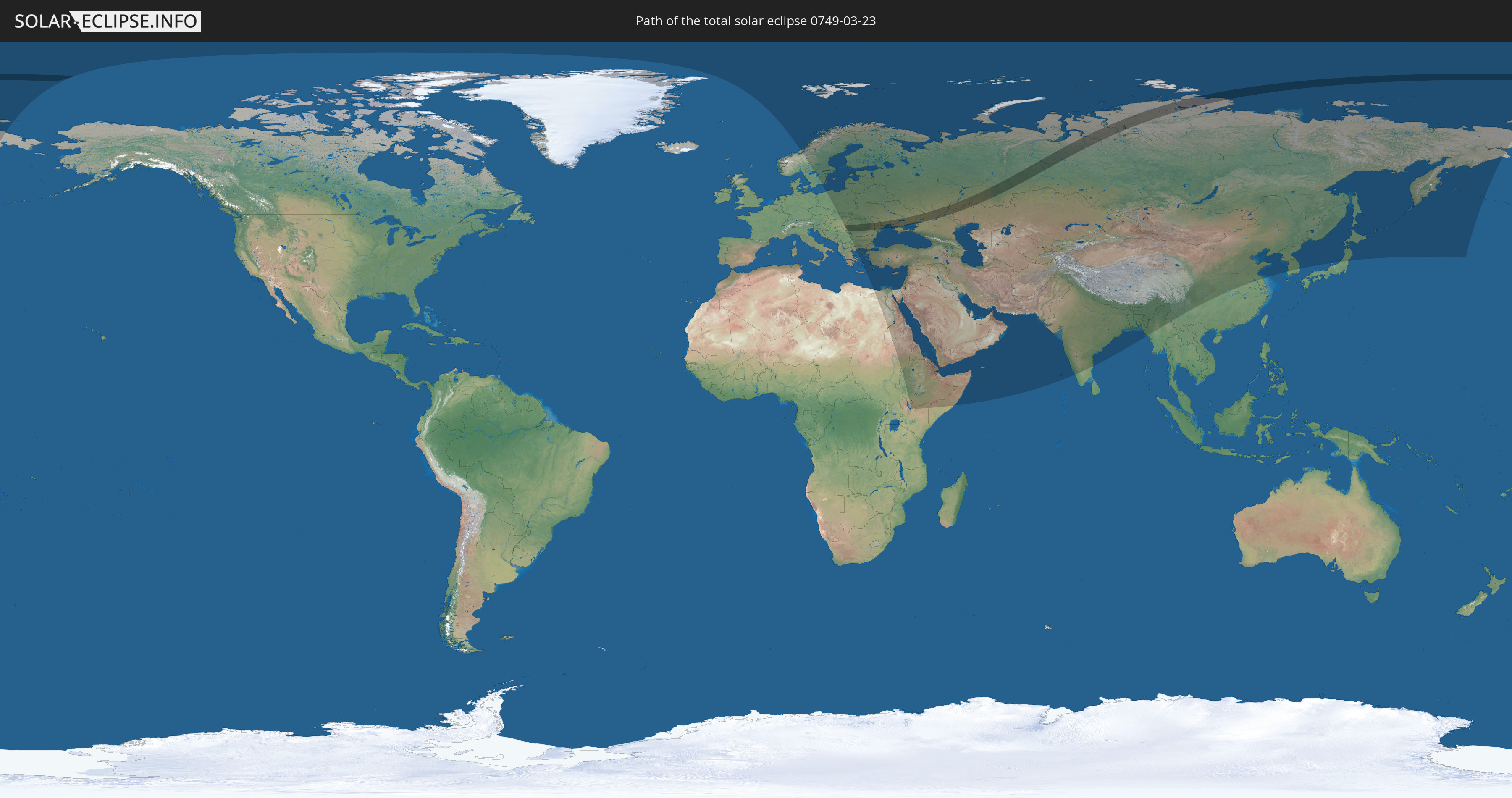
Die Sonnenfinsternis am 23.03.0749 kann man in 63 Ländern als partielle Sonnenfinsternis beobachten.
Der Finsternispfad verläuft durch 6 Länder. Nur in diesen Ländern ist sie als totale Sonnenfinsternis zu sehen.
In den folgenden Ländern ist die Sonnenfinsternis total zu sehen
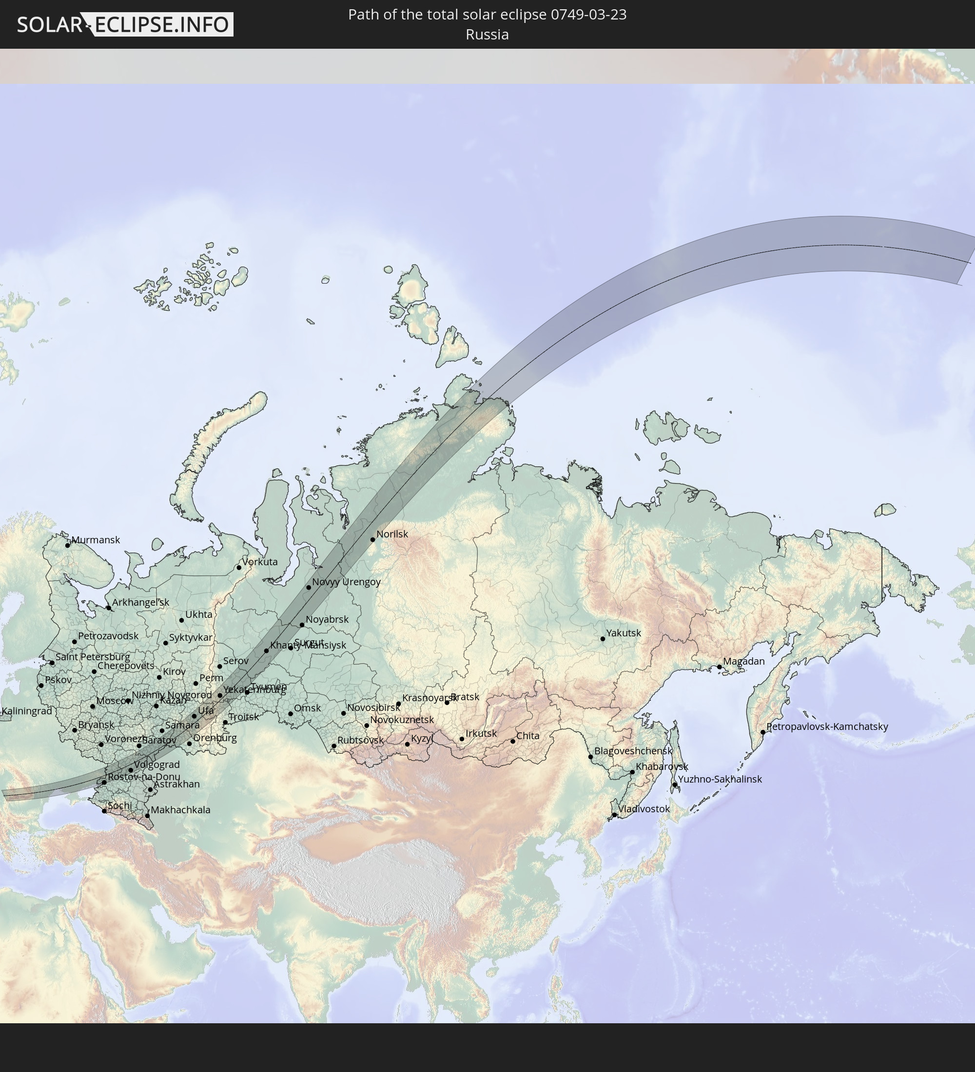 Russland
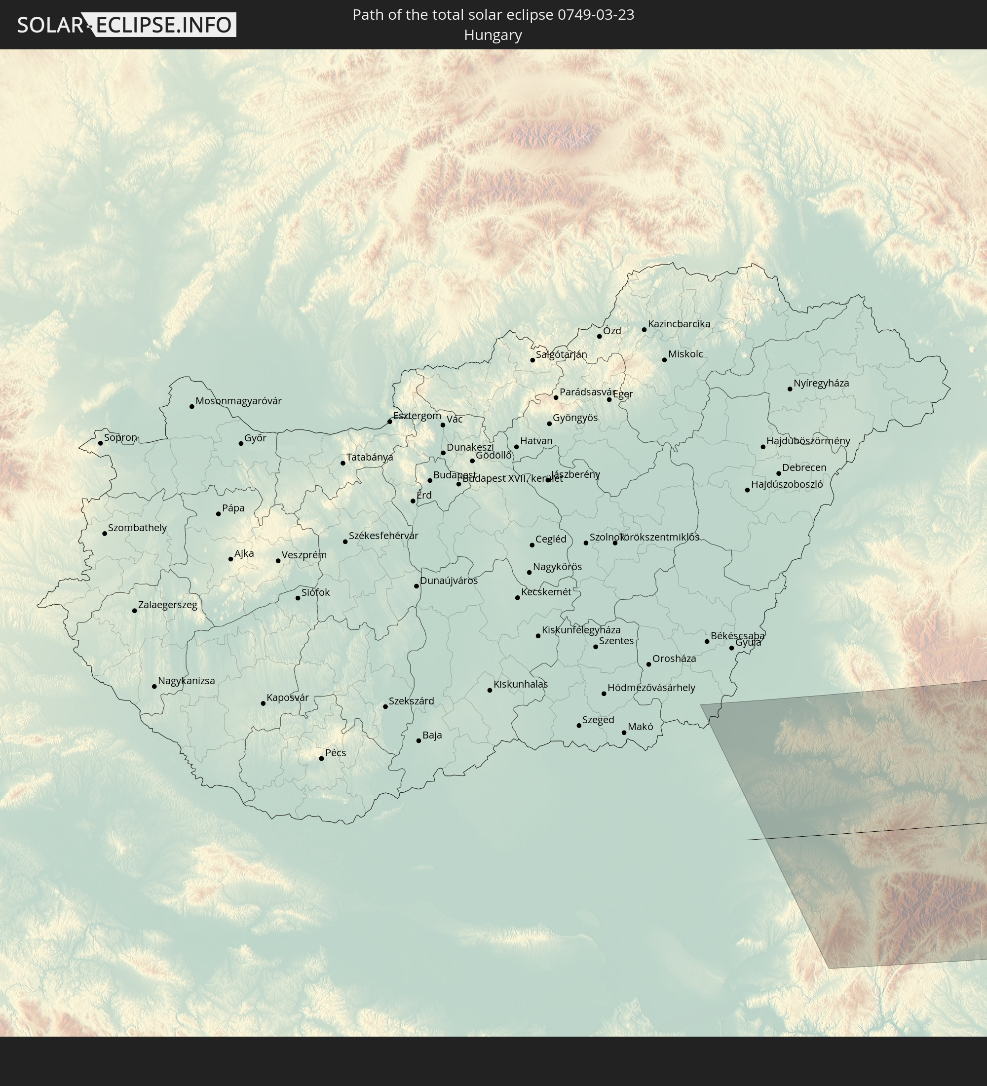 Ungarn
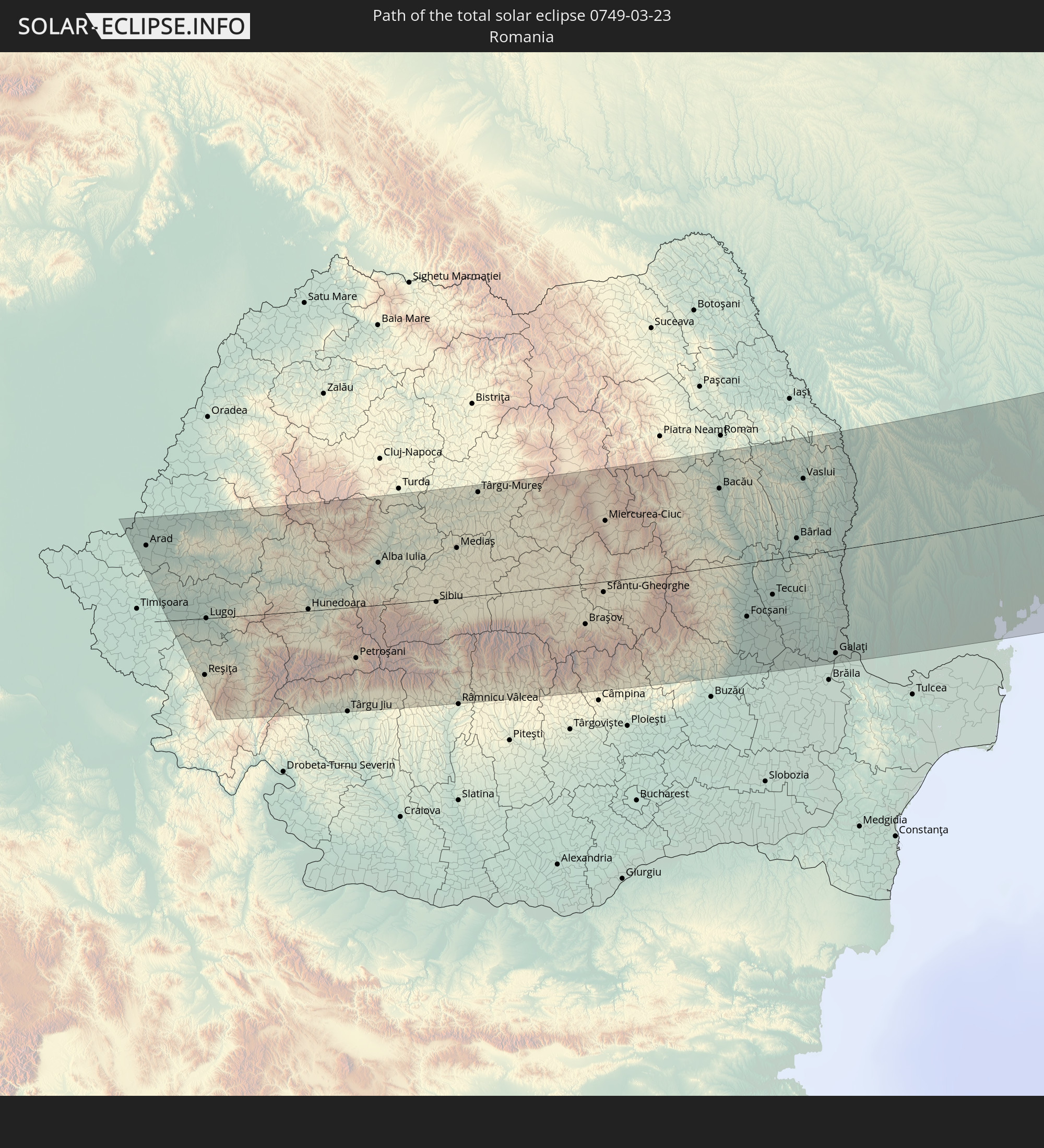 Rumänien
 Ukraine
 Moldawien
 Kasachstan
In den folgenden Ländern ist die Sonnenfinsternis partiell zu sehen
 Russland
 Vereinigte Staaten
 Spitzbergen
 Norwegen
 Schweden
 Polen
Polen
 Ungarn
 Slowakei
 Serbien
 Åland Islands
 Griechenland
 Rumänien
 Finnland
 Litauen
 Lettland
 Estland
 Sudan
Sudan
 Ukraine
 Bulgarien
 Weißrussland
 Ägypten
 Türkei
 Moldawien
 Republik Zypern
 Äthiopien
 Kenia
Kenia
 Staat Palästina
 Israel
 Saudi-Arabien
 Jordanien
 Libanon
 Syrien
 Eritrea
 Irak
Irak
 Georgien
 Somalia
 Dschibuti
 Jemen
Jemen
 Armenien
 Iran
Iran
 Aserbaidschan
 Kasachstan
 Kuwait
 Bahrain
 Katar
Katar
 Vereinigte Arabische Emirate
 Oman
Oman
 Turkmenistan
 Usbekistan
 Afghanistan
 Pakistan
 Tadschikistan
 Indien
 Kirgisistan
 Volksrepublik China
 Nepal
Nepal
 Mongolei
 Bangladesch
 Bhutan
 Myanmar
 Japan
Japan
 Nordkorea
 Südkorea
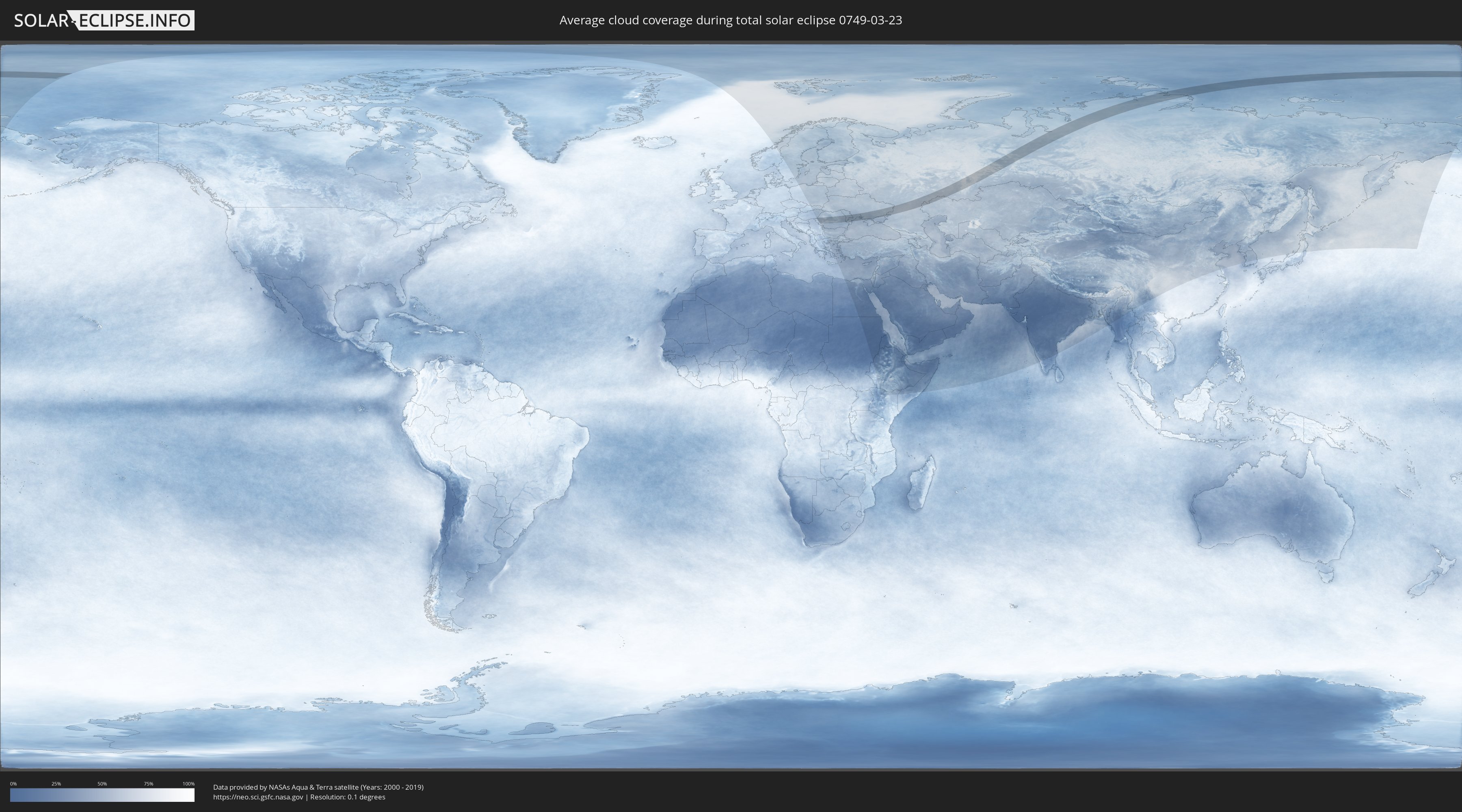
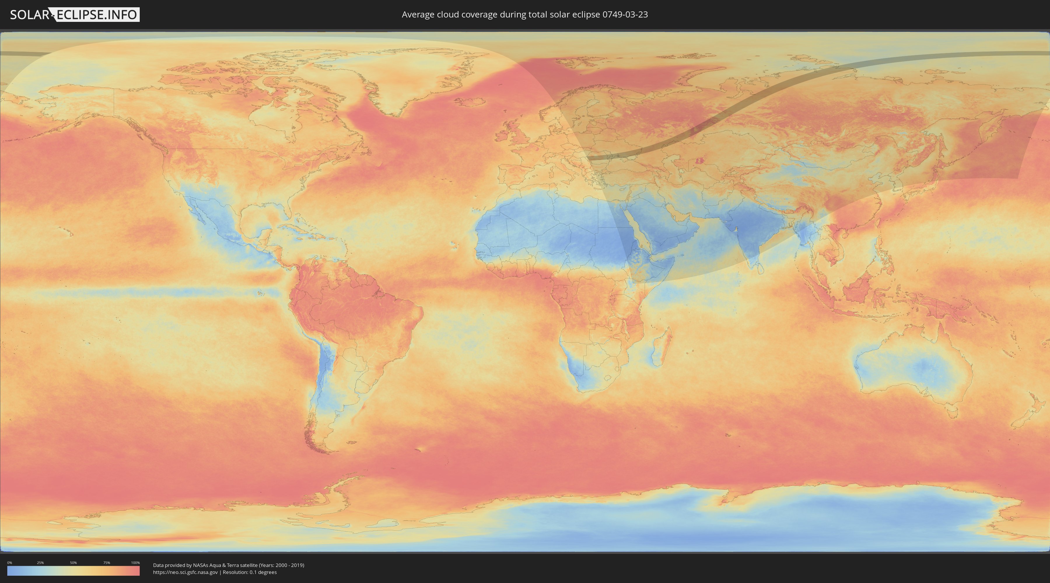
Wie wird das Wetter während der totalen Sonnenfinsternis am 23.03.0749?
Wo ist der beste Ort, um die totale Sonnenfinsternis vom 23.03.0749 zu beobachten?
Die folgenden Karten zeigen die durchschnittliche Bewölkung für den Tag, an dem die totale Sonnenfinsternis
stattfindet. Mit Hilfe der Karten lässt sich der Ort entlang des Finsternispfades eingrenzen,
der die besten Aussichen auf einen klaren wolkenfreien Himmel bietet.
Trotzdem muss man immer lokale Gegenenheiten beachten und sollte sich genau über das Wetter an seinem
gewählten Beobachtungsort informieren.
Die Daten stammen von den beiden NASA-Satelliten
AQUA und TERRA
und wurden über einen Zeitraum von 19 Jahren (2000 - 2019) gemittelt.
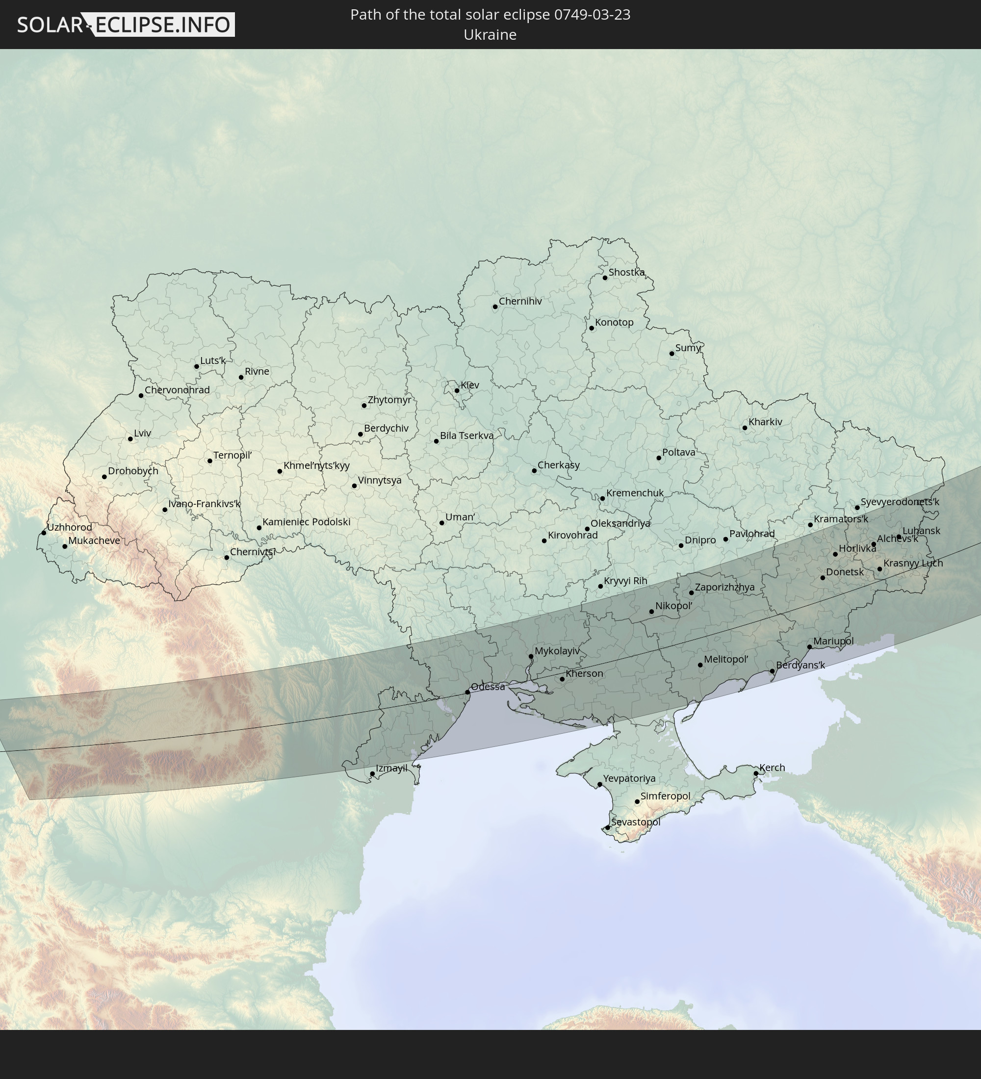
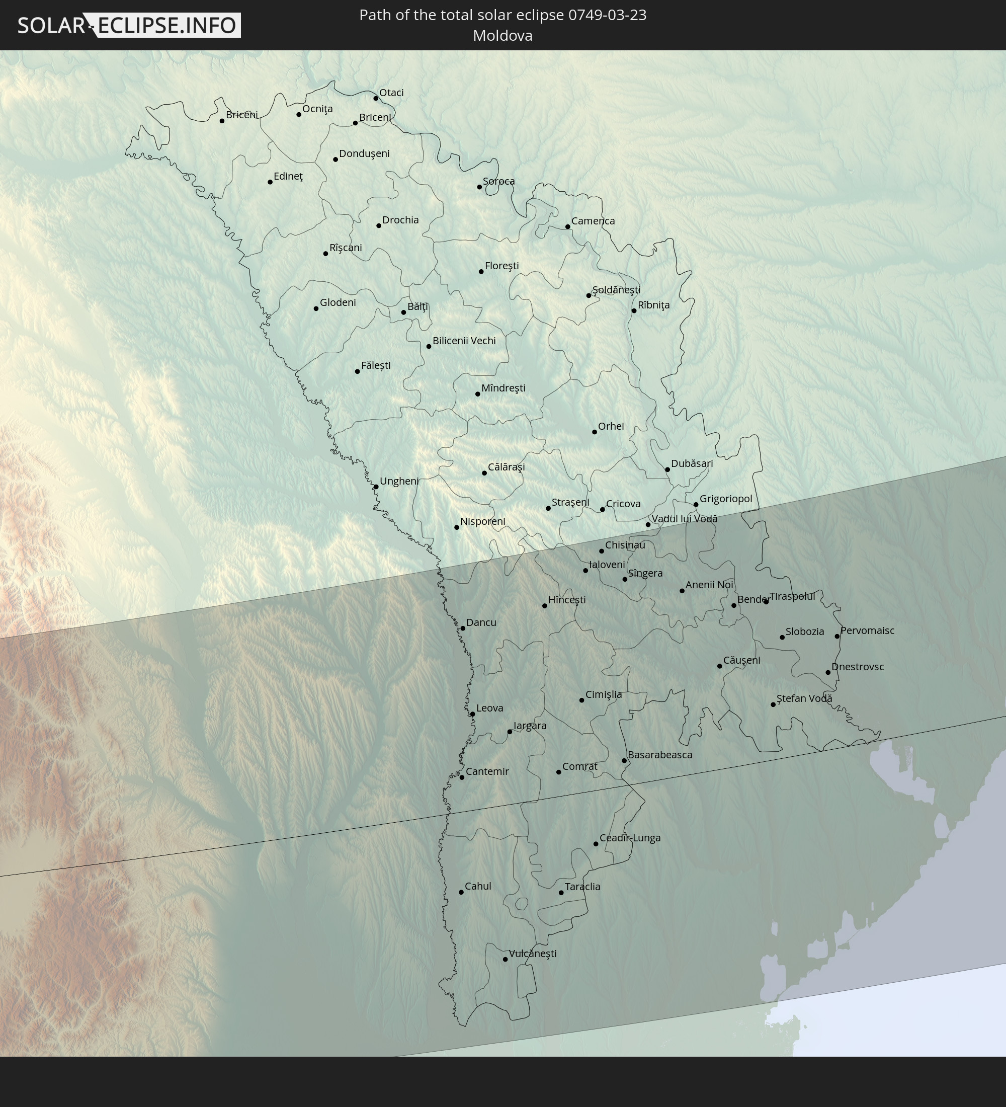
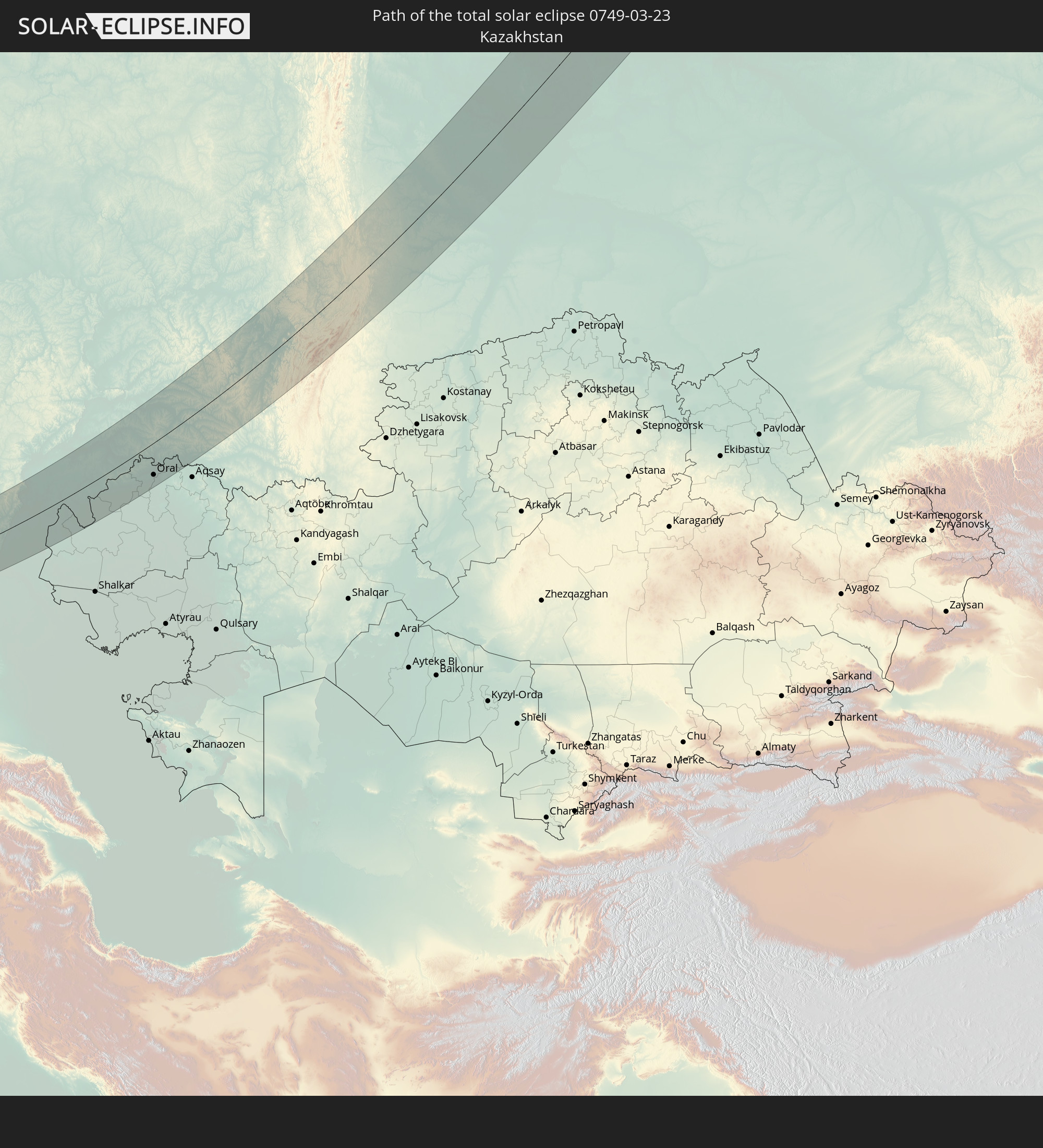
Detaillierte Länderkarten
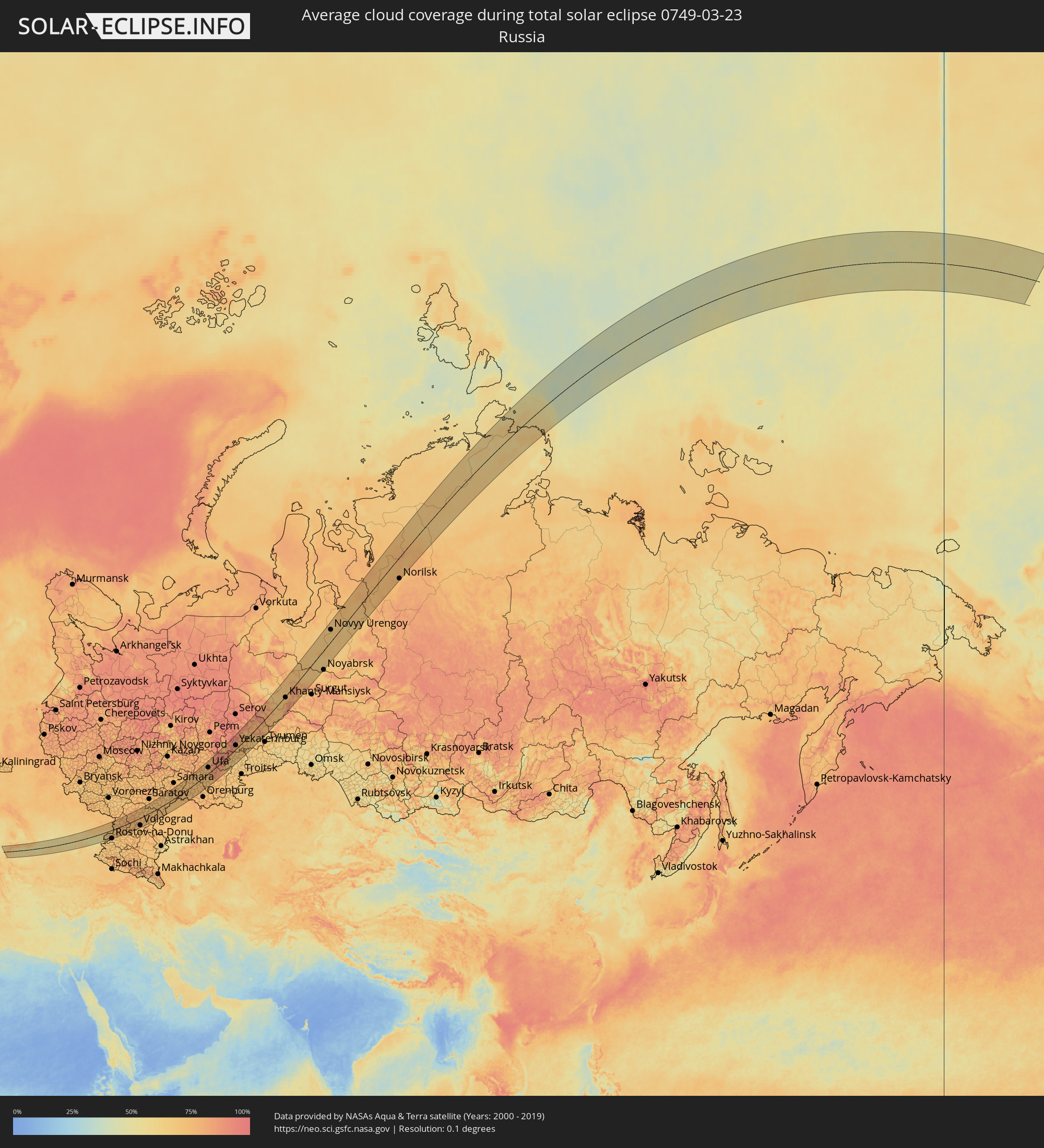 Russland
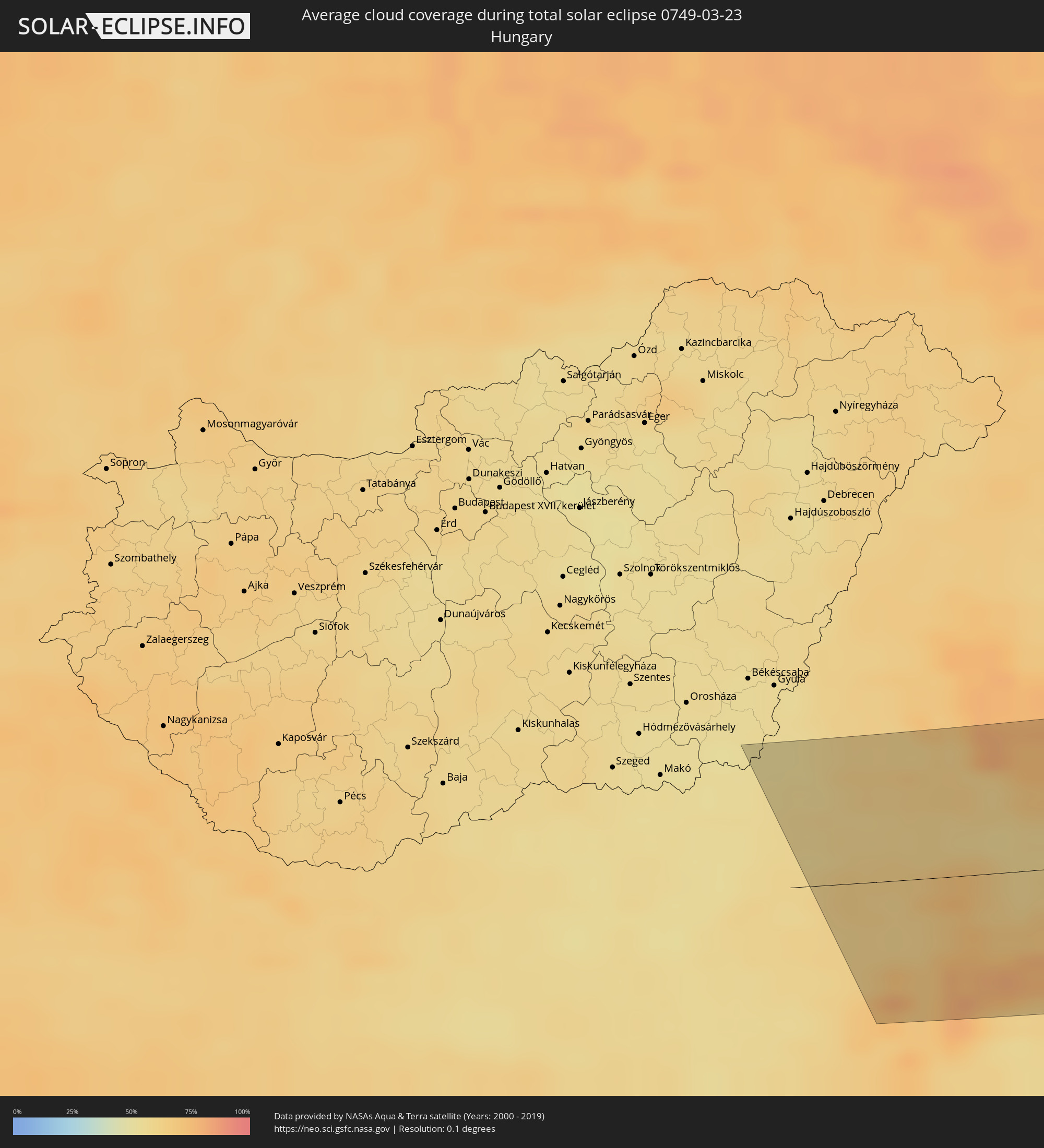 Ungarn
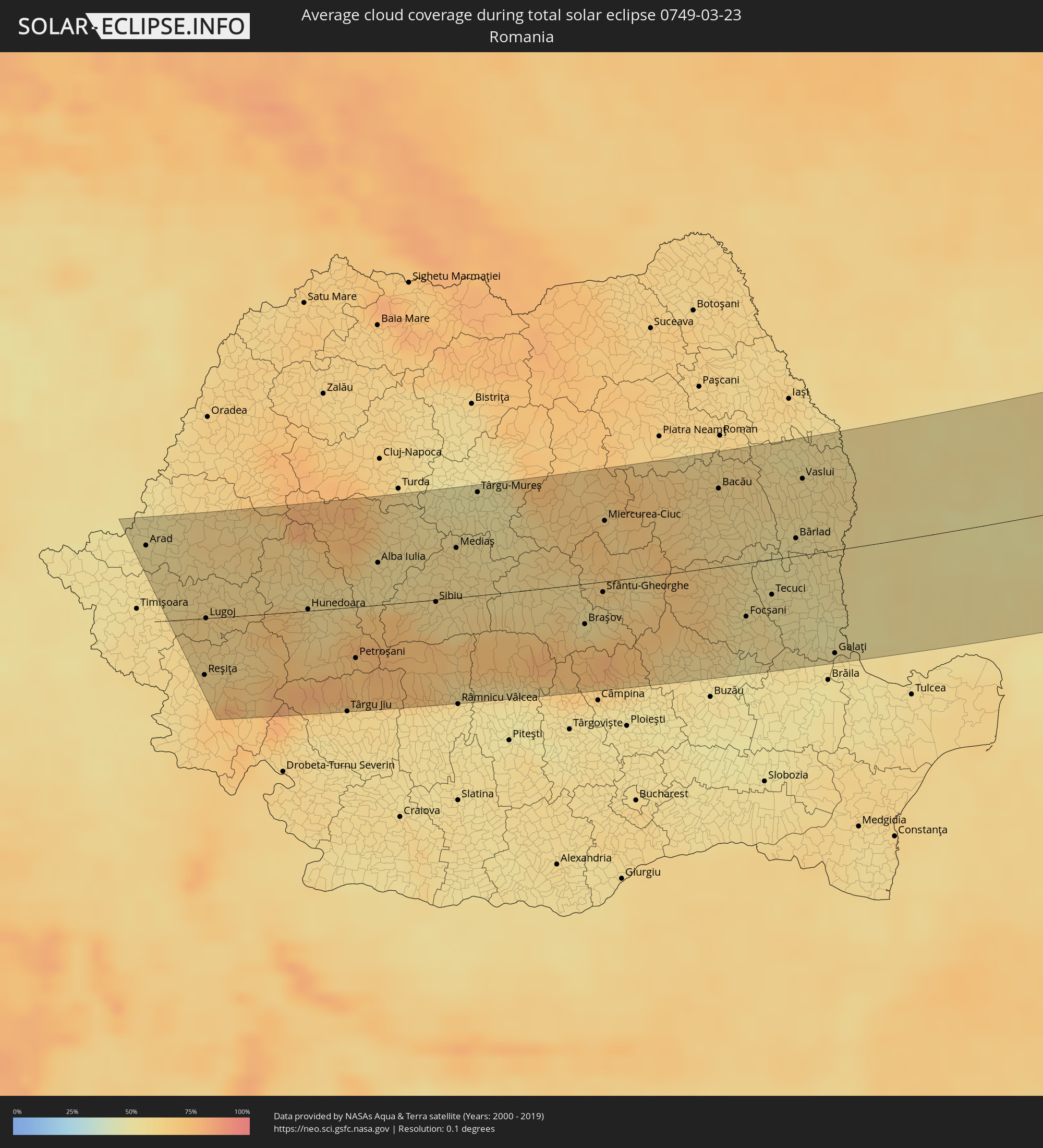 Rumänien
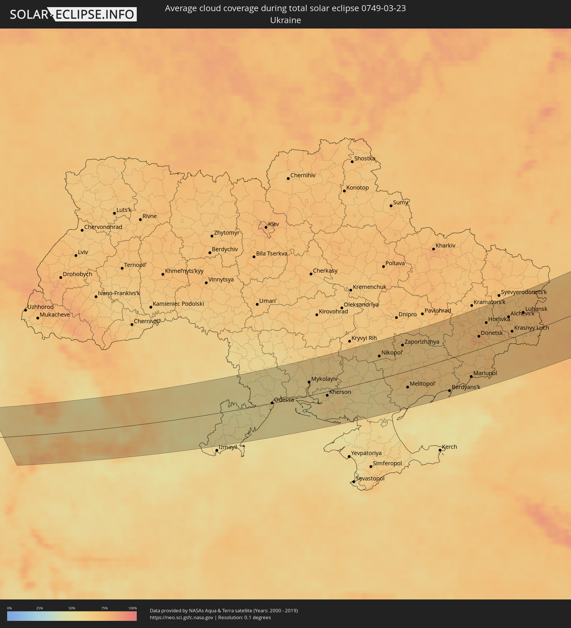 Ukraine
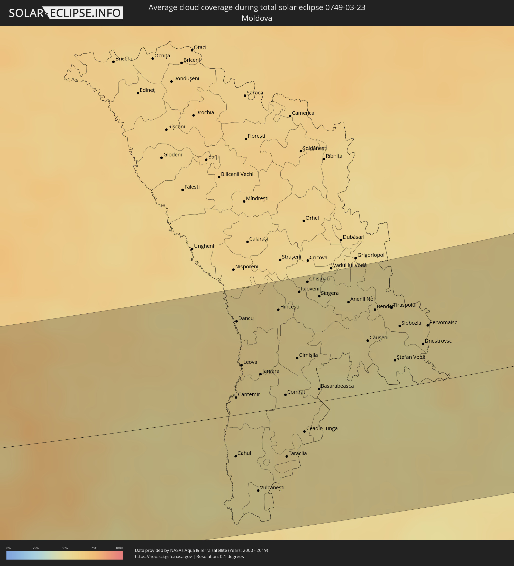 Moldawien
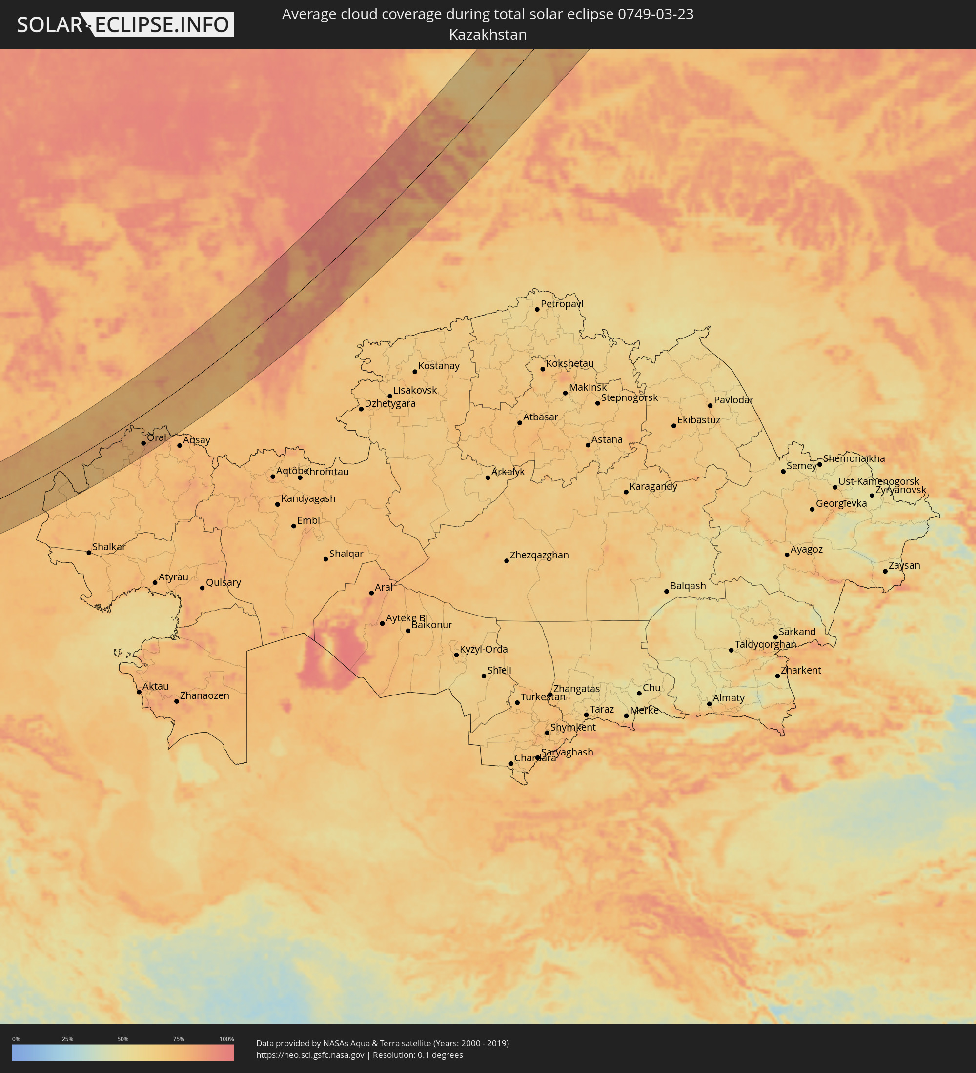 Kasachstan
Orte im Finsternispfad
Die nachfolgene Tabelle zeigt Städte und Orte mit mehr als 5.000 Einwohnern, die sich im Finsternispfad befinden. Städte mit mehr als 100.000 Einwohnern sind dick gekennzeichnet. Mit einem Klick auf den Ort öffnet sich eine Detailkarte die die Lage des jeweiligen Ortes zusammen mit dem Verlauf der zentralen Finsternis präsentiert.
| Ort | Typ | Dauer der Verfinsterung | Ortszeit bei maximaler Verfinsterung | Entfernung zur Zentrallinie | Ø Bewölkung |
|
Arad, Arad
|
total | - | 06:15:48 UTC+01:44 | 58 km | 55% |
|
Reşiţa, Caraş-Severin
|
total | - | 06:14:19 UTC+01:44 | 45 km | 63% |
|
Lugoj, Timiş
|
total | - | 06:14:57 UTC+01:44 | 8 km | 63% |
|
Caransebeş, Caraş-Severin
|
total | - | 06:14:29 UTC+01:44 | 35 km | 64% |
|
Brad, Hunedoara
|
total | - | 06:15:39 UTC+01:44 | 46 km | 61% |
|
Hunedoara, Hunedoara
|
total | - | 06:15:00 UTC+01:44 | 8 km | 60% |
|
Târgu Jiu, Gorj
|
total | - | 06:13:51 UTC+01:44 | 80 km | 59% |
|
Petroşani, Hunedoara
|
total | - | 06:14:27 UTC+01:44 | 41 km | 74% |
|
Cugir, Alba
|
total | - | 06:15:08 UTC+01:44 | 12 km | 69% |
|
Alba Iulia, Alba
|
total | - | 06:15:31 UTC+01:44 | 33 km | 57% |
|
Aiud, Alba
|
total | - | 06:15:55 UTC+01:44 | 60 km | 58% |
|
Blaj, Alba
|
total | - | 06:15:41 UTC+01:44 | 42 km | 56% |
|
Luduş, Mureş
|
total | - | 06:16:12 UTC+01:44 | 76 km | 54% |
|
Sibiu, Sibiu
|
total | - | 06:15:04 UTC+01:44 | 12 km | 60% |
|
Târnăveni, Mureş
|
total | - | 06:15:57 UTC+01:44 | 57 km | 58% |
|
Mediaş, Sibiu
|
total | - | 06:15:40 UTC+01:44 | 38 km | 57% |
|
Avrig, Sibiu
|
total | - | 06:14:55 UTC+01:44 | 16 km | 65% |
|
Târgu-Mureş, Mureş
|
total | - | 06:16:18 UTC+01:44 | 78 km | 52% |
|
Curtea de Argeş, Argeş
|
total | - | 06:13:57 UTC+01:44 | 80 km | 51% |
|
Sighișoara, Mureş
|
total | - | 06:15:46 UTC+01:44 | 42 km | 56% |
|
Făgăraș, Braşov
|
total | - | 06:15:09 UTC+01:44 | 4 km | 59% |
|
Odorheiu Secuiesc, Harghita
|
total | - | 06:15:54 UTC+01:44 | 46 km | 65% |
|
Zărnești, Braşov
|
total | - | 06:14:40 UTC+01:44 | 42 km | 73% |
|
Braşov, Braşov
|
total | - | 06:14:49 UTC+01:44 | 31 km | 71% |
|
Comarnic, Prahova
|
total | - | 06:14:09 UTC+01:44 | 75 km | 66% |
|
Sfântu-Gheorghe, Covasna
|
total | - | 06:15:11 UTC+01:44 | 19 km | 56% |
|
Miercurea-Ciuc, Harghita
|
total | - | 06:16:00 UTC+01:44 | 47 km | 64% |
|
Târgu Secuiesc, Covasna
|
total | - | 06:15:25 UTC+01:44 | 11 km | 58% |
|
Moineşti, Bacău
|
total | - | 06:16:15 UTC+01:44 | 53 km | 63% |
|
Târgu Ocna, Bacău
|
total | - | 06:15:55 UTC+01:44 | 32 km | 62% |
|
Buhuşi, Bacău
|
total | - | 06:16:40 UTC+01:44 | 78 km | 62% |
|
Bacău, Bacău
|
total | - | 06:16:25 UTC+01:44 | 58 km | 59% |
|
Râmnicu Sărat, Buzău
|
total | - | 06:14:25 UTC+01:44 | 74 km | 51% |
|
Adjud, Vrancea
|
total | - | 06:15:38 UTC+01:44 | 14 km | 55% |
|
Focșani, Vrancea
|
total | - | 06:14:58 UTC+01:44 | 41 km | 57% |
|
Tecuci, Galaţi
|
total | - | 06:15:14 UTC+01:44 | 28 km | 54% |
|
Bârlad, Vaslui
|
total | - | 06:15:54 UTC+01:44 | 20 km | 54% |
|
Vaslui, Vaslui
|
total | - | 06:16:35 UTC+01:44 | 58 km | 57% |
|
Galaţi, Galaţi
|
total | - | 06:14:36 UTC+01:44 | 78 km | 56% |
|
Huşi, Vaslui
|
total | - | 06:16:41 UTC+01:44 | 59 km | 58% |
|
Cahul, Cahul
|
total | - | 06:25:59 UTC+01:55 | 31 km | 54% |
|
Cantemir, Cantemir
|
total | - | 06:26:37 UTC+01:55 | 21 km | 56% |
|
Dancu, Hînceşti
|
total | - | 06:27:27 UTC+01:55 | 66 km | 55% |
|
Leova, Leova
|
total | - | 06:26:58 UTC+01:55 | 37 km | 55% |
|
Vulcăneşti, Găgăuzia
|
total | - | 06:25:37 UTC+01:55 | 58 km | 51% |
|
Iargara, Cantemir
|
total | - | 06:26:53 UTC+01:55 | 26 km | 53% |
|
Hînceşti, Hînceşti
|
total | - | 06:27:36 UTC+01:55 | 70 km | 56% |
|
Comrat, Găgăuzia
|
total | - | 06:26:41 UTC+01:55 | 16 km | 54% |
|
Taraclia, Taraclia
|
total | - | 06:26:01 UTC+01:55 | 36 km | 55% |
|
Cimişlia, Cimişlia
|
total | - | 06:27:06 UTC+01:55 | 35 km | 51% |
|
Ialoveni, Laloveni
|
total | - | 06:27:49 UTC+01:55 | 78 km | 54% |
|
Ceadîr-Lunga, Găgăuzia
|
total | - | 06:26:18 UTC+01:55 | 25 km | 54% |
|
Chisinau, Chişinău
|
total | - | 06:27:56 UTC+01:55 | 84 km | 53% |
|
Basarabeasca, Basarabeasca
|
total | - | 06:26:47 UTC+01:55 | 9 km | 53% |
|
Sîngera, Chişinău
|
total | - | 06:27:47 UTC+01:55 | 73 km | 54% |
|
Anenii Noi, Anenii Noi
|
total | - | 06:27:45 UTC+01:55 | 66 km | 55% |
|
Căuşeni, Căuşeni
|
total | - | 06:27:21 UTC+01:55 | 36 km | 54% |
|
Bender, Bender
|
total | - | 06:27:42 UTC+01:55 | 57 km | 54% |
|
Chiţcani, Căuşeni
|
total | - | 06:27:38 UTC+01:55 | 53 km | 52% |
|
Tiraspolul, Stînga Nistrului
|
total | - | 06:27:44 UTC+01:55 | 59 km | 52% |
|
Ştefan Vodă, Ştefan-Vodă
|
total | - | 06:27:10 UTC+01:55 | 25 km | 50% |
|
Slobozia, Stînga Nistrului
|
total | - | 06:27:33 UTC+01:55 | 45 km | 52% |
|
Dnestrovsc, Teleneşti
|
total | - | 06:27:23 UTC+01:55 | 27 km | 53% |
|
Pervomaisc, Stînga Nistrului
|
total | - | 06:27:35 UTC+01:55 | 39 km | 54% |
|
Bilhorod-Dnistrovs’kyy, Odessa
|
total | - | 06:33:46 UTC+02:02 | 30 km | 54% |
|
Illichivs’k, Odessa
|
total | - | 06:34:00 UTC+02:02 | 20 km | 53% |
|
Odessa, Odessa
|
total | - | 06:34:19 UTC+02:02 | 18 km | 59% |
|
Yuzhne, Odessa
|
total | - | 06:34:37 UTC+02:02 | 15 km | 56% |
|
Mykolayiv, Mykolaiv
|
total | - | 06:35:22 UTC+02:02 | 34 km | 60% |
|
Kherson, Kherson
|
total | - | 06:34:56 UTC+02:02 | 12 km | 60% |
|
Nova Kakhovka, Kherson
|
total | - | 06:35:15 UTC+02:02 | 19 km | 59% |
|
Armyansk, Republic of Crimea
|
total | - | 06:48:07 UTC+02:16 | 89 km | 57% |
|
Nikopol’, Dnipropetrovsk
|
total | - | 06:36:56 UTC+02:02 | 56 km | 64% |
|
Marhanets’, Dnipropetrovsk
|
total | - | 06:37:06 UTC+02:02 | 60 km | 64% |
|
Energodar, Zaporizhia
|
total | - | 06:36:52 UTC+02:02 | 46 km | 63% |
|
Zaporizhzhya, Zaporizhia
|
total | - | 06:37:34 UTC+02:02 | 67 km | 68% |
|
Melitopol’, Zaporizhia
|
total | - | 06:35:53 UTC+02:02 | 44 km | 62% |
|
Tokmak, Zaporizhia
|
total | - | 06:36:41 UTC+02:02 | 16 km | 66% |
|
Polohy, Zaporizhia
|
total | - | 06:37:15 UTC+02:02 | 8 km | 68% |
|
Berdyans’k, Zaporizhia
|
total | - | 06:36:07 UTC+02:02 | 80 km | 64% |
|
Dobropillya, Donetsk
|
total | - | 06:39:15 UTC+02:02 | 94 km | 74% |
|
Krasnoarmiys’k, Donetsk
|
total | - | 06:38:57 UTC+02:02 | 73 km | 74% |
|
Selydove, Donetsk
|
total | - | 06:38:45 UTC+02:02 | 55 km | 72% |
|
Volnovakha, Donetsk
|
total | - | 06:37:49 UTC+02:02 | 7 km | 67% |
|
Mariupol, Donetsk
|
total | - | 06:36:55 UTC+02:02 | 62 km | 67% |
|
Dokuchayevs’k, Donetsk
|
total | - | 06:38:09 UTC+02:02 | 5 km | 70% |
|
Kostyantynivka, Donetsk
|
total | - | 06:39:34 UTC+02:02 | 86 km | 73% |
|
Donetsk, Donetsk
|
total | - | 06:38:41 UTC+02:02 | 31 km | 77% |
|
Dzerzhyns’k, Donetsk
|
total | - | 06:39:22 UTC+02:02 | 69 km | 72% |
|
Artemivs’k, Donetsk
|
total | - | 06:39:47 UTC+02:02 | 86 km | 70% |
|
Horlivka, Donetsk
|
total | - | 06:39:20 UTC+02:02 | 57 km | 72% |
|
Khartsyz’k, Donetsk
|
total | - | 06:38:49 UTC+02:02 | 24 km | 72% |
|
Yenakiyeve, Donetsk
|
total | - | 06:39:11 UTC+02:02 | 43 km | 70% |
|
Popasna, Luhansk
|
total | - | 06:39:58 UTC+02:02 | 81 km | 68% |
|
Debal’tseve, Donetsk
|
total | - | 06:39:27 UTC+02:02 | 49 km | 73% |
|
Shakhtars’k, Donetsk
|
total | - | 06:38:57 UTC+02:02 | 19 km | 72% |
|
Stakhanov, Luhansk
|
total | - | 06:39:57 UTC+02:02 | 67 km | 72% |
|
Snizhne, Donetsk
|
total | - | 06:39:00 UTC+02:02 | 7 km | 69% |
|
Alchevs’k, Luhansk
|
total | - | 06:39:49 UTC+02:02 | 53 km | 74% |
|
Taganrog, Rostov Oblast
|
total | - | 07:05:50 UTC+02:30 | 79 km | 64% |
|
Krasnyy Luch, Luhansk
|
total | - | 06:39:16 UTC+02:02 | 15 km | 71% |
|
Luhansk, Luhansk
|
total | - | 06:40:11 UTC+02:02 | 50 km | 75% |
|
Roven’ky, Luhansk
|
total | - | 06:39:19 UTC+02:02 | 2 km | 72% |
|
Sverdlovs’k, Luhansk
|
total | - | 06:39:26 UTC+02:02 | 8 km | 73% |
|
Krasnodon, Luhansk
|
total | - | 06:39:50 UTC+02:02 | 11 km | 71% |
|
Novoshakhtinsk, Rostov Oblast
|
total | - | 07:07:09 UTC+02:30 | 50 km | 74% |
|
Gukovo, Rostov Oblast
|
total | - | 07:07:42 UTC+02:30 | 19 km | 73% |
|
Donetsk, Rostov Oblast
|
total | - | 07:08:12 UTC+02:30 | 10 km | 73% |
|
Krasnyy Sulin, Rostov Oblast
|
total | - | 07:07:26 UTC+02:30 | 40 km | 74% |
|
Novocherkassk, Rostov Oblast
|
total | - | 07:06:35 UTC+02:30 | 90 km | 72% |
|
Shakhty, Rostov Oblast
|
total | - | 07:07:10 UTC+02:30 | 63 km | 76% |
|
Kamensk-Shakhtinskiy, Rostov Oblast
|
total | - | 07:08:17 UTC+02:30 | 1 km | 75% |
|
Belaya Kalitva, Rostov Oblast
|
total | - | 07:08:15 UTC+02:30 | 28 km | 76% |
|
Mikhaylovka, Volgograd
|
total | - | 07:12:44 UTC+02:30 | 92 km | 73% |
|
Frolovo, Volgograd
|
total | - | 07:12:24 UTC+02:30 | 50 km | 76% |
|
Volgograd, Volgograd
|
total | - | 07:10:51 UTC+02:30 | 82 km | 74% |
|
Volzhskiy, Volgograd
|
total | - | 07:11:07 UTC+02:30 | 84 km | 73% |
|
Kamyshin, Volgograd
|
total | - | 07:13:51 UTC+02:30 | 26 km | 76% |
|
Zhänibek, Batys Qazaqstan
|
total | - | 08:08:28 UTC+03:25 | 90 km | 74% |
|
Pugachev, Saratov
|
total | - | 08:09:18 UTC+03:20 | 92 km | 74% |
|
Kamenka, Batys Qazaqstan
|
total | - | 08:13:36 UTC+03:25 | 49 km | 74% |
|
Oral, Batys Qazaqstan
|
total | - | 08:14:31 UTC+03:25 | 78 km | 81% |
|
Fedorovka, Batys Qazaqstan
|
total | - | 08:14:53 UTC+03:25 | 101 km | 74% |
|
Buzuluk, Orenburg
|
total | - | 08:55:05 UTC+04:02 | 30 km | 81% |
|
Buguruslan, Orenburg
|
total | - | 08:56:48 UTC+04:02 | 101 km | 80% |
|
Belebey, Bashkortostan
|
total | - | 08:58:46 UTC+04:02 | 75 km | 80% |
|
Salavat, Bashkortostan
|
total | - | 08:58:44 UTC+04:02 | 66 km | 75% |
|
Meleuz, Bashkortostan
|
total | - | 08:58:00 UTC+04:02 | 102 km | 74% |
|
Sterlitamak, Bashkortostan
|
total | - | 08:59:12 UTC+04:02 | 45 km | 75% |
|
Ufa, Bashkortostan
|
total | - | 09:01:13 UTC+04:02 | 51 km | 81% |
|
Satka, Chelyabinsk
|
total | - | 09:04:04 UTC+04:02 | 53 km | 91% |
|
Zlatoust, Chelyabinsk
|
total | - | 09:04:47 UTC+04:02 | 68 km | 87% |
|
Pervoural’sk, Sverdlovsk
|
total | - | 09:07:59 UTC+04:02 | 62 km | 89% |
|
Novoural’sk, Sverdlovsk
|
total | - | 09:08:40 UTC+04:02 | 81 km | 90% |
|
Miass, Chelyabinsk
|
total | - | 09:04:56 UTC+04:02 | 98 km | 83% |
|
Polevskoy, Sverdlovsk
|
total | - | 09:07:23 UTC+04:02 | 19 km | 92% |
|
Yekaterinburg, Sverdlovsk
|
total | - | 09:08:25 UTC+04:02 | 28 km | 92% |
|
Ozersk, Chelyabinsk
|
total | - | 09:06:38 UTC+04:02 | 64 km | 83% |
|
Snezhinsk, Chelyabinsk
|
total | - | 09:07:13 UTC+04:02 | 42 km | 88% |
|
Asbest, Sverdlovsk
|
total | - | 09:09:21 UTC+04:02 | 5 km | 89% |
|
Alapayevsk, Sverdlovsk
|
total | - | 09:10:57 UTC+04:02 | 61 km | 87% |
|
Kamensk-Ural’skiy, Sverdlovsk
|
total | - | 09:08:45 UTC+04:02 | 66 km | 76% |
|
Lesnoy, Sverdlovsk
|
total | - | 09:11:41 UTC+04:02 | 19 km | 75% |
|
Uray, Khanty-Mansiyskiy Avtonomnyy Okrug
|
total | - | 09:17:04 UTC+04:02 | 102 km | 75% |
|
Khanty-Mansiysk, Khanty-Mansiyskiy Avtonomnyy Okrug
|
total | - | 09:21:49 UTC+04:02 | 13 km | 70% |
|
Novyy Urengoy, Yamalo-Nenetskiy Avtonomnyy Okrug
|
total | - | 09:34:21 UTC+04:02 | 58 km | 74% |
|
Norilsk, Krasnoyarskiy
|
total | - | 11:54:33 UTC+06:11 | 89 km | 80% |
|
Talnakh, Krasnoyarskiy
|
total | - | 11:54:45 UTC+06:11 | 86 km | 79% |