Totale Sonnenfinsternis vom 28.11.0764
| Wochentag: | Samstag |
| Maximale Dauer der Verfinsterung: | 03m32s |
| Maximale Breite des Finsternispfades: | 142 km |
| Saroszyklus: | 93 |
| Bedeckungsgrad: | 100% |
| Magnitude: | 1.0412 |
| Gamma: | -0.227 |
Wo kann man die Sonnenfinsternis vom 28.11.0764 sehen?
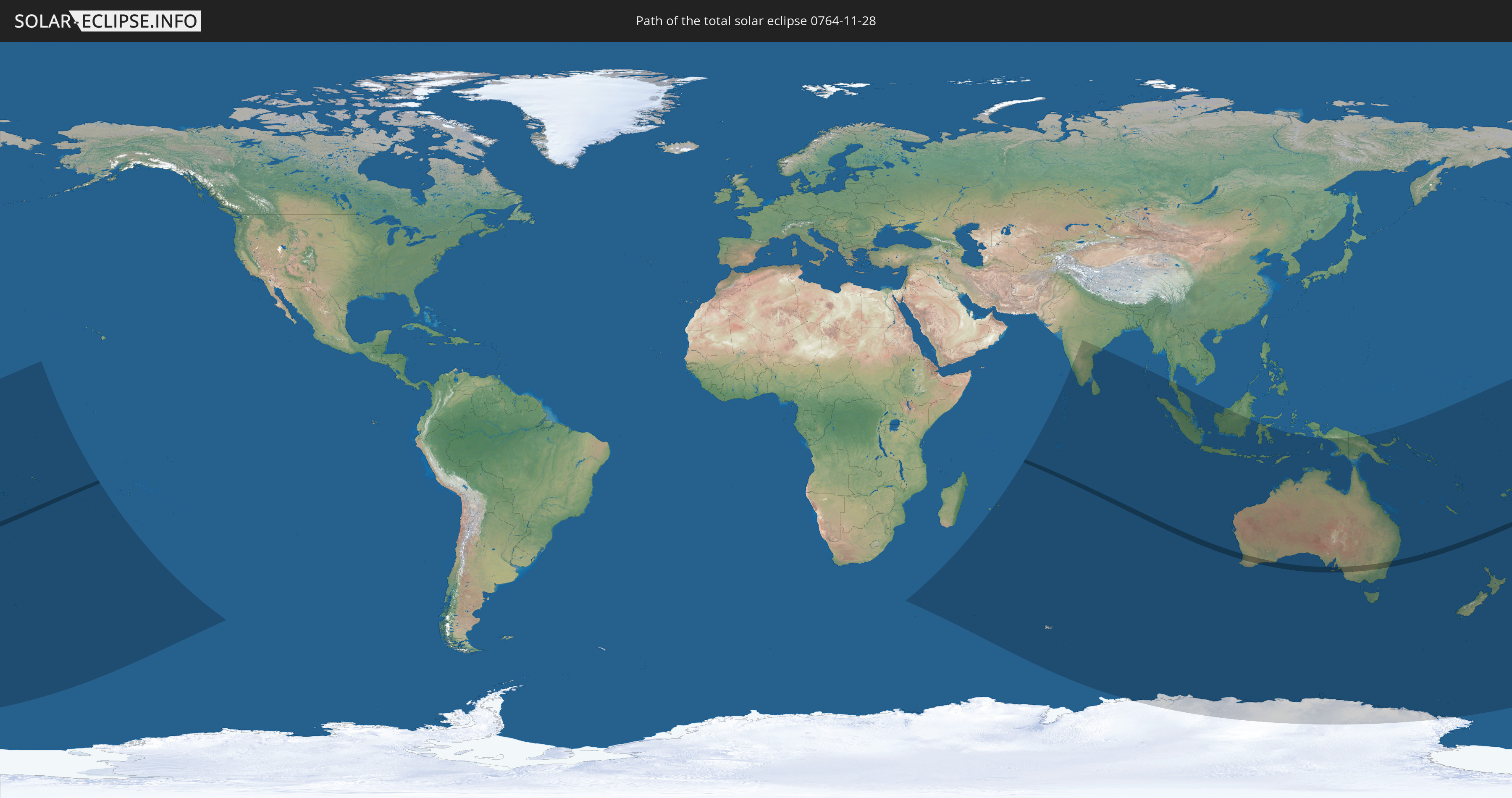
Die Sonnenfinsternis am 28.11.0764 kann man in 37 Ländern als partielle Sonnenfinsternis beobachten.
Der Finsternispfad verläuft durch 2 Länder. Nur in diesen Ländern ist sie als totale Sonnenfinsternis zu sehen.
In den folgenden Ländern ist die Sonnenfinsternis total zu sehen
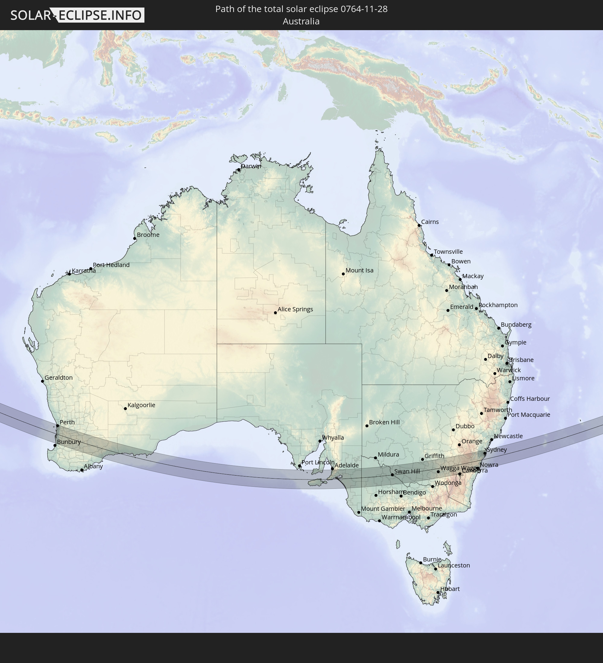 Australien
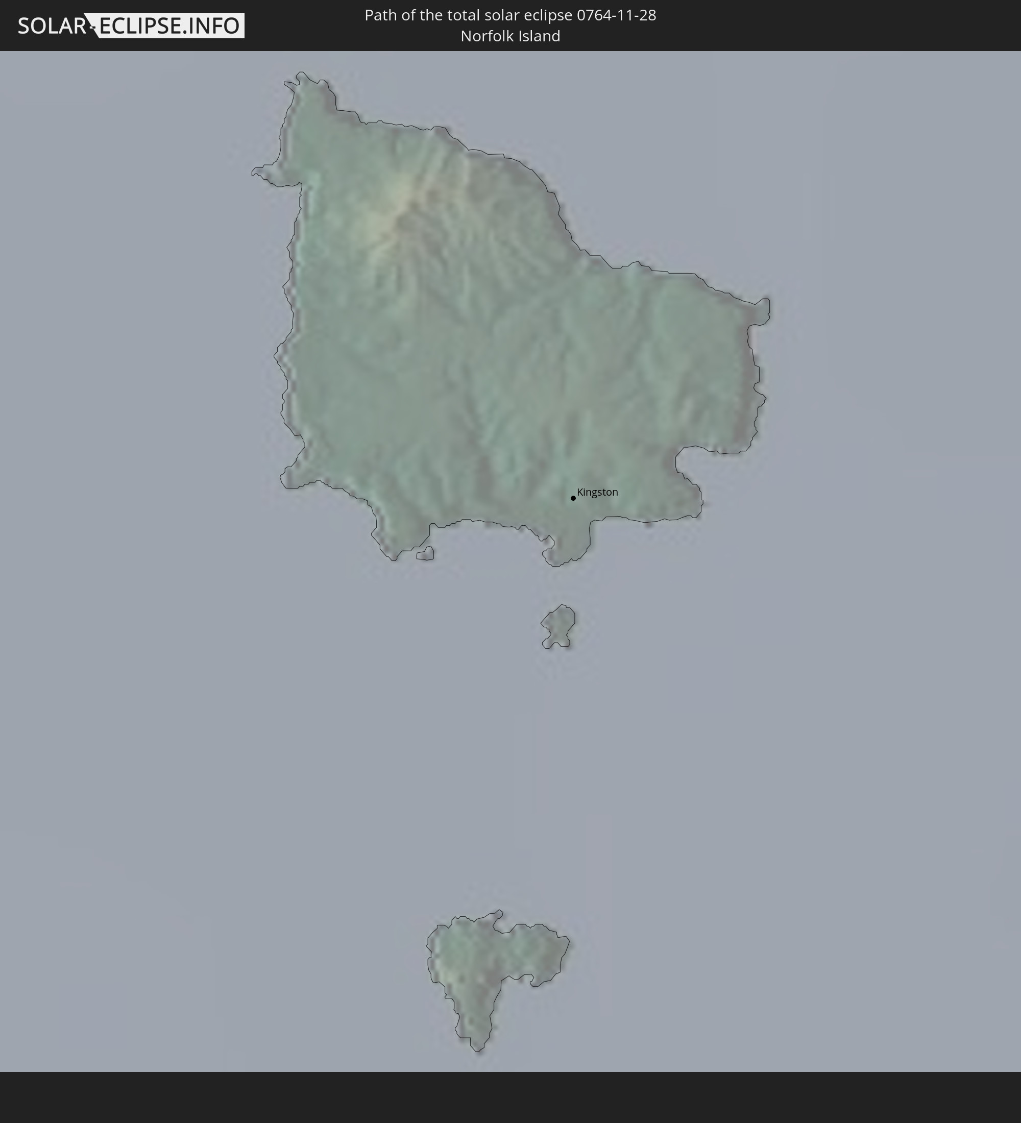 Norfolkinsel
In den folgenden Ländern ist die Sonnenfinsternis partiell zu sehen
 Antarktika
 Fidschi
 Neuseeland
 United States Minor Outlying Islands
 Wallis und Futuna
 Tonga
Tonga
 Kiribati
 Samoa
Samoa
 Tokelau
 Amerikanisch-Samoa
 Niue
Niue
 Cookinseln
 Französisch-Polynesien
 Französische Süd- und Antarktisgebiete
 Mauritius
 Indien
 Britisches Territorium im Indischen Ozean
 Heard und McDonaldinseln
 Malediven
 Sri Lanka
 Myanmar
 Indonesien
 Kokosinseln
 Thailand
 Malaysia
 Singapur
 Weihnachtsinsel
 Australien
 Osttimor
 Papua-Neuguinea
 Salomonen
 Neukaledonien
 Marshallinseln
 Vanuatu
 Nauru
Nauru
 Norfolkinsel
 Tuvalu
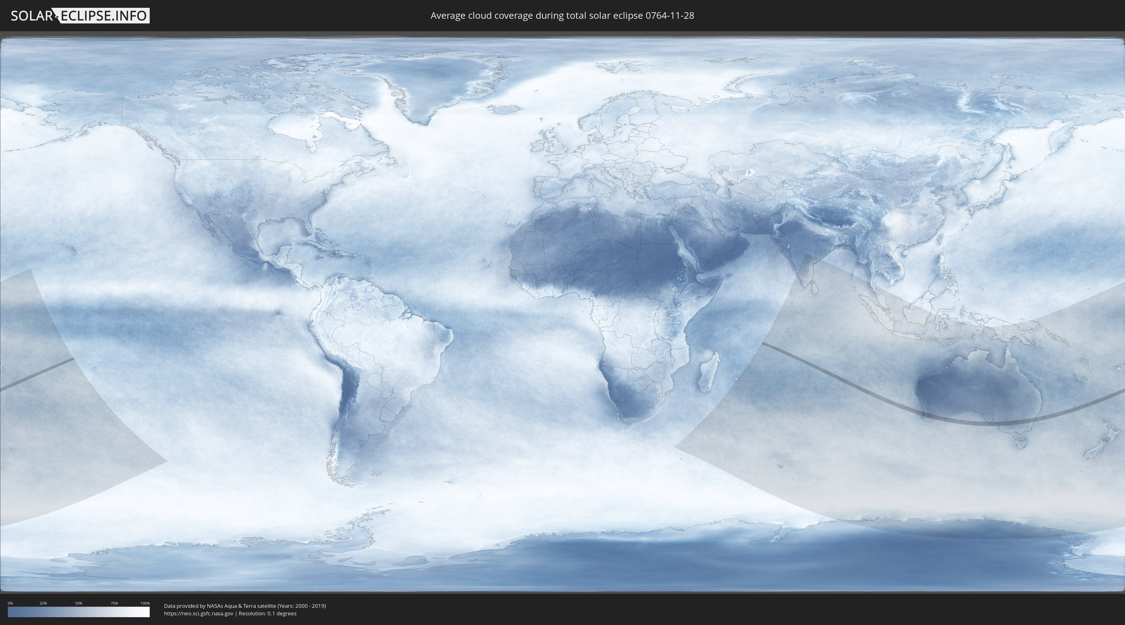
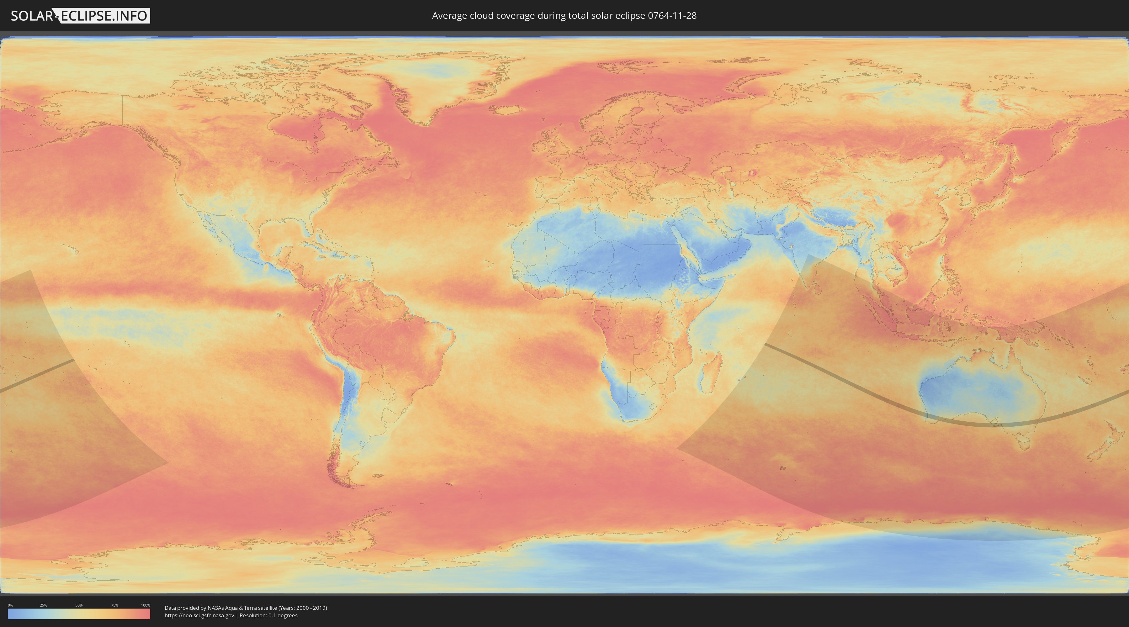
Wie wird das Wetter während der totalen Sonnenfinsternis am 28.11.0764?
Wo ist der beste Ort, um die totale Sonnenfinsternis vom 28.11.0764 zu beobachten?
Die folgenden Karten zeigen die durchschnittliche Bewölkung für den Tag, an dem die totale Sonnenfinsternis
stattfindet. Mit Hilfe der Karten lässt sich der Ort entlang des Finsternispfades eingrenzen,
der die besten Aussichen auf einen klaren wolkenfreien Himmel bietet.
Trotzdem muss man immer lokale Gegenenheiten beachten und sollte sich genau über das Wetter an seinem
gewählten Beobachtungsort informieren.
Die Daten stammen von den beiden NASA-Satelliten
AQUA und TERRA
und wurden über einen Zeitraum von 19 Jahren (2000 - 2019) gemittelt.
Detaillierte Länderkarten
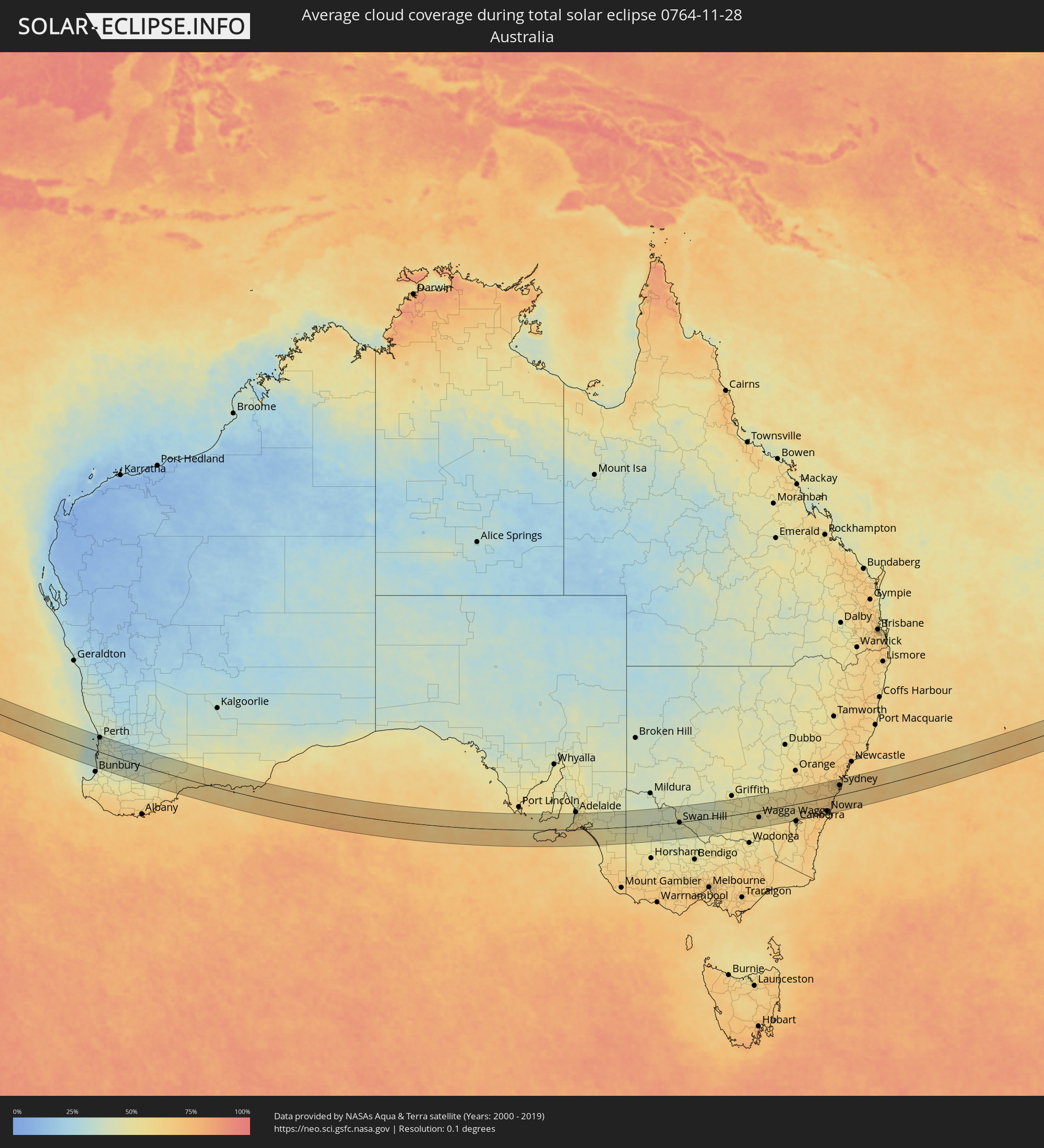 Australien
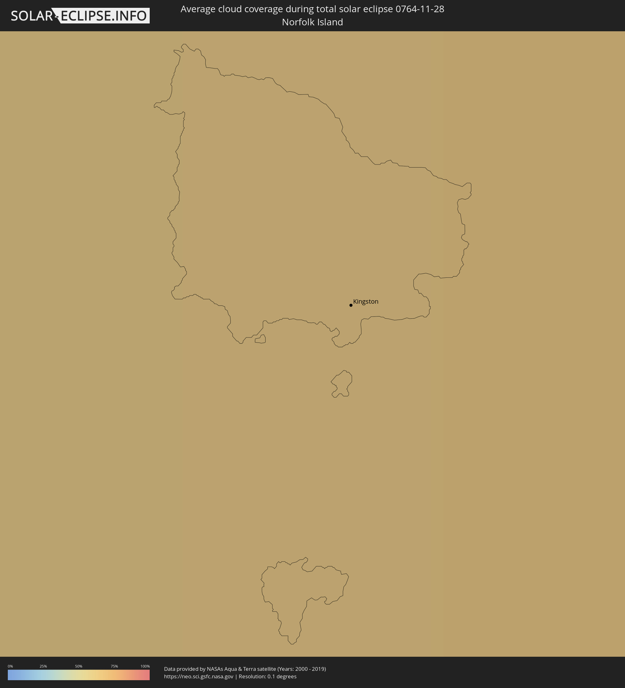 Norfolkinsel
Orte im Finsternispfad
Die nachfolgene Tabelle zeigt Städte und Orte mit mehr als 5.000 Einwohnern, die sich im Finsternispfad befinden. Städte mit mehr als 100.000 Einwohnern sind dick gekennzeichnet. Mit einem Klick auf den Ort öffnet sich eine Detailkarte die die Lage des jeweiligen Ortes zusammen mit dem Verlauf der zentralen Finsternis präsentiert.
| Ort | Typ | Dauer der Verfinsterung | Ortszeit bei maximaler Verfinsterung | Entfernung zur Zentrallinie | Ø Bewölkung |
|
Mandurah, Western Australia
|
total | - | 10:23:49 UTC+08:00 | 3 km | 40% |
|
Rockingham, Western Australia
|
total | - | 10:23:34 UTC+08:00 | 23 km | 40% |
|
Safety Bay, Western Australia
|
total | - | 10:23:37 UTC+08:00 | 21 km | 40% |
|
City Beach, Western Australia
|
total | - | 10:23:16 UTC+08:00 | 60 km | 35% |
|
Cottesloe, Western Australia
|
total | - | 10:23:20 UTC+08:00 | 53 km | 37% |
|
East Fremantle, Western Australia
|
total | - | 10:23:23 UTC+08:00 | 49 km | 37% |
|
Wembley Downs, Western Australia
|
total | - | 10:23:16 UTC+08:00 | 63 km | 35% |
|
Spearwood, Western Australia
|
total | - | 10:23:29 UTC+08:00 | 43 km | 37% |
|
Claremont, Western Australia
|
total | - | 10:23:21 UTC+08:00 | 56 km | 37% |
|
Bicton, Western Australia
|
total | - | 10:23:24 UTC+08:00 | 51 km | 37% |
|
Palmyra, Western Australia
|
total | - | 10:23:26 UTC+08:00 | 49 km | 37% |
|
Attadale, Western Australia
|
total | - | 10:23:26 UTC+08:00 | 52 km | 37% |
|
Beeliar, Western Australia
|
total | - | 10:23:34 UTC+08:00 | 41 km | 37% |
|
Yangebup, Western Australia
|
total | - | 10:23:34 UTC+08:00 | 42 km | 37% |
|
Bibra Lake, Western Australia
|
total | - | 10:23:33 UTC+08:00 | 45 km | 37% |
|
Parmelia, Western Australia
|
total | - | 10:23:44 UTC+08:00 | 28 km | 39% |
|
Winthrop, Western Australia
|
total | - | 10:23:31 UTC+08:00 | 50 km | 37% |
|
Applecross, Western Australia
|
total | - | 10:23:29 UTC+08:00 | 54 km | 37% |
|
Tuart Hill, Western Australia
|
total | - | 10:23:22 UTC+08:00 | 66 km | 35% |
|
South Lake, Western Australia
|
total | - | 10:23:36 UTC+08:00 | 44 km | 37% |
|
Mount Pleasant, Western Australia
|
total | - | 10:23:33 UTC+08:00 | 52 km | 37% |
|
Perth, Western Australia
|
total | - | 10:23:29 UTC+08:00 | 61 km | 39% |
|
East Perth, Western Australia
|
total | - | 10:23:30 UTC+08:00 | 61 km | 39% |
|
Victoria Park, Western Australia
|
total | - | 10:23:35 UTC+08:00 | 60 km | 39% |
|
Rivervale, Western Australia
|
total | - | 10:23:35 UTC+08:00 | 63 km | 39% |
|
Belmont, Western Australia
|
total | - | 10:23:36 UTC+08:00 | 64 km | 38% |
|
Seville Grove, Western Australia
|
total | - | 10:23:56 UTC+08:00 | 46 km | 41% |
|
Armadale, Western Australia
|
total | - | 10:23:59 UTC+08:00 | 46 km | 41% |
|
Esperance, Western Australia
|
total | - | 10:37:53 UTC+08:00 | 21 km | 64% |
|
Aldinga, South Australia
|
total | - | 12:46:49 UTC+09:30 | 35 km | 56% |
|
Morphett Vale, South Australia
|
total | - | 12:46:55 UTC+09:30 | 52 km | 49% |
|
Victor Harbor, South Australia
|
total | - | 12:47:05 UTC+09:30 | 5 km | 63% |
|
Mount Barker, South Australia
|
total | - | 12:47:44 UTC+09:30 | 58 km | 56% |
|
Murray Bridge, South Australia
|
total | - | 12:48:39 UTC+09:30 | 51 km | 48% |
|
Swan Hill, Victoria
|
total | - | 13:28:10 UTC+10:00 | 3 km | 46% |
|
Deniliquin, New South Wales
|
total | - | 13:31:04 UTC+10:00 | 40 km | 42% |
|
Leeton, New South Wales
|
total | - | 13:34:42 UTC+10:00 | 50 km | 51% |
|
Wagga Wagga, New South Wales
|
total | - | 13:36:19 UTC+10:00 | 28 km | 52% |
|
Lake Albert, New South Wales
|
total | - | 13:36:21 UTC+10:00 | 33 km | 52% |
|
Tumut, New South Wales
|
total | - | 13:37:58 UTC+10:00 | 61 km | 56% |
|
Young, New South Wales
|
total | - | 13:38:49 UTC+10:00 | 46 km | 55% |
|
Kaleen, Australian Capital Territory
|
total | - | 13:39:46 UTC+10:00 | 67 km | 56% |
|
Goulburn, New South Wales
|
total | - | 13:41:20 UTC+10:00 | 27 km | 62% |
|
Moss Vale, New South Wales
|
total | - | 13:42:46 UTC+10:00 | 17 km | 68% |
|
Bowral, New South Wales
|
total | - | 13:42:55 UTC+10:00 | 10 km | 67% |
|
Mittagong, New South Wales
|
total | - | 13:42:59 UTC+10:00 | 8 km | 67% |
|
Blaxland, New South Wales
|
total | - | 13:43:51 UTC+10:00 | 65 km | 65% |
|
Nowra, New South Wales
|
total | - | 13:42:57 UTC+10:00 | 58 km | 65% |
|
Bomaderry, New South Wales
|
total | - | 13:43:00 UTC+10:00 | 54 km | 66% |
|
Glenmore Park, New South Wales
|
total | - | 13:43:57 UTC+10:00 | 60 km | 66% |
|
Cambridge Park, New South Wales
|
total | - | 13:44:05 UTC+10:00 | 63 km | 66% |
|
Narellan, New South Wales
|
total | - | 13:43:53 UTC+10:00 | 32 km | 67% |
|
Narellan Vale, New South Wales
|
total | - | 13:43:53 UTC+10:00 | 30 km | 67% |
|
Albion Park Rail, New South Wales
|
total | - | 13:43:35 UTC+10:00 | 27 km | 67% |
|
Berkeley, New South Wales
|
total | - | 13:43:45 UTC+10:00 | 19 km | 66% |
|
Kiama, New South Wales
|
total | - | 13:43:36 UTC+10:00 | 39 km | 63% |
|
Barrack Heights, New South Wales
|
total | - | 13:43:41 UTC+10:00 | 28 km | 64% |
|
Ingleburn, New South Wales
|
total | - | 13:44:10 UTC+10:00 | 33 km | 62% |
|
Riverstone, New South Wales
|
total | - | 13:44:25 UTC+10:00 | 67 km | 65% |
|
Fairy Meadow, New South Wales
|
total | - | 13:43:54 UTC+10:00 | 10 km | 66% |
|
Wollongong, New South Wales
|
total | - | 13:43:53 UTC+10:00 | 14 km | 66% |
|
Glenfield, New South Wales
|
total | - | 13:44:16 UTC+10:00 | 36 km | 62% |
|
Corrimal, New South Wales
|
total | - | 13:43:56 UTC+10:00 | 9 km | 66% |
|
Cabramatta West, New South Wales
|
total | - | 13:44:20 UTC+10:00 | 43 km | 66% |
|
Rouse Hill, New South Wales
|
total | - | 13:44:31 UTC+10:00 | 67 km | 65% |
|
Blacktown, New South Wales
|
total | - | 13:44:27 UTC+10:00 | 57 km | 66% |
|
Fairfield Heights, New South Wales
|
total | - | 13:44:25 UTC+10:00 | 46 km | 66% |
|
Beaumont Hills, New South Wales
|
total | - | 13:44:33 UTC+10:00 | 64 km | 65% |
|
Northmead, New South Wales
|
total | - | 13:44:34 UTC+10:00 | 54 km | 66% |
|
Merrylands, New South Wales
|
total | - | 13:44:32 UTC+10:00 | 49 km | 66% |
|
Heathcote, New South Wales
|
total | - | 13:44:23 UTC+10:00 | 21 km | 63% |
|
Bankstown, New South Wales
|
total | - | 13:44:34 UTC+10:00 | 39 km | 65% |
|
Lugarno, New South Wales
|
total | - | 13:44:31 UTC+10:00 | 31 km | 63% |
|
Pennant Hills, New South Wales
|
total | - | 13:44:47 UTC+10:00 | 57 km | 67% |
|
Belfield, New South Wales
|
total | - | 13:44:40 UTC+10:00 | 39 km | 65% |
|
Gymea, New South Wales
|
total | - | 13:44:34 UTC+10:00 | 25 km | 62% |
|
Concord West, New South Wales
|
total | - | 13:44:43 UTC+10:00 | 45 km | 66% |
|
Gymea Bay, New South Wales
|
total | - | 13:44:33 UTC+10:00 | 23 km | 64% |
|
Hornsby Heights, New South Wales
|
total | - | 13:44:53 UTC+10:00 | 64 km | 67% |
|
Hornsby, New South Wales
|
total | - | 13:44:52 UTC+10:00 | 61 km | 67% |
|
Macquarie Park, New South Wales
|
total | - | 13:44:50 UTC+10:00 | 52 km | 66% |
|
Mount Colah, New South Wales
|
total | - | 13:44:55 UTC+10:00 | 62 km | 67% |
|
Caringbah, New South Wales
|
total | - | 13:44:37 UTC+10:00 | 23 km | 62% |
|
Summer Hill, New South Wales
|
total | - | 13:44:47 UTC+10:00 | 39 km | 65% |
|
Brighton-Le-Sands, New South Wales
|
total | - | 13:44:45 UTC+10:00 | 31 km | 62% |
|
Lilyfield, New South Wales
|
total | - | 13:44:51 UTC+10:00 | 40 km | 65% |
|
Lindfield, New South Wales
|
total | - | 13:44:56 UTC+10:00 | 50 km | 65% |
|
Camperdown, New South Wales
|
total | - | 13:44:52 UTC+10:00 | 39 km | 65% |
|
Botany, New South Wales
|
total | - | 13:44:51 UTC+10:00 | 32 km | 65% |
|
Haberfield, New South Wales
|
total | - | 13:44:55 UTC+10:00 | 39 km | 65% |
|
Alexandria, New South Wales
|
total | - | 13:44:54 UTC+10:00 | 37 km | 65% |
|
North Sydney, New South Wales
|
total | - | 13:44:58 UTC+10:00 | 43 km | 65% |
|
Sydney, New South Wales
|
total | - | 13:44:56 UTC+10:00 | 40 km | 65% |
|
Cammeray, New South Wales
|
total | - | 13:45:00 UTC+10:00 | 45 km | 65% |
|
Woollahra, New South Wales
|
total | - | 13:44:59 UTC+10:00 | 38 km | 65% |
|
Allambie Heights, New South Wales
|
total | - | 13:45:06 UTC+10:00 | 50 km | 65% |
|
Balgowlah, New South Wales
|
total | - | 13:45:06 UTC+10:00 | 47 km | 61% |
|
Bronte, New South Wales
|
total | - | 13:45:01 UTC+10:00 | 35 km | 63% |
|
Narrabeen, New South Wales
|
total | - | 13:45:14 UTC+10:00 | 55 km | 63% |
|
Dee Why, New South Wales
|
total | - | 13:45:13 UTC+10:00 | 51 km | 61% |
|
Kingston
|
total | - | 15:27:57 UTC+11:12 | 50 km | 66% |