Totale Sonnenfinsternis vom 09.12.0782
| Wochentag: | Donnerstag |
| Maximale Dauer der Verfinsterung: | 03m34s |
| Maximale Breite des Finsternispfades: | 145 km |
| Saroszyklus: | 93 |
| Bedeckungsgrad: | 100% |
| Magnitude: | 1.0421 |
| Gamma: | -0.2283 |
Wo kann man die Sonnenfinsternis vom 09.12.0782 sehen?
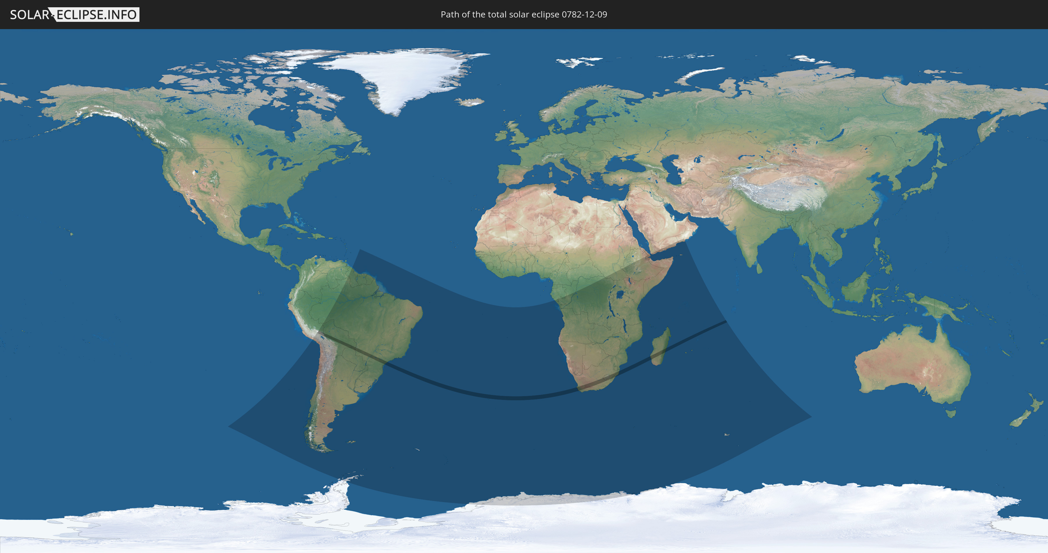
Die Sonnenfinsternis am 09.12.0782 kann man in 46 Ländern als partielle Sonnenfinsternis beobachten.
Der Finsternispfad verläuft durch 7 Länder. Nur in diesen Ländern ist sie als totale Sonnenfinsternis zu sehen.
In den folgenden Ländern ist die Sonnenfinsternis total zu sehen
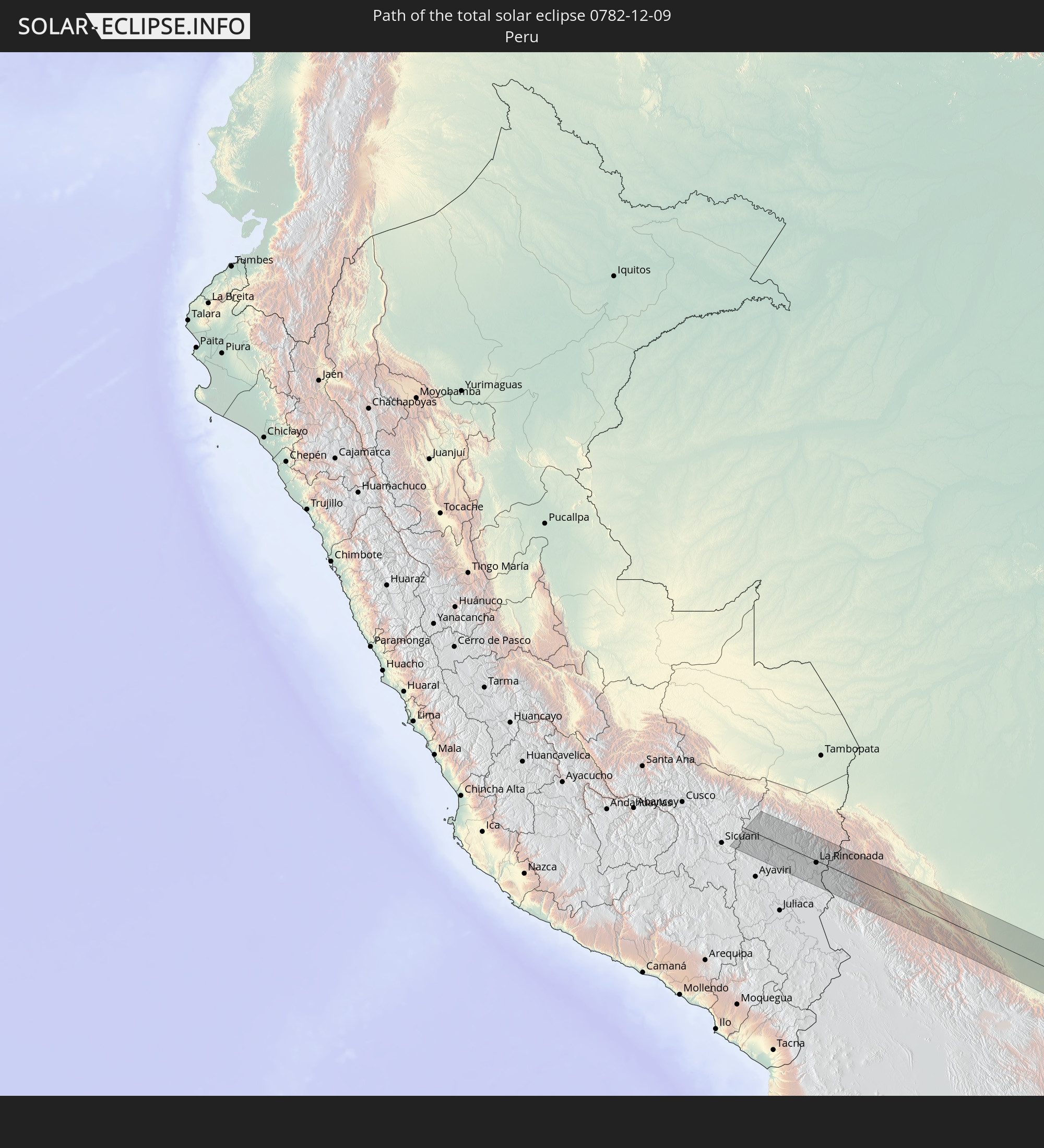 Peru
Peru
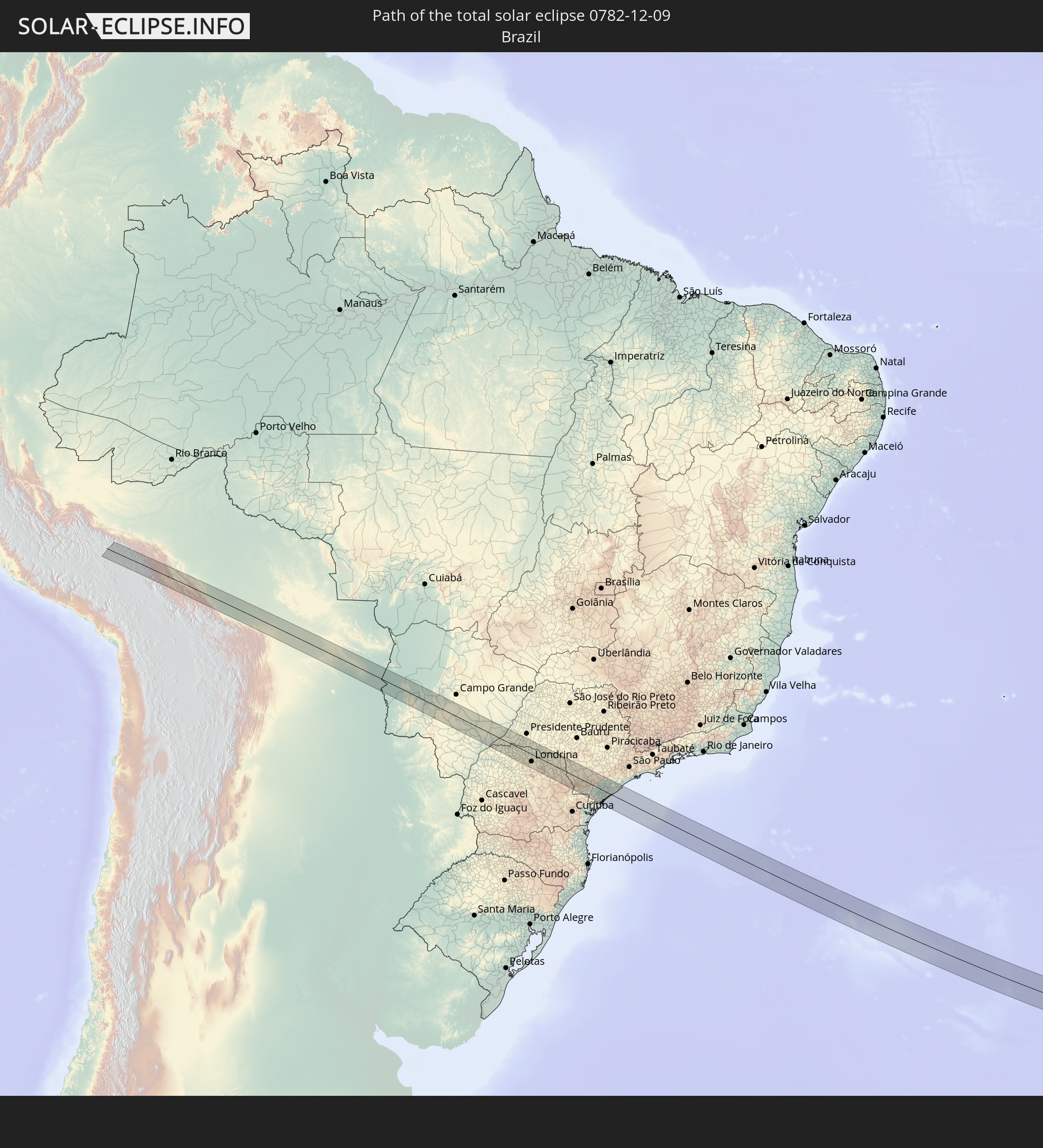 Brasilien
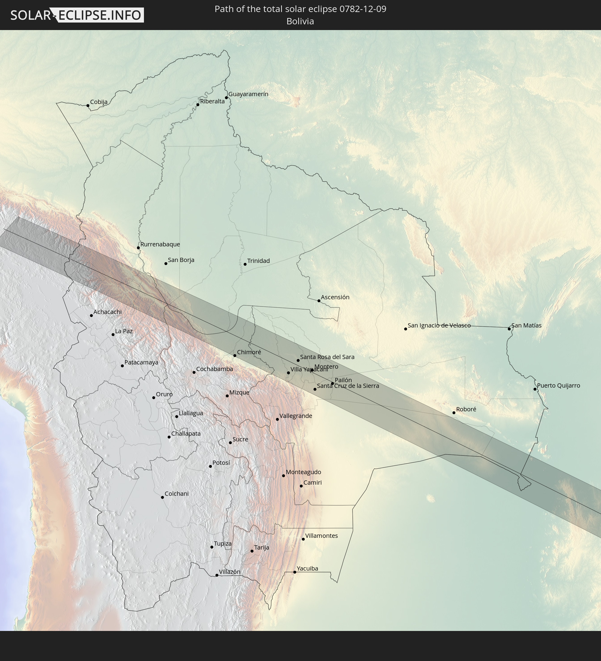 Bolivien
 Paraguay
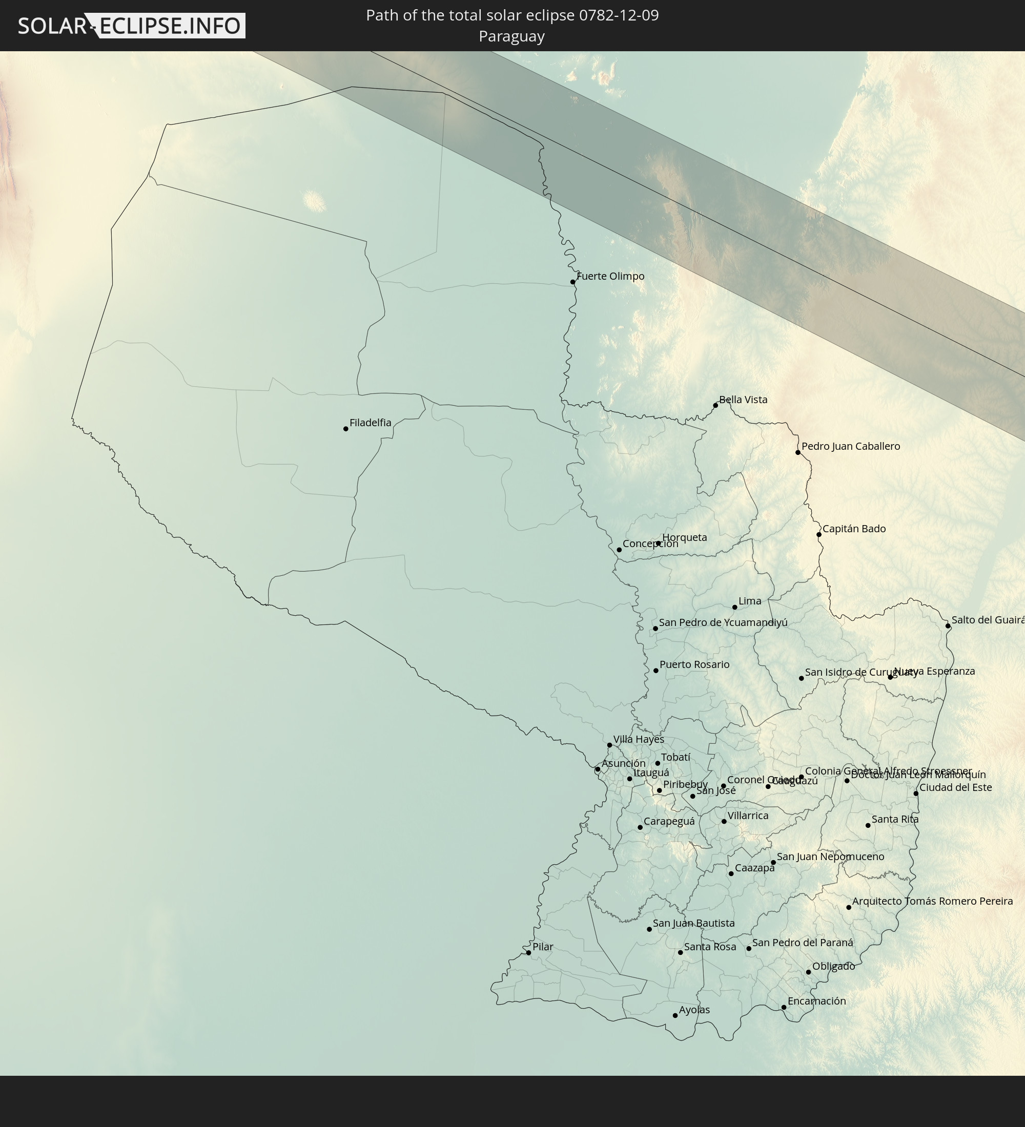
 Südafrika
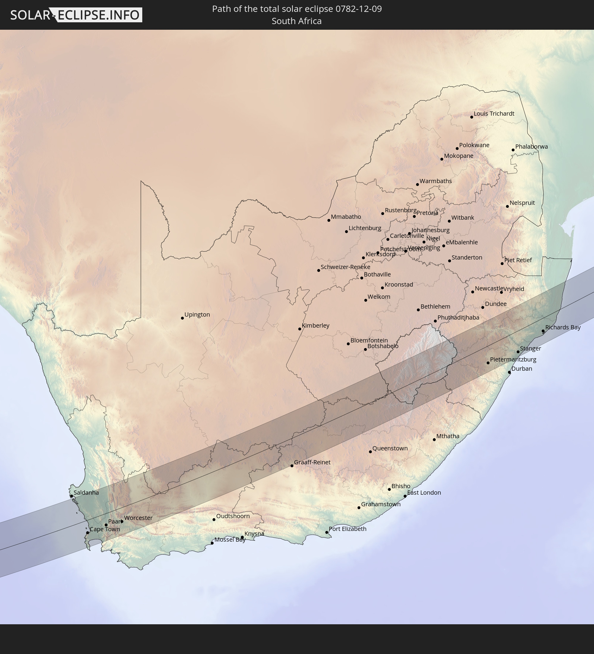
 Lesotho
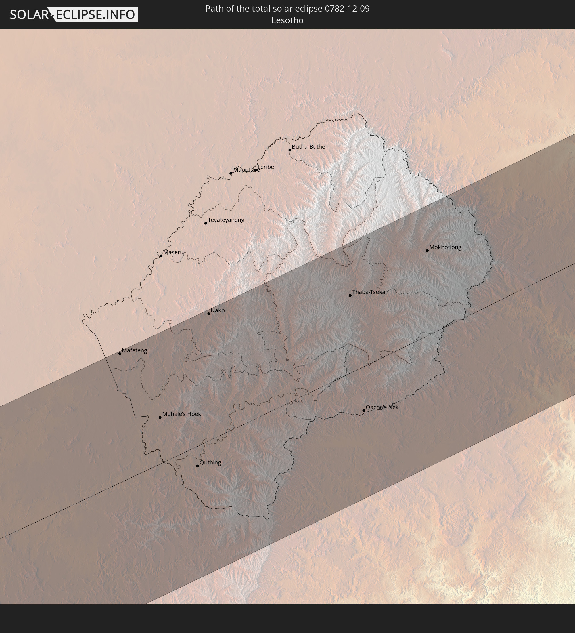
 Madagaskar
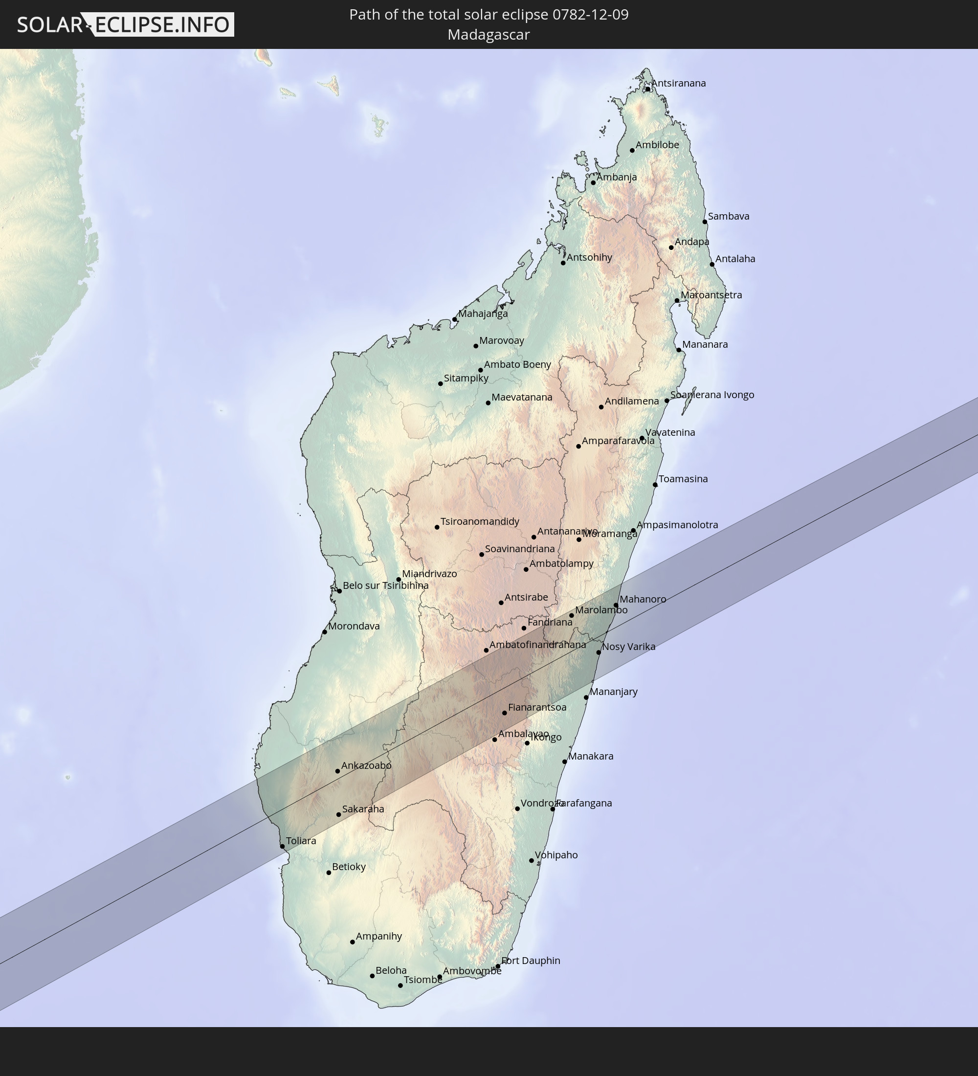
In den folgenden Ländern ist die Sonnenfinsternis partiell zu sehen
 Antarktika
 Chile
Chile
 Peru
Peru
 Brasilien
 Argentinien
 Bolivien
 Paraguay
 Falklandinseln
 Guyana
 Uruguay
 Suriname
 Französisch-Guayana
 Südgeorgien und die Südlichen Sandwichinseln
 St. Helena
 Bouvetinsel
 Gabun
Gabun
 Republik Kongo
 Angola
 Namibia
 Demokratische Republik Kongo
 Südafrika
 Botswana
 Sambia
 Simbabwe
 Lesotho
 Ruanda
 Burundi
 Tansania
 Uganda
 Mosambik
 Swasiland
 Malawi
 Äthiopien
 Kenia
Kenia
 Französische Süd- und Antarktisgebiete
 Somalia
 Dschibuti
 Jemen
Jemen
 Madagaskar
 Komoren
 Mayotte
 Seychellen
 Oman
Oman
 Réunion
 Mauritius
 Heard und McDonaldinseln
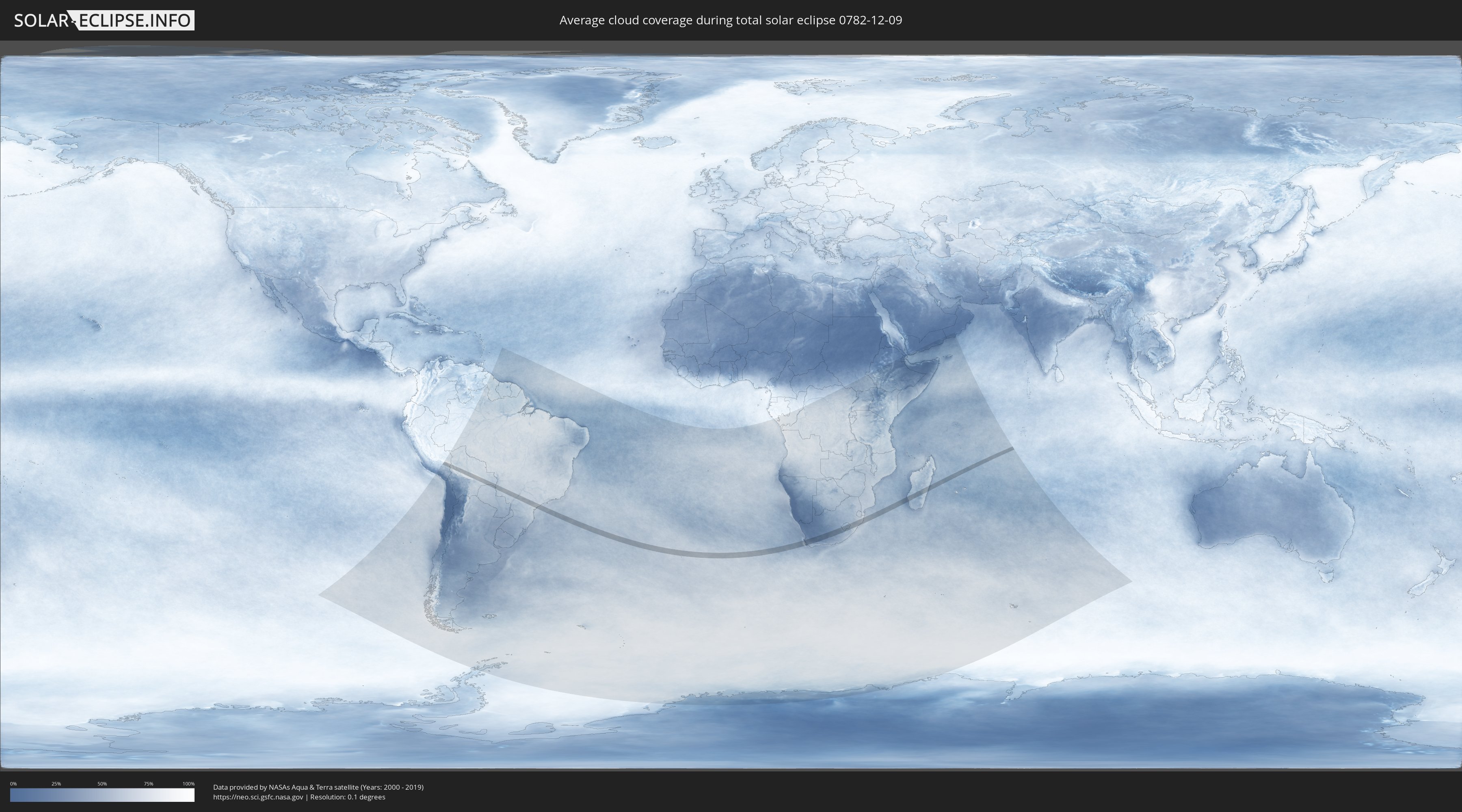
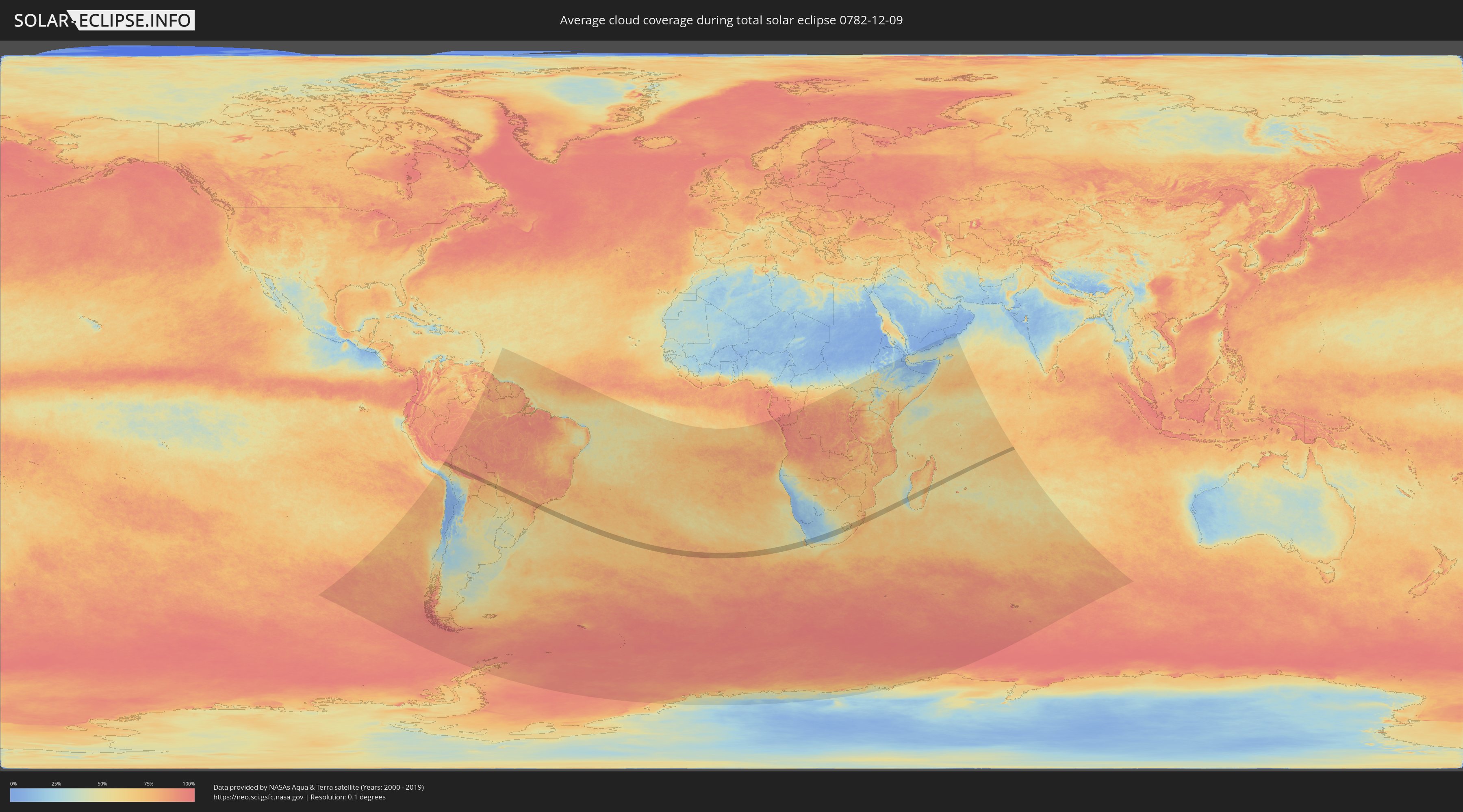
Wie wird das Wetter während der totalen Sonnenfinsternis am 09.12.0782?
Wo ist der beste Ort, um die totale Sonnenfinsternis vom 09.12.0782 zu beobachten?
Die folgenden Karten zeigen die durchschnittliche Bewölkung für den Tag, an dem die totale Sonnenfinsternis
stattfindet. Mit Hilfe der Karten lässt sich der Ort entlang des Finsternispfades eingrenzen,
der die besten Aussichen auf einen klaren wolkenfreien Himmel bietet.
Trotzdem muss man immer lokale Gegenenheiten beachten und sollte sich genau über das Wetter an seinem
gewählten Beobachtungsort informieren.
Die Daten stammen von den beiden NASA-Satelliten
AQUA und TERRA
und wurden über einen Zeitraum von 19 Jahren (2000 - 2019) gemittelt.
Detaillierte Länderkarten
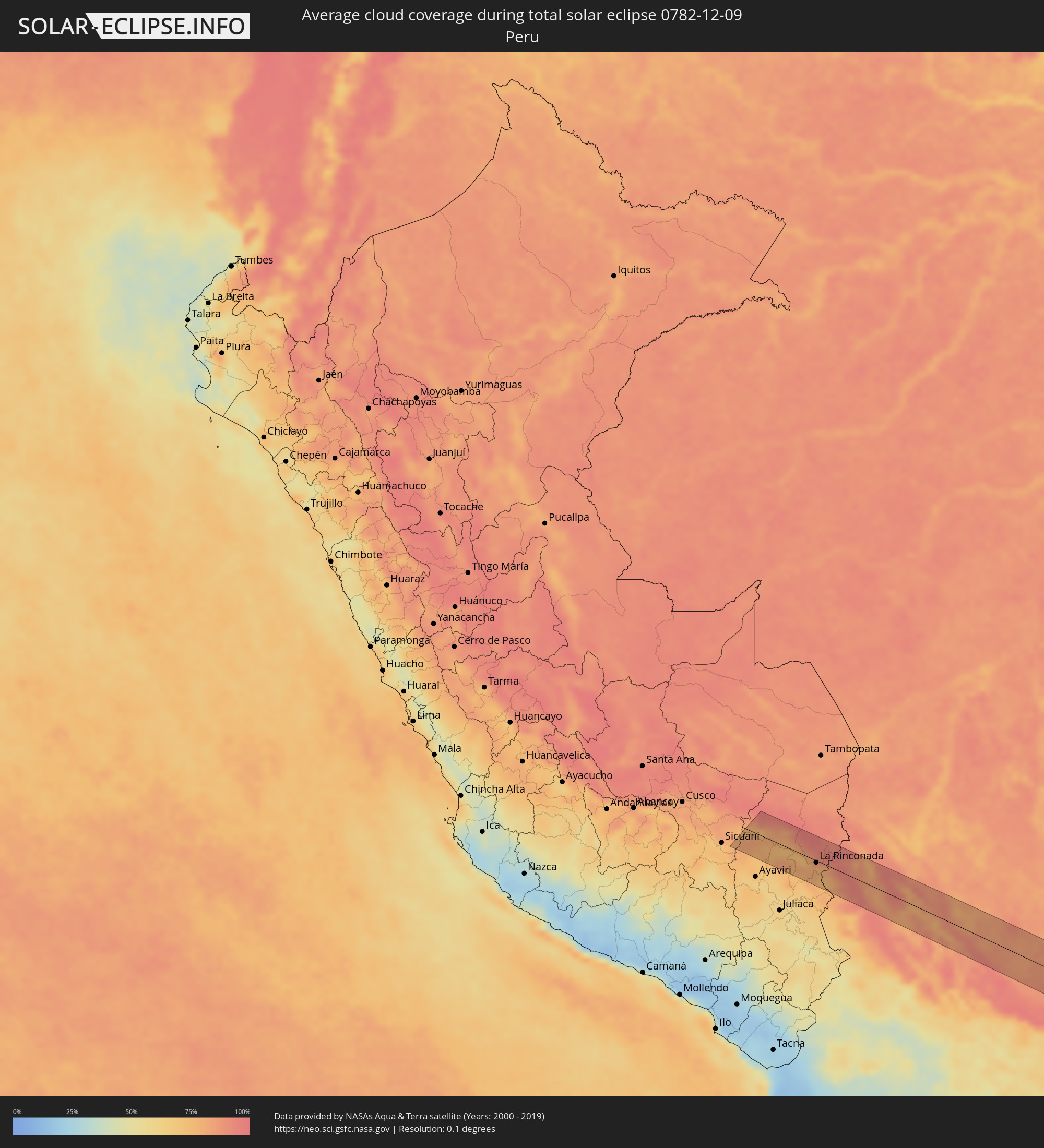 Peru
Peru
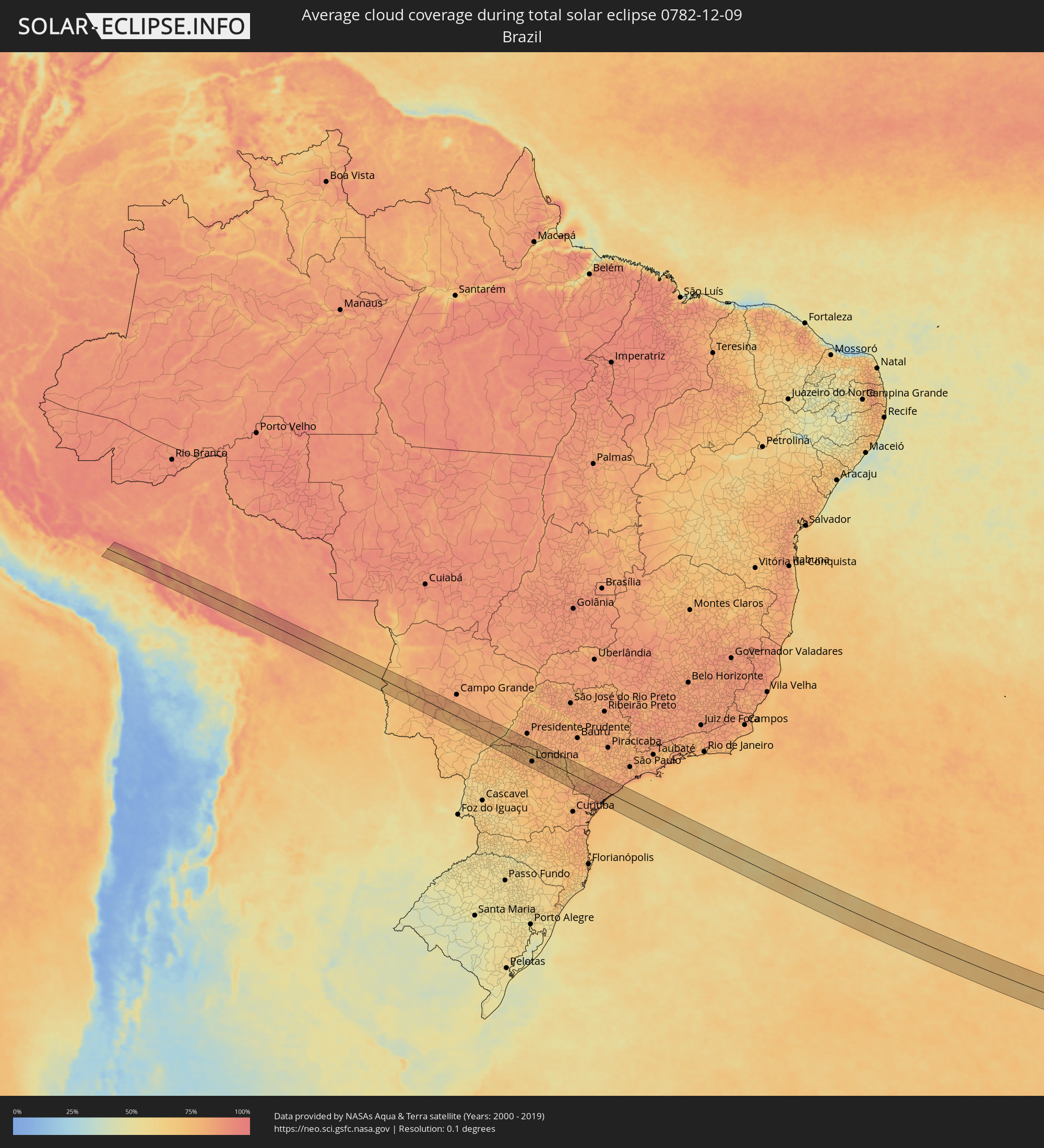 Brasilien
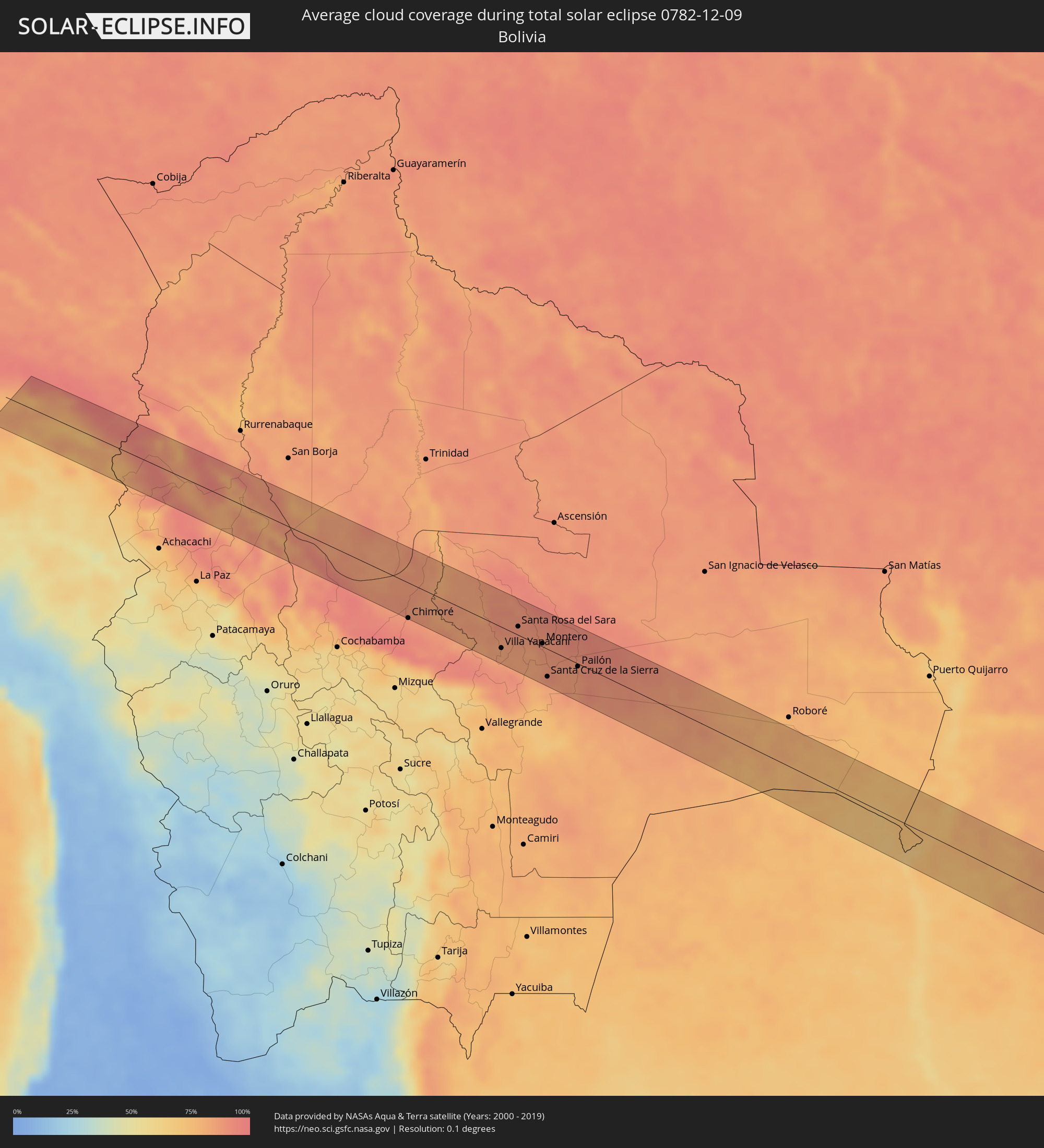 Bolivien
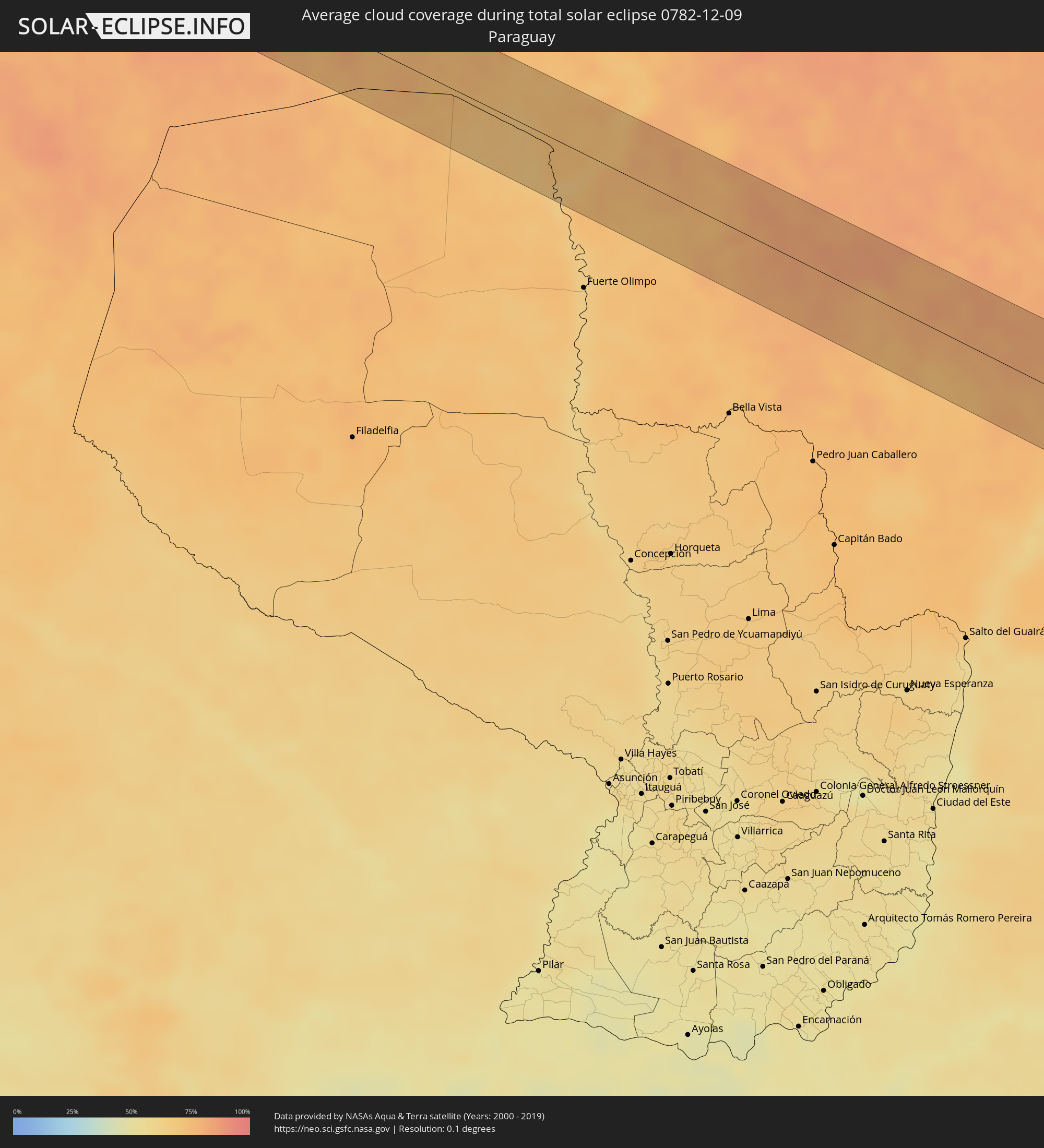 Paraguay
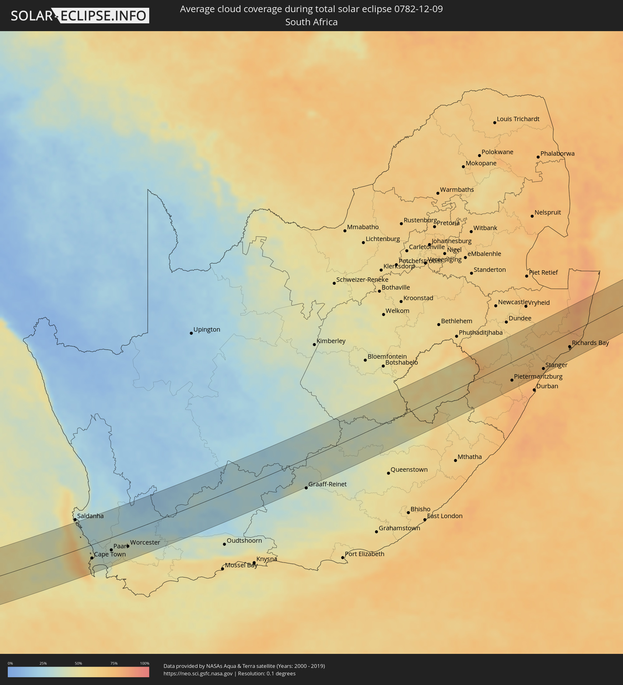 Südafrika
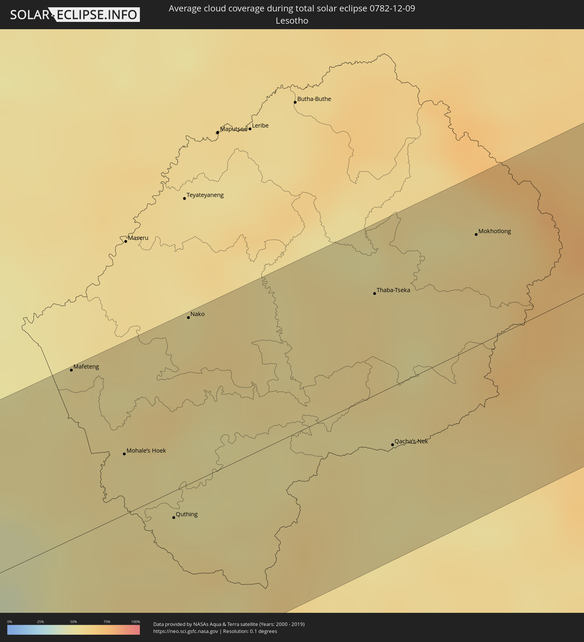 Lesotho
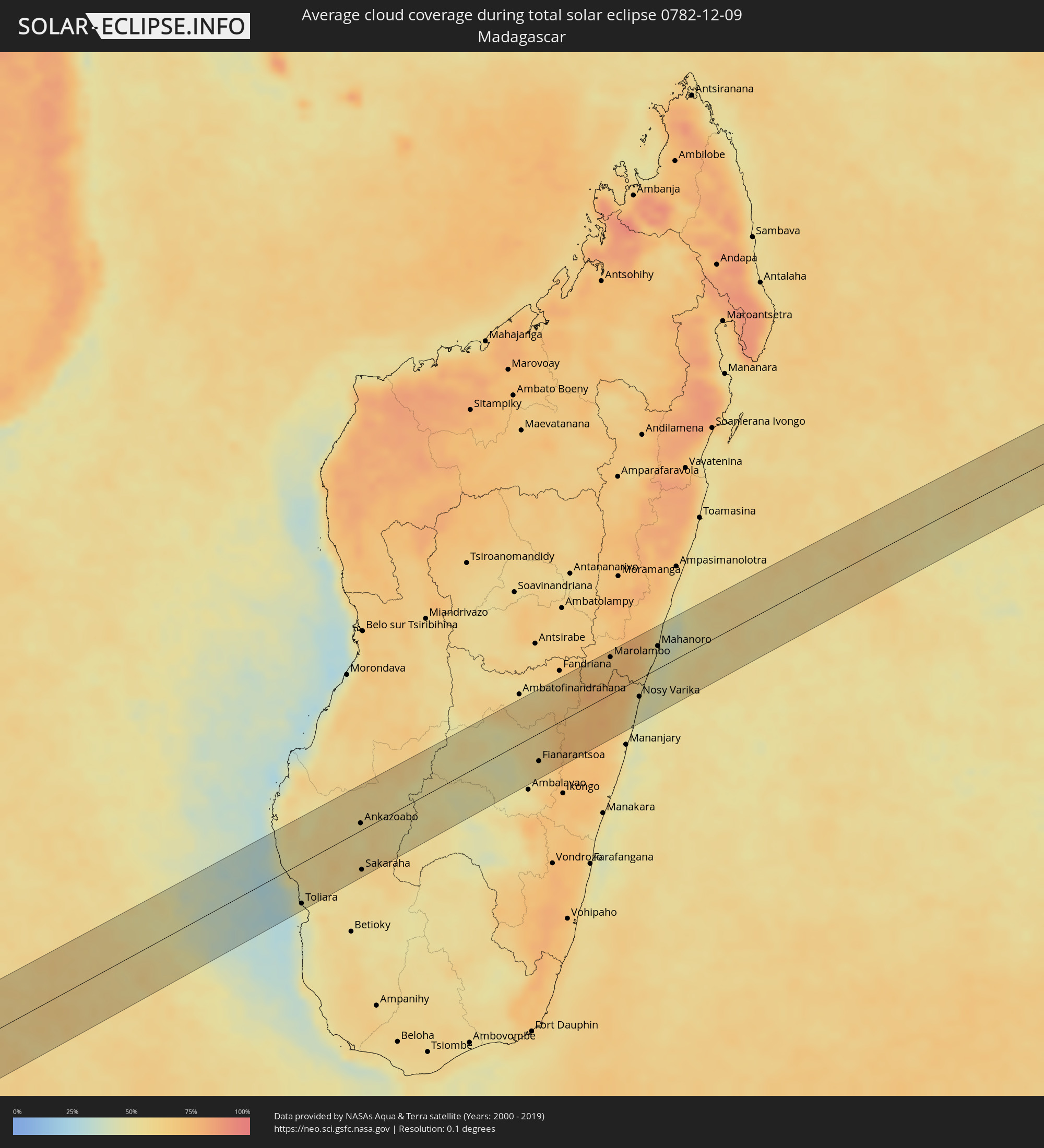 Madagaskar
Orte im Finsternispfad
Die nachfolgene Tabelle zeigt Städte und Orte mit mehr als 5.000 Einwohnern, die sich im Finsternispfad befinden. Städte mit mehr als 100.000 Einwohnern sind dick gekennzeichnet. Mit einem Klick auf den Ort öffnet sich eine Detailkarte die die Lage des jeweiligen Ortes zusammen mit dem Verlauf der zentralen Finsternis präsentiert.
| Ort | Typ | Dauer der Verfinsterung | Ortszeit bei maximaler Verfinsterung | Entfernung zur Zentrallinie | Ø Bewölkung |
|
Macusani, Puno
|
total | - | 05:07:07 UTC-05:08 | 9 km | 82% |
|
La Rinconada, Puno
|
total | - | 05:07:13 UTC-05:08 | 4 km | 78% |
|
Chimoré, Cochabamba
|
total | - | 05:44:08 UTC-04:32 | 48 km | 90% |
|
Villa Yapacaní, Santa Cruz
|
total | - | 05:44:19 UTC-04:32 | 29 km | 83% |
|
Santa Rosa del Sara, Santa Cruz
|
total | - | 05:44:05 UTC-04:32 | 12 km | 89% |
|
Portachuelo, Santa Cruz
|
total | - | 05:44:16 UTC-04:32 | 4 km | 83% |
|
Montero, Santa Cruz
|
total | - | 05:44:15 UTC-04:32 | 4 km | 88% |
|
Mineros, Santa Cruz
|
total | - | 05:44:05 UTC-04:32 | 27 km | 90% |
|
La Bélgica, Santa Cruz
|
total | - | 05:44:24 UTC-04:32 | 15 km | 86% |
|
Santa Cruz de la Sierra, Santa Cruz
|
total | - | 05:44:35 UTC-04:32 | 37 km | 87% |
|
Warnes, Santa Cruz
|
total | - | 05:44:23 UTC-04:32 | 10 km | 87% |
|
Cotoca, Santa Cruz
|
total | - | 05:44:36 UTC-04:32 | 34 km | 88% |
|
San Julian, Santa Cruz
|
total | - | 05:44:34 UTC-04:32 | 23 km | 87% |
|
Pailón, Santa Cruz
|
total | - | 05:44:28 UTC-04:32 | 4 km | 86% |
|
Anastácio, Mato Grosso do Sul
|
total | - | 06:41:34 UTC-03:38 | 35 km | 81% |
|
Aquidauana, Mato Grosso do Sul
|
total | - | 06:41:33 UTC-03:38 | 37 km | 81% |
|
Maracaju, Mato Grosso do Sul
|
total | - | 06:42:44 UTC-03:38 | 48 km | 76% |
|
Sidrolândia, Mato Grosso do Sul
|
total | - | 06:42:09 UTC-03:38 | 30 km | 83% |
|
Rio Brilhante, Mato Grosso do Sul
|
total | - | 06:43:04 UTC-03:38 | 38 km | 72% |
|
Teodoro Sampaio, São Paulo
|
total | - | 07:16:30 UTC-03:06 | 0 km | 74% |
|
Colorado, Paraná
|
total | - | 07:16:52 UTC-03:06 | 21 km | 79% |
|
Astorga, Paraná
|
total | - | 07:17:22 UTC-03:06 | 46 km | 77% |
|
Pirapozinho, São Paulo
|
total | - | 07:16:29 UTC-03:06 | 57 km | 81% |
|
Arapongas, Paraná
|
total | - | 07:17:39 UTC-03:06 | 54 km | 79% |
|
Bela Vista do Paraíso, Paraná
|
total | - | 07:17:19 UTC-03:06 | 1 km | 75% |
|
Londrina, Paraná
|
total | - | 07:17:38 UTC-03:06 | 31 km | 80% |
|
Sertanópolis, Paraná
|
total | - | 07:17:26 UTC-03:06 | 0 km | 76% |
|
Cornélio Procópio, Paraná
|
total | - | 07:17:43 UTC-03:06 | 6 km | 79% |
|
Bandeirantes, Paraná
|
total | - | 07:17:46 UTC-03:06 | 26 km | 79% |
|
Ibaiti, Paraná
|
total | - | 07:18:35 UTC-03:06 | 39 km | 76% |
|
Santo Antônio da Platina, Paraná
|
total | - | 07:18:05 UTC-03:06 | 21 km | 77% |
|
Cambará, Paraná
|
total | - | 07:17:50 UTC-03:06 | 46 km | 77% |
|
Jacarezinho, Paraná
|
total | - | 07:17:59 UTC-03:06 | 39 km | 76% |
|
Siqueira Campos, Paraná
|
total | - | 07:18:35 UTC-03:06 | 7 km | 75% |
|
Wenceslau Braz, Paraná
|
total | - | 07:18:47 UTC-03:06 | 24 km | 75% |
|
Jaguariaíva, Paraná
|
total | - | 07:19:13 UTC-03:06 | 56 km | 76% |
|
Sengés, Paraná
|
total | - | 07:19:11 UTC-03:06 | 32 km | 76% |
|
Itararé, São Paulo
|
total | - | 07:19:15 UTC-03:06 | 26 km | 77% |
|
Taquarituba, São Paulo
|
total | - | 07:18:42 UTC-03:06 | 36 km | 78% |
|
Itaí, São Paulo
|
total | - | 07:18:39 UTC-03:06 | 54 km | 78% |
|
Itapeva, São Paulo
|
total | - | 07:19:20 UTC-03:06 | 8 km | 77% |
|
Apiaí, São Paulo
|
total | - | 07:19:54 UTC-03:06 | 43 km | 83% |
|
Buri, São Paulo
|
total | - | 07:19:17 UTC-03:06 | 39 km | 79% |
|
Capâo Bonito, São Paulo
|
total | - | 07:19:37 UTC-03:06 | 30 km | 80% |
|
Cajati, São Paulo
|
total | - | 07:20:30 UTC-03:06 | 33 km | 83% |
|
Cananéia, São Paulo
|
total | - | 07:20:54 UTC-03:06 | 51 km | 75% |
|
Registro, São Paulo
|
total | - | 07:20:23 UTC-03:06 | 5 km | 81% |
|
Iguape, São Paulo
|
total | - | 07:20:46 UTC-03:06 | 4 km | 76% |
|
Constantia, Western Cape
|
total | - | 14:05:59 UTC+01:30 | 45 km | 46% |
|
Cape Town, Western Cape
|
total | - | 14:06:06 UTC+01:30 | 34 km | 43% |
|
Claremont, Western Cape
|
total | - | 14:06:07 UTC+01:30 | 41 km | 41% |
|
Rosebank, Western Cape
|
total | - | 14:06:10 UTC+01:30 | 39 km | 41% |
|
Retreat, Western Cape
|
total | - | 14:06:04 UTC+01:30 | 49 km | 44% |
|
Rondebosch, Western Cape
|
total | - | 14:06:10 UTC+01:30 | 40 km | 41% |
|
Atlantis, Western Cape
|
total | - | 14:06:36 UTC+01:30 | 2 km | 30% |
|
Lansdowne, Western Cape
|
total | - | 14:06:10 UTC+01:30 | 43 km | 41% |
|
Kraaifontein, Western Cape
|
total | - | 14:06:44 UTC+01:30 | 35 km | 34% |
|
Malmesbury, Western Cape
|
total | - | 14:07:10 UTC+01:30 | 5 km | 34% |
|
Stellenbosch, Western Cape
|
total | - | 14:06:55 UTC+01:30 | 49 km | 37% |
|
Paarl, Western Cape
|
total | - | 14:07:20 UTC+01:30 | 31 km | 38% |
|
Ceres, Western Cape
|
total | - | 14:08:21 UTC+01:30 | 4 km | 34% |
|
Worcester, Western Cape
|
total | - | 14:08:18 UTC+01:30 | 37 km | 40% |
|
Beaufort West, Western Cape
|
total | - | 14:15:17 UTC+01:30 | 11 km | 26% |
|
Middelburg, Eastern Cape
|
total | - | 14:20:18 UTC+01:30 | 14 km | 38% |
|
Colesberg, Northern Cape
|
total | - | 14:21:24 UTC+01:30 | 61 km | 37% |
|
Burgersdorp, Eastern Cape
|
total | - | 14:22:58 UTC+01:30 | 15 km | 40% |
|
Molteno, Eastern Cape
|
total | - | 14:22:31 UTC+01:30 | 57 km | 45% |
|
Aliwal North, Eastern Cape
|
total | - | 14:23:55 UTC+01:30 | 0 km | 40% |
|
Zastron, Orange Free State
|
total | - | 14:24:59 UTC+01:30 | 25 km | 47% |
|
Mafeteng, Mafeteng
|
total | - | 14:25:49 UTC+01:30 | 67 km | 52% |
|
Mohale’s Hoek, Mohaleʼs Hoek
|
total | - | 14:25:45 UTC+01:30 | 24 km | 54% |
|
Quthing, Quthing
|
total | - | 14:25:45 UTC+01:30 | 10 km | 55% |
|
Nako, Maseru
|
total | - | 14:26:51 UTC+01:30 | 66 km | 55% |
|
Thaba-Tseka, Thaba-Tseka
|
total | - | 14:28:10 UTC+01:30 | 40 km | 57% |
|
Qacha’s Nek, Qachaʼs Nek
|
total | - | 14:27:31 UTC+01:30 | 23 km | 53% |
|
Mokhotlong, Mokhotlong
|
total | - | 14:29:06 UTC+01:30 | 44 km | 58% |
|
Mooirivier, KwaZulu-Natal
|
total | - | 14:30:28 UTC+01:30 | 12 km | 65% |
|
Mpophomeni, KwaZulu-Natal
|
total | - | 14:30:16 UTC+01:30 | 32 km | 71% |
|
Howick, KwaZulu-Natal
|
total | - | 14:30:26 UTC+01:30 | 25 km | 68% |
|
Richmond, KwaZulu-Natal
|
total | - | 14:29:59 UTC+01:30 | 66 km | 74% |
|
Pietermaritzburg, KwaZulu-Natal
|
total | - | 14:30:28 UTC+01:30 | 46 km | 71% |
|
Greytown, KwaZulu-Natal
|
total | - | 14:31:27 UTC+01:30 | 1 km | 67% |
|
Stanger, KwaZulu-Natal
|
total | - | 14:32:00 UTC+01:30 | 56 km | 72% |
|
Sundumbili, KwaZulu-Natal
|
total | - | 14:32:23 UTC+01:30 | 41 km | 70% |
|
Ulundi, KwaZulu-Natal
|
total | - | 14:33:26 UTC+01:30 | 37 km | 71% |
|
Eshowe, KwaZulu-Natal
|
total | - | 14:32:48 UTC+01:30 | 20 km | 72% |
|
Empangeni, KwaZulu-Natal
|
total | - | 14:33:29 UTC+01:30 | 26 km | 69% |
|
eSikhawini, KwaZulu-Natal
|
total | - | 14:33:21 UTC+01:30 | 37 km | 69% |
|
Richards Bay, KwaZulu-Natal
|
total | - | 14:33:38 UTC+01:30 | 35 km | 69% |
|
Toliara, Atsimo-Andrefana
|
total | - | 15:48:38 UTC+02:27 | 53 km | 47% |
|
Behompy, Atsimo-Andrefana
|
total | - | 15:48:52 UTC+02:27 | 52 km | 53% |
|
Ankazoabo, Atsimo-Andrefana
|
total | - | 15:50:24 UTC+02:27 | 9 km | 55% |
|
Sakaraha, Atsimo-Andrefana
|
total | - | 15:49:43 UTC+02:27 | 52 km | 58% |
|
Beroroha, Atsimo-Andrefana
|
total | - | 15:51:29 UTC+02:27 | 37 km | 51% |
|
Ranohira, Ihorombe
|
total | - | 15:50:43 UTC+02:27 | 54 km | 56% |
|
Ikalamavony, Upper Matsiatra
|
total | - | 15:52:51 UTC+02:27 | 18 km | 47% |
|
Fianarantsoa, Upper Matsiatra
|
total | - | 15:52:47 UTC+02:27 | 37 km | 60% |
|
Ambositra, Amoron'i Mania
|
total | - | 15:53:52 UTC+02:27 | 45 km | 61% |
|
Fandrandava, Upper Matsiatra
|
total | - | 15:52:48 UTC+02:27 | 51 km | 64% |
|
Ifanadiana, Vatovavy Fitovinany
|
total | - | 15:53:13 UTC+02:27 | 49 km | 73% |
|
Marolambo, Atsinanana
|
total | - | 15:54:47 UTC+02:27 | 49 km | 69% |
|
Sahavato, Vatovavy Fitovinany
|
total | - | 15:54:19 UTC+02:27 | 16 km | 70% |
|
Nosy Varika, Vatovavy Fitovinany
|
total | - | 15:54:25 UTC+02:27 | 24 km | 50% |
|
Mahanoro, Atsinanana
|
total | - | 15:55:15 UTC+02:27 | 30 km | 49% |