Totale Sonnenfinsternis vom 26.08.0797
| Wochentag: | Dienstag |
| Maximale Dauer der Verfinsterung: | 04m21s |
| Maximale Breite des Finsternispfades: | 182 km |
| Saroszyklus: | 96 |
| Bedeckungsgrad: | 100% |
| Magnitude: | 1.0535 |
| Gamma: | 0.2556 |
Wo kann man die Sonnenfinsternis vom 26.08.0797 sehen?
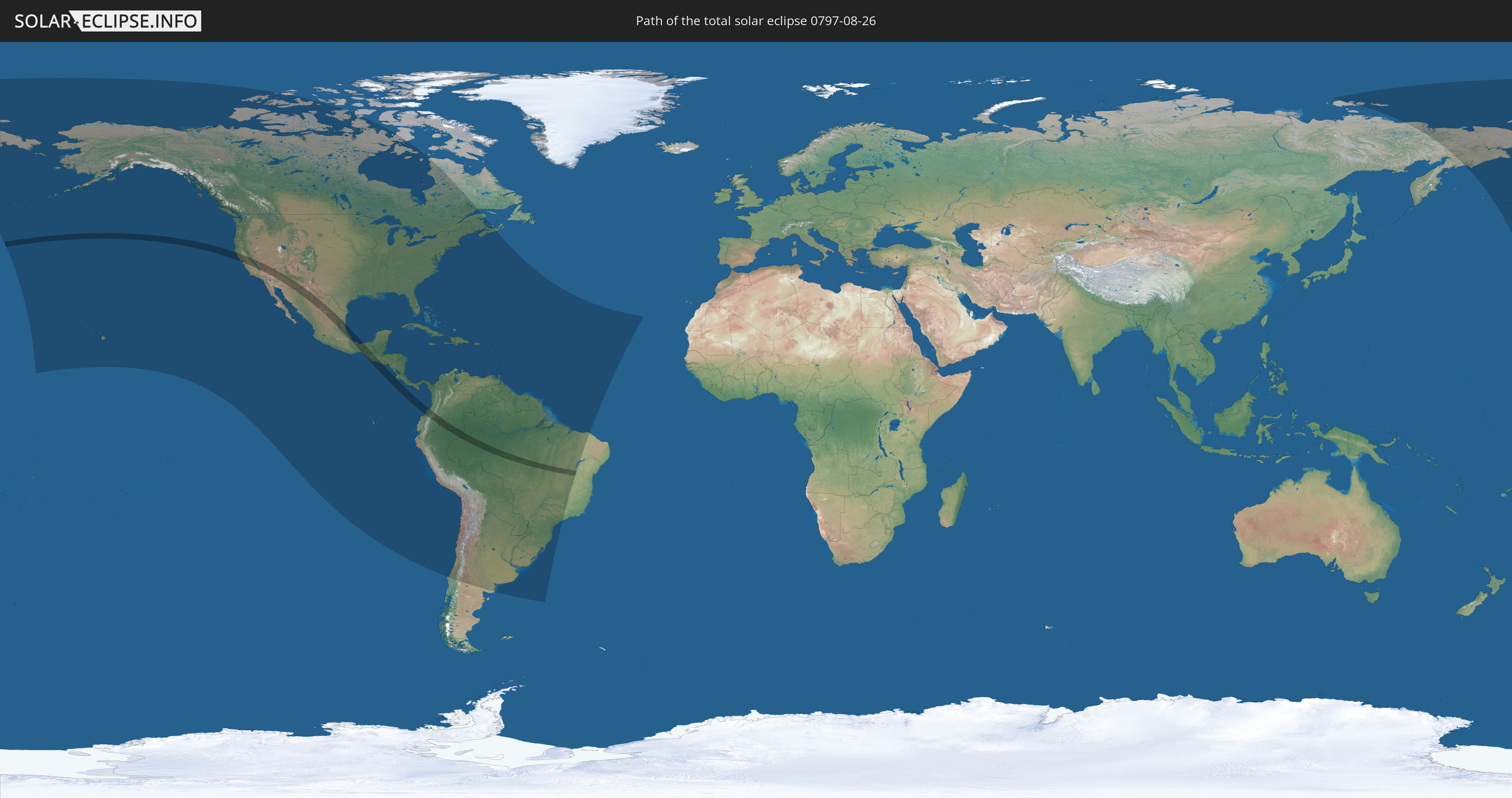
Die Sonnenfinsternis am 26.08.0797 kann man in 52 Ländern als partielle Sonnenfinsternis beobachten.
Der Finsternispfad verläuft durch 8 Länder. Nur in diesen Ländern ist sie als totale Sonnenfinsternis zu sehen.
In den folgenden Ländern ist die Sonnenfinsternis total zu sehen
 Vereinigte Staaten
 Mexiko
 Guatemala
 Ecuador
 El Salvador
 Kolumbien
 Peru
Peru
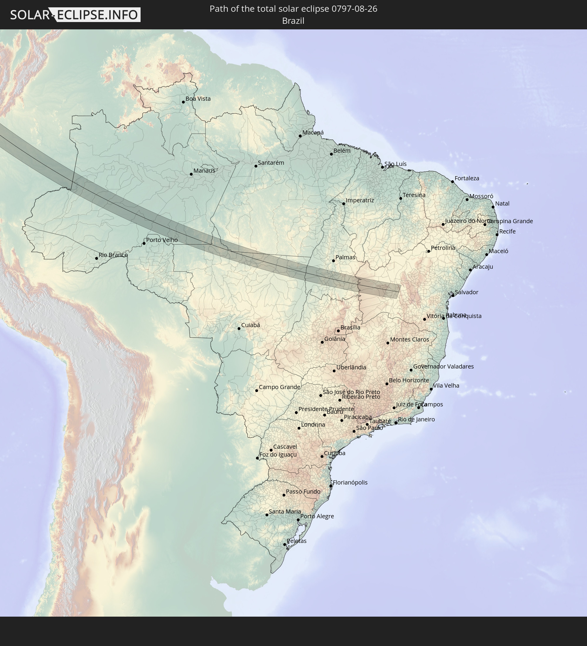 Brasilien
In den folgenden Ländern ist die Sonnenfinsternis partiell zu sehen
 Russland
 Vereinigte Staaten
 United States Minor Outlying Islands
 Kanada
 Mexiko
 Chile
Chile
 Grönland
 Guatemala
 Ecuador
 El Salvador
 Honduras
 Belize
 Nicaragua
 Costa Rica
 Kuba
Kuba
 Panama
 Kolumbien
 Kaimaninseln
 Peru
Peru
 Bahamas
 Jamaika
 Haiti
Haiti
 Brasilien
 Argentinien
 Venezuela
 Turks- und Caicosinseln
 Dominikanische Republik
 Aruba
Aruba
 Bolivien
 Puerto Rico
 Amerikanische Jungferninseln
 Bermuda
 Britische Jungferninseln
 Anguilla
 Saint-Martin
 Saint-Barthélemy
 St. Kitts und Nevis
 Paraguay
 Antigua und Barbuda
 Montserrat
 Trinidad und Tobago
 Guadeloupe
 Grenada
 Dominica
 St. Vincent und die Grenadinen
 Guyana
 Martinique
 St. Lucia
 Barbados
 Uruguay
 Suriname
 Französisch-Guayana
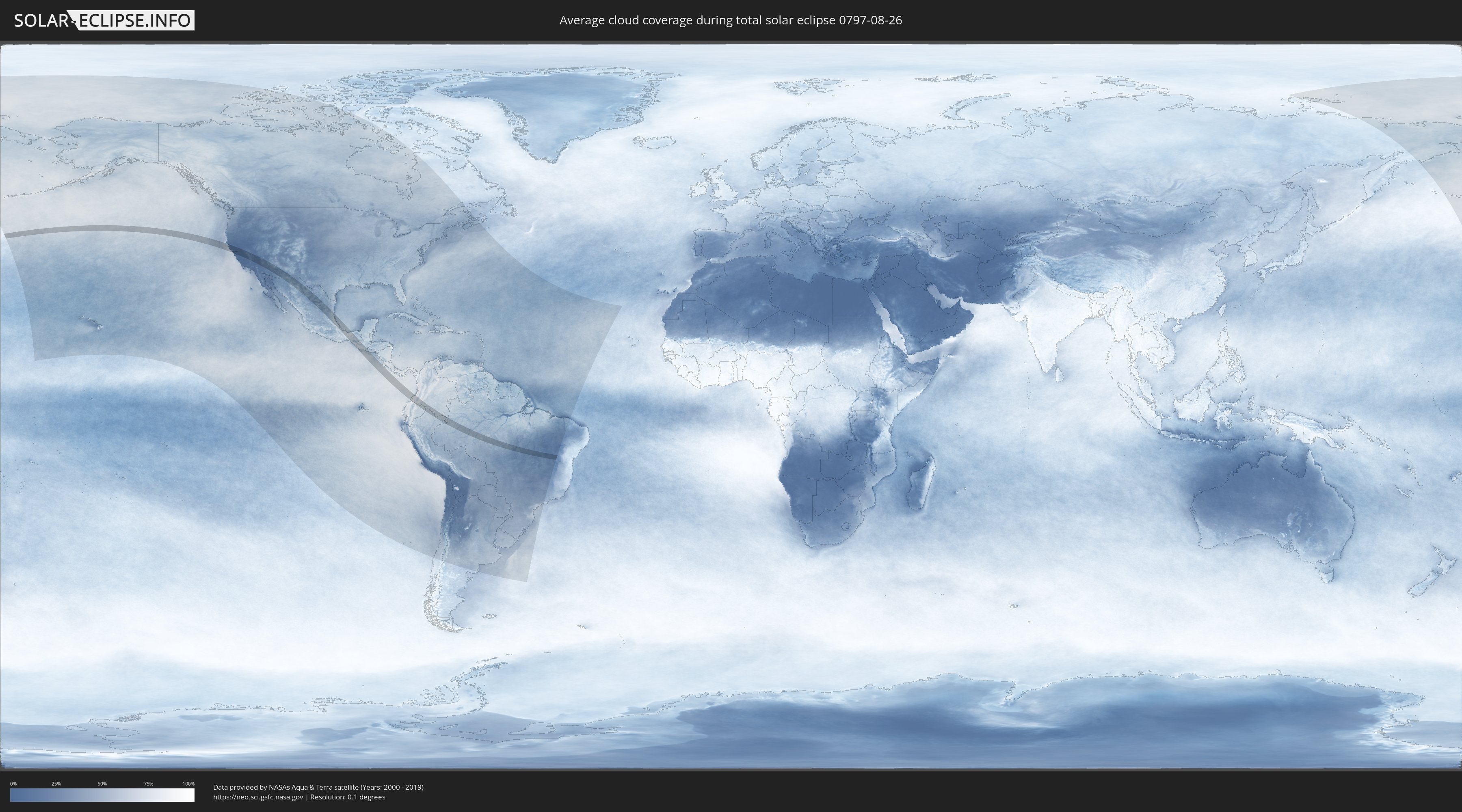
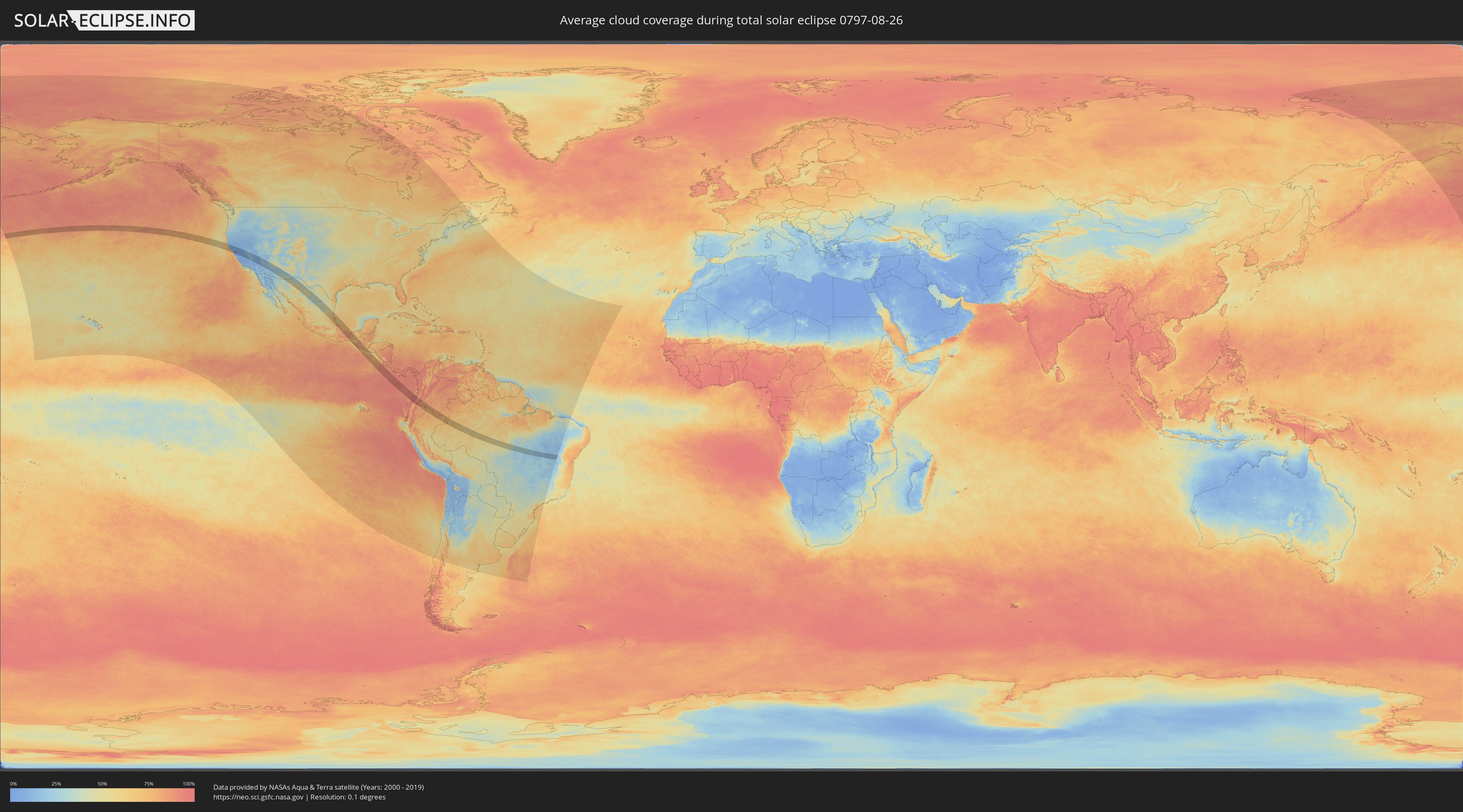
Wie wird das Wetter während der totalen Sonnenfinsternis am 26.08.0797?
Wo ist der beste Ort, um die totale Sonnenfinsternis vom 26.08.0797 zu beobachten?
Die folgenden Karten zeigen die durchschnittliche Bewölkung für den Tag, an dem die totale Sonnenfinsternis
stattfindet. Mit Hilfe der Karten lässt sich der Ort entlang des Finsternispfades eingrenzen,
der die besten Aussichen auf einen klaren wolkenfreien Himmel bietet.
Trotzdem muss man immer lokale Gegenenheiten beachten und sollte sich genau über das Wetter an seinem
gewählten Beobachtungsort informieren.
Die Daten stammen von den beiden NASA-Satelliten
AQUA und TERRA
und wurden über einen Zeitraum von 19 Jahren (2000 - 2019) gemittelt.
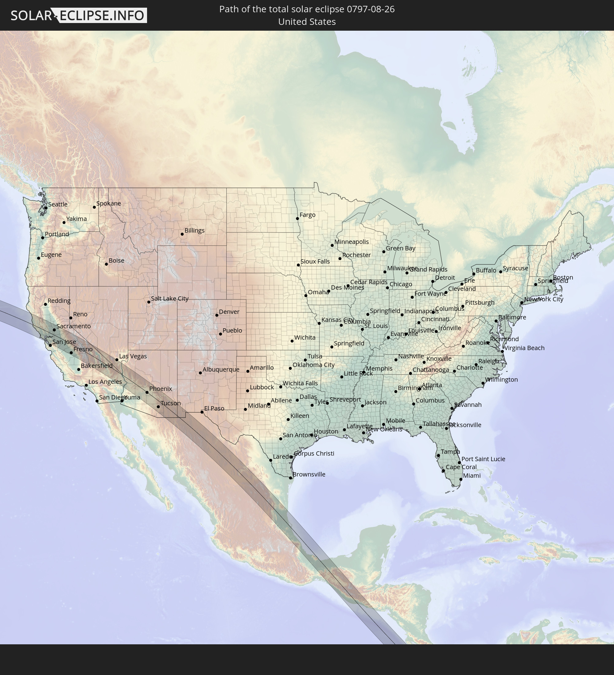
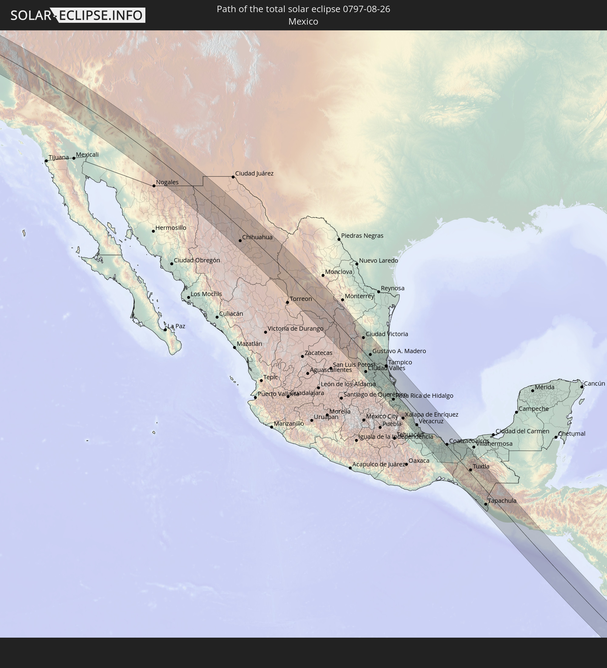
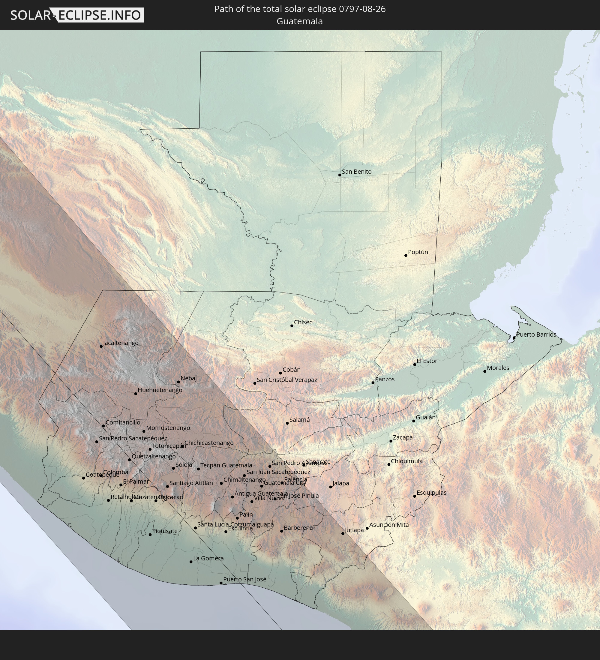
Detaillierte Länderkarten
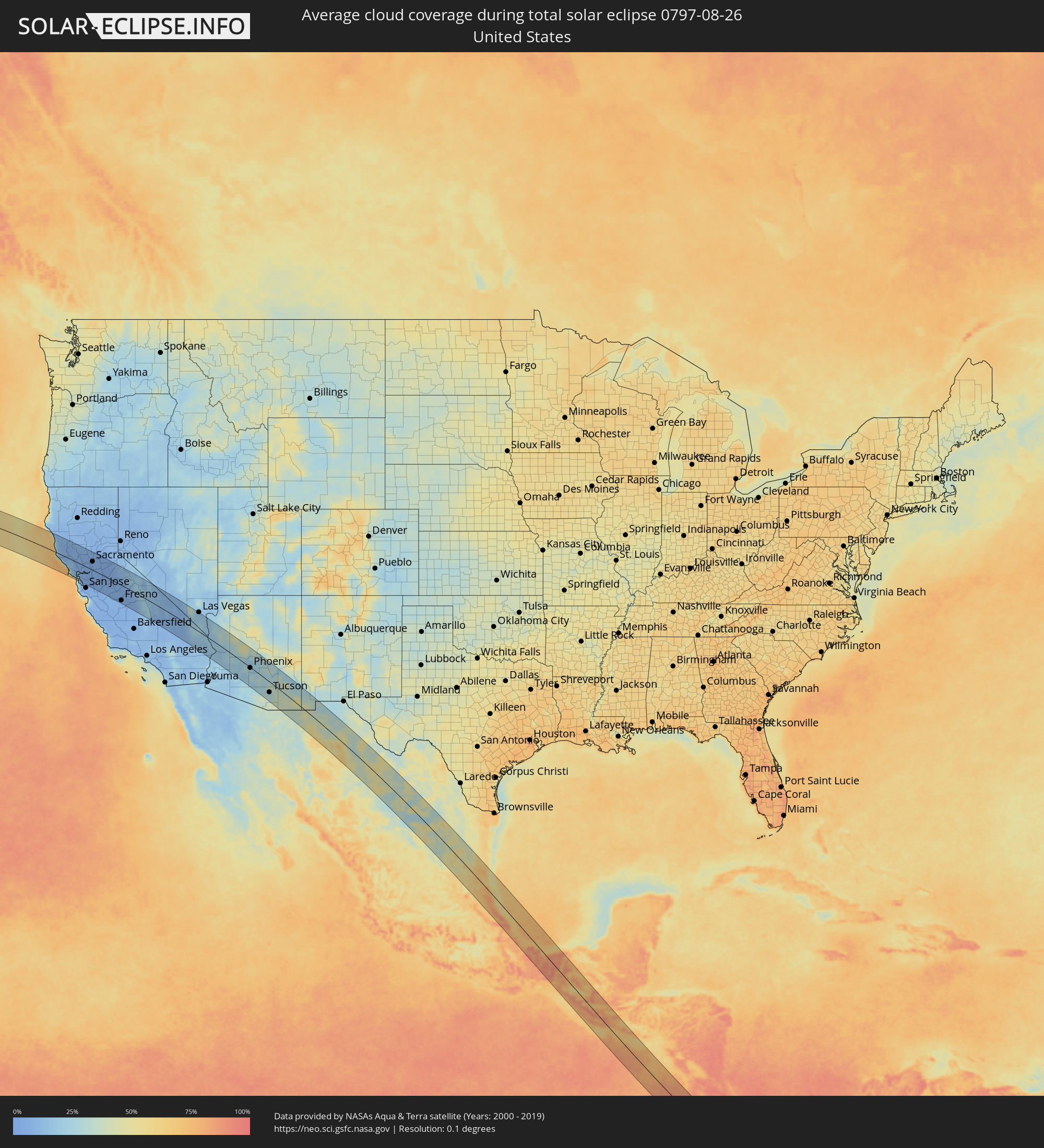 Vereinigte Staaten
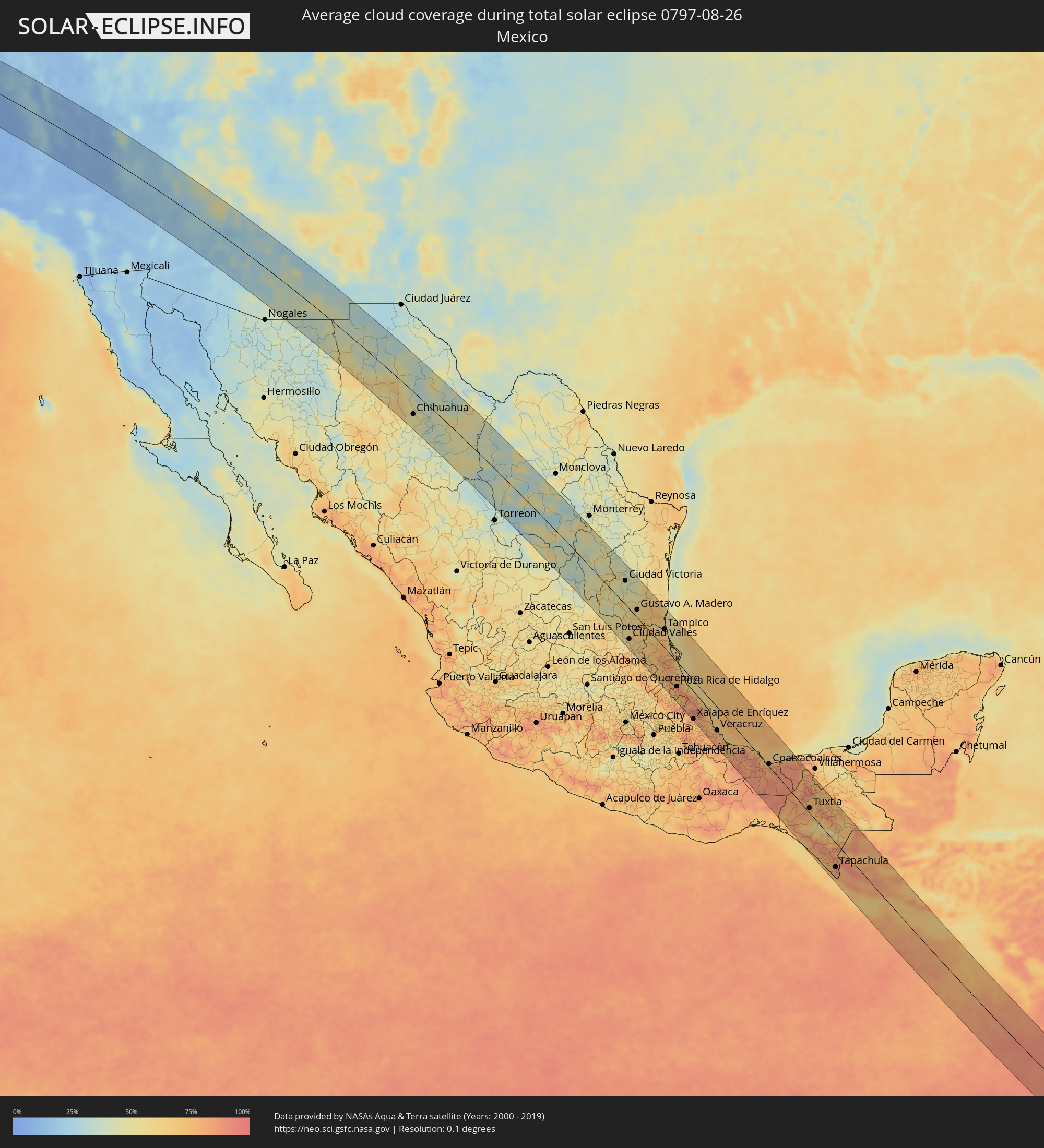 Mexiko
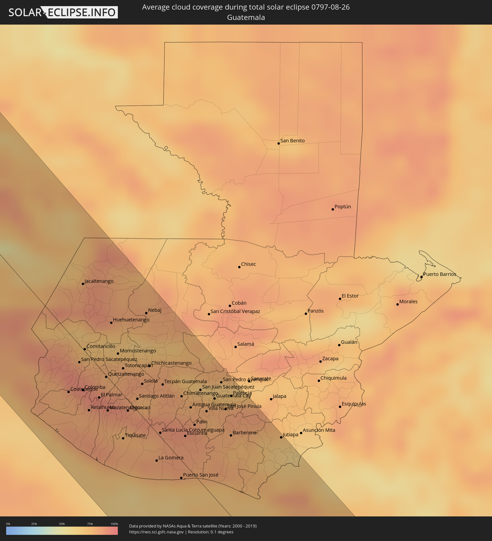 Guatemala
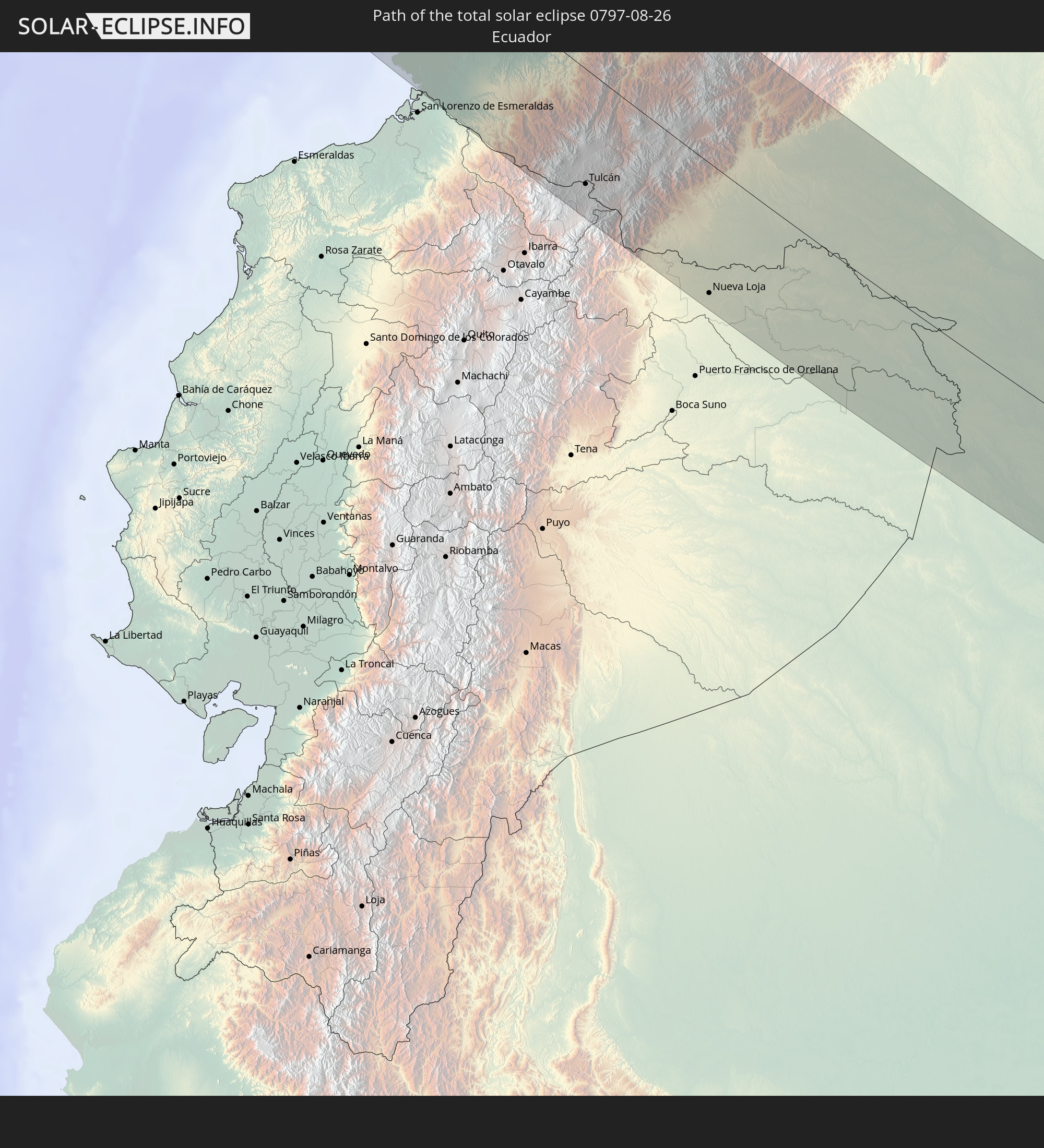
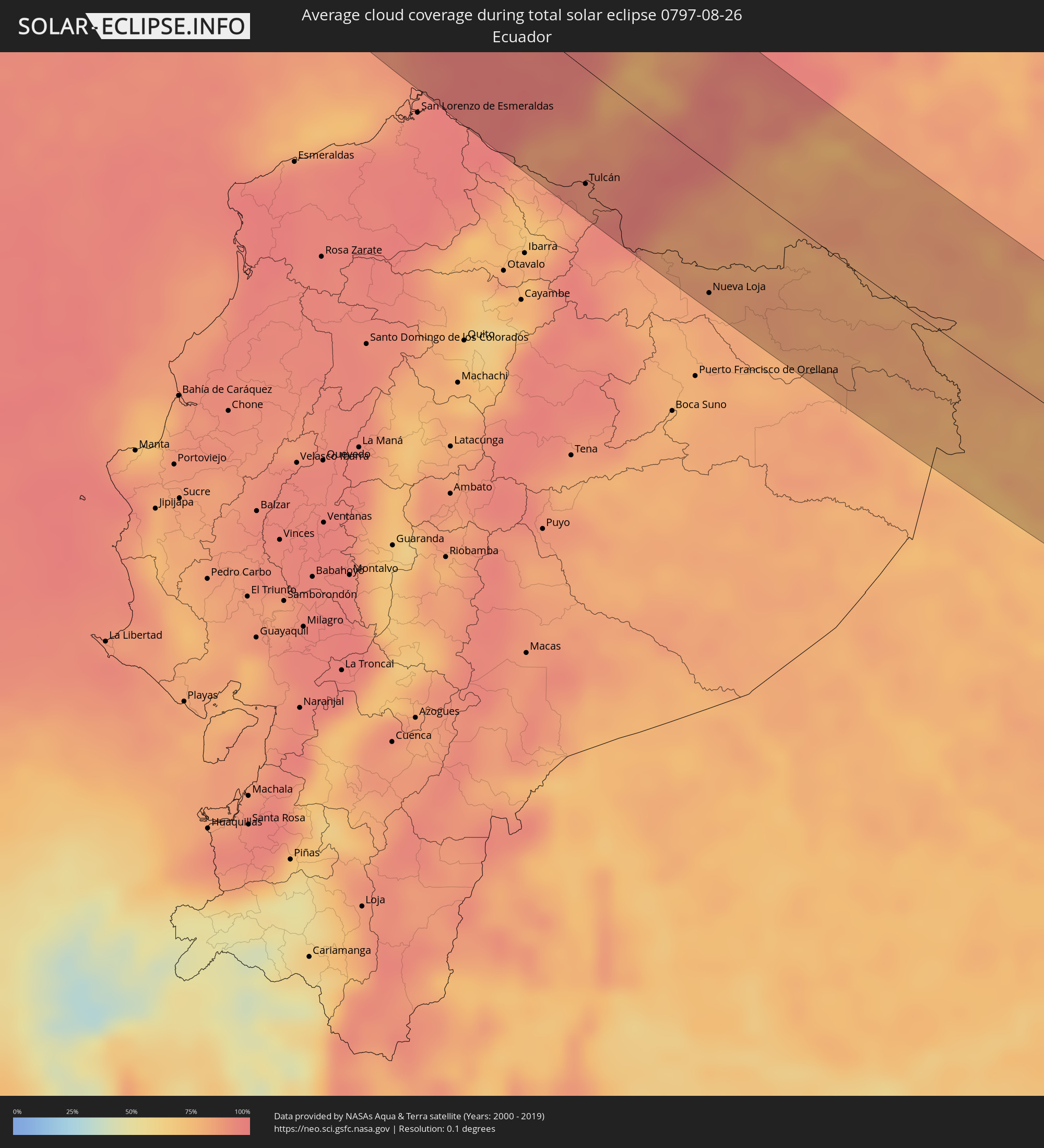 Ecuador
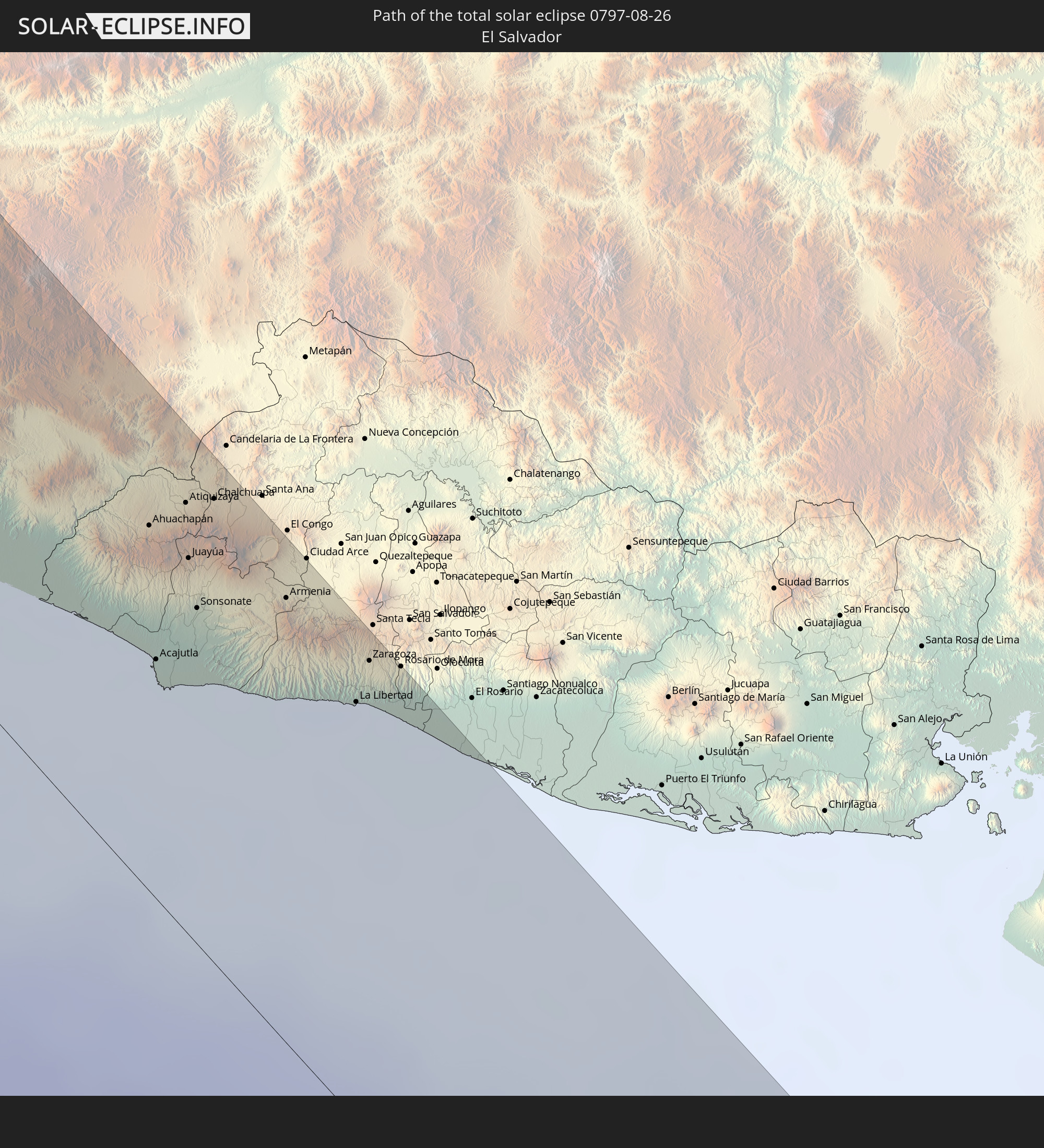
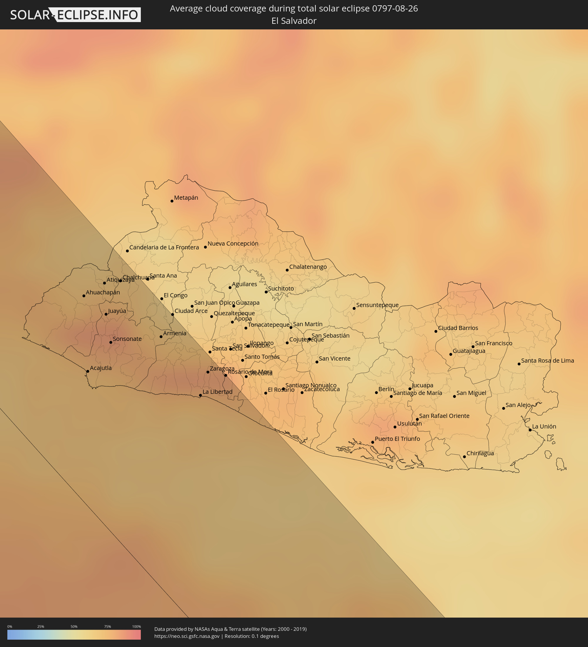 El Salvador
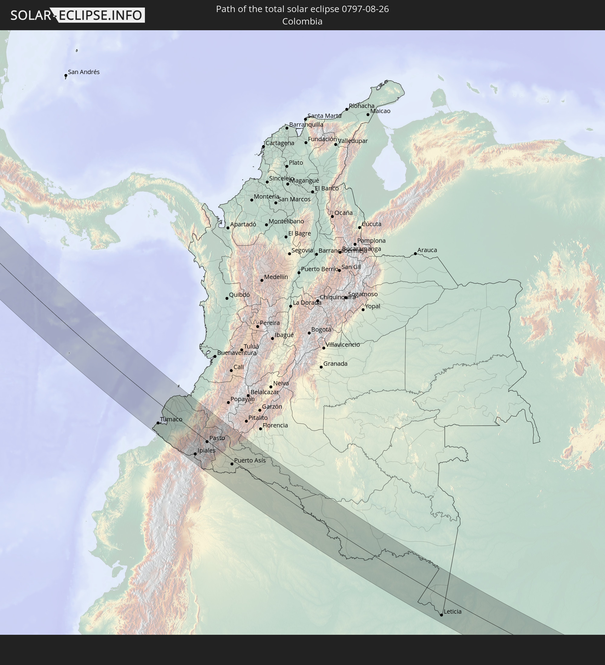
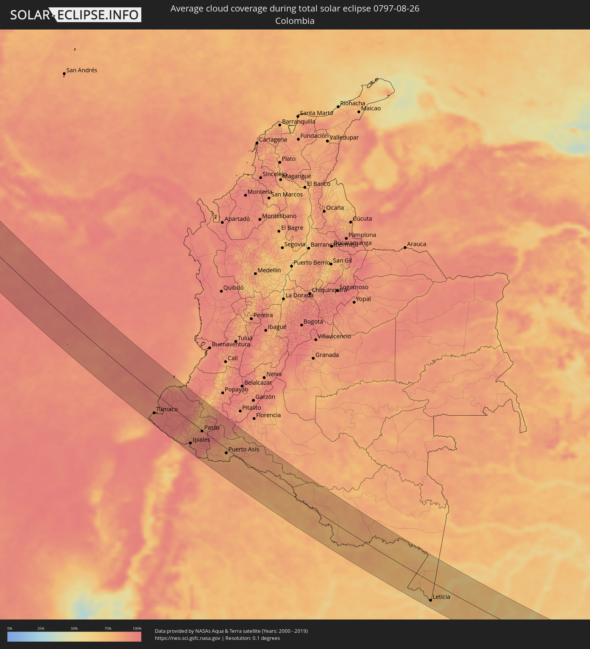 Kolumbien
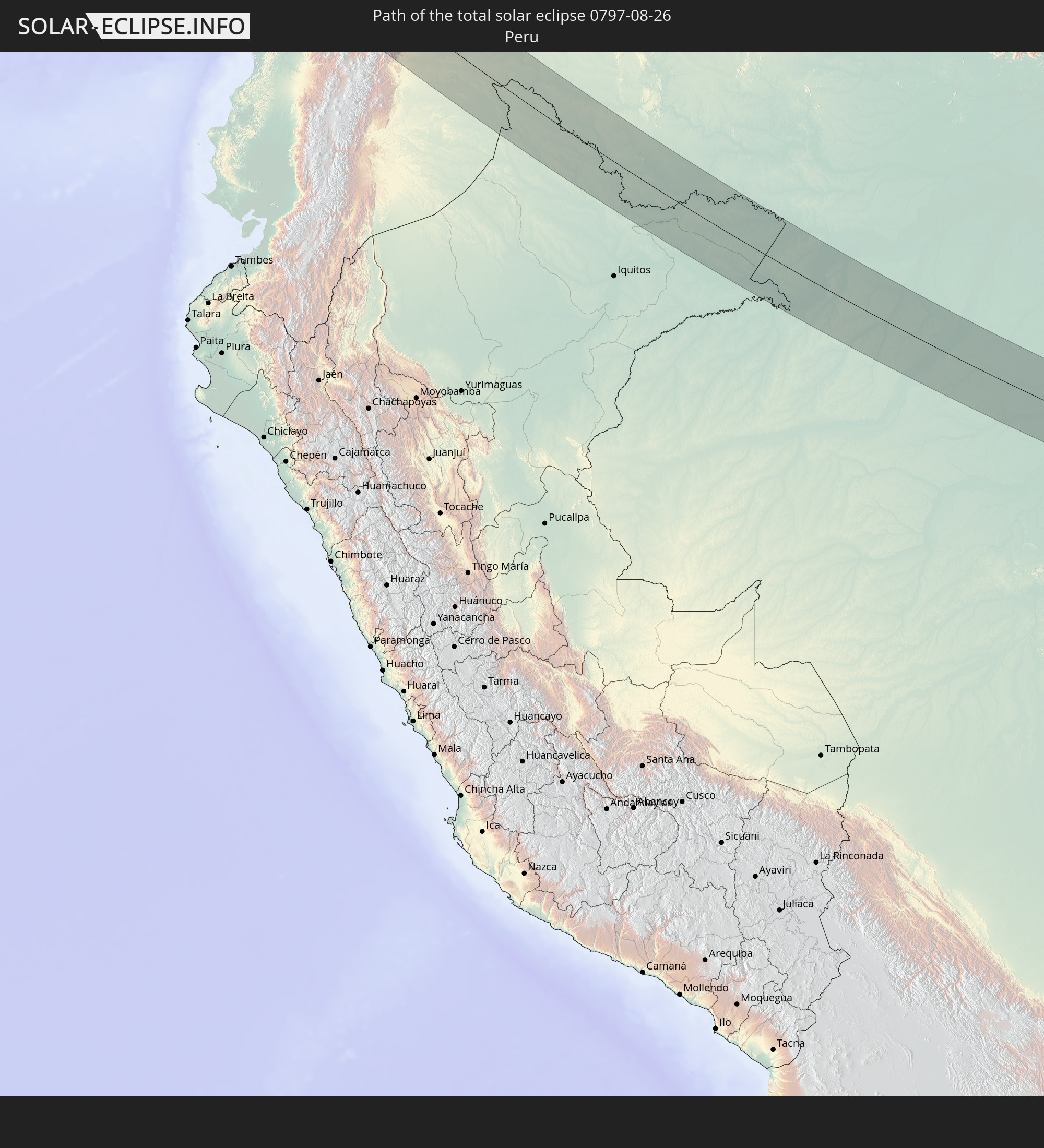
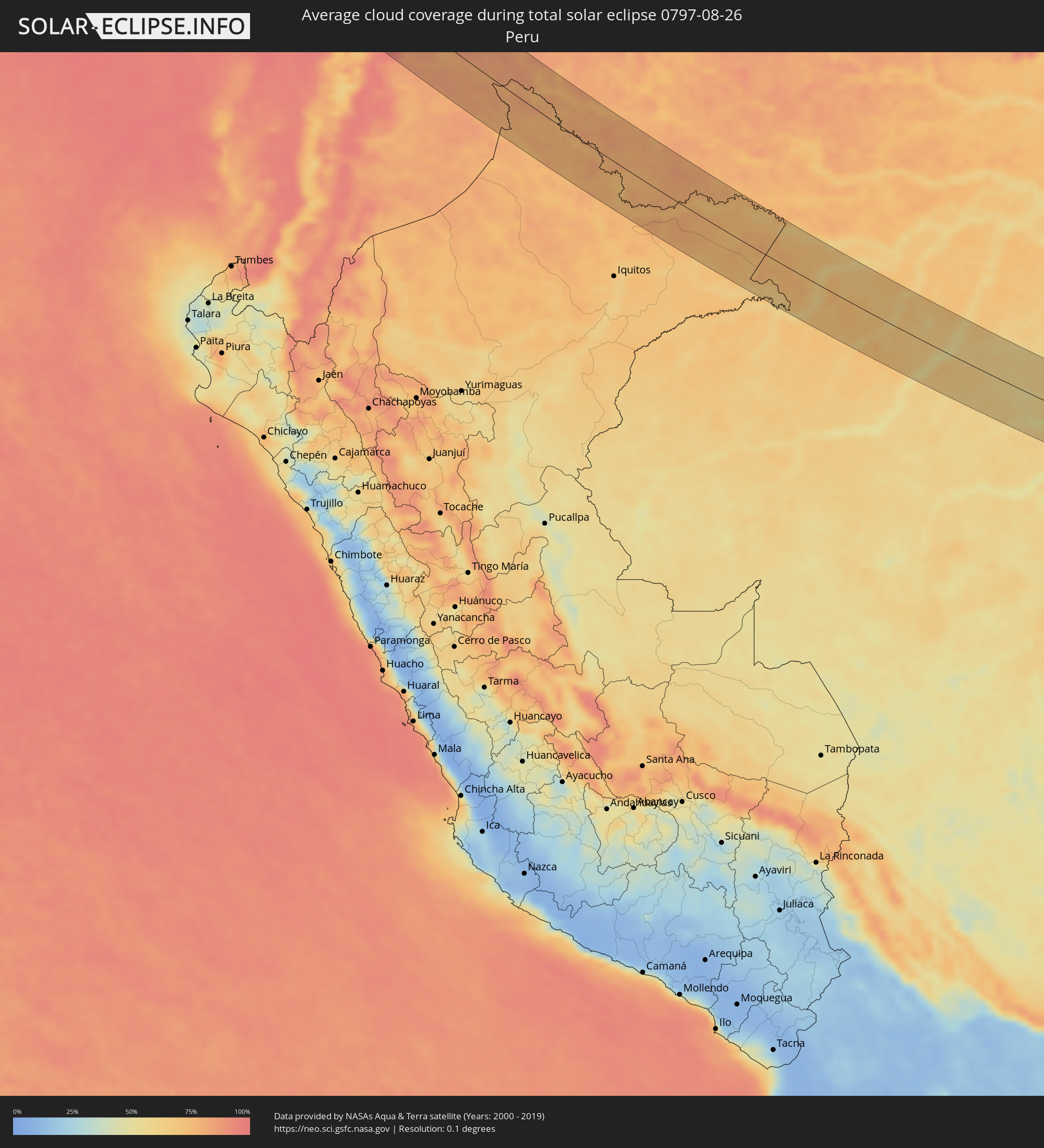 Peru
Peru
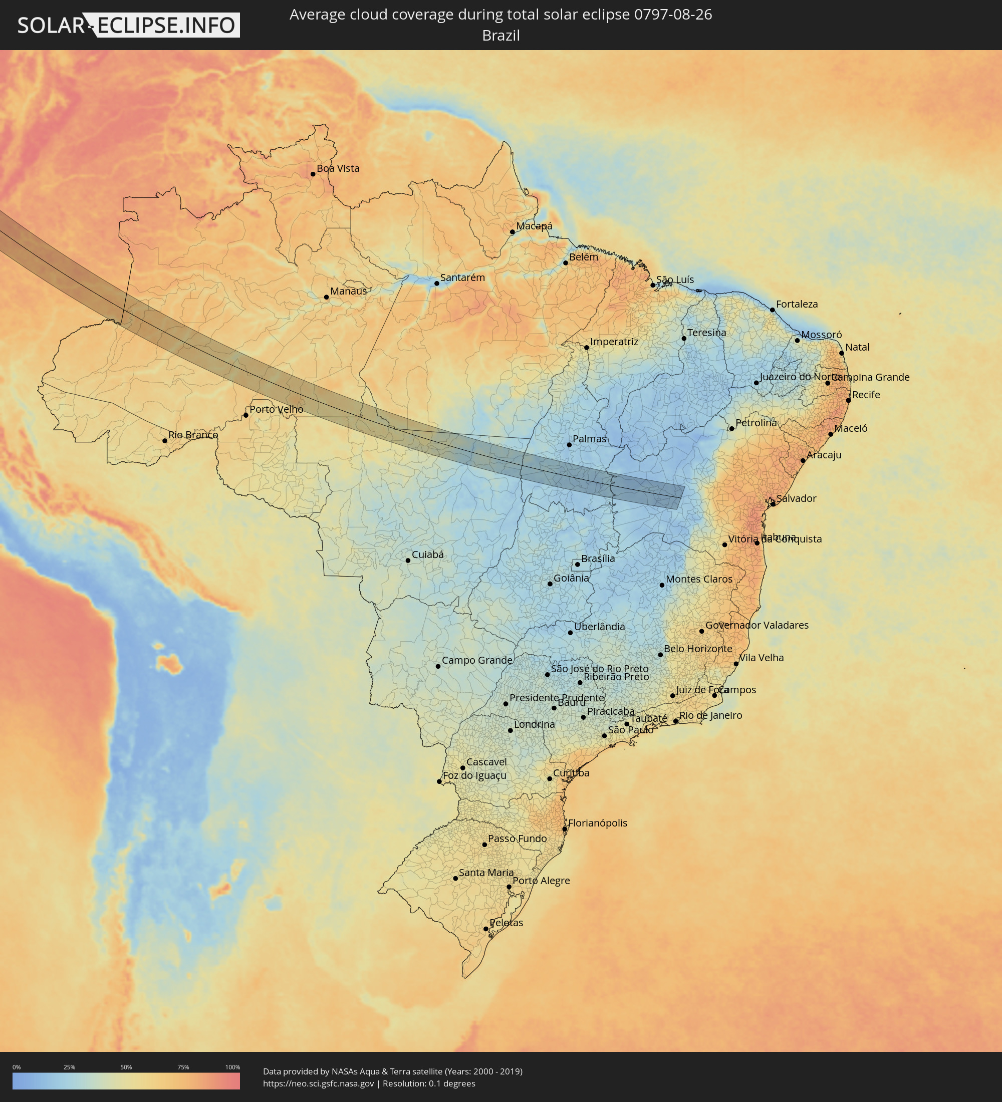 Brasilien
Orte im Finsternispfad
Die nachfolgene Tabelle zeigt Städte und Orte mit mehr als 5.000 Einwohnern, die sich im Finsternispfad befinden. Städte mit mehr als 100.000 Einwohnern sind dick gekennzeichnet. Mit einem Klick auf den Ort öffnet sich eine Detailkarte die die Lage des jeweiligen Ortes zusammen mit dem Verlauf der zentralen Finsternis präsentiert.
| Ort | Typ | Dauer der Verfinsterung | Ortszeit bei maximaler Verfinsterung | Entfernung zur Zentrallinie | Ø Bewölkung |
|
Santa Rosa, California
|
total | - | 09:58:29 UTC-08:00 | 22 km | 13% |
|
San Francisco, California
|
total | - | 09:59:19 UTC-08:00 | 77 km | 34% |
|
Berkeley, California
|
total | - | 09:59:28 UTC-08:00 | 62 km | 21% |
|
Vallejo, California
|
total | - | 09:59:21 UTC-08:00 | 38 km | 10% |
|
Hayward, California
|
total | - | 09:59:53 UTC-08:00 | 75 km | 14% |
|
Fairfield, California
|
total | - | 09:59:34 UTC-08:00 | 15 km | 8% |
|
Concord, California
|
total | - | 09:59:45 UTC-08:00 | 42 km | 6% |
|
Fremont, California
|
total | - | 10:00:06 UTC-08:00 | 83 km | 17% |
|
Antioch, California
|
total | - | 10:00:04 UTC-08:00 | 30 km | 4% |
|
Livermore, California
|
total | - | 10:00:20 UTC-08:00 | 61 km | 5% |
|
Sacramento, California
|
total | - | 10:00:09 UTC-08:00 | 39 km | 6% |
|
Tracy, California
|
total | - | 10:00:47 UTC-08:00 | 42 km | 5% |
|
Elk Grove, California
|
total | - | 10:00:26 UTC-08:00 | 27 km | 6% |
|
Stockton, California
|
total | - | 10:00:51 UTC-08:00 | 15 km | 5% |
|
Roseville, California
|
total | - | 10:00:20 UTC-08:00 | 64 km | 6% |
|
Modesto, California
|
total | - | 10:01:30 UTC-08:00 | 34 km | 5% |
|
Merced, California
|
total | - | 10:02:30 UTC-08:00 | 46 km | 6% |
|
Fresno, California
|
total | - | 10:03:59 UTC-08:00 | 71 km | 5% |
|
Paradise, Nevada
|
total | - | 10:11:46 UTC-08:00 | 80 km | 17% |
|
Henderson, Nevada
|
total | - | 10:12:05 UTC-08:00 | 83 km | 17% |
|
Peoria, Arizona
|
total | - | 11:19:17 UTC-07:00 | 1 km | 23% |
|
Phoenix, Arizona
|
total | - | 11:19:43 UTC-07:00 | 2 km | 25% |
|
Mesa, Arizona
|
total | - | 11:20:10 UTC-07:00 | 8 km | 26% |
|
San Tan Valley, Arizona
|
total | - | 11:20:57 UTC-07:00 | 5 km | 30% |
|
Tucson, Arizona
|
total | - | 11:23:13 UTC-07:00 | 47 km | 26% |
|
Agua Prieta, Sonora
|
total | - | 11:02:57 UTC-07:23 | 43 km | 33% |
|
Chihuahua, Chihuahua
|
total | - | 11:31:21 UTC-07:05 | 53 km | 52% |
|
Ciudad Delicias, Chihuahua
|
total | - | 11:33:11 UTC-07:05 | 48 km | 40% |
|
Saltillo, Coahuila
|
total | - | 12:15:02 UTC-06:36 | 45 km | 49% |
|
Matehuala, San Luis Potosí
|
total | - | 12:19:00 UTC-06:36 | 64 km | 42% |
|
Ciudad Victoria, Tamaulipas
|
total | - | 12:21:27 UTC-06:36 | 55 km | 42% |
|
Ciudad Valles, San Luis Potosí
|
total | - | 12:25:07 UTC-06:36 | 68 km | 61% |
|
Ciudad Mante, Tamaulipas
|
total | - | 12:23:42 UTC-06:36 | 7 km | 58% |
|
Gustavo A. Madero, Tamaulipas
|
total | - | 12:23:49 UTC-06:36 | 18 km | 61% |
|
Tantoyuca, Veracruz
|
total | - | 12:27:45 UTC-06:36 | 54 km | 74% |
|
Tampico, Tamaulipas
|
total | - | 12:26:32 UTC-06:36 | 42 km | 63% |
|
Temapache, Veracruz
|
total | - | 12:29:20 UTC-06:36 | 31 km | 79% |
|
Poza Rica de Hidalgo, Veracruz
|
total | - | 12:30:43 UTC-06:36 | 56 km | 81% |
|
Tuxpan de Rodríguez Cano, Veracruz
|
total | - | 12:29:57 UTC-06:36 | 20 km | 65% |
|
Martínez de la Torre, Veracruz
|
total | - | 12:32:20 UTC-06:36 | 59 km | 83% |
|
Xalapa de Enríquez, Veracruz
|
total | - | 12:33:41 UTC-06:36 | 87 km | 76% |
|
Veracruz, Veracruz
|
total | - | 12:35:43 UTC-06:36 | 52 km | 75% |
|
Minatitlan, Veracruz
|
total | - | 12:40:49 UTC-06:36 | 13 km | 84% |
|
Coatzacoalcos, Veracruz
|
total | - | 12:40:44 UTC-06:36 | 6 km | 83% |
|
Cárdenas, Tabasco
|
total | - | 12:42:46 UTC-06:36 | 81 km | 81% |
|
Tuxtla, Chiapas
|
total | - | 12:45:45 UTC-06:36 | 12 km | 81% |
|
San Cristóbal de las Casas, Chiapas
|
total | - | 12:46:34 UTC-06:36 | 48 km | 83% |
|
Tapachula, Chiapas
|
total | - | 12:50:57 UTC-06:36 | 56 km | 84% |
|
Comitán, Chiapas
|
total | - | 12:48:23 UTC-06:36 | 53 km | 71% |
|
Las Margaritas, Chiapas
|
total | - | 12:48:30 UTC-06:36 | 70 km | 66% |
|
Coatepeque, Quetzaltenango
|
total | - | 13:26:32 UTC-06:02 | 39 km | 80% |
|
San Pedro Sacatepéquez, San Marcos
|
total | - | 13:26:08 UTC-06:02 | 11 km | 88% |
|
Jacaltenango, Huehuetenango
|
total | - | 13:24:45 UTC-06:02 | 43 km | 87% |
|
Retalhuleu, Retalhuleu
|
total | - | 13:27:10 UTC-06:02 | 36 km | 83% |
|
Quetzaltenango, Quetzaltenango
|
total | - | 13:26:48 UTC-06:02 | 1 km | 88% |
|
Mazatenango, Suchitepeque
|
total | - | 13:27:27 UTC-06:02 | 22 km | 78% |
|
Huehuetenango, Huehuetenango
|
total | - | 13:25:53 UTC-06:02 | 38 km | 68% |
|
Momostenango, Totonicapán
|
total | - | 13:26:33 UTC-06:02 | 23 km | 80% |
|
Totonicapán, Totonicapán
|
total | - | 13:26:54 UTC-06:02 | 17 km | 83% |
|
Santiago Atitlán, Sololá
|
total | - | 13:27:40 UTC-06:02 | 8 km | 89% |
|
Sololá, Sololá
|
total | - | 13:27:28 UTC-06:02 | 21 km | 77% |
|
Nebaj, Quiché
|
total | - | 13:26:13 UTC-06:02 | 71 km | 79% |
|
Chichicastenango, Quiché
|
total | - | 13:27:14 UTC-06:02 | 39 km | 82% |
|
La Gomera, Escuintla
|
total | - | 13:29:05 UTC-06:02 | 19 km | 79% |
|
Santa Lucía Cotzumalguapa, Escuintla
|
total | - | 13:28:38 UTC-06:02 | 3 km | 83% |
|
Chimaltenango, Chimaltenango
|
total | - | 13:28:16 UTC-06:02 | 43 km | 79% |
|
Escuintla, Escuintla
|
total | - | 13:29:03 UTC-06:02 | 19 km | 84% |
|
Ciudad Vieja, Sacatepéquez
|
total | - | 13:28:38 UTC-06:02 | 38 km | 88% |
|
San Juan Sacatepéquez, Guatemala
|
total | - | 13:28:25 UTC-06:02 | 61 km | 80% |
|
Petapa, Guatemala
|
total | - | 13:29:00 UTC-06:02 | 53 km | 80% |
|
Guatemala City, Guatemala
|
total | - | 13:28:47 UTC-06:02 | 66 km | 79% |
|
San Pedro Ayampuc, Guatemala
|
total | - | 13:28:35 UTC-06:02 | 82 km | 72% |
|
San José Pinula, Guatemala
|
total | - | 13:29:08 UTC-06:02 | 67 km | 81% |
|
Barberena, Santa Rosa
|
total | - | 13:29:42 UTC-06:02 | 54 km | 76% |
|
Tacuba, Ahuachapán
|
total | - | 13:36:28 UTC-05:56 | 58 km | 83% |
|
Jutiapa, Jutiapa
|
total | - | 13:30:27 UTC-06:02 | 90 km | 64% |
|
Concepción de Ataco, Ahuachapán
|
total | - | 13:36:39 UTC-05:56 | 63 km | 84% |
|
Ahuachapán, Ahuachapán
|
total | - | 13:36:33 UTC-05:56 | 67 km | 84% |
|
Acajutla, Sonsonate
|
total | - | 13:37:15 UTC-05:56 | 44 km | 70% |
|
Atiquizaya, Ahuachapán
|
total | - | 13:36:35 UTC-05:56 | 78 km | 77% |
|
Juayúa, Sonsonate
|
total | - | 13:36:52 UTC-05:56 | 69 km | 80% |
|
San Antonio del Monte, Sonsonate
|
total | - | 13:37:08 UTC-05:56 | 60 km | 74% |
|
Nahuizalco, Sonsonate
|
total | - | 13:37:01 UTC-05:56 | 65 km | 80% |
|
Sonsonate, Sonsonate
|
total | - | 13:37:09 UTC-05:56 | 61 km | 74% |
|
Sonzacate, Sonsonate
|
total | - | 13:37:08 UTC-05:56 | 63 km | 74% |
|
Chalchuapa, Santa Ana
|
total | - | 13:36:40 UTC-05:56 | 85 km | 76% |
|
Izalco, Sonsonate
|
total | - | 13:37:11 UTC-05:56 | 67 km | 74% |
|
Armenia, Sonsonate
|
total | - | 13:37:27 UTC-05:56 | 81 km | 82% |
|
La Libertad, La Libertad
|
total | - | 13:38:14 UTC-05:56 | 77 km | 69% |
|
Zaragoza, La Libertad
|
total | - | 13:38:05 UTC-05:56 | 87 km | 75% |
|
Rosario de Mora, San Salvador
|
total | - | 13:38:14 UTC-05:56 | 92 km | 77% |
|
Tumaco, Nariño
|
total | - | 15:14:26 UTC-04:56 | 56 km | 93% |
|
Barbacoas, Nariño
|
total | - | 15:15:22 UTC-04:56 | 21 km | 95% |
|
El Charco, Nariño
|
total | - | 15:14:06 UTC-04:56 | 52 km | 93% |
|
Guapi, Cauca
|
total | - | 15:14:11 UTC-04:56 | 76 km | 91% |
|
Cumbal, Nariño
|
total | - | 15:16:58 UTC-04:56 | 64 km | 90% |
|
Tulcán, Carchi
|
total | - | 14:59:27 UTC-05:14 | 68 km | 89% |
|
Ipiales, Nariño
|
total | - | 15:17:14 UTC-04:56 | 61 km | 92% |
|
Pupiales, Nariño
|
total | - | 15:17:11 UTC-04:56 | 57 km | 90% |
|
Túquerres, Nariño
|
total | - | 15:16:51 UTC-04:56 | 36 km | 87% |
|
Samaniego, Nariño
|
total | - | 15:16:29 UTC-04:56 | 13 km | 82% |
|
Olaya Herrera, Nariño
|
total | - | 15:16:44 UTC-04:56 | 14 km | 87% |
|
Sandoná, Nariño
|
total | - | 15:16:42 UTC-04:56 | 9 km | 84% |
|
El Tambo, Nariño
|
total | - | 15:16:34 UTC-04:56 | 8 km | 80% |
|
Pasto, Nariño
|
total | - | 15:17:01 UTC-04:56 | 3 km | 92% |
|
La Unión, Nariño
|
total | - | 15:16:33 UTC-04:56 | 42 km | 86% |
|
La Cruz, Cauca
|
total | - | 15:16:43 UTC-04:56 | 53 km | 89% |
|
Sibundoy, Putumayo
|
total | - | 15:17:24 UTC-04:56 | 21 km | 94% |
|
Valle del Guamuez, Putumayo
|
total | - | 15:18:34 UTC-04:56 | 46 km | 85% |
|
San Miguel, Putumayo
|
total | - | 15:18:45 UTC-04:56 | 55 km | 81% |
|
Nueva Loja, Sucumbios
|
total | - | 15:01:26 UTC-05:14 | 77 km | 84% |
|
Orito, Putumayo
|
total | - | 15:18:17 UTC-04:56 | 24 km | 83% |
|
Mocoa, Putumayo
|
total | - | 15:17:45 UTC-04:56 | 34 km | 91% |
|
Villagarzón, Putumayo
|
total | - | 15:17:58 UTC-04:56 | 26 km | 84% |
|
Puerto Asís, Putumayo
|
total | - | 15:18:54 UTC-04:56 | 13 km | 76% |
|
Curillo, Caquetá
|
total | - | 15:18:41 UTC-04:56 | 72 km | 78% |
|
Puerto Leguízamo, Putumayo
|
total | - | 15:21:39 UTC-04:56 | 34 km | 76% |
|
Benjamin Constant, Amazonas
|
total | - | 16:24:57 UTC-04:02 | 79 km | 69% |
|
Ramón Castilla, Loreto
|
total | - | 15:18:56 UTC-05:08 | 64 km | 61% |
|
Leticia, Amazonas
|
total | - | 16:24:49 UTC-04:02 | 59 km | 69% |
|
Tabatinga, Amazonas
|
total | - | 16:24:51 UTC-04:02 | 60 km | 69% |
|
São Paulo de Olivença, Amazonas
|
total | - | 16:24:33 UTC-04:02 | 80 km | 62% |
|
Carauari, Amazonas
|
total | - | 16:27:43 UTC-04:02 | 35 km | 56% |
|
Canutama, Amazonas
|
total | - | 16:31:03 UTC-04:02 | 10 km | 53% |
|
Humaitá, Amazonas
|
total | - | 16:32:45 UTC-04:02 | 50 km | 56% |
|
Gurupi, Tocantins
|
total | - | 18:08:39 UTC-02:34 | 28 km | 22% |
|
Taguatinga, Tocantins
|
total | - | 18:09:09 UTC-02:34 | 41 km | 22% |
|
Barreiras, Bahia
|
total | - | 18:08:58 UTC-02:34 | 16 km | 20% |
|
São Desidério, Bahia
|
total | - | 18:09:06 UTC-02:34 | 7 km | 19% |
|
Riachão das Neves, Bahia
|
total | - | 18:08:44 UTC-02:34 | 62 km | 13% |
|
Ibotirama, Bahia
|
total | - | 18:08:53 UTC-02:34 | 46 km | 16% |
|
Paratinga, Bahia
|
total | - | 18:09:10 UTC-02:34 | 21 km | 18% |
|
Oliveira dos Brejinhos, Bahia
|
total | - | 18:08:56 UTC-02:34 | 37 km | 15% |