Totale Sonnenfinsternis vom 13.04.0804
| Wochentag: | Dienstag |
| Maximale Dauer der Verfinsterung: | 06m03s |
| Maximale Breite des Finsternispfades: | 250 km |
| Saroszyklus: | 90 |
| Bedeckungsgrad: | 100% |
| Magnitude: | 1.0732 |
| Gamma: | 0.3118 |
Wo kann man die Sonnenfinsternis vom 13.04.0804 sehen?
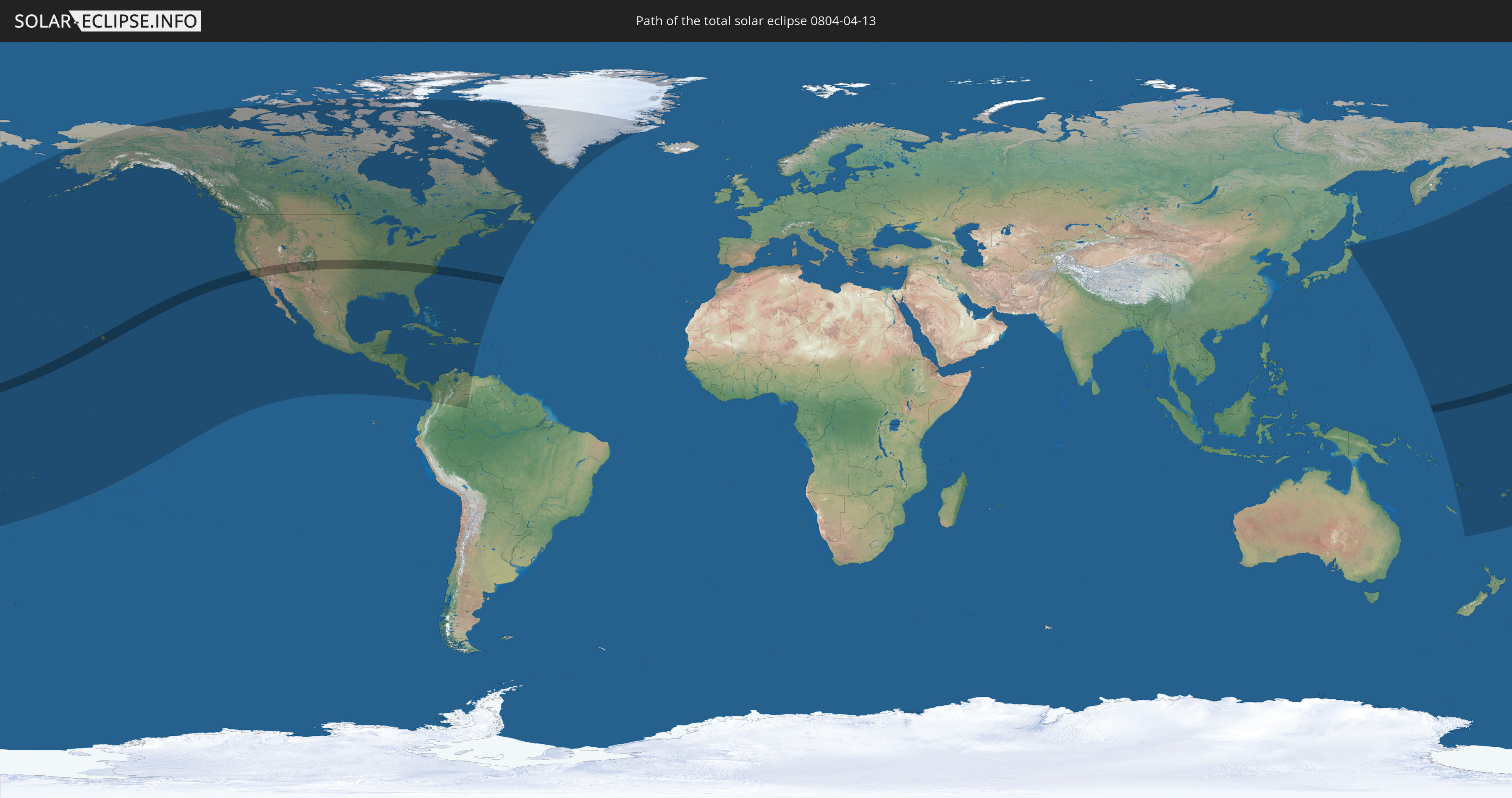
Die Sonnenfinsternis am 13.04.0804 kann man in 43 Ländern als partielle Sonnenfinsternis beobachten.
Der Finsternispfad verläuft durch 2 Länder. Nur in diesen Ländern ist sie als totale Sonnenfinsternis zu sehen.
In den folgenden Ländern ist die Sonnenfinsternis total zu sehen
 Vereinigte Staaten
 Marshallinseln
In den folgenden Ländern ist die Sonnenfinsternis partiell zu sehen
 Fidschi
 Vereinigte Staaten
 United States Minor Outlying Islands
 Wallis und Futuna
 Tonga
Tonga
 Kiribati
 Samoa
Samoa
 Tokelau
 Amerikanisch-Samoa
 Niue
Niue
 Cookinseln
 Französisch-Polynesien
 Kanada
 Mexiko
 Grönland
 Guatemala
 El Salvador
 Honduras
 Belize
 Nicaragua
 Costa Rica
 Kuba
Kuba
 Panama
 Kolumbien
 Kaimaninseln
 Bahamas
 Jamaika
 Haiti
Haiti
 Venezuela
 Turks- und Caicosinseln
 Dominikanische Republik
 Aruba
Aruba
 Puerto Rico
 Bermuda
 Saint-Pierre und Miquelon
 Japan
Japan
 Föderierte Staaten von Mikronesien
 Salomonen
 Neukaledonien
 Marshallinseln
 Vanuatu
 Nauru
Nauru
 Tuvalu
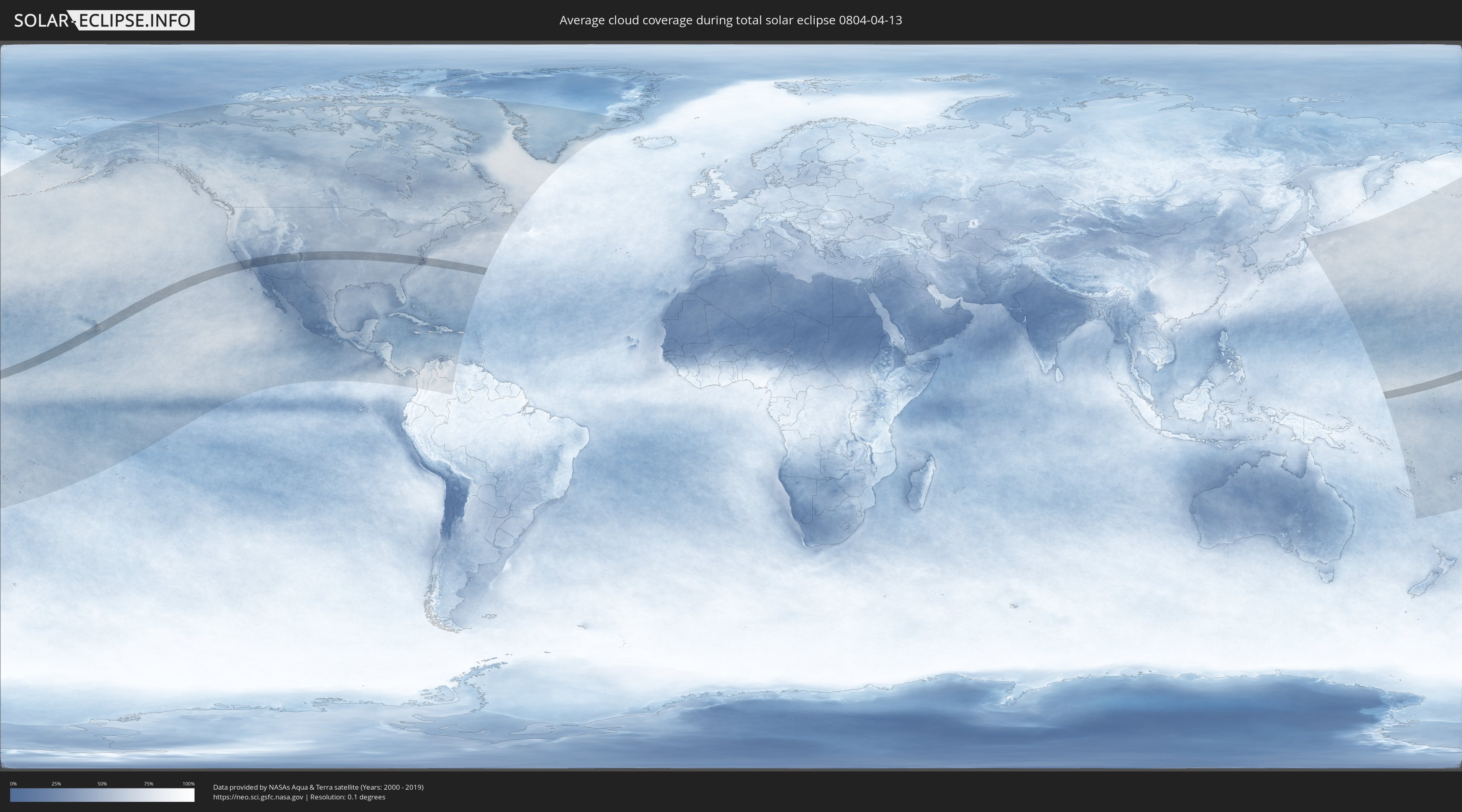
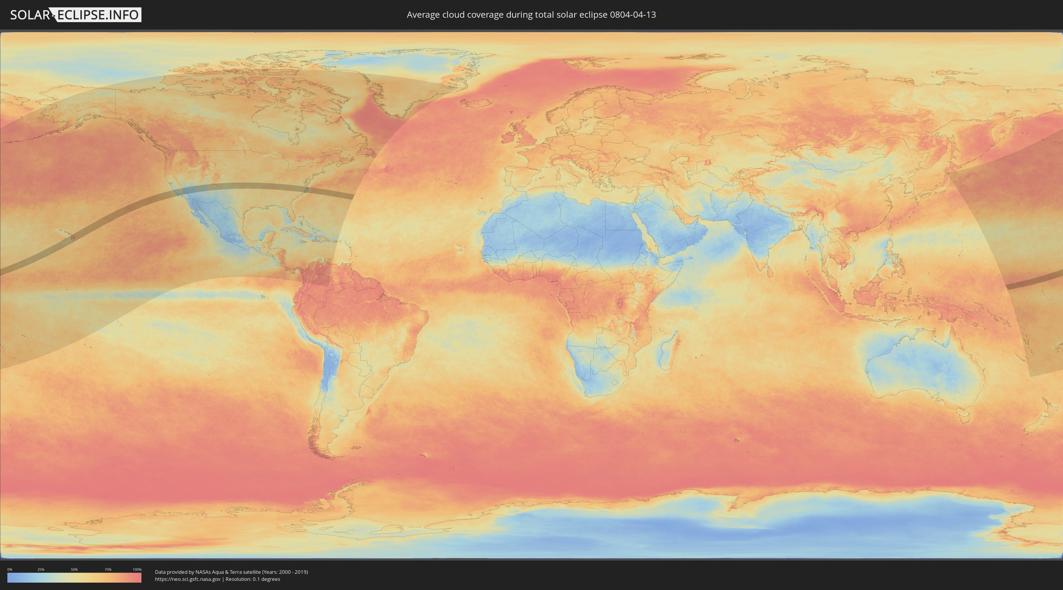
Wie wird das Wetter während der totalen Sonnenfinsternis am 13.04.0804?
Wo ist der beste Ort, um die totale Sonnenfinsternis vom 13.04.0804 zu beobachten?
Die folgenden Karten zeigen die durchschnittliche Bewölkung für den Tag, an dem die totale Sonnenfinsternis
stattfindet. Mit Hilfe der Karten lässt sich der Ort entlang des Finsternispfades eingrenzen,
der die besten Aussichen auf einen klaren wolkenfreien Himmel bietet.
Trotzdem muss man immer lokale Gegenenheiten beachten und sollte sich genau über das Wetter an seinem
gewählten Beobachtungsort informieren.
Die Daten stammen von den beiden NASA-Satelliten
AQUA und TERRA
und wurden über einen Zeitraum von 19 Jahren (2000 - 2019) gemittelt.
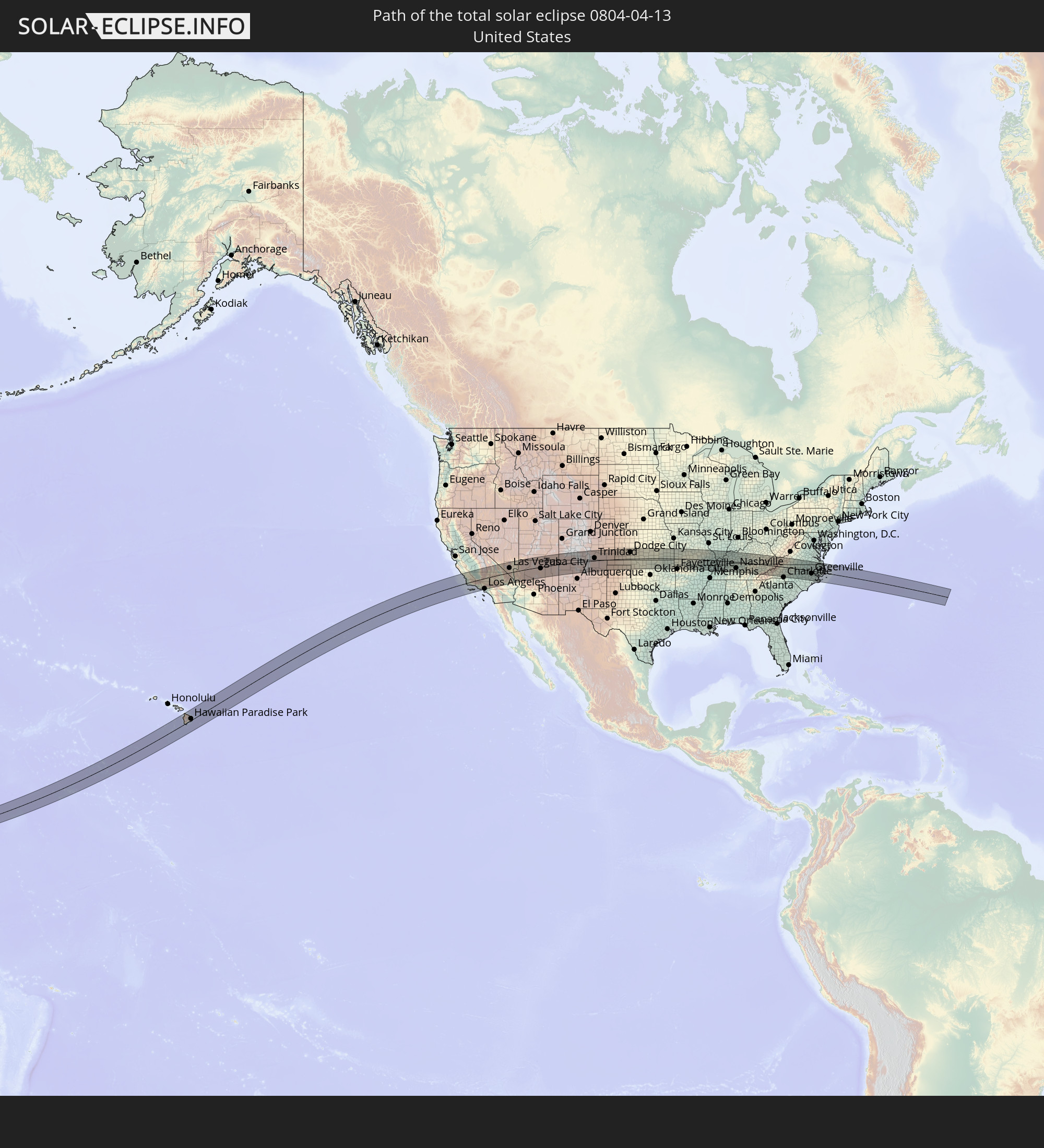
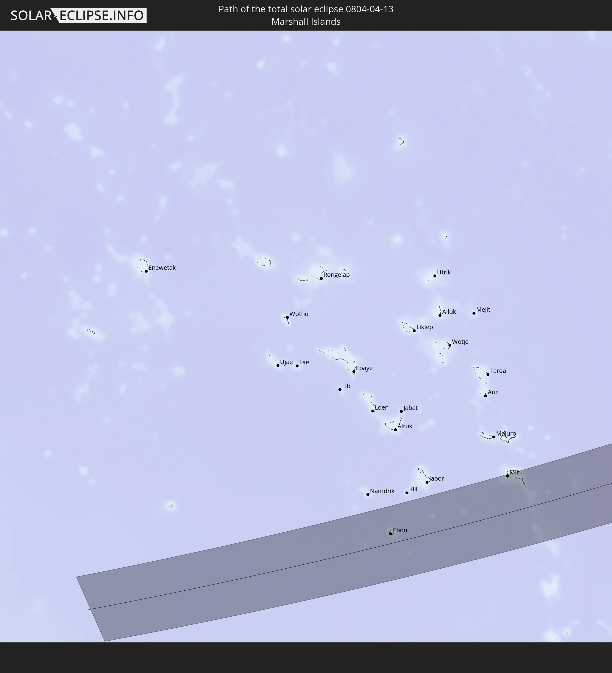
Detaillierte Länderkarten
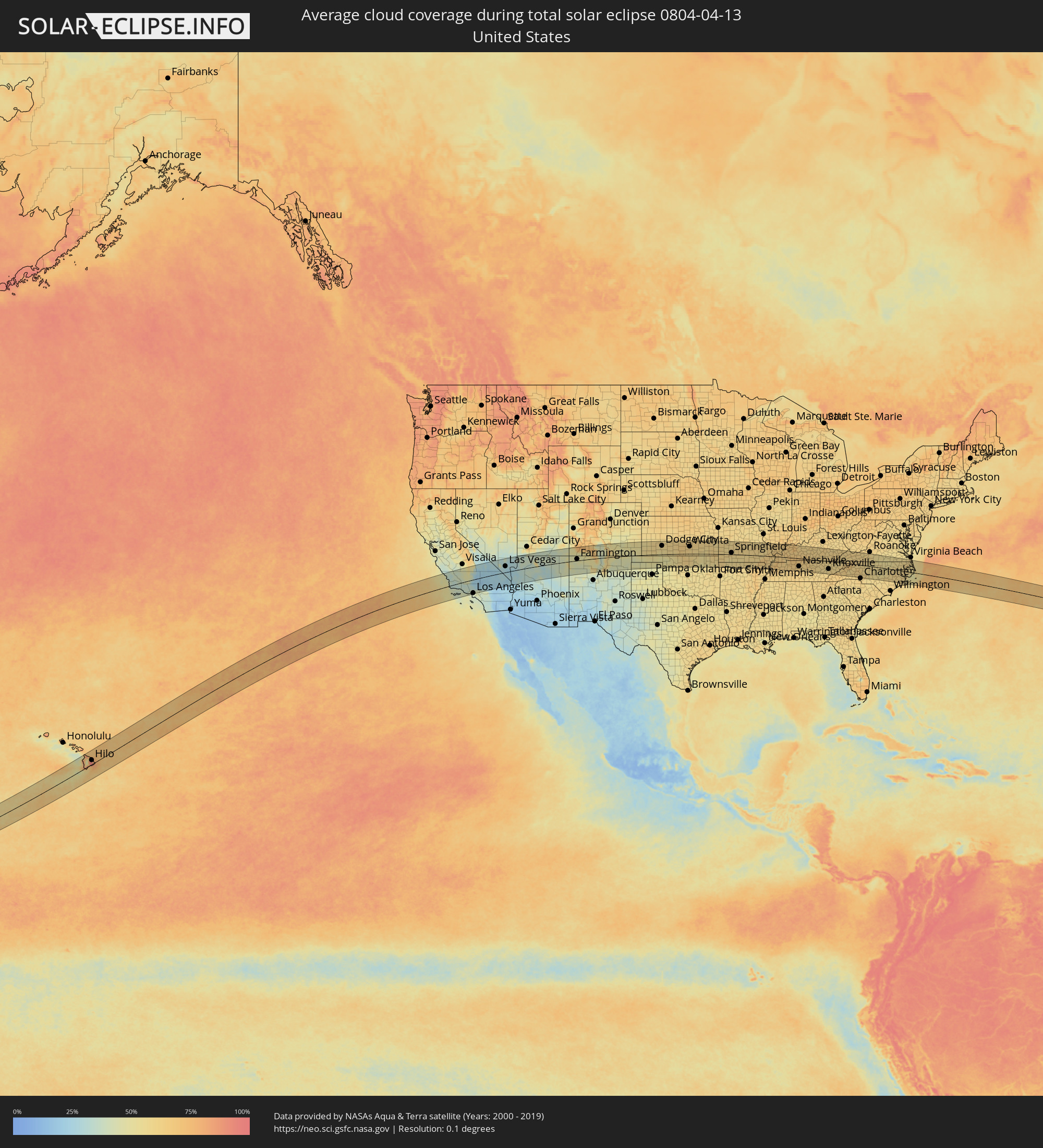 Vereinigte Staaten
 Marshallinseln
Orte im Finsternispfad
Die nachfolgene Tabelle zeigt Städte und Orte mit mehr als 5.000 Einwohnern, die sich im Finsternispfad befinden. Städte mit mehr als 100.000 Einwohnern sind dick gekennzeichnet. Mit einem Klick auf den Ort öffnet sich eine Detailkarte die die Lage des jeweiligen Ortes zusammen mit dem Verlauf der zentralen Finsternis präsentiert.
| Ort | Typ | Dauer der Verfinsterung | Ortszeit bei maximaler Verfinsterung | Entfernung zur Zentrallinie | Ø Bewölkung |
|
Hilo, Hawaii
|
total | - | 09:34:33 UTC-10:30 | 35 km | 92% |
|
Paso Robles, California
|
total | - | 13:34:57 UTC-08:00 | 111 km | 37% |
|
Atascadero, California
|
total | - | 13:34:57 UTC-08:00 | 95 km | 35% |
|
San Luis Obispo, California
|
total | - | 13:34:55 UTC-08:00 | 73 km | 33% |
|
Lompoc, California
|
total | - | 13:35:07 UTC-08:00 | 1 km | 38% |
|
Santa Maria, California
|
total | - | 13:35:15 UTC-08:00 | 32 km | 38% |
|
Santa Barbara, California
|
total | - | 13:36:32 UTC-08:00 | 43 km | 40% |
|
Wasco, California
|
total | - | 13:37:29 UTC-08:00 | 75 km | 42% |
|
Delano, California
|
total | - | 13:37:42 UTC-08:00 | 92 km | 44% |
|
Oxnard, California
|
total | - | 13:37:29 UTC-08:00 | 79 km | 38% |
|
Santa Paula, California
|
total | - | 13:37:45 UTC-08:00 | 65 km | 35% |
|
Bakersfield, California
|
total | - | 13:38:03 UTC-08:00 | 44 km | 47% |
|
Porterville, California
|
total | - | 13:38:11 UTC-08:00 | 118 km | 49% |
|
Thousand Oaks, California
|
total | - | 13:38:07 UTC-08:00 | 90 km | 36% |
|
West Hills, California
|
total | - | 13:38:30 UTC-08:00 | 91 km | 38% |
|
Santa Clarita, California
|
total | - | 13:38:44 UTC-08:00 | 73 km | 36% |
|
Santa Monica, California
|
total | - | 13:38:45 UTC-08:00 | 114 km | 41% |
|
Van Nuys, California
|
total | - | 13:38:53 UTC-08:00 | 97 km | 38% |
|
Los Angeles, California
|
total | - | 13:39:14 UTC-08:00 | 116 km | 42% |
|
Lancaster, California
|
total | - | 13:39:34 UTC-08:00 | 49 km | 26% |
|
Altadena, California
|
total | - | 13:39:29 UTC-08:00 | 104 km | 45% |
|
El Monte, California
|
total | - | 13:39:39 UTC-08:00 | 119 km | 43% |
|
Glendora, California
|
total | - | 13:39:59 UTC-08:00 | 115 km | 43% |
|
Ridgecrest, California
|
total | - | 13:40:35 UTC-08:00 | 41 km | 23% |
|
Victorville, California
|
total | - | 13:41:08 UTC-08:00 | 85 km | 28% |
|
Barstow Heights, California
|
total | - | 13:41:37 UTC-08:00 | 53 km | 22% |
|
Pahrump, Nevada
|
total | - | 13:43:41 UTC-08:00 | 71 km | 28% |
|
Enterprise, Nevada
|
total | - | 13:44:58 UTC-08:00 | 37 km | 26% |
|
Las Vegas, Nevada
|
total | - | 13:45:10 UTC-08:00 | 51 km | 29% |
|
Henderson, Nevada
|
total | - | 13:45:26 UTC-08:00 | 34 km | 25% |
|
Bullhead City, Arizona
|
total | - | 14:46:08 UTC-07:00 | 71 km | 27% |
|
Kingman, Arizona
|
total | - | 14:47:03 UTC-07:00 | 75 km | 29% |
|
Flagstaff, Arizona
|
total | - | 14:51:08 UTC-07:00 | 113 km | 35% |
|
Farmington, New Mexico
|
total | - | 14:56:16 UTC-07:00 | 13 km | 44% |
|
Garden City, Kansas
|
total | - | 16:05:35 UTC-06:00 | 99 km | 59% |
|
Dodge City, Kansas
|
total | - | 16:06:41 UTC-06:00 | 72 km | 57% |
|
Hutchinson, Kansas
|
total | - | 16:08:50 UTC-06:00 | 103 km | 61% |
|
Enid, Oklahoma
|
total | - | 16:09:49 UTC-06:00 | 82 km | 60% |
|
Wichita, Kansas
|
total | - | 16:09:40 UTC-06:00 | 62 km | 63% |
|
Derby, Kansas
|
total | - | 16:09:50 UTC-06:00 | 45 km | 60% |
|
Ponca City, Oklahoma
|
total | - | 16:10:30 UTC-06:00 | 48 km | 58% |
|
Tulsa, Oklahoma
|
total | - | 16:11:58 UTC-06:00 | 109 km | 53% |
|
Bartlesville, Oklahoma
|
total | - | 16:11:38 UTC-06:00 | 43 km | 53% |
|
Owasso, Oklahoma
|
total | - | 16:12:02 UTC-06:00 | 96 km | 53% |
|
Joplin, Missouri
|
total | - | 16:12:52 UTC-06:00 | 4 km | 59% |
|
Bella Vista, Arkansas
|
total | - | 16:13:28 UTC-06:00 | 71 km | 59% |
|
Springdale, Arkansas
|
total | - | 16:13:47 UTC-06:00 | 103 km | 60% |
|
Rogers, Arkansas
|
total | - | 16:13:43 UTC-06:00 | 87 km | 60% |
|
Springfield, Missouri
|
total | - | 16:13:55 UTC-06:00 | 14 km | 61% |
|
Paragould, Arkansas
|
total | - | 16:17:05 UTC-06:00 | 104 km | 63% |
|
Cape Girardeau, Missouri
|
total | - | 16:17:00 UTC-06:00 | 40 km | 62% |
|
Carbondale, Illinois
|
total | - | 16:16:56 UTC-06:00 | 89 km | 61% |
|
Paducah, Kentucky
|
total | - | 16:17:51 UTC-06:00 | 21 km | 63% |
|
Hopkinsville, Kentucky
|
total | - | 16:18:48 UTC-06:00 | 4 km | 68% |
|
Clarksville, Tennessee
|
total | - | 16:19:07 UTC-06:00 | 32 km | 67% |
|
Owensboro, Kentucky
|
total | - | 16:18:24 UTC-06:00 | 108 km | 66% |
|
Franklin, Tennessee
|
total | - | 16:19:53 UTC-06:00 | 96 km | 63% |
|
Nashville, Tennessee
|
total | - | 16:19:46 UTC-06:00 | 68 km | 62% |
|
Hendersonville, Tennessee
|
total | - | 16:19:47 UTC-06:00 | 52 km | 61% |
|
Smyrna, Tennessee
|
total | - | 16:20:05 UTC-06:00 | 87 km | 59% |
|
Gallatin, Tennessee
|
total | - | 16:19:50 UTC-06:00 | 41 km | 62% |
|
Bowling Green, Kentucky
|
total | - | 16:19:25 UTC-06:00 | 26 km | 65% |
|
Murfreesboro, Tennessee
|
total | - | 16:20:16 UTC-06:00 | 101 km | 60% |
|
Lebanon, Tennessee
|
total | - | 16:20:04 UTC-06:00 | 60 km | 62% |
|
Elizabethtown, Kentucky
|
total | - | 17:19:16 UTC-05:00 | 108 km | 62% |
|
Cookeville, Tennessee
|
total | - | 16:20:37 UTC-06:00 | 58 km | 61% |
|
Oak Ridge, Tennessee
|
total | - | 17:21:28 UTC-05:00 | 64 km | 57% |
|
Maryville, Tennessee
|
total | - | 17:21:49 UTC-05:00 | 89 km | 58% |
|
Knoxville, Tennessee
|
total | - | 17:21:42 UTC-05:00 | 66 km | 57% |
|
Morristown, Tennessee
|
total | - | 17:21:52 UTC-05:00 | 32 km | 58% |
|
Kingsport, Tennessee
|
total | - | 17:22:01 UTC-05:00 | 12 km | 59% |
|
Asheville, North Carolina
|
total | - | 17:22:43 UTC-05:00 | 93 km | 61% |
|
Johnson City, Tennessee
|
total | - | 17:22:18 UTC-05:00 | 12 km | 63% |
|
Bristol, Tennessee
|
total | - | 17:22:11 UTC-05:00 | 21 km | 60% |
|
Hickory, North Carolina
|
total | - | 17:23:14 UTC-05:00 | 65 km | 62% |
|
Statesville, North Carolina
|
total | - | 17:23:25 UTC-05:00 | 54 km | 63% |
|
Huntersville, North Carolina
|
total | - | 17:23:42 UTC-05:00 | 95 km | 62% |
|
Mooresville, North Carolina
|
total | - | 17:23:36 UTC-05:00 | 75 km | 60% |
|
Concord, North Carolina
|
total | - | 17:23:50 UTC-05:00 | 92 km | 61% |
|
Salisbury, North Carolina
|
total | - | 17:23:41 UTC-05:00 | 62 km | 60% |
|
Winston-Salem, North Carolina
|
total | - | 17:23:29 UTC-05:00 | 12 km | 58% |
|
Kernersville, North Carolina
|
total | - | 17:23:32 UTC-05:00 | 8 km | 58% |
|
High Point, North Carolina
|
total | - | 17:23:41 UTC-05:00 | 25 km | 58% |
|
Asheboro, North Carolina
|
total | - | 17:23:57 UTC-05:00 | 50 km | 57% |
|
Greensboro, North Carolina
|
total | - | 17:23:42 UTC-05:00 | 9 km | 58% |
|
Burlington, North Carolina
|
total | - | 17:23:50 UTC-05:00 | 3 km | 55% |
|
Danville, Virginia
|
total | - | 17:23:29 UTC-05:00 | 52 km | 56% |
|
Sanford, North Carolina
|
total | - | 17:24:23 UTC-05:00 | 67 km | 56% |
|
Chapel Hill, North Carolina
|
total | - | 17:24:07 UTC-05:00 | 18 km | 55% |
|
Fort Bragg, North Carolina
|
total | - | 17:24:43 UTC-05:00 | 103 km | 57% |
|
Durham, North Carolina
|
total | - | 17:24:08 UTC-05:00 | 7 km | 57% |
|
Apex, North Carolina
|
total | - | 17:24:20 UTC-05:00 | 35 km | 53% |
|
Raleigh, North Carolina
|
total | - | 17:24:24 UTC-05:00 | 28 km | 56% |
|
Wake Forest, North Carolina
|
total | - | 17:24:17 UTC-05:00 | 4 km | 55% |
|
Goldsboro, North Carolina
|
total | - | 17:24:56 UTC-05:00 | 63 km | 56% |
|
Wilson, North Carolina
|
total | - | 17:24:43 UTC-05:00 | 25 km | 59% |
|
Rocky Mount, North Carolina
|
total | - | 17:24:36 UTC-05:00 | 1 km | 58% |
|
Greenville, North Carolina
|
total | - | 17:24:59 UTC-05:00 | 29 km | 59% |
|
New Bern, North Carolina
|
total | - | 17:25:28 UTC-05:00 | 80 km | 58% |
|
Suffolk, Virginia
|
total | - | 17:24:25 UTC-05:00 | 104 km | 56% |
|
Ebon, Ebon Atoll
|
total | - | 06:14:41 UTC+11:00 | 26 km | 85% |
|
Mili, Mili Atoll
|
total | - | 06:16:25 UTC+11:00 | 102 km | 87% |