Totale Sonnenfinsternis vom 16.05.0858
| Wochentag: | Donnerstag |
| Maximale Dauer der Verfinsterung: | 05m30s |
| Maximale Breite des Finsternispfades: | 287 km |
| Saroszyklus: | 90 |
| Bedeckungsgrad: | 100% |
| Magnitude: | 1.076 |
| Gamma: | 0.5102 |
Wo kann man die Sonnenfinsternis vom 16.05.0858 sehen?
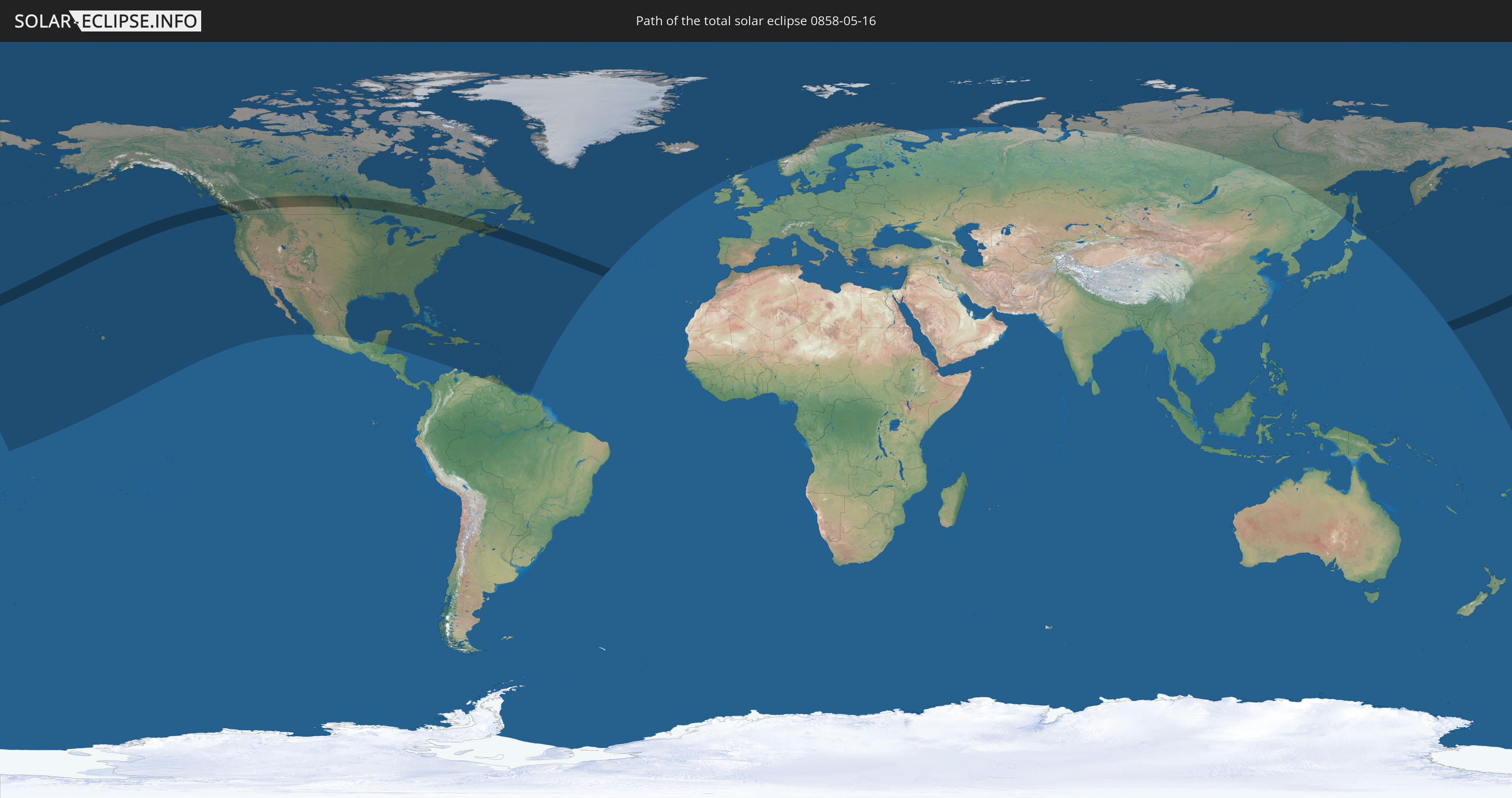
Die Sonnenfinsternis am 16.05.0858 kann man in 48 Ländern als partielle Sonnenfinsternis beobachten.
Der Finsternispfad verläuft durch 3 Länder. Nur in diesen Ländern ist sie als totale Sonnenfinsternis zu sehen.
In den folgenden Ländern ist die Sonnenfinsternis total zu sehen
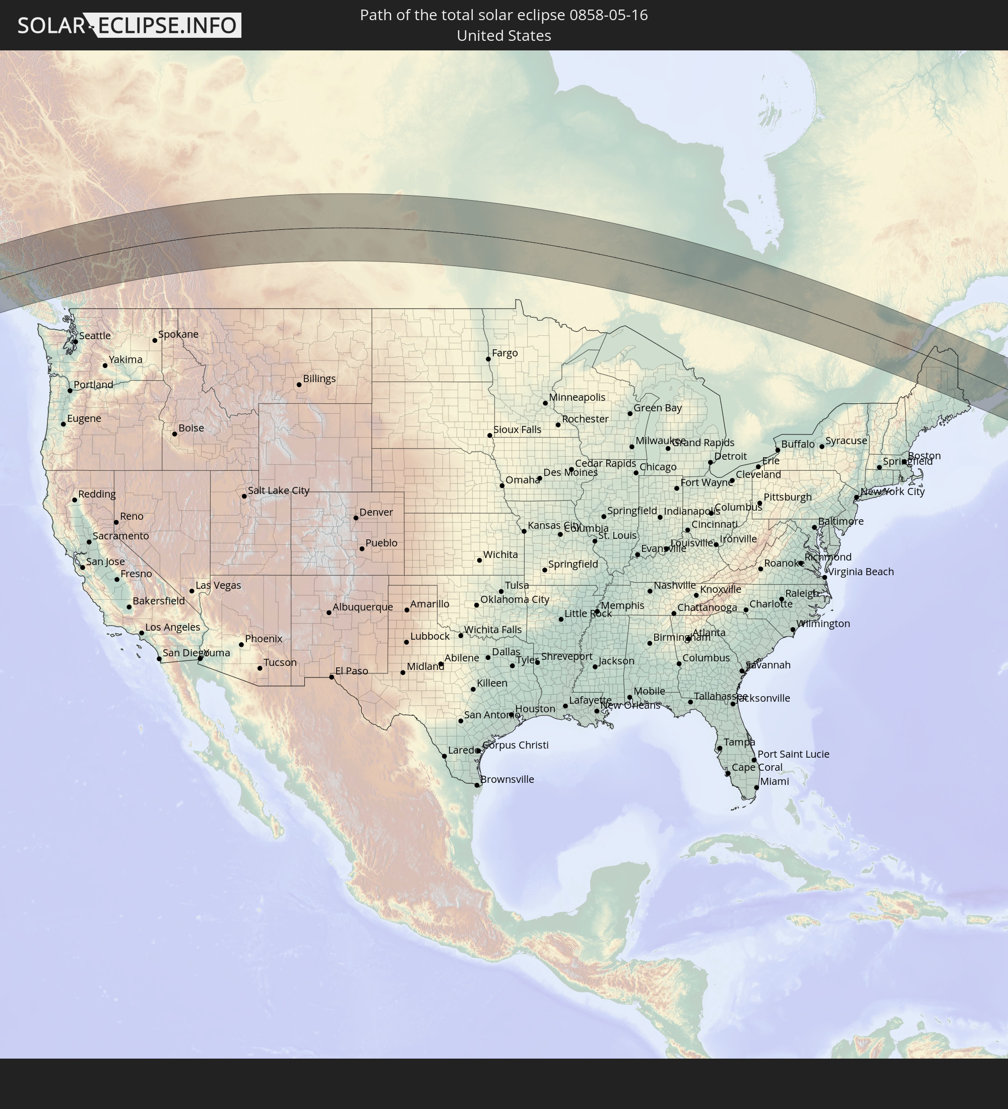 Vereinigte Staaten
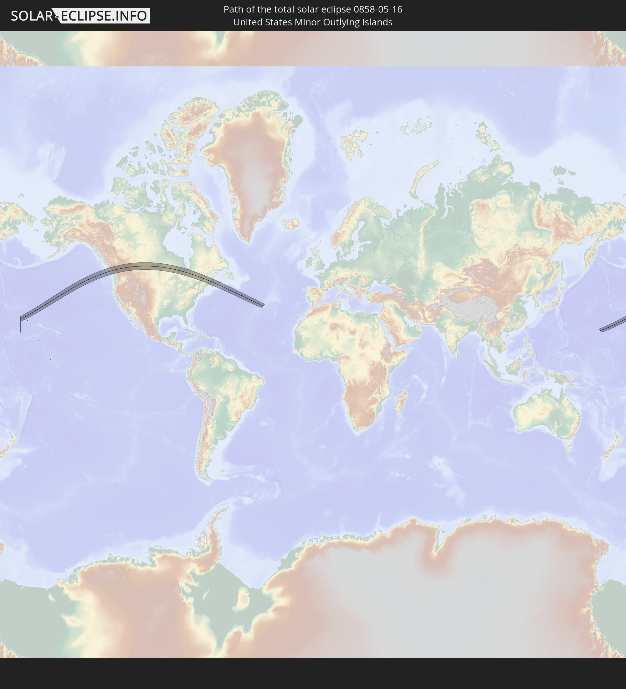 United States Minor Outlying Islands
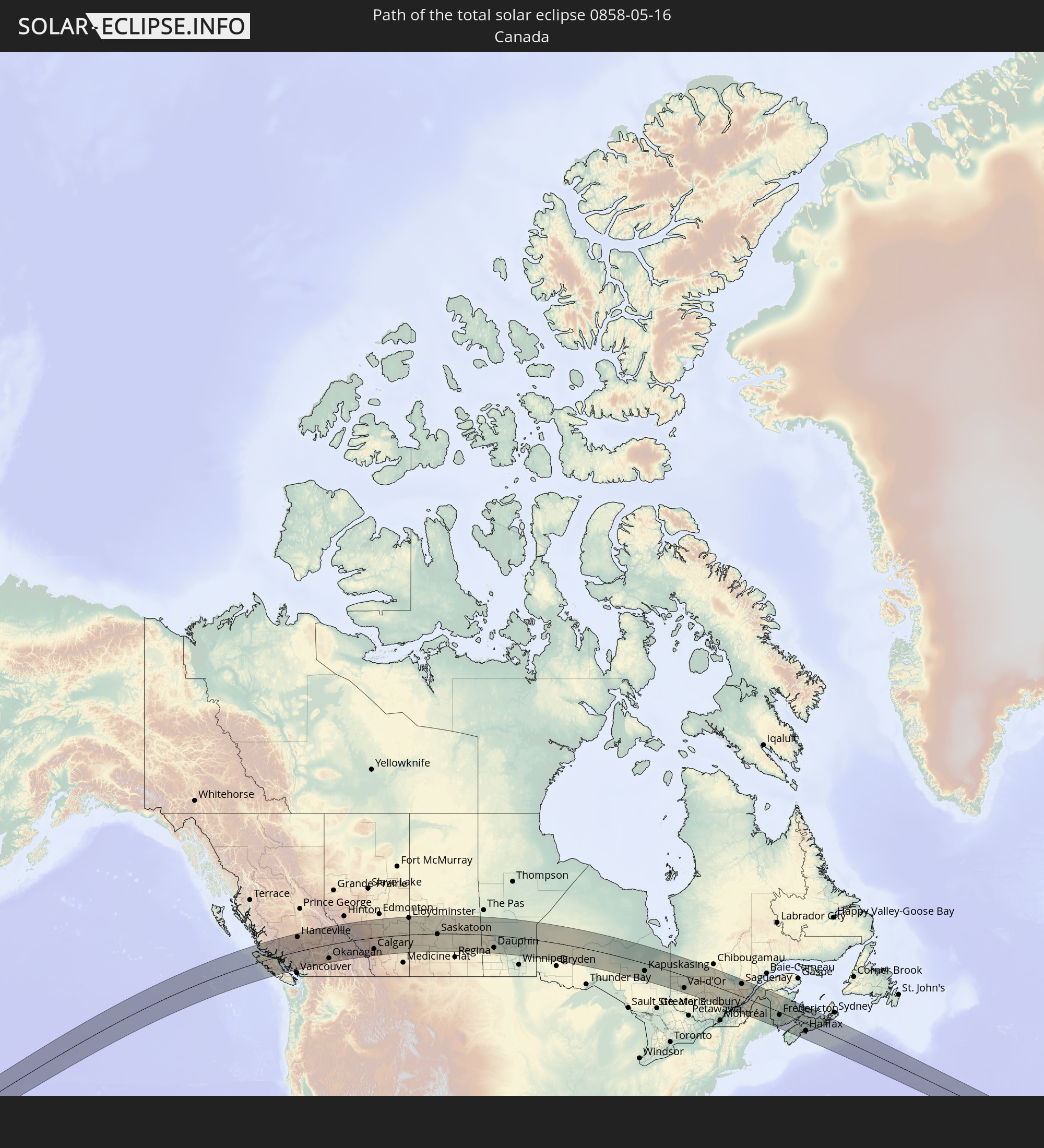 Kanada
In den folgenden Ländern ist die Sonnenfinsternis partiell zu sehen
 Russland
 Vereinigte Staaten
 United States Minor Outlying Islands
 Kiribati
 Kanada
 Mexiko
 Grönland
 Honduras
 Belize
 Kuba
Kuba
 Kolumbien
 Kaimaninseln
 Bahamas
 Jamaika
 Haiti
Haiti
 Venezuela
 Turks- und Caicosinseln
 Dominikanische Republik
 Aruba
Aruba
 Puerto Rico
 Amerikanische Jungferninseln
 Bermuda
 Britische Jungferninseln
 Anguilla
 Saint-Martin
 Saint-Barthélemy
 St. Kitts und Nevis
 Antigua und Barbuda
 Montserrat
 Trinidad und Tobago
 Guadeloupe
 Grenada
 Dominica
 St. Vincent und die Grenadinen
 Guyana
 Martinique
 St. Lucia
 Barbados
 Suriname
 Saint-Pierre und Miquelon
 Island
 Spitzbergen
 Vereinigtes Königreich
 Färöer
 Norwegen
 Schweden
 Finnland
 Japan
Japan
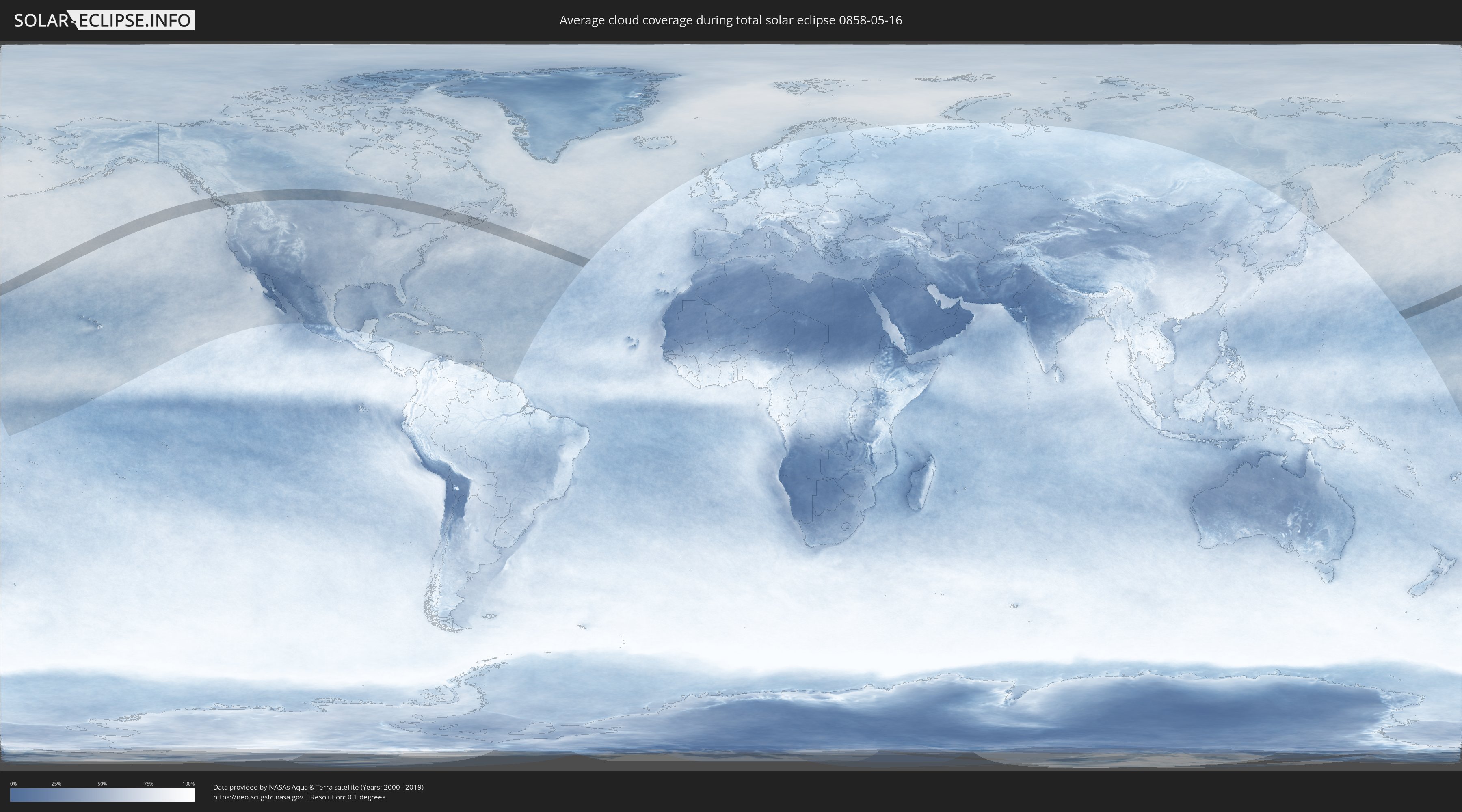
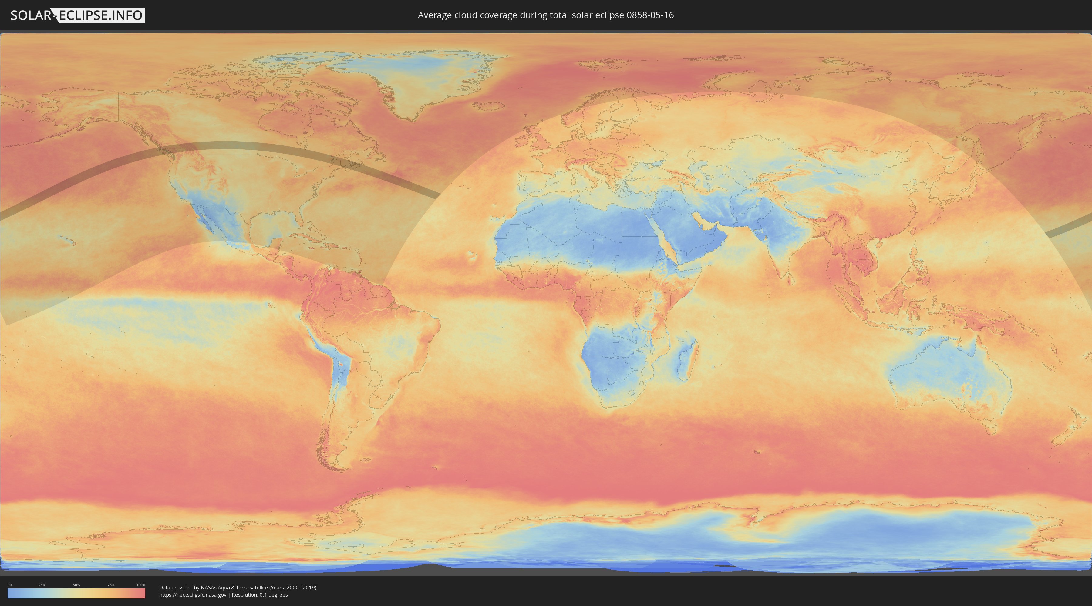
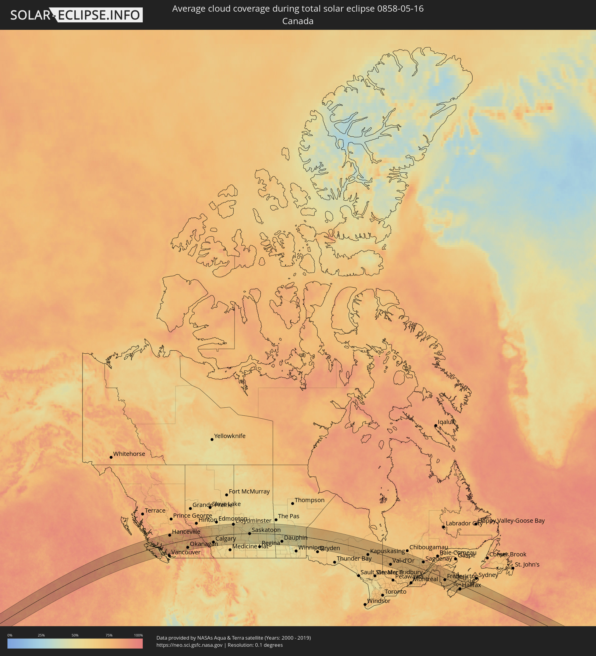
Wie wird das Wetter während der totalen Sonnenfinsternis am 16.05.0858?
Wo ist der beste Ort, um die totale Sonnenfinsternis vom 16.05.0858 zu beobachten?
Die folgenden Karten zeigen die durchschnittliche Bewölkung für den Tag, an dem die totale Sonnenfinsternis
stattfindet. Mit Hilfe der Karten lässt sich der Ort entlang des Finsternispfades eingrenzen,
der die besten Aussichen auf einen klaren wolkenfreien Himmel bietet.
Trotzdem muss man immer lokale Gegenenheiten beachten und sollte sich genau über das Wetter an seinem
gewählten Beobachtungsort informieren.
Die Daten stammen von den beiden NASA-Satelliten
AQUA und TERRA
und wurden über einen Zeitraum von 19 Jahren (2000 - 2019) gemittelt.
Detaillierte Länderkarten
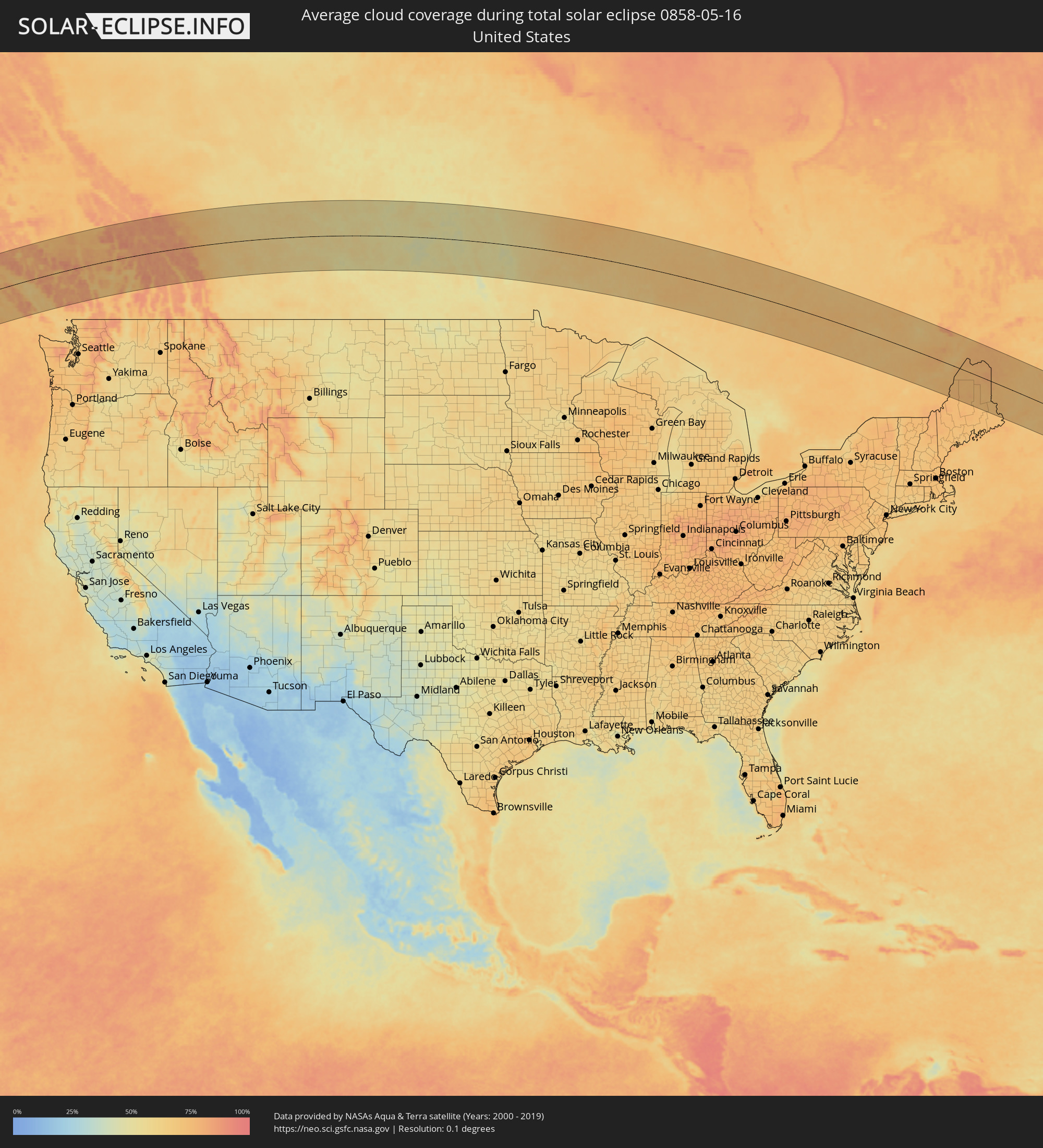 Vereinigte Staaten
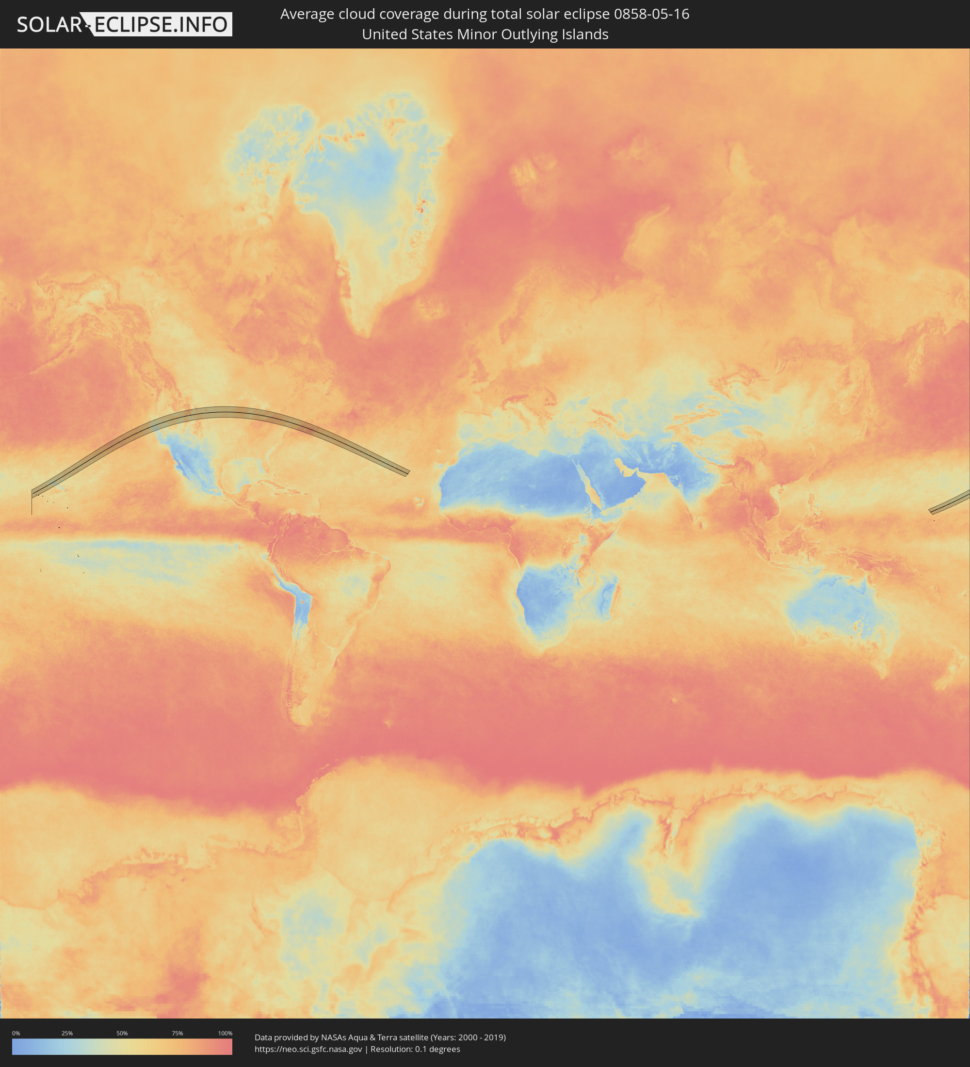 United States Minor Outlying Islands
 Kanada
Orte im Finsternispfad
Die nachfolgene Tabelle zeigt Städte und Orte mit mehr als 5.000 Einwohnern, die sich im Finsternispfad befinden. Städte mit mehr als 100.000 Einwohnern sind dick gekennzeichnet. Mit einem Klick auf den Ort öffnet sich eine Detailkarte die die Lage des jeweiligen Ortes zusammen mit dem Verlauf der zentralen Finsternis präsentiert.
| Ort | Typ | Dauer der Verfinsterung | Ortszeit bei maximaler Verfinsterung | Entfernung zur Zentrallinie | Ø Bewölkung |
|
Campbell River, British Columbia
|
total | - | 11:45:25 UTC-08:00 | 53 km | 63% |
|
Courtenay, British Columbia
|
total | - | 11:45:36 UTC-08:00 | 93 km | 66% |
|
Powell River, British Columbia
|
total | - | 11:46:26 UTC-08:00 | 86 km | 65% |
|
Sechelt, British Columbia
|
total | - | 11:47:26 UTC-08:00 | 139 km | 66% |
|
Hanceville, British Columbia
|
total | - | 11:49:52 UTC-08:00 | 113 km | 75% |
|
Whistler, British Columbia
|
total | - | 11:49:02 UTC-08:00 | 85 km | 80% |
|
Williams Lake, British Columbia
|
total | - | 11:51:18 UTC-08:00 | 124 km | 74% |
|
Merritt, British Columbia
|
total | - | 11:52:29 UTC-08:00 | 118 km | 66% |
|
Kamloops, British Columbia
|
total | - | 11:53:27 UTC-08:00 | 64 km | 64% |
|
Okanagan, British Columbia
|
total | - | 11:54:53 UTC-08:00 | 111 km | 66% |
|
Salmon Arm, British Columbia
|
total | - | 11:55:04 UTC-08:00 | 75 km | 70% |
|
Vernon, British Columbia
|
total | - | 11:54:58 UTC-08:00 | 123 km | 63% |
|
Revelstoke, British Columbia
|
total | - | 11:56:53 UTC-08:00 | 57 km | 77% |
|
Banff, Alberta
|
total | - | 12:27:08 UTC-07:33 | 65 km | 81% |
|
Canmore, Alberta
|
total | - | 12:27:28 UTC-07:33 | 77 km | 83% |
|
Rocky Mountain House, Alberta
|
total | - | 12:28:14 UTC-07:33 | 61 km | 68% |
|
Cochrane, Alberta
|
total | - | 12:28:50 UTC-07:33 | 74 km | 71% |
|
Olds, Alberta
|
total | - | 12:29:26 UTC-07:33 | 10 km | 65% |
|
Sylvan Lake, Alberta
|
total | - | 12:29:29 UTC-07:33 | 49 km | 65% |
|
Calgary, Alberta
|
total | - | 12:29:25 UTC-07:33 | 92 km | 69% |
|
Airdrie, Alberta
|
total | - | 12:29:31 UTC-07:33 | 64 km | 67% |
|
Okotoks, Alberta
|
total | - | 12:29:34 UTC-07:33 | 128 km | 67% |
|
Red Deer, Alberta
|
total | - | 12:29:54 UTC-07:33 | 41 km | 64% |
|
Lacombe, Alberta
|
total | - | 12:30:00 UTC-07:33 | 62 km | 62% |
|
Ponoka, Alberta
|
total | - | 12:30:13 UTC-07:33 | 85 km | 62% |
|
Strathmore, Alberta
|
total | - | 12:30:31 UTC-07:33 | 97 km | 61% |
|
Wetaskiwin, Alberta
|
total | - | 12:30:32 UTC-07:33 | 115 km | 60% |
|
Camrose, Alberta
|
total | - | 12:31:18 UTC-07:33 | 118 km | 60% |
|
Stettler, Alberta
|
total | - | 12:31:30 UTC-07:33 | 40 km | 59% |
|
Wainwright, Alberta
|
total | - | 12:34:11 UTC-07:33 | 87 km | 60% |
|
Lloydminster, Saskatchewan
|
total | - | 12:35:19 UTC-07:33 | 132 km | 58% |
|
North Battleford, Saskatchewan
|
total | - | 13:13:07 UTC-06:58 | 72 km | 57% |
|
Saskatoon, Saskatchewan
|
total | - | 13:15:38 UTC-06:58 | 12 km | 58% |
|
Prince Albert, Saskatchewan
|
total | - | 13:16:30 UTC-06:58 | 116 km | 56% |
|
Melfort, Saskatchewan
|
total | - | 13:18:13 UTC-06:58 | 78 km | 52% |
|
Yorkton, Saskatchewan
|
total | - | 13:22:01 UTC-06:58 | 102 km | 49% |
|
Dauphin, Manitoba
|
total | - | 14:24:01 UTC-06:00 | 99 km | 54% |
|
Kapuskasing, Ontario
|
total | - | 15:46:19 UTC-05:00 | 61 km | 66% |
|
La Sarre, Quebec
|
total | - | 15:49:59 UTC-05:00 | 58 km | 72% |
|
Rouyn-Noranda, Quebec
|
total | - | 15:50:51 UTC-05:00 | 114 km | 70% |
|
Amos, Quebec
|
total | - | 15:51:11 UTC-05:00 | 58 km | 72% |
|
Val-d'Or, Quebec
|
total | - | 15:52:03 UTC-05:00 | 101 km | 72% |
|
La Tuque, Quebec
|
total | - | 15:56:38 UTC-05:00 | 45 km | 71% |
|
Shawinigan, Quebec
|
total | - | 15:57:48 UTC-05:00 | 134 km | 71% |
|
Saint-Félicien, Quebec
|
total | - | 15:55:14 UTC-05:00 | 90 km | 67% |
|
Roberval, Quebec
|
total | - | 15:55:33 UTC-05:00 | 82 km | 65% |
|
Dolbeau-Mistassini, Quebec
|
total | - | 15:55:04 UTC-05:00 | 120 km | 67% |
|
Pont Rouge, Quebec
|
total | - | 15:55:09 UTC-05:00 | 124 km | 66% |
|
Donnacona, Quebec
|
total | - | 15:58:19 UTC-05:00 | 95 km | 69% |
|
Pont-Rouge, Quebec
|
total | - | 15:58:14 UTC-05:00 | 86 km | 69% |
|
Alma, Quebec
|
total | - | 15:55:52 UTC-05:00 | 101 km | 66% |
|
Sainte Catherine de la Jacques Cartier, Quebec
|
total | - | 15:58:09 UTC-05:00 | 74 km | 69% |
|
Shannon, Quebec
|
total | - | 15:58:11 UTC-05:00 | 70 km | 71% |
|
Saint-Augustin-de-Desmaures, Quebec
|
total | - | 15:58:25 UTC-05:00 | 81 km | 70% |
|
L'Ancienne-Lorette, Quebec
|
total | - | 15:58:24 UTC-05:00 | 73 km | 69% |
|
Jonquière, Quebec
|
total | - | 15:56:18 UTC-05:00 | 98 km | 71% |
|
Québec, Quebec
|
total | - | 15:58:28 UTC-05:00 | 68 km | 69% |
|
Lévis, Quebec
|
total | - | 15:58:30 UTC-05:00 | 68 km | 69% |
|
Saint-Henri, Quebec
|
total | - | 15:58:43 UTC-05:00 | 75 km | 73% |
|
Saguenay, Quebec
|
total | - | 15:56:25 UTC-05:00 | 103 km | 71% |
|
Sainte-Marie, Quebec
|
total | - | 15:59:06 UTC-05:00 | 101 km | 71% |
|
Beauceville, Quebec
|
total | - | 15:59:31 UTC-05:00 | 118 km | 71% |
|
Saint-Georges, Quebec
|
total | - | 15:59:44 UTC-05:00 | 124 km | 73% |
|
Montmagny, Quebec
|
total | - | 15:58:39 UTC-05:00 | 31 km | 70% |
|
Baie-Saint-Paul, Quebec
|
total | - | 15:58:04 UTC-05:00 | 18 km | 68% |
|
La Malbaie, Quebec
|
total | - | 15:57:59 UTC-05:00 | 50 km | 71% |
|
Rivière-du-Loup, Quebec
|
total | - | 15:58:06 UTC-05:00 | 85 km | 69% |
|
Edmundston, New Brunswick
|
total | - | 16:44:59 UTC-04:14 | 73 km | 76% |
|
Presque Isle, Maine
|
total | - | 16:00:28 UTC-05:00 | 10 km | 78% |
|
Caribou, Maine
|
total | - | 16:00:14 UTC-05:00 | 29 km | 79% |
|
Fredericton, New Brunswick
|
total | - | 16:47:44 UTC-04:14 | 25 km | 71% |
|
Oromocto, New Brunswick
|
total | - | 16:47:58 UTC-04:14 | 34 km | 70% |
|
Saint John, New Brunswick
|
total | - | 16:48:55 UTC-04:14 | 76 km | 72% |
|
Miramichi, New Brunswick
|
total | - | 16:46:50 UTC-04:14 | 121 km | 70% |
|
Greenwood, Nova Scotia
|
total | - | 16:49:49 UTC-04:14 | 71 km | 70% |
|
Lutes Mountain, New Brunswick
|
total | - | 16:48:17 UTC-04:14 | 48 km | 69% |
|
Moncton, New Brunswick
|
total | - | 16:48:24 UTC-04:14 | 47 km | 71% |
|
Dieppe, New Brunswick
|
total | - | 16:48:28 UTC-04:14 | 49 km | 70% |
|
Bridgewater, Nova Scotia
|
total | - | 16:50:47 UTC-04:14 | 119 km | 69% |
|
Kentville, Nova Scotia
|
total | - | 16:49:52 UTC-04:14 | 47 km | 70% |
|
Sackville, New Brunswick
|
total | - | 16:48:48 UTC-04:14 | 42 km | 72% |
|
Amherst, Nova Scotia
|
total | - | 16:49:00 UTC-04:14 | 39 km | 70% |
|
Summerside, Prince Edward Island
|
total | - | 16:48:24 UTC-04:14 | 109 km | 71% |
|
Lower Sacvkille, Nova Scotia
|
total | - | 16:50:36 UTC-04:14 | 52 km | 70% |
|
Dartmouth, Nova Scotia
|
total | - | 16:50:47 UTC-04:14 | 60 km | 68% |
|
Halifax, Nova Scotia
|
total | - | 16:50:49 UTC-04:14 | 62 km | 70% |
|
Cole Harbour, Nova Scotia
|
total | - | 16:50:49 UTC-04:14 | 56 km | 70% |
|
Truro, Nova Scotia
|
total | - | 16:49:59 UTC-04:14 | 21 km | 72% |
|
Charlottetown, Prince Edward Island
|
total | - | 16:48:52 UTC-04:14 | 114 km | 71% |
|
New Glasgow, Nova Scotia
|
total | - | 16:49:56 UTC-04:14 | 63 km | 70% |
|
Antigonish, Nova Scotia
|
total | - | 16:50:07 UTC-04:14 | 87 km | 71% |
|
Princeville, Nova Scotia
|
total | - | 16:50:10 UTC-04:14 | 125 km | 70% |