Totale Sonnenfinsternis vom 20.08.0993
| Wochentag: | Dienstag |
| Maximale Dauer der Verfinsterung: | 05m37s |
| Maximale Breite des Finsternispfades: | 220 km |
| Saroszyklus: | 109 |
| Bedeckungsgrad: | 100% |
| Magnitude: | 1.0654 |
| Gamma: | 0.235 |
Wo kann man die Sonnenfinsternis vom 20.08.0993 sehen?
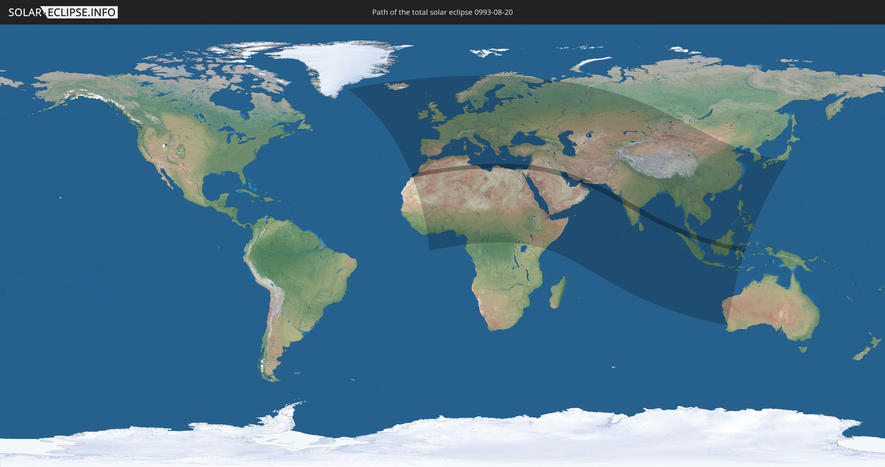
Die Sonnenfinsternis am 20.08.0993 kann man in 134 Ländern als partielle Sonnenfinsternis beobachten.
Der Finsternispfad verläuft durch 19 Länder. Nur in diesen Ländern ist sie als totale Sonnenfinsternis zu sehen.
In den folgenden Ländern ist die Sonnenfinsternis total zu sehen
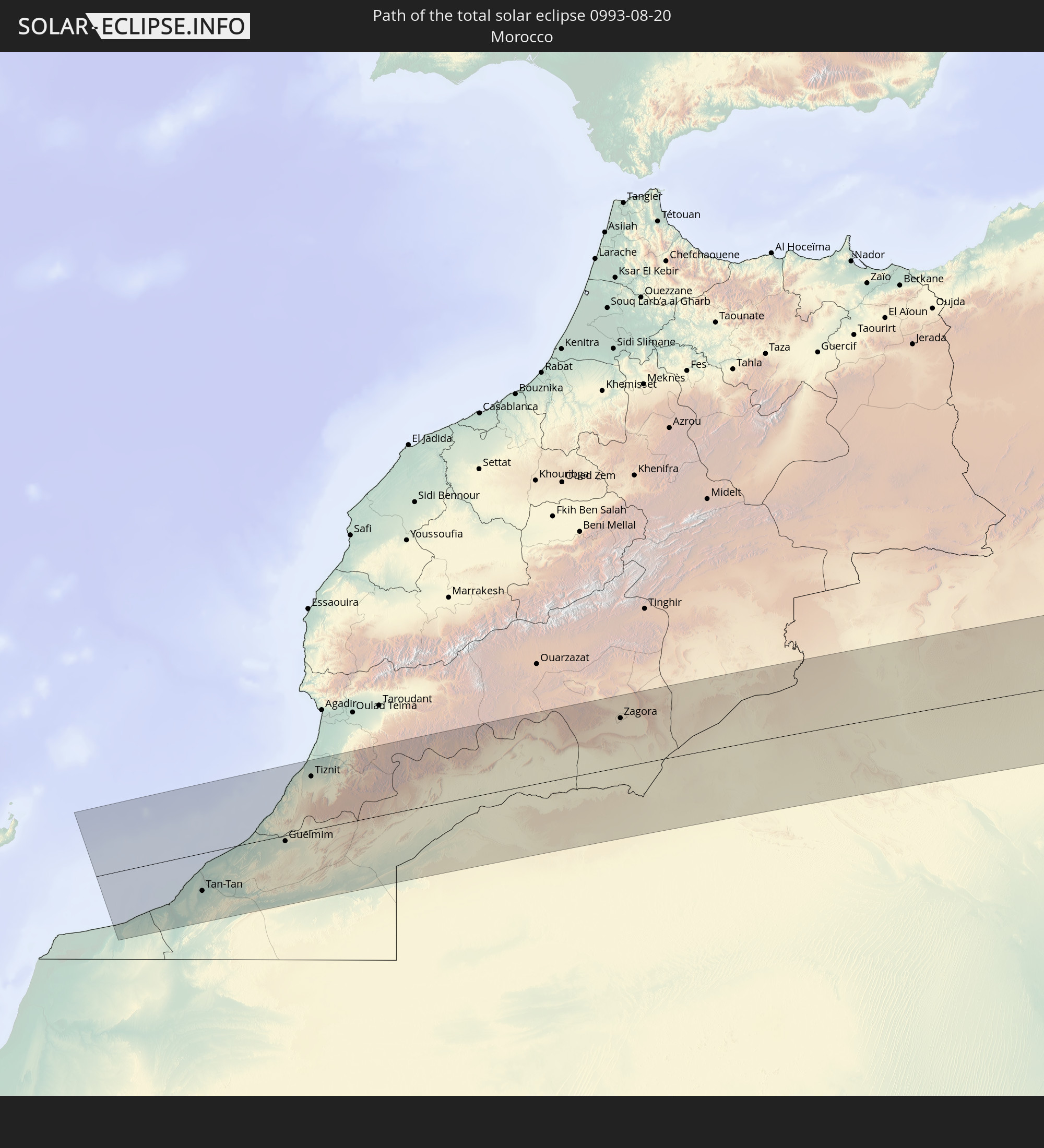 Marokko
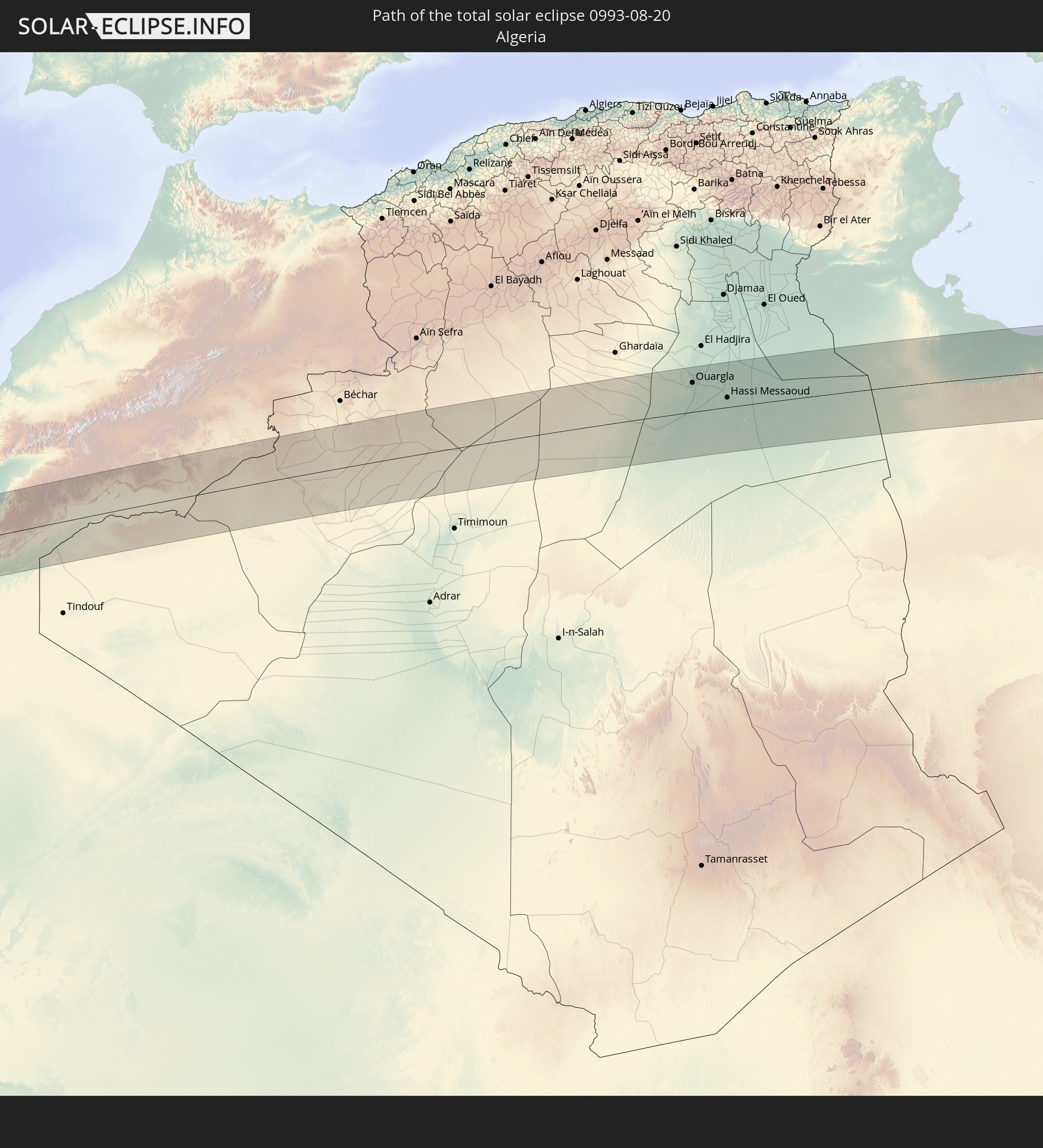 Algerien
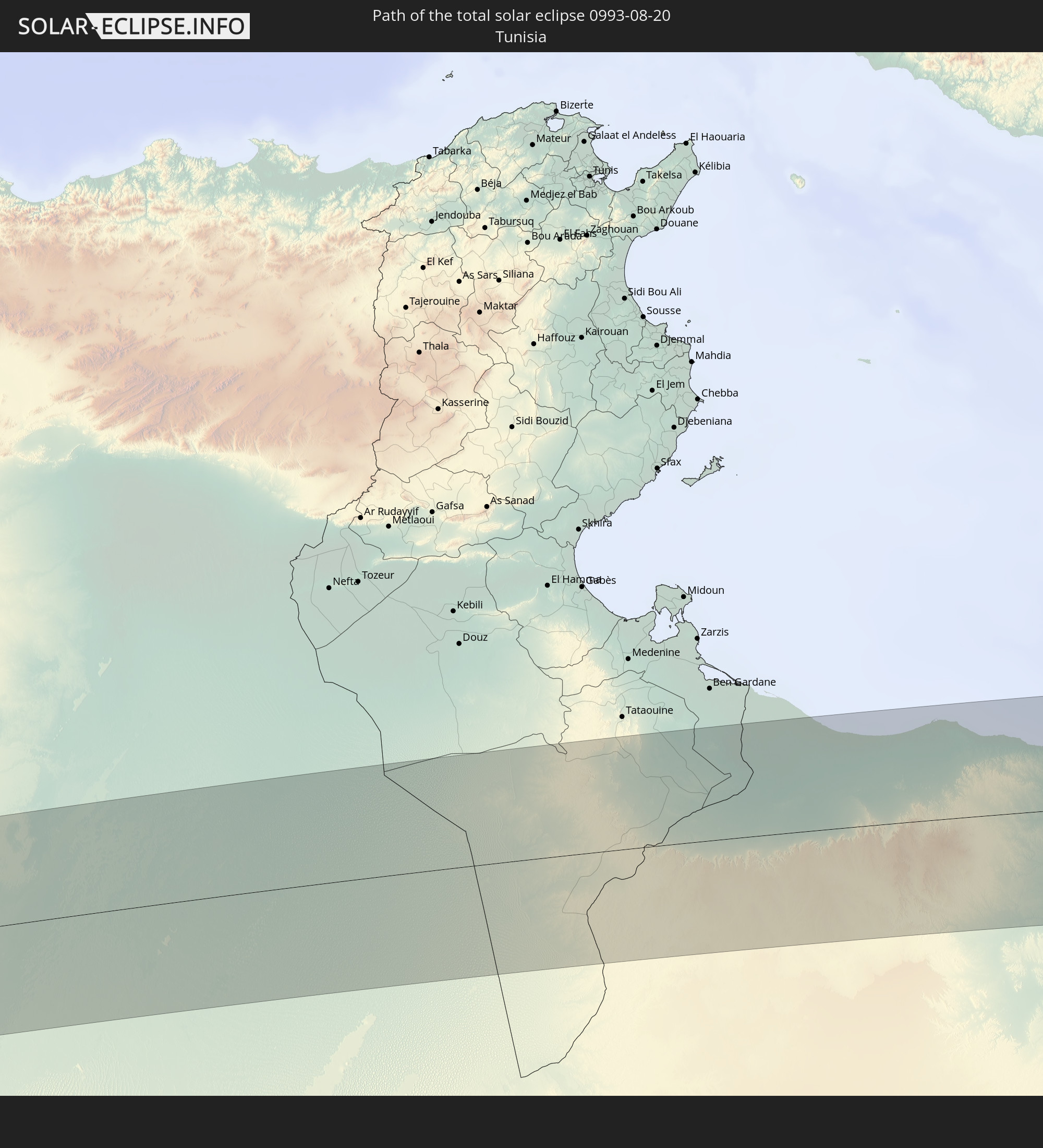 Tunesien
 Libyen
 Ägypten
 Staat Palästina
 Israel
 Saudi-Arabien
 Jordanien
 Syrien
 Irak
Irak
 Iran
Iran
 Kuwait
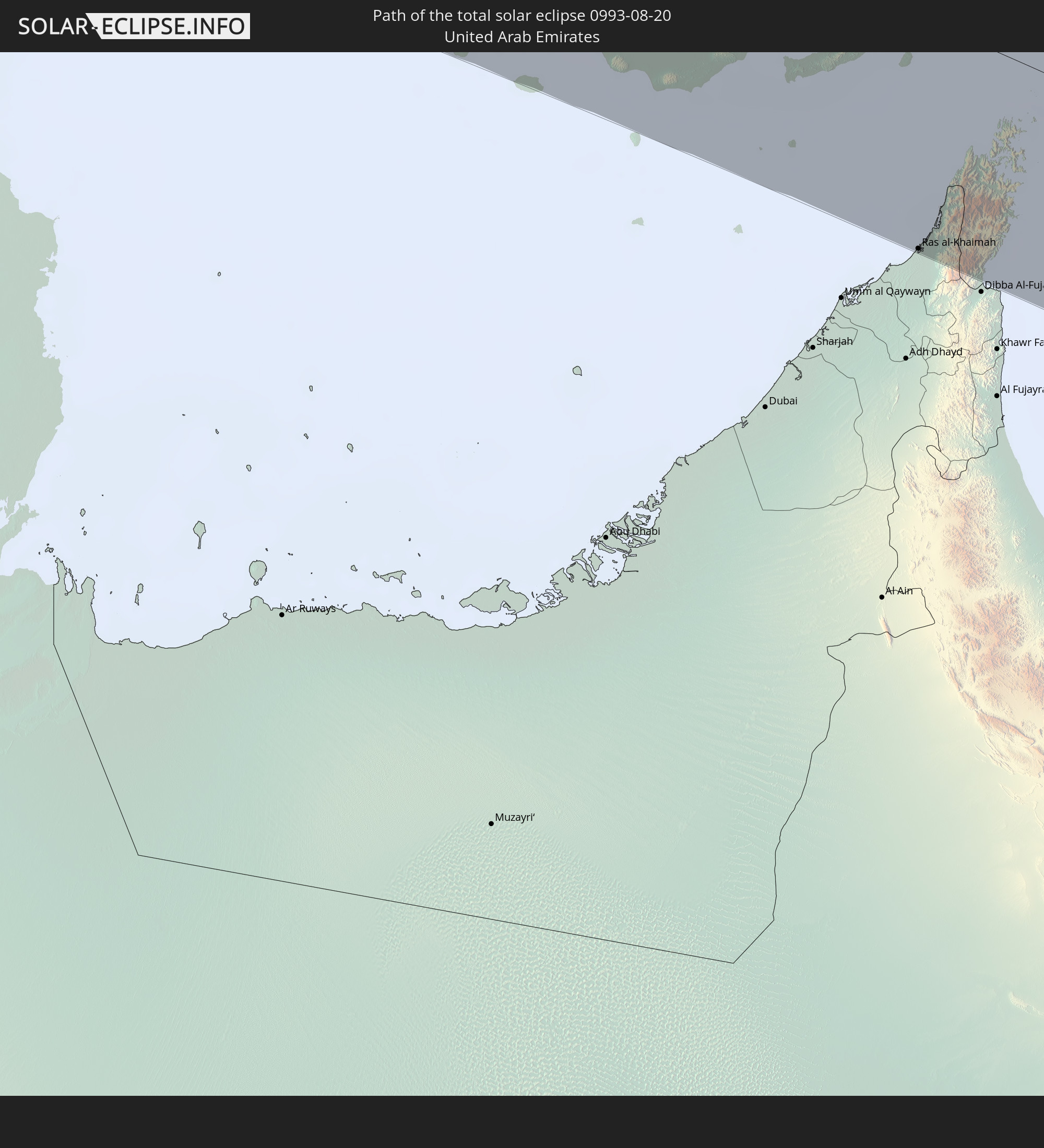 Vereinigte Arabische Emirate
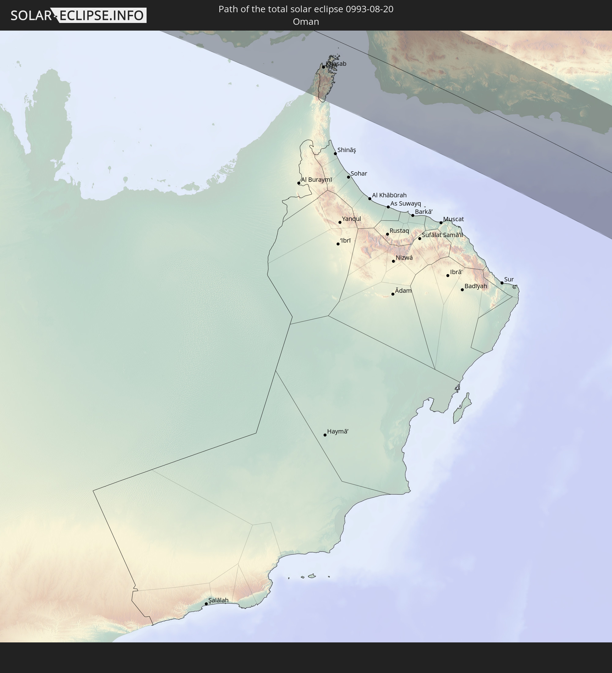 Oman
Oman
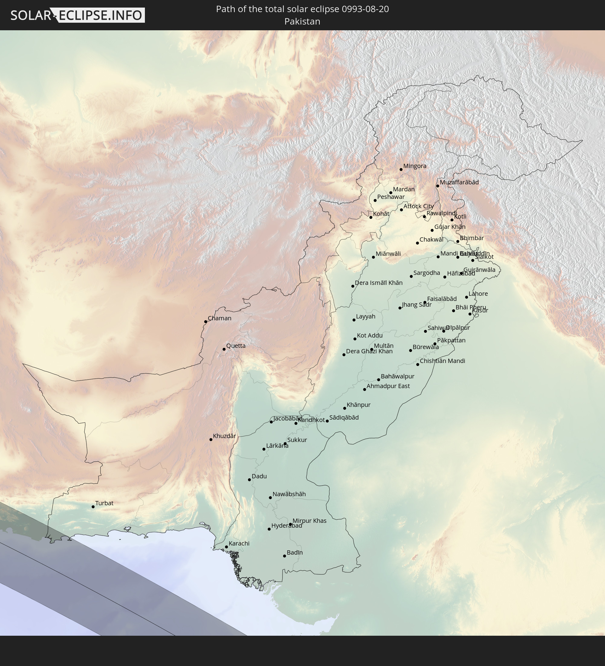 Pakistan
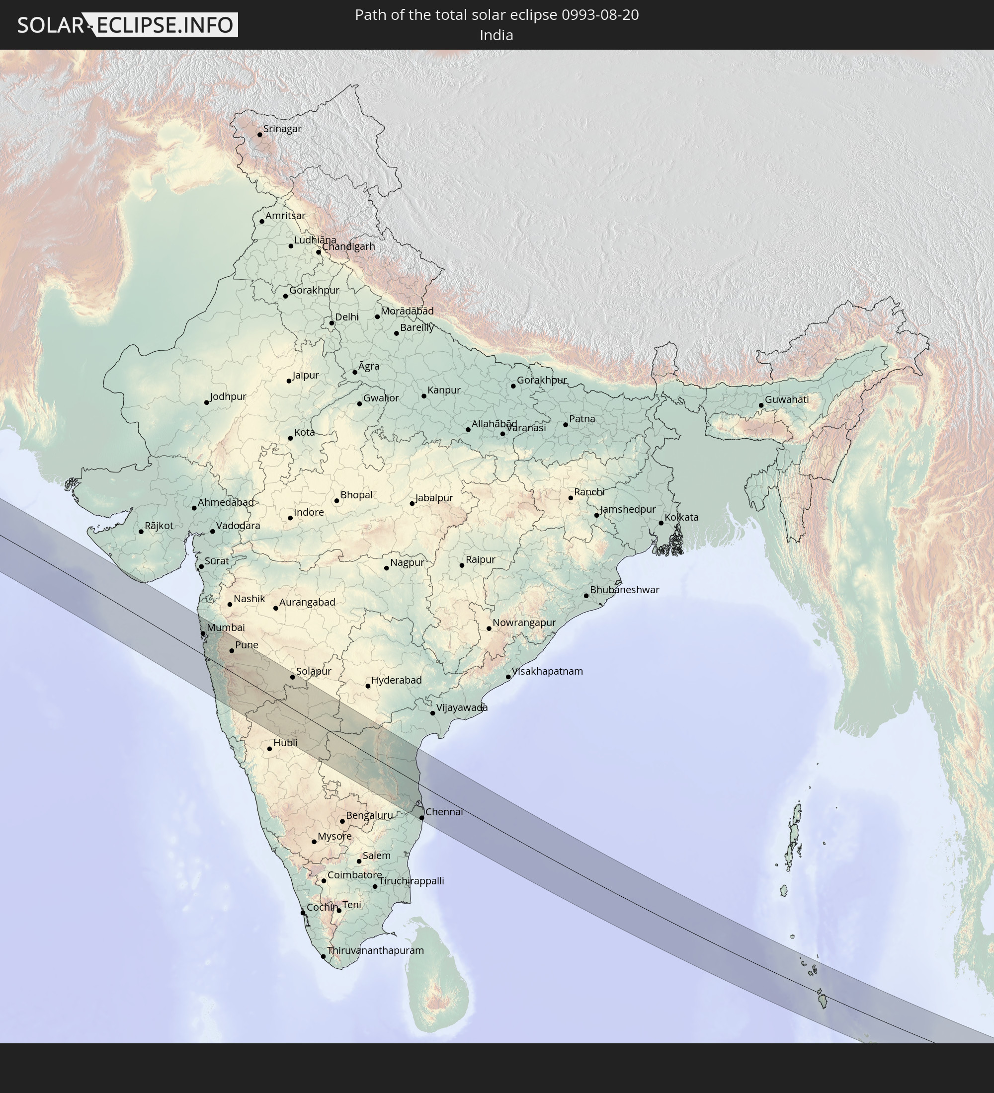 Indien
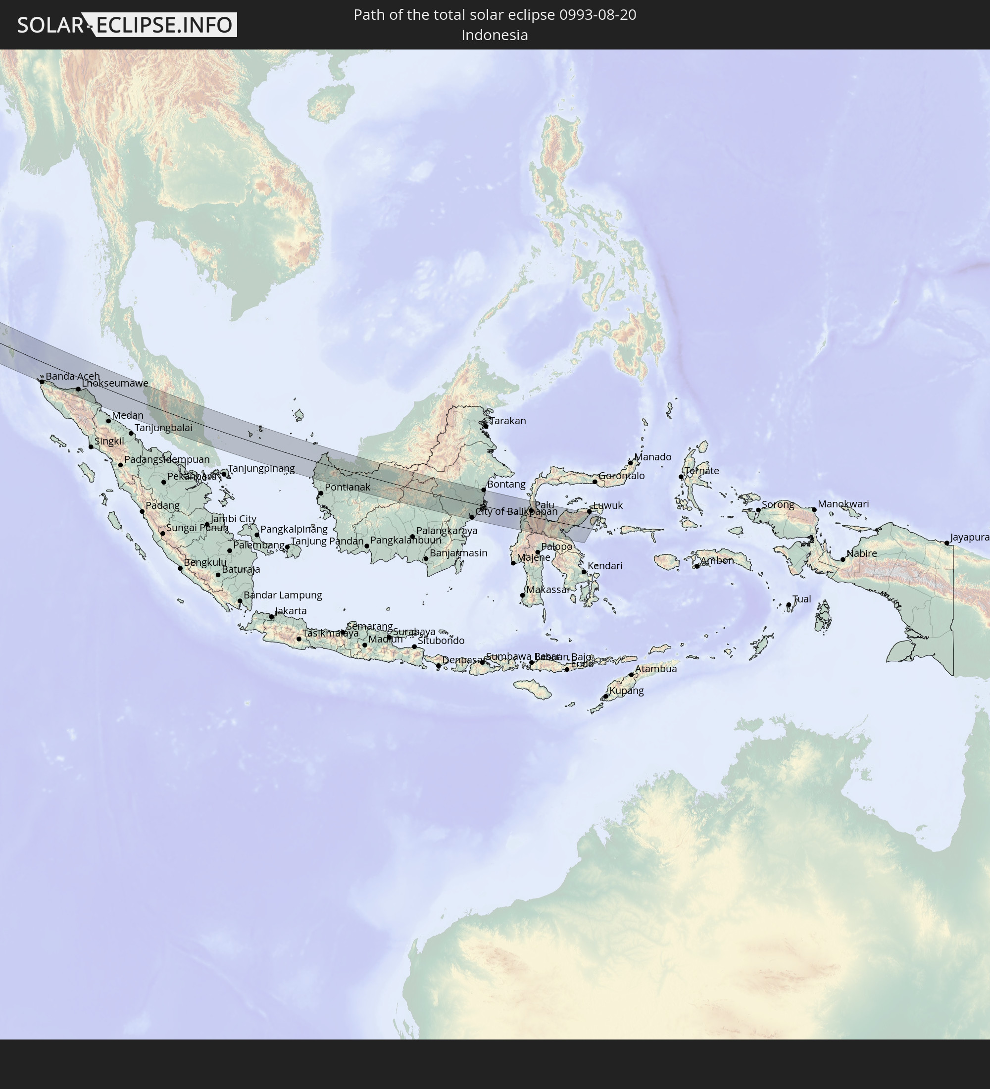 Indonesien
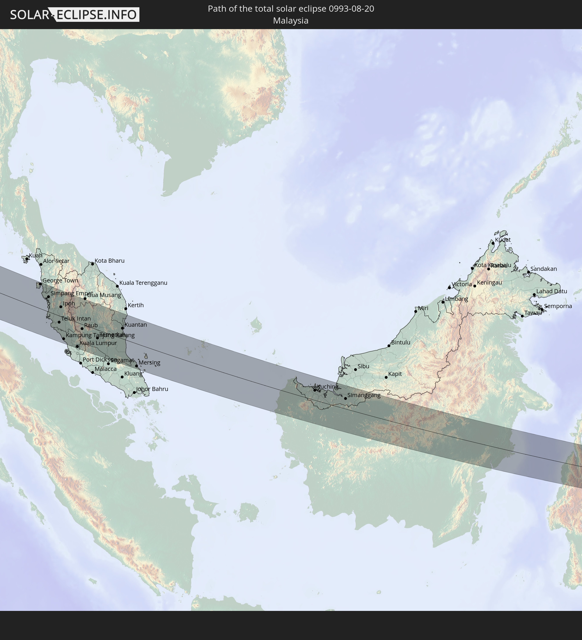 Malaysia
In den folgenden Ländern ist die Sonnenfinsternis partiell zu sehen
 Russland
 Portugal
 Island
 Spanien
 Mauretanien
 Marokko
 Mali
Mali
 Irland
 Algerien
 Vereinigtes Königreich
 Elfenbeinküste
 Färöer
 Burkina Faso
 Gibraltar
 Frankreich
 Isle of Man
 Ghana
Ghana
 Guernsey
 Jersey
 Togo
Togo
 Niger
Niger
 Benin
Benin
 Andorra
 Belgien
 Nigeria
 Niederlande
 Norwegen
 Äquatorialguinea
 Luxemburg
 Deutschland
 Schweiz
 São Tomé und Príncipe
 Italien
 Monaco
 Tunesien
 Dänemark
 Kamerun
 Gabun
Gabun
 Libyen
 Liechtenstein
 Österreich
 Schweden
 Republik Kongo
 Tschechien
 Demokratische Republik Kongo
 San Marino
 Vatikanstadt
 Slowenien
 Tschad
 Kroatien
 Polen
Polen
 Malta
Malta
 Zentralafrikanische Republik
 Bosnien und Herzegowina
 Ungarn
 Slowakei
 Montenegro
 Serbien
 Albanien
 Åland Islands
 Griechenland
 Rumänien
 Mazedonien
 Finnland
 Litauen
 Lettland
 Estland
 Sudan
Sudan
 Ukraine
 Bulgarien
 Weißrussland
 Ägypten
 Türkei
 Moldawien
 Uganda
 Republik Zypern
 Äthiopien
 Kenia
Kenia
 Staat Palästina
 Israel
 Saudi-Arabien
 Jordanien
 Libanon
 Syrien
 Eritrea
 Irak
Irak
 Georgien
 Somalia
 Dschibuti
 Jemen
Jemen
 Armenien
 Iran
Iran
 Aserbaidschan
 Seychellen
 Kasachstan
 Kuwait
 Bahrain
 Katar
Katar
 Vereinigte Arabische Emirate
 Oman
Oman
 Turkmenistan
 Usbekistan
 Afghanistan
 Pakistan
 Tadschikistan
 Indien
 Kirgisistan
 Britisches Territorium im Indischen Ozean
 Malediven
 Volksrepublik China
 Sri Lanka
 Nepal
Nepal
 Mongolei
 Bangladesch
 Bhutan
 Myanmar
 Indonesien
 Kokosinseln
 Thailand
 Malaysia
 Laos
Laos
 Vietnam
 Kambodscha
 Singapur
 Weihnachtsinsel
 Australien
 Macau
Macau
 Hongkong
 Brunei
 Taiwan
 Philippinen
 Japan
Japan
 Nordkorea
 Südkorea
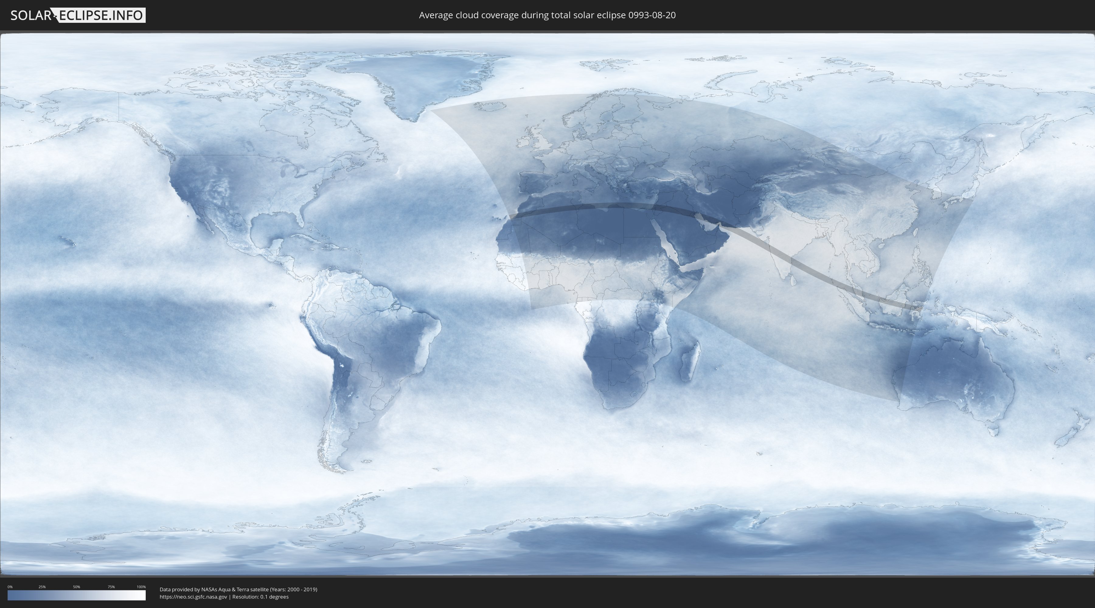
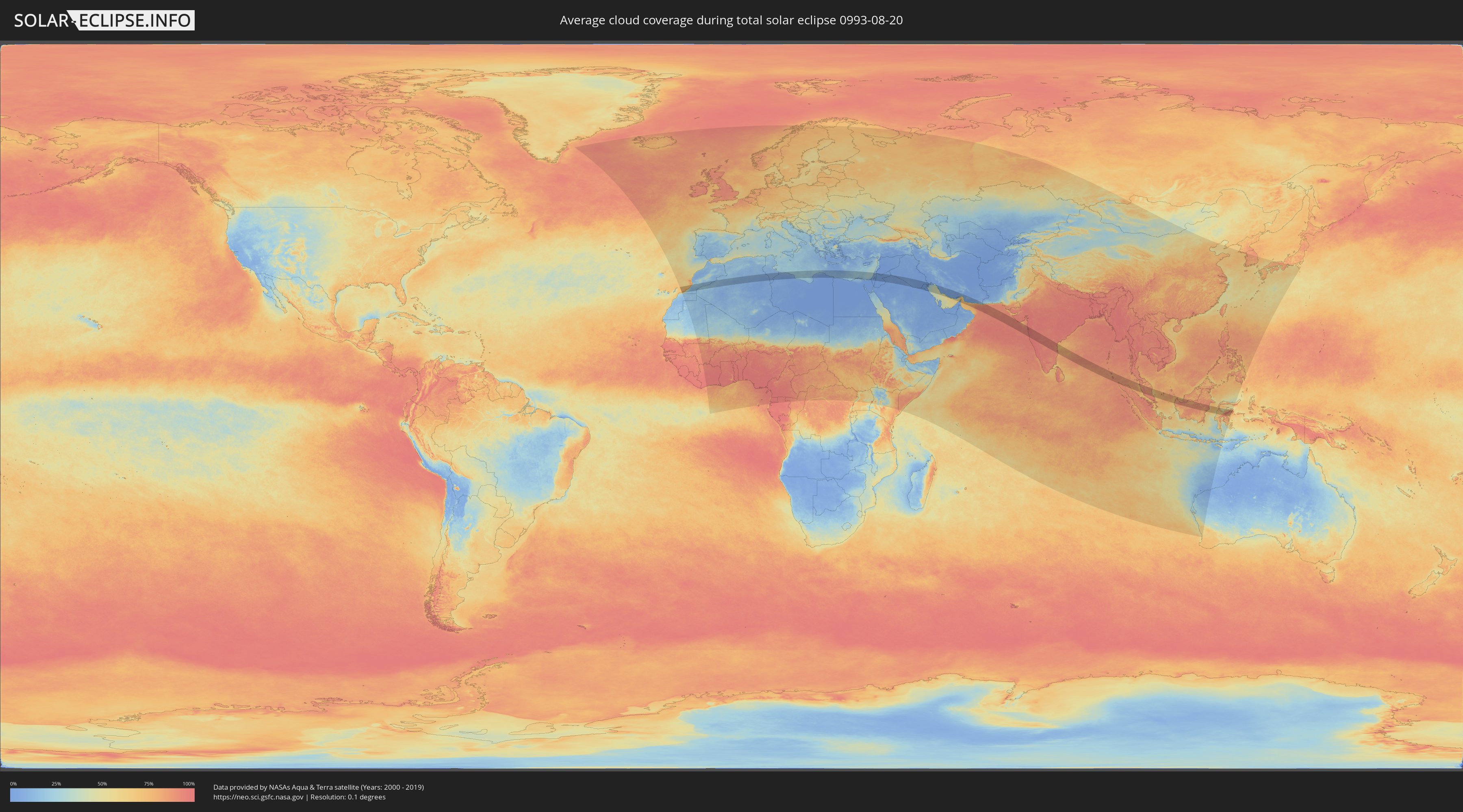
Wie wird das Wetter während der totalen Sonnenfinsternis am 20.08.0993?
Wo ist der beste Ort, um die totale Sonnenfinsternis vom 20.08.0993 zu beobachten?
Die folgenden Karten zeigen die durchschnittliche Bewölkung für den Tag, an dem die totale Sonnenfinsternis
stattfindet. Mit Hilfe der Karten lässt sich der Ort entlang des Finsternispfades eingrenzen,
der die besten Aussichen auf einen klaren wolkenfreien Himmel bietet.
Trotzdem muss man immer lokale Gegenenheiten beachten und sollte sich genau über das Wetter an seinem
gewählten Beobachtungsort informieren.
Die Daten stammen von den beiden NASA-Satelliten
AQUA und TERRA
und wurden über einen Zeitraum von 19 Jahren (2000 - 2019) gemittelt.
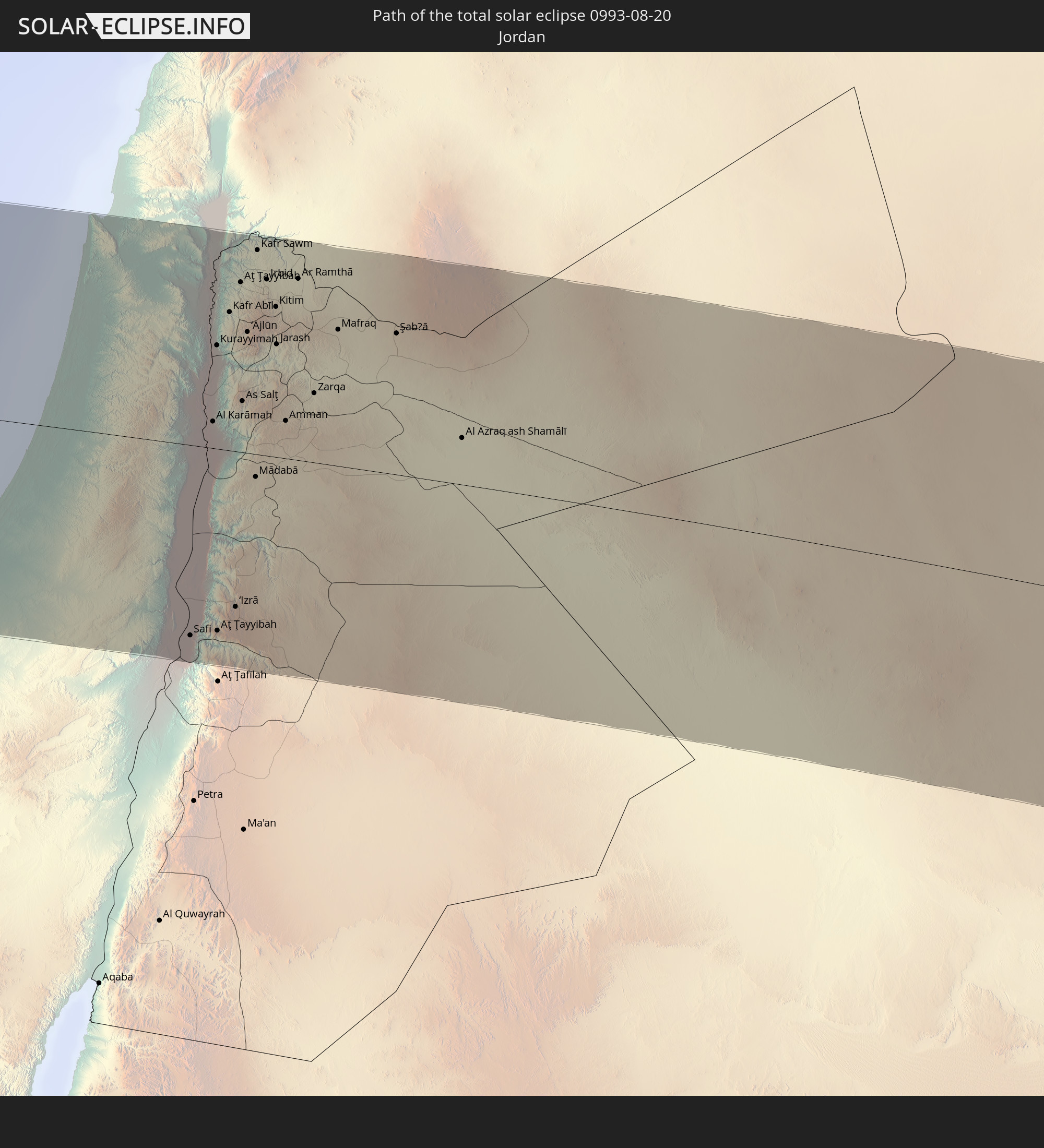
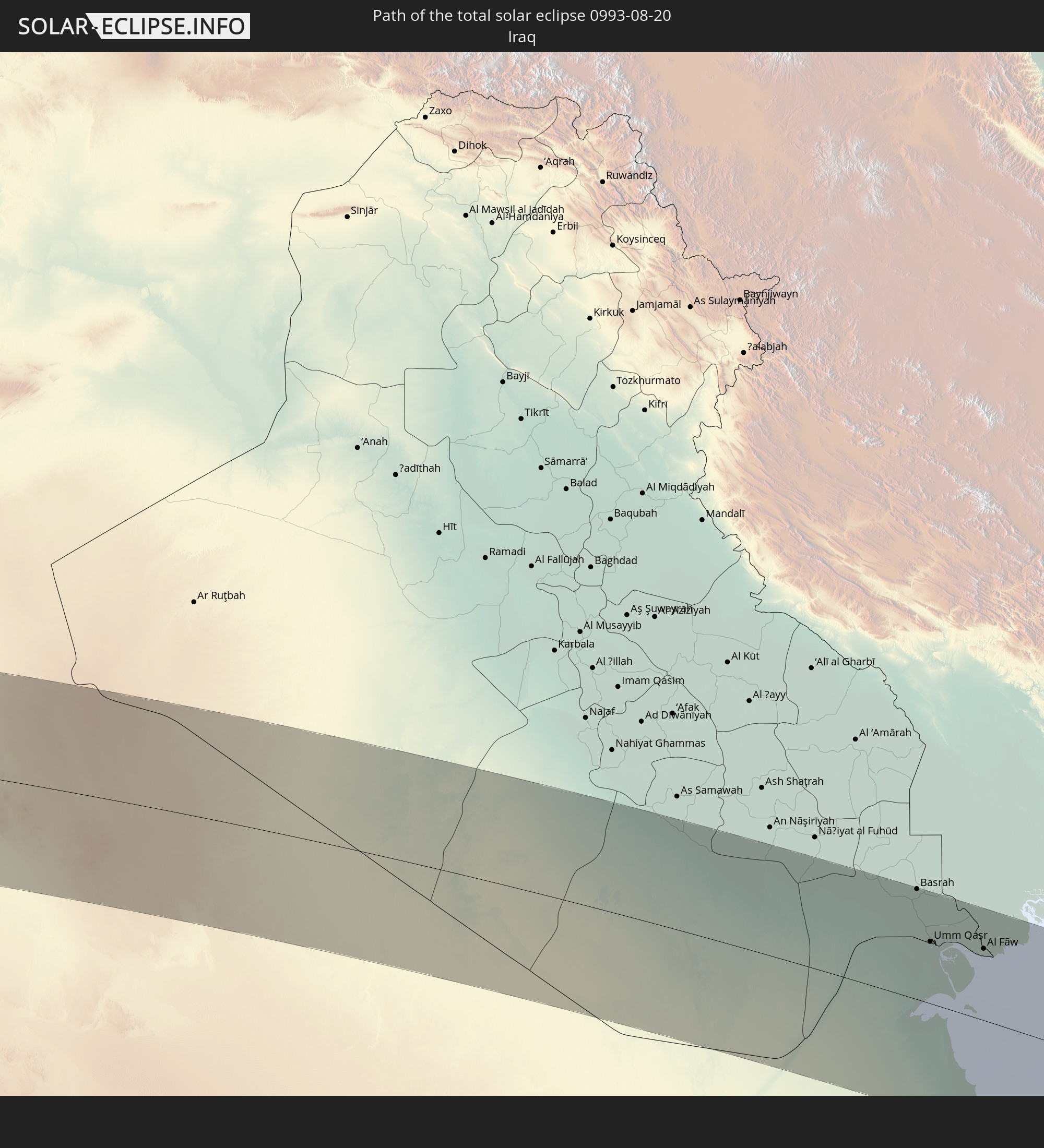
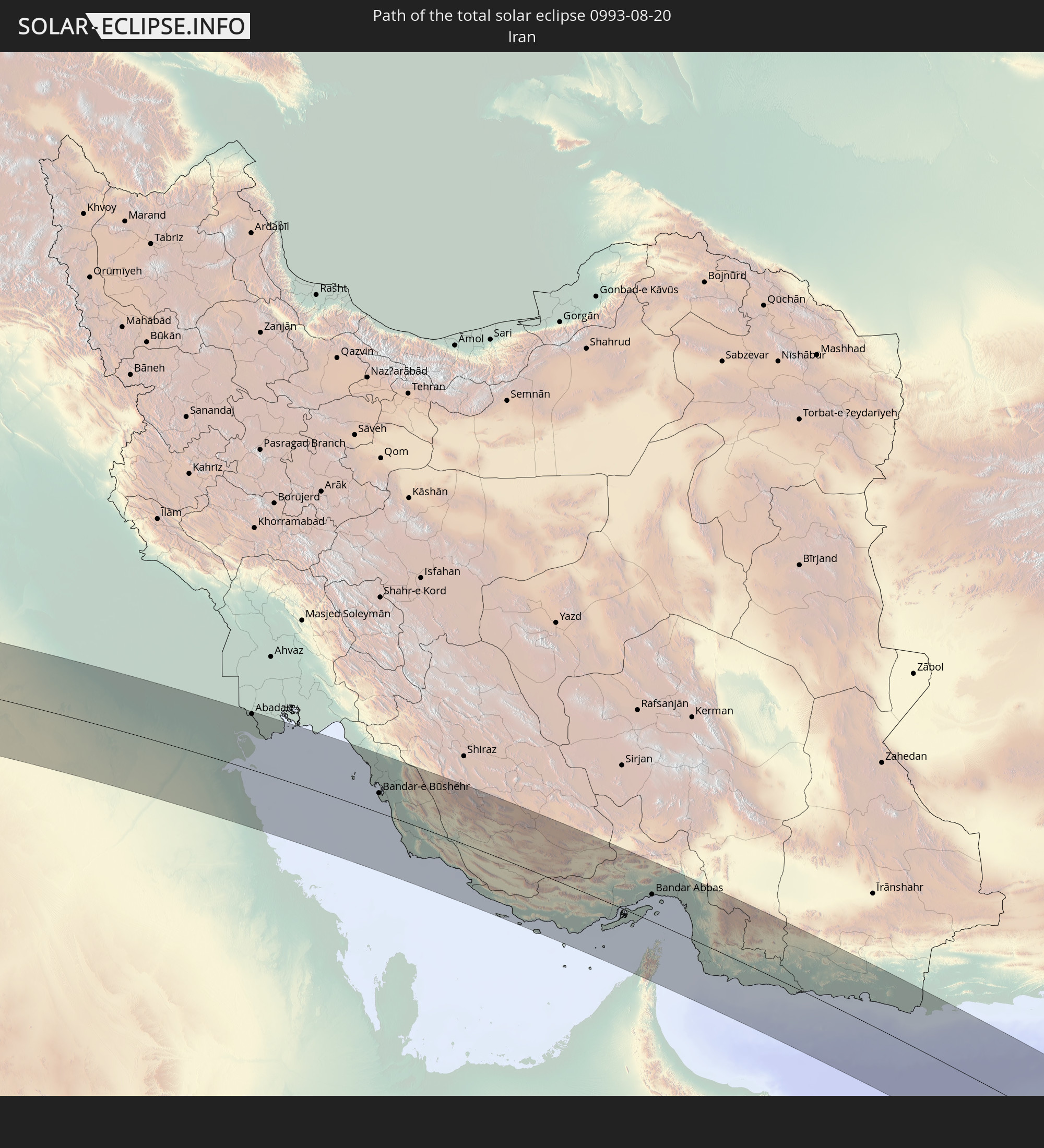
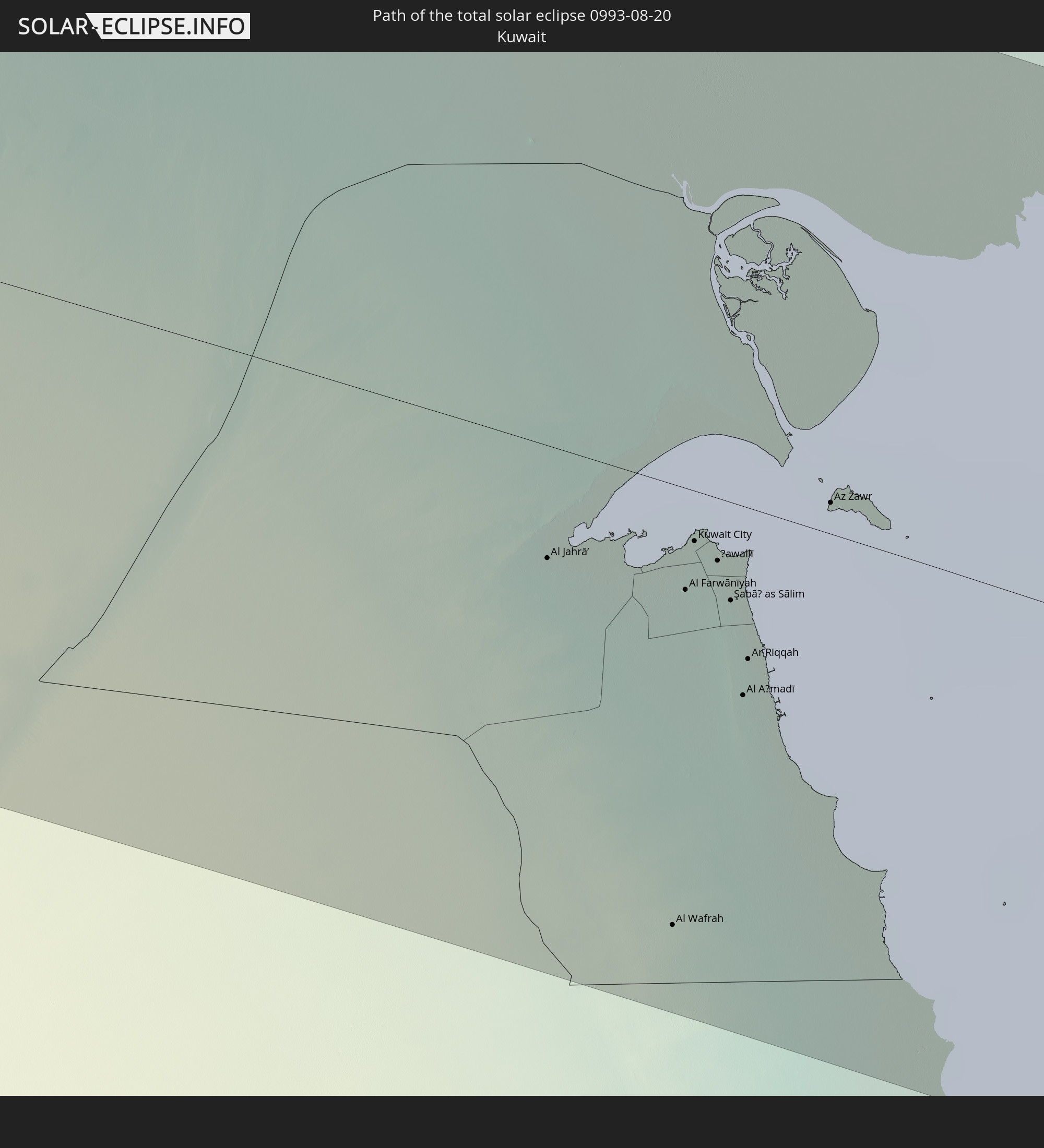
Detaillierte Länderkarten
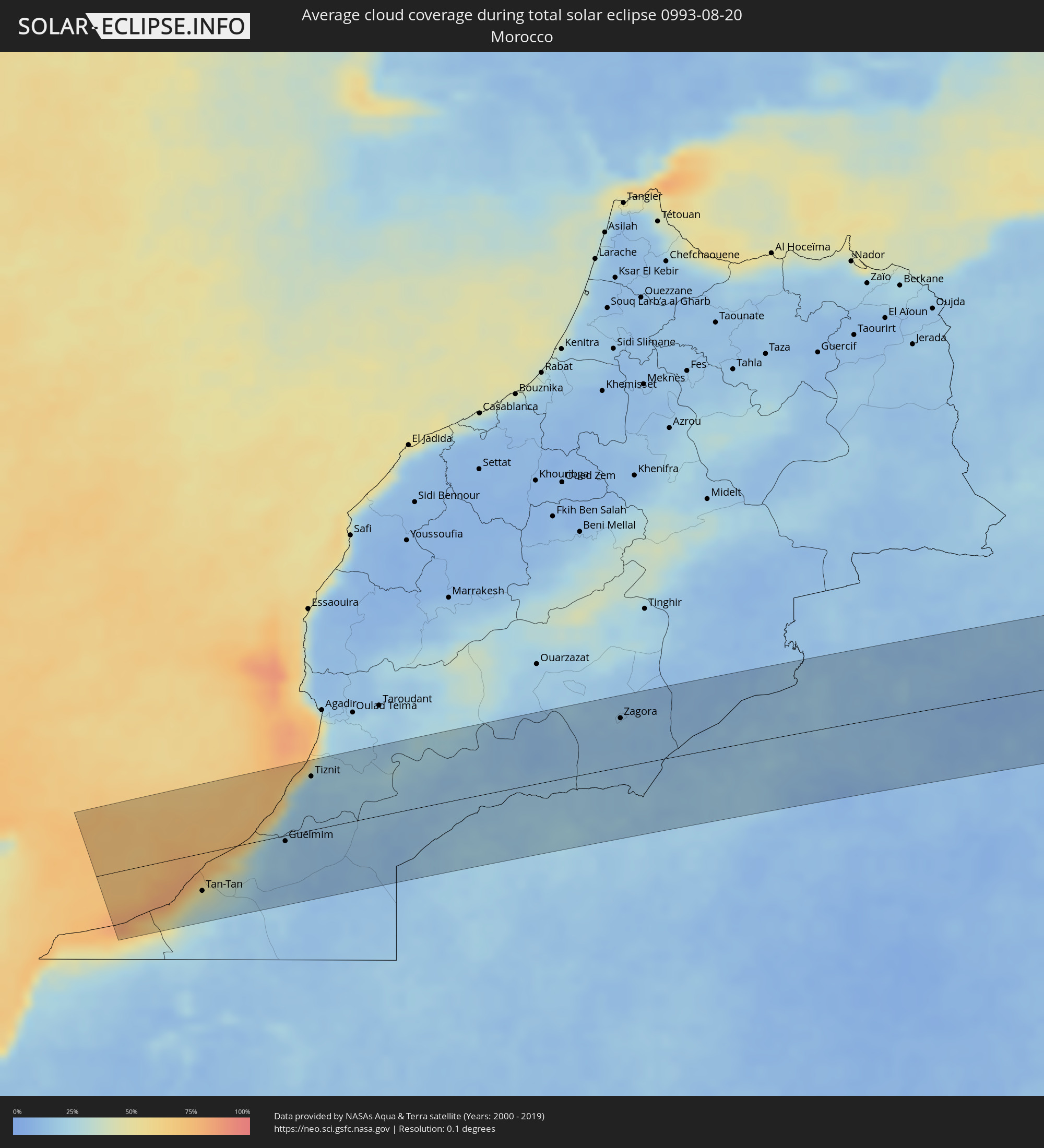 Marokko
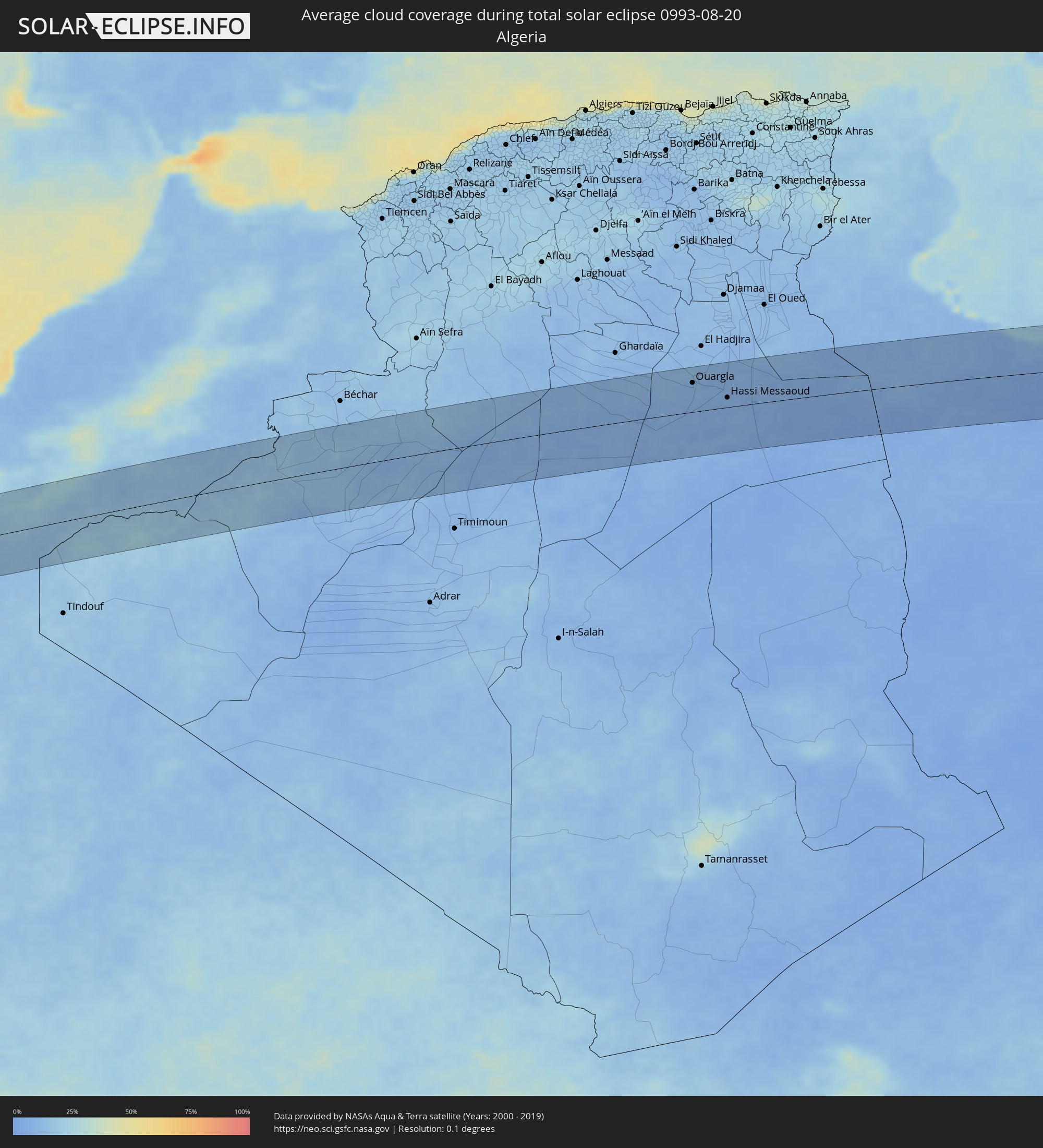 Algerien
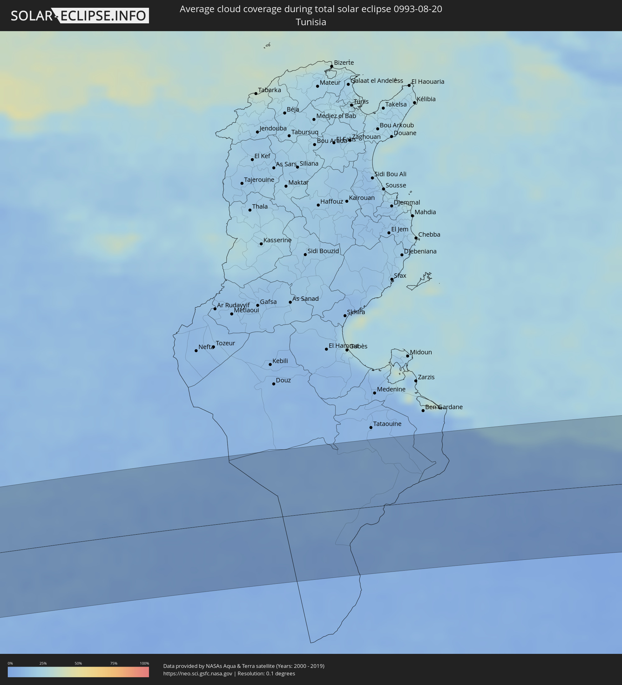 Tunesien
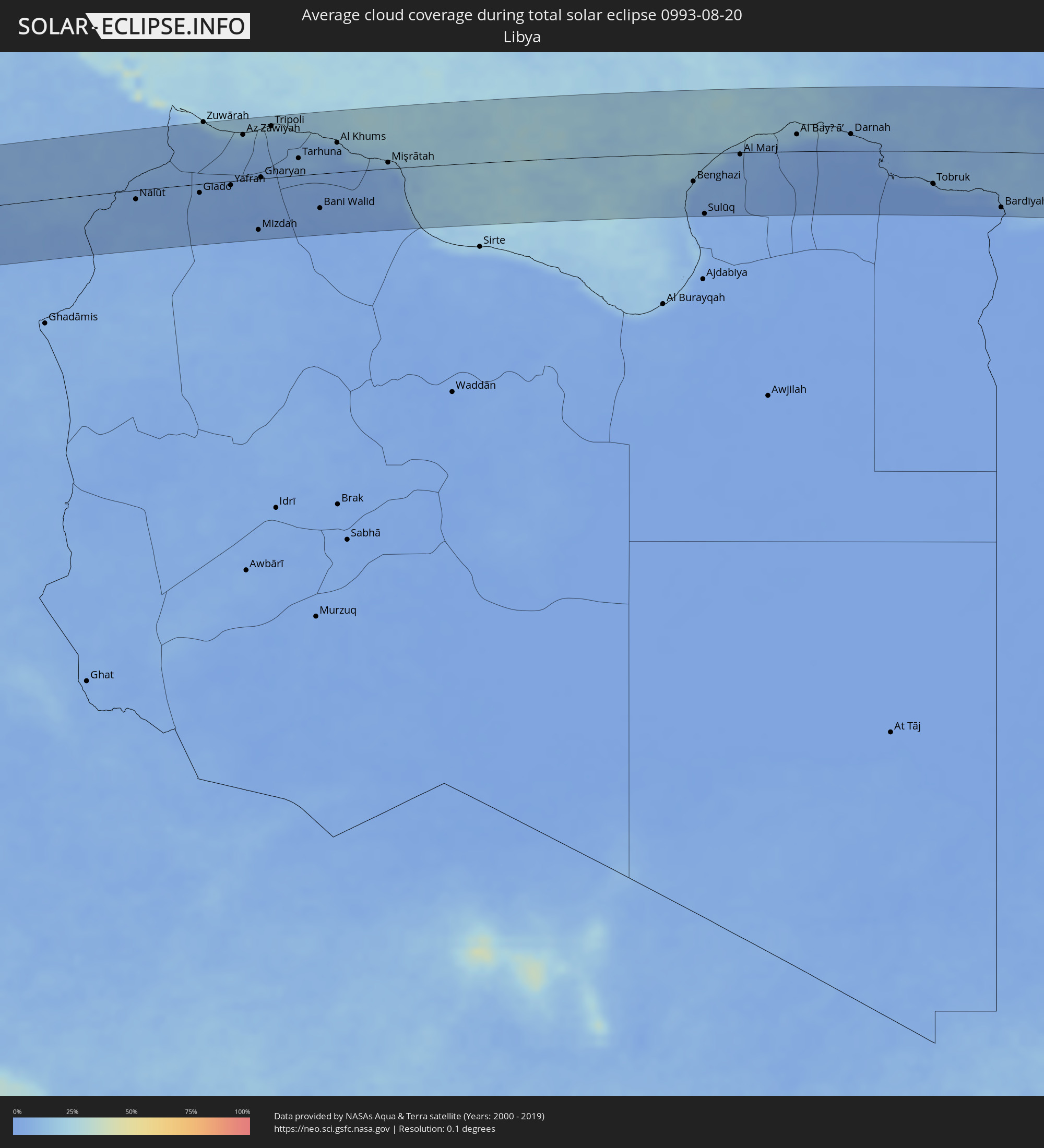 Libyen
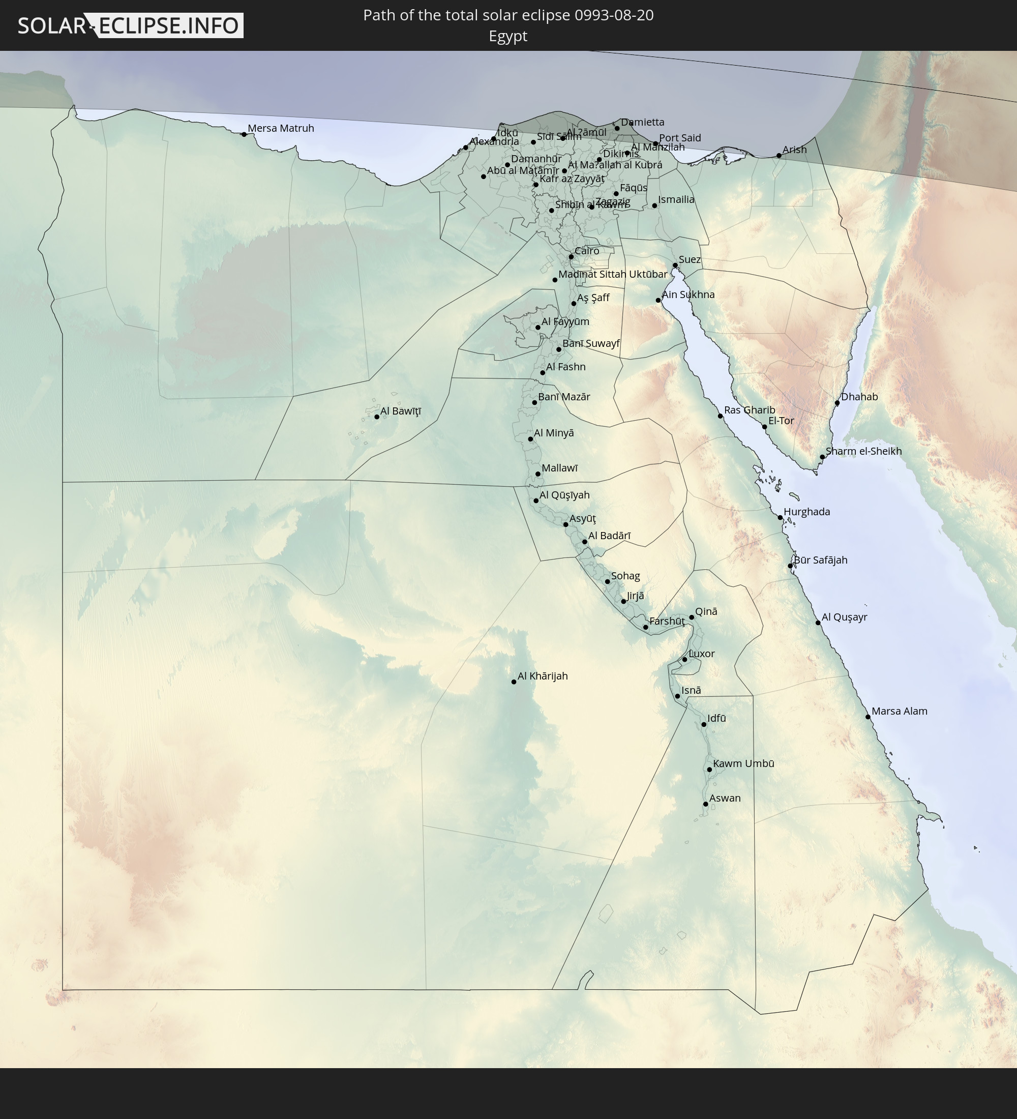
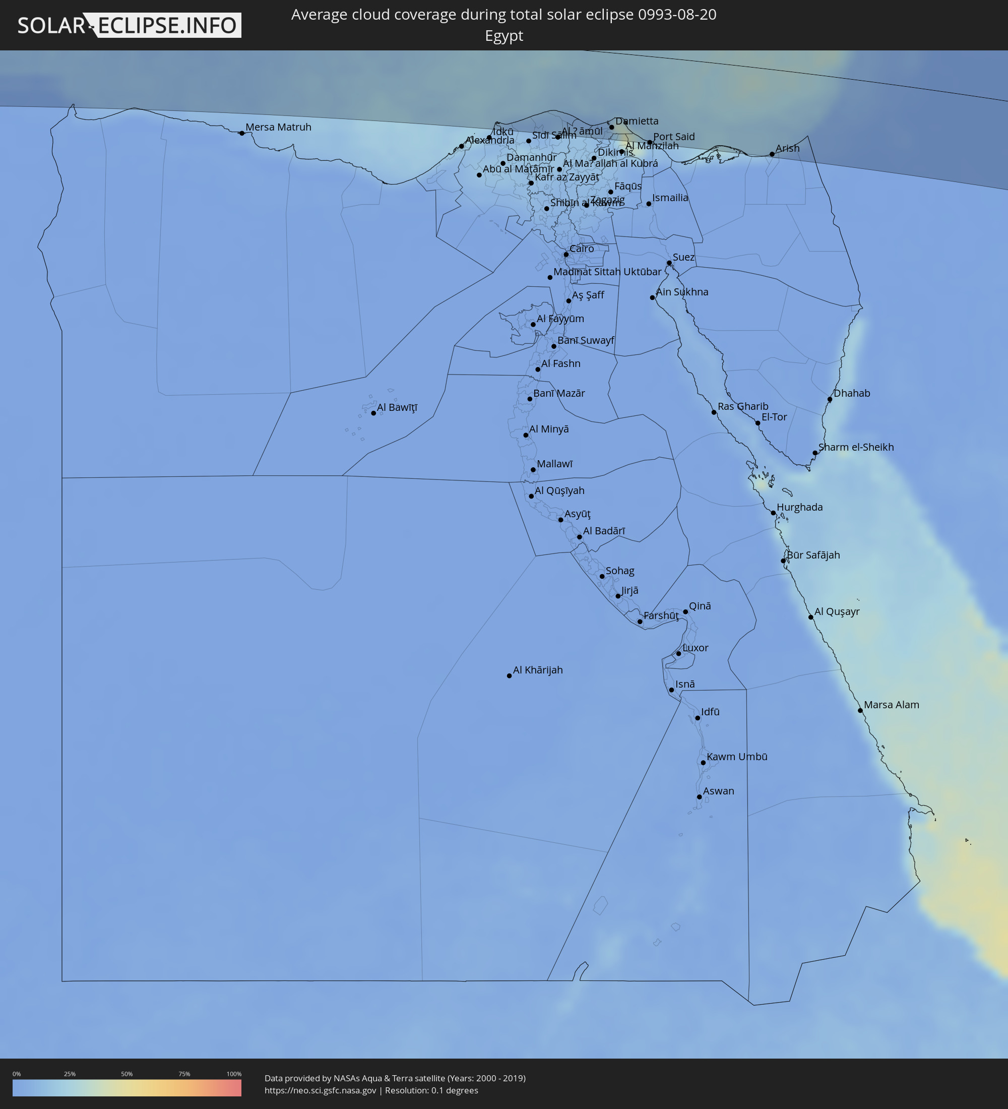 Ägypten
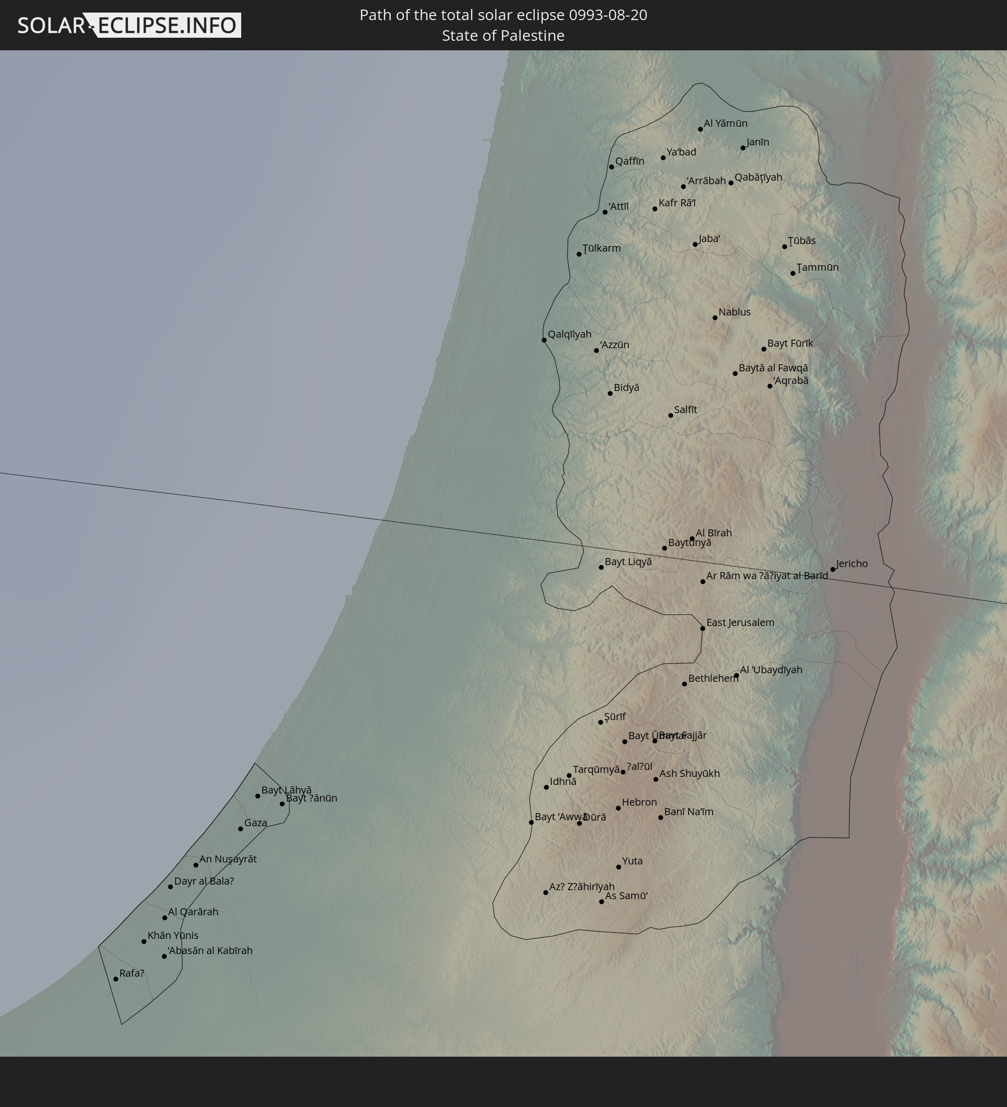
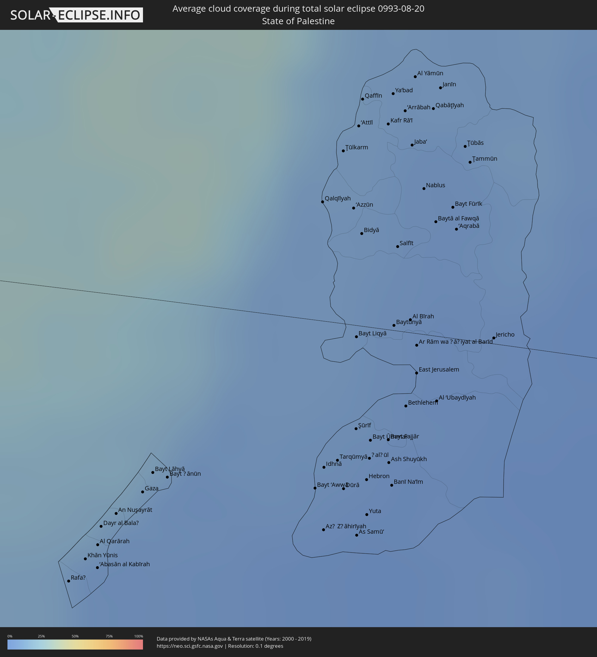 Staat Palästina
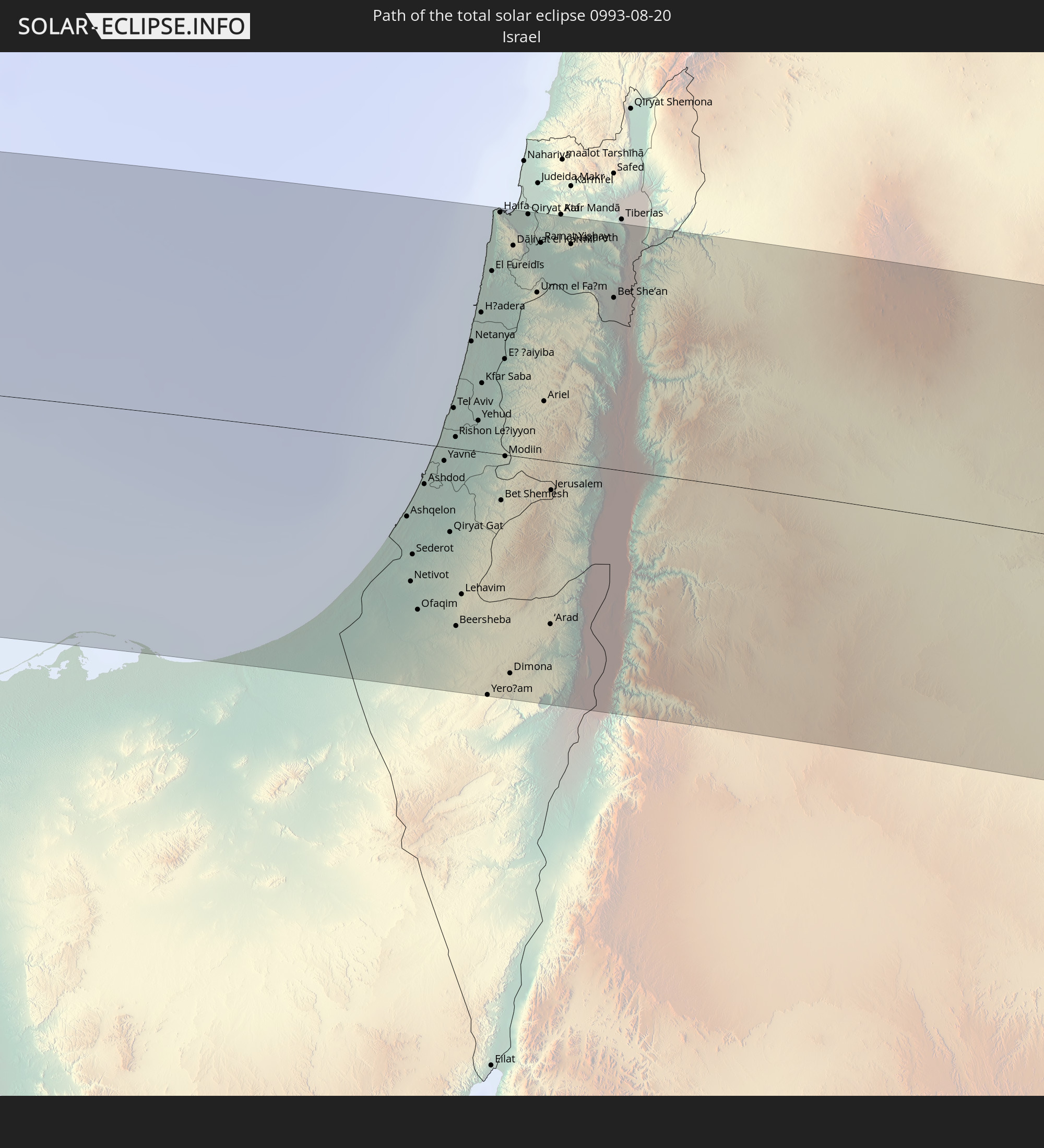
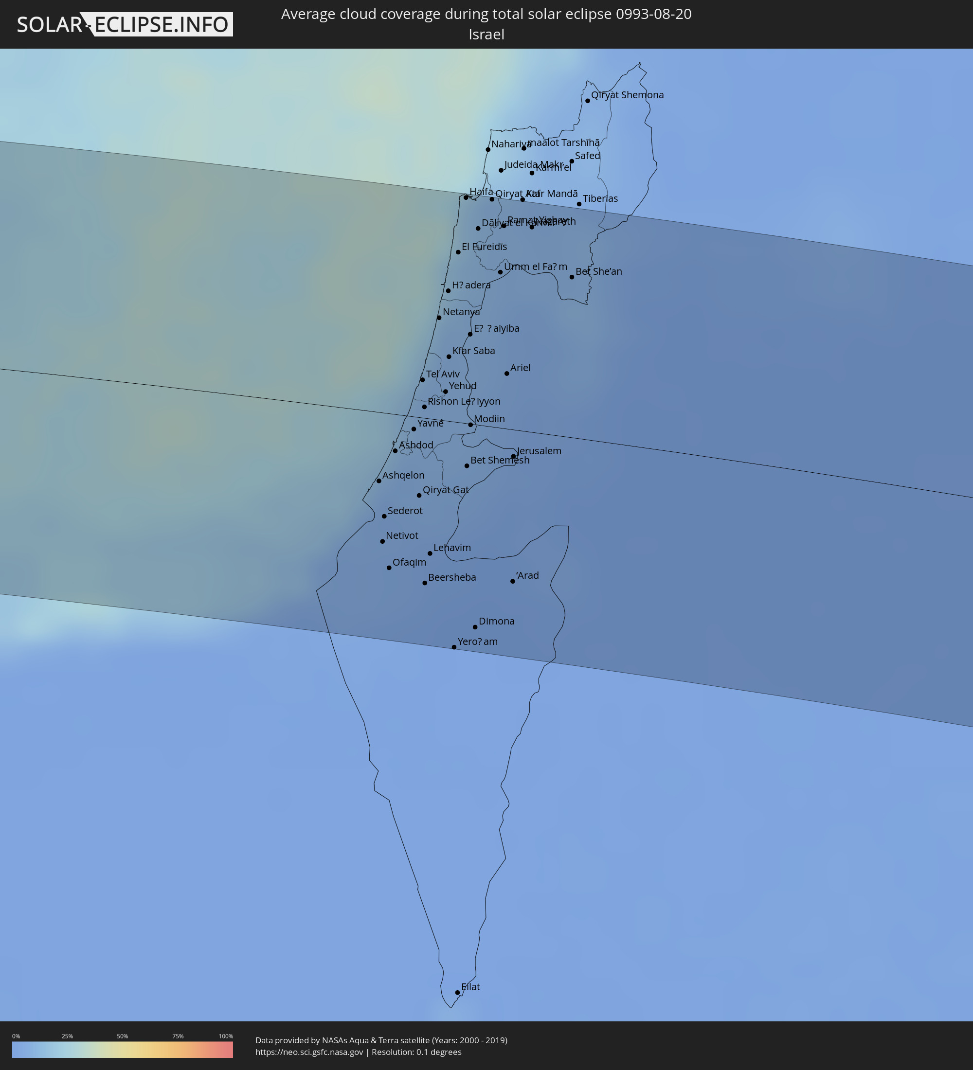 Israel
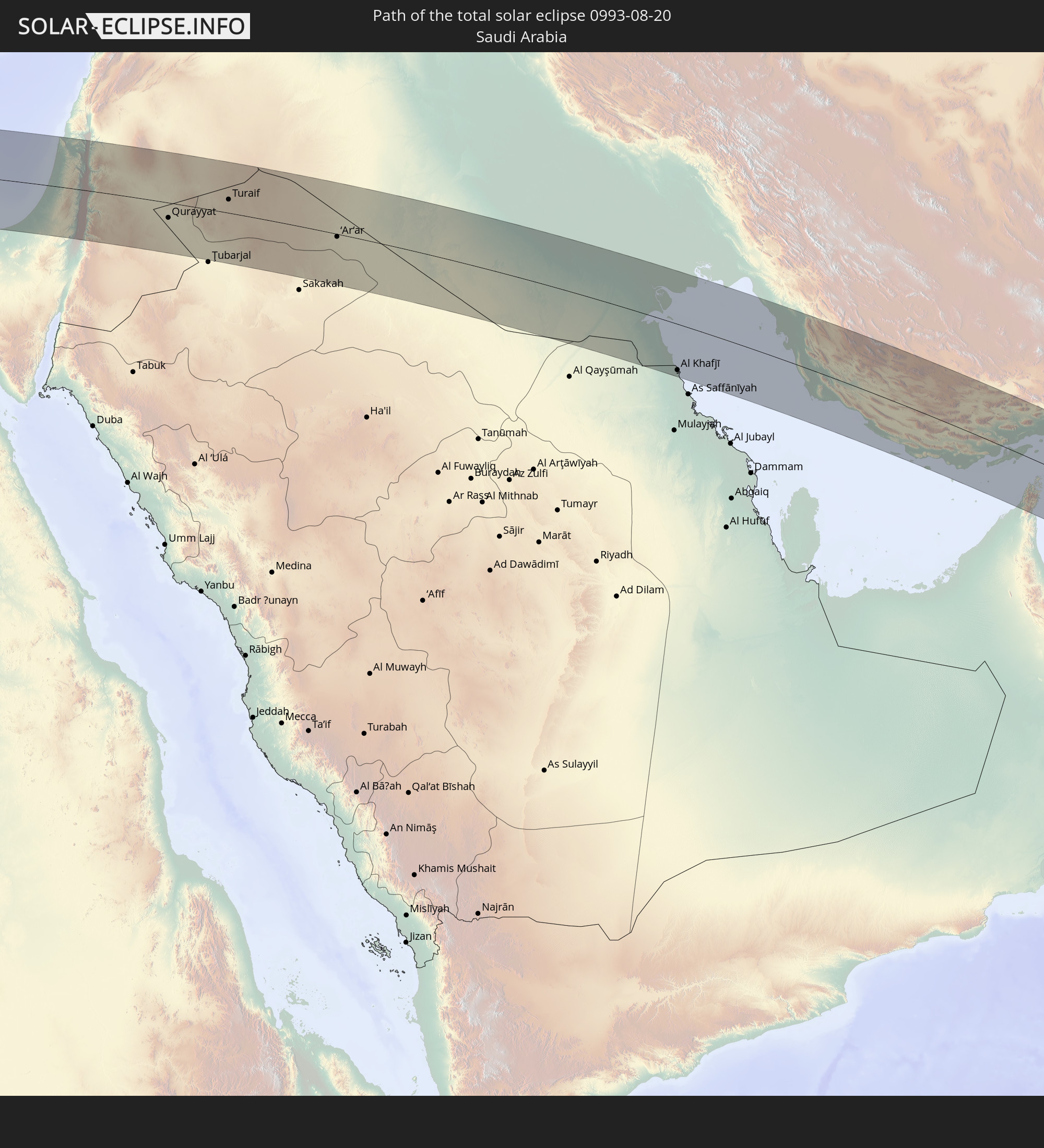
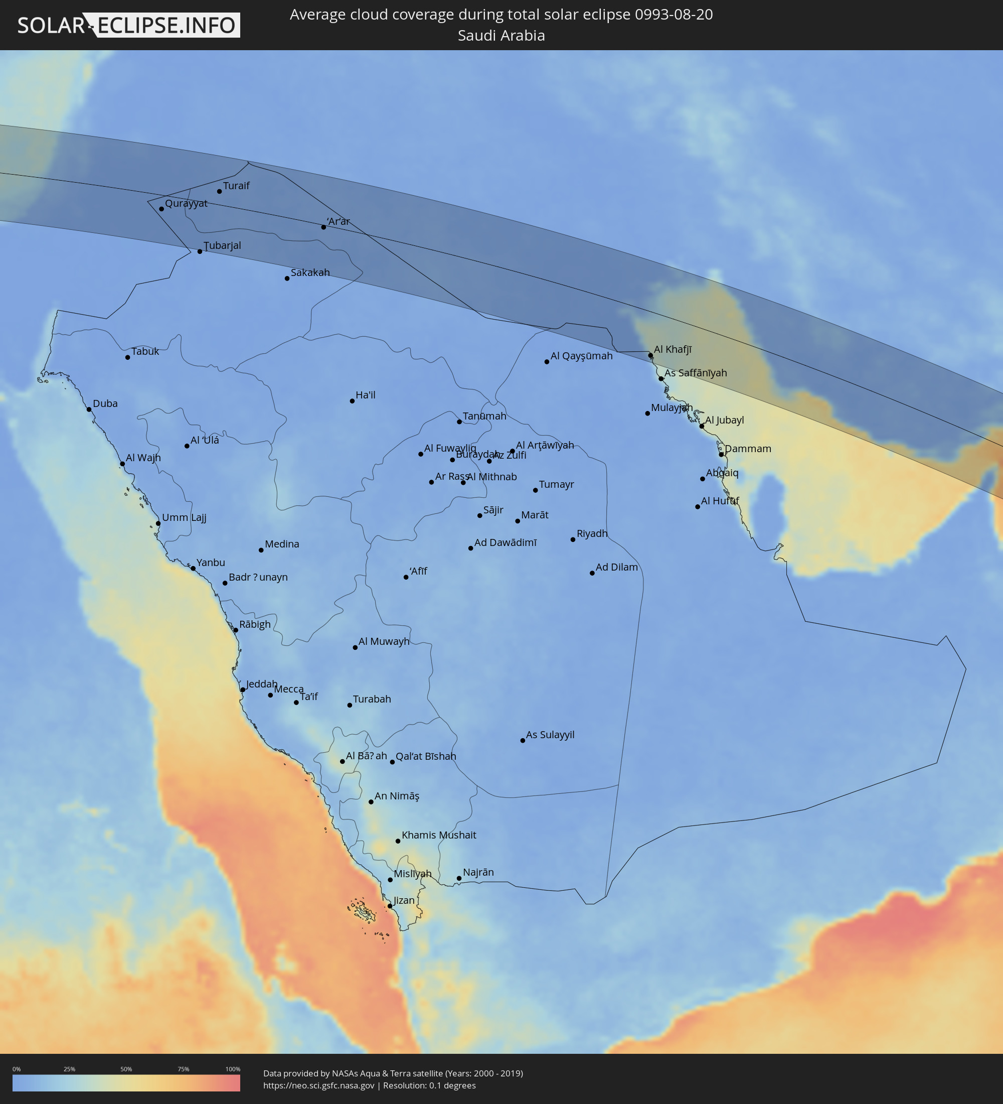 Saudi-Arabien
 Jordanien
 Syrien
 Irak
Irak
 Iran
Iran
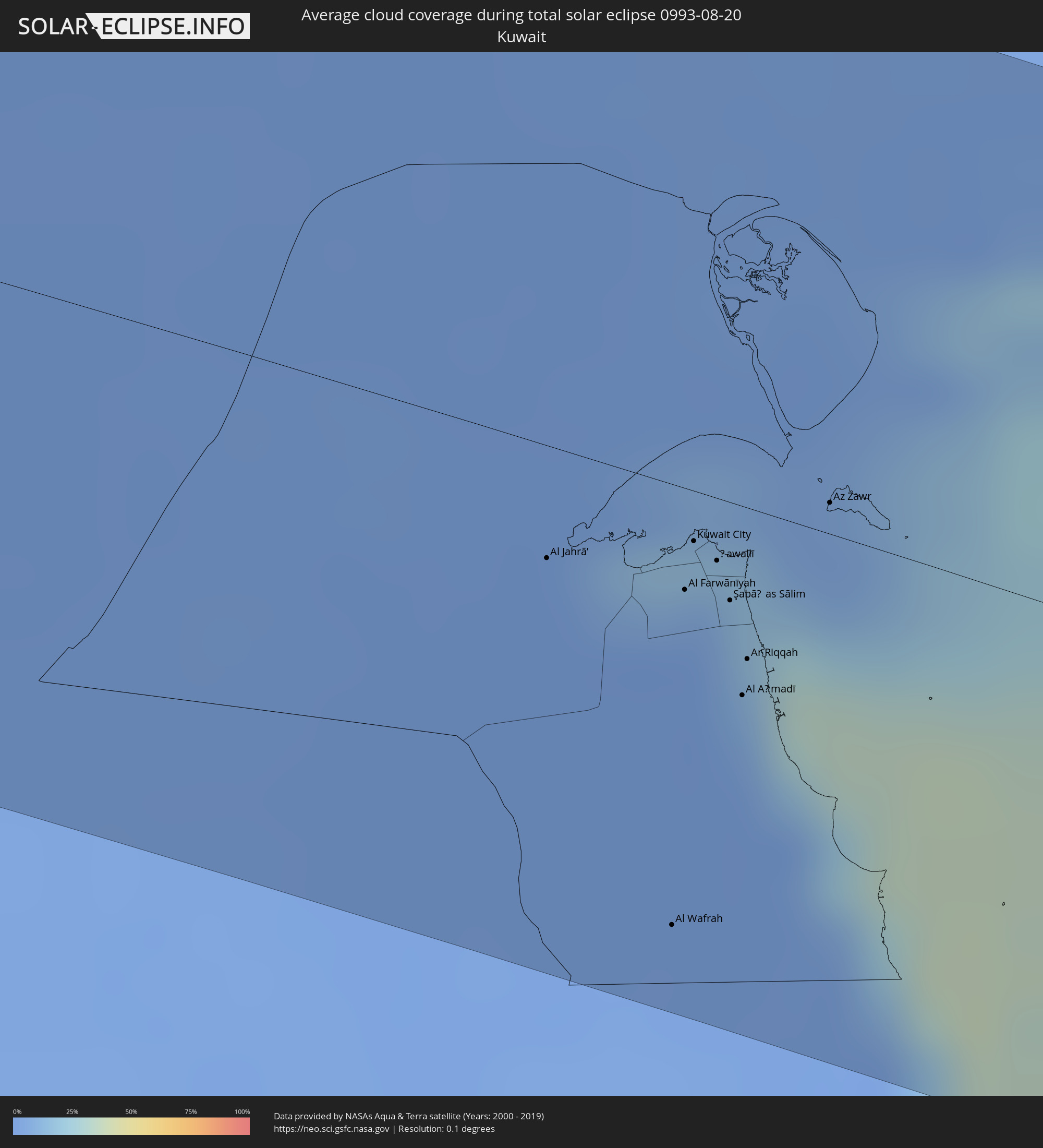 Kuwait
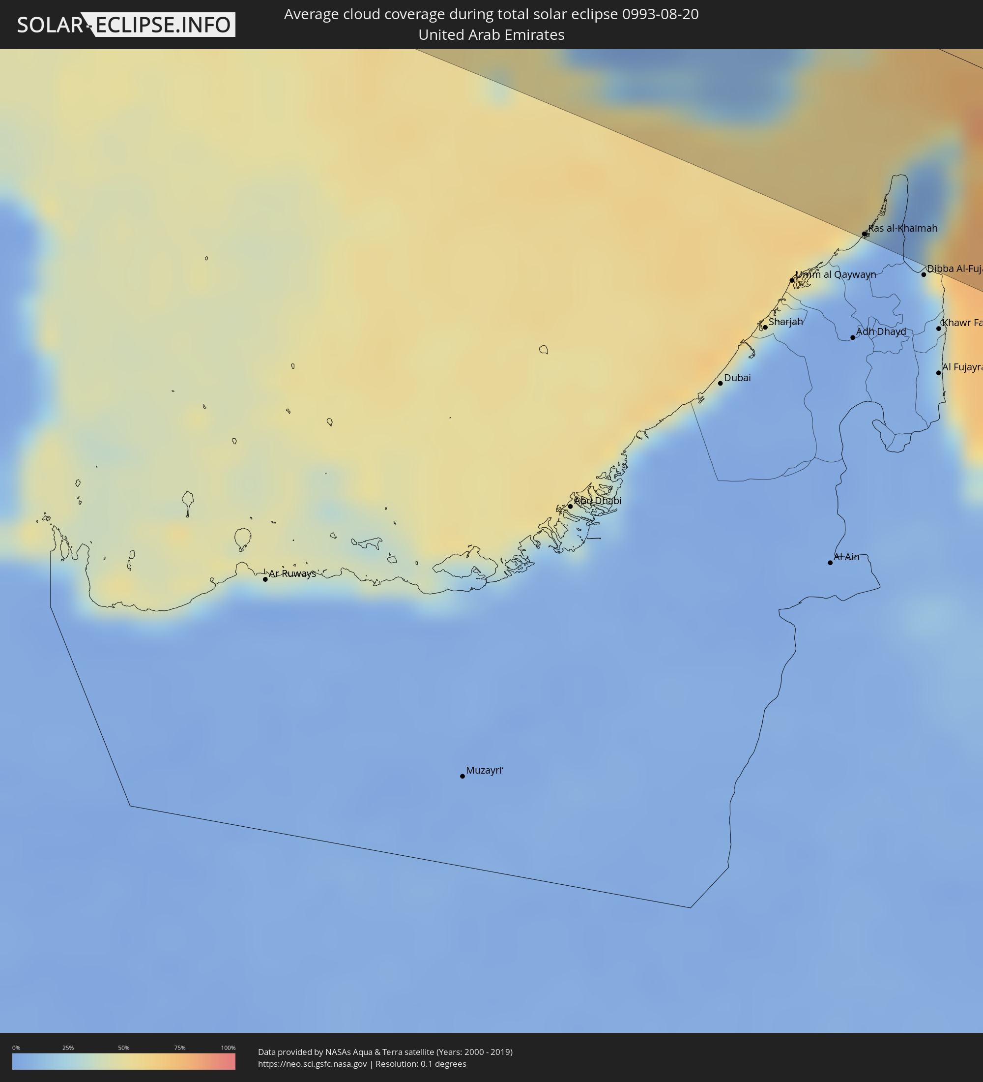 Vereinigte Arabische Emirate
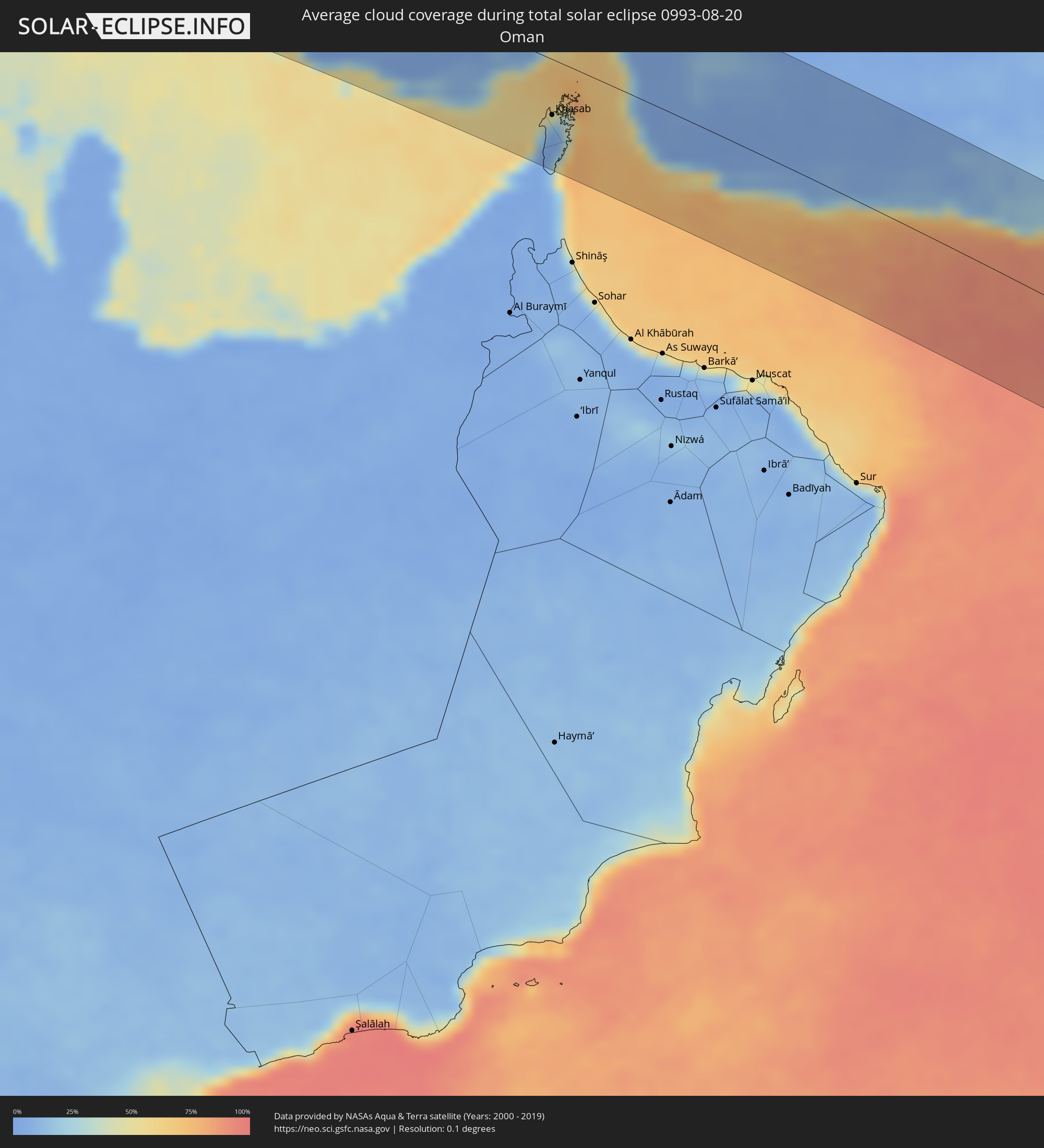 Oman
Oman
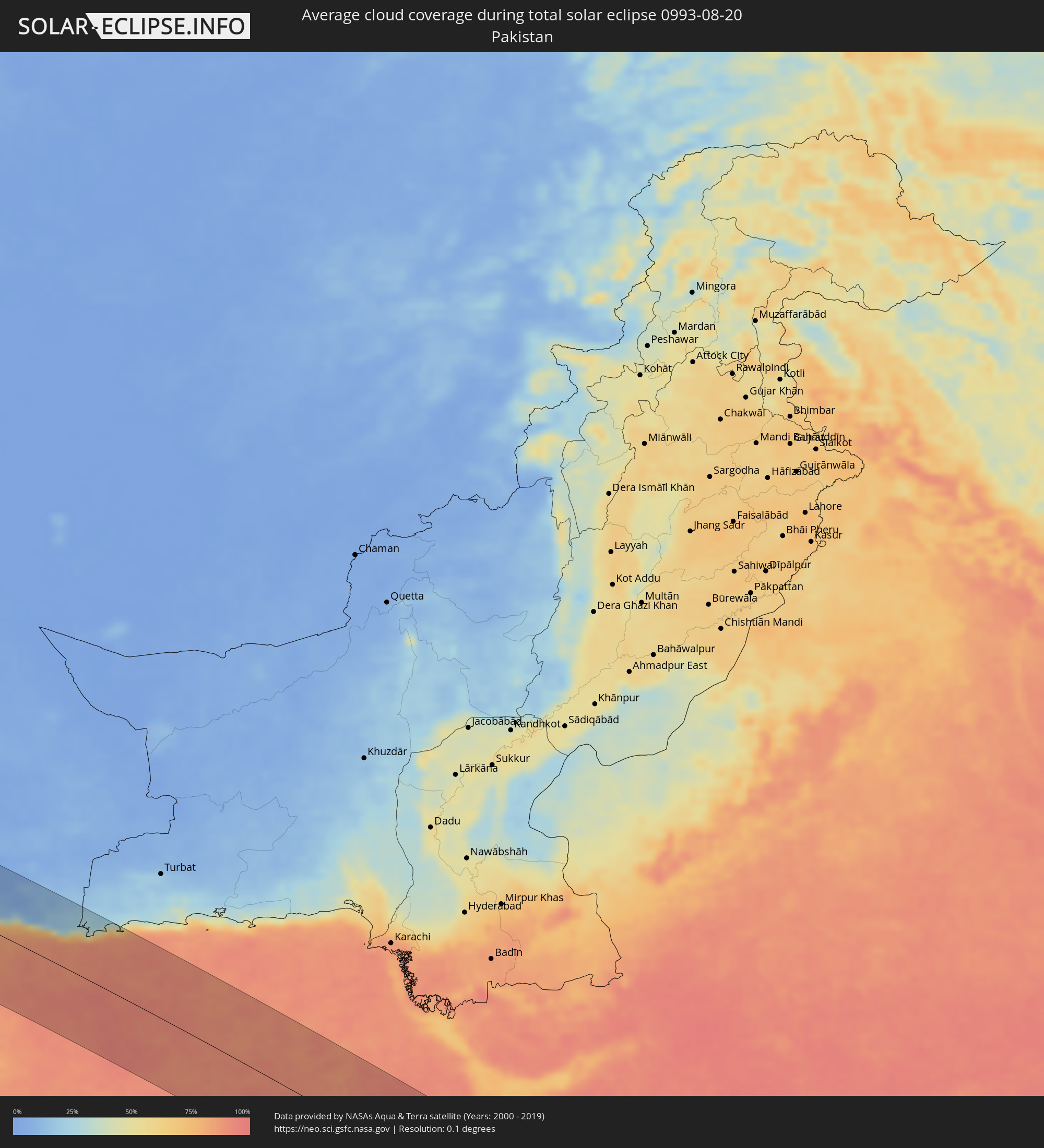 Pakistan
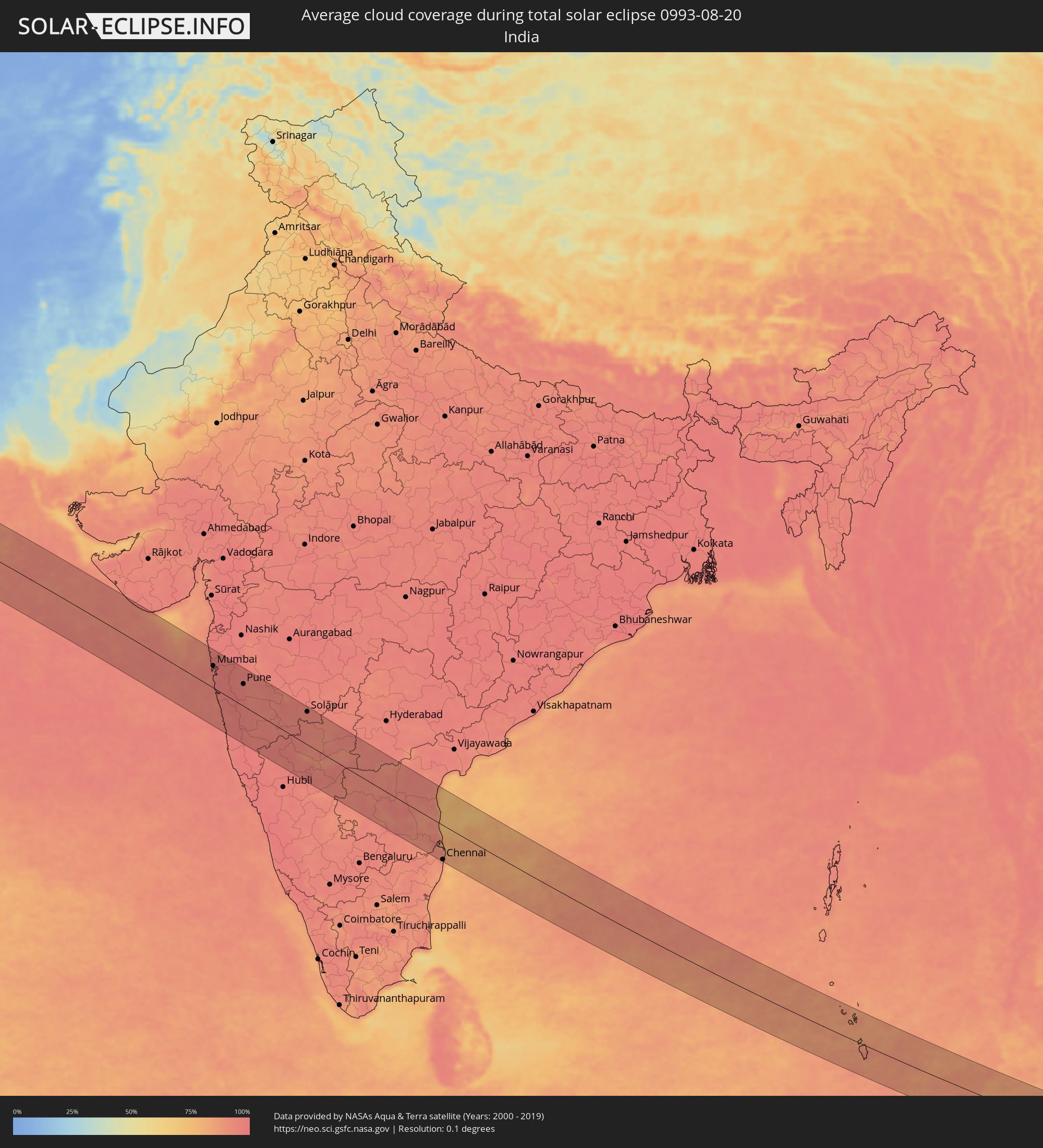 Indien
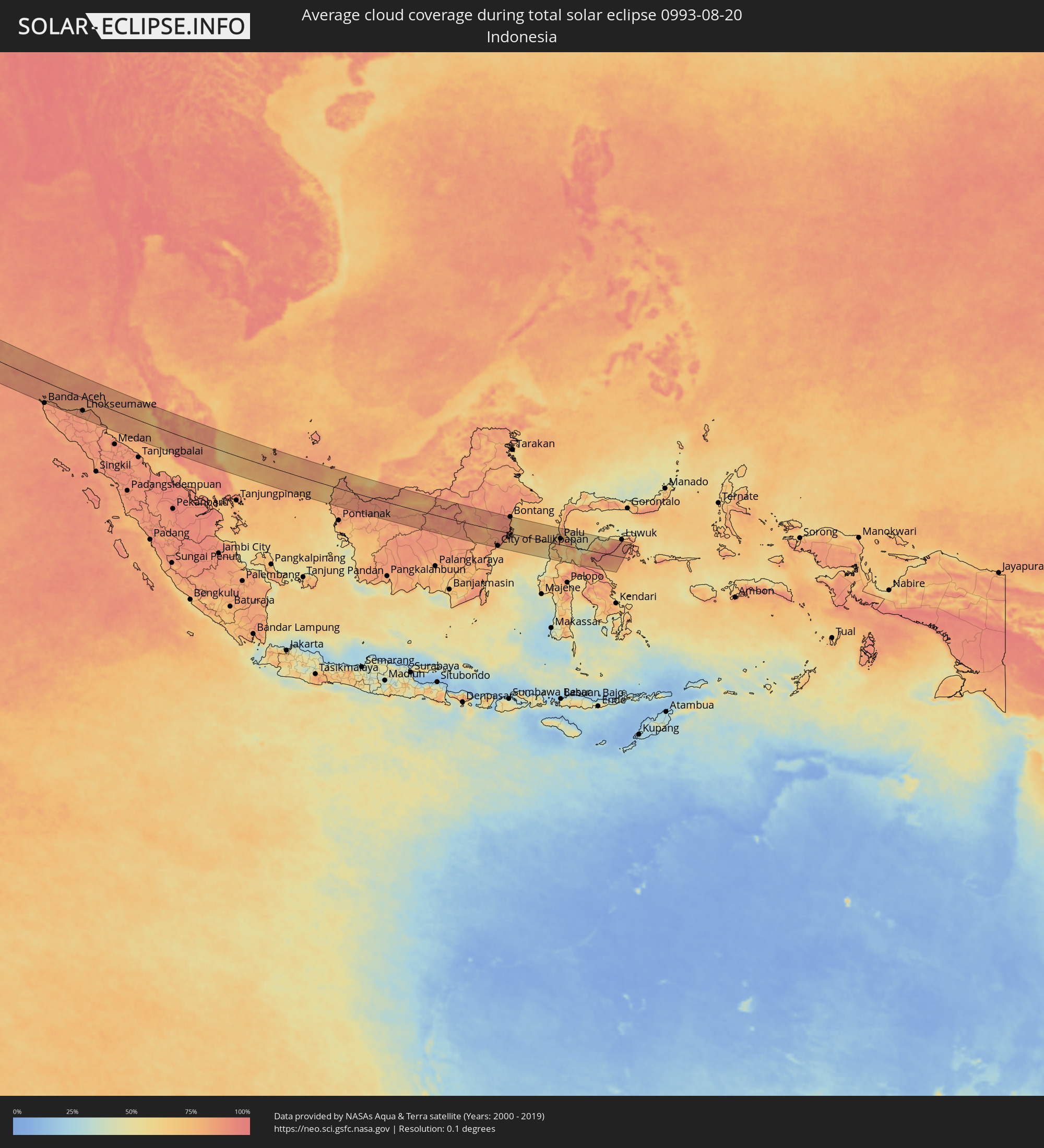 Indonesien
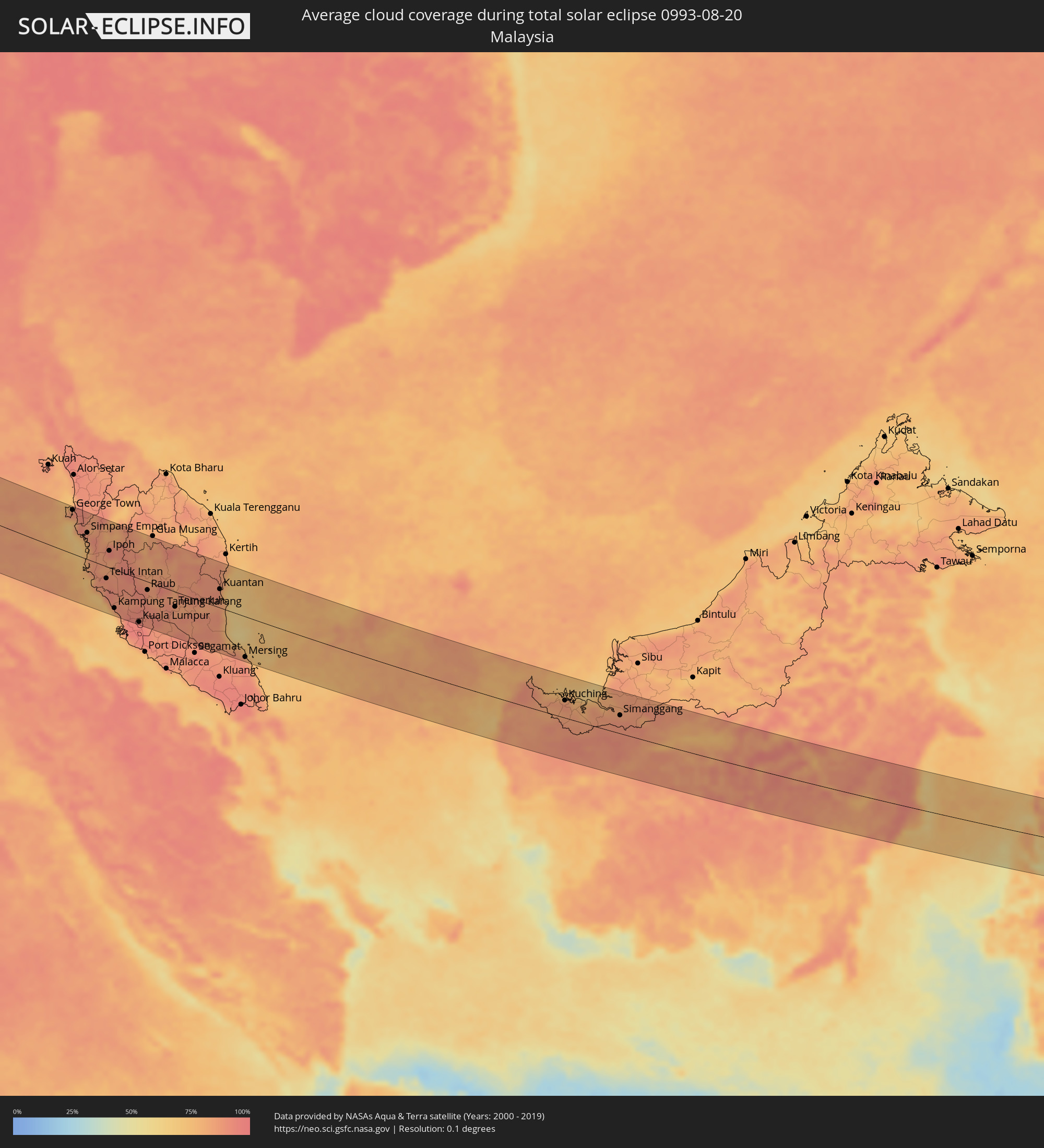 Malaysia
Orte im Finsternispfad
Die nachfolgene Tabelle zeigt Städte und Orte mit mehr als 5.000 Einwohnern, die sich im Finsternispfad befinden. Städte mit mehr als 100.000 Einwohnern sind dick gekennzeichnet. Mit einem Klick auf den Ort öffnet sich eine Detailkarte die die Lage des jeweiligen Ortes zusammen mit dem Verlauf der zentralen Finsternis präsentiert.
| Ort | Typ | Dauer der Verfinsterung | Ortszeit bei maximaler Verfinsterung | Entfernung zur Zentrallinie | Ø Bewölkung |
|
Tan-Tan, Guelmim-Es Smara
|
total | - | 05:56:11 UTC-00:30 | 45 km | 35% |
|
Sidi Ifni, Souss-Massa-Drâa
|
total | - | 05:56:39 UTC-00:30 | 38 km | 52% |
|
Guelmim, Guelmim-Es Smara
|
total | - | 05:56:26 UTC-00:30 | 7 km | 18% |
|
Tiznit, Souss-Massa-Drâa
|
total | - | 05:56:49 UTC-00:30 | 64 km | 20% |
|
Zagora, Souss-Massa-Drâa
|
total | - | 05:57:18 UTC-00:30 | 58 km | 15% |
|
Mhamid, Souss-Massa-Drâa
|
total | - | 05:57:00 UTC-00:30 | 0 km | 17% |
|
Ouargla, Ouargla
|
total | - | 06:40:49 UTC+00:09 | 59 km | 8% |
|
Rouissat, Ouargla
|
total | - | 06:40:49 UTC+00:09 | 56 km | 10% |
|
Hassi Messaoud, Ouargla
|
total | - | 06:41:00 UTC+00:09 | 20 km | 8% |
|
Şabrātah, Az Zāwiyah
|
total | - | 07:28:48 UTC+00:52 | 75 km | 10% |
|
Az Zāwīyah, Az Zāwiyah
|
total | - | 07:28:56 UTC+00:52 | 69 km | 13% |
|
Gharyan, Jabal al Gharbi District
|
total | - | 07:28:48 UTC+00:52 | 2 km | 4% |
|
Tripoli, Tripoli
|
total | - | 07:29:20 UTC+00:52 | 78 km | 14% |
|
Tagiura, Tripoli
|
total | - | 07:29:28 UTC+00:52 | 78 km | 13% |
|
Tarhuna, Al Marqab
|
total | - | 07:29:24 UTC+00:52 | 26 km | 9% |
|
Al Khums, Al Marqab
|
total | - | 07:30:01 UTC+00:52 | 45 km | 8% |
|
Zliten, Mişrātah
|
total | - | 07:30:09 UTC+00:52 | 23 km | 9% |
|
Mişrātah, Mişrātah
|
total | - | 07:30:30 UTC+00:52 | 9 km | 8% |
|
Benghazi, Banghāzī
|
total | - | 07:34:54 UTC+00:52 | 43 km | 8% |
|
Al Marj, Al Marj
|
total | - | 07:35:53 UTC+00:52 | 3 km | 7% |
|
Tobruk, Sha‘bīyat al Buţnān
|
total | - | 07:39:13 UTC+00:52 | 50 km | 5% |
|
Rosetta, Beheira
|
total | - | 08:54:54 UTC+02:00 | 101 km | 10% |
|
Fāraskūr, Damietta
|
total | - | 08:56:51 UTC+02:00 | 98 km | 13% |
|
Damietta, Damietta
|
total | - | 08:57:01 UTC+02:00 | 88 km | 11% |
|
‘Izbat al Burj, Dakahlia
|
total | - | 08:57:05 UTC+02:00 | 77 km | 11% |
|
Port Said, Port Said
|
total | - | 08:57:44 UTC+02:00 | 101 km | 14% |
|
Arish, North Sinai
|
total | - | 09:00:10 UTC+02:00 | 99 km | 1% |
|
Khān Yūnis, Gaza Strip
|
total | - | 09:01:01 UTC+02:00 | 71 km | 3% |
|
Gaza, Gaza Strip
|
total | - | 09:01:18 UTC+02:00 | 51 km | 6% |
|
Ashqelon, Southern District
|
total | - | 09:22:10 UTC+02:20 | 31 km | 6% |
|
Ashdod, Southern District
|
total | - | 09:22:18 UTC+02:20 | 17 km | 10% |
|
Qiryat Gat, Southern District
|
total | - | 09:22:29 UTC+02:20 | 35 km | 6% |
|
Tel Aviv, Tel Aviv
|
total | - | 09:22:33 UTC+02:20 | 17 km | 8% |
|
Beersheba, Southern District
|
total | - | 09:22:30 UTC+02:20 | 75 km | 2% |
|
Netanya, Central District
|
total | - | 09:22:43 UTC+02:20 | 46 km | 8% |
|
Kfar Saba, Central District
|
total | - | 09:22:46 UTC+02:20 | 29 km | 7% |
|
Az̧ Z̧āhirīyah, West Bank
|
total | - | 09:02:09 UTC+02:00 | 55 km | 1% |
|
Haifa, Haifa
|
total | - | 09:22:59 UTC+02:20 | 101 km | 15% |
|
Bet Shemesh, Jerusalem
|
total | - | 09:22:52 UTC+02:20 | 19 km | 6% |
|
Modiin, Central District
|
total | - | 09:22:55 UTC+02:20 | 1 km | 7% |
|
Ţūlkarm, West Bank
|
total | - | 09:02:19 UTC+02:00 | 45 km | 8% |
|
Bayt Liqyā, West Bank
|
total | - | 09:02:21 UTC+02:00 | 3 km | 6% |
|
Hebron, West Bank
|
total | - | 09:02:22 UTC+02:00 | 40 km | 1% |
|
Salfīt, West Bank
|
total | - | 09:02:33 UTC+02:00 | 22 km | 5% |
|
Jerusalem, Jerusalem
|
total | - | 09:23:15 UTC+02:20 | 12 km | 4% |
|
East Jerusalem, West Bank
|
total | - | 09:23:17 UTC+02:20 | 10 km | 4% |
|
Nablus, West Bank
|
total | - | 09:02:41 UTC+02:00 | 38 km | 4% |
|
Janīn, West Bank
|
total | - | 09:02:47 UTC+02:00 | 65 km | 5% |
|
Nazareth, Northern District
|
total | - | 09:23:29 UTC+02:20 | 91 km | 8% |
|
Ţūbās, West Bank
|
total | - | 09:02:54 UTC+02:00 | 51 km | 4% |
|
Jericho, West Bank
|
total | - | 09:02:59 UTC+02:00 | 1 km | 2% |
|
Safi, Karak
|
total | - | 09:26:42 UTC+02:23 | 90 km | 0% |
|
Kurayyimah, Irbid
|
total | - | 09:27:00 UTC+02:23 | 49 km | 7% |
|
‘Izrā, Karak
|
total | - | 09:27:06 UTC+02:23 | 73 km | 0% |
|
As Salţ, Balqa
|
total | - | 09:27:12 UTC+02:23 | 24 km | 1% |
|
‘Ajlūn, Ajlun
|
total | - | 09:27:16 UTC+02:23 | 57 km | 2% |
|
Mādabā, Madaba
|
total | - | 09:27:18 UTC+02:23 | 11 km | 0% |
|
Irbid, Irbid
|
total | - | 09:27:27 UTC+02:23 | 83 km | 2% |
|
Amman, Amman
|
total | - | 09:27:34 UTC+02:23 | 18 km | 0% |
|
Aţ Ţurrah, Irbid
|
total | - | 09:27:42 UTC+02:23 | 93 km | 1% |
|
Zarqa, Zarqa
|
total | - | 09:27:49 UTC+02:23 | 33 km | 0% |
|
Dar‘ā, Daraa
|
total | - | 09:29:21 UTC+02:25 | 93 km | 1% |
|
Mafraq, Mafraq
|
total | - | 09:28:02 UTC+02:23 | 64 km | 1% |
|
Al Azraq ash Shamālī, Zarqa
|
total | - | 09:29:06 UTC+02:23 | 22 km | 0% |
|
Qurayyat, Al Jawf
|
total | - | 10:13:08 UTC+03:06 | 31 km | 0% |
|
Turaif, Northern Borders
|
total | - | 10:15:30 UTC+03:06 | 27 km | 3% |
|
‘Ar‘ar, Northern Borders
|
total | - | 10:20:02 UTC+03:06 | 6 km | 3% |
|
Al Jahrā’, Al Jahrāʼ
|
total | - | 10:34:18 UTC+03:06 | 23 km | 0% |
|
Az Zubayr, Basra Governorate
|
total | - | 10:24:35 UTC+02:57 | 91 km | 1% |
|
Basrah, Basra Governorate
|
total | - | 10:24:41 UTC+02:57 | 105 km | 1% |
|
Al Başrah al Qadīmah, Basra Governorate
|
total | - | 10:24:46 UTC+02:57 | 106 km | 1% |
|
Umm Qaşr, Basra Governorate
|
total | - | 10:25:14 UTC+02:57 | 59 km | 1% |
|
Al Wafrah, Al Aḩmadī
|
total | - | 10:35:17 UTC+03:06 | 89 km | 1% |
|
Ar Rābiyah, Al Asimah
|
total | - | 10:34:55 UTC+03:06 | 19 km | 0% |
|
Ash Shāmīyah, Al Asimah
|
total | - | 10:34:57 UTC+03:06 | 13 km | 2% |
|
Janūb as Surrah, Al Farwaniyah
|
total | - | 10:35:02 UTC+03:06 | 21 km | 2% |
|
Ad Dasmah, Al Asimah
|
total | - | 10:35:02 UTC+03:06 | 10 km | 7% |
|
Ḩawallī, Hawalli
|
total | - | 10:35:07 UTC+03:06 | 13 km | 2% |
|
Bayān, Hawalli
|
total | - | 10:35:10 UTC+03:06 | 15 km | 2% |
|
Al Aḩmadī, Al Aḩmadī
|
total | - | 10:35:22 UTC+03:06 | 38 km | 7% |
|
Al Finţās, Al Aḩmadī
|
total | - | 10:35:24 UTC+03:06 | 27 km | 11% |
|
Al Mahbūlah, Al Aḩmadī
|
total | - | 10:35:26 UTC+03:06 | 30 km | 7% |
|
Az Zawr, Al Asimah
|
total | - | 10:35:35 UTC+03:06 | 6 km | 9% |
|
Abadan, Khuzestan
|
total | - | 10:54:02 UTC+03:25 | 102 km | 1% |
|
Al Fāw, Basra Governorate
|
total | - | 10:26:28 UTC+02:57 | 68 km | 9% |
|
Al Khafjī, Eastern Province
|
total | - | 10:36:39 UTC+03:06 | 94 km | 12% |
|
Bandar-e Ganāveh, Bushehr
|
total | - | 10:59:19 UTC+03:25 | 89 km | 25% |
|
Bandar-e Būshehr, Bushehr
|
total | - | 11:00:27 UTC+03:25 | 36 km | 20% |
|
Borāzjān, Bushehr
|
total | - | 11:01:06 UTC+03:25 | 80 km | 4% |
|
Fīrūzābād, Fars
|
total | - | 11:04:28 UTC+03:25 | 81 km | 8% |
|
Kīsh, Hormozgan
|
total | - | 11:09:48 UTC+03:25 | 103 km | 39% |
|
Gerāsh, Fars
|
total | - | 11:09:04 UTC+03:25 | 15 km | 4% |
|
Bandar-e Lengeh, Hormozgan
|
total | - | 11:11:51 UTC+03:25 | 70 km | 19% |
|
Ras al-Khaimah, Raʼs al Khaymah
|
total | - | 11:30:38 UTC+03:41 | 107 km | 27% |
|
Khasab, Musandam
|
total | - | 11:30:58 UTC+03:41 | 55 km | 16% |
|
Qeshm, Hormozgan
|
total | - | 11:14:46 UTC+03:25 | 24 km | 57% |
|
Bandar Abbas, Hormozgan
|
total | - | 11:14:33 UTC+03:25 | 49 km | 26% |
|
Mīnāb, Hormozgan
|
total | - | 11:16:30 UTC+03:25 | 76 km | 6% |
|
Chabahar, Sistan and Baluchestan
|
total | - | 11:27:01 UTC+03:25 | 44 km | 70% |
|
Jīwani, Balochistān
|
total | - | 12:32:24 UTC+04:28 | 71 km | 88% |
|
Gwadar, Balochistān
|
total | - | 12:33:40 UTC+04:28 | 105 km | 84% |
|
Bhayandar, Maharashtra
|
total | - | 13:58:52 UTC+05:21 | 84 km | 96% |
|
Mumbai, Maharashtra
|
total | - | 13:59:17 UTC+05:21 | 64 km | 96% |
|
Thāne, Maharashtra
|
total | - | 13:59:16 UTC+05:21 | 80 km | 97% |
|
Kalyān, Maharashtra
|
total | - | 13:59:33 UTC+05:21 | 94 km | 97% |
|
Pune, Maharashtra
|
total | - | 14:02:11 UTC+05:21 | 64 km | 95% |
|
Kolhāpur, Maharashtra
|
total | - | 14:05:49 UTC+05:21 | 89 km | 96% |
|
Ichalkaranji, Maharashtra
|
total | - | 14:06:18 UTC+05:21 | 77 km | 96% |
|
Sāngli, Maharashtra
|
total | - | 14:06:15 UTC+05:21 | 55 km | 95% |
|
Solāpur, Maharashtra
|
total | - | 14:07:38 UTC+05:21 | 96 km | 95% |
|
Bellary, Karnataka
|
total | - | 14:13:34 UTC+05:21 | 89 km | 91% |
|
Nellore, Andhra Pradesh
|
total | - | 14:20:14 UTC+05:21 | 12 km | 88% |
|
Chennai, Tamil Nadu
|
total | - | 14:22:49 UTC+05:21 | 103 km | 87% |
|
Sabang, Aceh
|
total | - | 16:38:13 UTC+07:07 | 69 km | 83% |
|
Reuleuet, Aceh
|
total | - | 16:39:49 UTC+07:07 | 96 km | 87% |
|
Bireun, Aceh
|
total | - | 16:40:12 UTC+07:07 | 79 km | 88% |
|
Lhokseumawe, Aceh
|
total | - | 16:40:36 UTC+07:07 | 63 km | 86% |
|
George Town, Penang
|
total | - | 16:31:03 UTC+06:55 | 92 km | 87% |
|
Bukit Mertajam, Penang
|
total | - | 16:31:12 UTC+06:55 | 92 km | 92% |
|
Taiping, Perak
|
total | - | 16:31:54 UTC+06:55 | 49 km | 89% |
|
Teluk Intan, Perak
|
total | - | 16:32:54 UTC+06:55 | 25 km | 87% |
|
Ipoh, Perak
|
total | - | 16:32:24 UTC+06:55 | 35 km | 93% |
|
Kampung Baru Subang, Selangor
|
total | - | 16:34:04 UTC+06:55 | 97 km | 95% |
|
Rawang, Selangor
|
total | - | 16:33:56 UTC+06:55 | 77 km | 93% |
|
Kuala Lumpur, Kuala Lumpur
|
total | - | 16:34:10 UTC+06:55 | 92 km | 95% |
|
Temerluh, Pahang
|
total | - | 16:34:20 UTC+06:55 | 32 km | 86% |
|
Kuantan, Pahang
|
total | - | 16:34:32 UTC+06:55 | 40 km | 88% |
|
Cukai, Terengganu
|
total | - | 16:34:11 UTC+06:55 | 89 km | 84% |
|
Pemangkat, West Kalimantan
|
total | - | 16:51:08 UTC+07:07 | 46 km | 81% |
|
Singkawang, West Kalimantan
|
total | - | 16:51:20 UTC+07:07 | 73 km | 85% |
|
Kuching, Sarawak
|
total | - | 17:05:25 UTC+07:21 | 38 km | 85% |
|
City of Balikpapan, East Kalimantan
|
total | - | 17:44:47 UTC+07:57 | 79 km | 79% |
|
Loa Janan, East Kalimantan
|
total | - | 17:44:24 UTC+07:57 | 2 km | 93% |
|
Samarinda, East Kalimantan
|
total | - | 17:44:21 UTC+07:57 | 9 km | 91% |
|
Bontang, East Kalimantan
|
total | - | 17:43:58 UTC+07:57 | 85 km | 81% |
|
Palu, Central Sulawesi
|
total | - | 17:44:41 UTC+07:57 | 30 km | 70% |
|
Poso, Central Sulawesi
|
total | - | 17:44:56 UTC+07:57 | 3 km | 53% |