Totale Sonnenfinsternis vom 31.08.1011
| Wochentag: | Samstag |
| Maximale Dauer der Verfinsterung: | 05m25s |
| Maximale Breite des Finsternispfades: | 204 km |
| Saroszyklus: | 109 |
| Bedeckungsgrad: | 100% |
| Magnitude: | 1.0612 |
| Gamma: | 0.1851 |
Wo kann man die Sonnenfinsternis vom 31.08.1011 sehen?
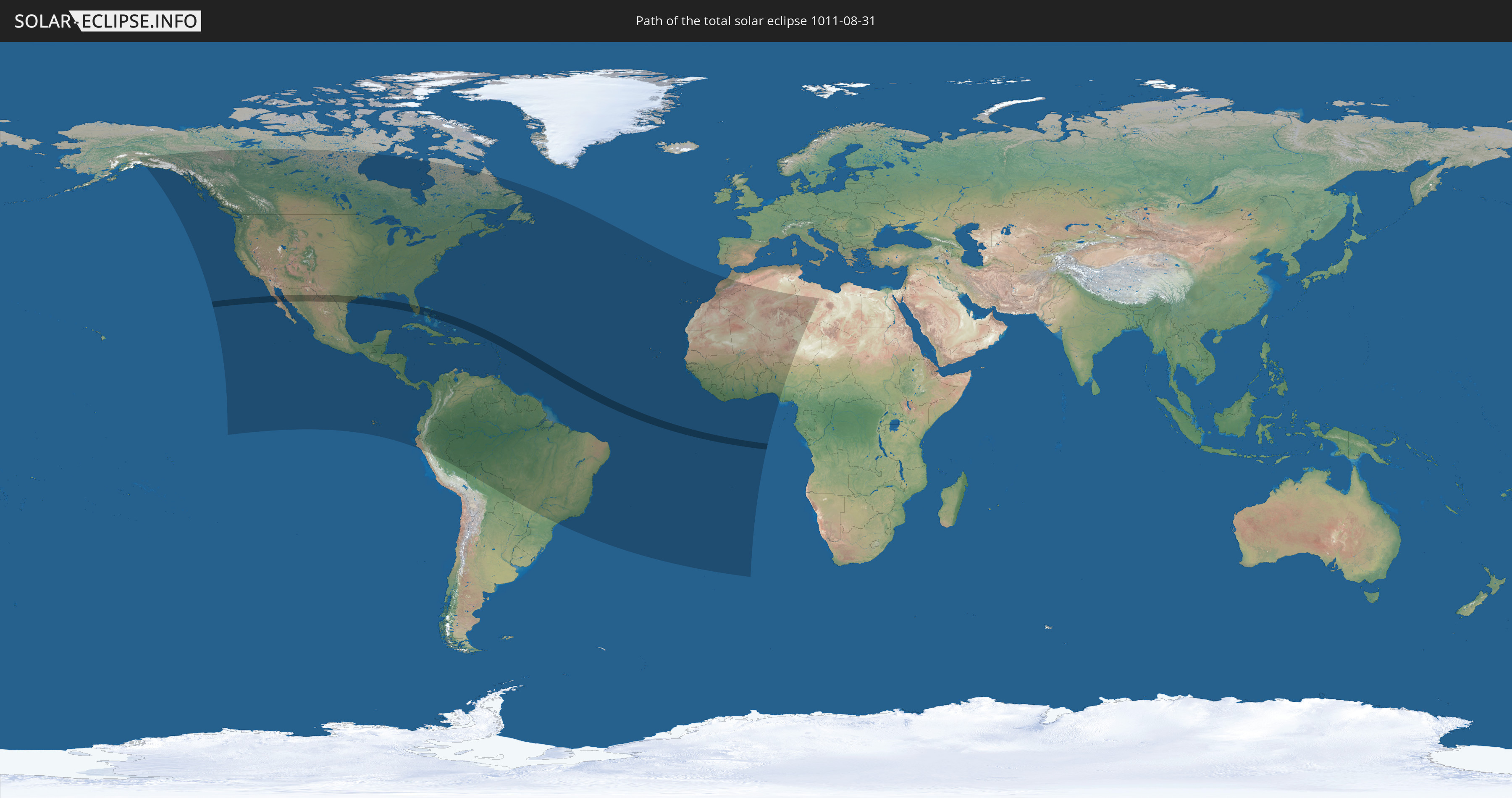
Die Sonnenfinsternis am 31.08.1011 kann man in 70 Ländern als partielle Sonnenfinsternis beobachten.
Der Finsternispfad verläuft durch 3 Länder. Nur in diesen Ländern ist sie als totale Sonnenfinsternis zu sehen.
In den folgenden Ländern ist die Sonnenfinsternis total zu sehen
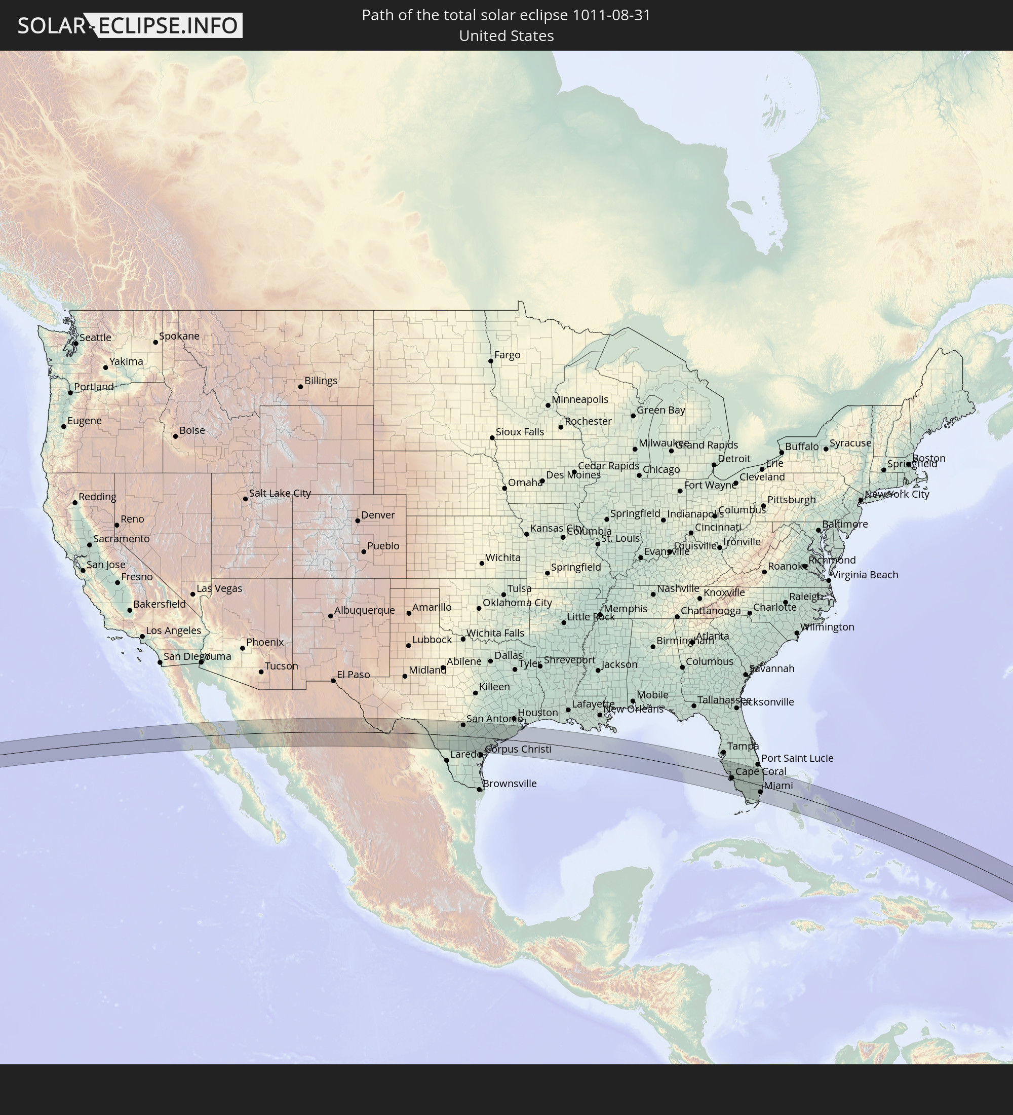 Vereinigte Staaten
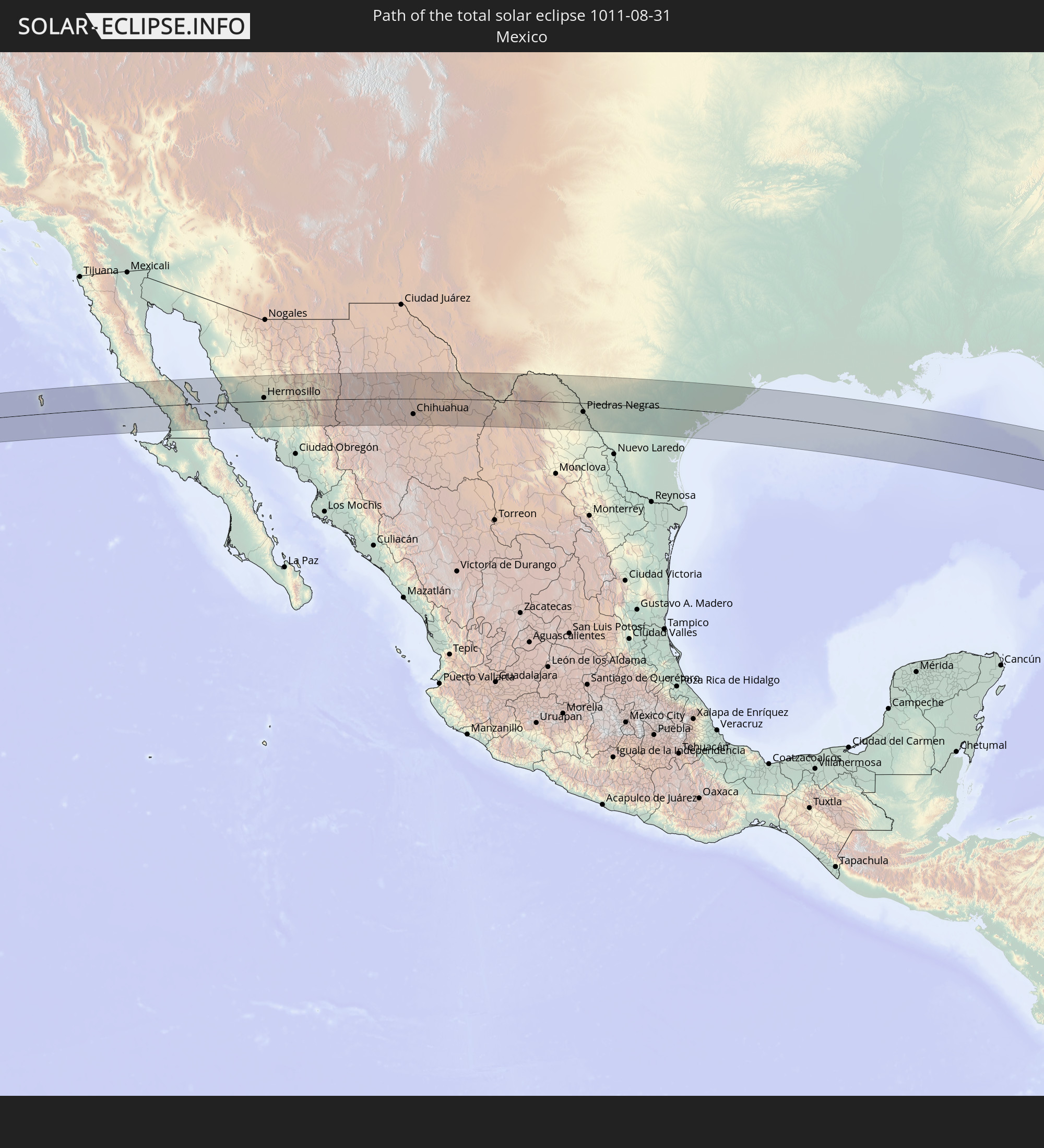 Mexiko
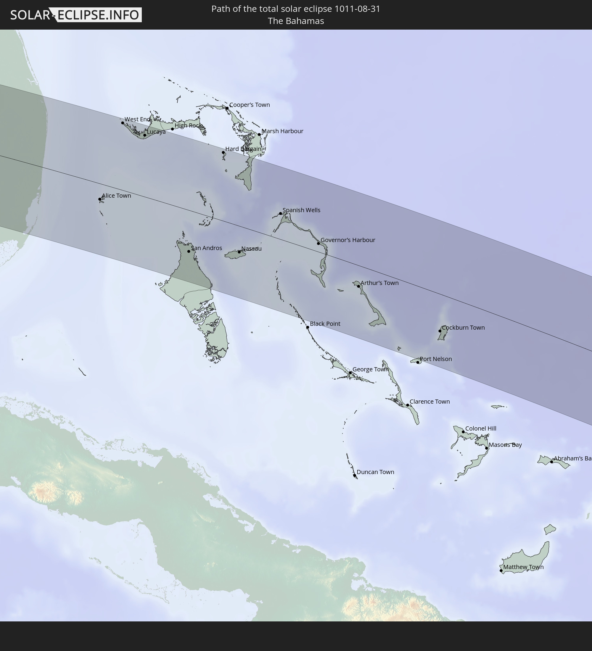 Bahamas
In den folgenden Ländern ist die Sonnenfinsternis partiell zu sehen
 Vereinigte Staaten
 United States Minor Outlying Islands
 Kanada
 Mexiko
 Grönland
 Guatemala
 Ecuador
 El Salvador
 Honduras
 Belize
 Nicaragua
 Costa Rica
 Kuba
Kuba
 Panama
 Kolumbien
 Kaimaninseln
 Peru
Peru
 Bahamas
 Jamaika
 Haiti
Haiti
 Brasilien
 Venezuela
 Turks- und Caicosinseln
 Dominikanische Republik
 Aruba
Aruba
 Bolivien
 Puerto Rico
 Amerikanische Jungferninseln
 Bermuda
 Britische Jungferninseln
 Anguilla
 Saint-Martin
 Saint-Barthélemy
 St. Kitts und Nevis
 Antigua und Barbuda
 Montserrat
 Trinidad und Tobago
 Guadeloupe
 Grenada
 Dominica
 St. Vincent und die Grenadinen
 Guyana
 Martinique
 St. Lucia
 Barbados
 Suriname
 Saint-Pierre und Miquelon
 Französisch-Guayana
 Portugal
 Kap Verde
 Spanien
 Senegal
 Mauretanien
 Gambia
 Guinea-Bissau
 Guinea
 St. Helena
 Sierra Leone
 Marokko
 Mali
Mali
 Liberia
 Algerien
 Elfenbeinküste
 Burkina Faso
 Ghana
Ghana
 Togo
Togo
 Niger
Niger
 Benin
Benin
 Nigeria
 Libyen
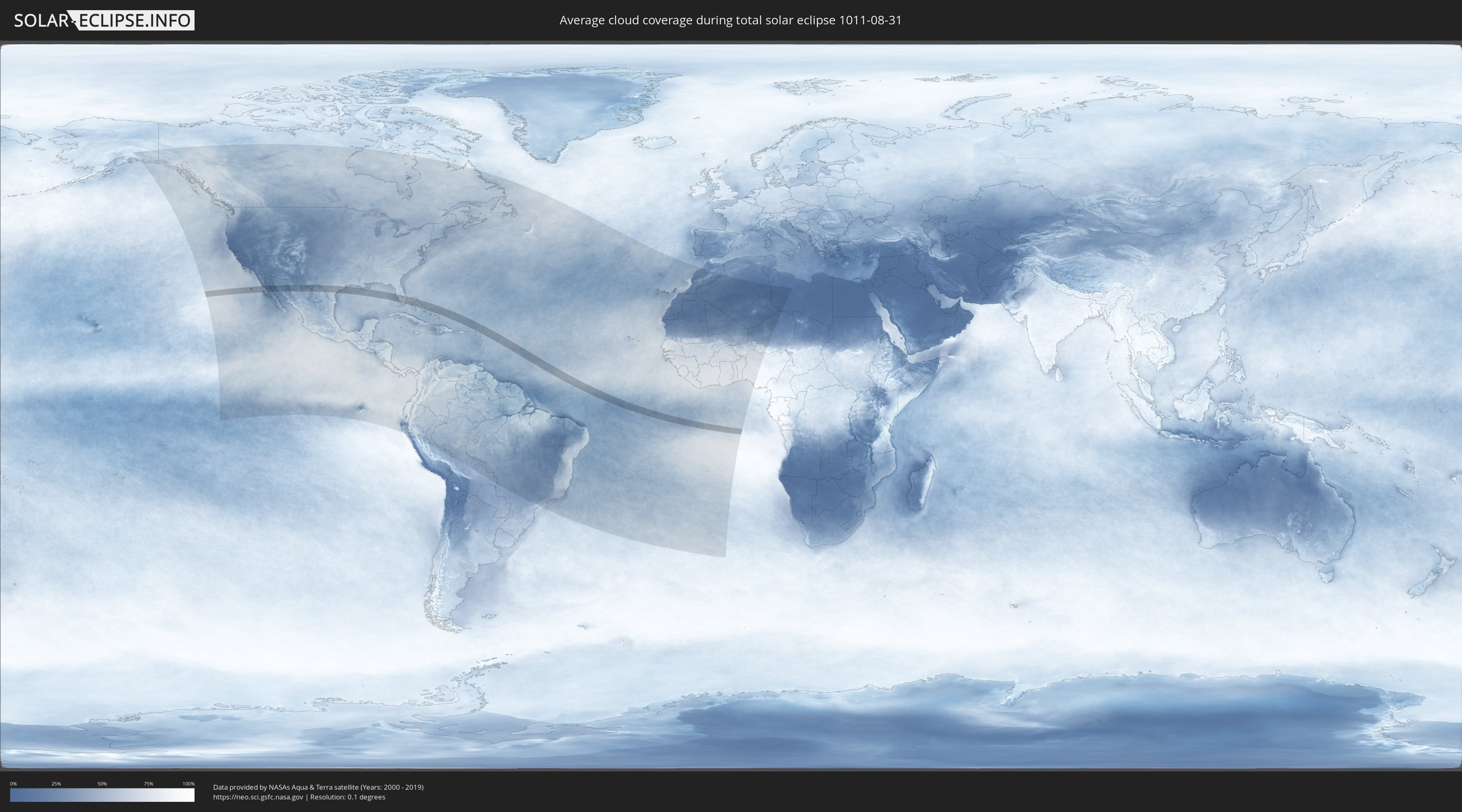
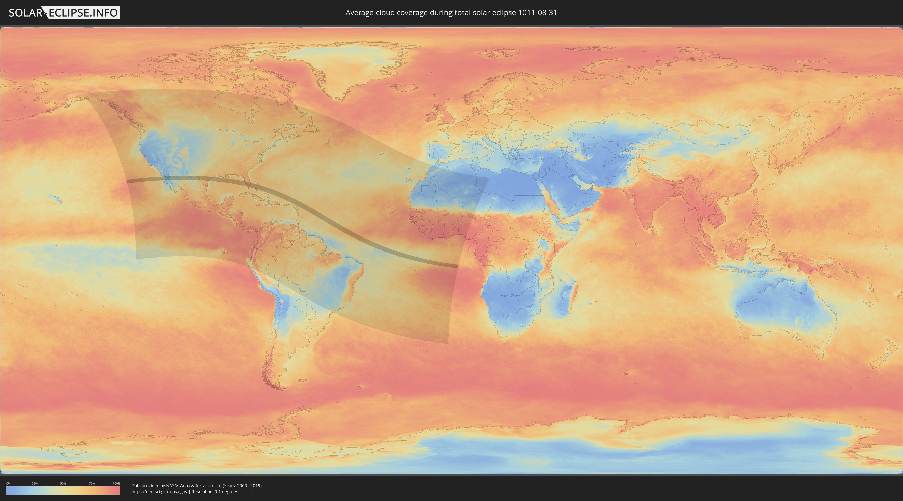
Wie wird das Wetter während der totalen Sonnenfinsternis am 31.08.1011?
Wo ist der beste Ort, um die totale Sonnenfinsternis vom 31.08.1011 zu beobachten?
Die folgenden Karten zeigen die durchschnittliche Bewölkung für den Tag, an dem die totale Sonnenfinsternis
stattfindet. Mit Hilfe der Karten lässt sich der Ort entlang des Finsternispfades eingrenzen,
der die besten Aussichen auf einen klaren wolkenfreien Himmel bietet.
Trotzdem muss man immer lokale Gegenenheiten beachten und sollte sich genau über das Wetter an seinem
gewählten Beobachtungsort informieren.
Die Daten stammen von den beiden NASA-Satelliten
AQUA und TERRA
und wurden über einen Zeitraum von 19 Jahren (2000 - 2019) gemittelt.
Detaillierte Länderkarten
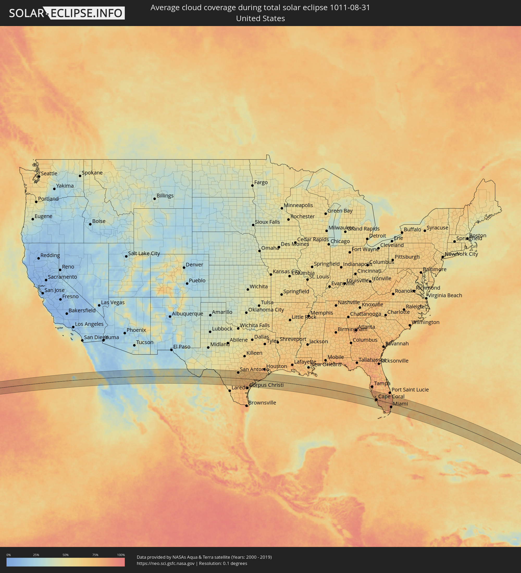 Vereinigte Staaten
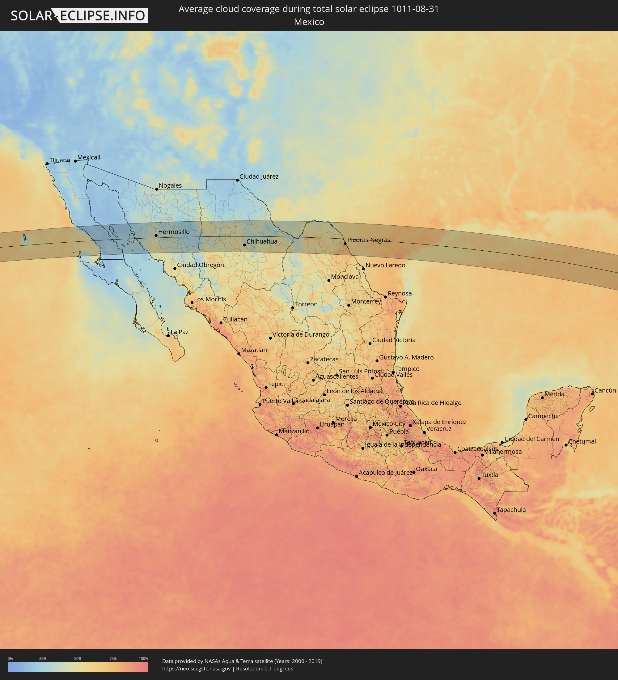 Mexiko
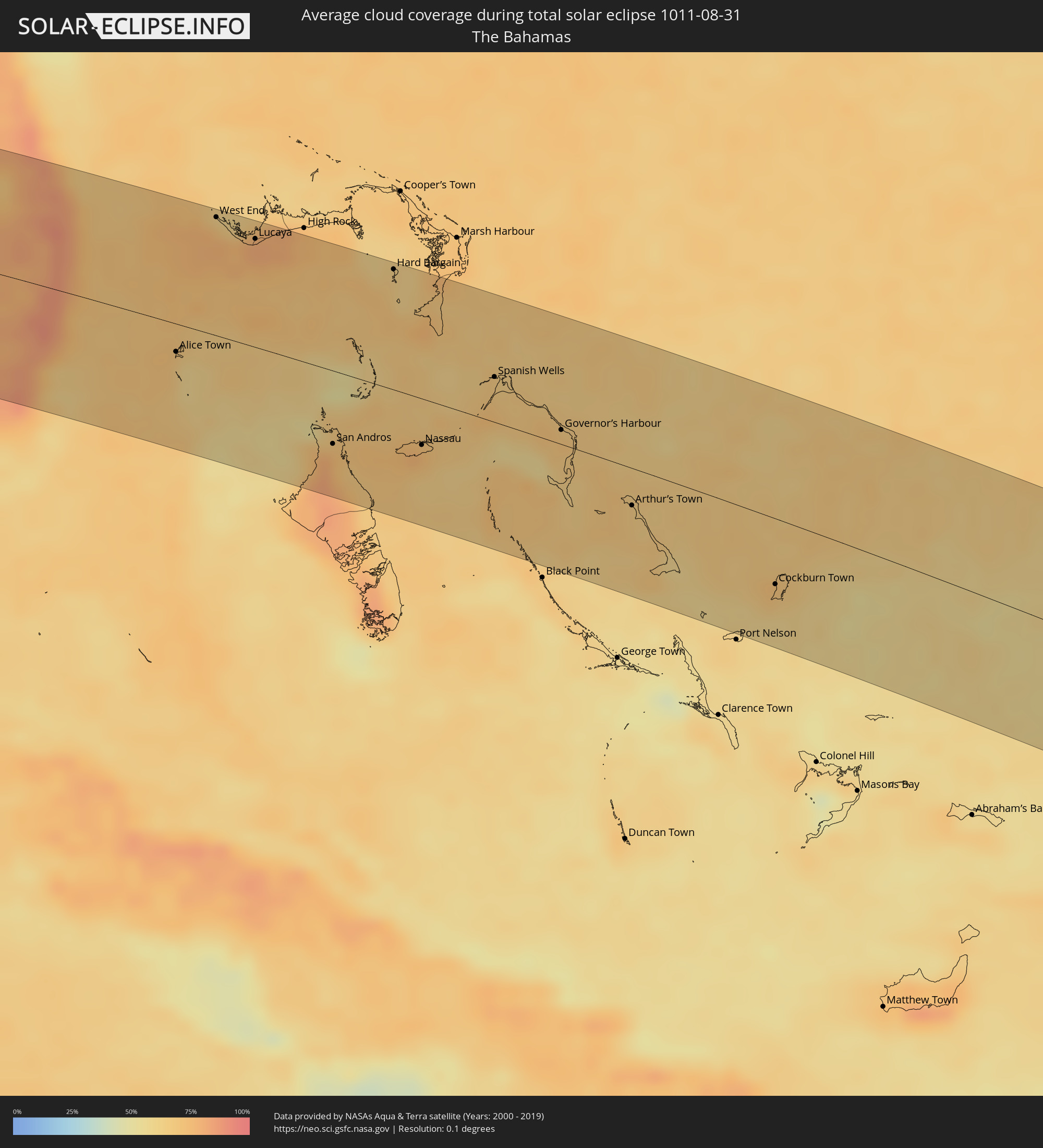 Bahamas
Orte im Finsternispfad
Die nachfolgene Tabelle zeigt Städte und Orte mit mehr als 5.000 Einwohnern, die sich im Finsternispfad befinden. Städte mit mehr als 100.000 Einwohnern sind dick gekennzeichnet. Mit einem Klick auf den Ort öffnet sich eine Detailkarte die die Lage des jeweiligen Ortes zusammen mit dem Verlauf der zentralen Finsternis präsentiert.
| Ort | Typ | Dauer der Verfinsterung | Ortszeit bei maximaler Verfinsterung | Entfernung zur Zentrallinie | Ø Bewölkung |
|
San Luis, Baja California
|
total | - | 06:36:26 UTC-07:48 | 52 km | 18% |
|
Bahía de Kino, Sonora
|
total | - | 07:01:38 UTC-07:23 | 17 km | 31% |
|
Miguel Alemán (La Doce), Sonora
|
total | - | 07:01:53 UTC-07:23 | 17 km | 41% |
|
Hermosillo, Sonora
|
total | - | 07:02:15 UTC-07:23 | 10 km | 47% |
|
Pesqueira, Sonora
|
total | - | 07:02:25 UTC-07:23 | 41 km | 39% |
|
San Pedro Madera, Chihuahua
|
total | - | 07:22:09 UTC-07:05 | 14 km | 43% |
|
Benito Juárez, Chihuahua
|
total | - | 07:22:30 UTC-07:05 | 75 km | 44% |
|
Adolfo López Mateos, Chihuahua
|
total | - | 07:22:26 UTC-07:05 | 68 km | 46% |
|
Cuauhtémoc, Chihuahua
|
total | - | 07:22:43 UTC-07:05 | 74 km | 50% |
|
Anáhuac, Chihuahua
|
total | - | 07:22:49 UTC-07:05 | 66 km | 48% |
|
Chihuahua, Chihuahua
|
total | - | 07:23:20 UTC-07:05 | 49 km | 47% |
|
Ampliación Colonia Lázaro Cárdenas, Chihuahua
|
total | - | 07:23:36 UTC-07:05 | 77 km | 38% |
|
Jiménez, Chihuahua
|
total | - | 07:23:45 UTC-07:05 | 82 km | 43% |
|
Ojinaga, Chihuahua
|
total | - | 07:24:50 UTC-07:05 | 56 km | 36% |
|
Manuel Ojinaga, Chihuahua
|
total | - | 07:24:56 UTC-07:05 | 56 km | 36% |
|
Ciudad Acuña, Coahuila
|
total | - | 07:56:52 UTC-06:36 | 39 km | 51% |
|
Zaragoza, Coahuila
|
total | - | 07:56:40 UTC-06:36 | 53 km | 64% |
|
Del Rio, Texas
|
total | - | 08:33:32 UTC-06:00 | 44 km | 53% |
|
Allende, Coahuila
|
total | - | 07:56:41 UTC-06:36 | 70 km | 67% |
|
Nava, Coahuila
|
total | - | 07:56:47 UTC-06:36 | 60 km | 67% |
|
Villa Union, Coahuila
|
total | - | 07:56:47 UTC-06:36 | 83 km | 68% |
|
Piedras Negras, Coahuila
|
total | - | 07:57:06 UTC-06:36 | 28 km | 67% |
|
Eagle Pass, Texas
|
total | - | 08:33:43 UTC-06:00 | 27 km | 67% |
|
Eidson Road, Texas
|
total | - | 08:33:43 UTC-06:00 | 31 km | 67% |
|
Crystal City, Texas
|
total | - | 08:34:22 UTC-06:00 | 27 km | 64% |
|
Uvalde, Texas
|
total | - | 08:34:33 UTC-06:00 | 32 km | 59% |
|
Hondo, Texas
|
total | - | 08:35:13 UTC-06:00 | 51 km | 64% |
|
Pearsall, Texas
|
total | - | 08:35:09 UTC-06:00 | 1 km | 71% |
|
Helotes, Texas
|
total | - | 08:35:44 UTC-06:00 | 80 km | 63% |
|
San Antonio, Texas
|
total | - | 08:35:54 UTC-06:00 | 64 km | 64% |
|
Pleasanton, Texas
|
total | - | 08:35:48 UTC-06:00 | 13 km | 72% |
|
Kirby, Texas
|
total | - | 08:36:01 UTC-06:00 | 69 km | 68% |
|
Schertz, Texas
|
total | - | 08:36:10 UTC-06:00 | 80 km | 64% |
|
Seguin, Texas
|
total | - | 08:36:29 UTC-06:00 | 83 km | 67% |
|
Beeville, Texas
|
total | - | 08:36:26 UTC-06:00 | 45 km | 74% |
|
Gonzales, Texas
|
total | - | 08:37:01 UTC-06:00 | 80 km | 73% |
|
Rockport, Texas
|
total | - | 08:37:07 UTC-06:00 | 82 km | 62% |
|
Victoria, Texas
|
total | - | 08:37:20 UTC-06:00 | 6 km | 71% |
|
Port Lavaca, Texas
|
total | - | 08:37:43 UTC-06:00 | 12 km | 67% |
|
El Campo, Texas
|
total | - | 08:38:14 UTC-06:00 | 55 km | 76% |
|
Wharton, Texas
|
total | - | 08:38:27 UTC-06:00 | 70 km | 74% |
|
Bay City, Texas
|
total | - | 08:38:32 UTC-06:00 | 34 km | 77% |
|
Lake Jackson, Texas
|
total | - | 08:39:10 UTC-06:00 | 45 km | 70% |
|
Angleton, Texas
|
total | - | 08:39:12 UTC-06:00 | 60 km | 71% |
|
La Marque, Texas
|
total | - | 08:39:46 UTC-06:00 | 86 km | 66% |
|
Galveston, Texas
|
total | - | 08:39:58 UTC-06:00 | 81 km | 53% |
|
Bradenton, Florida
|
total | - | 09:58:00 UTC-05:00 | 85 km | 78% |
|
Memphis, Florida
|
total | - | 09:58:01 UTC-05:00 | 89 km | 78% |
|
Sarasota, Florida
|
total | - | 09:58:07 UTC-05:00 | 68 km | 77% |
|
Southgate, Florida
|
total | - | 09:58:10 UTC-05:00 | 66 km | 77% |
|
Laurel, Florida
|
total | - | 09:58:17 UTC-05:00 | 49 km | 65% |
|
Venice, Florida
|
total | - | 09:58:19 UTC-05:00 | 44 km | 65% |
|
Rotonda, Florida
|
total | - | 09:58:40 UTC-05:00 | 25 km | 69% |
|
North Port, Florida
|
total | - | 09:58:43 UTC-05:00 | 44 km | 72% |
|
Port Charlotte, Florida
|
total | - | 09:58:59 UTC-05:00 | 40 km | 75% |
|
Cape Coral, Florida
|
total | - | 09:59:22 UTC-05:00 | 1 km | 81% |
|
McGregor, Florida
|
total | - | 09:59:26 UTC-05:00 | 1 km | 81% |
|
Arcadia, Florida
|
total | - | 09:59:21 UTC-05:00 | 71 km | 79% |
|
Bonita Springs, Florida
|
total | - | 09:59:44 UTC-05:00 | 21 km | 80% |
|
Gateway, Florida
|
total | - | 09:59:43 UTC-05:00 | 5 km | 83% |
|
Marco, Florida
|
total | - | 09:59:57 UTC-05:00 | 60 km | 72% |
|
Golden Gate, Florida
|
total | - | 09:59:57 UTC-05:00 | 36 km | 83% |
|
Lehigh Acres, Florida
|
total | - | 09:59:56 UTC-05:00 | 13 km | 84% |
|
Immokalee, Florida
|
total | - | 10:00:23 UTC-05:00 | 4 km | 83% |
|
Clewiston, Florida
|
total | - | 10:01:10 UTC-05:00 | 45 km | 69% |
|
Belle Glade, Florida
|
total | - | 10:01:41 UTC-05:00 | 44 km | 78% |
|
Homestead, Florida
|
total | - | 10:02:29 UTC-05:00 | 81 km | 86% |
|
Naranja, Florida
|
total | - | 10:02:34 UTC-05:00 | 75 km | 79% |
|
Weston, Florida
|
total | - | 10:02:23 UTC-05:00 | 12 km | 87% |
|
Richmond Heights, Florida
|
total | - | 10:02:37 UTC-05:00 | 61 km | 81% |
|
Doral, Florida
|
total | - | 10:02:35 UTC-05:00 | 41 km | 83% |
|
East Perrine, Florida
|
total | - | 10:02:41 UTC-05:00 | 63 km | 68% |
|
Southwest Ranches, Florida
|
total | - | 10:02:31 UTC-05:00 | 14 km | 88% |
|
Kendall, Florida
|
total | - | 10:02:42 UTC-05:00 | 55 km | 72% |
|
Coral Springs, Florida
|
total | - | 10:02:34 UTC-05:00 | 10 km | 86% |
|
Wellington, Florida
|
total | - | 10:02:29 UTC-05:00 | 53 km | 89% |
|
Lake Lucerne, Florida
|
total | - | 10:02:44 UTC-05:00 | 22 km | 83% |
|
Pembroke Pines, Florida
|
total | - | 10:02:45 UTC-05:00 | 17 km | 83% |
|
Miami, Florida
|
total | - | 10:02:54 UTC-05:00 | 41 km | 74% |
|
Melrose Park, Florida
|
total | - | 10:02:46 UTC-05:00 | 5 km | 84% |
|
Fort Lauderdale, Florida
|
total | - | 10:02:52 UTC-05:00 | 2 km | 74% |
|
Pompano Beach Highlands, Florida
|
total | - | 10:02:52 UTC-05:00 | 16 km | 79% |
|
Jupiter, Florida
|
total | - | 10:02:40 UTC-05:00 | 86 km | 81% |
|
Boca Raton, Florida
|
total | - | 10:02:53 UTC-05:00 | 25 km | 80% |
|
Lake Park, Florida
|
total | - | 10:02:46 UTC-05:00 | 72 km | 82% |
|
Boynton Beach, Florida
|
total | - | 10:02:52 UTC-05:00 | 43 km | 81% |
|
West Palm Beach, Florida
|
total | - | 10:02:49 UTC-05:00 | 64 km | 83% |
|
Palm Beach, Florida
|
total | - | 10:02:51 UTC-05:00 | 63 km | 74% |
|
Alice Town, Bimini
|
total | - | 09:55:09 UTC-05:09 | 21 km | 68% |
|
West End, West Grand Bahama
|
total | - | 09:55:22 UTC-05:09 | 90 km | 75% |
|
Freeport, Freeport
|
total | - | 09:55:58 UTC-05:09 | 81 km | 75% |
|
Lucaya, Freeport
|
total | - | 09:56:02 UTC-05:09 | 82 km | 75% |
|
San Andros, North Andros
|
total | - | 09:57:56 UTC-05:09 | 56 km | 78% |
|
Hard Bargain, Moore’s Island
|
total | - | 09:58:17 UTC-05:09 | 91 km | 67% |
|
Nassau, New Providence
|
total | - | 09:59:22 UTC-05:09 | 35 km | 72% |
|
Spanish Wells, Spanish Wells
|
total | - | 10:00:17 UTC-05:09 | 34 km | 70% |
|
Governor’s Harbour, Central Eleuthera
|
total | - | 15:11:05 UTC+00:00 | 11 km | 70% |
|
Arthur’s Town, Cat Island
|
total | - | 10:03:05 UTC-05:09 | 28 km | 67% |
|
Cockburn Town, San Salvador
|
total | - | 10:05:53 UTC-05:09 | 50 km | 67% |